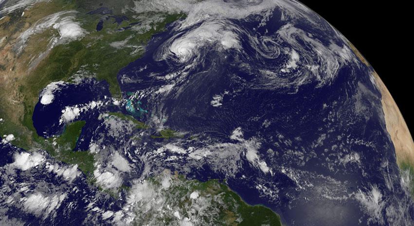
This image depicts a full view of the Earth, taken by the Geostationary Operational Environment Satellite (GOES-8). The red and green charnels represent visible data, while the blue channel represents inverted 11 micron infrared data. The north and south poles were not actually observed by GOES-8. To produce this image, poles were taken from a GOES-7 image. Owned and operated by the National Oceanic and Atmospheric Administration (NOAA), GOES satellites provide the kind of continuous monitoring necessary for intensive data analysis. They circle the Earth in a geosynchronous orbit, which means they orbit the equatorial plane of the Earth at a speed matching the Earth's rotation. This allows them to hover continuously over one position on the surface. The geosynchronous plane is about 35,800 km (22,300 miles) above the Earth, high enough to allow the satellites a full-disc view of the Earth. Because they stay above a fixed spot on the surface, they provide a constant vigil for the atmospheric triggers for severe weather conditions such as tornadoes, flash floods, hail storms, and hurricanes. When these conditions develop, the GOES satellites are able to monitor storm development and track their movements. NASA manages the design and launch of the spacecraft. NASA launched the first GOES for NOAA in 1975 and followed it with another in 1977. Currently, the United States is operating GOES-8, positioned at 75 west longitude and the equator, and GOES-10, which is positioned at 135 west longitude and the equator. (GOES-9, which malfunctioned in 1998, is being stored in orbit as an emergency backup should either GOES-8 or GOES-10 fail. GOES-11 was launched on May 3, 2000 and GOES-12 on July 23, 2001. Both are being stored in orbit as a fully functioning replacement for GOES-8 or GOES-10 on failure.
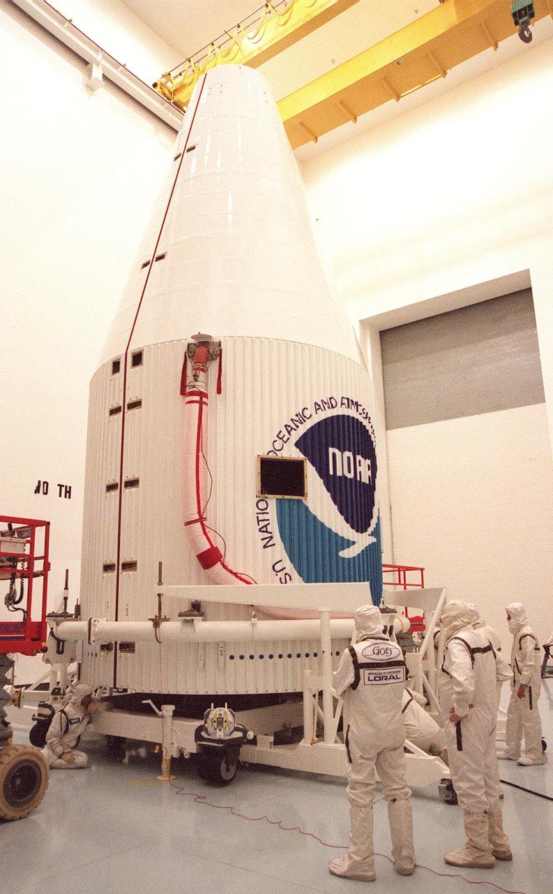
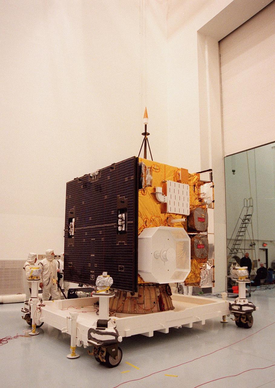
The Geostationary Operational Environmental Satellite-K (GOES-K) is placed on display for news media representatives at the Astrotech Space Operations LP facility in Titusville. GOES-K, the latest in the current series of advanced geostationary weather satellites in service, is scheduled to be launched into space aboard an Atlas 1 rocket on April 24 from Launch Complex 36, Pad B, Cape Canaveral Air Station. Once in orbit, GOES-K will become GOES-10, joining GOES-8 and GOES-9 in space
The Geostationary Operational Environmental Satellite-K (GOES-K) is placed on display for news media representatives at the Astrotech Space Operations LP facility in Titusville. GOES-K, the latest in the current series of advanced geostationary weather satellites in service, is scheduled to be launched into space aboard an Atlas 1 rocket on April 24 from Launch Complex 36, Pad B, Cape Canaveral Air Station. Once in orbit, GOES-K will become GOES-10, joining GOES-8 and GOES-9 in space
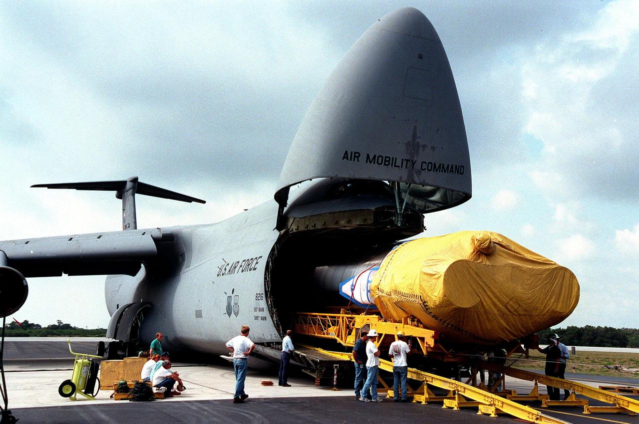
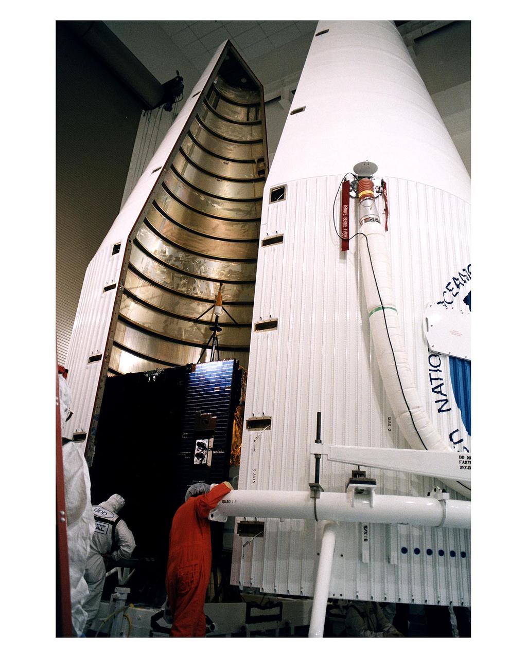
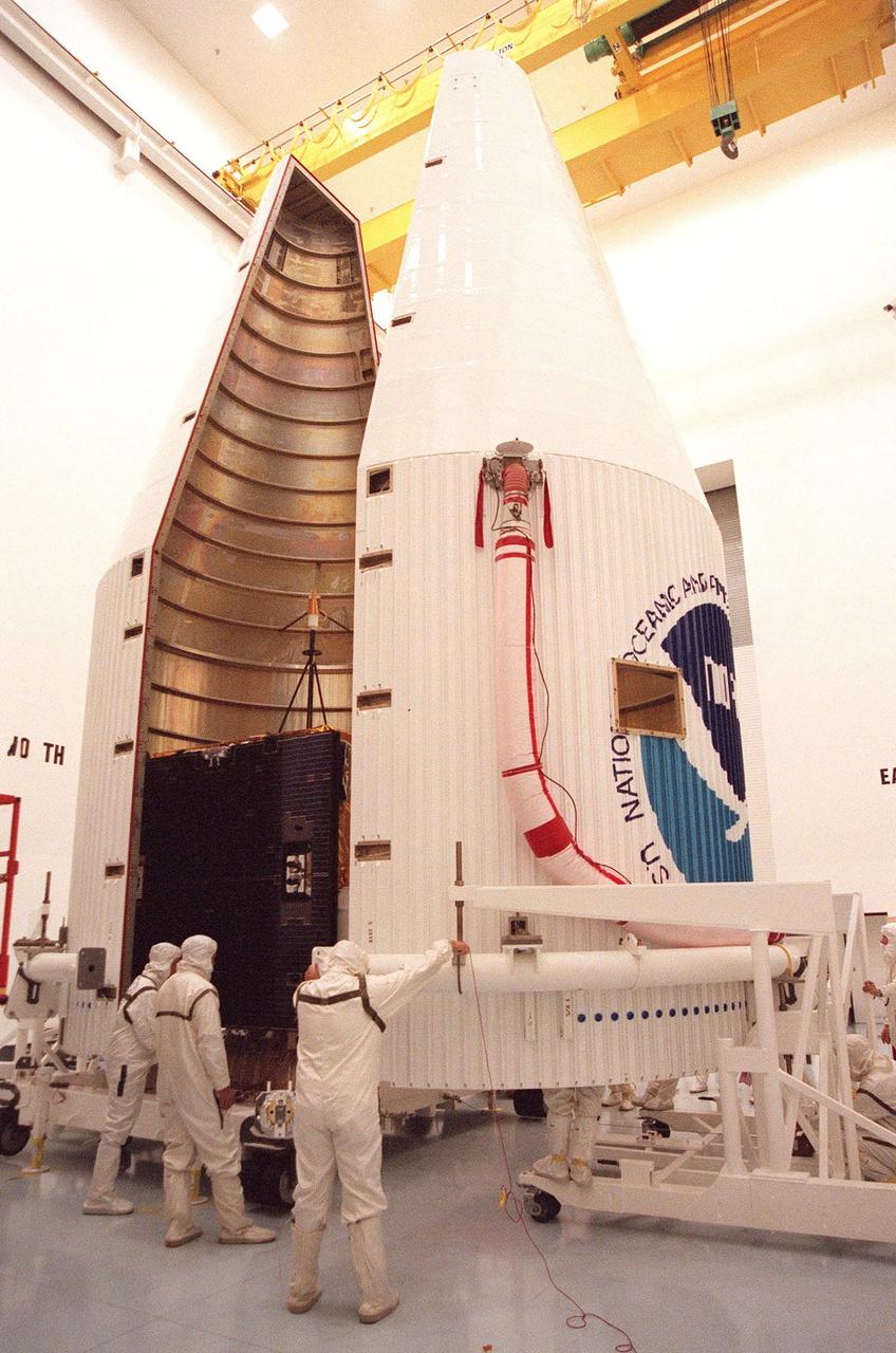
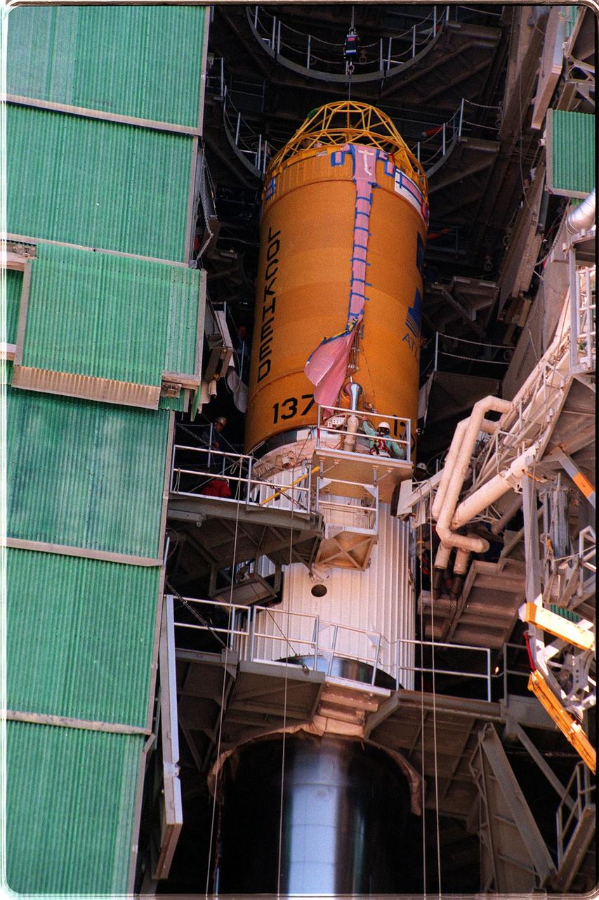
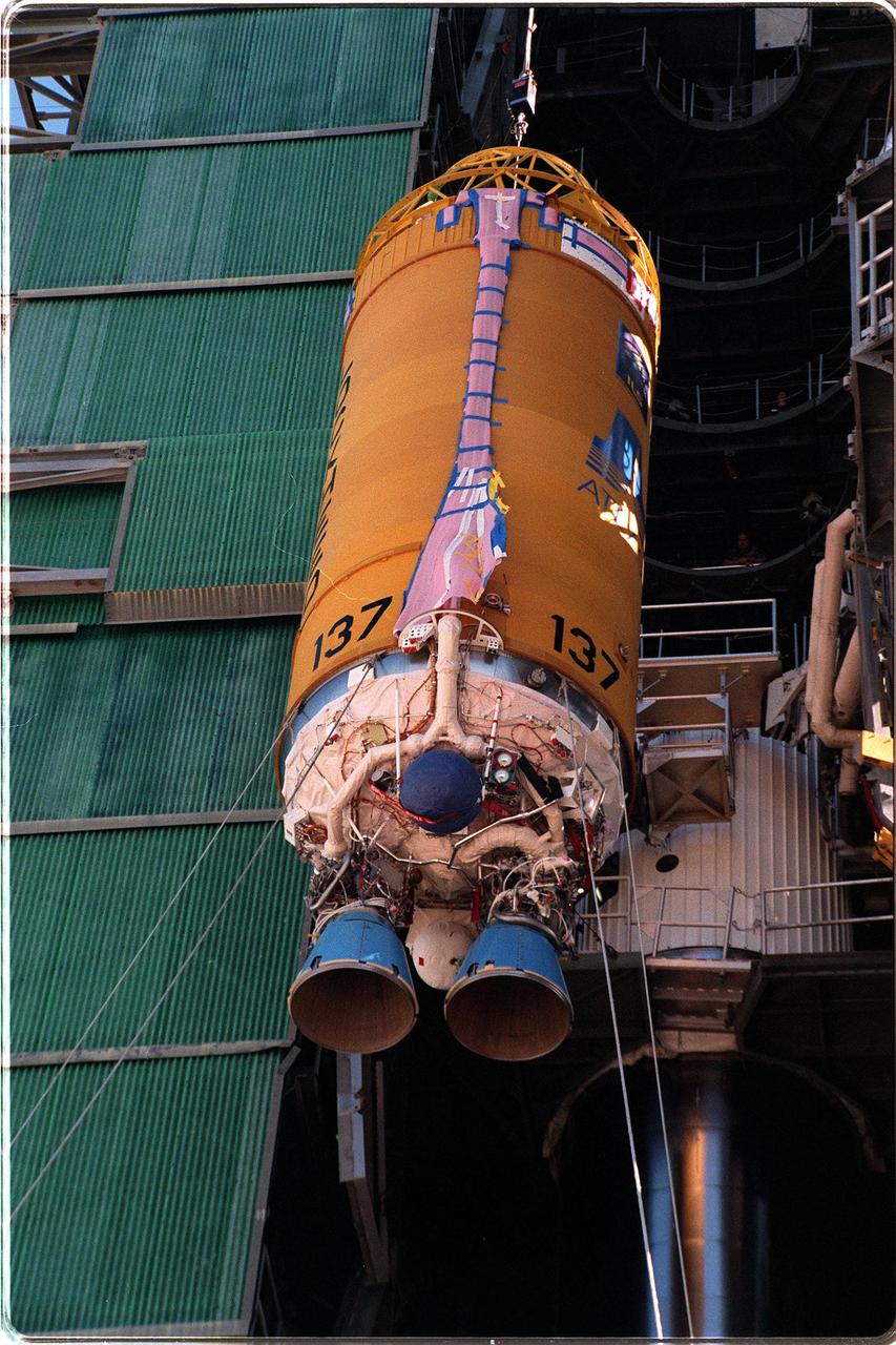
Workers at Launch Pad 36A, Cape Canaveral Air Station, help guide an encapsulated GOES-L weather satellite up the gantry for mating to a Lockheed Martin Atlas II rocket. The fourth of a new advanced series of geostationary weather satellites for the National Oceanic and Atmospheric Administration (NOAA), GOES-L is a three-axis inertially stabilized spacecraft that will provide pictures and perform atmospheric sounding at the same time. After it is launched, the satellite will undergo checkout and then provide backup capabilities for the existing, aging operational satellites. Once in orbit, the satellite will become GOES-11, joining GOES-8, GOES-9 and GOES-10 in space. The GOES is scheduled for launch later this month
Workers at Astrotech, in Titusville, Fla., prepare the GOES-L satellite for a media showing. The GOES-L is due to be launched May 15 from Launch Pad 36A aboard an Atlas IIA rocket. Once in orbit, the satellite will become GOES-11, joining GOES-8, GOES-9 and GOES-10 in space. The fourth of a new advanced series of geostationary weather satellites for the National Oceanic and Atmospheric Administration (NOAA), GOES-L is a three-axis inertially stabilized spacecraft that will provide pictures and perform atmospheric sounding at the same time. Once launched, the satellite will undergo checkout and then provide backup capabilities for the existing, aging operational satellites
After being transported from Astrotech, in Titusville, Fla., the encapsulated GOES-L weather satellite arrives at Launch Pad 36A, Cape Canaveral Air Station, to be mated to a Lockheed Martin Atlas II rocket. The fourth of a new advanced series of geostationary weather satellites for the National Oceanic and Atmospheric Administration (NOAA), GOES-L is a three-axis inertially stabilized spacecraft that will provide pictures and perform atmospheric sounding at the same time. After it is launched, the satellite will undergo checkout and then provide backup capabilities for the existing, aging operational satellites. Once in orbit, the satellite will become GOES-11, joining GOES-8, GOES-9 and GOES-10 in space. The GOES is scheduled for launch later this month
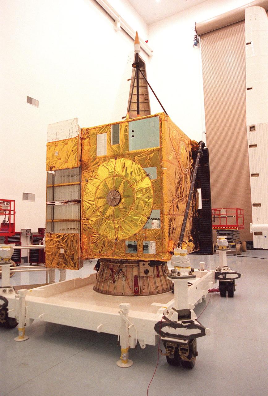
At Astrotech, Titusville, Fla., the GOES-L weather satellite sits on a workstand, ready to be encapsulated for its transfer to Launch Pad 36A, Cape Canaveral Air Station. GOES is scheduled for launch aboard a Lockheed Martin Atlas II rocket later in May. The fourth of a new advanced series of geostationary weather satellites for the National Oceanic and Atmospheric Administration (NOAA), GOES-L is a three-axis inertially stabilized spacecraft that will provide pictures and perform atmospheric sounding at the same time. After it is launched, the satellite will undergo checkout and then provide backup capabilities for the existing, aging operational satellites. Once in orbit, the satellite will become GOES-11, joining GOES-8, GOES-9 and GOES-10 in space
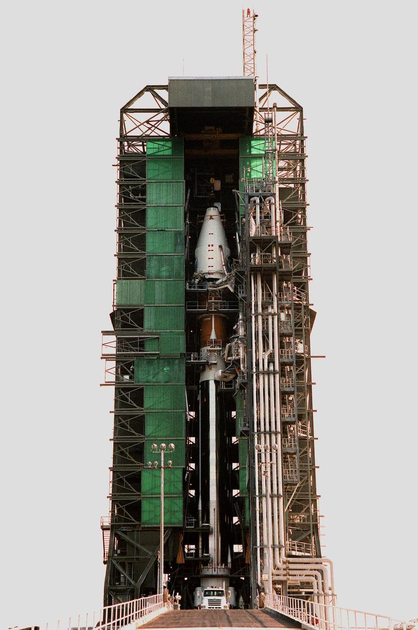
At Launch Pad 36A, Cape Canaveral Air Station, an encapsulated GOES-L weather satellite (top center) is prepared for mating to the a Lockheed Martin Atlas II rocket below it. The fourth of a new advanced series of geostationary weather satellites for the National Oceanic and Atmospheric Administration (NOAA), GOES-L is a three-axis inertially stabilized spacecraft that will provide pictures and perform atmospheric sounding at the same time. After it is launched, the satellite will undergo checkout and then provide backup capabilities for the existing, aging operational satellites. Once in orbit, the satellite will become GOES-11, joining GOES-8, GOES-9 and GOES-10 in space. The GOES is scheduled for launch later this month
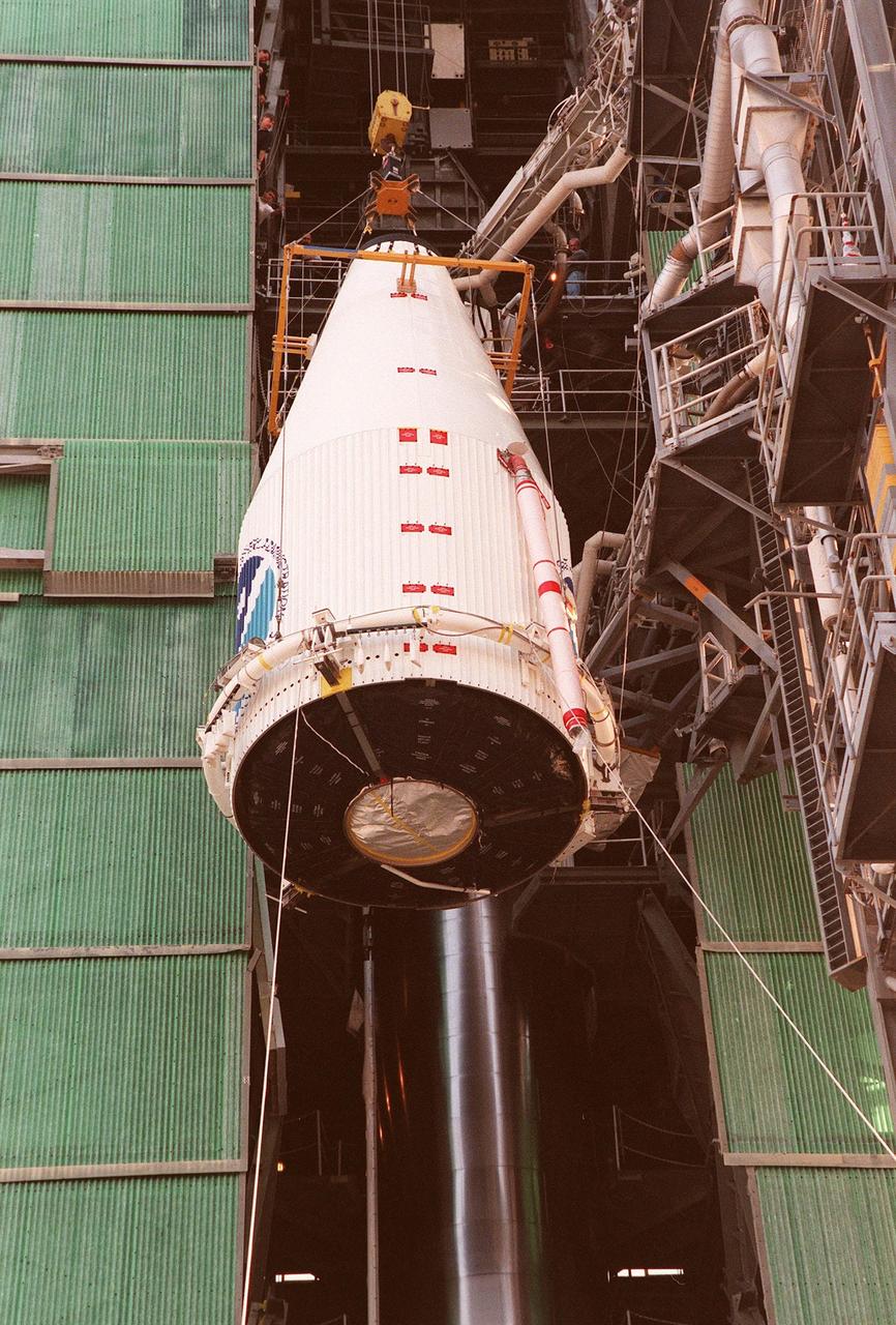
At Launch Pad 36A, Cape Canaveral Air Station, an encapsulated GOES-L weather satellite is lifted up the gantry for mating to a Lockheed Martin Atlas II rocket. The fourth of a new advanced series of geostationary weather satellites for the National Oceanic and Atmospheric Administration (NOAA), GOES-L is a three-axis inertially stabilized spacecraft that will provide pictures and perform atmospheric sounding at the same time. After it is launched, the satellite will undergo checkout and then provide backup capabilities for the existing, aging operational satellites. Once in orbit, the satellite will become GOES-11, joining GOES-8, GOES-9 and GOES-10 in space. The GOES is scheduled for launch later this month
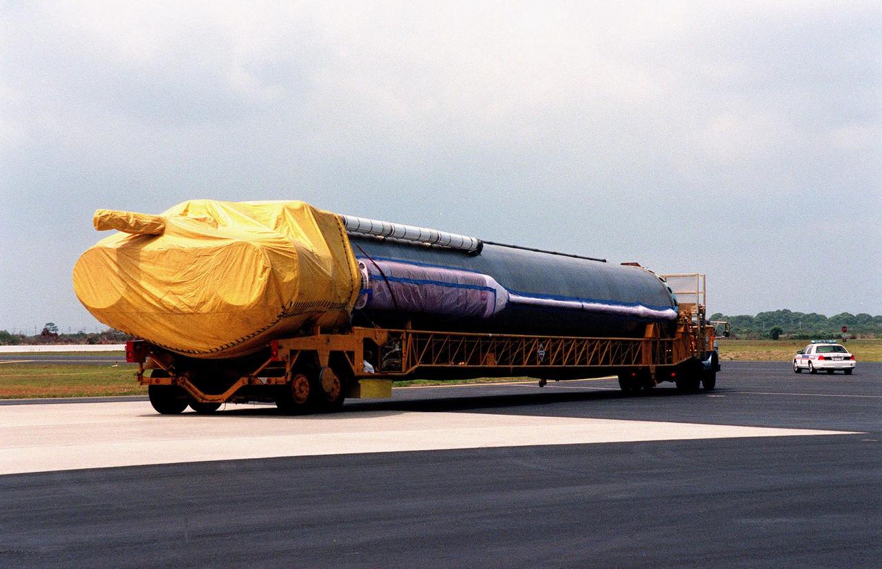
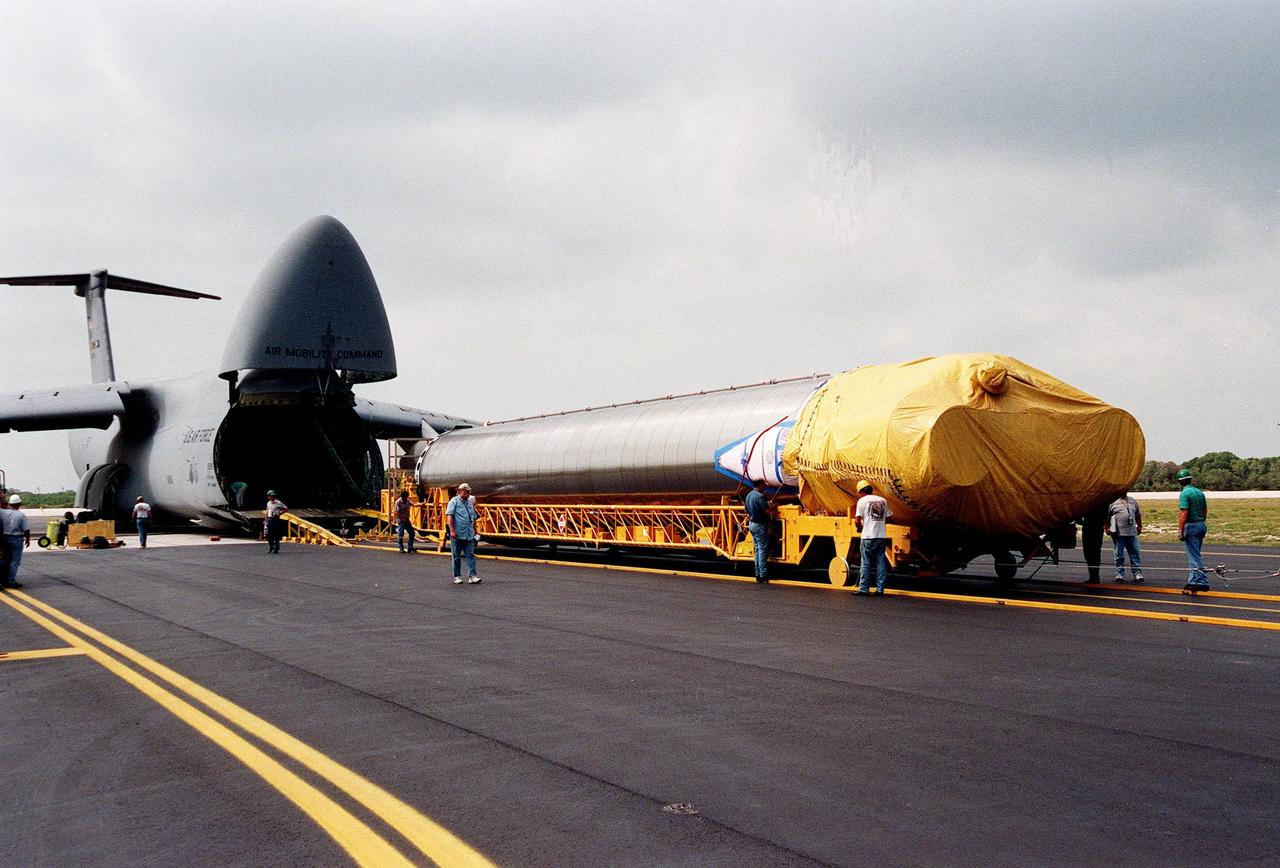
At Astrotech, Titusville, Fla., the fully encapsulated GOES-L weather satellite is ready for transfer to Launch Pad 36A, Cape Canaveral Air Station. The fourth of a new advanced series of geostationary weather satellites for the National Oceanic and Atmospheric Administration (NOAA), GOES-L is a three-axis inertially stabilized spacecraft that will provide pictures and perform atmospheric sounding at the same time. After it is launched, the satellite will undergo checkout and then provide backup capabilities for the existing, aging operational satellites. Once in orbit, the satellite will become GOES-11, joining GOES-8, GOES-9 and GOES-10 in space. The GOES is scheduled for launch aboard a Lockheed Martin Atlas II rocket later in May
At Astrotech, in Titusville, Fla., the GOES-L satellite sits ready for a media showing. The GOES-L is due to be launched May 15 from Launch Pad 36A aboard an Atlas IIA rocket. Once in orbit, the satellite will become GOES-11, joining GOES-8, GOES-9 and GOES-10 in space. The fourth of a new advanced series of geostationary weather satellites for the National Oceanic and Atmospheric Administration (NOAA), GOES-L is a three-axis inertially stabilized spacecraft that will provide pictures and perform atmospheric sounding at the same time. Once launched, the satellite will undergo checkout and then provide backup capabilities for the existing, aging operational satellites
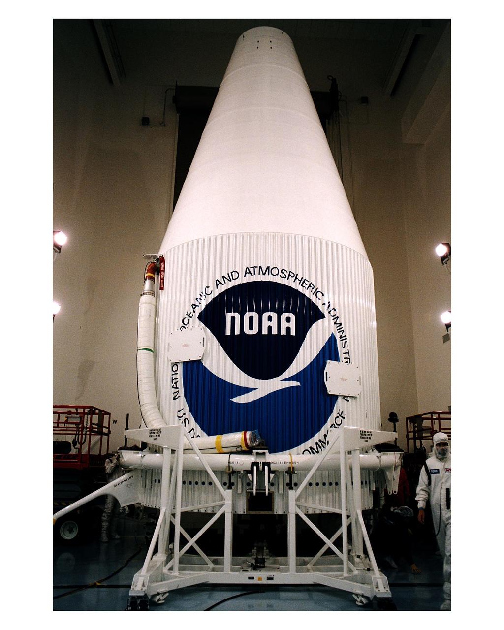
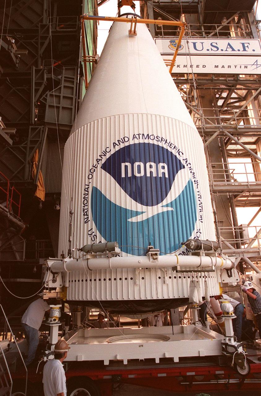
The Atlas 1 payload fairing with the encapsulated GOES-K advanced weather satellite awaits transport to the launch pad. GOES-K was prepared for launch at the Astrotech Space Operations LP facility in Titusville. GOES-K will be the third spacecraft to be launched in the advanced series of Geostationary Operational Environmental Satellites (GOES). The GOES satellites are owned and operated by the National Oceanic and Atmospheric Administration (NOAA); NASA manages the design, development and launch of the spacecraft. GOES-K is targeted for an <a href="http://www-pao.ksc.nasa.gov/kscpao/release/1997/63-97.htm">April 24 launch</a> aboard a Lockheed Martin Atlas 1 expendable launch vehicle (AC-79) from Launch Complex 36, Pad B, Cape Canaveral Air Station. The launch window opens at 1:50 a.m. and extends to 3:09 a.m. EDT. Once in orbit, GOES-K will become GOES-10, joining GOES-8 and GOES-9 in space
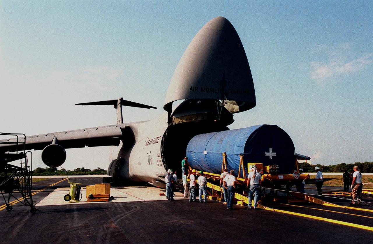
An Atlas IIA rocket is transported from Cape Canaveral Air Station after its arrival aboard a U.S. Air Force C-5c. The rocket is scheduled to launch the NASA GOES-L satellite from Launch Pad 36A on May 15. Once in orbit, the satellite will become GOES-11, joining GOES-8, GOES-9 and GOES-10 in space. The fourth of a new advanced series of geostationary weather satellites for the National Oceanic and Atmospheric Administration (NOAA), GOES-L is a three-axis inertially stabilized spacecraft that will provide pictures and perform atmospheric sounding at the same time. Once launched, the satellite will undergo checkout and then provide backup capabilities for the existing, aging operational satellites
At Cape Canaveral Air Station, workers begin offloading an Atlas IIA rocket from a U.S. Air Force C-5c. The rocket is scheduled to launch the NASA GOES-L satellite from Launch Pad 36B on May 15. Once in orbit, the satellite will become GOES-11, joining GOES-8, GOES-9 and GOES-10 in space. The fourth of a new advanced series of geostationary weather satellites for the National Oceanic and Atmospheric Administration (NOAA), GOES-L is a three-axis inertially stabilized spacecraft that will provide pictures and perform atmospheric sounding at the same time. Once launched, the satellite will undergo checkout and then provide backup capabilities for the existing, aging operational satellites
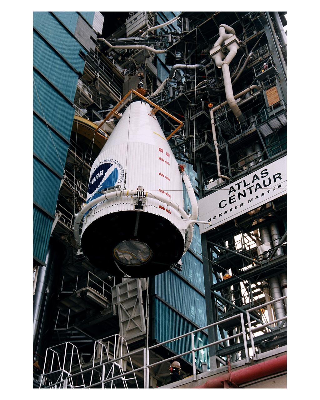
The Atlas 1 payload fairing with the encapsulated GOES-K advanced weather satellite is being lifted into position for mating to the Lockheed Martin Atlas 1 expendable launch vehicle (AC-79) at Launch Complex 36, Pad B, Cape Canaveral Air Station. GOES-K will be the third spacecraft to be launched in the advanced series of Geostationary Operational Environmental Satellites (GOES). The GOES satellites are owned and operated by the National Oceanic and Atmospheric Administration (NOAA); NASA manages the design, development and launch of the spacecraft. GOES-K is targeted for an <a href="http://www-pao.ksc.nasa.gov/kscpao/release/1997/63-97.htm">April 24 launch</a> during a launch window which extends from 1:50-3:09 a.m. EDT. Once in orbit, GOES-K will become GOES-10, joining GOES-8 and GOES-9 in space
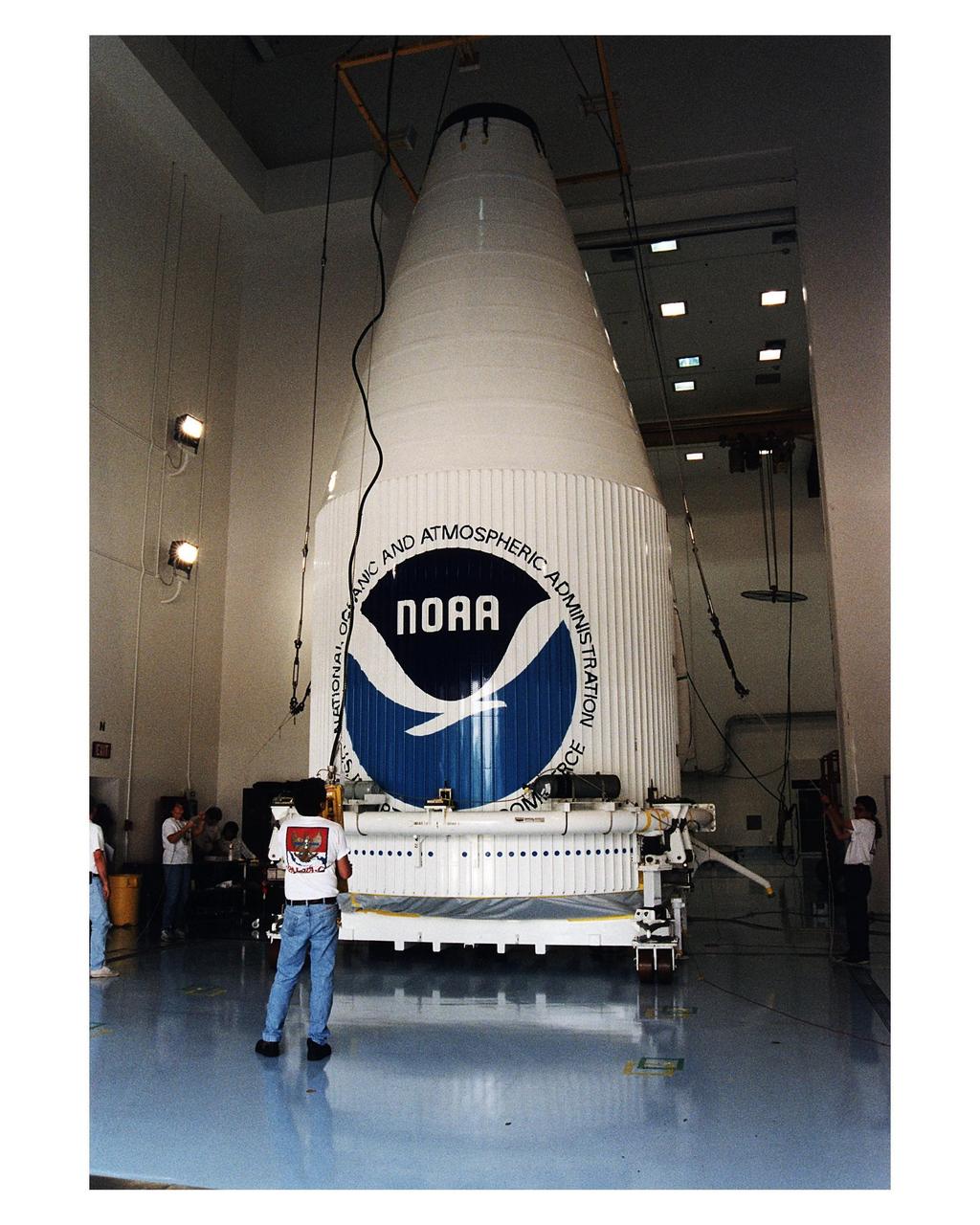
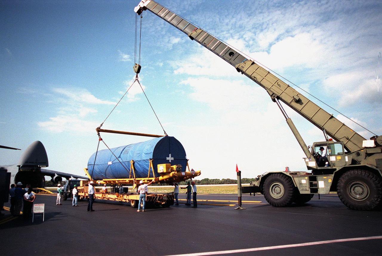
The GOES-K advanced weather satellite, already encapsulated in the Atlas 1 payload fairing, is carefully placed on the transporter at Astrotech Space Operations LP facility in Titusville. GOES-K will be the third spacecraft to be launched in the advanced series of Geostationary Operational Environmental Satellites (GOES). The GOES satellites are owned and operated by the National Oceanic and Atmospheric Administration (NOAA); NASA manages the design, development and launch of the spacecraft. GOES-K is targeted for an <a href="http://www-pao.ksc.nasa.gov/kscpao/release/1997/63-97.htm">April 24 launch</a> aboard a Lockheed Martin Atlas 1 expendable launch vehicle (AC-79) from Launch Complex 36, Pad B, Cape Canaveral Air Station. The launch window opens at 1:50 a.m. and extends to 3:09 a.m. EDT. Once in orbit, GOES-K will become GOES-10, joining GOES-8 and GOES-9 in space
Workers at the Astrotech Space Operations LP facility in Titusville make final checks and adjustments after encapsulating the GOES-K advanced weather satellite in the Atlas 1 payload fairing. GOES-K will be the third spacecraft to be launched in the advanced series of Geostationary Operational Environmental Satellites (GOES). The GOES satellites are owned and operated by the National Oceanic and Atmospheric Administration (NOAA); NASA manages the design, development and launch of the spacecraft. GOES-K is targeted for an <a href="http://www-pao.ksc.nasa.gov/kscpao/release/1997/63-97.htm">April 24 launch</a> aboard a Lockheed Martin Atlas 1 expendable launch vehicle (AC-79) from Launch Complex 36, Pad B, Cape Canaveral Air Station. The launch window opens at 1:50 a.m. and extends to 3:09 a.m. EDT. Once in orbit, GOES-K will become GOES-10, joining GOES-8 and GOES-9 in space
Workers at the Astrotech Space Operations LP facility in Titusville make final checks and adjustments after encapsulating the GOES-K advanced weather satellite in the Atlas 1 payload fairing. GOES-K will be the third spacecraft to be launched in the advanced series of Geostationary Operational Environmental Satellites (GOES). The GOES satellites are owned and operated by the National Oceanic and Atmospheric Administration (NOAA); NASA manages the design, development and launch of the spacecraft. GOES-K is targeted for an <a href="http://www-pao.ksc.nasa.gov/kscpao/release/1997/63-97.htm">April 24 launch</a> aboard a Lockheed Martin Atlas 1 expendable launch vehicle (AC-79) from Launch Complex 36, Pad B, Cape Canaveral Air Station. The launch window opens at 1:50 a.m. and extends to 3:09 a.m. EDT. Once in orbit, GOES-K will become GOES-10, joining GOES-8 and GOES-9 in space
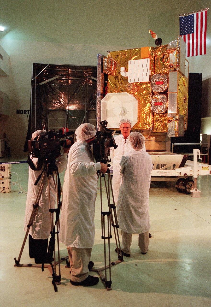
At Astrotech, in Titusville, Fla., GOES-L Program Manager Gerald Dittberner, with the National Oceanic and Atmospheric Administration (NOAA) talks with a journalist during a media showing of the GOES-L satellite in the background. The GOES-L is due to be launched May 15 from Launch Pad 36A aboard an Atlas IIA rocket. Once in orbit, the satellite will become GOES-11, joining GOES-8, GOES-9 and GOES-10 in space. The fourth of a new advanced series of geostationary weather satellites for the National Oceanic and Atmospheric Administration (NOAA), GOES-L is a three-axis inertially stabilized spacecraft that will provide pictures and perform atmospheric sounding at the same time. Once launched, the satellite will undergo checkout and then provide backup capabilities for the existing, aging operational satellites

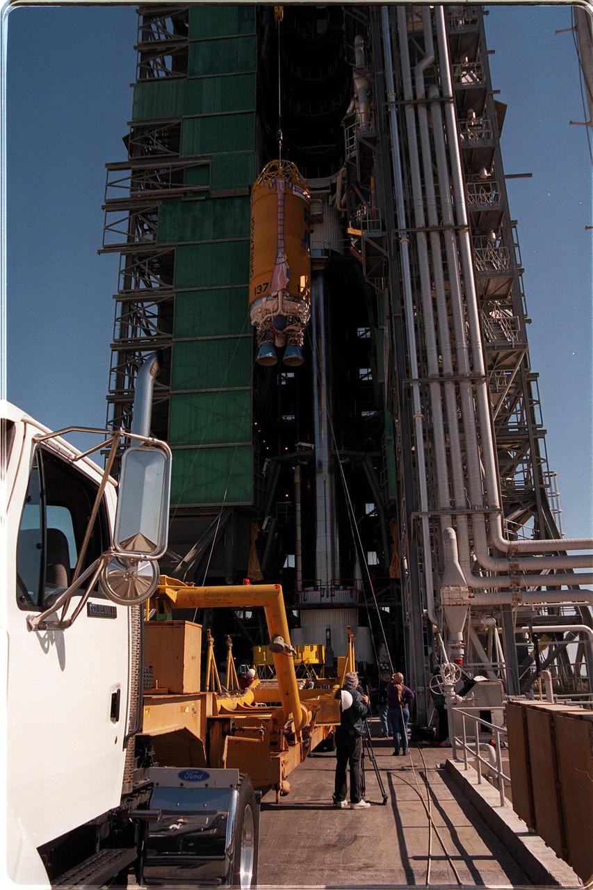
At Astrotech, Titusville, Fla., the GOES-L weather satellite undergoes encapsulation in the first half of the fairing before its transfer to Launch Pad 36A, Cape Canaveral Air Station. At right is the second half of the fairing. The mounted equipment on top of the satellite is a telemetry and command antenna. The fourth of a new advanced series of geostationary weather satellites for the National Oceanic and Atmospheric Administration (NOAA), GOES-L is a three-axis inertially stabilized spacecraft that will provide pictures and perform atmospheric sounding at the same time. After it is launched, the satellite will undergo checkout and then provide backup capabilities for the existing, aging operational satellites. Once in orbit, the satellite will become GOES-11, joining GOES-8, GOES-9 and GOES-10 in space. The GOES is scheduled for launch aboard a Lockheed Martin Atlas II rocket later in May
Workers at Astrotech, Titusville, Fla., move the second half of the fairing to finish encapsulating the GOES-L weather satellite before its transfer to Launch Pad 36A, Cape Canaveral Air Station. The fourth of a new advanced series of geostationary weather satellites for the National Oceanic and Atmospheric Administration (NOAA), GOES-L is a three-axis inertially stabilized spacecraft that will provide pictures and perform atmospheric sounding at the same time. After it is launched, the satellite will undergo checkout and then provide backup capabilities for the existing, aging operational satellites. Once in orbit, the satellite will become GOES-11, joining GOES-8, GOES-9 and GOES-10 in space. The GOES is scheduled for launch aboard a Lockheed Martin Atlas II rocket later in May

Workers at Astrotech, Titusville, Fla., prepare the GOES-L weather satellite for encapsulation in the fairing (left and right) before its transfer to Launch Pad 36A, Cape Canaveral Air Station. The mounted equipment on top of the satellite is a telemetry and command antenna. The fourth of a new advanced series of geostationary weather satellites for the National Oceanic and Atmospheric Administration (NOAA), GOES-L is a three-axis inertially stabilized spacecraft that will provide pictures and perform atmospheric sounding at the same time. After it is launched, the satellite will undergo checkout and then provide backup capabilities for the existing, aging operational satellites. Once in orbit, the satellite will become GOES-11, joining GOES-8, GOES-9 and GOES-10 in space. The GOES is scheduled for launch aboard a Lockheed Martin Atlas II rocket later in May
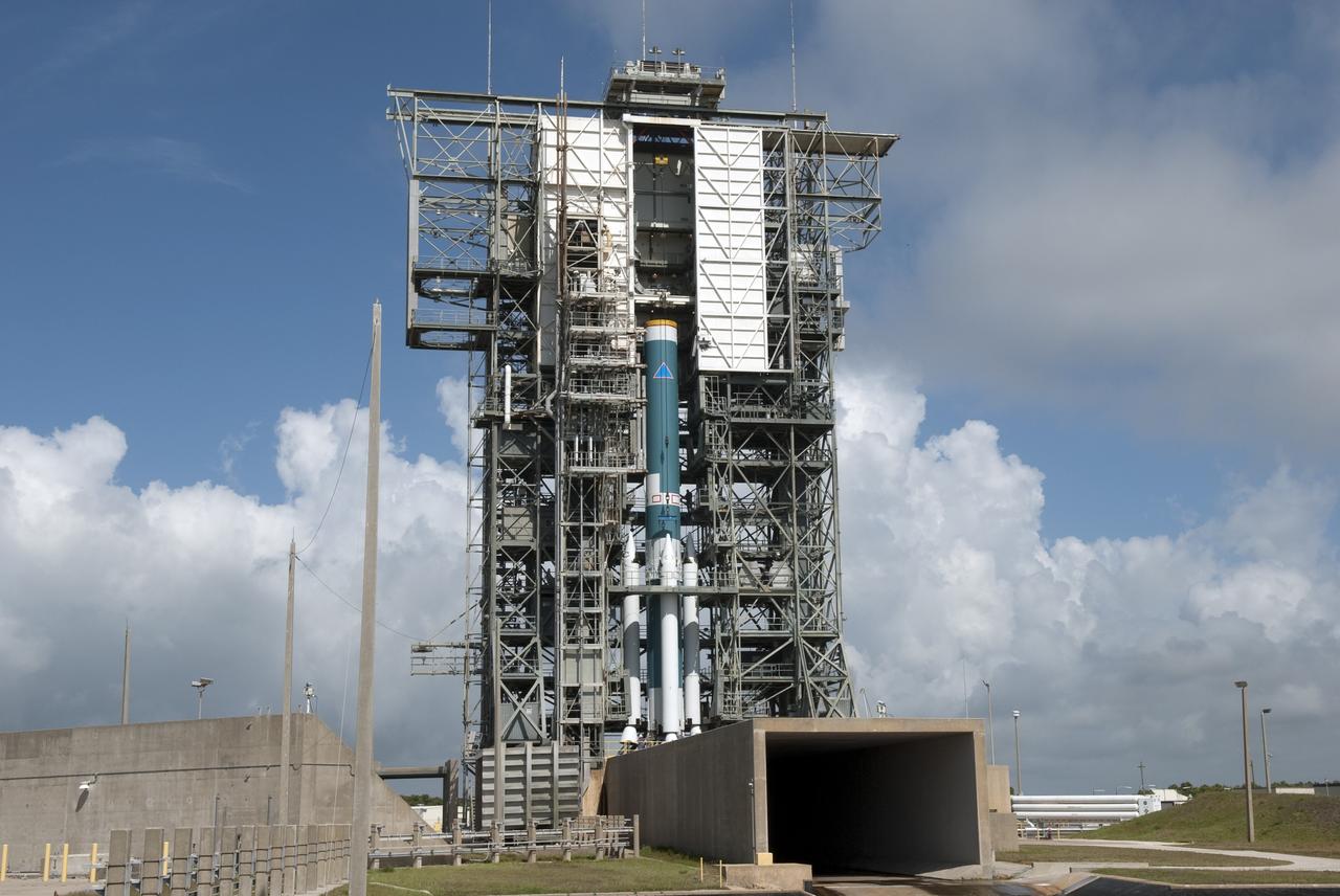
At Launch Pad 36A, Cape Canaveral Air Station, a Centaur upper stage is lifted up the gantry for mating with the lower stage Lockheed Martin Atlas IIA rocket already in place. The Lockheed Martin-manufactured Centaur IIA is powered by two Pratt & Whitney turbopump-fed engines, producing a total thrust of 41,600 pounds. The rocket is scheduled to launch the NASA GOES-L satellite on May 15, at the opening of a launch window which extends from 2:23 to 4:41 a.m. EDT. Once in orbit, the satellite will become GOES-11, joining GOES-8, GOES-9 and GOES-10 in space. The fourth of a new advanced series of geostationary weather satellites for the National Oceanic and Atmospheric Administration (NOAA), GOES-L is a three-axis inertially stabilized spacecraft that will provide pictures and perform atmospheric sounding at the same time. Once launched, the satellite will undergo checkout and then provide backup capabilities for the existing, aging operational satellites
At Cape Canaveral Air Station, workers begin offloading a Centaur upper stage from a U.S. Air Force C-5c. After being mated with the Atlas IIA lower stage, the rocket is scheduled to launch the NASA GOES-L satellite from Launch Pad 36A on May 15. Once in orbit, the satellite will become GOES-11, joining GOES-8, GOES-9 and GOES-10 in space. The fourth of a new advanced series of geostationary weather satellites for the National Oceanic and Atmospheric Administration (NOAA), GOES-L is a three-axis inertially stabilized spacecraft that will provide pictures and perform atmospheric sounding at the same time. Once launched, the satellite will undergo checkout and then provide backup capabilities for the existing, aging operational satellites
At Launch Pad 36A, Cape Canaveral Air Station, a Centaur upper stage is mated to the lower stage Lockheed Martin Atlas IIA rocket. The rocket is scheduled to launch the NASA GOES-L satellite on May 15, at the opening of a launch window which extends from 2:23 to 4:41 a.m. EDT. Once in orbit, the satellite will become GOES-11, joining GOES-8, GOES-9 and GOES-10 in space. The fourth of a new advanced series of geostationary weather satellites for the National Oceanic and Atmospheric Administration (NOAA), GOES-L is a three-axis inertially stabilized spacecraft that will provide pictures and perform atmospheric sounding at the same time. Once launched, the satellite will undergo checkout and then provide backup capabilities for the existing, aging operational satellites
At Launch Pad 36A, Cape Canaveral Air Station, a Centaur upper stage is lifted up the gantry for mating with the lower stage Lockheed Martin Atlas IIA rocket seen behind it. The Lockheed Martin-manufactured Centaur IIA is powered by two Pratt & Whitney turbopump-fed engines, producing a total thrust of 41,600 pounds. The rocket is scheduled to launch the NASA GOES-L satellite on May 15, at the opening of a launch window which extends from 2:23 to 4:41 a.m. EDT. Once in orbit, the satellite will become GOES-11, joining GOES-8, GOES-9 and GOES-10 in space. The fourth of a new advanced series of geostationary weather satellites for the National Oceanic and Atmospheric Administration (NOAA), GOES-L is a three-axis inertially stabilized spacecraft that will provide pictures and perform atmospheric sounding at the same time. Once launched, the satellite will undergo checkout and then provide backup capabilities for the existing, aging operational satellites
At Cape Canaveral Air Station, workers secure a Centaur upper stage on a transporter after offloading it from a U.S. Air Force C-5c (right). After being mated with the Atlas IIA lower stage, the rocket is scheduled to launch the NASA GOES-L satellite from Launch Pad 36A on May 15. Once in orbit, the satellite will become GOES-11, joining GOES-8, GOES-9 and GOES-10 in space. The fourth of a new advanced series of geostationary weather satellites for the National Oceanic and Atmospheric Administration (NOAA), GOES-L is a three-axis inertially stabilized spacecraft that will provide pictures and perform atmospheric sounding at the same time. Once launched, the satellite will undergo checkout and then provide backup capabilities for the existing, aging operational satellites
At Cape Canaveral Air Station (CCAS), workers help guide the crane lifting a Centaur upper stage onto a transporter. The Centaur arrived at CCAS aboard a U.S. Air Force C-5c (far left). After being mated with the Atlas IIA lower stage, the rocket is scheduled to launch the NASA GOES-L satellite from Launch Pad 36A on May 15. Once in orbit, the satellite will become GOES-11, joining GOES-8, GOES-9 and GOES-10 in space. The fourth of a new advanced series of geostationary weather satellites for the National Oceanic and Atmospheric Administration (NOAA), GOES-L is a three-axis inertially stabilized spacecraft that will provide pictures and perform atmospheric sounding at the same time. Once launched, the satellite will undergo checkout and then provide backup capabilities for the existing, aging operational satellites
At Launch Pad 36A, Cape Canaveral Air Station, a Centaur upper stage is moved into place above the lower stage Lockheed Martin Atlas IIA rocket. The Lockheed Martin-manufactured Centaur IIA is powered by two Pratt & Whitney turbopump-fed engines, producing a total thrust of 41,600 pounds. The rocket is scheduled to launch the NASA GOES-L satellite on May 15, at the opening of a launch window which extends from 2:23 to 4:41 a.m. EDT. Once in orbit, the satellite will become GOES-11, joining GOES-8, GOES-9 and GOES-10 in space. The fourth of a new advanced series of geostationary weather satellites for the National Oceanic and Atmospheric Administration (NOAA), GOES-L is a three-axis inertially stabilized spacecraft that will provide pictures and perform atmospheric sounding at the same time. Once launched, the satellite will undergo checkout and then provide backup capabilities for the existing, aging operational satellites
At Cape Canaveral Air Station, workers secure an Atlas IIA rocket on a transporter after offloading it from a U.S. Air Force C-5c (left). The rocket is scheduled to launch the NASA GOES-L satellite from Launch Pad 36A on May 15. Once in orbit, the satellite will become GOES-11, joining GOES-8, GOES-9 and GOES-10 in space. The fourth of a new advanced series of geostationary weather satellites for the National Oceanic and Atmospheric Administration (NOAA), GOES-L is a three-axis inertially stabilized spacecraft that will provide pictures and perform atmospheric sounding at the same time. Once launched, the satellite will undergo checkout and then provide backup capabilities for the existing, aging operational satellites
With its prelaunch processing completed, the GOES-K advanced weather satellite awaits encapsulation in the Atlas 1 payload fairing, seen at left rear. GOES-K was prepared for launch at the Astrotech Space Operations LP facility in Titusville. GOES-K will be the third spacecraft to be launched in the advanced series of Geostationary Operational Environmental Satellites (GOES). The GOES satellites are owned and operated by the National Oceanic and Atmospheric Administration (NOAA); NASA manages the design, development and launch of the spacecraft. GOES-K is targeted for an <a href="http://www-pao.ksc.nasa.gov/kscpao/release/1997/63-97.htm">April 24 launch</a> aboard a Lockheed Martin Atlas 1 expendable launch vehicle (AC-79) from Launch Complex 36, Pad B, Cape Canaveral Air Station. The launch window opens at 1:50 a.m. and extends to 3:09 a.m. EDT. Once in orbit, GOES-K will become GOES-10, joining GOES-8 and GOES-9 in space
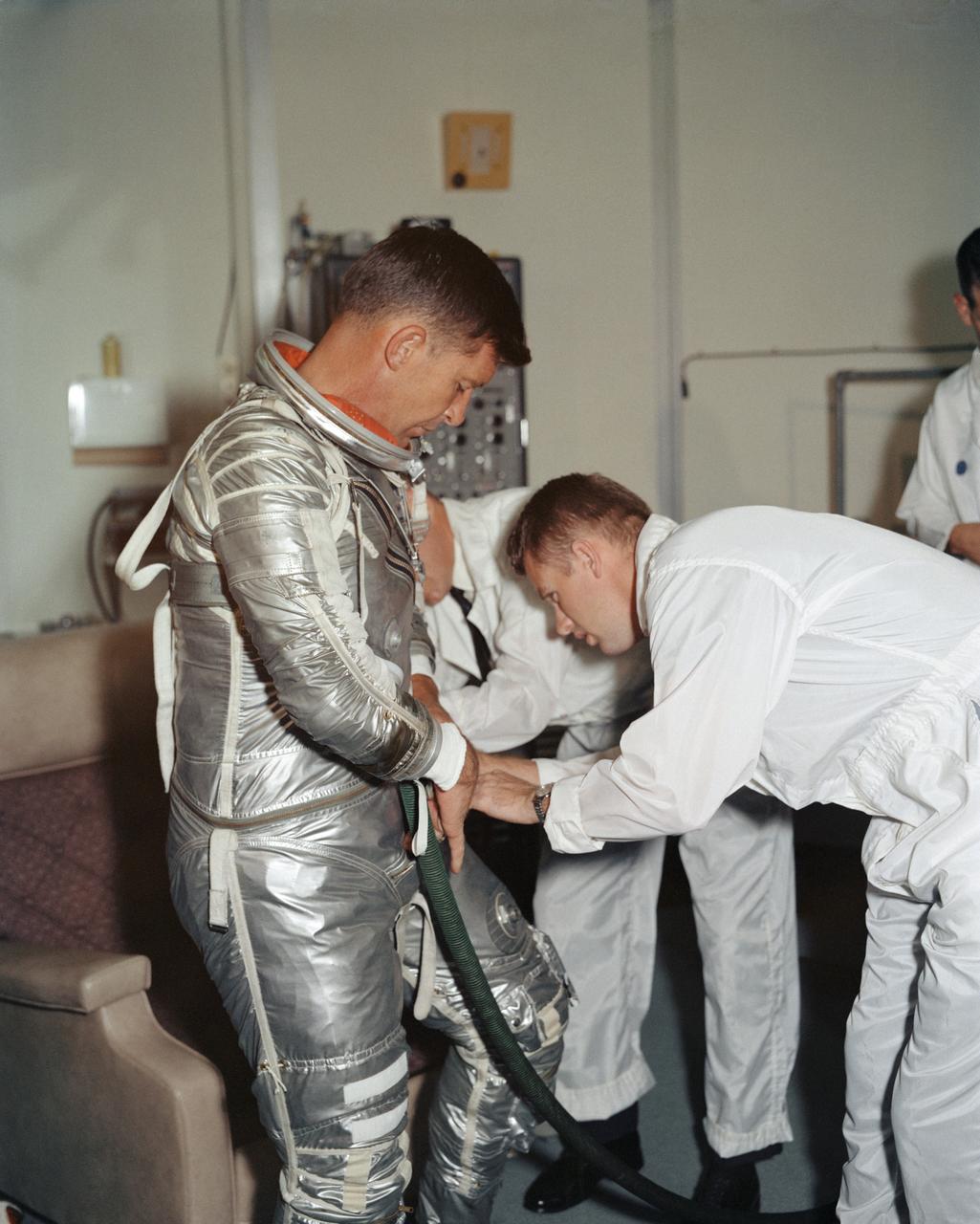
S62-08895 (1962) --- Astronaut Walter M. Schirra Jr., pilot of the Mercury-Atlas 8 (MA-8) Earth-orbital spaceflight, goes through a suiting-up exercise in Hangar "S" at Cape Canaveral several weeks prior to his scheduled Oct. 3, 1962 flight. Photo credit: NASA
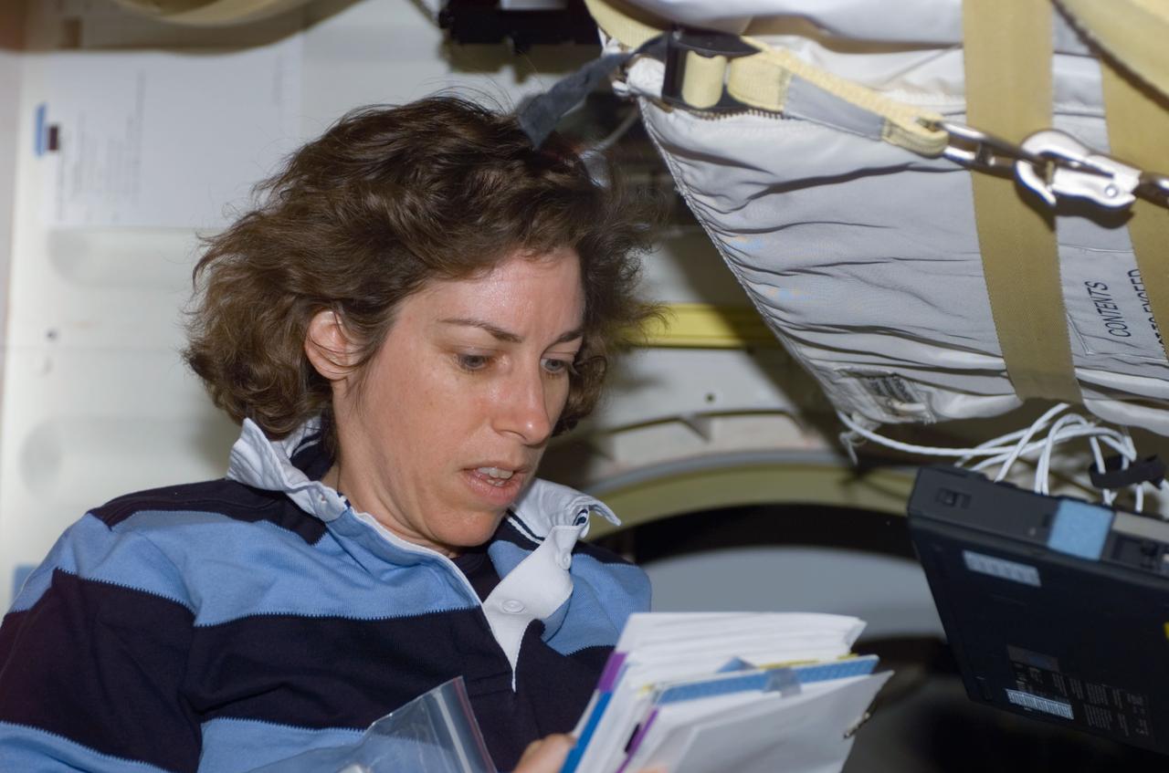
S110-E-5010 (8 April 2002) --- Astronaut Ellen Ochoa, STS-110 mission specialist, goes over a procedures checklist on the mid deck of the Space Shuttle Atlantis. The image was taken with at digital still camera.
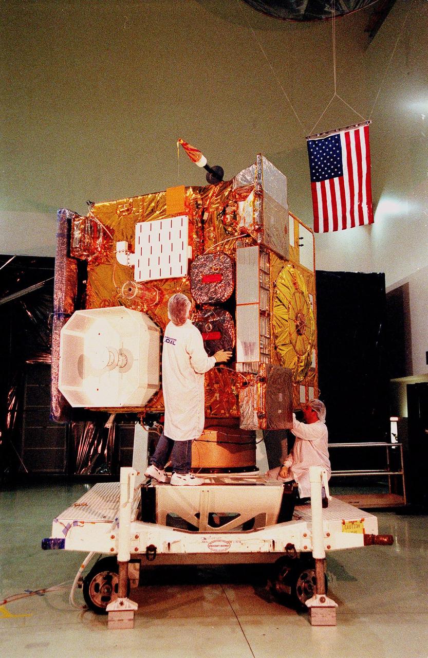
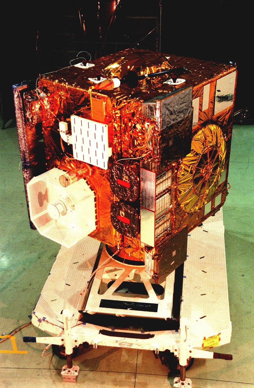
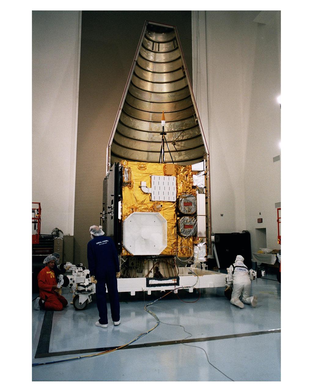
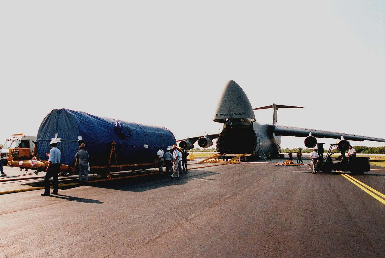
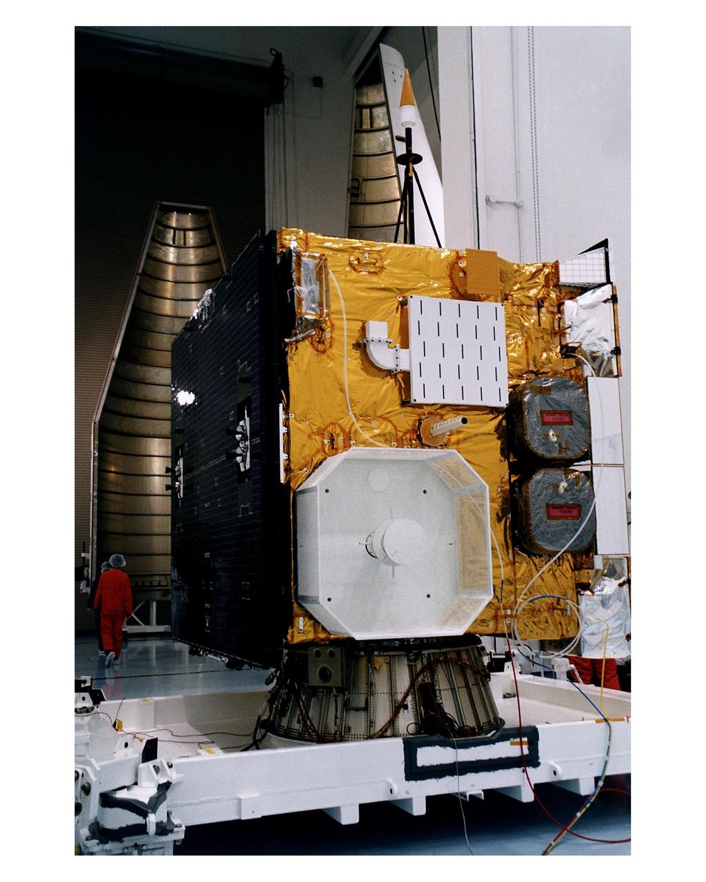
The GOES-L weather satellite sits on a workstand at Astrotech, Titusville, Fla., ready to be encapsulated for its transfer to Launch Pad 36A, Cape Canaveral Air Station. On the left side is the folded, two-panel solar array; on the adjoining side is a white box, which is the UHF antenna. Above the box is the S-band transmit antenna and receive antenna. Between them protrudes a search and rescue antenna. At right are the sounder (top) and imager (bottom). The mounted equipment on top of the unit is a telemetry and command antenna. The GOES is scheduled for launch aboard a Lockheed Martin Atlas II rocket later in May. The fourth of a new advanced series of geostationary weather satellites for the National Oceanic and Atmospheric Administration (NOAA), GOES-L is a three-axis inertially stabilized spacecraft that will provide pictures and perform atmospheric sounding at the same time. After it is launched, the satellite will undergo checkout and then provide backup capabilities for the existing, aging operational satellites. Once in orbit, the satellite will become GOES-11, joining GOES-8, GOES-9 and GOES-10 in space
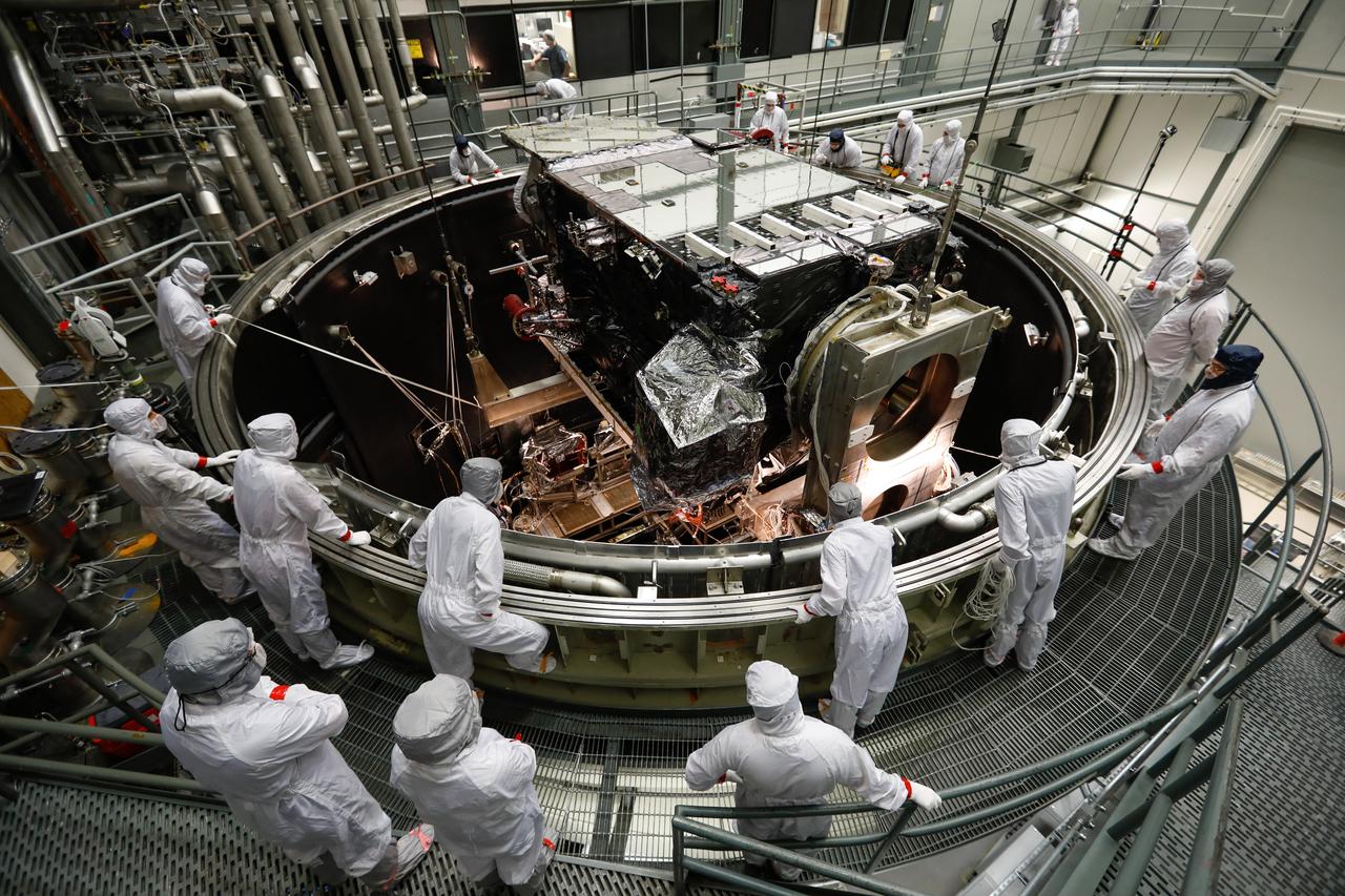
In March, NOAA's Geostationary Operational Environmental Satellite-S (GOES-S) satellite was lifted into a thermal vacuum chamber to test its ability to function in the cold void of space in its orbit 22,300 miles above the Earth. The most complicated and challenging test is thermal vacuum where a satellite experiences four cycles of extreme cold to extreme heat in a giant vacuum chamber. To simulate the environment of space, the chamber is cooled to below minus 100 degrees Celsius or minus 148 degrees Fahrenheit and air is pumped out. The test simulates the temperature changes GOES-S will encounter in space, as well as worst case scenarios of whether the instruments can come back to life in case of a shut down that exposes them to even colder temperatures. In this photo from March 8, the GOES-S satellite was lowered into the giant vacuum chamber at Lockheed Martin Space Systems, Denver, Colorado. GOES-S will be in the thermal vacuum chamber for 45 days. As of March 30, two of four thermal cycles were complete. GOES-S is the second in the GOES-R series. The GOES-R program is a collaborative development and acquisition effort between the National Oceanic and Atmospheric Administration and NASA. The GOES-R series of satellites will help meteorologists observe and predict local weather events, including thunderstorms, tornadoes, fog, flash floods, and other severe weather. In addition, GOES-R will monitor hazards such as aerosols, dust storms, volcanic eruptions, and forest fires and will also be used for space weather, oceanography, climate monitoring, in-situ data collection, and for search and rescue. Credit: Lockheed Martin <b><a href="http://www.nasa.gov/audience/formedia/features/MP_Photo_Guidelines.html" rel="nofollow">NASA image use policy.</a></b> <b><a href="http://www.nasa.gov/centers/goddard/home/index.html" rel="nofollow">NASA Goddard Space Flight Center</a></b> enables NASA’s mission through four scientific endeavors: Earth Science, Heliophysics, Solar System Exploration, and Astrophysics. Goddard plays a leading role in NASA’s accomplishments by contributing compelling scientific knowledge to advance the Agency’s mission. <b>Follow us on <a href="http://twitter.com/NASAGoddardPix" rel="nofollow">Twitter</a></b> <b>Like us on <a href="http://www.facebook.com/pages/Greenbelt-MD/NASA-Goddard/395013845897?ref=tsd" rel="nofollow">Facebook</a></b> <b>Find us on <a href="http://instagrid.me/nasagoddard/?vm=grid" rel="nofollow">Instagram</a></b>
STS083-317-009 (4-8 April 1997) --- Astronaut Susan L. Still, pilot, goes over a checklist at the control panel on the aft flight deck of the Earth-orbiting Space Shuttle Columbia. Scheduled originally as a 16-day mission, the Microgravity Sciences Laboratory (MSL-1) flight completed about one-fourth of its manifest time frame prior to being cut short by a power shortage.
STS083-448-025 (8 April 1997) --- Partially suited in the partial-pressure launch and entry garment, astronaut James D. Halsell, Jr., mission commander, goes over a checklist prior to entry. Halsell, along with four other NASA astronauts and two payload specialists supporting the Microgravity Sciences Laboratory (MSL-1) mission were less than a fourth of the way through a scheduled 16-day flight when a power problem cut short their planned stay.
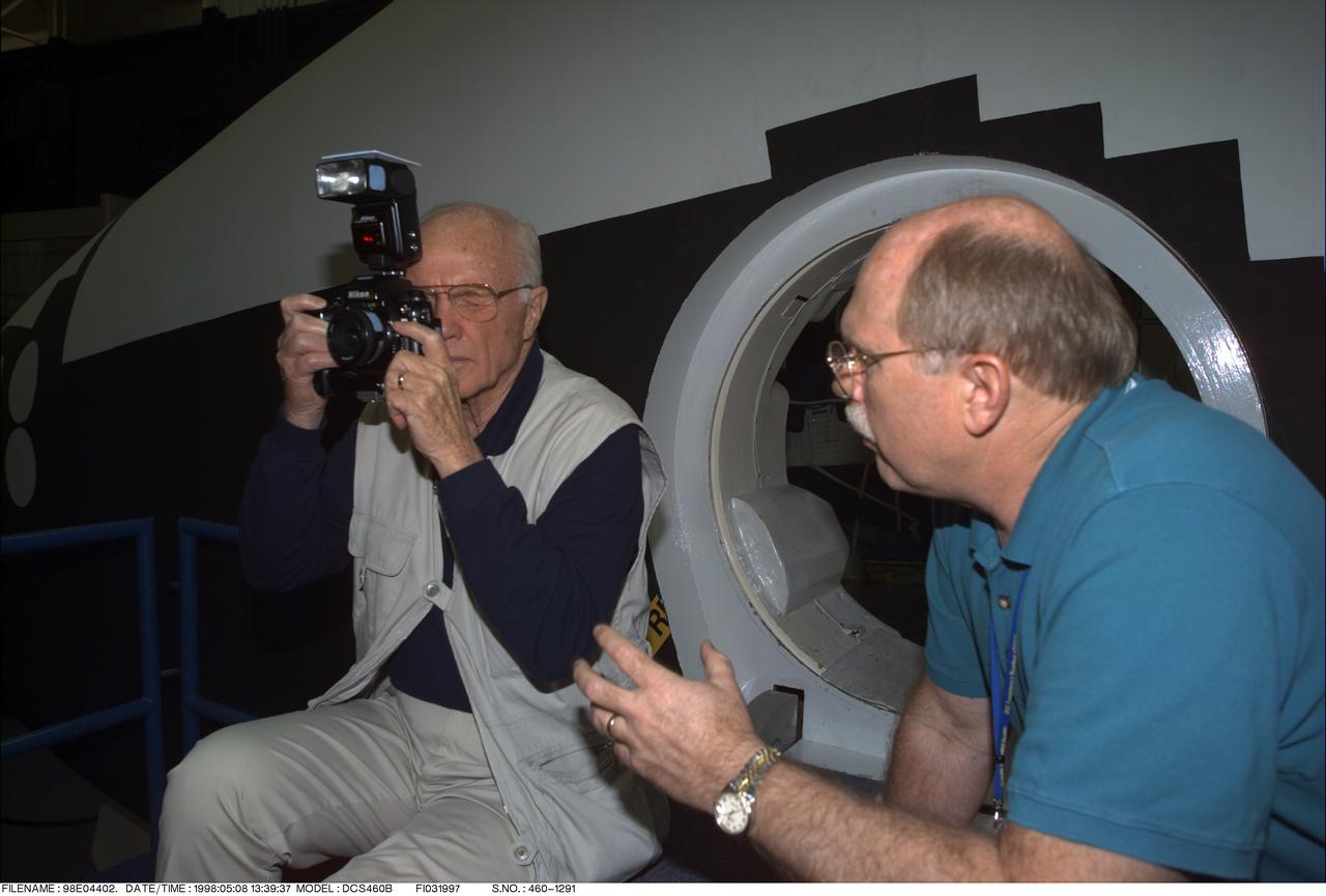
98-E-04402 (8 May 1998) --- Photo/TV instructor Donald Carico, right, goes over some fine points of using a 35mm camera with U.S. Sen. John H. Glenn Jr., (D.-Ohio). Glenn, who made America's first orbital flight over 36 years ago, is in Houston to train for his assignment as a payload specialist aboard the Space Shuttle Discovery later this year.

GOES 11 satellite image showing earth on March 26, 2010 8:00 AM EDT. <b><a href="http://goes.gsfc.nasa.gov/" rel="nofollow">Credit: NOAA/NASA GOES Project</a><b> <b><a href="http://www.nasa.gov/centers/goddard/home/index.html" rel="nofollow">NASA Goddard Space Flight Center</a></b> is home to the nation's largest organization of combined scientists, engineers and technologists that build spacecraft, instruments and new technology to study the Earth, the sun, our solar system, and the universe. <b>Follow us on <a href="http://twitter.com/NASA_GoddardPix" rel="nofollow">Twitter</a></b> <b>Join us on <a href="http://www.facebook.com/pages/Greenbelt-MD/NASA-Goddard/395013845897?ref=tsd" rel="nofollow">Facebook</a></b></b></b>
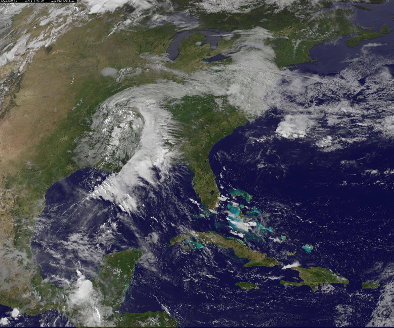
A "backdoor cold front" is bringing April temperatures to the U.S. northeast and Mid-Atlantic today, May 29. The backdoor cold front brings relief to the Mid-Atlantic after temperatures in Washington, D.C. hit 92F on Tuesday, May 27 and 88F on Wednesday, May 28 at Reagan National Airport, according to the National Weather Service (NWS). NWS forecasters expect the high temperature for May 29 to only reach 60F in the District of Columbia. NOAA's GOES-East satellite captured a view of the clouds associated with the backdoor cold front that stretch from southern Illinois to North Carolina. The National Weather Service forecast expects the backdoor cold front to bring showers to the Midwest, Northeast, and Mid-Atlantic today, May 29. According to the National Oceanic and Atmospheric Administration, a backdoor cold front is a cold front moving south or southwest along the Atlantic seaboard and Great Lakes; these are especially common during the spring months. This visible image was taken by NOAA's GOES-East satellite on May 29 at 12:30 UTC (8:30 a.m. EDT). The image was created at NASA/NOAA's GOES Project at NASA's Goddard Space Flight Center in Greenbelt, Maryland. In addition to the backdoor cold front clouds, the GOES-East image shows clouds circling around a low pressure area located in eastern Texas. That low pressure area is expected to bring rain from Texas eastward over the southeastern U.S. According to NOAA's National Weather Service, the slow-moving low pressure area in the Deep South "will bring heavy showers and thunderstorms from Louisiana to Alabama through Thursday. This area is already saturated from previous rainfall, so flash flooding will be possible." Image: NASA/NOAA GOES Project Caption: NASA Goddard/Rob Gutro

This image from NOAA's GOES satellite shows the swaths of snow across the Midwest after the weekend storms (December 7 and 8) there. This visible image was captured at 1745 UTC/12:45 p.m. EST on December 10, 2013. The riverine topography is highlighted by the snowfall, and the forested Ozarks appear as a dark patch west of St. Louis, Missouri. The image was created by NASA's GOES Project at NASA's Goddard Space Flight Center in Greenbelt, Md. For more information about GOES, visit: <a href="http://www.nasa.gov/goes" rel="nofollow">www.nasa.gov/goes</a>. Credit: NASA Goddard/Dennis Chesters <b><a href="http://www.nasa.gov/audience/formedia/features/MP_Photo_Guidelines.html" rel="nofollow">NASA image use policy.</a></b> <b><a href="http://www.nasa.gov/centers/goddard/home/index.html" rel="nofollow">NASA Goddard Space Flight Center</a></b> enables NASA’s mission through four scientific endeavors: Earth Science, Heliophysics, Solar System Exploration, and Astrophysics. Goddard plays a leading role in NASA’s accomplishments by contributing compelling scientific knowledge to advance the Agency’s mission. <b>Follow us on <a href="http://twitter.com/NASA_GoddardPix" rel="nofollow">Twitter</a></b> <b>Like us on <a href="http://www.facebook.com/pages/Greenbelt-MD/NASA-Goddard/395013845897?ref=tsd" rel="nofollow">Facebook</a></b> <b>Find us on <a href="http://instagram.com/nasagoddard?vm=grid" rel="nofollow">Instagram</a></b>
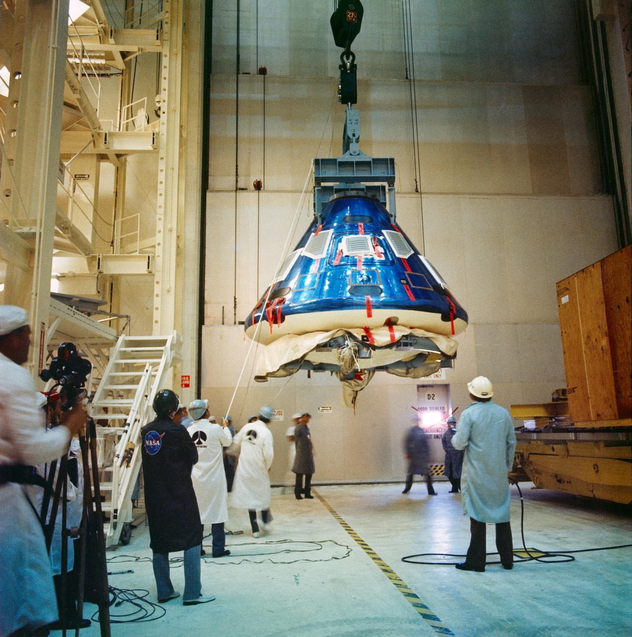
S74-32049 (8 Sept. 1974) --- The Apollo Command Module for the Apollo-Soyuz Test Project mission goes through receiving, inspection and checkout procedures in the Manned Spacecraft Operations Building at the Kennedy Space Center. The spacecraft had just arrived by air from the Rockwell International plant at Downey, California. The Apollo spacecraft (Command Module, Service Module and Docking Module), with astronauts Thomas P. Stafford, Vance D. Brand and Donald K. Slayton aboard, will dock in Earth orbit with a Soviet Soyuz spacecraft during the joint U.S.-USSR ASTP flight scheduled for July 1975. The Soviet and American crews will visit one another?s spacecraft.
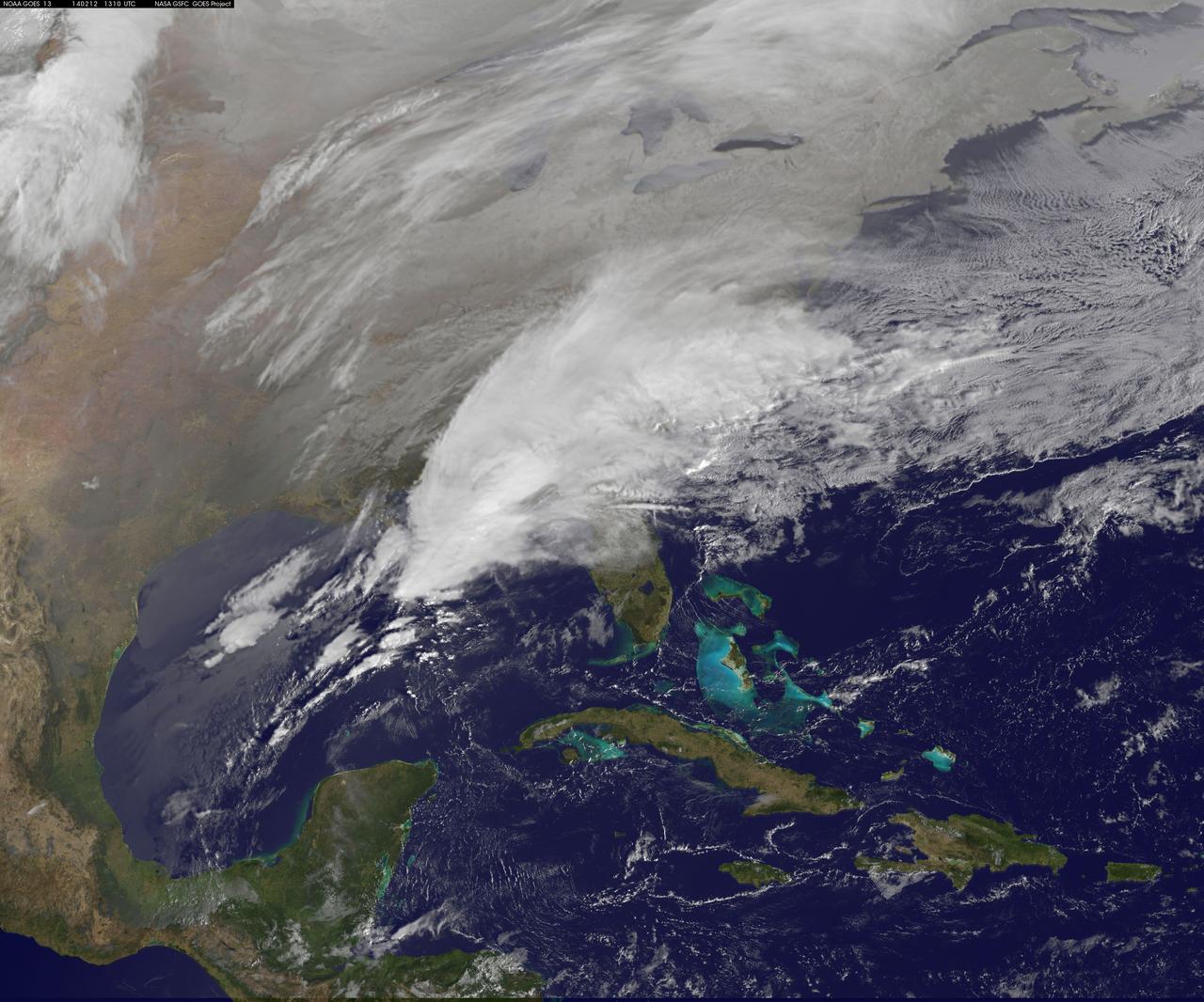
Clouds associated with the major winter storm that is bringing wintry precipitation and chilly temperatures to the U.S. south is the focus in an image from NOAA's GOES-East satellite today, February 12 at 1310 UTC/ 8:10 EST. Rain, freezing rain, sleet and snow are part of the large front that stretches from eastern Texas to the Carolinas in the Geostationary Operational Environmental satellite or GOES image. NOAA's weather maps show several areas of low pressure along the frontal boundary. One low pressure is in the northern Gulf of Mexico, while the other is in the Atlantic Ocean, just south of South Carolina. (Insert link: <a href="http://www.hpc.ncep.noaa.gov/noaa/noaad1.gif" rel="nofollow">www.hpc.ncep.noaa.gov/noaa/noaad1.gif</a>). NOAA's National Weather Service has been issuing watches and warnings throughout the south that extend along Mid-Atlantic east coast. The visible cloud and ground snow data in this image was taken from NOAA's GOES-East satellite. The image was created by the NASA GOES Project at NASA's Goddard Space Flight Center in Greenbelt, Md. The clouds and fallen snow were overlaid on a true-color image of land and ocean created by data from the Moderate Resolution Imaging Spectroradiometer or MODIS instrument that flies aboard NASA's Aqua and Terra satellites. NOAA's Weather Prediction Center, or WPC noted on Feb. 11 at 3:59 a.m. EST, "Once the intensifying surface low moves off the Southeast coast and begins its track up the Eastern Seaboard Wednesday night...winter weather will start lifting northward into the northern Mid-Atlantic states." GOES satellites provide the kind of continuous monitoring necessary for intensive data analysis. Geostationary describes an orbit in which a satellite is always in the same position with respect to the rotating Earth. This allows GOES to hover continuously over one position on Earth's surface, appearing stationary. As a result, GOES provide a constant vigil for the atmospheric "triggers" for severe weather conditions such as tornadoes, flash floods, hail storms and hurricanes. For updated information about the storm system, visit NOAA's WPC website; <a href="http://www.hpc.ncep.noaa.gov/" rel="nofollow">www.hpc.ncep.noaa.gov/</a> For more information about GOES satellites, visit: <a href="http://www.goes.noaa.gov/" rel="nofollow">www.goes.noaa.gov/</a> or <a href="http://goes.gsfc.nasa.gov/" rel="nofollow">goes.gsfc.nasa.gov/</a> Rob Gutro NASA's Goddard Space Flight Center <b><a href="http://www.nasa.gov/audience/formedia/features/MP_Photo_Guidelines.html" rel="nofollow">NASA image use policy.</a></b> <b><a href="http://www.nasa.gov/centers/goddard/home/index.html" rel="nofollow">NASA Goddard Space Flight Center</a></b> enables NASA’s mission through four scientific endeavors: Earth Science, Heliophysics, Solar System Exploration, and Astrophysics. Goddard plays a leading role in NASA’s accomplishments by contributing compelling scientific knowledge to advance the Agency’s mission. <b>Follow us on <a href="http://twitter.com/NASAGoddardPix" rel="nofollow">Twitter</a></b> <b>Like us on <a href="http://www.facebook.com/pages/Greenbelt-MD/NASA-Goddard/395013845897?ref=tsd" rel="nofollow">Facebook</a></b> <b>Find us on <a href="http://instagram.com/nasagoddard?vm=grid" rel="nofollow">Instagram</a></b>
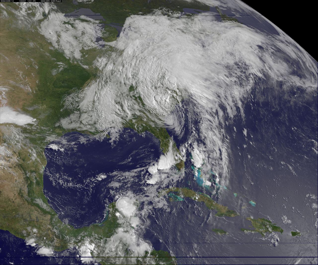
This image of tropical storm Andrea was assembled from data collected by NOAA's GOES-14 satellite at 8:31 a.m. EDT on June 7, when the storm's center was about 35 miles north-northwest of Charleston, S.C. Credit: NASA/NOAA GOES Project <b><a href="http://www.nasa.gov/audience/formedia/features/MP_Photo_Guidelines.html" rel="nofollow">NASA image use policy.</a></b> <b><a href="http://www.nasa.gov/centers/goddard/home/index.html" rel="nofollow">NASA Goddard Space Flight Center</a></b> enables NASA’s mission through four scientific endeavors: Earth Science, Heliophysics, Solar System Exploration, and Astrophysics. Goddard plays a leading role in NASA’s accomplishments by contributing compelling scientific knowledge to advance the Agency’s mission. <b>Follow us on <a href="http://twitter.com/NASA_GoddardPix" rel="nofollow">Twitter</a></b> <b>Like us on <a href="http://www.facebook.com/pages/Greenbelt-MD/NASA-Goddard/395013845897?ref=tsd" rel="nofollow">Facebook</a></b> <b>Find us on <a href="http://instagram.com/nasagoddard?vm=grid" rel="nofollow">Instagram</a></b>
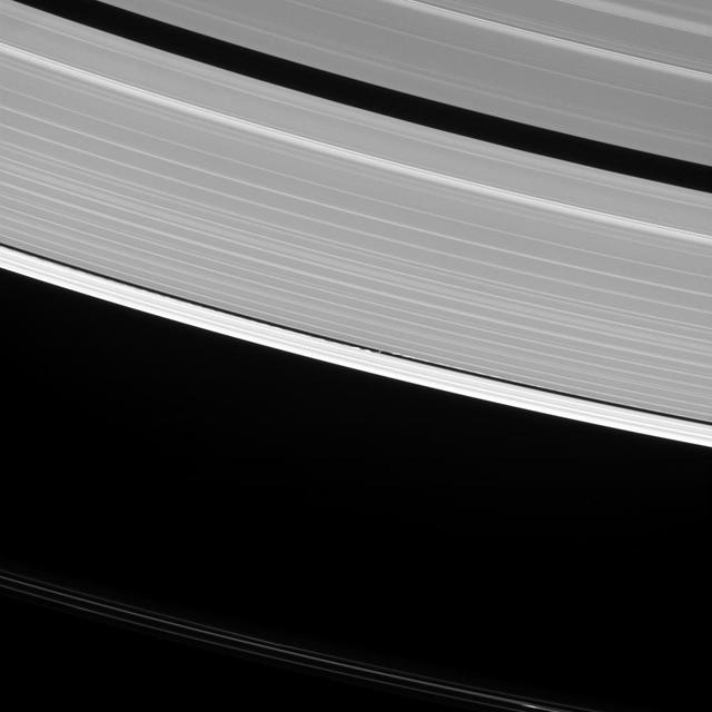
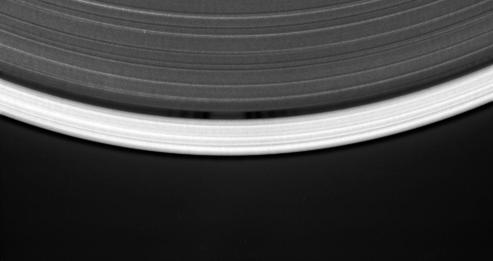
Saturn's moon Daphnis raises waves wherever it goes. In fact, such waves are one way that scientists search for undiscovered moons in the ring gaps. But they can tell researchers a lot of other things, as well. The waves that Daphnis (5 miles or 8 kilometers across) raises on the edges of the Keeler Gap can also be used to deduce the moon's mass and even some of its orbital behavior. Since the moon moves in and out of the ring-plane, and closer to and farther from the rings' edges as it orbits, the waves it makes change over time. Cassini has been observing these changes during its extended study of the Saturn system to help understand this interaction. This view looks toward the sunlit side of the rings from about 35 degrees above the ring plane. The image was taken in visible light with the Cassini spacecraft narrow-angle camera on Oct. 10, 2016. Daphnis has been brightened by a factor of two in this image to increase its visibility. The view was obtained at a distance of approximately 810,000 miles (1.3 million kilometers) from Daphnis and at a Sun-Daphnis-spacecraft, or phase, angle of 96 degrees. Image scale is 5 miles (8 kilometers) per pixel. http://photojournal.jpl.nasa.gov/catalog/PIA20511
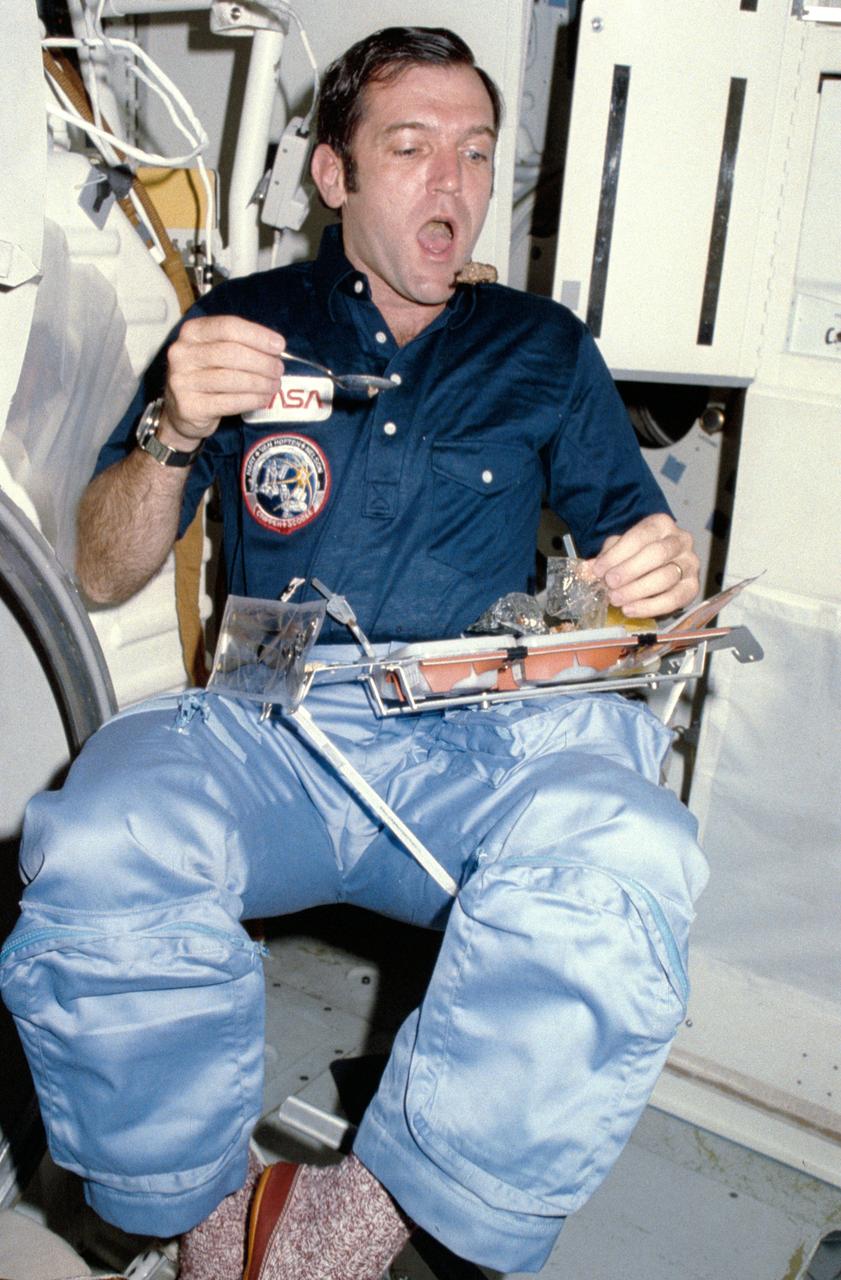
Candid views of the STS-41C crew preparing and eating food on the middeck include : Mission pilot Francis R. (Dick) Scobee goes bobbing for a morsel of food from his position on the middeck near the galley.
This NOAA GOES-East satellite animation shows the development of System 91L into Tropical Storm Andrea over the course of 3 days from June 4 to June 6, just after Andrea was officially designated a tropical storm. Credit: NASA's GOES Project --- NASA Sees Heavy Rainfall in Tropical Storm Andrea NASA’s TRMM satellite passed over Tropical Storm Andrea right after it was named, while NASA’s Terra satellite captured a visible image of the storm’s reach hours beforehand. TRMM measures rainfall from space and saw that rainfall rates in the southern part of the storm was falling at almost 5 inches per hour. NASA’s Terra satellite passed over Tropical Storm Andrea on June 5 at 16:25 UTC (12:25 p.m. EDT) and the Moderate Resolution Imaging Spectroradiometer or MODIS instrument, captured a visible image of the storm. At that time, Andrea’s clouds had already extended over more than half of Florida. At 8 p.m. EDT on Wednesday, June 5, System 91L became the first tropical storm of the Atlantic Ocean hurricane season. Tropical Storm Andrea was centered near 25.5 North and 86.5 West, about 300 miles (485 km) southwest of Tampa, Fla. At the time Andrea intensified into a tropical storm, its maximum sustained winds were near 40 mph (65 kph). Full updates can be found at NASA's Hurricane page: <a href="http://www.nasa.gov/hurricane" rel="nofollow">www.nasa.gov/hurricane</a> Rob Gutro NASA’s Goddard Space Flight Center
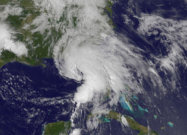
NOAA's GOES-East satellite captured this visible image of Hurricane Joaquin east of the Bahamas on Sept. 30 at 1745 UTC (1:45 p.m. EDT). Credit: NASA/NOAA GOES Project At 11 a.m. EDT (1500 UTC) on Wednesday, September 30, 2015 the center of Hurricane Joaquin was located near latitude 24.7 North, longitude 72.6 West. That puts the center of Joaquin about 215 miles (345 km) east-northeast of the Central Bahamas. Joaquin became a tropical storm Monday evening (EDT), September 29 when it was midway between the Bahamas and Bermuda. By 8 a.m. EDT on September 30, it strengthened into a hurricane and has become the third hurricane of the Atlantic Hurricane season. On September 30, the National Hurricane Center issued a Hurricane Warning for the central Bahamas including Cat Island, the Exumas, Long Island, Rum Cay, and San Salvador. A Hurricane Watch is in effect for the northwestern Bahamas including the Abacos, Berry Islands, Bimini, Eleuthera, Grand Bahama Island, and New Providence, but excluding Andros Island. <b><a href="http://www.nasa.gov/audience/formedia/features/MP_Photo_Guidelines.html" rel="nofollow">NASA image use policy.</a></b> <b><a href="http://www.nasa.gov/centers/goddard/home/index.html" rel="nofollow">NASA Goddard Space Flight Center</a></b> enables NASA’s mission through four scientific endeavors: Earth Science, Heliophysics, Solar System Exploration, and Astrophysics. Goddard plays a leading role in NASA’s accomplishments by contributing compelling scientific knowledge to advance the Agency’s mission. <b>Follow us on <a href="http://twitter.com/NASAGoddardPix" rel="nofollow">Twitter</a></b> <b>Like us on <a href="http://www.facebook.com/pages/Greenbelt-MD/NASA-Goddard/395013845897?ref=tsd" rel="nofollow">Facebook</a></b> <b>Find us on <a href="http://instagrid.me/nasagoddard/?vm=grid" rel="nofollow">Instagram</a></b>
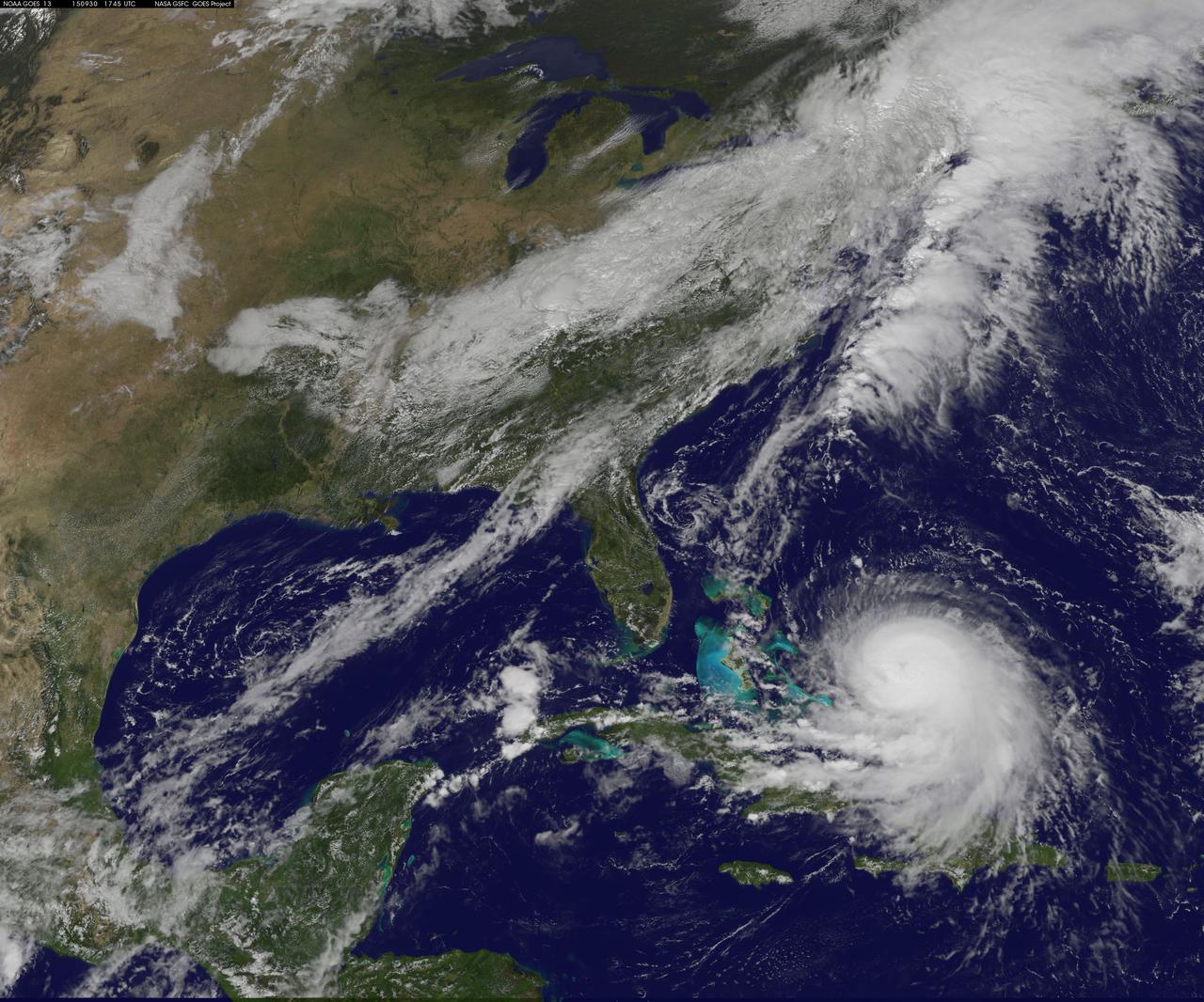
NOAA's GOES-East satellite captured this visible image of Hurricane Joaquin east of the Bahamas on Sept. 30 at 1745 UTC (1:45 p.m. EDT). Credit: NASA/NOAA GOES Project At 11 a.m. EDT (1500 UTC) on Wednesday, September 30, 2015 the center of Hurricane Joaquin was located near latitude 24.7 North, longitude 72.6 West. That puts the center of Joaquin about 215 miles (345 km) east-northeast of the Central Bahamas. Joaquin became a tropical storm Monday evening (EDT), September 29 when it was midway between the Bahamas and Bermuda. By 8 a.m. EDT on September 30, it strengthened into a hurricane and has become the third hurricane of the Atlantic Hurricane season. On September 30, the National Hurricane Center issued a Hurricane Warning for the central Bahamas including Cat Island, the Exumas, Long Island, Rum Cay, and San Salvador. A Hurricane Watch is in effect for the northwestern Bahamas including the Abacos, Berry Islands, Bimini, Eleuthera, Grand Bahama Island, and New Providence, but excluding Andros Island. <b><a href="http://www.nasa.gov/audience/formedia/features/MP_Photo_Guidelines.html" rel="nofollow">NASA image use policy.</a></b> <b><a href="http://www.nasa.gov/centers/goddard/home/index.html" rel="nofollow">NASA Goddard Space Flight Center</a></b> enables NASA’s mission through four scientific endeavors: Earth Science, Heliophysics, Solar System Exploration, and Astrophysics. Goddard plays a leading role in NASA’s accomplishments by contributing compelling scientific knowledge to advance the Agency’s mission. <b>Follow us on <a href="http://twitter.com/NASAGoddardPix" rel="nofollow">Twitter</a></b> <b>Like us on <a href="http://www.facebook.com/pages/Greenbelt-MD/NASA-Goddard/395013845897?ref=tsd" rel="nofollow">Facebook</a></b> <b>Find us on <a href="http://instagrid.me/nasagoddard/?vm=grid" rel="nofollow">Instagram</a></b>
CAPE CANAVERAL, Fla. -- A United Launch Alliance Delta II goes through preparations at Launch Complex 17-B at Cape Canaveral Air Force Station in Florida. The first set of three solid-fueled boosters were lifted and positioned for attachment to the rocket's first stage. The boosters are being attached to the rocket at Launch Complex 17-B at Cape Canaveral Air Force Station in Florida. The Delta II will carry NASA's Gravity Recovery and Interior Laboratory, or GRAIL, spacecraft into lunar orbit. The GRAIL mission is a part of NASA's Discovery Program. GRAIL will fly twin spacecraft in tandem orbits around the moon for several months to measure its gravity field. The mission also will answer longstanding questions about Earth's moon and provide scientists a better understanding of how Earth and other rocky planets in the solar system formed. GRAIL is scheduled to launch September 8, 2011. For more information visit: http://science.nasa.gov/missions/grail/. Photo credit: NASA/Jim Grossmann

Surging to take advantage of near-perfect launch conditions, NASA’s Scientific Balloon Team launched two balloons within 24 hours Sept. 27-28 from the Agency’s launch site at Fort Sumner, New Mexico. Clear, calm weather paved the way for launching a balloon technology test flight at 8:20 a.m. MDT, Sept. 28, via a 29.47 million-cubic-foot scientific balloon. Just less than 24 hours earlier, the balloon team launched the Jet Propulsion Laboratory (JPL) Remote payload via a 29.47-million-cubic-foot scientific balloon at 8:28 a.m. MDT, Sept. 27. Technicians successfully completed the JPL Remote mission at 10:28 p.m. MDT, Sept. 27, issuing flight termination commands to safely return the balloon material and payload back to Earth. “An enormous amount of planning, coordination, and labor goes into every balloon launch,” said Debbie Fairbrother, NASA’s Balloon Program Office chief. “To do two in a day’s time is nothing short of phenomenal work by an incredible team.” Read more: <a href="http://go.nasa.gov/2cLgslt" rel="nofollow">go.nasa.gov/2cLgslt</a> Credit: NASA/Wallops/Jeremy Eggers <b><a href="http://www.nasa.gov/audience/formedia/features/MP_Photo_Guidelines.html" rel="nofollow">NASA image use policy.</a></b> <b><a href="http://www.nasa.gov/centers/goddard/home/index.html" rel="nofollow">NASA Goddard Space Flight Center</a></b> enables NASA’s mission through four scientific endeavors: Earth Science, Heliophysics, Solar System Exploration, and Astrophysics. Goddard plays a leading role in NASA’s accomplishments by contributing compelling scientific knowledge to advance the Agency’s mission. <b>Follow us on <a href="http://twitter.com/NASAGoddardPix" rel="nofollow">Twitter</a></b> <b>Like us on <a href="http://www.facebook.com/pages/Greenbelt-MD/NASA-Goddard/395013845897?ref=tsd" rel="nofollow">Facebook</a></b> <b>Find us on <a href="http://instagrid.me/nasagoddard/?vm=grid" rel="nofollow">Instagram</a></b>
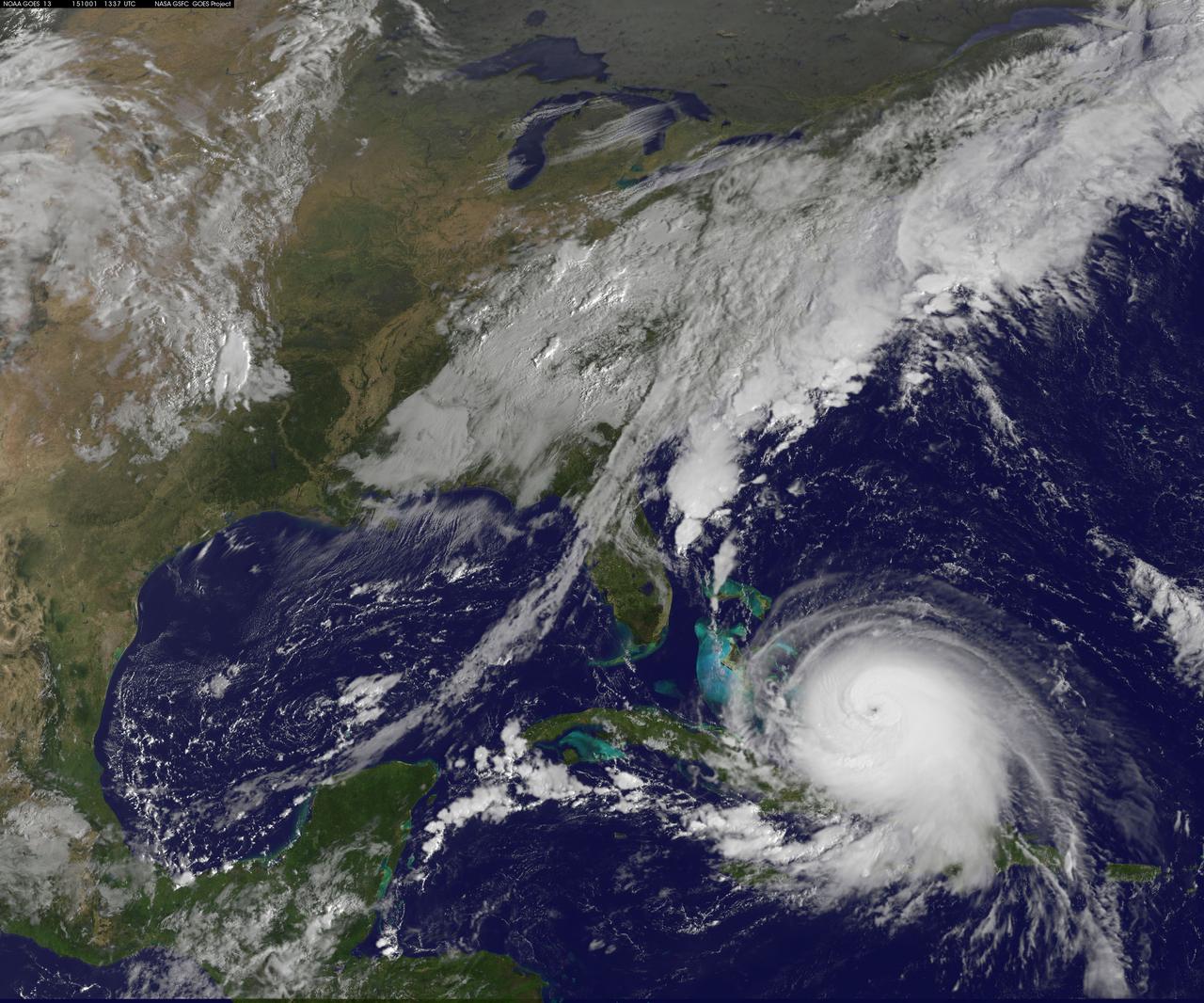
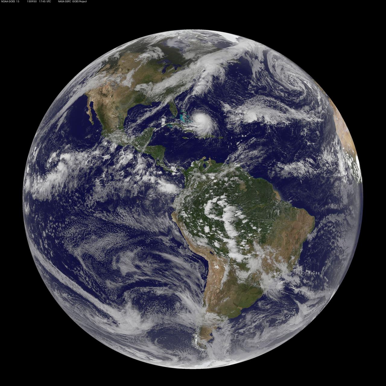
Hurricane Joaquin continued to intensify in the Bahamas on October 1 and NASA and NOAA satellites have been providing valuable data on the storm. NASA's GPM and Terra satellites and NOAA's GOES-East satellite provided rainfall, cloud extent, cloud height and other data to forecasters. Joaquin became a major hurricane today, October 1, reaching Category 3 status on the Saffir-Simpson Wind Scale. On October 1 at 1330 UTC (9:30 a.m. EDT) NOAA's GOES-East satellite captured this visible image of Hurricane Joaquin covering the southern Bahamas and extending over southeastern Cuba, and the island of Hispaniola (which includes Haiti and the Dominican Republic). Joaquin's eye had become completely visible now that the storm had reached Category 3 status. On October 1, a Hurricane Warning was in effect for the Central Bahamas, Northwestern Bahamas including the Abacos, Berry Islands, Eleuthera, Grand Bahama Island, and New Providence, The Acklins, Crooked Island, and Mayaguana in the southeastern Bahamas. A Hurricane Watch was in effect for Bimini and Andros Island, and a Tropical Storm Warning was in effect for the remainder of the southeastern Bahamas excluding the Turks and Caicos Islands and Andros Island. According to NHC, at 8 a.m. EDT (1200 UTC), the center of Hurricane Joaquin was located near latitude 23.2 North, longitude 73.7 West. That's just 10 miles (15 km) north of Samana Cays, Bahamas and about 75 miles (120 km) southeast of San Salvador, Bahamas. Joaquin was moving toward the west-southwest near 5 mph (7 kph), and this motion is expected to continue today. NHC noted that a turn toward the west- northwest is forecast tonight (Oct. 1), followed by a turn toward the north and an increase in forward speed on Friday, Oct. 2. On the forecast track, the center of Joaquin will move near or over portions of the central Bahamas today and tonight and pass near or over portions of the northwestern Bahamas on Friday. Maximum sustained winds are near 120 mph (195 km/h) with higher gusts. Joaquin is a category 3 hurricane on the Saffir-Simpson Hurricane Wind Scale. Some strengthening is forecast in the next day or so, with some fluctuations in intensity possible on Friday. Hurricane force winds extend outward up to 35 miles (55 km) from the center and tropical storm force winds extend outward up to 140 miles (220 km). The minimum central pressure just extrapolated by an Air Force Reserve Hurricane Hunter aircraft is 942 millibars. For updated forecasts, watches and warnings visit the National Hurricane Center (NHC) website: <a href="http://www.nhc.noaa.gov" rel="nofollow">www.nhc.noaa.gov</a>. Credit: NASA/NOAA GOES Project <b><a href="http://www.nasa.gov/audience/formedia/features/MP_Photo_Guidelines.html" rel="nofollow">NASA image use policy.</a></b> <b><a href="http://www.nasa.gov/centers/goddard/home/index.html" rel="nofollow">NASA Goddard Space Flight Center</a></b> enables NASA’s mission through four scientific endeavors: Earth Science, Heliophysics, Solar System Exploration, and Astrophysics. Goddard plays a leading role in NASA’s accomplishments by contributing compelling scientific knowledge to advance the Agency’s mission. <b>Follow us on <a href="http://twitter.com/NASAGoddardPix" rel="nofollow">Twitter</a></b> <b>Like us on <a href="http://www.facebook.com/pages/Greenbelt-MD/NASA-Goddard/395013845897?ref=tsd" rel="nofollow">Facebook</a></b> <b>Find us on <a href="http://instagrid.me/nasagoddard/?vm=grid" rel="nofollow">Instagram</a></b>
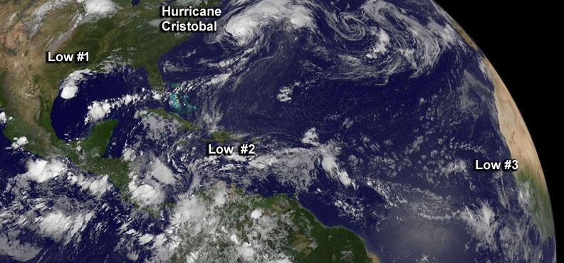
Although there's only one formed tropical cyclone in the Atlantic: Hurricane Cristobal, there are three other developing areas of low pressure and all were captured in this panoramic image from NOAA's GOES-East satellite today at 8 a.m. EDT. Cristobal is a hurricane located east of the U.S. East coast and is forecast to move up toward eastern Canada tonight (and stay off-shore). The image was made at NASA's GOES Project at NASA's Goddard Space Flight Center in Greenbelt, Maryland. Low #1. A weak area of low pressure near the coast of South Texas is producing disorganized showers and thunderstorms. Significant development of this system is unlikely before it moves inland over South Texas and northern Mexico today. It has a ten percent chance of development into a tropical depression in the next 2 days. Low #2. A tropical wave located over the eastern Caribbean Sea continues to produce disorganized cloudiness and showers. Upper-level winds are expected to remain unfavorable for development during the next couple of days while the system moves across the eastern and central Caribbean Sea. However, environmental conditions could become conducive for some development when the system moves over the northwestern Caribbean Sea on Sunday and into the southwestern Gulf of Mexico early next week. It has a near zero chance to develop in the next 2 days. Low #3. A tropical wave is forecast to move off the west coast of Africa on Friday. Environmental conditions could be conducive for some gradual development of this system while it moves westward at 10 to 15 mph across the eastern Atlantic early next week. This has a near zero chance of development in the next two days. <b><a href="http://www.nasa.gov/audience/formedia/features/MP_Photo_Guidelines.html" rel="nofollow">NASA image use policy.</a></b> <b><a href="http://www.nasa.gov/centers/goddard/home/index.html" rel="nofollow">NASA Goddard Space Flight Center</a></b> enables NASA’s mission through four scientific endeavors: Earth Science, Heliophysics, Solar System Exploration, and Astrophysics. Goddard plays a leading role in NASA’s accomplishments by contributing compelling scientific knowledge to advance the Agency’s mission. <b>Follow us on <a href="http://twitter.com/NASAGoddardPix" rel="nofollow">Twitter</a></b> <b>Like us on <a href="http://www.facebook.com/pages/Greenbelt-MD/NASA-Goddard/395013845897?ref=tsd" rel="nofollow">Facebook</a></b> <b>Find us on <a href="http://instagram.com/nasagoddard?vm=grid" rel="nofollow">Instagram</a></b>
Although there's only one formed tropical cyclone in the Atlantic: Hurricane Cristobal, there are three other developing areas of low pressure and all were captured in this panoramic image from NOAA's GOES-East satellite today at 8 a.m. EDT. Cristobal is a hurricane located east of the U.S. East coast and is forecast to move up toward eastern Canada tonight (and stay off-shore). The image was made at NASA's GOES Project at NASA's Goddard Space Flight Center in Greenbelt, Maryland. Low #1. A weak area of low pressure near the coast of South Texas is producing disorganized showers and thunderstorms. Significant development of this system is unlikely before it moves inland over South Texas and northern Mexico today. It has a ten percent chance of development into a tropical depression in the next 2 days. Low #2. A tropical wave located over the eastern Caribbean Sea continues to produce disorganized cloudiness and showers. Upper-level winds are expected to remain unfavorable for development during the next couple of days while the system moves across the eastern and central Caribbean Sea. However, environmental conditions could become conducive for some development when the system moves over the northwestern Caribbean Sea on Sunday and into the southwestern Gulf of Mexico early next week. It has a near zero chance to develop in the next 2 days. Low #3. A tropical wave is forecast to move off the west coast of Africa on Friday. Environmental conditions could be conducive for some gradual development of this system while it moves westward at 10 to 15 mph across the eastern Atlantic early next week. This has a near zero chance of development in the next two days. <b><a href="http://www.nasa.gov/audience/formedia/features/MP_Photo_Guidelines.html" rel="nofollow">NASA image use policy.</a></b> <b><a href="http://www.nasa.gov/centers/goddard/home/index.html" rel="nofollow">NASA Goddard Space Flight Center</a></b> enables NASA’s mission through four scientific endeavors: Earth Science, Heliophysics, Solar System Exploration, and Astrophysics. Goddard plays a leading role in NASA’s accomplishments by contributing compelling scientific knowledge to advance the Agency’s mission. <b>Follow us on <a href="http://twitter.com/NASAGoddardPix" rel="nofollow">Twitter</a></b> <b>Like us on <a href="http://www.facebook.com/pages/Greenbelt-MD/NASA-Goddard/395013845897?ref=tsd" rel="nofollow">Facebook</a></b> <b>Find us on <a href="http://instagram.com/nasagoddard?vm=grid" rel="nofollow">Instagram</a></b>
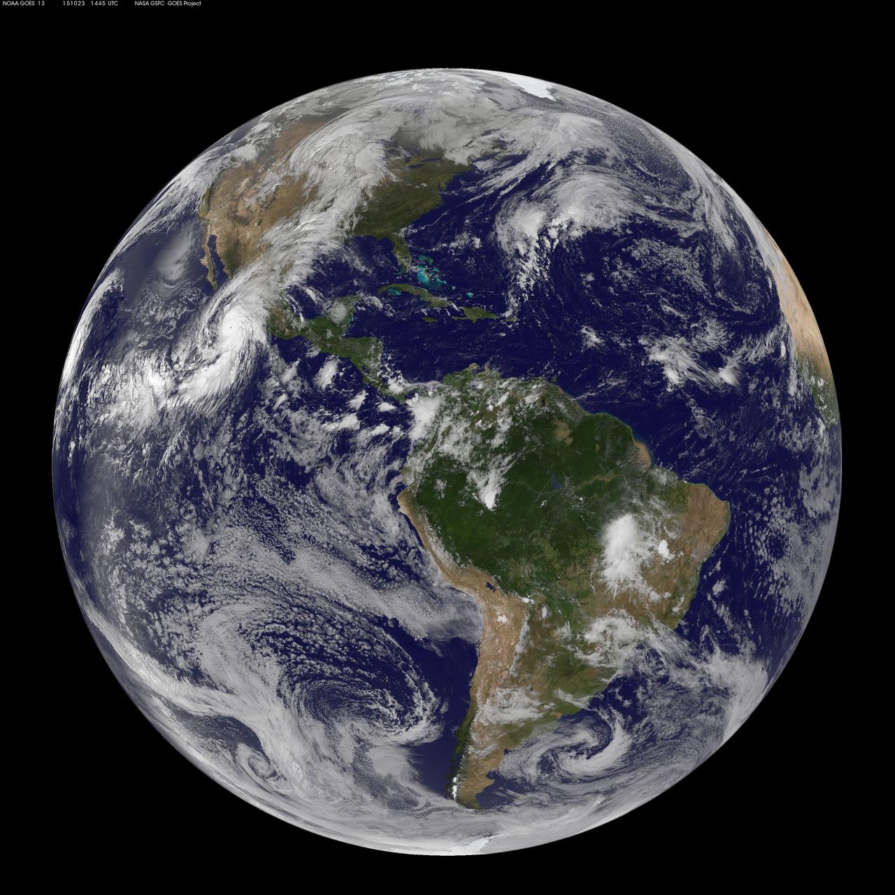
This full-disk image from NOAA’s GOES-13 satellite was captured at 14:45 UTC (10:45 a.m. EDT) and shows Hurricane Patricia off the coast of Mexico on September 23, 2015. At 8 a.m. EDT on October 23, 2015, the National Hurricane Center said that Hurricane Patricia had grown into a monster hurricane. In fact, it is the strongest eastern north pacific hurricane on record. At 8 a.m. EDT (1200 UTC) on Oct. 23, the eye of Hurricane Patricia was located near latitude 17.3 North, longitude 105.6 West. That's about 145 miles (235 km) southwest of Manzanillo, Mexico and about 215 miles (345 km) south of Cabo Corrientes, Mexico. Patricia was moving toward the north-northwest near 12 mph (19 kph) and a turn toward the north is expected later this morning, followed by a turn toward the north-northeast this afternoon. On the forecast track, the core of Patricia will make landfall in the hurricane warning area today, October 23, 2015 during the afternoon or evening. Maximum sustained winds remain near 200 mph (325 kph) with higher gusts. The National Hurricane Center (NHC) said that Patricia is a category 5 hurricane on the Saffir-Simpson Hurricane Wind Scale. Some fluctuations in intensity are possible today, but Patricia is expected to remain an extremely dangerous category 5 hurricane through landfall. Hurricane force winds extend outward up to 30 miles (45 km) from the center and tropical storm force winds extend outward up to 175 miles (280 km). The estimated minimum central pressure is 880 millibars. <b><a href="http://www.nasa.gov/audience/formedia/features/MP_Photo_Guidelines.html" rel="nofollow">NASA image use policy.</a></b> <b><a href="http://www.nasa.gov/centers/goddard/home/index.html" rel="nofollow">NASA Goddard Space Flight Center</a></b> enables NASA’s mission through four scientific endeavors: Earth Science, Heliophysics, Solar System Exploration, and Astrophysics. Goddard plays a leading role in NASA’s accomplishments by contributing compelling scientific knowledge to advance the Agency’s mission. <b>Follow us on <a href="http://twitter.com/NASAGoddardPix" rel="nofollow">Twitter</a></b> <b>Like us on <a href="http://www.facebook.com/pages/Greenbelt-MD/NASA-Goddard/395013845897?ref=tsd" rel="nofollow">Facebook</a></b> <b>Find us on <a href="http://instagrid.me/nasagoddard/?vm=grid" rel="nofollow">Instagram</a></b>
Cassini's celestial sleuthing has paid off with this time-lapse series of images which confirmed earlier suspicions that a small moon was orbiting within the narrow Keeler gap of Saturn's rings. The movie sequence, which consists of 12 images taken over 16 minutes while Cassini gazed down upon the sunlit side of the A ring, shows a tiny moon orbiting in the center of the Keeler gap, churning up waves in the gap edges as it goes. The pattern of waves travels with the moon in its orbit. The Keeler gap is located about 250 kilometers (155 miles) inside the outer edge of the A ring, which is also the outer edge of the bright main rings. The new object is about 7 kilometers across (4 miles) and reflects about 50 percent of the sunlight that falls upon it -- a brightness that is typical of particles in the nearby rings. The new body has been provisionally named S/2005 S1. Imaging scientists predicted the moon's presence and its orbital distance from Saturn after July 2004, when they saw a set of peculiar spiky and wispy features in the Keeler gap's outer edge. The similarities of the Keeler gap features to those noted in Saturn's F ring and the Encke gap led the scientists to conclude that a small body, a few kilometers across, was lurking in the center of the Keeler gap, awaiting discovery. Also included here is a view of the same scene created by combining six individual, unmagnified frames used in the movie sequence. This digital composite view improves the overall resolution of the scene compared to that available in any of the single images. The images in this movie sequence were obtained with the Cassini spacecraft narrow-angle camera on May 1, 2005, at a distance of approximately 1.1 million kilometers (708,000 miles) from Saturn. Resolution in the original image was 8 kilometers (5 miles) per pixel. The images in the movie sequence have been magnified in (the vertical direction only) by a factor of two to aid visibility of features caused within the gap by the moonlet. An animation is available at http://photojournal.jpl.nasa.gov/catalog/PIA06238