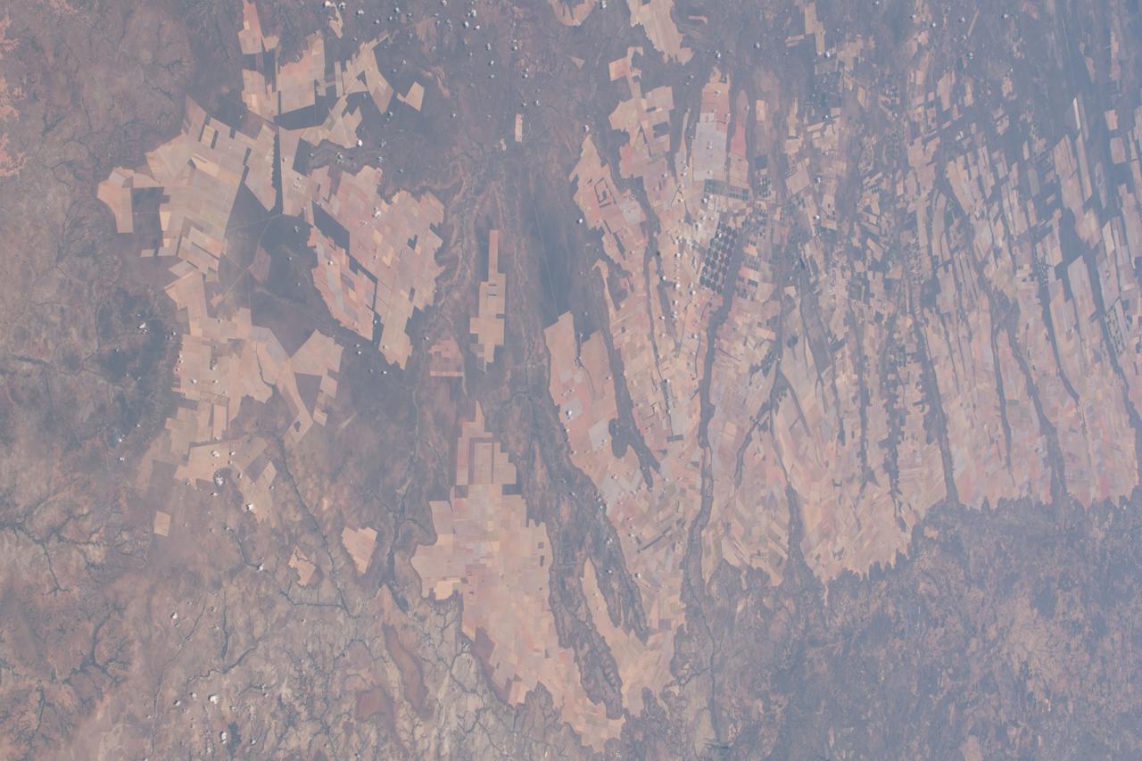
iss056e084580 (July 7, 2018) --- An Expedition 56 crew member pictured agricultural development in the savanna and grassland areas in the Brazilian state of Bahia.
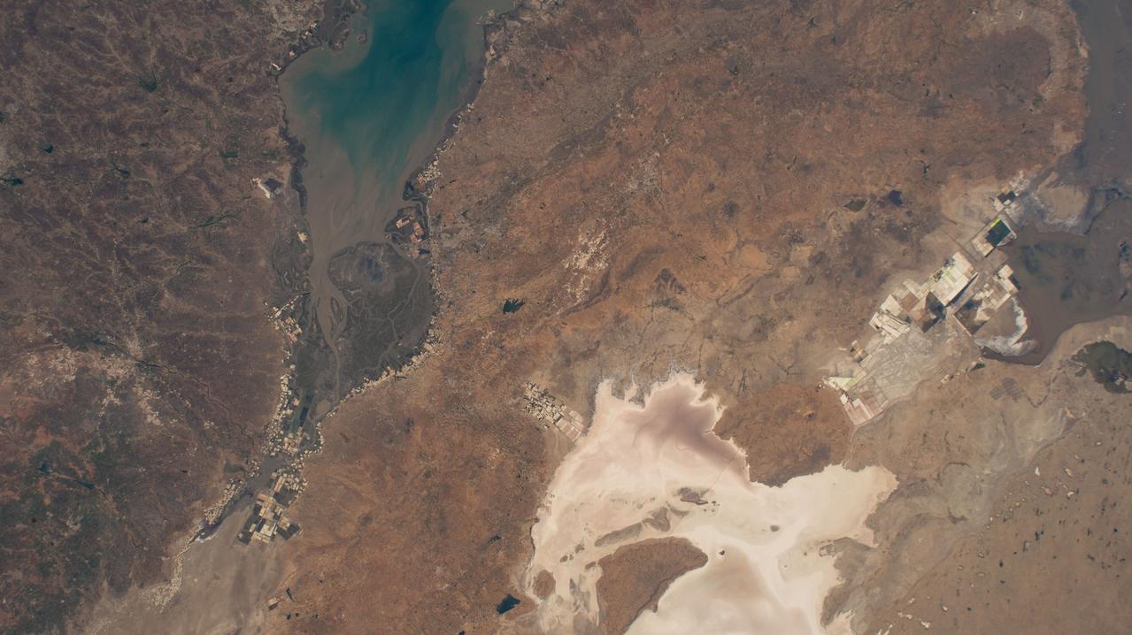
iss071e041652 (April 25, 2024) --- India's Gulf of Kutch (top left) and the Rann of Kutch (bottom right), an area of grassland and deserts, in the state of Gujarat are pictured from the International Space Station as it orbited 258 miles above.
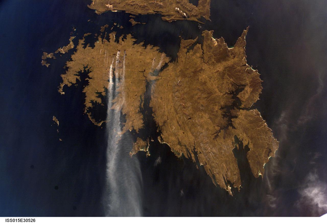
ISS015-E-30526 (25 Sept. 2007) --- Fires in East Falkland Island in the South Atlantic Ocean are featured in this image photographed by an Expedition 15 crewmember on the International Space Station. The Falkland Islands are an overseas territory of the United Kingdom, referred to by Argentina (which also claims the islands) as the Islas Malvinas. The main islands of East Falkland and West Falkland are separated by Falkland Sound (12 kilometers) wide at the narrow point. Together they total about the same area as the State of Connecticut or Northern Ireland. The islands lie almost 500 kilometers from the Argentine coast and less than 1,000 kilometers from Antarctica. The first air links to these remote islands were only put in place in 1971. The capital city of Stanley lies on the eastern tip of East Falkland. The local inhabitants are mainly English speakers, and interestingly, the islands have become a center of English-language learning for students from South America. The windy and relatively dry climate has given rise to natural vegetation comprised of treeless grassland with scattered bogs. The grasslands are ideal for sheep rearing which was the dominant occupation until recent decades, when fishing (mainly squid to Spain) and tourism became the mainstay of the economy. These expanses of grassland provide ready fuel for fires, as indicated by the several long smoke plumes visible in this image.
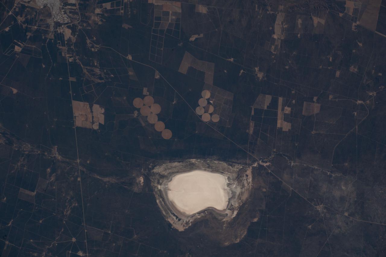
iss067e031910 (April 27, 2022) --- Lake Salinas del Bebedero rests southwest of San Luis, Argentina (upper left), in this photograph from the International Space Station as it orbited 269 miles above. The area pictured lies at the foot of the Sierra Grande Mountains in the temperate grassland region of central Argentina.
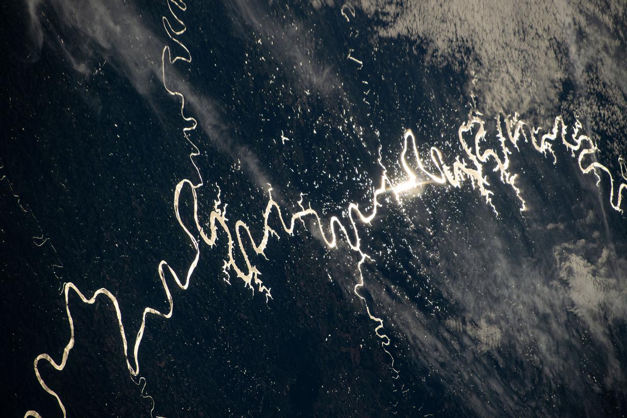
iss072e311451 (Dec. 3, 2024) --- The Sun's glint beams off one of the many rivers that snake throughout South America's fertile, low grasslands region, also known as the Pampas. The International Space Station was orbiting 261 miles above the border of Paraguay and Argentina at the time of this photograph. Credit: NASA/Don Pettit
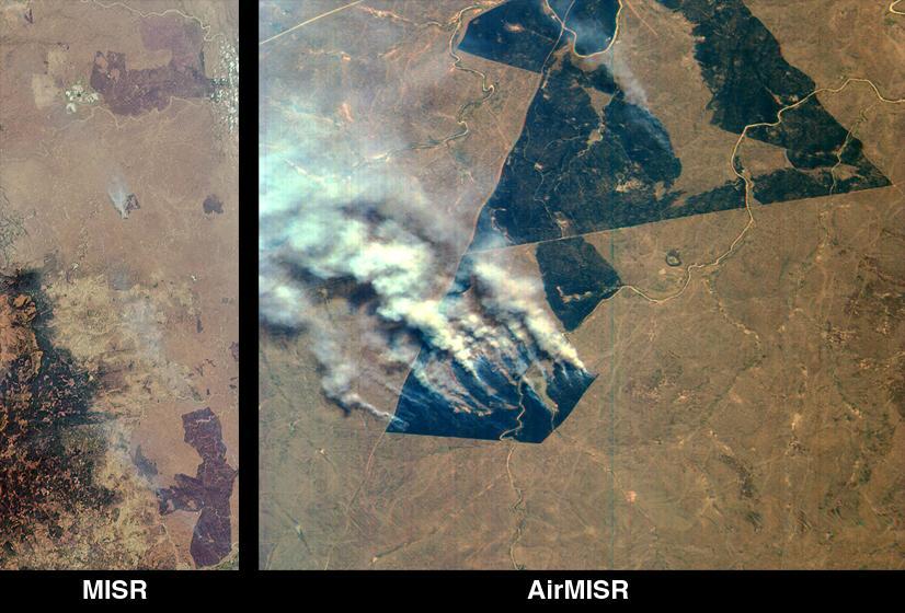
These images from NASA Terra satellite images are of northeastern South Africa, near Kruger National Park, were acquired on September 7, 2000.
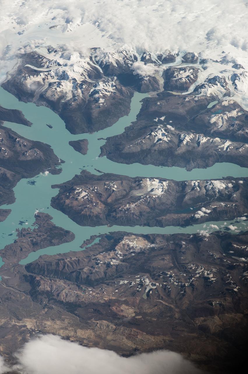
ISS047e014747 (03/22/2016) --- Crewmembers of the International Space Stations Expedition 47 captured this image of southern South America. Patagonia is a sparsely populated region located at the southern end of South America, shared by Argentina and Chile. The region comprises the southern section of the Andes mountains as well as the deserts, steppes and grasslands east of this southern portion of the Andes. The Colorado and Barrancas rivers, which run from the Andes to the Atlantic, are commonly considered the northern limit of Argentine Patagonia
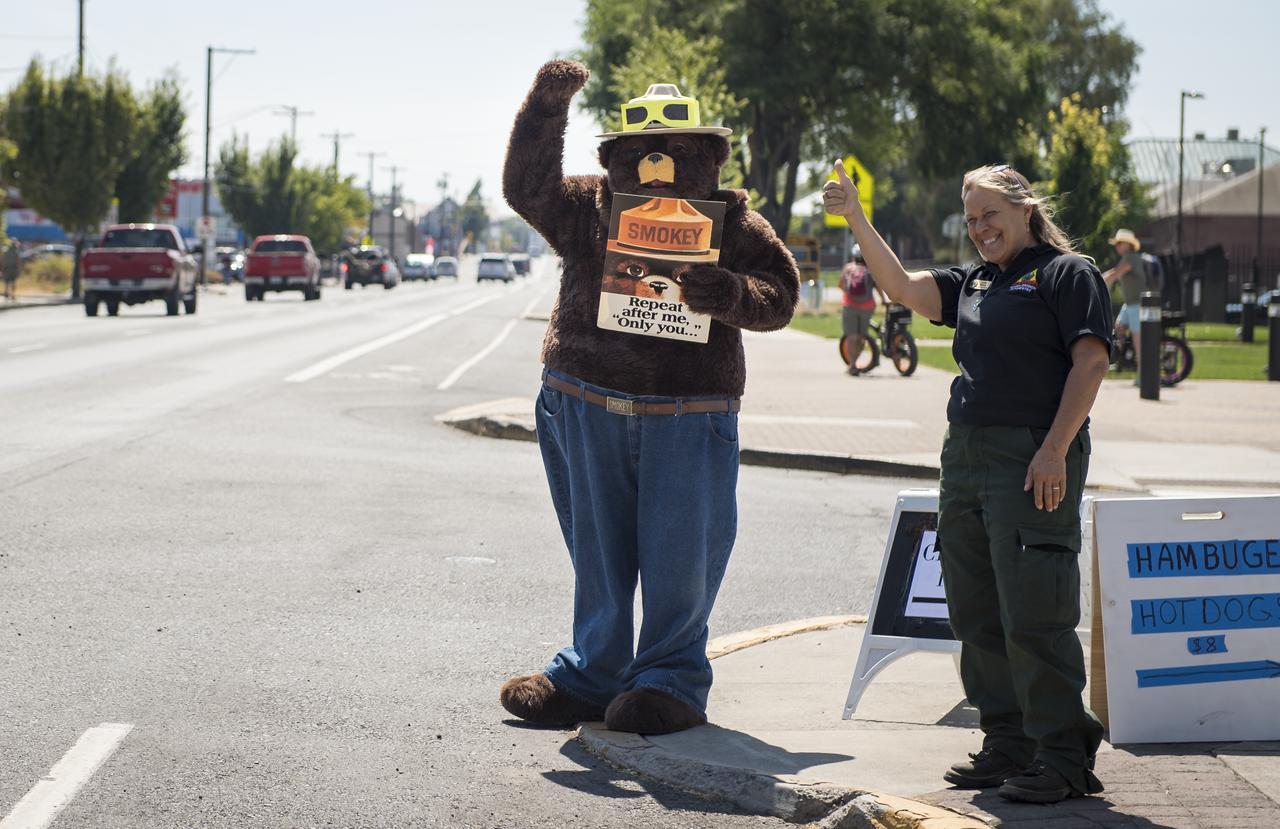
Smokey Bear, left, and Judy Reese of the Crooked River National Grassland, right, wave at passersby as crowds arrive to watch the total solar eclipse in Madras, Oregon on Saturday, August 19, 2017. The eclipse will be sweeping across a narrow portion of the contiguous United States from Lincoln Beach, Oregon to Charleston, South Carolina on August 21. A partial solar eclipse will be visible across the entire North American continent along with parts of South America, Africa, and Europe. Photo Credit: (NASA/Aubrey Gemignani)
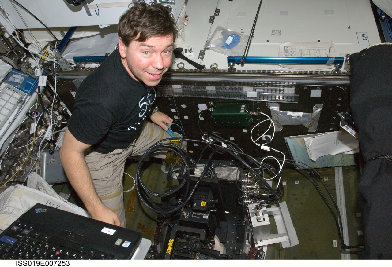
ISS019-E-007253 (16 April 2009) --- Astronaut Michael Barratt, Expedition 19/20 flight engineer, performs Agricultural Camera (AgCam) setup and activation in the Destiny laboratory of the International Space Station. AgCam takes frequent images, in visible and infrared light, of vegetated areas on Earth, such as farmland, rangeland, grasslands, forests and wetlands in the northern Great Plains and Rocky Mountain regions of the United States. Images will be delivered directly to requesting farmers, ranchers, foresters, natural resource managers and tribal officials to help improve environmental stewardship.
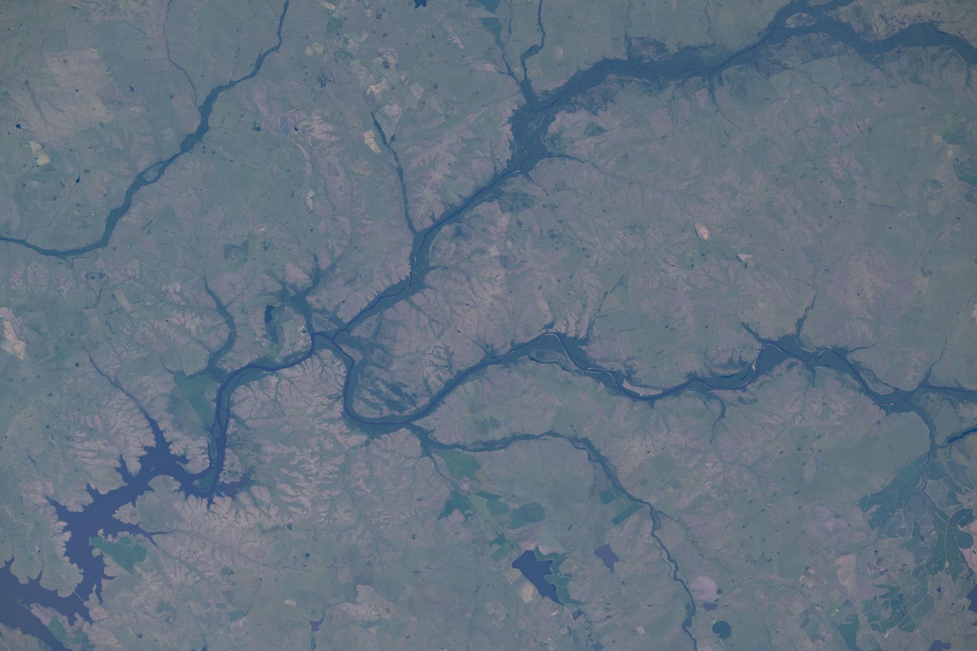
iss074e0046046 (Jan. 5, 2025) --- The Arapey Grande River splits into its tributary, the Arapey Chico River, in northern Uruguay within the Arapey Grande Basin—a region characterized by rolling hills, natural grasslands, and dense woodlands that support a biodiverse ecosystem. The International Space Station was orbiting 268 miles above the Brazil–Uruguay border when this photograph was taken. Credit: NASA/Chris Williams
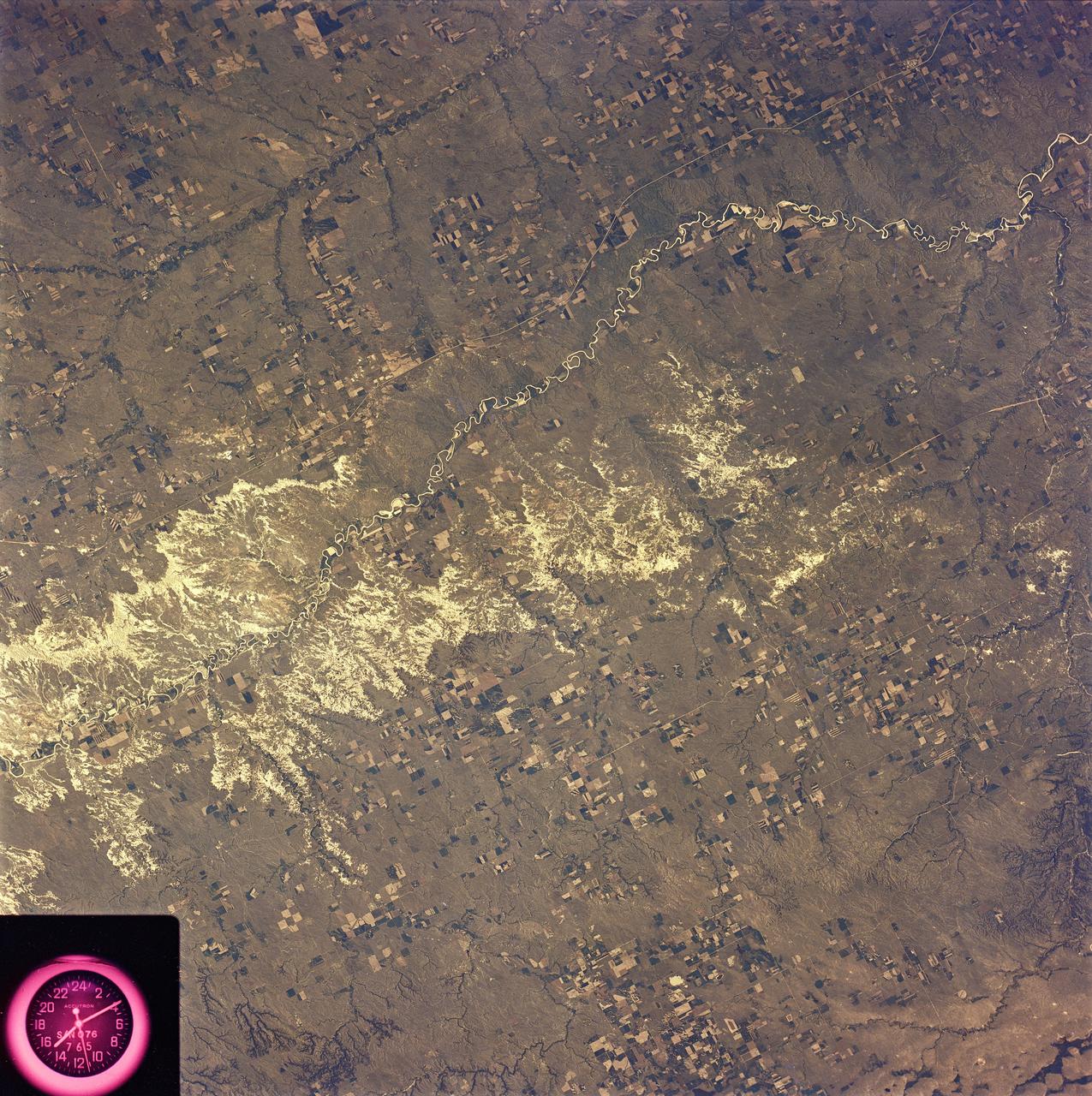
SL2-81-162 (22 June 1973) --- The most striking feature of this scene of the western Great Plains and the Badlands of SD (43.5N, 101.0W) is the rugged topography of the landscape. Over eons of time, the White River has carved out a badlands topography of steep gullies, irregular winding ridges and isolated buttes. The barren wasteland of badlands light toned rock surfaces contrast sharply with the adjacent vegetated landscape of native grasslands and cultivated fields. Photo credit: NASA
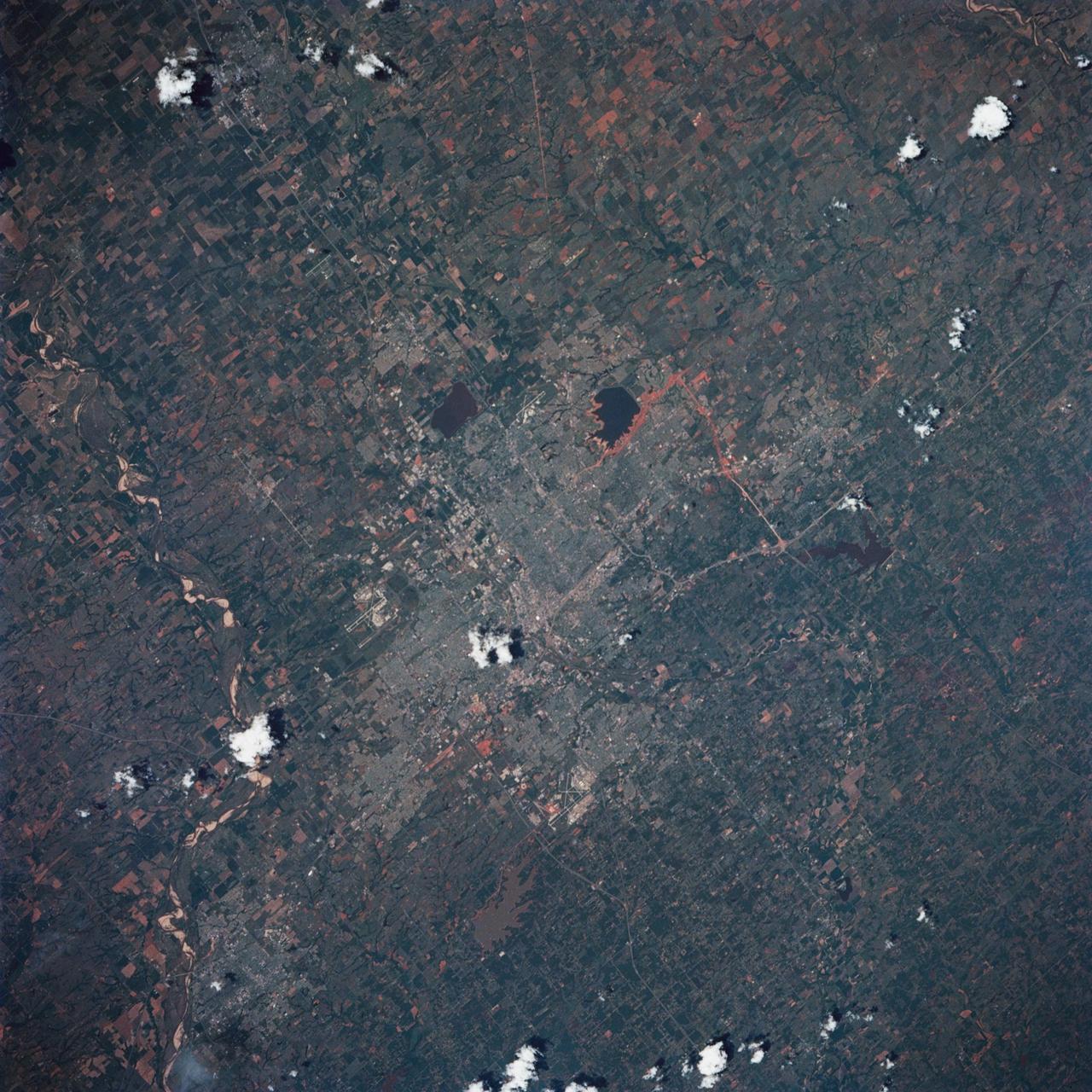
STS039-85-029 (28 April-6 May 1991) --- This 70mm frame is one of the best pictures of the Oklahoma City area from the manned space program, according to NASA photo experts studying STS-39 onboard photography. The central business district is near the center. Several municipalities are visible, along with thousands of acres of farmland. The towns of Norman and Moore and the South Canadian River are in the bottom (south). El Reno and Wiley Post Field off I-40W are just below center in lower left quadrant. Edmond is seen at the top (north). Tinker Field can be seen north of I-40E at right center. Lake Overholser shows recent spring rainfall northwest of the central business district.
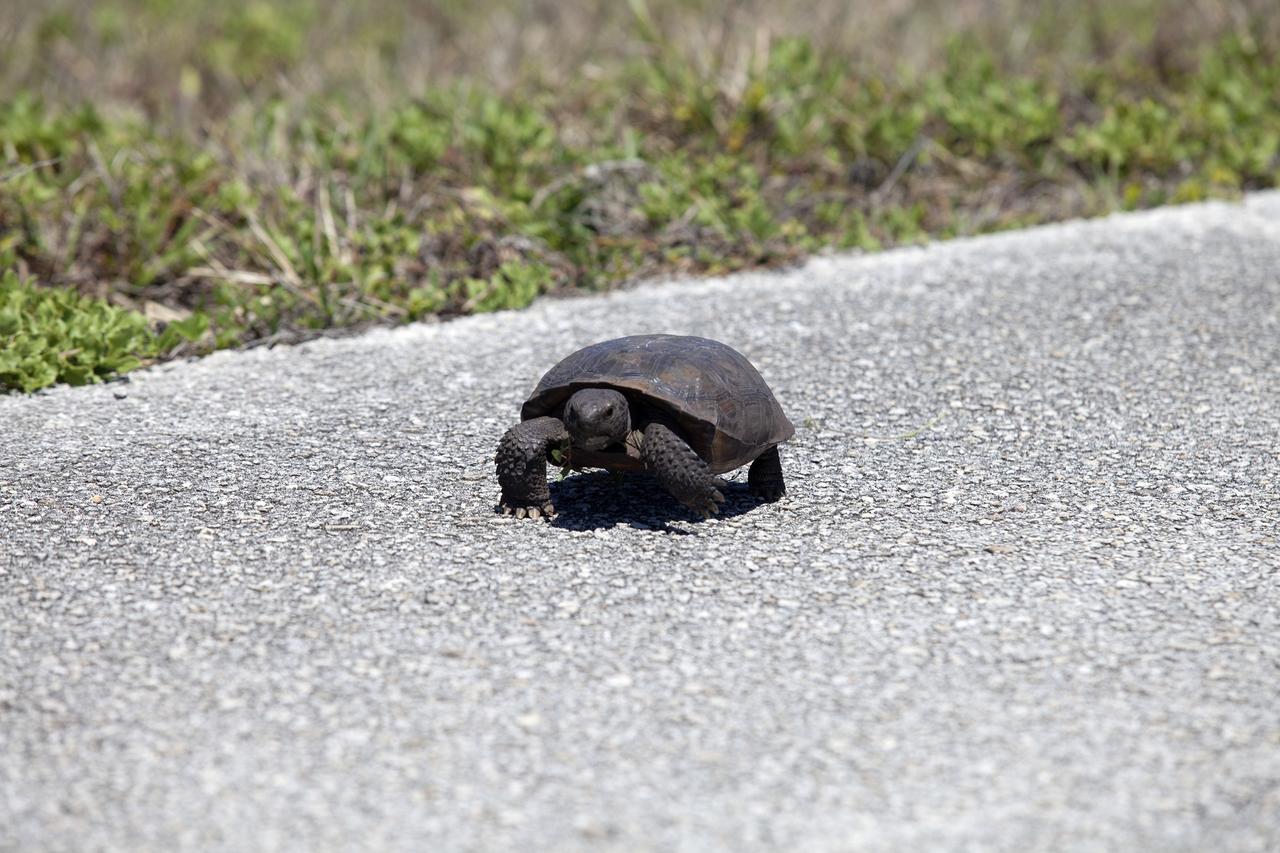
CAPE CANAVERAL, Fla. -- Why did the gopher tortoise cross the road? To get to the other side of the Launch Pad 39B beach road on NASA's Kennedy Space Center in Florida, of course. Gopher tortoises are dry-land turtles that live in scrub, dry hammock, pine flatwood, coastal grassland and dune habitats. The undeveloped property on Kennedy Space Center is managed by the U.S. Fish and Wildlife Service through the Merritt Island National Wildlife Refuge. Currently, gopher tortoises are protected in some states by federal law under the Endangered Species Act ESA. The refuge provides a habitat for 14 species federally listed as threatened or endangered, including the leatherback, green, Kemps Ridley, loggerhead and Atlantic hawksbill turtles. For information on the refuge, visit http://www.fws.gov/merrittisland/Index.html. For more information on the gopher tortoise, visit http://www.fws.gov/northflorida/GopherTortoise/Gopher_Tortoise_Fact_Sheet.html. Photo credit: NASA/Daniel Casper
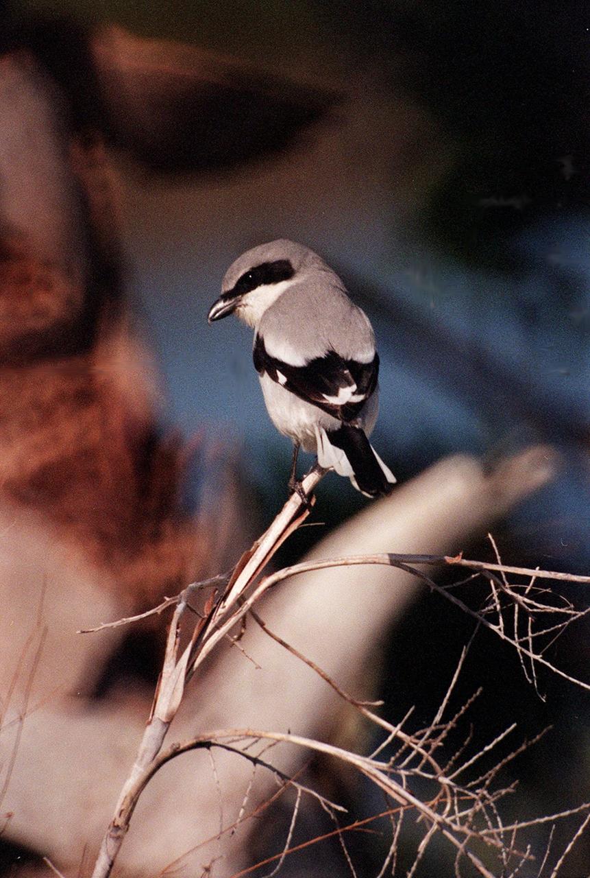
KENNEDY SPACE CENTER, FLA. -- A loggerhead shrike perches on a branch in the Merritt Island National Wildlife Refuge, which shares a boundary with Kennedy Space Center. The loggerhead shrike prefers grasslands, orchards and open areas with scattered trees throughout a range extending from southern Canada to southern Florida and the Gulf Coast. The Refuge encompasses 92,000 acres that are a habitat for more than 331 species of birds, 31 mammals, 117 fishes, and 65 amphibians and reptiles. The marshes and open water of the refuge provide wintering areas for 23 species of migratory waterfowl, as well as a year-round home for great blue herons, great egrets, wood storks, cormorants, brown pelicans and other species of marsh and shore birds, as well as a variety of insects
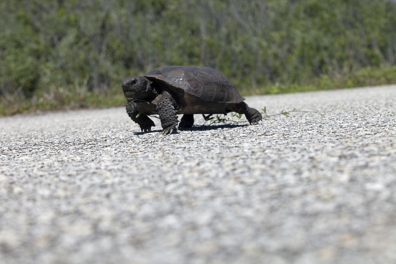
CAPE CANAVERAL, Fla. -- A gopher tortoise ambles along the Launch Pad 39B beach road on NASA's Kennedy Space Center in Florida. Gopher tortoises are dry-land turtles that live in scrub, dry hammock, pine flatwood, coastal grassland and dune habitats. The undeveloped property on Kennedy Space Center is managed by the U.S. Fish and Wildlife Service through the Merritt Island National Wildlife Refuge. Currently, gopher tortoises are protected in some states by federal law under the Endangered Species Act ESA. The refuge provides a habitat for 14 species federally listed as threatened or endangered, including the leatherback, green, Kemps Ridley, loggerhead and Atlantic hawksbill turtles. For information on the refuge, visit http://www.fws.gov/merrittisland/Index.html. For more information on the gopher tortoise, visit http://www.fws.gov/northflorida/GopherTortoise/Gopher_Tortoise_Fact_Sheet.html. Photo credit: NASA/Daniel Casper
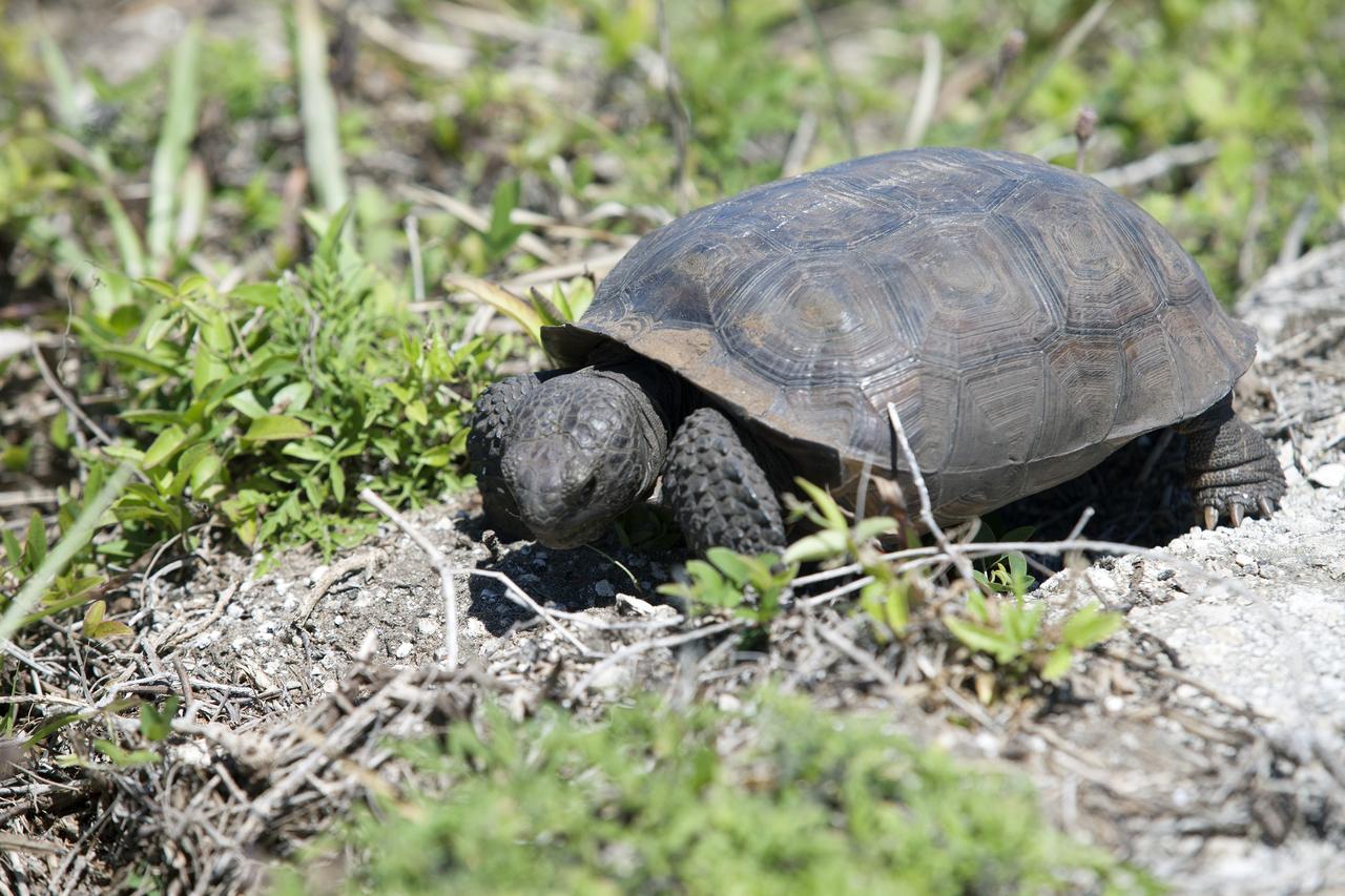
CAPE CANAVERAL, Fla. -- A gopher tortoise stops for lunch beside the Launch Pad 39B beach road on NASA's Kennedy Space Center in Florida. Gopher tortoises are dry-land turtles that live in scrub, dry hammock, pine flatwood, coastal grassland and dune habitats. The undeveloped property on Kennedy Space Center is managed by the U.S. Fish and Wildlife Service through the Merritt Island National Wildlife Refuge. Currently, gopher tortoises are protected in some states by federal law under the Endangered Species Act ESA. The refuge provides a habitat for 14 species federally listed as threatened or endangered, including the leatherback, green, Kemps Ridley, loggerhead and Atlantic hawksbill turtles. For information on the refuge, visit http://www.fws.gov/merrittisland/Index.html. For more information on the gopher tortoise, visit http://www.fws.gov/northflorida/GopherTortoise/Gopher_Tortoise_Fact_Sheet.html. Photo credit: NASA/Daniel Casper
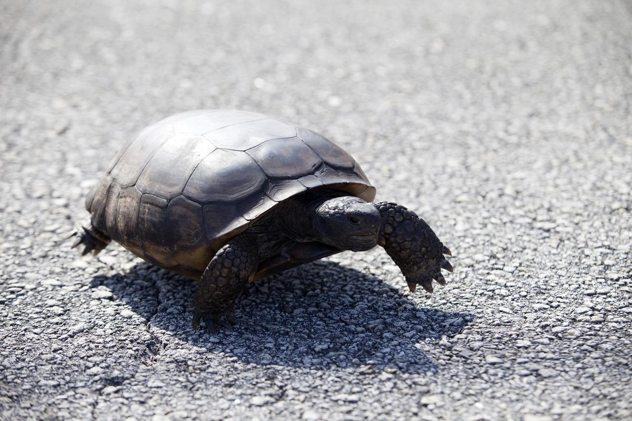
CAPE CANAVERAL, Fla. -- This gopher tortoise almost seems to float above the pavement as it hastens along the road at NASA's Kennedy Space Center in Florida. Gopher tortoises are dry-land turtles that live in scrub, dry hammock, pine flatwood, coastal grassland and dune habitats. The undeveloped property on Kennedy Space Center is managed by the U.S. Fish and Wildlife Service through the Merritt Island National Wildlife Refuge. Currently, gopher tortoises are protected in some states by federal law under the Endangered Species Act ESA. The refuge provides a habitat for 14 species federally listed as threatened or endangered, including the leatherback, green, Kemps Ridley, loggerhead and Atlantic hawksbill turtles. For information on the refuge, visit http://www.fws.gov/merrittisland/Index.html. For more information on the gopher tortoise, visit http://www.fws.gov/northflorida/GopherTortoise/Gopher_Tortoise_Fact_Sheet.html. Photo credit: NASA/Daniel Casper
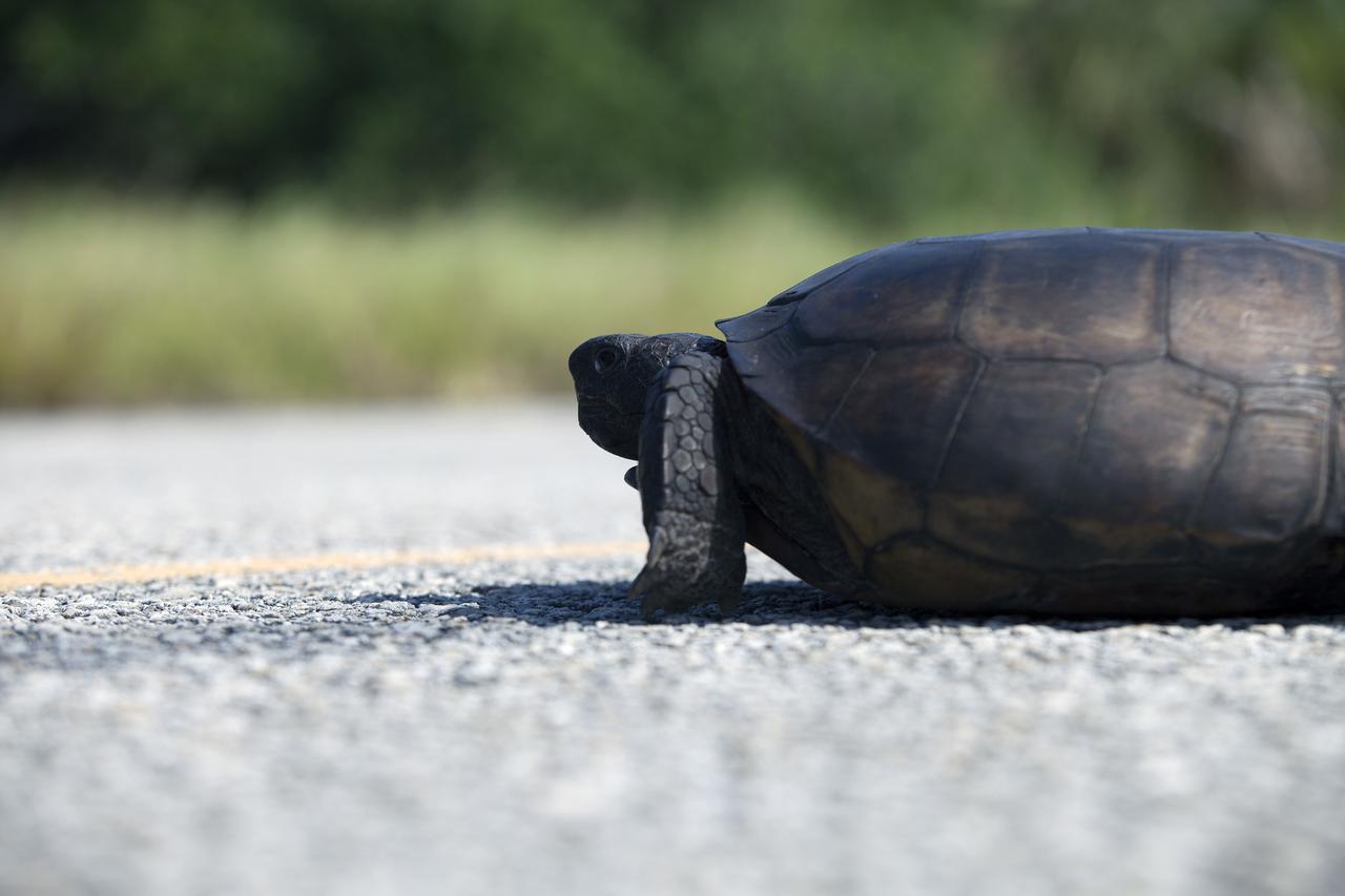
CAPE CANAVERAL, Fla. -- A gopher tortoise lumbers down the roadway at NASA's Kennedy Space Center in Florida. Gopher tortoises are dry-land turtles that live in scrub, dry hammock, pine flatwood, coastal grassland and dune habitats. The undeveloped property on Kennedy Space Center is managed by the U.S. Fish and Wildlife Service through the Merritt Island National Wildlife Refuge. Currently, gopher tortoises are protected in some states by federal law under the Endangered Species Act ESA. The refuge provides a habitat for 14 species federally listed as threatened or endangered, including the leatherback, green, Kemps Ridley, loggerhead and Atlantic hawksbill turtles. For information on the refuge, visit http://www.fws.gov/merrittisland/Index.html. For more information on the gopher tortoise, visit http://www.fws.gov/northflorida/GopherTortoise/Gopher_Tortoise_Fact_Sheet.html. Photo credit: NASA/Daniel Casper
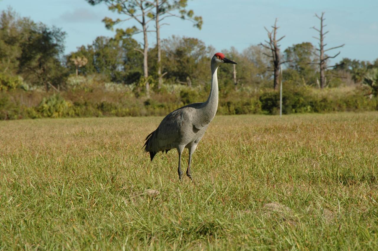
KENNEDY SPACE CENTER, FLA. -- A sandhill crane is on the lookout on grounds near the Headquarters Building at NASA's Kennedy Space Center. Sandhill cranes are primarily birds of open freshwater wetlands and shallow marshes and in Florida use seasonally variable wetlands, grasslands, and palm and pine savannahs. Sandhill cranes are omnivorous, feeding on a wide variety of plant materials (including waste grains) and small vertebrates and invertebrates, both on land and in shallow wetlands. Florida's sandhill crane population increases as cranes from northern states spend the winter in Florida. Florida sandhill cranes stay with the same mate for several years and young sandhills stay with their parents until they are about 10 months old. Like their endangered relatives the whooping cranes, sandhills live to be older than most birds. In fact, some sandhill cranes live up to 20 years. Photo credit: NASAJim Grossmann

KENNEDY SPACE CENTER, FLA. -- Sandhill cranes stalk a parking lot near the Headquarters Building at NASA's Kennedy Space Center. Sandhill cranes are primarily birds of open freshwater wetlands and shallow marshes and in Florida use seasonally variable wetlands, grasslands, and palm and pine savannahs. Sandhill cranes are omnivorous, feeding on a wide variety of plant materials (including waste grains) and small vertebrates and invertebrates, both on land and in shallow wetlands. Florida's sandhill crane population increases as cranes from northern states spend the winter in Florida. Florida sandhill cranes stay with the same mate for several years and young sandhills stay with their parents until they are about 10 months old. Like their endangered relatives the whooping cranes, sandhills live to be older than most birds. In fact, some sandhill cranes live up to 20 years. Photo credit: NASAJim Grossmann
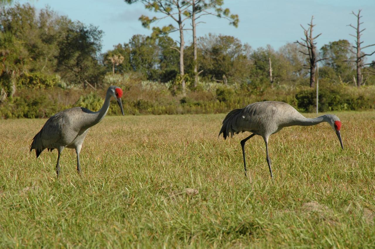
KENNEDY SPACE CENTER, FLA. -- A pair of sandhill cranes search for food on the grounds near the Headquarters Building at NASA's Kennedy Space Center. Sandhill cranes are primarily birds of open freshwater wetlands and shallow marshes and in Florida use seasonally variable wetlands, grasslands, and palm and pine savannahs. Sandhill cranes are omnivorous, feeding on a wide variety of plant materials (including waste grains) and small vertebrates and invertebrates, both on land and in shallow wetlands. Florida's sandhill crane population increases as cranes from northern states spend the winter in Florida. Florida sandhill cranes stay with the same mate for several years and young sandhills stay with their parents until they are about 10 months old. Like their endangered relatives the whooping cranes, sandhills live to be older than most birds. In fact, some sandhill cranes live up to 20 years. Photo credit: NASAJim Grossmann
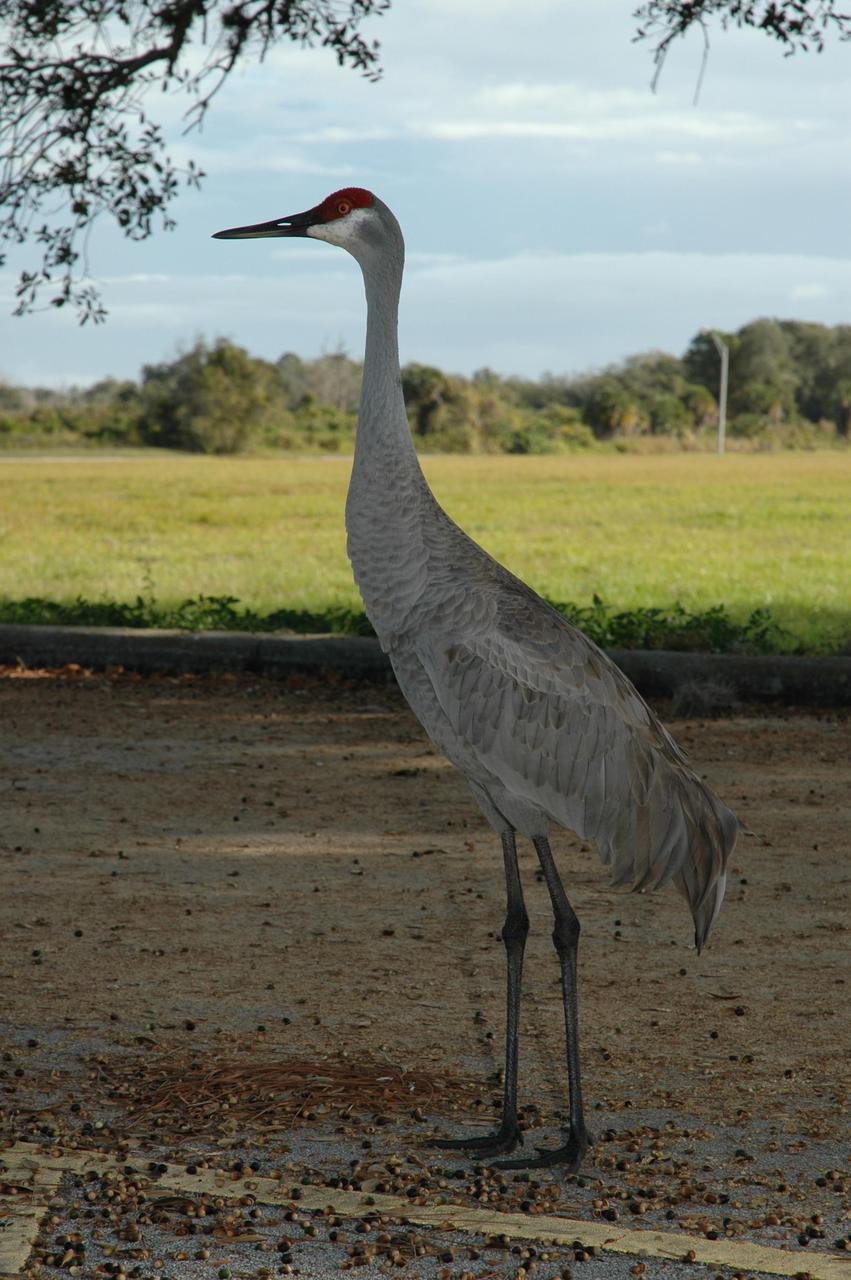
KENNEDY SPACE CENTER, FLA. -- A sandhill crane is on the lookout in a parking lot near the Headquarters Building at NASA's Kennedy Space Center. Sandhill cranes are primarily birds of open freshwater wetlands and shallow marshes and in Florida use seasonally variable wetlands, grasslands, and palm and pine savannahs. Sandhill cranes are omnivorous, feeding on a wide variety of plant materials (including waste grains) and small vertebrates and invertebrates, both on land and in shallow wetlands. Florida's sandhill crane population increases as cranes from northern states spend the winter in Florida. Florida sandhill cranes stay with the same mate for several years and young sandhills stay with their parents until they are about 10 months old. Like their endangered relatives the whooping cranes, sandhills live to be older than most birds. In fact, some sandhill cranes live up to 20 years. Photo credit: NASAJim Grossmann
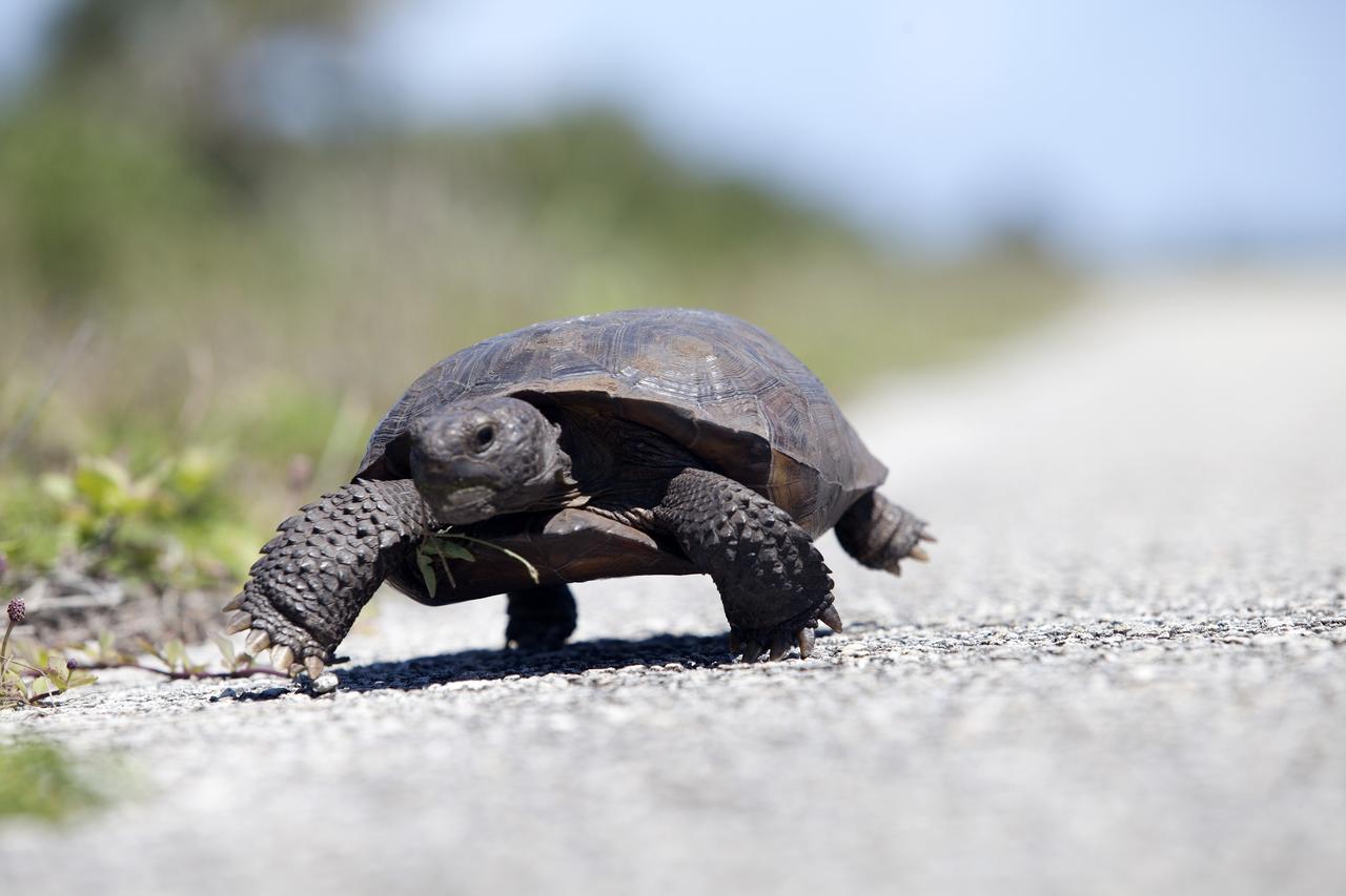
CAPE CANAVERAL, Fla. -- Slow and steady wins the race for this gopher tortoise, ambling along the Launch Pad 39B beach road on NASA's Kennedy Space Center in Florida. Gopher tortoises are dry-land turtles that live in scrub, dry hammock, pine flatwood, coastal grassland and dune habitats. The undeveloped property on Kennedy Space Center is managed by the U.S. Fish and Wildlife Service through the Merritt Island National Wildlife Refuge. Currently, gopher tortoises are protected in some states by federal law under the Endangered Species Act ESA. The refuge provides a habitat for 14 species federally listed as threatened or endangered, including the leatherback, green, Kemps Ridley, loggerhead and Atlantic hawksbill turtles. For information on the refuge, visit http://www.fws.gov/merrittisland/Index.html. For more information on the gopher tortoise, visit http://www.fws.gov/northflorida/GopherTortoise/Gopher_Tortoise_Fact_Sheet.html. Photo credit: NASA/Daniel Casper

ISS032-E-024687 (3 Sept. 2012) --- Idaho fires are featured in this image photographed by an Expedition 32 crew member on the International Space Station. Taken with a short lens (45 mm), this west-looking photograph has a field of view covering much of the forested region of central Idaho. The dark areas are all wooded mountains—the Salmon River Mountains (left), Bitterroot Mountains (lower right) and Clearwater Mountains (right). All three areas experienced wildfires in September 2012—this image illustrates the situation early in the month. Smaller fire ‘complexes” appear as tendrils of smoke near the sources (e.g. Halstead complex at left), and as major white smoke plumes from the Mustang fire complex in the densest forests (darkest green, center) of the Clearwater Mountains. This was the largest plume noted in the region with thick smoke blowing eastward over the Beaverhead Mountains at bottom. The linear shape of the smoke plumes gives a sense of the generally eastward smoke transport on this day in early September. The smoke distribution shows another kind of transport: at night, when winds are weak, cooling of the atmosphere near the ground causes drainage of cooled (denser) air down into the major valleys. Here the smoke can be seen flowing west down into the narrow Salmon and Lochsa River valleys (at a local time of 12:18:50 p.m.) – in the opposite direction to the higher winds and the thick smoke masses. The bright yellow-tan areas at top left and top right contrasting with the mountains are grasslands of the Snake River in southern Idaho around Boise, and the Palouse region in western Idaho–SE Washington state. This latter area is known to ecologists as the Palouse Grasslands Ecoregion. Light green areas visible in the center of many of the valleys are agricultural crops including barley, alfalfa, and wheat. The image also shows several firsts of which Idaho can boast. The Snake River between Boise and the Palouse region has cut Hells Canyon (top), the deepest gorge in the U.S. at almost 2,436 meters (8,000 feet). The largest single wilderness area in the contiguous U.S., the Frank Church-River of No Return Wilderness occupies the wooded zones of the Salmon River Mountains and the Clearwater Mountains, i.e. most of the area shown in the middle of the image. Idaho’s highest peak is Borah Peak (lower left) at 3,860 meters above sea level (12,662 feet ASL). The Continental Divide cuts through the bottom of the image—rivers on the eastern slopes of the Beaverhead Mountains drain to the Atlantic Ocean, whereas rivers in the rest of the area drain to the Pacific Ocean.
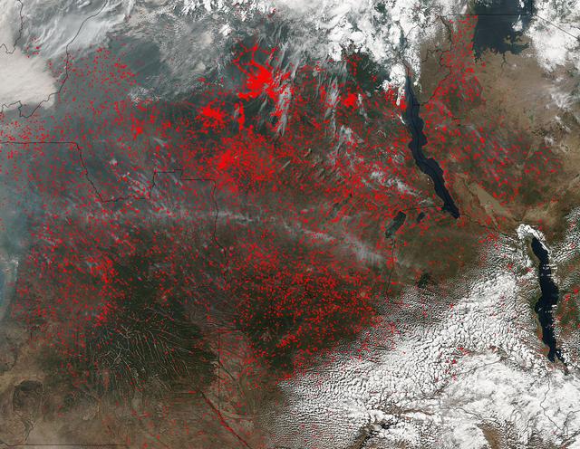
NASA’s Suomi NPP satellite detected thousands of fires burning in central Africa on July 11, 2016. The fires are represented by the multitudes of red dots. Most of the fires burn in grass or cropland. The location, widespread nature, and number of fires suggest that these fires were deliberately set to manage land. Places where traditional plots of open land is not available because the vegetation in the area is dense are the places where "slash and burn" agriculture is practiced most often. These regions include parts of Africa, northern South America, and Southeast Asia, where an abundance of grasslands and rainforests are found. Although most parts of the world outlaw this type of agriculture due to the fact that the smoke from these (or any) fires is a health hazard, the method of agriculture continues because it is the easiest and lowest cost solution to clearing fields for next year's crops. The Suomi NPP satellite is a joint mission between NASA, NOAA and the U.S. Department of Defense. NASA image courtesy Jeff Schmaltz, MODIS Rapid Response Team.
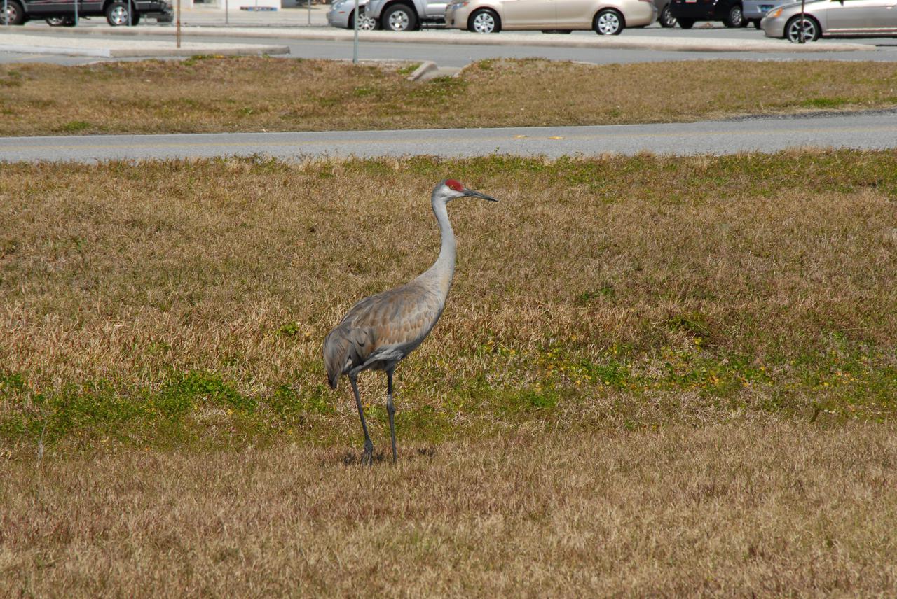
CAPE CANAVERAL, Fla. – A sandhill crane pauses from its food search near the Vehicle Assembly Building at NASA's Kennedy Space Center in Florida long enough to determine if it is in any imminent danger as its photograph is taken. Sandhill cranes are primarily birds of open freshwater wetlands and shallow marshes, and in Florida, use seasonally variable wetlands, grasslands, and palm and pine savannahs. Sandhill cranes are omnivorous, feeding on a wide variety of plants and small vertebrates and invertebrates, both on land and in shallow water. Florida's sandhill crane population increases as cranes from northern states spend the winter in Florida. Florida sandhill cranes stay with the same mate for several years, and young sandhills stay with their parents until they are about 10 months old. Like whooping cranes, their endangered relatives, sandhills live to be older than most birds, some living up to 20 years. The Merritt Island National Wildlife Refuge coexists with Kennedy Space Center and provides a habitat for 330 species of birds including the sandhill crane. Photo credit: NASA_Jim Grossmann
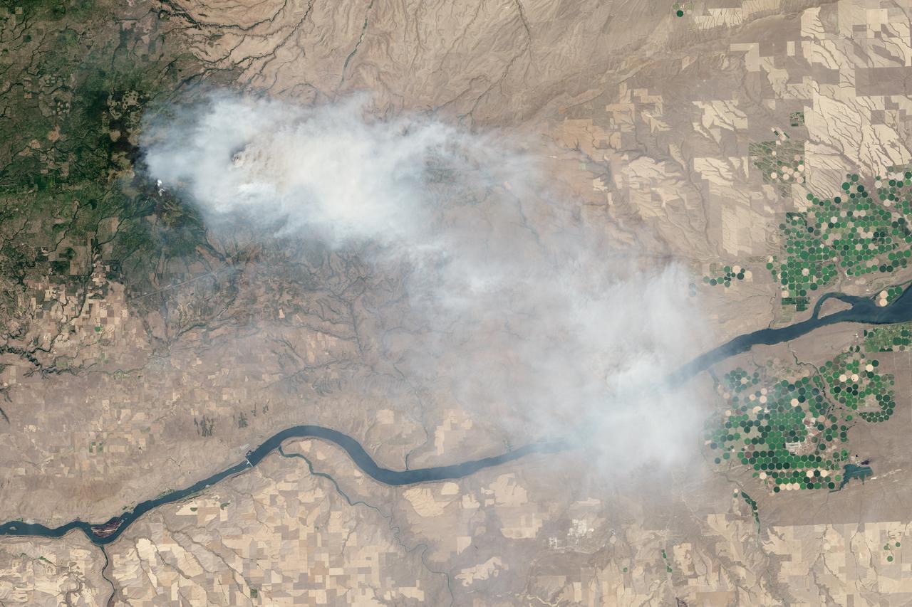
Eight major wildfires burned through forests and grasslands in the Pacific Northwest in late-July 2013, threatening homes and forcing road closings and evacuations. Many parts of Washington and Oregon faced extreme fire threats, as strong thunderstorms lined up to hit parched forests and grasslands with lightning. On July 28, 2013, the Operational Land Imager (OLI) on Landsat 8 captured these images of the Mile Marker 28 fire in the Simcoe Mountains northeast of Goldendale, Washington. Smoke blew east toward Kennewick, Pasco, and Richland. The lower image shows a closer view of smoke billowing up from the most active part of the fire. Ignited on July 24, 2013, the fire charred more than 22,000 acres (8,900 hectares) by July 30, when more than 1,000 firefighters achieved 40 percent containment. The blaze forced the evacuation of dozens of homes and the closure of US Highway 97. Through July 25, 450 wildfires had burned 10,220 acres (4,136 hectares) in Washington, while Oregon saw 603 fires that burned 63,135 acres (25,549 hectares). In all, 2.3 million acres burned across the United States by late-July, below the national average. Over the past ten years, an average of 4.2 million acres had burned in the United States by the end of each July. While coastal and western Washington receive heavy rain throughout the year, the rain shadow caused by the Cascades leaves central Washington quite dry. The mountains force moist air from the Pacific to rise, causing it to cool and condense into rain or snow on the windward side of the Cascades. So little moisture is left by the time air passes over the Cascades, that the area around Mile Marker 28 typically receives just 8 inches (20 centimeters) of precipitation per year. NASA Earth Observatory image by Jesse Allen and Robert Simmon, using Landsat data from the U.S. Geological Survey. Caption by Adam Voiland Instrument: Landsat 8 - OLI More info: <a href="http://earthobservatory.nasa.gov/IOTD/view.php?id=81738" rel="nofollow">earthobservatory.nasa.gov/IOTD/view.php?id=81738</a> Credit: <b><a href="http://www.earthobservatory.nasa.gov/" rel="nofollow"> NASA Earth Observatory</a></b> <b><a href="http://www.nasa.gov/audience/formedia/features/MP_Photo_Guidelines.html" rel="nofollow">NASA image use policy.</a></b> <b><a href="http://www.nasa.gov/centers/goddard/home/index.html" rel="nofollow">NASA Goddard Space Flight Center</a></b> enables NASA’s mission through four scientific endeavors: Earth Science, Heliophysics, Solar System Exploration, and Astrophysics. Goddard plays a leading role in NASA’s accomplishments by contributing compelling scientific knowledge to advance the Agency’s mission. <b>Follow us on <a href="http://twitter.com/NASA_GoddardPix" rel="nofollow">Twitter</a></b> <b>Like us on <a href="http://www.facebook.com/pages/Greenbelt-MD/NASA-Goddard/395013845897?ref=tsd" rel="nofollow">Facebook</a></b> <b>Find us on <a href="http://instagram.com/nasagoddard?vm=grid" rel="nofollow">Instagram</a></b>
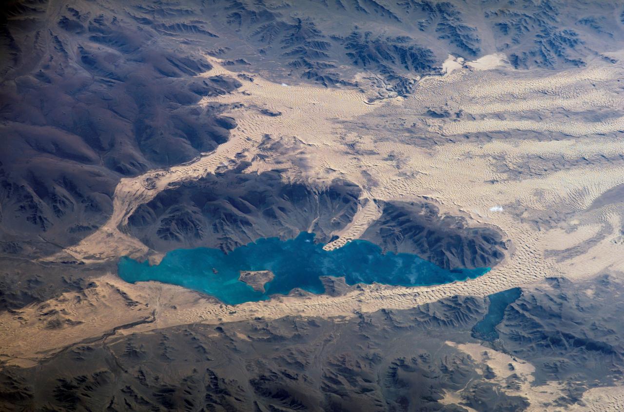
ISS013-E-78506 (7 Sept. 2006) --- Sand dunes near Mongolia's Har Lake are featured in this image photographed by an Expedition 13 crewmember on the International Space Station. Har (or Black) Lake is located in the western part of the country within the Valley of Lakes--part of a system of closed basins that stretches across central Asia. According to scientists, these basins are the remnants of larger paleolakes that had begun to shrink in size by approximately five thousand years ago as regional climate became drier. Today, the Valley of Lakes is an important ecological resource for study of steppe grasslands, and as resting points for large numbers of migratory birds. Portions of the basin are designated as national parks or other protected areas, and Har Lake itself is an ecotourism destination (usually by horseback). This oblique view captures the dynamic nature of the landscape of Har Lake. The lake is encircled by sand dune fields which encroach on the lower slopes of the Tobhata Mountains to the west and south. Gaps in the mountains have been exploited by sand dunes moving eastward (indicating westerly winds) -- the most striking example being a series of dunes entering Har Lake along its southwestern shoreline. Here, the dune forms reflect the channeling of winds through the break in the mountain ridgeline, leading to dune crests oriented transverse to northwesterly winds. Another well-developed line of dunes is visible between Har and Baga Lakes. While these dunes appear to cut across a lake surface, the dunes have in fact moved across a narrow stream channel.
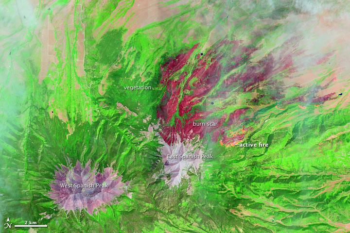
On June 22, 2013, the Operational Land Imager (OLI) on Landsat 8 captured this false-color image of the East Peak fire burning in southern Colorado near Trinidad. Burned areas appear dark red, while actively burning areas look orange. Dark green areas are forests; light green areas are grasslands. Lightning ignited the blaze on June 19, 2013. By June 25, it had burned nearly 13,500 acres (5,500 hectares). NASA Earth Observatory image by Jesse Allen and Robert Simmon, using Landsat data from the U.S. Geological Survey. Caption by Adam Voiland. Instrument: Landsat 8 - OLI More images from this event: <a href="http://1.usa.gov/14DesQC" rel="nofollow">1.usa.gov/14DesQC</a> Credit: <b><a href="http://www.earthobservatory.nasa.gov/" rel="nofollow"> NASA Earth Observatory</a></b> <b><a href="http://www.nasa.gov/audience/formedia/features/MP_Photo_Guidelines.html" rel="nofollow">NASA image use policy.</a></b> <b><a href="http://www.nasa.gov/centers/goddard/home/index.html" rel="nofollow">NASA Goddard Space Flight Center</a></b> enables NASA’s mission through four scientific endeavors: Earth Science, Heliophysics, Solar System Exploration, and Astrophysics. Goddard plays a leading role in NASA’s accomplishments by contributing compelling scientific knowledge to advance the Agency’s mission. <b>Follow us on <a href="http://twitter.com/NASA_GoddardPix" rel="nofollow">Twitter</a></b> <b>Like us on <a href="http://www.facebook.com/pages/Greenbelt-MD/NASA-Goddard/395013845897?ref=tsd" rel="nofollow">Facebook</a></b> <b>Find us on <a href="http://instagram.com/nasagoddard?vm=grid" rel="nofollow">Instagram</a></b>
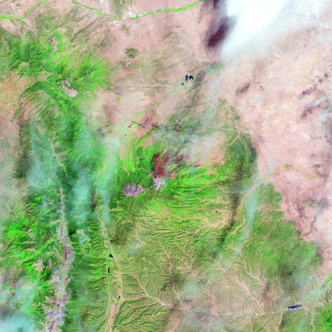
On June 22, 2013, the Operational Land Imager (OLI) on Landsat 8 captured this false-color image of the East Peak fire burning in southern Colorado near Trinidad. Burned areas appear dark red, while actively burning areas look orange. Dark green areas are forests; light green areas are grasslands. Lightning ignited the blaze on June 19, 2013. By June 25, it had burned nearly 13,500 acres (5,500 hectares). NASA Earth Observatory image by Jesse Allen and Robert Simmon, using Landsat data from the U.S. Geological Survey. Caption by Adam Voiland. Instrument: Landsat 8 - OLI More images from this event: <a href="http://1.usa.gov/14DesQC" rel="nofollow">1.usa.gov/14DesQC</a> Credit: <b><a href="http://www.earthobservatory.nasa.gov/" rel="nofollow"> NASA Earth Observatory</a></b> <b><a href="http://www.nasa.gov/audience/formedia/features/MP_Photo_Guidelines.html" rel="nofollow">NASA image use policy.</a></b> <b><a href="http://www.nasa.gov/centers/goddard/home/index.html" rel="nofollow">NASA Goddard Space Flight Center</a></b> enables NASA’s mission through four scientific endeavors: Earth Science, Heliophysics, Solar System Exploration, and Astrophysics. Goddard plays a leading role in NASA’s accomplishments by contributing compelling scientific knowledge to advance the Agency’s mission. <b>Follow us on <a href="http://twitter.com/NASA_GoddardPix" rel="nofollow">Twitter</a></b> <b>Like us on <a href="http://www.facebook.com/pages/Greenbelt-MD/NASA-Goddard/395013845897?ref=tsd" rel="nofollow">Facebook</a></b> <b>Find us on <a href="http://instagram.com/nasagoddard?vm=grid" rel="nofollow">Instagram</a></b>
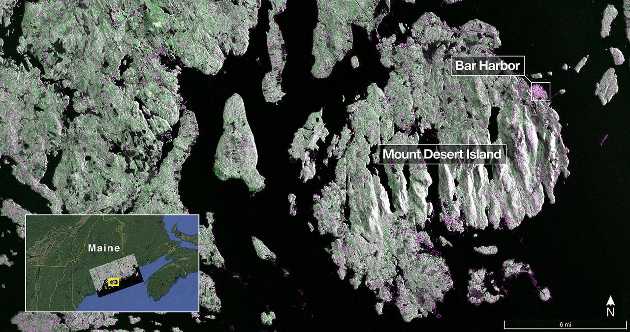
The NISAR (NASA-ISRO Synthetic Aperture Radar) Earth-observing radar satellite's L-band synthetic aperture radar (SAR) system captured this image of Mount Desert Island off the Maine coast on Aug. 21, 2025. Dark areas represent water, green areas are forest, and magenta areas are hard or regular surfaces, such as bare ground or buildings. The bright magenta area on the island's northeast end is the town of Bar Harbor. The satellite is a joint effort between NASA and the Indian Space Research Organisation (ISRO) and is the first satellite to combine L-band and S-band radar systems. The L-band system uses a 10-inch (25-centimeter) wavelength that enables its signal to penetrate forest canopies and measure soil moisture as well as motion of ice surfaces and land down to fractions of an inch – a key measurement in understanding how the land surface moves before, during, and after earthquakes, volcanic eruptions, and landslides. The S-band radar, provided by ISRO's Space Applications Centre, uses a 4-inch (10-centimeter) microwave signal that's more sensitive to small vegetation, which makes it effective at monitoring certain types of agriculture and grassland ecosystems. Data used to create the image was collected during NISAR's commissioning phase, when the spacecraft's systems and instruments are powered on and tested. The NISAR mission will begin science operations in November, roughly 90 days after its July 30, 2025, launch from Satish Dhawan Space Centre on India's southeastern coast. Observations from NISAR will benefit humanity by helping researchers around the world better understand changes in our planet's surface, including its ice sheets, glaciers, and sea ice. It also will capture changes in forest and wetland ecosystems and track movement and deformation of our planet's crust by phenomena such as earthquakes, landslides, and volcanic activity. The global and rapid coverage from NISAR will provide unprecedented support for disaster response, producing data to assist in mitigating and assessing damage, with observations before and after catastrophic events available in short time frames. https://photojournal.jpl.nasa.gov/catalog/PIA26616
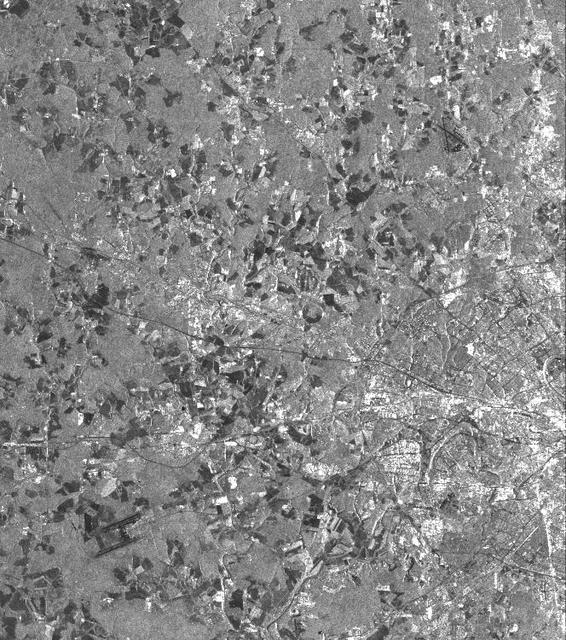
This is a vertically polarized L-band image of the southern half of Moscow, an area which has been inhabited for 2,000 years. The image covers a diameter of approximately 50 kilometers (31 miles) and was taken on September 30, 1994 by the Spaceborne Imaging Radar-C/X-band Synthetic Aperture Radar aboard the space shuttle Endeavour. The city of Moscow was founded about 750 years ago and today is home to about 8 million residents. The southern half of the circular highway (a road that looks like a ring) can easily be identified as well as the roads and railways radiating out from the center of the city. The city was named after the Moskwa River and replaced Russia's former capital, St. Petersburg, after the Russian Revolution in 1917. The river winding through Moscow shows up in various gray shades. The circular structure of many city roads can easily be identified, although subway connections covering several hundred kilometers are not visible in this image. The white areas within the ring road and outside of it are buildings of the city itself and it suburban towns. Two of many airports are located in the west and southeast of Moscow, near the corners of the image. The Kremlin is located north just outside of the imaged city center. It was actually built in the 16th century, when Ivan III was czar, and is famous for its various churches. In the surrounding area, light gray indicates forests, while the dark patches are agricultural areas. The various shades from middle gray to dark gray indicate different stages of harvesting, ploughing and grassland. http://photojournal.jpl.nasa.gov/catalog/PIA01752
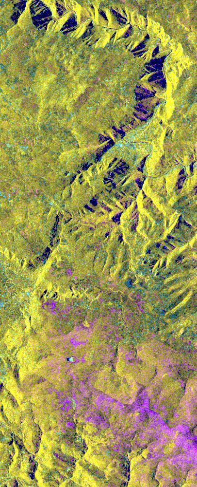
This is an X-band seasonal image of the central part of Lozere Departement situated south of the Massif Central in France. The image is 10 kilometers by 25 kilometers (6 miles by 15.5 miles) and is centered at approximately 44.3 degrees north latitude and 3 degrees east longitude. This image was acquired by the Spaceborne Imaging Radar-C/X-band Synthetic Aperture Radar aboard the space shuttle Endeavour on April 15, 1994 and on October 6, 1994. The image channels have the following color assignments: red was acquired in April; green was acquired in October; and blue is the ratio of the two data sets combined. Seasonal differences in the vegetation are visible in pink, which are heaths growing in the spring. This research area features two large limestone plateaus cut by the famous Gorges du Tarn, standing in parallel with the granite mountain range known as the Cevennes Mountains nearby. Land-use consists mainly of grasslands, heaths and forests. Forest types seen in the images are Austrian pines,Scots pines, spruce, fir and beech trees. Most forests were planted at the end of the 19th century through a national reforestation program aimed at reducing the strong erosion risks in these areas. This program was so successful that today the forests are exploited for forest pulpwood and sawlogs, but also remain protected as conservation regions. The study being performed in this area will assess the potential of spaceborne radar remote sensing for temperate forest type mapping and forest resource monitoring. The combination of X-band SAR data with lower frequency data (such as the SIR-C L-band data) allows scientists to distinguish forest tree species and biomass, or areas of ground vegetation. The lessons learned from the radar images of these controlled forest regions can be applied to larger areas and naturally grown forests to help ecologists protect and maintain them. The SIR-C/X-SAR images will be investigated by scientists from the remote sensing laboratory Cemagref in Montpellier and the National Forestry Board in Mende, France. http://photojournal.jpl.nasa.gov/catalog/PIA01755
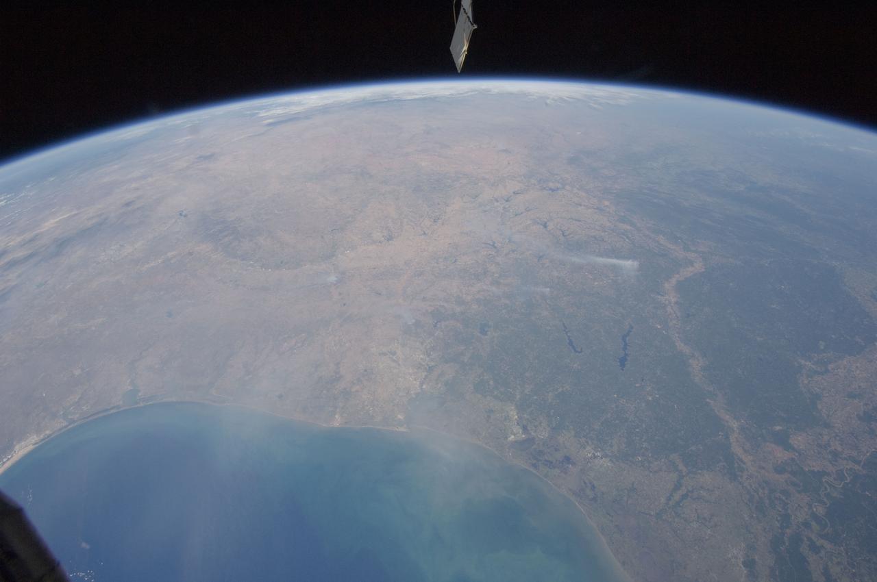
ISS028-E-037978 (6 Sept. 2011) --- Wildfire smoke plumes in Texas are featured in this image photographed by an Expedition 28 crew member on the International Space Station. This panoramic view of east-central Texas highlights numerous smoke plumes caused by wildfires burning across the state. The image was taken using a short focal length lens (12-mm), which captures a wide field of view at the cost of fine feature resolution. Smoke plumes are clearly visible in the image to the east of Austin; to the north of Houston; to the northwest of Lake Sam Rayburn and Toledo Bend Reservoir; and to the west of Shreveport, LA. More diffuse smoke moving offshore into the Gulf of Mexico is visible at bottom. Part of an ISS photovoltaic radiator panel is visible at top center. Record-setting drought conditions have affected much of Texas since early 2011 and have dried out both forest and grassland, providing ample fuel for wildfires. Relatively high winds and low humidity levels have also contributed to the rapid spread and expansion of fires. According to a Texas Forest Service (TXFS) Incident Management Situation Report dated Sept. 7, 2011, TXFS had responded to 172 fires affecting an area of 546.53 square kilometers (135,051 acres) over the preceding seven days. Fires near Bastrop, TX to the east of Austin had destroyed 785 homes as of Sept. 7, 2011.
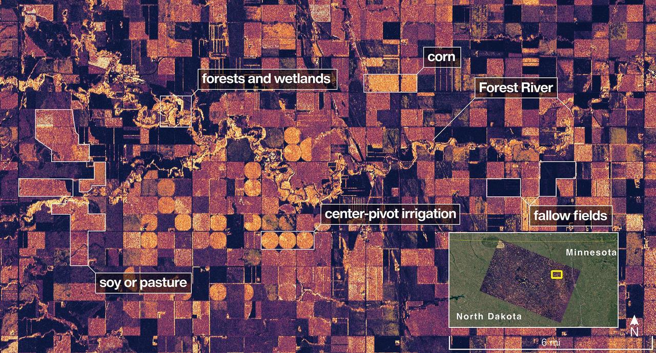
The NISAR (NASA-ISRO Synthetic Aperture Radar) Earth-observing radar satellite's L-band synthetic aperture radar (SAR) system captured an image of a portion of northeastern North Dakota straddling Grand Forks and Walsh counties on Aug. 23, 2025. Produced by scientists on the NISAR science team, the image shows forests and wetlands on the banks of the Forest River meandering through the middle of the frame from west to east and farmland to the north and south. The darker agricultural plots are fallow fields, while the lighter colors represent the presence of pasture or crops, such as soybean and corn. Circular patterns indicate the use of center-pivot irrigation. The satellite is a joint effort between NASA and the Indian Space Research Organisation (ISRO) and is the first satellite to combine L-band and S-band radar systems. The satellite's L-band system, provided by NASA's Jet Propulsion Laboratory in Southern California, uses a 10-inch (25-centimeter) wavelength that enables its signal to penetrate forest canopies and measure soil moisture as well as motion of ice surfaces and land down to fractions of an inch – a key measurement in understanding how the land surface moves before, during, and after earthquakes, volcanic eruptions, and landslides. The NISAR S-band radar, provided by ISRO's Space Applications Centre, uses a 4-inch (10-centimeter) microwave signal that's more sensitive to small vegetation, which makes it effective at monitoring certain types of agriculture and grassland ecosystems. Data used to create the image was collected during NISAR's commissioning phase, when the spacecraft's systems and instruments are powered on and tested. The NISAR mission will begin science operations in November, roughly 90 days after its July 30, 2025, launch from Satish Dhawan Space Centre on India's southeastern coast. Observations from NISAR will benefit humanity by helping researchers around the world better understand changes in our planet's surface, including its ice sheets, glaciers, and sea ice. It also will capture changes in forest and wetland ecosystems and track movement and deformation of our planet's crust by phenomena such as earthquakes, landslides, and volcanic activity. The global and rapid coverage from NISAR will provide unprecedented support for disaster response, producing data to assist in mitigating and assessing damage, with observations before and after catastrophic events available in short time frames. https://photojournal.jpl.nasa.gov/catalog/PIA26615
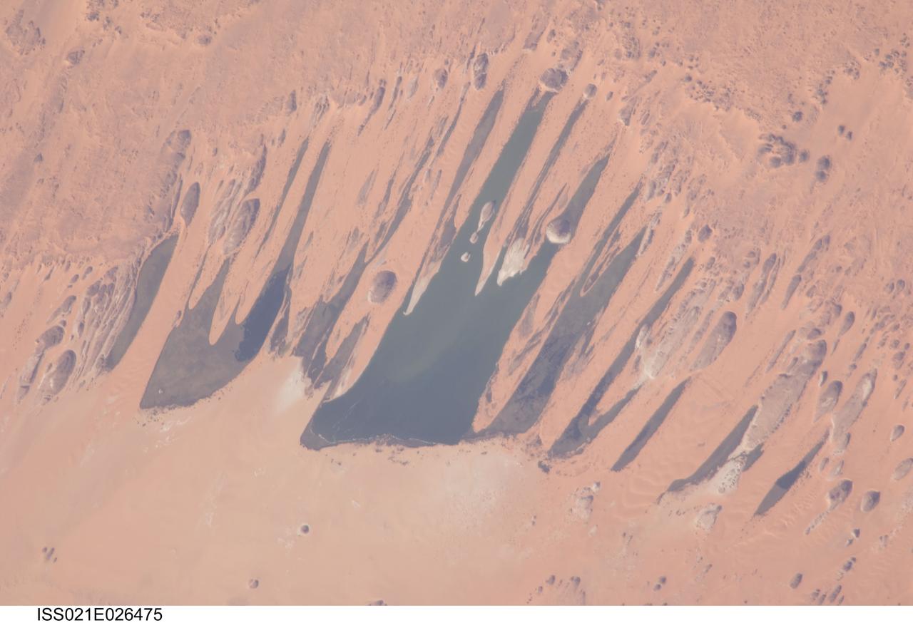
ISS021-E-026475 (14 Nov. 2009) --- Ounianga Lakes in the Sahara Desert, in the nation of Chad are featured in this image photographed by an Expedition 21 crew member on the International Space Station. This view features one of the largest of a series of ten, mostly fresh water lakes in the Ounianga basin in the heart of the Sahara Desert of northeastern Chad. According to scientists, the lakes are the remnant of a single large lake, probably tens of kilometers long that once occupied this remote area approximately 14,800 to 5,500 years ago. As the climate dried out during the subsequent millennia, the lake was reduced in size and large wind-driven sand dunes invaded the original depression dividing it into several smaller basins. The area shown in this image measures approximately 11 x 9 kilometers, with the dark water surfaces of the lake segregated almost completely by orange linear sand dunes that stream into the depression from the northeast. The almost year-round northeast winds and cloudless skies make for very high evaporation (an evaporation rate of greater than six meters per year has been measured in one of the nearby lakes). Despite this, only one of the ten lakes is saline. According to scientists, the reason for the apparent paradox of fresh water lakes in the heart of the desert lies in the fact that fresh water from a very large aquifer reaches the surface in the Ounianga depression in the form of the lakes. The aquifer is large enough to keep supplying the small lakes with water despite the high evaporation rate. Mats of floating reeds also reduce the evaporation in places. The lakes form a hydrological system that is unique in the Sahara Desert. Scientists believe the aquifer was charged with fresh water, and the large original lake evolved, during the so-called African Humid Period (approximately 14,800 to 5,500 years ago) when the West African summer monsoon was stronger than it is today. Associated southerly winds brought Atlantic moisture well north of modern limits, producing sufficient rainfall in the central Sahara to foster an almost complete savanna vegetation cover. Pollen data from lake sediments of the original 50-meters-deep Ounianga Lake suggests to scientists that a mild tropical climate with a wooded grassland savanna existed in the region. This vegetation association is now only encountered 300 kilometers further south. Ferns grew in the stream floodplains which must have been occasionally flooded. Even shrubs that now occur only on the very high, cool summits (greater than 2,900 meters, greater than 9,500 feet) of the Tibesti Mts. have been found in the Ounianga lake sediments.
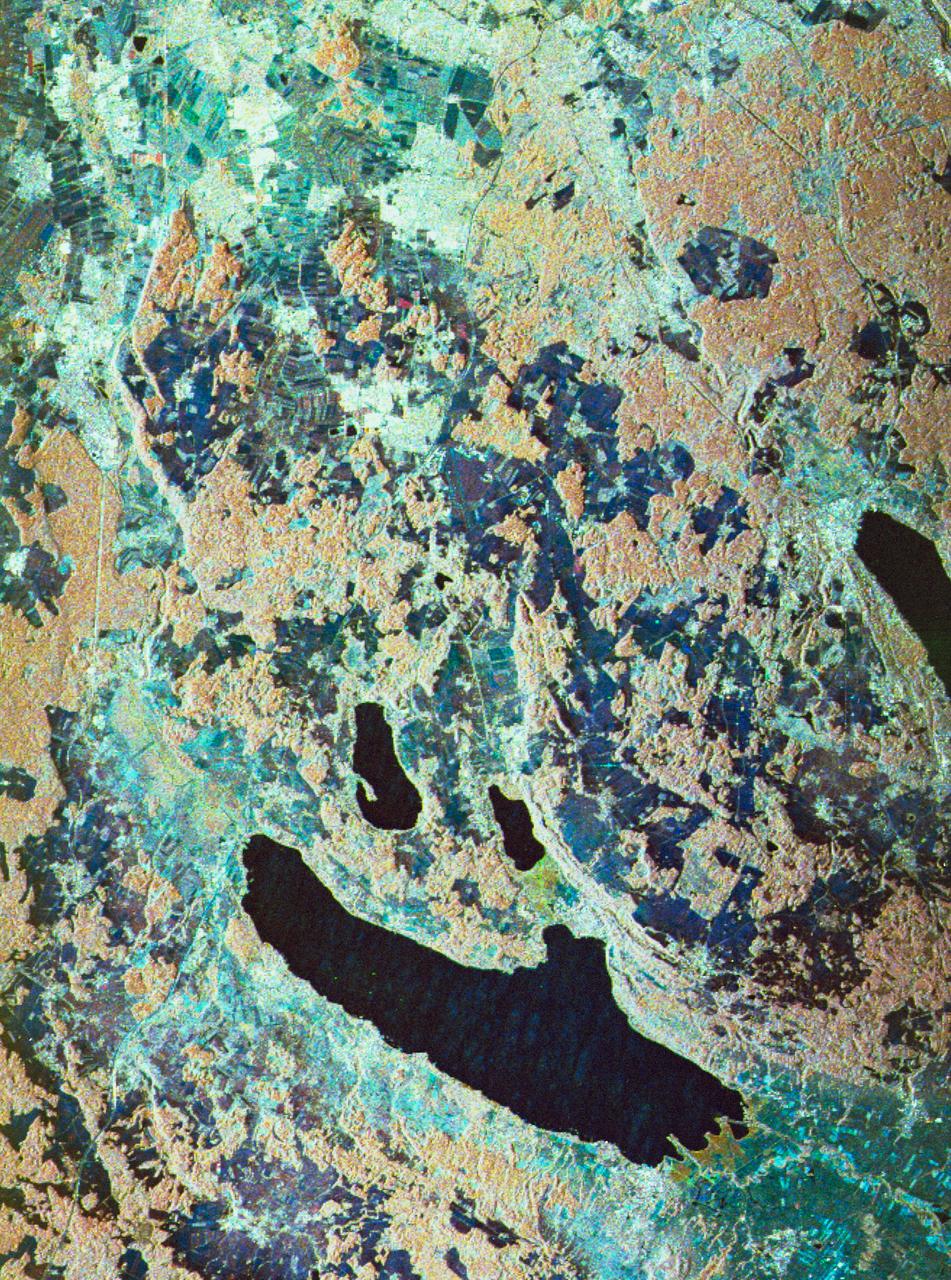
STS059-S-080 (18 April 1994) --- This is a false-color three frequency image of the Oberpfaffenhofen supersite, an area just south-west of Munich in southern Germany. The colors show the different conditions that the three radars (X-Band, C-Band and L-Band) can see on the ground. The image covers a 27 by 36 kilometer area. The center of the site is 48.09 degrees north and 11.29 degrees east. The image was acquired by the Spaceborne Imaging Radar-C and X-Band Synthetic Aperture Radar (SIR-C/X-SAR) onboard the Space Shuttle Endeavour on April 11, 1994. The dark area on the left is Lake Ammersee. The two smaller lakes are the Woerthsee and the Pilsensee. On the bottom is the tip of the Starnbergersee. The city of Munich is located just beyond the right of the image. The Oberpfaffenhofen supersite is the major test site for SIR-C/X-SAR calibration and scientific investigations concerning agriculture, forestry, hydrology and geology. This color composite image is a three frequency overlay. L-Band total power was assigned red, the C-Band total power is shown in green and the X-Band VV polarization appears blue. The colors on the image stress the differences between the L-Band, C-Band, X-Band images. If the three radar antennas were getting an equal response from objects on the ground, this image would appear in black and white. However, in this image, the blue areas corresponds to area for which the X-Band backscatter is relatively higher than the backscatter at L and C-Bands. This behavior is characteristic of grasslands, clear cuts and shorter vegetation. Similarly, the forested areas have a reddish tint (L-Band). The green areas seen near both the Ammersee and the Pilsensee lakes indicate marshy areas. The agricultural fields in the upper right hand corner appear mostly in blue and green (X-Band and C-Band). The white areas are mostly urban areas, while the smooth surfaces of the lakes appear very dark. SIR-C/X-SAR is part of NASA's Mission to Planet Earth (MTPE). SIR-C/X-SAR radars illuminate Earth with microwaves allowing detailed observations at any time, regardless of weather or sunlight conditions. SIR-C/X-SAR uses three microwave wavelengths: L-Band (24 cm), C-Band (6 cm), and X-Band (3 cm). The multi-frequency data will be used by the international scientific community to better understand the global environment and how it is changing. The SIR-C/X-SAR data, complemented by aircraft and ground studies, will give scientists clearer insights into those environmental changes which are caused by nature and those changes which are induced by human activity. SIR-C was developed by NASA's Jet Propulsion Laboratory (JPL). X-SAR was developed by the Dornire and Alenia Spazio Companies for the German Space Agency, Deutsche Agentur fuer Raumfahrtangelegenheiten (DARA), and the Italian Space Agency, Agenzia Spaziale Italiana (ASI). JPL Photo ID: P-43930
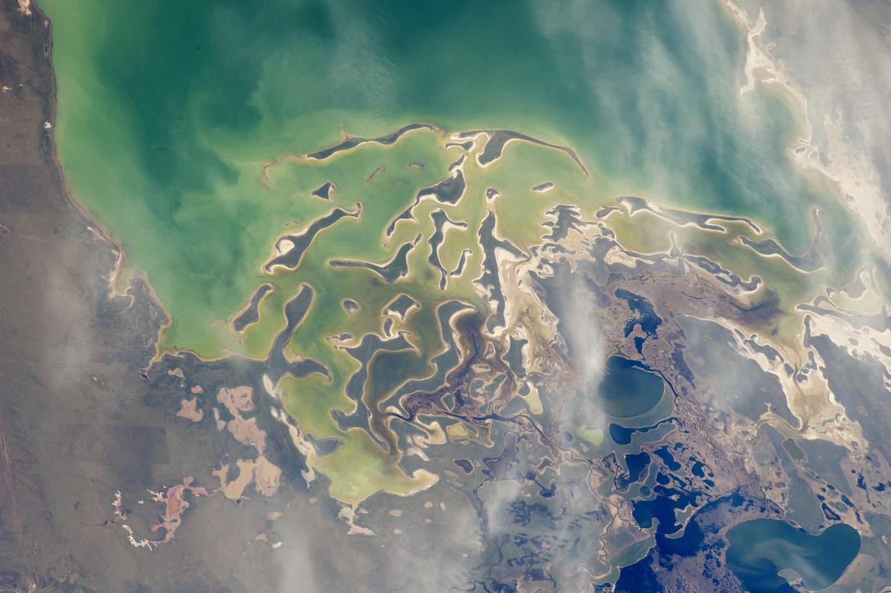
In orbit above the semi-desert grasslands in Kazakhstan, an astronaut aboard the International Space Station spotted one of the few features that stand out. Lake Tengiz is the only large lake (1590 square kilometers, 615 square miles) in northern Kazakhstan. Through white wisps of cloud, the crew member photographed the 50 kilometer-long eastern shore of the lake, with its thin, winding islands and white beaches. The islands and intervening waterways make a rich habitat for birds in this part of Asia. At least 318 species of birds have been identified at the lake; 22 of them are endangered. It is the northernmost habitat of the pink flamingo. The lake system is Kazakhstan’s first UNESCO World Heritage Site, and it has been declared a RAMSAR wetland site of international importance. Part of the richness of area is its complex hydrology. Fresh water enters the system via the Kulanutpes River, so there are small lakes (lower right) full of fresh water. But in this closed basin, the water in the main lake (top) slowly evaporates, becoming salty. Winds stir up bigger waves on the main lake, dispersing sediment and salt and making the water a cloudier and lighter blue-green. (Another astronaut photograph shows the entire lake system, while this story provides more information.) The strange shape of the islands is not easy to interpret. They may be drowned remnants of delta distributaries of the Kulanutpes River. Westerly winds probably have had a smoothing effect on the shorelines, especially in a shallow lake like Tengiz, which is only about 6 meters (20 feet) deep. The lake has an exciting history for people who follow space exploration. In 1976, a Soyuz spacecraft landed in the lake near the north shore (top right). The capsule crashed through the ice and sank during an October snowstorm when temperatures were -22°C (-8°F). Because of low power, the capsule was unheated and the crew was feared lost. It was many hours before the airtight capsule was located and divers could attach flotation tanks to get the capsule to the surface. It was then dragged ashore across the ice by helicopter. The rescue effort took nine hours before the crew was able to safely exit the capsule. Credit: <b><a href="http://www.earthobservatory.nasa.gov/" rel="nofollow"> NASA Earth Observatory</a></b> <b><a href="http://www.nasa.gov/audience/formedia/features/MP_Photo_Guidelines.html" rel="nofollow">NASA image use policy.</a></b> <b><a href="http://www.nasa.gov/centers/goddard/home/index.html" rel="nofollow">NASA Goddard Space Flight Center</a></b> enables NASA’s mission through four scientific endeavors: Earth Science, Heliophysics, Solar System Exploration, and Astrophysics. Goddard plays a leading role in NASA’s accomplishments by contributing compelling scientific knowledge to advance the Agency’s mission. <b>Follow us on <a href="http://twitter.com/NASAGoddardPix" rel="nofollow">Twitter</a></b> <b>Like us on <a href="http://www.facebook.com/pages/Greenbelt-MD/NASA-Goddard/395013845897?ref=tsd" rel="nofollow">Facebook</a></b> <b>Find us on <a href="http://instagrid.me/nasagoddard/?vm=grid" rel="nofollow">Instagram</a></b>