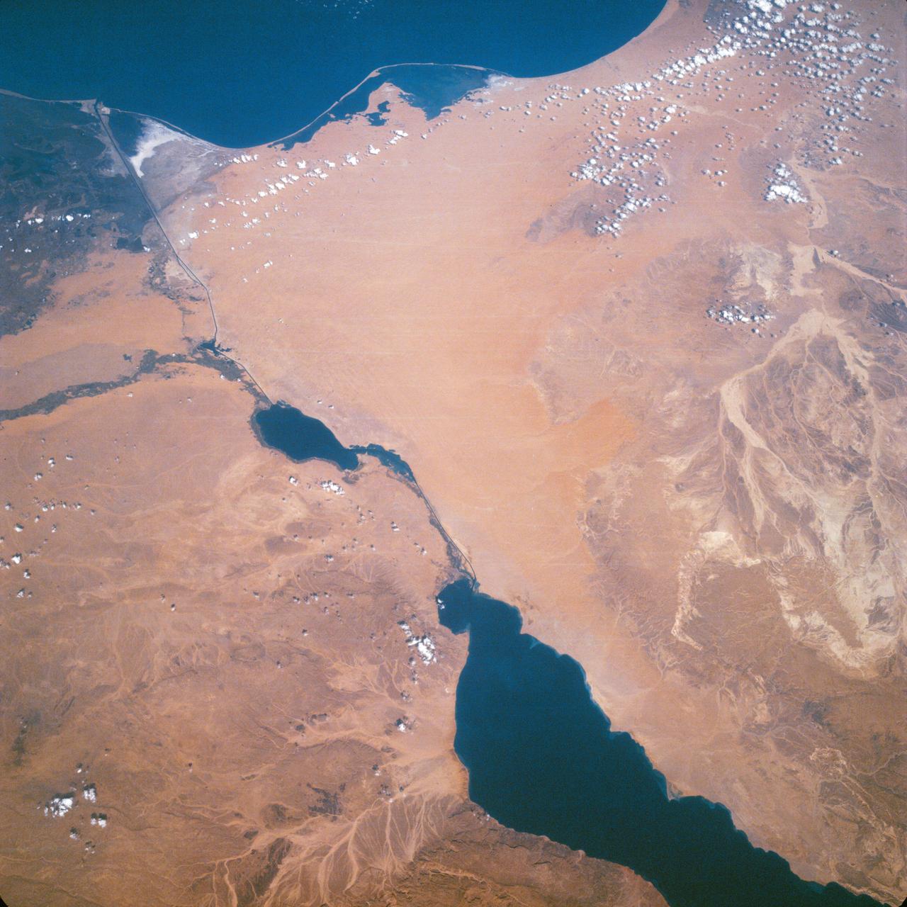
Suez Canal, Gulf of Suez, Sinai Peninsula, United Arab Republic (Egypt), Mediterranean Sea, as seen from the Apollo 7 spacecraft during its 13th revolution of the earth. Photographed from an altitude of 126 nautical miles, at ground elapsed time of 19 hours and 42 minutes.
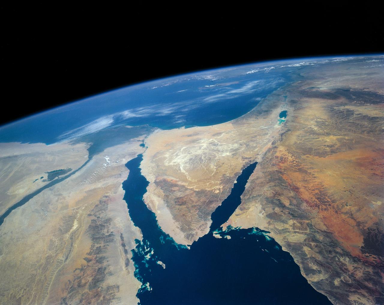
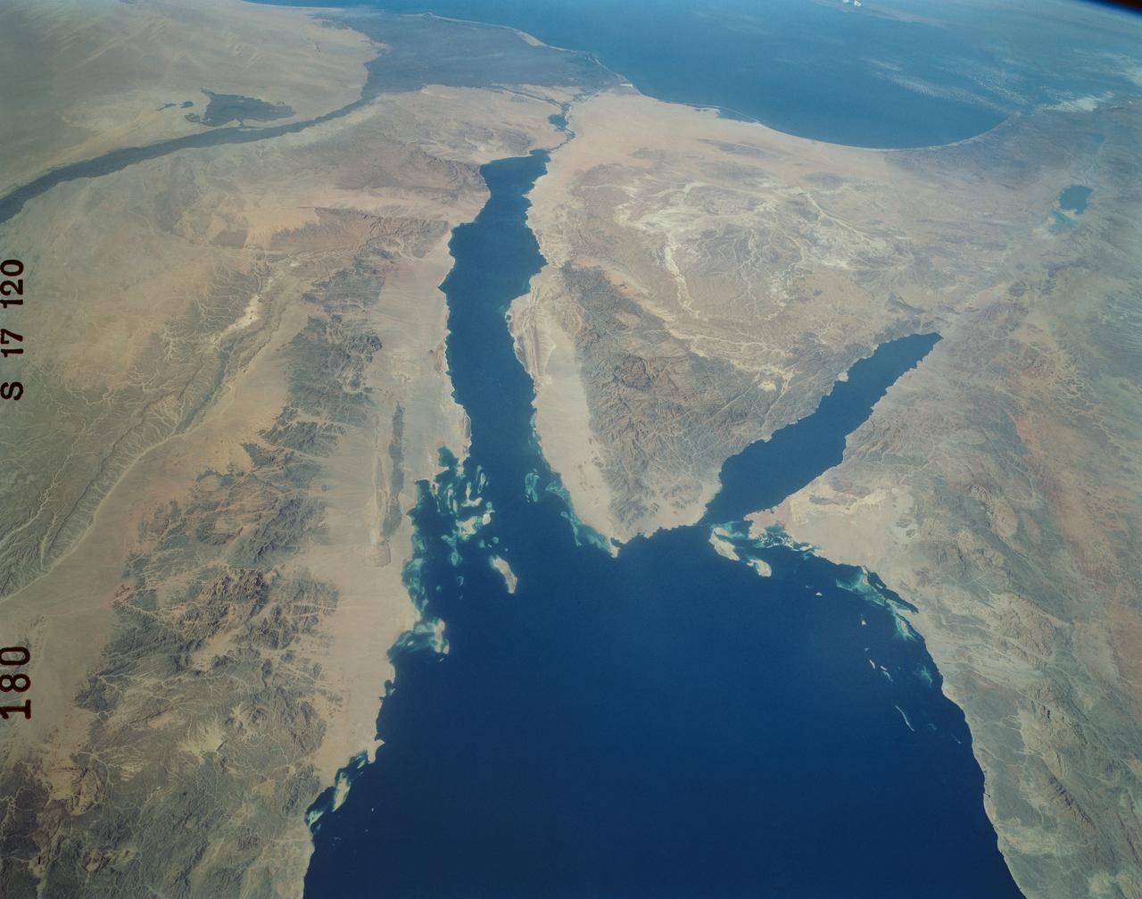
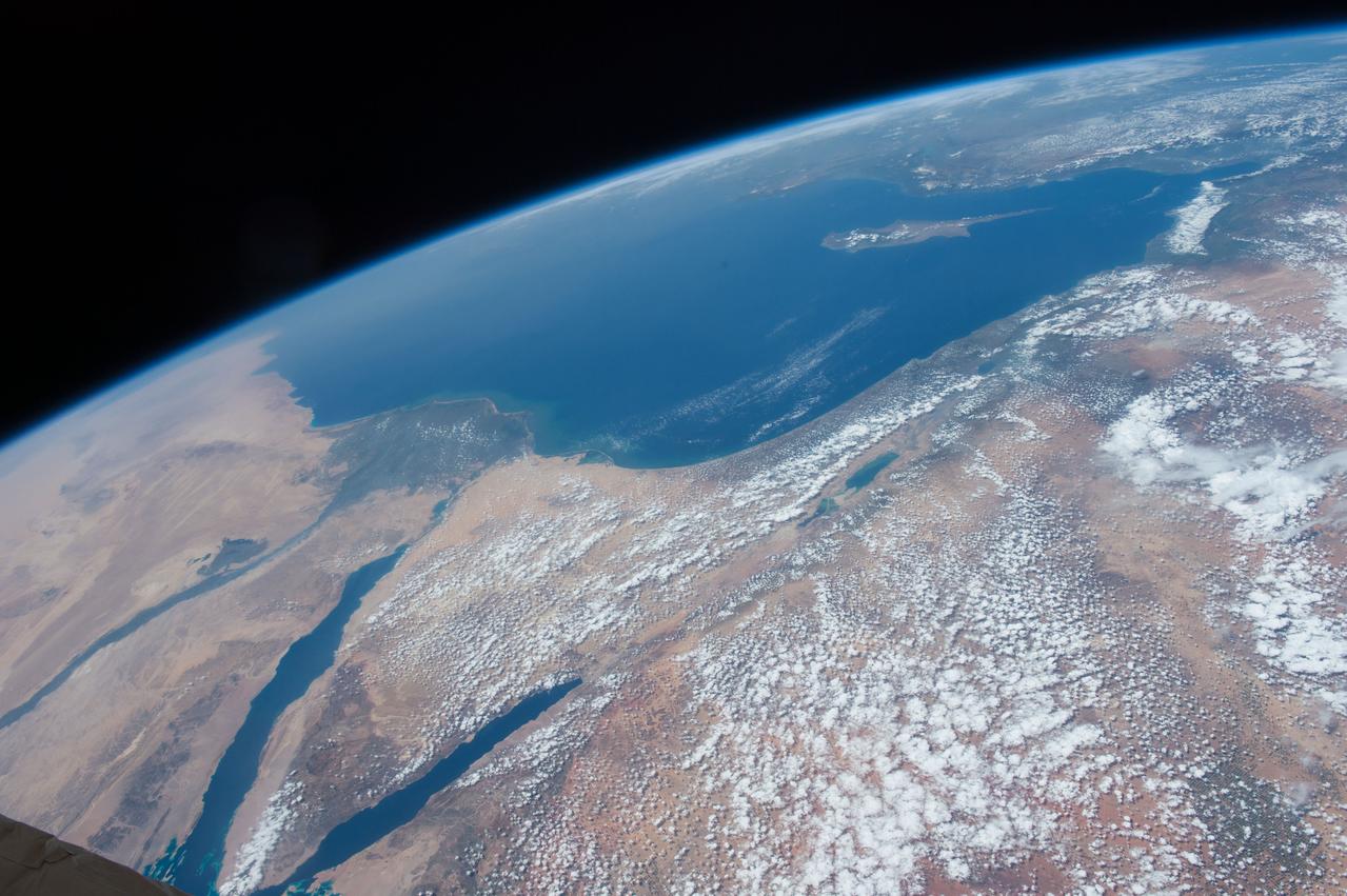
STS040-152-180 (5-24 June 1991) --- The Sinai Peninsula dominates this north-looking, oblique view. According to NASA photo experts studying the STS 40 imagery, the Red Sea in the foreground is clear of river sediment because of the prevailing dry climate of the Middle East. The great rift of the Gulf of Aqaba extends northward to Turkey (top right) through the Dead Sea. The international boundary between Israel and Egypt, reflecting different rural landscapes, stands out clearly. The Nile River runs through the frame. NASA photo experts believe the haze over the Mediterranean to be wind-borne dust. The photo was taken with an Aero-Linhof large format camera.
iss071e414023 (Aug. 2, 2024) --- The sun's glint beams off the Gulf of Gabes on the coast of Tunisia with Sharqi Island in the Mediterranean Sea in this photograph taken from the International Space Station as it orbited 262 miles above the African nation.
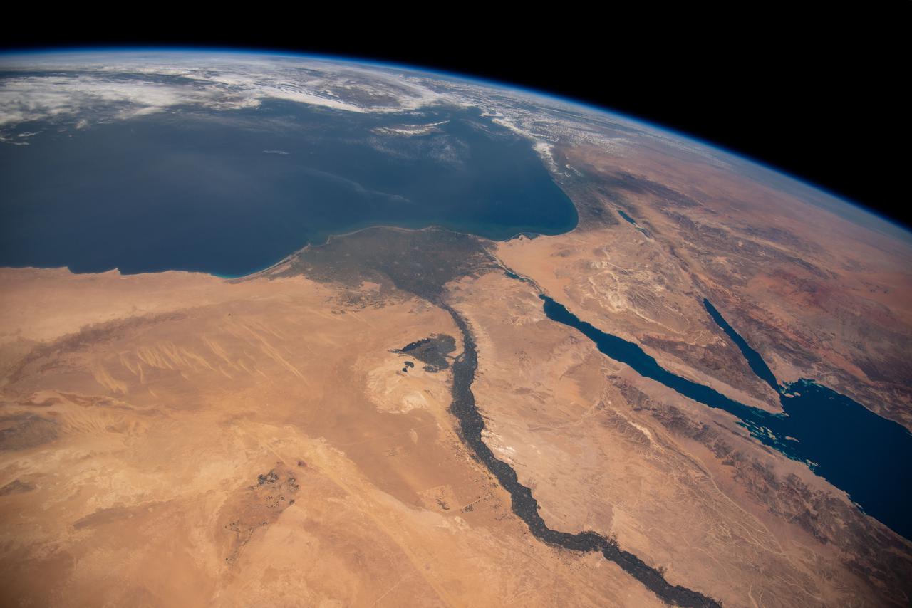
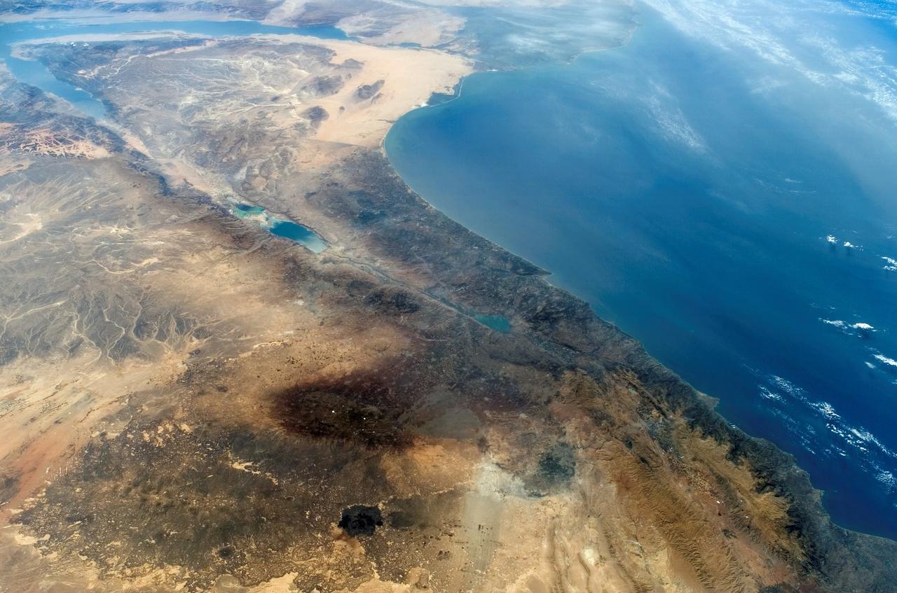
iss064e053173 (April 4, 2021) --- The Nile River, The Red Sea, The Gulf of Oman, The Gulf of Aqaba, and The Mediterranean Sea are pictured in the Middle East from the International Space Station as it orbited 263 miles above Egypt.
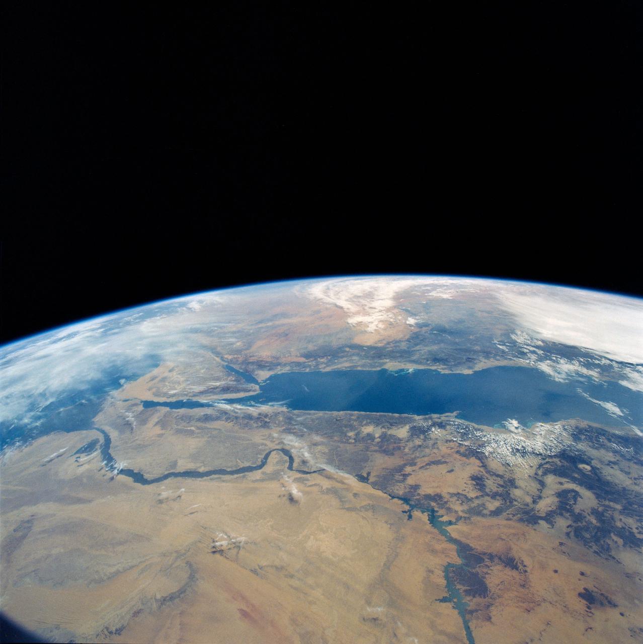
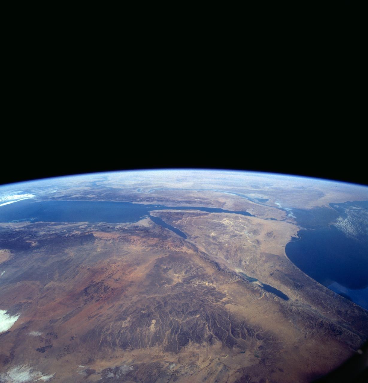
An excellent panoramic view of the entire Sinai Peninsula (29.0N, 34.0E) and the nearby Nile River Delta and eastern Mediterranean coastal region. The Suez Canal, at the top of the scene just to the right of the Delta, connects the Mediterranean Sea with the Gulf of Suez on the west side of the Sinai Peninsula and the Gulf of Aqaba is on the west where they both flow into the Red Sea. At upper right, is the Dead Sea, Jordan River and Lake Tiberius.
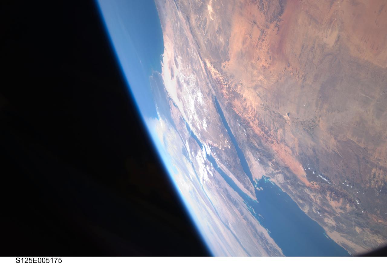
S125-E-005175 (12 May 2009) --- Among the first group of still images downlinked by the STS-125 crewmembers onboard the Space Shuttle Atlantis was this high oblique scene looking toward the Red Sea, Sinai Peninsula and the Mediterranean Sea. Saudi Arabia is in the foreground and Egypt?s Nile River and its delta can be seen (left) toward the horizon. Israel and Jordan can be seen near the top edge of the frame. The Gulf of Suez and the Gulf of Aqaba (near frame center) extend from the Red Sea toward the Mediterranean Sea.
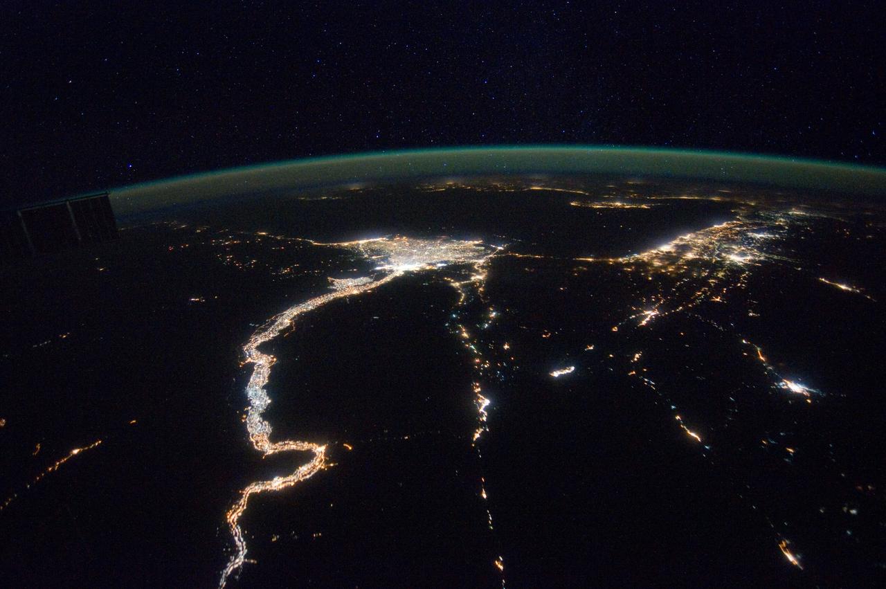
iss065e074560 (May 20, 2021) --- This nighttime photograph, taken from the International Space Station as it orbited 263 miles above Turkey, highlights the Moon's glint on the Mediterranean Sea and the Gulf of Suez. The city lights along the Nile Delta and the eastern Mediterranean coast also figure prominently in the picture.
S125-E-005173 (12 May 2009) --- Among the first group of still images downlinked by the STS-125 crewmembers onboard the Space Shuttle Atlantis was this high oblique scene looking toward the Sinai Peninsula and the Mediterranean Sea. The Red Sea is just out of frame at bottom right. Saudi Arabia is in the right foreground and Egypt?s Nile River and its delta can be seen (lower left) toward the horizon. Jordan and a small portion of Israel can be seen near the top of the frame. The Gulf of Suez and the Gulf of Aqaba extend from the Red Sea toward the Mediterranean.
iss071e405499 (July 26, 2024) -- Flowing into the Mediterranean Sea, the Nile River is pictured from the International Space Station as it orbited 257 miles above Egypt. The Gulfs of Suez and Aqaba, feeding into the Red Sea, can also be seen in this photo, contrasting against the surrounding tan and orange terrain.
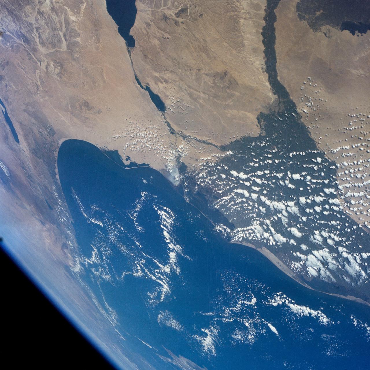
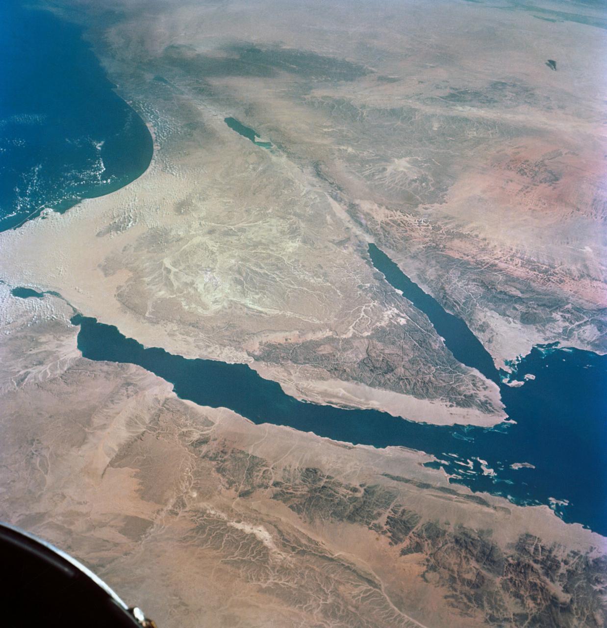
STS080-745-004 (19 Nov.-7 Dec. 1996) --- A view to the west showing Asia in the foreground and Africa in the background, as photographed by the space shuttle Columbia crewmembers. The Mediterranean Sea is to the upper right and the Red Sea to the lower left (holding photograph with NASA numbers on left). Sinai Peninsula is between the two with the Gulf of Suez above and the Gulf of Aqaba below. The Suez Canal connects the Gulf of Suez with the Mediterranean Sea. The triangular shaped dark area beyond is the Nile River Delta. The thin green fertile valley of the Nile crosses the photograph from a point at Cairo (near dark triangle area) past the great bend at Luxor with Thebes and the Valley of the Kings, and on the left into the Nubian Desert with the Aswan High Dam at the very left edge of the photograph. To the horizon is the Western Desert of Egypt and Libya. The foreground is the northwest portion of Saudi Arabia, an area known as the Hejaz with the southern portions of Israel and Jordan to the lower right.
STS031-79-015 (24-29 April 1990) --- The 330-plus nautical mile orbital altitude of the Space Shuttle Discovery allowed for this unique high oblique 70mm Hasselblad frame. Egypt is in the foreground, with the Nile River and Lake Nasser readily identifiable. Cairo and Alexandria are visible. The Mediterranean Sea is on the horizon in upper left. The Red Sea is in the center. Other areas seen include Saudi Arabia, Jordan, Palestine and Israel; the Gulf of Aqaba and the Gulf of Suez.
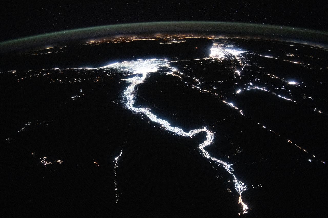
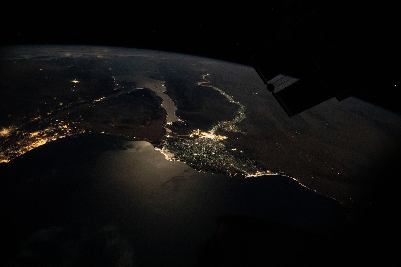
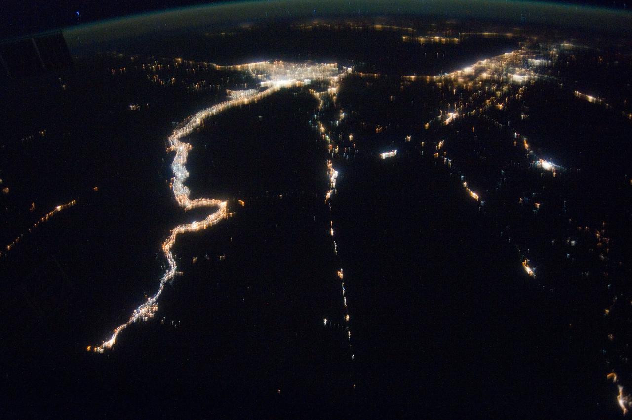
iss071e256968 (June 30, 2024) --- The night lights of civilization highlight the Nile River and dimly outline the shores of the Red Sea, the Gulf of Suez, and the Gulf of Adaba in the Middle East. The nations of Israel, Jordan, and Syria, as well as the Southern European region across the darkness of the Mediterranean Sea also are well lit in this photograph taken from the International Space Station at approximately midnight local time in Cairo, Egypt.
S115-E-07595 (19 Sept. 2006) --- A crewmember aboard the Space Shuttle Atlantis recorded this digital still image of part of the eastern Mediterranean area. The Gulf of Suez, Gulf of Aqaba, Dead Sea, Tel Aviv and Jerusalem all are visible in the upper left quadrant. Jordan is in the lower left quadrant. The Golan Heights and Haifa appear in the lower right quarter.
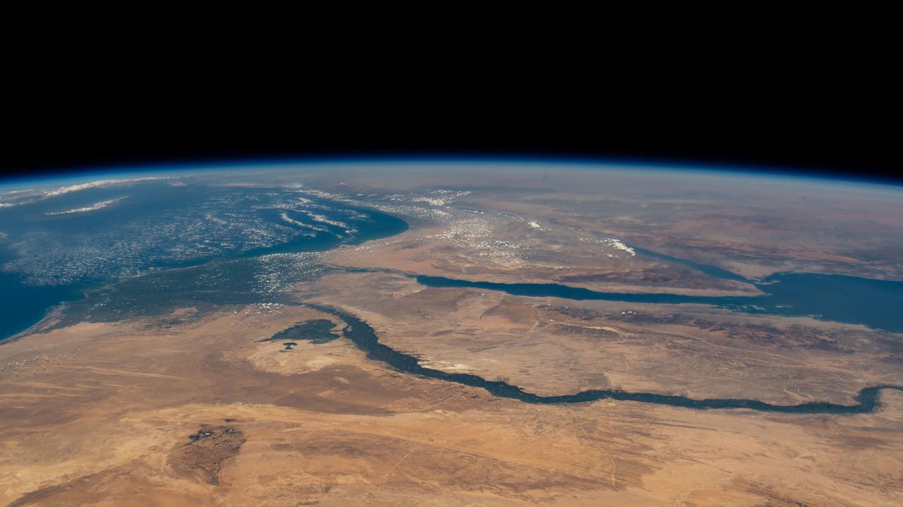
ISS047e057822 (04/14/2016) --- The Middle East is seen from 250 miles above in this photo from the International Space Station. Countries seen left to right along the Mediterranean coast include Egypt, Gaza, Saudi Arabia, Israel, Lebanon, Syria, and Turkey. The major waterways shown from left to right are the Nile River, Gulf of Suez, Gulf of Aqaba, and the Red Sea.
S65-63849 (8 Dec. 1965) --- The eastern Mediterranean area as seen from the National Aeronautics and Space Administration's Gemini-7 spacecraft. The Nile Delta in Egypt is at bottom. The Suez Canal, Gulf of Suez and Red Sea are in the center of the photograph. The Sinai Peninsula is in the upper right corner of the picture. The body of water at the top edge of the photograph is the Gulf of Aqaba. The Dead Sea can be seen at top center. Israel, Palestine, Jordan and Syria are also at top center. The Island of Cyprus is at extreme left. Astronauts Frank Borman and James A. Lovell Jr. took this picture using a modified 70mm Hasselblad camera, with Eastman Kodak, Ektachrome MS (S.O. 217) color film. Photo credit: NASA
A high oblique view of the Middle East centered at approximately 28.0 degrees north and 34.0 degrees east. Portions of the countries of Egypt, Israel, Jordan and Saudi Arabia are visible. The Dead Sea Rift Valley continuing into the Gulf of Aqaba marks the boundary between Israel and Jordan. The vegetation change in the Sinai Peninsula is the border between the Gaza Strip and Egypt. In Egypt, the Suez Canal connects the Gulf of Suez with the Mediterranean Sea and forms the western boundary of the Sinai Peninsula. The green ribbon of the Nile River is in marked contrast to this arid region. Even the Jordan River does not support large scale agriculture.
S66-54893 (14 Sept. 1966) --- Near East area as seen from the orbiting Gemini-11 spacecraft during its 26th revolution of Earth. The United Arab Republic (Egypt) is in foreground. Triangular-shaped area is the Sinai Peninsula. Saudi Arabia is at upper right. The Mediterranean Sea is at upper left. The Gulf of Suez separates Egypt from the Sinai Peninsula. The Red Sea is at bottom right. The Gulf of Aqaba is the body of water in right center of photograph separating the Sinai Peninsula and the Arabian Peninsula. The Dead Sea, Sea of Galilee, Jordan and Israel are in top center of picture. Iraq is at top right edge of photograph. Taken with a J. A. Maurer 70mm camera, using Eastman Kodak, Ektachrome, MS (S.O. 368) color film. Photo credit: NASA
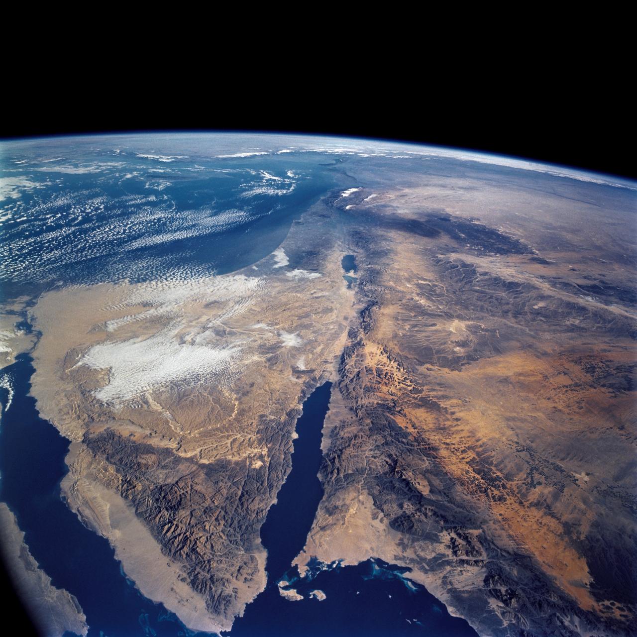
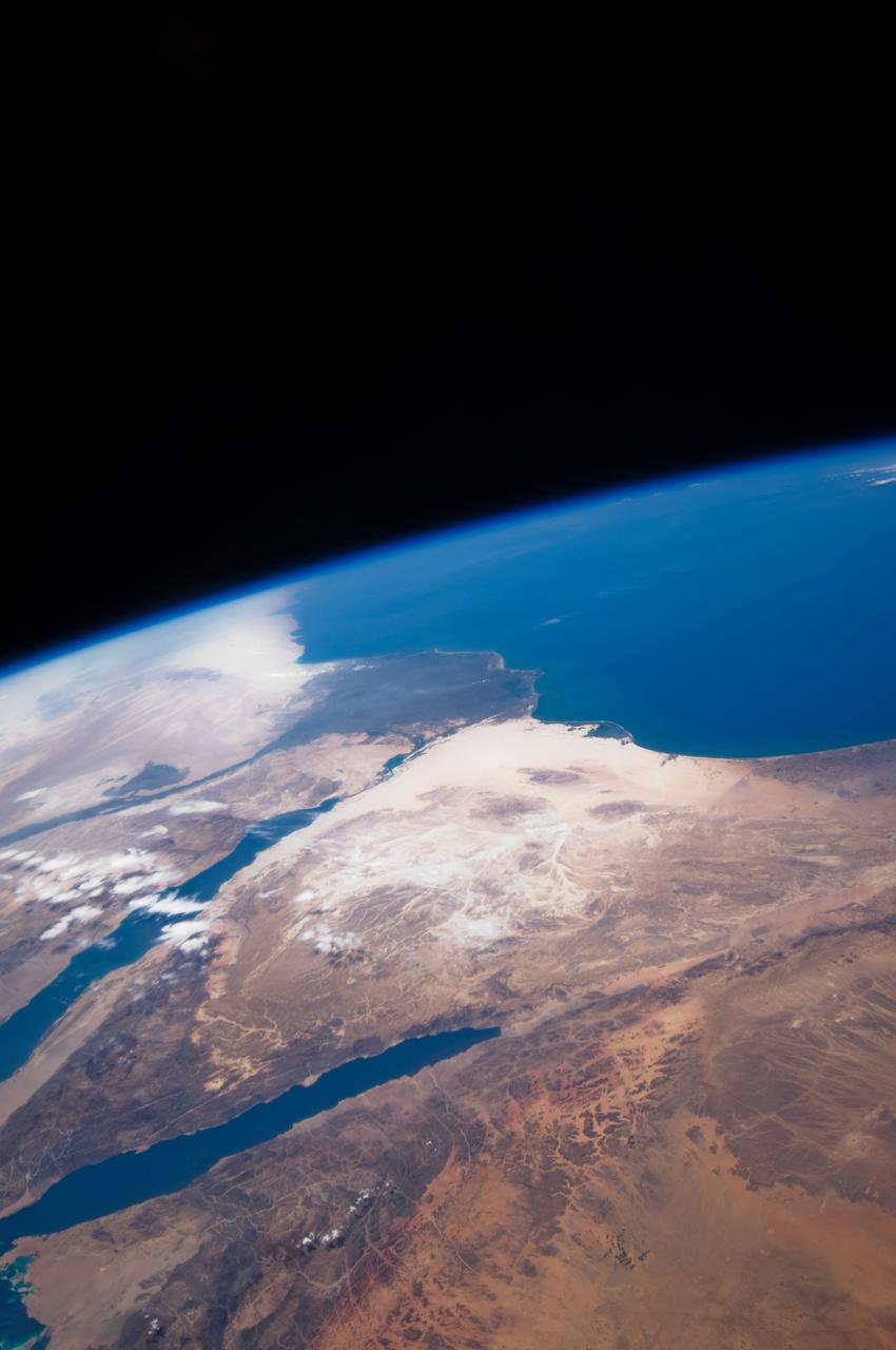
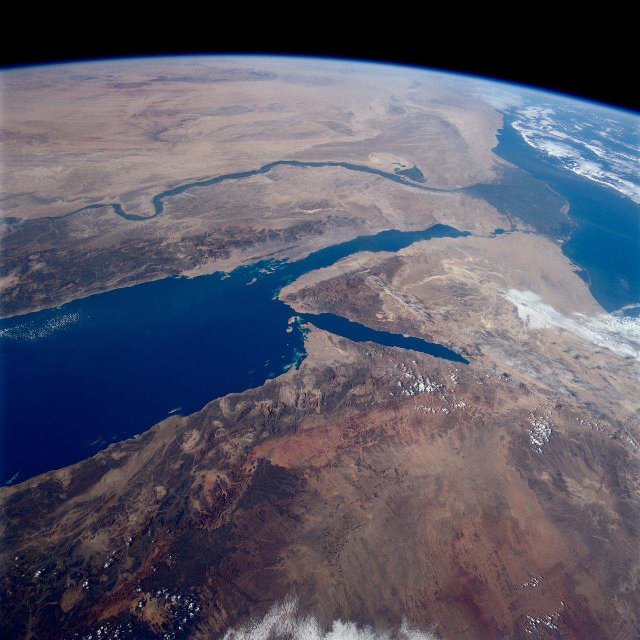
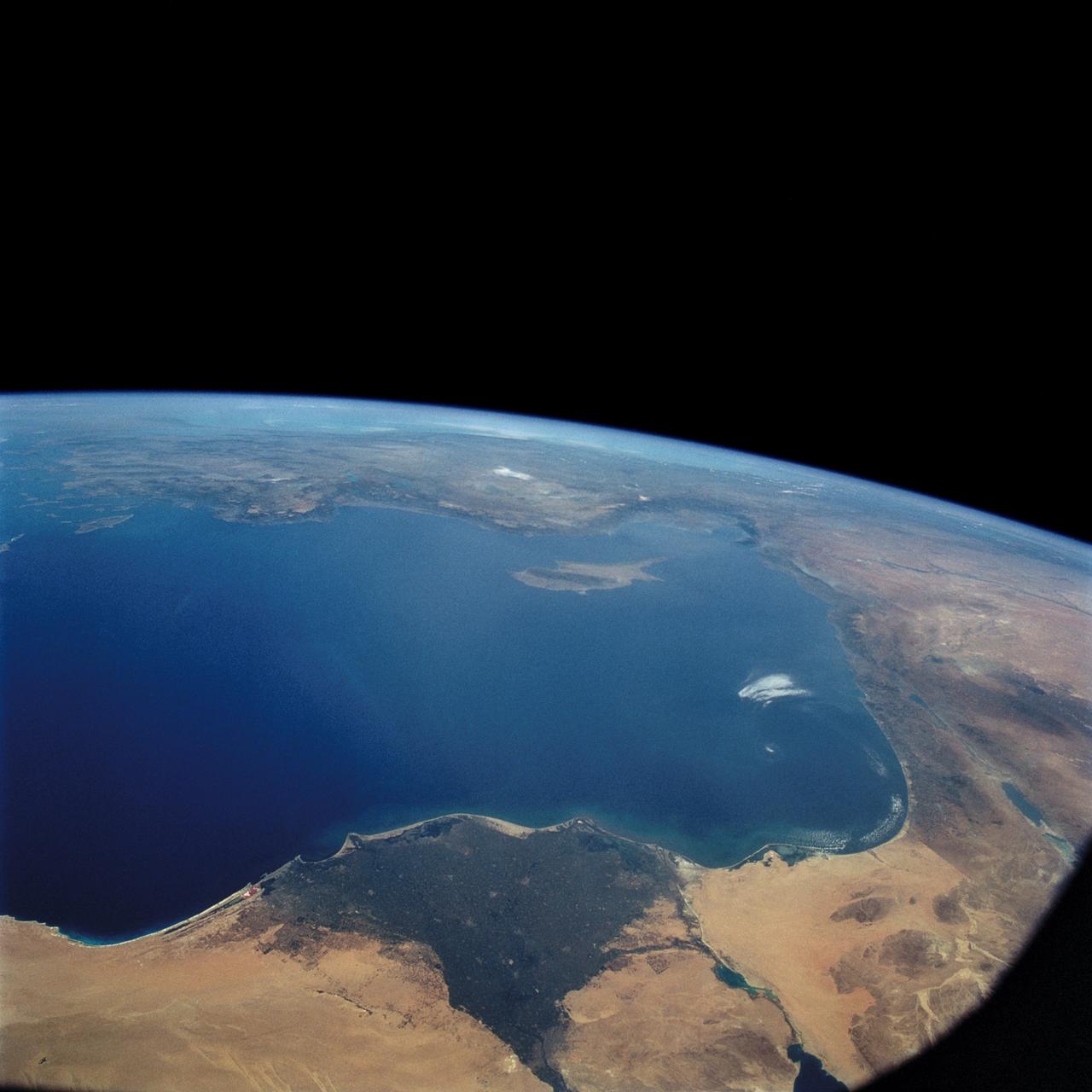
STS109-708-024 (1-12 March 2002) --- The astronauts on board the Space Shuttle Columbia took this 70mm picture featuring the Sinai Peninsula and the Dead Sea Rift. The left side of the view is dominated by the great triangle of the Sinai peninsula, which is partly obscured by an unusual cloud mass on this day. The famous Monastery of St. Catherine lies in the very remote, rugged mountains in the southern third of the peninsula (foreground). The Gulf of Aqaba is a finger of the Red Sea bottom center, pointing north to the Dead Sea, the small body of water near the center of the view. According to NASA scientists studying the STS-109 photo collection, the gulf and the Dead Sea are northerly extensions of the same geological rift that resulted in the opening of the Red Sea . The Gulf of Suez appears in the lower left corner. Northwest Saudi Arabia occupies the lower right side of the view, Jordan and Syria the right and top right, and the Eastern Mediterranean Sea the top left. Thin white lines of cloud have formed along the coastal mountains of southern Turkey and stretch across the top of the view near the Earth's limb.
Even after the mega-freighter Ever Given was freed from its grounding in the Suez Canal on March 29, 5 days later shipping traffic still had not recovered from the crisis. At the southern entrance to the Canal, in the Gulf of Suez, over 100 freighters waited their turn to enter the Canal and proceed to the Mediterranean Sea. The image was acquired April 4, covers an area of 21.3 by 34.5 km, and is located 29.7 degrees north, 32.6 degrees east. https://photojournal.jpl.nasa.gov/catalog/PIA24553
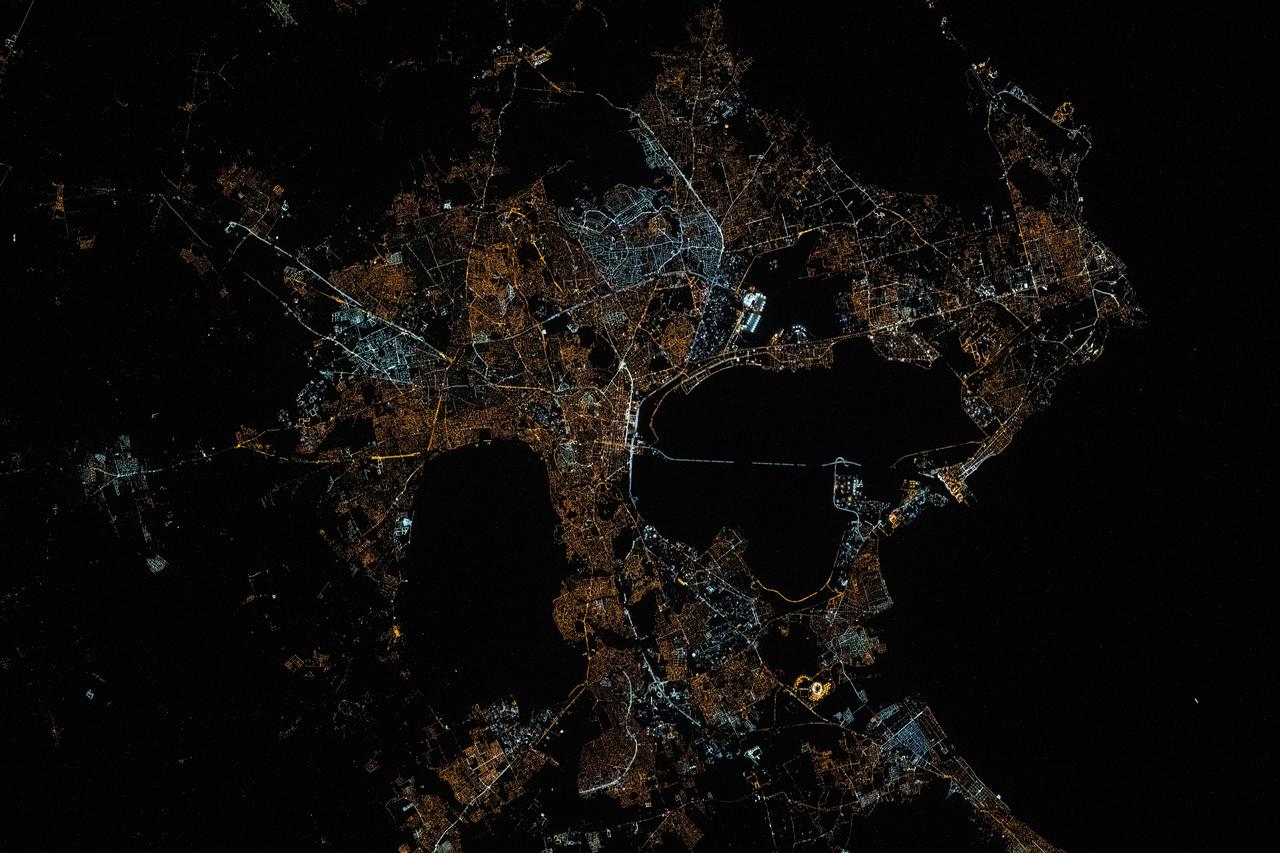
iss073e0078538 (May 17, 2025) --- The city lights of Tunis, the capital of the north African nation of Tunisia with a metropolitan population of 2.67 million, contrast the city's historical and modern character in this photograph at approximately 12:34 a.m. local time from the International Space Station as it orbited 260 miles above the Mediterranean Sea. Tunis sits in between the Lake of Tunis and the Sebkhet Sejoumi, a seasonal salt flat, and is situated on the Gulf of Tunis.
ISS030-E-112823 (25 Feb. 2012) --- This nighttime image photographed by one of the Expedition 30 crew members aboard the International Space Station provides a look toward the Mediterranean Sea. Along the left side, the night lights clearly depict the high population associated with the Nile River and its delta and the Alexandria, Egypt area (top left center). The Gulf of Suez and the Suez Canal are seen to the right.
ISS030-E-112822 (25 Feb. 2012) --- This nighttime image photographed by one of the Expedition 30 crew members aboard the International Space Station provides a look toward the Mediterranean Sea. Along the left side, the night lights clearly depict the high population associated with the Nile River and its delta and the Alexandria, Egypt area (top left center). The Gulf of Suez and the Suez Canal are seen to the right.
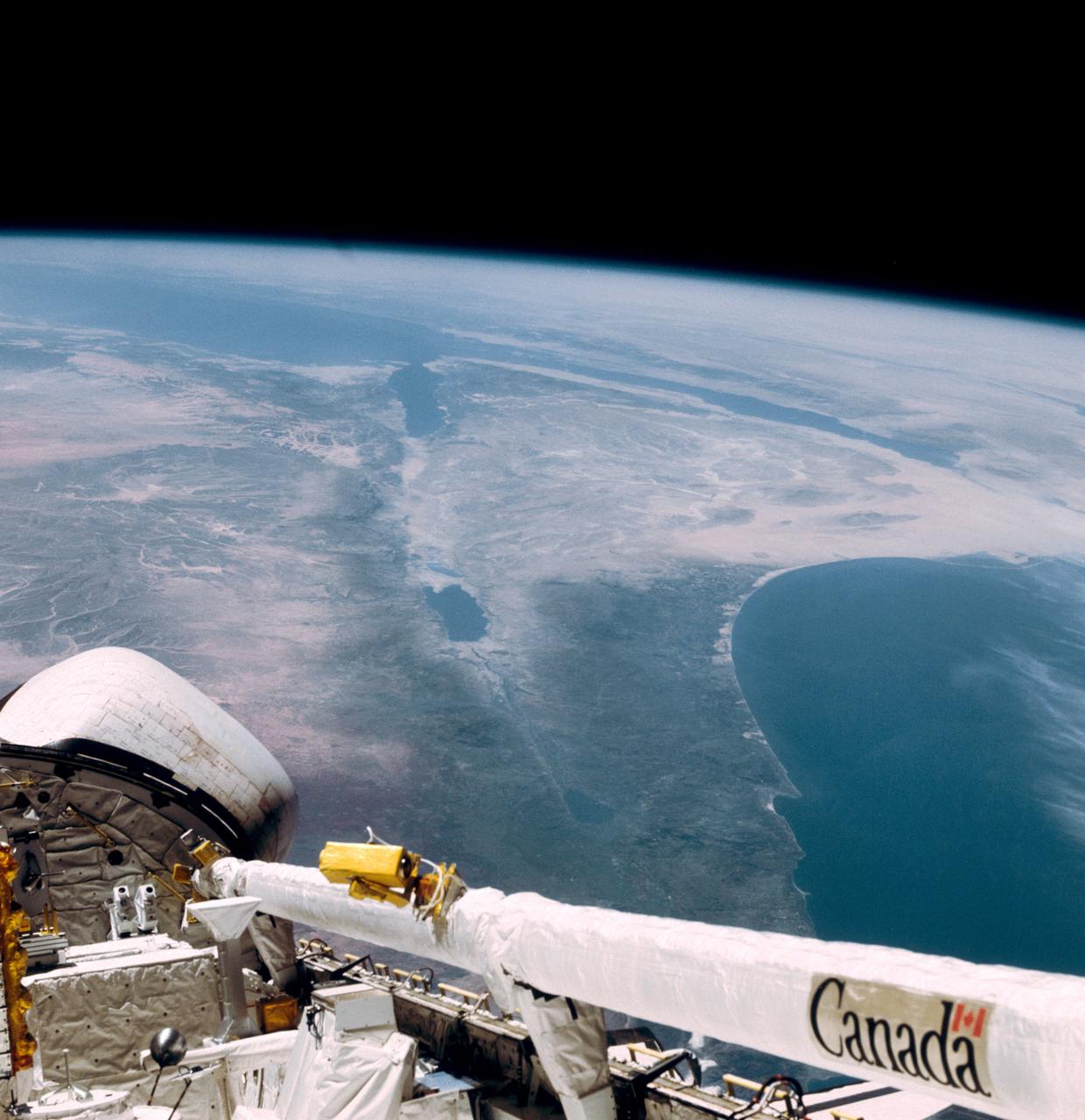
This southerly looking view photographed from the orbiting Space Shuttle Columbia shows a small portion of the vehichle's aft section. The 50-ft Canadian built remote manipulator system (RMS) is in a resting posture (lower right corner) stretched out along the 60-ft. long cargo bay. Many of the components of the OSS-1 payload package are in the bottom center. The Mediterranean Sea is at right foreground. Parts of the Sinai peninsula, Israel, Egypt, Saudi Arabia, Jordan, Palestine, Syria, and Lebanon can be located in the photo. The Red Sea, Gulf of Aqaba, Suez Canal are near the photo's horizon.
STS057-73-075 (21 June-1 July 1993) --- Eastern Mediterranean from an unusually high vantage point over the Nile River, this north-looking view shows not only the eastern Mediterranean but also the entire landmass of Asia Minor, with the Black Sea dimly visible at the horizon. Many of the Greek islands can be seen in the Aegean Sea (top left), off the coast of Asia Minor. Cyprus is visible under atmospheric dust in the northeast corner of the Mediterranean. The dust cloud covers the east end of the Mediterranean, its western edge demarcated by a line that cuts the center of the Nile Delta. This dust cloud originated far to the west, in Algeria, and moved northeast over Sicily, southern Italy, and Greece. Part of the cloud then moved on over the Black Sea, but another part swerved southward back towards Egypt. A gyre of clouds in the southeast corner of the Mediterranean indicates a complementary counterclockwise (cyclonic) circulation of air. The Euphrates River appears as a thin green line (upper right) in the yellow Syrian Desert just south of the blue-green mountains of Turkey. The Dead Sea (lower right) lies in a rift valley which extends north into Turkey and south thousands of miles down the Gulf of Aqaba, the Red Sea, and on through East Africa. The straight international boundary between Israel and Egypt (where the coastline angles) is particularly clear in this view, marked by the thicker vegetation on the Israeli side of the border. The green delta of the Nile River appears in the foreground, with the great conurbation of Cairo seen as a gray area at the apex of the triangle. Most of Egypt's 52 million inhabitants live in the delta. On the east side of the delta, the Suez Canal is visible. On the western corner of the delta lies the ancient city of Alexandria, beside the orange and white salt pans. The World War II battlesite El Alamein lies on the coast.
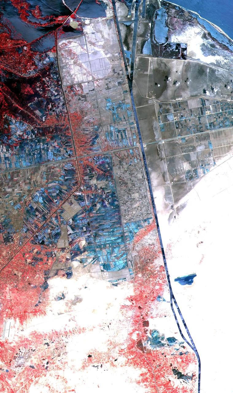
One of the most important waterways in the world, the Suez Canal runs north to south across the Isthmus of Suez in northeastern Egypt. This image of the canal covers an area 36 kilometers (22 miles) wide and 60 kilometers (47 miles) long in three bands of the reflected visible and infrared wavelength region. It shows the northern part of the canal, with the Mediterranean Sea just visible in the upper right corner. The Suez Canal connects the Mediterranean Sea with the Gulf of Suez, an arm of the Red Sea. The artificial canal provides an important shortcut for ships operating between both European and American ports and ports located in southern Asia, eastern Africa, and Oceania. With a length of about 195 kilometers (121 miles) and a minimum channel width of 60 meters (197 feet), the Suez Canal is able to accommodate ships as large as 150,000 tons fully loaded. Because no locks interrupt traffic on this sea level waterway, the transit time only averages about 15 hours. ASTER acquired this scene on May 19, 2000. http://photojournal.jpl.nasa.gov/catalog/PIA02661
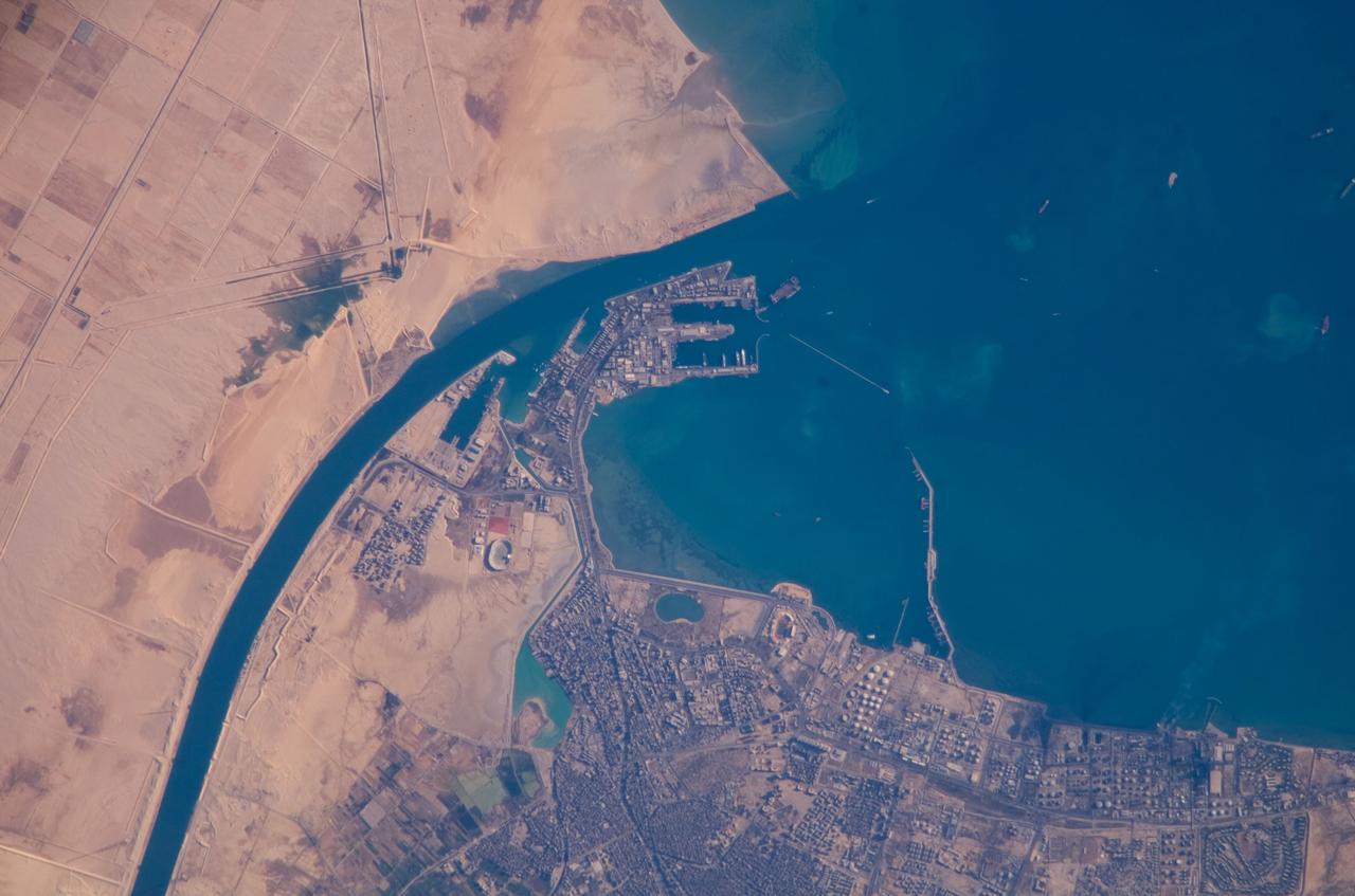
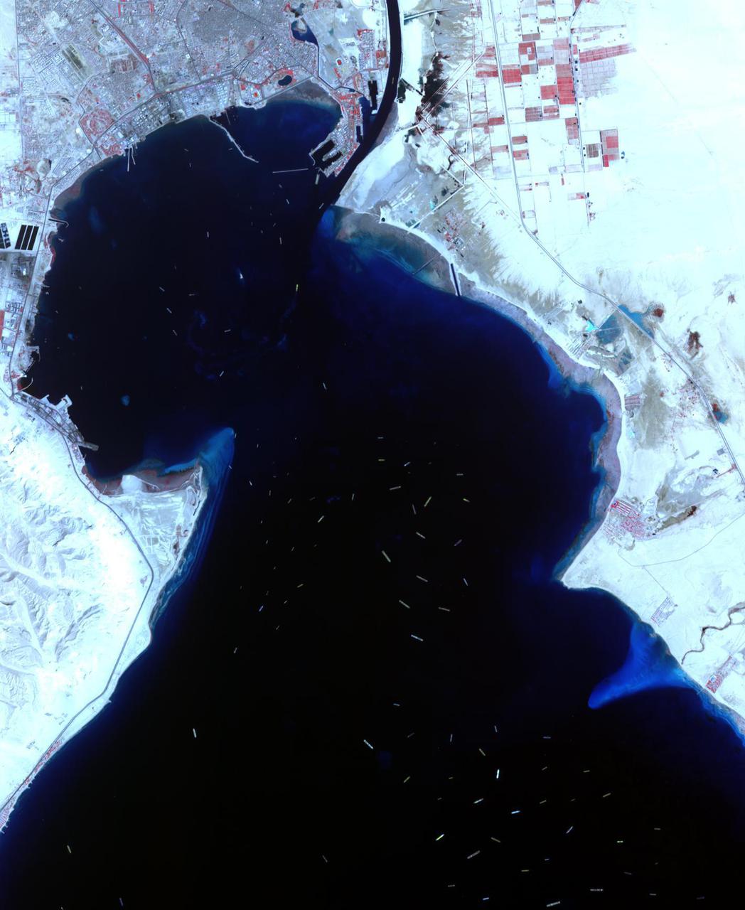
ISS016-E-019375 (30 Dec. 2007) --- Port of Suez, Egypt is featured in this image photographed by an Expedition 16 crewmember on the International Space Station. The Port of Suez is located in Egypt along the northern coastline of the Gulf of Suez. The port and city are the southern terminus of the Suez Canal that transits through Egypt and debouches into the Mediterranean Sea near Port Said. The port serves vessels transporting general cargo, oil tankers, and both commercial and private passenger vessels. The port is also an important waypoint for Muslim pilgrims traveling to and from Mecca in Saudi Arabia. Several large vessels are visible in the Gulf of Suez and berthed at various docks around the port. An extensive petroleum refinery complex forms the southern coastal boundary of the Port of Suez. At the time this image was acquired, gaseous byproducts of petroleum processing were being burned off -- as indicated by a smoke plume extending southwards into the Gulf of Suez (lower right). This view also captures several regions of greenish blue coloration in the Gulf. These are most probably sediments stirred up by passage of ships traveling to and from the Port. Similarly-colored regions along the coastline are bottom sediments visible through the shallow water column.
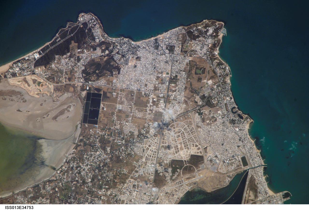
ISS013-E-34753 (8 June 2006) --- Carthage, Tunisia is featured in this image photographed by an Expedition 13 crewmember on the International Space Station. The favorable location of the ancient city of Carthage is clear in this image. Embayments along the coastline provided ready access to the Gulf of Tunis/Mediterranean Sea to the east and southeast. Docks along the coastline (lower right) support the shipping industry. Modern Carthage is a wealthy suburb of the Tunis metropolitan area (the center of which is located to the southwest of the image), as evidenced by dense concentrations of white building rooftops in residential subdivisions to the north and south of the ancient city location. Large tracts of new developments appear to be in progress along the curving, light colored roadways to the southwest of the historical city (lower center). The green shallow waters of an evaporating saline lake are visible at image left ? several such lakes are present in Tunisia and are centers for bird watching-related tourism.
ISS039-E-003505 (21 March 2014) --- The Peloponnese, Greece is featured in this image photographed by an Expedition 39 crew member on the International Space Station. This view shows most of Greece. The urban region of Athens is readily recognizable due to its size and light tone compared to the surrounding landscape, although smaller Megara and Lamia also stand out. The dark-toned mountains with snow-covered peaks contrast with the warmer, greener valleys where agriculture takes place. The intense blue of the Mediterranean Sea fades near the sun?s reflection point, where numerous wind streaks in the lee of the island become visible along the right side of the image. The Peloponnese, ancient Sparta, is the great peninsula separated from the mainland by the narrow Isthmus of Corinth. Several times over the centuries the narrows have acted as a defensive point against attack from the mainland. More recently in 1893 the narrows provided a point of connection when a ship canal was excavated between the gulfs to the west and to the east.
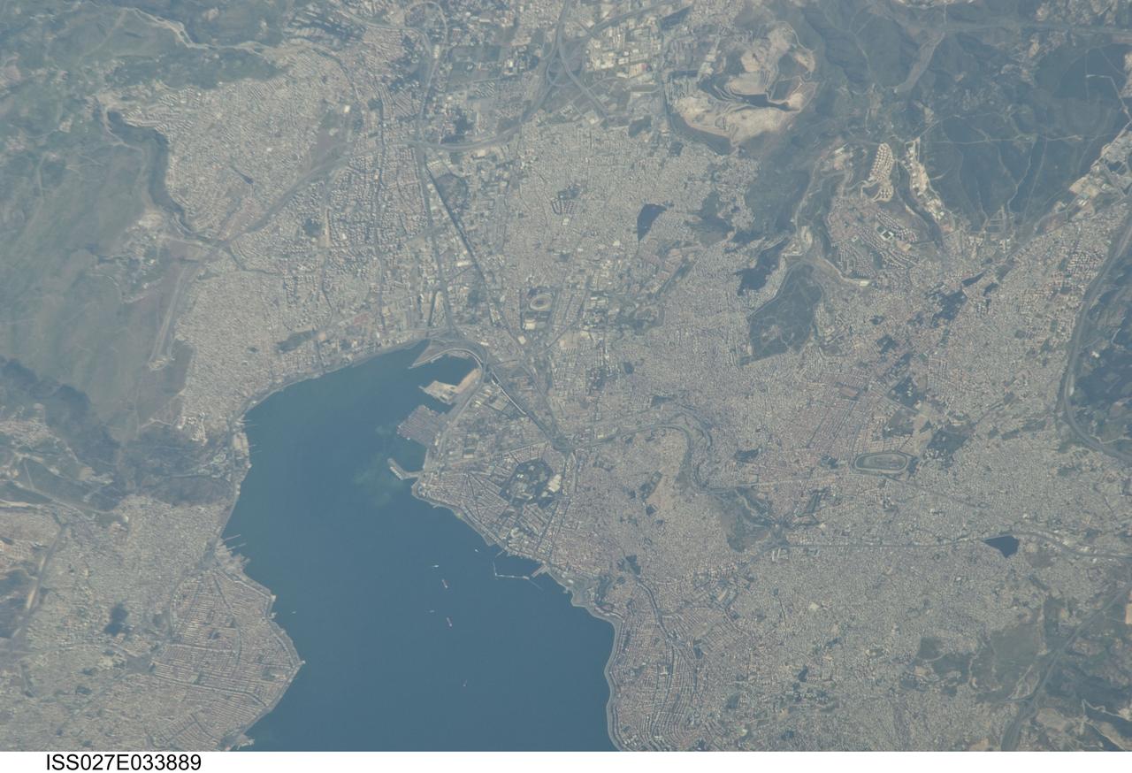
ISS027-E-033889 (16 May 2011) --- Izmir Metropolitan Area, Izmir Province in Turkey is featured in this image photographed by an Expedition 27 crew member on the International Space Station. The metropolis of Izmir is located in the western Anatolia region of Turkey. It is the country’s third largest city in terms of population and the second largest port city (after Istanbul). The Izmir region has included urban areas for almost 3,500 years, and the ancient core of the metropolitan area was originally known as Smyrna. Due to its location on the Gulf of Izmir (lower left) with access to the Aegean Sea, Izmir (or Smyrna) has been an important Mediterranean Sea port for most of its history. This detailed photograph highlights the modern urban landscape of the Izmir metropolitan area. Today, the metropolitan area includes eleven districts, many of which were independent neighborhoods prior to agglomeration into “greater Izmir”. Densely built-up residential and commercial districts, characterized by gray to reddish gray rooftops occupy much of the central part of the image. Larger structures with bright white rooftops are indicative of commercial/industrial areas near the Izmir Port at left. Two large sport complexes, the Ataturk Stadium and Sirinyer Hippodrome (horse racing track) are clearly visible at upper left and right respectively. Numerous vegetated parks (green) are located throughout the area. In addition to being a major trade center, greater Izmir is a hub for regional tourism.