The THEMIS VIS camera contains 5 filters. The data from different filters can be combined in multiple ways to create a false color image. These false color images may reveal subtle variations of the surface not easily identified in a single band image. Today's false color image shows part of Gale Crater. Gale Crater is the home of the Curiosity Rover. Orbit Number: 46072 Latitude: -4.53679 Longitude: 137.296 Instrument: VIS Captured: 2012-05-03 17:29 http://photojournal.jpl.nasa.gov/catalog/PIA21196
The THEMIS VIS camera contains 5 filters. The data from different filters can be combined in multiple ways to create a false color image. These false color images may reveal subtle variations of the surface not easily identified in a single band image. Today's false color image shows part of Gale Crater. The Curiosity Rover is located in Gale Crater. Orbit Number: 52390 Latitude: -4.49318 Longitude: 137.423 Instrument: VIS Captured: 2013-10-05 16:16 https://photojournal.jpl.nasa.gov/catalog/PIA21530
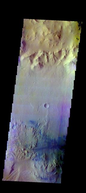
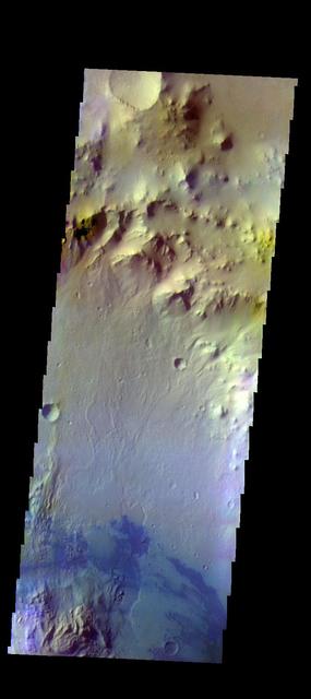
The THEMIS VIS camera contains 5 filters. The data from different filters can be combined in multiple ways to create a false color image. These false color images may reveal subtle variations of the surface not easily identified in a single band image. Today's false color image shows part of the floor of Gale Crater. The Curiosity Rover is located in Gale Crater. Orbit Number: 52365 Latitude: -4.54529 Longitude: 137.352 Instrument: VIS Captured: 2013-10-03 14:54 https://photojournal.jpl.nasa.gov/catalog/PIA21529
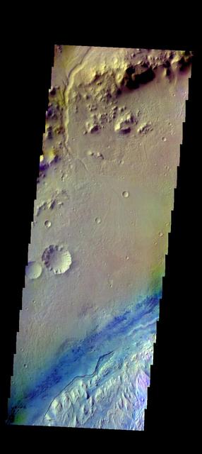
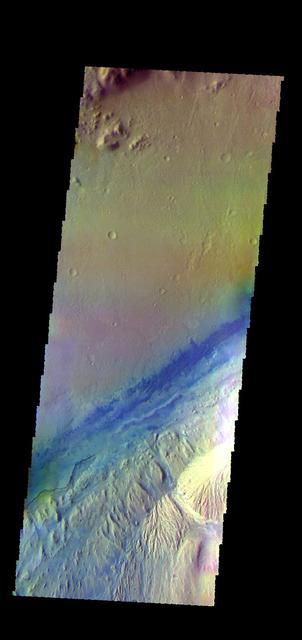
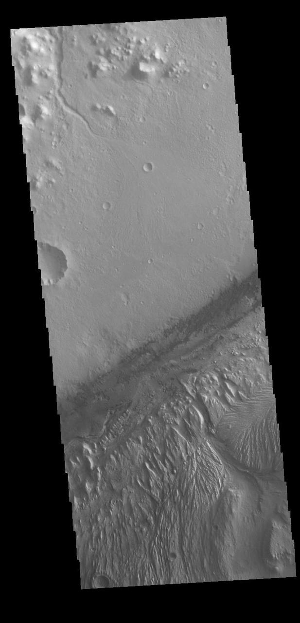
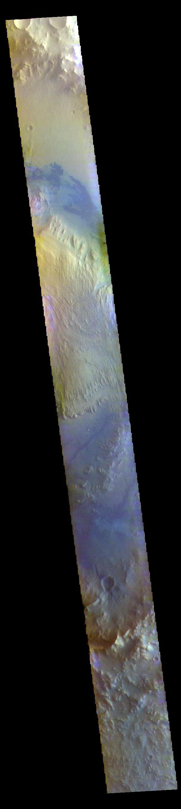
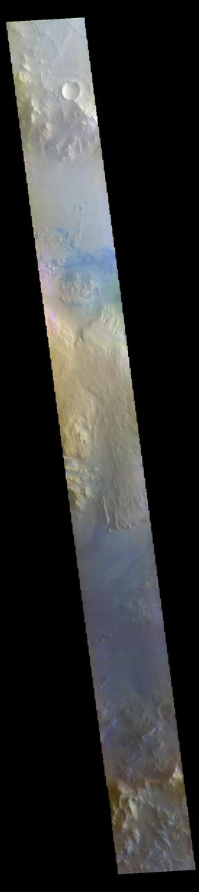
The THEMIS VIS camera contains 5 filters. The data from different filters can be combined in multiple ways to create a false color image. These false color images may reveal subtle variations of the surface not easily identified in a single band image. Today's false color image shows part of Gale Crater. Basaltic sands are dark blue in this type of false color combination. The Curiosity Rover is located in another portion of Gale Crater, far southwest of this image. Orbit Number: 51803 Latitude: -4.39948 Longitude: 138.116 Instrument: VIS Captured: 2013-08-18 09:04 http://photojournal.jpl.nasa.gov/catalog/PIA21312
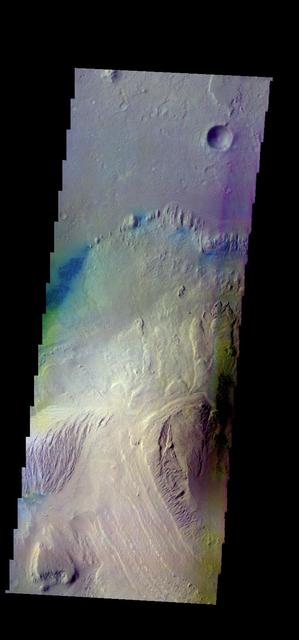
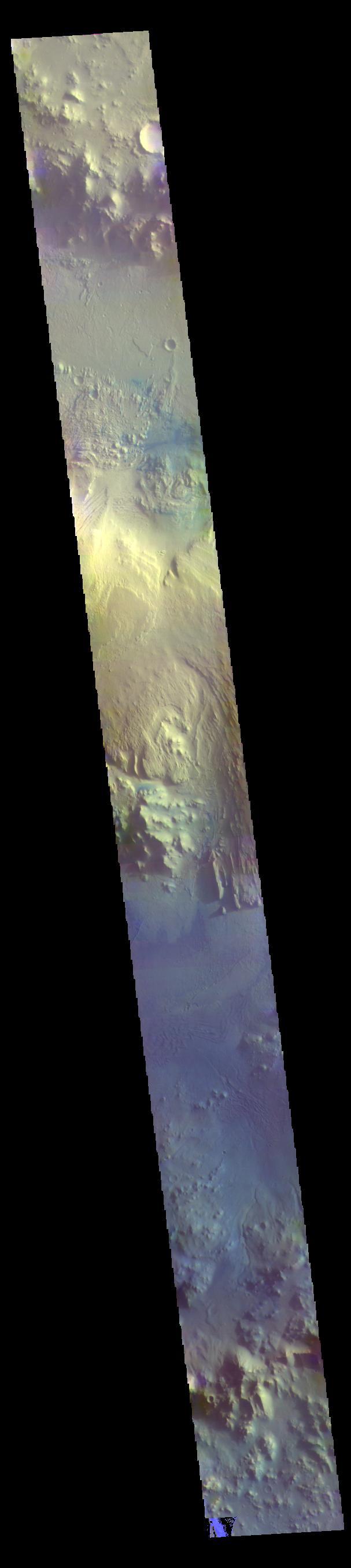
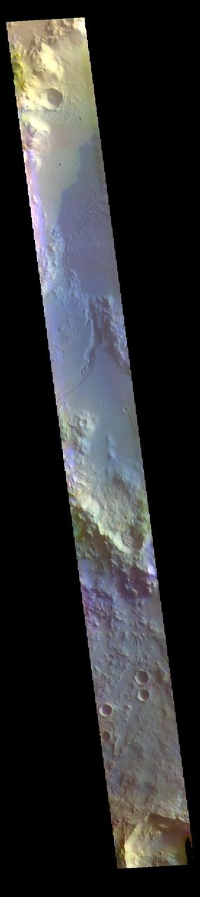
The THEMIS VIS camera contains 5 filters. The data from different filters can be combined in multiple ways to create a false color image. These false color images may reveal subtle variations of the surface not easily identified in a single band image. Today's false color image shows part of the interior mound of material within Gale Crater. The dark blue material is most likely basaltic sand. Gale Crater is the home of Curiosity Rover. Orbit Number: 44524 Latitude: -4.64054 Longitude: 137.663 Instrument: VIS Captured: 2011-12-28 07:29 http://photojournal.jpl.nasa.gov/catalog/PIA21164
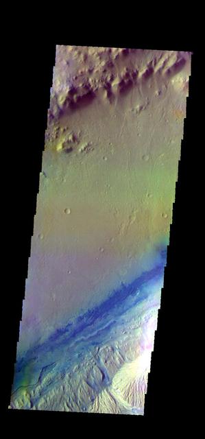
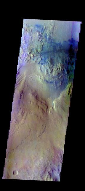
The THEMIS VIS camera contains 5 filters. The data from different filters can be combined in multiple ways to create a false color image. These false color images may reveal subtle variations of the surface not easily identified in a single band image. Today's false color image shows part of Gale Crater, the home of Curiosity Rover. Orbit Number: 52340 Latitude: -4.59603 Longitude: 137.402 Instrument: VIS Captured: 2013-10-01 13:32 http://photojournal.jpl.nasa.gov/catalog/PIA21516
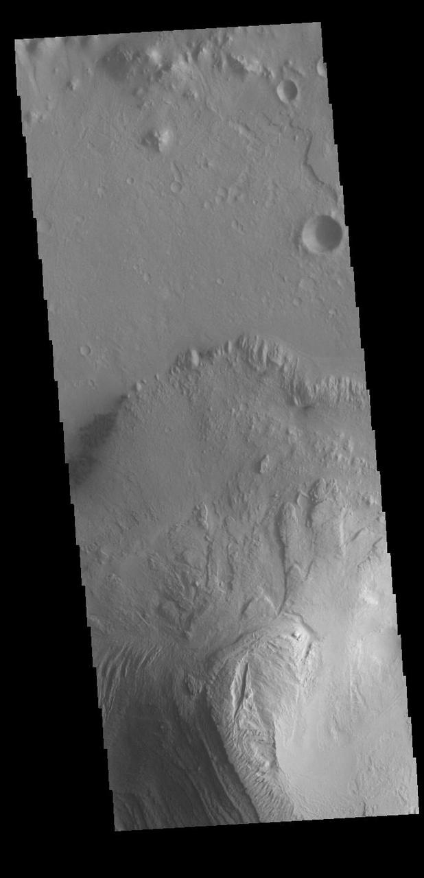
The THEMIS camera contains 5 filters. The data from different filters can be combined in multiple ways to create a false color image. This image from NASA 2001 Mars Odyssey spacecraft shows part of Gale Crater. The Curiosity Rover is located off this image to the west. Orbit Number: 46047 Latitude: -4.36053 Longitude: 138.275 Instrument: VIS Captured: 2012-05-01 16:06 http://photojournal.jpl.nasa.gov/catalog/PIA21193
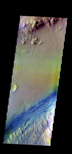
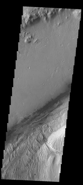
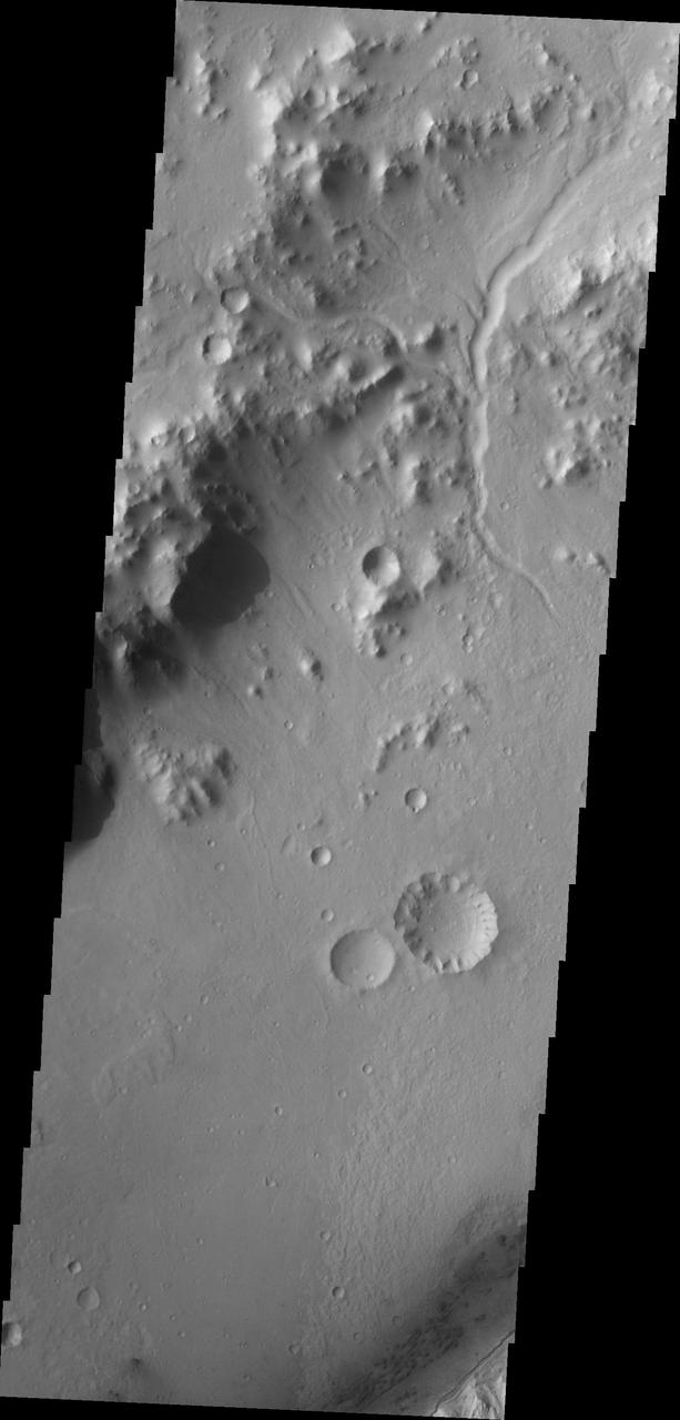
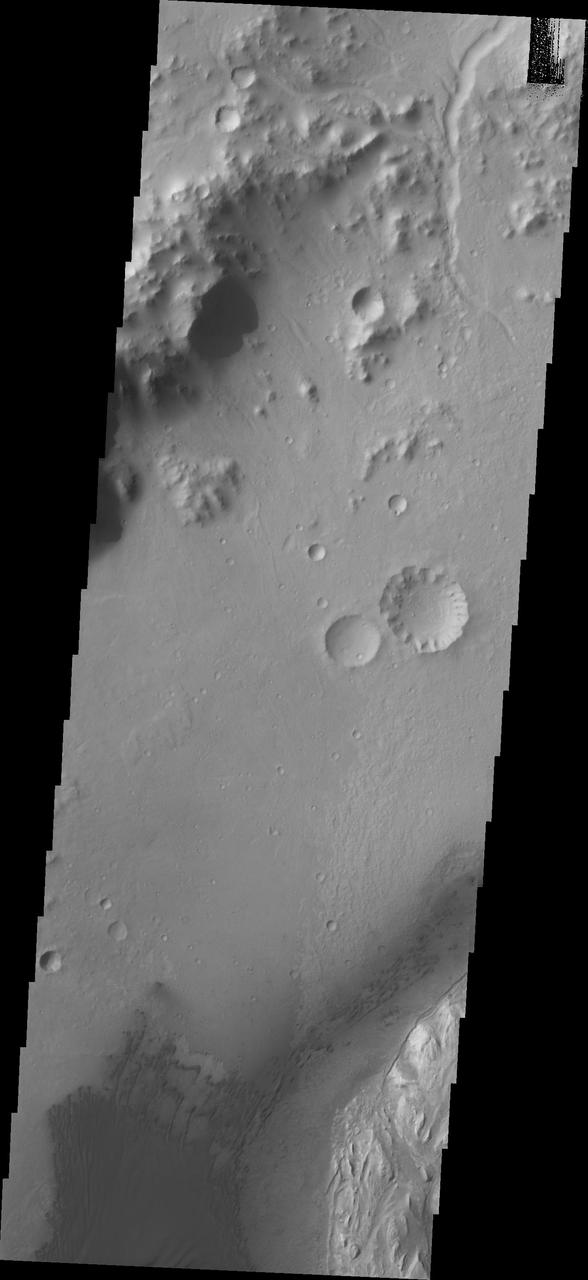
The THEMIS VIS camera contains 5 filters. The data from different filters can be combined in multiple ways to create a false color image. These false color images may reveal subtle variations of the surface not easily identified in a single band image. Today's false color image shows part of the floor of Gale Crater. Orbit Number: 51266 Latitude: -4.86134 Longitude: 138.086 Instrument: VIS Captured: 2013-07-05 04:36 http://photojournal.jpl.nasa.gov/catalog/PIA21293
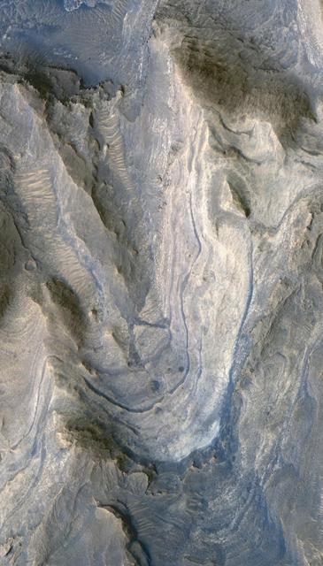
Layers in Gale Crater
Layers in Gale Crater
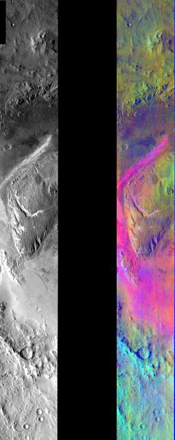
Gale Crater in IR Color
This VIS image shows part of Gale Crater. Gale Crater is the home of the Curiosity Rover. Orbit Number: 71399 Latitude: -4.54006 Longitude: 137.334 Instrument: VIS Captured: 2018-01-18 03:26 https://photojournal.jpl.nasa.gov/catalog/PIA22392
Today's VIS image shows the large layered deposit on the floor of Gale. The Curiosity Rover is located in Gale Crater. Gale crater is 150km (90 miles) in diameter. Orbit Number: 86309 Latitude: -4.67469 Longitude: 137.724 Instrument: VIS Captured: 2021-05-29 23:44 https://photojournal.jpl.nasa.gov/catalog/PIA24951
Proposed MSL Site in Gale Crater

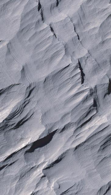
Layers in Gale Crater Central Mound
Today's VIS image shows part of Gale Crater, including the large layered deposit on the crater floor. The Curiosity Rover is located in Gale Crater. Gale crater is 150km (90 miles) in diameter. Orbit Number: 88942 Latitude: -4.53543 Longitude: 137.674 Instrument: VIS Captured: 2022-01-01 18:55 https://photojournal.jpl.nasa.gov/catalog/PIA25344
Today's VIS image shows part of Gale Crater, including the large layered deposit on the crater floor. This deposit has been heavily eroded, which exposed the layering. The Curiosity Rover is located in Gale Crater. Gale crater is 150km (90 miles) in diameter. Orbit Number: 92243 Latitude: -4.91547 Longitude: 137.678 Instrument: VIS Captured: 2022-09-30 13:20 https://photojournal.jpl.nasa.gov/catalog/PIA25756
Today's VIS image shows part of Gale Crater, including the large layered deposit on the crater floor. This deposit has been heavily eroded, which exposed the layering. The Curiosity Rover is located in Gale Crater. Gale crater is 150km (90 miles) in diameter. Orbit Number: 89803 Latitude: -4.84713 Longitude: 137.859 Instrument: VIS Captured: 2022-03-13 16:25 https://photojournal.jpl.nasa.gov/catalog/PIA25397
This image captured by NASA 2001 Mars Odyssey spacecraft of Gale Crater shows the region of the crater that is home to the Curiosity Rover.
Today's VIS image shows a cross section of Gale Crater, including part of the large layered deposit on the crater floor. This deposit has been heavily eroded. The Curiosity Rover is located in Gale Crater. Gale crater is 150km (90 miles) in diameter. Orbit Number: 86908 Latitude: -4.63872 Longitude: 137.343 Instrument: VIS Captured: 2021-07-18 07:25 https://photojournal.jpl.nasa.gov/catalog/PIA25203
Wind has eroded the deposit on the floor of Gale Crater in this image captured by NASA 2001 Mars Odyssey.
The THEMIS VIS camera contains 5 filters. The data from different filters can be combined in multiple ways to create a false color image. These false color images may reveal subtle variations of the surface not easily identified in a single band image. Today's false color image shows a cross section of Gale Crater, including the large layered deposit on the crater floor. The Curiosity Rover is located in Gale Crater. Gale crater is 150km (90 miles) in diameter. Orbit Number: 78672 Latitude: -5.332 Longitude: 138.139 Instrument: VIS Captured: 2019-09-09 04:00 https://photojournal.jpl.nasa.gov/catalog/PIA24653
This frame from a sequence of images shows a dust-carrying whirlwind, called a dust devil, scooting across the ground inside Gale Crater, as observed on the local summer afternoon of NASA's Curiosity Mars Rover's 1,597th Martian day, or sol (Feb. 1, 2017). Set within a broader southward view from the rover's Navigation Camera, the rectangular area outlined in black was imaged multiple times over a span of several minutes to check for dust devils. Images from the period with most activity are shown in the inset area. The images are in pairs that were taken about 12 seconds apart, with an interval of about 90 seconds between pairs. Timing is accelerated and not fully proportional in this animation. A dust devil is most evident in the 10th, 11th and 12th frames. In the first and fifth frames, dust blowing across the ground appears as pale horizontal streak. Contrast has been modified to make frame-to-frame changes easier to see. A black frame is added between repeats of the sequence. On Mars as on Earth, dust devils are whirlwinds that result from sunshine warming the ground, prompting convective rising of air that has gained heat from the ground. Observations of Martian dust devils provide information about wind directions and interaction between the surface and the atmosphere. An animation is available at http://photojournal.jpl.nasa.gov/catalog/PIA21270
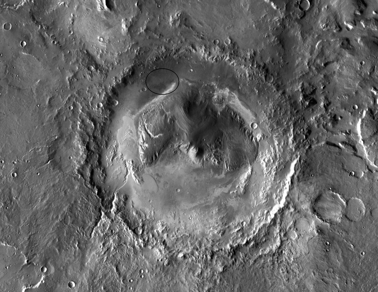
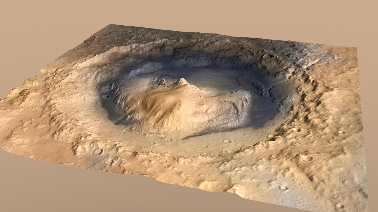
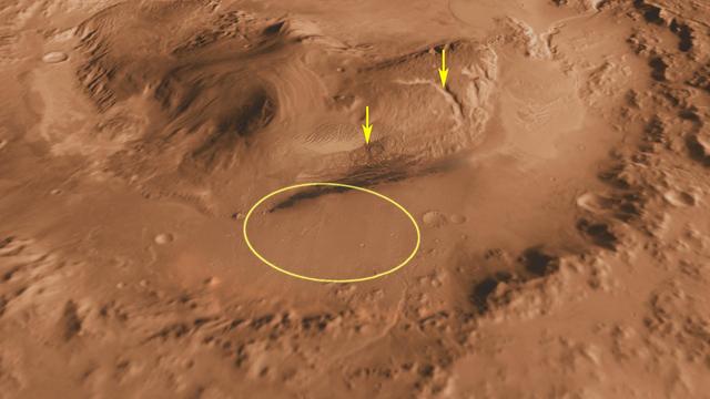
Gale Crater, the Selected Landing Site for Curiosity
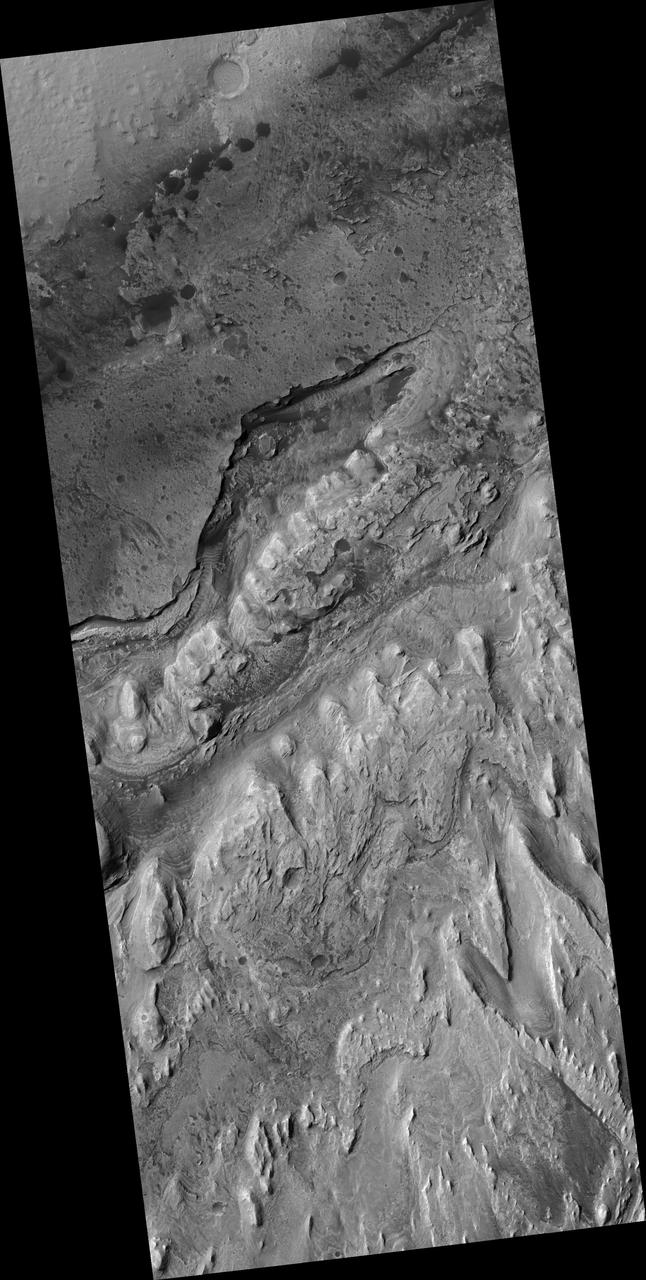
Sediment History Preserved in Gale Crater Central Mound

Sediment History Preserved in Gale Crater Central Mound
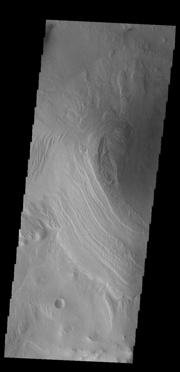
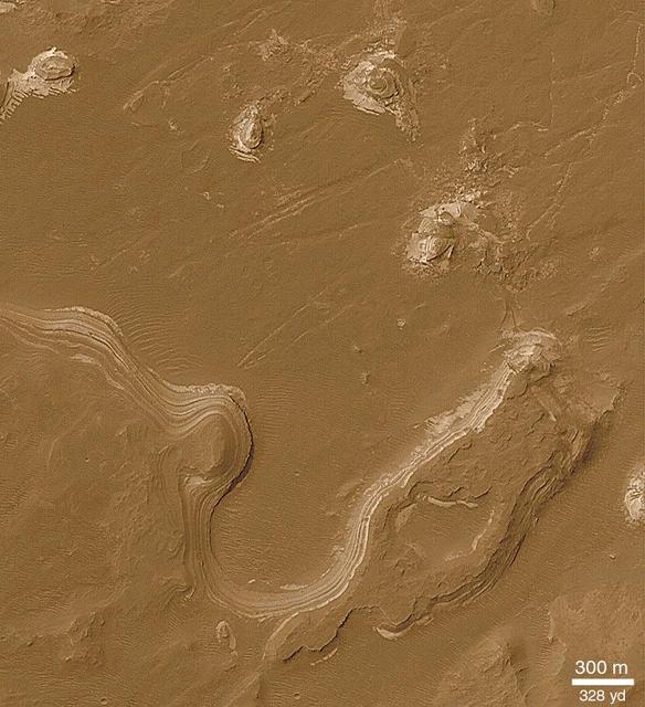
Southern Layered Mound and Floor in Gale Crater

Sediment History Preserved in Gale Crater Central Mound
Sediment History Preserved in Gale Crater Central Mound
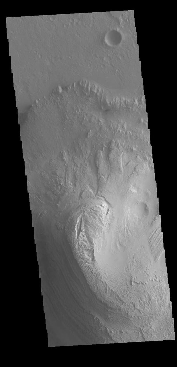
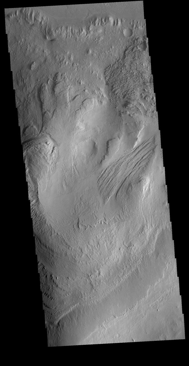
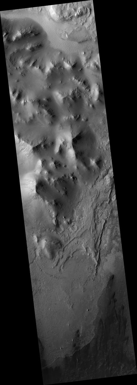
Edge along Gale Crater Interior Mound
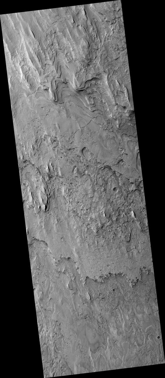
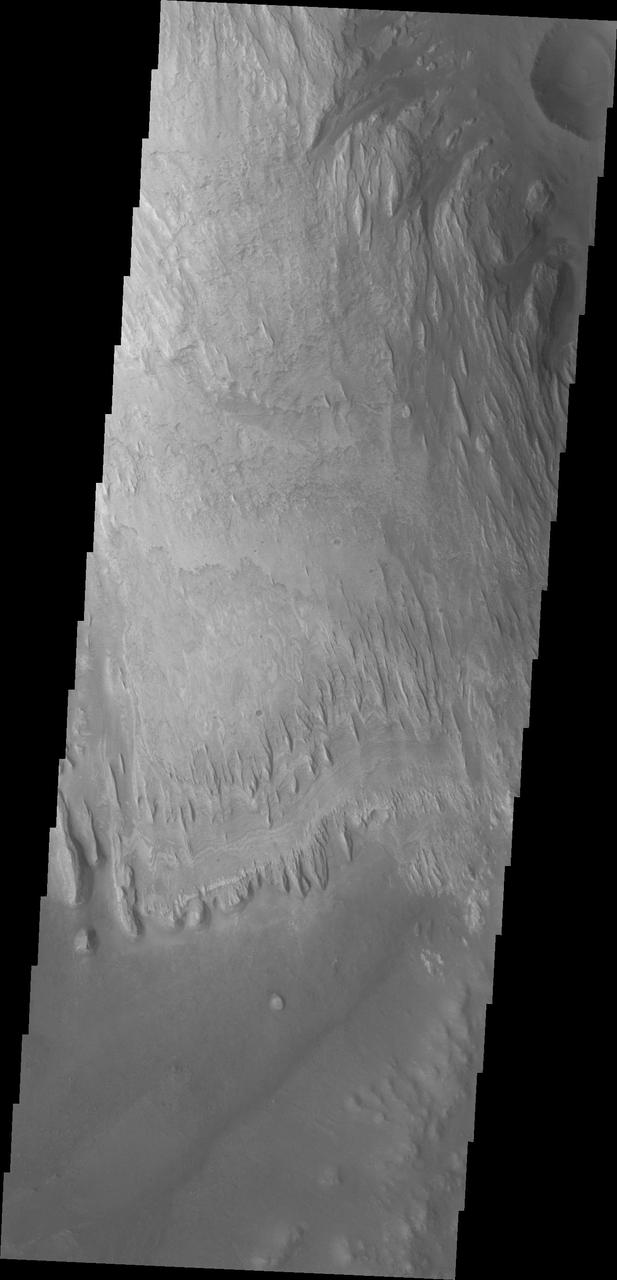
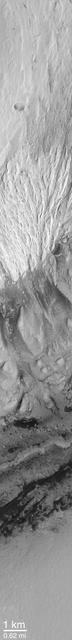
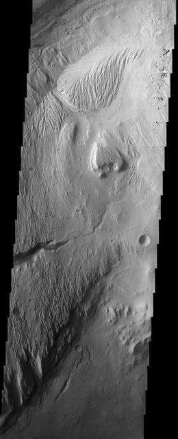
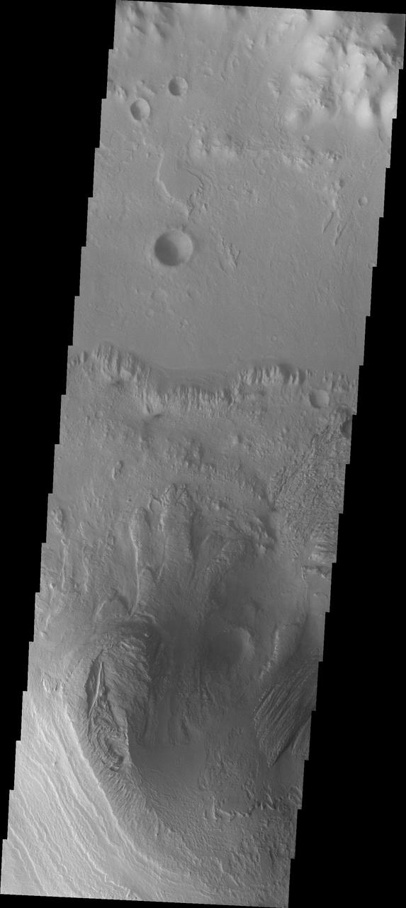
This VIS image of Gale Crater shows part of the huge layered deposit that covers much of the crater floor. The top of the image shows part of the crater rim, including one of the many small channels that drain to the crater floor. A series of dark dunes surround the inner layered deposit, appearing darker than the other materials in this image. Gale Crater is the home of the Curiosity Rover. Orbit Number: 71374 Latitude: -4.41326 Longitude: 137.314 Instrument: VIS Captured: 2018-01-16 02:01 https://photojournal.jpl.nasa.gov/catalog/PIA22389
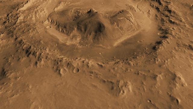
Today's VIS image is located in Gale Crater. Home to the Curiosity Rover since August of 2012, Gale crater is 154km in diameter (96 miles). Multiple features within the crater are visible in this image, including dunes, wind and water etched rock, layered central mound (Aeolis Mons — common name Mount Sharp), and small channels. Aeolis Mons rises 18,000 ft (5,500 m) from the crater floor, higher than Mount Rainier rises above Seattle. Orbit Number: 81879 Latitude: -4.7719 Longitude: 137.564 Instrument: VIS Captured: 2020-05-30 05:35 https://photojournal.jpl.nasa.gov/catalog/PIA24085
This artist impression Mars Gale Crater depicts a cross section through the mountain in the middle of the crater, from a viewpoint looking toward the southeast. NASA rover Curiosity will land in Gale Crater in August 2012.
This image, taken by NASA 2001 Mars Odyssey spacecraft, shows a portion of the rim and floor of Gale Crater. The crater rim is dissected by a channel, and dunes are located on the floor at the rim margin.
This computer-generated view depicts part of Mars at the boundary between darkness and daylight, with an area including Gale Crater beginning to catch morning light. NASA has selected Gale as the landing site for the Mars Science Laboratory mission.
The THEMIS VIS camera contains 5 filters. The data from different filters can be combined in multiple ways to create a false color image. These false color images may reveal subtle variations of the surface not easily identified in a single band image. Today's false color image shows a cross section of Gale Crater, including the large layered deposit in the center of the crater floor. Gale Crater is the 'home' of the Curiosity Rover. Orbit Number: 77287 Latitude: -5.53403 Longitude: 138.375 Instrument: VIS Captured: 2019-05-18 02:45 https://photojournal.jpl.nasa.gov/catalog/PIA24608
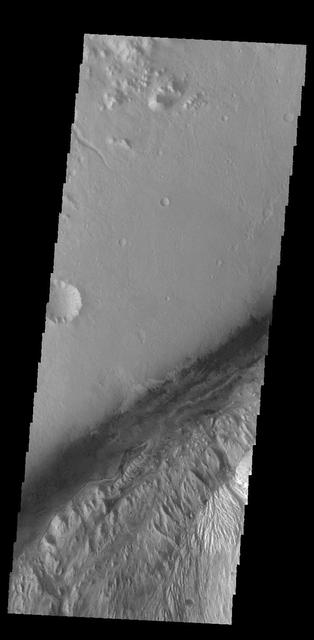
Small channels dissect the northwestern rim of Gale Crater in this image captured by NASA Mars Odyssey.
This image from NASA 2001 Mars Odyssey spacecraft shows the dunes located on the floor of Gale Crater.
This computer-generated view based on multiple orbital observations shows Mars Gale crater as if seen from an aircraft northwest of the crater. NASA has selected Gale as the landing site for the Mars Science Laboratory mission.
NASA has selected Gale crater as the landing site for the Mars Science Laboratory mission. This view of Gale is a mosaic of observations from NASA Mars Odyssey orbiter.
This VIS image shows much of the same location as yesterday's image. Gale Crater is the home of the Curiosity Rover. The rover landed in August of 2012 and has been exploring the crater for the past 6 Earth years (3 Mars years). The goal of the mission is to climb onto the layered deposit in the center of the crater to assess it's possible origins. Orbit Number: 71424 Latitude: -4.66294 Longitude: 137.356 Instrument: VIS Captured: 2018-01-20 04:52 https://photojournal.jpl.nasa.gov/catalog/PIA22393
This image captured by NASA 2001 Mars Odyssey spacecraft shows part of Gale Crater, the home of the Curiosity Rover. Orbit Number: 59044 Latitude: -4.48044 Longitude: 137.355 Instrument: VIS Captured: 2015-04-06 09:17 http://photojournal.jpl.nasa.gov/catalog/PIA19474
West of NASA Curiosity landing site, this image from NASA Mars Reconnaissance Orbiter spacecraft along the northwestern floor of Gale Crater is between Aeolis Mons informally called Mt. Sharp and the crater rim.
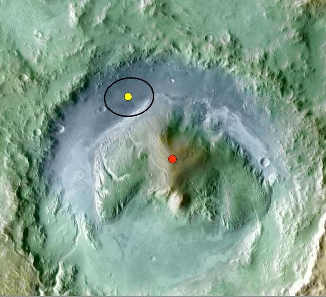
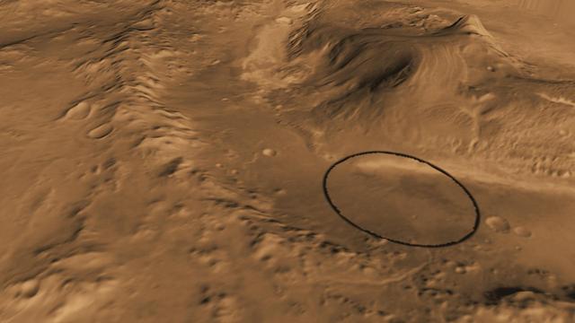
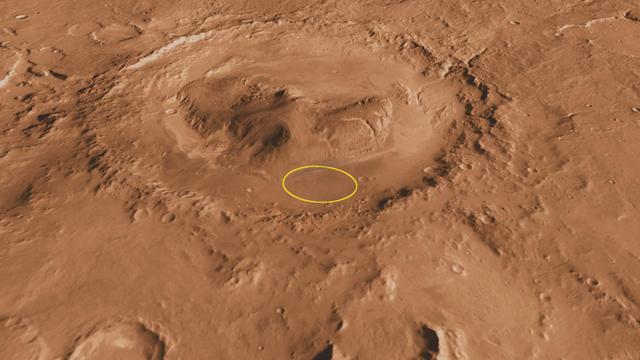
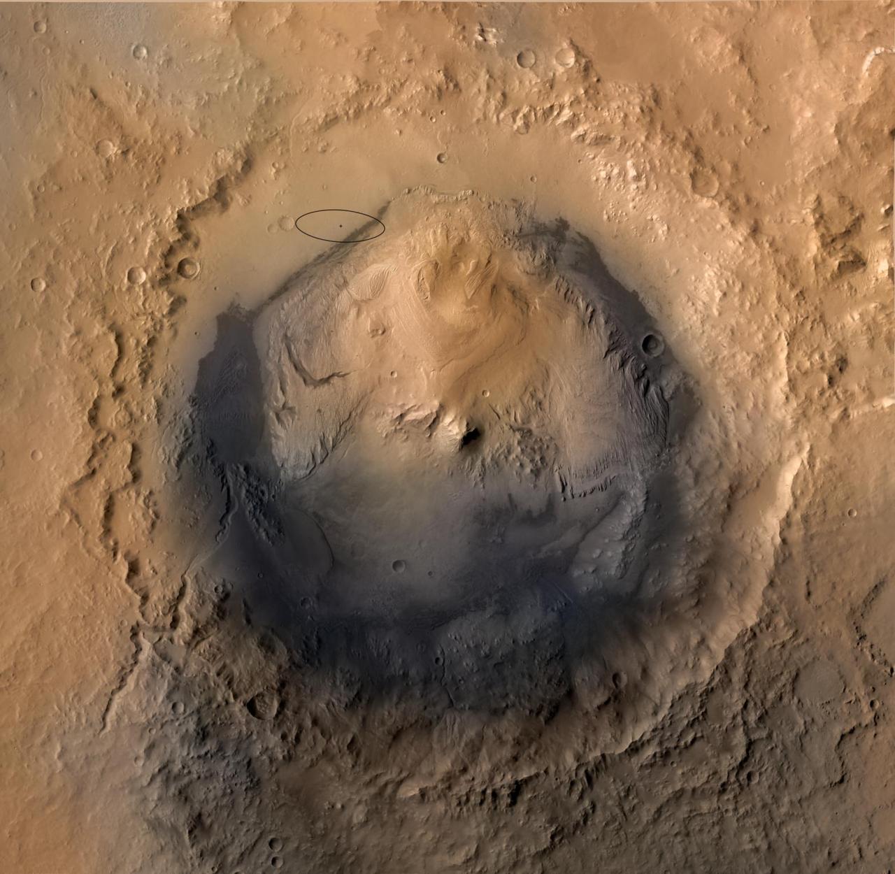
Color coding in this image of Gale Crater on Mars represents differences in elevation. The vertical difference from a low point inside the landing ellipse for NASA Mars Science Laboratory yellow dot to a high point on the mountain inside the crater.
This image from NASA 2001 Mars Odyssey spacecraft shows the northwestern floor and rim of Gale crater. A channel dissects the rim, and the edge of the central mound is visible in the bottom right corner. This is the landing site of NASA rover, Curiosi
Gale Crater contains a large layered deposit, part of which is shown in this image captured by NASA 2001 Mars Odyssey spacecraft. This deposit is the target of the Curiosity Lander due to land in early August 2012.
The THEMIS VIS camera contains 5 filters. The data from different filters can be combined in multiple ways to create a false color image. These false color images may reveal subtle variations of the surface not easily identified in a single band image. Today's false color image shows Gale Crater. Gale Crater is the home of the Curiosity Rover. Gale Crater is 154 km (95 miles) in diameter. The THEMIS VIS camera is capable of capturing color images of the Martian surface using five different color filters. In this mode of operation, the spatial resolution and coverage of the image must be reduced to accommodate the additional data volume produced from using multiple filters. To make a color image, three of the five filter images (each in grayscale) are selected. Each is contrast enhanced and then converted to a red, green, or blue intensity image. These three images are then combined to produce a full color, single image. Because the THEMIS color filters don't span the full range of colors seen by the human eye, a color THEMIS image does not represent true color. Also, because each single-filter image is contrast enhanced before inclusion in the three-color image, the apparent color variation of the scene is exaggerated. Nevertheless, the color variation that does appear is representative of some change in color, however subtle, in the actual scene. Note that the long edges of THEMIS color images typically contain color artifacts that do not represent surface variation. Orbit Number: 95044 Latitude: -5.28468 Longitude: 138.309 Instrument: VIS Captured: 2023-05-19 05:23 https://photojournal.jpl.nasa.gov/catalog/PIA26139
Gale Crater, where the rover Curiosity of NASA Mars Science Laboratory mission will land in August 2012, contains a mountain rising from the crater floor.
This computer-generated view based on multiple orbital observations shows Mars Gale crater. NASA is considering Gale as a possible landing site for the Mars Science Laboratory mission.
The lower portion of a mountain inside Gale crater on Mars contains layers that may be examined by NASA Mars Science Laboratory. A landing site in Gale, close to the foot of the mountain, has been selected for the mission.

This image depicts how a mountain inside a Mars Gale Crater might have formed. At left, the crater fills with layers of sediment. Yellow is for deposits in alluvial fans, deltas, and drifts during both wet and dry periods.
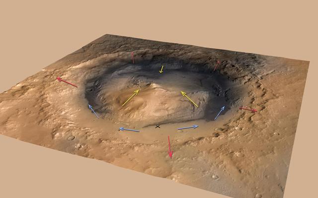
This graphic shows the pattern of winds predicted to be swirling around and inside Gale Crater, where NASA Curiosity rover landed on Mars. Modeling the winds gives scientists a context for the data from Curiosity Rover Environmental Monitoring Station

The THEMIS camera contains 5 filters. The data from different filters can be combined in multiple ways to create a false color image. This image from NASA 2001 Mars Odyssey spacecraft shows part of Gale Crater.
The eroded, layered deposit in this NASA Mars Odyssey image of Gale Crater is a mound of material rising 3 km about 2 miles above the crater floor. It has been sculpted by wind and possibly water to produce the dramatic landforms seen today.
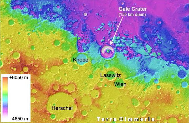
Gale Crater on Mars, where NASA Curiosity rover is set to land, belongs to a family of large, very old craters shown here on this elevation map. The data come from the Mars Orbiter Laser Altimeter instrument on NASA Mars Global Surveyor.
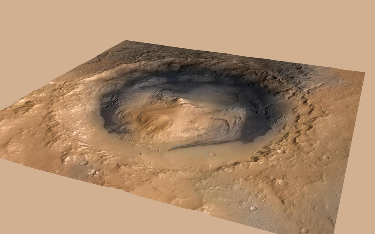
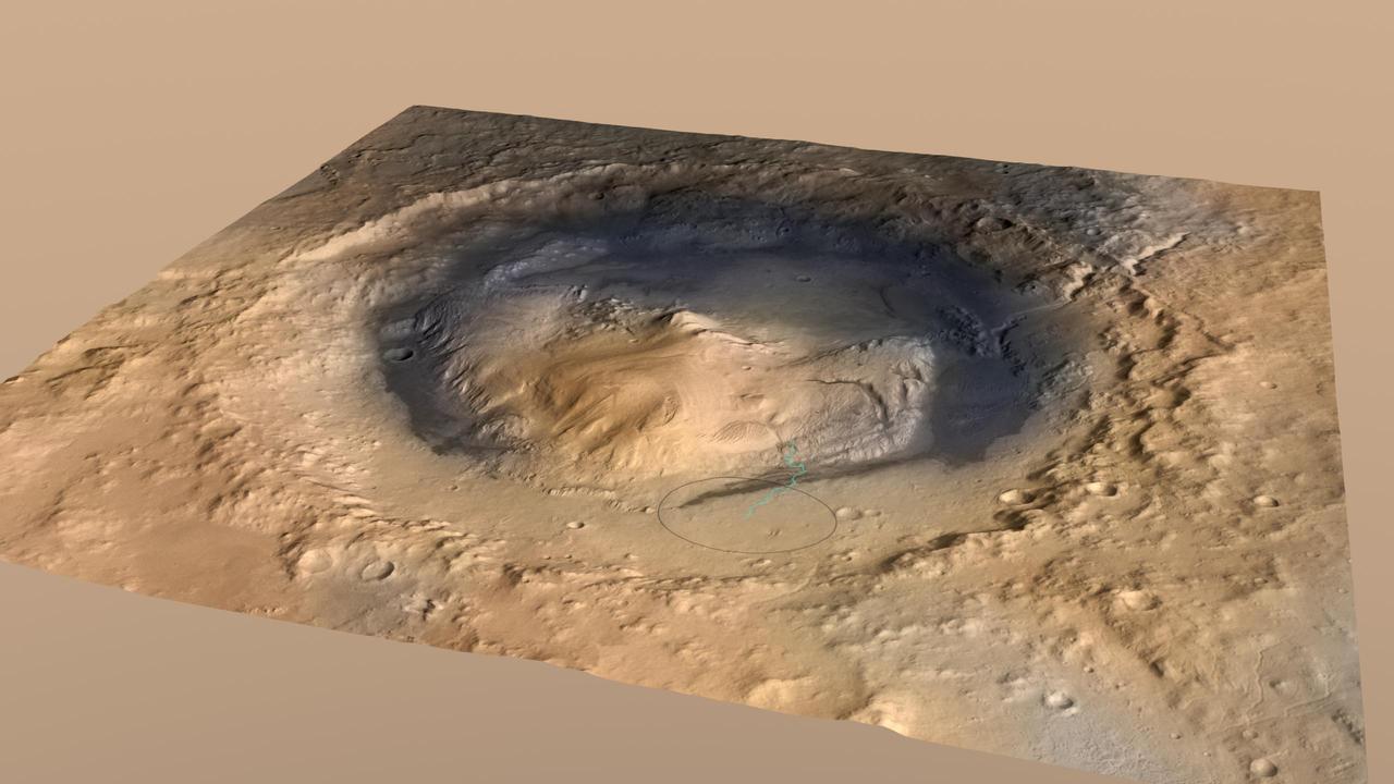
NASA Curiosity rover landed in the Martian crater known as Gale Crater, which is approximately the size of Connecticut and Rhode Island combined. A green dot shows where the rover landed, well within its targeted landing ellipse, outlined in blue.
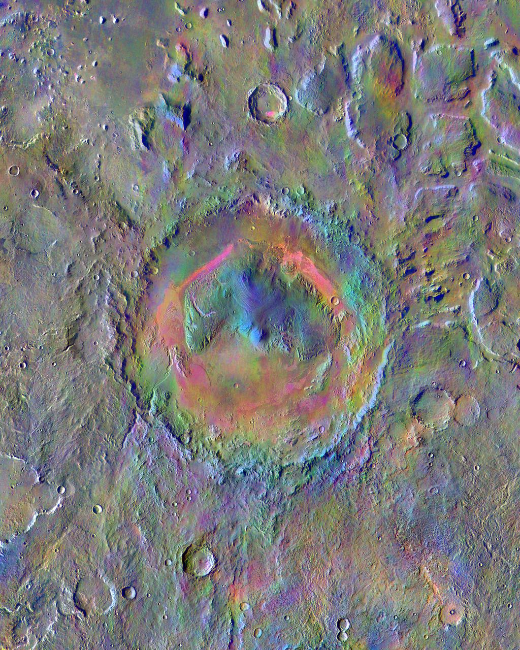
Gale Crater, home to NASA's Curiosity Mars rover, shows a new face in this mosaic image made using data from the Thermal Emission Imaging System (THEMIS) on NASA's Mars Odyssey orbiter. The colors come from an image processing technique that identifies mineral differences in surface materials and displays them in false colors. For example, windblown dust appears pale pink and olivine-rich basalt looks purple. The bright pink on Gale's floor appears due to a mix of basaltic sand and windblown dust. The blue at the summit of Gale's central mound, Mount Sharp, probably comes from local materials exposed there. The typical average Martian surface soil looks grayish-green. Scientists use false-color images such as these to identify places of potential geologic interest. The diameter of the crater is 96 miles (154 kilometers). North is up. THEMIS and other instruments on Mars Odyssey have been studying Mars from orbit since 2001. Curiosity landed in the northeastern portion of Gale Crater in 2012 and climbed onto the flank of Mount Sharp in 2014. http://photojournal.jpl.nasa.gov/catalog/PIA19674
The THEMIS VIS camera contains 5 filters. The data from different filters can be combined in multiple ways to create a false color image. These false color images may reveal subtle variations of the surface not easily identified in a single band image. Today's false color image shows a cross section of Gale Crater, including the large layered deposit in the center of the crater. The Curiosity Rover is located on the floor of Gale Crater. Gale Crater is 154 km (95 miles) in diameter and is located near Terra Cimmeria. The THEMIS VIS camera is capable of capturing color images of the Martian surface using five different color filters. In this mode of operation, the spatial resolution and coverage of the image must be reduced to accommodate the additional data volume produced from using multiple filters. To make a color image, three of the five filter images (each in grayscale) are selected. Each is contrast enhanced and then converted to a red, green, or blue intensity image. These three images are then combined to produce a full color, single image. Because the THEMIS color filters don't span the full range of colors seen by the human eye, a color THEMIS image does not represent true color. Also, because each single-filter image is contrast enhanced before inclusion in the three-color image, the apparent color variation of the scene is exaggerated. Nevertheless, the color variation that does appear is representative of some change in color, however subtle, in the actual scene. Note that the long edges of THEMIS color images typically contain color artifacts that do not represent surface variation. Orbit Number: 85710 Latitude: -5.28449 Longitude: 138.202 Instrument: VIS Captured: 2021-04-10 16:02 https://photojournal.jpl.nasa.gov/catalog/PIA25092
This oblique, southward-looking view of Gale crater shows the mound of layered rocks that NASA Mars Science Laboratory will investigate. The mission selected landing site is just north of the mound inside the crater.
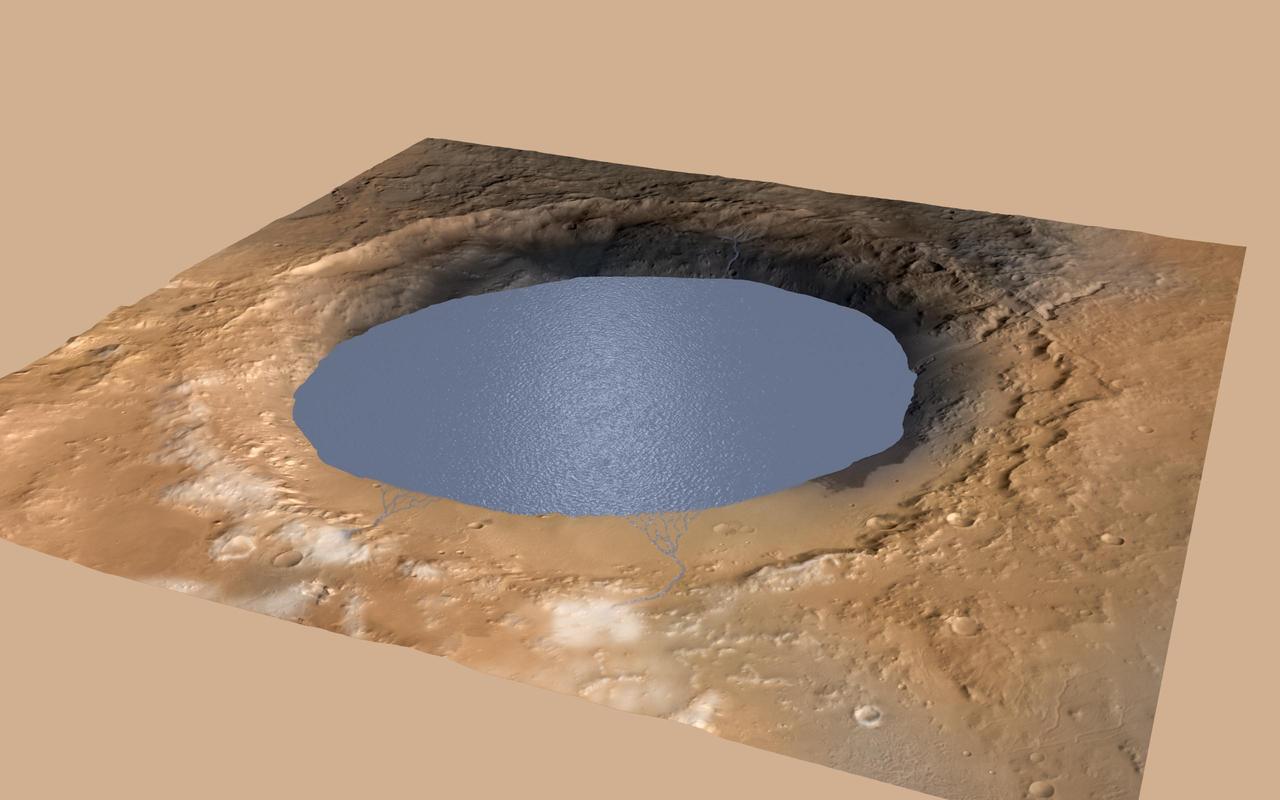
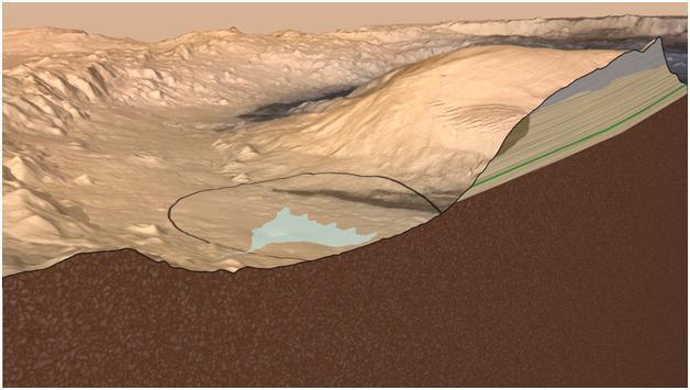
This simulation depicts a lake partially filling Mars Gale Crater, receiving runoff from snow melting on the crater rim, showing evidence that NASA Curiosity rover has found ancient streams, deltas and lakes.
The THEMIS VIS camera contains 5 filters. The data from different filters can be combined in multiple ways to create a false color image. These false color images may reveal subtle variations of the surface not easily identified in a single band image. Today's false color image shows Gale Crater. Gale Crater is the home of the Curiosity Rover. The THEMIS VIS camera is capable of capturing color images of the Martian surface using five different color filters. In this mode of operation, the spatial resolution and coverage of the image must be reduced to accommodate the additional data volume produced from using multiple filters. To make a color image, three of the five filter images (each in grayscale) are selected. Each is contrast enhanced and then converted to a red, green, or blue intensity image. These three images are then combined to produce a full color, single image. Because the THEMIS color filters don't span the full range of colors seen by the human eye, a color THEMIS image does not represent true color. Also, because each single-filter image is contrast enhanced before inclusion in the three-color image, the apparent color variation of the scene is exaggerated. Nevertheless, the color variation that does appear is representative of some change in color, however subtle, in the actual scene. Note that the long edges of THEMIS color images typically contain color artifacts that do not represent surface variation. Orbit Number: 87507 Latitude: -6.02215 Longitude: 137.01 Instrument: VIS Captured: 2021-09-05 15:06 https://photojournal.jpl.nasa.gov/catalog/PIA25383
This is the first 360-degree panorama in color of the Gale Crater landing site taken by NASA Curiosity rover. The panorama was made from thumbnail versions of images taken by the Mast Camera.
This oblique view of Gale crater shows the landing site and the mound of layered rocks that NASA Mars Science Laboratory will investigate. The landing site is in the smooth area in front of the mound.
As of June 2012, the target landing area for NASA Mars Science Laboratory mission is the ellipse marked on this image of Gale Crater. The ellipse is about 12 miles long and 4 miles wide 20 kilometers by 7 kilometers.
This mosaic of images from the Mast Camera onboard NASA Curiosity Mars rover shows a series of sedimentary deposits in the Glenelg area of Gale Crater, from a perspective in Yellowknife Bay looking toward west-northwest.
This color image from NASA Curiosity rover shows part of the wall of Gale Crater, the location on Mars where the rover landed. This is part of a larger, high-resolution color mosaic made from images obtained by Curiosity Mast Camera.
This oblique view of the mound in Gale crater shows several different rock types of interest to the Mars Science Laboratory mission. The Mars Science Laboratory rover, Curiosity, will use its full instrument suite to study these minerals and how they form
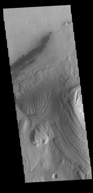
Gale Crater is well-known as the landing site of NASA's Curiosity rover, which has explored the northwest crater floor since 2012. But the entire crater is full of fascinating geology, some beyond the rover's reach. This image covers a fan of sedimentary rock on the southeast crater floor. Ridges on the fan surface may be composed of coarse-grained sediment deposited in ancient streams. More recent wind erosion of the surrounding finer sediments could have left these channel deposits elevated in "inverted relief." A closeup shows some of these ridges, as well as light-toned layers of sediment exposed along the fan edge. The fan is also punctured by scattered circular impact craters. One of these craters appears to have a circular deposit of sedimentary rock filling its floor, suggesting that it formed during the span of time that streams were active here. Features like this help scientists to infer the geologic history of the region. https://photojournal.jpl.nasa.gov/catalog/PIA25988
Curiosity, the big rover of NASA Mars Science Laboratory mission, will land in August 2012 near the foot of a mountain inside Gale Crater. The mission project science group is calling the mountain Mount Sharp.
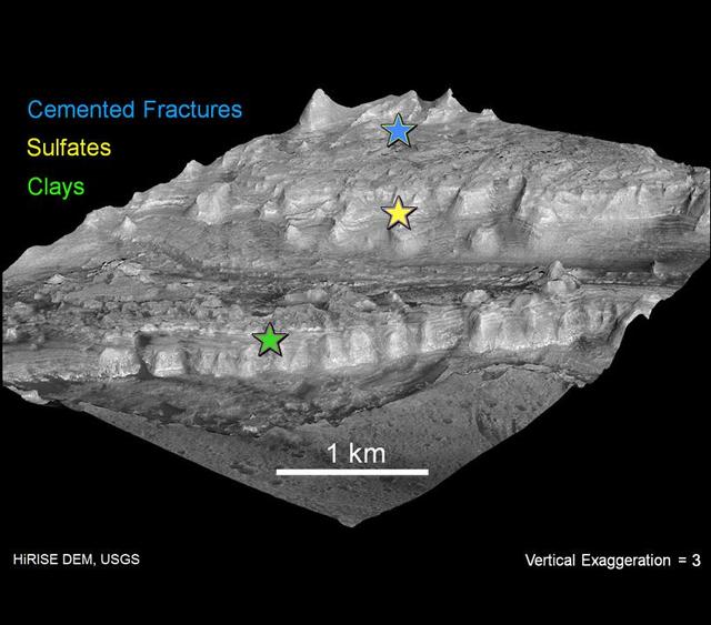
One type of feature of scientific interest on the mountain inside Gale crater is exposure of cemented fractures, evidence that groundwater once reached to at least that height of the mountain. This image is from NASA Mars Reconnaissance Orbiter.
This oblique view, captured by NASA Mars Reconnaissance Orbiter, shows geological layers of rock exposed on a mound inside Gale Crater on Mars. This view was created from a three-dimensional topographic model of the mound.
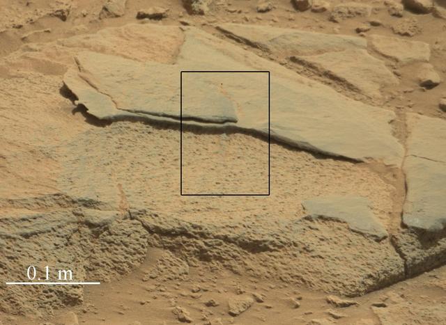
The rock Ithaca is shown here with a rougher lower texture and smoother texture on top, and appears to be a piece of the local sedimentary bedrock protruding from the surrounding soil in Gale Crater as seen by NASA Curiosity Mars rover.
This oblique view of Gale crater shows the landing site and the mound of layered rocks that NASA Mars Science Laboratory will investigate. The landing site is in the smooth area in front of the mound.
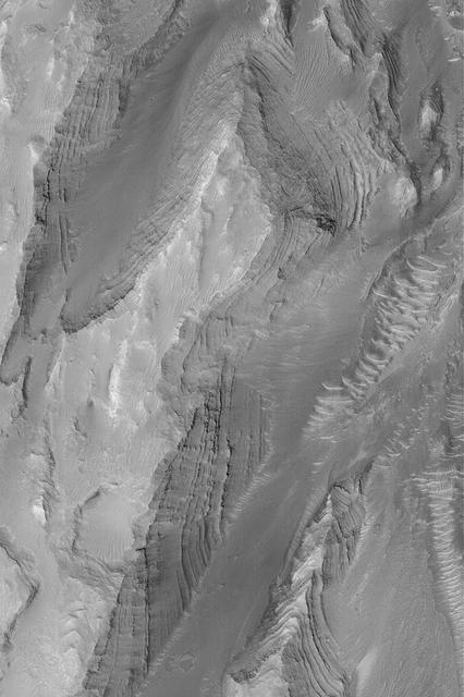
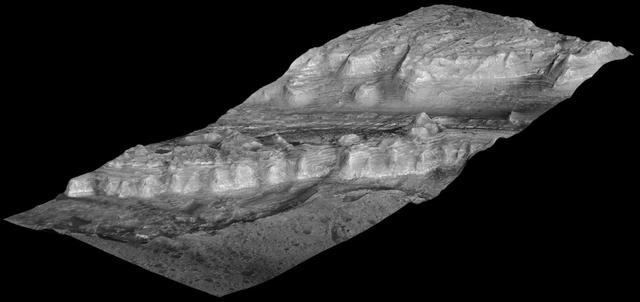
Layers of rock exposed in the lower portion of a tall mound near the center of Gale Crater on Mars exhibit variations in layer thickness and range between dark and light tones in this image taken by NASA Mars Reconnaissance Orbiter.
Layers of rock in the upper portion of a tall mound near the center of Gale Crater on Mars exhibit a regular thickness of several meters in this image taken by NASA Mars Reconnaissance Orbiter.
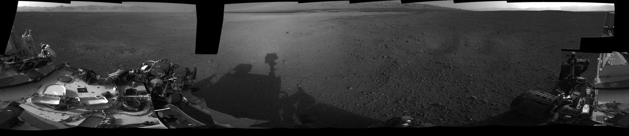
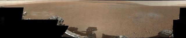
This 360-degree, full-resolution panorama from NASA Curiosity rover shows the area all around the rover within Gale Crater on Mars. The rover deck is to the left and far right.

Scientist hypothesize that a lake of liquid water once filled Gale crater, and the layers in the mound formed as sediment settled down through the water to the bottom of the lake in this image from NASA Mars Reconnaissance Orbiter.
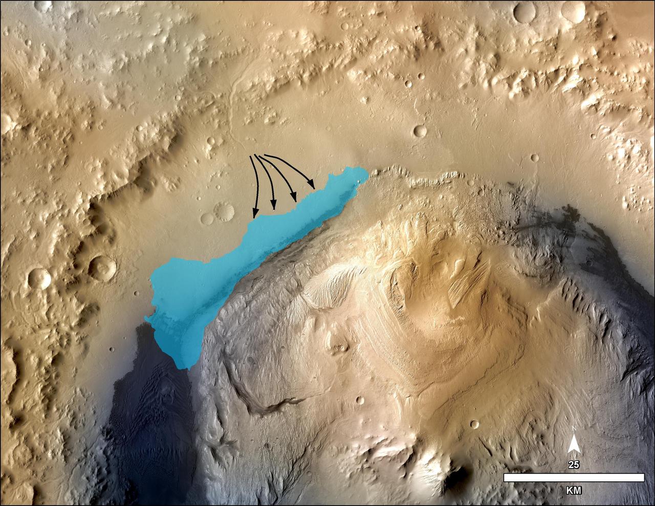
This illustration depicts a concept for the possible extent of an ancient lake inside Gale Crater. The base map combines image data from the Context Camera on NASA Mars Reconnaissance Orbiter and color information from Viking Orbiter imagery.
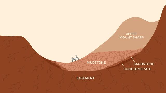
This pair of drawings depicts the same location on Mars at two points in time: now and billions of years ago. The location is in Gale Crater, near the Red Planet's equator. Since August 2012, NASA's Curiosity Mars rover mission has been investigating rock layers in the crater floor and in the crater's central peak (Mount Sharp) for information recorded in the rocks about ancient environmental conditions and how they changed over time. Slide 1 shows a present-day snapshot of the northern half of Gale Crater. North is to the left. The underlying basement is the crust of Mars that forms the crater's rim (left) and central peak (right). About 3.5 billion years ago, rivers brought sediment into the crater, depositing pebbles where the river was flowing more quickly, sand where the river entered a standing body of water in the center of the basin, and silt within this lake. Lake level rose over time as the sediments built up. Eventually they were buried by dry dust. These sediments later turned into the conglomerate, sandstone, mudstone, and duststone rocks that Curiosity has found. Wind then carved the stack of deposits into the present shape of a mountain, which Curiosity is climbing as approximately shown. The basement rock fractured during the initial impact that formed the crater, and the later sediments fractured as they were buried. Slide 2 shows a snapshot in time when a lake was present in the crater. As on Earth, Martian lakes were the surface expression of a much larger lake and groundwater system. Spaces between grains and in fractures were saturated with water at levels below the water table (dashed blue line). This groundwater circulated due to gravity and the topography within and around the crater. In this case, groundwater pressurized under the nearby Martian highlands may have flowed into the crater, where it would be less confined. Groundwater also flowed downward from the lake. As the groundwater circulated, it drove chemical reactions that dissolved some minerals and precipitate others. Habitable environments in ancient Gale Crater -- identified during Curiosity's first year on Mars --expanded both in space and time beyond just the lakes. They extend throughout the subsurface where groundwater was present, and extended in time well after the lakes disappeared, when groundwater continued to circulate through the buried and fractured sediments. The unannotated figure and an animated gif are available at http://photojournal.jpl.nasa.gov/catalog/PIA21255
While far from the rover, this VIS image of Gale Crater covers the same central layered deposit that Curiosity is studying. The linear ridges are the result of wind action eroding the material. Orbit Number: 72297 Latitude: -5.20235 Longitude: 138.126 Instrument: VIS Captured: 2018-04-02 02:54 https://photojournal.jpl.nasa.gov/catalog/PIA22505
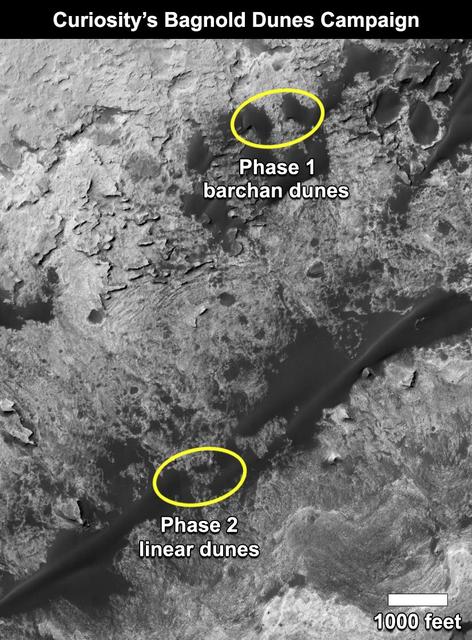
This map shows the two locations of a research campaign by NASA's Curiosity Mars rover mission to investigate active sand dunes inside Gale Crater on Mars. The Bagnold Dunes form a dark band on the northwestern flank of Mount Sharp, inside the crater. In late 2015 and early 2016, Curiosity examined crescent-shaped dunes, called barchans, which are convex on the downwind (leeward) side. This was the first close-up study of active sand dunes anywhere other than Earth. In February 2017, the rover reached a location where the dunes are linear in shape, and the mission began Phase 2 of its dunes campaign. http://photojournal.jpl.nasa.gov/catalog/PIA21269
The THEMIS VIS camera contains 5 filters. The data from different filters can be combined in multiple ways to create a false color image. These false color images may reveal subtle variations of the surface not easily identified in a single band image. Today's false color image shows part of the floor of Gale Crater, home of the Curiosity Rover. The location of the rover is to the north of this image. The dark material on the upper left are dunes, the bright material on the upper right is part of the large central deposit of materials (the goal of the rover). The channel at the bottom of the image dissects the crater rim. Orbit Number: 19628 Latitude: -5.41839 Longitude: 137.086 Instrument: VIS Captured: 2006-05-18 12:33 http://photojournal.jpl.nasa.gov/catalog/PIA20245
A vantage point on "Vera Rubin Ridge" provided NASA's Curiosity Mars rover this detailed look back over the area where it began its mission inside Gale Crater, plus more-distant features of the crater. This view toward the north-northeast combines eight images taken by the right-eye, telephoto-lens camera of Curiosity's Mast Camera (Mastcam). It shows more detail of a fraction of the area pictured in a more sweeping panorama (see PIA22210) acquired from the same rover location using Mastcam's left-eye, wider-angle-lens camera. The scene has been white-balanced so the colors of the rock materials resemble how they would appear under daytime lighting conditions on Earth. The component images were taken on Oct. 25, 2017, during the 1,856th Martian day, or sol, of the rover's work on Mars. At that point, Curiosity had gained 1,073 feet (327 meters) in elevation and driven 10.95 miles (17.63 kilometers) from its landing site. Mount Sharp stands about 3 miles (5 kilometers) high in the middle of Gale Crater, which spans 96 miles (154 kilometers) in diameter. Vera Rubin Ridge is on the northwestern flank of lower Mount Sharp. The right foreground of this panorama shows a portion of Vera Rubin Ridge. In the distance is the northern wall of Gale Crater, with the rim crest forming the horizon roughly 25 miles (40 kilometers) from the rover's location. An annotated version, Figure 1, indicates where the rover landed (at "Bradbury Landing") in 2012 and the initial portion of its drive, including investigation sites "Yellowknife Bay," "Darwin" and "Cooperstown." The rover's exact landing site is hidden behind a slight rise. The heat shield, back shell, and parachute used during the spacecraft's descent are within the pictured area but not recognizable due to the distance and to camouflaging by dust. At Yellowknife Bay in 2013, the mission found evidence of an ancient freshwater-lake environment that offered all of the basic chemical ingredients for microbial life. Figure 2 includes three scale bars: of 40 meters (131 feet) at a distance of about 1,530 meters (1,673 yards) near the base of Mount Sharp; of 1,500 meters (1,640 yards) at a distance of about 30.75 kilometers (19.1 miles) near the base of the crater wall; and of 2,000 meters (1.2 miles) at a distance of about 41.2 kilometers (25.6 miles) at the crest of the rim. Annotated images are available at https://photojournal.jpl.nasa.gov/catalog/PIA22209
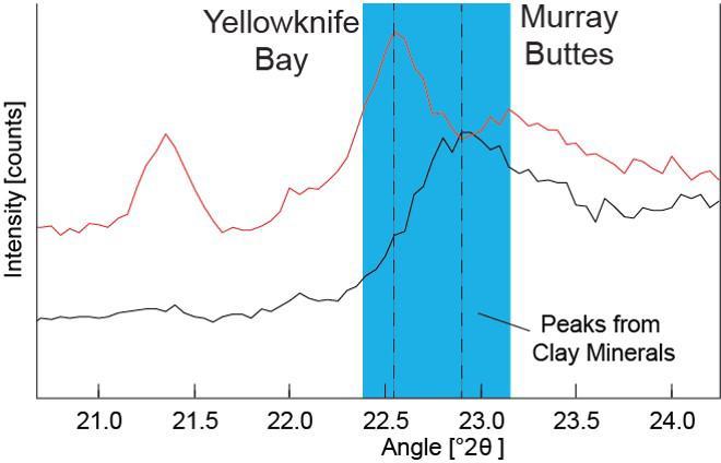
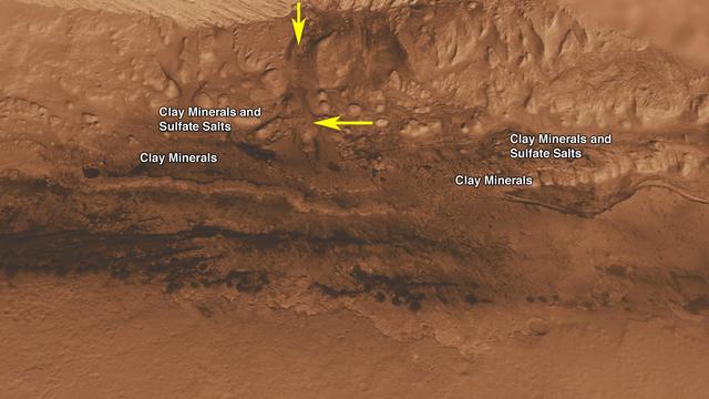
Data graphed here from the Chemistry and Camera (CheMin) instrument on NASA's Mars Curiosity rover show a difference between clay minerals in powder drilled from mudstone outcrops at two locations in Mars' Gale Crater: "Yellowknife Bay" and "Murray Buttes." CheMin's X-ray diffraction analysis reveals information about the crystalline structure of minerals in the rock. The intensity peaks marked with dotted vertical lines in this chart indicate that the crystalline structure of the two sites' clay minerals differs. The difference can be tied to a compositional difference in the clay minerals, as depicted in a diagram at PIA21148. The Yellowknife Bay site is on the floor of Gale Crater. The Murray Buttes site is on lower Mount Sharp, the layered mound in the center of the crater. http://photojournal.jpl.nasa.gov/catalog/PIA21147
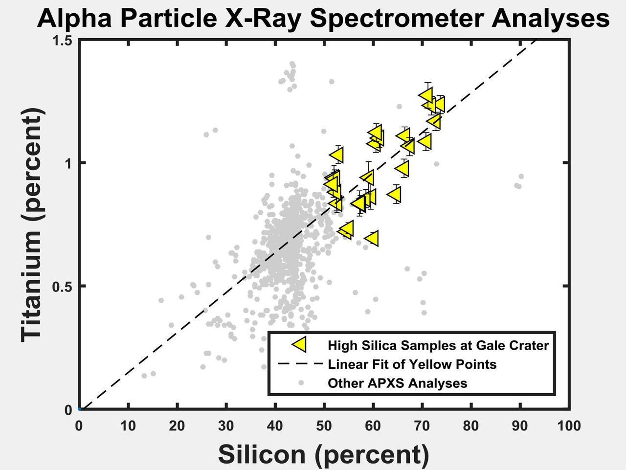
The yellow triangles on this graph indicate concentrations of the elements titanium and silicon in selected rock targets with high silica content analyzed by the Alpha Particle X-ray Spectrometer (APXS) instrument on NASA's Curiosity rover in Mars' Gale Crater. The pattern shows a correlation between enriched silicon content and enriched titanium content. Titanium is difficult to mobilize in weathering environments, and this correlation suggests that both titanium and silicon remain as the residue of acidic weathering. Ongoing research aims to distinguish between that possible explanation for silicon enrichment and an alternative of mobilized silicon being added to the site (see PIA20275). As a general comparison with these selected high-silica targets in Gale Crater, the gray dots in the graph show the range of titanium and silicon concentrations in all Martian targets analyzed by APXS instruments on three Mars rovers at three different areas of Mars. http://photojournal.jpl.nasa.gov/catalog/PIA20274

Climbing "Vera Rubin Ridge" provided NASA's Curiosity Mars rover this sweeping vista of the interior and rim of Gale Crater, including much of the rover's route during its first five-and-a-half years on Mars and features up to about 50 miles (85 kilometers) away. The scene spans from southwest on the left to northeast on the right, combining 16 side-by-side images taken by the left-eye, wider-angle-lens camera of Curiosity's Mast Camera (Mastcam). It has been white-balanced so the colors of the rock materials resemble how they would appear under daytime lighting conditions on Earth. The component images were taken on Oct. 25, 2017, during the 1,856th Martian day, or sol, of the rover's work on Mars. At that point, Curiosity had gained 1,073 feet (327 meters) in elevation and driven 10.95 miles (17.63 kilometers) from its landing site. Mount Sharp stands about 3 miles (5 kilometers) high in the middle of Gale Crater, which spans 96 miles (154 kilometers) in diameter. Vera Rubin Ridge is on the northwestern flank of lower Mount Sharp. The foreground of this panorama shows portions of lower Mount Sharp. The middle distance shows the floor of Gale Crater. Most of the horizon is formed by the crater's rim. The top of the rim is about 1.2 miles (2 kilometers) higher than the rover's position. On the horizon near the center of the image is a glimpse outside of Gale Crater, to a peak about 50 miles (85 kilometers) from the rover. An annotated version, Figure 1, indicates the rover's approximate path since its 2012 landing, identifies some of the sites it has investigated along the way, such as "Yellowknife Bay," "The Kimberley," "Namib Dune" and "Murray Buttes"; and points out other geological features visible in the scene, such as the channel of Peace Vallis, an ancient streambed descending from the crater rim. The relative positions of the labeled features are also mapped on an accompanying orbital view in PIA22208, with two areas color-coded for ease of matching them in the annotated panorama and the orbital view. Figure 2 is a version with a white-line box indicating the smaller area covered in a more-detailed vista (see PIA22209) taken from this same rover location by Mastcam's right-eye, telephoto-lens camera. It also includes three scale bars: of 50 meters (164 feet) at a distance of 1,170 meters (1,280 yards) near the base of Mount Sharp; of 1,000 meters (1,094 yards) at a distance of about 23.4 kilometers (14.5 miles) near the base of the crater wall; and of 2 kilometers (1.2 miles) at a distance of about 31.5 kilometers (19.6 miles) at the crest of the rim. Annotated images are available at https://photojournal.jpl.nasa.gov/catalog/PIA22210
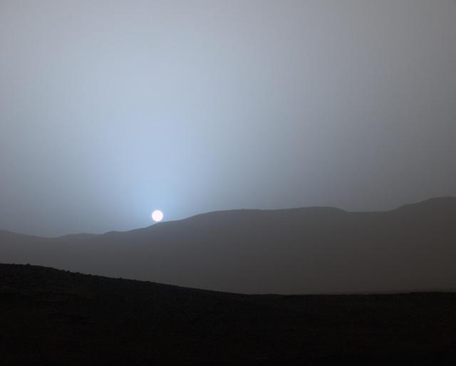
NASA's Curiosity Mars rover recorded this view of the sun setting at the close of the mission's 956th Martian day, or sol (April 15, 2015), from the rover's location in Gale Crater. This was the first sunset observed in color by Curiosity. The image comes from the left-eye camera of the rover's Mast Camera (Mastcam). The color has been calibrated and white-balanced to remove camera artifacts. Mastcam sees color very similarly to what human eyes see, although it is actually a little less sensitive to blue than people are. Dust in the Martian atmosphere has fine particles that permit blue light to penetrate the atmosphere more efficiently than longer-wavelength colors. That causes the blue colors in the mixed light coming from the sun to stay closer to sun's part of the sky, compared to the wider scattering of yellow and red colors. The effect is most pronounced near sunset, when light from the sun passes through a longer path in the atmosphere than it does at mid-day. Malin Space Science Systems, San Diego, built and operates the rover's Mastcam. NASA's Jet Propulsion Laboratory, a division of the California Institute of Technology, Pasadena, manages the Mars Science Laboratory Project for NASA's Science Mission Directorate, Washington. JPL designed and built the project's Curiosity rover. http://photojournal.jpl.nasa.gov/catalog/PIA19400
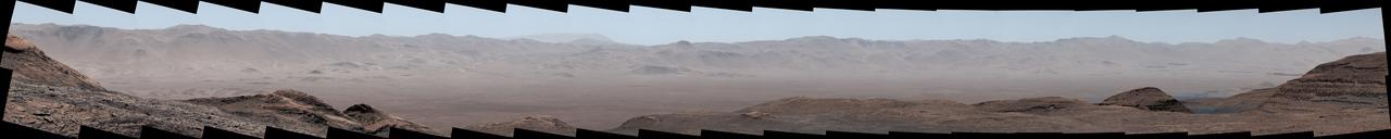
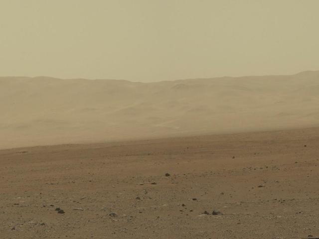
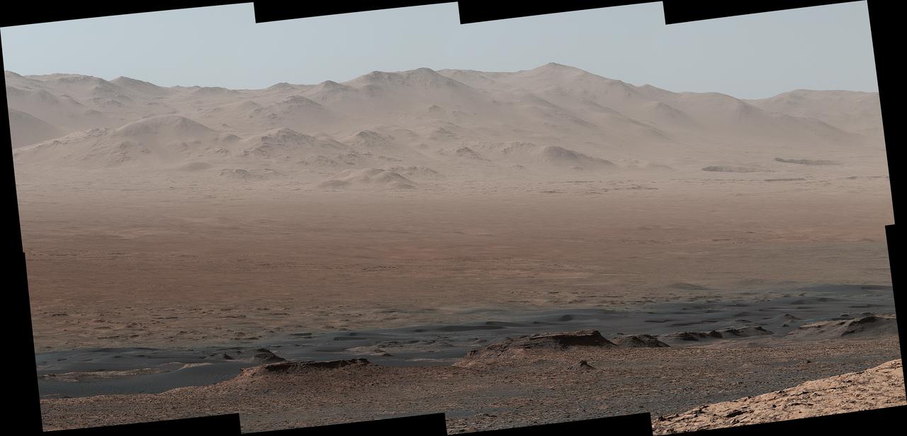
NASA's Curiosity Mars rover captured this panorama under exceptionally clear conditions of Gale Crater's northern rim on Aug. 25, 2025, the 4,640th Martian day, or sol, of the mission. Dust in the air is at its lowest during Martian winter, providing Curiosity its best views all the way across the yawning crater floor from the rover's perch in the foothills of Mount Sharp, a 3-mile-tall (5-kilometer-tall) mountain roughly 22 miles (35 kilometers) from the crater rim. The panorama was stitched together on Earth from 44 images captured by Curiosity's Mastcam instrument. The color in these images has been adjusted to match the lighting conditions as the human eye would see them on Earth. https://photojournal.jpl.nasa.gov/catalog/PIA26671
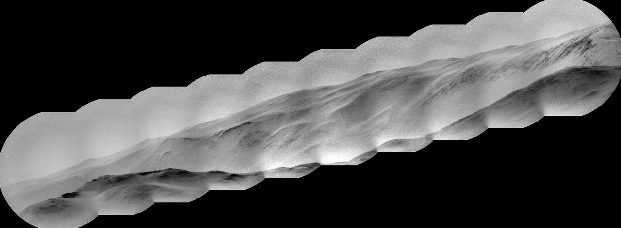
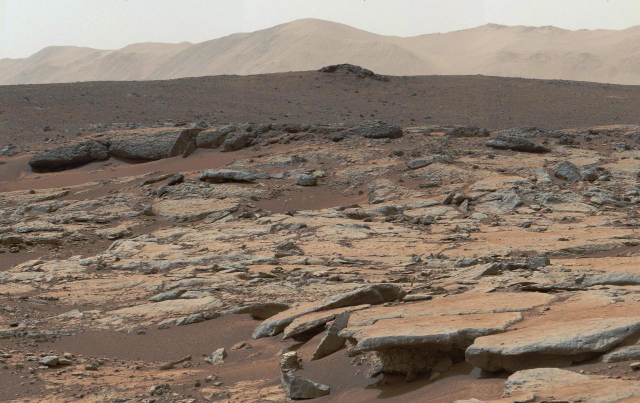
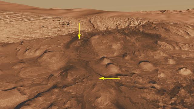
NASA's Curiosity Mars rover captured this view of a mountain nearly 57 miles (91 kilometers) away and outside of Gale Crater, where Curiosity landed in 2012. The rover is currently in the foothills of Mount Sharp, a 3-mile-tall (5-kilometer-tall) mountain within the crater. Estimated to be 8,202 feet (2,500 meters) tall, the mountain's summit just peeks over the crater rim in the panorama. It has never been viewed with this much detail. Toward the lower left, dark rocky outcrops are visible. Curiosity captured the view with its black-and-white Remote Micro Imager, or RMI. Part of the rover's ChemCam instrument, RMI can be used like a small telescope to see distant features, creating a circular "spyglass" view. Ten RMI images taken on Aug. 28, 2025 (the 4,643rd Martian day, or sol of the mission) were stitched together to create the mosaic. https://photojournal.jpl.nasa.gov/catalog/PIA26638
This image from NASA Mars Odyssey spacecraft shows the western rim of Gale Crater. Several channels dissect the rim of the crater.

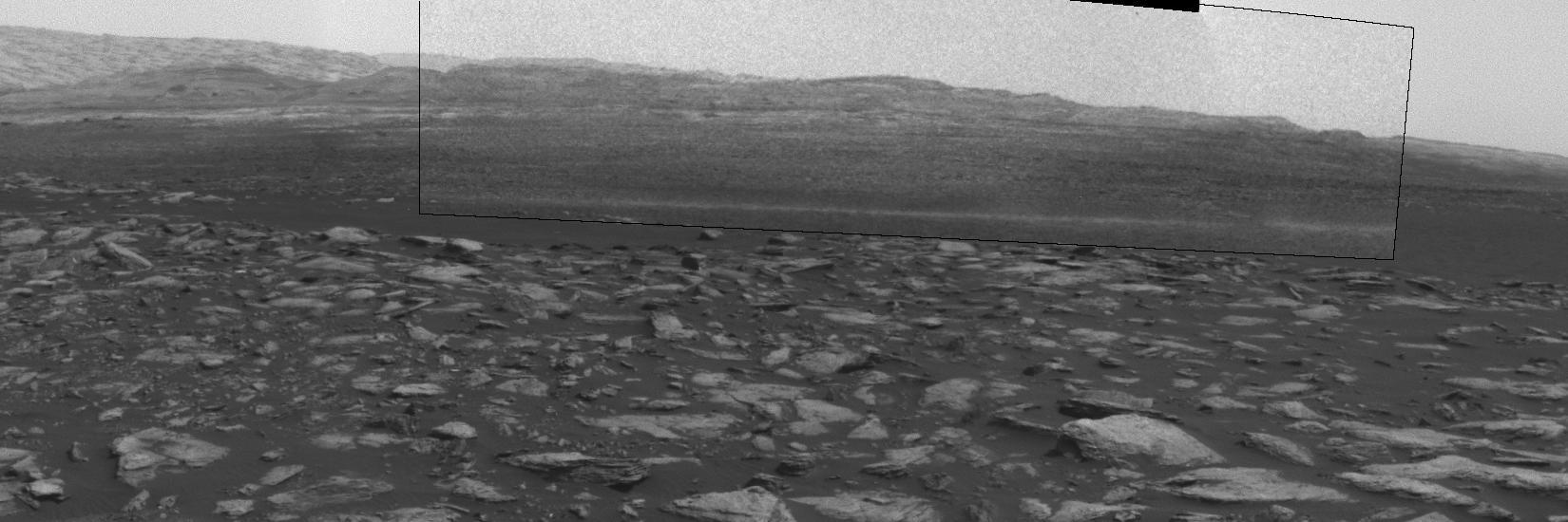
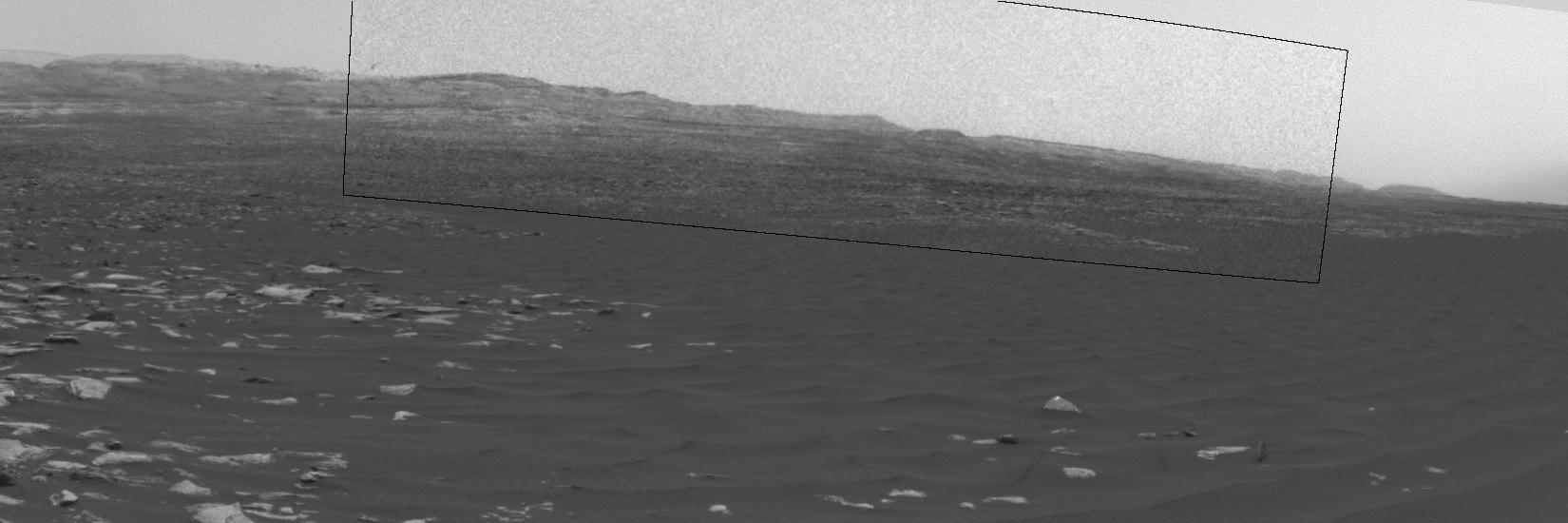
This early-morning view from the Mast Camera (Mastcam) on NASA's Curiosity Mars rover covers a field of view of about 130 degrees of the inner wall of Gale Crater. It was acquired during a period when there was very little dust or haze in the atmosphere, so conditions were optimal for long-distance imaging. The right side of the image fades into the glare of the rising sun. Mastcam's right-eye camera, which has a telephoto lens, took the component images on March 16, 2016, during the 1,284th sol, or Martian day, of Curiosity's work on Mars. The rover's location was on the "Naukluft Plateau" of lower Mount Sharp, inside Gale Crater. The view spans from west-northwest on the left to northeast on the right. Details of the morphology (shape and pattern of features) on the wall, which include gullies, channels and debris fans help geologists understand the processes that have shaped the crater and transported sediments -- sand, pebbles and larger rocks -- down to the floor of the crater. Some of the foothills show layers morphologically not unlike the layers Curiosity is exploring near the base of Mount Sharp, suggesting that the crater was filled along the north wall with sediments that have in large part now been eroded away, much as happened closer to Mount Sharp. The scene is presented with a color adjustment that approximates white balancing, to resemble how the terrain would appear under daytime lighting conditions on Earth. Figure 1 includes labels on three peaks of the crater wall, for scale and position reference. The peak labeled "A," near the left end of the panorama, is at azimuth 291.8 degrees east of north and 18.1 miles (29.1 kilometers) away from the rover's position. It rises about 6,200 feet (1,900 meters) above the closest point on the floor of the crater. Peak "B," at azimuth 357.2 degrees east of north (or 2.8 degrees from north), is about 17.6 miles (28.4 kilometers) away and rises about 3,900 feet (1,200 meters) above the base of its foothills. Peak "C," at azimuth 33.6 degrees east of north, is about 27.3 miles (45.5 kilometers) distant and rises about 6,200 feet (1,900 meters) above the base of its foothills. http://photojournal.jpl.nasa.gov/catalog/PIA20333

This graph shows the ratio of concentrations of several elements in four different pairs of targets examined by Alpha Particle X-ray Spectrometer (APXS) instruments on NASA Mars rovers Curiosity and Spirit. For each pair of targets, one shows evidence of mineral alteration and the other is an unaltered counterpart. The first three pairs (with ratios shown by green, blue and red lines) are targets in Gale Crater analyzed by Curiosity's APXS. The fourth pair (with ratio shown by the black line) is in Gusev Crater and was analyzed by Spirit's APXS. Similar profiles are observed, suggesting the possibility of related formation processes. As with examples of silica enrichment found by Curiosity, the origin of high-silica nodular deposits found by Spirit also remains unresolved: Either acidic weathering or silica addition could be responsible. It is clear, however, that liquid water was involved in either alteration scenario. http://photojournal.jpl.nasa.gov/catalog/PIA20276
This frame from a sequence of images shows a dust-carrying whirlwind, called a dust devil, on lower Mount Sharp inside Gale Crater, as viewed by NASA's Curiosity Mars Rover during the summer afternoon of the rover's 1,613rd Martian day, or sol (Feb. 18, 2017). Set within a broader southward view from the rover's Navigation Camera, the rectangular area outlined in black was imaged multiple times over a span of several minutes to check for dust devils. Images from the period with most activity are shown in the inset area. The images are in pairs that were taken about 12 seconds apart, with an interval of about 90 seconds between pairs. Timing is accelerated and not fully proportional in this animation. Contrast has been modified to make frame-to-frame changes easier to see. A black frame provides a marker between repeats of the sequence. On Mars as on Earth, dust devils result from sunshine warming the ground, prompting convective rising of air that has gained heat from the ground. Observations of dust devils provide information about wind directions and interaction between the surface and the atmosphere. An animation is available at http://photojournal.jpl.nasa.gov/catalog/PIA21483
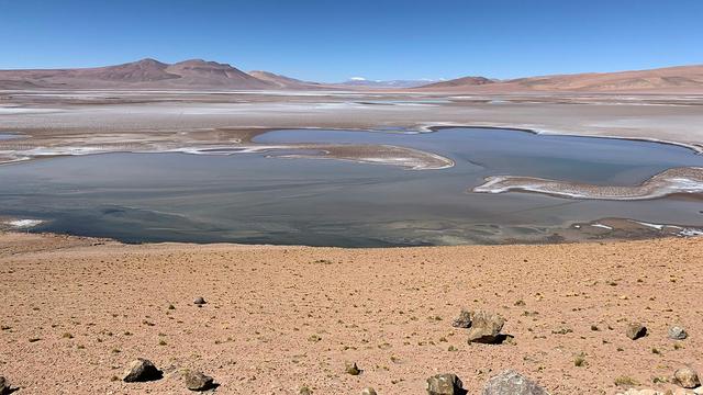
Filled with briny lakes, the Quisquiro salt flat in South America's Altiplano represents the kind of landscape that scientists think may have existed in Gale Crater, which NASA's Curiosity rover is exploring. This salt flat is located in Chile, though the Altiplano sprawls across countries. Streams and rivers flowing from mountain ranges into this arid, high-altitude plateau lead to closed basins similar to Mars' ancient Gale Crater. Lakes on the Altiplano are heavily influenced by climate in the same way as Gale. https://photojournal.jpl.nasa.gov/catalog/PIA23374
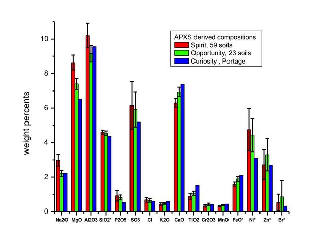
This graph compares the elemental composition of typical soils at three landing regions on Mars: Gusev Crater, from Spirit; Meridiani Planum, from Opportunity; and now Gale Crater, where NASA newest Curiosity rover is currently investigating.
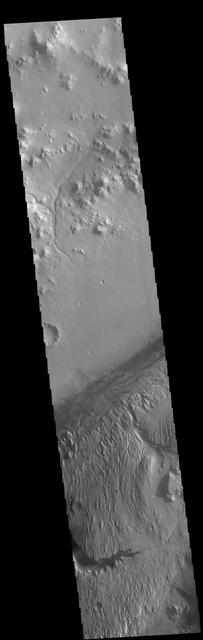
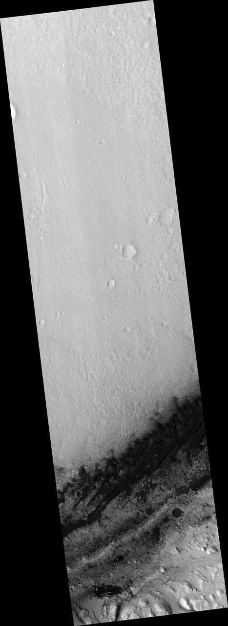
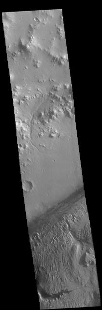
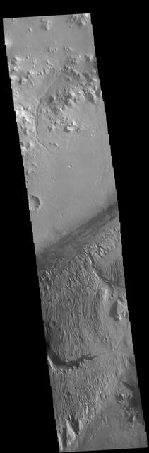
This image from NASA Mars Odyssey spacecraft shows the southwestern floor of Gale Crater. A fairly large channel that dissects the crater rim is visible entering from the bottom of the frame and continuing northward.
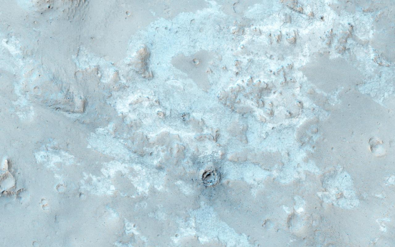
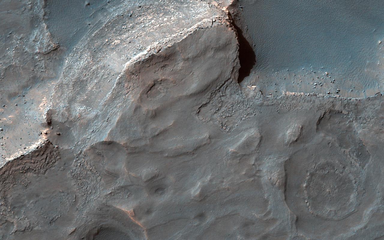
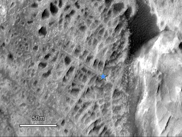
NASA Mars Reconnaissance Orbiter used its HiRISE camera to obtain this view of an area with unusual texture on the southern floor of Gale Crater. An enigmatic deposit appears to have flowed into the small crater from the south.
This image from NASA Mars Odyssey spacecraft shows the northern part of Mt. Sharp and the crater floor between Mt. Sharp and the northern rim of Gale Crater. The layering of Mt. Sharp is visible at the bottom of the image.
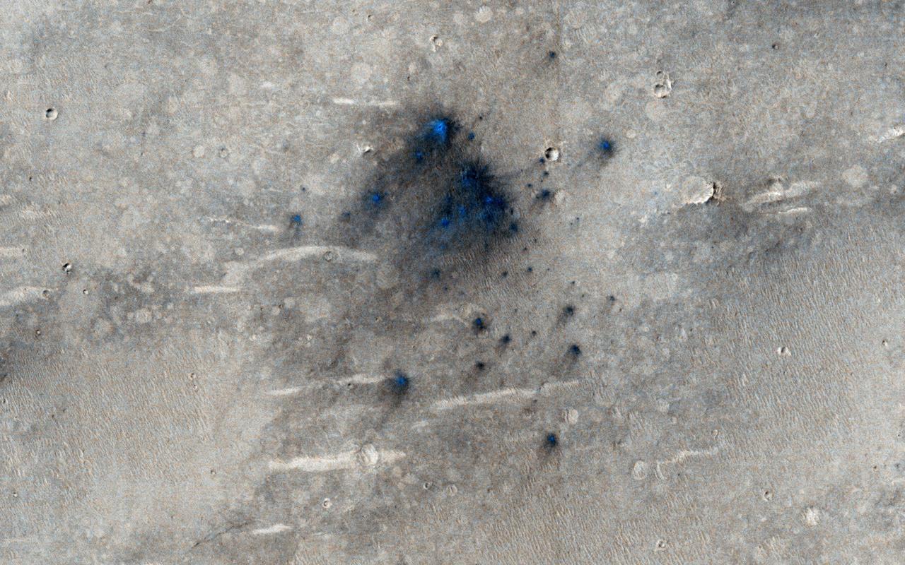
This cluster of small impact craters was spotted by the Context Camera on Mars Reconnaissance Orbiter in the region northwest of Gale Crater, the landing site of the Mars Science Laboratory MSL rover, Curiosity.
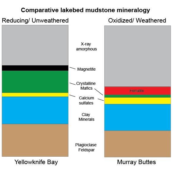
This graphic shows proportions of minerals identified in mudstone exposures at the "Yellowknife Bay" location where NASA's Curiosity Mars rover first analyzed bedrock, in 2013, and at the "Murray Buttes" area investigated in 2016. Minerals were identified by X-ray diffraction analysis of sample powder from the rocks. The samples were acquired by drilling and delivered to the Chemistry and Mineralogy (CheMin) instrument inside the rover. Two key differences in the Murray Buttes mudstone include hematite rather than magnetite, and far less abundance of crystalline mafic minerals, compared to the Yellowknife Bay mudstone composition. Hematite and magnetite are both iron oxide minerals, with hematite as a more oxidized one. That difference could result from the Murray Buttes mudstone layer experiencing more weathering than the Yellowknife Bay mudstone. More weathering could also account for the lower abundance of crystalline mafics, which are volcanic-origin minerals such as pyroxene and olivine. The Yellowknife Bay site is on the floor of Gale Crater. The Murray Buttes site is on lower Mount Sharp, the layered mound in the center of the crater. http://photojournal.jpl.nasa.gov/catalog/PIA21149