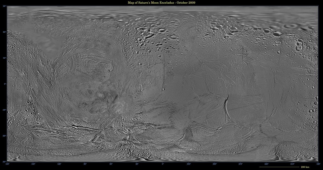
This image shows an updated map of Saturn icy moon Enceladus, generated by NASA Cassini imaging team. The map incorporates new images taken in 2008, with better image processing techniques.

An elongated coronal hole rotated across the face of the sun this past week so that it is now streaming solar wind towards Earth (Jan. 2-5, 2017). Coronal holes are areas of open magnetic field from which solar wind particles stream into space. In this wavelength of extreme ultraviolet light it appears as a dark area near the center and lower portion of the sun. The particle stream will likely generate aurora here on Earth. Check spaceweather.com for updates on auroral activity. Movies are available at http://photojournal.jpl.nasa.gov/catalog/PIA14093

NASA Administrator Jim Bridenstine, far right, talks with participants of an Economic Development Commission roundtable discussion hosted by Space Florida at the Space Life Sciences Laboratory on Aug. 7, 2018, near NASA's Kennedy Space Center in Florida. In view next to Bridenstine is Kennedy Center Director Bob Cabana, and Brigadier General Wayne Monteith, commander, 45th Space Wing, and director, Eastern Range, at Patrick Air Force Base in Florida. The administrator also toured Kennedy facilities and received updates on various center accomplishments.
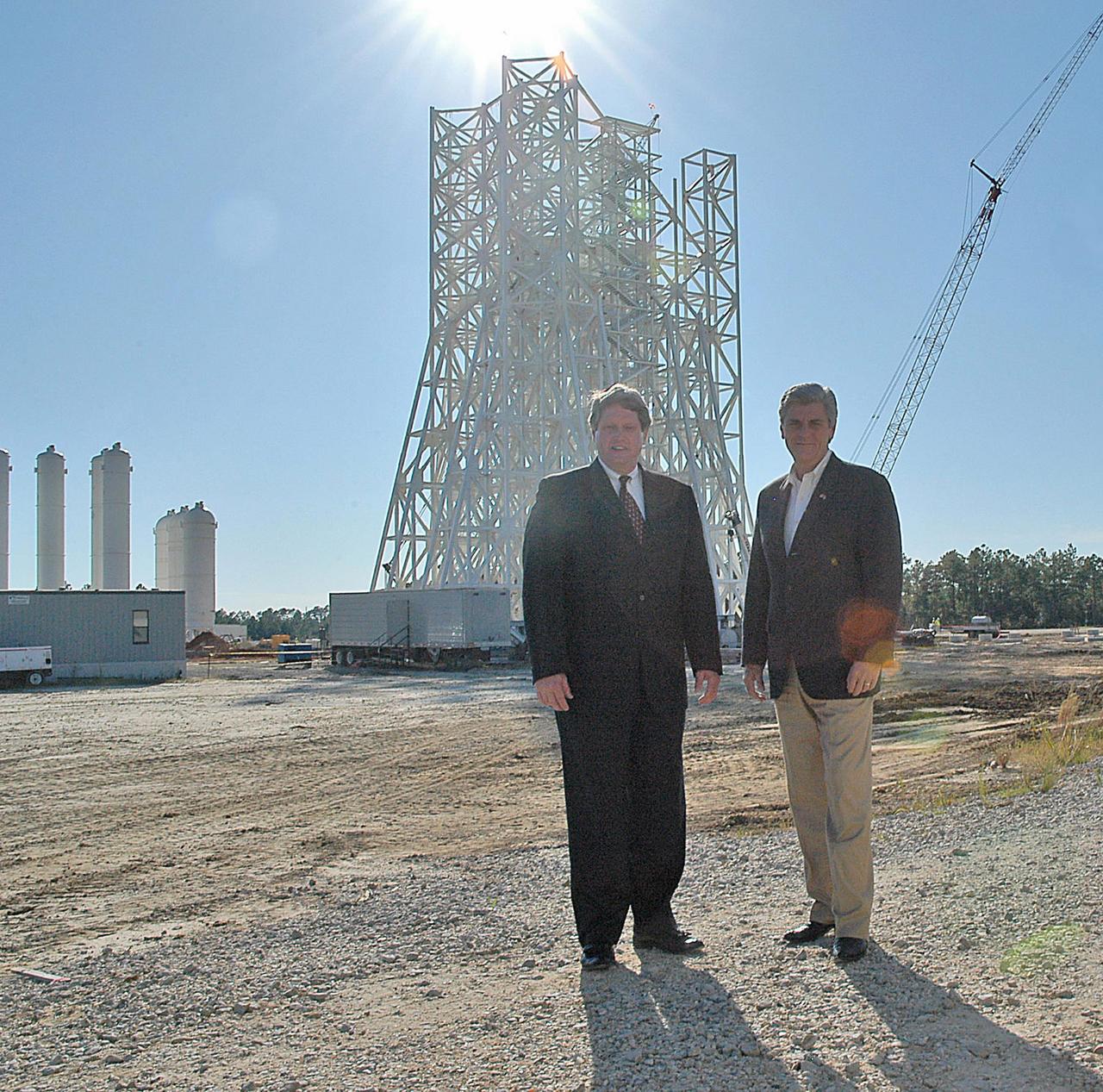
Stennis Space Center Director Gene Goldman (left) stands with Mississippi Lt. Gov. Phil Bryant at the A-3 Test Stand construction site during an Oct. 1 visit by the state official. During his tour, Bryant was updated on construction of the first large test stand at Stennis since the 1960s. The A-3 stand will be used to conduct simulated high-altitude testing on the next generation of rocket engines that will take humans back to the moon and possibly beyond. In addition to touring Stennis facilities, Bryant visited the INFINITY Science Center construction site, where he was updated on work under way to construct a 72,000-square-foot facility that will showcase the science underpinning the missions of NASA and resident agencies at Stennis.

NASA Administrator Jim Bridenstine, seated at the far table, center, participates in an Economic Development Commission roundtable discussion hosted by Space Florida at the Space Life Sciences Laboratory on Aug. 7, 2018, near NASA's Kennedy Space Center in Florida. Seated at left is Kennedy Center Director Bob Cabana. Seated at right is U.S. Rep. Bill Posey, and Brigadier General Wayne Monteith, commander, 45th Space Wing, and director, Eastern Range, Patrick Air Force Base in Florida. The administrator also toured Kennedy facilities and received updates on various center accomplishments.

iss069e088358 (9/14/2023) --- Japan Aerospace Exploration Agency (JAXA) astronaut Satoshi Furukawa is seen processing samples from the JEM Water Recovery System (JWRS) in the KIBO module aboard the International Space Station (ISS). The JWRS demonstrates that potable water can be generated from urine. In the past, urine and wastewater were collected and stored, or vented overboard. However, for long-term space missions, water supply could become a limiting factor. Demonstrating the function of this water recovery system on orbit contributes to updating the Environmental Control and Life Support System (ECLSS) to support astronauts on the space station and future exploration missions.

NASA Administrator Jim Bridenstine, second from right, participates in an Economic Development Commission roundtable discussion hosted by Space Florida at the Space Life Sciences Laboratory on Aug. 7, 2018, near NASA's Kennedy Space Center in Florida. With him, from left, are Kennedy Center Director Bob Cabana; Brigadier General Wayne Monteith, commander, 45th Space Wing, and director, Eastern Range, Patrick Air Force Base in Florida; and U.S. Rep. Bill Posey. The administrator also toured Kennedy facilities and received updates on various center accomplishments.
CAPE CANAVERAL, Fla. -- Bill Couch, standing on the left, and Gary Milbourne, both of United Space Alliance monitor the updated controls of crawler-transporter No. 2 as it moves out of high bay 2 of the Vehicle Assembly Building at NASA's Kennedy Space Center in Florida. The test drive is designed to check out recent modifications and upgrades to ensure its capability to carry launch vehicles such as the space agency's Space Launch System heavy-lift rocket to the launch pad. NASA's Ground Systems Development and Operations Program is leading the 20-year life-extension project for the crawler. A pair of behemoth machines called crawler-transporters has carried the load of taking rockets and spacecraft to the launch pad for more than 40 years at NASA’s Kennedy Space Center in Florida. Each the size of a baseball infield and powered by locomotive and large electrical power generator engines, the crawler-transporters will stand ready to keep up the work for the next generation of launch vehicles projects to lift astronauts into space. For more information, visit http://www.nasa.gov/exploration/systems/ground/index.html Photo credit: NASA/Jim Grossmann
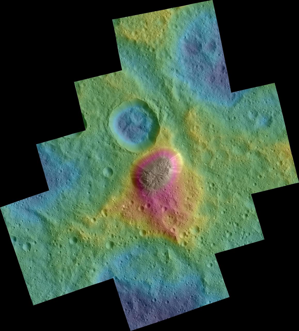
These color topographic views show variations in surface height around Ahuna Mons, a mysterious mountain on Ceres. The views are colorized versions of PIA20348 and PIA20349. They represent an update to the view in PIA19976, which showed the mountain using data from an earlier, higher orbit. Both views were made using images taken by NASA's Dawn spacecraft during its low-altitude mapping orbit, at a distance of about 240 miles (385 kilometers) from the surface. The resolution of the component images is about 120 feet (35 meters) per pixel. Elevations span a range of about 5.5 miles (9 kilometers) from the lowest places in the region to the highest terrains. Blue represents the lowest elevation, and brown is the highest. The streaks running down the side of the mountain, which appear white in the grayscale view, are especially bright parts of the surface (the brightness does not relate to elevation). The elevations are from a shape model generated using images taken at varying sun and viewing angles during Dawn's lower-resolution, high-altitude mapping orbit (HAMO) phase. The side perspective view was generated by draping the image mosaics over the shape model. http://photojournal.jpl.nasa.gov/catalog/PIA20399
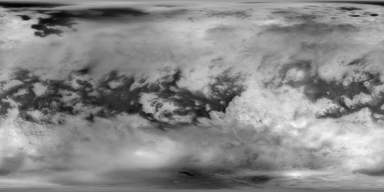
This Cassini Imaging Science Subsystem (ISS) global mosaic of Titan's surface brightness in the near-infrared at 938 nm wavelength shows the distribution of Titan's wide variety of landforms, from the vast equatorial sand seas to the high-latitude lakes and seas of liquid hydrocarbons. To generate this mosaic, 9,873 separate ISS images taken over more than 13 years of NASA's Cassini spacecraft operations at Saturn have been combined. Averaging such a large number of images dramatically improves how well surface features can be seen. A new photometric analysis method, with more accurate radiative transfer models of Titan's haze, allows spatial and temporal atmospheric and instrumental variations to be accounted for. This technique makes it possible to generate a mosaic without image seams that provides calibrated normal albedos. The image scale is 16 pixels per degree or 2.8 km in latitude. The new image is an update to the previous version of the ISS imaging map of Titan. The most recent version was published in 2015. https://photojournal.jpl.nasa.gov/catalog/PIA22770
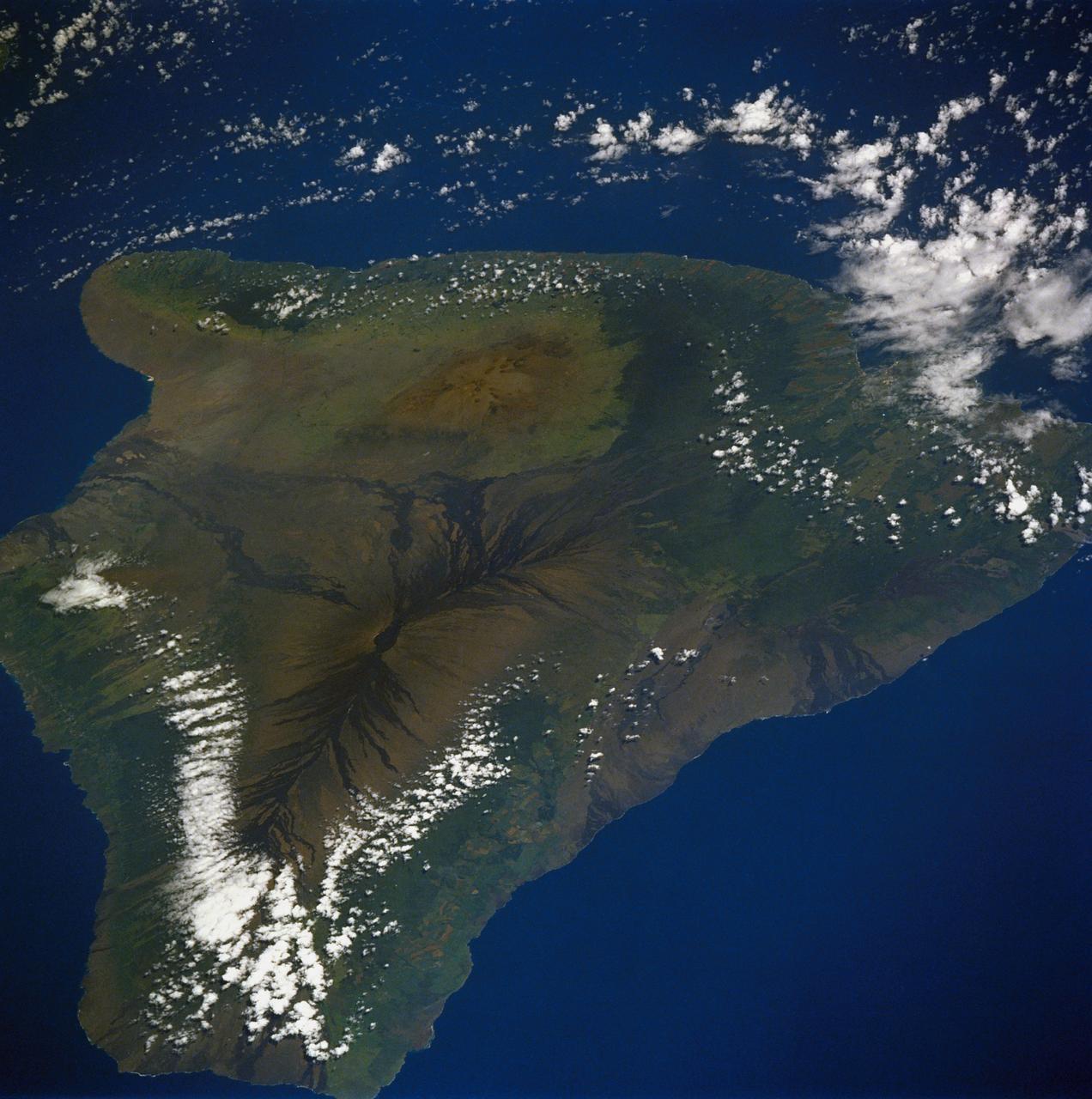
61A-50-057 (1 Nov 1985) --- An oblique view of Hawaii, the largest of the Hawaiian Island Group, as photographed by the crewmembers of Challenger on STS-61A in November of 1985. This unusual early morning view shows nearly the entire island with minimal cloud cover. Normally, these near tropical islands are obscured by heavy cloud cover except for the early morning hours. UPDATE, NOVEMBER 28, 1986 PLEASE NOTE: The Kilauea fissure, on the southeast coast, while not as prominent as ancient, neighboring Mauna Loa and Mauna Kea craters, has been spewing a molten lava flow since July 18, 1986, at a rate of six cubic yards per second. Generally flowing toward the sea, the lava mass had reached the coast by today after destroying several homes and private property along the way. The seven-mile long lava flow covered over 600 feet of coastline and extended into the ocean, creating over 12 acres of new beachfront property.
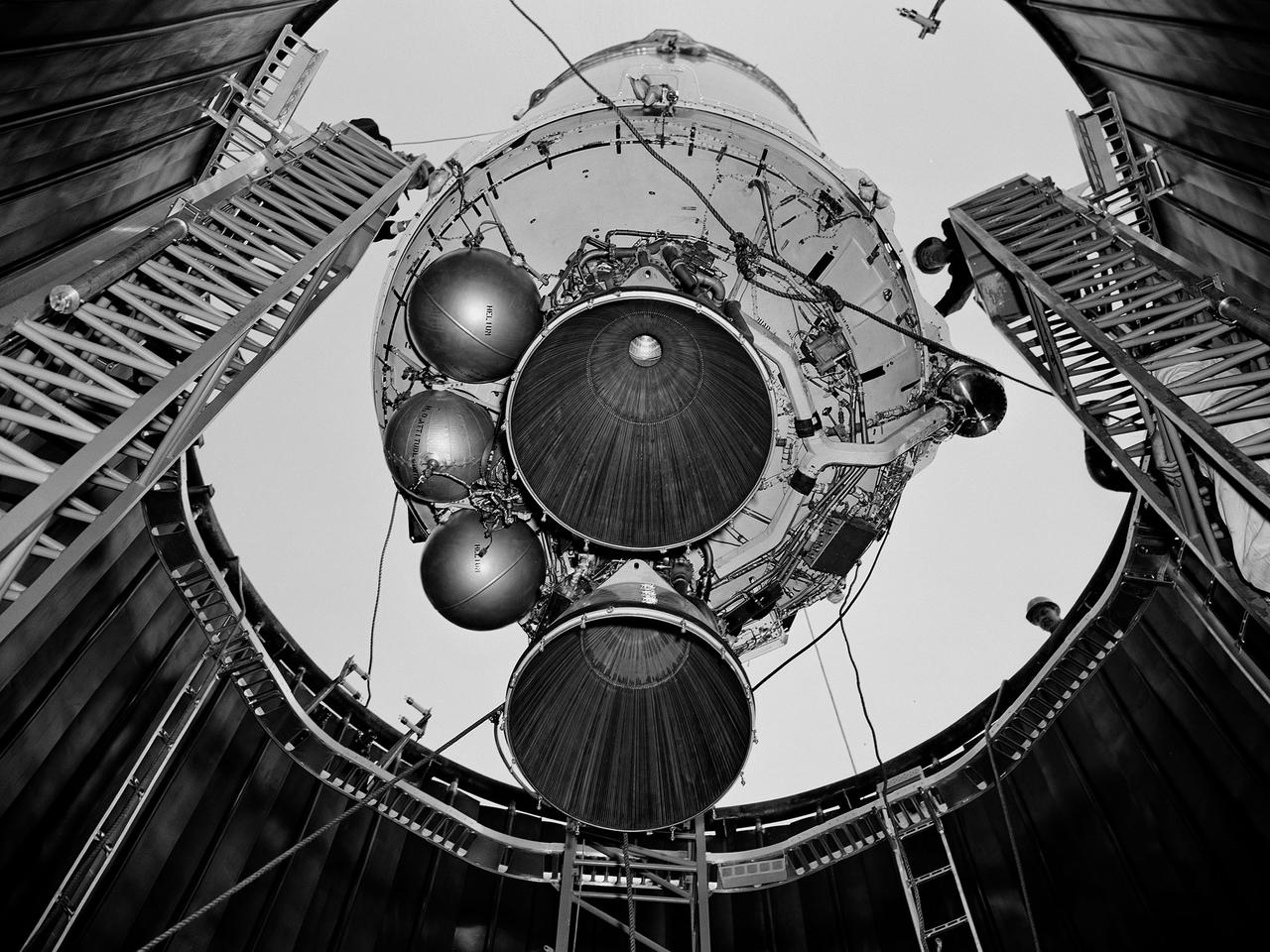
A Centaur second-stage rocket is lowered into the vacuum tank inside the Space Power Chambers at NASA’s Lewis Research Center. Centaur was to be paired with an Atlas booster to send the Surveyor spacecraft to the moon as a precursor to the Apollo landings. Lewis was assigned responsibility for the Centaur Program after the failure of its first developmental flight in May 1962. Lewis’ Altitude Wind Tunnel was converted into two large test chambers—the Space Power Chambers. The facility’s vacuum chamber, seen here, allowed the Centaur to be stood up vertically and subjected to atmospheric conditions-- pressures, temperature, and radiation--similar to those it would encounter in space. The Centaur for these tests was delivered to Cleveland in a C‒130 aircraft on September 27, 1963. The rocket was set up in the facility’s high bay where Lewis technicians and General Dynamics consultants updated its flight systems to match the upcoming Atlas-Centaur‒4 mission. Months were spent reharnessing the Centaur’s electronics, learning about the systems, and being taught how to handle flight hardware. By early spring 1964, the extensive setup of both the spacecraft and the chamber was finally completed. On March 19 the Centaur was rolled out from the shop, hoisted high into the air by a crane, and lowered into the waiting space tank. Researchers were able to verify that the Centaur’s electronics and electrical systems functioned reliably in a space environment.
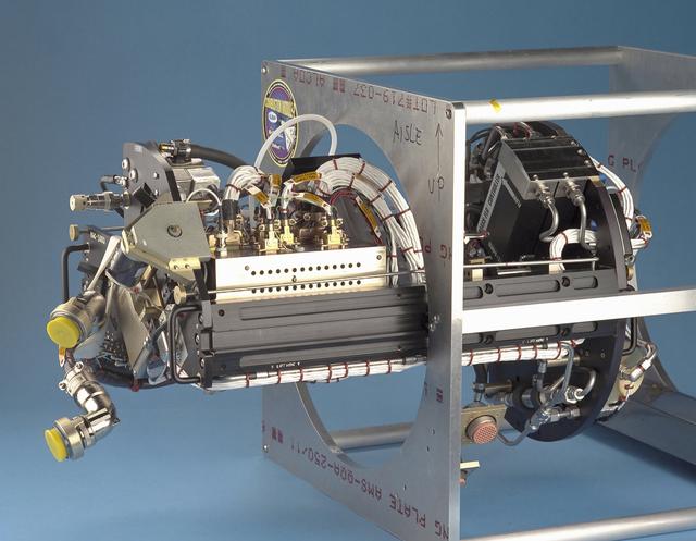
The Water Mist commercial research program is scheduled to fly an investigation on STS-107 in 2002. This investigation will be flown as an Experimental Mounting Structure (EMS) insert into the updated Combustion Module (CM-2), a sophisticated combustion chamber plus diagnostic equipment. (The investigation hardware is shown here mounted in a non-flight frame similar to the EMS.) Water Mist is a commercial research program by the Center for Commercial Applications of Combustion in Space (CCACS), a NASA Commercial Space Center located at the Colorado School of Mines, in Golden, CO and Industry Partner Environmental Engineering Concepts. The program is focused on developing water mist as a replacement for bromine-based chemical fire suppression agents (halons). By conducting the experiments in microgravity, interference from convection currents is minimized and fundamental knowledge can be gained. This knowledge is incorporated into models, which can be used to simulate a variety of physical environments. The immediate objective of the project is to study the effect of a fine water mist on a laminar propagating flame generated in a propane-air mixture at various equivalence ratios. The effects of droplet size and concentration on the speed of the flame front is used as a measure of the effectiveness of fire suppression in this highly controlled experimental environment.
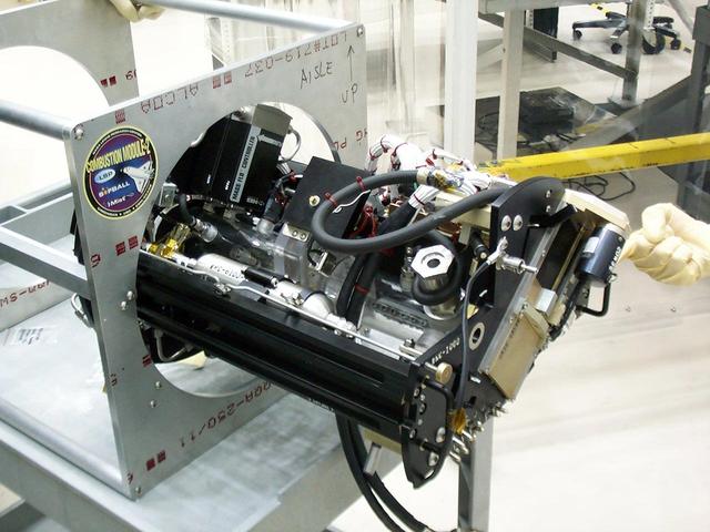
The Water Mist commercial research program is scheduled to fly an investigation on STS-107 in 2002. This investigation will be flown as an Experimental Mounting Structure (EMS) insert into the updated Combustion Module (CM-2), a sophisticated combustion chamber plus diagnostic equipment. (The investigation hardware is shown here mounted in a non-flight frame similar to the EMS.) Water Mist is a commercial research program by the Center for Commercial Applications of Combustion in Space (CCACS), a NASA Commercial Space Center located at the Colorado School of Mines, in Golden, CO and Industry Partner Environmental Engineering Concepts. The program is focused on developing water mist as a replacement for bromine-based chemical fire suppression agents (halons). By conducting the experiments in microgravity, interference from convection currents is minimized and fundamental knowledge can be gained. This knowledge is incorporated into models, which can be used to simulate a variety of physical environments. The immediate objective of the project is to study the effect of a fine water mist on a laminar propagating flame generated in a propane-air mixture at various equivalence ratios. The effects of droplet size and concentration on the speed of the flame front is used as a measure of the effectiveness of fire suppression in this highly controlled experimental environment.
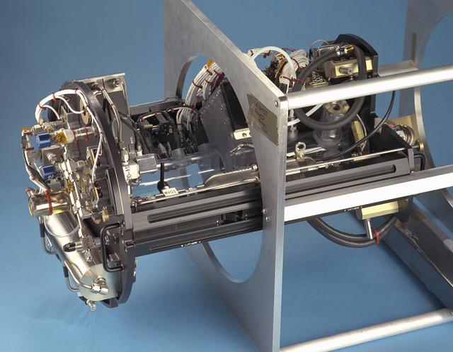
The Water Mist commercial research program is scheduled to fly an investigation on STS-107 in 2002. This investigation will be flown as an Experimental Mounting Structure (EMS) insert into the updated Combustion Module (CM-2), a sophisticated combustion chamber plus diagnostic equipment. (The investigation hardware is shown here mounted in a non-flight frame similar to the EMS.) Water Mist is a commercial research program by the Center for Commercial Applications of Combustion in Space (CCACS), a NASA Commercial Space Center located at the Colorado School of Mines, in Golden, CO and Industry Partner Environmental Engineering Concepts. The program is focused on developing water mist as a replacement for bromine-based chemical fire suppression agents (halons). By conducting the experiments in microgravity, interference from convection currents is minimized and fundamental knowledge can be gained. This knowledge is incorporated into models, which can be used to simulate a variety of physical environments. The immediate objective of the project is to study the effect of a fine water mist on a laminar propagating flame generated in a propane-air mixture at various equivalence ratios. The effects of droplet size and concentration on the speed of the flame front is used as a measure of the effectiveness of fire suppression in this highly controlled experimental environment.
A researcher prepares a Centaur 6A second-stage rocket for a series of tests in the Space Power Chambers’ vacuum tank at the National Aeronautics and Space Administration (NASA) Lewis Research Center. Lewis was assigned oversight of the Centaur Program in the fall of 1962. Prior to that, Centaur’s only launch had failed shortly after liftoff. Lewis engineers undertook an expansive effort to quickly resolve Centaur’s problems and prepare it for its planned missions to send Surveyor spacecraft to land on the moon. For one test program, a complete Centaur vehicle was lowered into the vacuum chamber at the Space Power Chambers to verify that its electronics and electrical systems functioned reliably in a space environment. At the time, electronic malfunctions were one of the most likely causes of failures in space. Studying these systems during long soaks inside the space tank helped the Lewis team calibrate them and facilitate the monitoring of the spacecraft during an actual flight. The Centaur for the tests was delivered to Cleveland in a C-130 aircraft on September 27, 1963. The rocket was set up in the facility’s high bay where Lewis technicians and General Dynamics consultants updated its flight systems to match the upcoming Atlas-Centaur-4 mission, as seen in this photograph.
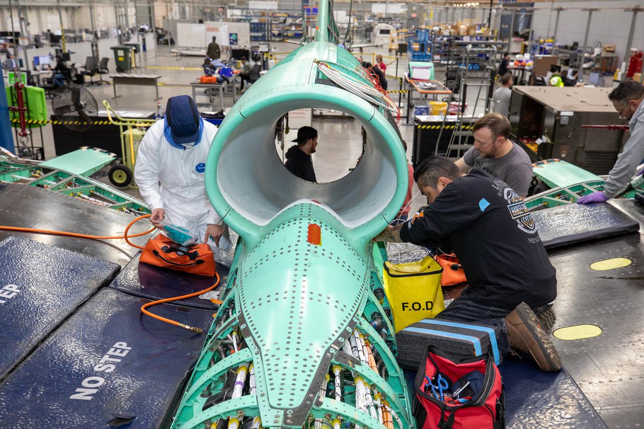
The X-59 team working on the aircraft’s wiring around the engine inlet prior to the engine being installed. Once complete, the X-59 is designed to fly supersonic while reducing the loud sonic boom. The Quesst mission could help change the rules for commercial supersonic air travel over land.
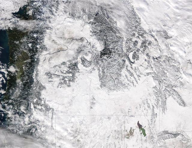
Extreme rain events have been affecting California and snow has blanketed the Pacific Northwest. This visible image from NASA's Aqua satellite on Jan. 6, 2017, at 3:35 p.m. EST (20:35 UTC) shows snow cover in the U.S. Pacific Northwest in Washington, Idaho, Oregon, northern California and Nevada. On Jan. 9, another area of low pressure moved over Oregon, where the National Weather Service is forecasting heavy snows. It was the same week last year that the West Coast endured a similar bout of very wet weather. Heavy rain affected the Pacific coast in 2016 during the same week from Jan. 5 through Jan. 7, as a progression of storm systems in the Eastern Pacific Ocean hit southern California and generated flooding and mudslides. For updated forecasts, visit the National Weather Service website at: <a href="http://www.weather.gov" rel="nofollow">www.weather.gov</a> Learn more about NASA's view of the storm: <a href="http://go.nasa.gov/2j0xpvW" rel="nofollow">go.nasa.gov/2j0xpvW</a> Credits: NASA Goddard MODIS Rapid Response <b><a href="http://www.nasa.gov/audience/formedia/features/MP_Photo_Guidelines.html" rel="nofollow">NASA image use policy.</a></b> <b><a href="http://www.nasa.gov/centers/goddard/home/index.html" rel="nofollow">NASA Goddard Space Flight Center</a></b> enables NASA’s mission through four scientific endeavors: Earth Science, Heliophysics, Solar System Exploration, and Astrophysics. Goddard plays a leading role in NASA’s accomplishments by contributing compelling scientific knowledge to advance the Agency’s mission. <b>Follow us on <a href="http://twitter.com/NASAGoddardPix" rel="nofollow">Twitter</a></b> <b>Like us on <a href="http://www.facebook.com/pages/Greenbelt-MD/NASA-Goddard/395013845897?ref=tsd" rel="nofollow">Facebook</a></b> <b>Find us on <a href="http://instagrid.me/nasagoddard/?vm=grid" rel="nofollow">Instagram</a></b>
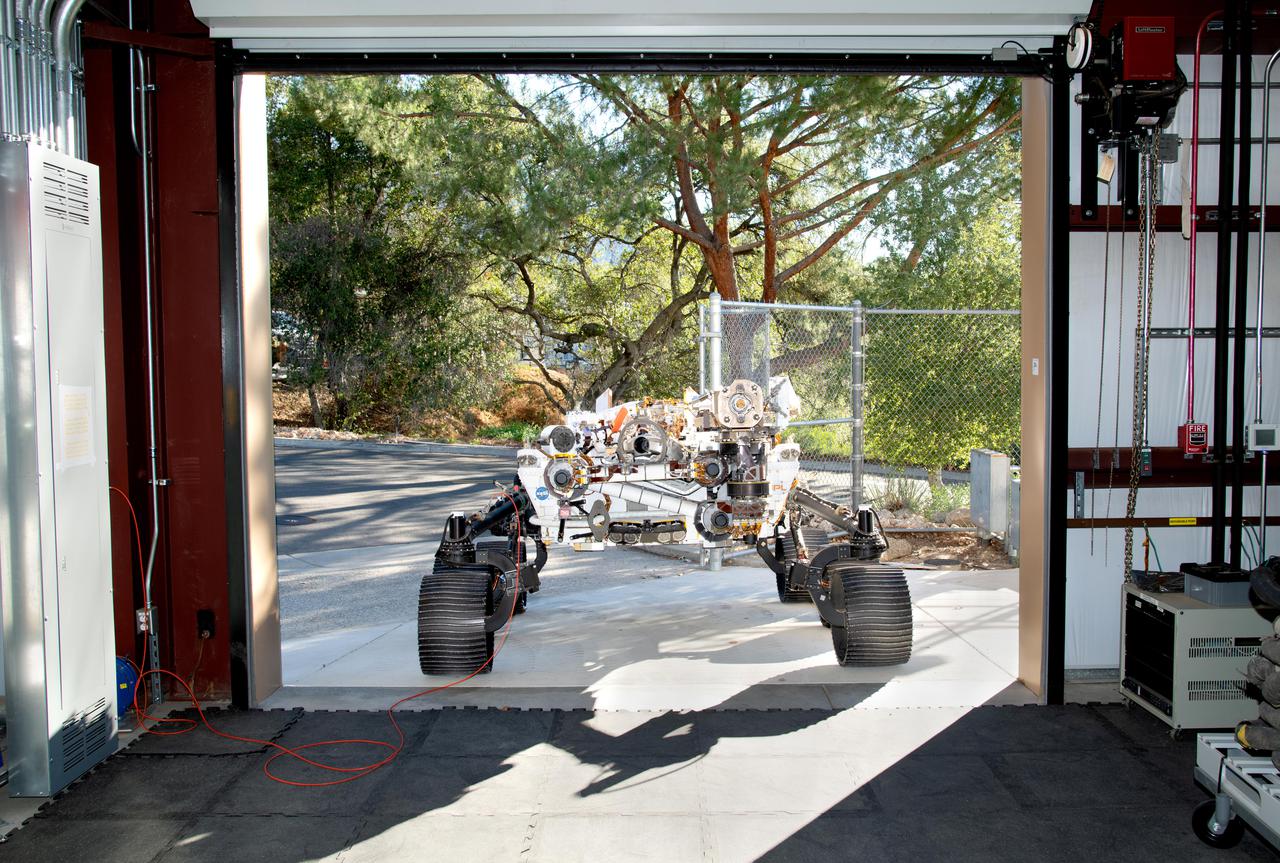
Short for Operational Perseverance Twin for Integration of Mechanisms and Instruments Sent to Mars, OPTIMISM faces a doorway of the Mars Yard garage at NASA's Jet Propulsion Laboratory on Oct. 29, 2021. Referred to generically as a vehicle system test bed, OPTIMISM was recently updated with additional mobility software and the bulk of the complex sample caching system. As with vehicle system test beds for other Mars rovers, OPTIMISM is used to test moves and scenarios in the Mars Yard's simulated Red Planet landscape to help ensure that its twin on Mars can safely execute the commands sent by Earth-bound controllers. The tests could also potentially reveal unexpected problems Perseverance might encounter. With longer drives in Perseverance's near future, another job for OPTIMISM will involve presenting new challenges to the rover's autonomous navigation system, or AutoNav. A key objective for Perseverance's mission on Mars is astrobiology, including the search for signs of ancient microbial life. The rover will characterize the planet's geology and past climate, pave the way for human exploration of the Red Planet, and be the first mission to collect and cache Martian rock and regolith (broken rock and dust). Subsequent NASA missions, in cooperation with ESA (European Space Agency), would send spacecraft to Mars to collect these sealed samples from the surface and return them to Earth for in-depth analysis. The Mars 2020 Perseverance mission is part of NASA's Moon to Mars exploration approach, which includes Artemis missions to the Moon that will help prepare for human exploration of the Red Planet. https://photojournal.jpl.nasa.gov/catalog/PIA24527
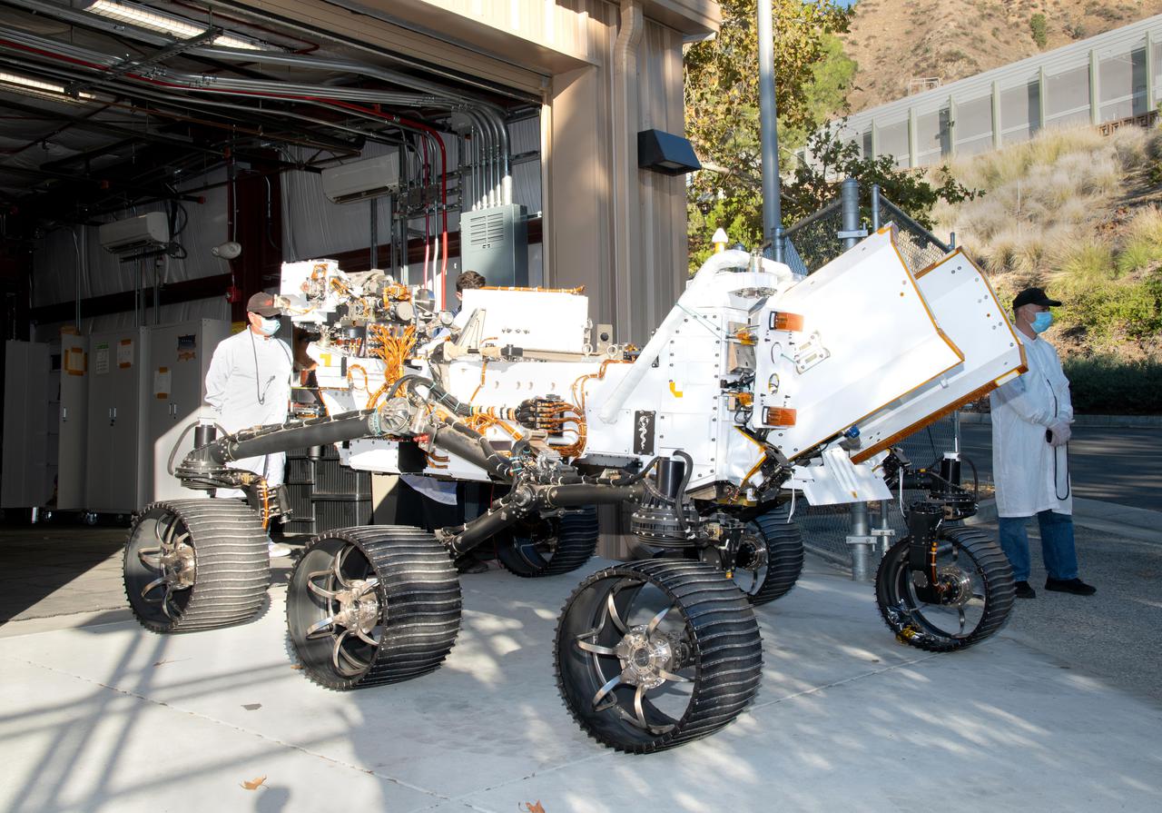
Updated with new features, including additional mobility software and the bulk of the sample caching system, the Earthly twin of NASA's Perseverance Mars rover arrives at the Mars Yard garage at the agency's Jet Propulsion Laboratory on Oct. 29, 2021. The vehicle is generically referred to as a vehicle system test bed but goes by the name OPTIMISM (short for Operational Perseverance Twin for Integration of Mechanisms and Instruments Sent to Mars). As with vehicle system test beds for other Mars rovers, OPTIMISM is used to test moves and scenarios in the Mars Yard's simulated Red Planet landscape to help ensure that its twin on Mars can safely execute the commands sent by Earth-bound controllers. The tests could also potentially reveal unexpected problems Perseverance might encounter. With longer drives in Perseverance's near future, another job for OPTIMISM will involve presenting new challenges to the rover's autonomous navigation system, or AutoNav. A key objective for Perseverance's mission on Mars is astrobiology, including the search for signs of ancient microbial life. The rover will characterize the planet's geology and past climate, pave the way for human exploration of the Red Planet, and be the first mission to collect and cache Martian rock and regolith (broken rock and dust). Subsequent NASA missions, in cooperation with ESA (European Space Agency), would send spacecraft to Mars to collect these sealed samples from the surface and return them to Earth for in-depth analysis. The Mars 2020 Perseverance mission is part of NASA's Moon to Mars exploration approach, which includes Artemis missions to the Moon that will help prepare for human exploration of the Red Planet. https://photojournal.jpl.nasa.gov/catalog/PIA24528
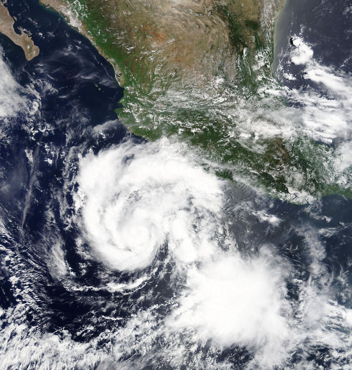
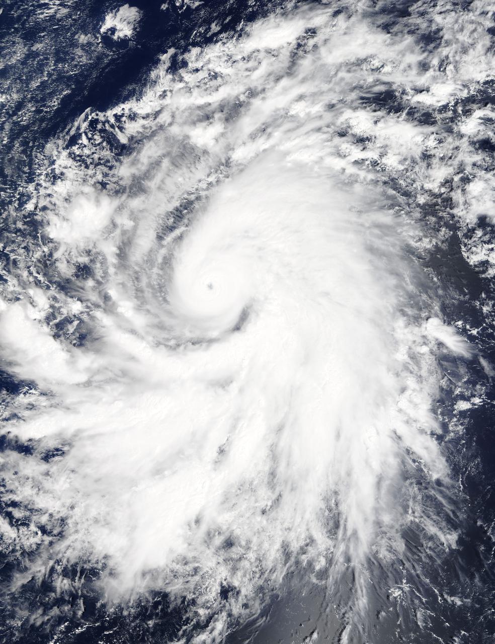
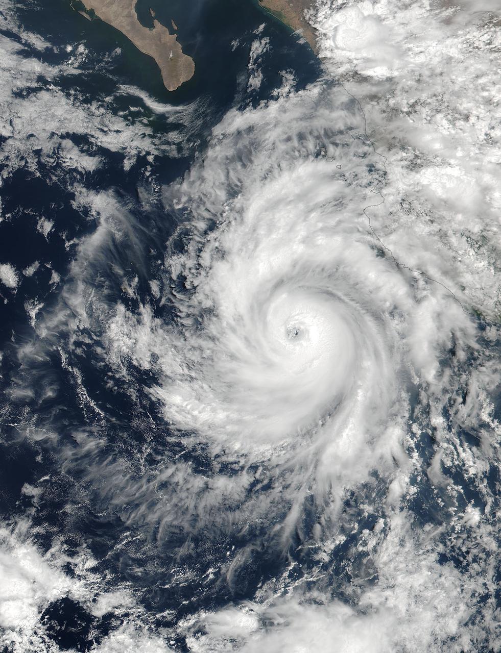
Hilary is a small but strengthening hurricane, with hurricane-force winds extending outward up to 10 miles (20 km) from the center. Tropical-storm-force winds extending outward up to 60 miles (95 km). Hilary began when Tropical Depression 9E formed on July 21. By July 22 at 11 p.m. EDT, the depression strengthened into a tropical storm and was re-named Hilary. At 5 a.m. EDT on Monday, July 24, 2017, Hilary rapidly intensified into a hurricane. NASA's Moderate Resolution Imaging Spectroradiometer, or MODIS, instrument aboard NASA’s Terra satellite captured a true color image of Hurricane Hilary on July 24 at 11 a.m. EDT. The image revealed a better organized tropical cyclone. The National Hurricane Center (NHC) noted "Satellite images indicate that Hilary has a small central core of convection, with both the visible and infrared channels suggesting that an eye is trying to form. Microwave data also show an incomplete eyewall." At 11 a.m. EDT (1500 UTC), the center of Hurricane Hilary was located near 14.1 degrees north latitude and 104.2 degrees west longitude. That's about 340 miles (545 km) south of Manzanillo, Mexico. Hilary is moving toward the west-northwest near 8 mph (13 kph), and the National Hurricane Center said this general motion with some increase in forward speed is expected over the next 48 hours. Maximum sustained winds have increased to near 80 mph (130 kph) with higher gusts. The estimated minimum central pressure is 989 millibars. The National Hurricane Center expects Hilary to become a major hurricane on Tuesday, July 25. For updated forecasts, visit: <a href="http://www.nhc.noaa.gov" rel="nofollow">www.nhc.noaa.gov</a>.
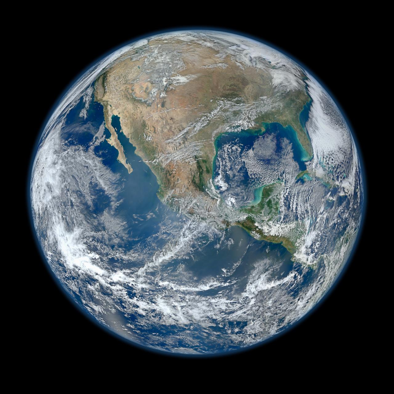
January 25, 2012 <b>*Updated February 2, 2012: According to Flickr, "The western hemisphere Blue Marble 2012 image has rocketed up to over 3.1 million views making it one of the all time most viewed images on the site after only one week."</b> A 'Blue Marble' image of the Earth taken from the VIIRS instrument aboard NASA's most recently launched Earth-observing satellite - Suomi NPP. This composite image uses a number of swaths of the Earth's surface taken on January 4, 2012. The NPP satellite was renamed 'Suomi NPP' on January 24, 2012 to honor the late Verner E. Suomi of the University of Wisconsin. Suomi NPP is NASA's next Earth-observing research satellite. It is the first of a new generation of satellites that will observe many facets of our changing Earth. Suomi NPP is carrying five instruments on board. The biggest and most important instrument is The Visible/Infrared Imager Radiometer Suite or VIIRS. To read more about NASA's Suomi NPP go to: <a href="http://www.nasa.gov/npp" rel="nofollow">www.nasa.gov/npp</a> Credit: NASA/NOAA/GSFC/Suomi NPP/VIIRS/Norman Kuring <b><a href="http://www.nasa.gov/audience/formedia/features/MP_Photo_Guidelines.html" rel="nofollow">NASA image use policy.</a></b> <b><a href="http://www.nasa.gov/centers/goddard/home/index.html" rel="nofollow">NASA Goddard Space Flight Center</a></b> enables NASA’s mission through four scientific endeavors: Earth Science, Heliophysics, Solar System Exploration, and Astrophysics. Goddard plays a leading role in NASA’s accomplishments by contributing compelling scientific knowledge to advance the Agency’s mission. <b>Follow us on <a href="http://twitter.com/NASAGoddardPix" rel="nofollow">Twitter</a></b> <b>Like us on <a href="http://www.facebook.com/pages/Greenbelt-MD/NASA-Goddard/395013845897?ref=tsd" rel="nofollow">Facebook</a></b> <b>Find us on <a href="http://instagrid.me/nasagoddard/?vm=grid" rel="nofollow">Instagram</a></b>
On Oct. 19 at 19:35 UTC (3:35 p.m. EDT) the MODIS instrument aboard NASA's Terra satellite saw Hurricane Olaf moving into the central Pacific Ocean with a visible eye. Powerful thunderstorms circled the eye and extended in a thick band in the eastern quadrant from north to south. At 5 a.m. EDT (0900 UTC) on Oct. 20, Hurricane Olaf's center was located near latitude 10.3 north and longitude 140.4 west. That's about 1,175 miles (1,890 km) east-southeast of Hilo, Hawaii. Despite being so far from Hawaii and because Olaf is a powerful hurricane, large swells generated by Olaf will begin to arrive along east facing shores of the main Hawaiian Islands over the next couple of days. The CPHC said that resultant surf will be large...potentially life-threatening and damaging. Olaf is moving toward the west-northwest near 10 mph (17 kph) and the Central Pacific Hurricane Center (CPHC), who has taken over forecast responsibilities now that Olaf has crossed the 140 degree longitude line, expects Olaf to turn toward the west-northwest and then northwest by October 21. Maximum sustained winds are near 150 mph (240 kph). Olaf is a category four hurricane on the Saffir-Simpson Hurricane wind scale. Some additional strengthening is forecast on Tuesday, Oct. 20 and fluctuations in intensity are possible Tuesday night and Wednesday. The estimated minimum central pressure is 938 millibars. Olaf is expected to remain a major hurricane for the next couple of days and begin curving to the northeast and away from Hawaii by Friday, October 23. For updates, visit: <a href="http://www.prh.noaa.gov/cphc" rel="nofollow">www.prh.noaa.gov/cphc</a>. Credit: NASA Goddard's MODIS Rapid Response Team <b><a href="http://www.nasa.gov/audience/formedia/features/MP_Photo_Guidelines.html" rel="nofollow">NASA image use policy.</a></b> <b><a href="http://www.nasa.gov/centers/goddard/home/index.html" rel="nofollow">NASA Goddard Space Flight Center</a></b> enables NASA’s mission through four scientific endeavors: Earth Science, Heliophysics, Solar System Exploration, and Astrophysics. Goddard plays a leading role in NASA’s accomplishments by contributing compelling scientific knowledge to advance the Agency’s mission. <b>Follow us on <a href="http://twitter.com/NASAGoddardPix" rel="nofollow">Twitter</a></b> <b>Like us on <a href="http://www.facebook.com/pages/Greenbelt-MD/NASA-Goddard/395013845897?ref=tsd" rel="nofollow">Facebook</a></b> <b>Find us on <a href="http://instagrid.me/nasagoddard/?vm=grid" rel="nofollow">Instagram</a></b>
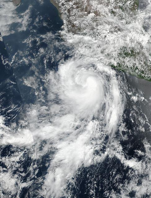
The fourth tropical cyclone of the Eastern Pacific Ocean season formed on June 25 and by June 26 it was already a hurricane. NASA-NOAA's Suomi NPP satellite passed over Dora on June 25 when it was a tropical storm and the next day it became the first hurricane of the season. Tropical Depression Dora developed around 11 p.m. EDT on Saturday, June 24 about 180 miles (290 km) south of Acapulco, Mexico. By 5 a.m. EDT on June 25, the depression had strengthened into a tropical storm and was named Dora. At 19:36 UTC (3:36 p.m. EDT), the Visible Infrared Imaging Radiometer Suite (VIIRS) instrument aboard NASA-NOAA's Suomi NPP satellite provided a visible-light image of the storm. The VIIRS imagery showed well-defined convective spiral bands of thunderstorms with a developing central dense overcast or CDO cloud feature. Seven and a half hours later, Dora showed signs of better organization. At 11 p.m. EDT, the National Hurricane Center or NHC noted "Dora's cloud pattern has continued to quickly improve this evening. Several well-defined spiral bands wrap around the center and the CDO has become more symmetric and expanded since the previous advisory." At 5 a.m. EDT on Monday, June 26, Dora became the first hurricane of the Eastern Pacific Ocean hurricane season. Satellite data indicate that maximum sustained winds have increased to near 80 mph (130 kph) with higher gusts. The NHC said the eye of Hurricane Dora was located near latitude 16.7 degrees North and longitude 105.3 degrees West. That's about 170 miles (275 km) south-southwest of Manzanillo, Mexico. Dora was moving toward the west-northwest near 13 mph (20 kph), and the NHC forecast said that general motion with some decrease in forward speed is expected over the next 48 hours. On the forecast track, the center of Dora is expected to remain offshore of the coast of southwestern Mexico. Some strengthening is likely today before weakening is forecast to begin on Tuesday, June 27. For updated forecasts, visit: <a href="http://www.nhc.noaa.gov" rel="nofollow">www.nhc.noaa.gov</a>. Credit: NASA/NOAA <b><a href="http://www.nasa.gov/audience/formedia/features/MP_Photo_Guidelines.html" rel="nofollow">NASA image use policy.</a></b> <b><a href="http://www.nasa.gov/centers/goddard/home/index.html" rel="nofollow">NASA Goddard Space Flight Center</a></b> enables NASA’s mission through four scientific endeavors: Earth Science, Heliophysics, Solar System Exploration, and Astrophysics. Goddard plays a leading role in NASA’s accomplishments by contributing compelling scientific knowledge to advance the Agency’s mission. <b>Follow us on <a href="http://twitter.com/NASAGoddardPix" rel="nofollow">Twitter</a></b> <b>Like us on <a href="http://www.facebook.com/pages/Greenbelt-MD/NASA-Goddard/395013845897?ref=tsd" rel="nofollow">Facebook</a></b> <b>Find us on <a href="http://instagrid.me/nasagoddard/?vm=grid" rel="nofollow">Instagram</a></b>
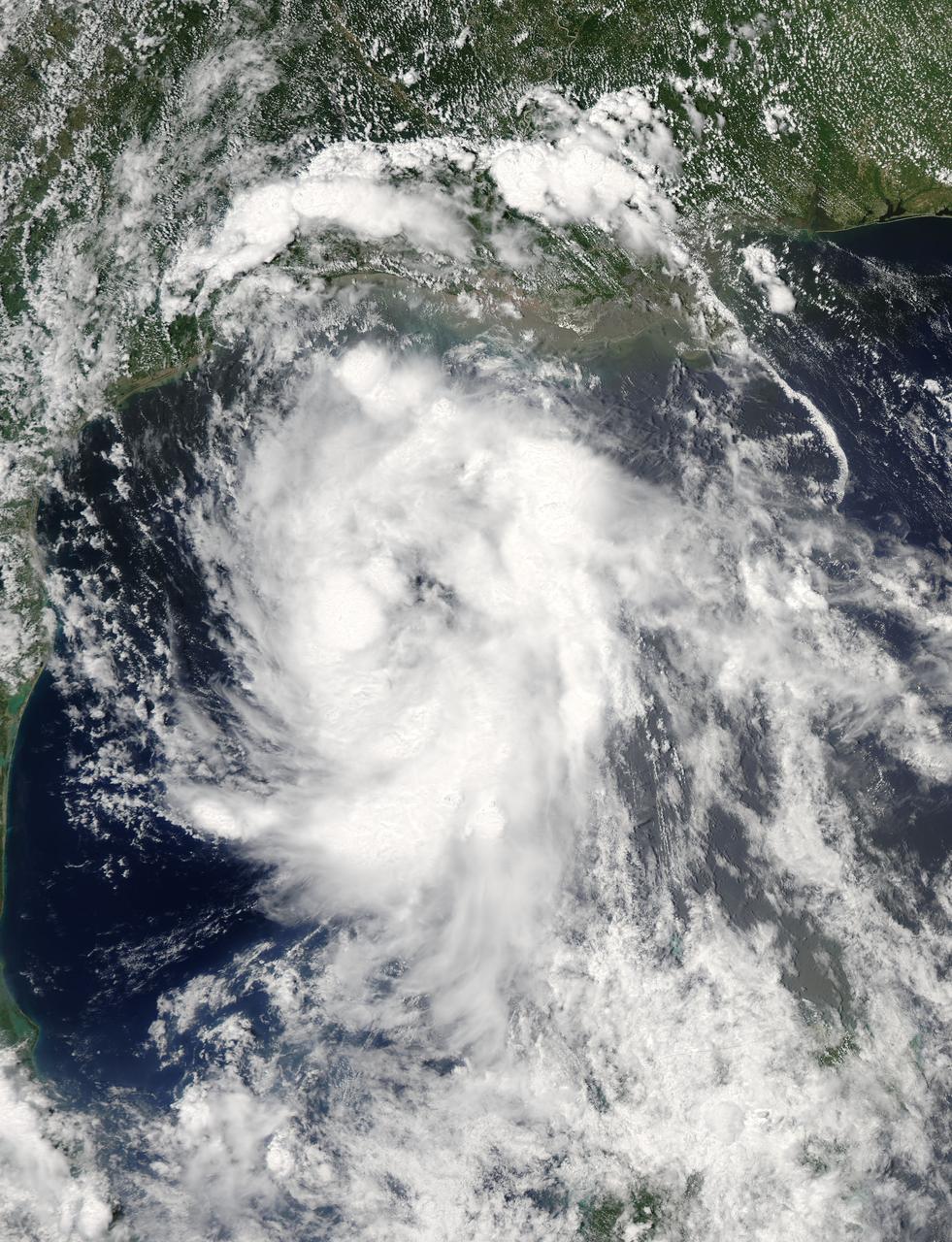
On June 15 at 19:15 UTC (3:15 p.m. EDT) the MODIS instrument aboard NASA's Aqua satellite captured a visible image of Tropical Storm Bill approaching Texas and Louisiana. Powerful thunderstorms circled the center in fragmented bands. At 11 a.m. CDT on June 16, a Tropical Storm Warning was in effect from Baffin Bay to High Island Texas as Bill was making landfall. The National Hurricane Center noted that Bill is expected to produce total rain accumulations of 4 to 8 inches over eastern Texas and eastern Oklahoma and 2 to 4 inches over western Arkansas and southern Missouri, with possible isolated maximum amounts of 12 inches in eastern Texas. In eastern Texas and far western Louisiana today and tonight, isolated tornadoes are also possible, as with any landfalling tropical storm. Tropical storm conditions are expected to continue into the evening in the warning area. Along the coasts, the combination of a storm surge and the tide will cause normally dry areas near the coast to be flooded by rising waters. The water could reach the following heights above ground if the peak surge occurs at the time of high tide. The NHC noted that the Upper Texas coast could experience 2 to 4 feet, and the western Louisiana coast between 1 to 2 feet. At 10 a.m. CDT (1500 UTC), the center of Tropical Storm Bill was located near latitude 28.2 North, longitude 96.4 West. Bill was moving toward the northwest near 10 mph (17 kph) and that general motion is expected to continue today. The latest minimum central pressure reported by an Air Force Reserve Hurricane Hunter aircraft was 997 millibars. Reports from an Air Force Reserve reconnaissance aircraft indicate that maximum sustained winds remain near 60 mph (95 kph) with higher gusts. Unlike Carlos, Bill is not a compact storm. Tropical-storm-force winds extend outward up to 150 miles (240 km) from the center. Between 9 and 10 a.m. CDT, an automated observing station at Port O'Connor also reported a sustained wind of 44 mph (70 kph) and a gust to 53 mph (85 kph). For updated forecasts, watches and warnings, visit the National Hurricane Center webpage at <a href="http://www.nhc.noaa.gov" rel="nofollow">www.nhc.noaa.gov</a>. For local forecasts and advisories, visit: <a href="http://www.weather.gov" rel="nofollow">www.weather.gov</a>. Bill is forecast to continue moving inland and is expected to be a tropical depression by Wednesday, June 17, west of Dallas. The remnants of Bill are forecast to move into the Midwest later in the week. Credit: NASA/GSFC/Jeff Schmaltz/MODIS Land Rapid Response Team <b><a href="http://www.nasa.gov/audience/formedia/features/MP_Photo_Guidelines.html" rel="nofollow">NASA image use policy.</a></b> <b><a href="http://www.nasa.gov/centers/goddard/home/index.html" rel="nofollow">NASA Goddard Space Flight Center</a></b> enables NASA’s mission through four scientific endeavors: Earth Science, Heliophysics, Solar System Exploration, and Astrophysics. Goddard plays a leading role in NASA’s accomplishments by contributing compelling scientific knowledge to advance the Agency’s mission. <b>Follow us on <a href="http://twitter.com/NASAGoddardPix" rel="nofollow">Twitter</a></b> <b>Like us on <a href="http://www.facebook.com/pages/Greenbelt-MD/NASA-Goddard/395013845897?ref=tsd" rel="nofollow">Facebook</a></b> <b>Find us on <a href="http://instagrid.me/nasagoddard/?vm=grid" rel="nofollow">Instagram</a></b>

Typhoon Chan-Hom's eye was visible from space when NASA's Aqua satellite passed overhead early on July 8, 2015. The MODIS instrument, known as the Moderate Resolution Imaging Spectrometer, flies aboard NASA's Aqua satellite. When Aqua passed over Typhoon Chan-Hom on July 8 at 04:25 UTC (12:25 a.m. EDT), MODIS captured a visible-light image of the storm that clearly showed its eye. The MODIS image also a ring of powerful thunderstorms surrounding the eye of the storm, and the bulk of thunderstorms wrapping around the system from west to east, along the southern side. At 0900 UTC (5 a.m. EDT), Typhoon Chan-Hom's maximum sustained winds were near 85 knots (97.8 mph/157.4 kph). Tropical-storm-force winds extended 145 nautical miles (166.9 miles/268.5 km) from the center, making the storm almost 300 nautical miles (345 miles/555 km) in diameter. Typhoon-force winds extended out to 35 nautical miles (40 miles/64.8 km) from the center. Chan-Hom's eye was centered near 20.5 North latitude and 132.7 East longitude, about 450 nautical miles (517.9 miles/833.4 km) southeast of Kadena Air Base, Iwo To, Japan. Chan-Hom was moving to the northwest at 11 knots (12.6 mph/20.3 kph). The typhoon was generating very rough seas with wave heights to 28 feet (8.5 meters). The Joint Typhoon Warning Center expects Chan-Hom to continue tracking northwestward over the next three days under the steering influence of a sub-tropical ridge (elongated area of high pressure). Chan-Hom is expected to intensify steadily peaking at 120 knots (138.1 mph/222.2 kph) on July 10. The JTWC forecast predicts that Chan-Hom will make landfall near Wenzhou, Zhejiang, China and begin decaying due to land interaction. For updated warnings and watches from China's National Meteorological Centre, visit: <a href="http://www.cma.gov.cn/en/WeatherWarnings/" rel="nofollow">www.cma.gov.cn/en/WeatherWarnings/</a>. Credit: NASA/GSFC/Jeff Schmaltz/MODIS Land Rapid Response Team b><a href="http://www.nasa.gov/audience/formedia/features/MP_Photo_Guidelines.html" rel="nofollow">NASA image use policy.</a> <b><a href="http://www.nasa.gov/centers/goddard/home/index.html" rel="nofollow">NASA Goddard Space Flight Center</a></b> enables NASA’s mission through four scientific endeavors: Earth Science, Heliophysics, Solar System Exploration, and Astrophysics. Goddard plays a leading role in NASA’s accomplishments by contributing compelling scientific knowledge to advance the Agency’s mission. <b>Follow us on <a href="http://twitter.com/NASAGoddardPix" rel="nofollow">Twitter</a></b> <b>Like us on <a href="http://www.facebook.com/pages/Greenbelt-MD/NASA-Goddard/395013845897?ref=tsd" rel="nofollow">Facebook</a></b> <b>Find us on <a href="http://instagrid.me/nasagoddard/?vm=grid" rel="nofollow">Instagram</a></b>
At 19:36 UTC (3:36 p.m. EDT) on June 26, the Visible Infrared Imaging Radiometer Suite (VIIRS) instrument aboard NASA-NOAA's Suomi NPP satellite provided a visible-light image of Hurricane Dora. The VIIRS imagery showed a small hurricane with a visible pinhole eye surrounded by a thick band of powerful thunderstorms. That strength didn't last long as Dora moved over cooler waters and began to weaken early on June 27. Dora appeared degraded in satellite imagery as strong convection and thunderstorms were diminishing, although the storm still maintained a visible eye. At 11 a.m. EDT (1500 UTC) on Tuesday, June 27, Dora's maximum sustained winds have decreased slightly to near 75 mph (120 kph) with higher gusts. Dora is a small tropical cyclone, as hurricane-force winds extended outward up to 15 miles (30 km) from the center. The NHC said the eye of Hurricane Dora was located near latitude 19.3 degrees north and longitude 110.2 degrees west. That's about 250 miles (400 km) south of the southern tip of Baja California, Mexico. Dora was moving toward the west-northwest near 13 mph (20 kph). The NHC said the center of Dora is expected to pass just north of Socorro Island later today, and remain well south of the Baja California Peninsula. Ocean swells generated by Dora are affecting portions of the coast of southwest Mexico and are expected to spread northwestward and begin affecting portions of the coast of the southern Baja California peninsula through Wednesday, June 28. Dora is moving over sea surface temperatures cooler than 26.6 degrees Celsius or 80 degrees Fahrenheit, which is the threshold to maintain a tropical cyclone. Temperatures cooler than that weaken tropical cyclones. The NHC said that the waters beneath Dora will continue to cool for the next couple of days so Dora is expected to weaken to a tropical storm later today, June 27, and degenerate to a remnant low pressure area over the next two days. For updated forecasts, visit: <a href="http://www.nhc.noaa.gov" rel="nofollow">www.nhc.noaa.gov</a>. Credit: NASA/NOAA <b><a href="http://www.nasa.gov/audience/formedia/features/MP_Photo_Guidelines.html" rel="nofollow">NASA image use policy.</a></b> <b><a href="http://www.nasa.gov/centers/goddard/home/index.html" rel="nofollow">NASA Goddard Space Flight Center</a></b> enables NASA’s mission through four scientific endeavors: Earth Science, Heliophysics, Solar System Exploration, and Astrophysics. Goddard plays a leading role in NASA’s accomplishments by contributing compelling scientific knowledge to advance the Agency’s mission. <b>Follow us on <a href="http://twitter.com/NASAGoddardPix" rel="nofollow">Twitter</a></b> <b>Like us on <a href="http://www.facebook.com/pages/Greenbelt-MD/NASA-Goddard/395013845897?ref=tsd" rel="nofollow">Facebook</a></b> <b>Find us on <a href="http://instagrid.me/nasagoddard/?vm=grid" rel="nofollow">Instagram</a></b>