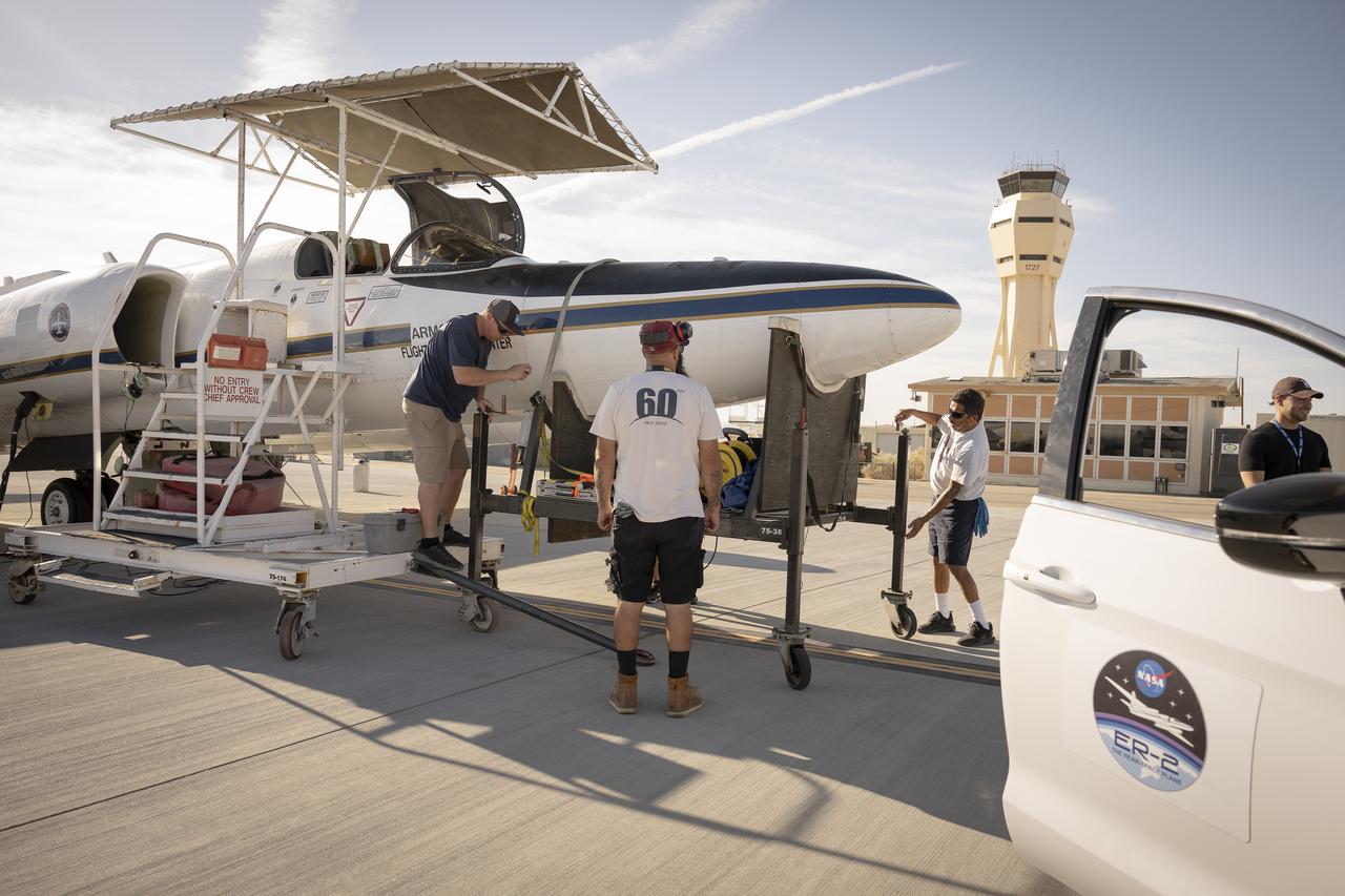
Ground crew members make final preparations on NASA Armstrong Flight Research Center’s ER-2 aircraft at Edwards, California, on Thursday, Aug. 21, 2025, ahead of a high-altitude mission for the Geological Earth Mapping Experiment (GEMx). The pilot will soon board the aircraft, which can fly at altitudes up to 70,000 feet.
Ground crew members make final preparations on NASA Armstrong Flight Research Center’s ER-2 aircraft at Edwards, California, on Thursday, Aug. 21, 2025, ahead of a high-altitude mission for the Geological Earth Mapping Experiment (GEMx). The pilot will soon board the aircraft, which can fly at altitudes up to 70,000 feet.
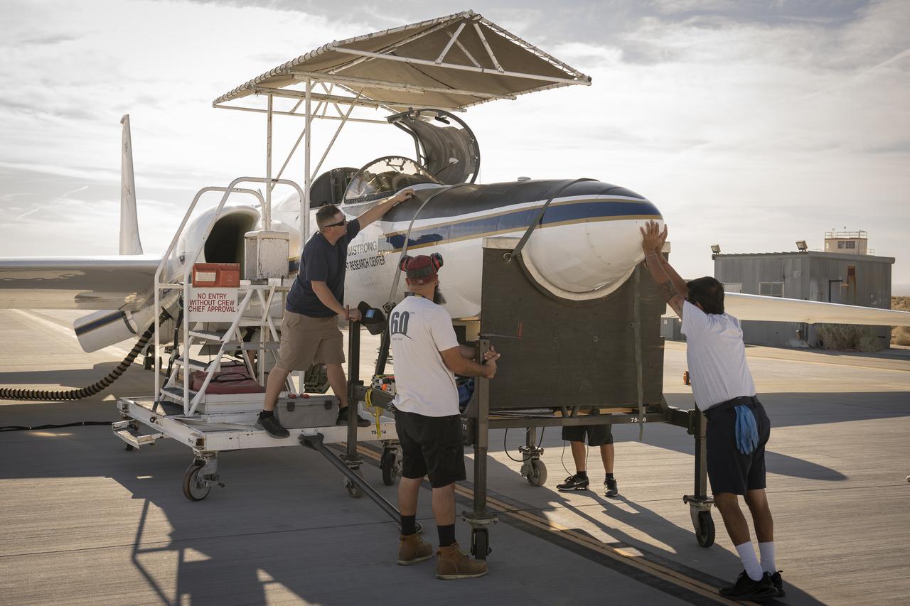
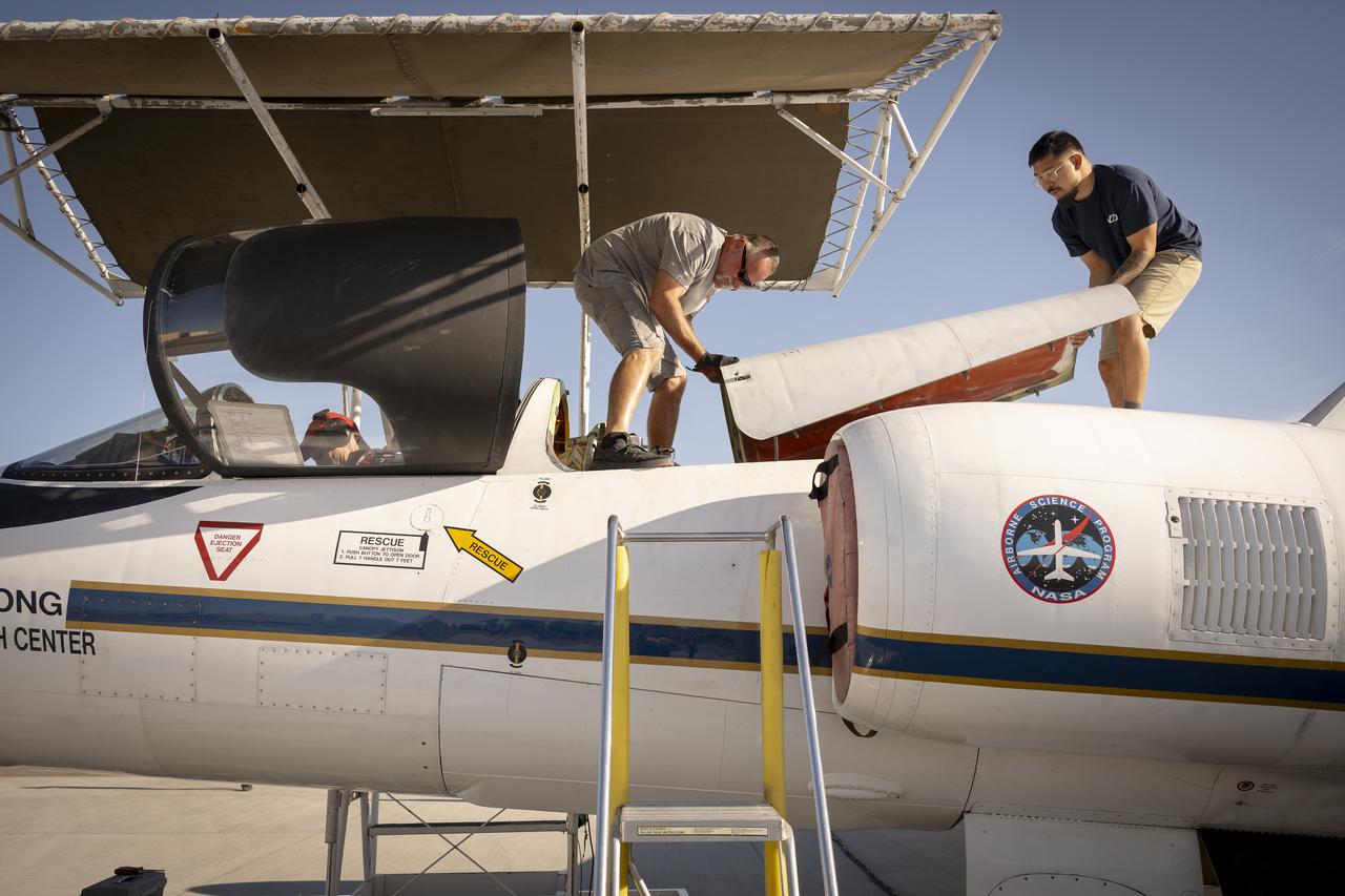
Crew members reattach the nose cone of NASA’s Armstrong Flight Research Center’s ER-2 aircraft at Edwards, California, on Thursday, Aug. 21, 2025, ahead of a mission for the Geological Earth Mapping Experiment (GEMx). The aircraft’s nose houses key science instruments used to collect data during flight.

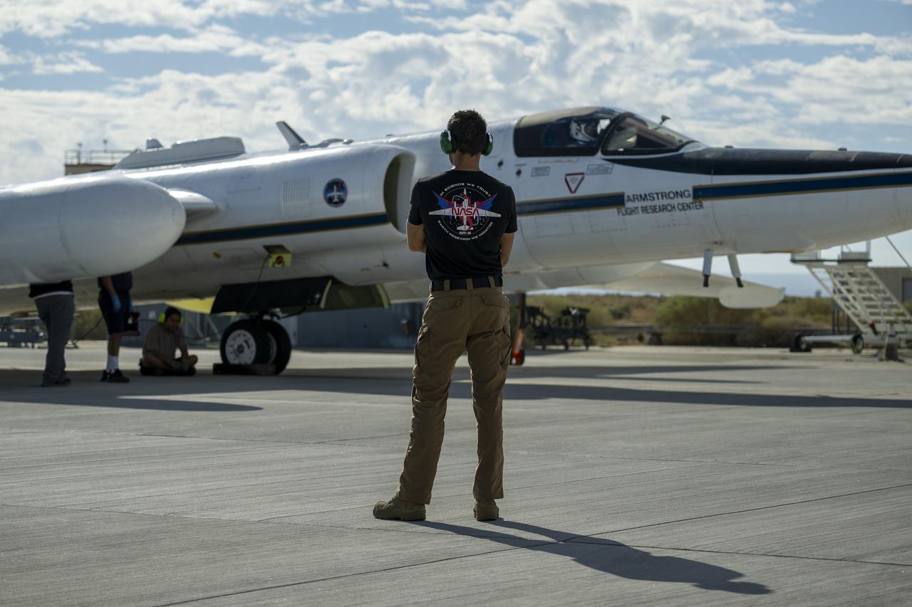
NASA Armstrong Flight Research Center’s ER-2 aircraft taxis at Edwards, California, on Thursday, Aug. 21, 2025, ahead of a high-altitude mission supporting the Geological Earth Mapping Experiment (GEMx), which requires flights of up to eight hours at approximately 65,000 feet altitude.

A crew member handles liquid nitrogen servicing for NASA’s Armstrong Flight Research Center’s ER-2 aircraft at Edwards, California, on Thursday, Aug. 21, 2025. Liquid nitrogen is used to support key science instruments for extended flight durations in critical research missions, such as the Geological Earth Mapping Experiment (GEMx), which requires flights of up to eight hours at approximately 65,000 feet altitude.

Crew members prepare NASA Armstrong Flight Research Center’s ER-2 aircraft for flight at Edwards, California, on Tuesday, Sept. 23, 2025, in support of the Geological Earth Mapping Experiment (GEMx). The high-altitude science aircraft operates between 20,000 and 70,000 feet. For this mission, pilots flew at approximately 65,000 feet, requiring them to wear specially designed pressure suits.
Crew members prepare NASA Armstrong Flight Research Center’s ER-2 aircraft for flight at Edwards, California, on Tuesday, Sept. 23, 2025, in support of the Geological Earth Mapping Experiment (GEMx). The high-altitude science aircraft operates between 20,000 and 70,000 feet. For this mission, pilots flew at approximately 65,000 feet, requiring them to wear specially designed pressure suits.

Suited up and ready, ER-2 pilot Kirt Stallings waits inside the transport vehicle at Edwards, California, on Thursday, Aug. 21, 2025, moments before boarding NASA’s Armstrong Flight Research Center’s ER-2 aircraft for a high-altitude mission supporting the Geological Earth Mapping Experiment (GEMx). Through the vehicle window, the aircraft can be seen being readied for flight.
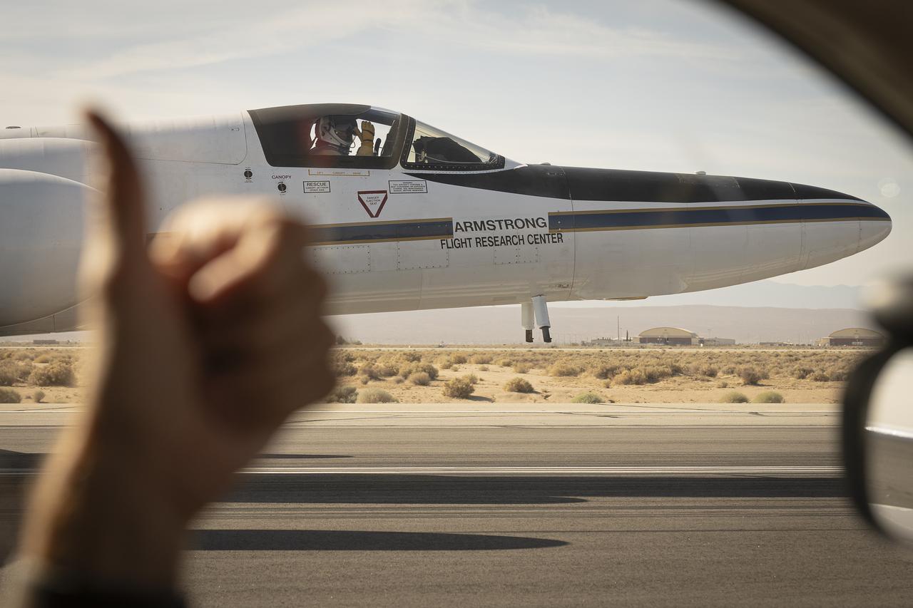
From the window of the ER-2 chase car, a crew member gives a thumbs up to the pilot as NASA Armstrong Flight Research Center’s ER-2 aircraft taxis at Edwards, California, on Thursday, Aug. 21, 2025. The gesture signals a final check before takeoff for the high-altitude mission supporting the Geological Earth Mapping Experiment (GEMx).
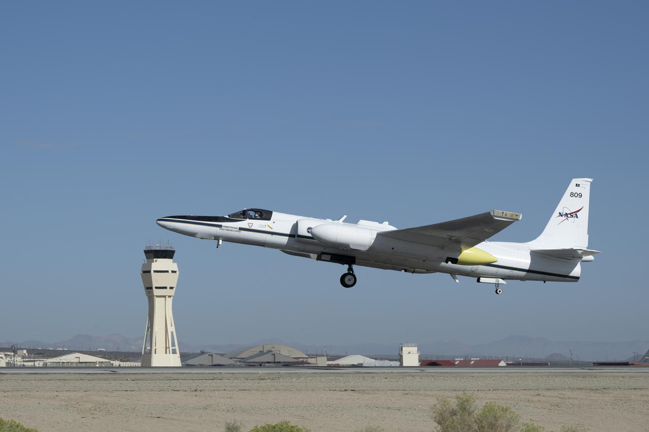
NASA Armstrong Flight Research Center’s ER-2 aircraft lifts off from Edwards, California, on Tuesday, Sept. 23, 2025, in support of the Geological Earth Mapping Experiment (GEMx). The high-altitude science aircraft operates between 20,000 and 70,000 feet. For this mission, pilots flew at approximately 65,000 feet, requiring them to wear specially designed pressure suits.

Francisco Rodriguez (aircraft mechanic) services liquid oxygen or LOX on the ER-2 during the Geological Earth Mapping Experiment (GEMx) research project. Experts like Rodriguez sustain a high standard of safety on airborne science aircraft like the ER-2 and science missions like GEMx. The ER-2 is based out of NASA’s Armstrong Flight Research Center in Edwards, California.
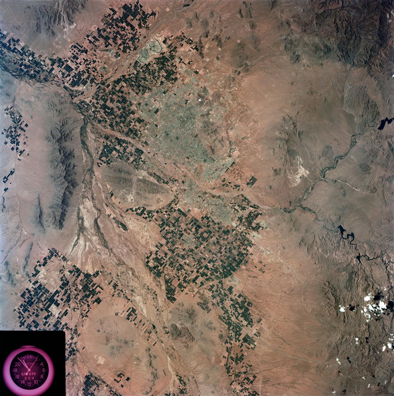
S73-35078 (July-Sept. 1973) --- A nearly vertical view of the Phoenix, Arizona metropolitan area is seen in this Skylab 3 (second manning) Earth Resources Experiments Package S190-B (five-inch Earth terrain camera) photograph taken from the Skylab space station in Earth orbit. Also in the picture are Scottsdale, Paradise Valley, Tempe, Mesa, Komatke, Salt River Indian Reservation and part of the Gila River Indian Reservation. Features which can be delineated from the photograph include: cultural patterns defined by commercial, industrial, agricultural and residential areas; transportation networks consisting of major corridors, primary, secondary and feeder streets; major urban developments in the area such as airports, Squaw Peak City Park, Turf Paradise Race Track and the State Fairgrounds. Phoenix is one of the 27 census cities of interest under study by the U.S. Geological Survey and is the center of the Arizona Regional Ecological Test Site. A large number of investigators will be using the Skylab data. This photo will be compared to earlier ones to document changes in the urban area with time. The landscape is well defined in terms of mountains, alluvial fans and river flood plains. Several different types of natural vegetation and irrigated crop lands can be mapped. Geological features are not well displayed but mining activities are readily identified. Photo credit: NASA
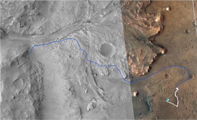
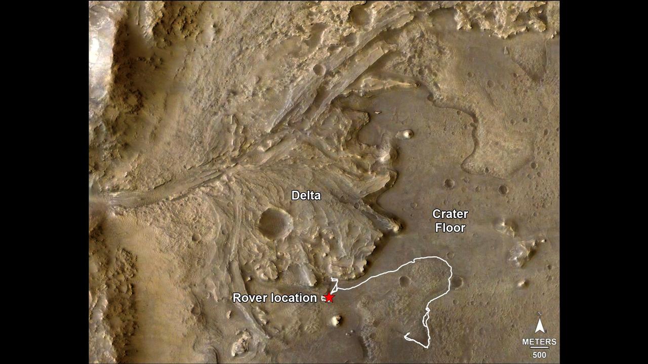
This annotated image from NASA's Mars Reconnaissance Orbiter (MRO) shows the journey NASA's Perseverance rover has taken and will take in the future as it heads toward Jezero Crater's delta on Mars. The white line depicts the route the rover has taken since it touched down at the "Octavia E. Butler Landing" site on Feb. 18, 2021, to its current location in the "South Séítah" geologic unit (light-blue dot). The rover will return to the landing site along the same route and then continue to the delta along the line in blue. This map is composed of images from the MRO's High Resolution Imaging Experiment (HiRISE). A key objective for Perseverance's mission on Mars is astrobiology, including the search for signs of ancient microbial life. The rover will characterize the planet's geology and past climate, pave the way for human exploration of the Red Planet, and be the first mission to collect and cache Martian rock and regolith (broken rock and dust). Subsequent NASA missions, in cooperation with ESA (European Space Agency), would send spacecraft to Mars to collect these sealed samples from the surface and return them to Earth for in-depth analysis. The Mars 2020 Perseverance mission is part of NASA's Moon to Mars exploration approach, which includes Artemis missions to the Moon that will help prepare for human exploration of the Red Planet. https://photojournal.jpl.nasa.gov/catalog/PIA25027
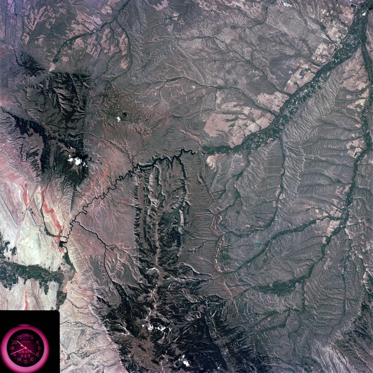
S73-35081 (July-September 1973) --- A view of approximately 3,600 square miles of north central Wyoming and southern Montana is seen in this Skylab 3 Earth Resources Experiments Package S190-B (five-inch Earth terrain camera) photograph taken from the Skylab space station in Earth orbit. The Big Horn River following northward crosses between the northwest trending Big Horn Mountains and the Pryor Mountains. Yellowtail Reservoir, named after a former chief of the Crow Indian tribe in the center of the picture is impounded by a dam across the small rectangular crop area along the Big Horn River (upper right) and the strip farming (yellow) practiced on the rolling hill along the Big Horn River and its tributaries (upper left corner and right edge). The low sun angle enhances the structural features of the mountains as well as the drainage patterns in the adjacent basins. Rock formation appears in this color photograph as they would to the eye from this altitude. The distinctive redbeds can be traced along the front of the Pryor Mountains and indicate the folding that occurred during mountain building. EREP investigators, Dr. Houston of the University of Wyoming and Dr. Hoppin of the University of Iowa, will analyze the photograph and use the results in geological mapping and mineral resource studies. Lowell, Wyoming (lower left corner) and Hardin, Montana (upper right corner) can be recognized. Federal agencies participating with NASA on the EREP project are the Departments of Agriculture, Commerce, Interior, the Environmental Protection Agency and the Corps of Engineers. All EREP photography is available to the public through the Department of Interior?s Earth Resources Observations Systems Data Center, Sioux Falls, South Dakota, 57198. (Alternate number SL3-86-337) Photo credit: NASA
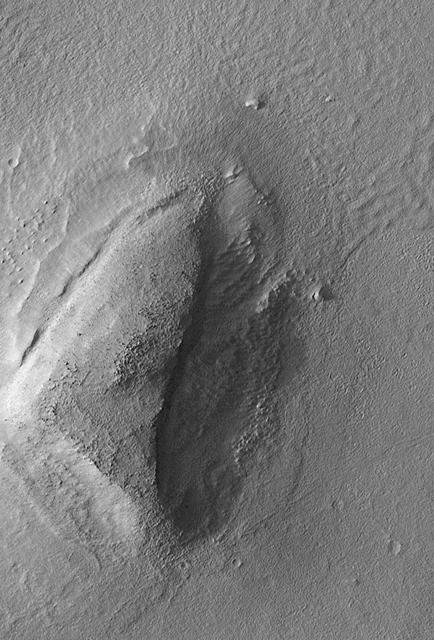
The Mars Global Surveyor (MGS) Mars Orbiter Camera (MOC) was designed specifically to provide images of Mars that have a resolution comparable to the aerial photographs commonly used by Earth scientists to study geological processes and map landforms on our home planet. When MGS reaches its Mapping Orbit in March 1999, MOC will be able to obtain pictures with spatial resolutions of 1.5 meters (5 feet) per pixel--this good enough to easily see objects the size of an automobile. Boulders are one of the keys to determining which processes have eroded, transported, and deposited material on Mars (e.g.,landslides, mud flows, flood debris). During the first year in orbit,MGS MOC obtained pictures with resolutions between 2 and 30 meters (7to 98 feet) per pixel. It was found that boulders are difficult to identify on Mars in images with resolutions worse than about 2-3 meters per pixel. Although not known when the MOC was designed,"thresholds" like this are found on Earth, too. The MOC's 1.5 m/pixel resolution was a compromise between (1) the anticipation of such resolution-dependent sensitivity based on our experience with Earth and (2)the cost in terms of mass if we had built a larger telescope to get a higher resolution. Some rather larger boulders (i.e., larger than about 10 meters--or yards--in size) have already been seen on Mars by the orbiting camera. This is a feat similar to that which can be obtained by "spy" satellites on Earth. The MOC image 53104 subframe shown above features a low, rounded hill in southeastern Utopia Planitia. Each of the small, lumpy features on the top of this hill is a boulder. In this picture, boulders are not seen on the surrounding plain. These boulders are interpreted to be the remnants of a layer of harder rock that once covered the top of the hill, but was subsequently eroded and broken up by weathering and wind processes. MOC image 53104 was taken on September 2, 1998. The subframe shows an area 2.2 km by 3.3 km (1.4 miles by 2.7 miles). The image has a resolution of about 3.25 meters (10.7 feet) per pixel. The subframe is centered at 41.0°N latitude and 207.3°W longitude. North is approximately up, illumination is from the left. http://photojournal.jpl.nasa.gov/catalog/PIA01500
The route of NASA's Perseverance Mars rover – from its landing site on the floor of Jezero Crater to the ancient river delta, which it is currently exploring – is shown in this annotated image composed of overhead views from the agency's Mars Reconnaissance Orbiter (MRO). The red star indicates the location of the rover in September 2022. Perseverance touched down at "Octavia E. Butler Landing" on Feb. 18, 2021, and explored formations (abbreviated "fm" in the annotation) known as "Séítah" and "Máaz" on the floor of Jezero Crater before driving toward the delta region. The delta, which Perseverance reached in April 2022, is a fan-shaped area where, billions of years ago, a river once flowed into a lake and deposited rocks and sediment. Scientists consider it one of the best places on Mars to search for potential signs of ancient microbial life. For this image, the Perseverance team and the U.S. Geological Survey collaborated on the base map, combining multiple images from the High Resolution Imaging Experiment (HiRISE) camera with color from the Compact Reconnaissance Imaging Spectrometer for Mars (CRISM), both instruments aboard MRO. The HiRISE images used span a period from 2007 to 2017. A key objective for Perseverance's mission on Mars is astrobiology, including the search for signs of ancient microbial life. The rover will characterize the planet's geology and past climate, pave the way for human exploration of the Red Planet, and be the first mission to collect and cache Martian rock and regolith (broken rock and dust). Subsequent NASA missions, in cooperation with ESA (European Space Agency), would send spacecraft to Mars to collect these sealed samples from the surface and return them to Earth for in-depth analysis. The Mars 2020 Perseverance mission is part of NASA's Moon to Mars exploration approach, which includes Artemis missions to the Moon that will help prepare for human exploration of the Red Planet. https://photojournal.jpl.nasa.gov/catalog/PIA24922
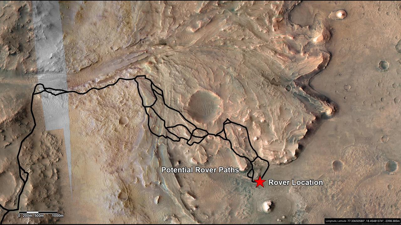
This annotated image highlights potential routes that NASA's Perseverance team is considering in September 2022 for the rover to drive from the front of an ancient river delta to the rim of Jezero Crater. The team will continue to investigate the Martian terrain and consider the science potential of these options before choosing the rover's route. The Perseverance team and the U.S. Geological Survey collaborated on the base map seen here, combining multiple images from the High Resolution Imaging Experiment (HiRISE) camera with color from the Compact Reconnaissance Imaging Spectrometer for Mars (CRISM), both instruments aboard NASA's Mars Reconnaissance Orbiter (MRO). The HiRISE images used span a period from 2007 to 2017. Perseverance landed on the floor of Jezero Crater on Feb. 18, 2021. The delta, which Perseverance reached in April 2022, is a fan-shaped area where an ancient river once flowed into an ancient lake and deposited rocks and sediment. A key objective for Perseverance's mission on Mars is astrobiology, including the search for signs of ancient microbial life. The rover will characterize the planet's geology and past climate, pave the way for human exploration of the Red Planet, and be the first mission to collect and cache Martian rock and regolith (broken rock and dust). Subsequent NASA missions, in cooperation with ESA (European Space Agency), would send spacecraft to Mars to collect these sealed samples from the surface and return them to Earth for in-depth analysis. The Mars 2020 Perseverance mission is part of NASA's Moon to Mars exploration approach, which includes Artemis missions to the Moon that will help prepare for human exploration of the Red Planet. https://photojournal.jpl.nasa.gov/catalog/PIA25244