
NASA Associate Administrator for Science Thomas Zurbuchenlistens during a bilateral meeting with Dr. Walther Pelzer, Member of the German Aerospace Center (DLR) Executive Board, Head of the German Space Agency at DLR, Monday, Aug. 23, 2021, during the 36th Space Symposium in Colorado Springs, Colorado. Photo Credit: (NASA/Bill Ingalls)

Dr. Walther Pelzer, Member of the German Aerospace Center (DLR) Executive Board, Head of the German Space Agency at DLR speaks in a bilateral meeting with NASA during the 36th Space Symposium, Monday, Aug. 23, 2021, in Colorado Springs, Colorado. Photo Credit: (NASA/Bill Ingalls)

Dr. Walther Pelzer, Head of the German Space Agency, German Aerospace Center (DLR) gives remarks in a Heads of Agency panel discussion, during the 36th Space Symposium, Wednesday, Aug. 25, 2021, in Colorado Springs, Colorado. Photo Credit: (NASA/Bill Ingalls)

Dr. Walther Pelzer, Executive Board Member and Head of the German Space Agency at the German Aerospace Center (DLR) speaks in a Heads of Agency panel during the 37th Space Symposium, Wednesday, April 6, 2022, in Colorado Springs, Colorado. Photo Credit: (NASA/Bill Ingalls)

NASA Administrator Bill Nelson meets with Dr. Walther Pelzer, Member of the German Aerospace Center (DLR) Executive Board, Head of the German Space Agency at DLR in a bilateral meeting during the 36th Space Symposium, Monday, Aug. 23, 2021, in Colorado Springs, Colorado. Photo Credit: (NASA/Bill Ingalls)
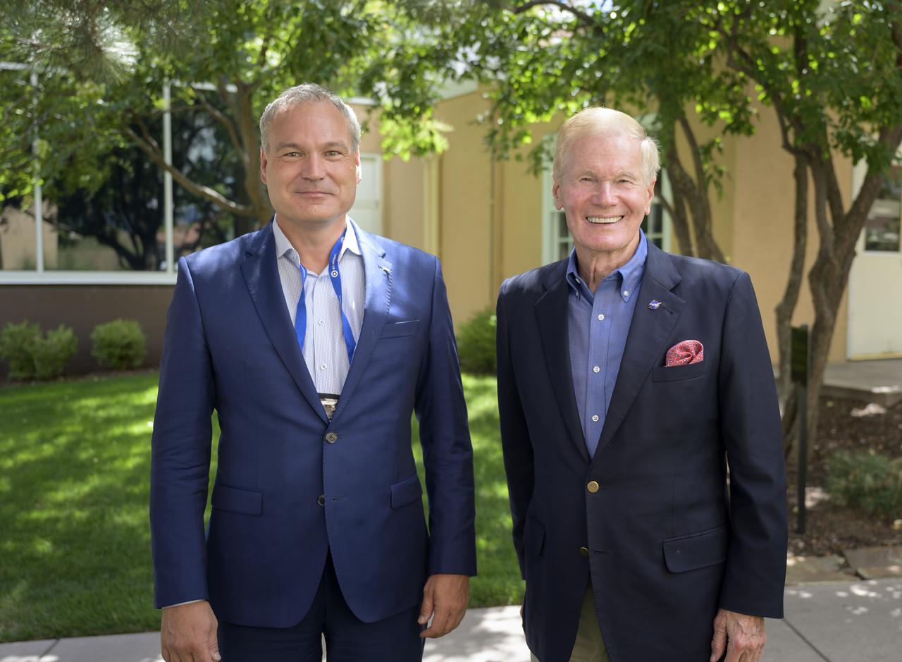
NASA Administrator Bill Nelson, right, meets with Dr. Walther Pelzer, Member of the German Aerospace Center (DLR) Executive Board, Head of the German Space Agency at DLR in a bilateral meeting during the 36th Space Symposium, Monday, Aug. 23, 2021, in Colorado Springs, Colorado. Photo Credit: (NASA/Bill Ingalls)

NASA Associate Administrator for Human Exploration and Operations Kathy Lueders meets with Dr. Walther Pelzer, Member of the German Aerospace Center (DLR) Executive Board, Head of the German Space Agency at DLR in a bilateral meeting during the 36th Space Symposium, Monday, Aug. 23, 2021, in Colorado Springs, Colorado. Photo Credit: (NASA/Bill Ingalls)
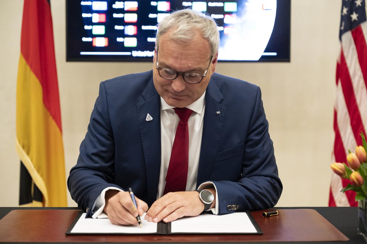
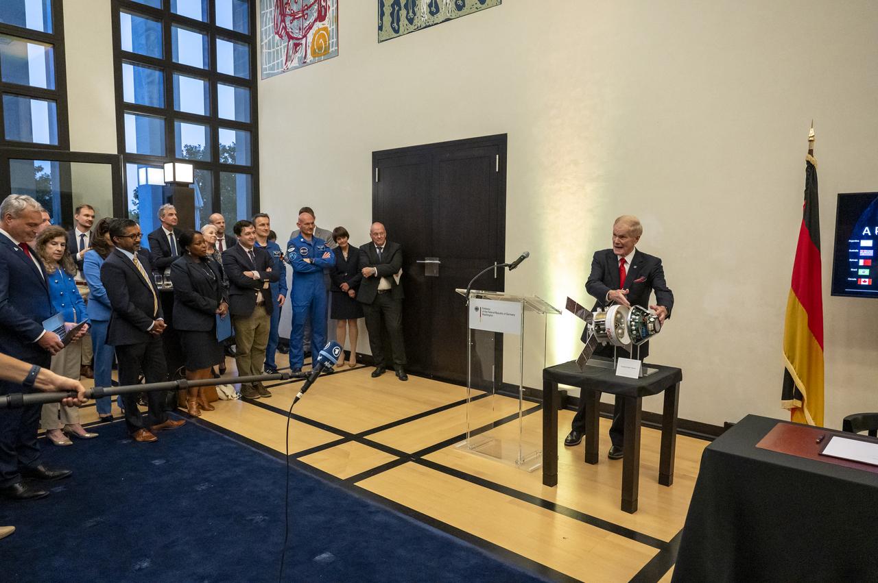
Director General of the German Space Agency at the German Aerospace Center (DLR) Walther Pelzer signs the Artemis Accords, Thursday, September 14, 2023, at the German Ambassador’s Residence in Washington. Germany is the 29th country to sign the Artemis Accords, which establish a practical set of principles to guide space exploration cooperation among nations participating in NASA’s Artemis program. Photo Credit: (NASA/Keegan Barber)
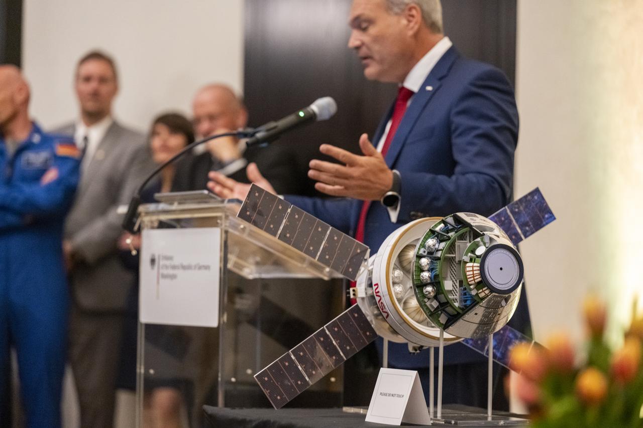
A model of the Orion Spacecraft is seen in the foreground as Director General of the German Space Agency at the German Aerospace Center (DLR) Walther Pelzer delivers remarks during an Artemis Accords signing ceremony, Thursday, September 14, 2023, at the German Ambassador’s Residence in Washington. Germany is the 29th country to sign the Artemis Accords, which establish a practical set of principles to guide space exploration cooperation among nations participating in NASA’s Artemis program. Photo Credit: (NASA/Keegan Barber)
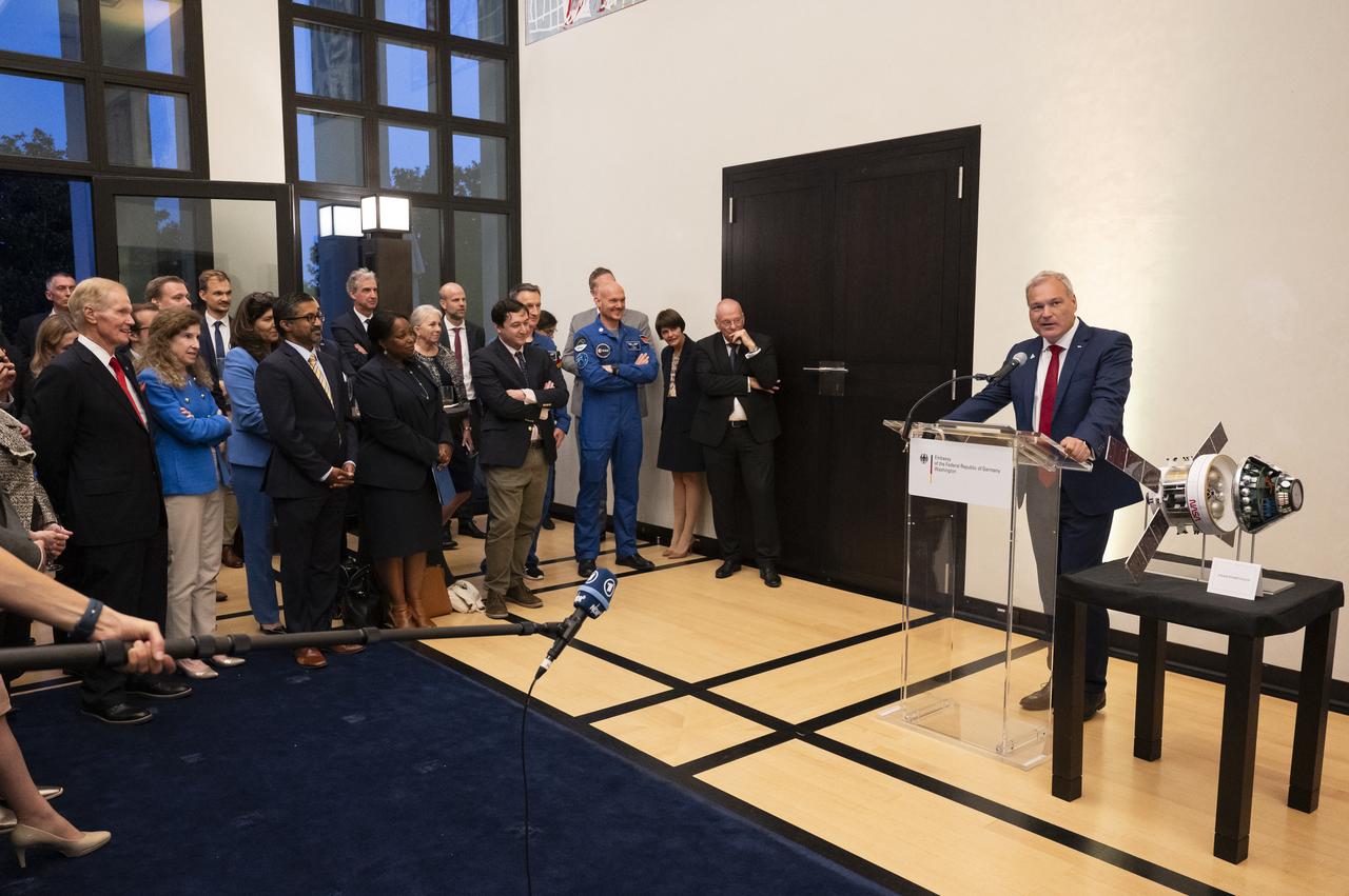
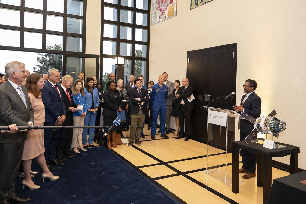
Director General of the German Space Agency at the German Aerospace Center (DLR) Walther Pelzer delivers remarks during an Artemis Accords signing ceremony, Thursday, September 14, 2023, at the German Ambassador’s Residence in Washington. Germany is the 29th country to sign the Artemis Accords, which establish a practical set of principles to guide space exploration cooperation among nations participating in NASA’s Artemis program. Photo Credit: (NASA/Keegan Barber)
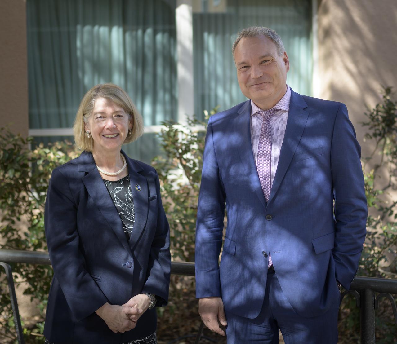
NASA Deputy Administrator Pam Melroy, left, and Executive Board Member and Head of the German Space Agency at the German Aerospace Center (DLR) Dr. Walther Pelzer, pose for a photograph prior to starting at meeting during the 37th Space Symposium, Monday, April 4, 2022, in Colorado Springs, Colorado. Photo Credit: (NASA/Bill Ingalls)
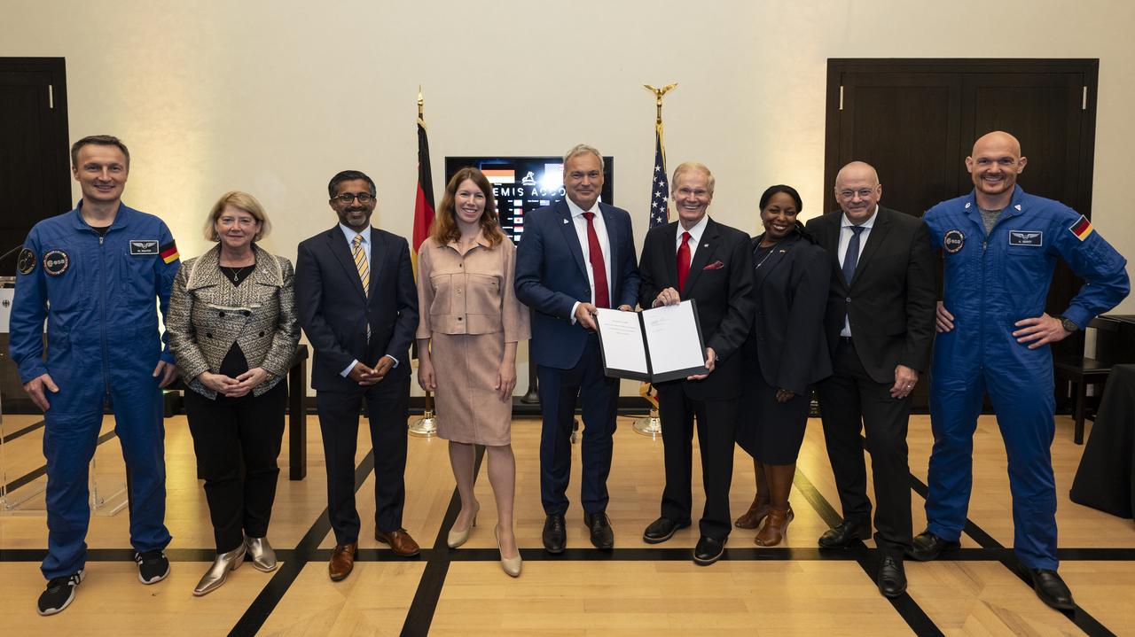
From left to right, ESA (European Space Agency) astronaut Matthias Maurer, NASA Deputy Administrator Pam Melroy, National Space Council (NSpC) Executive Secretary Chirag Parikh, Federal Government Coordinator of German Aerospace Policy Anna Christmann, NASA Administrator Bill Nelson, Director General of the German Space Agency at the German Aerospace Center (DLR) Walther Pelzer, Acting Assistant Secretary of State for Oceans and International Environmental and Scientific Affairs Jennifer R. Littlejohn, German Ambassador to the United States Andreas Michaelis, and ESA astronaut Alexander Gerst pose for a group photo during an Artemis Accords signing ceremony, Thursday, September 14, 2023, at the German Ambassador’s Residence in Washington. Germany is the 29th country to sign the Artemis Accords, which establish a practical set of principles to guide space exploration cooperation among nations participating in NASA’s Artemis program. Photo Credit: (NASA/Keegan Barber)
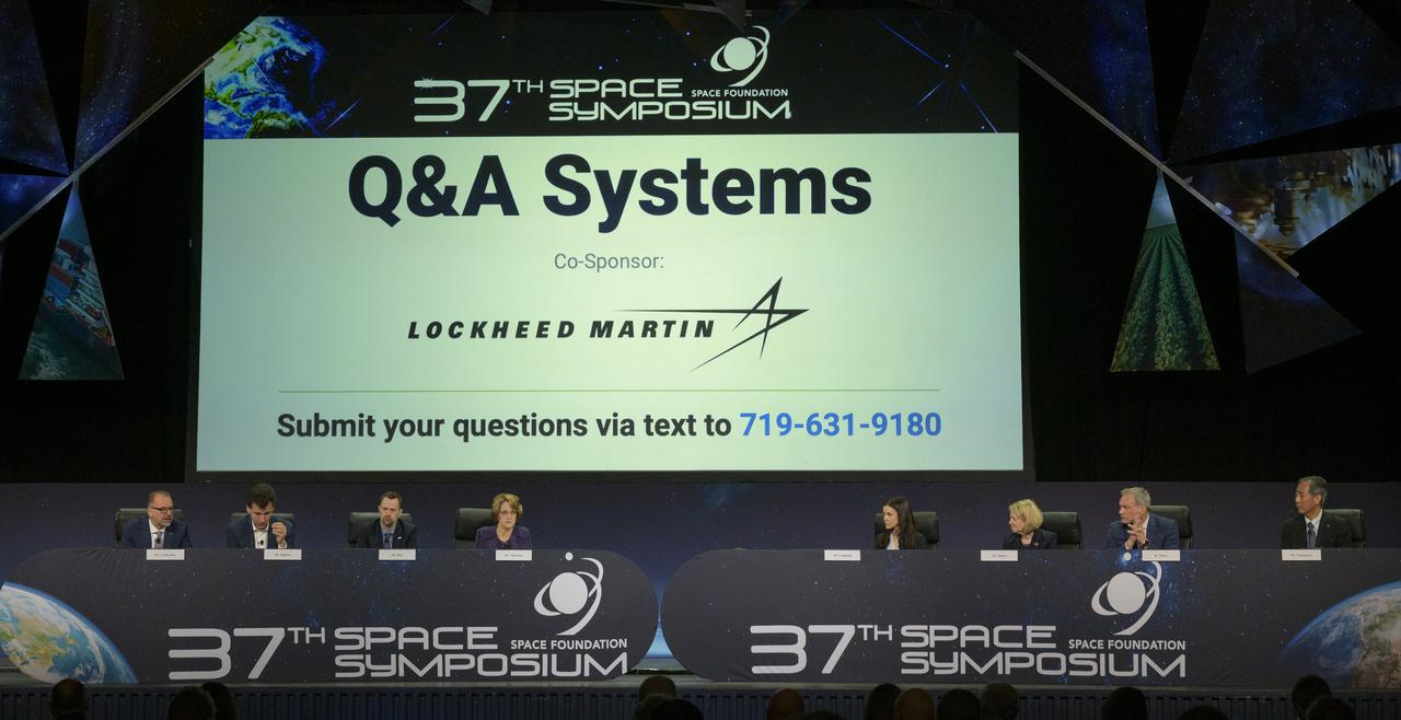
Heads of Agency participate in a panel discussion, from left, Dr. Josef Aschbacher, Director General, European Space Agency (ESA); Dr. Philippe Baptiste, President, French Space Agency (CNES); Dr. Paul Bate, Chief Executive Officer UK Space Agency (UKSA); moderator Dr. Kathryn C. Thornton, Chairwoman, Space Foundation; Lisa Campbell, President, Canadian Space Agency (CSA); NASA Deputy Administrator Pam Melroy; Dr. Walther Pelzer, Executive Board Member and Head of the German Space Agency at the German Aerospace Center (DLR); and Dr. Hiroshi Yamakawa, President, Japan Aerospace Exploration Agency (JAXA), right, during the 37th Space Symposium, Wednesday, April 6, 2022, in Colorado Springs, Colorado. Photo Credit: (NASA/Bill Ingalls)

S97-01442 (August 1996) --- Dr. Reinhold Ewald, German Space Agency (DLR), cosmonaut researcher
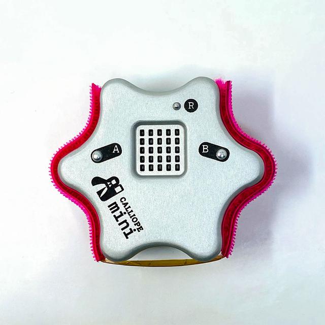
jsc2021e064349 (8/31/2021) --- A prefligt image of the Flight Model of the CalliopEO Hardware. CalliopEO (Calliope Mini in Space) is a project of Ruhr-Universität Bochum, Calliope gGmbH, and the German Space Agency at DLR to promote software programming skills among German school children. Image courtesy of Calliope gGmbH
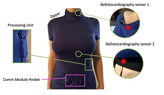
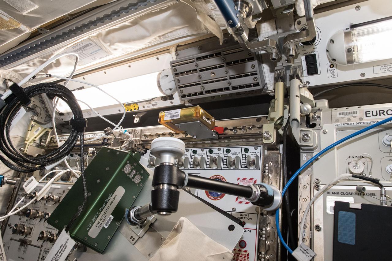
jsc2022e023740 (4/19/2022) --- The components of the Smart-Shirt garment includes integrated sensors, wiring, and a communication module to transmit scientific data via a wireless link for the Ballistocardiography for Extraterrestrial Applications and long-Term missions (BEAT) experiment, part of the Wireless Compose-2 investigation. The technology demonstration builds on work by the German Space Agency (DLR) to develop wireless network infrastructure to support scientific experiments on the space station. Image courtesy of DLR.

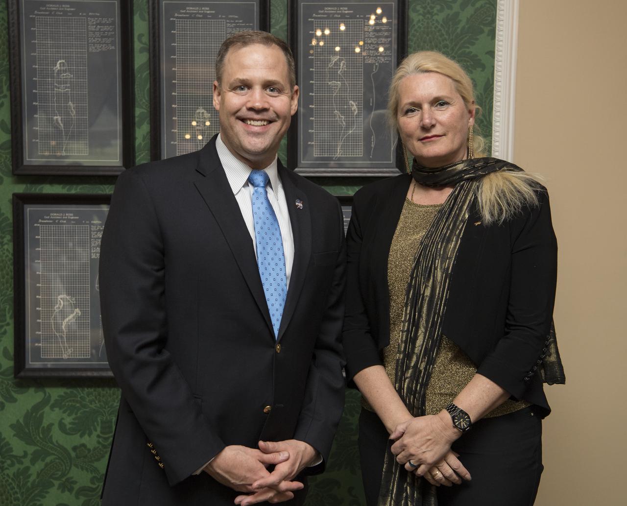
German Aerospace Center (DLR) executive board chair, Dr. Pascale Ehrenfreund, left, and Walther Pelzer, DLR executive board member, speak with NASA Administrator Jim Bridenstine about the robust relationship between their agencies in human and robotic exploration, and prospects for cooperation as NASA pursues the landing of humans on the Moon by 2024, at the Space Symposium, Wednesday, April 10, 2019 in Colorado Springs, Colorado. Photo Credit: (NASA/Aubrey Gemignani)
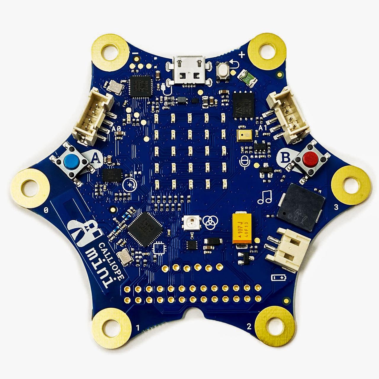
jsc2021e064348 (12/10/2021) --- The Standard Calliope mini Computer which is in a Modified Version the Heart and Brain of the CalliopEO Hardware. CalliopEO (Calliope Mini in Space) is a project of Ruhr-Universität Bochum, Calliope gGmbH, and the German Space Agency at DLR to promote software programming skills among German school children. Image courtesy of Calliope gGmbH
iss056e148119 (8/20/2018) --- Astronaut Alexander Gerst of ESA (European Space Agency) prepares the German Space Agency (DLR) Earth Sensing Imaging Spectrometer (DESIS) investigation for installation. DESIS verifies and enhances the use of space-based hyperspectral imaging capabilities for Earth remote sensing and provides an instrument which produces high value hyperspectral imagery
iss056e148130 (8/20/2018) --- Photographic documentation taken in the Japanese Experiment Module (JEM) during preparation for the installation of the German Space Agency (DLR) Earth Sensing Imaging Spectrometer (DESIS) investigation. DESIS verifies and enhances the use of space-based hyperspectral imaging capabilities for Earth remote sensing and provides an instrument which produces high value hyperspectral imagery.
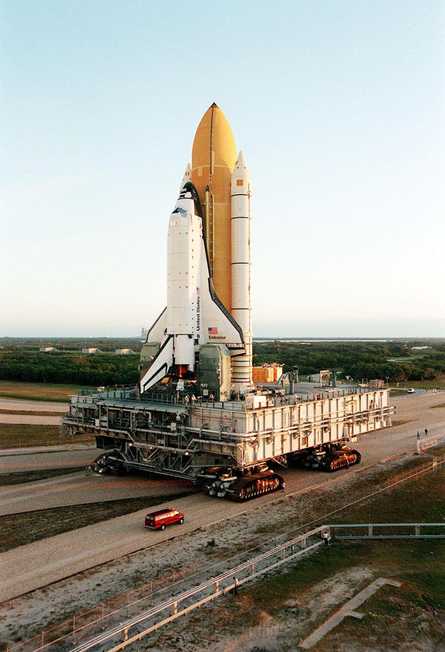
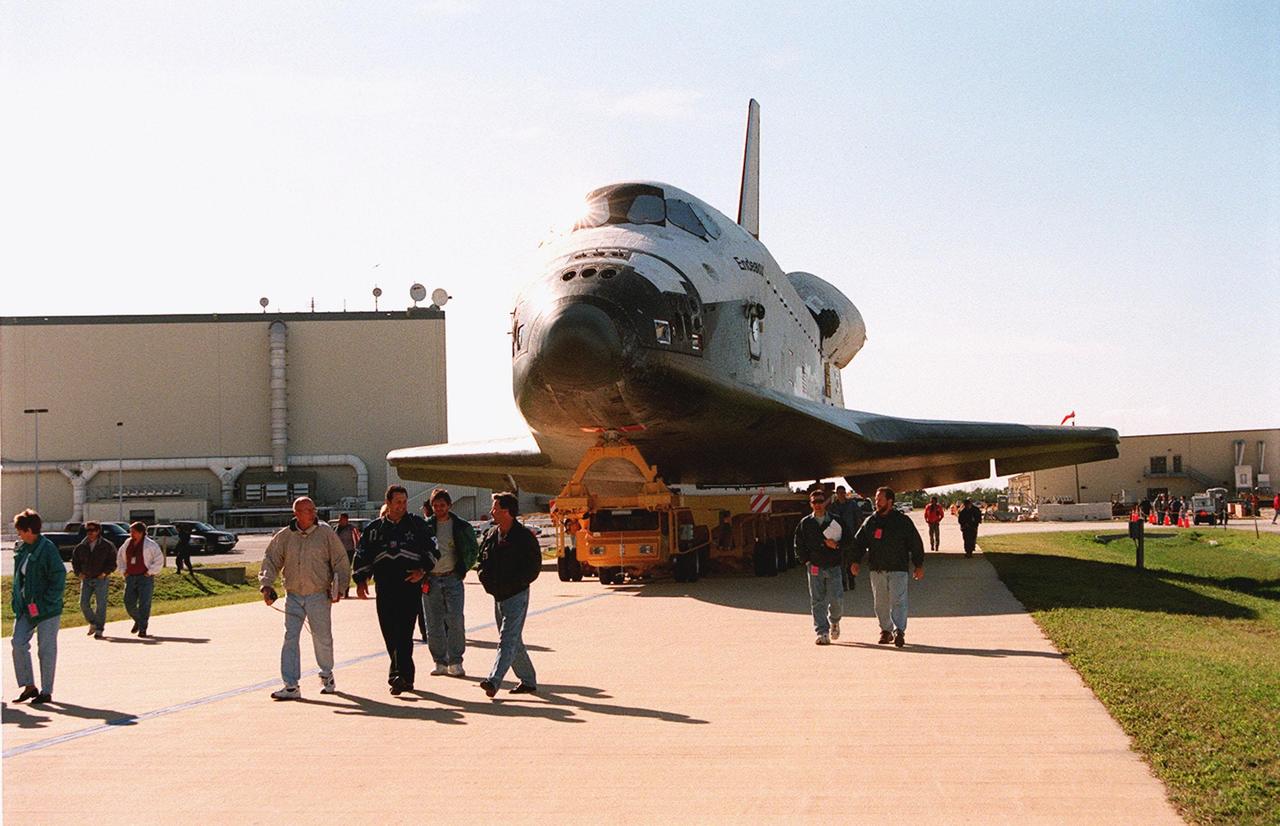
KENNEDY SPACE CENTER, Fla. -- Space Shuttle Endeavour, on its mobile launcher platform, is transferred to Launch Pad 39A for mission STS-99. Named the Shuttle Radar Topography Mission (SRTM), it involves an international project spearheaded by the National Imagery and Mapping Agency and NASA, with participation of the German Aerospace Center DLR. The SRTM consists of a specially modified radar system that will gather data for the most accurate and complete topographic map of the Earth's surface that has ever been assembled
KENNEDY SPACE CENTER, Fla. -- The doors of the Vehicle Assembly Building (VAB) are open for the transfer of Space Shuttle Endeavour, on its mobile launcher platform, to Launch Pad 39A for mission STS-99. Named the Shuttle Radar Topography Mission (SRTM), it involves an international project spearheaded by the National Imagery and Mapping Agency and NASA, with participation of the German Aerospace Center DLR. The SRTM consists of a specially modified radar system that will gather data for the most accurate and complete topographic map of the Earth's surface that has ever been assembled
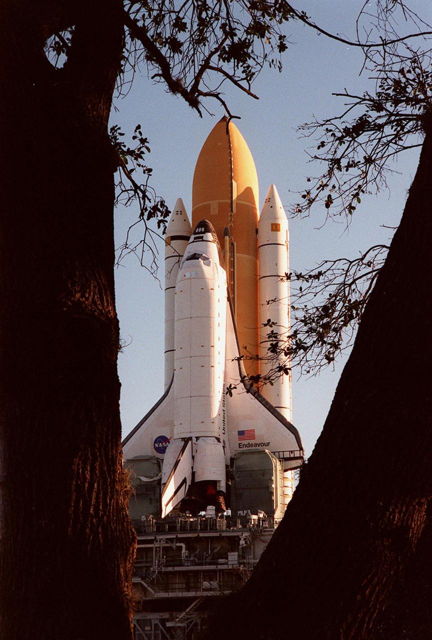
KENNEDY SPACE CENTER, Fla. -- Space Shuttle Endeavour is viewed between two tree trunks in this photo during the Shuttle's rollout to Launch Pad 39A for launch of mission STS-99. Named the Shuttle Radar Topography Mission (SRTM), it involves an international project spearheaded by the National Imagery and Mapping Agency and NASA, with participation of the German Aerospace Center DLR. The SRTM consists of a specially modified radar system that will gather data for the most accurate and complete topographic map of the Earth's surface that has ever been assembled

German Aerospace Center (DLR) executive board chair, Dr. Pascale Ehrenfreund, speaks with NASA Administrator Jim Bridenstine about the robust relationship between their agencies in human and robotic exploration, and prospects for cooperation as NASA pursues the landing of humans on the Moon by 2024, at the Space Symposium, Wednesday, April 10, 2019 in Colorado Springs, Colorado. Photo Credit: (NASA/Aubrey Gemignani)

German Aerospace Center (DLR) executive board chair, Dr. Pascale Ehrenfreund, center, speaks with NASA Administrator Jim Bridenstine about the robust relationship between their agencies in human and robotic exploration, and prospects for cooperation as NASA pursues the landing of humans on the Moon by 2024, at the Space Symposium, Wednesday, April 10, 2019 in Colorado Springs, Colorado. Photo Credit: (NASA/Aubrey Gemignani)

German Aerospace Center (DLR) executive board chair, Dr. Pascale Ehrenfreund, center, speaks with NASA Administrator Jim Bridenstine about the robust relationship between their agencies in human and robotic exploration, and prospects for cooperation as NASA pursues the landing of humans on the Moon by 2024, at the Space Symposium, Wednesday, April 10, 2019 in Colorado Springs, Colorado. Photo Credit: (NASA/Aubrey Gemignani)

NASA Administrator Jim Bridenstine speaks with German Aerospace Center (DLR) executive board chair, Dr. Pascale Ehrenfreund, about the robust relationship between their agencies in human and robotic exploration, and prospects for cooperation as NASA pursues the landing of humans on the Moon by 2024, at the Space Symposium, Wednesday, April 10, 2019 in Colorado Springs, Colorado. Photo Credit: (NASA/Aubrey Gemignani)

NASA Administrator Jim Bridenstine, right, speaks with officials from the German Aerospace Center (DLR) executive board about the robust relationship between their agencies in human and robotic exploration, and prospects for cooperation as NASA pursues the landing of humans on the Moon by 2024, at the Space Symposium, Wednesday, April 10, 2019 in Colorado Springs, Colorado. Photo Credit: (NASA/Aubrey Gemignani)

NASA Administrator Jim Bridenstine, right, speaks with German Aerospace Center (DLR) executive board chair, Dr. Pascale Ehrenfreund, about the robust relationship between their agencies in human and robotic exploration, and prospects for cooperation as NASA pursues the landing of humans on the Moon by 2024, at the Space Symposium, Wednesday, April 10, 2019 in Colorado Springs, Colorado. Photo Credit: (NASA/Aubrey Gemignani)

NASA Administrator Jim Bridenstine, right, and Deputy Administrator Jim Morhard listen as German Aerospace Center (DLR) executive board chair, Dr. Pascale Ehrenfreund, speaks about the robust relationship between their agencies in human and robotic exploration, and prospects for cooperation as NASA pursues the landing of humans on the Moon by 2024, at the Space Symposium, Wednesday, April 10, 2019 in Colorado Springs, Colorado. Photo Credit: (NASA/Aubrey Gemignani)

Walther Pelzer, German Aerospace Center (DLR) executive board member, speaks with NASA Administrator Jim Bridenstine about the robust relationship between their agencies in human and robotic exploration, and prospects for cooperation as NASA pursues the landing of humans on the Moon by 2024, at the Space Symposium, Wednesday, April 10, 2019 in Colorado Springs, Colorado. Photo Credit: (NASA/Aubrey Gemignani)
STS089-357-003 (22-31 Jan. 1998) --- Astronaut Michael P. Anderson, STS-89 mission specialist, works on Endeavour's middeck with the Closed Equilibrated Biological Aquatic System (CEBAS), an experiment developed by the German Space Agency (DLR). The CEBAS mini-module, a middeck habitat for aquatic organisms, enables scientists to conduct various gravity-related experiments in the areas of zoology, botany and developmental biology, as well as in interdisciplinary areas such as scientific research on artificial ecosystems. Photo credit: NASA

NASA Administrator Jim Bridenstine listens as German Aerospace Center (DLR) executive board chair, Dr. Pascale Ehrenfreund, speaks about the robust relationship between their agencies in human and robotic exploration, and prospects for cooperation as NASA pursues the landing of humans on the Moon by 2024, at the Space Symposium, Wednesday, April 10, 2019 in Colorado Springs, Colorado. Photo Credit: (NASA/Aubrey Gemignani)
NASA Administrator Jim Bridenstine, left, poses for a photo with German Aerospace Center (DLR) executive board chair, Dr. Pascale Ehrenfreund after meeting to discuss the robust relationship between their agencies in human and robotic exploration, and prospects for cooperation as NASA pursues the landing of humans on the Moon by 2024, at the Space Symposium, Wednesday, April 10, 2019 in Colorado Springs, Colorado. Photo Credit: (NASA/Aubrey Gemignani)
iss056e005285 (June 6, 2018) --- The small, yellow box in the middle of the picture is a module for the Wireless Compose-2 investigation from ESA (European Space Agency). Wireless Compose-2 is a technology demonstration that aims to provide a flexible and adaptable wireless network infrastructure to conduct and execute low-power, low-weight, and wireless experiments on the International Space Station. Building on technology used for the German Space Agency's (DLR) first Wireless Compose technology demonstrator in 2018, it shows the capabilities of Wireless Networks for scientific, localization, and medical experiments in the Columbus module.
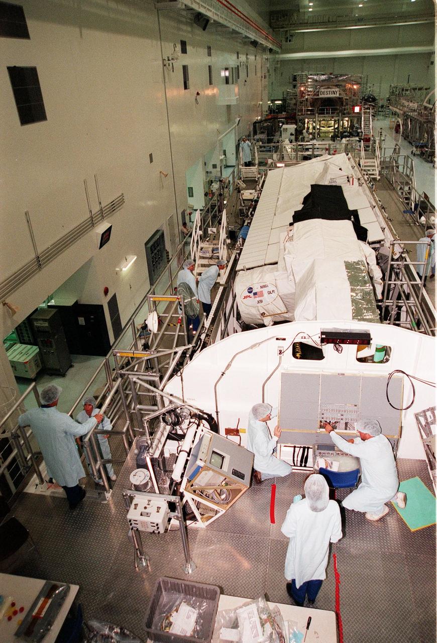
The Shuttle Radar Topography Mission (SRTM) is moved into the Space Station Processing Facility to prepare it for launch targeted for September 1999. The primary payload on mission STS-99, the SRTM consists of a specially modified radar system that will fly onboard the Space Shuttle during the 11-day mission. This radar system will gather data that will result in the most accurate and complete topographic map of the Earth's surface that has ever been assembled. SRTM is an international project spearheaded by the National Imagery and Mapping Agency and NASA, with participation of the German Aerospace Center DLR. Its objective is to obtain the most complete high-resolution digital topographic database of the Earth
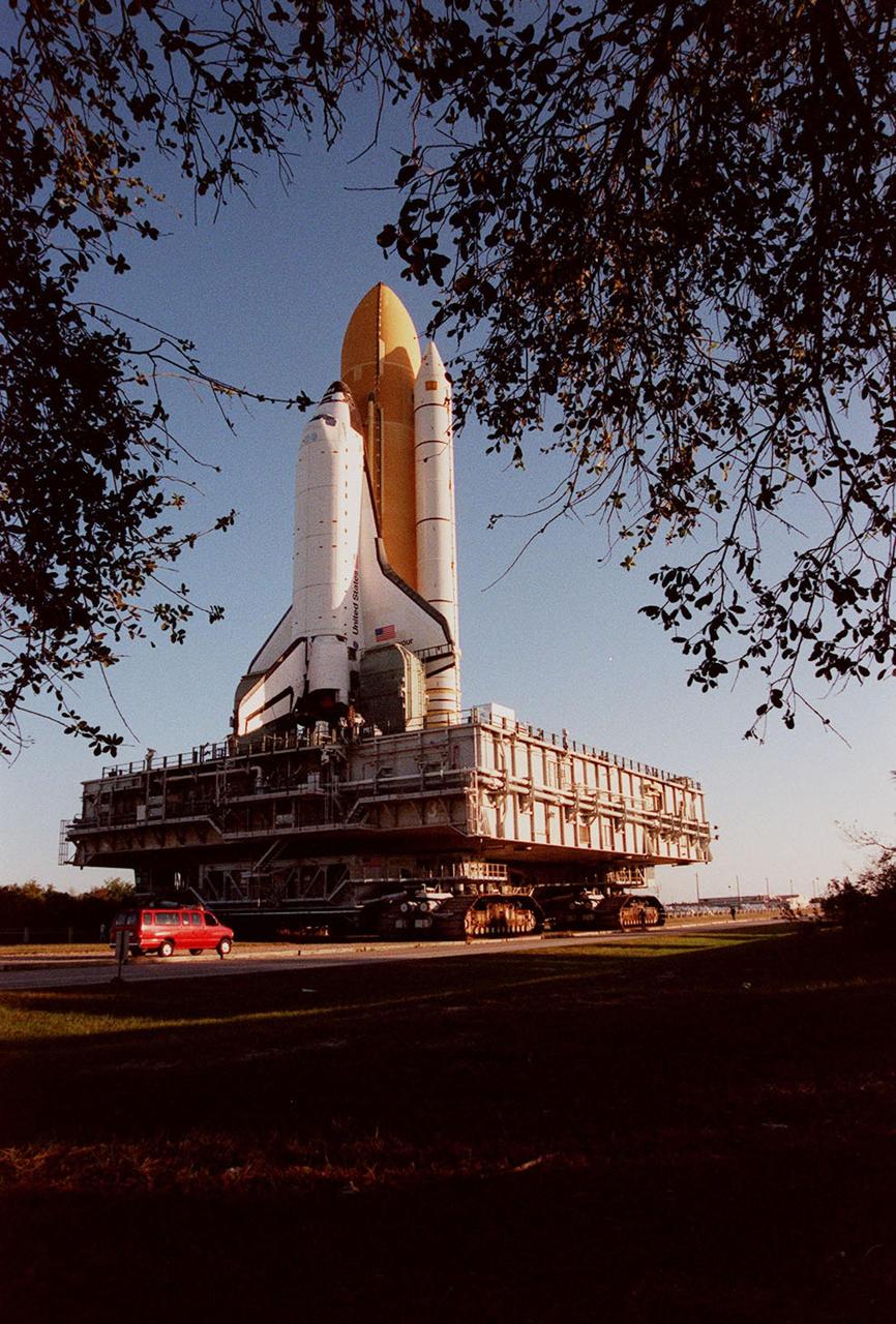
KENNEDY SPACE CENTER, Fla. -- Framed by branches of oak leaves in this photo, Space Shuttle Endeavour, on its mobile launcher platform, is transferred to Launch Pad 39A for mission STS-99. The van behind it is barely noticeable next to the gigantic stature of the moving vehicle. Named the Shuttle Radar Topography Mission (SRTM), it involves an international project spearheaded by the National Imagery and Mapping Agency and NASA, with participation of the German Aerospace Center DLR. The SRTM consists of a specially modified radar system that will gather data for the most accurate and complete topographic map of the Earth's surface that has ever been assembled
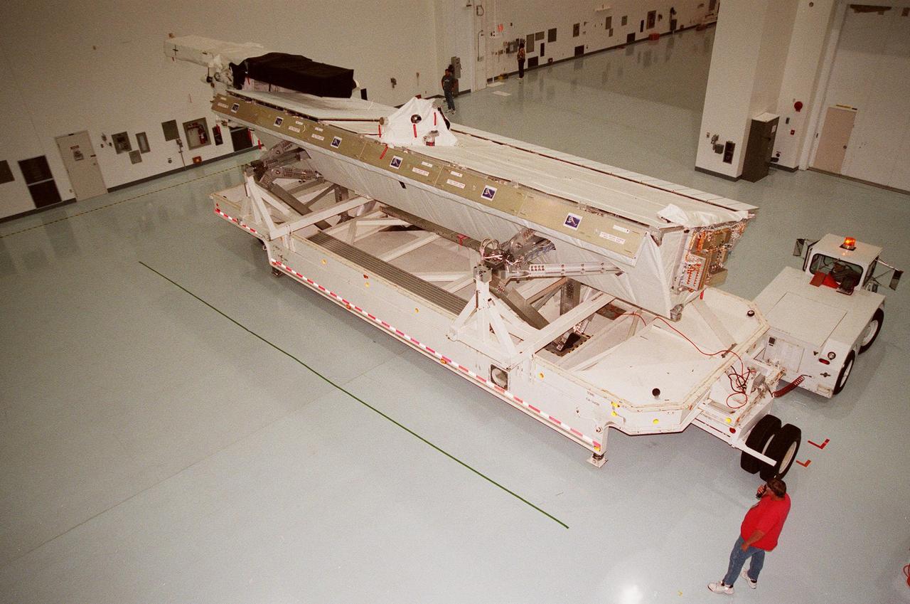
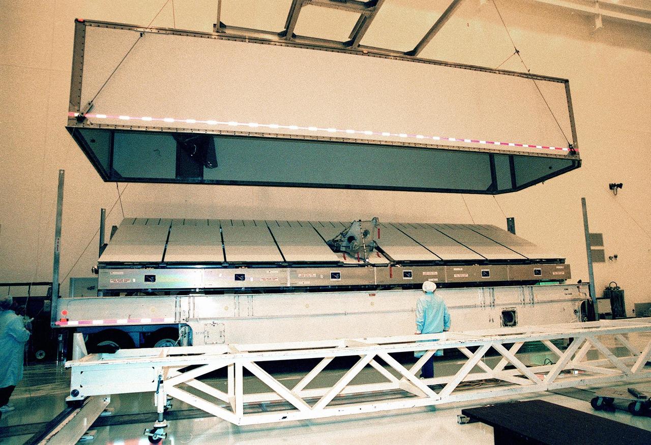
Inside the Space Station Processing Facility, the Shuttle Radar Topography Mission (SRTM) is maneuvered into place to prepare it for launch targeted for September 1999. The primary payload on mission STS-99, the SRTM consists of a specially modified radar system that will fly onboard the Space Shuttle during the 11-day mission. This radar system will gather data that will result in the most accurate and complete topographic map of the Earth's surface that has ever been assembled. SRTM is an international project spearheaded by the National Imagery and Mapping Agency and NASA, with participation of the German Aerospace Center DLR. Its objective is to obtain the most complete high-resolution digital topographic database of the Earth
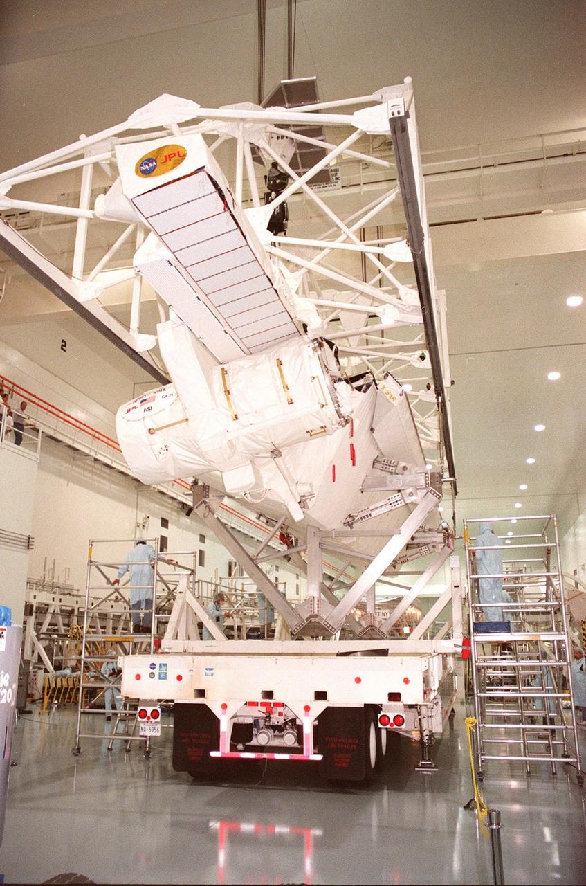
Inside the Multi-Payload Processing Facility, the lid covering the Shuttle Radar Topography Mission (SRTM) is lifted from the crate. The primary payload on mission STS-99, the SRTM consists of a specially modified radar system that will fly onboard the Space Shuttle during the 11-day mission scheduled for September 1999. This radar system will gather data that will result in the most accurate and complete topographic map of the Earth's surface that has ever been assembled. SRTM is an international project spearheaded by the National Imagery and Mapping Agency and NASA, with participation of the German Aerospace Center DLR. Its objective is to obtain the most complete high-resolution digital topographic database of the Earth
The Shuttle Radar Topography Mission (SRTM) sits uncovered inside the Multi-Payload Processing Facility. The primary payload on mission STS-99, the SRTM consists of a specially modified radar system that will fly onboard the Space Shuttle during the 11-day mission scheduled for September 1999. This radar system will gather data that will result in the most accurate and complete topographic map of the Earth's surface that has ever been assembled. SRTM is an international project spearheaded by the National Imagery and Mapping Agency and NASA, with participation of the German Aerospace Center DLR. Its objective is to obtain the most complete high-resolution digital topographic database of the Earth
The Shuttle Radar Topography Mission (SRTM) sits inside the Multi-Payload Processing Facility after the SRTM's cover was removed. The primary payload on mission STS-99, the SRTM consists of a specially modified radar system that will fly onboard the Space Shuttle during the 11-day mission scheduled for September 1999. This radar system will gather data that will result in the most accurate and complete topographic map of the Earth's surface that has ever been assembled. SRTM is an international project spearheaded by the National Imagery and Mapping Agency and NASA, with participation of the German Aerospace Center DLR. Its objective is to obtain the most complete high-resolution digital topographic database of the Earth
Inside the Multi-Payload Processing Facility, the lid covering the Shuttle Radar Topography Mission (SRTM) is lifted. The primary payload on mission STS-99, the SRTM consists of a specially modified radar system that will fly onboard the Space Shuttle during the 11-day mission scheduled for September 1999. This radar system will gather data that will result in the most accurate and complete topographic map of the Earth's surface that has ever been assembled. SRTM is an international project spearheaded by the National Imagery and Mapping Agency and NASA, with participation of the German Aerospace Center DLR. Its objective is to obtain the most complete high-resolution digital topographic database of the Earth
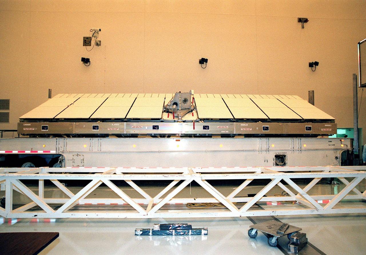
Inside the Multi-Payload Processing Facility, the Shuttle Radar Topography Mission (SRTM) is revealed after the lid of its container was removed. The primary payload on mission STS-99, the SRTM consists of a specially modified radar system that will fly onboard the Space Shuttle during the 11-day mission scheduled for September 1999. This radar system will gather data that will result in the most accurate and complete topographic map of the Earth's surface that has ever been assembled. SRTM is an international project spearheaded by the National Imagery and Mapping Agency and NASA, with participation of the German Aerospace Center DLR. Its objective is to obtain the most complete high-resolution digital topographic database of the Earth

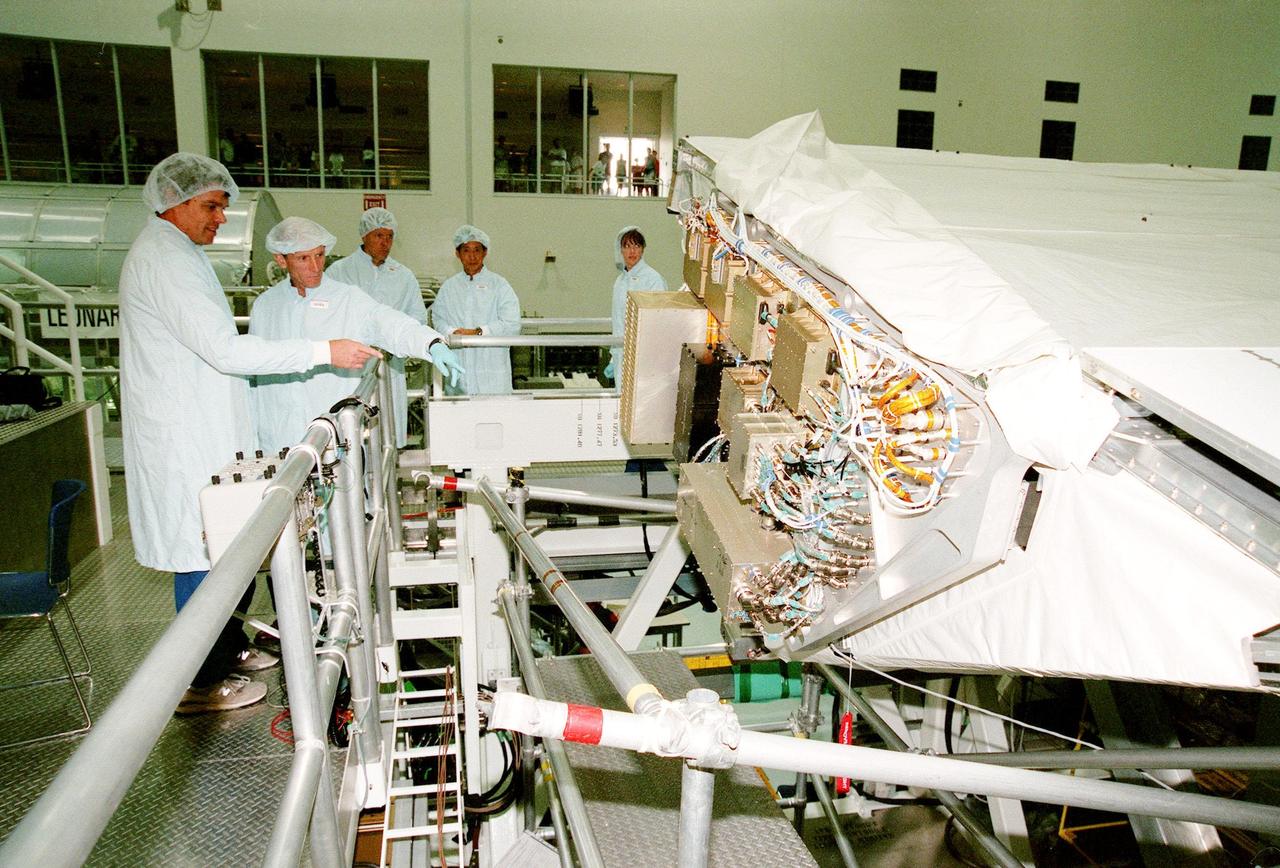
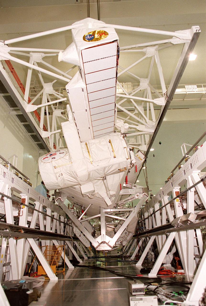
In the Multi-Payload Processing Facility, Beverly St. Ange, with the Jet Propulsion Laboratory, wires a biopod, a component of the STS-99 Shuttle Radar Topography Mission (SRTM). The SRTM consists of a specially modified radar system that will fly onboard the Space Shuttle during an 11-day mission in September 1999. This radar system will gather data that will result in the most accurate and complete topographic map of the Earth's surface that has ever been assembled. SRTM is an international project spearheaded by the National Imagery and Mapping Agency and NASA, with participation of the German Aerospace Center DLR. Its objective is to obtain the most complete high-resolution digital topographic database of the Earth
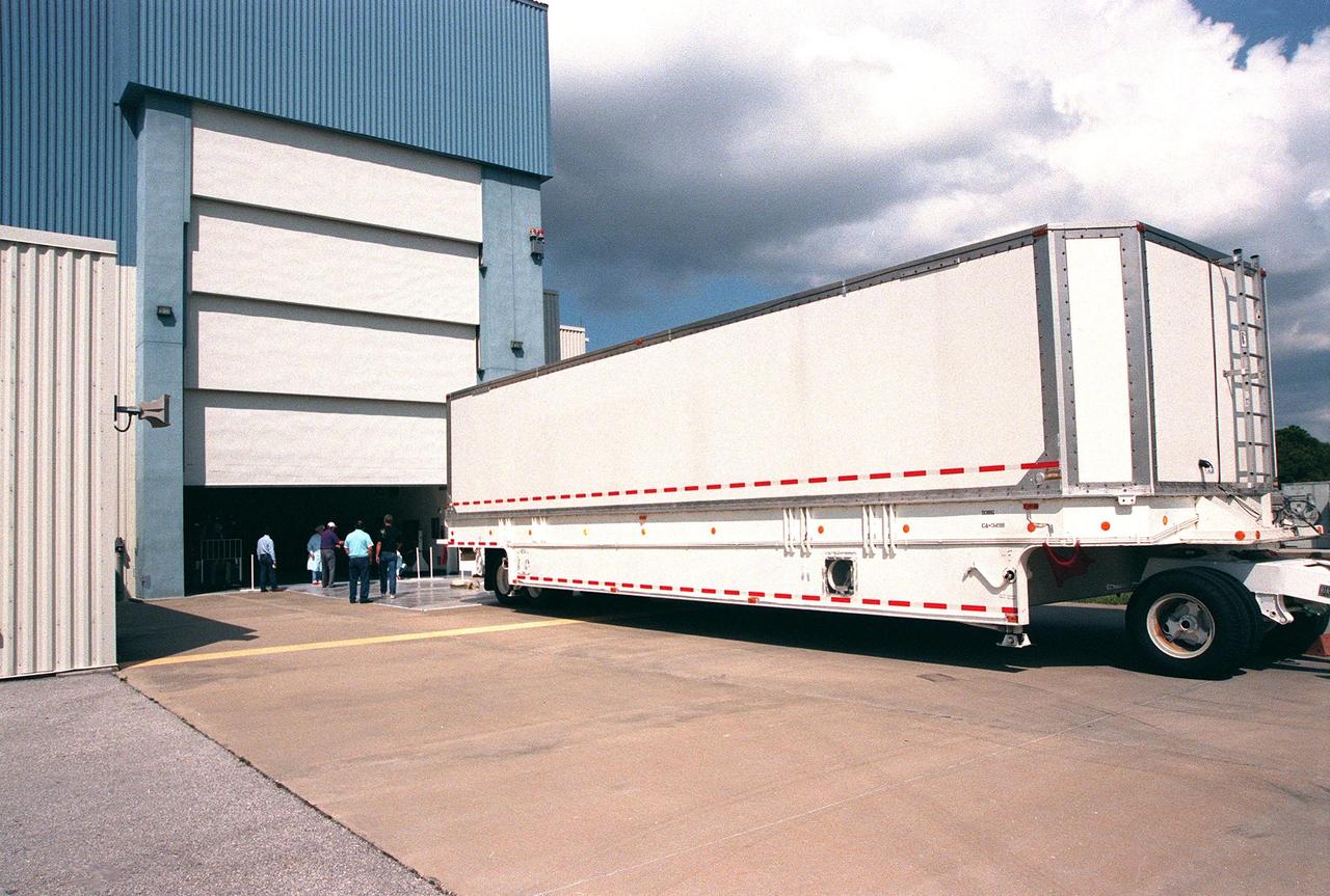
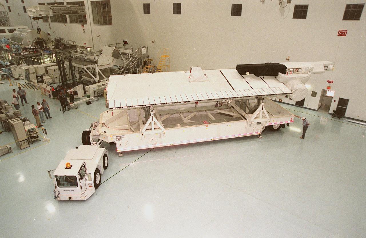
The vehicle carrying the Shuttle Radar Topography Mission (SRTM) arrives at the Multi-Payload Processing Facility. The primary payload on mission STS-99, the SRTM consists of a specially modified radar system that will fly onboard the Space Shuttle during the 11-day mission scheduled for September 1999. This radar system will gather data that will result in the most accurate and complete topographic map of the Earth's surface that has ever been assembled. SRTM is an international project spearheaded by the National Imagery and Mapping Agency and NASA, with participation of the German Aerospace Center DLR. Its objective is to obtain the most complete high-resolution digital topographic database of the Earth
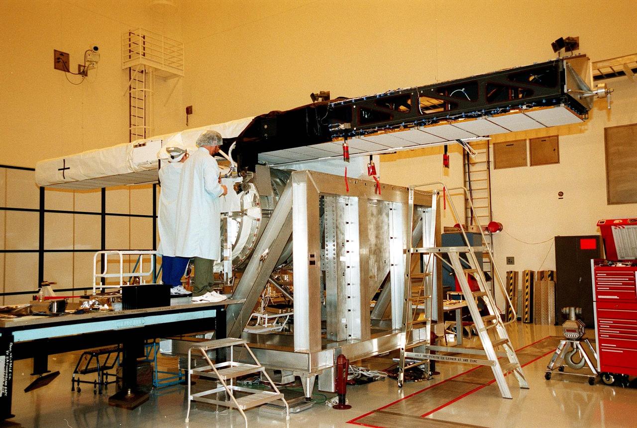
In the Multi-Payload Processing Facility, Mary Reaves (left) and Richard Rainen, with the Jet Propulsion Laboratory, check out the carrier and horizontal antenna mast for the STS-99 Shuttle Radar Topography Mission (SRTM). The SRTM consists of a specially modified radar system that will fly onboard the Space Shuttle during an 11-day mission in September 1999. This radar system will gather data that will result in the most accurate and complete topographic map of the Earth's surface that has ever been assembled. SRTM is an international project spearheaded by the National Imagery and Mapping Agency and NASA, with participation of the German Aerospace Center DLR. Its objective is to obtain the most complete high-resolution digital topographic database of the Earth
This is a Space Shuttle Columbia (STS-65) onboard photo of the second International Microgravity Laboratory (IML-2) in the cargo bay with Earth in the background. Mission objectives of IML-2 were to conduct science and technology investigations that required the low-gravity environment of space, with emphasis on experiments that studied the effects of microgravity on materials processes and living organisms. Materials science and life sciences are two of the most exciting areas of microgravity research because discoveries in these fields could greatly enhance the quality of life on Earth. If the structure of certain proteins can be determined by examining high-quality protein crystals grown in microgravity, advances can be made to improve the treatment of many human diseases. Electronic materials research in space may help us refine processes and make better products, such as computers, lasers, and other high-tech devices. The 14-nation European Space Agency (ESA), the Canadian Space Agency (SCA), the French National Center for Space Studies (CNES), the German Space Agency and the German Aerospace Research Establishment (DARA/DLR), and the National Space Development Agency of Japan (NASDA) participated in developing hardware and experiments for the IML missions. The missions were managed by NASA's Marshall Space Flight Center. The Orbiter Columbia was launched from the Kennedy Space Center on July 8, 1994 for the IML-2 mission.
This is the Space Shuttle Orbiter Discovery, STS-42 mission, with the First International Microgravity Laboratory (IML-1) module shown in the cargo bay. IML-1, the first in a series of Shuttle flights, was dedicated to study the fundamental materials and life sciences in the microgravity environment inside Spacelab, a laboratory carried aloft by the Shuttle. The mission explored how life forms adapt to weightlessness and investigated how materials behave when processed in space. The IML program gave a team of scientists from around the world access to a unique environment, one that is free from most of Earth's gravity. The 14-nation European Space Agency (ESA), the Canadian Space Agency (SCA), the French National Center for Space Studies (CNES), the German Space Agency and the German Aerospace Research Establishment (DARA/DLR), and the National Space Development Agency of Japan (NASDA) participated in developing hardware and experiments for the IML missions. The missions were managed by NASA's Marshall Space Flight Center. The Orbiter Discovery was launched on January 22, 1992 for the IML-1 mission.
Astronaut Carl E. Walz, mission specialist, flies through the second International Microgravity Laboratory (IML-2) science module, STS-65 mission. IML was dedicated to study fundamental materials and life sciences in a microgravity environment inside Spacelab, a laboratory carried aloft by the Shuttle. The mission explored how life forms adapt to weightlessness and investigated how materials behave when processed in space. The IML program gave a team of scientists from around the world access to a unique environment, one that is free from most of Earth's gravity. Managed by the NASA Marshall Space Flight Center, the 14-nation European Space Agency (ESA), the Canadian Space Agency (SCA), the French National Center for Space Studies (CNES), the German Space Agency and the German Aerospace Research Establishment (DARA/DLR), and the National Space Development Agency of Japan (NASDA) participated in developing hardware and experiments for the IML missions. The missions were managed by NASA's Marshall Space Flight Center. The Orbiter Columbia was launched on July 8, 1994 for the IML-2 mission.
Acting Assistant Secretary of State for Oceans and International Environmental and Scientific Affairs Jennifer R. Littlejohn delivers remarks during an Artemis Accords signing ceremony, Thursday, September 14, 2023, at the German Ambassador’s Residence in Washington. Germany is the 29th country to sign the Artemis Accords, which establish a practical set of principles to guide space exploration cooperation among nations participating in NASA’s Artemis program. Photo Credit: (NASA/Keegan Barber)
German Ambassador to the United States Andreas Michaelis delivers remarks during an Artemis Accords signing ceremony, Thursday, September 14, 2023, at the German Ambassador’s Residence in Washington. Germany is the 29th country to sign the Artemis Accords, which establish a practical set of principles to guide space exploration cooperation among nations participating in NASA’s Artemis program. Photo Credit: (NASA/Keegan Barber)

Federal Government Coordinator of German Aerospace Policy Anna Christmann delivers remarks during an Artemis Accords signing ceremony, Thursday, September 14, 2023, at the German Ambassador’s Residence in Washington. Germany is the 29th country to sign the Artemis Accords, which establish a practical set of principles to guide space exploration cooperation among nations participating in NASA’s Artemis program. Photo Credit: (NASA/Keegan Barber)

Acting Assistant Secretary of State for Oceans and International Environmental and Scientific Affairs Jennifer R. Littlejohn delivers remarks during an Artemis Accords signing ceremony, Thursday, September 14, 2023, at the German Ambassador’s Residence in Washington. Germany is the 29th country to sign the Artemis Accords, which establish a practical set of principles to guide space exploration cooperation among nations participating in NASA’s Artemis program. Photo Credit: (NASA/Keegan Barber)
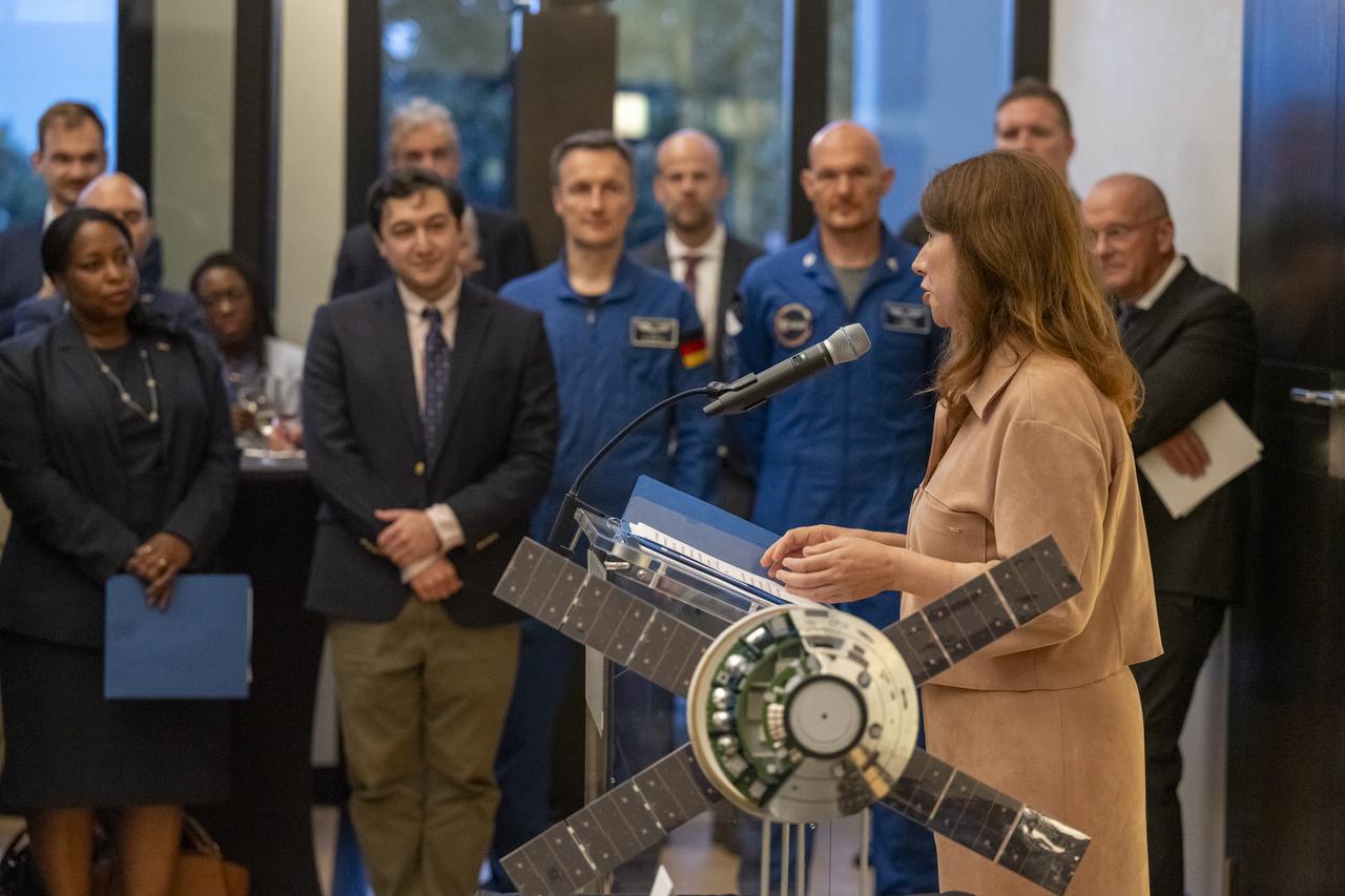
Federal Government Coordinator of German Aerospace Policy Anna Christmann delivers remarks during an Artemis Accords signing ceremony, Thursday, September 14, 2023, at the German Ambassador’s Residence in Washington. Germany is the 29th country to sign the Artemis Accords, which establish a practical set of principles to guide space exploration cooperation among nations participating in NASA’s Artemis program. Photo Credit: (NASA/Keegan Barber)

National Space Council (NSpC) Executive Secretary Chirag Parikh delivers remarks during an Artemis Accords signing ceremony, Thursday, September 14, 2023, at the German Ambassador’s Residence in Washington. Germany is the 29th country to sign the Artemis Accords, which establish a practical set of principles to guide space exploration cooperation among nations participating in NASA’s Artemis program. Photo Credit: (NASA/Keegan Barber)
National Space Council (NSpC) Executive Secretary Chirag Parikh delivers remarks during an Artemis Accords signing ceremony, Thursday, September 14, 2023, at the German Ambassador’s Residence in Washington. Germany is the 29th country to sign the Artemis Accords, which establish a practical set of principles to guide space exploration cooperation among nations participating in NASA’s Artemis program. Photo Credit: (NASA/Keegan Barber)
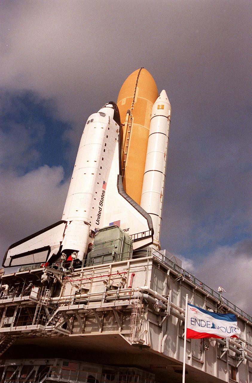
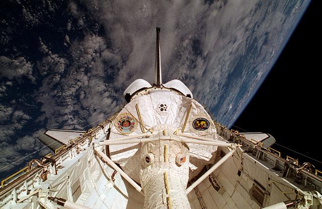
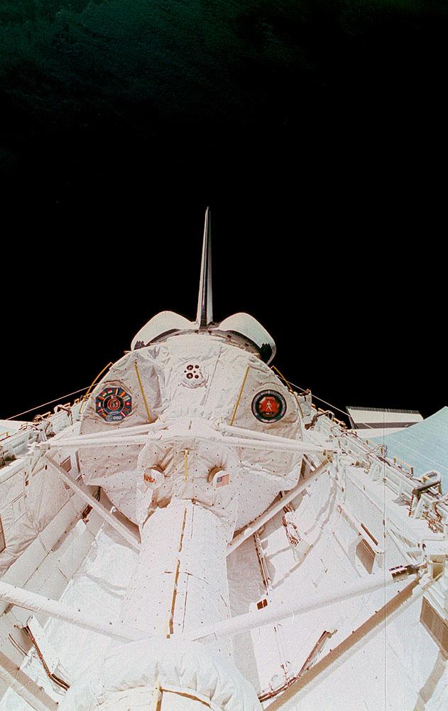
KENNEDY SPACE CENTER, Fla. -- Space Shuttle Endeavour is viewed atop the mobile launcher platform on its way to Launch Pad 39A for launch of mission STS-99. Named the Shuttle Radar Topography Mission (SRTM), STS-99 involves an international project spearheaded by the National Imagery and Mapping Agency and NASA, with participation of the German Aerospace Center DLR. SRTM will chart a new course, using two antennae and a 200-foot-long section of space station-derived mast protruding from its payload bay, to produce unrivaled 3-D images of the Earth's surface. The result of the Shuttle Radar Topography Mission could be close to 1 trillion measurements of the Earth's topography. Besides contributing to the production of better maps, these measurements could lead to improved water drainage modeling, more realistic flight simulators, better locations for cell phone towers, and enhanced navigation safety. STS-99 is scheduled for launch in January 2000
In the Space Station Processing Facility (SSPF), workers (lower right) disconnect the transport vehicle from the Shuttle Radar Topography Mission (SRTM) after moving it into the building for pre-launch preparations. The primary payload on mission STS-99, the SRTM consists of a specially modified radar system that will fly onboard the Space Shuttle during the 11-day mission targeted for launch in September 1999. This radar system will gather data that will result in the most accurate and complete topographic map of the Earth's surface that has ever been assembled. SRTM is an international project spearheaded by the National Imagery and Mapping Agency and NASA, with participation of the German Aerospace Center DLR. Its objective is to obtain the most complete high-resolution digital topographic database of the Earth
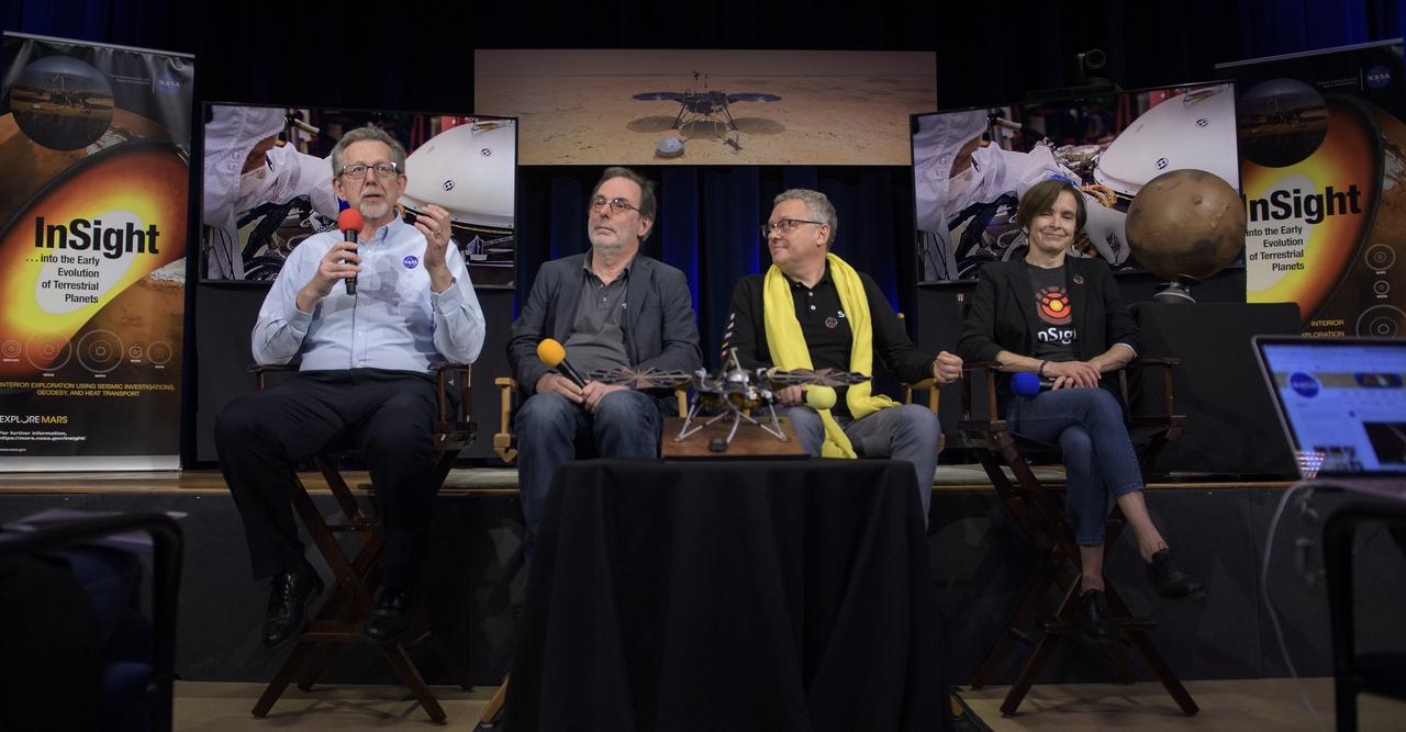
From left to right: NASA Chief Scientist Jim Green; HP3 Principle Investigator, German Aerospace Center (DLR), Tilman Spohn; SEIS Project Manager, French National Space Agency (CNES), Philippe Laudet; and InSight deputy principal investigator, NASA JPL, Sue Smrekar talk about Mars InSight during a social media briefing, Sunday, Nov. 25, 2018 at NASA's Jet Propulsion Laboratory in Pasadena, California. InSight, short for Interior Exploration using Seismic Investigations, Geodesy and Heat Transport, is a Mars lander designed to study the "inner space" of Mars: its crust, mantle, and core. InSight is scheduled to touch down on the Red Planet at approximately noon PST (3 p.m. EST) on Nov. 26. Photo Credit: (NASA/Bill Ingalls)
In the Multi-Payload Processing Facility, Mary Reaves and Richard Rainen, with the Jet Propulsion Laboratory, work on the carrier and horizontal antenna mast for the STS-99 Shuttle Radar Topography Mission (SRTM) while Larry Broms watches. The SRTM consists of a specially modified radar system that will fly onboard the Space Shuttle during an 11-day mission in September 1999. This radar system will gather data that will result in the most accurate and complete topographic map of the Earth's surface that has ever been assembled. SRTM is an international project spearheaded by the National Imagery and Mapping Agency and NASA, with participation of the German Aerospace Center DLR. Its objective is to obtain the most complete high-resolution digital topographic database of the Earth
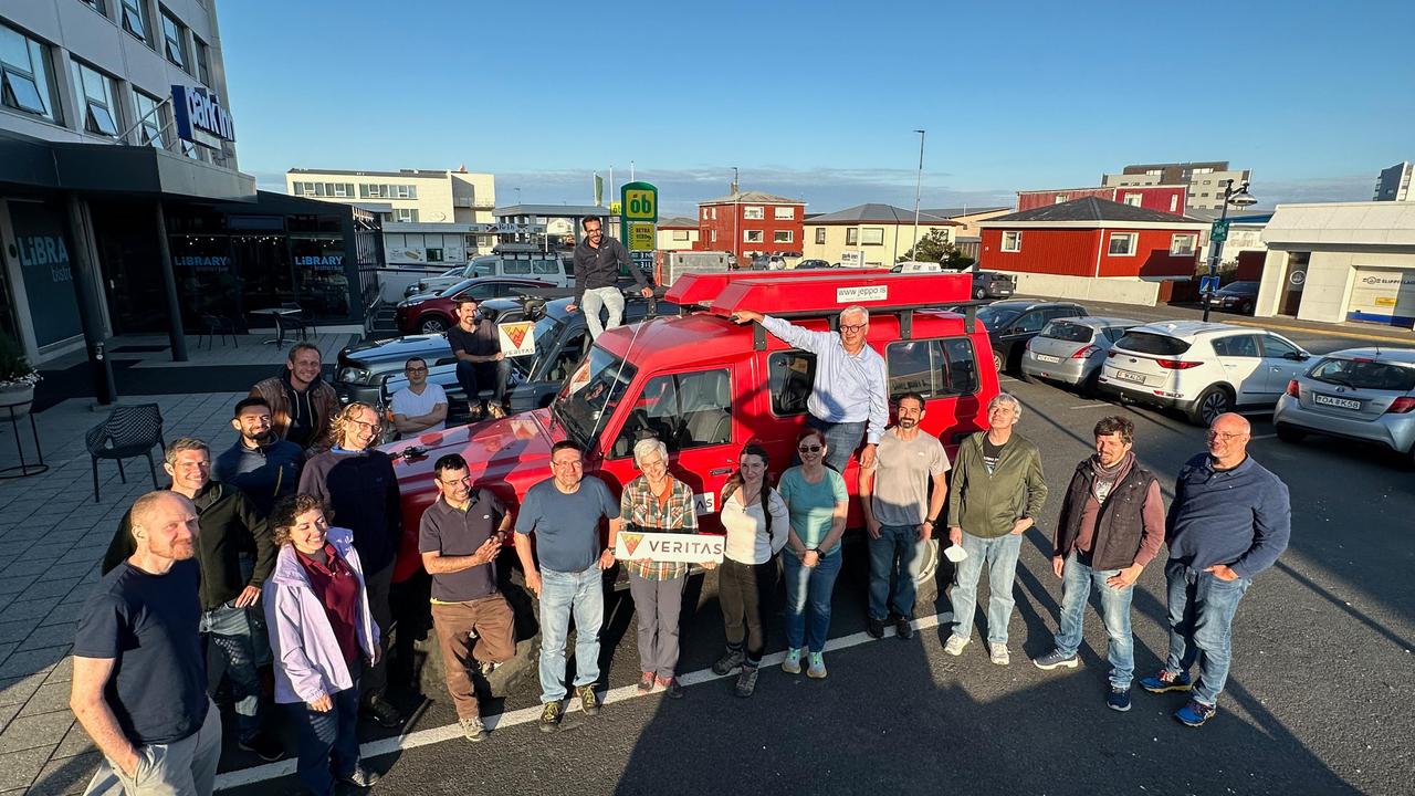
Members of the VERITAS science team pause for a photograph on July 31, 2023, after arriving in Iceland to begin a two-week campaign to study the volcanic island's geology to help the team prepare for NASA's VERITAS (short for Venus Emissivity, Radio science, InSAR, Topography, And Spectroscopy) mission to Venus. From July 30 to Aug. 14, 2023, the international science team, including local participation from the University of Iceland, worked to lay the groundwork for the science that will ultimately be done from Venus orbit. At center, holding the VERITAS mission identifier is the mission's principal investigator and the science team lead, Sue Smrekar, of NASA's Jet Propulsion Laboratory in Southern California. Flanking her are science team members from multiple U.S., Italian, and German institutions, including members of the German Aerospace Center (DLR) Flugzeug Synthetic Aperture Radar (F-SAR) airplane team. The DLR F-SAR team was tasked with collecting synthetic-aperture radar data of the regions studied by the field team. A key objective of the campaign is to refine change detection algorithms that will be used to look for global surface change (such as volcanic activity) between NASA's Magellan radar mission from the 1990s and VERITAS, as well as between VERITAS and the ESA (European Space Agency) EnVision mission to Venus, both of which are targeting the early 2030s for launch. NASA's VERITAS is an orbiter designed to peer through Venus' thick atmosphere with a suite of powerful instruments to create global maps of the planet's surface, including topography, radar images, rock type, and gravity, as well as detect surface changes. VERITAS is designed to understand what processes are currently active, search for evidence of past and current interior water, and understand the geologic evolution of the planet, illuminating how rocky planets throughout the galaxy evolve. VERITAS and NASA's Deep Atmosphere Venus Investigation of Noble gases, Chemistry, and Imaging (DAVINCI) mission were selected in 2021 under NASA's Discovery Program as the agency's next missions to Venus. The Discovery Program is managed by the Planetary Missions Program Office at NASA's Marshall Space Flight Center in Huntsville, Alabama, for the Planetary Science Division of NASA's Science Mission Directorate in Washington. https://photojournal.jpl.nasa.gov/catalog/PIA25835

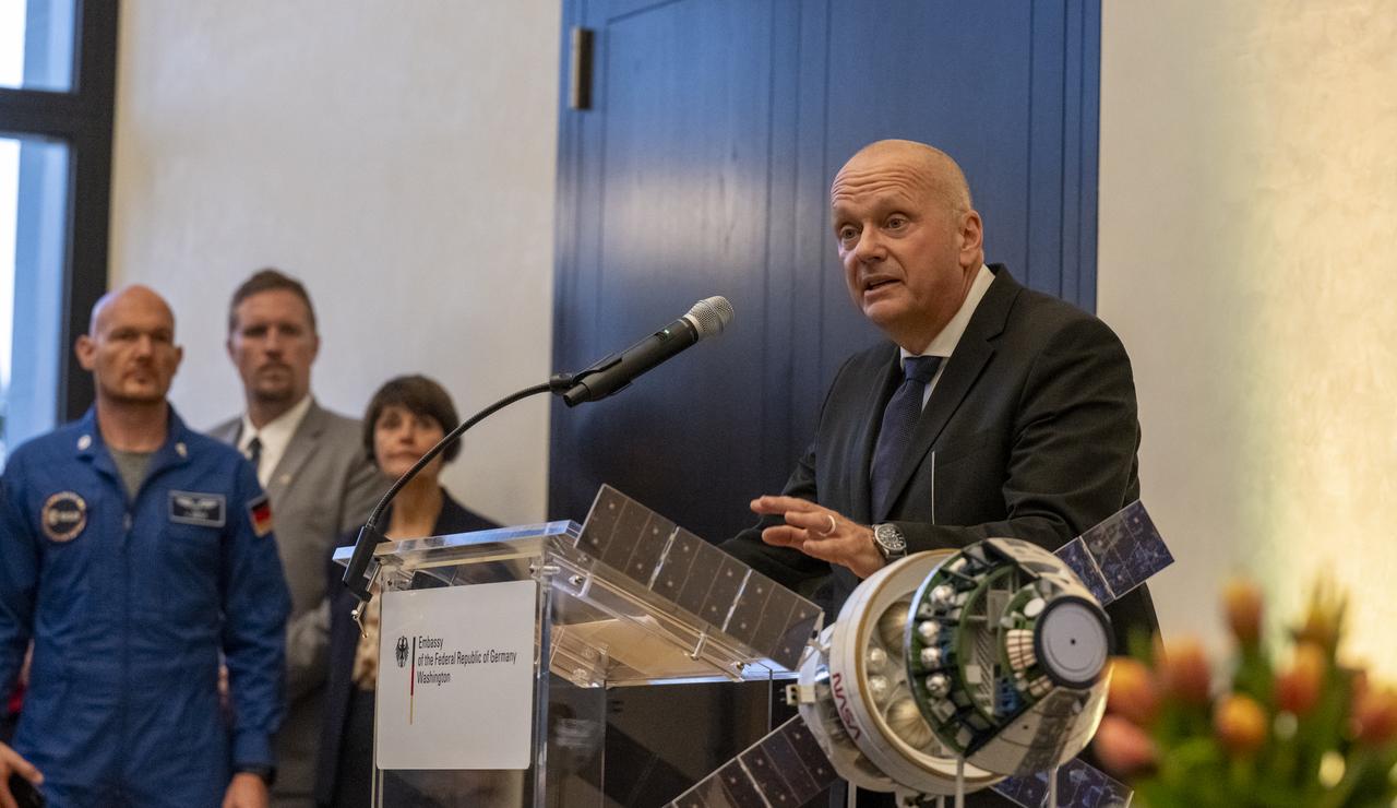
NASA Administrator Bill Nelson delivers remarks during an Artemis Accords signing ceremony, Thursday, September 14, 2023, at the German Ambassador’s Residence in Washington. Germany is the 29th country to sign the Artemis Accords, which establish a practical set of principles to guide space exploration cooperation among nations participating in NASA’s Artemis program. Photo Credit: (NASA/Keegan Barber)
NASA Administrator Bill Nelson delivers remarks during an Artemis Accords signing ceremony, Thursday, September 14, 2023, at the German Ambassador’s Residence in Washington. Germany is the 29th country to sign the Artemis Accords, which establish a practical set of principles to guide space exploration cooperation among nations participating in NASA’s Artemis program. Photo Credit: (NASA/Keegan Barber)
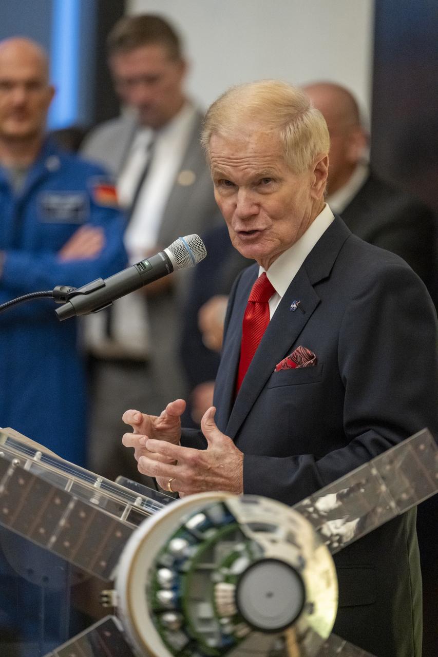
NASA Administrator Bill Nelson delivers remarks during an Artemis Accords signing ceremony, Thursday, September 14, 2023, at the German Ambassador’s Residence in Washington. Germany is the 29th country to sign the Artemis Accords, which establish a practical set of principles to guide space exploration cooperation among nations participating in NASA’s Artemis program. Photo Credit: (NASA/Keegan Barber)
The IML-1 mission was the first in a series of Shuttle flights dedicated to fundamental materials and life sciences research with the international partners. The participating space agencies included: NASA, the 14-nation European Space Agency (ESA), the Canadian Space Agency (CSA), the French National Center of Space Studies (CNES), the German Space Agency and the German Aerospace Research Establishment (DAR/DLR), and the National Space Development Agency of Japan (NASDA). Dedicated to the study of life and materials sciences in microgravity, the IML missions explored how life forms adapt to weightlessness and investigated how materials behave when processed in space. Both life and materials sciences benefited from the extended periods of microgravity available inside the Spacelab science module in the cargo bay of the Space Shuttle Orbiter. In this photograph, Commander Ronald J. Grabe works with the Mental Workload and Performance Evaluation Experiment (MWPE) in the IML-1 module. This experiment was designed as a result of difficulty experienced by crewmembers working at a computer station on a previous Space Shuttle mission. The problem was due to the workstation's design being based on Earthbound conditions with the operator in a typical one-G standing position. Information gained from this experiment was used to design workstations for future Spacelab missions and the International Space Station. Managed by the Marshall Space Flight Center, IML-1 was launched on January 22, 1992 aboard the Space Shuttle Orbiter Discovery (STS-42 mission).
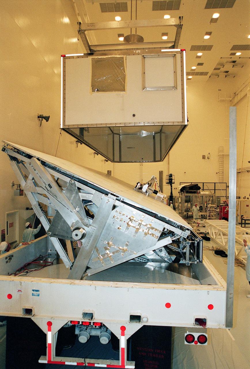
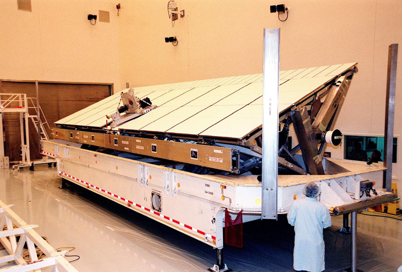
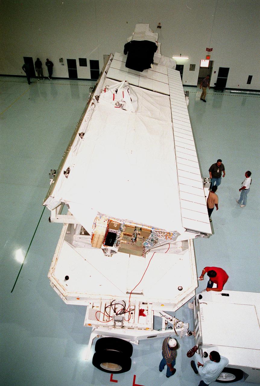
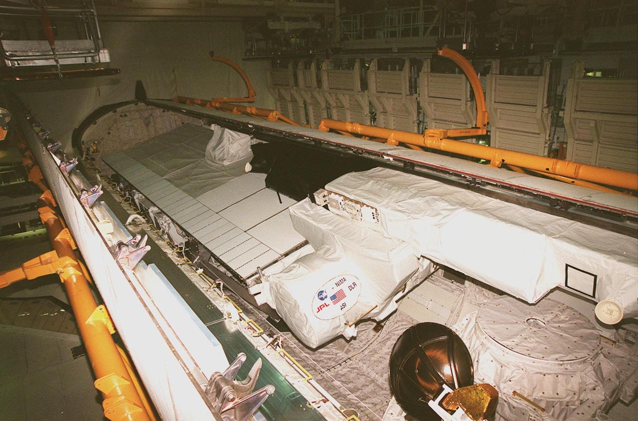
In the Space Station Processing Facility, STS-99 crew members take part in a simulated flight check of the Shuttle Radar Topography Mission (SRTM), above and behind them. The SRTM is the payload for their mission. The crew members are Commander Kevin R. Kregel, Pilot Dominic L. Pudwill Gorie, and Mission Specialists Janet Lynn kavandi (Ph.D.), Janice Voss (Ph.D.), Mamoru Mohri of Japan and Gerhard Thiele of Germany. Mohri represents the National Space Development Agency of Japan and Thiele represents the European Space Agency. An international project spearheaded by the National Imagery and Mapping Agency and NASA, with participation of the German Aerospace Center DLR, the SRTM consists of a specially modified radar system that will gather data for the most accurate and complete topographic map of the Earth's surface that has ever been assembled. SRTM will make use of radar interferometry, wherein two radar images are taken from slightly different locations. Differences between these images allow for the calculation of surface elevation, or change. The SRTM hardware will consist of one radar antenna in the shuttle payload bay and a second radar antenna attached to the end of a mast extended 60 meters (195 feet) out from the shuttle. STS-99 is scheduled to launch Sept. 16 at 8:47 a.m. from Launch Pad 39A
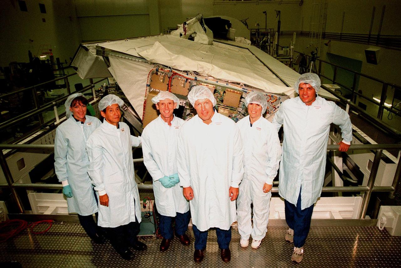
The STS-99 crew poses in front of the Shuttle Radar Topography Mission (SRTM) in the Space Station Processing Facility. The crew has been checking out the SRTM, which is the payload for their mission. From left are Mission Specialists Janet Lynn Kavandi (Ph.D.), Mamoru Mohri of Japan, and Gerhard Thiele of Germany; Pilot Dominic L. Pudwill Gorie; Mission Specialist Janice Voss (Ph.D.); and Commander Kevin R. Kregel. Mohri represents the National Space Development Agency of Japan and Thiele represents the European Space Agency. An international project spearheaded by the National Imagery and Mapping Agency and NASA, with participation of the German Aerospace Center DLR, the SRTM consists of a specially modified radar system that will gather data for the most accurate and complete topographic map of the Earth's surface that has ever been assembled. SRTM will make use of radar interferometry, wherein two radar images are taken from slightly different locations. Differences between these images allow for the calculation of surface elevation, or change. The SRTM hardware will consist of one radar antenna in the shuttle payload bay and a second radar antenna attached to the end of a mast extended 60 meters (195 feet) out from the shuttle. STS-99 is scheduled to launch Sept. 16 at 8:47 a.m. from Launch Pad 39A
In the Space Station Processing Facility, STS-99 crew members inspect the Shuttle Radar Topography Mission (SRTM), the payload for their mission. At left is Commander Kevin R. Kregel talking to Mission Specialist Janice Voss (Ph.D.); and Mission Specialists Gerhard Thiele of Germany and Mamoru Mohri of Japan farther back. In the foreground (back to camera) is Mission Specialist Janet Lynn Kavandi (Ph.D.). The final crew member (not shown) is Pilot Dominic L. Pudwill Gorie. Thiele represents the European Space Agency and Mohri represents the National Space Agency of Japan. An international project spearheaded by the National Imagery and Mapping Agency and NASA, with participation of the German Aerospace Center DLR, the SRTM consists of a specially modified radar system that will gather data for the most accurate and complete topographic map of the Earth's surface that has ever been assembled. SRTM will make use of radar interferometry, wherein two radar images are taken from slightly different locations. Differences between these images allow for the calculation of surface elevation, or change. The SRTM hardware will consist of one radar antenna in the shuttle payload bay and a second radar antenna attached to the end of a mast extended 60 meters (195 feet) out from the shuttle. STS-99 is scheduled to launch Sept. 16 at 8:47 a.m. from Launch Pad 39A
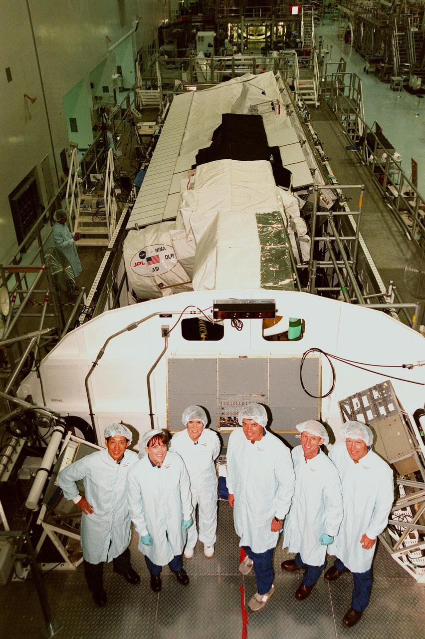
In the Space Station Processing Facility, the STS-99 crew pose in front of the Shuttle Radar Topography Mission, the payload for their mission. From left are Mission Specialists Mamoru Mohri of Japan, Janet Lynn Kavandi (Ph.D.), and Janice Voss (Ph.D.); Commander Kevin R. Kregel; Mission Specialist Gerhard Thiele of Germany; and Pilot Dominic L. Pudwill Gorie. Mohri represents the National Space Development Agency of Japan and Thiele represents the European Space Agency. An international project spearheaded by the National Imagery and Mapping Agency and NASA, with participation of the German Aerospace Center DLR, the SRTM consists of a specially modified radar system that will gather data for the most accurate and complete topographic map of the Earth's surface that has ever been assembled. SRTM will make use of radar interferometry, wherein two radar images are taken from slightly different locations. Differences between these images allow for the calculation of surface elevation, or change. The SRTM hardware will consist of one radar antenna in the shuttle payload bay and a second radar antenna attached to the end of a mast extended 60 meters (195 feet) out from the shuttle. STS-99 is scheduled to launch Sept. 16 at 8:47 a.m. from Launch Pad 39A
In the Space Station Processing Facility, the STS-99 crew looks over the payload for their mission, the Shuttle Radar Topography Mission (SRTM). Pointing to the SRTM are Commander Kevin R. Kregel and Mission Specialist Gerhard Thiele of Germany. Behind them are (left to right) Pilot Dominic L. Pudwill Gorie and Mission Specialists Mamoru Mohri of Japan and Janet Lynn Kavandi (Ph.D.) The remaining crew member (not shown) is Mission Specialist Janice Voss (Ph.D.) Mohri represents the National Space Development Agency of Japan and Thiele represents the European Space Agency. An international project spearheaded by the National Imagery and Mapping Agency and NASA, with participation of the German Aerospace Center DLR, the SRTM consists of a specially modified radar system that will gather data for the most accurate and complete topographic map of the Earth's surface that has ever been assembled. SRTM will make use of radar interferometry, wherein two radar images are taken from slightly different locations. Differences between these images allow for the calculation of surface elevation, or change. The SRTM hardware will consist of one radar antenna in the shuttle payload bay and a second radar antenna attached to the end of a mast extended 60 meters (195 feet) out from the shuttle. STS-99 is scheduled to launch Sept. 16 at 8:47 a.m. from Launch Pad 39A
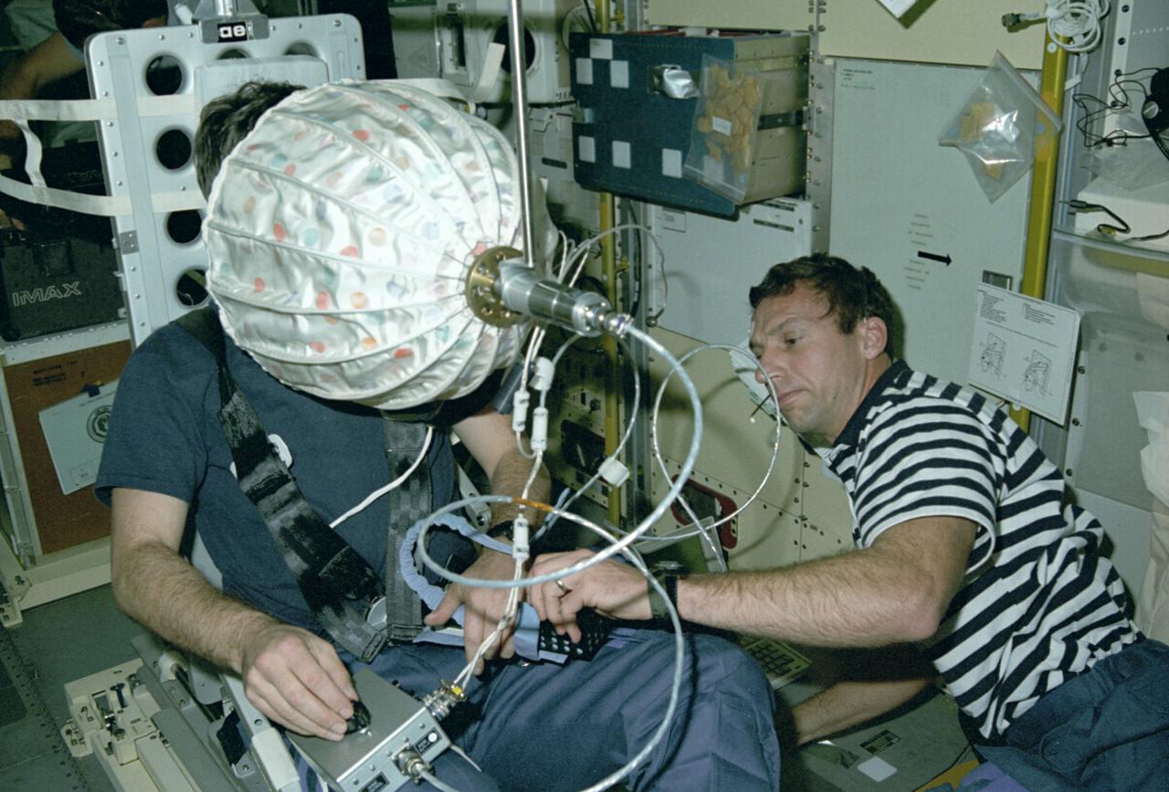
Astronaut David C. Hilmers conducts the Microgravity Vestibular Investigations (MVI) sitting in its rotator chair inside the IML-1 science module. When environmental conditions change so that the body receives new stimuli, the nervous system responds by interpreting the incoming sensory information differently. In space, the free-fall environment of an orbiting spacecraft requires that the body adapts to the virtual absence of gravity. Early in flights, crewmembers may feel disoriented or experience space motion sickness. MVI examined the effects of orbital flight on the human orientation system to obtain a better understanding of the mechanisms of adaptation to weightlessness. By provoking interactions among the vestibular, visual, and proprioceptive systems and then measuring the perceptual and sensorimotor reactions, scientists can study changes that are integral to the adaptive process. The IML-1 mission was the first in a series of Shuttle flights dedicated to fundamental materials and life sciences research with the international partners. The participating space agencies included: NASA, the 14-nation European Space Agency (ESA), the Canadian Space Agency (CSA), the French National Center of Space Studies (CNES), the German Space Agency and the German Aerospace Research Establishment (DAR/DLR), and the National Space Development Agency of Japan (NASDA). Both life and materials sciences benefited from the extended periods of microgravity available inside the Spacelab science module in the cargo bay of the Space Shuttle Orbiter. Managed by the Marshall Space Flight Center, IML-1 was launched on January 22, 1992 aboard the Space Shuttle Orbiter Discovery (STS-42 mission).
The IML-1 mission was the first in a series of Shuttle flights dedicated to fundamental materials and life sciences research with the international partners. The participating space agencies included: NASA, the 14-nation European Space Agency (ESA), the Canadian Space Agency (CSA), The French National Center of Space Studies (CNES), the German Space Agency and the German Aerospace Research Establishment (DAR/DLR), and the National Space Development Agency of Japan (NASDA). Dedicated to the study of life and materials sciences in microgravity, the IML missions explored how life forms adapt to weightlessness and investigated how materials behave when processed in space. Both life and materials sciences benefited from the extended periods of microgravity available inside the Spacelab science module in the cargo bay of the Space Shuttle Orbiter. This photograph shows Astronaut Norman Thagard performing the fluid experiment at the Fluid Experiment System (FES) facility inside the laboratory module. The FES facility had sophisticated optical systems for imaging fluid flows during materials processing, such as experiments to grow crystals from solution and solidify metal-modeling salts. A special laser diagnostic technique recorded the experiments, holograms were made for post-flight analysis, and video was used to view the samples in space and on the ground. Managed by the Marshall Space Flight Center (MSFC), the IML-1 mission was launched on January 22, 1992 aboard the Shuttle Orbiter Discovery (STS-42).
International Microgravity Laboratory-1 (IML-1) was the first in a series of Shuttle flights dedicated to fundamental materials and life sciences research with the international partners. The participating space agencies included: NASA, the 14-nation European Space Agency (ESA), the Canadian Space Agency (CSA), the French National Center of Space Studies (CNES), the German Space Agency and the German Aerospace Research Establishment (DAR/DLR), and the National Space Development Agency of Japan (NASDA). Dedicated to the study of life and materials sciences in microgravity, the IML missions explored how life forms adapt to weightlessness and investigated how materials behave when processed in space. Both life and materials sciences benefited from the extended periods of microgravity available inside the Spacelab science module in the cargo bay of the Space Shuttle Orbiter. In this photograph, Astronauts Stephen S. Oswald and Norman E. Thagard handle ampoules used in the Mercuric Iodide Crystal Growth (MICG) experiment. Mercury Iodide crystals have practical uses as sensitive x-ray and gamma-ray detectors. In addition to their exceptional electronic properties, these crystals can operate at room temperature rather than at the extremely low temperatures usually required by other materials. Because a bulky cooling system is urnecessary, these crystals could be useful in portable detector devices for nuclear power plant monitoring, natural resource prospecting, biomedical applications in diagnosis and therapy, and astronomical observation. Managed by the Marshall Space Flight Center, IML-1 was launched on January 22, 1992 aboard the Space Shuttle Orbiter Discovery (STS-42 mission).
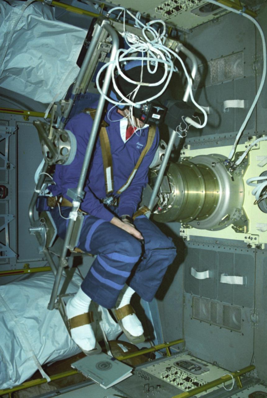
Astronaut Ulf Merbold on the stationary seat of the mini-sled, stares into an umbrella-shaped rotating dome with colored dots. Astronaut Merbold, assisted by astronaut David Hilmer, are conducting the Visual Simulator Experiment, a space physiology experiment. The Visual Stimulator Experiment measures the relative importance of visual and vestibular information in determining body orientation. When a person looks at a rotating visual field, a false sensation of self-rotation, called circularvection, results. In weightlessness, circularvection should increase immediately and may continue to increase as the nervous system comes to rely more on visual than vestibular cues. As Astronaut Merbold stares into the rotating dome with a pattern of colored dots and its interior, he turns a knob to indicate his perception of body rotation. The strength of circularvection is calculated by comparing signals from the dome and the knob. The greater the false sense of circularvection, the more the subject is relying on visual information instead of otolith information. The IML-1 mission was the first in a series of Shuttle flights dedicated to fundamental materials and life sciences research with the international partners. The participating space agencies included: NASA, the 14-nation European Space Agency (ESA), the Canadian Space Agency (CSA), the French National Center of Space Studies (CNES), the German Space Agency and the German Aerospace Research Establishment (DAR/DLR), and the National Space Development Agency of Japan (NASDA). Managed by the Marshall Space Flight Center, IML-1 was launched on January 22, 1992 aboard the Space Shuttle Orbiter Discovery (STS-42 mission).
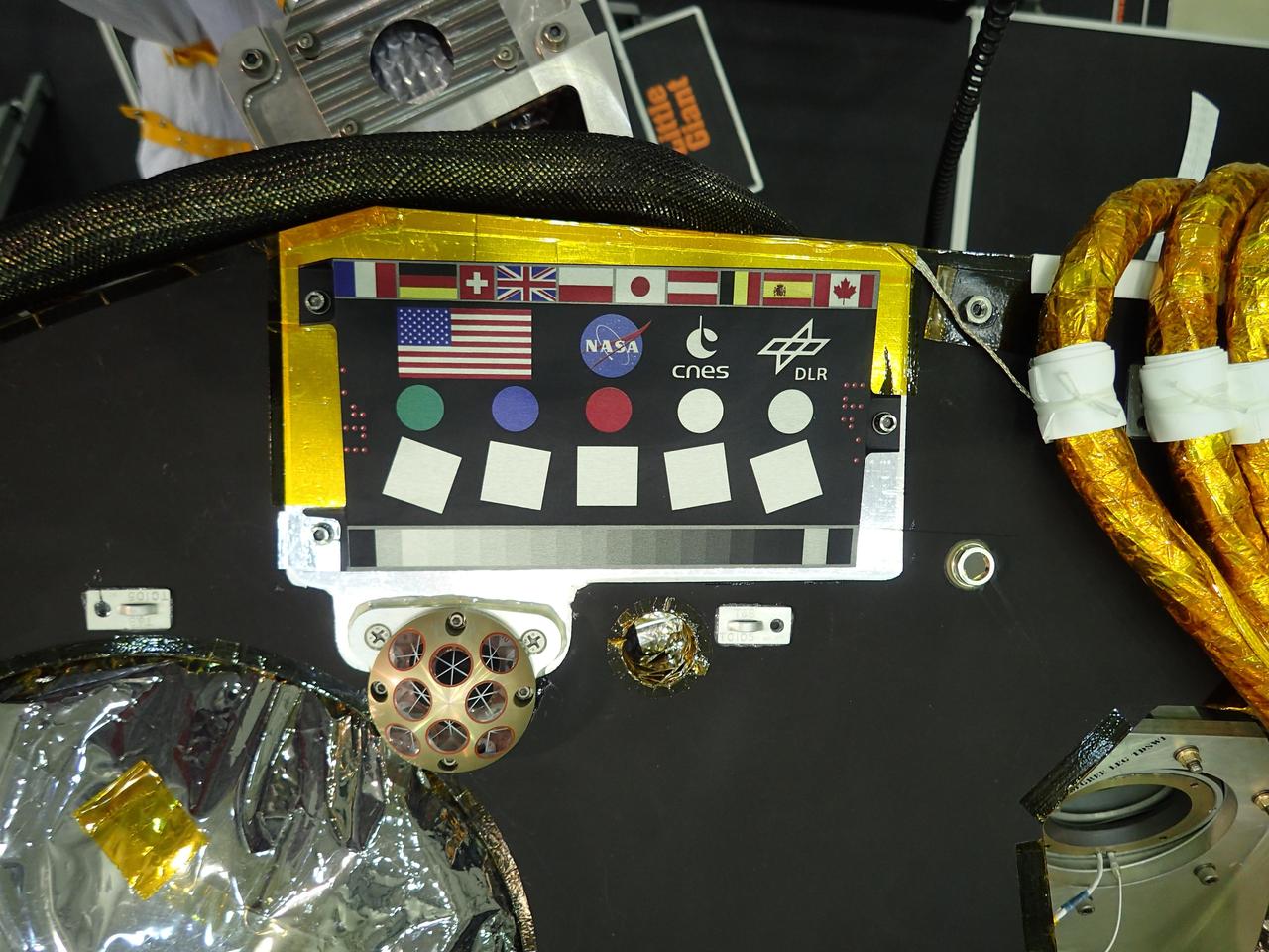
A camera calibration target sits on the deck of the NASA's InSight lander, adorned with the flags of the countries participating in the mission. The target, which will be viewed by InSight's cameras, provides a variety of colors and shapes to help calibrate the lander's cameras. It also shows off international flags representing the agencies, institutions and participating scientists of the mission as of late 2014 (since that time, Italy has contributed an experiment). In the second row are the United States flag and the logos of NASA, the French space agency CNES, which provided InSight's seismometer; and the German Aerospace Center DLR, which provided InSight's heat flow probe. Below the target in the photo is an Italian experiment called the Laser Retroreflector for InSight (LaRRI). LaRRI is the small, copper-colored dome covered with circles just below the calibration target; it won't actually play a role in InSight's mission. The national space agency of Italy (ASI, for Agenzia Spaziale Italiana) provided LaRRI to be used by a possible future Mars orbiter mission with a laser altimeter making extremely precise measurements of the lander's location for fundamental physics studies and precision cartography. A microchip bearing the names of nearly a million members of the public is visible in this image to the right of the calibration target. A second microchip with more than a million additional names was added after this photo was taken. https://photojournal.jpl.nasa.gov/catalog/PIA22540
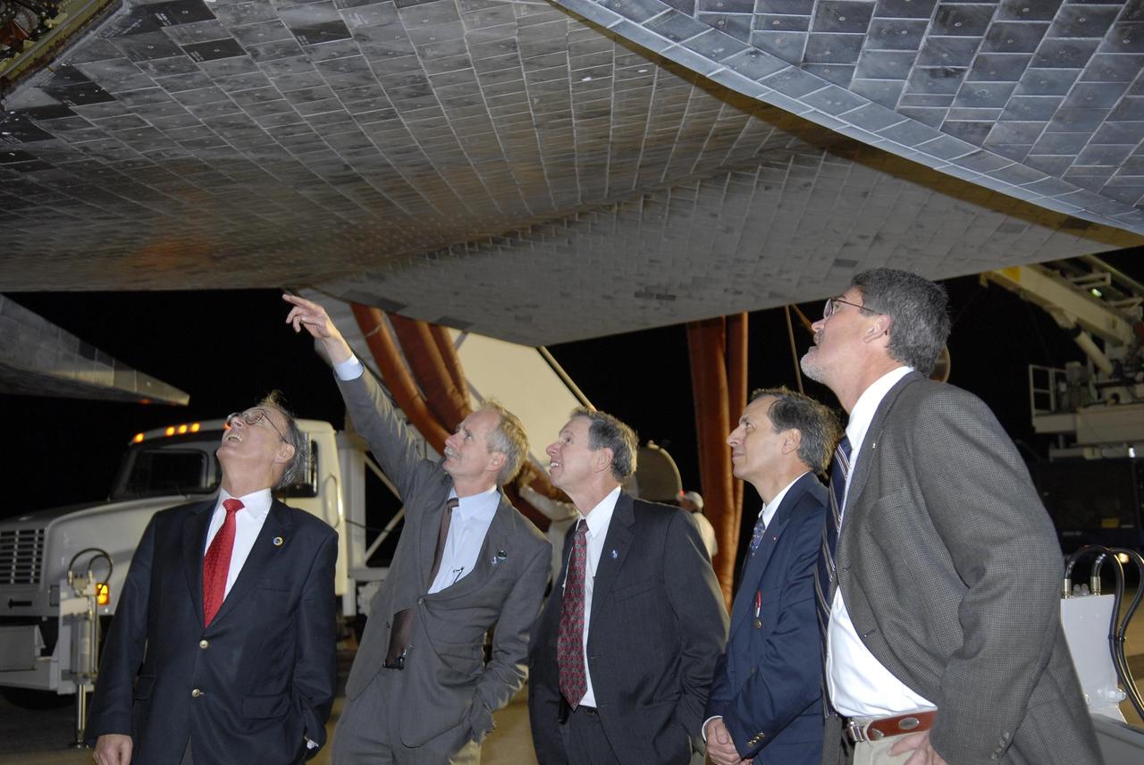
KENNEDY SPACE CENTER, FLA. -- Sigmar Wittig, head of the DLR, the German Space Agency; Bill Gerstenmaier, NASA associate administrator for Space Operations; Mike Griffin, NASA administrator; Michel Tognini, head of the European Astronaut Center; and Bill Parsons, Kennedy Space Center deputy director, examine the thermal protection system tiles beneath Space Shuttle Discovery following the landing of mission STS-116 on Runway 15 at NASA Kennedy Space Center's Shuttle Landing Facility. During the STS-116 mission, three spacewalks attached the P5 integrated truss structure to the station, and completed the rewiring of the orbiting laboratory's power system. A fourth spacewalk retracted a stubborn solar array. Main gear touchdown was at 5:32 p.m. EST. Nose gear touchdown was at 5:32:12 p.m. and wheel stop was at 5:32:52 p.m. At touchdown -- nominally about 2,500 ft. beyond the runway threshold -- the orbiter is traveling at a speed ranging from 213 to 226 mph. Discovery traveled 5,330,000 miles, landing on orbit 204. Mission elapsed time was 12 days, 20 hours, 44 minutes and 16 seconds. This is the 64th landing at KSC. Photo credit: NASA/Kim Shiflett
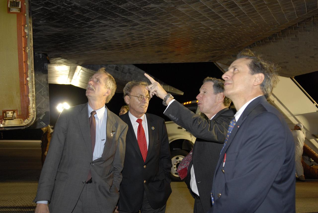
KENNEDY SPACE CENTER, FLA. -- Bill Gerstenmaier, NASA associate administrator for Space Operations; Sigmar Wittig, head of the DLR, the German Space Agency; Mike Griffin, NASA administrator; and Michel Tognini, head of the European Astronaut Center, examine the thermal protection system tiles beneath Space Shuttle Discovery following the landing of mission STS-116 on Runway 15 at NASA Kennedy Space Center's Shuttle Landing Facility. During the STS-116 mission, three spacewalks attached the P5 integrated truss structure to the station, and completed the rewiring of the orbiting laboratory's power system. A fourth spacewalk retracted a stubborn solar array. Main gear touchdown was at 5:32 p.m. EST. Nose gear touchdown was at 5:32:12 p.m. and wheel stop was at 5:32:52 p.m. At touchdown -- nominally about 2,500 ft. beyond the runway threshold -- the orbiter is traveling at a speed ranging from 213 to 226 mph. Discovery traveled 5,330,000 miles, landing on orbit 204. Mission elapsed time was 12 days, 20 hours, 44 minutes and 16 seconds. This is the 64th landing at KSC. Photo credit: NASA/Kim Shiflett
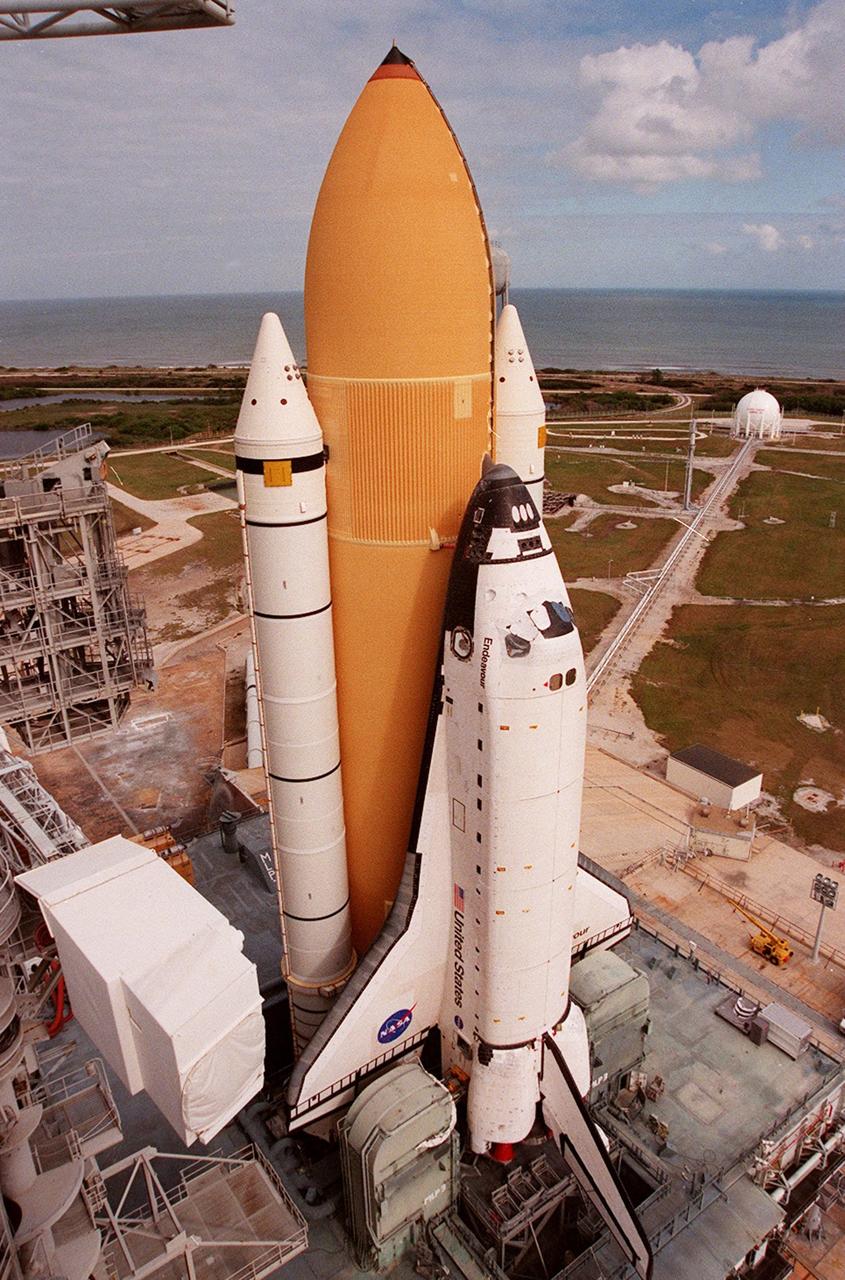
KENNEDY SPACE CENTER, Fla. -- Under partly cloudy skies and the Atlantic Ocean as a backdrop, Space Shuttle Endeavour, atop the mobile launcher platform, arrives at Launch Pad 39A for mission STS-99. The white cubicle at left is the environmental chamber, the White Room, that provides entry into the orbiter for the astronauts. It is at the outer end of the Orbiter Access Arm on the Fixed Service Structure. STS-99, named the Shuttle Radar Topography Mission (SRTM), involves an international project spearheaded by the National Imagery and Mapping Agency and NASA, with participation of the German Aerospace Center DLR. SRTM will chart a new course, using two antennae and a 200-foot-long section of space station-derived mast protruding from its payload bay, to produce unrivaled 3-D images of the Earth's surface. The result of the Shuttle Radar Topography Mission could be close to 1 trillion measurements of the Earth's topography. Besides contributing to the production of better maps, these measurements could lead to improved water drainage modeling, more realistic flight simulators, better locations for cell phone towers, and enhanced navigation safety. STS-99 is scheduled for launch in January 2000
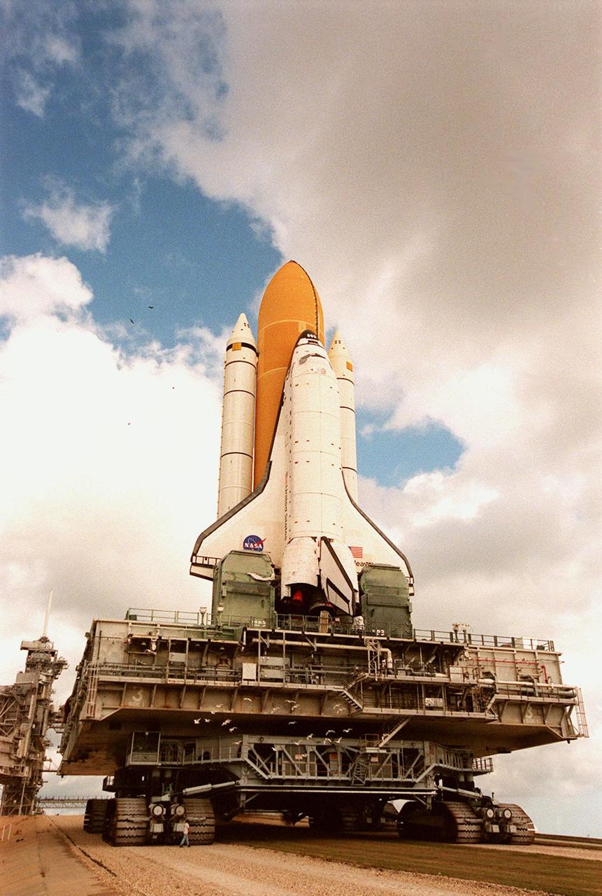
KENNEDY SPACE CENTER, Fla. -- Under breaking clouds, Space Shuttle Endeavour, atop the mobile launcher platform and crawler-transporter, crawls its way to Launch Pad 39A for mission STS-99. Named the Shuttle Radar Topography Mission (SRTM), STS-99 involves an international project spearheaded by the National Imagery and Mapping Agency and NASA, with participation of the German Aerospace Center DLR. SRTM will chart a new course, using two antennae and a 200-foot-long section of space station-derived mast protruding from its payload bay, to produce unrivaled 3-D images of the Earth's surface. The result of the Shuttle Radar Topography Mission could be close to 1 trillion measurements of the Earth's topography. Besides contributing to the production of better maps, these measurements could lead to improved water drainage modeling, more realistic flight simulators, better locations for cell phone towers, and enhanced navigation safety. STS-99 is scheduled for launch in January 2000
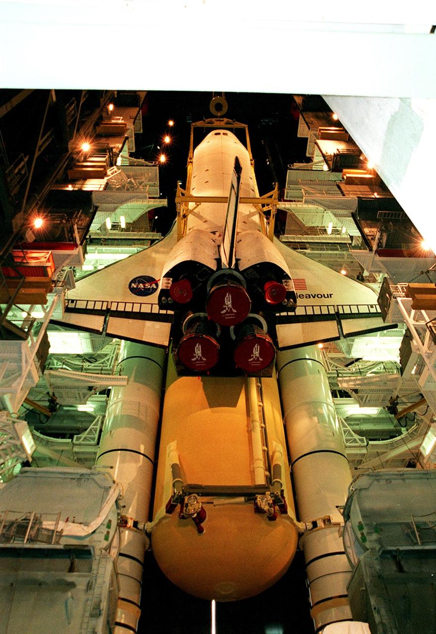
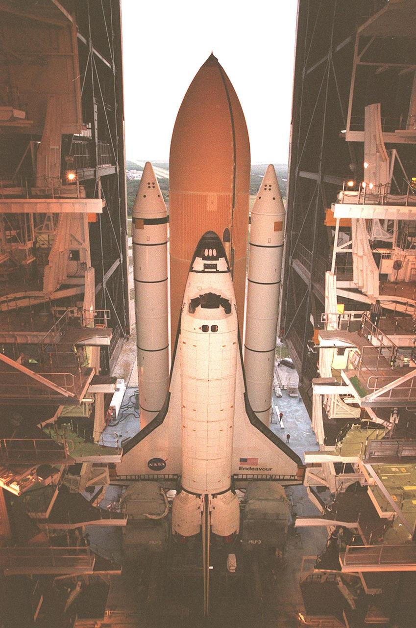
KENNEDY SPACE CENTER, FLA. -- Viewed from the ground level in high bay 1 of the VAB, the orbiter Endeavour seems to float in mid-air as it is lowered for mating with the external tank and solid rocket boosters behind and below it. Space Shuttle Endeavour is targeted for launch on mission STS-99 Jan. 13, 2000, at 1:11 p.m. EST. STS-99 is the Shuttle Radar Topography Mission, an international project spearheaded by the National Imagery and Mapping Agency and NASA, with participation of the German Aerospace Center DLR. The SRTM consists of a specially modified radar system that will gather data for the most accurate and complete topographic map of the Earth's surface that has ever been assembled. SRTM will make use of radar interferometry, wherein two radar images are taken from slightly different locations. Differences between these images allow for the calculation of surface elevation, or change. The SRTM hardware will consist of one radar antenna in the shuttle payload bay and a second radar antenna attached to the end of a mast extended 60 meters (195 feet) out from the shuttle
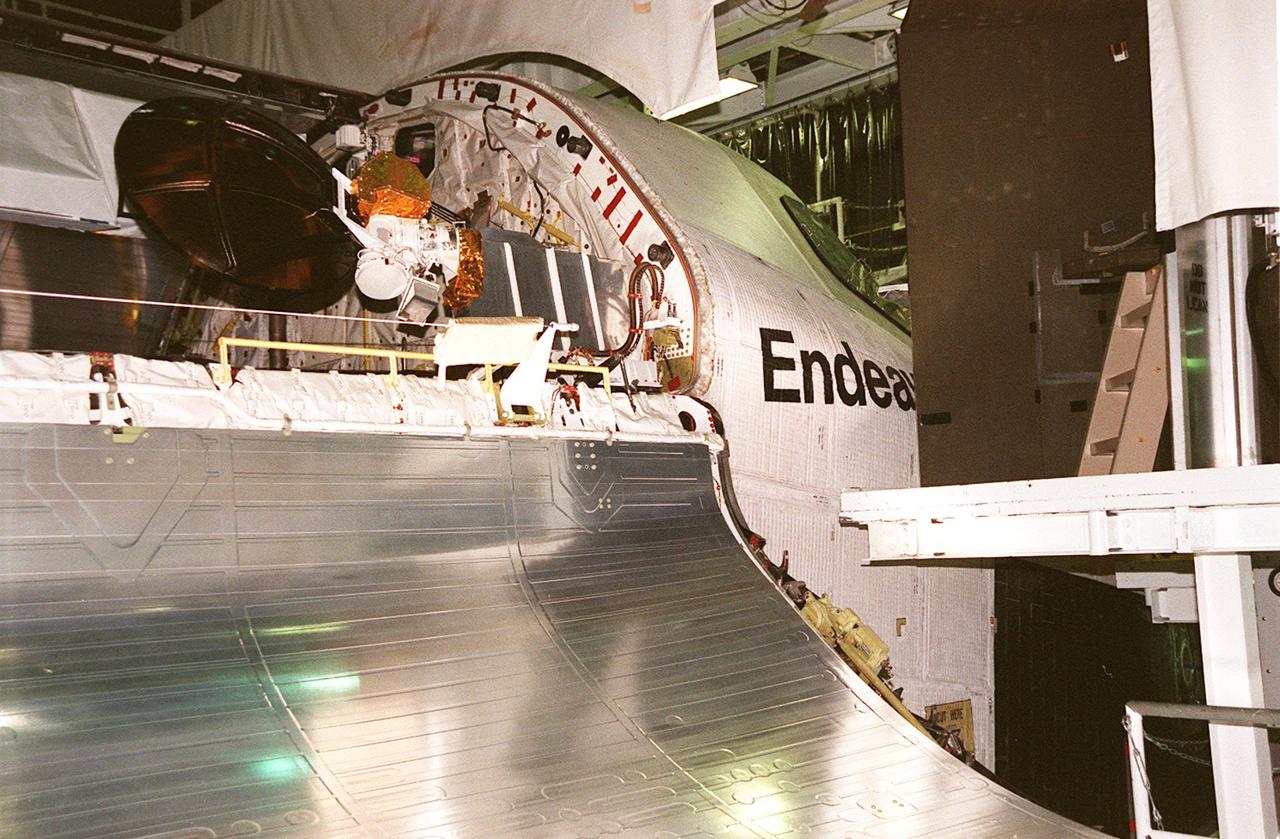
KENNEDY SPACE CENTER, FLA. -- Orbiter Endeavour waits in the Orbiter Processing Facility bay 2 for the closing of its payload bay doors. The Ku-band antenna (upper right) is now in its closed position inside the payload bay. Endeavour is expected to roll over to the Vehicle Assembly Building in three days for mating to the external tank and solid rocket boosters in high bay 1. Space Shuttle Endeavour is targeted for launch on mission STS-99 Jan. 13, 2000 at 1:11 p.m. EST. STS-99 is the Shuttle Radar Topography Mission, an international project spearheaded by the National Imagery and Mapping Agency and NASA, with participation of the German Aerospace Center DLR. The SRTM consists of a specially modified radar system that will gather data for the most accurate and complete topographic map of the Earth's surface that has ever been assembled. SRTM will make use of radar interferometry, wherein two radar images are taken from slightly different locations. Differences between these images allow for the calculation of surface elevation, or change. The SRTM hardware will consist of one radar antenna in the shuttle payload bay and a second radar antenna attached to the end of a mast extended 60 meters (195 feet) out from the shuttle

After being lifted off the transporter (lower right) in the Space Station Processing Facility, the Shuttle Radar Topography Mission (SRTM) moves across the floor toward a workstand. The SRTM, which is the primary payload on mission STS-99, consists of a specially modified radar system that will fly onboard the Space Shuttle during the 11-day mission scheduled for launch in September 1999. The objective of this radar system is to obtain the most complete high-resolution digital topographic database of the Earth. It will gather data that will result in the most accurate and complete topographic map of the Earth's surface that has ever been assembled. SRTM is an international project spearheaded by the National Imagery and Mapping Agency and NASA, with participation of the German Aerospace Center DLR. SRTM will be making use of a technique called radar interferometry, wherein two radar images are taken from slightly different locations. Differences between these images allow for the calculation of surface elevation, or change. To get two radar images taken from different locations, the SRTM hardware will consist of one radar antenna in the shuttle payload bay and a second radar antenna attached to the end of a mast extended 60 meters (195 feet) out from the shuttle
Workers inside the Space Station Processing Facility keep watch as an overhead crane begins lifting the Shuttle Radar Topography Mission (SRTM) from the transporter below. The SRTM is being moved to a workstand. The primary payload on mission STS-99, the SRTM consists of a specially modified radar system that will fly onboard the Space Shuttle during the 11-day mission scheduled for launch in September 1999. The objective of this radar system is to obtain the most complete high-resolution digital topographic database of the Earth. It will gather data that will result in the most accurate and complete topographic map of the Earth's surface that has ever been assembled. SRTM is an international project spearheaded by the National Imagery and Mapping Agency and NASA, with participation of the German Aerospace Center DLR. SRTM will be making use of a technique called radar interferometry, wherein two radar images are taken from slightly different locations. Differences between these images allow for the calculation of surface elevation, or change. To get two radar images taken from different locations, the SRTM hardware will consist of one radar antenna in the shuttle payload bay and a second radar antenna attached to the end of a mast extended 60 meters (195 feet) out from the shuttle
KENNEDY SPACE CENTER, FLA. -- Workers at KSC lead the way as Orbiter Endeavour, on an orbiter transfer vehicle, rolls from the Orbiter Processing Facility to the Vehicle Assembly Building, where it will be mated to the external tank and solid rocket boosters in high bay 1. Space Shuttle Endeavour is targeted for launch on mission STS-99 Jan. 13, 2000 at 1:11 p.m. EST. STS-99 is the Shuttle Radar Topography Mission, an international project spearheaded by the National Imagery and Mapping Agency and NASA, with participation of the German Aerospace Center DLR. The SRTM consists of a specially modified radar system that will gather data for the most accurate and complete topographic map of the Earth's surface that has ever been assembled. SRTM will make use of radar interferometry, wherein two radar images are taken from slightly different locations. Differences between these images allow for the calculation of surface elevation, or change. The SRTM hardware will consist of one radar antenna in the shuttle payload bay and a second radar antenna attached to the end of a mast extended 60 meters (195 feet) out from the shuttle
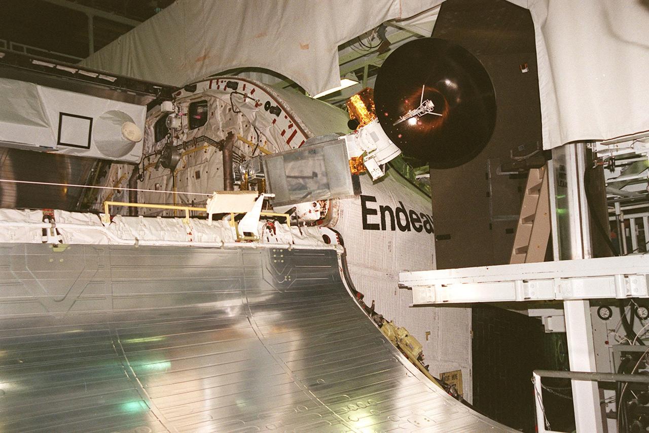
KENNEDY SPACE CENTER, FLA. -- Viewed end to end, the interior of orbiter Endeavour's payload bay can be seen with its cargo (center and right) in place, before the close of its payload bay doors. The Ku-band antenna (lower right) is now in its closed position inside the payload bay. Endeavour is expected to roll over to the Vehicle Assembly Building in three days for mating to the external tank and solid rocket boosters in high bay 1. Space Shuttle Endeavour is targeted for launch on mission STS-99 Jan. 13, 2000 at 1:11 p.m. EST. STS-99 is the Shuttle Radar Topography Mission, an international project spearheaded by the National Imagery and Mapping Agency and NASA, with participation of the German Aerospace Center DLR. The SRTM consists of a specially modified radar system that will gather data for the most accurate and complete topographic map of the Earth's surface that has ever been assembled. SRTM will make use of radar interferometry, wherein two radar images are taken from slightly different locations. Differences between these images allow for the calculation of surface elevation, or change. The SRTM hardware will consist of one radar antenna in the shuttle payload bay and a second radar antenna attached to the end of a mast extended 60 meters (195 feet) out from the shuttle
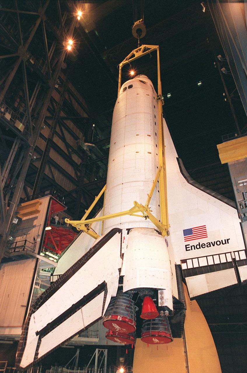
KENNEDY SPACE CENTER, FLA. -- In high bay 1 of the VAB, the orbiter Endeavour is lowered for mating with the external tank below (on right), and the solid rocket boosters. Space Shuttle Endeavour is targeted for launch on mission STS-99 Jan. 13, 2000, at 1:11 p.m. EST. STS-99 is the Shuttle Radar Topography Mission, an international project spearheaded by the National Imagery and Mapping Agency and NASA, with participation of the German Aerospace Center DLR. The SRTM consists of a specially modified radar system that will gather data for the most accurate and complete topographic map of the Earth's surface that has ever been assembled. SRTM will make use of radar interferometry, wherein two radar images are taken from slightly different locations. Differences between these images allow for the calculation of surface elevation, or change. The SRTM hardware will consist of one radar antenna in the shuttle payload bay and a second radar antenna attached to the end of a mast extended 60 meters (195 feet) out from the shuttle
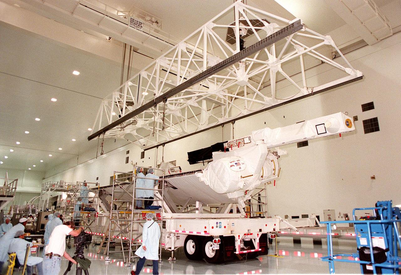
Inside the Space Station Processing Facility, workers watch as an overhead crane is lowered for lifting the Shuttle Radar Topography Mission (SRTM) from the transporter it is resting on. The SRTM is being moved to a workstand. The primary payload on mission STS-99, the SRTM consists of a specially modified radar system that will fly onboard the Space Shuttle during the 11-day mission scheduled for launch in September 1999. The objective of this radar system is to obtain the most complete high-resolution digital topographic database of the Earth. It will gather data that will result in the most accurate and complete topographic map of the Earth's surface that has ever been assembled. SRTM is an international project spearheaded by the National Imagery and Mapping Agency and NASA, with participation of the German Aerospace Center DLR. SRTM will be making use of a technique called radar interferometry, wherein two radar images are taken from slightly different locations. Differences between these images allow for the calculation of surface elevation, or change. To get two radar images taken from different locations, the SRTM hardware will consist of one radar antenna in the shuttle payload bay and a second radar antenna attached to the end of a mast extended 60 meters (195 feet) out from the shuttle
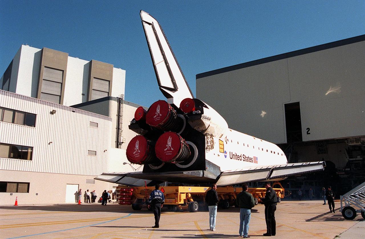
KENNEDY SPACE CENTER, FLA. -- Orbiter Endeavour rolls out of the Orbiter Processing Facility bay 2 for transfer to the Vehicle Assembly Building. There it will be mated to the external tank and solid rocket boosters in high bay 1. Space Shuttle Endeavour is targeted for launch on mission STS-99 Jan. 13, 2000 at 1:11 p.m. EST. STS-99 is the Shuttle Radar Topography Mission, an international project spearheaded by the National Imagery and Mapping Agency and NASA, with participation of the German Aerospace Center DLR. The SRTM consists of a specially modified radar system that will gather data for the most accurate and complete topographic map of the Earth's surface that has ever been assembled. SRTM will make use of radar interferometry, wherein two radar images are taken from slightly different locations. Differences between these images allow for the calculation of surface elevation, or change. The SRTM hardware will consist of one radar antenna in the shuttle payload bay and a second radar antenna attached to the end of a mast extended 60 meters (195 feet) out from the shuttle
KENNEDY SPACE CENTER, FLA. -- Lights frame the orbiter Endeavour as it is lowered onto the platform for mating with the external tank and solid rocket boosters. Space Shuttle Endeavour is targeted for launch on mission STS-99 Jan. 13, 2000, at 1:11 p.m. EST. STS-99 is the Shuttle Radar Topography Mission, an international project spearheaded by the National Imagery and Mapping Agency and NASA, with participation of the German Aerospace Center DLR. The SRTM consists of a specially modified radar system that will gather data for the most accurate and complete topographic map of the Earth's surface that has ever been assembled. SRTM will make use of radar interferometry, wherein two radar images are taken from slightly different locations. Differences between these images allow for the calculation of surface elevation, or change. The SRTM hardware will consist of one radar antenna in the shuttle payload bay and a second radar antenna attached to the end of a mast extended 60 meters (195 feet) out from the shuttle
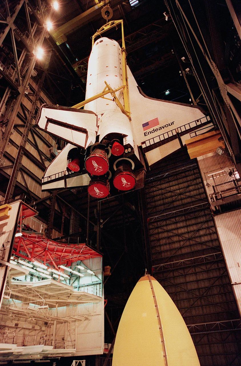
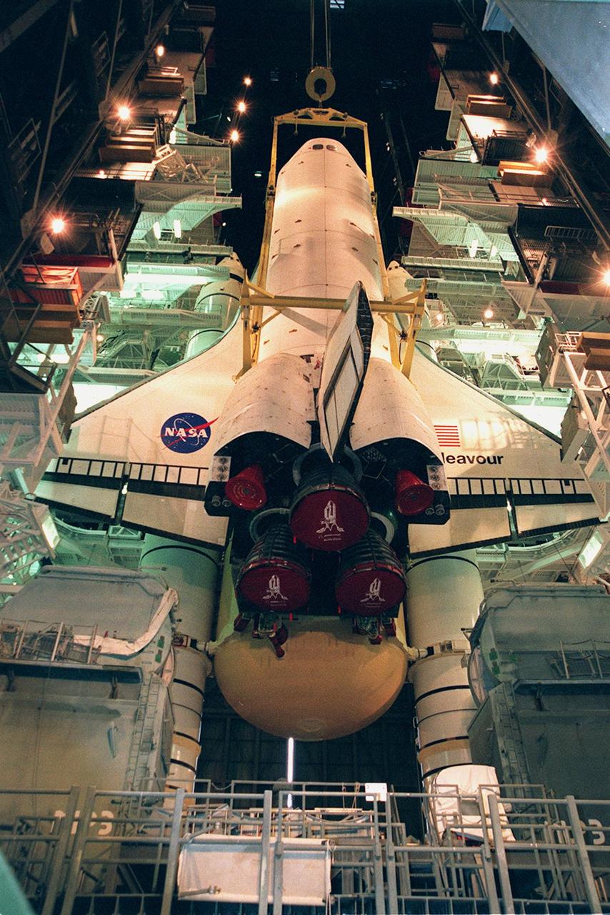
KENNEDY SPACE CENTER, FLA. -- Inside the VAB, orbiter Endeavour is lifted to a vertical position before being mated to the external tank (bottom of photo) and solid rocket boosters in high bay 1. Space Shuttle Endeavour is targeted for launch on mission STS-99 Jan. 13, 2000, at 1:11 p.m. EST. STS-99 is the Shuttle Radar Topography Mission, an international project spearheaded by the National Imagery and Mapping Agency and NASA, with participation of the German Aerospace Center DLR. The SRTM consists of a specially modified radar system that will gather data for the most accurate and complete topographic map of the Earth's surface that has ever been assembled. SRTM will make use of radar interferometry, wherein two radar images are taken from slightly different locations. Differences between these images allow for the calculation of surface elevation, or change. The SRTM hardware will consist of one radar antenna in the shuttle payload bay and a second radar antenna attached to the end of a mast extended 60 meters (195 feet) out from the shuttle
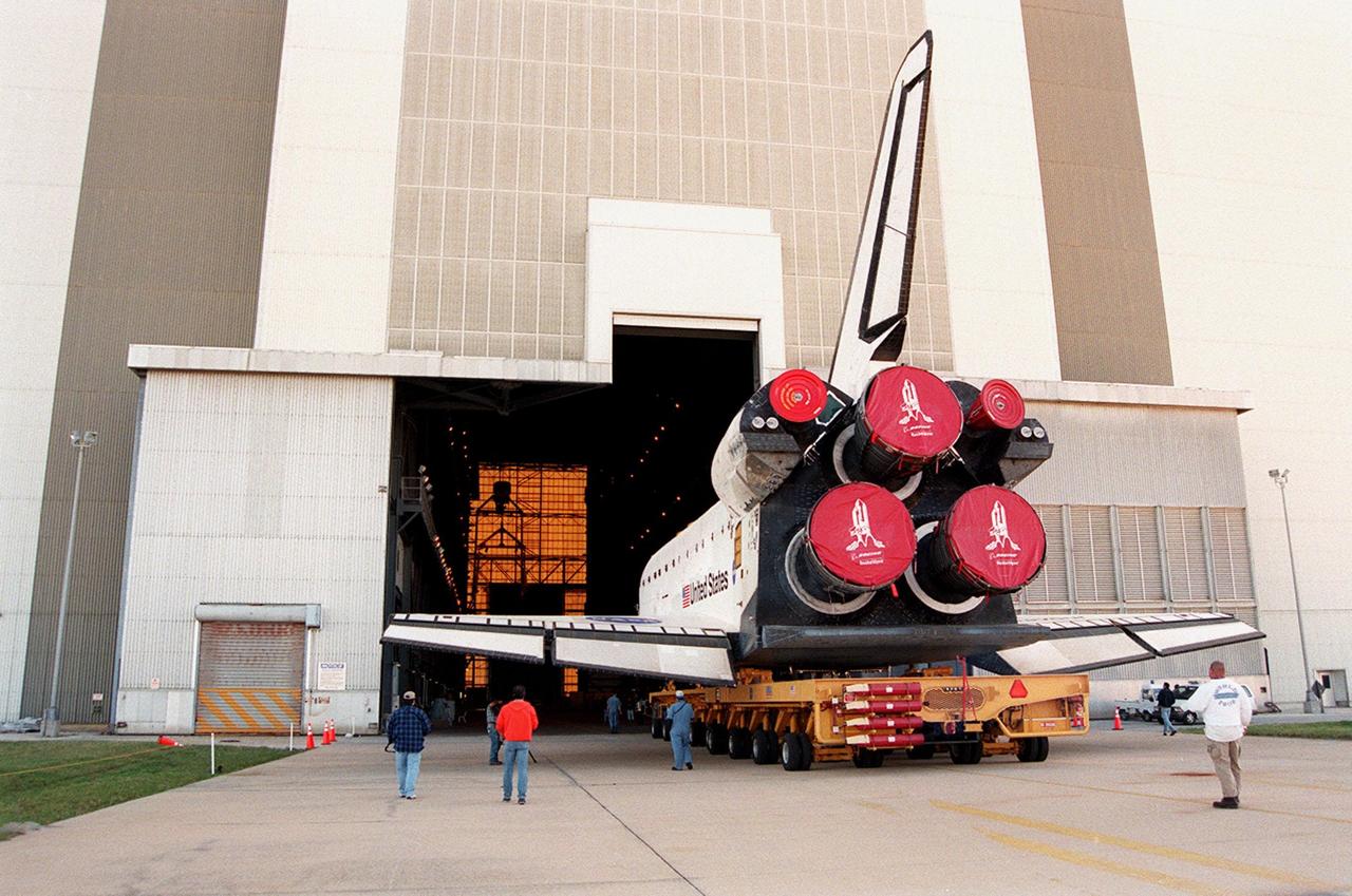
KENNEDY SPACE CENTER, FLA. -- Orbiter Endeavour rolls into the Vehicle Assembly Building on its orbiter transfer vehicle. In high bay 1 it will be mated to the external tank and solid rocket boosters. Space Shuttle Endeavour is targeted for launch on mission STS-99 Jan. 13, 2000 at 1:11 p.m. EST. STS-99 is the Shuttle Radar Topography Mission, an international project spearheaded by the National Imagery and Mapping Agency and NASA, with participation of the German Aerospace Center DLR. The SRTM consists of a specially modified radar system that will gather data for the most accurate and complete topographic map of the Earth's surface that has ever been assembled. SRTM will make use of radar interferometry, wherein two radar images are taken from slightly different locations. Differences between these images allow for the calculation of surface elevation, or change. The SRTM hardware will consist of one radar antenna in the shuttle payload bay and a second radar antenna attached to the end of a mast extended 60 meters (195 feet) out from the shuttle
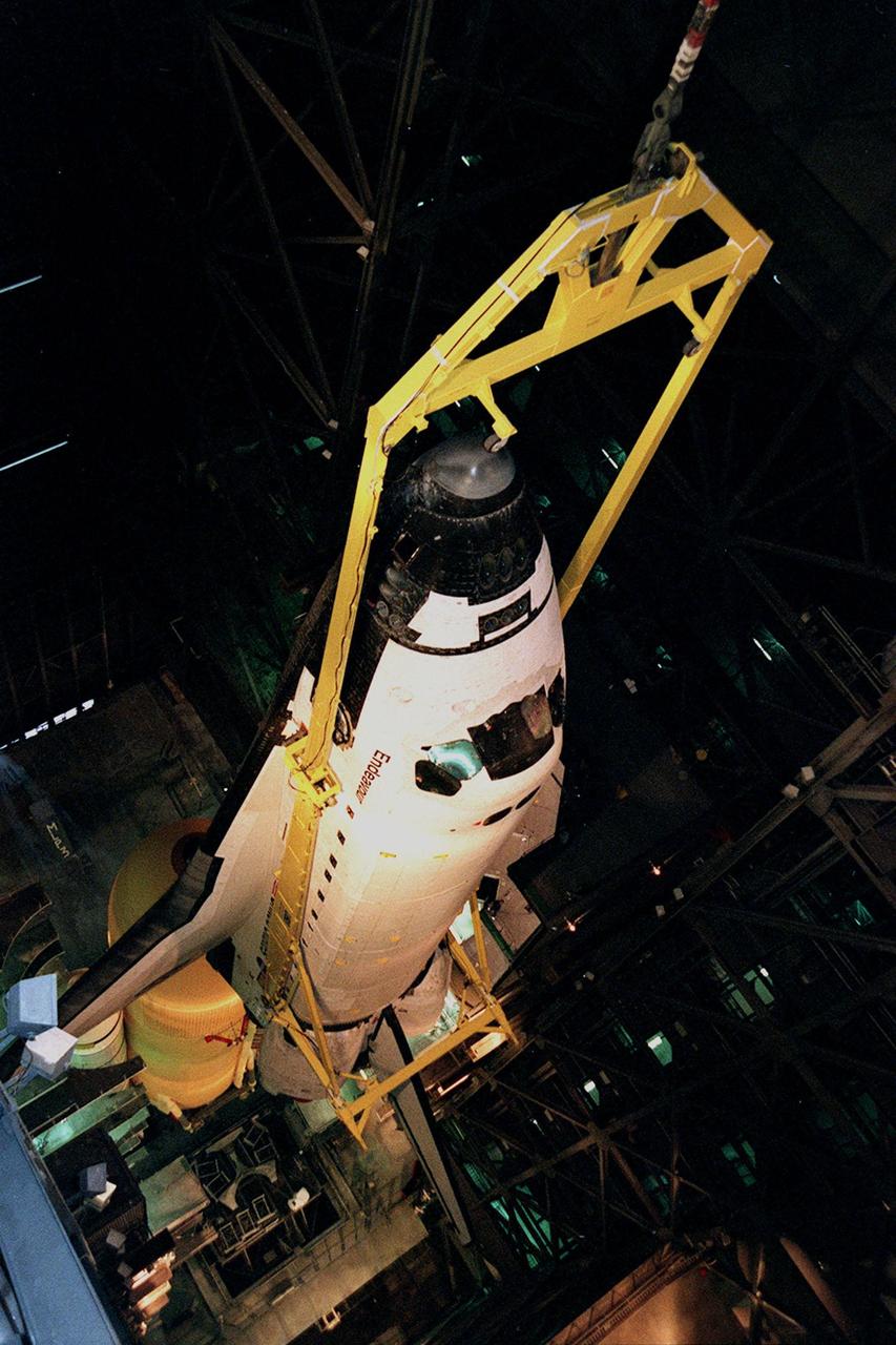
KENNEDY SPACE CENTER, FLA. -- In this dizzying view from overhead in high bay 1 of the VAB, the orbiter Endeavour is lowered for mating with the external tank below (on left), and the solid rocket boosters. Space Shuttle Endeavour is targeted for launch on mission STS-99 Jan. 13, 2000, at 1:11 p.m. EST. STS-99 is the Shuttle Radar Topography Mission, an international project spearheaded by the National Imagery and Mapping Agency and NASA, with participation of the German Aerospace Center DLR. The SRTM consists of a specially modified radar system that will gather data for the most accurate and complete topographic map of the Earth's surface that has ever been assembled. SRTM will make use of radar interferometry, wherein two radar images are taken from slightly different locations. Differences between these images allow for the calculation of surface elevation, or change. The SRTM hardware will consist of one radar antenna in the shuttle payload bay and a second radar antenna attached to the end of a mast extended 60 meters (195 feet) out from the shuttle
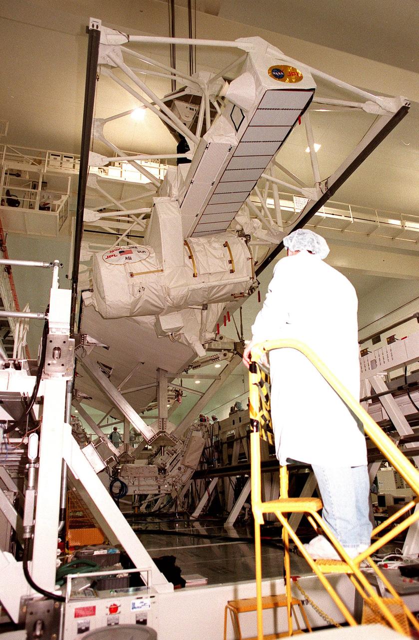
Inside the Space Station Processing Facility, workers at each end of a workstand watch as the Shuttle Radar Topography Mission (SRTM) begins its descent onto it. The SRTM, which is the primary payload on mission STS-99, consists of a specially modified radar system that will fly onboard the Space Shuttle during the 11-day mission scheduled for launch in September 1999. The objective of this radar system is to obtain the most complete high-resolution digital topographic database of the Earth. It will gather data that will result in the most accurate and complete topographic map of the Earth's surface that has ever been assembled. SRTM is an international project spearheaded by the National Imagery and Mapping Agency and NASA, with participation of the German Aerospace Center DLR. SRTM will be making use of a technique called radar interferometry, wherein two radar images are taken from slightly different locations. Differences between these images allow for the calculation of surface elevation, or change. To get two radar images taken from different locations, the SRTM hardware will consist of one radar antenna in the shuttle payload bay and a second radar antenna attached to the end of a mast extended 60 meters (195 feet) out from the shuttle

STS-99 Mission Specialist Janice Voss conducts a system verification test on the Shuttle Radar Topography Mission in the Space Station Processing Facility. The primary payload on mission STS-99, the SRTM consists of a specially modified radar system that will fly onboard the Space Shuttle during the 11-day mission targeted for launch Sept. 16, 1999. This radar system will gather data for the most accurate and complete topographic map of the Earth's surface that has ever been assembled. SRTM is an international project spearheaded by the National Imagery and Mapping Agency and NASA, with participation of the German Aerospace Center DLR. SRTM will make use of radar interferometry, wherein two radar images are taken from slightly different locations. Differences between these images allow for the calculation of surface elevation, or change. The SRTM hardware will consist of one radar antenna in the shuttle payload bay and a second radar antenna attached to the end of a mast extended 60 meters (195 feet) out from the shuttle
KENNEDY SPACE CENTER, FLA. -- Orbiter Endeavour waits in the Orbiter Processing Facility bay 2 for the closing of its payload bay doors. The Ku-band antenna (upper right) is still in the open position, outside the payload bay. Endeavour is expected to roll over to the Vehicle Assembly Building in three days for mating to the external tank and solid rocket boosters in high bay 1. Space Shuttle Endeavour is targeted for launch on mission STS-99 Jan. 13, 2000 at 1:11 p.m. EST. STS-99 is the Shuttle Radar Topography Mission, an international project spearheaded by the National Imagery and Mapping Agency and NASA, with participation of the German Aerospace Center DLR. The SRTM consists of a specially modified radar system that will gather data for the most accurate and complete topographic map of the Earth's surface that has ever been assembled. SRTM will make use of radar interferometry, wherein two radar images are taken from slightly different locations. Differences between these images allow for the calculation of surface elevation, or change. The SRTM hardware will consist of one radar antenna in the shuttle payload bay and a second radar antenna attached to the end of a mast extended 60 meters (195 feet) out from the shuttle
Inside the Space Station Processing Facility, the Shuttle Radar Topography Mission (SRTM) is maneuvered by an overhead crane toward a workstand below. The SRTM, which is the primary payload on mission STS-99, consists of a specially modified radar system that will fly onboard the Space Shuttle during the 11-day mission scheduled for launch in September 1999. The objective of this radar system is to obtain the most complete high-resolution digital topographic database of the Earth. It will gather data that will result in the most accurate and complete topographic map of the Earth's surface that has ever been assembled. SRTM is an international project spearheaded by the National Imagery and Mapping Agency and NASA, with participation of the German Aerospace Center DLR. SRTM will be making use of a technique called radar interferometry, wherein two radar images are taken from slightly different locations. Differences between these images allow for the calculation of surface elevation, or change. To get two radar images taken from different locations, the SRTM hardware will consist of one radar antenna in the shuttle payload bay and a second radar antenna attached to the end of a mast extended 60 meters (195 feet) out from the shuttle
The move of the Shuttle Radar Topography Mission (SRTM) is nearly complete as it is lowered onto the workstand in the Space Station Processing Facility. The SRTM, which is the primary payload on mission STS-99, consists of a specially modified radar system that will fly onboard the Space Shuttle during the 11-day mission scheduled for launch in September 1999. The objective of this radar system is to obtain the most complete high-resolution digital topographic database of the Earth. It will gather data that will result in the most accurate and complete topographic map of the Earth's surface that has ever been assembled. SRTM is an international project spearheaded by the National Imagery and Mapping Agency and NASA, with participation of the German Aerospace Center DLR. SRTM will be making use of a technique called radar interferometry, wherein two radar images are taken from slightly different locations. Differences between these images allow for the calculation of surface elevation, or change. To get two radar images taken from different locations, the SRTM hardware will consist of one radar antenna in the shuttle payload bay and a second radar antenna attached to the end of a mast extended 60 meters (195 feet) out from the shuttle
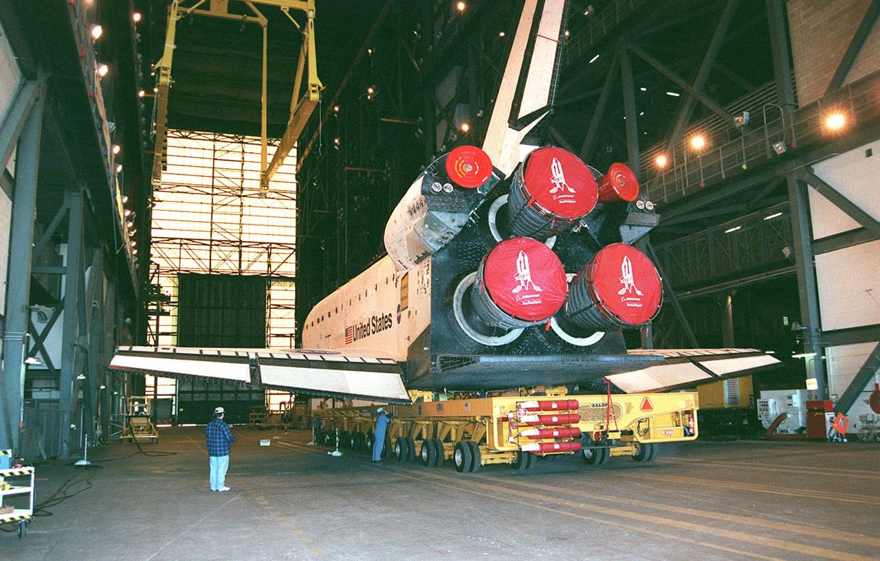
KENNEDY SPACE CENTER, FLA. -- Orbiter Endeavour rolls inside the Vehicle Assembly Building where it will be lifted to vertical and mated to the external tank and solid rocket boosters in high bay 1. Space Shuttle Endeavour is targeted for launch on mission STS-99 Jan. 13, 2000 at 1:11 p.m. EST. STS-99 is the Shuttle Radar Topography Mission, an international project spearheaded by the National Imagery and Mapping Agency and NASA, with participation of the German Aerospace Center DLR. The SRTM consists of a specially modified radar system that will gather data for the most accurate and complete topographic map of the Earth's surface that has ever been assembled. SRTM will make use of radar interferometry, wherein two radar images are taken from slightly different locations. Differences between these images allow for the calculation of surface elevation, or change. The SRTM hardware will consist of one radar antenna in the shuttle payload bay and a second radar antenna attached to the end of a mast extended 60 meters (195 feet) out from the shuttle
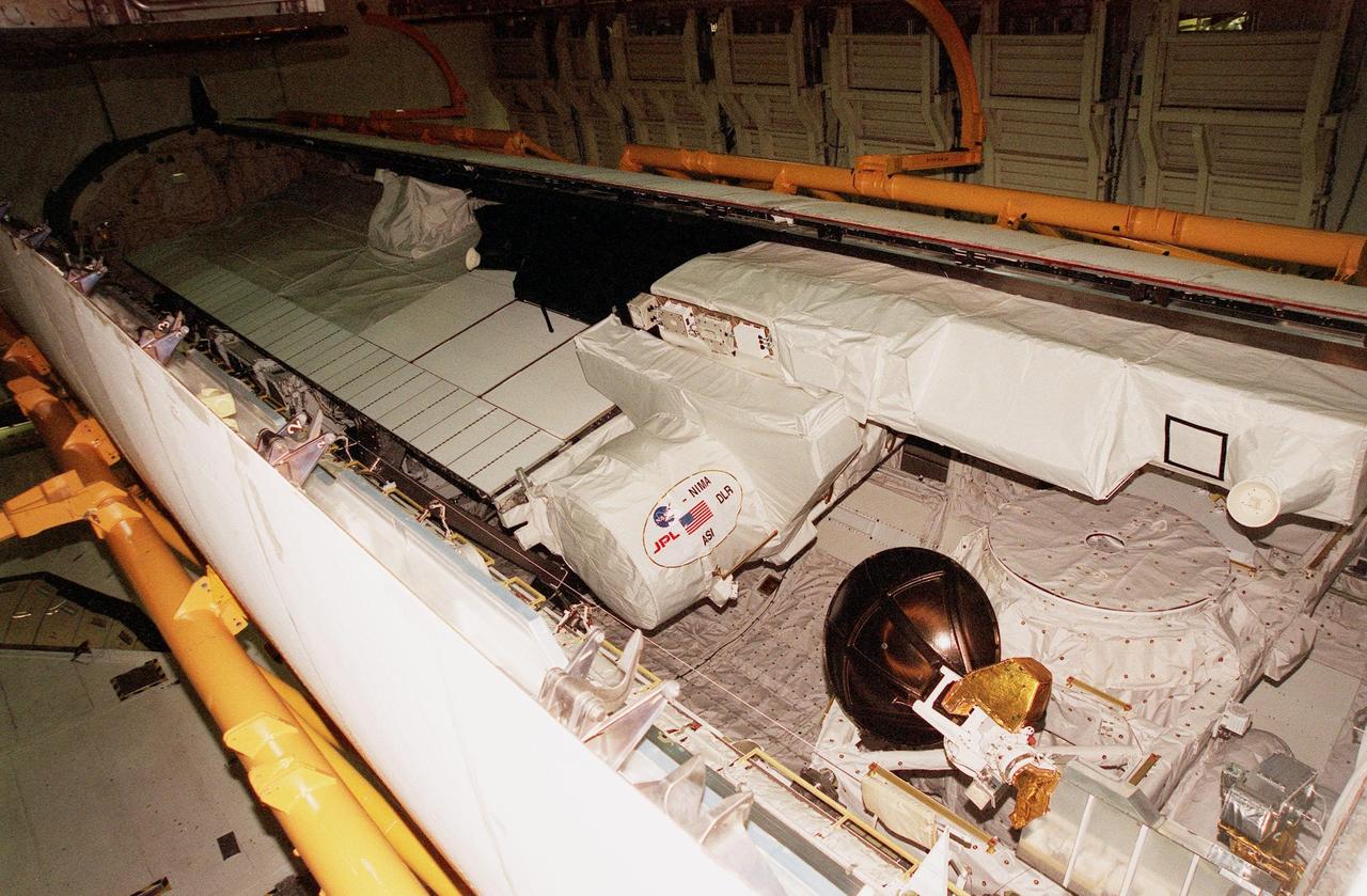
KENNEDY SPACE CENTER, FLA. -- In the Orbiter Processing Facility, a radar antenna, part of the Shuttle Radar Topography Mission (SRTM), is stored in the payload bay of the orbiter Endeavour before door closure. SRTM is the primary payload on mission STS-99, scheduled to launch Sept. 16 at 8:47 a.m. EDT from Launch Pad 39A. A specially modified radar system, the SRTM will gather data for the most accurate and complete topographic map of the Earth's surface that has ever been assembled. SRTM will make use of radar interferometry, wherein two radar images are taken from slightly different locations. Differences between these images allow for the calculation of surface elevation, or change. The SRTM hardware consists of one radar antenna in the shuttle payload bay and a second radar antenna attached to the end of a mast extended 60 meters (195 feet) out from the shuttle. SRTM is an international project spearheaded by the National Imagery and Mapping Agency and NASA, with participation of the German Aerospace Center DLR

KENNEDY SPACE CENTER, FLA. -- In the Orbiter Processing Facility, a radar antenna, part of the Shuttle Radar Topography Mission (SRTM), is nestled in the cargo bay of the orbiter Endeavour just before door closure. SRTM is the primary payload on mission STS-99, scheduled to launch Sept. 16 at 8:47 a.m. EDT from Launch Pad 39A. A specially modified radar system, the SRTM will gather data for the most accurate and complete topographic map of the Earth's surface that has ever been assembled. SRTM will make use of radar interferometry, wherein two radar images are taken from slightly different locations. Differences between these images allow for the calculation of surface elevation, or change. The SRTM hardware consists of one radar antenna in the shuttle payload bay and a second radar antenna attached to the end of a mast extended 60 meters (195 feet) out from the shuttle. SRTM is an international project spearheaded by the National Imagery and Mapping Agency and NASA, with participation of the German Aerospace Center DLR