
The bronze statue of the goat mascot for Worcester Polytechnic Institute (WPI) named "Gompei" is seen wearing a staff t-shirt for the "TouchTomorrow" education and outreach event that was held in tandem with the NASA-WPI Sample Return Robot Centennial Challenge on Saturday, June 16, 2012 in Worcester, Mass. The challenge tasked robotic teams to build autonomous robots that can identify, collect and return samples. NASA needs autonomous robotic capability for future planetary exploration. Photo Credit: (NASA/Bill Ingalls)

NASA Deputy Administrator Lori Garver and NASA Chief Technologist Mason Peck stop to look at the bronze statue of the goat mascot for Worcester Polytechnic Institute (WPI) named "Gompei" that is wearing a staff t-shirt for the "TouchTomorrow" education and outreach event that was held in tandem with the NASA-WPI Sample Return Robot Centennial Challenge on Saturday, June 16, 2012 in Worcester, Mass. The challenge tasked robotic teams to build autonomous robots that can identify, collect and return samples. NASA needs autonomous robotic capability for future planetary exploration. Photo Credit: (NASA/Bill Ingalls)
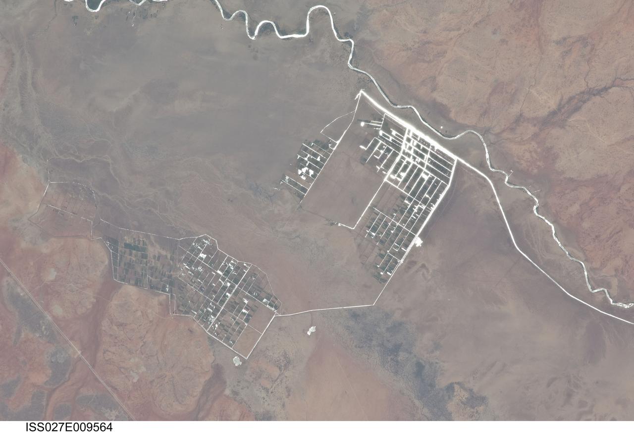
ISS027-E-009564 (31 March 2011) --- Agricultural fields along the Shebelle River in Ethiopia are featured in this image photographed by an Expedition 27 crew member on the International Space Station. The Shebelle River supports limited agricultural development within the arid to semi-arid Ogaden Plateau region of southeastern Ethiopia. This detailed photograph illustrates a network of irrigation canals and fields located approximately 42 kilometers to the west-northwest of the city of Gode, Ethiopia. Floodplain sediments and soils are dark brown to gray (center), and contrast with reddish rocks and soils of the adjacent plateau. Water in the Shebelle River, and the irrigation canals, has a bright, mirror-like appearance due to sunglint, or light reflecting off the water surface back towards the observer on the space station. Vegetation in the floodplain (bottom center) and agricultural fields is dark green. The river water supports a variety of crops?the most common being sorghum and maize?as well as grazing for livestock (cattle, sheep, goats, and camels). The Shebelle River has its headwaters in the Ethiopian Highlands, and transports water and sediment 1,000 kilometers to the southeast across Ethiopia, continuing an additional 130 kilometers into neighboring Somalia. The Shebelle River does not reach the Indian Ocean during most years, but disappears into the sands near the coast in Somalia. During periods of heavy rainfall and flooding however, the Shebelle can reach the Indian Ocean.
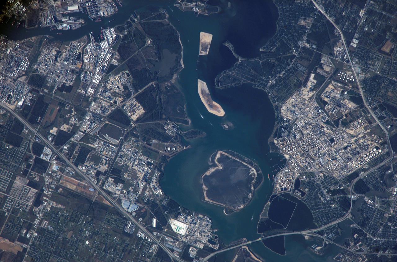
ISS012-E-09567 (28 Nov. 2005) --- Houston Ship Channel, Texas is featured in this image photographed by an Expedition 12 crewmember on the International Space Station. This view depicts the San Jacinto River portion of the Houston Ship Channel, one of the United States' busiest sea ports. The Channel provides a conduit between the continental interior and the Gulf of Mexico for both petrochemical products and Midwestern grain. The original watercourse for the Channel, Buffalo Bayou, has its headwaters 30 miles to the west of the city of Houston and has been used to move goods to the sea since at least 1836. Wakes of ships traveling along the channel are visible to the south of the Goat Islands (bright oblong islands at top center of image). The close proximity to Texas oilfields led to the establishment of numerous petrochemical refineries along the waterway, such as the Exxon Mobil Baytown installation on the eastern bank of the San Jacinto River. While much of the Ship Channel is associated with heavy industry, two icons of Texas history are also located along its length. A close search of the photo's details reveals both the battleship U.S.S. Texas and the neighboring San Jacinto Monument. The Texas saw service during both World Wars, and is the last remaining example of a dreadnought-class battleship in existence. The nearby San Jacinto Monument commemorates the 1836 battle in which Texas won its independence from Mexico. The monument itself is a 570 feet (173 meters) high shaft topped by a 34 feet (10 meters) high star, making it 15 feet (5 meters) higher than the Washington Monument in Washington, D.C. The Houston Ship Channel has been periodically widened and deepened to accommodate ever-larger ships, and is currently 530 feet (161 meters) wide by 45 feet (14 meters) deep by 50 miles (80 kilometers) long. The islands in the ship channel are part of the ongoing channel widening and deepening project--created by dredge spoils, salt marshes and bird islands are part of the Houston Port Authority's beneficial use and environmental mitigation responsibilities.
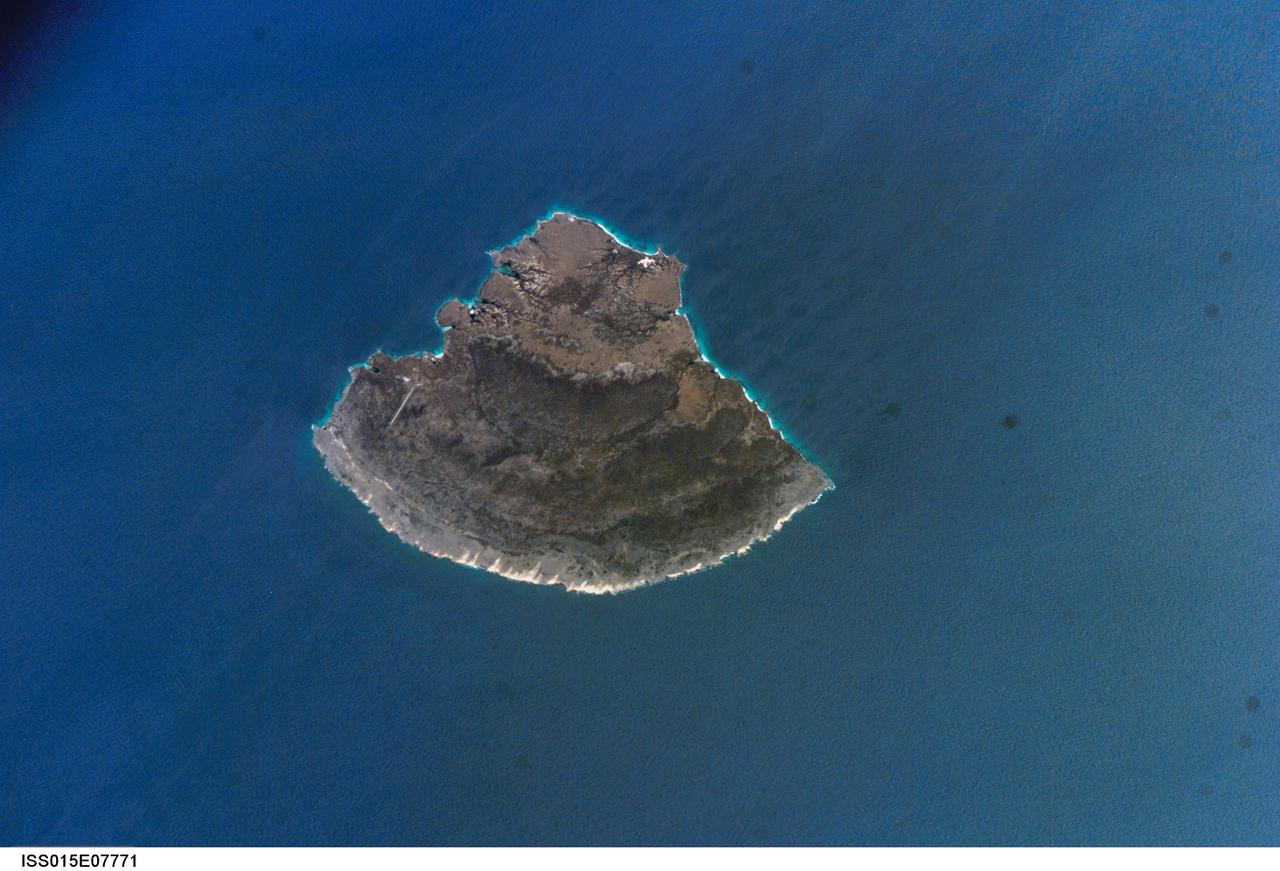
ISS015-E-07771 (12 May 2007) --- Isla Blanquilla, Venezuela is featured in this image photographed by an Expedition 15 crewmember on the International Space Station. The small island of Blanquilla is so named for its white sand beaches, visible in this image as a bright border along the northeastern -- eastern shoreline. Located approximately 292 kilometers (182 miles) northeast of Caracas, this Caribbean island is a popular destination for divers and tourists arriving by boat or airplane (the airstrip is visible at left center). Surface currents extending from the western coastline of the island (right center) are caused by easterly trade winds. According to scientists, this dominant wind has also caused movement of beach sand to form white "fingers" extending inland along the east coast (bottom center). The flora and fauna of Isla Blanquilla are an interesting mixture of arid (cacti, iguanas) and introduced species (wild donkeys and goats), but it is particularly notable for the presence of black coral. Black coral (order Antipatharia) is something of a misnomer, as it refers to the skeleton of the coral rather than the living organism (which is typically brightly colored). Black corals around the world are harvested for use in jewelry and other craftwork, so much so that the species has been listed for protection under the Convention on International Trade in Endangered Species of Wild Fauna and Flora. The island is the southernmost subaerial (above water) exposure of the Aves Ridge, a seafloor topography feature of the southernmost Caribbean ocean. The western third of the island is comprised of Cretaceous to Paleocene granitic rock (brown to tan), while the remainder consists of three limestone terraces of Pleistocene age deposited on the older granitic basement rock. The terraces decrease in age outwards from the western third of the island. The terraces record fluctuating sea levels, thought to be related to glacial advances and retreats during the Pleistocene together with tectonic uplift of the island.