
Brian McLendon, VP of Engineering, Google, Inc., speaks during a press conference, Monday, July 20, 2009, announcing the launch of Moon in Google Earth, an immersive 3D atlas of the Moon, accessible within Google Earth 5.0, Monday, July 20, 2009, at the Newseum in Washington. Photo Credit: (NASA/Bill Ingalls)
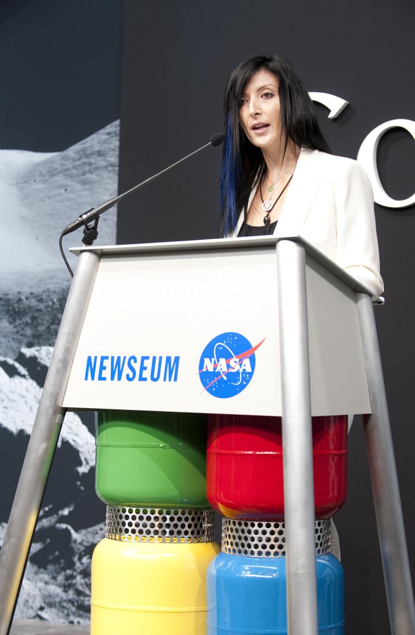
Tiffany Montague, Technical Program Manager for NASA and Google Lunar X PRIZE, Google, Inc., speaks during a press conference, Monday, July 20, 2009, announcing the launch of Moon in Google Earth, an immersive 3D atlas of the Moon, accessible within Google Earth 5.0, Monday, July 20, 2009, at the Newseum in Washington. Photo Credit: (NASA/Bill Ingalls)
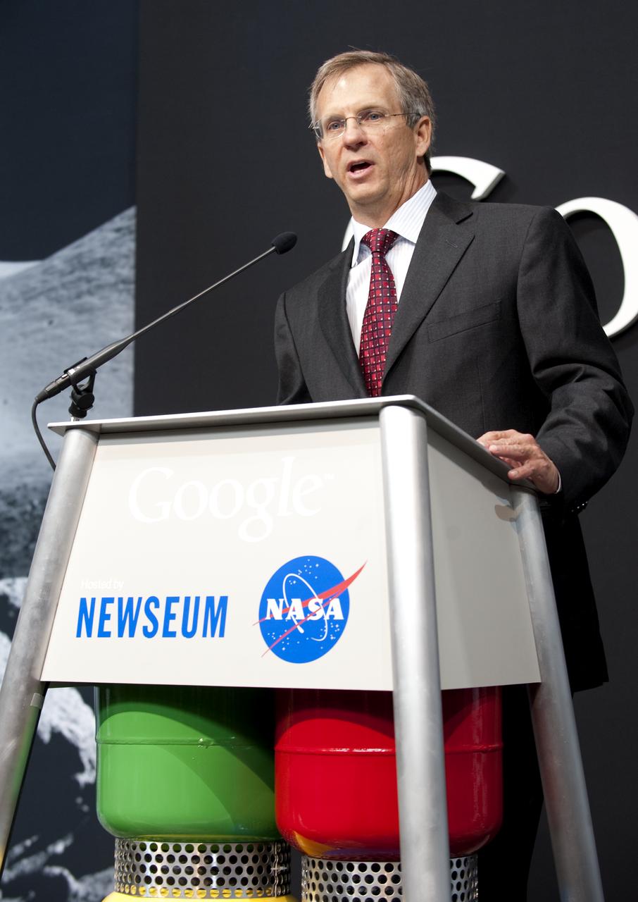
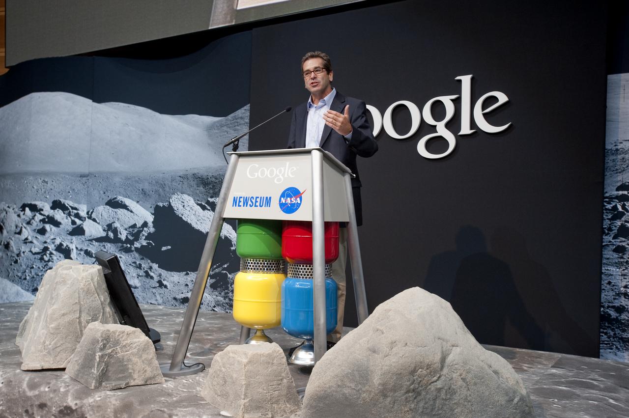
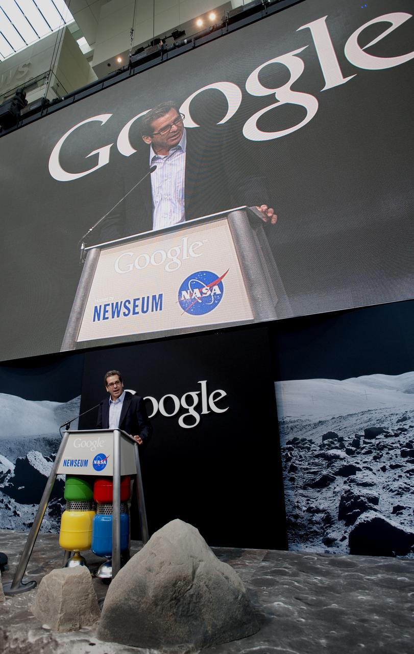
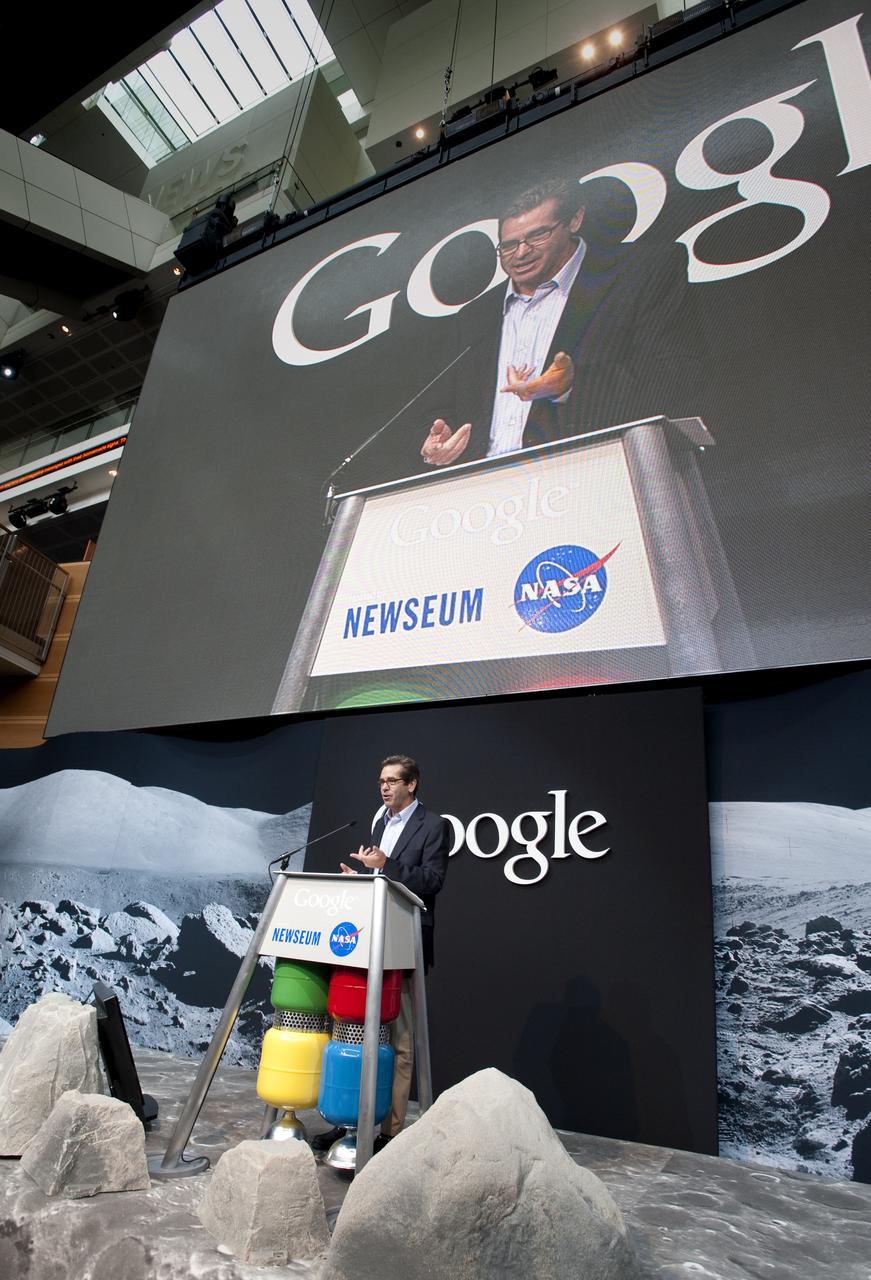
Alan Eustace, Senior VP of Engineering and Research, Google, Inc., speaks during a press conference, Monday, July 20, 2009, announcing the launch of Moon in Google Earth, an immersive 3D atlas of the Moon, accessible within Google Earth 5.0, Monday, July 20, 2009, at the Newseum in Washington. Photo Credit: (NASA/Bill Ingalls)

Andrew Chaikin, author of "A Man on the Moon" speaks during a press conference, Monday, July 20, 2009, announcing the launch of Moon in Google Earth, an immersive 3D atlas of the Moon, accessible within Google Earth 5.0, Monday, July 20, 2009, at the Newseum in Washington. Photo Credit: (NASA/Bill Ingalls)
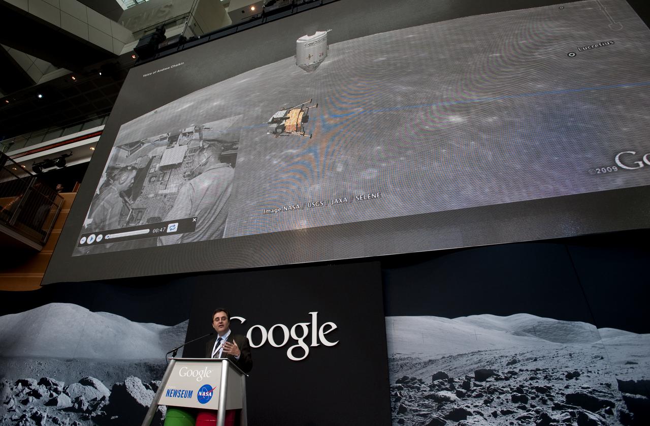
Andrew Chaikin, author of "A Man on the Moon" speaks during a press conference, Monday, July 20, 2009, announcing the launch of Moon in Google Earth, an immersive 3D atlas of the Moon, accessible within Google Earth 5.0, Monday, July 20, 2009, at the Newseum in Washington. Photo Credit: (NASA/Bill Ingalls)
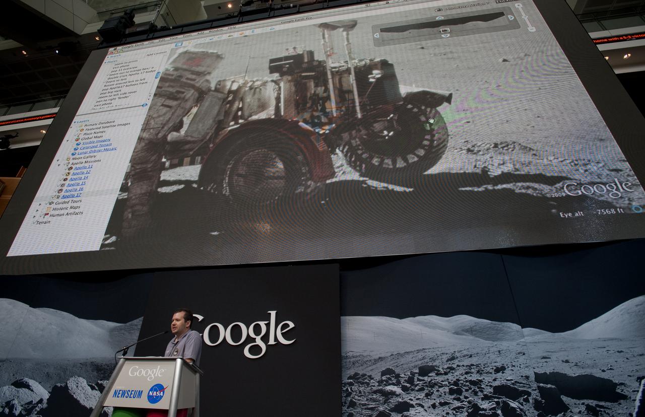
Michael Weiss-Malik, Product Manager for Moon in Google Earth, Google, Inc., speaks during a press conference, Monday, July 20, 2009, announcing the launch of Moon in Google Earth, an immersive 3D atlas of the Moon, accessible within Google Earth 5.0, Monday, July 20, 2009, at the Newseum in Washington. Photo Credit: (NASA/Bill Ingalls)
Miles O'Brien, former chief science and tech correspondent for CNN, speaks during a press conference, Monday, July 20, 2009, announcing the launch of Moon in Google Earth, an immersive 3D atlas of the Moon, accessible within Google Earth 5.0, Monday, July 20, 2009, at the Newseum in Washington. Photo Credit: (NASA/Bill Ingalls)
Miles O'Brien, former chief science and tech correspondent for CNN, speaks during a press conference, Monday, July 20, 2009, announcing the launch of Moon in Google Earth, an immersive 3D atlas of the Moon, accessible within Google Earth 5.0, Monday, July 20, 2009, at the Newseum in Washington. Photo Credit: (NASA/Bill Ingalls)
Miles O'Brien, former chief science and tech correspondent for CNN, speaks during a press conference, Monday, July 20, 2009, announcing the launch of Moon in Google Earth, an immersive 3D atlas of the Moon, accessible within Google Earth 5.0, Monday, July 20, 2009, at the Newseum in Washington. Photo Credit: (NASA/Bill Ingalls)
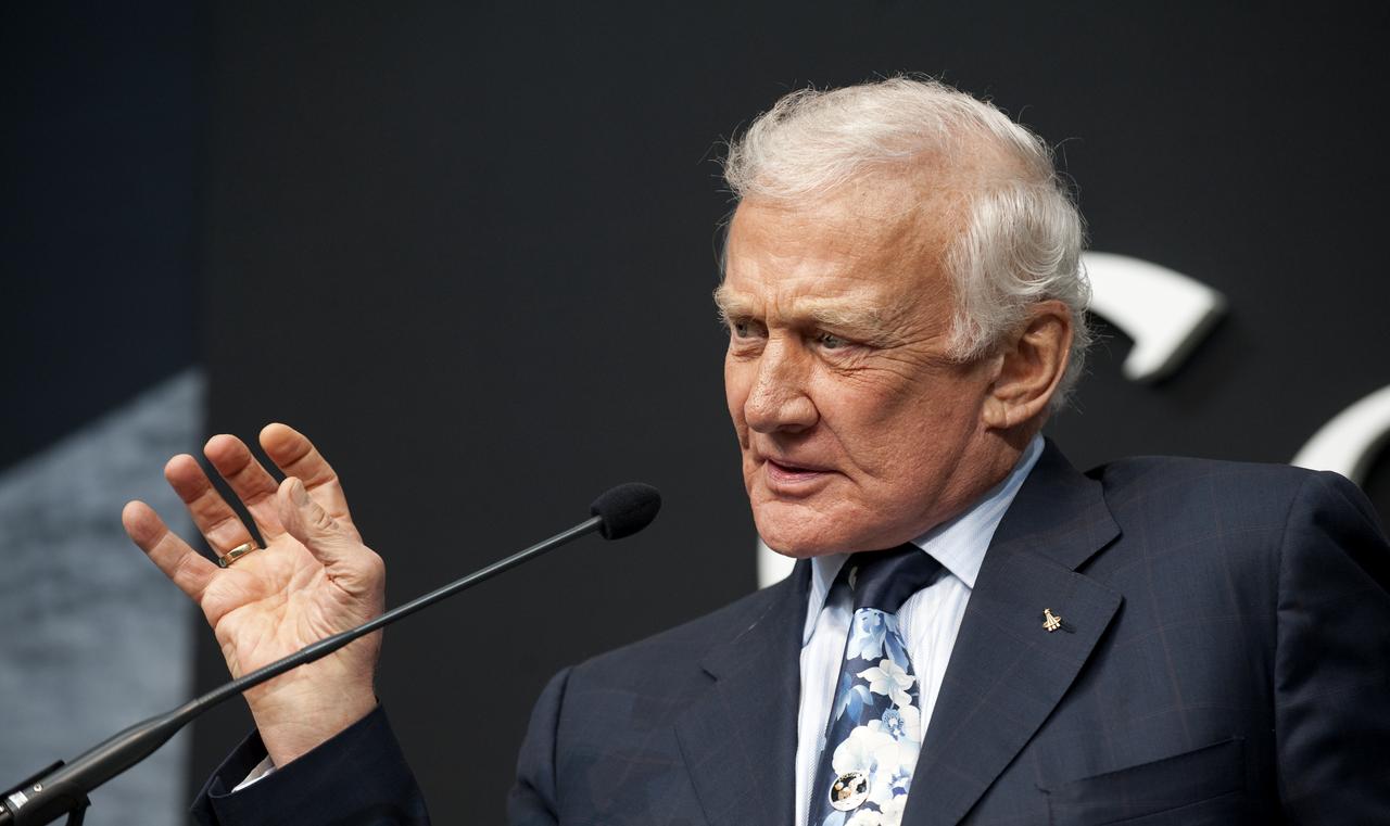
Buzz Aldrin, the second man to walk on the moon, speaks during a press conference, Monday, July 20, 2009, announcing the launch of Moon in Google Earth, an immersive 3D atlas of the Moon, accessible within Google Earth 5.0, Monday, July 20, 2009, at the Newseum in Washington. Photo Credit: (NASA/Bill Ingalls)

NASA Deputy Administrator Lori Garver, speaks during a press conference, Monday, July 20, 2009, announcing the launch of Moon in Google Earth, an immersive 3D atlas of the Moon, accessible within Google Earth 5.0, Monday, July 20, 2009, at the Newseum in Washington. Photo Credit: (NASA/Bill Ingalls)
Buzz Aldrin, the second man to walk on the moon, speaks during a press conference, Monday, July 20, 2009, announcing the launch of Moon in Google Earth, an immersive 3D atlas of the Moon, accessible within Google Earth 5.0, Monday, July 20, 2009, at the Newseum in Washington. Photo Credit: (NASA/Bill Ingalls)
Yoshinori Yoshimura, a respresentative from the Japan Aerospace Exploration Agency (JAXA), speaks during a press conference, Monday, July 20, 2009, announcing the launch of Moon in Google Earth, an immersive 3D atlas of the Moon, accessible within Google Earth 5.0, Monday, July 20, 2009, at the Newseum in Washington. Photo Credit: (NASA/Bill Ingalls)
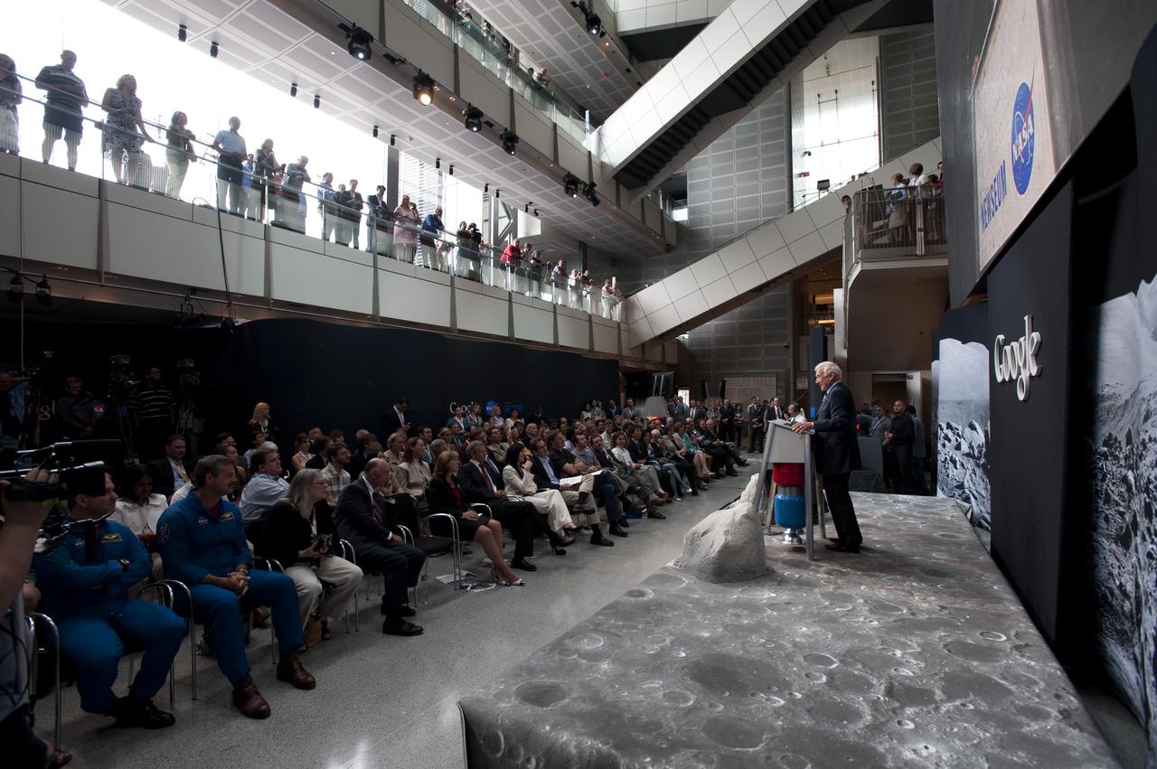
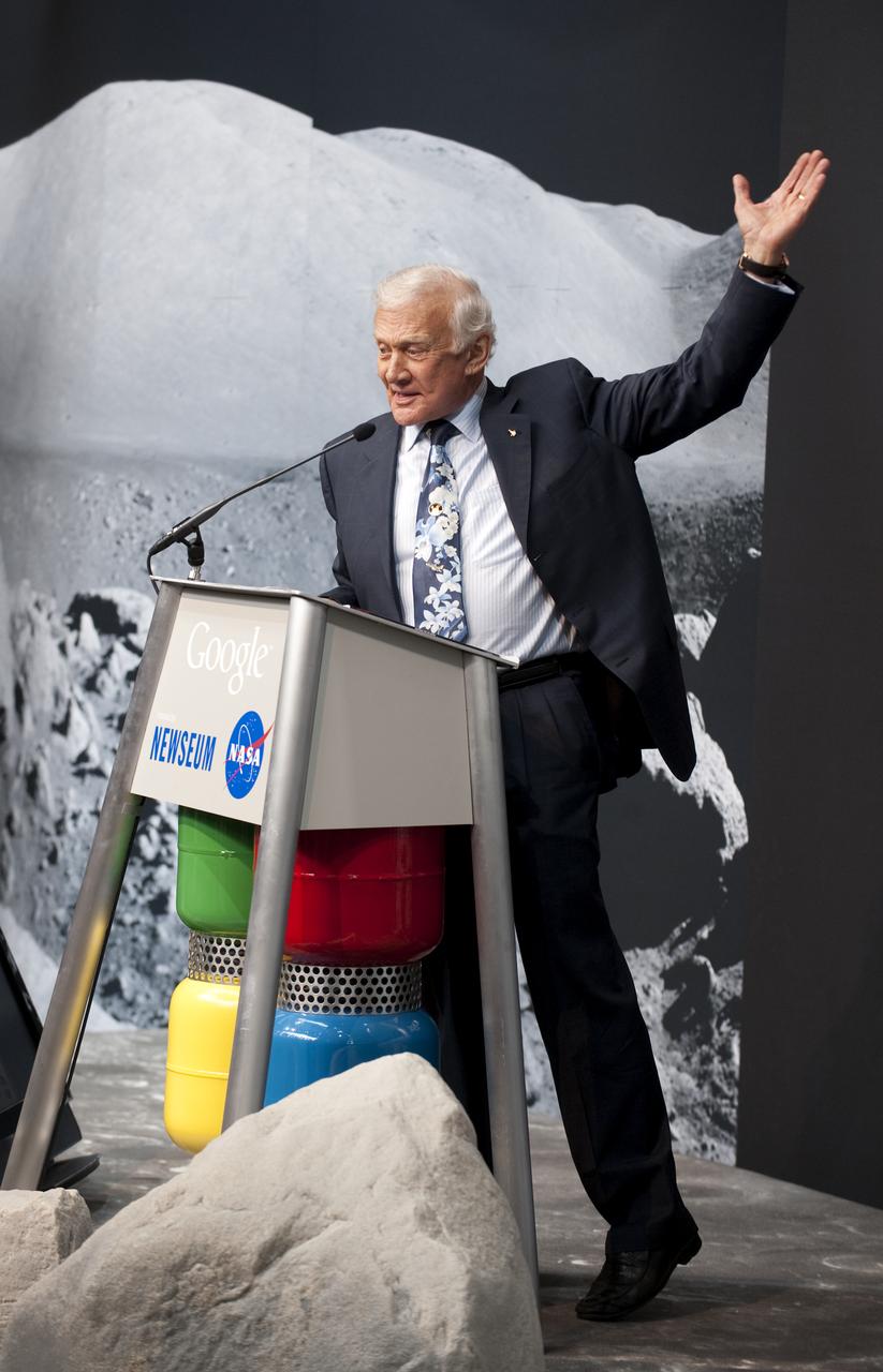
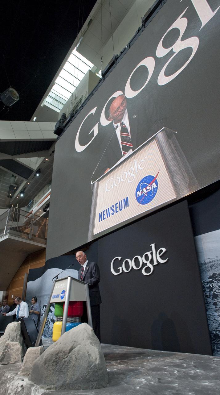
Apollo 11 astronaut Buzz Aldrin, the second man to walk on the Moon, speaks during a press conference, Monday, July 20, 2009, announcing the launch of Moon in Google Earth, an immersive 3D atlas of the Moon, accessible within Google Earth 5.0, Monday, July 20, 2009, at the Newseum in Washington. Photo Credit: (NASA/Bill Ingalls)
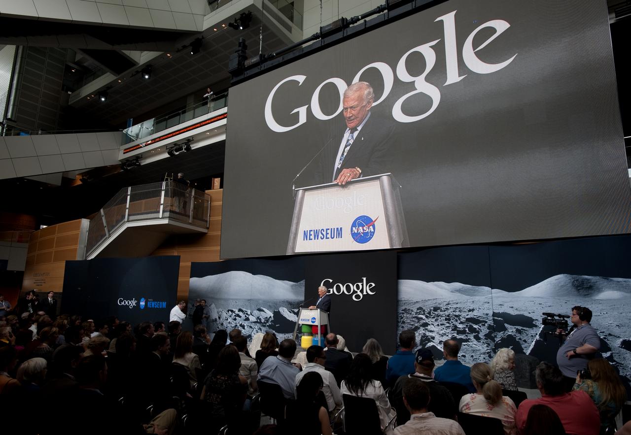
Apollo 11 astronaut Buzz Aldrin, the second man to walk on the Moon, speaks during a press conference, Monday, July 20, 2009, announcing the launch of Moon in Google Earth, an immersive 3D atlas of the Moon, accessible within Google Earth 5.0, Monday, July 20, 2009, at the Newseum in Washington. Photo Credit: (NASA/Bill Ingalls)
NASA Deputy Administrator Lori Garver participates in a live "We The Geeks" Google+ Hangout hosted by the White House to talk about asteroids, Friday, May 31, 2013 at NASA Headquarters in Washington. An asteroid nearly three kilometers wide will pass by the Earth today at 3.6 million miles away. Garver is joined in the conversation by Bill Nye, Executive Director, Planetary Society; Ed Lu, former astronaut and CEO, B612 Foundation; Peter Diamandis, Co-Founder and Co-Chairman, Planetary Resources and Jose Luis Galache, Astronomer at the International Astronomical Unions's Minor Planet Center. Photo Credit: (NASA/Carla Cioffi)

NASA Deputy Administrator Lori Garver participates in a live "We The Geeks" Google+ Hangout hosted by the White House to talk about asteroids, Friday, May 31, 2013 at NASA Headquarters in Washington. An asteroid nearly three kilometers wide will pass by the Earth today at 3.6 million miles away. Garver is joined in the conversation by Bill Nye, Executive Director, Planetary Society; Ed Lu, former astronaut and CEO, B612 Foundation; Peter Diamandis, Co-Founder and Co-Chairman, Planetary Resources and Jose Luis Galache, Astronomer at the International Astronomical Unions's Minor Planet Center. Photo Credit: (NASA/Carla Cioffi)
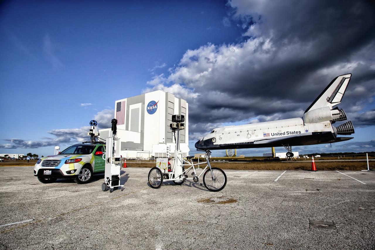
CAPE CANAVERAL, Fla. – Google used an assortment of vehicles to precisely map NASA's Kennedy Space Center in Florida to be featured on the company's map page. The work allows Internet users to see inside buildings at Kennedy as they were used during the space shuttle era. Google used a car, tricycle and pushcart to maneuver around the center and through some of its facilities. Photo credit: Google/Wendy Wang
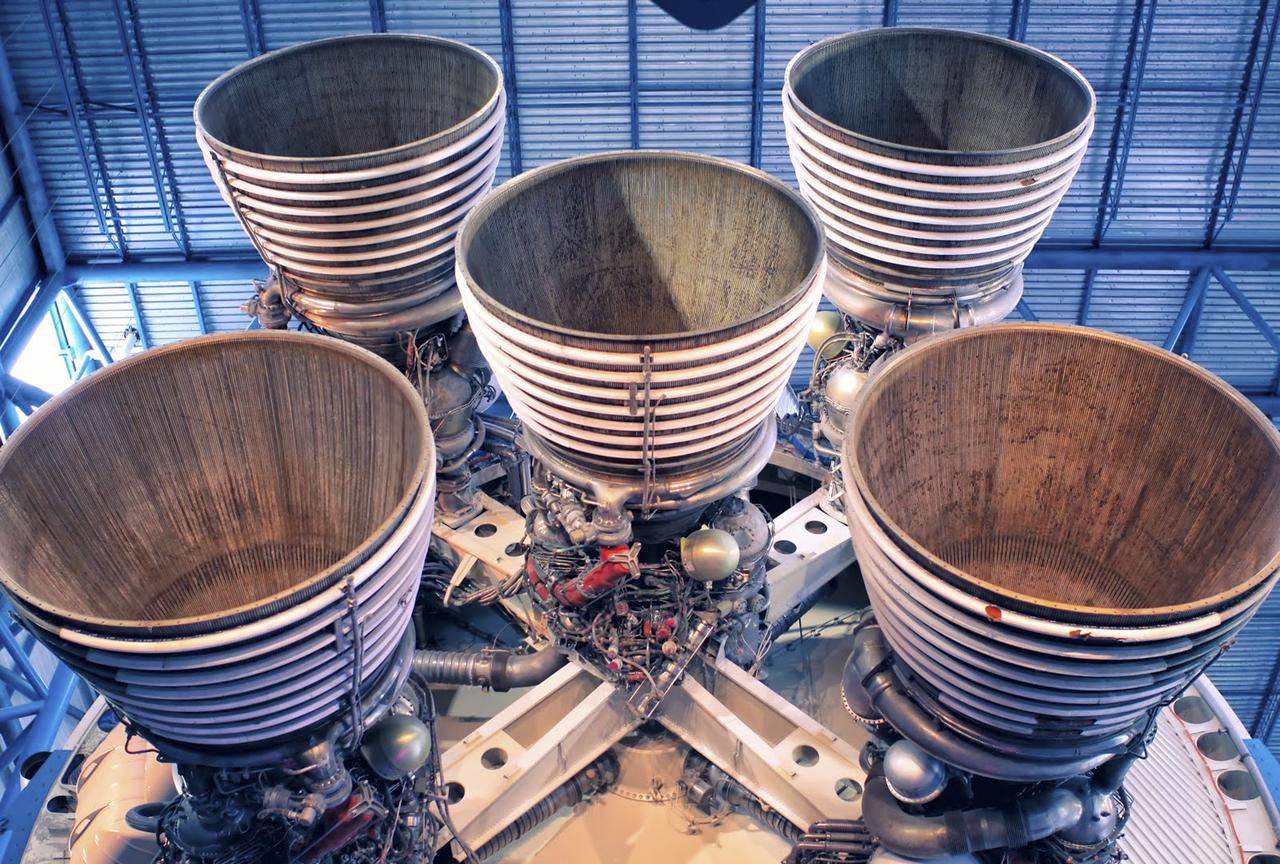
CAPE CANAVERAL, Fla. – As seen on Google Maps, the massive F-1 engines of the Saturn V's first stage on display inside the Apollo/Saturn V Center at the Kennedy Space Center Visitor Complex. Each engine stands 19 feet tall with a diameter of more than 12 feet. The five engines on the first stage produced 7.5 million pounds of thrust at liftoff. The Saturn V was used to launch NASA's Apollo missions to the moon which saw 12 astronauts land and work on the lunar surface. Google precisely mapped Kennedy Space Center and some of its historical facilities for the company's map page. Photo credit: Google/Wendy Wang
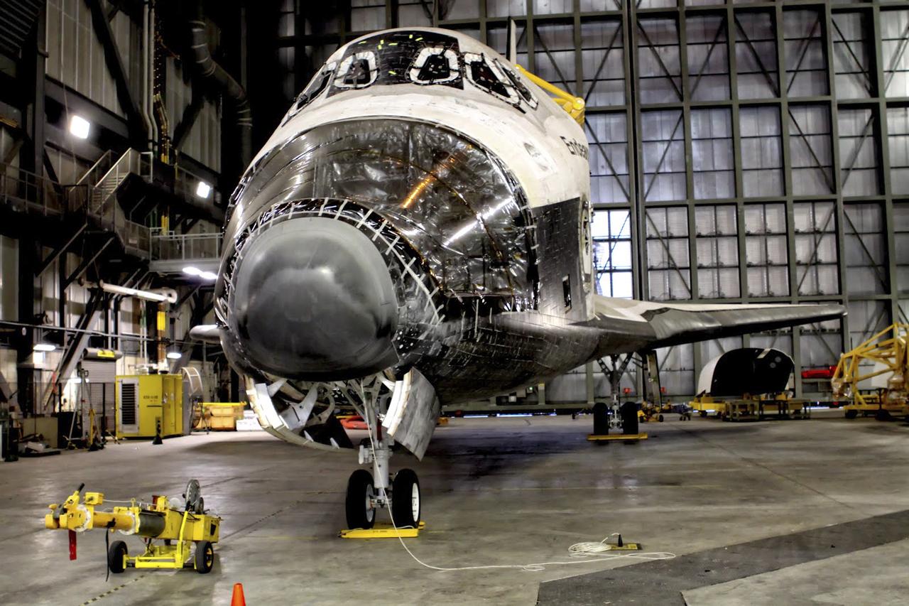
CAPE CANAVERAL, Fla. – As seen on Google Maps, space shuttle Endeavour goes through transition and retirement processing in high bay 4 of the Vehicle Assembly Building at NASA's Kennedy Space Center. The spacecraft completed 25 missions beginning with its first flight, STS-49, in May 1992, and ending with STS-134 in May 2011. It helped construct the International Space Station in orbit and travelled more than 122 million miles in orbit during its career. The reaction control system pods in the shuttle's nose and aft section were removed for processing before Endeavour was put on public display at the California Science Center in Los Angeles. Google precisely mapped the space center and some of its historical facilities for the company's map page. The work allows Internet users to see inside buildings at Kennedy as they were used during the space shuttle era. Photo credit: Google/Wendy Wang

CAPE CANAVERAL, Fla. – As seen on Google Maps, the Rotating Service Structure at Launch Complex 39A at NASA's Kennedy Space Center housed space shuttle payloads temporarily so they could be loaded inside the 60-foot-long cargo bay of a shuttle before launch. The RSS, as the structure was known, was hinged to the Fixed Service Structure on one side and rolled on a rail on the other. As its name suggests, the enclosed facility would rotate into place around the shuttle as it stood at the launch pad. Once in place, the RSS protected the shuttle and its cargo. Google precisely mapped the space center and some of its historical facilities for the company's map page. The work allows Internet users to see inside buildings at Kennedy as they were used during the space shuttle era. Photo credit: Google/Wendy Wang
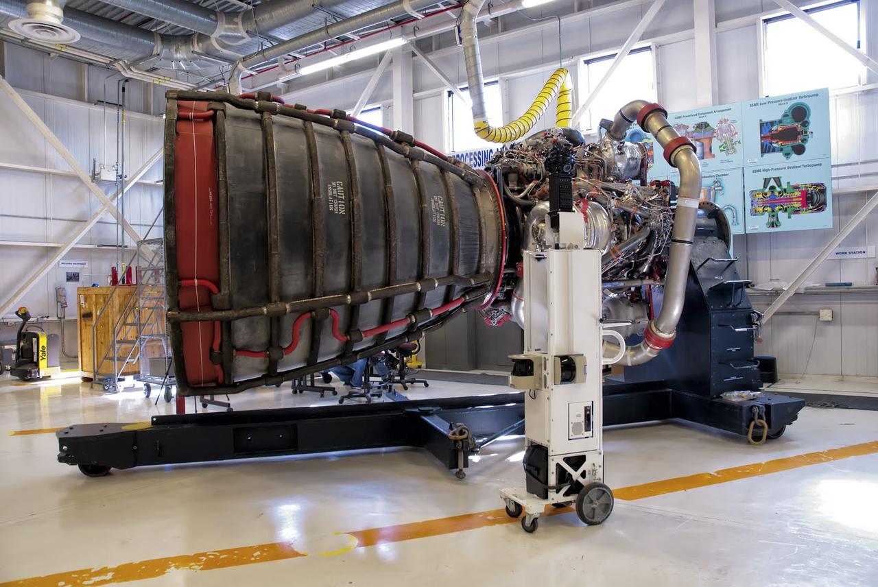
CAPE CANAVERAL, Fla. – As seen on Google Maps, a Space Shuttle Main Engine, or SSME, stands inside the Engine Shop at Orbiter Processing Facility 3 at NASA's Kennedy Space Center. Each orbiter used three of the engines during launch and ascent into orbit. The engines burn super-cold liquid hydrogen and liquid oxygen and each one produces 155,000 pounds of thrust. The engines, known in the industry as RS-25s, could be reused on multiple shuttle missions. They will be used again later this decade for NASA's Space Launch System rocket. Google precisely mapped the space center and some of its historical facilities for the company's map page. The work allows Internet users to see inside buildings at Kennedy as they were used during the space shuttle era. Photo credit: Google/Wendy Wang

CAPE CANAVERAL, Fla. – As seen on Google Maps, the view from the top of the Fixed Service Structure at Launch Complex 39A at NASA's Kennedy Space Center. The FSS, as the structure is known, is 285 feet high and overlooks the Rotating Service Structure that was rolled into place when a space shuttle was at the pad. The path taken by NASA's massive crawler-transporters that carried the shuttle stack 3 miles from Vehicle Assembly Building are also visible leading up to the launch pad. In the distance are seen the launch pads and support structures at Cape Canaveral Air Force Station for the Atlas V, Delta IV and Falcon 9 rockets. Google precisely mapped the space center and some of its historical facilities for the company's map page. The work allows Internet users to see inside buildings at Kennedy as they were used during the space shuttle era. Photo credit: Google/Wendy Wang
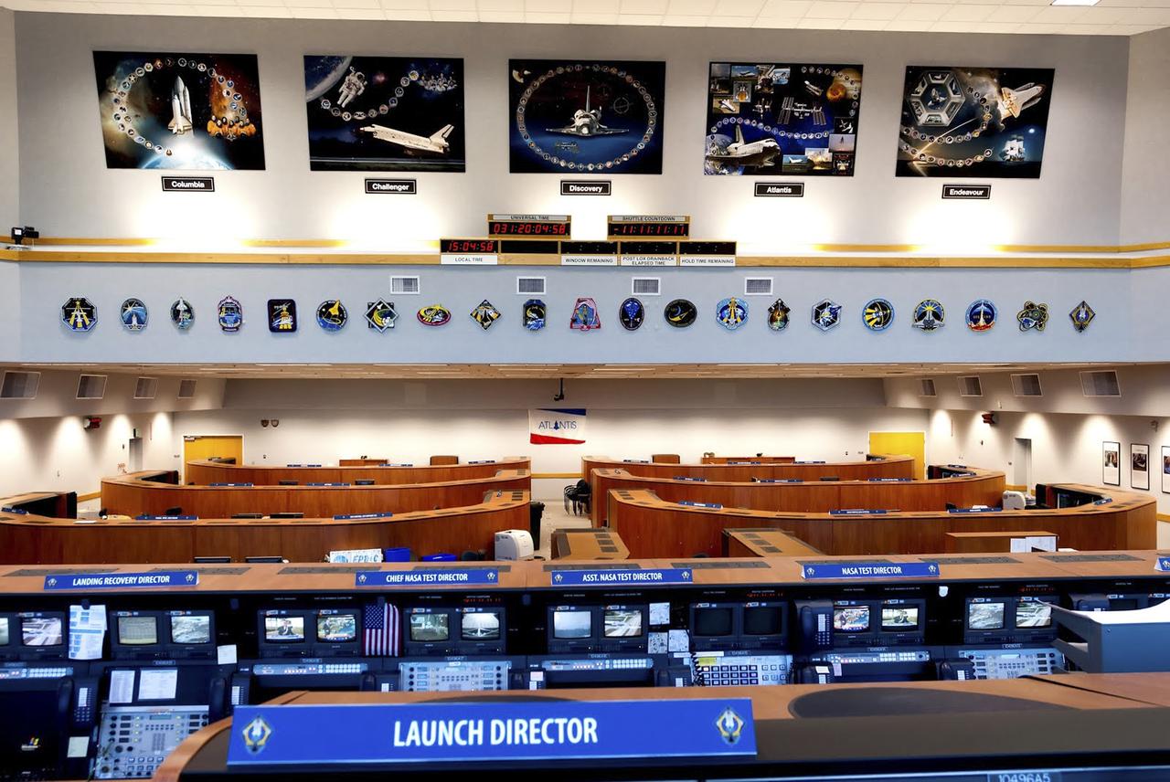
CAPE CANAVERAL, Fla. – As seen on Google Maps, Firing Room 4 inside the Launch Control Center at NASA's Kennedy Space Center was one of the four control rooms used by NASA and contractor launch teams to oversee a space shuttle countdown. This firing room was the most advanced of the control rooms used for shuttle missions and was the primary firing room for the shuttle's final series of launches before retirement. It is furnished in a more contemporary style with wood cabinets and other features, although it retains many of the computer systems the shuttle counted on to operate safely. Specialized operators worked at consoles tailored to keep track of the status of shuttle systems while the spacecraft was processed in the Orbiter Processing Facility, being stacked inside the Vehicle Assembly Building and standing at the launch pad before liftoff. The firing rooms, including 3, were also used during NASA's Apollo Program. Google precisely mapped the space center and some of its historical facilities for the company's map page. The work allows Internet users to see inside buildings at Kennedy as they were used during the space shuttle era. Photo credit: Google/Wendy Wang
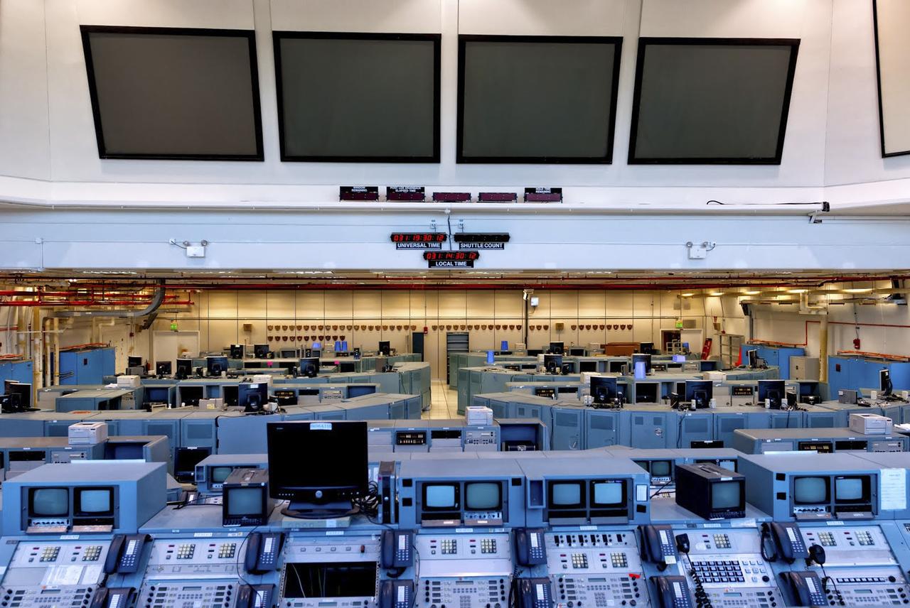
CAPE CANAVERAL, Fla. – As seen on Google Maps, Firing Room 3 inside the Launch Control Center at NASA's Kennedy Space Center was one of the four control rooms used by NASA and contractor launch teams to oversee a space shuttle countdown. This firing room is furnished in the classic style with the same metal computer cabinets and some of the same monitors in place when the first shuttle mission launched April 12, 1981. Specialized operators worked at consoles tailored to keep track of the status of shuttle systems while the spacecraft was processed in the Orbiter Processing Facility, being stacked inside the Vehicle Assembly Building and standing at the launch pad before liftoff. The firing rooms, including 3, were also used during NASA's Apollo Program. Google precisely mapped the space center and some of its historical facilities for the company's map page. The work allows Internet users to see inside buildings at Kennedy as they were used during the space shuttle era. Photo credit: Google/Wendy Wang
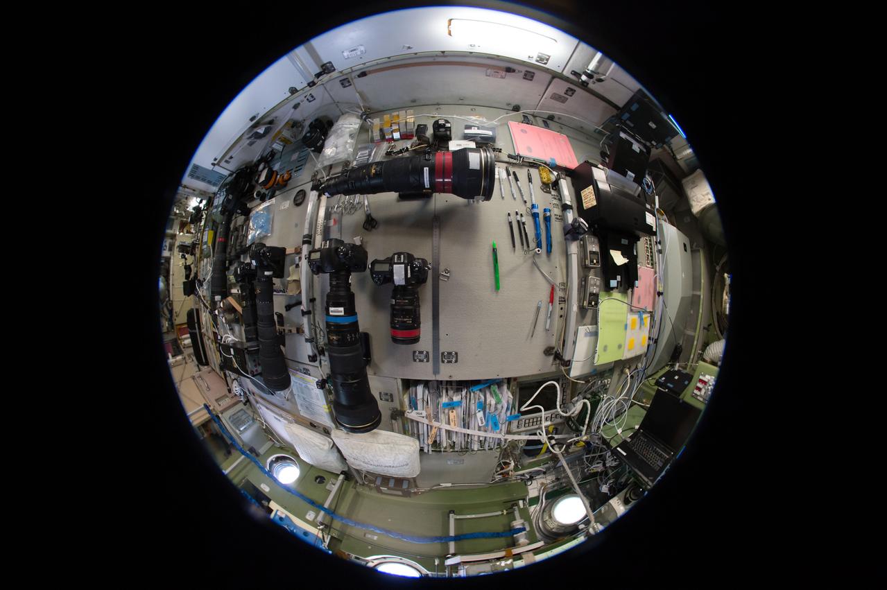
iss051e018869 (4/18/2017) --- A fish-eye view looking port in the Zvezda Service Module (SM), taken for a Google Street View of the ISS.
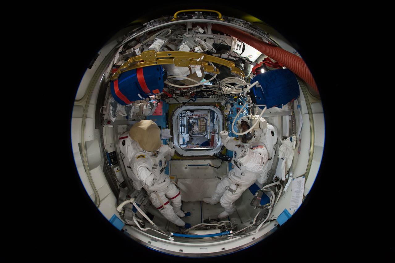
iss051e041018 (5/11/2017) --- A fish-eye view looking port in the Quest Airlock (A/L), taken for a Google Street View of the ISS. The port hatch into the Unity Node 1 is in view.
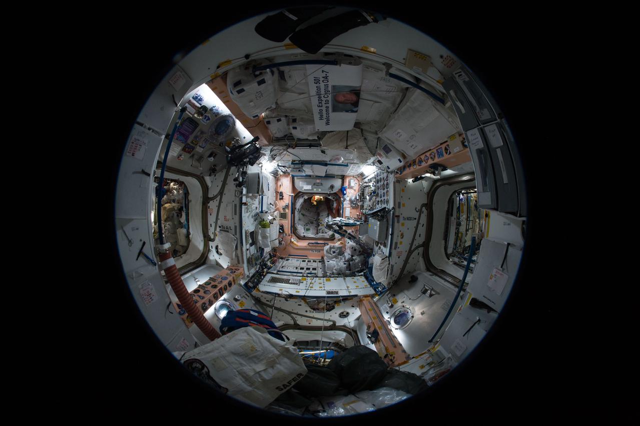
iss051e040946 (5/11/2017) --- A fish-eye view looking aft in the Unity Node 1, taken for a Google Street View of the ISS.
CAPE CANAVERAL, Fla. -- At NASA's Kennedy Space Center in Florida, Nancy Bray of NASA Public Affairs welcomes agency social media followers to the first day of activities of a NASA Social revolving around NASA's Tracking and Data Relay Satellite-K mission. NASA Socials are in-person meetings for people who engage with the agency through Twitter, Facebook, Google+ and other social networks. The satellite, known as TDRS-K, is set to launch at 8:48 p.m. EST on Jan. 30 aboard a United Launch Alliance Atlas V rocket from Space Launch Complex 41 on nearby Cape Canaveral Air Force Station. About 50 followers were selected to participate in the TDRS-K prelaunch and launch activities and share them with their own fan base. The TDRS-K spacecraft is part of the next-generation series in the Tracking and Data Relay Satellite System, a constellation of space-based communication satellites providing tracking, telemetry, command and high-bandwidth data return services. For more information, visit http://www.nasa.gov/mission_pages/tdrs/index.html. Photo credit: NASA/Jim Grossmann
CAPE CANAVERAL, Fla. -- At NASA's Kennedy Space Center in Florida, Jeff Gramling, project manager for NASA's Tracking and Data Relay Satellite-K, takes a question from an agency social media follower participating in the first day of activities of a NASA Social revolving around the satellite's mission. NASA Socials are in-person meetings for people who engage with the agency through Twitter, Facebook, Google+ and other social networks. The satellite, known as TDRS-K, is set to launch at 8:48 p.m. EST on Jan. 30 aboard a United Launch Alliance Atlas V rocket from Space Launch Complex 41 on nearby Cape Canaveral Air Force Station. About 50 followers were selected to participate in the TDRS-K prelaunch and launch activities and share them with their own fan base. The TDRS-K spacecraft is part of the next-generation series in the Tracking and Data Relay Satellite System, a constellation of space-based communication satellites providing tracking, telemetry, command and high-bandwidth data return services. For more information, visit http:__www.nasa.gov_mission_pages_tdrs_index.html. Photo credit: NASA_Jim Grossmann
CAPE CANAVERAL, Fla. -- At NASA's Kennedy Space Center in Florida, Jeff Gramling, project manager for NASA's Tracking and Data Relay Satellite-K, addresses agency social media followers on the first day of activities of a NASA Social revolving around the satellite's mission. NASA Socials are in-person meetings for people who engage with the agency through Twitter, Facebook, Google+ and other social networks. The satellite, known as TDRS-K, is set to launch at 8:48 p.m. EST on Jan. 30 aboard a United Launch Alliance Atlas V rocket from Space Launch Complex 41 on nearby Cape Canaveral Air Force Station. About 50 followers were selected to participate in the TDRS-K prelaunch and launch activities and share them with their own fan base. The TDRS-K spacecraft is part of the next-generation series in the Tracking and Data Relay Satellite System, a constellation of space-based communication satellites providing tracking, telemetry, command and high-bandwidth data return services. For more information, visit http:__www.nasa.gov_mission_pages_tdrs_index.html. Photo credit: NASA_Jim Grossmann
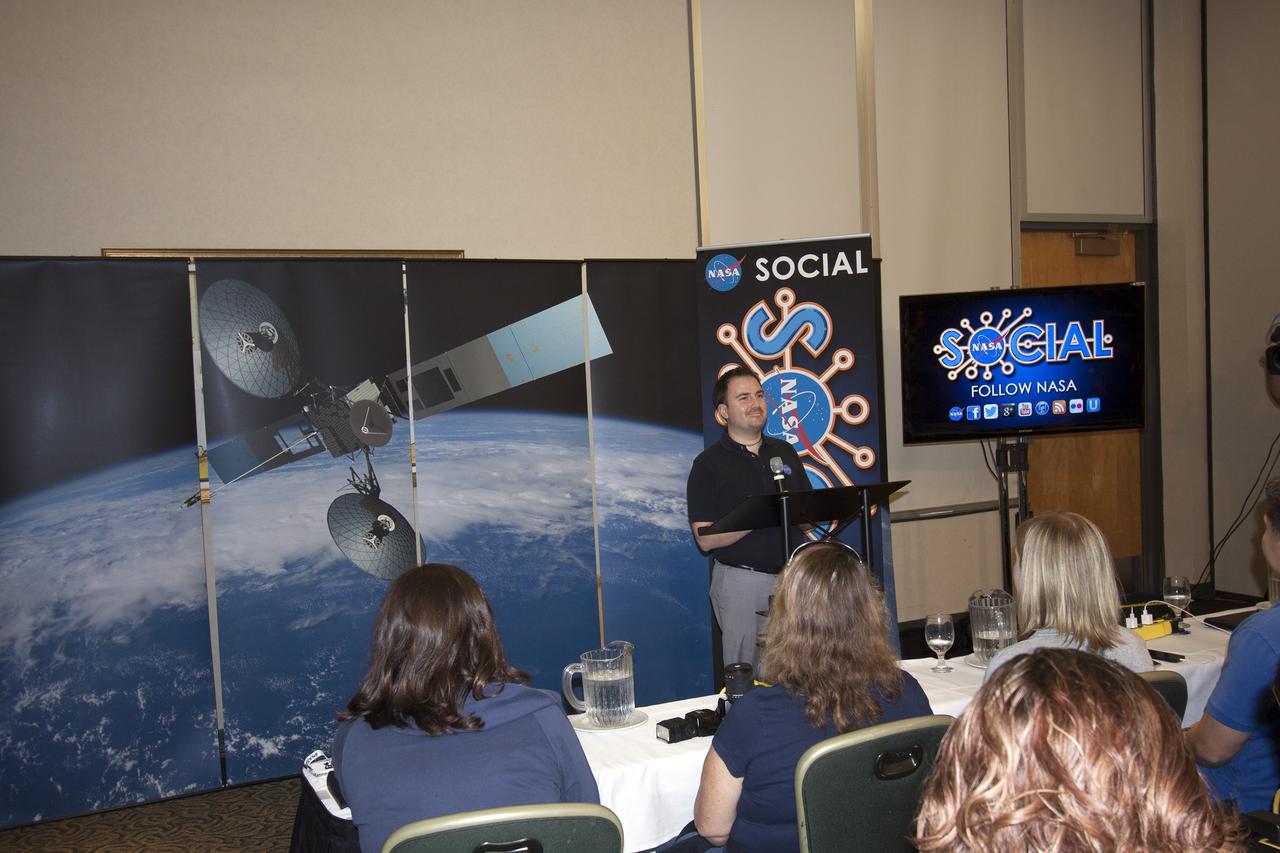
CAPE CANAVERAL, Fla. -- At NASA's Kennedy Space Center in Florida, Jason Townsend of NASA's Social Media Team welcomes agency social media followers to the first day of activities of a NASA Social revolving around NASA's Tracking and Data Relay Satellite-K mission. NASA Socials are in-person meetings for people who engage with the agency through Twitter, Facebook, Google+ and other social networks. The satellite, known as TDRS-K, is set to launch at 8:48 p.m. EST on Jan. 30 aboard a United Launch Alliance Atlas V rocket from Space Launch Complex 41 on nearby Cape Canaveral Air Force Station. About 50 followers were selected to participate in the TDRS-K prelaunch and launch activities and share them with their own fan base. The TDRS-K spacecraft is part of the next-generation series in the Tracking and Data Relay Satellite System, a constellation of space-based communication satellites providing tracking, telemetry, command and high-bandwidth data return services. For more information, visit http://www.nasa.gov/mission_pages/tdrs/index.html. Photo credit: NASA/Jim Grossmann
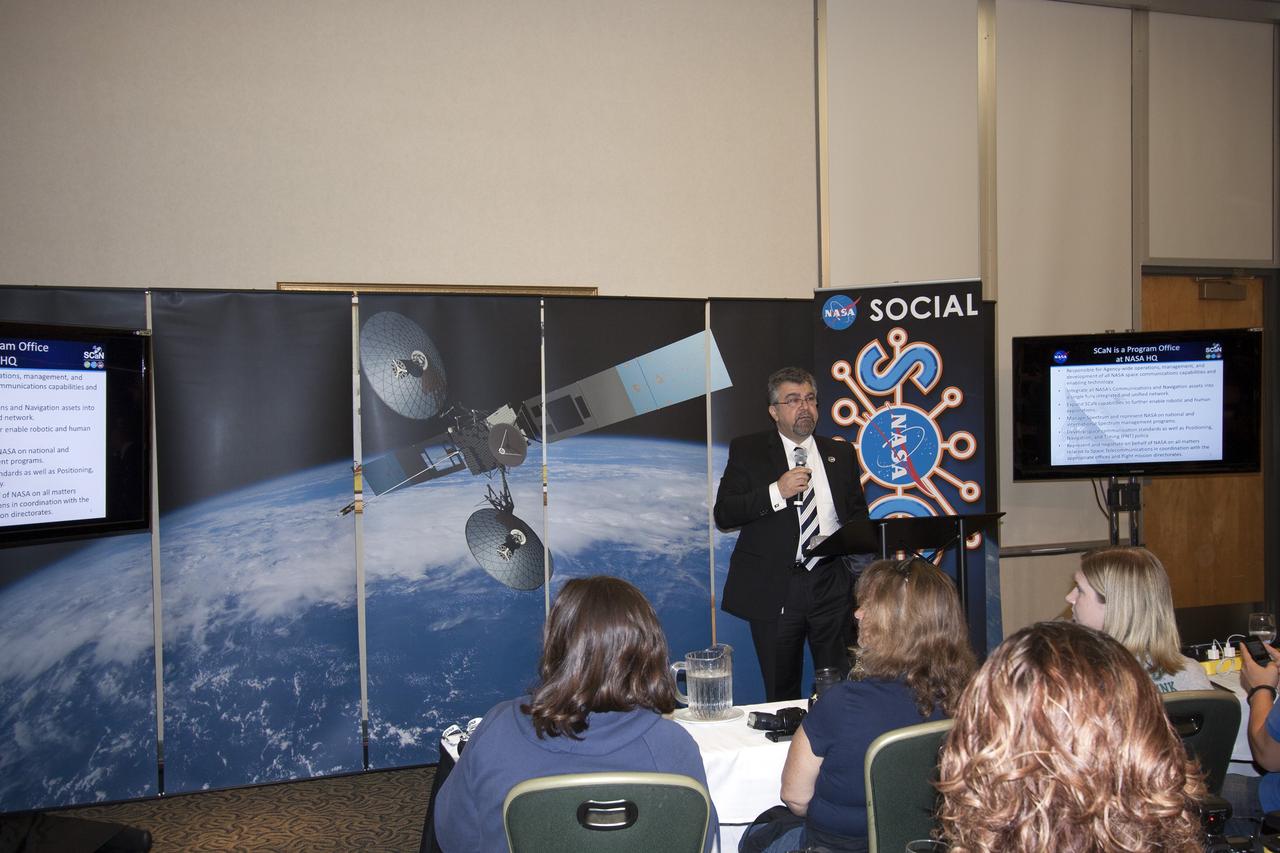
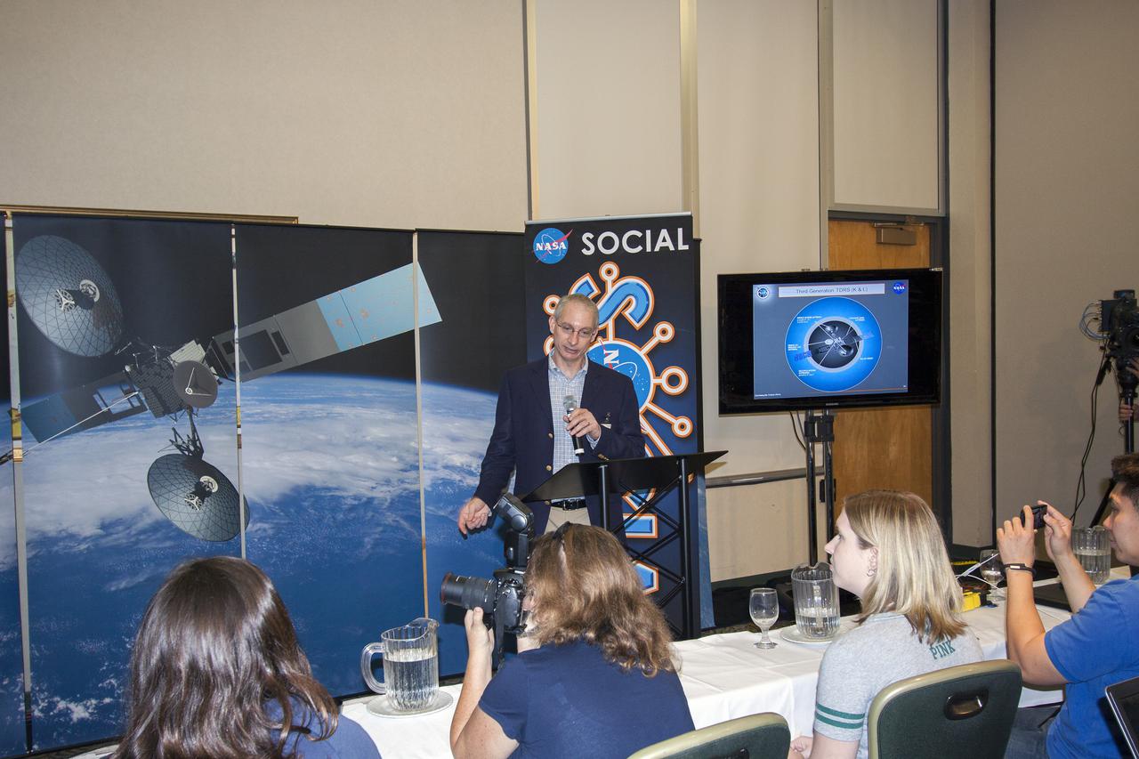
CAPE CANAVERAL, Fla. -- At NASA's Kennedy Space Center in Florida, Badri Younes, NASA deputy associate administrator for Space Communications and Navigation, or SCaN, addresses agency social media followers on the first day of activities of a NASA Social revolving around NASA's Tracking and Data Relay Satellite-K mission. NASA Socials are in-person meetings for people who engage with the agency through Twitter, Facebook, Google+ and other social networks. The satellite, known as TDRS-K, is set to launch at 8:48 p.m. EST on Jan. 30 aboard a United Launch Alliance Atlas V rocket from Space Launch Complex 41 on nearby Cape Canaveral Air Force Station. About 50 followers were selected to participate in the TDRS-K prelaunch and launch activities and share them with their own fan base. The TDRS-K spacecraft is part of the next-generation series in the Tracking and Data Relay Satellite System, a constellation of space-based communication satellites providing tracking, telemetry, command and high-bandwidth data return services. For more information, visit http://www.nasa.gov/mission_pages/tdrs/index.html. Photo credit: NASA/Jim Grossmann
CAPE CANAVERAL, Fla. -- At NASA's Kennedy Space Center in Florida, Michael Woltman, senior vehicle systems engineer for NASA's Launch Services Program, addresses agency social media followers on the first day of activities of a NASA Social revolving around NASA's Tracking and Data Relay Satellite-K mission. NASA Socials are in-person meetings for people who engage with the agency through Twitter, Facebook, Google+ and other social networks. The satellite, known as TDRS-K, is set to launch at 8:48 p.m. EST on Jan. 30 aboard a United Launch Alliance Atlas V rocket from Space Launch Complex 41 on nearby Cape Canaveral Air Force Station. About 50 followers were selected to participate in the TDRS-K prelaunch and launch activities and share them with their own fan base. The TDRS-K spacecraft is part of the next-generation series in the Tracking and Data Relay Satellite System, a constellation of space-based communication satellites providing tracking, telemetry, command and high-bandwidth data return services. For more information, visit http://www.nasa.gov/mission_pages/tdrs/index.html. Photo credit: NASA/Jim Grossmann

CAPE CANAVERAL, Fla. -- At NASA's Kennedy Space Center in Florida, agency social media followers prepare for the first day of activities of a NASA Social revolving around NASA's Tracking and Data Relay Satellite-K mission. NASA Socials are in-person meetings for people who engage with the agency through Twitter, Facebook, Google+ and other social networks. The satellite, known as TDRS-K, is set to launch at 8:48 p.m. EST on Jan. 30 aboard a United Launch Alliance Atlas V rocket from Space Launch Complex 41 on nearby Cape Canaveral Air Force Station. About 50 followers were selected to participate in the TDRS-K prelaunch and launch activities and share them with their own fan base. The TDRS-K spacecraft is part of the next-generation series in the Tracking and Data Relay Satellite System, a constellation of space-based communication satellites providing tracking, telemetry, command and high-bandwidth data return services. For more information, visit http://www.nasa.gov/mission_pages/tdrs/index.html. Photo credit: NASA/Jim Grossmann

CAPE CANAVERAL, Fla. -- At NASA's Kennedy Space Center in Florida, Gifford Moak, deputy project manager of resources for NASA's Tracking and Data Relay Satellite-K, addresses agency social media followers on the first day of activities of a NASA Social revolving around NASA's Tracking and Data Relay Satellite-K mission. NASA Socials are in-person meetings for people who engage with the agency through Twitter, Facebook, Google+ and other social networks. The satellite, known as TDRS-K, is set to launch at 8:48 p.m. EST on Jan. 30 aboard a United Launch Alliance Atlas V rocket from Space Launch Complex 41 on nearby Cape Canaveral Air Force Station. About 50 followers were selected to participate in the TDRS-K prelaunch and launch activities and share them with their own fan base. The TDRS-K spacecraft is part of the next-generation series in the Tracking and Data Relay Satellite System, a constellation of space-based communication satellites providing tracking, telemetry, command and high-bandwidth data return services. For more information, visit http:__www.nasa.gov_mission_pages_tdrs_index.html. Photo credit: NASA_Jim Grossmann
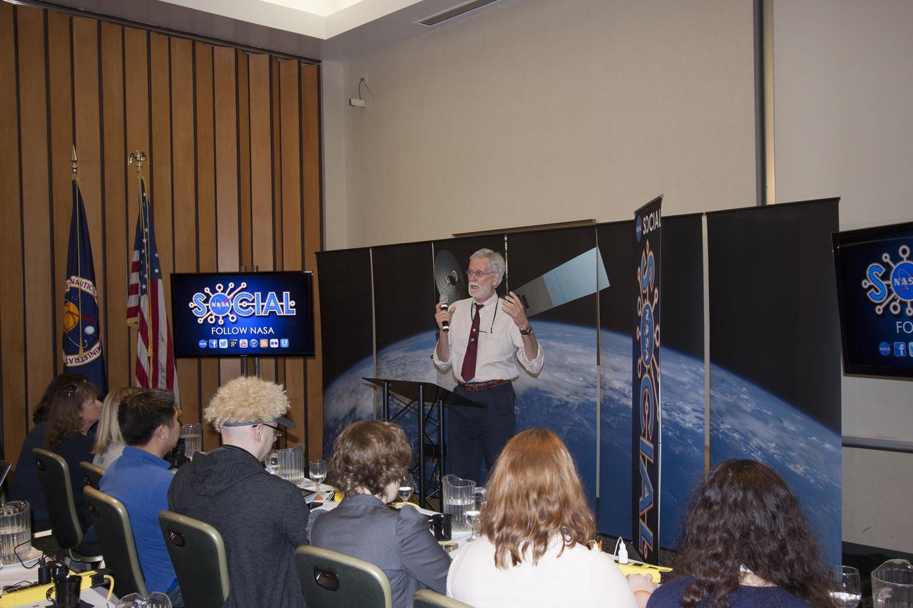
CAPE CANAVERAL, Fla. -- At NASA's Kennedy Space Center in Florida, Dr. Compton Tucker, senior scientist from NASA's Goddard Space Flight Center, addresses agency social media followers on the first day of activities of a NASA Social revolving around NASA's Tracking and Data Relay Satellite-K mission. NASA Socials are in-person meetings for people who engage with the agency through Twitter, Facebook, Google+ and other social networks. The satellite, known as TDRS-K, is set to launch at 8:48 p.m. EST on Jan. 30 aboard a United Launch Alliance Atlas V rocket from Space Launch Complex 41 on nearby Cape Canaveral Air Force Station. About 50 followers were selected to participate in the TDRS-K prelaunch and launch activities and share them with their own fan base. The TDRS-K spacecraft is part of the next-generation series in the Tracking and Data Relay Satellite System, a constellation of space-based communication satellites providing tracking, telemetry, command and high-bandwidth data return services. For more information, visit http://www.nasa.gov/mission_pages/tdrs/index.html. Photo credit: NASA/Jim Grossmann
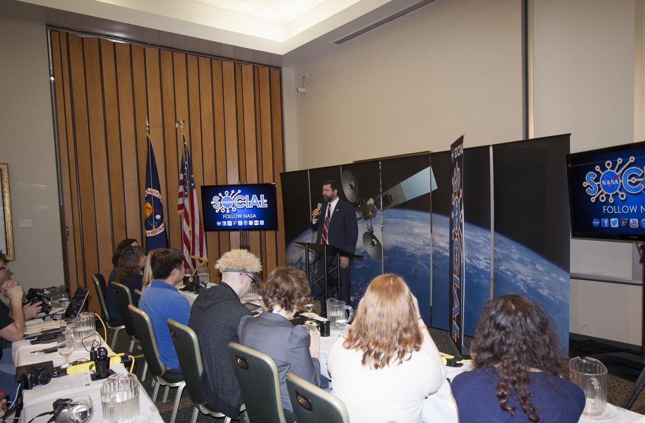
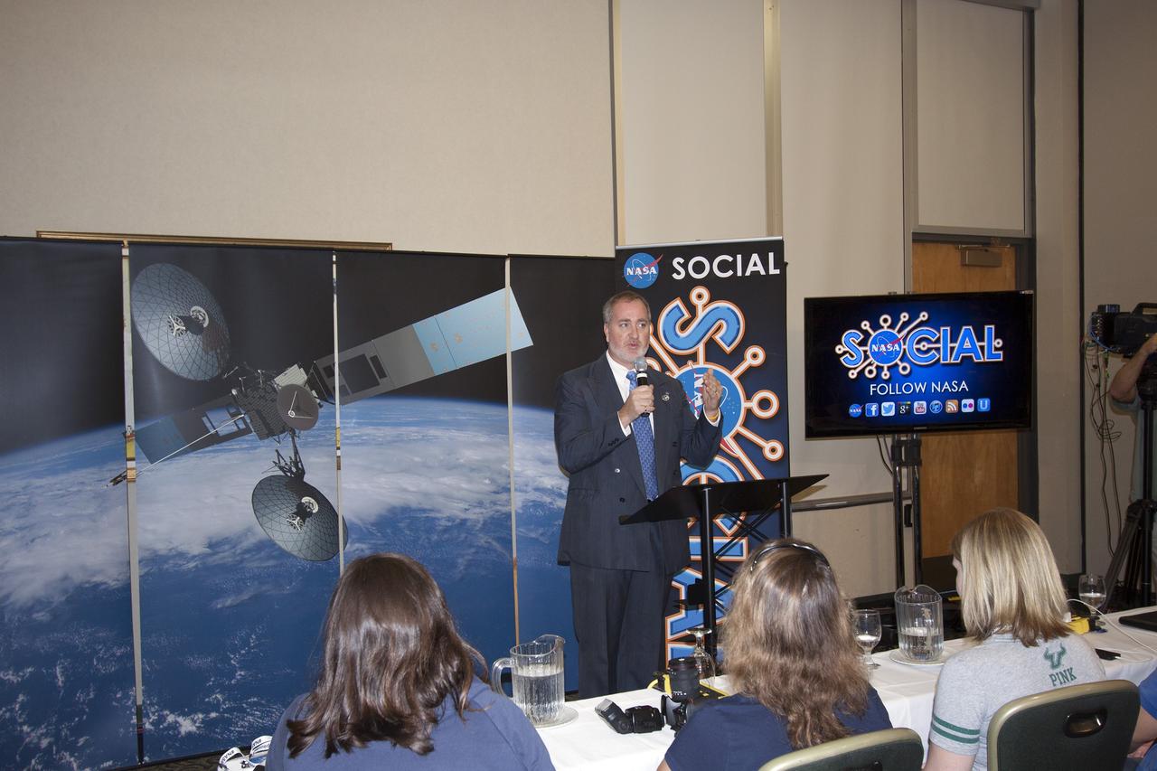
CAPE CANAVERAL, Fla. -- At NASA's Kennedy Space Center in Florida, Greg Williams, deputy associate administrator of NASA's Human Exploration and Operations Mission Directorate, addresses agency social media followers on the first day of activities of a NASA Social revolving around NASA's Tracking and Data Relay Satellite-K mission. NASA Socials are in-person meetings for people who engage with the agency through Twitter, Facebook, Google+ and other social networks. The satellite, known as TDRS-K, is set to launch at 8:48 p.m. EST on Jan. 30 aboard a United Launch Alliance Atlas V rocket from Space Launch Complex 41 on nearby Cape Canaveral Air Force Station. About 50 followers were selected to participate in the TDRS-K prelaunch and launch activities and share them with their own fan base. The TDRS-K spacecraft is part of the next-generation series in the Tracking and Data Relay Satellite System, a constellation of space-based communication satellites providing tracking, telemetry, command and high-bandwidth data return services. For more information, visit http://www.nasa.gov/mission_pages/tdrs/index.html. Photo credit: NASA/Jim Grossmann
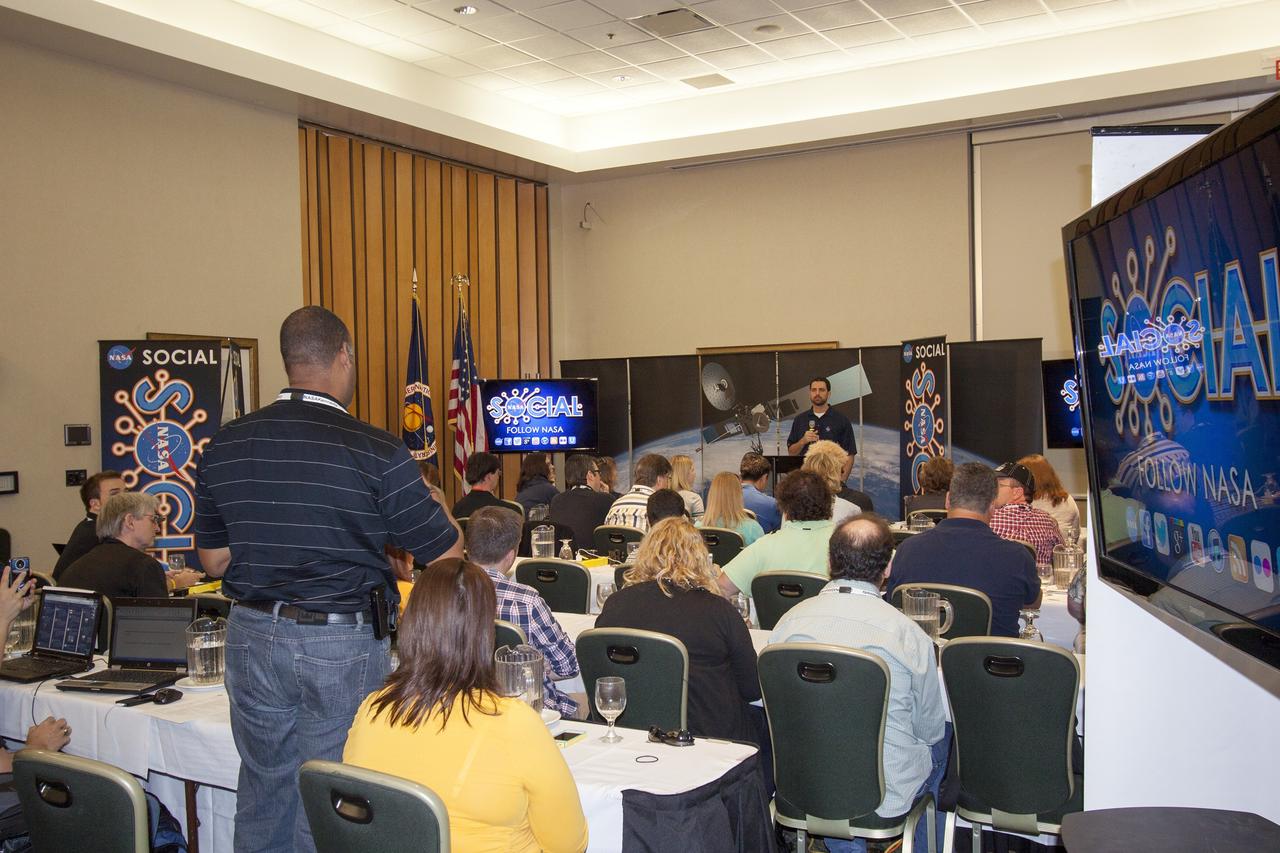
CAPE CANAVERAL, Fla. -- At NASA's Kennedy Space Center in Florida, Jeremy Parsons, technical manager for operations of NASA's Ground Systems Development and Operations Program, takes a question from an agency social media follower participating in the first day of activities of a NASA Social revolving around NASA's Tracking and Data Relay Satellite-K mission. NASA Socials are in-person meetings for people who engage with the agency through Twitter, Facebook, Google+ and other social networks. The satellite, known as TDRS-K, is set to launch at 8:48 p.m. EST on Jan. 30 aboard a United Launch Alliance Atlas V rocket from Space Launch Complex 41 on nearby Cape Canaveral Air Force Station. About 50 followers were selected to participate in the TDRS-K prelaunch and launch activities and share them with their own fan base. The TDRS-K spacecraft is part of the next-generation series in the Tracking and Data Relay Satellite System, a constellation of space-based communication satellites providing tracking, telemetry, command and high-bandwidth data return services. For more information, visit http://www.nasa.gov/mission_pages/tdrs/index.html. Photo credit: NASA/Jim Grossmann
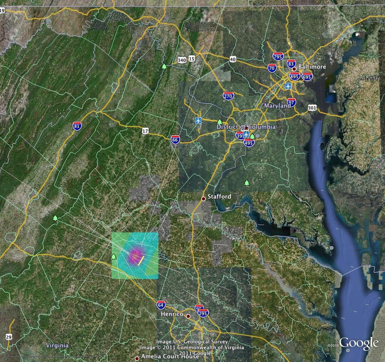
A magnitude 5.8 earthquake in Mineral, Va. was widely felt up and down the East Coast of the United States. This computer model is a QuakeSim model image overlaid on a Google Earth image.
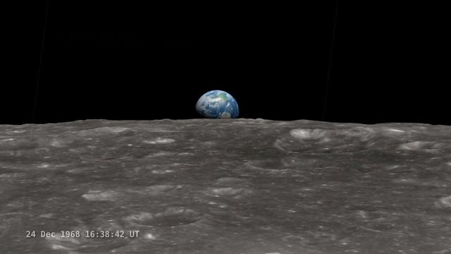
<b>Join NASA's Google+ Hangout on Friday, December 20th 2:00 - 3:00 PM (EST) at <a href="http://go.nasa.gov/18S2TbC" rel="nofollow">go.nasa.gov/18S2TbC</a> </b> It was 45 years ago, on December 24, 1968 when Apollo 8 astronauts captured 'Earthrise' – the first color photograph of Earth taken by a person in lunar orbit. NASA announces a new simulation of the events leading to the creation of 'Earthrise,' one of the iconic photographs of the 20th Century – Earth seen from the moon captured by the crew of Apollo 8. This new simulation allows anyone to virtually ride with the astronauts and experience the awe they felt at the vista in front of them. Apollo 8 Commander Frank Borman and crew members William A. Anders and James A. Lovell photographed the stunning scene as their spacecraft orbited the moon on December 24, 1968. The new computer simulation was created using data from NASA's Lunar Reconnaissance Orbiter, or LRO, spacecraft and includes details not seen in the previous visualization released last year. Participants in this Hangout include: * John Keller, project scientist for the Lunar Reconnaissance Orbiter project * Ernie Wright, project lead with the Scientific Visualization Studio at NASA Goddard Space Flight Center * Andrew Chaikin, space historian, author of the book A Man on the Moon "This will also be the first time we've released a video that's synchronized with the onboard audio recording of the astronauts,", says Ernie Wright. "The new visualization tells us not only what time the photos were taken, but also exactly which way the spacecraft was pointing and therefore which window each photo was taken from." Earthrise is the cover photo of TIME's Great Images of the 20th Century and is among photos on the cover of LIFE's 100 Photographs That Changed the World. <b><a href="http://www.nasa.gov/audience/formedia/features/MP_Photo_Guidelines.html" rel="nofollow">NASA image use policy.</a></b> <b><a href="http://www.nasa.gov/centers/goddard/home/index.html" rel="nofollow">NASA Goddard Space Flight Center</a></b> enables NASA’s mission through four scientific endeavors: Earth Science, Heliophysics, Solar System Exploration, and Astrophysics. Goddard plays a leading role in NASA’s accomplishments by contributing compelling scientific knowledge to advance the Agency’s mission. <b>Follow us on <a href="http://twitter.com/NASA_GoddardPix" rel="nofollow">Twitter</a></b> <b>Like us on <a href="http://www.facebook.com/pages/Greenbelt-MD/NASA-Goddard/395013845897?ref=tsd" rel="nofollow">Facebook</a></b> <b>Find us on <a href="http://instagram.com/nasagoddard?vm=grid" rel="nofollow">Instagram</a></b>
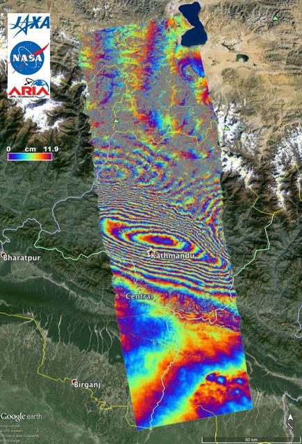
NASA and its partners are contributing important observations and expertise to the ongoing response to the April 25, 2015, magnitude 7.8 Gorkha earthquake in Nepal. The quake was the strongest to occur in that area since the 1934 Nepal-Bihar magnitude 8.0 event and caused significant regional damage and a humanitarian crisis. Scientists with the Advanced Rapid Imaging and Analysis project (ARIA), a collaboration between NASA's Jet Propulsion Laboratory, Pasadena, California, and the California Institute of Technology in Pasadena, analyzed interferometric synthetic aperture radar images from the PALSAR-2 instrument on the ALOS-2 satellite operated by the Japan Aerospace Exploration Agency (JAXA) to calculate a map of the deformation of Earth's surface caused by the quake. This false-color map shows the amount of permanent surface movement caused almost entirely by the earthquake, as viewed by the satellite, during a 70-day interval between two ALOS-2 images, acquired February 21 and May 2, 2015. In the map, surface displacements are seen as color contours (or "fringes"), where each color cycle represents 4.7 inches (11.9 centimeters) of surface motion. The contours show the land around Kathmandu has moved toward the satellite by up to 4.6 feet (1.4 meter), or 5.2 feet (1.6 meters) if we assume purely vertical motion. Areas without the color contours have snow or heavy vegetation that affects the radar measurements. Scientists use these maps to build detailed models of the fault and associated land movements to better understand the impact on future earthquake activity. The PALSAR-2 data were provided by JAXA through the Committee on Earth Observation Satellite (CEOS) in support of the response effort. The background image is from Google Earth. http://photojournal.jpl.nasa.gov/catalog/PIA19383
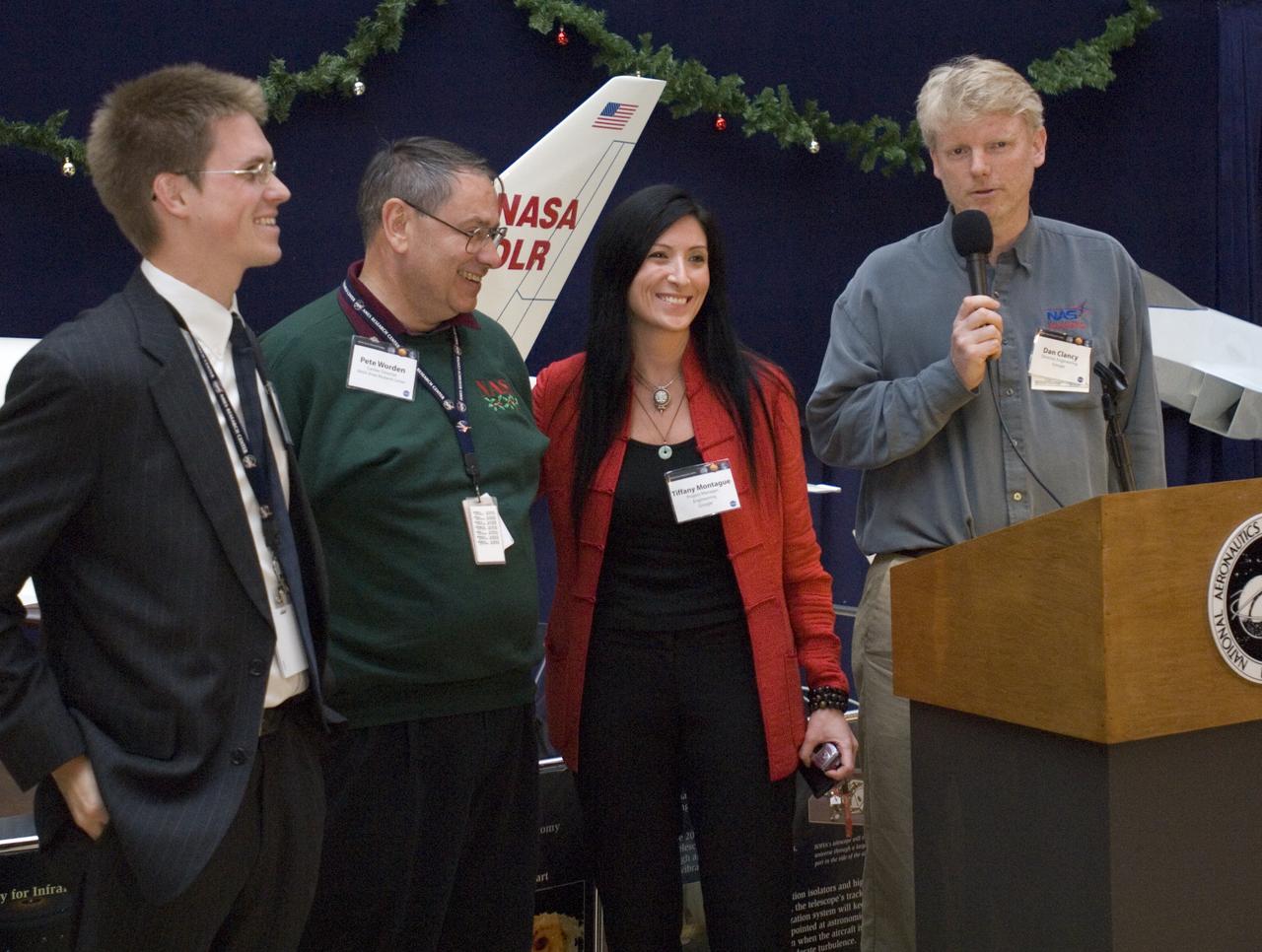
Kick-off event for Google NASA collaboration (held in the Ames Exploration Center 943A) with Chris Kemp, Ames Business Development (L) Ames Center Director Pete Worden (L-M) Tiffany Montage, Project Manager Engineering, Google (R-M) and Dan Clancy, Director of engineering Google (R)

Perseid Meteor flight on Google's Gulfstream Aircraft. P.I. Peter Jenniskens, SETI Group - Google's Gulfstream Aircraft on flightline before take-off
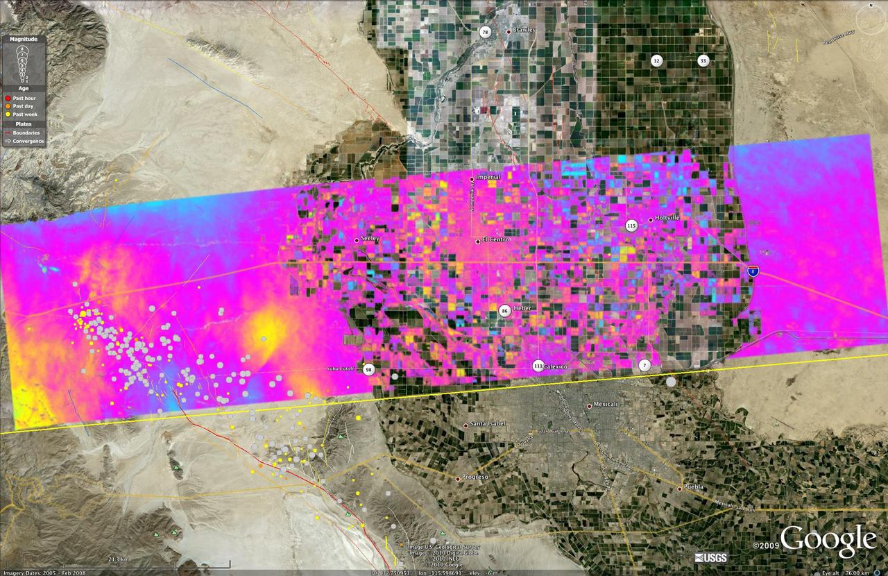
This image shows a UAVSAR interferogram swath overlaid atop a Google Earth image. New NASA airborne radar images show the continuing deformation in Earth surface resulting from the magnitude 7.2 temblor in Baja California on April 4, 2010.
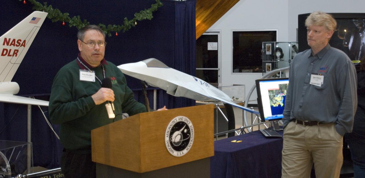
Kick-off event for Google NASA collaboration (held in the Ames Exploration Center 943A) with Ames Center Director Pete Worden (L) and Dan Clancy, Director of engineering Google
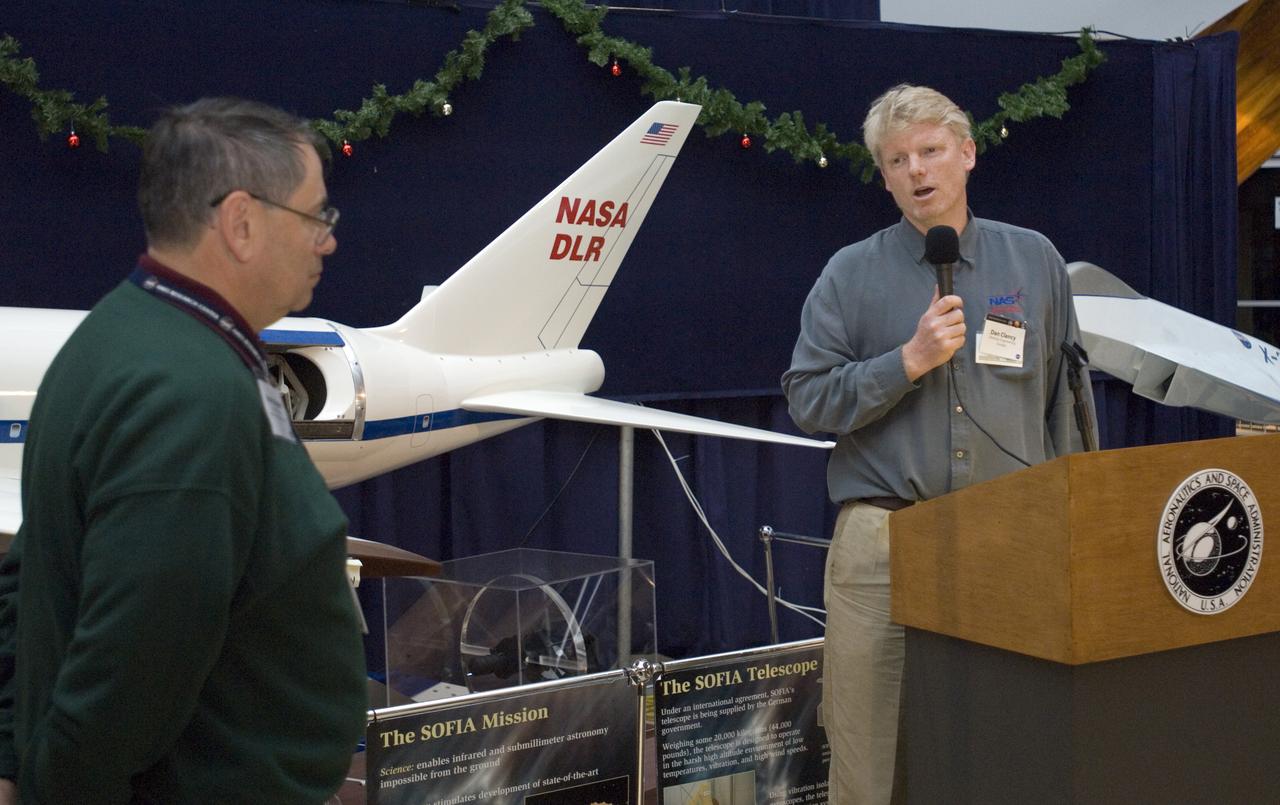
Kick-off event for Google NASA collaboration (held in the Ames Exploration Center 943A) with Ames Center Director Pete Worden (L) and Dan Clancy, Director of engineering Google
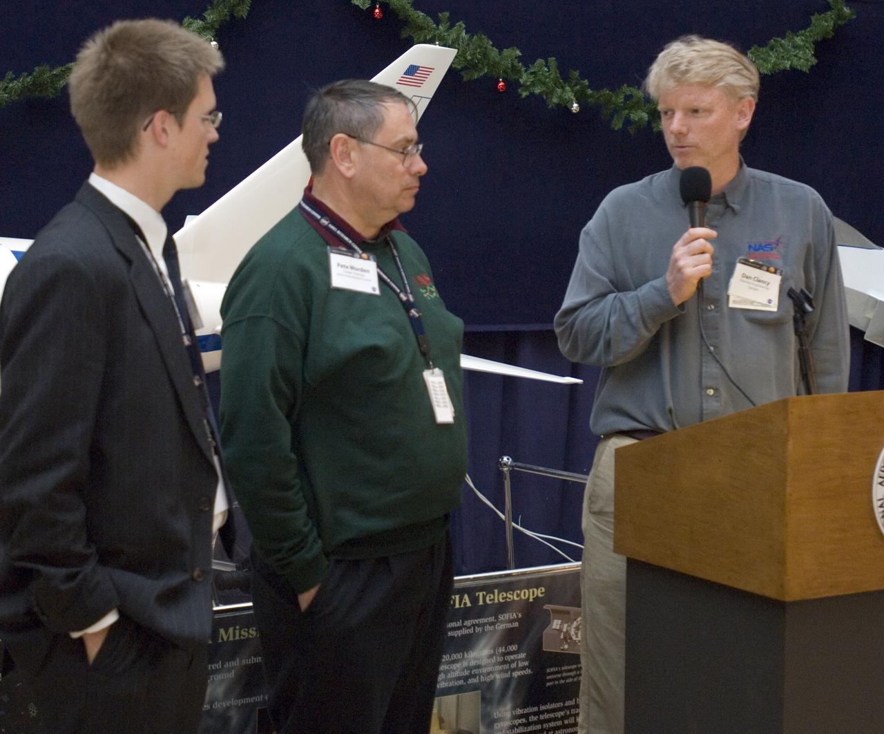
Kick-off event for Google NASA collaboration (held in the Ames Exploration Center 943A) with Chris Kemp, Ames Business Development (L) Ames Center Director Pete Worden (M) and Dan Clancy, Director of engineering Google (R)
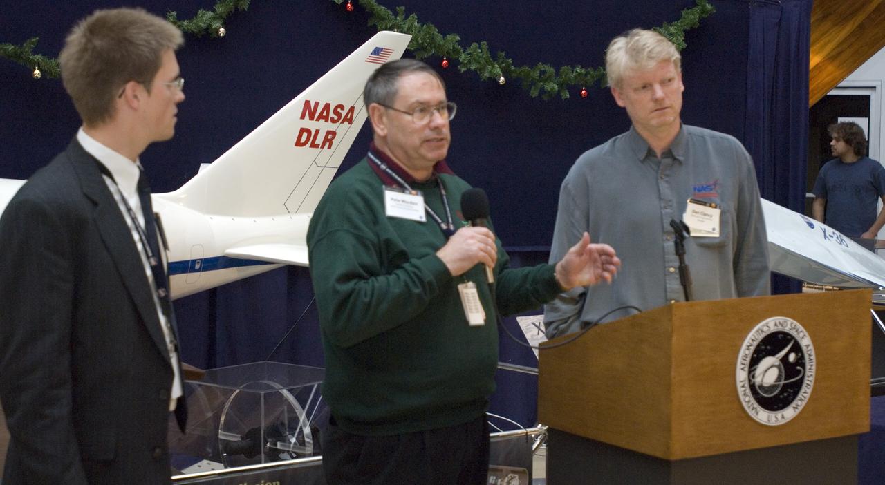
Kick-off event for Google NASA collaboration (held in the Ames Exploration Center 943A) with Chris Kemp, Ames Business Development (L) Ames Center Director Pete Worden (M) and Dan Clancy, Director of engineering Google (R)

Perseid Meteor flight on Google's Gulfstream Aircraft. P.I. Peter Jenniskens, SETI Group with D.K. Holman, CMS/IMO

Perseid Meteor flight on Google's Gulfstream Aircraft. P.I. Peter Jenniskens, SETI Group with D. Nugent UC San Degio

Perseid Meteor flight on Google's Gulfstream Aircraft. P.I. Peter Jenniskens, SETI Group with C.C. Crawford, Meteor Society, CA

Perseid Meteor flight on Google's Gulfstream Aircraft. P.I. Peter Jenniskens, SETI Group

Perseid Meteor flight on Google's Gulfstream Aircraft. P.I. Peter Jenniskens, SETI Group with Julian Nott, Santa Barbara

Perseid Meteor flight on Google's Gulfstream Aircraft. P.I. Peter Jeniskens, SETI Group

Perseid Meteor flight on Google's Gulfstream Aircraft. P.I. Peter Jenniskens, SETI Group with D.K. Holman, CMS/IMO

Perseid Meteor flight on Google's Gulfstream Aircraft. P.I. Peter Jenniskens, SETI Group with C.C. Crawford, Meteor Society, CA

Perseid Meteor flight on Google's Gulfstream Aircraft. P.I. Peter Jenniskens, SETI Group Peter Jenniskens, SETI

Perseid Meteor flight on Google's Gulfstream Aircraft. P.I. Peter Jenniskens, SETI Group with Julian Nott, Santa Barbara
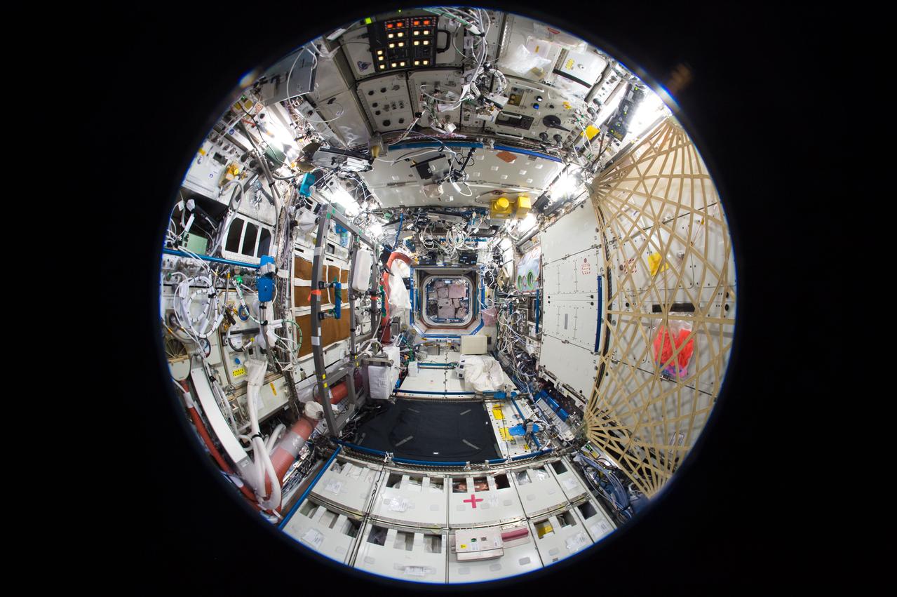
iss050e050873 (2/19/2017) --- A fish-eye view of the U.S. Laboratory taken for a Google Street View of the ISS.

Perseid Meteor flight on Google's Gulfstream Aircraft. P.I. Peter Jenniskens, SETI Group shown at window with camera set up.

Perseid Meteor flight on Google's Gulfstream Aircraft. P.I. Peter Jenniskens, SETI Group with C.C. Crawford, Meteor Society, CA

Perseid Meteor flight on Google's Gulfstream Aircraft. P.I. Peter Jenniskens, SETI Group with D.K. Holman, CMS/IMO

Perseid Meteor flight on Google's Gulfstream Aircraft. P.I. Peter Jenniskens, SETI Group with Julian Nott, Santa Barbara

Perseid Meteor flight on Google's Gulfstream Aircraft. P.I. Peter Jenniskens, SETI Group Peter Jenniskens, SETI

Perseid Meteor flight on Google's Gulfstream Aircraft. P.I. Peter Jenniskens, SETI Group, with M.W. Koop, Meteor Society, CA

Perseid Meteor flight on Google's Gulfstream Aircraft. P.I. Peter Jenniskens, SETI Group

Perseid Meteor flight on Google's Gulfstream Aircraft. P.I. Peter Jenniskens, SETI Group, with M.W. Koop, Meteor Society, CA

Perseid Meteor flight on Google's Gulfstream Aircraft. P.I. Peter Jenniskens, SETI Group, with M.W. Koop, Meteor Society, CA

Perseid Meteor flight on Google's Gulfstream Aircraft. P.I. Peter Jenniskens, SETI Group with Rick Conrey, NASA Ames, Exploration Academy

Perseid Meteor flight on Google's Gulfstream Aircraft. P.I. Peter Jenniskens, SETI Group and J Houston-Jones, Meteor Society, CA

Perseid Meteor flight on Google's Gulfstream Aircraft. P.I. Peter Jenniskens, SETI Group with J Houston-Jones, Meteor Society CA

Perseid Meteor flight on Google's Gulfstream Aircraft. P.I. Peter Jenniskens, SETI Group wit Kat De Kleer, SETI, REU Program

Perseid Meteor flight on Google's Gulfstream Aircraft. P.I. Peter Jenniskens, SETI Group and J Houston-Jones, Meteor Society, CA

Perseid Meteor flight on Google's Gulfstream Aircraft. P.I. Peter Jenniskens, SETI Group with Rick Conrey, NASA Ames, Exploration Academy

Perseid Meteor flight on Google's Gulfstream Aircraft. P.I. Peter Jenniskens, SETI Group and Rick Conrey, NASA Ames Exploration Academy

Perseid Meteor flight on Google's Gulfstream Aircraft. P.I. Peter Jenniskens, SETI Group takes Kat De Kleer, SETI, REU Program picture

Perseid Meteor flight on Google's Gulfstream Aircraft. P.I. Peter Jenniskens, SETI Group with Rick Rairden, Lockheed-Martin, Palo Alto, CA

Perseid Meteor flight on Google's Gulfstream Aircraft. P.I. Peter Jenniskens, SETI Group with Rick Rairden, Lockheed-Martin, Palo Alto, CA

Perseid Meteor flight on Google's Gulfstream Aircraft. P.I. Peter Jenniskens, SETI Group wit Kat De Kleer, SETI, REU Program

Perseid Meteor flight on Google's Gulfstream Aircraft. P.I. Peter Jenniskens, SETI Group with Rick Conrey, NASA Ames, Exploration Academy

Perseid Meteor flight on Google's Gulfstream Aircraft. P.I. Peter Jenniskens, SETI Group with J Houston-Jones, Meteor Society CA

Perseid Meteor flight on Google's Gulfstream Aircraft. P.I. Peter Jenniskens, SETI Group - C.C. Crawford and J houston-Jones load up for flight

Perseid Meteor flight on Google's Gulfstream Aircraft. P.I. Peter Jenniskens, SETI Group wit Kat De Kleer, SETI, REU Program

Girl Scout troop 2612 members from Tulsa, OK take photos of one another with Google Glass at the White House Science Fair Tuesday, May 27, 2014. Avery Dodson, 6; Natalie Hurley, 8; Miriam Schaffer, 8; Claire Winton, 8; and Lucy Claire Sharp, 8 participated in the Junior FIRST Lego League's Disaster Blaster Challenge, which invites elementary-school-aged students from across the country to explore how simple machines, engineering, and math can help solve problems posed by natural disasters. The girls invented the "Flood Proof Bridge" and built a model mechanizing the bridge using motors and developing a computer program to automatically retract the bridge when flood conditions are detected. The fourth White House Science Fair was held at the White House and included 100 students from more than 30 different states who competed in science, technology, engineering, and math (STEM) competitions. (Photo Credit: NASA/Aubrey Gemignani)

Perseid Meteor flight on Google's Gulfstream Aircraft. P.I. Peter Jenniskens, SETI Group - NASA Ames' Chris Kemp and Lisa Lockyer board aircaft for ride along

Perseid Meteor flight on Google's Gulfstream Aircraft. P.I. Peter Jenniskens, SETI Group - Koop, Kemp, Rairden, Lockyer discuss the mission on board the Gulfstream enroute to meteor shower local
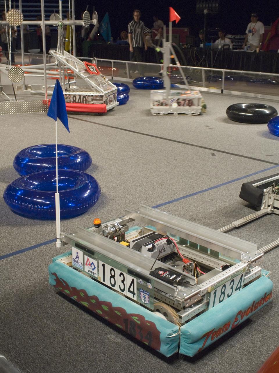
Silicon Valley FIRST Regional Robotics competition: Evolution Team 1834 - NASA/Google/NASA Robotics Education FIRST Spnsorship program/San Jose Job Corps/MetroED & SIA Tech, San Jose, California (CA)

Perseid Meteor flight on Google's Gulfstream Aircraft. P.I. Peter Jenniskens, SETI Group L-R; Julian Nott, Santa Barbara, Peter Jenniskens, SETI and Apex Aviation Corp rep.

Perseid Meteor flight on Google's Gulfstream Aircraft. P.I. Peter Jenniskens, SETI Group - L-R; briefing w/L-R; J Houston-Jones, D Nugent, l Lockyer, R Rairden, & C Kemp

Perseid Meteor flight on Google's Gulfstream Aircraft. P.I. Peter Jenniskens, SETI Group Peter Jenniskens, SETI (R) and Kat De Kleer, SETI, REU Program (L)

Perseid Meteor flight on Google's Gulfstream Aircraft. P.I. Peter Jenniskens, SETI Group Peter Jenniskens, SETI - briefing w/L-R; J Nott, P Jenniskens, M Koop, D Holman and two Apex Aviation Corp reps.

Sam Choi and Naiara Pinto observe Google Earth overlaid with in almost real time what the synthetic aperture radar is mapping from the C-20A aircraft. Researchers were in the sky and on the ground to take measurements of plant mass, distribution of trees, shrubs and ground cover and the diversity of plants and how much carbon is absorbed by them.
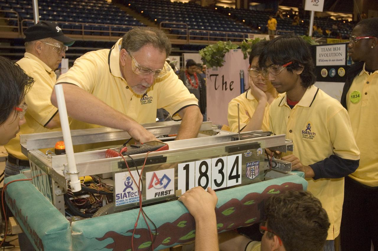
Silicon Valley FIRST Regional Robotics competition: Evolution Team 1834 - NASA/Google/NASA Robotics Education FIRST Spnsorship program/San Jose Job Corps/MetroED & SIA Tech, San Jose, California (CA)s Cheezy Poofs team-1834
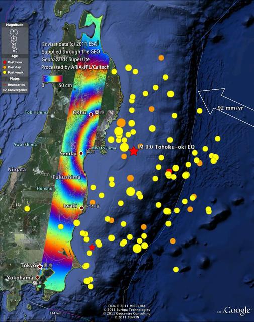
This radar image from ESA Envisat depicts ground displacements resulting from the March 11, 2011, magnitude 9.0 Tohoku earthquake in Japan.

e-Genius Aircraft Pilot Klaus Ohlmann poses for a photograph during the 2011 Green Flight Challenge, sponsored by Google, held at the Charles M. Schulz Sonoma County Airport in Santa Rosa, Calif. on Thursday, Sept. 29, 2011. NASA and the Comparative Aircraft Flight Efficiency (CAFE) Foundation are having the challenge with the goal to advance technologies in fuel efficiency and reduced emissions with cleaner renewable fuels and electric aircraft. Photo Credit: (NASA/Bill Ingalls)
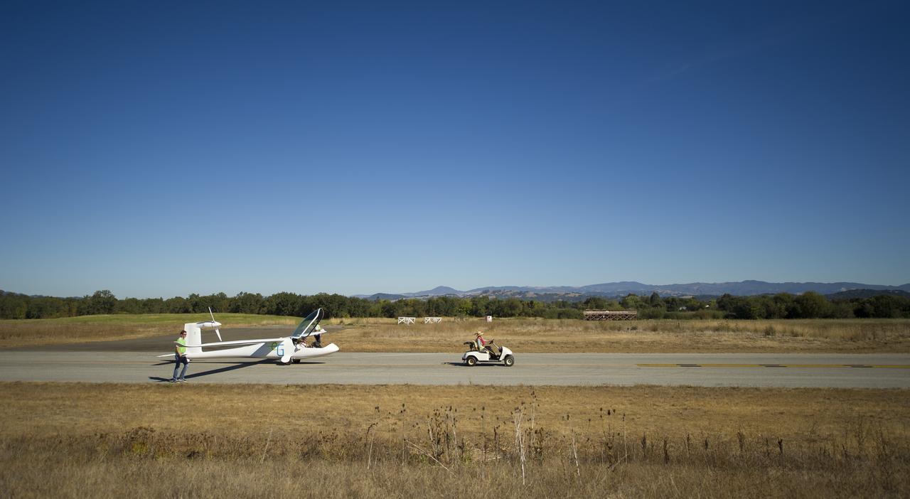
The e-Genius aircraft is pulled out to the runway for the miles per gallon (MPG) flight during the 2011 Green Flight Challenge, sponsored by Google, at the Charles M. Schulz Sonoma County Airport in Santa Rosa, Calif. on Tuesday, Sept. 27, 2011. NASA and the Comparative Aircraft Flight Efficiency (CAFE) Foundation are having the challenge with the goal to advance technologies in fuel efficiency and reduced emissions with cleaner renewable fuels and electric aircraft. Photo Credit: (NASA/Bill Ingalls)
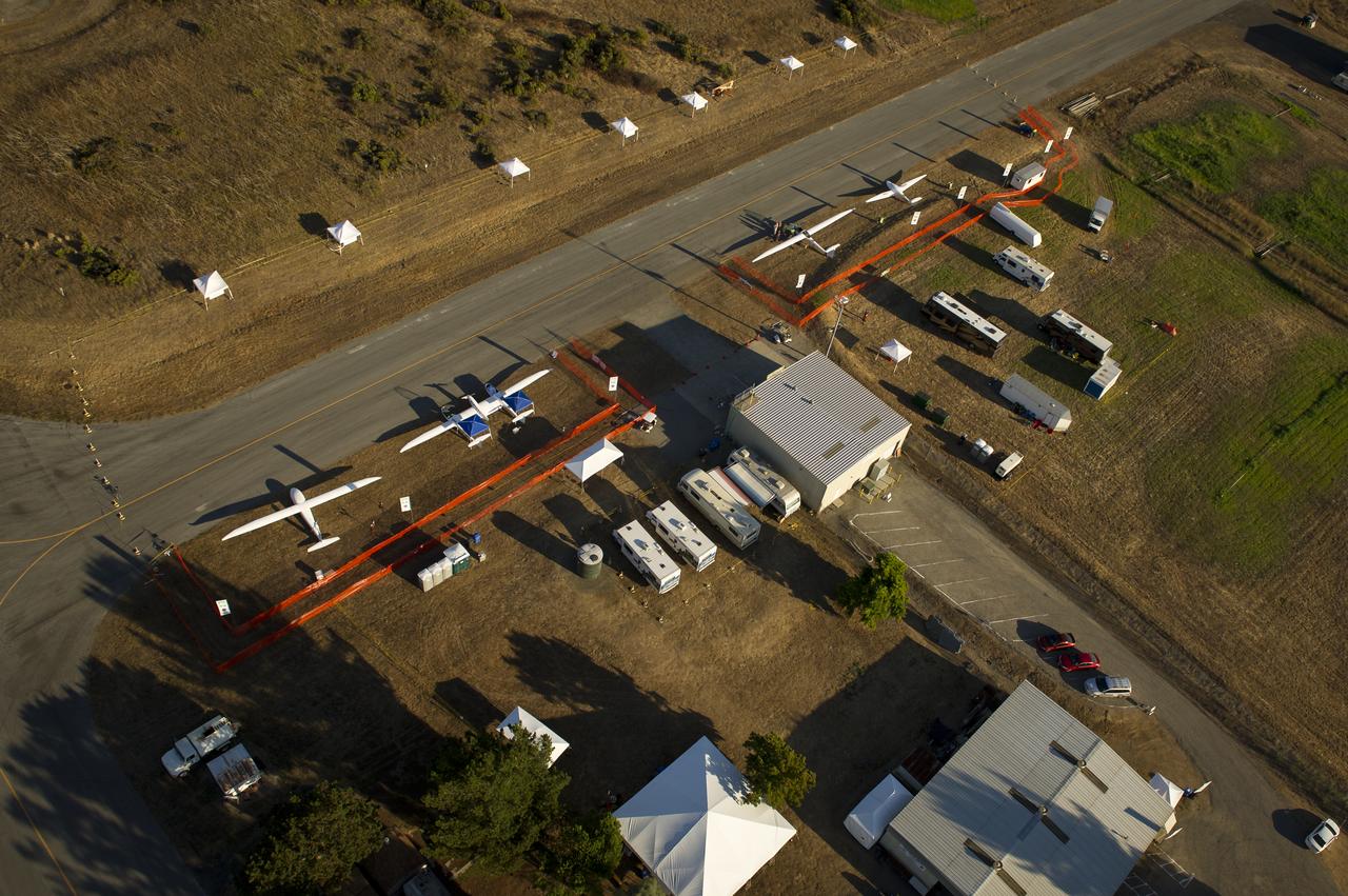
The e-Genius, left, Taurus G4, 2nd from left, EcoEagle, and PhoEnix aircraft, top right, are seen on the campus of the 2011 Green Flight Challenge, sponsored by Google, at the Charles M. Schulz Sonoma County Airport in Santa Rosa, Calif. on Wednesday, Sept. 28, 2011. NASA and the Comparative Aircraft Flight Efficiency (CAFE) Foundation are having the challenge with the goal to advance technologies in fuel efficiency and reduced emissions with cleaner renewable fuels and electric aircraft. Photo Credit: (NASA/Bill Ingalls)
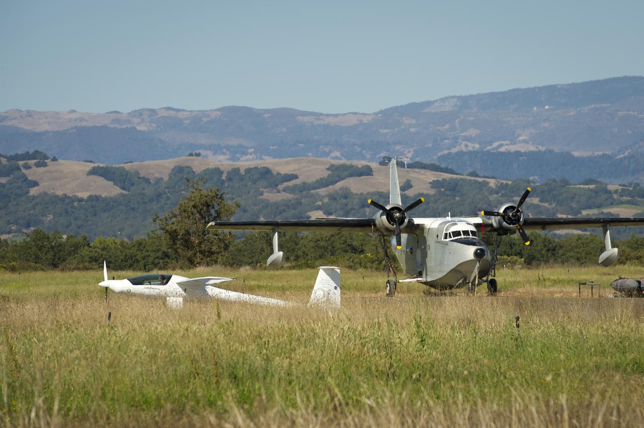
The Embry-Riddle Aeronautical University, EcoEagle is seen as it passes a Grumman Albatross during the 2011 Green Flight Challenge, sponsored by Google, at the Charles M. Schulz Sonoma County Airport in Santa Rosa, Calif. on Monday, Sept. 26, 2011. NASA and the Comparative Aircraft Flight Efficiency (CAFE) Foundation are having the challenge with the goal to advance technologies in fuel efficiency and reduced emissions with cleaner renewable fuels and electric aircraft. Photo Credit: (NASA/Bill Ingalls)
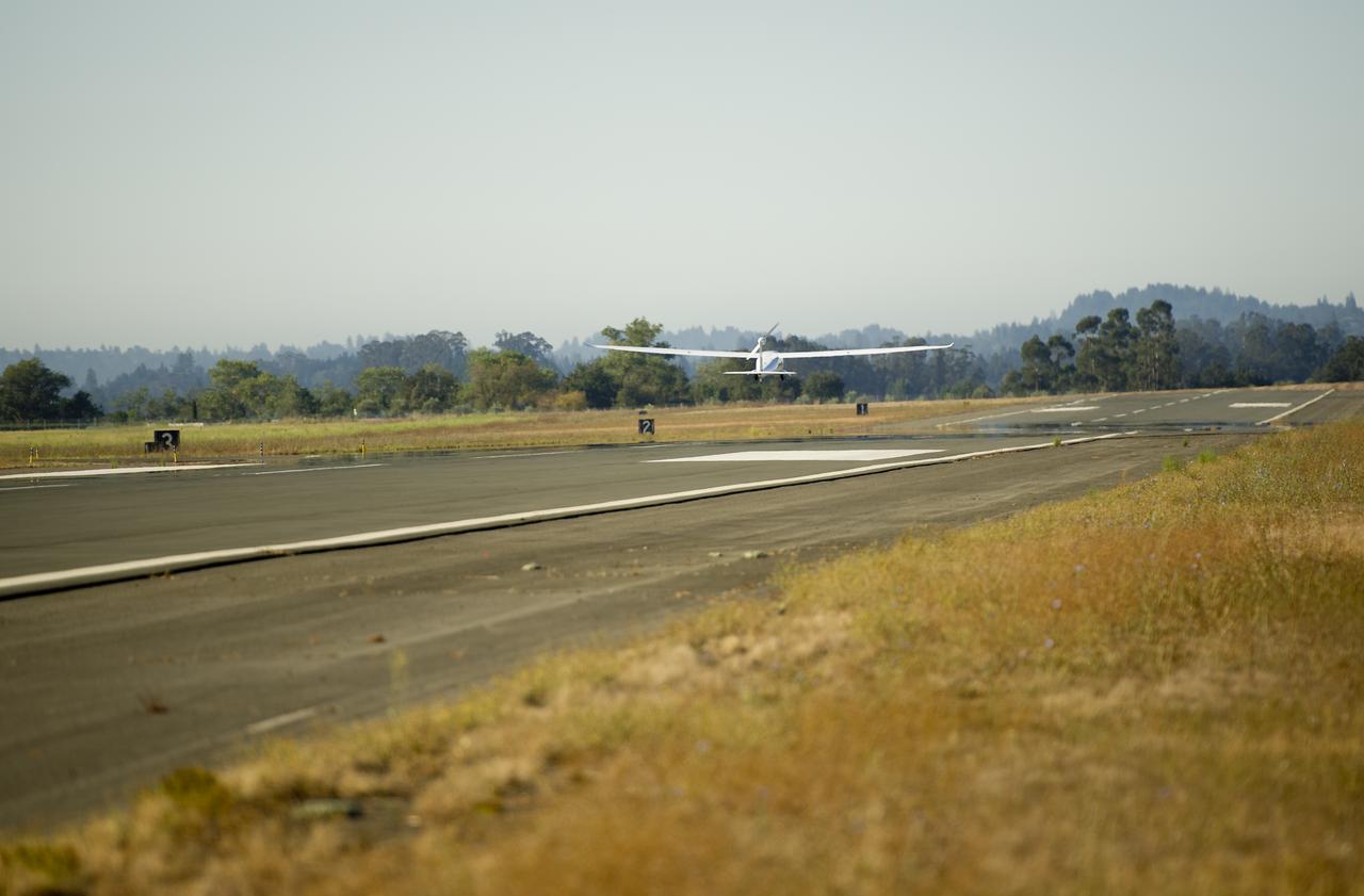
The e-Genius aircraft takes off for the start of the speed competition during the 2011 Green Flight Challenge, sponsored by Google, at the Charles M. Schulz Sonoma County Airport in Santa Rosa, Calif. on Thursday, Sept. 29, 2011. NASA and the Comparative Aircraft Flight Efficiency (CAFE) Foundation are having the challenge with the goal to advance technologies in fuel efficiency and reduced emissions with cleaner renewable fuels and electric aircraft. Photo Credit: (NASA/Bill Ingalls)