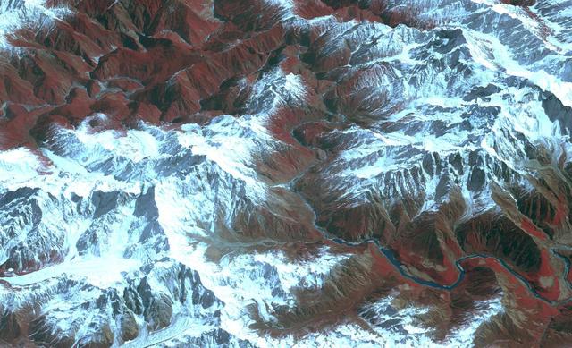
Acquired by NASA Terra spacecraft, this image shows the Yarlung Zangpo Grand Canyon or Tsangpo Gorge in Tibet, the deepest canyon in the world, and longer than the Grand Canyon.

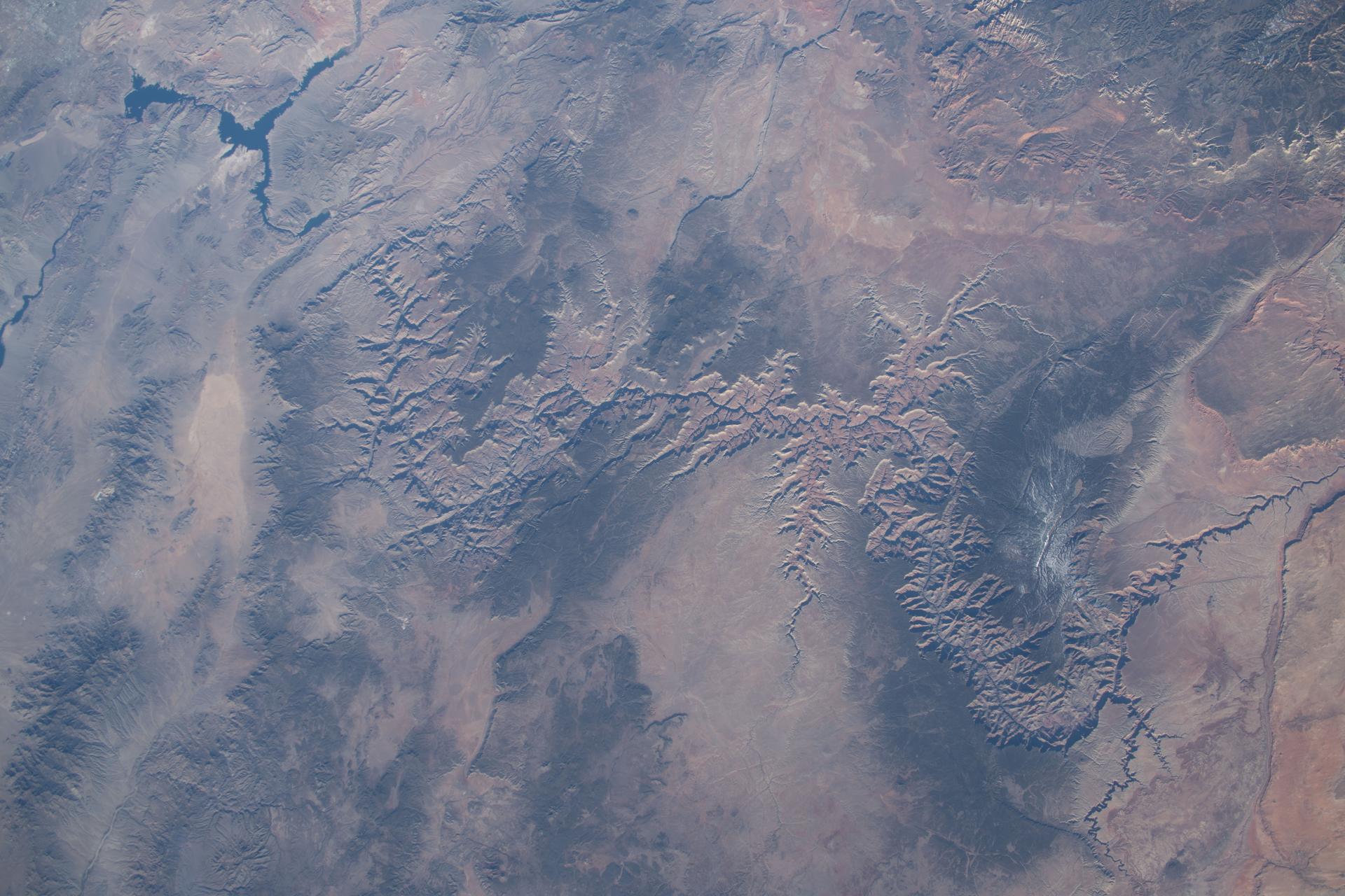
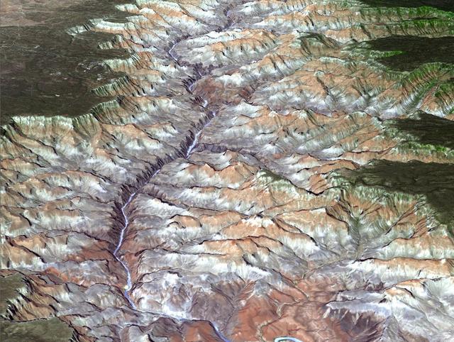
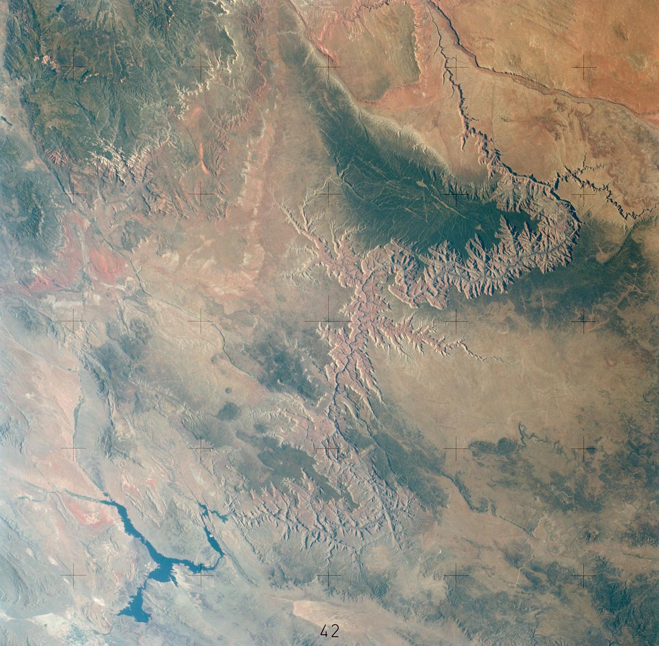
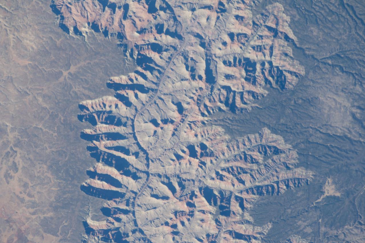
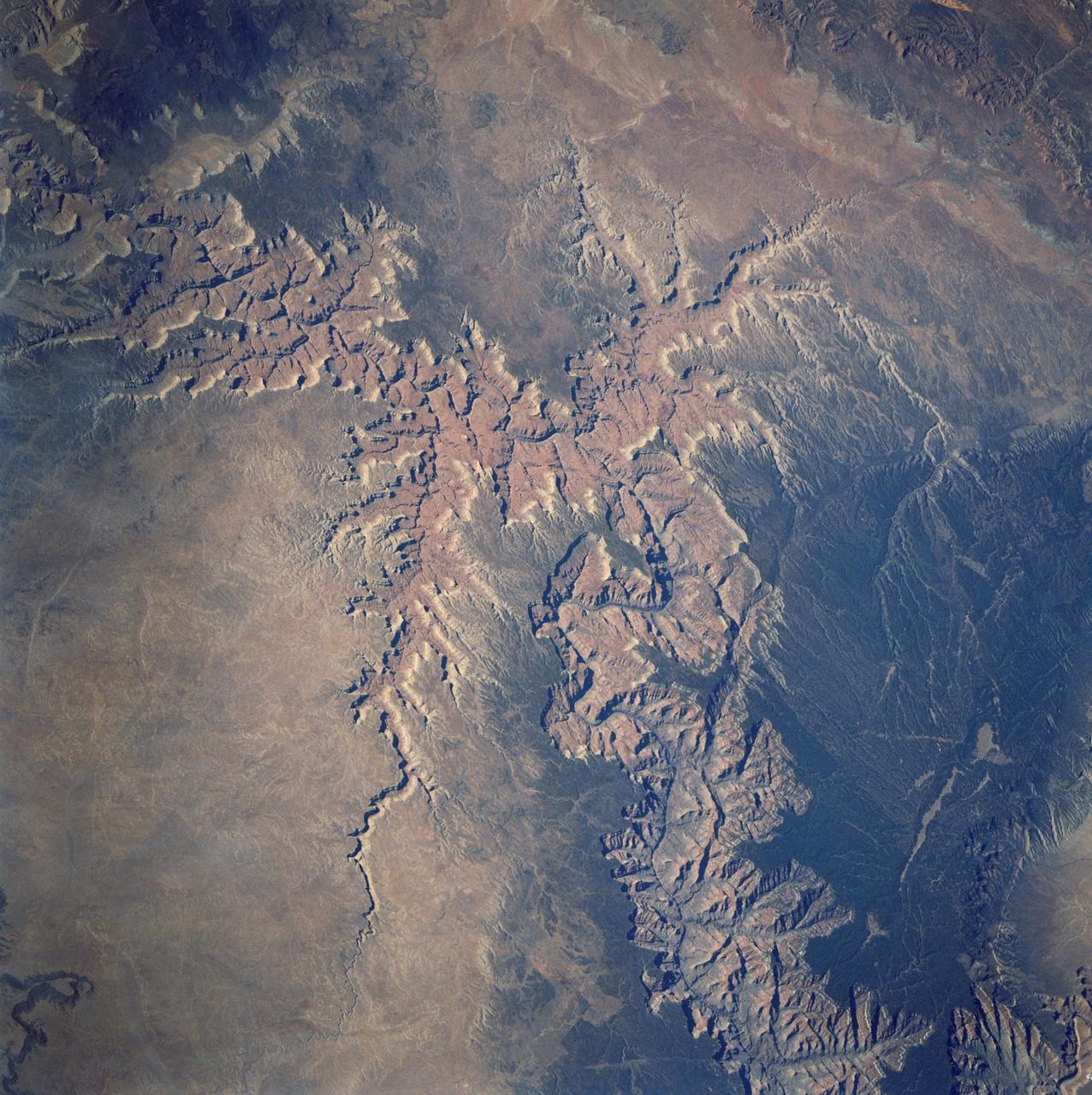
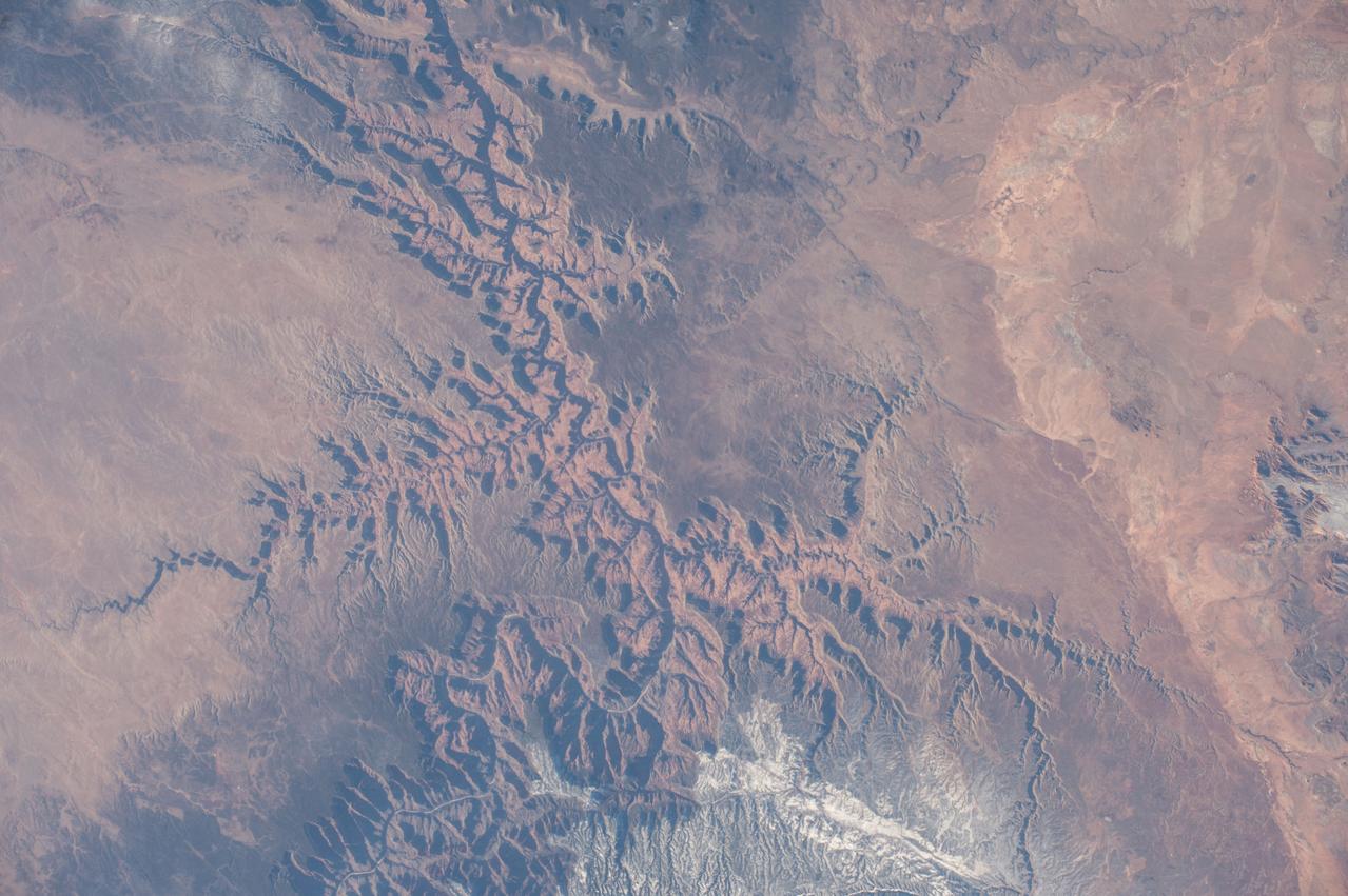
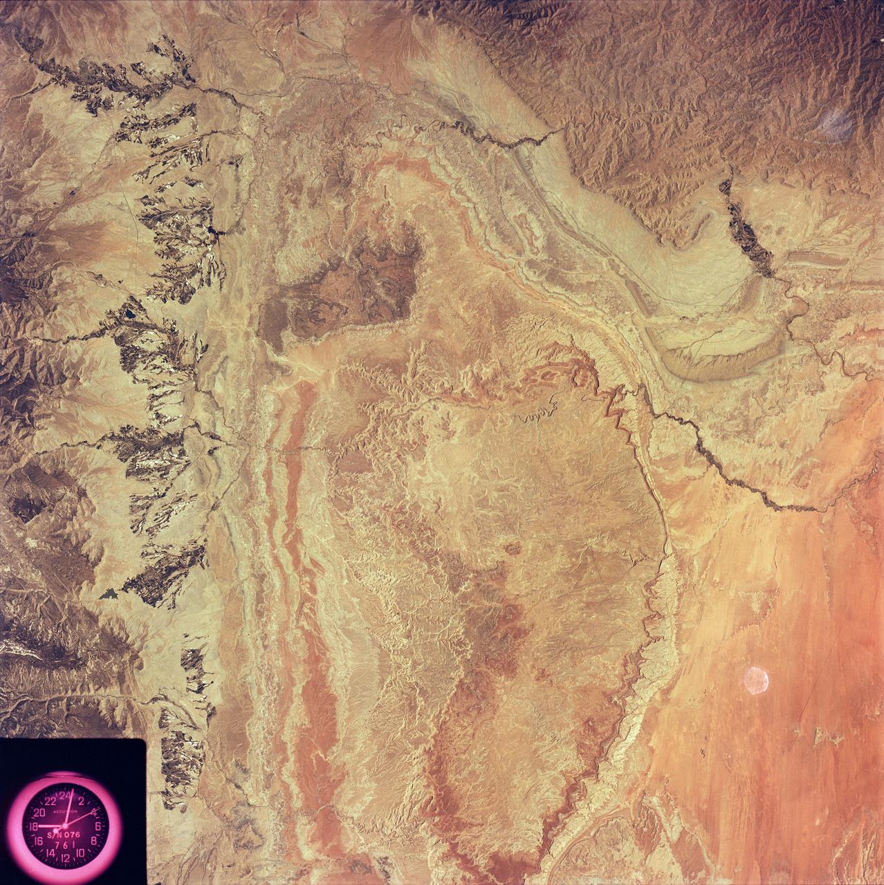
Northern Arizona and the Grand Canyon are captured in this pair of images from December 31, 2000 as seen by NASA Terra satellite Terra orbit 5525.
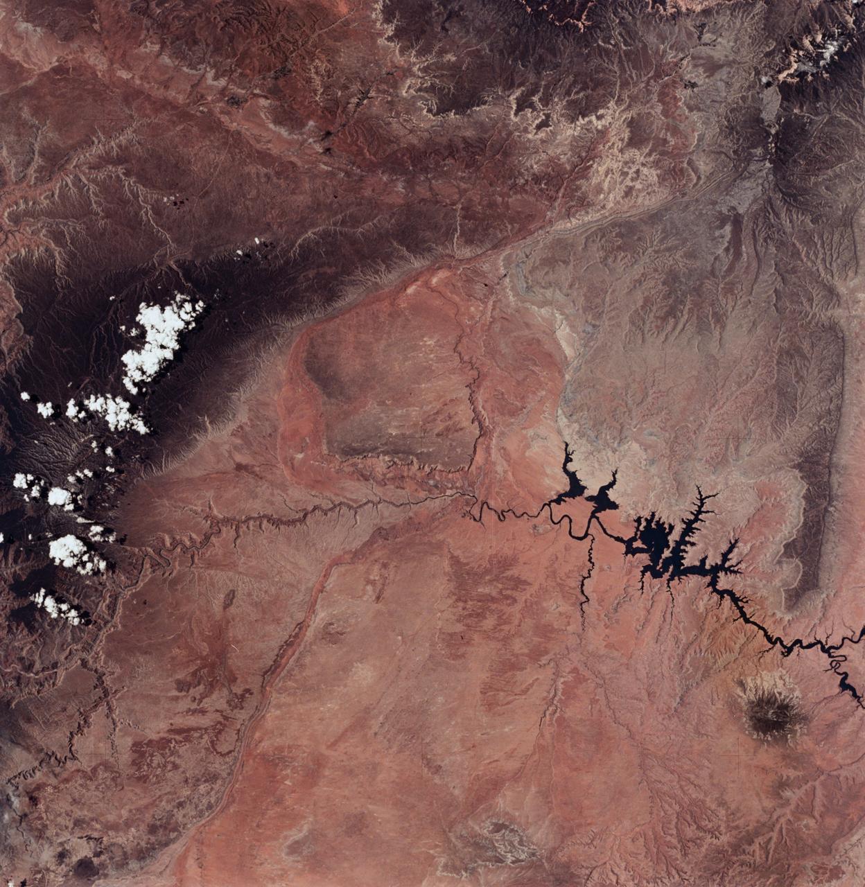
SL2-04-018 (June 1973) --- A vertical view of the Arizona-Utah border area showing the Colorado River and Grand Canyon photographed from the Skylab 1/2 space station in Earth orbit. This picture was taken by one of the six lenses of the Itek-furnished S190-A Multispectral Photographic Facility Experiment in the Multiple Docking Adapter of the space station. Type S0-356 film was used. The row of white clouds extend north-south over the dark colored Kaibab Plateau. The junction of the Colorado and Little Colorado rivers is in the southwest corner of the picture. The body of water is Lake Powell on the Colorado River upstream from the Grand Canyon. The lone peak at the eastern edge of the photograph south of Colorado River is the 10,416-foot Navajo Mountain. The S190-A experiment is part of the Skylab Earth Resources Experiments Package(EREP). Photo credit: NASA
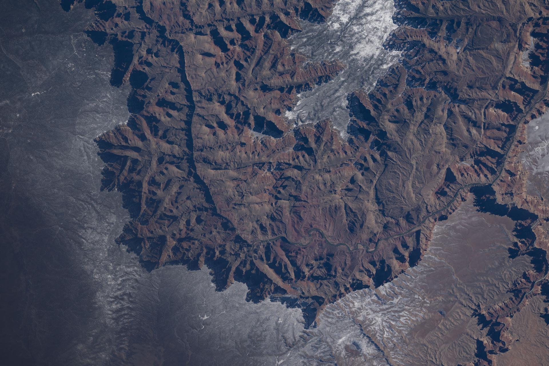
iss074e0301902 (Feb. 3, 2026) --- The Grand Canyon stretches about 277 miles across Arizona in the southwestern corner of the Colorado Plateau. The Colorado River began carving the Grand Canyon—one of the Seven Natural Wonders of the World and a UNESCO World Heritage Site—about 5 to 6 million years ago. The International Space Station was orbiting 259 miles above the United States when this photograph was taken.
Arguably one of America most magnificent national parks is the Grand Canyon in northern Arizona. NASA Terra spacecraft captured this image looking to the northeast, the buildings and roads in the center foreground are Grand Canyon Village.
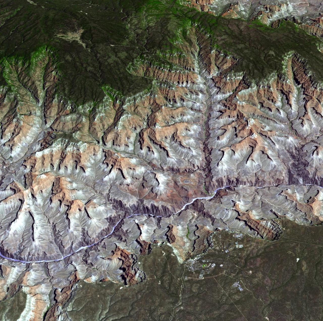
NASA Terra spacecraft provided this view of the eastern part of Grand Canyon National Park in northern Arizona in this image on July 14, 2011. This view looks to the west, with tourist facilities of Grand Canyon Village visible in the upper left.
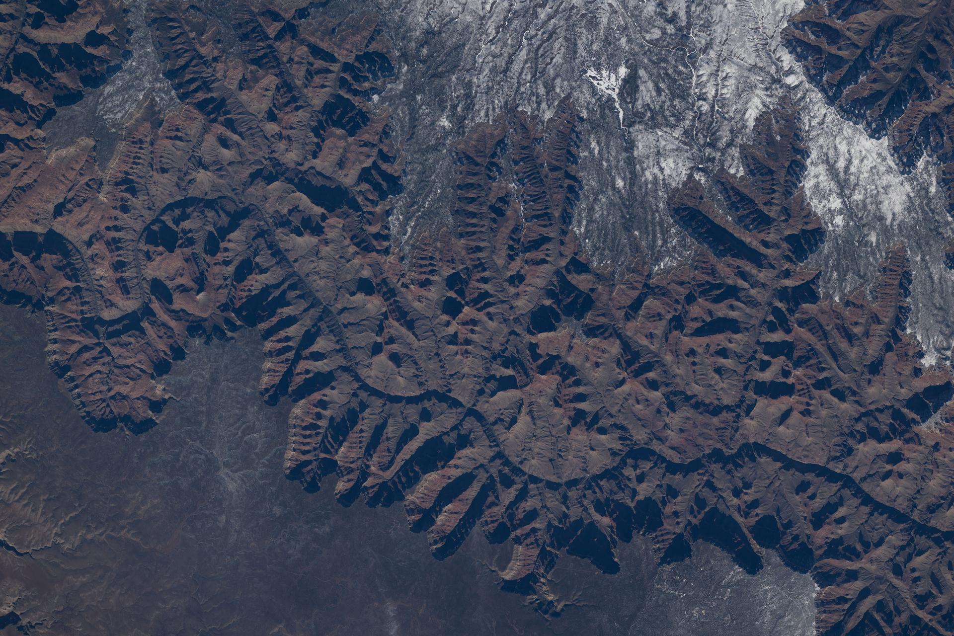
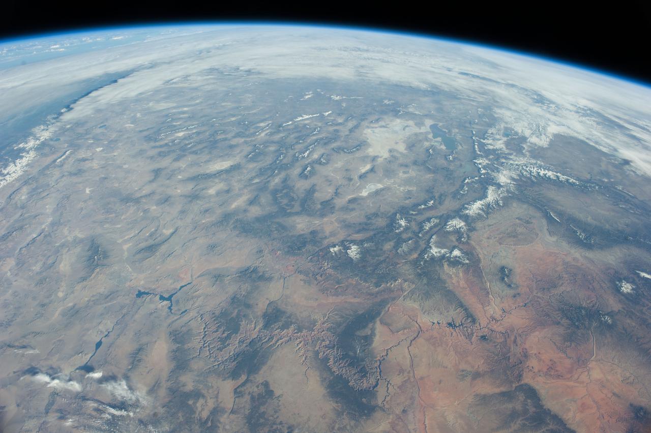
iss074e0208848 (Jan. 26, 2026) --- The Colorado River began carving the Grand Canyon—one of the Seven Natural Wonders of the World and a UNESCO World Heritage Site in Arizona—about 5 to 6 million years ago. This photograph was taken from the International Space Station as it orbited 260 miles above the Colorado Plateau in the southwestern United States.
iss074e0208838 (Jan. 26, 2026) --- The Colorado River began carving the Grand Canyon—one of the Seven Natural Wonders of the World and a UNESCO World Heritage Site in Arizona—about 5 to 6 million years ago. This photograph was taken from the International Space Station as it orbited 260 miles above the Colorado Plateau in the southwestern United States.
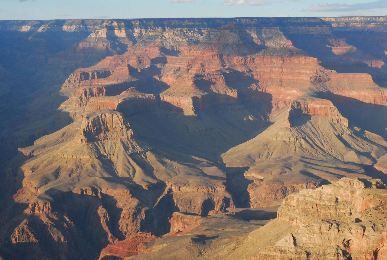
Before NASA Curiosity rover landed on Mars, the strata exposed in Mount Sharp were compared to those in the Grand Canyon of the western United States, shown here. Scientists are surprised by just how close the similarities are.

This simulated true color perspective view over the Grand Canyon was created from Advanced Spaceborne Thermal Emission and Reflection Radiometer (ASTER) data acquired on May 12, 2000. The Grand Canyon Village is in the lower foreground; the Bright Angel Trail crosses the Tonto Platform, before dropping down to the Colorado Village and then to the Phantom Ranch (green area across the river). Bright Angel Canyon and the North Rim dominate the view. At the top center of the image the dark blue area with light blue haze is an active forest fire. http://photojournal.jpl.nasa.gov/catalog/PIA01908
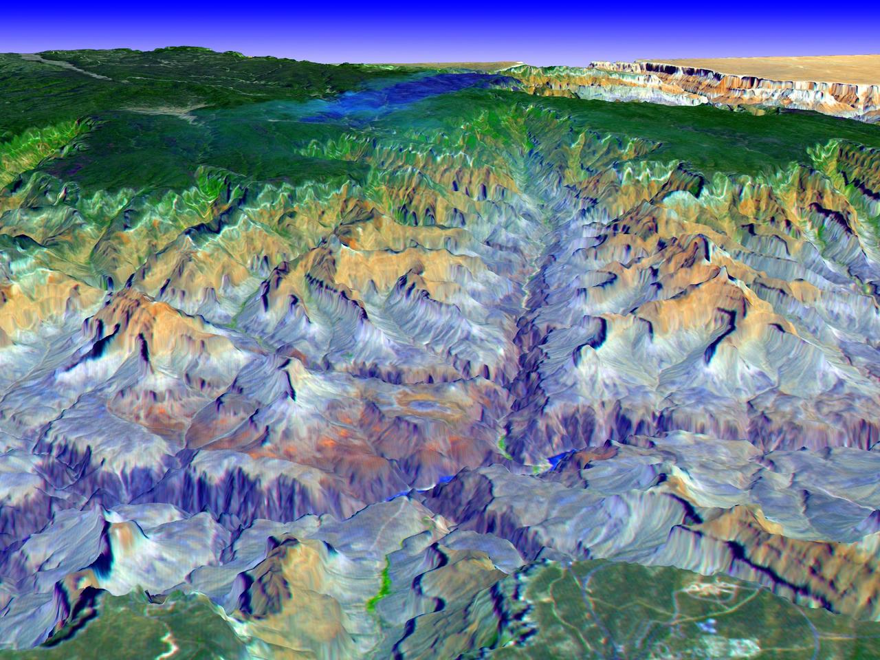
The Grand Canyon is one of North America's most spectacular geologic features. Carved primarily by the Colorado River over the past six million years, the canyon sports vertical drops of 5,000 feet and spans a 445-kilometer-long stretch of Arizona desert. The strata along the steep walls of the canyon form a record of geologic time from the Paleozoic Era (250 million years ago) to the Precambrian (1.7 billion years ago). The above view was acquired by the Advanced Spaceborne Thermal Emission and Reflection Radiometer (ASTER) instrument aboard the Terra spacecraft. Visible and near infrared data were combined to form an image that simulates the natural colors of water and vegetation. Rock colors, however, are not accurate. The image data were combined with elevation data to produce this perspective view, with no vertical exaggeration, looking from above the South Rim up Bright Angel Canyon towards the North Rim. The light lines on the plateau at lower right are the roads around the Canyon View Information Plaza. The Bright Angel Trail, which reaches the Colorado in 11.3 kilometers, can be seen dropping into the canyon over Plateau Point at bottom center. The blue and black areas on the North Rim indicate a forest fire that was smoldering as the data were acquired on May 12, 2000. http://photojournal.jpl.nasa.gov/catalog/PIA02668
SL3-122-2581 (July-September 1973) --- Skylab 3 Earth view of the Grand Canyon, Lake Mead and Kaibab. Photo credit: NASA
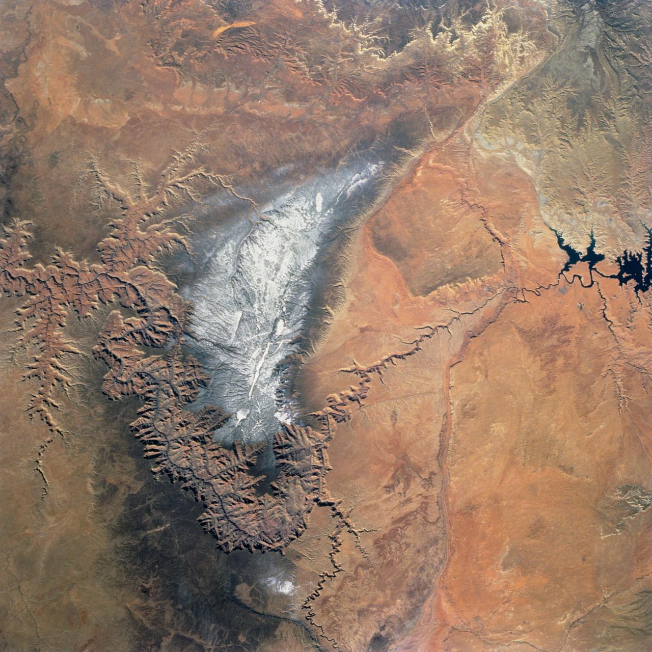
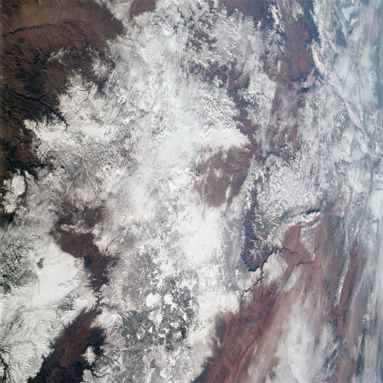
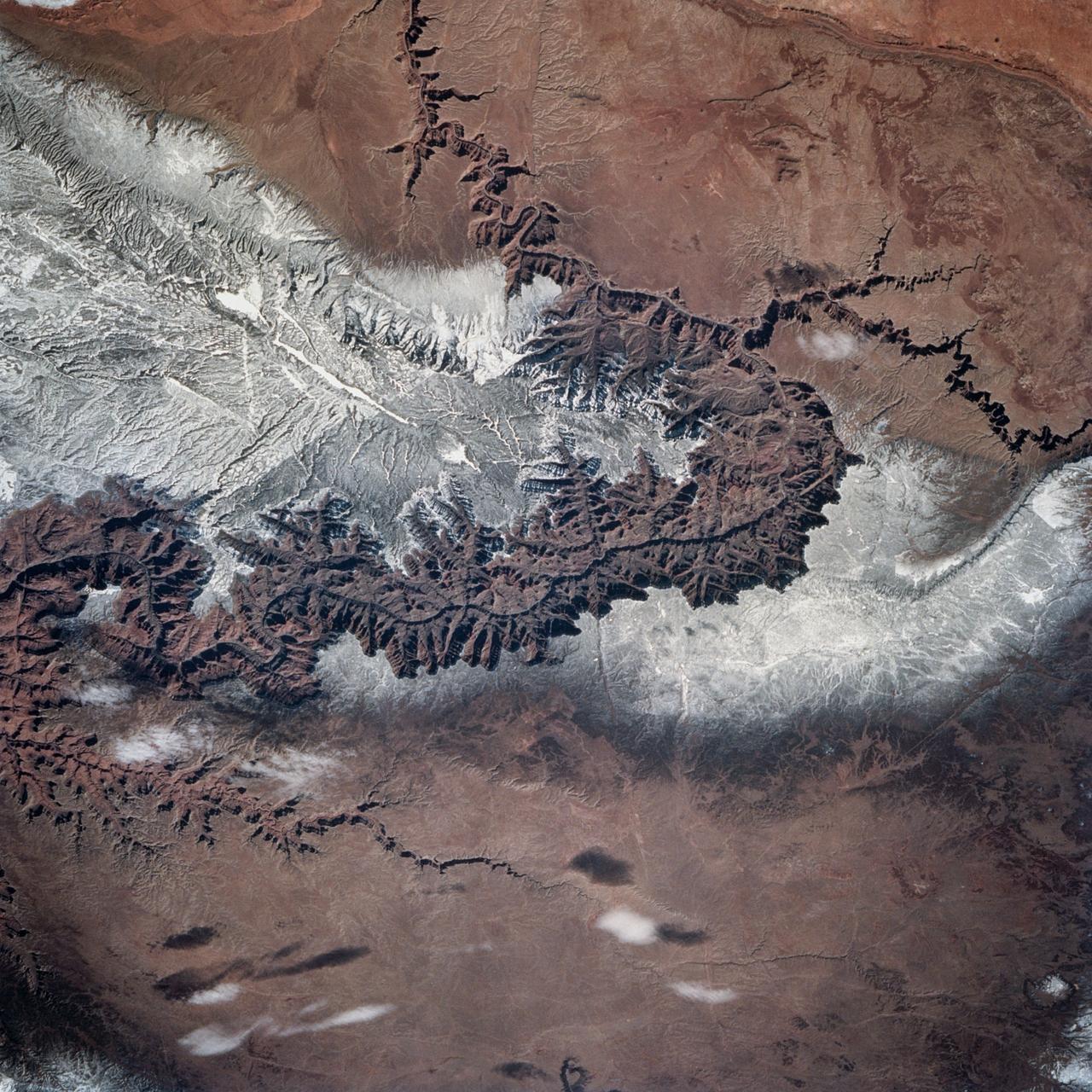
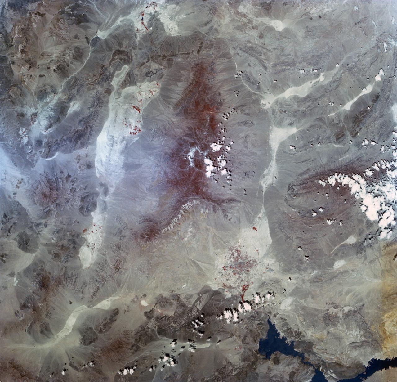
Snow covers the Kaibab Plateau on the northern side of the Colorado River in this November, 1994 view of the Grand Canyon. North is to the bottom of this view. The Colorado River has created a canyon which cuts through billions of years of geologic time. The Grand Canyon is 446 kilometers (277 miles) long, averages 16 kilometers (10 miles) wide, and is approximately 1.6 kilometers (1 mile) deep. The Coconino Plateau is located on the upper left side of the view, or to the south of the Colorado River. The direction of the flow of the Colorado River is from the east to the west. Eventually the river turns south and empties into the Gulf of California. The southern portion of Lake Powell in Utah can be seen at the bottom center of the view.
A Grand Canyon of Mars slices across the Red Planet near its equator. This canyon -- Valles Marineris, or the Mariner Valley -- is 10 times longer and deeper than Arizona Grand Canyon, and 20 times wider
AS09-20-3137 (3-13 March 1969) --- The Grand Canyon is sharply etched on the snow-covered Colorado Plateau in Arizona in this photograph from the Apollo 9 spacecraft during its Earth-orbital mission. Lake Powell behind Glen Canyon Dam is in the upper right corner. Humphreys Peak and the many volcanic craters around the San Francisco Mountains near Flagstaff, Arizona, are right of center. Prescott is under clouds at lower center.
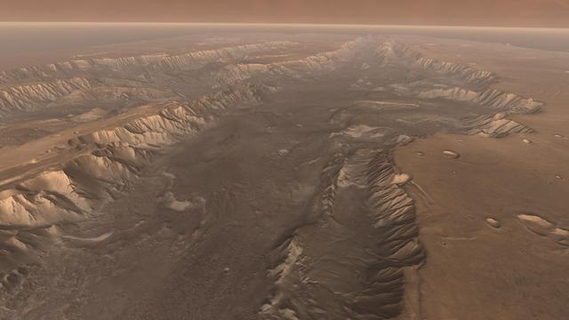
Soaring high above Valles Marineris, the Grand Canyon of Mars, viewers look down and catch a sight resembling parts of the desert West of the United States, but on a vastly greater scale. Here the canyon averages over a hundred miles wide.
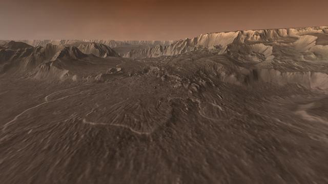
Ages ago, a giant earthquake shook the walls of Valles Marineris, the Grand Canyon of Mars, and triggered a catastrophic landslide that crashed down 15,000 feet.
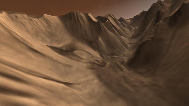
Viewers experience roller-coaster twists and turns as they fly up a winding tributary valley that feeds into Valles Marineris, the Grand Canyon of Mars.
Light blue clouds fill Coprates Chasma on Mars, part of Valles Marineris, the vast Grand Canyon of Mars. The clouds are mostly ice crystals and they appear blue in color in this image from NASA Mars Odyssey.
Northern Arizona is best known for the Grand Canyon. Less widely known are the hundreds of geologically young volcanoes, at least one of which buried the homes of local residents. This image was acquired by NASA Terra spacecraft.
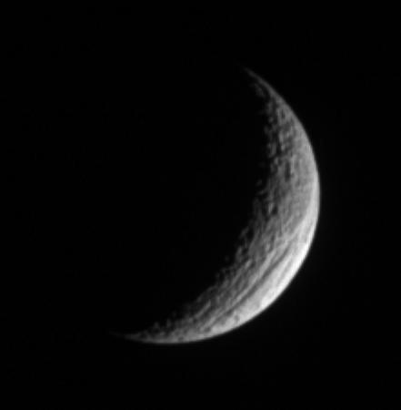
A crescent Tethys shows off its great scar, Ithaca Chasma, for which the moon is renowned. The chasm is 100 kilometers 60 miles across on average, and is 4 kilometers 2 miles deep in places.
Earth Observations taken by Expedition 38 crewmember. Photographer indicates California and the Grand Canyon. Image was released by astronaut on Twitter.
Earth observation taken by the Expedition 39 crew aboard the ISS. Image was released by astronaut on Twitter and downlinked in folder: Grand Canyon.
Earth Observations taken by Expedition 38 crewmember. Photographer indicates California and the Grand Canyon. Image was released by astronaut on Twitter.
STS034-73-062 (18-23 October 1989) --- Grand Canyon, Arizona (36.5N, 112.5W), as photographed from the Space Shuttle Atlantis.
iss048e011242 (June 26, 2016) --- Grand Canyon National Park in Arizona is pictured from the International Space Station as it orbited 251 miles above.
Today's VIS image crosses both Ophir Chasma (top) and Candor Chasma (bottom). Layered and eroded material covers the floors of both chasmata. Both canyons are part of Valles Marineris. Often called the grand canyon of Mars, Valles Marineris extends over 3,000 kilometers (1864 miles) long, spans as much as 600 kilometers across, and as deep as 8 kilometers. By comparison, the Earth's Grand Canyon in Arizona, USA is 800 kilometers long, 30 kilometers across, and 1.8 kilometers deep. Orbit Number: 84551 Latitude: -4.18643 Longitude: 286.548 Instrument: VIS Captured: 2021-01-05 04:50 https://photojournal.jpl.nasa.gov/catalog/PIA24404
Cotahuasi Canyon, near the city of Arequipa, Peru, is one of the deepest canyons in the world. It reaches a maximum depth of 3,350 m, twice as deep as the Grand Canyon. Volcanic peaks nearby reach altitudes of over 6,000 meters. The perspective view is draped over an ASTER DEM, and projected with no vertical exaggeration. The image was acquired August 30, 2019, and is located at 15.3 degrees south, 73 degrees west. https://photojournal.jpl.nasa.gov/catalog/PIA24943
iss068e051442 (Feb. 12, 2023) --- Chandler, Arizona, southeast of the state's capital city of Phoenix, is pictured from the International Space Station as it orbited 264 miles above the dry, desert climate of the Grand Canyon State.
iss069e085276 (Aug. 31, 2023) --- Navajo Nation, a Native American reservation in northeastern Arizona, is pictured from the International Space Station as it orbited 261 miles above the Grand Canyon State.
ISS042E080610 (12/29/2014) --- One of the 7 wonders of the Earth, the Grand Canyon in the US West as viewed from the International Space Station. NASA astronaut Terry Virts tweeted this revealing image that was taken on Dec. 29, 2014.
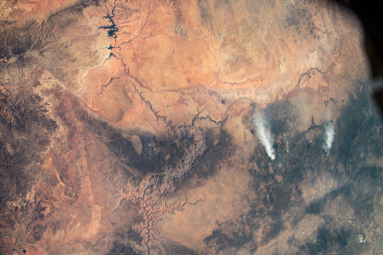
iss070e007659 (Oct. 20, 2023) --- A pair of wildfires near Flagstaff, Arizona, are pictured from the International Space Station as it orbited 261 miles above Lake Powell (top left) and the Grand Canyon (center).
ISS039-E-005258 (25 March 2014) --- Not only do millions of tourists have special attractions to the Grand Canyon, but also through the years astronauts and cosmonauts in space. One of the Expedition 39 crew members aboard the Earth-orbiting International Space Station aimed his camera, equipped with a 180mm lens, at the iconic feature. The steep walls of the Colorado River canyon and its many side canyons make an intricate landscape that contrasts with the dark green, forested plateau to the north and south. The Colorado River has done all the erosional work of carving away cubic kilometers of rock in a geologically short period of time. Visible as a darker line snaking along the bottom of the canyon, the river lies at an altitude of 715 meters (2,345 feet), thousands of meters below the North and South Rims. Temperatures are furnace-like on the river banks in the summer. But Grand Canyon Village, the classic outlook point for visitors, enjoys a milder climate at an altitude of 2,100 meters (6,890 feet). The Grand Canyon has become a geologic icon?a place where, geologists say, one can almost sense the invisible tectonic forces within the Earth. The North and South Rims are part of the Kaibab Plateau, a gentle tectonic swell in the landscape. The uplift of the plateau had two pronounced effects on the landscape that show up in this image. First, in drier parts of the world, forests usually indicate higher places; higher altitudes are cooler and wetter, conditions that allow trees to grow. The other geologic lesson on view is the canyon itself. Geologists now know that a river can cut a canyon only if the Earth surface rises vertically. If such uplift is not rapid, a river can maintain its course by eroding huge quantities of rock and forming a canyon.
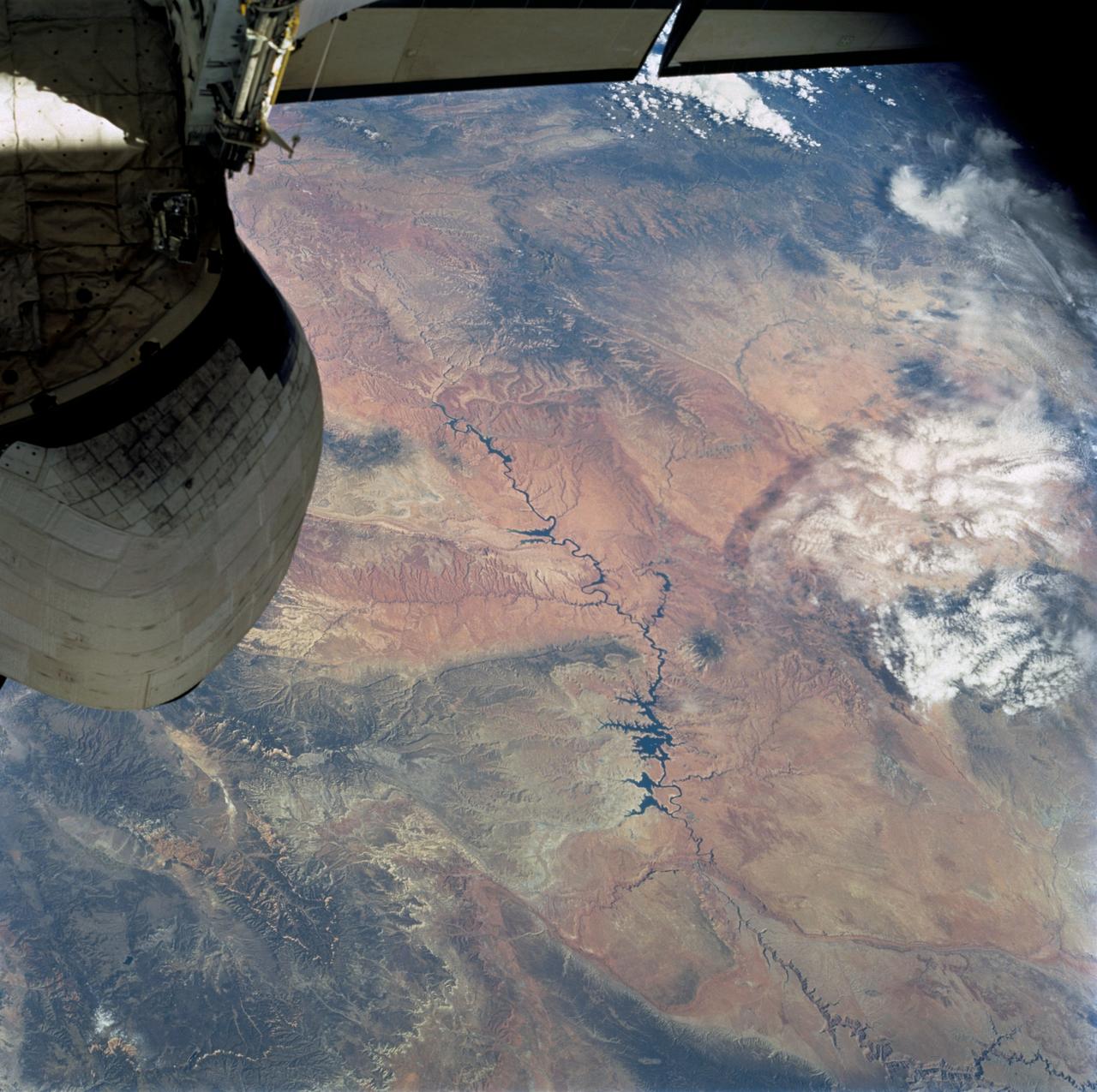
STS058-74-000R (18 Oct-1 Nov 1993) --- A broad view westward along the Colorado River from just below Glen Canyon Dam (out of picture), through the entire Grand Canyon to Lake Mead and Las Vegas, and westward to include southern Nevada and much of California. The Salton Sea, Los Angeles Basin, and Great Valley rim the Pacific Coast in the distance. Photo credit: NASA
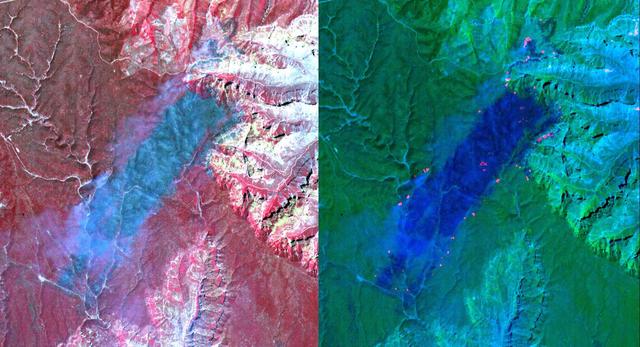
These ASTER images cover an area of 11 x 14 km on the north rim of the Grand Canyon, Arizona, and were acquired May 12, 2000. The left image displays bands 3,2,1 in RGB, displaying vegetation as red. The large dark area is burned forest, and small smoke plumes can be seen at the edges where active fires are burning. The right display substitutes SWIR band 8 for band 3. The bright red spots are the active fires, visible because the SWIR wavelength region has the capability to penetrate through the smoke. This image is located at 35.9 degrees north latitude and 113.4 degrees west longitude. http://photojournal.jpl.nasa.gov/catalog/PIA11092

iss073e0251994 (June 26, 2025) --- Phoenix, Arizona's capital and largest city with a metropolitan population of about 4.84 million, is pictured at approximately 1:40 a.m. local time from the International Space Station as it orbited 261 miles above the Grand Canyon State.

STS098-714A-049 (16 February 2001) --- Demonstrating the power of water erosion, this orbital view photographed by the crew of Atlantis during STS-98 on February 16, 2001, as the spacecraft orbited the earth at an altitude of 173 nautical miles (320 kilometers), shows Lake Powell at the headwaters of the Colorado River in southwestern Utah. The river over eons has carved out Arizona's mile deep and 270 mile long Grand Canyon. Prominent in this scene is the Kaibab Plateau at the head of the canyon where the big bend of the Colorado River has eroded the plateau into a peninsula. This plateau, directly across the canyon from the South Rim Visitor's Center, is at the widest part of the canyon, about 12 miles. The Kaibab Indian Reservation and the Kaibab National Forest are visible in the picture.
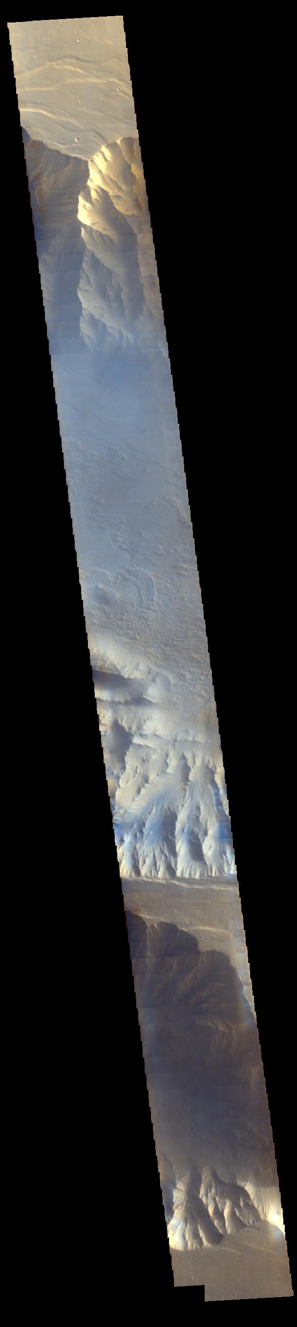
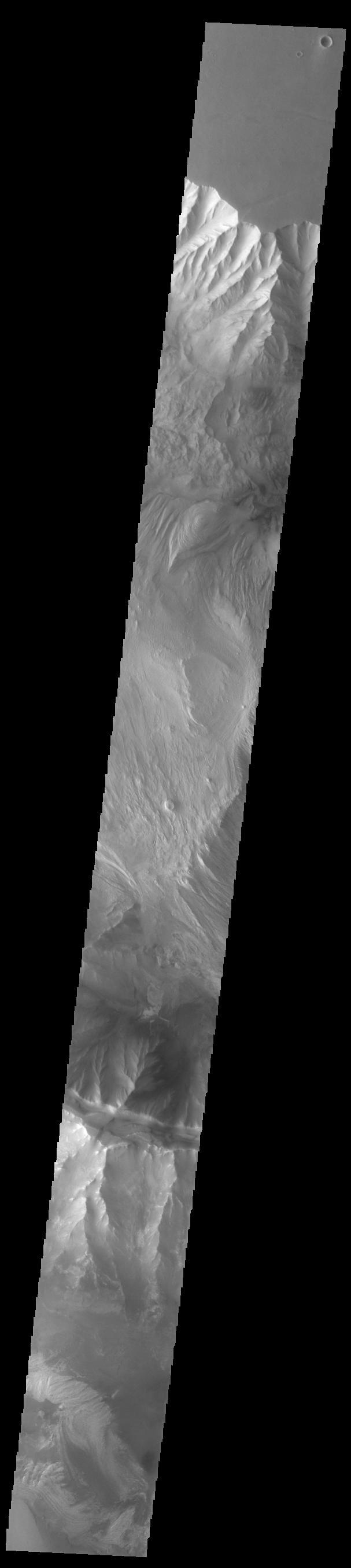
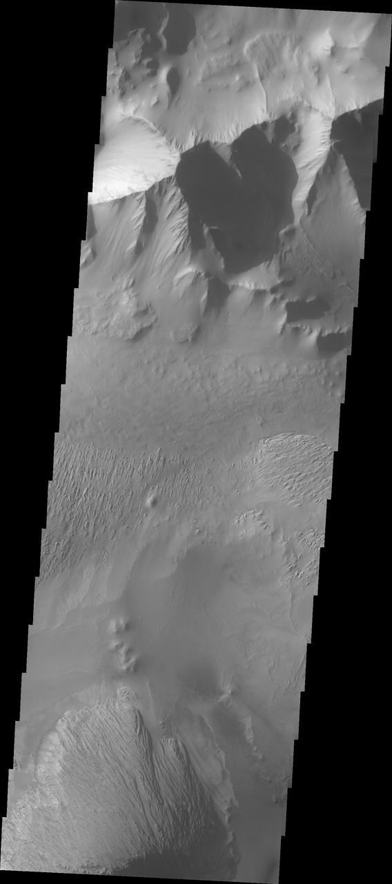
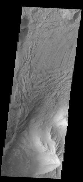
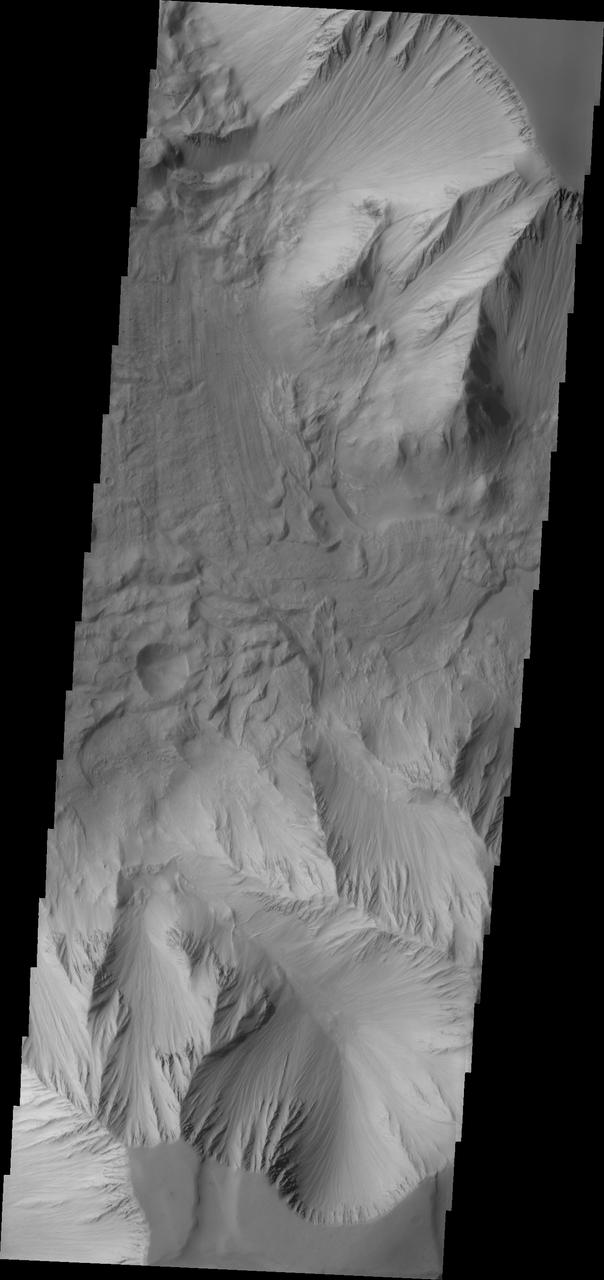
Ius and Tithonium Chasmata are located at the western end of Valles Marineris. Tithonium Chasma is north of Ius Chasma. Valles Marineris is over 4000 kilometers long (2495 miles), almost as wide as the United States. Ius Chasma is almost 840 kilometers long (522 miles), 120 kilometers wide and over 8 kilometers deep. Tithonium Chasma is 803 km (499 miles) long. In comparison, the Grand Canyon in Arizona is about 175 kilometers long (109 miles), 30 kilometers wide, and only 2 kilometers deep. The canyons of Valles Marineris were formed by extensive fracturing and pulling apart of the crust during the uplift of the vast Tharsis plateau. Landslides have enlarged the canyon walls and created deposits on the canyon floor. Weathering of the surface and influx of dust and sand have modified the canyon floor, both creating and modifying layered materials. There are many features that indicate flowing and standing water played a part in the chasma formation. The rugged floor of Ius Chasma (lower half of image) is comprised of large landslide deposits. Orbit Number: 89711 Latitude: -6.50729 Longitude: 272.316 Instrument: VIS Captured: 2022-03-06 02:35 https://photojournal.jpl.nasa.gov/catalog/PIA25459
Ius and Tithonium Chasmata are located at the western end of Valles Marineris. Tithonium Chasma is north of Ius Chasma. Valles Marineris is over 4000 kilometers long (2495 miles), almost as wide as the United States. Ius Chasma is almost 840 kilometers long (522 miles), 120 kilometers wide and over 8 kilometers deep. Tithonium Chasma is 803 km (499 miles) long. In comparison, the Grand Canyon in Arizona is about 175 kilometers long (109 miles), 30 kilometers wide, and only 2 kilometers deep. The canyons of Valles Marineris were formed by extensive fracturing and pulling apart of the crust during the uplift of the vast Tharsis plateau. Landslides have enlarged the canyon walls and created deposits on the canyon floor. Weathering of the surface and influx of dust and sand have modified the canyon floor, both creating and modifying layered materials. There are many features that indicate flowing and standing water played a part in the chasma formation. The rugged floor of Ius Chasma (bottom of image) is comprised of large landslide deposits. Orbit Number: 92700 Latitude: -5.02133 Longitude: 273.439 Instrument: VIS Captured: 2022-11-07 04:26 https://photojournal.jpl.nasa.gov/catalog/PIA25769
Today's VIS image shows part of Ius Chasma. Ius Chasma is at the western end of Valles Marineris. Valles Marineris is over 4000 kilometers long, wider than the United States. Ius Chasma is almost 850 kilometers long (528 miles), 120 kilometers wide and over 8 kilometers deep. In comparison, the Grand Canyon in Arizona is about 175 kilometers long, 30 kilometers wide, and only 2 kilometers deep. The canyons of Valles Marineris were formed by extensive fracturing and pulling apart of the crust during the uplift of the vast Tharsis plateau. Landslides have enlarged the canyon walls and created deposits on the canyon floor. Weathering of the surface and influx of dust and sand have modified the canyon floor, both creating and modifying layered materials. There are many features that indicate flowing and standing water played a part in the chasma formation. The rugged floor of Ius Chasma in this image is the result of many large landslides. Orbit Number: 92987 Latitude: -6.37421 Longitude: 273.45 Instrument: VIS Captured: 2022-11-30 19:36 https://photojournal.jpl.nasa.gov/catalog/PIA25808

Today's VIS image shows a complete cross section of Ius Chasma. Ius Chasma is at the western end of Valles Marineris. Valles Marineris is over 4000 kilometers long, wider than the United States. Ius Chasma is almost 850 kilometers long (528 miles), 120 kilometers wide and over 8 kilometers deep. In comparison, the Grand Canyon in Arizona is about 175 kilometers long, 30 kilometers wide, and only 2 kilometers deep. The canyons of Valles Marineris were formed by extensive fracturing and pulling apart of the crust during the uplift of the vast Tharsis plateau. Landslides have enlarged the canyon walls and created deposits on the canyon floor. Weathering of the surface and influx of dust and sand have modified the canyon floor, both creating and modifying layered materials. There are many features that indicate flowing and standing water played a part in the chasma formation. The rugged floor of Ius Chasma in this image is the result of many large landslides. Orbit Number: 92413 Latitude: -6.89657 Longitude: 272.994 Instrument: VIS Captured: 2022-10-14 13:17 https://photojournal.jpl.nasa.gov/catalog/PIA25760

Today's VIS image shows the southern cliffside of Tithonium Chasma (top of image) and the complete cross section of Ius Chasma (center of image). Ius Chasma and Thithonium Chasma are at the western end of Valles Marineris. Valles Marineris is over 4000 kilometers long, wider than the United States. Tithonium Chasma is 803 kilometers long (499 miles) while Ius Chasma is almost 850 kilometers long (528 miles), 120 kilometers wide and over 8 kilometers deep. In comparison, the Grand Canyon in Arizona is about 175 kilometers long, 30 kilometers wide, and only 2 kilometers deep. The canyons of Valles Marineris were formed by extensive fracturing and pulling apart of the crust during the uplift of the vast Tharsis plateau. Landslides have enlarged the canyon walls and created deposits on the canyon floor. Weathering of the surface and influx of dust and sand have modified the canyon floor, both creating and modifying layered materials. There are many features that indicate flowing and standing water played a part in the chasma formation. The rugged floor of Ius Chasma in this image is the result of many large landslides. Orbit Number: 89711 Latitude: -6.50729 Longitude: 272.316 Instrument: VIS Captured: 2022-03-06 02:35 https://photojournal.jpl.nasa.gov/catalog/PIA25391

Ius Chasma is at the western end of Valles Marineris, south of Tithonium Chasma. Valles Marineris is over 4000 kilometers long, almost as wide as the United States. Ius Chasma is almost 850 kilometers long (528 miles), 120 kilometers wide and over 8 kilometers deep. In comparison, the Grand Canyon in Arizona is about 175 kilometers long, 30 kilometers wide, and only 2 kilometers deep. The canyons of Valles Marineris were formed by extensive fracturing and pulling apart of the crust during the uplift of the vast Tharsis plateau. Landslides have enlarged the canyon walls and created deposits on the canyon floor. Weathering of the surface and influx of dust and sand have modified the canyon floor, both creating and modifying layered materials. There are many features that indicate flowing and standing water played a part in the chasma formation. The rugged floor of Ius Chasma in this image is the result of many large landslides. Orbit Number: 91839 Latitude: -7.09251 Longitude: 272.604 Instrument: VIS Captured: 2022-08-28 06:58 https://photojournal.jpl.nasa.gov/catalog/PIA25712
STS060-83-004 (3-11 Feb 1994) --- In this winter scene of the Grand Canyon of Arizona, the canyon is particularly well revealed because snow lies on the rims of the canyon, and exits mid-right; the Little Colorado River enters from the left, joining the Colorado just upstream of its big bend. Visitors to the South Rim can view the canyon in both the east-west and north-south reaches. The South Rim is closer to centers of transportation so that tourists mostly see the canyon from this area, that is from about 7,000 feet. The canyon floor lies at 2,000 feet in this sector. The most heavily snow covered area is the highest, reaching more than 9,000 feet (bottom right). Visitors see this protected area by hiking and mule and helicopter rides. The ecology of this part of the Colorado has been changed since the building of a lake upstream: river water is now derived from snow melt water from the bottom of the lake. This water is much colder than the water which used to flow through the canyon. According to NASA scientists, the view is unusual because the snow also reveals so well the higher country around the canyon, a swath stretching from bottom right to middle left of the view. This higher swath is an arch of uplifted rocks known as the Kaibab Plateau, raised vertically by tectonic forces in the recent geologic past. Despite this up parching, the Colorado River managed to maintain its course to the sea by cutting an ever deeper canyon into the Plateau. The white snow cover hides the fact that the Kaibab Plateau is thickly forested and thus appears dark green in summer, except in areas of clear-cutting. Since the Plateau reaches altitudes of 6 to 9,000 feet, it is both cooler and moister than the surrounding lower desert floor (top and bottom in this view) - where sparse vegetation and rocky country appear as brown colors. The zone of dark color running parallel to the snow line is all that can be seen of the pine forest on the south flanks of the Plateau.
This series of oblique images highlight the wall and exterior of the beautiful volcanic vent located to the northeast of Rachmaninoff basin and west of Copland crater. Layering can be seen along a portion of the wall and the exterior is smooth due to a blanket of fine particles of lava that were ejected explosively from the vent in a pyroclastic eruption. This vent is deeper than Earth's Grand Canyon. http://photojournal.jpl.nasa.gov/catalog/PIA19282
ISS035-E-027434 (23 April 2013) --- One of the Expedition 35 crew members aboard the Earth-orbiting International Space Station recorded this widespread image covering parts of Mexico, California and Nevada: Grand Canyon to Lake Mead and Las Vegas area (lower right corner), and westward to include the Gulf of California (beneath the docked Russian vehicle at upper left), the Salton Sea, Los Angeles Basin, and Great Valley.
iss073e1199153 (Nov. 29, 2025) --- Pastora Peak, rising to 9,413 feet (2,869 meters) inside Arizona's Navajo Nation near the New Mexico border, is seen from the International Space Station as it orbited 263 miles (423 kilometers) above the Grand Canyon State. At upper right, the San Juan River—a major tributary of the Colorado River—winds through New Mexico.
SL2-81-014 (22 June 1973) --- Desert and mountain scenery along the Utah/Colorado border are displayed in this scene of the Canyonlands National Park, UT (39.0N, 110.0W). The park occupies the near center of the image, displaying spectacular incised meanders and the bulls-eye structure of Upheaval Dome (a salt dome). The Green River and the Colorado River flow southward to join (off scene) before flowing through the Grand Canyon National Park. Photo credit: NASA
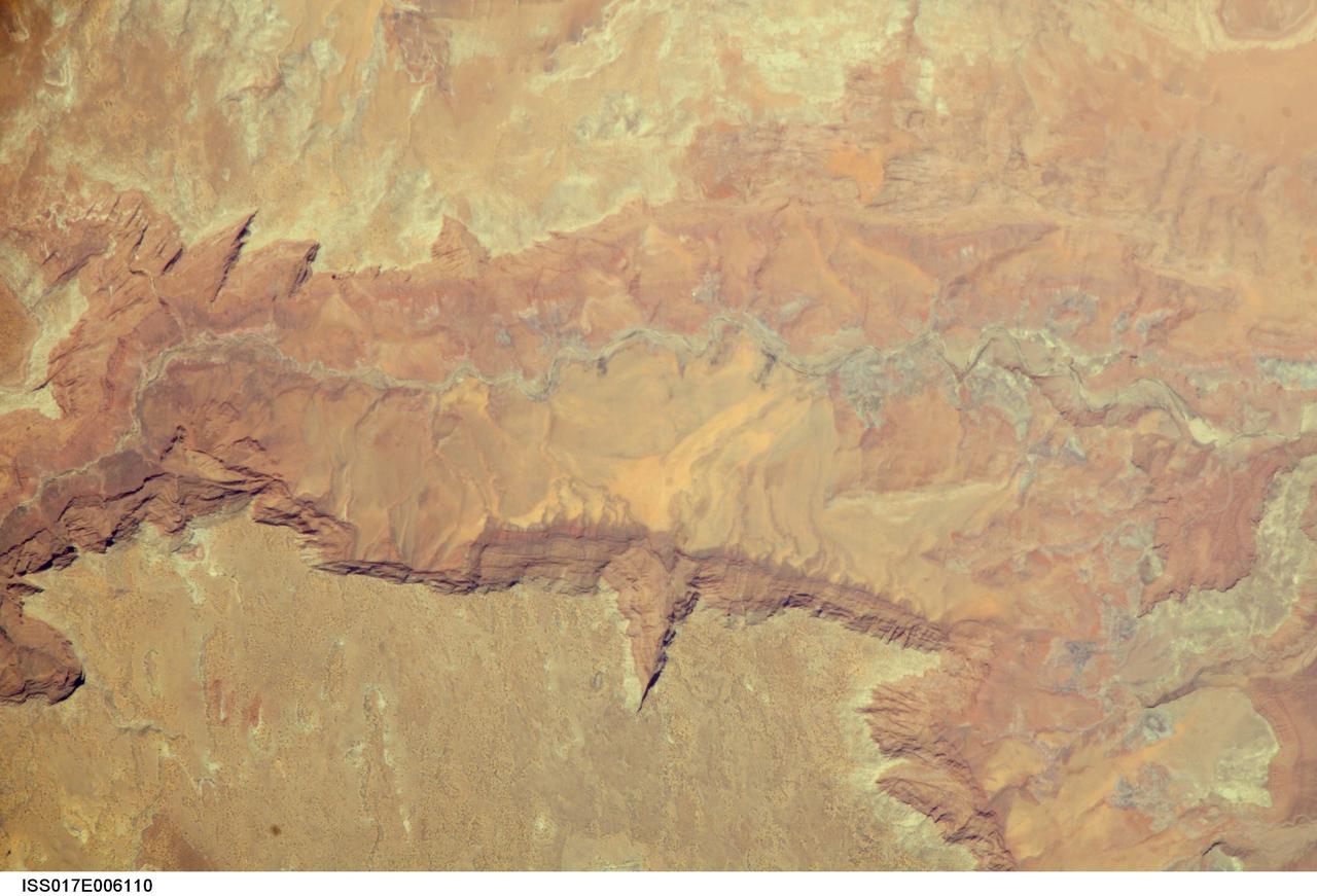
ISS017-E-006110 (2 May 2008) --- Vermilion Cliffs and Paria River, Arizona are featured in this image photographed by an Expedition 17 crewmember on the International Space Station. The largest tributary of the Colorado River between Lake Powell and the Grand Canyon, the Paria River flows southeast from headwaters in southernmost Utah to join the Colorado River between Page, AZ and Marble Canyon. The Paria River provides spectacular scenery, and is known for the very narrow "slot" canyons that it cuts through the layered rocks of the Colorado Plateau. According to scientists, these canyons formed over millions of years by water erosion slicing deep into the rock layers. Exploring the river channel through the slot canyons is a popular activity for hikers and backpackers. Indeed, there is no road access to much of the river channel, and hiking in on foot is the only way to experience the slot canyons. The Paria River also exposes the red and white layers of rocks beneath the Paria Plateau that are known as the Vermilion Cliffs (center). Scientists say that these rocks record the changing environmental conditions of the region during the early Mesozoic Era, ranging from widespread deserts to more water-rich periods when rivers flowed across the landscape. The spectacular scenery of the Vermilion Cliffs and Paria Canyon falls within the Vermilion Cliffs National Monument. This rugged and remote landscape is also home to many species of raptors -- including the California condor -- and other desert fauna such as bighorn sheep.
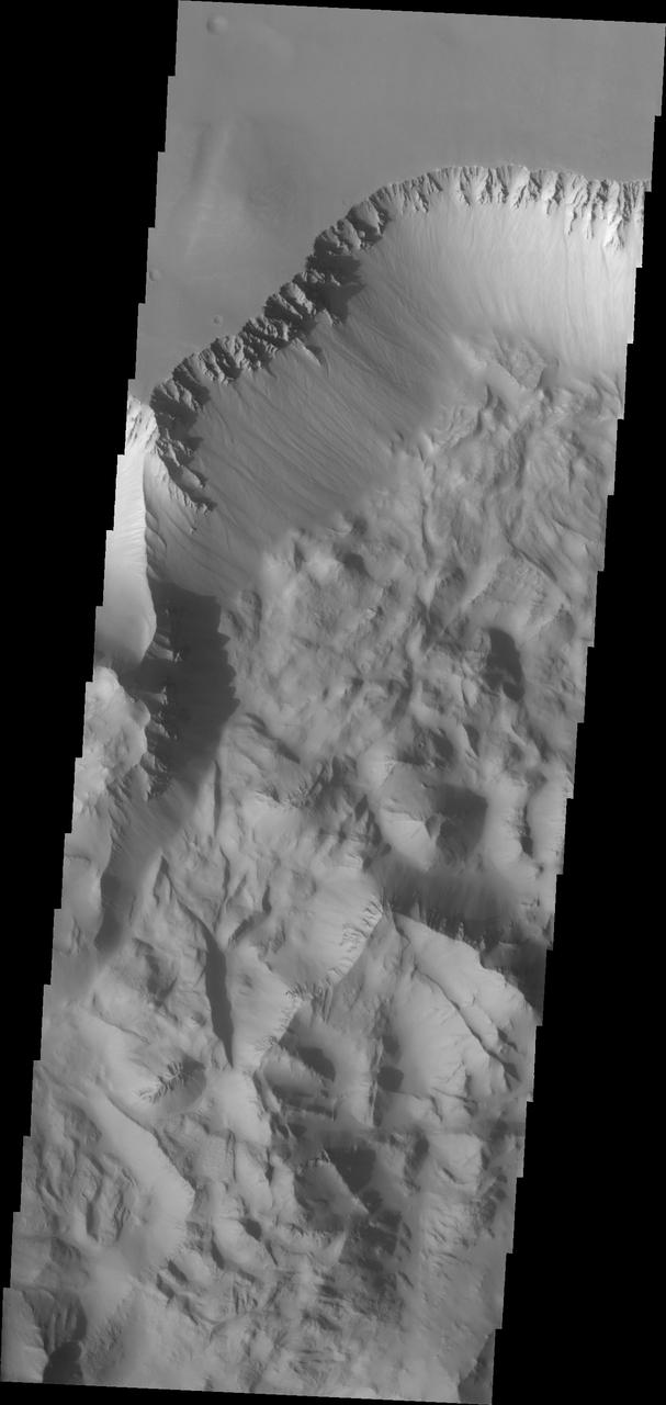
Today's VIS image shows the central part of Tithonium Chasma. Tithonium Chasma is at the western end of Valles Marineris. Valles Marineris is over 4000 kilometers long, almost as wide as the United States. Tithonium Chasma is almost 810 kilometers long (499 miles), 50 kilometers wide and over 6 kilometers deep. In comparison, the Grand Canyon in Arizona is about 175 kilometers long, 30 kilometers wide, and only 2 kilometers deep. The canyons of Valles Marineris were formed by extensive fracturing and pulling apart of the crust during the uplift of the vast Tharsis plateau. Orbit Number: 95214 Latitude: -4.83447 Longitude: 273.933 Instrument: VIS Captured: 2023-06-02 05:19 https://photojournal.jpl.nasa.gov/catalog/PIA26269
Today's VIS image shows the part of the eastern end of Tithonium Chasma. Tithonium Chasma is at the western end of Valles Marineris. Valles Marineris is over 4000 kilometers long, almost as wide as the United States. Tithonium Chasma is almost 810 kilometers long (499 miles), 50 kilometers wide and over 6 kilometers deep. In comparison, the Grand Canyon in Arizona is about 175 kilometers long, 30 kilometers wide, and only 2 kilometers deep. The canyons of Valles Marineris were formed by extensive fracturing and pulling apart of the crust during the uplift of the vast Tharsis plateau. In this image, the shallower regions of Tithonium are visible. The northern cliff of Ius Chasma is visible at the bottom of the image. Orbit Number: 92650 Latitude: -5.20867 Longitude: 275.913 Instrument: VIS Captured: 2022-11-03 01:37 https://photojournal.jpl.nasa.gov/catalog/PIA25767
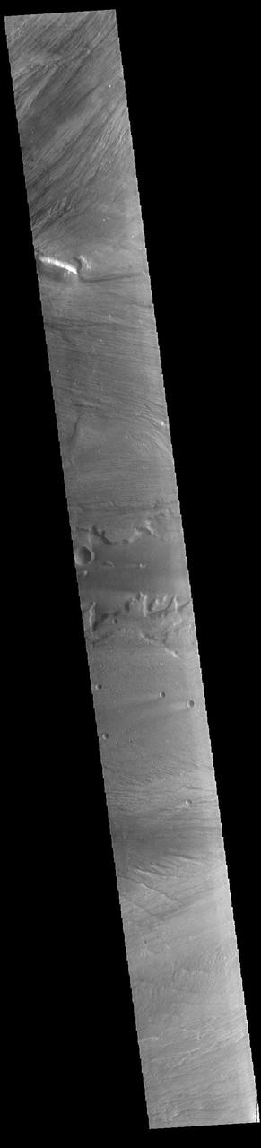
This VIS image shows part of Tithonium Chasma. The ridge visible at the top of the image is not the top of the canyon. The top of the canyon is off the image to the north. A lobate "tongue" visible between the ridge and the top of the canyon is the deposit left by a landslide event. This material is more resistant and forms the ridges extending down the canyon walls. Eroded materials cover much of the canyon floor. The initial formation of layered floor desposits was possibly created of air fall of dust, sand, and volcanic materials and water lain materials. The weathering of these deposits is probably by the wind. Loose sand and dust can be seen in other portions of this image. Tithonium Chasma is at the western end of Valles Marineris. Valles Marineris is over 4000 kilometers long, wider than the United States. Tithonium Chasma is almost 810 kilometers long (499 miles), 50 kilometers wide and over 6 kilometers deep. In comparison, the Grand Canyon in Arizona is about 175 kilometers long, 30 kilometers wide, and only 2 kilometers deep. The canyons of Valles Marineris were formed by extensive fracturing and pulling apart of the crust during the uplift of the vast Tharsis plateau. Landslides have enlarged the canyon walls and created deposits on the canyon floor. Weathering of the surface and influx of dust and sand have modified the canyon floor, both creating and modifying layered materials. The Odyssey spacecraft has spent over 15 years in orbit around Mars, circling the planet more than 71,000 times. It holds the record for longest working spacecraft at Mars. THEMIS, the IR/VIS camera system, has collected data for the entire mission and provides images covering all seasons and lighting conditions. Over the years many features of interest have received repeated imaging, building up a suite of images covering the entire feature. From the deepest chasma to the tallest volcano, individual dunes inside craters and dune fields that encircle the north pole, channels carved by water and lava, and a variety of other feature, THEMIS has imaged them all. For the next several months the image of the day will focus on the Tharsis volcanoes, the various chasmata of Valles Marineris, and the major dunes fields. We hope you enjoy these images! Orbit Number: 3212 Latitude: -4.46108 Longitude: 271.004 Instrument: VIS Captured: 2002-09-04 22:56 https://photojournal.jpl.nasa.gov/catalog/PIA22268
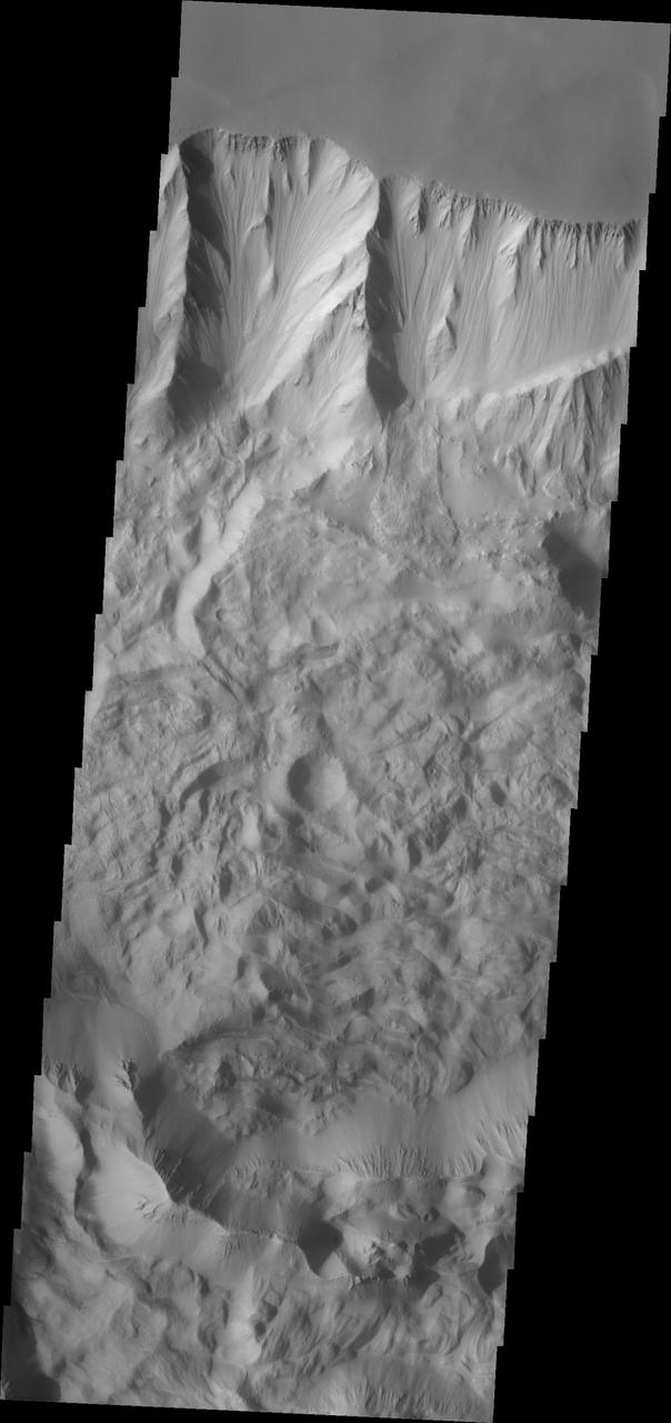
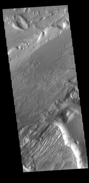
Tithonium Chasma has numerous large landslide deposits. The resistant material of the plateau surface forms the linear ridges of the canyon wall. Large landslides have changed the walls and floor of the canyon. A landslide is a failure of slope due to gravity. They initiate due to several reasons. A lower layer of poorly cemented/resistant material may have been eroded, undermining the wall above which then collapses; earth quake seismic waves can cause the slope to collapse; and even an impact event near the canyon wall can cause collapse. As millions of tons of material fall and slide down slope a scalloped cavity forms at the upper part where the slope failure occurred. At the material speeds downhill it will pick up more of the underlying slope, increasing the volume of material entrained into the landslide. Whereas some landslides spread across the canyon floor forming lobate deposits, very large volume slope failures will completely fill the canyon floor in a large complex region of chaotic blocks. This VIS image shows the result of this type of landslide. Tithonium Chasma is at the western end of Valles Marineris. Valles Marineris is over 4000 kilometers long, wider than the United States. Tithonium Chasma is almost 810 kilometers long (499 miles), 50 kilometers wide and over 6 kilometers deep. In comparison, the Grand Canyon in Arizona is about 175 kilometers long, 30 kilometers wide, and only 2 kilometers deep. The canyons of Valles Marineris were formed by extensive fracturing and pulling apart of the crust during the uplift of the vast Tharsis plateau. Landslides have enlarged the canyon walls and created deposits on the canyon floor. Weathering of the surface and influx of dust and sand have modified the canyon floor, both creating and modifying layered materials. The Odyssey spacecraft has spent over 15 years in orbit around Mars, circling the planet more than 71,000 times. It holds the record for longest working spacecraft at Mars. THEMIS, the IR/VIS camera system, has collected data for the entire mission and provides images covering all seasons and lighting conditions. Over the years many features of interest have received repeated imaging, building up a suite of images covering the entire feature. From the deepest chasma to the tallest volcano, individual dunes inside craters and dune fields that encircle the north pole, channels carved by water and lava, and a variety of other feature, THEMIS has imaged them all. For the next several months the image of the day will focus on the Tharsis volcanoes, the various chasmata of Valles Marineris, and the major dunes fields. We hope you enjoy these images! Orbit Number: 18239 Latitude: -4.4678 Longitude: 273.788 Instrument: VIS Captured: 2006-01-24 01:55 https://photojournal.jpl.nasa.gov/catalog/PIA22271
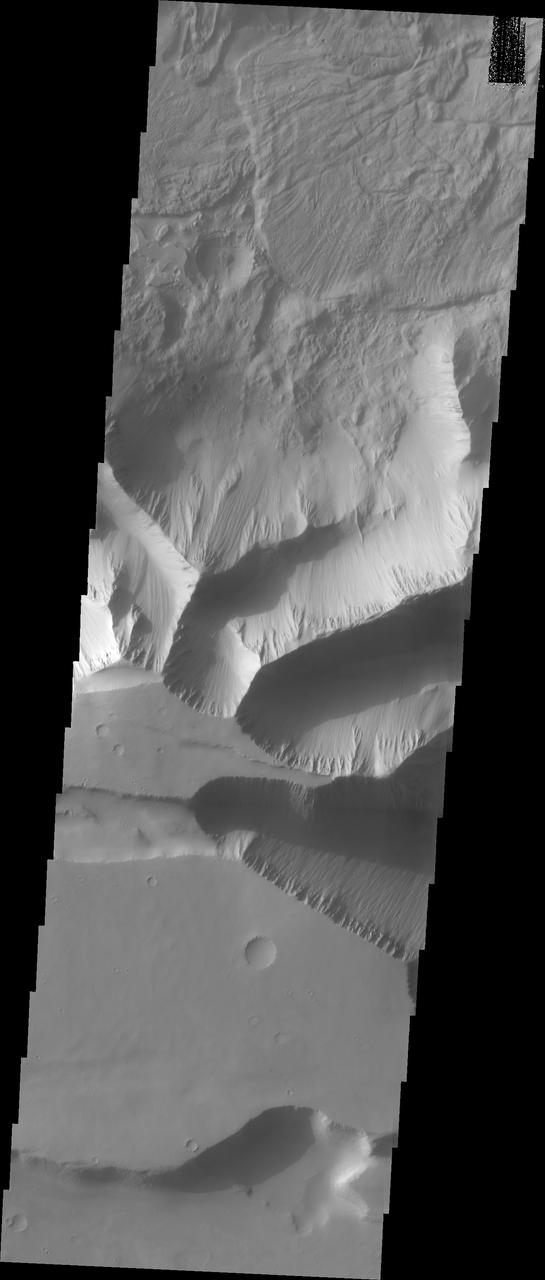
Continuing eastward along Ius Chasma, this section of the canyon floor has been completely filled by blocky deposits from large volume landslides. A landslide is a failure of slope due to gravity. They initiate due to several reasons. A lower layer of poorly cemented/resistant material may have been eroded, undermining the wall above which then collapses; earth quake seismic waves can cause the slope to collapse; and even an impact event near the canyon wall can cause collapse. As millions of tons of material fall and slide down slope a scalloped cavity forms at the upper part where the slope failure occurred. At the material speeds downhill it will pick up more of the underlying slope, increasing the volume of material entrained into the landslide. Whereas some landslides spread across the canyon floor forming lobate deposits, very large volume slope failures will completely fill the canyon floor in a large complex region of chaotic blocks. Ius Chasma is at the western end of Valles Marineris, south of Tithonium Chasma. Valles Marineris is over 4000 kilometers long, wider than the United States. Ius Chasma is almost 850 kilometers long (528 miles), 120 kilometers wide and over 8 kilometers deep. In comparison, the Grand Canyon in Arizona is about 175 kilometers long, 30 kilometers wide, and only 2 kilometers deep. The canyons of Valles Marineris were formed by extensive fracturing and pulling apart of the crust during the uplift of the vast Tharsis plateau. Landslides have enlarged the canyon walls and created deposits on the canyon floor. Weathering of the surface and influx of dust and sand have modified the canyon floor, both creating and modifying layered materials. There are many features that indicate flowing and standing water played a part in the chasma formation. The Odyssey spacecraft has spent over 15 years in orbit around Mars, circling the planet more than 71,000 times. It holds the record for longest working spacecraft at Mars. THEMIS, the IR/VIS camera system, has collected data for the entire mission and provides images covering all seasons and lighting conditions. Over the years many features of interest have received repeated imaging, building up a suite of images covering the entire feature. From the deepest chasma to the tallest volcano, individual dunes inside craters and dune fields that encircle the north pole, channels carved by water and lava, and a variety of other feature, THEMIS has imaged them all. For the next several months the image of the day will focus on the Tharsis volcanoes, the various chasmata of Valles Marineris, and the major dunes fields. We hope you enjoy these images! Orbit Number: 17041 Latitude: -6.50422 Longitude: 272.124 Instrument: VIS Captured: 2005-10-17 10:40 https://photojournal.jpl.nasa.gov/catalog/PIA22278
This VIS image shows part of the central region of Tithonium Chasma. The steep wall of the canyon is visible at the top of the image. The top of the canyon walls are layered, mostly likely by numerous volcanic flows. This material is more resistant and forms the ridges extending down the canyon walls. A large landslide deposit covers the right side of the image. An eroded mound on the floor of the canyon exists at the bottom left of the image. The initial formation of the mound was possibly created of air fall of dust, sand, and volcanic materials and water lain materials. Tithonium Chasma is at the western end of Valles Marineris. Valles Marineris is over 4000 kilometers long, wider than the United States. Tithonium Chasma is almost 810 kilometers long (499 miles), 50 kilometers wide and over 6 kilometers deep. In comparison, the Grand Canyon in Arizona is about 175 kilometers long, 30 kilometers wide, and only 2 kilometers deep. The canyons of Valles Marineris were formed by extensive fracturing and pulling apart of the crust during the uplift of the vast Tharsis plateau. Landslides have enlarged the canyon walls and created deposits on the canyon floor. Weathering of the surface and influx of dust and sand have modified the canyon floor. The Odyssey spacecraft has spent over 15 years in orbit around Mars, circling the planet more than 71,000 times. It holds the record for longest working spacecraft at Mars. THEMIS, the IR/VIS camera system, has collected data for the entire mission and provides images covering all seasons and lighting conditions. Over the years many features of interest have received repeated imaging, building up a suite of images covering the entire feature. From the deepest chasma to the tallest volcano, individual dunes inside craters and dune fields that encircle the north pole, channels carved by water and lava, and a variety of other feature, THEMIS has imaged them all. For the next several months the image of the day will focus on the Tharsis volcanoes, the various chasmata of Valles Marineris, and the major dunes fields. We hope you enjoy these images! Orbit Number: 3187 Latitude: -4.15004 Longitude: 272.043 Instrument: VIS Captured: 2002-09-02 21:33 https://photojournal.jpl.nasa.gov/catalog/PIA22267
This VIS image of Tithonium Chasma shows the canyon wall at the top of the frame and the cliff face of the opposite side of the canyon at the bottom of the image. Most of the floor has been covered with the deposits of large volume landslides. Near the top-right portion of the canyon wall several smaller lobate landslide deposits are visible. Tithonium Chasma has numerous large landslide deposits. The resistant material of the plateau surface forms the linear ridges of the canyon wall. Large landslides have changed the walls and floor of the canyon. A landslide is a failure of slope due to gravity. They initiate due to several reasons. A lower layer of poorly cemented/resistant material may have been eroded, undermining the wall above which then collapses; earth quake seismic waves can cause the slope to collapse; and even an impact event near the canyon wall can cause collapse. As millions of tons of material fall and slide down slope a scalloped cavity forms at the upper part where the slope failure occurred. At the material speeds downhill it will pick up more of the underlying slope, increasing the volume of material entrained into the landslide. Whereas some landslides spread across the canyon floor forming lobate deposits, very large volume slope failures will completely fill the canyon floor in a large complex region of chaotic blocks. Tithonium Chasma is at the western end of Valles Marineris. Valles Marineris is over 4000 kilometers long, wider than the United States. Tithonium Chasma is almost 810 kilometers long (499 miles), 50 kilometers wide and over 6 kilometers deep. In comparison, the Grand Canyon in Arizona is about 175 kilometers long, 30 kilometers wide, and only 2 kilometers deep. The canyons of Valles Marineris were formed by extensive fracturing and pulling apart of the crust during the uplift of the vast Tharsis plateau. Landslides have enlarged the canyon walls and created deposits on the canyon floor. Weathering of the surface and influx of dust and sand have modified the canyon floor, both creating and modifying layered materials. The Odyssey spacecraft has spent over 15 years in orbit around Mars, circling the planet more than 71,000 times. It holds the record for longest working spacecraft at Mars. THEMIS, the IR/VIS camera system, has collected data for the entire mission and provides images covering all seasons and lighting conditions. Over the years many features of interest have received repeated imaging, building up a suite of images covering the entire feature. From the deepest chasma to the tallest volcano, individual dunes inside craters and dune fields that encircle the north pole, channels carved by water and lava, and a variety of other feature, THEMIS has imaged them all. For the next several months the image of the day will focus on the Tharsis volcanoes, the various chasmata of Valles Marineris, and the major dunes fields. We hope you enjoy these images! Orbit Number: 26775 Latitude: -4.54217 Longitude: 274.121 Instrument: VIS Captured: 2007-12-27 21:24 https://photojournal.jpl.nasa.gov/catalog/PIA22274
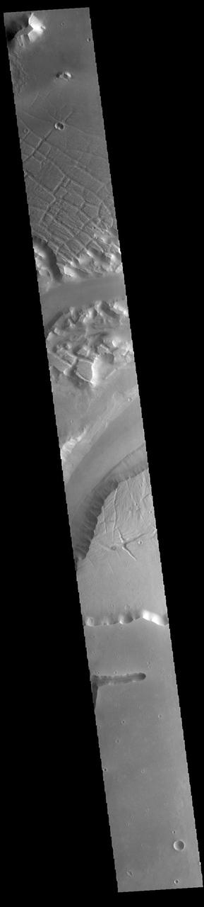
Today's VIS image shows a portion of Kasei Valles. Kasei Valles is one of the largest outflow channel systems on Mars, in places up to 482 km (300 miles) wide and 1580 km (982 miles) long. For comparison, the Grand Canyon in Arizona is is only 29 km (18 miles) at its widest and only 446 km (277 miles) long. Kasei Valles flows eastward through Lunae Planum and empties into Chryse Planitia. Orbit Number: 85218 Latitude: 21.7275 Longitude: 288.166 Instrument: VIS Captured: 2021-03-01 03:56 https://photojournal.jpl.nasa.gov/catalog/PIA24821
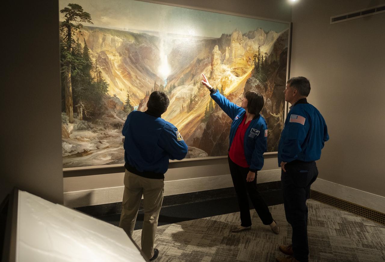
NASA’s SpaceX Crew-2 astronauts Akihiko Hoshide of the Japan Aerospace Exploration Agency (JAXA), left, and NASA astronauts Megan McArthur, center, and Shane Kimbrough, right, look at Thomas Moran’s 1872 painting “The Grand Canyon of Yellowstone,” Thursday, June 9, 2022, during a visit to the National Park Service at the U.S. Department of the Interior in Washington, DC. Kimbrough, McArthur, Hoshide, and ESA (European Space Agency) astronaut Thomas Pesquet completed the second crew rotation mission to the International Space Station as part of the agency’s Commercial Crew Program and spent 198 days aboard the orbiting laboratory as part of Expeditions 65 and 66. Photo Credit: (NASA/Joel Kowsky)
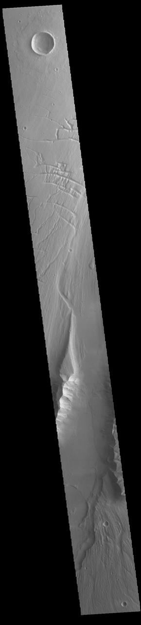
Today's VIS image shows a portion of Kasei Valles. Kasei Valles is one of the largest outflow channel systems on Mars, in places up to 482 km (300 miles) wide and 1580 km (982 miles) long. For comparison, the Grand Canyon in Arizona is is only 29 km (18 miles) at its widest and only 446 km (277 miles) long. Kasei Valles flows eastward through Lunae Planum and empties into Chryse Planitia. Orbit Number: 93978 Latitude: 24.9563 Longitude: 287.171 Instrument: VIS Captured: 2023-02-20 11:01 https://photojournal.jpl.nasa.gov/catalog/PIA25939
Today's VIS image shows a portion of Kasei Valles. Kasei Valles is one of the largest outflow channel systems on Mars, in places up to 482 km (300 miles) wide and 1580 km (982 miles) long. For comparison, the Grand Canyon in Arizona is is only 29 km (18 miles) at its widest and only 446 km (277 miles) long. Kasei Valles flows eastward through Lunae Planum and empties into Chryse Planitia. Orbit Number: 93928 Latitude: 25.9137 Longitude: 289.462 Instrument: VIS Captured: 2023-02-16 08:13 https://photojournal.jpl.nasa.gov/catalog/PIA25927

Park ranger Rader Lane speaks on the National Park Service’s astronomy and dark sky programs at Grand Canyon National Park during a visit by NASA’s SpaceX Crew-2 astronauts Megan McArthur and Shane Kimbrough of NASA, and Akihiko Hoshide of the Japan Aerospace Exploration Agency (JAXA), Thursday, June 9, 2022 at the U.S. Department of the Interior in Washington, DC. Kimbrough, McArthur, Hoshide, and ESA (European Space Agency) astronaut Thomas Pesquet completed the second crew rotation mission to the International Space Station as part of the agency’s Commercial Crew Program and spent 198 days aboard the orbiting laboratory as part of Expeditions 65 and 66. Photo Credit: (NASA/Joel Kowsky)
Today's VIS image shows a portion of Kasei Valles. Kasei Valles is one of the largest outflow channel systems on Mars, in places up to 482 km (300 miles) wide and 1580 km (982 miles) long. For comparison, the Grand Canyon in Arizona is is only 29 km (18 miles) at its widest and only 446 km (277 miles) long. Kasei Valles flows eastward through Lunae Planum and empties into Chryse Planitia. Orbit Number: 80538 Latitude: 24.6507 Longitude: 300.343 Instrument: VIS Captured: 2020-02-09 19:44 https://photojournal.jpl.nasa.gov/catalog/PIA23845
Today's VIS image shows a portion of Kasei Valles. Kasei Valles is one of the largest outflow channel systems on Mars, in places up to 482 km (300 miles) wide and 1580 km (982 miles) long. For comparison, the Grand Canyon in Arizona is is only 29 km (18 miles) at its widest and only 446 km (277 miles) long. Kasei Valles flows eastward through Lunae Planum and empties into Chryse Planitia. Orbit Number: 85280 Latitude: 25.2042 Longitude: 299.095 Instrument: VIS Captured: 2021-03-06 06:28 https://photojournal.jpl.nasa.gov/catalog/PIA24822

Park ranger Rader Lane speaks on the National Park Service’s astronomy and dark sky programs at Grand Canyon National Park during a visit by NASA’s SpaceX Crew-2 astronauts Megan McArthur and Shane Kimbrough of NASA, and Akihiko Hoshide of the Japan Aerospace Exploration Agency (JAXA), Thursday, June 9, 2022 at the U.S. Department of the Interior in Washington, DC. Kimbrough, McArthur, Hoshide, and ESA (European Space Agency) astronaut Thomas Pesquet completed the second crew rotation mission to the International Space Station as part of the agency’s Commercial Crew Program and spent 198 days aboard the orbiting laboratory as part of Expeditions 65 and 66. Photo Credit: (NASA/Joel Kowsky)
Today's VIS image shows a portion of Kasei Valles, just at the region where the northward flow of the channel turns eastward towards it's eventual end in Chryse Planitia. Kasei Valles is one of the largest outflow channel systems on Mars, in places up to 482 km (300 miles) wide and 1580 km (982 miles) long. For comparison, the Grand Canyon in Arizona is is only 29 km (18 miles) at its widest and only 446 km (277 miles) long. Orbit Number: 79952 Latitude: 20.11 Longitude: 286.449 Instrument: VIS Captured: 2019-12-23 13:42 https://photojournal.jpl.nasa.gov/catalog/PIA23748
SL2-03-192 (22 June 1973) --- Lake Mead, Nevada, (36.0N, 114.5E) where the water from the Colorado River empties after it's 273 mile journey through the Grand Canyon of Arizona is the subject of this photo. Other features of interest are Hoover Dam on the south shore of Lake Mead where cheap hydroelectric power is secondary to the water resources made available in this northern desert region and the resort city of Las Vegas, just to the west of Lake Mead. In this harsh desert environment, color infrared photography readily penetrates haze, detects and portrays vegetation as shades of red. Photo credit: NASA
STS112-707-035 (7-18 October 2002) --- The Colorado River snakes across this view, photographed from the Space Shuttle Atlantis, from top left (near the vehicle’s vertical stabilizer), to the lower right, where the Grand Canyon gorge can be detected. The wider blue parts of the Colorado in the center of the view are Lake Powell, an artificial lake more than 120 miles long. The dark green areas are wooded slopes generally above 6000 feet. The Kaibab Plateau (lower left) and the range with Abajo Peak (11,360 feet, Utah-Colorado border region) cross the top of the view. The red areas are lower and semiarid, dominated by desert scrub vegetation.

Today's VIS image shows a portion of Kasei Valles. Kasei Valles is one of the largest outflow channel systems on Mars, in places up to 482 km (300 miles) wide and 1580 km (982 miles) long. For comparison, the Grand Canyon in Arizona is is only 29 km (18 miles) at its widest and only 446 km (277 miles) long. Kasei Valles flows eastward through Lunae Planum and empties into Chryse Planitia. Orbit Number: 88163 Latitude: 22.243 Longitude: 288.106 Instrument: VIS Captured: 2021-10-29 15:37 https://photojournal.jpl.nasa.gov/catalog/PIA25153

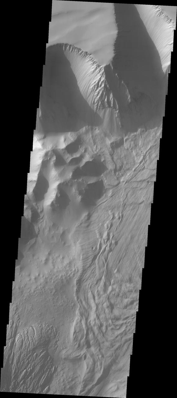
Continuing eastward along Ius Chasma, this image shows the eastern section of the large landslide deposit seen in yesterday's post. A landslide is a failure of slope due to gravity. They initiate due to several reasons. A lower layer of poorly cemented/resistant material may have been eroded, undermining the wall above which then collapses; earth quake seismic waves can cause the slope to collapse; and even an impact event near the canyon wall can cause collapse. As millions of tons of material fall and slide down slope a scalloped cavity forms at the upper part where the slope failure occurred. At the material speeds downhill it will pick up more of the underlying slope, increasing the volume of material entrained into the landslide. Whereas some landslides spread across the canyon floor forming lobate deposits, very large volume slope failures will completely fill the canyon floor in a large complex region of chaotic blocks. Ius Chasma is at the western end of Valles Marineris, south of Tithonium Chasma. Valles Marineris is over 4000 kilometers long, wider than the United States. Ius Chasma is almost 850 kilometers long (528 miles), 120 kilometers wide and over 8 kilometers deep. In comparison, the Grand Canyon in Arizona is about 175 kilometers long, 30 kilometers wide, and only 2 kilometers deep. The canyons of Valles Marineris were formed by extensive fracturing and pulling apart of the crust during the uplift of the vast Tharsis plateau. Landslides have enlarged the canyon walls and created deposits on the canyon floor. Weathering of the surface and influx of dust and sand have modified the canyon floor, both creating and modifying layered materials. There are many features that indicate flowing and standing water played a part in the chasma formation. The Odyssey spacecraft has spent over 15 years in orbit around Mars, circling the planet more than 71,000 times. It holds the record for longest working spacecraft at Mars. THEMIS, the IR/VIS camera system, has collected data for the entire mission and provides images covering all seasons and lighting conditions. Over the years many features of interest have received repeated imaging, building up a suite of images covering the entire feature. From the deepest chasma to the tallest volcano, individual dunes inside craters and dune fields that encircle the north pole, channels carved by water and lava, and a variety of other feature, THEMIS has imaged them all. For the next several months the image of the day will focus on the Tharsis volcanoes, the various chasmata of Valles Marineris, and the major dunes fields. We hope you enjoy these images! Orbit Number: 17902 Latitude: -6.65656 Longitude: 274.872 Instrument: VIS Captured: 2005-12-27 08:01 https://photojournal.jpl.nasa.gov/catalog/PIA22279
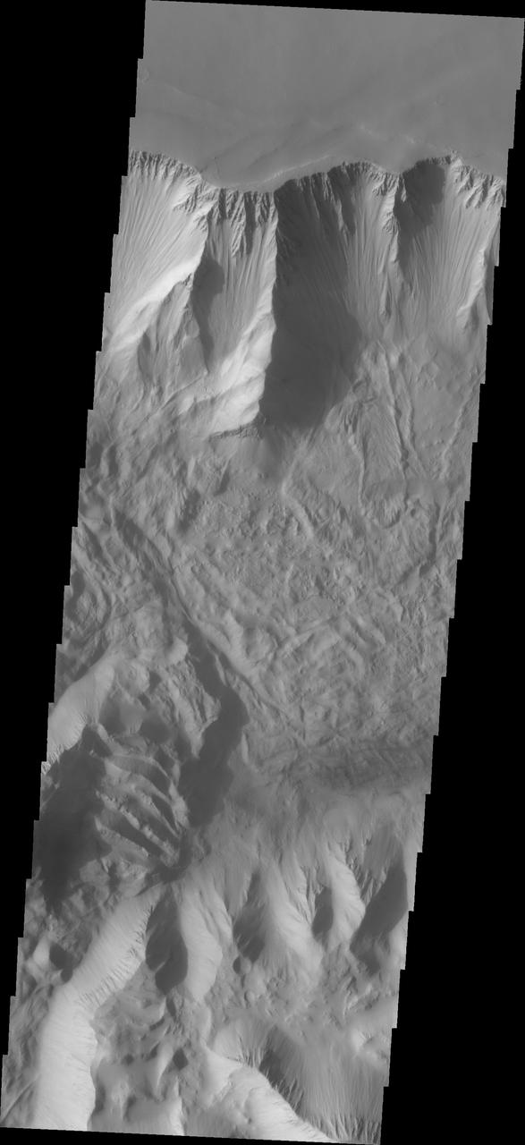
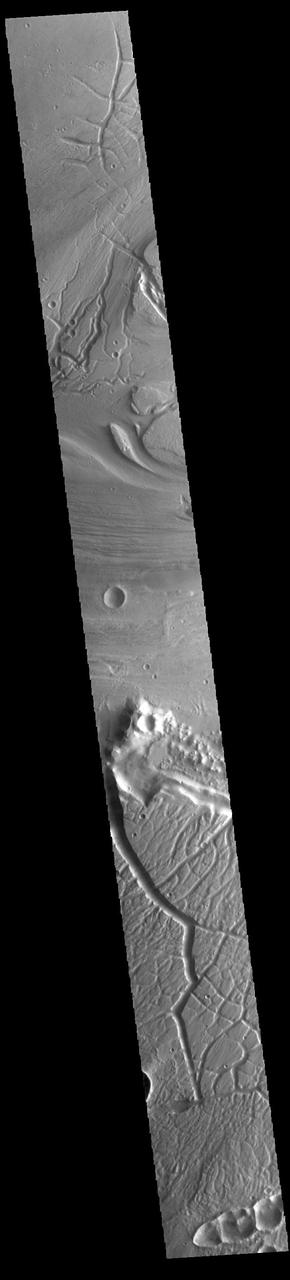
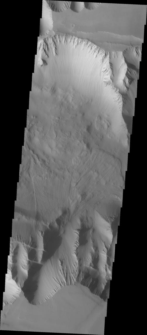
Moving into the central part of Ius Chasma, the canyon profile changes. What started as a large graben south of the main chasma wall, has widened to create a central high ridge separating the chasm into two parallel sections. This interior ridge is called Geryon Montes. The northern canyon wall is at the top of the image, including several tongue shaped landslide deposits. The floor has been covered in deposits that may include landslide material and later materials such as air fall particles like dust and water lain layered deposits. The Geryon Montes are in the lower 1/3 of the image. Just to the top of the Montes are materials with different "colors". These are part of the layered materials inside the canyon. At the very bottom of the image a highly eroded landslide deposit exists. The materials on this side of Geryon Montes are at a higher elevation than the floor on the opposite side. The unusual texture of the canyon floor also points to layered materials that may have been laid down in standing water. A landslide is a failure of slope due to gravity. They initiate due to several reasons. A lower layer of poorly cemented/resistant material may have been eroded, undermining the wall above which then collapses; earth quake seismic waves can cause the slope to collapse; and even an impact event near the canyon wall can cause collapse. As millions of tons of material fall and slide down slope a scalloped cavity forms at the upper part where the slope failure occurred. At the material speeds downhill it will pick up more of the underlying slope, increasing the volume of material entrained into the landslide. Whereas some landslides spread across the canyon floor forming lobate deposits, very large volume slope failures will completely fill the canyon floor in a large complex region of chaotic blocks. Ius Chasma is at the western end of Valles Marineris, south of Tithonium Chasma. Valles Marineris is over 4000 kilometers long, wider than the United States. Ius Chasma is almost 850 kilometers long (528 miles), 120 kilometers wide and over 8 kilometers deep. In comparison, the Grand Canyon in Arizona is about 175 kilometers long, 30 kilometers wide, and only 2 kilometers deep. The canyons of Valles Marineris were formed by extensive fracturing and pulling apart of the crust during the uplift of the vast Tharsis plateau. Landslides have enlarged the canyon walls and created deposits on the canyon floor. Weathering of the surface and influx of dust and sand have modified the canyon floor, both creating and modifying layered materials. There are many features that indicate flowing and standing water played a part in the chasma formation. The Odyssey spacecraft has spent over 15 years in orbit around Mars, circling the planet more than 71,000 times. It holds the record for longest working spacecraft at Mars. THEMIS, the IR/VIS camera system, has collected data for the entire mission and provides images covering all seasons and lighting conditions. Over the years many features of interest have received repeated imaging, building up a suite of images covering the entire feature. From the deepest chasma to the tallest volcano, individual dunes inside craters and dune fields that encircle the north pole, channels carved by water and lava, and a variety of other feature, THEMIS has imaged them all. For the next several months the image of the day will focus on the Tharsis volcanoes, the various chasmata of Valles Marineris, and the major dunes fields. We hope you enjoy these images! Orbit Number: 26151 Latitude: -7.12079 Longitude: 275.703 Instrument: VIS Captured: 2007-11-06 12:17 https://photojournal.jpl.nasa.gov/catalog/PIA22280
This VIS image of Tithonium Chasma shows the canyon wall at the top of the frame, a series of landslide deposits in the middle, and an eroded mound of materials at the bottom. The mound has been eroded, most likely by wind action. Tithonium Chasma has numerous large landslide deposits. The resistant material of the plateau surface forms the linear ridges of the canyon wall. Large landslides have changed the walls and floor of the canyon. A landslide is a failure of slope due to gravity. They initiate due to several reasons. A lower layer of poorly cemented/resistant material may have been eroded, undermining the wall above which then collapses; earth quake seismic waves can cause the slope to collapse; and even an impact event near the canyon wall can cause collapse. As millions of tons of material fall and slide down slope a scalloped cavity forms at the upper part where the slope failure occurred. At the material speeds downhill it will pick up more of the underlying slope, increasing the volume of material entrained into the landslide. Whereas some landslides spread across the canyon floor forming lobate deposits, very large volume slope failures will completely fill the canyon floor in a large complex region of chaotic blocks. Tithonium Chasma is at the western end of Valles Marineris. Valles Marineris is over 4000 kilometers long, wider than the United States. Tithonium Chasma is almost 810 kilometers long (499 miles), 50 kilometers wide and over 6 kilometers deep. In comparison, the Grand Canyon in Arizona is about 175 kilometers long, 30 kilometers wide, and only 2 kilometers deep. The canyons of Valles Marineris were formed by extensive fracturing and pulling apart of the crust during the uplift of the vast Tharsis plateau. Landslides have enlarged the canyon walls and created deposits on the canyon floor. Weathering of the surface and influx of dust and sand have modified the canyon floor, both creating and modifying layered materials. The Odyssey spacecraft has spent over 15 years in orbit around Mars, circling the planet more than 71,000 times. It holds the record for longest working spacecraft at Mars. THEMIS, the IR/VIS camera system, has collected data for the entire mission and provides images covering all seasons and lighting conditions. Over the years many features of interest have received repeated imaging, building up a suite of images covering the entire feature. From the deepest chasma to the tallest volcano, individual dunes inside craters and dune fields that encircle the north pole, channels carved by water and lava, and a variety of other feature, THEMIS has imaged them all. For the next several months the image of the day will focus on the Tharsis volcanoes, the various chasmata of Valles Marineris, and the major dunes fields. We hope you enjoy these images! Orbit Number: 25964 Latitude: -4.26209 Longitude: 270.721 Instrument: VIS Captured: 2007-10-22 02:44 https://photojournal.jpl.nasa.gov/catalog/PIA22273

This VIS image shows part of eastern Ius Chasma. The lower elevations of Geryon Montes are located at the top of the image. Between the montes and the southern wall face is a region of sand and sand dunes. The presence of mobile sand indicates that winds are eroding, depositing and changing the canyon floor. The texture of the canyon floor beneath the dunes and elsewhere in the image is an indication of water, in some form, was part of the process creating the surface. There is a tongue of material emerging from the canyon wall that has steep sides, this may be a delta formed by material washing down the valley and into a body of standing water, like a lake. It may also just be a landslide deposit that has undergone extensive weathering. A landslide is a failure of slope due to gravity. They initiate due to several reasons. A lower layer of poorly cemented/resistant material may have been eroded, undermining the wall above which then collapses; earthquake seismic waves can cause the slope to collapse; and even an impact event near the canyon wall can cause collapse. As millions of tons of material fall and slide down slope a scalloped cavity forms at the upper part where the slope failure occurred. At the material speeds downhill it will pick up more of the underlying slope, increasing the volume of material entrained into the landslide. Whereas some landslides spread across the canyon floor forming lobate deposits, very large volume slope failures will completely fill the canyon floor in a large complex region of chaotic blocks. Ius Chasma is at the western end of Valles Marineris, south of Tithonium Chasma. Valles Marineris is over 4000 kilometers long, wider than the United States. Ius Chasma is almost 850 kilometers long (528 miles), 120 kilometers wide and over 8 kilometers deep. In comparison, the Grand Canyon in Arizona is about 175 kilometers long, 30 kilometers wide, and only 2 kilometers deep. The canyons of Valles Marineris were formed by extensive fracturing and pulling apart of the crust during the uplift of the vast Tharsis plateau. Landslides have enlarged the canyon walls and created deposits on the canyon floor. Weathering of the surface and influx of dust and sand have modified the canyon floor, both creating and modifying layered materials. There are many features that indicate flowing and standing water played a part in the chasma formation. The Odyssey spacecraft has spent over 15 years in orbit around Mars, circling the planet more than 71,000 times. It holds the record for longest working spacecraft at Mars. THEMIS, the IR/VIS camera system, has collected data for the entire mission and provides images covering all seasons and lighting conditions. Over the years many features of interest have received repeated imaging, building up a suite of images covering the entire feature. From the deepest chasma to the tallest volcano, individual dunes inside craters and dune fields that encircle the north pole, channels carved by water and lava, and a variety of other feature, THEMIS has imaged them all. For the next several months the image of the day will focus on the Tharsis volcanoes, the various chasmata of Valles Marineris, and the major dunes fields. We hope you enjoy these images! Orbit Number: 10701 Latitude: -8.75442 Longitude: 281.333 Instrument: VIS Captured: 2004-05-13 10:49 https://photojournal.jpl.nasa.gov/catalog/PIA22282
In this VIS image a complex region of multiple overlapping landslide deposits fills most the the frame. In the center of the image the top layer has the lobate edges and radial surface grooves of a low volume slide. It appears to be the top of a complex layering of materials, It is possible that all the lower layers are landslides as well. At the top of the image are a series of smaller lobate shaped landslide deposits Whether the layers formed very close in time of over thousands of years can not be determined in the image. Tithonium Chasma has numerous large landslide deposits. The resistant material of the plateau surface forms the linear ridges of the canyon wall. Large landslides have changed the walls and floor of the canyon. A landslide is a failure of slope due to gravity. They initiate due to several reasons. A lower layer of poorly cemented/resistant material may have been eroded, undermining the wall above which then collapses; earth quake seismic waves can cause the slope to collapse; and even an impact event near the canyon wall can cause collapse. As millions of tons of material fall and slide down slope a scalloped cavity forms at the upper part where the slope failure occurred. At the material speeds downhill it will pick up more of the underlying slope, increasing the volume of material entrained into the landslide. Whereas some landslides spread across the canyon floor forming lobate deposits, very large volume slope failures will completely fill the canyon floor in a large complex region of chaotic blocks. Tithonium Chasma is at the western end of Valles Marineris. Valles Marineris is over 4000 kilometers long, wider than the United States. Tithonium Chasma is almost 810 kilometers long (499 miles), 50 kilometers wide and over 6 kilometers deep. In comparison, the Grand Canyon in Arizona is about 175 kilometers long, 30 kilometers wide, and only 2 kilometers deep. The canyons of Valles Marineris were formed by extensive fracturing and pulling apart of the crust during the uplift of the vast Tharsis plateau. Landslides have enlarged the canyon walls and created deposits on the canyon floor. Weathering of the surface and influx of dust and sand have modified the canyon floor, both creating and modifying layered materials. The Odyssey spacecraft has spent over 15 years in orbit around Mars, circling the planet more than 71,000 times. It holds the record for longest working spacecraft at Mars. THEMIS, the IR/VIS camera system, has collected data for the entire mission and provides images covering all seasons and lighting conditions. Over the years many features of interest have received repeated imaging, building up a suite of images covering the entire feature. From the deepest chasma to the tallest volcano, individual dunes inside craters and dune fields that encircle the north pole, channels carved by water and lava, and a variety of other feature, THEMIS has imaged them all. For the next several months the image of the day will focus on the Tharsis volcanoes, the various chasmata of Valles Marineris, and the major dunes fields. We hope you enjoy these images! Orbit Number: 35746 Latitude: -4.47838 Longitude: 272.133 Instrument: VIS Captured: 2010-01-04 14:22 https://photojournal.jpl.nasa.gov/catalog/PIA22275
Tithonium Chasma has numerous large landslide deposits. At the bottom of this VIS image is the high plateau between Tithonium Chasma and Ius Chasma (off the bottom of the frame). The resistant material of the plateau surface forms the linear ridges of the canyon wall. Erosion of the walls cover the lower slopes. Large landslides have changed the walls and floor of the canyon. A landslide is a failure of slope due to gravity. They initiate due to several reasons. A lower layer of poorly cemented/resistant material may have been eroded, undermining the wall above which then collapses; earth quake seismic waves can cause the slope to collapse; and even an impact event near the canyon wall can cause collapse. As millions of tons of material fall and slide down slope a scalloped cavity forms at the upper part where the slope failure occurred. At the material speeds downhill it will pick up more of the underlying slope, increasing the volume of material entrained into the landslide. As the landslide material reaches the canyon bottom it spreads out and eventually comes to rest. The edge of the deposit is lobate, and may be affected by running up against pre-existing features on the canyon floor. Most Martian landslide have radial grooves on the slide surface. Tithonium Chasma is at the western end of Valles Marineris. Valles Marineris is over 4000 kilometers long, wider than the United States. Tithonium Chasma is almost 810 kilometers long (499 miles), 50 kilometers wide and over 6 kilometers deep. In comparison, the Grand Canyon in Arizona is about 175 kilometers long, 30 kilometers wide, and only 2 kilometers deep. The canyons of Valles Marineris were formed by extensive fracturing and pulling apart of the crust during the uplift of the vast Tharsis plateau. Landslides have enlarged the canyon walls and created deposits on the canyon floor. Weathering of the surface and influx of dust and sand have modified the canyon floor, both creating and modifying layered materials. The Odyssey spacecraft has spent over 15 years in orbit around Mars, circling the planet more than 71,000 times. It holds the record for longest working spacecraft at Mars. THEMIS, the IR/VIS camera system, has collected data for the entire mission and provides images covering all seasons and lighting conditions. Over the years many features of interest have received repeated imaging, building up a suite of images covering the entire feature. From the deepest chasma to the tallest volcano, individual dunes inside craters and dune fields that encircle the north pole, channels carved by water and lava, and a variety of other feature, THEMIS has imaged them all. For the next several months the image of the day will focus on the Tharsis volcanoes, the various chasmata of Valles Marineris, and the major dunes fields. We hope you enjoy these images! Orbit Number: 11500 Latitude: -4.89712 Longitude: 273.275 Instrument: VIS Captured: 2004-07-18 05:36 https://photojournal.jpl.nasa.gov/catalog/PIA22270
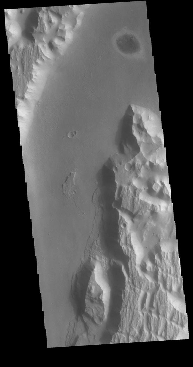
The VIS image shows part of the western end of Ius Chasma. Both the north and south canyon walls are visible in this image. At the top of the frame paired faults have created a graben. On the southern face of the canyon, several linear faults parallel the graben. These faults are part of the tectonic formation of Valles Marineris. Landslides on both walls created deposits on the crater floor. The easiest to identify is the lobate margin at the right side of the images. Lobate margins and radial surface grooves are common features in low volume landslides. A landslide is a failure of slope due to gravity. They initiate due to several reasons. A lower layer of poorly cemented/resistant material may have been eroded, undermining the wall above which then collapses; earth quake seismic waves can cause the slope to collapse; and even an impact event near the canyon wall can cause collapse. As millions of tons of material fall and slide down slope a scalloped cavity forms at the upper part where the slope failure occurred. At the material speeds downhill it will pick up more of the underlying slope, increasing the volume of material entrained into the landslide. Whereas some landslides spread across the canyon floor forming lobate deposits, very large volume slope failures will completely fill the canyon floor in a large complex region of chaotic blocks. Ius Chasma is at the western end of Valles Marineris, south of Tithonium Chasma. Valles Marineris is over 4000 kilometers long, wider than the United States. Ius Chasma is almost 850 kilometers long (528 miles), 120 kilometers wide and over 8 kilometers deep. In comparison, the Grand Canyon in Arizona is about 175 kilometers long, 30 kilometers wide, and only 2 kilometers deep. The canyons of Valles Marineris were formed by extensive fracturing and pulling apart of the crust during the uplift of the vast Tharsis plateau. Landslides have enlarged the canyon walls and created deposits on the canyon floor. Weathering of the surface and influx of dust and sand have modified the canyon floor, both creating and modifying layered materials. There are many features that indicate flowing and standing water played a part in the chasma formation. The Odyssey spacecraft has spent over 15 years in orbit around Mars, circling the planet more than 71,000 times. It holds the record for longest working spacecraft at Mars. THEMIS, the IR/VIS camera system, has collected data for the entire mission and provides images covering all seasons and lighting conditions. Over the years many features of interest have received repeated imaging, building up a suite of images covering the entire feature. From the deepest chasma to the tallest volcano, individual dunes inside craters and dune fields that encircle the north pole, channels carved by water and lava, and a variety of other feature, THEMIS has imaged them all. For the next several months the image of the day will focus on the Tharsis volcanoes, the various chasmata of Valles Marineris, and the major dunes fields. We hope you enjoy these images! Orbit Number: 8792 Latitude: -6.69222 Longitude: 270.88 Instrument: VIS Captured: 2003-12-08 06:35 https://photojournal.jpl.nasa.gov/catalog/PIA22277
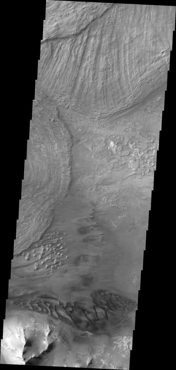
This VIS image shows the eastern end of Ius Chasma. The southern canyon wall is at the bottom of the image, with dark sand and sand dunes. The presence of mobile sand indicates that winds are eroding, depositing and changing the canyon floor. The rest of the image is dominated by large landslide deposits. At the top of the image are two overlapping deposits from landslides originating on the northern chasma wall. The landslide deposit on the left side of the image originate from the southern chasma wall. A landslide is a failure of slope due to gravity. They initiate due to several reasons. A lower layer of poorly cemented/resistant material may have been eroded, undermining the wall above which then collapses; earthquake seismic waves can cause the slope to collapse; and even an impact event near the canyon wall can cause collapse. As millions of tons of material fall and slide down slope a scalloped cavity forms at the upper part where the slope failure occurred. At the material speeds downhill it will pick up more of the underlying slope, increasing the volume of material entrained into the landslide. Whereas some landslides spread across the canyon floor forming lobate deposits, very large volume slope failures will completely fill the canyon floor in a large complex region of chaotic blocks. Ius Chasma is at the western end of Valles Marineris, south of Tithonium Chasma. Valles Marineris is over 4000 kilometers long, wider than the United States. Ius Chasma is almost 850 kilometers long (528 miles), 120 kilometers wide and over 8 kilometers deep. In comparison, the Grand Canyon in Arizona is about 175 kilometers long, 30 kilometers wide, and only 2 kilometers deep. The canyons of Valles Marineris were formed by extensive fracturing and pulling apart of the crust during the uplift of the vast Tharsis plateau. Landslides have enlarged the canyon walls and created deposits on the canyon floor. Weathering of the surface and influx of dust and sand have modified the canyon floor, both creating and modifying layered materials. There are many features that indicate flowing and standing water played a part in the chasma formation. The Odyssey spacecraft has spent over 15 years in orbit around Mars, circling the planet more than 71,000 times. It holds the record for longest working spacecraft at Mars. THEMIS, the IR/VIS camera system, has collected data for the entire mission and provides images covering all seasons and lighting conditions. Over the years many features of interest have received repeated imaging, building up a suite of images covering the entire feature. From the deepest chasma to the tallest volcano, individual dunes inside craters and dune fields that encircle the north pole, channels carved by water and lava, and a variety of other feature, THEMIS has imaged them all. For the next several months the image of the day will focus on the Tharsis volcanoes, the various chasmata of Valles Marineris, and the major dunes fields. We hope you enjoy these images! Orbit Number: 36744 Latitude: -8.64709 Longitude: 282.235 Instrument: VIS Captured: 2010-03-27 18:32 https://photojournal.jpl.nasa.gov/catalog/PIA22285
In this VIS image of Tithonium Chasma both sides of the chasma are visible. In this narrow and deep part of the chasma exist both large, chaotic block landslide deposits with smaller lobate shaped landslide deposits on top. Tithonium Chasma has numerous large landslide deposits. The resistant material of the plateau surface forms the linear ridges of the canyon wall. Large landslides have changed the walls and floor of the canyon. A landslide is a failure of slope due to gravity. They initiate due to several reasons. A lower layer of poorly cemented/resistant material may have been eroded, undermining the wall above which then collapses; earth quake seismic waves can cause the slope to collapse; and even an impact event near the canyon wall can cause collapse. As millions of tons of material fall and slide down slope a scalloped cavity forms at the upper part where the slope failure occurred. At the material speeds downhill it will pick up more of the underlying slope, increasing the volume of material entrained into the landslide. Whereas some landslides spread across the canyon floor forming lobate deposits, very large volume slope failures will completely fill the canyon floor in a large complex region of chaotic blocks. Tithonium Chasma is at the western end of Valles Marineris. Valles Marineris is over 4000 kilometers long, wider than the United States. Tithonium Chasma is almost 810 kilometers long (499 miles), 50 kilometers wide and over 6 kilometers deep. In comparison, the Grand Canyon in Arizona is about 175 kilometers long, 30 kilometers wide, and only 2 kilometers deep. The canyons of Valles Marineris were formed by extensive fracturing and pulling apart of the crust during the uplift of the vast Tharsis plateau. Landslides have enlarged the canyon walls and created deposits on the canyon floor. Weathering of the surface and influx of dust and sand have modified the canyon floor, both creating and modifying layered materials. The Odyssey spacecraft has spent over 15 years in orbit around Mars, circling the planet more than 71,000 times. It holds the record for longest working spacecraft at Mars. THEMIS, the IR/VIS camera system, has collected data for the entire mission and provides images covering all seasons and lighting conditions. Over the years many features of interest have received repeated imaging, building up a suite of images covering the entire feature. From the deepest chasma to the tallest volcano, individual dunes inside craters and dune fields that encircle the north pole, channels carved by water and lava, and a variety of other feature, THEMIS has imaged them all. For the next several months the image of the day will focus on the Tharsis volcanoes, the various chasmata of Valles Marineris, and the major dunes fields. We hope you enjoy these images! Orbit Number: 36058 Latitude: -4.39265 Longitude: 272.557 Instrument: VIS Captured: 2010-01-30 06:55 https://photojournal.jpl.nasa.gov/catalog/PIA22276
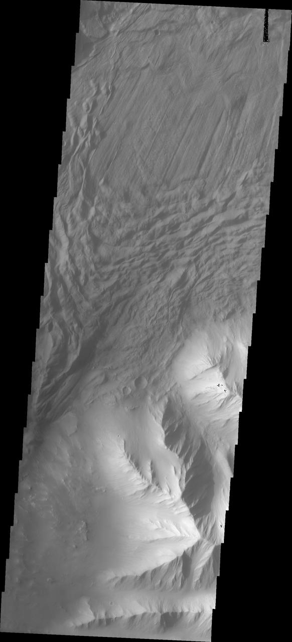
In this VIS image a complex region of multiple overlapping landslide deposits fills most the the frame. The very top layer has the lobate edges and radial surface grooves of a low volume slide. It appears to be the top of a complex layering of materials. It is possible that all the lower layers are landslides as well. Whether the layers formed very close in time of over thousands of years can not be determined in the image. Tithonium Chasma has numerous large landslide deposits. The resistant material of the plateau surface forms the linear ridges of the canyon wall. Large landslides have changed the walls and floor of the canyon. A landslide is a failure of slope due to gravity. They initiate due to several reasons. A lower layer of poorly cemented/resistant material may have been eroded, undermining the wall above which then collapses; earth quake seismic waves can cause the slope to collapse; and even an impact event near the canyon wall can cause collapse. As millions of tons of material fall and slide down slope a scalloped cavity forms at the upper part where the slope failure occurred. At the material speeds downhill it will pick up more of the underlying slope, increasing the volume of material entrained into the landslide. Whereas some landslides spread across the canyon floor forming lobate deposits, very large volume slope failures will completely fill the canyon floor in a large complex region of chaotic blocks. Tithonium Chasma is at the western end of Valles Marineris. Valles Marineris is over 4000 kilometers long, wider than the United States. Tithonium Chasma is almost 810 kilometers long (499 miles), 50 kilometers wide and over 6 kilometers deep. In comparison, the Grand Canyon in Arizona is about 175 kilometers long, 30 kilometers wide, and only 2 kilometers deep. The canyons of Valles Marineris were formed by extensive fracturing and pulling apart of the crust during the uplift of the vast Tharsis plateau. Landslides have enlarged the canyon walls and created deposits on the canyon floor. Weathering of the surface and influx of dust and sand have modified the canyon floor, both creating and modifying layered materials. The Odyssey spacecraft has spent over 15 years in orbit around Mars, circling the planet more than 71,000 times. It holds the record for longest working spacecraft at Mars. THEMIS, the IR/VIS camera system, has collected data for the entire mission and provides images covering all seasons and lighting conditions. Over the years many features of interest have received repeated imaging, building up a suite of images covering the entire feature. From the deepest chasma to the tallest volcano, individual dunes inside craters and dune fields that encircle the north pole, channels carved by water and lava, and a variety of other feature, THEMIS has imaged them all. For the next several months the image of the day will focus on the Tharsis volcanoes, the various chasmata of Valles Marineris, and the major dunes fields. We hope you enjoy these images! Orbit Number: 19200 Latitude: -4.54491 Longitude: 272.164 Instrument: VIS Captured: 2006-04-13 04:51
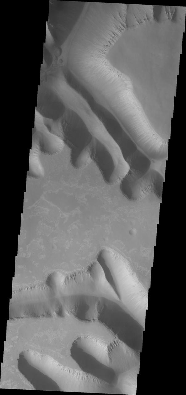
Ius Chasma is unique from the other chasmata of Valles Marineris in possessing mega gullies on both sides of the chasma. The largest mega gullies are located in Sinai Planum, dissecting those plains and emptying into the canyon. These mega gullies are called Louros Valles. Mega gullies are thought to be sapping channels caused by groundwater flow and erosion. The Earth analog is springs - water that flows underground and then breaches the surface creating channels. The morphology of the Mars gullies mirrors terrestrial springs. The channel is fairly uniform in width and the "head" of the channel is rounded like an amphitheater. The channel lengthens by erosion at the "head" backwards as the surface where the spring emerges is undercut. For Mars it is theorized that subsurface water would stay liquid due to underground heating. The channels in this image are parts of the two largest mega gullies. Note how every channel head is the amphitheater bowl shape. Ius Chasma is at the western end of Valles Marineris, south of Tithonium Chasma. Valles Marineris is over 4000 kilometers long, wider than the United States. Ius Chasma is almost 850 kilometers long (528 miles), 120 kilometers wide and over 8 kilometers deep. In comparison, the Grand Canyon in Arizona is about 175 kilometers long, 30 kilometers wide, and only 2 kilometers deep. The canyons of Valles Marineris were formed by extensive fracturing and pulling apart of the crust during the uplift of the vast Tharsis plateau. Landslides have enlarged the canyon walls and created deposits on the canyon floor. Weathering of the surface and influx of dust and sand have modified the canyon floor, both creating and modifying layered materials. There are many features that indicate flowing and standing water played a part in the chasma formation. The Odyssey spacecraft has spent over 15 years in orbit around Mars, circling the planet more than 71,000 times. It holds the record for longest working spacecraft at Mars. THEMIS, the IR/VIS camera system, has collected data for the entire mission and provides images covering all seasons and lighting conditions. Over the years many features of interest have received repeated imaging, building up a suite of images covering the entire feature. From the deepest chasma to the tallest volcano, individual dunes inside craters and dune fields that encircle the north pole, channels carved by water and lava, and a variety of other feature, THEMIS has imaged them all. For the next several months the image of the day will focus on the Tharsis volcanoes, the various chasmata of Valles Marineris, and the major dunes fields. We hope you enjoy these images! Orbit Number: 40700 Latitude: -8.16691 Longitude: 275.35 Instrument: VIS Captured: 2011-02-16 12:12 https://photojournal.jpl.nasa.gov/catalog/PIA22287
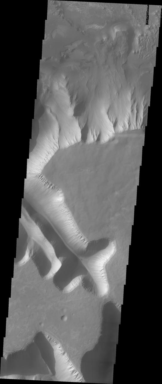
Ius Chasma is unique from the other chasmata of Valles Marineris in possessing mega gullies on both sides of the chasma. The largest mega gullies are located in Sinai Planum, dissecting those plains and emptying into the canyon. These mega gullies are called Louros Valles. Mega gullies are thought to be sapping channels caused by groundwater flow and erosion. The Earth analog is springs - water that flows underground and then breaches the surface creating channels. The morphology of the Mars gullies mirrors terrestrial springs. The channel is fairly uniform in width and the "head" of the channel is rounded like an amphiteater. The channel lengthens by erosion at the "head" backwards as the surface where the spring emerges is undercut. For Mars it is theorized that subsurface water would stay liquid due to underground heating. The "X" in the lower half of the image and the channel at the very bottom are parts of the two largest mega gullies. Ius Chasma is at the western end of Valles Marineris, south of Tithonium Chasma. Valles Marineris is over 4000 kilometers long, wider than the United States. Ius Chasma is almost 850 kilometers long (528 miles), 120 kilometers wide and over 8 kilometers deep. In comparison, the Grand Canyon in Arizona is about 175 kilometers long, 30 kilometers wide, and only 2 kilometers deep. The canyons of Valles Marineris were formed by extensive fracturing and pulling apart of the crust during the uplift of the vast Tharsis plateau. Landslides have enlarged the canyon walls and created deposits on the canyon floor. Weathering of the surface and influx of dust and sand have modified the canyon floor, both creating and modifying layered materials. There are many features that indicate flowing and standing water played a part in the chasma formation. The Odyssey spacecraft has spent over 15 years in orbit around Mars, circling the planet more than 71,000 times. It holds the record for longest working spacecraft at Mars. THEMIS, the IR/VIS camera system, has collected data for the entire mission and provides images covering all seasons and lighting conditions. Over the years many features of interest have received repeated imaging, building up a suite of images covering the entire feature. From the deepest chasma to the tallest volcano, individual dunes inside craters and dune fields that encircle the north pole, channels carved by water and lava, and a variety of other feature, THEMIS has imaged them all. For the next several months the image of the day will focus on the Tharsis volcanoes, the various chasmata of Valles Marineris, and the major dunes fields. We hope you enjoy these images! Orbit Number: 11138 Latitude: -7.92828 Longitude: 275.477 Instrument: VIS Captured: 2004-06-18 10:19 https://photojournal.jpl.nasa.gov/catalog/PIA22286
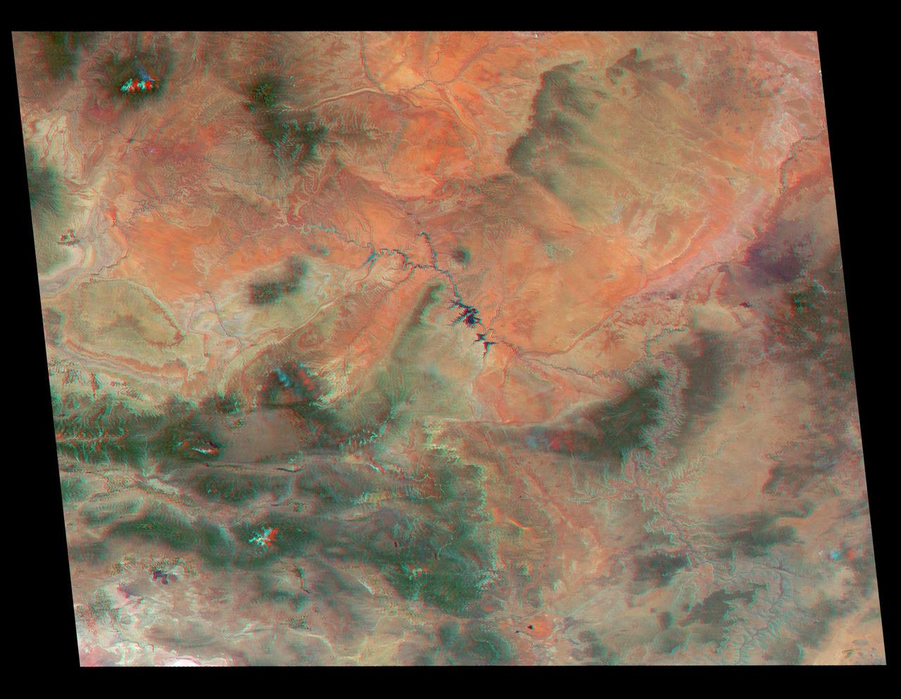
Just in time for the U.S. National Park Service's Centennial celebration on Aug. 25, NASA's Multiangle Imaging SpectroRadiometer (MISR) instrument aboard NASA's Terra satellite is releasing four new anaglyphs that showcase 33 of our nation's national parks, monuments, historical sites and recreation areas in glorious 3D. Shown in the annotated image are Walnut Canyon National Monument, Sunset Crater Volcano National Monument, Wupatki National Monument, Grand Canyon National Park, Pipe Spring National Monument, Zion National Park, Cedar Breaks National Monument, Bryce Canyon National Park, Capitol Reef National Park, Navajo National Monument, Glen Canyon National Recreation Area, Natural Bridges National Monument, Canyonlands National Park, and Arches National Park. MISR views Earth with nine cameras pointed at different angles, giving it the unique capability to produce anaglyphs, stereoscopic images that allow the viewer to experience the landscape in three dimensions. The anaglyphs were made by combining data from MISR's vertical-viewing and 46-degree forward-pointing camera. You will need red-blue glasses in order to experience the 3D effect; ensure you place the red lens over your left eye. The images have been rotated so that north is to the left in order to enable 3D viewing because the Terra satellite flies from north to south. All of the images are 235 miles (378 kilometers) from west to east. These data were acquired June 18, 2016, Orbit 87774. http://photojournal.jpl.nasa.gov/catalog/PIA20889

This VIS image shows part of the eastern end of Ius Chasma. Geryon Montes are located in the bottom half of the image. Between the montes and the southern wall face is a region of sand and sand dunes. The presence of mobile sand indicates that winds are eroding, depositing and changing the canyon floor. The top of the image is dominated by a large landslide deposit. The radial surface grooves are still visible, but the region as a whole as undergone significant erosion. A landslide is a failure of slope due to gravity. They initiate due to several reasons. A lower layer of poorly cemented/resistant material may have been eroded, undermining the wall above which then collapses; earthquake seismic waves can cause the slope to collapse; and even an impact event near the canyon wall can cause collapse. As millions of tons of material fall and slide down slope a scalloped cavity forms at the upper part where the slope failure occurred. At the material speeds downhill it will pick up more of the underlying slope, increasing the volume of material entrained into the landslide. Whereas some landslides spread across the canyon floor forming lobate deposits, very large volume slope failures will completely fill the canyon floor in a large complex region of chaotic blocks. Ius Chasma is at the western end of Valles Marineris, south of Tithonium Chasma. Valles Marineris is over 4000 kilometers long, wider than the United States. Ius Chasma is almost 850 kilometers long (528 miles), 120 kilometers wide and over 8 kilometers deep. In comparison, the Grand Canyon in Arizona is about 175 kilometers long, 30 kilometers wide, and only 2 kilometers deep. The canyons of Valles Marineris were formed by extensive fracturing and pulling apart of the crust during the uplift of the vast Tharsis plateau. Landslides have enlarged the canyon walls and created deposits on the canyon floor. Weathering of the surface and influx of dust and sand have modified the canyon floor, both creating and modifying layered materials. There are many features that indicate flowing and standing water played a part in the chasma formation. The Odyssey spacecraft has spent over 15 years in orbit around Mars, circling the planet more than 71,000 times. It holds the record for longest working spacecraft at Mars. THEMIS, the IR/VIS camera system, has collected data for the entire mission and provides images covering all seasons and lighting conditions. Over the years many features of interest have received repeated imaging, building up a suite of images covering the entire feature. From the deepest chasma to the tallest volcano, individual dunes inside craters and dune fields that encircle the north pole, channels carved by water and lava, and a variety of other feature, THEMIS has imaged them all. For the next several months the image of the day will focus on the Tharsis volcanoes, the various chasmata of Valles Marineris, and the major dunes fields. We hope you enjoy these images! Orbit Number: 17153 Latitude: -8.20738 Longitude: 281.009 Instrument: VIS Captured: 2005-10-26 16:00 https://photojournal.jpl.nasa.gov/catalog/PIA22284
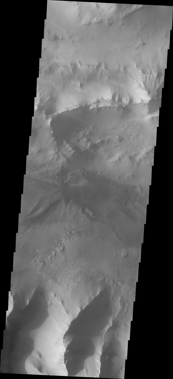
Continuing eastward thru central Ius Chasma, this image shows a section of chasma that is not dominated by landslide deposits. Geryon Montes, in the upper half of the image, has several visible faults, including a pair of faults that divide the uppermost ridge into two sections. Between the montes and the southern wall face is a region of sand and sand dunes. The presence of mobile sand indicates that winds are eroding, depositing and changing the canyon floor. A landslide is a failure of slope due to gravity. They initiate due to several reasons. A lower layer of poorly cemented/resistant material may have been eroded, undermining the wall above which then collapses; earthquake seismic waves can cause the slope to collapse; and even an impact event near the canyon wall can cause collapse. As millions of tons of material fall and slide down slope a scalloped cavity forms at the upper part where the slope failure occurred. At the material speeds downhill it will pick up more of the underlying slope, increasing the volume of material entrained into the landslide. Whereas some landslides spread across the canyon floor forming lobate deposits, very large volume slope failures will completely fill the canyon floor in a large complex region of chaotic blocks. Ius Chasma is at the western end of Valles Marineris, south of Tithonium Chasma. Valles Marineris is over 4000 kilometers long, wider than the United States. Ius Chasma is almost 850 kilometers long (528 miles), 120 kilometers wide and over 8 kilometers deep. In comparison, the Grand Canyon in Arizona is about 175 kilometers long, 30 kilometers wide, and only 2 kilometers deep. The canyons of Valles Marineris were formed by extensive fracturing and pulling apart of the crust during the uplift of the vast Tharsis plateau. Landslides have enlarged the canyon walls and created deposits on the canyon floor. Weathering of the surface and influx of dust and sand have modified the canyon floor, both creating and modifying layered materials. There are many features that indicate flowing and standing water played a part in the chasma formation. The Odyssey spacecraft has spent over 15 years in orbit around Mars, circling the planet more than 71,000 times. It holds the record for longest working spacecraft at Mars. THEMIS, the IR/VIS camera system, has collected data for the entire mission and provides images covering all seasons and lighting conditions. Over the years many features of interest have received repeated imaging, building up a suite of images covering the entire feature. From the deepest chasma to the tallest volcano, individual dunes inside craters and dune fields that encircle the north pole, channels carved by water and lava, and a variety of other feature, THEMIS has imaged them all. For the next several months the image of the day will focus on the Tharsis volcanoes, the various chasmata of Valles Marineris, and the major dunes fields. We hope you enjoy these images! Orbit Number: 27012 Latitude: -7.59048 Longitude: 276.328 Instrument: VIS Captured: 2008-01-16 09:47 https://photojournal.jpl.nasa.gov/catalog/PIA22281
STS077-150-044 (20 May 1996) --- Following its deployment from the Space Shuttle Endeavour, the Spartan 207/Inflatable Antenna Experiment (IAE) payload is backdropped over the Grand Canyon. After the IAE completed its inflation process in free-flight, this view was photographed with a large format still camera. The activity came on the first full day of in-space operations by the six-member crew. Managed by Goddard Space Flight Center (GSFC), Spartan is designed to provide short-duration, free-flight opportunities for a variety of scientific studies. The Spartan configuration on this flight is unique in that the IAE is part of an additional separate unit which is ejected once the experiment is completed. The IAE experiment will lay the groundwork for future technology development in inflatable space structures, which will be launched and then inflated like a balloon on-orbit.
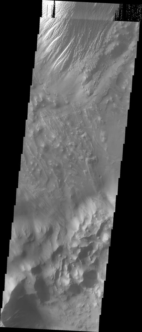
This VIS image shows part of the floor of Tithonium Chasma. Eroded materials cover most of the image. The initial formation of layered floor deposits was possibly created of air fall of dust, sand, and volcanic materials and water lain materials. The weathering of these deposits is probably by the wind. The bottom part of the image has complex, hummocky material, probably very old landslide deposits. At the top of the image is a large mound of material that has been eroded mainly by wind action. The overlapping of these surfaces indicates a long history of modication of Tithonium Chasma. Tithonium Chasma is at the western end of Valles Marineris. Valles Marineris is over 4000 kilometers long, wider than the United States. Tithonium Chasma is almost 810 kilometers long (499 miles), 50 kilometers wide and over 6 kilometers deep. In comparison, the Grand Canyon in Arizona is about 175 kilometers long, 30 kilometers wide, and only 2 kilometers deep. The canyons of Valles Marineris were formed by extensive fracturing and pulling apart of the crust during the uplift of the vast Tharsis plateau. Landslides have enlarged the canyon walls and created deposits on the canyon floor. Weathering of the surface and influx of dust and sand have modified the canyon floor, both creating and modifying layered materials. The Odyssey spacecraft has spent over 15 years in orbit around Mars, circling the planet more than 71,000 times. It holds the record for longest working spacecraft at Mars. THEMIS, the IR/VIS camera system, has collected data for the entire mission and provides images covering all seasons and lighting conditions. Over the years many features of interest have received repeated imaging, building up a suite of images covering the entire feature. From the deepest chasma to the tallest volcano, individual dunes inside craters and dune fields that encircle the north pole, channels carved by water and lava, and a variety of other feature, THEMIS has imaged them all. For the next several months the image of the day will focus on the Tharsis volcanoes, the various chasmata of Valles Marineris, and the major dunes fields. We hope you enjoy these images! Orbit Number: 3936 Latitude: -5.06026 Longitude: 271.813 Instrument: VIS Captured: 2002-11-03 13:15 https://photojournal.jpl.nasa.gov/catalog/PIA22269
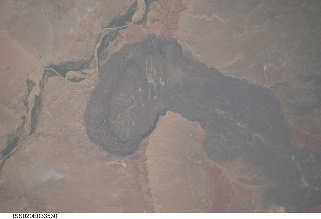
ISS020-E-033530 (21 Aug. 2009) --- Black Point Lava Flow in northern Arizona, seen in this image photographed by an Expedition 20 crew member on the International Space Station, is an excellent setting for training and systems testing for future exploration missions to the moon. Seen from space, the other-worldly footprint of the dark black basaltic lava creates a striking landscape. The flow is part of Arizona?s San Francisco Volcanic Field, a group of geologically young (approximately 6 million to less than one thousand years old, according to scientists) volcanoes, flows and cinder cones located just north of Flagstaff, Arizona. Scientists believe when it erupted onto the surface, the Black Point Lava flowed eastward over the older Permian and Triassic sedimentary rock sequences (spanning the period from roughly 300 to 240 million years ago) that are so well known around the vicinity of the Grand Canyon. The eastern edge of the flow slumps down to the surrounding plain, and ends along the Little Colorado River (upper left). In late August and early September 2009, scientists and engineers from NASA and several universities will travel to the Black Point Lava Flow to conduct tests for NASA?s Lunar Electric Rover (LER). This year, a team of geologists will support the tests, simulating traverses that might occur on the moon.
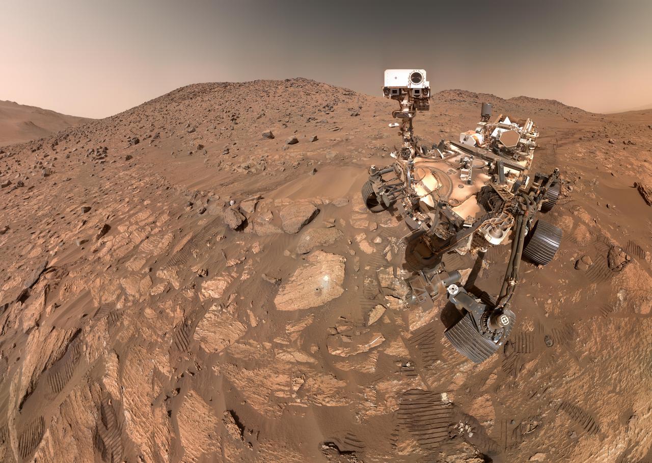
NASA's Perseverance Mars rover took this selfie on July 23, 2024, the 1,218th Martian day, or sol, of the mission. To the left of the rover near the center of the image is the arrowhead-shaped rock nicknamed "Cheyava Falls," which has features that may bear on the question of whether Mars was home to microscopic life in the distant past. The small dark hole in the rock is where Perseverance took a core sample, which is now in a sample tube stored in the rover's belly. The white patch to the right of the hole is where the rover used an abrasion tool to clear away the top surface, allowing science instruments to study the rock's composition. Measuring 3.2 feet by 2 feet (1 meter by 0.6 meters) and named after a Grand Canyon waterfall, Cheyava Falls lies at the northern edge of Neretva Vallis, an ancient river valley measuring a quarter-mile (400 meters) wide that was carved by water rushing into Jezero Crater long ago. The selfie is composed of 62 images taken by the WATSON (Wide Angle Topographic Sensor for Operations and eNgineering) camera on the end of the rover's robotic arm. The images were stitched together after being sent back to Earth. Animation available at https://photojournal.jpl.nasa.gov/catalog/PIA26344
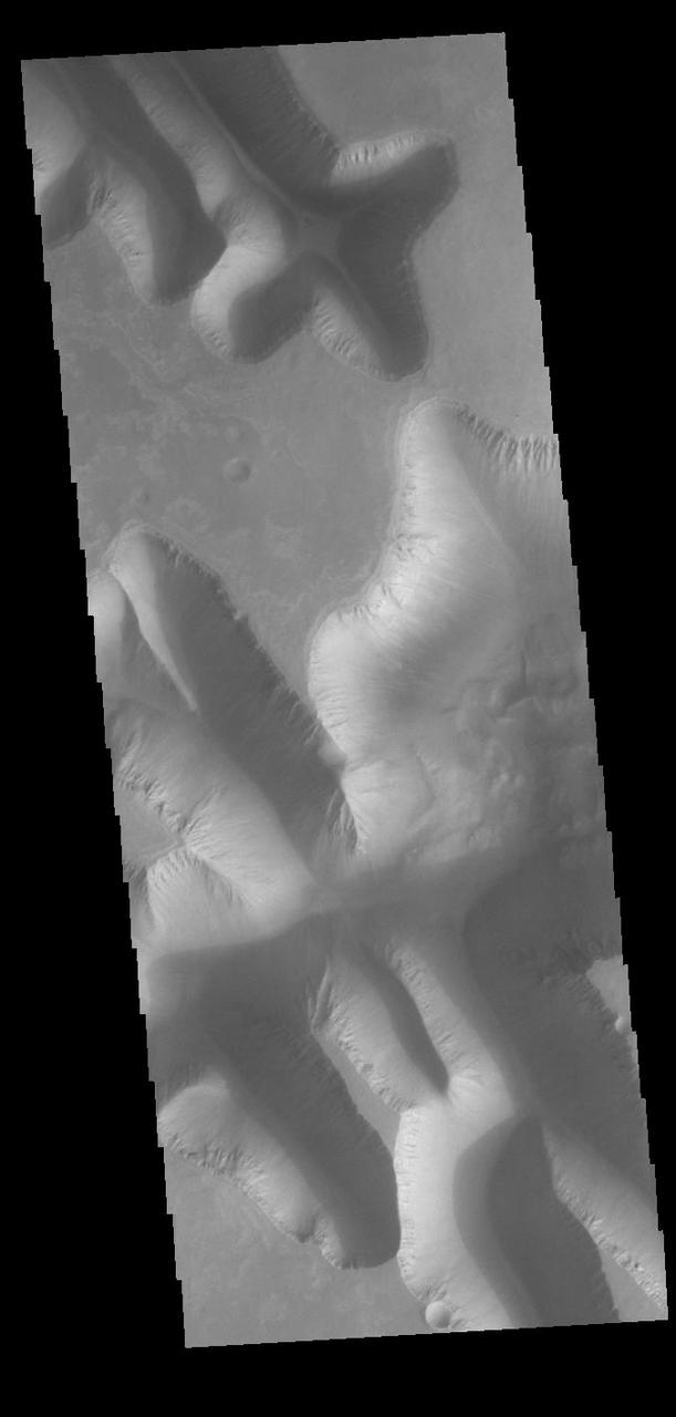
Today's VIS image shows part of Louros Valles on the southern part of Ius Chasma. Louros Valles is a region of mega gullies the empty into Ius Chasma. Ius Chasma is unique from the other chasmata of Valles Marineris in possessing mega gullies on both sides of the chasma. The largest mega gullies are located in Sinai Planum, dissecting those plains and emptying into the canyon. Mega gullies are thought to be sapping channels caused by groundwater flow and erosion. The Earth analog is springs – water that flows underground and then breaches the surface creating channels. The morphology of the Mars gullies mirrors terrestrial springs. The channel is fairly uniform in width and the "head" of the channel is rounded like an amphiteater. The channel lengthens by erosion at the "head" backwards as the surface where the spring emerges is undercut. For Mars it is theorized that subsurface water would stay liquid due to underground heating. Ius Chasma is at the western end of Valles Marineris, south of Tithonium Chasma. Valles Marineris is over 4000 kilometers long, wider than the United States. Ius Chasma is almost 850 kilometers long (528 miles), 120 kilometers wide and over 8 kilometers deep. In comparison, the Grand Canyon in Arizona is about 175 kilometers long, 30 kilometers wide, and only 2 kilometers deep. Orbit Number: 90809 Latitude: -8.38091 Longitude: 275.49 Instrument: VIS Captured: 2022-06-04 12:25 https://photojournal.jpl.nasa.gov/catalog/PIA25512
On July 14, 2015, NASA's New Horizons spacecraft made its historic flight through the Pluto system. This detailed, high-quality global mosaic of Pluto's largest moon, Charon, was assembled from nearly all of the highest-resolution images obtained by the Long-Range Reconnaissance Imager (LORRI) and the Multispectral Visible Imaging Camera (MVIC) on New Horizons. The mosaic is the most detailed and comprehensive global view yet of Charon's surface using New Horizons data. It includes topography data of the hemisphere visible to New Horizons during the spacecraft's closest approach. The topography is derived from digital stereo-image mapping tools that measure the parallax -- or the difference in the apparent relative positions -- of features on the surface obtained at different viewing angles during the encounter. Scientists use these parallax displacements of high and low terrain to estimate landform heights. The global mosaic has been overlain with transparent, colorized topography data wherever on the surface stereo data is available. Terrain south of about 30°S was in darkness leading up to and during the flyby, so is shown in black. All feature names on Pluto and Charon are informal. The global mosaic has been overlain with transparent, colorized topography data wherever on their surfaces stereo data is available. Standing out on Charon is the Caleuche Chasma ("C") in the far north, an enormous trough at least 350 kilometers (nearly 220 miles) long, and reaching 14 kilometers (8.5 miles) deep -- more than seven times as deep as the Grand Canyon. https://photojournal.jpl.nasa.gov/catalog/PIA21860
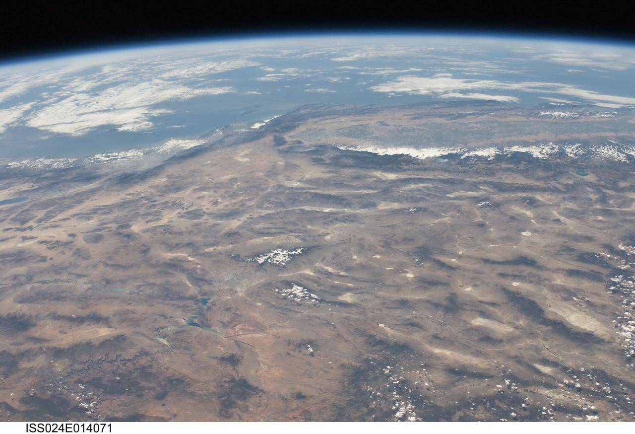
ISS024-E-014071 (9 Sept. 2010) --- This striking panoramic view of the southwestern USA and Pacific Ocean is an oblique image photographed by an Expedition 24 crew member looking outwards at an angle from the International Space Station (ISS). While most unmanned orbital satellites view Earth from a nadir perspective?in other words, collecting data with a ?straight down? viewing geometry?crew members onboard the space station can acquire imagery at a wide range of viewing angles using handheld digital cameras. The ISS nadir point (the point on Earth?s surface directly below the spacecraft) was located in northwestern Arizona, approximately 260 kilometers to the east-southeast, when this image was taken. The image includes parts of the States of Arizona, Nevada, Utah, and California together with a small segment of the Baja California, Mexico coastline at center left. Several landmarks and physiographic features are readily visible. The Las Vegas, NV metropolitan area appears as a gray region adjacent to the Spring Mountains and Sheep Range (both covered by white clouds). The Grand Canyon, located on the Colorado Plateau in Arizona, is visible (lower left) to the east of Las Vegas with the blue waters of Lake Mead in between. The image also includes the Mojave Desert, stretching north from the Salton Sea (left) to the Sierra Nevada mountain range. The Sierra Nevada range is roughly 640 kilometers long (north-south) and forms the boundary between the Central Valley of California and the adjacent Basin and Range. The Basin and Range is so called due to the pattern of long linear valleys separated by parallel linear mountain ranges ? this landscape, formed by extension and thinning of Earth?s crust, is particularly visible at right.
NASA's Perseverance Mars rover captured this image of a rock nicknamed "Cheyava Falls" on July 18, 2024, the 1,212th Martian day, or sol, of the mission. Running the length of the rock are large white calcium sulfate veins. Between those veins are bands of material whose reddish color suggests the presence of hematite, one of the minerals that gives Mars its distinctive rusty hue. Scientists are particularly interested in the millimeter-size, irregularly shaped light patches on the central reddish band (from lower left to upper right of the image) that are surrounded by a thin ring of dark material, akin to leopard spots. Spotting of this type on sedimentary terrestrial rocks can occur when chemical reactions involving hematite turn the rock from red to white. Those reactions can also release iron and phosphate, possibly causing the black halos to form, and they can be an energy source for microbes, hence the association between such features and microbes in a terrestrial setting. Measuring 3.2 feet by 2 feet (1 meter by 0.6 meters) and named after a Grand Canyon waterfall, Cheyava Falls was found in an ancient riverbed within the "Bright Angel" region of Mars' Jezero Crater. This image of the rock was captured using a camera called WATSON (Wide Angle Topographic Sensor for Operations and eNgineering), which is part of the SHERLOC (Scanning Habitable Environments with Raman and Luminescence for Organics and Chemicals) instrument suite located on the end of Perseverance's 7-foot-long (2-meter-long) robotic arm. SHERLOC looks for organic compounds – carbon-based molecules that are considered the building blocks of life – and detected them in Cheyava Falls. The white, knobby material seen on either side of the spots is dotted with a few green olivine crystals, which form in igneous rocks such as lava flows. It's unknown whether the olivine formed at the same time as the leopard spots; scientists hope to establish a timeline for when both the olivine and the spots formed. Perseverance drilled a core from Cheyava Falls, the rover's 22nd rock sample, on July 21. https://photojournal.jpl.nasa.gov/catalog/PIA26368
Composed of 18 images, this natural-color mosaic shows a boulder field on "Mount Washburn" (named after a mountain in Wyoming) in Mars' Jezero Crater. The Perseverance science team nicknamed the light-toned boulder with dark speckles near the center of the mosaic "Atoko Point" (after a feature in the eastern Grand Canyon). The images were acquired by NASA's Perseverance Mars rover on May 27, 2024, the 1,162nd Martian day, or sol, of the mission. Analysis by the rover's SuperCam and Mastcam-Z instruments indicate Atoko Point is composed of the mineral pyroxene, similar to some boulders the rover has encountered elsewhere in Jezero Crater. In terms of the size, shape, and arrangement of its mineral grains and crystals – and potentially its chemical composition – Atoko Point is different from any of the rocks the rover has encountered before. Some Perseverance scientists speculate the minerals that make up Atoko Point were produced in a subsurface body of magma that is possibly exposed now on the crater rim. Others on the team wonder if the boulder, which stands about 18 inches (45 centimeters) wide and 14 inches (35 centimeters) tall, had been created far beyond the walls of Jezero and transported there by swift Martian waters eons ago. Arizona State University leads the operations of the Mastcam-Z instrument, working in collaboration with Malin Space Science Systems in San Diego, on the design, fabrication, testing, and operation of the cameras, and in collaboration with the Niels Bohr Institute of the University of Copenhagen on the design, fabrication, and testing of the calibration targets. A key objective for Perseverance's mission on Mars is astrobiology, including the search for signs of ancient microbial life. The rover will characterize the planet's geology and past climate, pave the way for human exploration of the Red Planet, and be the first mission to collect and cache Martian rock and regolith (broken rock and dust). Subsequent NASA missions, in cooperation with ESA (European Space Agency), would send spacecraft to Mars to collect these sealed samples from the surface and return them to Earth for in-depth analysis. The Mars 2020 Perseverance mission is part of NASA's Moon to Mars exploration approach, which includes Artemis missions to the Moon that will help prepare for human exploration of the Red Planet. https://photojournal.jpl.nasa.gov/catalog/PIA26333

This enhanced color view from NASA's New Horizons spacecraft zooms in on the southeastern portion of Pluto's great ice plains, where at lower right the plains border rugged, dark highlands informally named Krun Macula. Krun Macula -- Krun is the lord of the underworld in the Mandaean religion, and a macula is a dark feature on a planetary surface -- is believed to get its dark red color from tholins, complex molecules found across Pluto. Krun Macula rises 1.5 miles (2.5 kilometers) above the surrounding plain -- informally named Sputnik Planum -- and is scarred by clusters of connected, roughly circular pits that typically reach between 5 and 8 miles (8 and 13 kilometers) across, and up to 1.5 miles (2.5 kilometers) deep. At the boundary with Sputnik Planum, these pits form deep valleys reaching more than 25 miles (40 kilometers) long, 12.5 miles (20 kilometers) wide and almost 2 miles (3 kilometers) deep (almost twice as deep as the Grand Canyon in Arizona), and have floors covered with nitrogen ice. New Horizons scientists think these pits may have formed through surface collapse, although what may have prompted such a collapse is a mystery. This scene was created using three separate observations made by New Horizons in July 2015. The right half of the image is composed of 260 feet- (80 meter-) per-pixel data from the Long Range Reconnaissance Imager (LORRI), obtained at 9,850 miles (15,850 kilometers) from Pluto, about 23 minutes before New Horizons' closest approach. The left half is composed of 410 feet- (125 meter-) per-pixel LORRI data, obtained about six minutes earlier, with New Horizons 15,470 miles (24,900 kilometers) from Pluto. These data respectively represent portions of the highest- and second-highest-resolution observations obtained by New Horizons in the Pluto system. The entire scene was then colorized using 2230 feet- (680 meter-) per-pixel data from New Horizons' Ralph/Multispectral Visual Imaging Camera (MVIC), obtained at 21,100 miles (33,900 kilometers) from Pluto, about 45 minutes before closest approach. http://photojournal.jpl.nasa.gov/catalog/PIA20732
This enhanced color view from NASA's New Horizons spacecraft zooms in on the southeastern portion of Pluto's great ice plains, where at lower right the plains border rugged, dark highlands informally named Krun Macula. Krun Macula -- Krun is the lord of the underworld in the Mandaean religion, and a macula is a dark feature on a planetary surface -- is believed to get its dark red color from tholins, complex molecules found across Pluto. Krun Macula rises 1.5 miles (2.5 kilometers) above the surrounding plain -- informally named Sputnik Planum -- and is scarred by clusters of connected, roughly circular pits that typically reach between 5 and 8 miles (8 and 13 kilometers) across, and up to 1.5 miles (2.5 kilometers) deep. At the boundary with Sputnik Planum, these pits form deep valleys reaching more than 25 miles (40 kilometers) long, 12.5 miles (20 kilometers) wide and almost 2 miles (3 kilometers) deep (almost twice as deep as the Grand Canyon in Arizona), and have floors covered with nitrogen ice. New Horizons scientists think these pits may have formed through surface collapse, although what may have prompted such a collapse is a mystery. This scene was created using three separate observations made by New Horizons in July 2015. The right half of the image is composed of 260 feet- (80 meter-) per-pixel data from the Long Range Reconnaissance Imager (LORRI), obtained at 9,850 miles (15,850 kilometers) from Pluto, about 23 minutes before New Horizons' closest approach. The left half is composed of 410 feet- (125 meter-) per-pixel LORRI data, obtained about six minutes earlier, with New Horizons 15,470 miles (24,900 kilometers) from Pluto. These data respectively represent portions of the highest- and second-highest-resolution observations obtained by New Horizons in the Pluto system. The entire scene was then colorized using 2230 feet- (680 meter-) per-pixel data from New Horizons' Ralph/Multispectral Visual Imaging Camera (MVIC), obtained at 21,100 miles (33,900 kilometers) from Pluto, about 45 minutes before closest approach. http://photojournal.jpl.nasa.gov/catalog/PIA20733