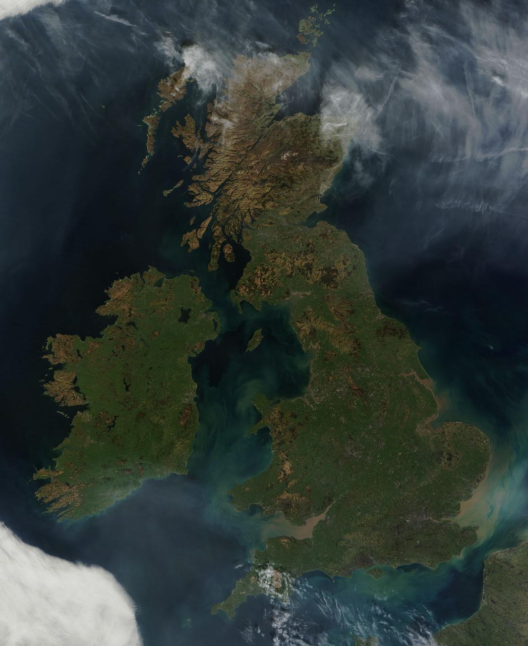
NASA image acquired March 26, 2012 This nearly cloud-free view of Great Britain and Ireland was acquired by the Moderate Resolution Imaging Spectroradiometer (MODIS) aboard NASA’s Terra satellite on March 26, 2012. Just a few days into spring, most of the land appears green, although not quite as brilliant as the summertime hues that give Ireland the nickname “the Emerald Island”. The islands of Ireland (west) and Great Britain (east) are separated by the Irish Sea, which is filled with the turquoise, green and tan swirls typical of sediment, although blooming algae could also contribute some color to the waters. To the southeast, the English Channel separates the island of Great Britain from France (south) and Belgium (north). London can be seen as a gray circle situated inland on the tan-colored River Thames. The sediment from the Thames flows into the English Channel due east of London. The United Kingdom is made up of Wales, Scotland and England, all located primarily on the island of Great Britain, and of Northern Ireland, which comprises the northern section of the island of Ireland. Dublin, in the Republic of Ireland, can be seen as a gray smudge on the eastern coast of the island. Almost due west Galway can be seen as a linear gray streak on the northern coast of Galway Bay, with the blue waters of Loch Corrib to the north. Most of the United Kingdom and Ireland are part of the Celtic broadleaf forest ecoregion, where acid-loving oak and mixed oak forests abound, along with fen and swamp forests and ombrotrophic mires. A portion of the Scottish Highlands, in the north of Great Britain, are covered by the Caledon conifer forest ecoregion. The Caledonia conifers once covered a large area of Scotland, but now only about 1% of the original forest survives, mostly high in the cooler areas of the Highlands. NASA/GSFC/Jeff Schmaltz/MODIS Land Rapid Response Team <b><a href="http://www.nasa.gov/audience/formedia/features/MP_Photo_Guidelines.html" rel="nofollow">NASA image use policy.</a></b> <b><a href="http://www.nasa.gov/centers/goddard/home/index.html" rel="nofollow">NASA Goddard Space Flight Center</a></b> enables NASA’s mission through four scientific endeavors: Earth Science, Heliophysics, Solar System Exploration, and Astrophysics. Goddard plays a leading role in NASA’s accomplishments by contributing compelling scientific knowledge to advance the Agency’s mission. <b>Follow us on <a href="http://twitter.com/NASA_GoddardPix" rel="nofollow">Twitter</a></b> <b>Like us on <a href="http://www.facebook.com/pages/Greenbelt-MD/NASA-Goddard/395013845897?ref=tsd" rel="nofollow">Facebook</a></b> <b>Find us on <a href="http://instagrid.me/nasagoddard/?vm=grid" rel="nofollow">Instagram</a></b>

This image from NASA Terra spacecraft is of the Isle of Man also known as Mann, a self-governing British Crown Dependency in the Irish Sea between Great Britain and Ireland.

iss066e118171 (Jan. 17, 2022) --- A faint aurora and the Earth's atmospheric glow crown this night time photograph of Ireland, Great Britain, and a portion of Northern Europe, as the International Space Station orbited 262 miles above the Atlantic Ocean.
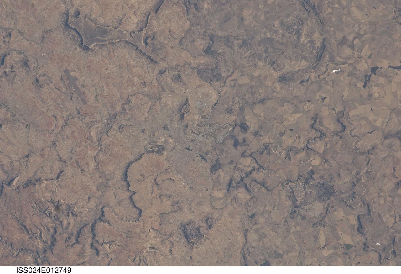
ISS024-E-012749 (28 Aug. 2010) --- Maseru, Lesotho is featured in this image photographed by an Expedition 24 crew member on the International Space Station. Maseru is the capital city of the Kingdom of Lesotho and is located along the northwestern border of the country with the Republic of South Africa. The footprint of the urban area, recognizable by street grids and distinctive blue-roofed industrial buildings at center, is only just visible against the surrounding landscape. The city has expanded eightfold (to 230,000 today) since independence from the United Kingdom of Great Britain and Northern Ireland in 1966, and is now home to one in five inhabitants in the country. The Caledon (or Mohokare) River flows adjacent to Maseru and forms a part of the border between Lesotho and South Africa. Locally, the border extends from approximately top center left to bottom center right, with the cities of Ladybrand and Manyatseng located in South Africa. Moshoeshoe I International Airport (left) provides access to the capital. Major industries in the city include flour mills, and footwear and textile companies. Tourism is also a growing part of the local economy. The Kingdom of Lesotho is completely landlocked by the surrounding Republic of South Africa. Major landforms visible in the image near Maseru include the Qeme and Berea Plateaus to the south and east respectively; these are erosional remnants of widespread horizontally layered sedimentary rocks that formed in the Karoo Basin during the Upper Triassic Period (approximately 200–229 million years ago), according to scientists.