
Guests interact with the VIPER exhibit at the Total Solar Eclipse Fest at the Great Lakes Science Center in Cleveland, OH on April 6, 2024. A total solar eclipse swept across a narrow portion of the North American continent from Mexico’s Pacific coast to the Atlantic coast of Newfoundland, Canada. A partial solar eclipse was visible across the entire North American continent along with parts of Central America and Europe. Photo Credit: (NASA/Sara Lowthian-Hanna)
An event attendee interacts with a booth science activity at the Total Eclipse Fest at the Great Lakes Science Center in Cleveland, OH on April 7, 2024. A total solar eclipse swept across a narrow portion of the North American continent from Mexico’s Pacific coast to the Atlantic coast of Newfoundland, Canada. A partial solar eclipse was visible across the entire North American continent along with parts of Central America and Europe. Photo Credit: (NASA/Jef Janis)

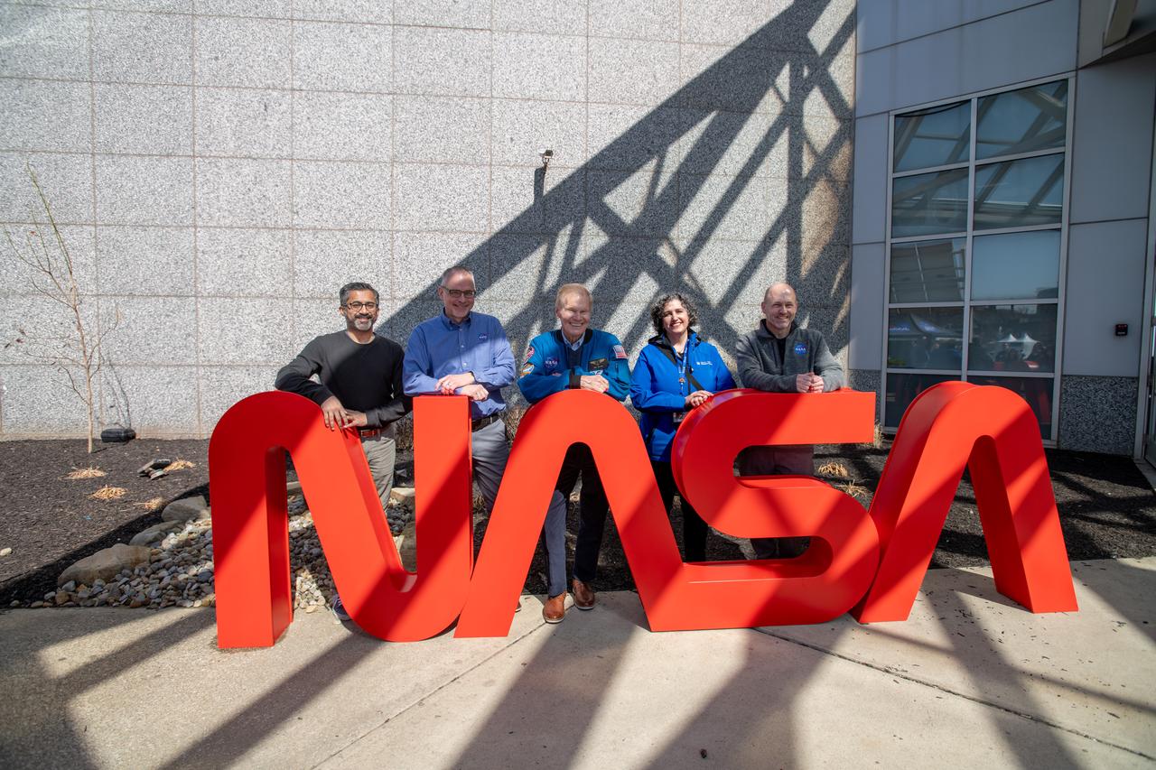
GRC Center Director Jimmy Kenyon, President & CEO of Greater Cleveland Partnership Baiju R. Shah, Representative Shontel Brown, Administrator Bill Nelson, Cuyahoga County Executive Chris Ronayne, Cleveland Mayor Justin Bibb, Great Lakes Science Center President and CEO Kristen Ellenbogen, Represenative Max Miller, pose for a photo together. NASA Glenn Research Center and the Great Lakes Science Center hosted a three-day celestial celebration in downtown Cleveland, OH. This free, outdoor, family-friendly science and arts festival will feature free concerts, performances, speakers, and hands-on science activities with community partners. A total solar eclipse swept across a narrow portion of the North American continent from Mexico’s Pacific coast to the Atlantic coast of Newfoundland, Canada. A partial solar eclipse was visible across the entire North American continent along with parts of Central America and Europe.
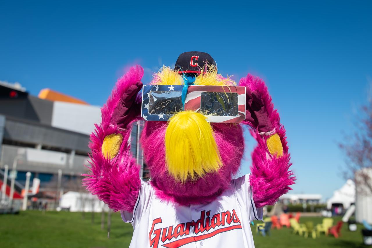
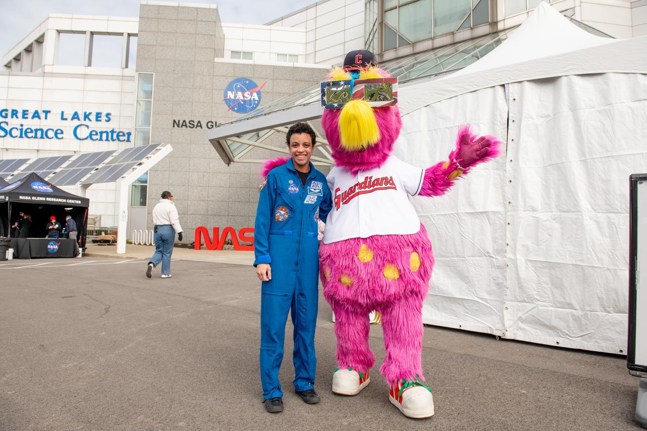
The Cleveland Guardians mascot, Slider poses with solar eclipse glasses at the Total Solar Eclipse Fest at the Great Lakes Science Center April 6, 2024. A total solar eclipse swept across a narrow portion of the North American continent from Mexico’s Pacific coast to the Atlantic coast of Newfoundland, Canada. A partial solar eclipse was visible across the entire North American continent along with parts of Central America and Europe.
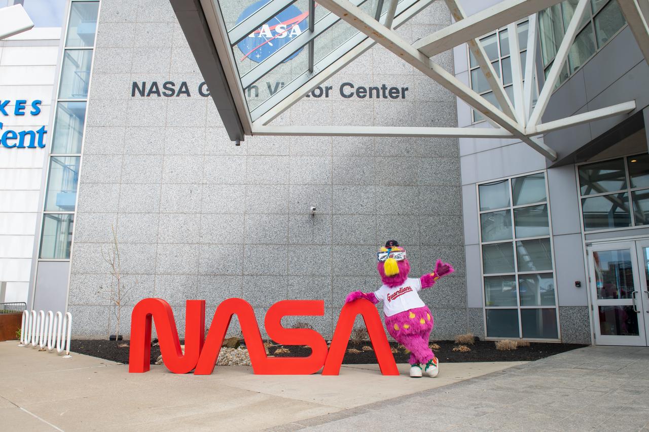
The Cleveland Guardians mascot, Slider poses in front of the NASA sign at the Total Solar Eclipse Fest at the Great Lakes Science Center April 6, 2024. A total solar eclipse swept across a narrow portion of the North American continent from Mexico’s Pacific coast to the Atlantic coast of Newfoundland, Canada. A partial solar eclipse was visible across the entire North American continent along with parts of Central America and Europe.
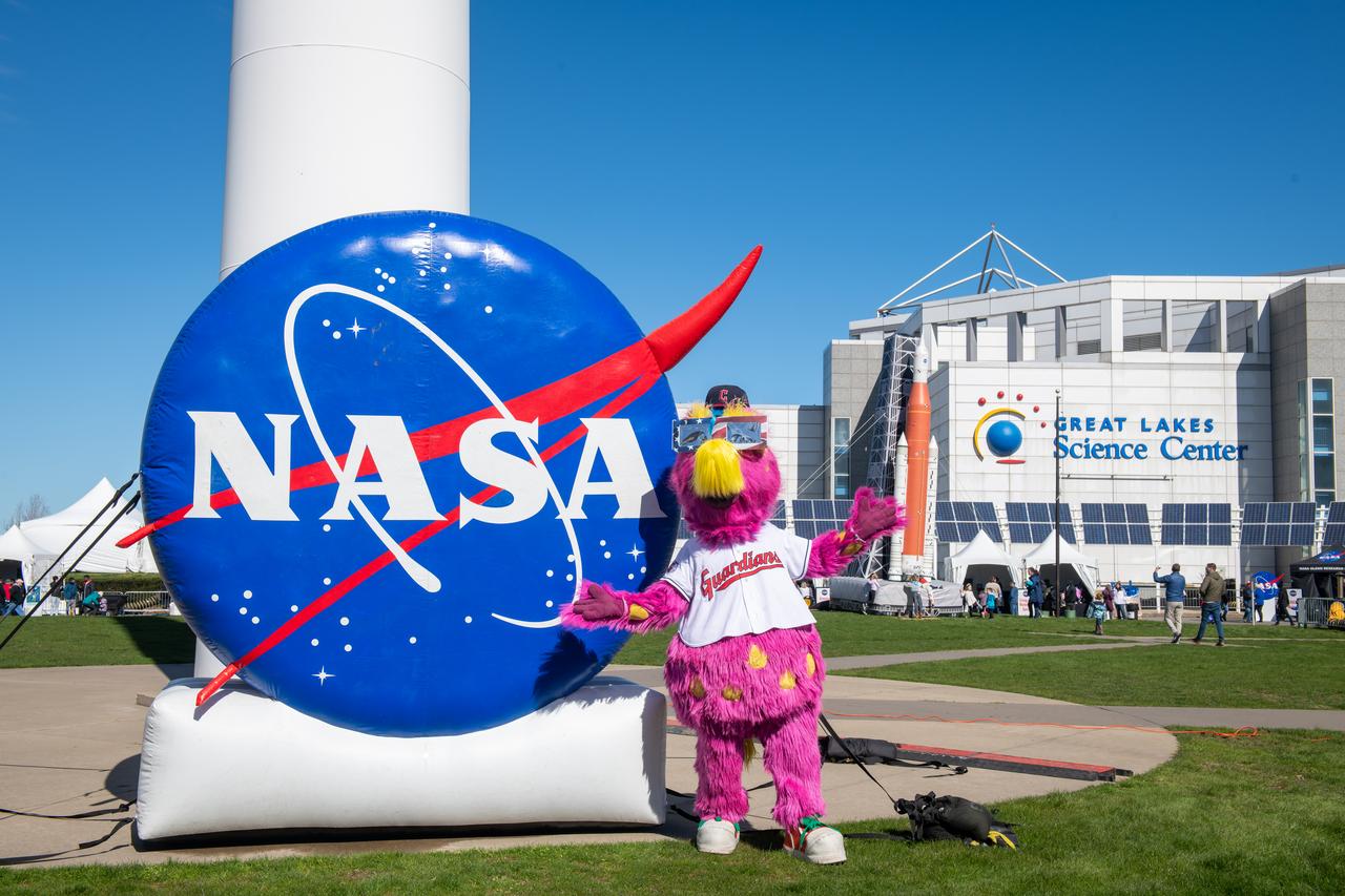
The Cleveland Guardians mascot, Slider poses in front of the NASA sign at the Total Solar Eclipse Fest at the Great Lakes Science Center April 6, 2024. A total solar eclipse swept across a narrow portion of the North American continent from Mexico’s Pacific coast to the Atlantic coast of Newfoundland, Canada. A partial solar eclipse was visible across the entire North American continent along with parts of Central America and Europe.

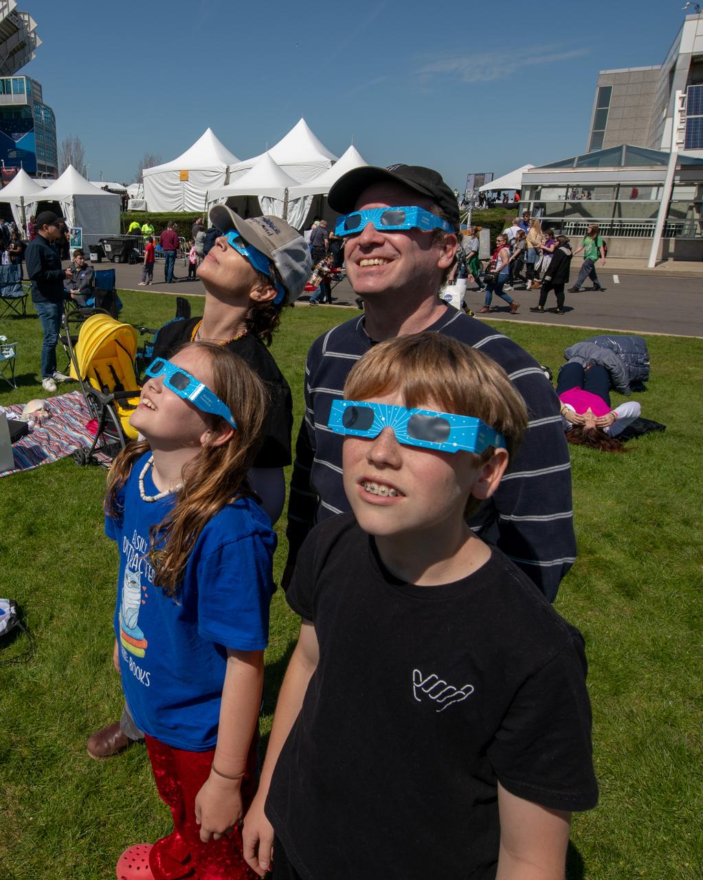
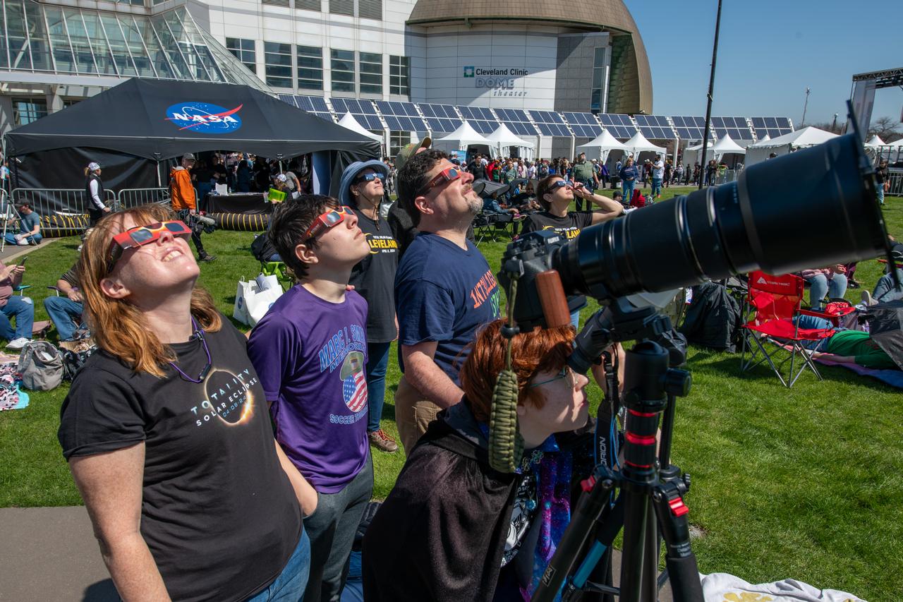
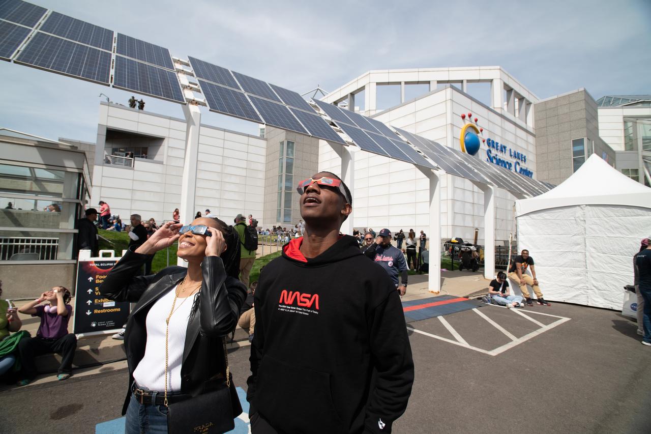
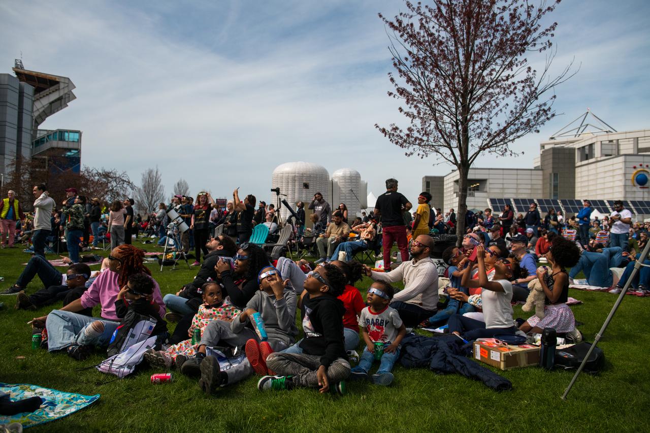
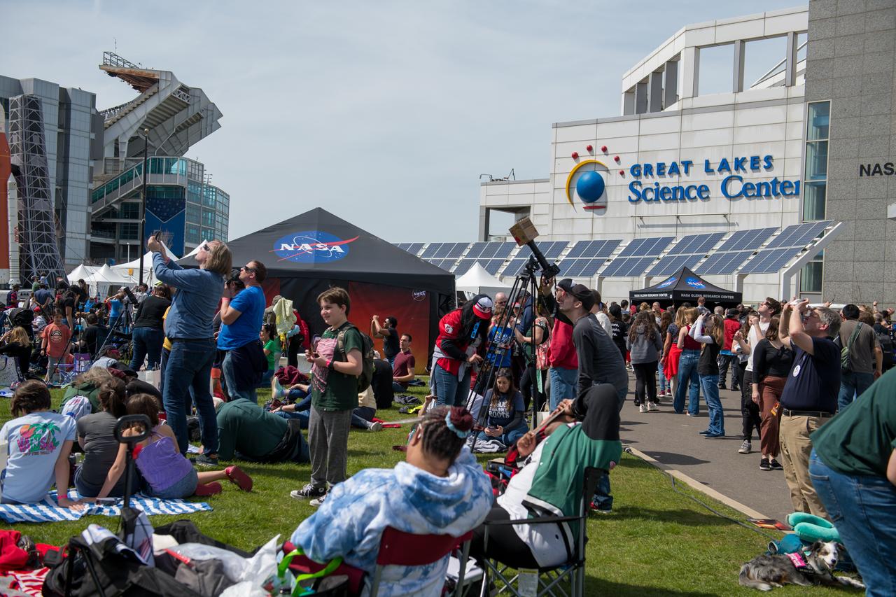
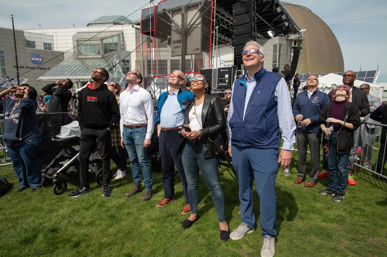
Event attendees view the eclipse on April 8, 2024. NASA Glenn Research Center and the Great Lakes Science Center hosted a three-day celestial celebration in downtown Cleveland, OH. This free, outdoor, family-friendly science and arts festival will feature free concerts, performances, speakers, and hands-on science activities with community partners. A total solar eclipse swept across a narrow portion of the North American continent from Mexico’s Pacific coast to the Atlantic coast of Newfoundland, Canada. A partial solar eclipse was visible across the entire North American continent along with parts of Central America and Europe. Photo Credit: (NASA/Jef Janis)
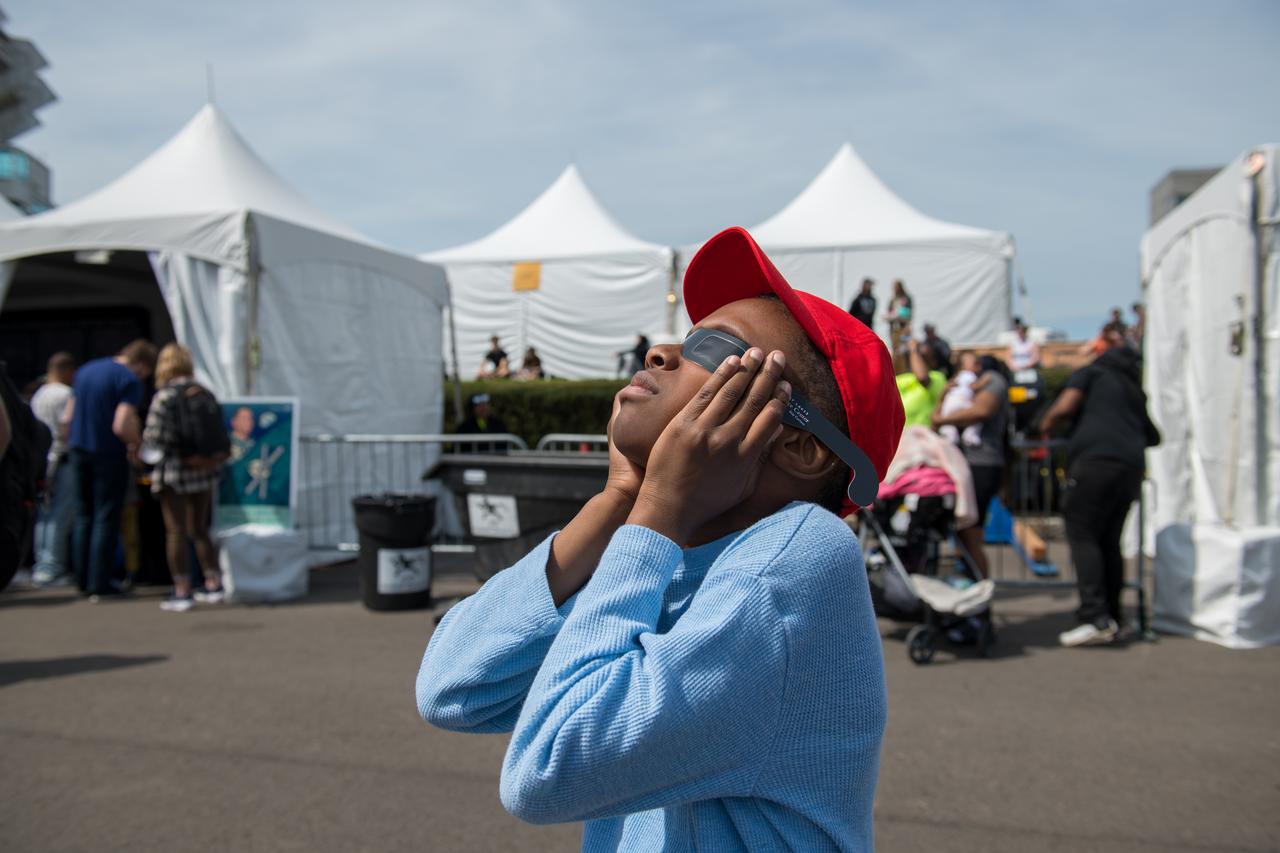
Event attendee views the eclipse on April 8, 2024. NASA Glenn Research Center and the Great Lakes Science Center hosted a three-day celestial celebration in downtown Cleveland, OH. This free, outdoor, family-friendly science and arts festival will feature free concerts, performances, speakers, and hands-on science activities with community partners. A total solar eclipse swept across a narrow portion of the North American continent from Mexico’s Pacific coast to the Atlantic coast of Newfoundland, Canada. A partial solar eclipse was visible across the entire North American continent along with parts of Central America and Europe. Photo Credit: (NASA/Jef Janis)
Event attendees view the eclipse on April 8, 2024. NASA Glenn Research Center and the Great Lakes Science Center hosted a three-day celestial celebration in downtown Cleveland, OH. This free, outdoor, family-friendly science and arts festival will feature free concerts, performances, speakers, and hands-on science activities with community partners. A total solar eclipse swept across a narrow portion of the North American continent from Mexico’s Pacific coast to the Atlantic coast of Newfoundland, Canada. A partial solar eclipse was visible across the entire North American continent along with parts of Central America and Europe. Photo Credit: (NASA/Jef Janis)

Event attendees view the eclipse. NASA Glenn Research Center and the Great Lakes Science Center hosted a three-day celestial celebration in downtown Cleveland, OH. This free, outdoor, family-friendly science and arts festival will feature free concerts, performances, speakers, and hands-on science activities with community partners. A total solar eclipse swept across a narrow portion of the North American continent from Mexico’s Pacific coast to the Atlantic coast of Newfoundland, Canada. A partial solar eclipse was visible across the entire North American continent along with parts of Central America and Europe.

Event attendees view the total solar eclipse on April 8, 2024. NASA Glenn Research Center and the Great Lakes Science Center hosted a three-day celestial celebration in downtown Cleveland, OH. This free, outdoor, family-friendly science and arts festival will feature free concerts, performances, speakers, and hands-on science activities with community partners. A total solar eclipse swept across a narrow portion of the North American continent from Mexico’s Pacific coast to the Atlantic coast of Newfoundland, Canada. A partial solar eclipse was visible across the entire North American continent along with parts of Central America and Europe. Photo Credit: (NASA/Jef Janis)
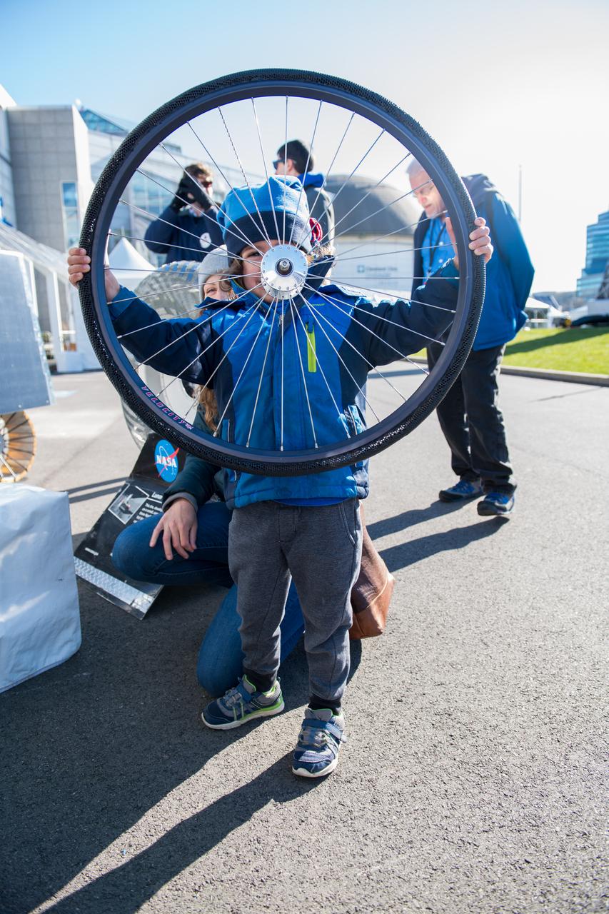
An event attendee holds a bike tire made with shape memory alloys at the Total Eclipse Fest at the Great Lakes Science Center in Cleveland, OH on April 7, 2024. A total solar eclipse swept across a narrow portion of the North American continent from Mexico’s Pacific coast to the Atlantic coast of Newfoundland, Canada. A partial solar eclipse was visible across the entire North American continent along with parts of Central America and Europe. Photo Credit: (NASA/Jef Janis)

Event attendees interact with one of the hands on science activities on April 8, 2024. NASA Glenn Research Center and the Great Lakes Science Center hosted a three-day celestial celebration in downtown Cleveland, OH. This free, outdoor, family-friendly science and arts festival will feature free concerts, performances, speakers, and hands-on science activities with community partners. Photo Credit: (NASA/Jef Janis)
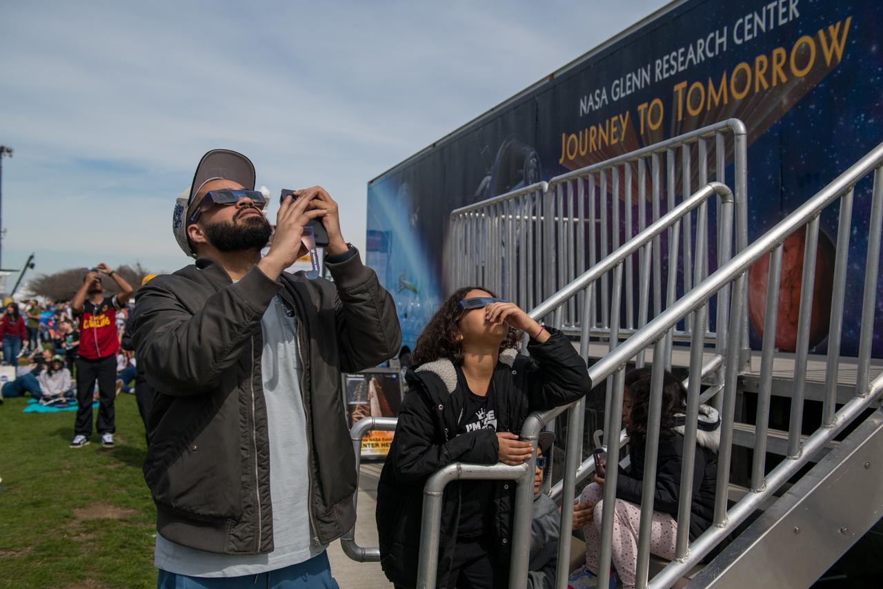
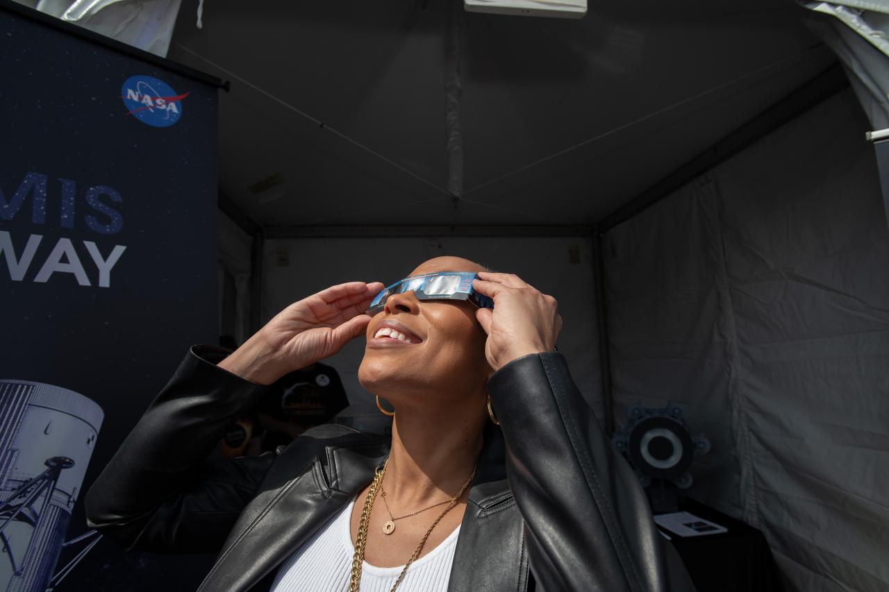
Event attendee views and photographs the eclipse safely. NASA Glenn Research Center and the Great Lakes Science Center hosted a three-day celestial celebration in downtown Cleveland, OH. This free, outdoor, family-friendly science and arts festival will feature free concerts, performances, speakers, and hands-on science activities with community partners. A total solar eclipse swept across a narrow portion of the North American continent from Mexico’s Pacific coast to the Atlantic coast of Newfoundland, Canada. A partial solar eclipse was visible across the entire North American continent along with parts of Central America and Europe. Photo Credit: (NASA/Jef Janis)
Representative Shontel Brown views the eclipse. NASA Glenn Research Center and the Great Lakes Science Center hosted a three-day celestial celebration in downtown Cleveland, OH. This free, outdoor, family-friendly science and arts festival will feature free concerts, performances, speakers, and hands-on science activities with community partners. A total solar eclipse swept across a narrow portion of the North American continent from Mexico’s Pacific coast to the Atlantic coast of Newfoundland, Canada. A partial solar eclipse was visible across the entire North American continent along with parts of Central America and Europe. Photo Credit: (NASA/Sara Lowthian-Hanna)

Event attendees view the eclipse. NASA Glenn Research Center and the Great Lakes Science Center hosted a three-day celestial celebration in downtown Cleveland, OH. This free, outdoor, family-friendly science and arts festival will feature free concerts, performances, speakers, and hands-on science activities with community partners. A total solar eclipse swept across a narrow portion of the North American continent from Mexico’s Pacific coast to the Atlantic coast of Newfoundland, Canada. A partial solar eclipse was visible across the entire North American continent along with parts of Central America and Europe. Photo Credit: (NASA/Jef Janis)
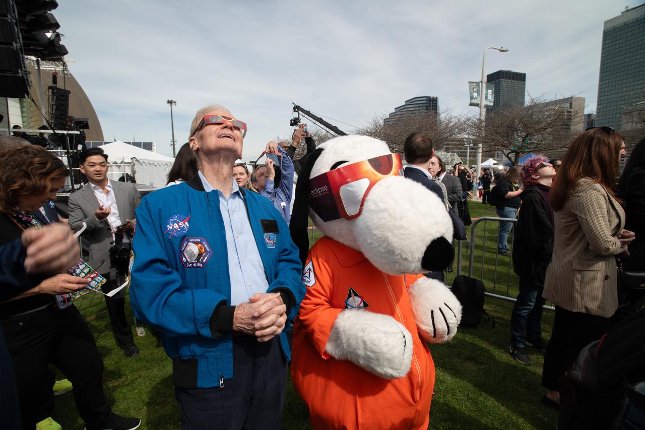
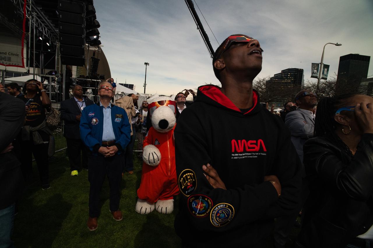
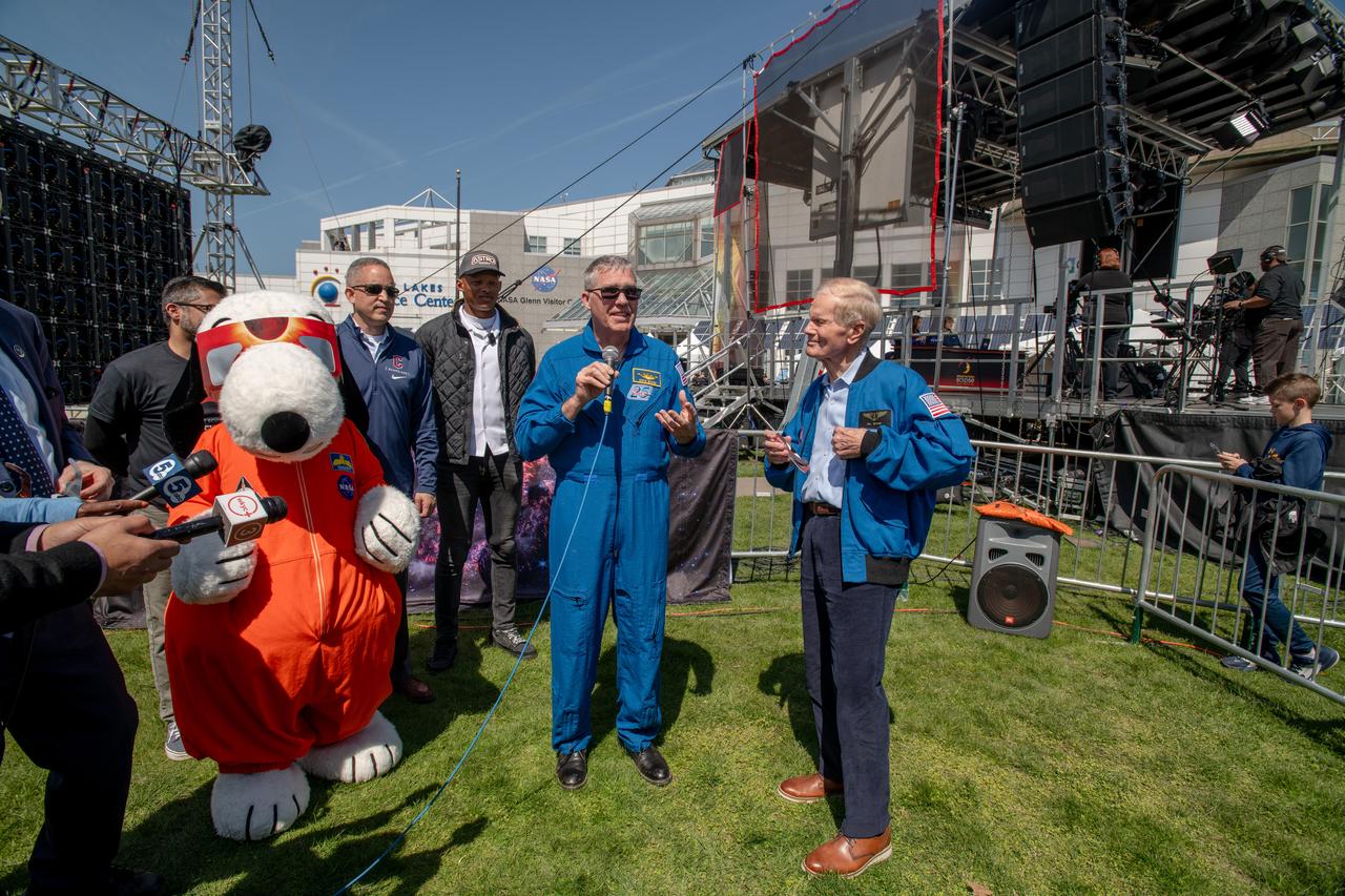
Administrator Bill Nelson and Snoopy view the eclipse just before totality on April 8,2024. NASA Glenn Research Center and the Great Lakes Science Center hosted a three-day celestial celebration in downtown Cleveland, OH. This free, outdoor, family-friendly science and arts festival will feature free concerts, performances, speakers, and hands-on science activities with community partners. A total solar eclipse swept across a narrow portion of the North American continent from Mexico’s Pacific coast to the Atlantic coast of Newfoundland, Canada. A partial solar eclipse was visible across the entire North American continent along with parts of Central America and Europe. Photo Credit: (NASA/Sara Lowthian-Hanna)
Administrator Bill Nelson and Snoopy view the eclipse together on April 8, 2024. NASA Glenn Research Center and the Great Lakes Science Center hosted a three-day celestial celebration in downtown Cleveland, OH. This free, outdoor, family-friendly science and arts festival will feature free concerts, performances, speakers, and hands-on science activities with community partners. A total solar eclipse swept across a narrow portion of the North American continent from Mexico’s Pacific coast to the Atlantic coast of Newfoundland, Canada. A partial solar eclipse was visible across the entire North American continent along with parts of Central America and Europe. Photo Credit: (NASA/Sara Lowthian-Hanna)
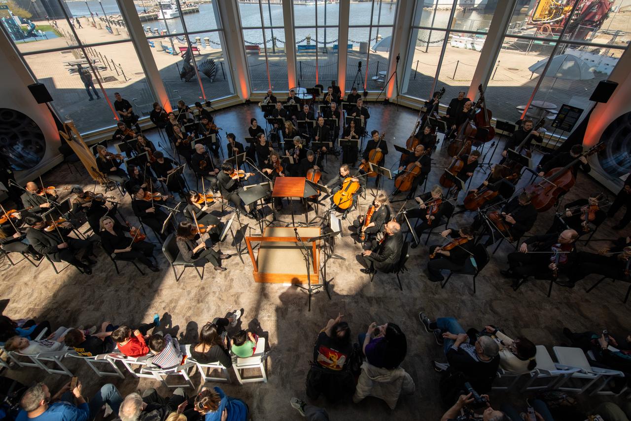
The Cleveland Orchestra performed an “Out of this World” concert program of galactic proportions featuring music by Mozart, Vivaldi, Debussy, Jessie Montgomery, and the first movement from Beethoven’s Symphony No. 5 on April 7, 2024. NASA Glenn Research Center and the Great Lakes Science Center hosted a three-day celestial celebration in downtown Cleveland, OH. This free, outdoor, family-friendly science and arts festival will feature free concerts, performances, speakers, and hands-on science activities with community partners.
President & CEO of Greater Cleveland Partnership Baiju R. Shah, Jim Free, Administrator Bill Nelson, Great Lakes Science Center President and CEO Kristen Ellenbogen, GRC Center Director Jimmy Kenyon pose for a photo together. NASA Glenn Research Center and the Great Lakes Science Center hosted a three-day celestial celebration in downtown Cleveland, OH. This free, outdoor, family-friendly science and arts festival will feature free concerts, performances, speakers, and hands-on science activities with community partners. A total solar eclipse swept across a narrow portion of the North American continent from Mexico’s Pacific coast to the Atlantic coast of Newfoundland, Canada. A partial solar eclipse was visible across the entire North American continent along with parts of Central America and Europe.
Event attendees view the eclipse. NASA Glenn Research Center and the Great Lakes Science Center hosted a three-day celestial celebration in downtown Cleveland, OH. This free, outdoor, family-friendly science and arts festival will feature free concerts, performances, speakers, and hands-on science activities with community partners. A total solar eclipse swept across a narrow portion of the North American continent from Mexico’s Pacific coast to the Atlantic coast of Newfoundland, Canada. A partial solar eclipse was visible across the entire North American continent along with parts of Central America and Europe.
Event attendees view the eclipse. NASA Glenn Research Center and the Great Lakes Science Center hosted a three-day celestial celebration in downtown Cleveland, OH. This free, outdoor, family-friendly science and arts festival will feature free concerts, performances, speakers, and hands-on science activities with community partners. A total solar eclipse swept across a narrow portion of the North American continent from Mexico’s Pacific coast to the Atlantic coast of Newfoundland, Canada. A partial solar eclipse was visible across the entire North American continent along with parts of Central America and Europe.

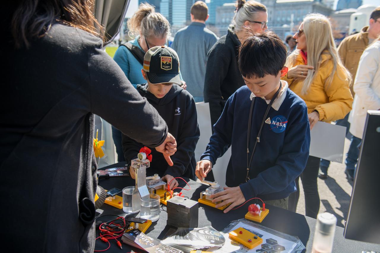
An event attendee interacts with one of the hands on science activities on April 7, 2024. NASA Glenn Research Center and the Great Lakes Science Center hosted a three-day celestial celebration in downtown Cleveland, OH. This free, outdoor, family-friendly science and arts festival will feature free concerts, performances, speakers, and hands-on science activities with community partners.
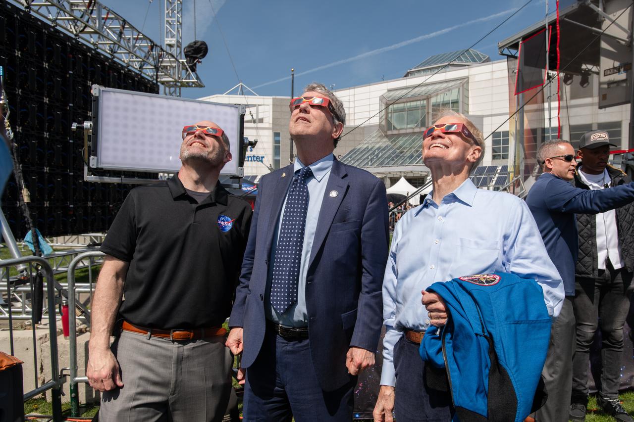
GRC Center Director Jimmy Kenyon, Senator Sherrod Brown and Administrator Bill Nelson view the eclipse together on April 8th. NASA Glenn Research Center and the Great Lakes Science Center hosted a three-day celestial celebration in downtown Cleveland, OH. This free, outdoor, family-friendly science and arts festival will feature free concerts, performances, speakers, and hands-on science activities with community partners. A total solar eclipse swept across a narrow portion of the North American continent from Mexico’s Pacific coast to the Atlantic coast of Newfoundland, Canada. A partial solar eclipse was visible across the entire North American continent along with parts of Central America and Europe.
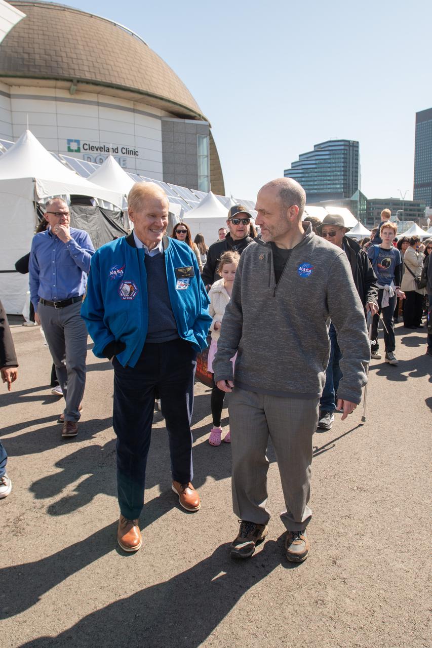
Administrator Bill Nelson and GRC Center director Jimmy walk through NASA village. NASA Glenn Research Center and the Great Lakes Science Center hosted a three-day celestial celebration in downtown Cleveland, OH. This free, outdoor, family-friendly science and arts festival will feature free concerts, performances, speakers, and hands-on science activities with community partners. A total solar eclipse swept across a narrow portion of the North American continent from Mexico’s Pacific coast to the Atlantic coast of Newfoundland, Canada. A partial solar eclipse was visible across the entire North American continent along with parts of Central America and Europe.
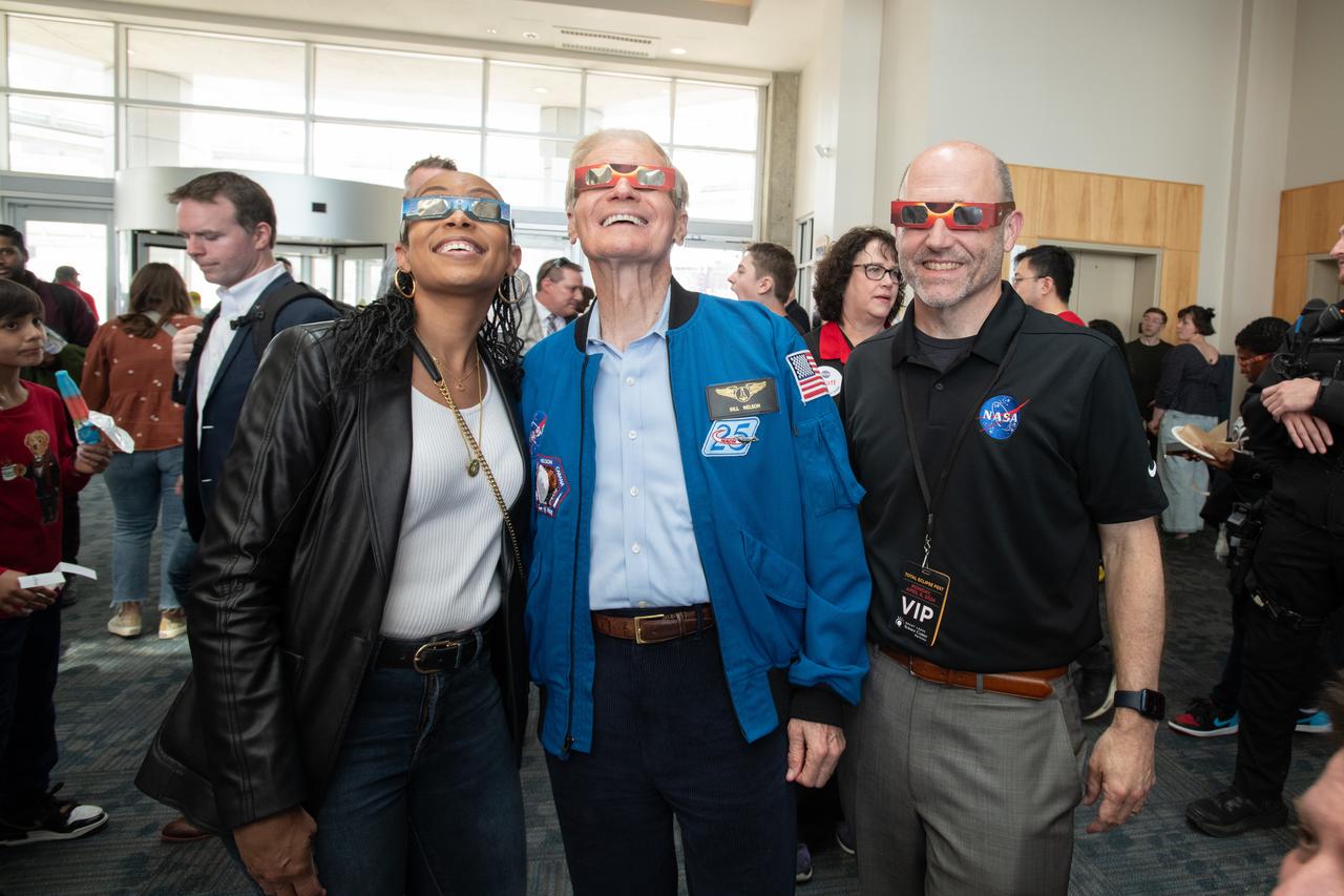
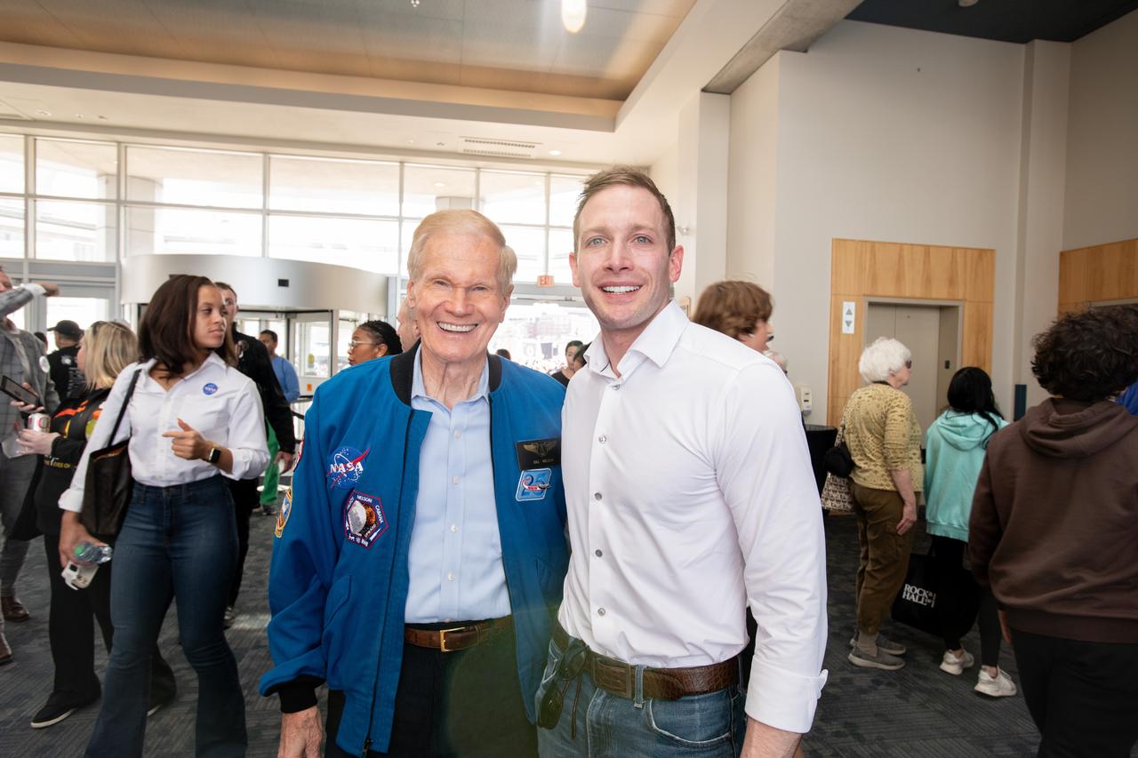
Representative Shontel Brown, Administrator Bill Nelson, GRC Center Director Jimmy Kenyon pose for a photo together with solar eclipse glasses on. NASA Glenn Research Center and the Great Lakes Science Center hosted a three-day celestial celebration in downtown Cleveland, OH. This free, outdoor, family-friendly science and arts festival will feature free concerts, performances, speakers, and hands-on science activities with community partners. A total solar eclipse swept across a narrow portion of the North American continent from Mexico’s Pacific coast to the Atlantic coast of Newfoundland, Canada. A partial solar eclipse was visible across the entire North American continent along with parts of Central America and Europe.
GRC Center Director Jimmy Kenyon and Cleveland Mayor Justin Bibb pose for a photo together. NASA Glenn Research Center and the Great Lakes Science Center hosted a three-day celestial celebration in downtown Cleveland, OH. This free, outdoor, family-friendly science and arts festival will feature free concerts, performances, speakers, and hands-on science activities with community partners. A total solar eclipse swept across a narrow portion of the North American continent from Mexico’s Pacific coast to the Atlantic coast of Newfoundland, Canada. A partial solar eclipse was visible across the entire North American continent along with parts of Central America and Europe.
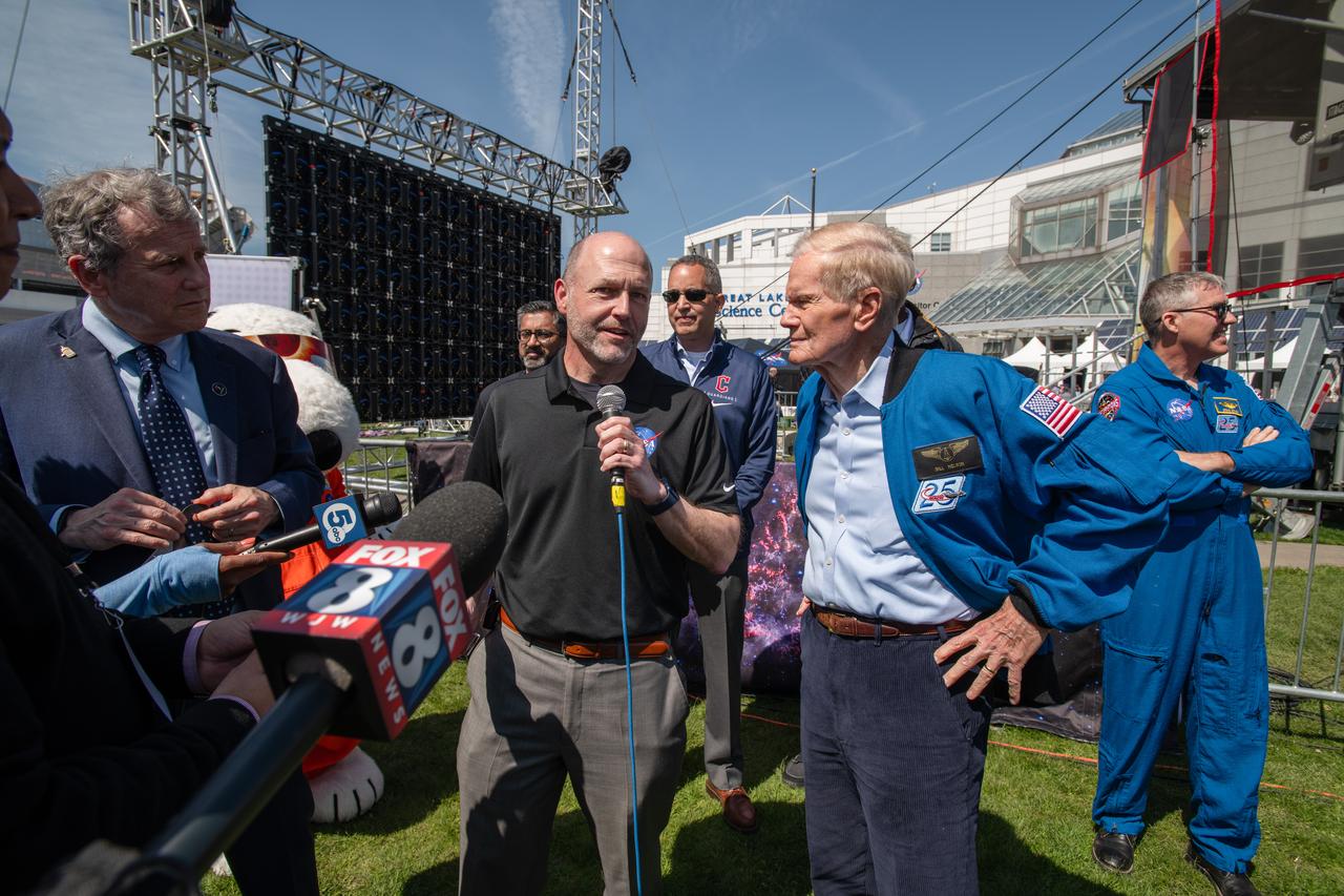
Senator Sherrod Brown, GRC Center Director Jimmy Kenyon and Administrator Bill Nelson speak to the media on April 8th. NASA Glenn Research Center and the Great Lakes Science Center hosted a three-day celestial celebration in downtown Cleveland, OH. This free, outdoor, family-friendly science and arts festival will feature free concerts, performances, speakers, and hands-on science activities with community partners. A total solar eclipse swept across a narrow portion of the North American continent from Mexico’s Pacific coast to the Atlantic coast of Newfoundland, Canada. A partial solar eclipse was visible across the entire North American continent along with parts of Central America and Europe.
Administrator Bill Nelson and Represenative Max Miller pose for a photo together. NASA Glenn Research Center and the Great Lakes Science Center hosted a three-day celestial celebration in downtown Cleveland, OH. This free, outdoor, family-friendly science and arts festival will feature free concerts, performances, speakers, and hands-on science activities with community partners. A total solar eclipse swept across a narrow portion of the North American continent from Mexico’s Pacific coast to the Atlantic coast of Newfoundland, Canada. A partial solar eclipse was visible across the entire North American continent along with parts of Central America and Europe.
Representative Shontel Brown and Cleveland Mayor Justin Bibb view the eclipse together. NASA Glenn Research Center and the Great Lakes Science Center hosted a three-day celestial celebration in downtown Cleveland, OH. This free, outdoor, family-friendly science and arts festival will feature free concerts, performances, speakers, and hands-on science activities with community partners. A total solar eclipse swept across a narrow portion of the North American continent from Mexico’s Pacific coast to the Atlantic coast of Newfoundland, Canada. A partial solar eclipse was visible across the entire North American continent along with parts of Central America and Europe.
Administrator Bill Nelson, Snoopy and Cleveland Mayor Justin Bibb view the eclipse just before totality. NASA Glenn Research Center and the Great Lakes Science Center hosted a three-day celestial celebration in downtown Cleveland, OH. This free, outdoor, family-friendly science and arts festival will feature free concerts, performances, speakers, and hands-on science activities with community partners. A total solar eclipse swept across a narrow portion of the North American continent from Mexico’s Pacific coast to the Atlantic coast of Newfoundland, Canada. A partial solar eclipse was visible across the entire North American continent along with parts of Central America and Europe.

Representative Shontel Brown and Administrator Bill Nelson pose for a photo together with solar eclipse glasses on. NASA Glenn Research Center and the Great Lakes Science Center hosted a three-day celestial celebration in downtown Cleveland, OH. This free, outdoor, family-friendly science and arts festival will feature free concerts, performances, speakers, and hands-on science activities with community partners. A total solar eclipse swept across a narrow portion of the North American continent from Mexico’s Pacific coast to the Atlantic coast of Newfoundland, Canada. A partial solar eclipse was visible across the entire North American continent along with parts of Central America and Europe.
Event attendees view the eclipse. NASA Glenn Research Center and the Great Lakes Science Center hosted a three-day celestial celebration in downtown Cleveland, OH. This free, outdoor, family-friendly science and arts festival will feature free concerts, performances, speakers, and hands-on science activities with community partners. A total solar eclipse swept across a narrow portion of the North American continent from Mexico’s Pacific coast to the Atlantic coast of Newfoundland, Canada. A partial solar eclipse was visible across the entire North American continent along with parts of Central America and Europe.

Event attendee views the eclipse. NASA Glenn Research Center and the Great Lakes Science Center hosted a three-day celestial celebration in downtown Cleveland, OH. This free, outdoor, family-friendly science and arts festival will feature free concerts, performances, speakers, and hands-on science activities with community partners. A total solar eclipse swept across a narrow portion of the North American continent from Mexico’s Pacific coast to the Atlantic coast of Newfoundland, Canada. A partial solar eclipse was visible across the entire North American continent along with parts of Central America and Europe.
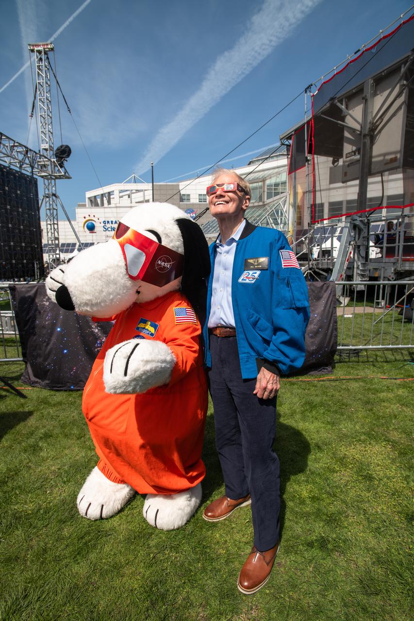
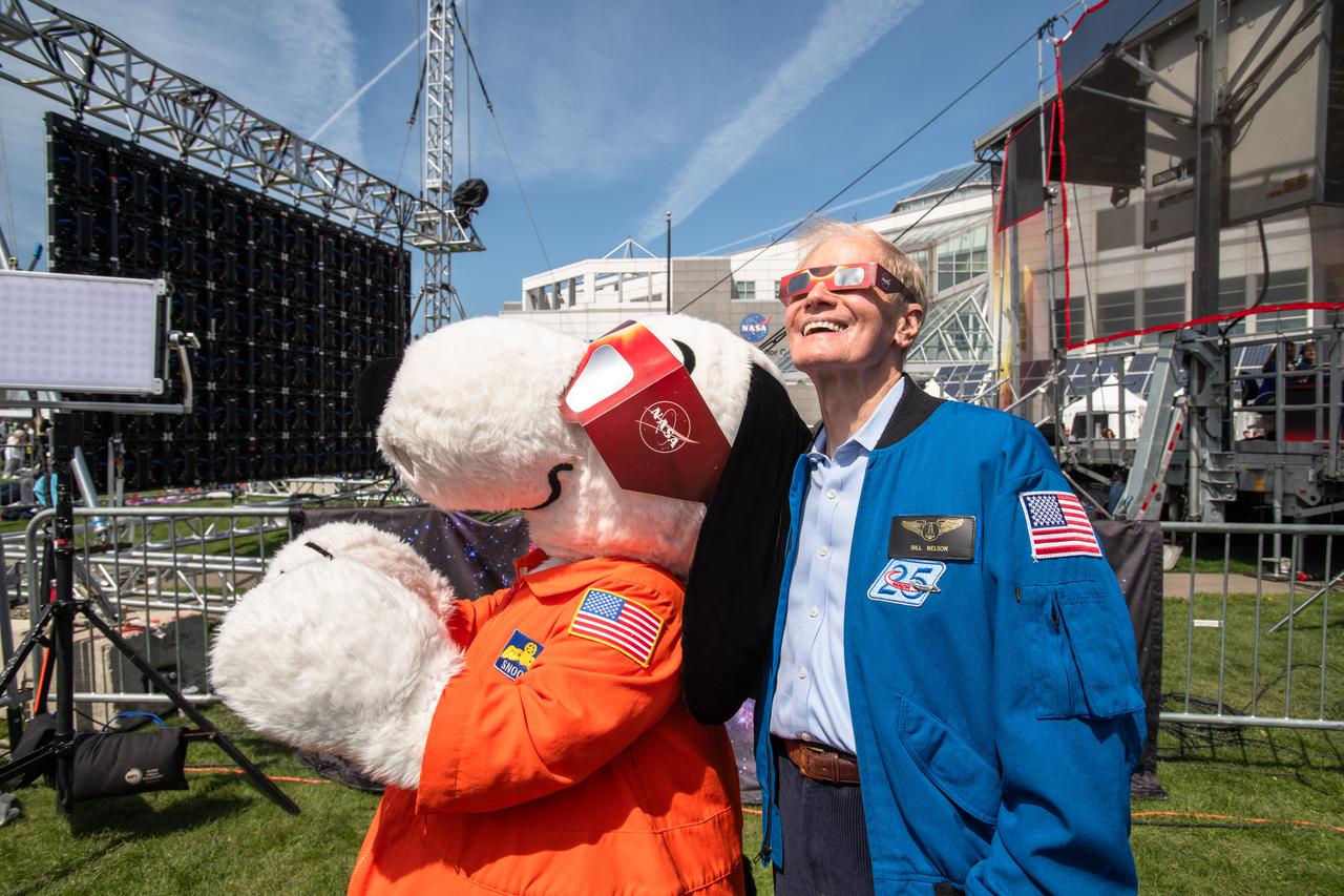
Administrator Bill Nelson and Snoopy view the eclipse together. NASA Glenn Research Center and the Great Lakes Science Center hosted a three-day celestial celebration in downtown Cleveland, OH. This free, outdoor, family-friendly science and arts festival will feature free concerts, performances, speakers, and hands-on science activities with community partners. A total solar eclipse swept across a narrow portion of the North American continent from Mexico’s Pacific coast to the Atlantic coast of Newfoundland, Canada. A partial solar eclipse was visible across the entire North American continent along with parts of Central America and Europe.
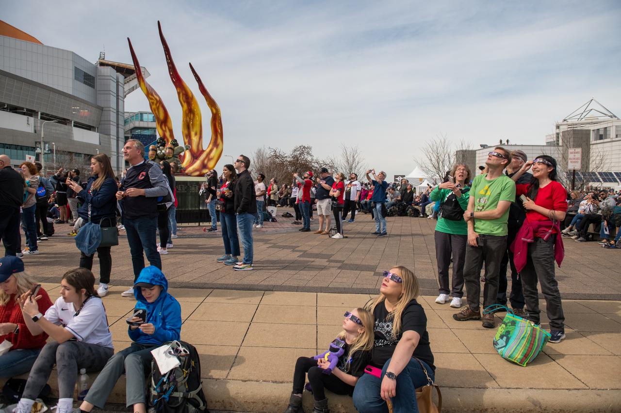
Event attendees view the eclipse. NASA Glenn Research Center and the Great Lakes Science Center hosted a three-day celestial celebration in downtown Cleveland, OH. This free, outdoor, family-friendly science and arts festival will feature free concerts, performances, speakers, and hands-on science activities with community partners. A total solar eclipse swept across a narrow portion of the North American continent from Mexico’s Pacific coast to the Atlantic coast of Newfoundland, Canada. A partial solar eclipse was visible across the entire North American continent along with parts of Central America and Europe.
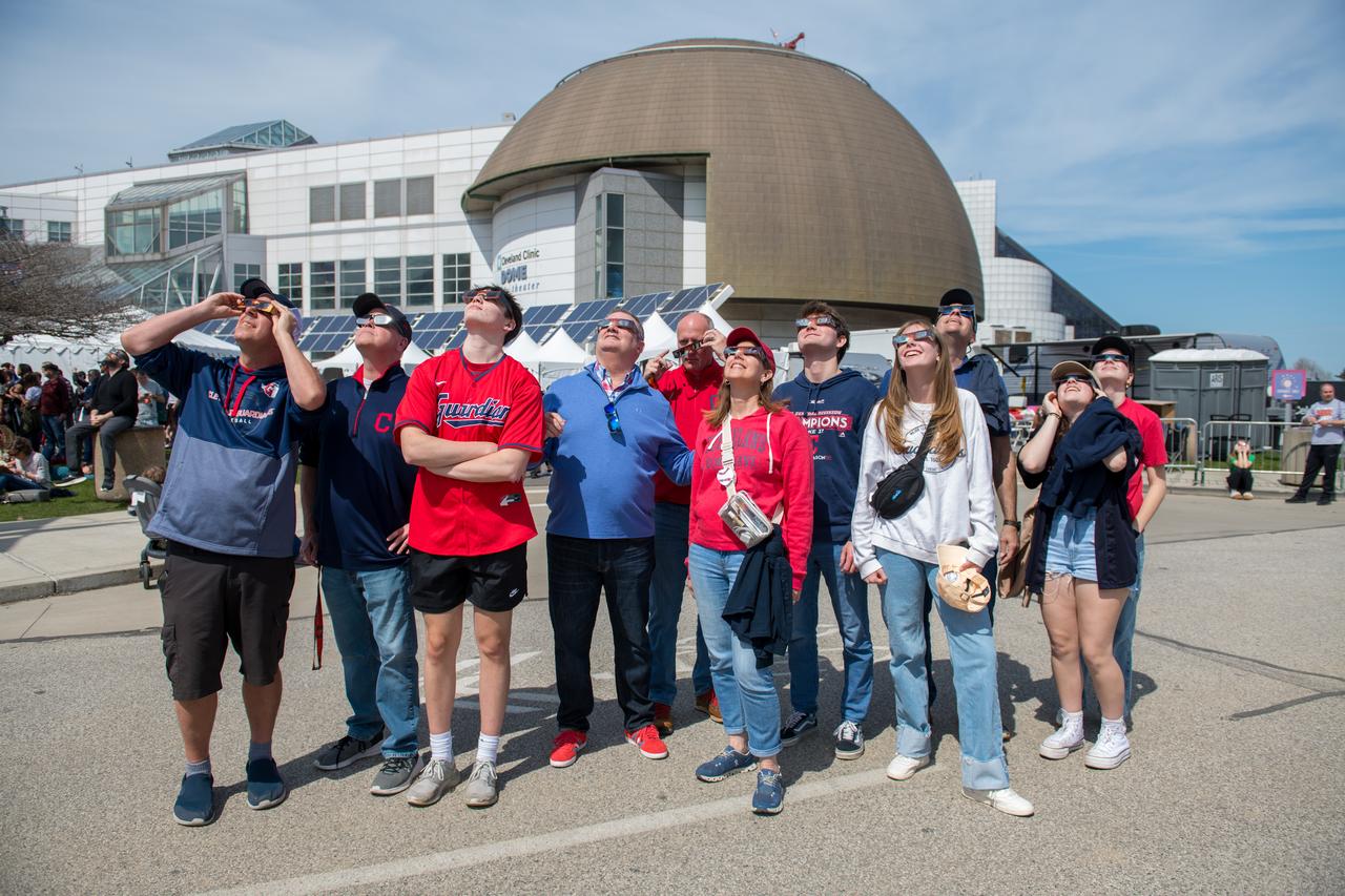
Event attendees view the eclipse. NASA Glenn Research Center and the Great Lakes Science Center hosted a three-day celestial celebration in downtown Cleveland, OH. This free, outdoor, family-friendly science and arts festival will feature free concerts, performances, speakers, and hands-on science activities with community partners. A total solar eclipse swept across a narrow portion of the North American continent from Mexico’s Pacific coast to the Atlantic coast of Newfoundland, Canada. A partial solar eclipse was visible across the entire North American continent along with parts of Central America and Europe.

Event attendees view the eclipse. NASA Glenn Research Center and the Great Lakes Science Center hosted a three-day celestial celebration in downtown Cleveland, OH. This free, outdoor, family-friendly science and arts festival will feature free concerts, performances, speakers, and hands-on science activities with community partners. A total solar eclipse swept across a narrow portion of the North American continent from Mexico’s Pacific coast to the Atlantic coast of Newfoundland, Canada. A partial solar eclipse was visible across the entire North American continent along with parts of Central America and Europe.
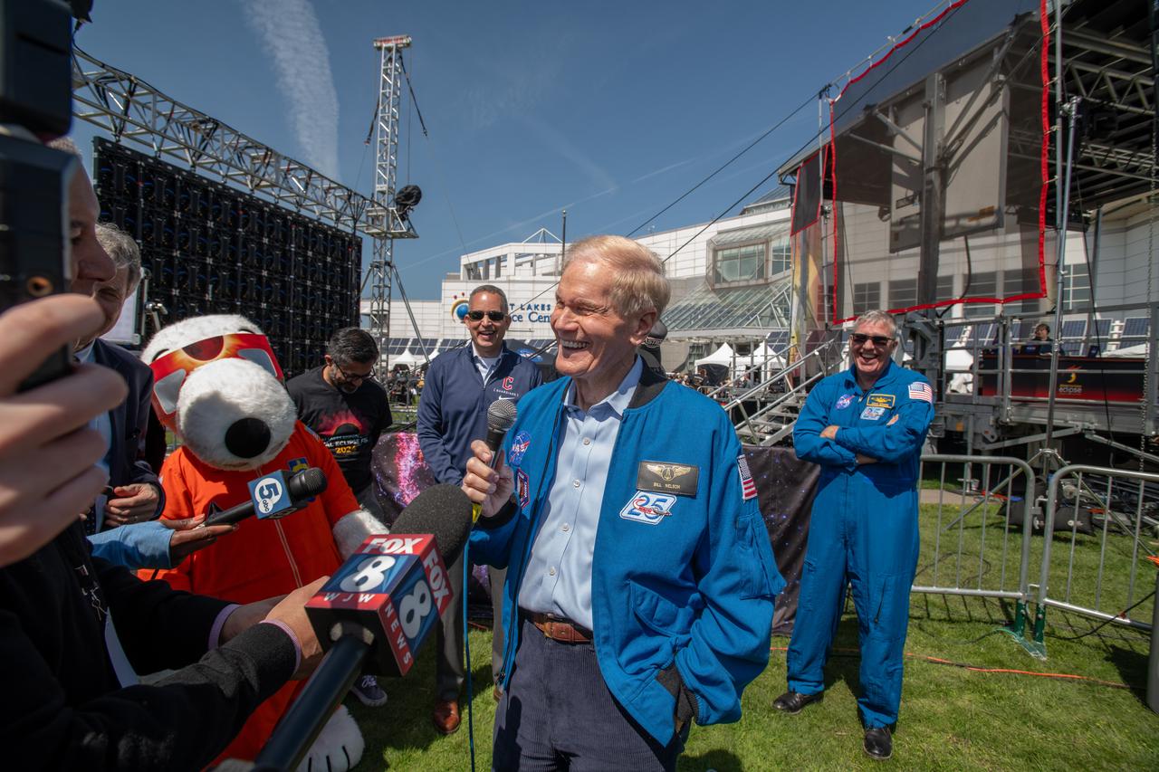
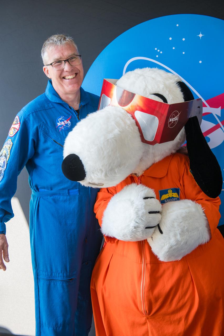
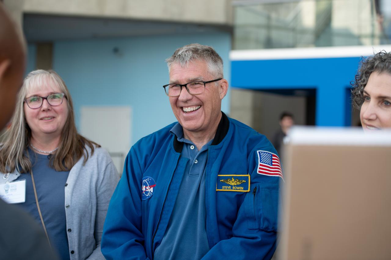
Administrator Bill Nelson, Snoopy and Astronaut Stephen Bowen speak to the media on April 8th. NASA Glenn Research Center and the Great Lakes Science Center hosted a three-day celestial celebration in downtown Cleveland, OH. This free, outdoor, family-friendly science and arts festival will feature free concerts, performances, speakers, and hands-on science activities with community partners. A total solar eclipse swept across a narrow portion of the North American continent from Mexico’s Pacific coast to the Atlantic coast of Newfoundland, Canada. A partial solar eclipse was visible across the entire North American continent along with parts of Central America and Europe.

Senator Sherrod Brown, Snoopy and Administrator Bill Nelson speak to the media on April 8th. NASA Glenn Research Center and the Great Lakes Science Center hosted a three-day celestial celebration in downtown Cleveland, OH. This free, outdoor, family-friendly science and arts festival will feature free concerts, performances, speakers, and hands-on science activities with community partners. A total solar eclipse swept across a narrow portion of the North American continent from Mexico’s Pacific coast to the Atlantic coast of Newfoundland, Canada. A partial solar eclipse was visible across the entire North American continent along with parts of Central America and Europe.
Administrator Bill Nelson, Snoopy and Astronaut Stephen Bowen speak to the media on April 8th. NASA Glenn Research Center and the Great Lakes Science Center hosted a three-day celestial celebration in downtown Cleveland, OH. This free, outdoor, family-friendly science and arts festival will feature free concerts, performances, speakers, and hands-on science activities with community partners. A total solar eclipse swept across a narrow portion of the North American continent from Mexico’s Pacific coast to the Atlantic coast of Newfoundland, Canada. A partial solar eclipse was visible across the entire North American continent along with parts of Central America and Europe.
Administrator Bill Nelson and Represenative Max Miller and wife pose for a photo together. NASA Glenn Research Center and the Great Lakes Science Center hosted a three-day celestial celebration in downtown Cleveland, OH. This free, outdoor, family-friendly science and arts festival will feature free concerts, performances, speakers, and hands-on science activities with community partners. A total solar eclipse swept across a narrow portion of the North American continent from Mexico’s Pacific coast to the Atlantic coast of Newfoundland, Canada. A partial solar eclipse was visible across the entire North American continent along with parts of Central America and Europe.
Event attendees view the eclipse. NASA Glenn Research Center and the Great Lakes Science Center hosted a three-day celestial celebration in downtown Cleveland, OH. This free, outdoor, family-friendly science and arts festival will feature free concerts, performances, speakers, and hands-on science activities with community partners. A total solar eclipse swept across a narrow portion of the North American continent from Mexico’s Pacific coast to the Atlantic coast of Newfoundland, Canada. A partial solar eclipse was visible across the entire North American continent along with parts of Central America and Europe.
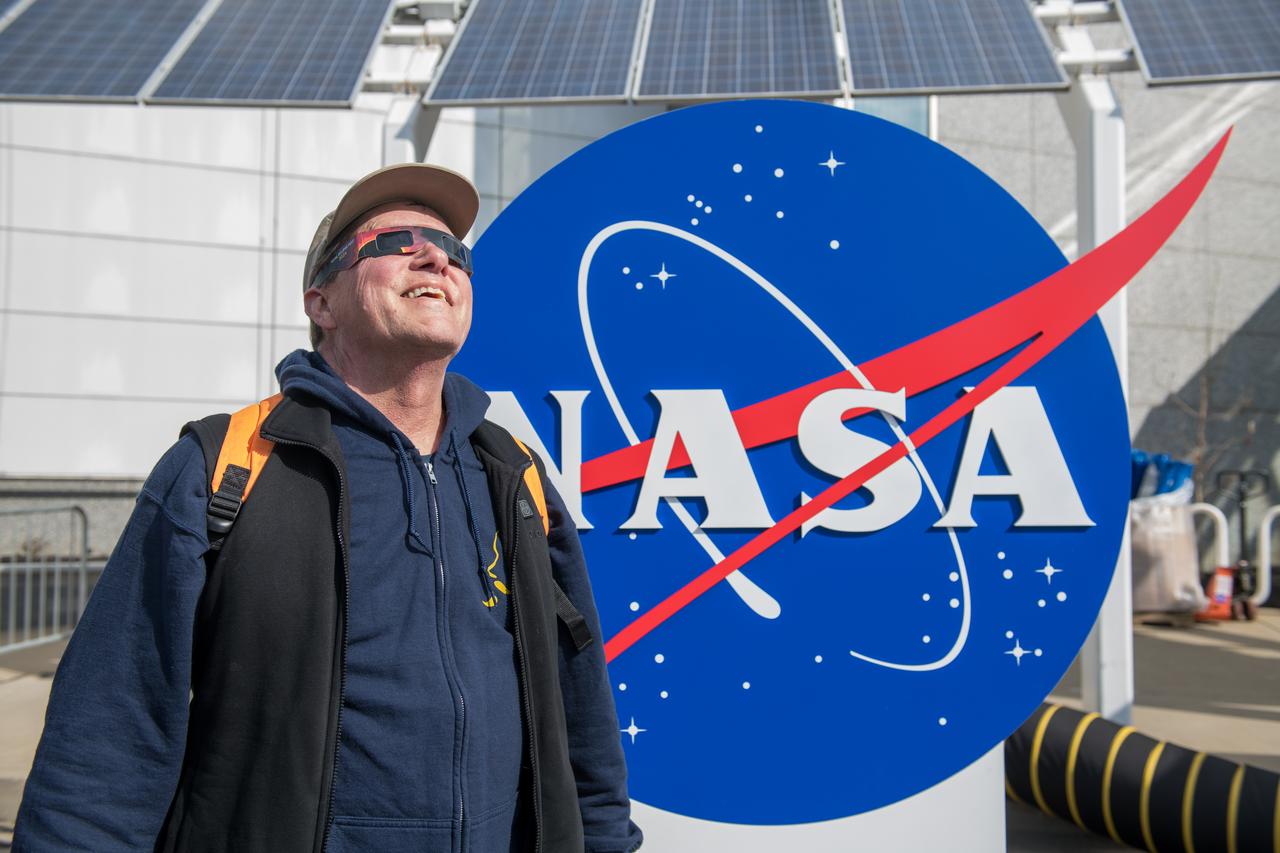
An event attendee views the eclipse on April 8, 2024. NASA Glenn Research Center and the Great Lakes Science Center hosted a three-day celestial celebration in downtown Cleveland, OH. This free, outdoor, family-friendly science and arts festival will feature free concerts, performances, speakers, and hands-on science activities with community partners. A total solar eclipse swept across a narrow portion of the North American continent from Mexico’s Pacific coast to the Atlantic coast of Newfoundland, Canada. A partial solar eclipse was visible across the entire North American continent along with parts of Central America and Europe.
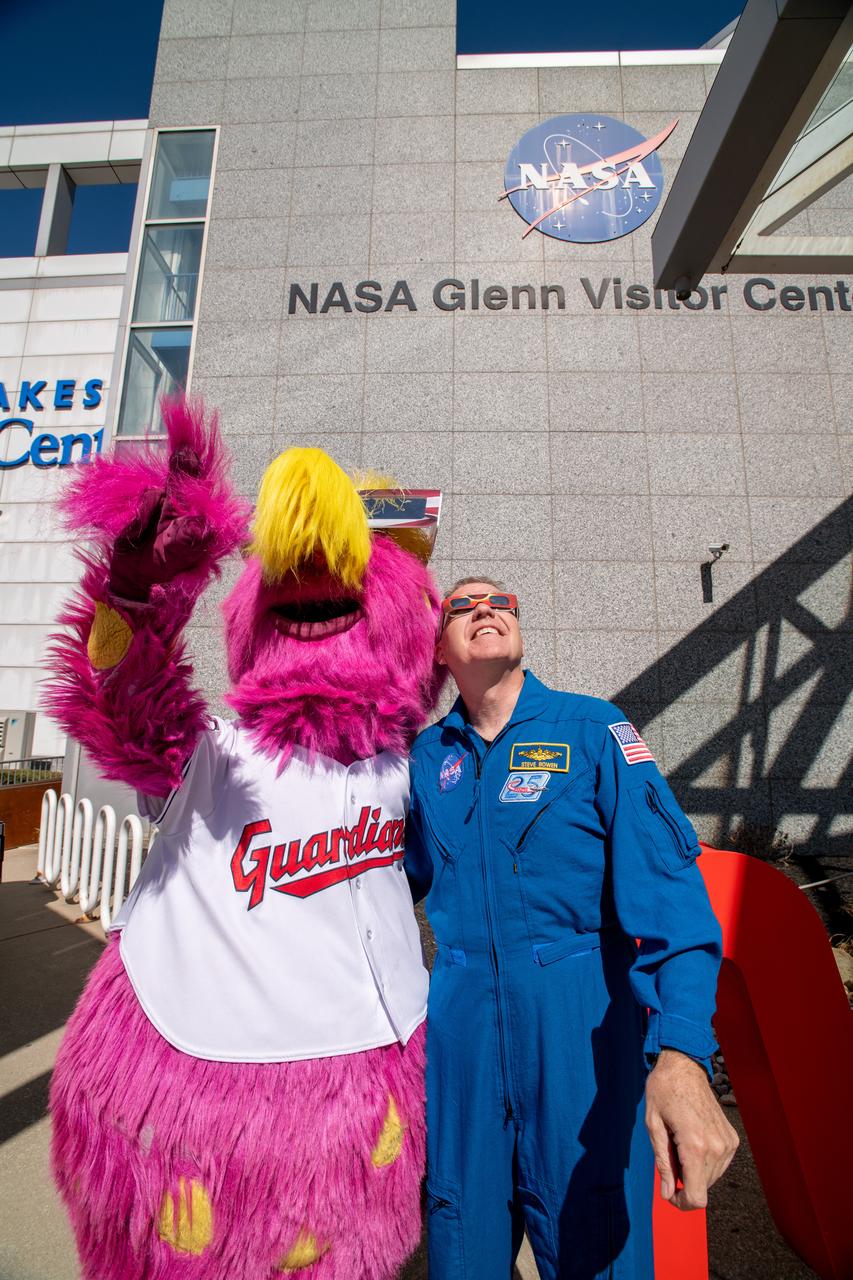
The Cleveland Guardians mascot, Slider and Astronaut Stephen Bowen view the solar eclipse at the Total Solar Eclipse Fest at the Great Lakes Science Center on April 6, 2024. A total solar eclipse swept across a narrow portion of the North American continent from Mexico’s Pacific coast to the Atlantic coast of Newfoundland, Canada. A partial solar eclipse was visible across the entire North American continent along with parts of Central America and Europe.
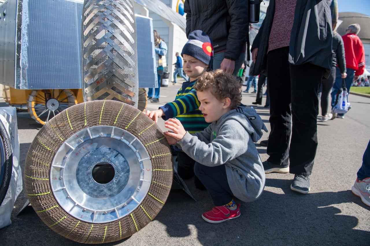
An event attendee checks out a rover tire made with shape memory alloys at the Total Eclipse Fest at the Great Lakes Science Center in Cleveland, OH on April 7, 2024. A total solar eclipse swept across a narrow portion of the North American continent from Mexico’s Pacific coast to the Atlantic coast of Newfoundland, Canada. A partial solar eclipse was visible across the entire North American continent along with parts of Central America and Europe.
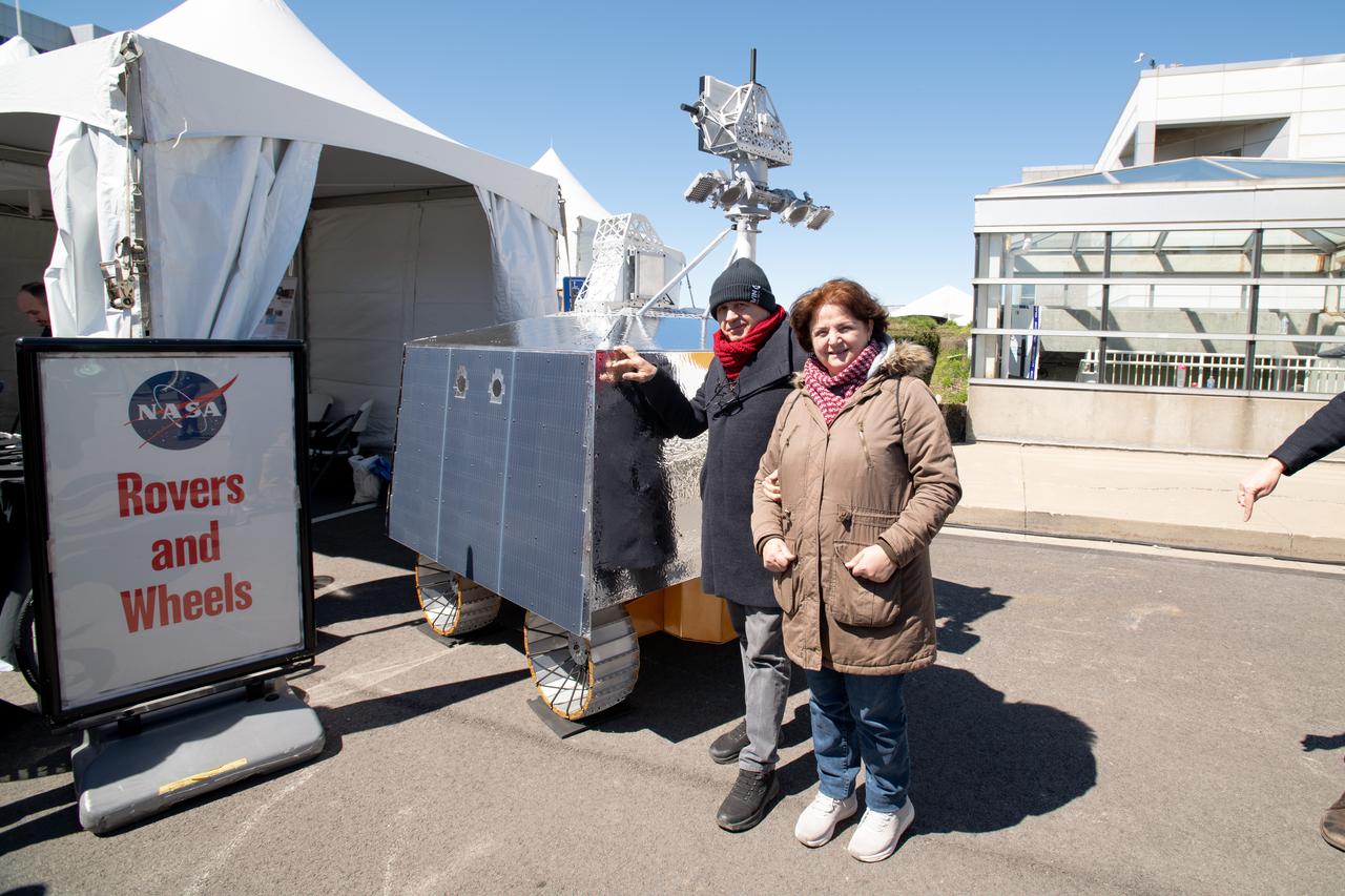
Event Attendees at pose in front of the VIPER model at the Total Eclipse Fest at the Great Lakes Science Center in Cleveland, OH April 6, 2024. A total solar eclipse swept across a narrow portion of the North American continent from Mexico’s Pacific coast to the Atlantic coast of Newfoundland, Canada. A partial solar eclipse was visible across the entire North American continent along with parts of Central America and Europe.

Guests pose for a photo at the Total Solar Eclipse Fest at the Great Lakes Science Center in Cleveland, OH April 6, 2024. A total solar eclipse swept across a narrow portion of the North American continent from Mexico’s Pacific coast to the Atlantic coast of Newfoundland, Canada. A partial solar eclipse was visible across the entire North American continent along with parts of Central America and Europe.
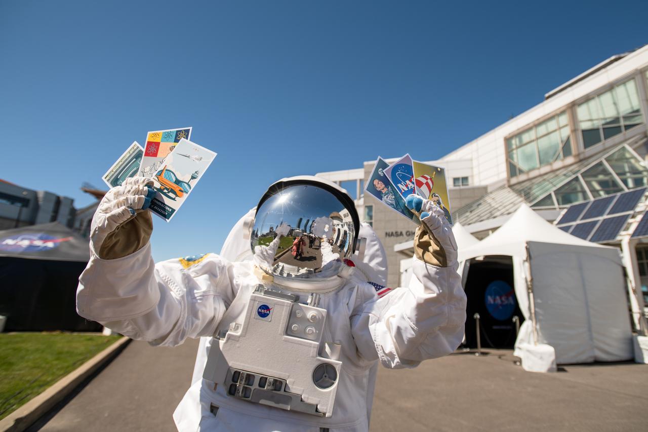
The astronaut mascot holds the 6 collectable postcards designed for the Total Eclipse Fest at the Great Lakes Science Center in Cleveland, OH on April 6, 2024. A total solar eclipse swept across a narrow portion of the North American continent from Mexico’s Pacific coast to the Atlantic coast of Newfoundland, Canada. A partial solar eclipse was visible across the entire North American continent along with parts of Central America and Europe.
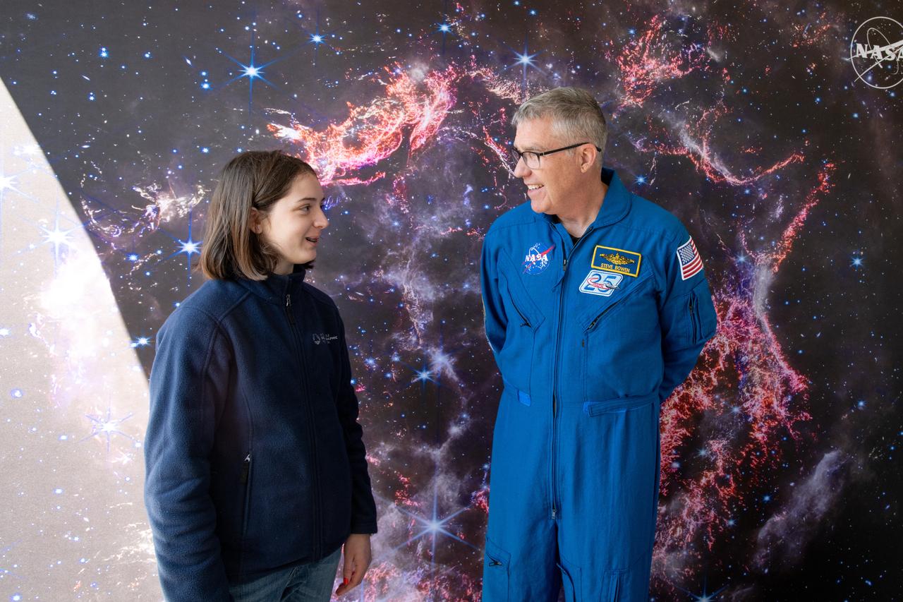
A guest interacts with Astronaut Stephen Bowen during meet and greets at the Total Eclipse Fest at the Great Lakes Science Center in Cleveland, OH on April 6, 2024. A total solar eclipse swept across a narrow portion of the North American continent from Mexico’s Pacific coast to the Atlantic coast of Newfoundland, Canada. A partial solar eclipse was visible across the entire North American continent along with parts of Central America and Europe.
The Cleveland Guardians mascot, Slider and Astronaut Stephen Bowen and Snoopy participate in meet and greets with the public at the Great Lakes Science Center. A total solar eclipse swept across a narrow portion of the North American continent from Mexico’s Pacific coast to the Atlantic coast of Newfoundland, Canada. A partial solar eclipse was visible across the entire North American continent along with parts of Central America and Europe.
Astronaut Jessica Watkins and the Cleveland Guardians mascot, Slider pose together at Total Solar Eclipse Fest at the Great Lakes Science Center on April 6, 2024. A total solar eclipse swept across a narrow portion of the North American continent from Mexico’s Pacific coast to the Atlantic coast of Newfoundland, Canada. A partial solar eclipse was visible across the entire North American continent along with parts of Central America and Europe.
Cleveland Mayor Justin Bibb, Represenative Max Miller, Administrator Bill Nelson, Representative Shontel Brown, and Cuyahoga County Executive Chris Ronayne view the eclipse together. NASA Glenn Research Center and the Great Lakes Science Center hosted a three-day celestial celebration in downtown Cleveland, OH. This free, outdoor, family-friendly science and arts festival will feature free concerts, performances, speakers, and hands-on science activities with community partners. A total solar eclipse swept across a narrow portion of the North American continent from Mexico’s Pacific coast to the Atlantic coast of Newfoundland, Canada. A partial solar eclipse was visible across the entire North American continent along with parts of Central America and Europe.
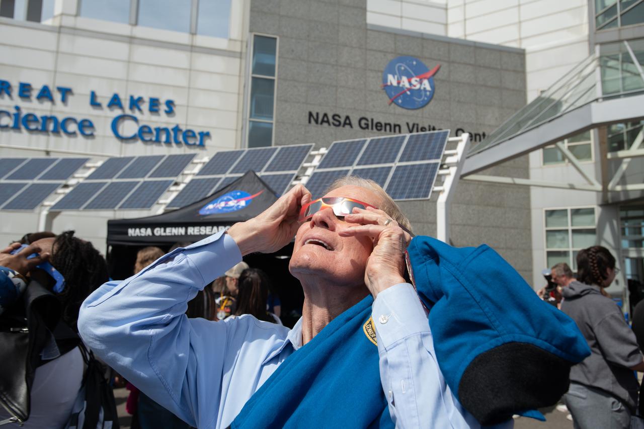
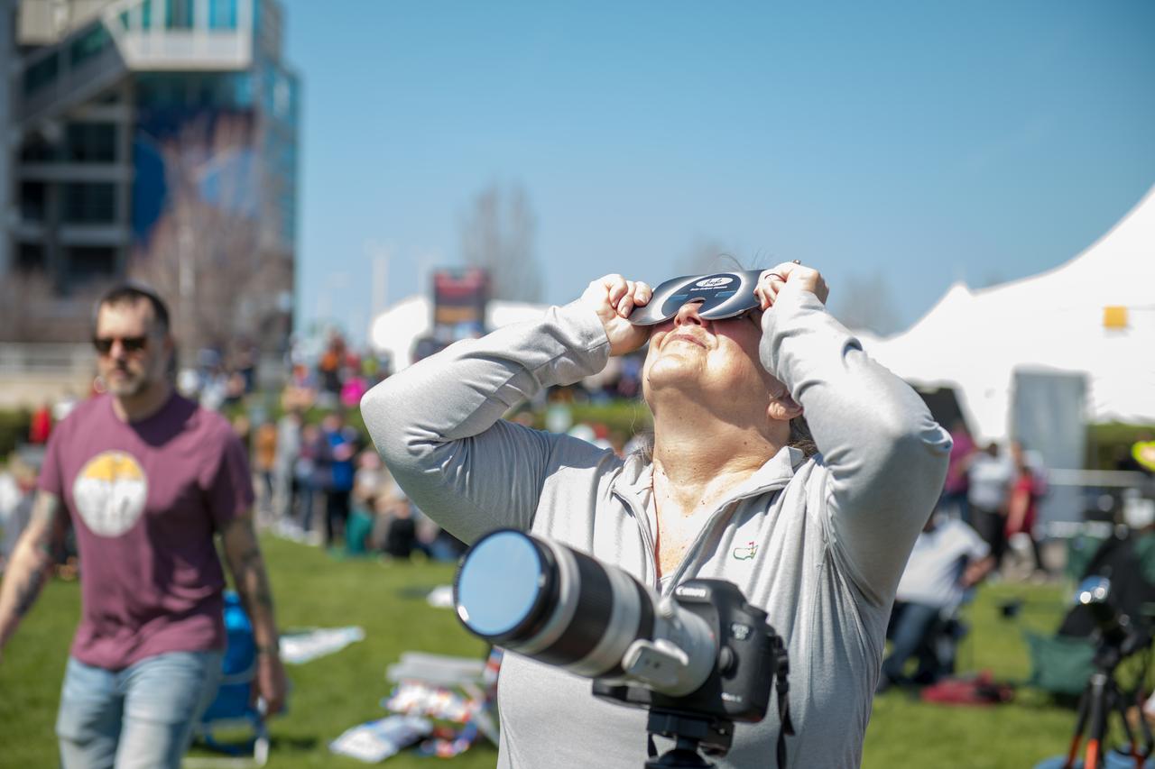
Administrator Bill Nelson views the eclipse safetly with solar eclipse glasses. NASA Glenn Research Center and the Great Lakes Science Center hosted a three-day celestial celebration in downtown Cleveland, OH. This free, outdoor, family-friendly science and arts festival will feature free concerts, performances, speakers, and hands-on science activities with community partners. A total solar eclipse swept across a narrow portion of the North American continent from Mexico’s Pacific coast to the Atlantic coast of Newfoundland, Canada. A partial solar eclipse was visible across the entire North American continent along with parts of Central America and Europe.
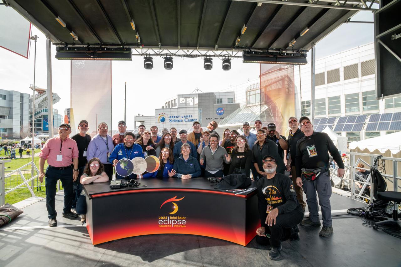
Team photo of those involved in NASA TV’s live coverage of the total solar eclipse on April 8, 2024. A total solar eclipse swept across a narrow portion of the North American continent from Mexico’s Pacific coast to the Atlantic coast of Newfoundland, Canada. A partial solar eclipse was visible across the entire North American continent along with parts of Central America and Europe. Photo Credit: (NASA/Sara Lowthian-Hanna)
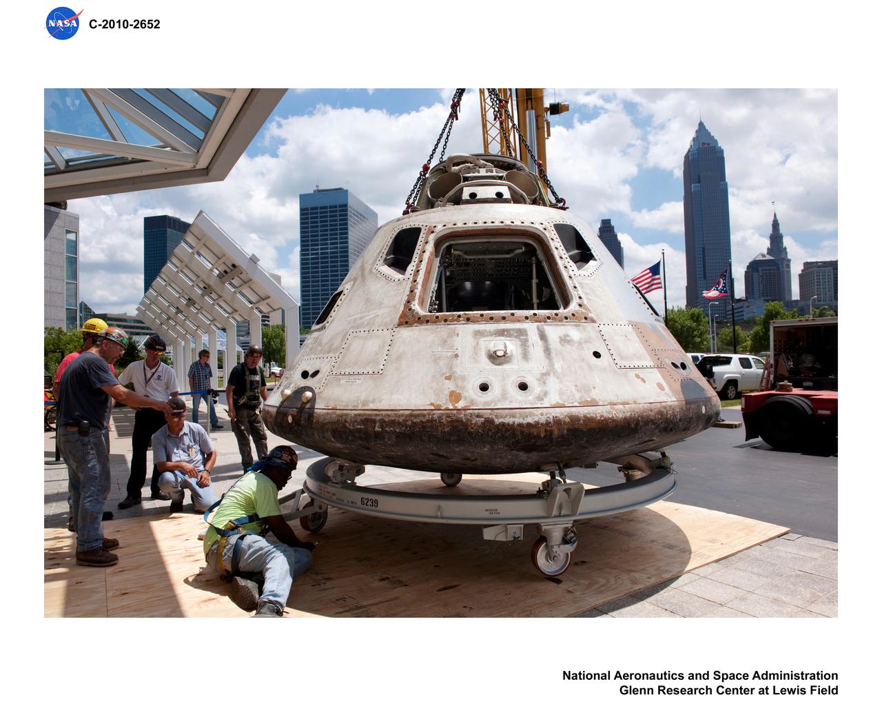
Skylab 3 Command Module being relocated to the Great Lakes Science Center in Cleveland Ohio
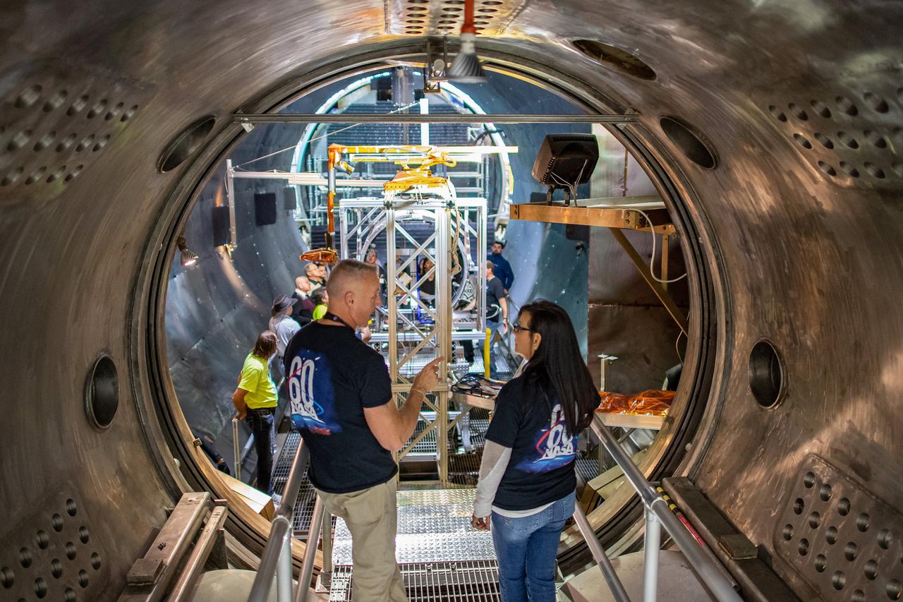
NASA 60th Anniversary Public Tours / NASA 60th Anniversary Celebration at the Great Lakes Science Center
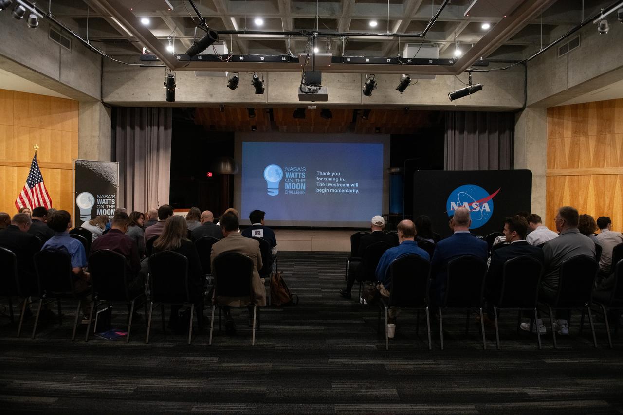
NASA has awarded a total of $1.5 million to two U.S. teams for their novel technology solutions addressing energy distribution, management, and storage as part of the agency’s Watts on the Moon Challenge. The innovations from this challenge aim to support NASA’s Artemis missions, which will establish long-term human presence on the Moon. This two-phase competition has challenged U.S. innovators to develop breakthrough power transmission and energy storage technologies that could enable long-duration Moon missions to advance the nation’s lunar exploration goals. The final phase of the challenge concluded with a technology showcase and winners’ announcement ceremony Friday at Great Lakes Science Center, home of the visitor center for NASA’s Glenn Research Center in Cleveland. Team H.E.L.P.S. (High Efficiency Long-Range Power Solution) from The University of California, Santa Barbara won the $1 million grand prize in NASA’s Watts on the Moon Challenge. Their team developed a low-mass, high efficiency cable and featured energy storage batteries on both ends of their power transmission and energy storage system. Second prize ($500,000): Orbital Mining Corporation of Golden, Colorado
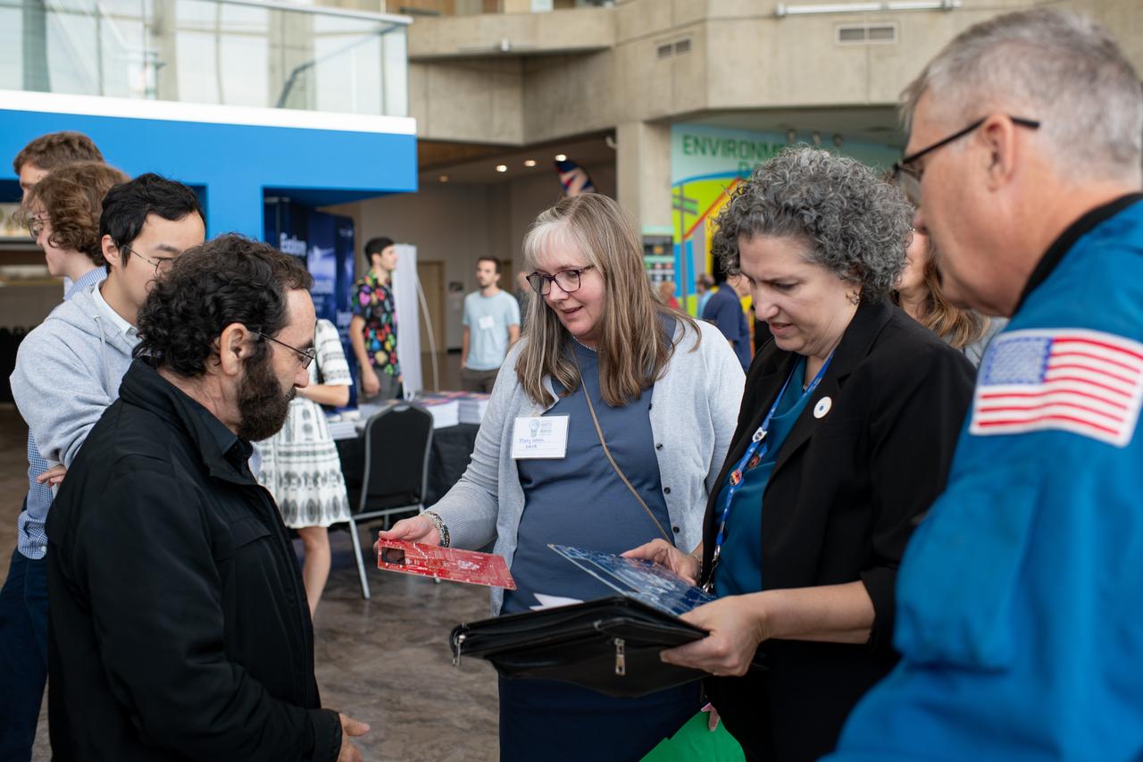
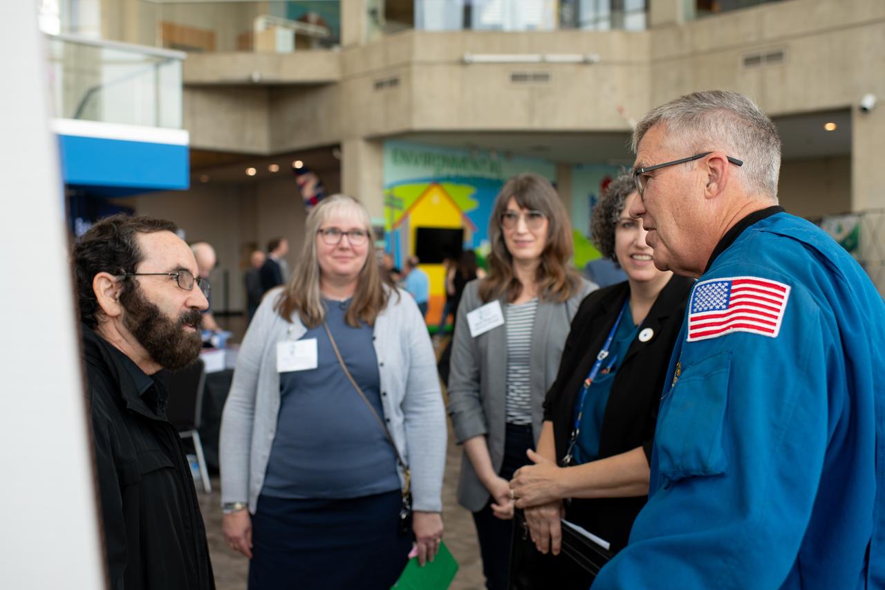
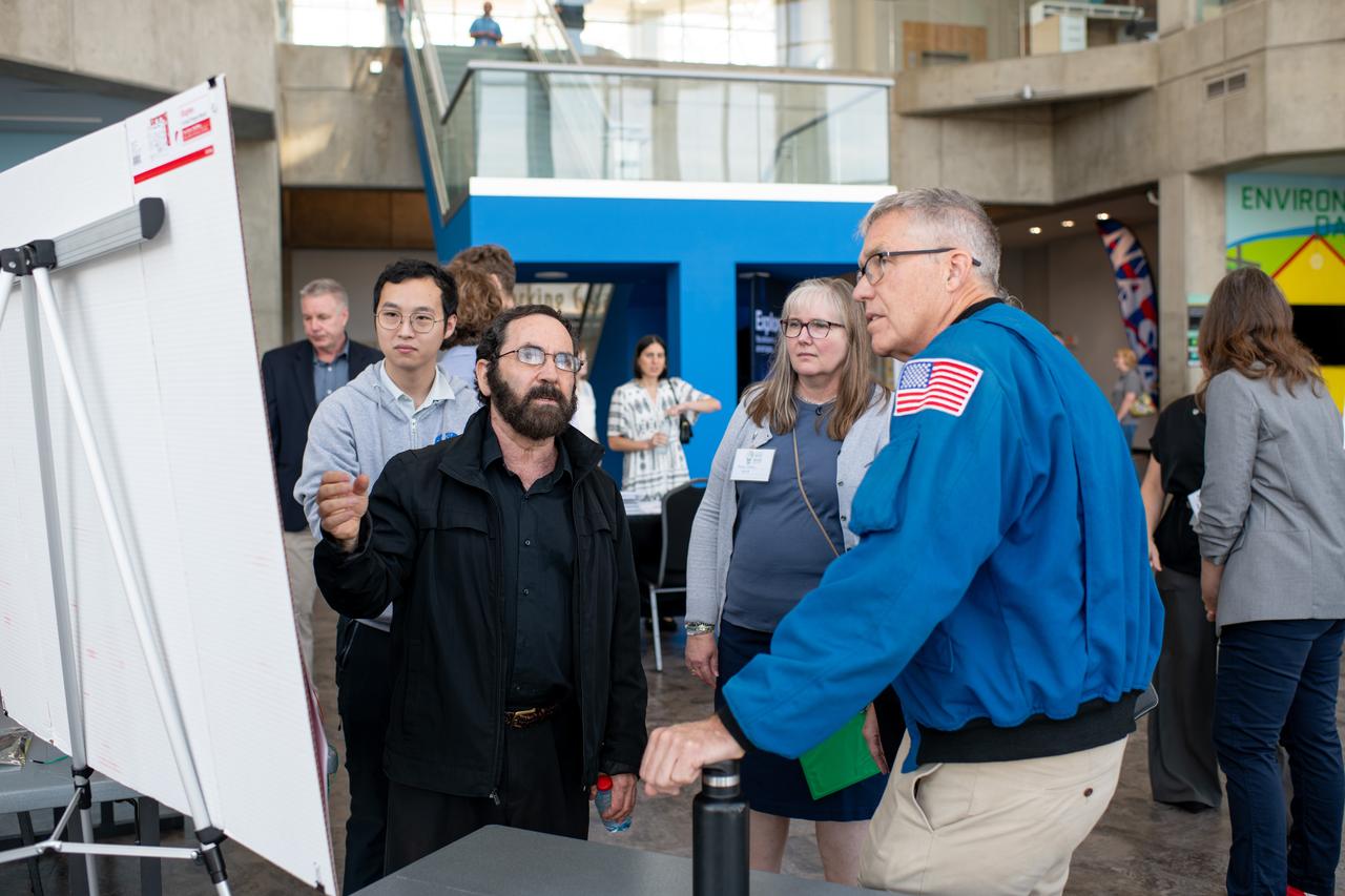
Philip Lubin from Team H.E.L.P.S. (High Efficiency Long-Range Power Solution) explains his project to Mary Wadel, Kirsten Ellenbogen and Stephen Bowen. NASA has awarded a total of $1.5 million to two U.S. teams for their novel technology solutions addressing energy distribution, management, and storage as part of the agency’s Watts on the Moon Challenge. The innovations from this challenge aim to support NASA’s Artemis missions, which will establish long-term human presence on the Moon. This two-phase competition has challenged U.S. innovators to develop breakthrough power transmission and energy storage technologies that could enable long-duration Moon missions to advance the nation’s lunar exploration goals. The final phase of the challenge concluded with a technology showcase and winners’ announcement ceremony Friday at Great Lakes Science Center, home of the visitor center for NASA’s Glenn Research Center in Cleveland. Team H.E.L.P.S. (High Efficiency Long-Range Power Solution) from The University of California, Santa Barbara won the $1 million grand prize in NASA’s Watts on the Moon Challenge. Their team developed a low-mass, high efficiency cable and featured energy storage batteries on both ends of their power transmission and energy storage system. Second prize ($500,000): Orbital Mining Corporation of Golden, Colorado Photo Credit: (NASA/Sara Lowthian-Hanna)
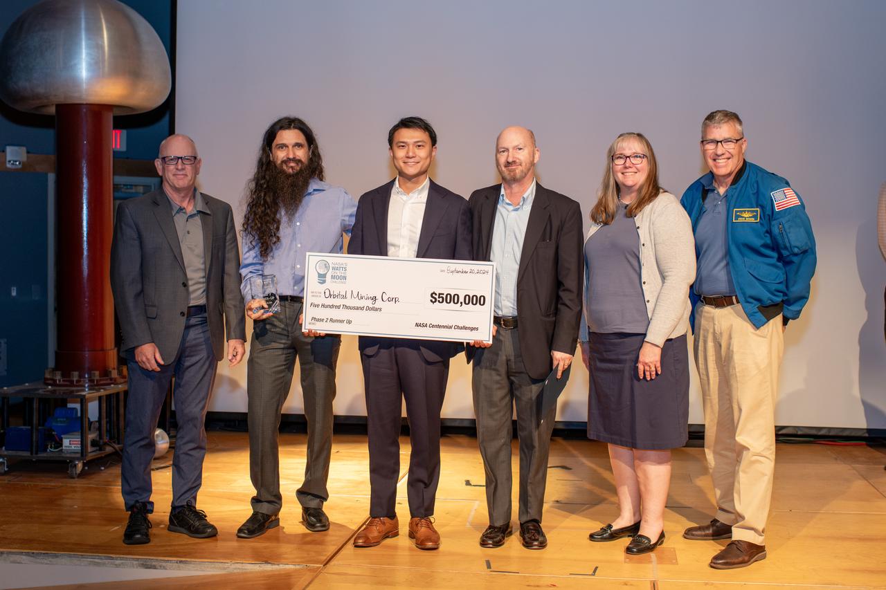
Individuals from Orbital Mining Corporation of Golden, Colorado pose with Robert Button, Mary Wadel and Astronaut Stephen Bowen. NASA has awarded a total of $1.5 million to two U.S. teams for their novel technology solutions addressing energy distribution, management, and storage as part of the agency’s Watts on the Moon Challenge. The innovations from this challenge aim to support NASA’s Artemis missions, which will establish long-term human presence on the Moon. This two-phase competition has challenged U.S. innovators to develop breakthrough power transmission and energy storage technologies that could enable long-duration Moon missions to advance the nation’s lunar exploration goals. The final phase of the challenge concluded with a technology showcase and winners’ announcement ceremony Friday at Great Lakes Science Center, home of the visitor center for NASA’s Glenn Research Center in Cleveland. Team H.E.L.P.S. (High Efficiency Long-Range Power Solution) from The University of California, Santa Barbara won the $1 million grand prize in NASA’s Watts on the Moon Challenge. Their team developed a low-mass, high efficiency cable and featured energy storage batteries on both ends of their power transmission and energy storage system. Second prize ($500,000): Orbital Mining Corporation of Golden, Colorado

NASA has awarded a total of $1.5 million to two U.S. teams for their novel technology solutions addressing energy distribution, management, and storage as part of the agency’s Watts on the Moon Challenge. The innovations from this challenge aim to support NASA’s Artemis missions, which will establish long-term human presence on the Moon. This two-phase competition has challenged U.S. innovators to develop breakthrough power transmission and energy storage technologies that could enable long-duration Moon missions to advance the nation’s lunar exploration goals. The final phase of the challenge concluded with a technology showcase and winners’ announcement ceremony Friday at Great Lakes Science Center, home of the visitor center for NASA’s Glenn Research Center in Cleveland. Team H.E.L.P.S. (High Efficiency Long-Range Power Solution) from The University of California, Santa Barbara won the $1 million grand prize in NASA’s Watts on the Moon Challenge. Their team developed a low-mass, high efficiency cable and featured energy storage batteries on both ends of their power transmission and energy storage system. Second prize ($500,000): Orbital Mining Corporation of Golden, Colorado
NASA has awarded a total of $1.5 million to two U.S. teams for their novel technology solutions addressing energy distribution, management, and storage as part of the agency’s Watts on the Moon Challenge. The innovations from this challenge aim to support NASA’s Artemis missions, which will establish long-term human presence on the Moon. This two-phase competition has challenged U.S. innovators to develop breakthrough power transmission and energy storage technologies that could enable long-duration Moon missions to advance the nation’s lunar exploration goals. The final phase of the challenge concluded with a technology showcase and winners’ announcement ceremony Friday at Great Lakes Science Center, home of the visitor center for NASA’s Glenn Research Center in Cleveland. Team H.E.L.P.S. (High Efficiency Long-Range Power Solution) from The University of California, Santa Barbara won the $1 million grand prize in NASA’s Watts on the Moon Challenge. Their team developed a low-mass, high efficiency cable and featured energy storage batteries on both ends of their power transmission and energy storage system. Second prize ($500,000): Orbital Mining Corporation of Golden, Colorado

Astronaut Stephen Bowen speaks during the award ceremony. NASA has awarded a total of $1.5 million to two U.S. teams for their novel technology solutions addressing energy distribution, management, and storage as part of the agency’s Watts on the Moon Challenge. The innovations from this challenge aim to support NASA’s Artemis missions, which will establish long-term human presence on the Moon. This two-phase competition has challenged U.S. innovators to develop breakthrough power transmission and energy storage technologies that could enable long-duration Moon missions to advance the nation’s lunar exploration goals. The final phase of the challenge concluded with a technology showcase and winners’ announcement ceremony Friday at Great Lakes Science Center, home of the visitor center for NASA’s Glenn Research Center in Cleveland. Team H.E.L.P.S. (High Efficiency Long-Range Power Solution) from The University of California, Santa Barbara won the $1 million grand prize in NASA’s Watts on the Moon Challenge. Their team developed a low-mass, high efficiency cable and featured energy storage batteries on both ends of their power transmission and energy storage system. Second prize ($500,000): Orbital Mining Corporation of Golden, Colorado
Philip Lubin from Team H.E.L.P.S. (High Efficiency Long-Range Power Solution) explains his project to Mary Wadel, Lisa Ferguson, Kirsten Ellenbogen and Stephen Bowen. NASA has awarded a total of $1.5 million to two U.S. teams for their novel technology solutions addressing energy distribution, management, and storage as part of the agency’s Watts on the Moon Challenge. The innovations from this challenge aim to support NASA’s Artemis missions, which will establish long-term human presence on the Moon. This two-phase competition has challenged U.S. innovators to develop breakthrough power transmission and energy storage technologies that could enable long-duration Moon missions to advance the nation’s lunar exploration goals. The final phase of the challenge concluded with a technology showcase and winners’ announcement ceremony on September 20, 2024 at Great Lakes Science Center, home of the visitor center for NASA’s Glenn Research Center in Cleveland. Team H.E.L.P.S. (High Efficiency Long-Range Power Solution) from The University of California, Santa Barbara won the $1 million grand prize in NASA’s Watts on the Moon Challenge. Their team developed a low-mass, high efficiency cable and featured energy storage batteries on both ends of their power transmission and energy storage system. Second prize ($500,000): Orbital Mining Corporation of Golden, Colorado. Photo Credit: (NASA/Sara Lowthian-Hanna)
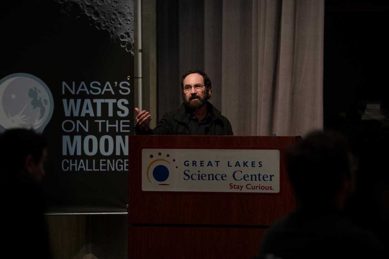
Philip Lubin from H.E.L.P.S. (High Efficiency Long-Range Power Solution) from The University of California gives their presentation. NASA has awarded a total of $1.5 million to two U.S. teams for their novel technology solutions addressing energy distribution, management, and storage as part of the agency’s Watts on the Moon Challenge. The innovations from this challenge aim to support NASA’s Artemis missions, which will establish long-term human presence on the Moon. This two-phase competition has challenged U.S. innovators to develop breakthrough power transmission and energy storage technologies that could enable long-duration Moon missions to advance the nation’s lunar exploration goals. The final phase of the challenge concluded with a technology showcase and winners’ announcement ceremony on September 11, 2024 at Great Lakes Science Center, home of the visitor center for NASA’s Glenn Research Center in Cleveland. Team H.E.L.P.S. (High Efficiency Long-Range Power Solution) from The University of California, Santa Barbara won the $1 million grand prize in NASA’s Watts on the Moon Challenge. Their team developed a low-mass, high efficiency cable and featured energy storage batteries on both ends of their power transmission and energy storage system. Second prize ($500,000): Orbital Mining Corporation of Golden, Colorado. Photo Credit: (NASA/Sara Lowthian-Hanna)
Philip Lubin from Team H.E.L.P.S. (High Efficiency Long-Range Power Solution) explains his project to Mary Wadel and Stephen Bowen. NASA has awarded a total of $1.5 million to two U.S. teams for their novel technology solutions addressing energy distribution, management, and storage as part of the agency’s Watts on the Moon Challenge. The innovations from this challenge aim to support NASA’s Artemis missions, which will establish long-term human presence on the Moon. This two-phase competition has challenged U.S. innovators to develop breakthrough power transmission and energy storage technologies that could enable long-duration Moon missions to advance the nation’s lunar exploration goals. The final phase of the challenge concluded with a technology showcase and winners’ announcement ceremony on September 20, 2024 at Great Lakes Science Center, home of the visitor center for NASA’s Glenn Research Center in Cleveland. Team H.E.L.P.S. (High Efficiency Long-Range Power Solution) from The University of California, Santa Barbara won the $1 million grand prize in NASA’s Watts on the Moon Challenge. Their team developed a low-mass, high efficiency cable and featured energy storage batteries on both ends of their power transmission and energy storage system. Second prize ($500,000): Orbital Mining Corporation of Golden, Colorado. Photo Credit: (NASA/Sara Lowthian-Hanna)

NASA women leaders present the flag at the NCAA championship game on Sunday, April 7th at Rocket Mortgage Fieldhouse in Cleveland, OH.

Behind the Scenes of Snoopy entering the stage at NASA TV’s live coverage of the total solar eclipse on April 8, 2024. A total solar eclipse swept across a narrow portion of the North American continent from Mexico’s Pacific coast to the Atlantic coast of Newfoundland, Canada. A partial solar eclipse was visible across the entire North American continent along with parts of Central America and Europe.
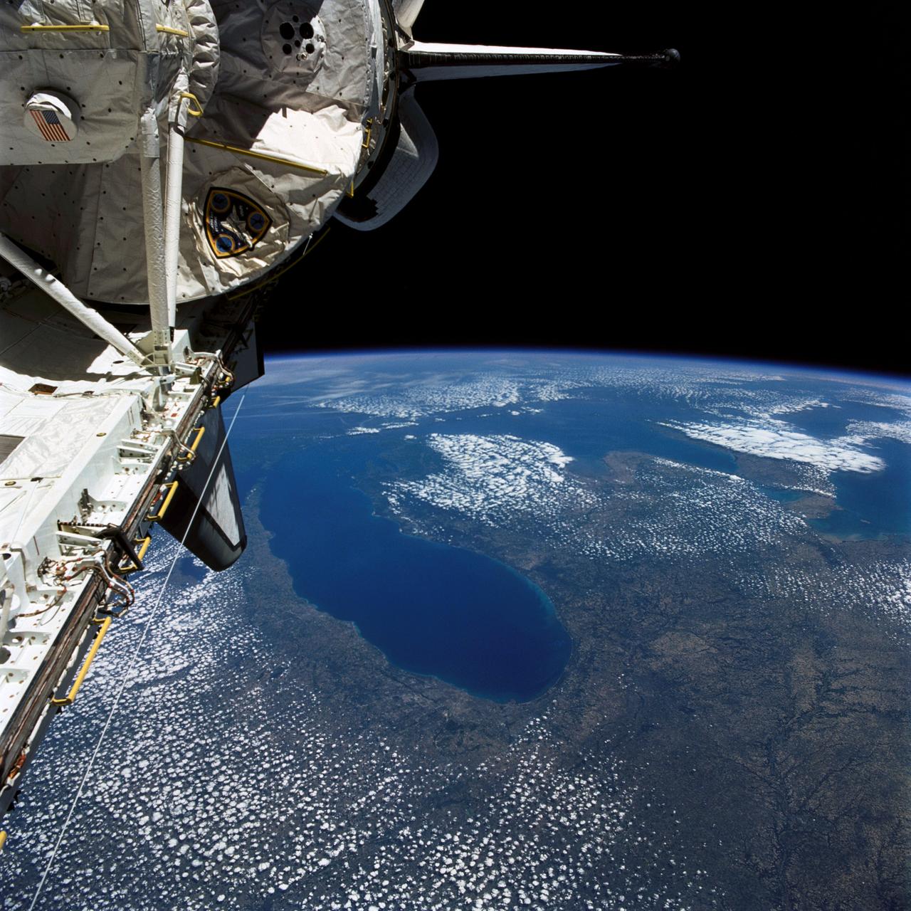
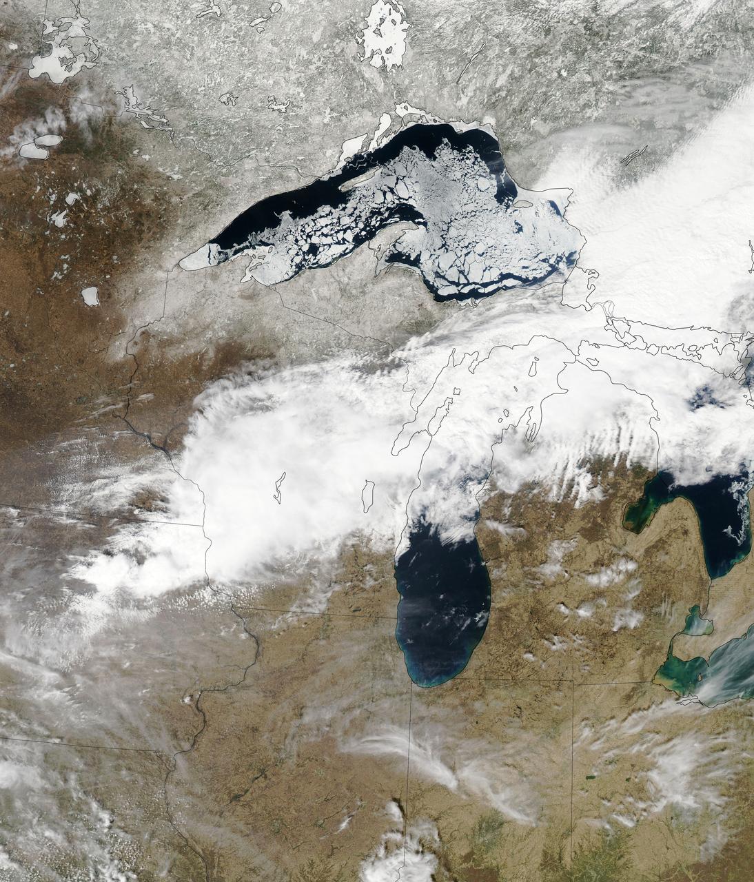
STS040-77-045 (6 June 1991) --- This image, photographed on June 6, 1991, is an oblique view looking north-northeast and shows most of the Great Lakes region. Part of Columbia's cargo bay and the Spacelab Life Sciences (SLS-1) module are in the foreground. In the center of the image is Lake Michigan with Chicago clearly visible along the southwest shore. According to NASA photo experts studying the STS-40 imagery, this image shows several interesting meteorological phenomena. The difference in temperature between the warming land and the cold lake waters is illustrated by the low level clouds. The warming land surface results in rising air and the formation of clouds, while the lake waters are cold and result in the lakes remaining cloud free. Also visible is evidence of lake breezes developing around several of the lakes. This phenomena is also driven by the difference in temperature between the land and the water. Winds blowing off the lakes must travel 25 - 30 miles inland before it warms sufficiently to create clouds.

Kennedy Space Center Director Janet Petro and Representative Shontel Brown at the Read to the Final Four event In Cleveland, OH on April 5, 2024 where the NCAA, Women’s Final Four and the Cleveland Local Organizing Committee have teamed up to help third graders across the state develop their abilities as part of a nine-week program designed to leave a lasting impact on students throughout Ohio. From January to April 2024, local elementary students are encouraged to track their reading minutes leading up to the Women’s Final Four. Participating students and leading classrooms will receive awards at Tourney Town to celebrate their accomplishments. Photo Credit: (NASA/Sara Lowthian-Hanna)

Astronaut Jessica Watkins, Representative Shontel Brown, the Greater Cleveland Sports Commission and Destination Cleveland CEO David Gilbert speak to students about the importrance of reading in their lives a the Read to the Final Four event on April 5th 2024 In Cleveland, OH. The NCAA, Women’s Final Four and the Cleveland Local Organizing Committee have teamed up to help third graders across the state develop their abilities as part of a nine-week program designed to leave a lasting impact on students throughout Ohio. From January to April 2024, local elementary students are encouraged to track their reading minutes leading up to the Women’s Final Four. Participating students and leading classrooms will receive awards at Tourney Town to celebrate their accomplishments.
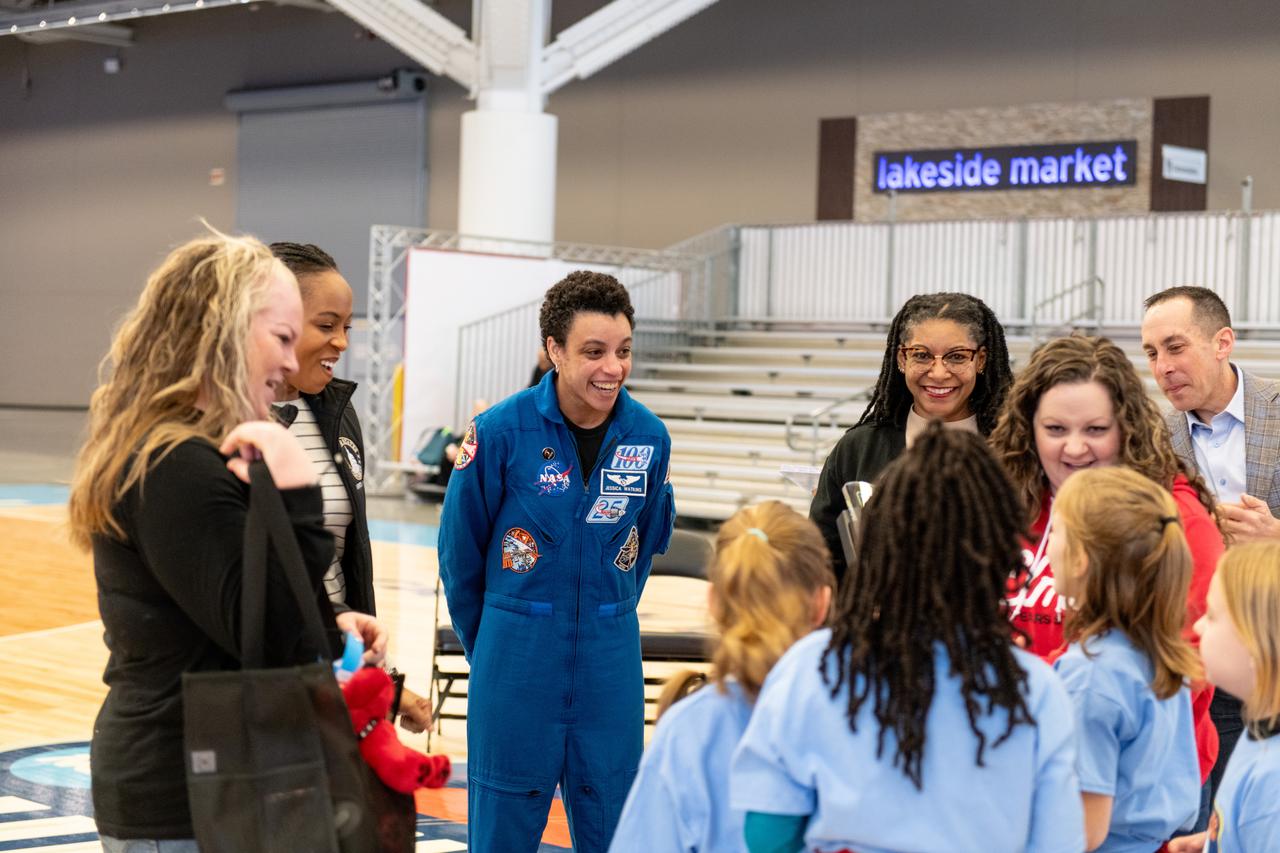
Astronaut Jessica Watkins congratulates the winning students from Our Lady of the Elms School at the Read to the Final Four event In Cleveland, OH on April 5th, 2024. The NCAA, Women’s Final Four and the Cleveland Local Organizing Committee have teamed up to help third graders across the state develop their abilities as part of a nine-week program designed to leave a lasting impact on students throughout Ohio. From January to April 2024, local elementary students are encouraged to track their reading minutes leading up to the Women’s Final Four. Participating students and leading classrooms will receive awards at Tourney Town to celebrate their accomplishments.

Astronaut Jessica Watkins, Representative Shontel Brown, the Greater Cleveland Sports Commission and Destination Cleveland CEO David Gilbert poses with the winning students from Our Lady of the Elms School at the Read to the Final Four event on April 5, 2024. In Cleveland, OH the NCAA, Women’s Final Four and the Cleveland Local Organizing Committee have teamed up to help third graders across the state develop their abilities as part of a nine-week program designed to leave a lasting impact on students throughout Ohio. From January to April 2024, local elementary students are encouraged to track their reading minutes leading up to the Women’s Final Four. Participating students and leading classrooms will receive awards at Tourney Town to celebrate their accomplishments.
Kennedy Space Center Director Janet Petro and Astonaut Jessica Watkins at the Read to the Final Four Event in Cleveland, Ohio on April 5, 2024. Read to the Final Four event is where the NCAA, Women’s Final Four and the Cleveland Local Organizing Committee have teamed up to help third graders across the state develop their abilities as part of a nine-week program designed to leave a lasting impact on students throughout Ohio. From January to April 2024, local elementary students are encouraged to track their reading minutes leading up to the Women’s Final Four. Participating students and leading classrooms will receive awards at Tourney Town to celebrate their
Astrophysicist Dr. Kelly Korreck, Kennedy Space Center Director Janet Petro, Astonaut Jessica Watkins and Representative Shontel Brown pose for a photo at the Read to the Final Four Event in Cleveland Ohio on April 5th 2024. A total solar eclipse swept across a narrow portion of the North American continent from Mexico’s Pacific coast to the Atlantic coast of Newfoundland, Canada. A partial solar eclipse was visible across the entire North American continent along with parts of Central America and Europe.
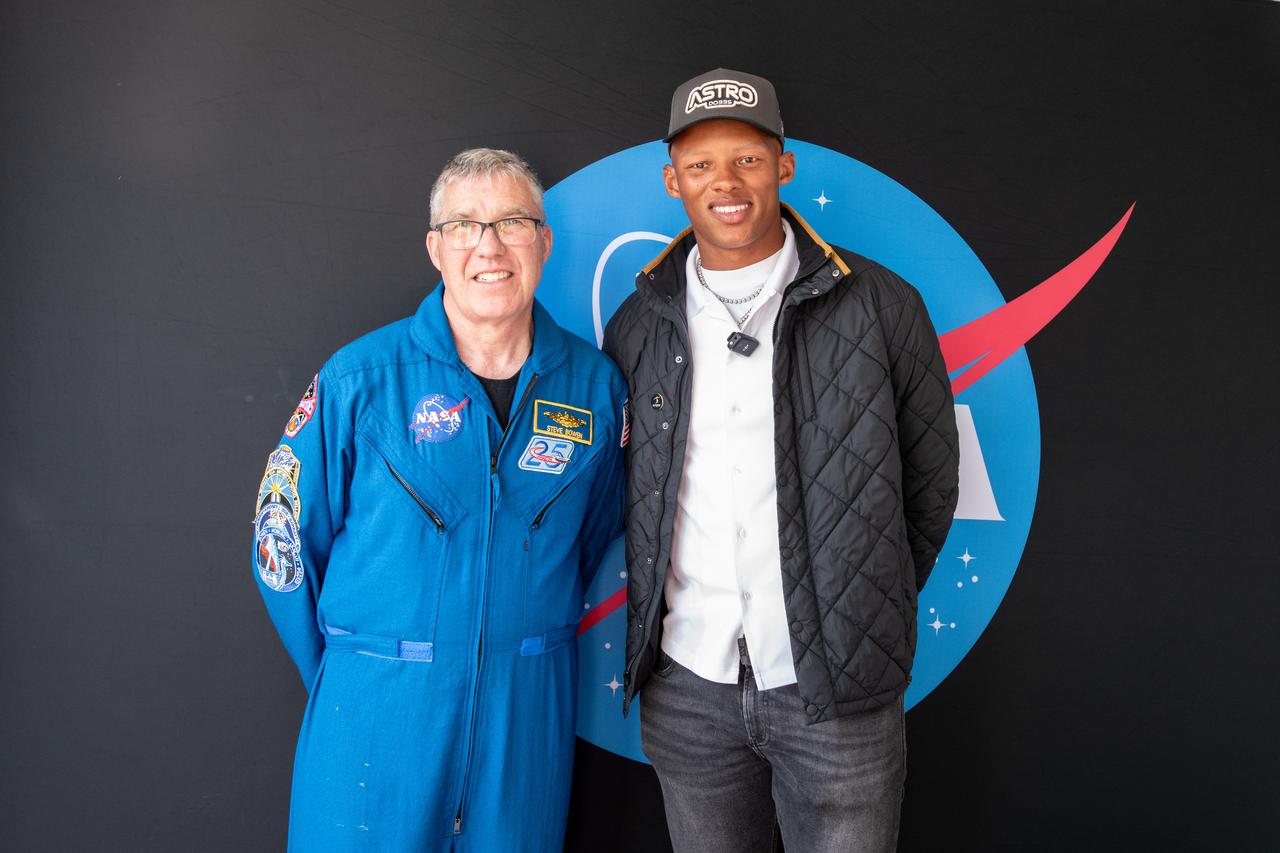
Astonaut Stephen Bowen and Josh Dobbs pose for a photo together at Total Eclipse fest. They both participated in meet and greets with the community. This free, outdoor, family-friendly science and arts festival will feature free concerts, performances, speakers, and hands-on science activities with community partners. A total solar eclipse swept across a narrow portion of the North American continent from Mexico’s Pacific coast to the Atlantic coast of Newfoundland, Canada. A partial solar eclipse was visible across the entire North American continent along with parts of Central America and Europe.
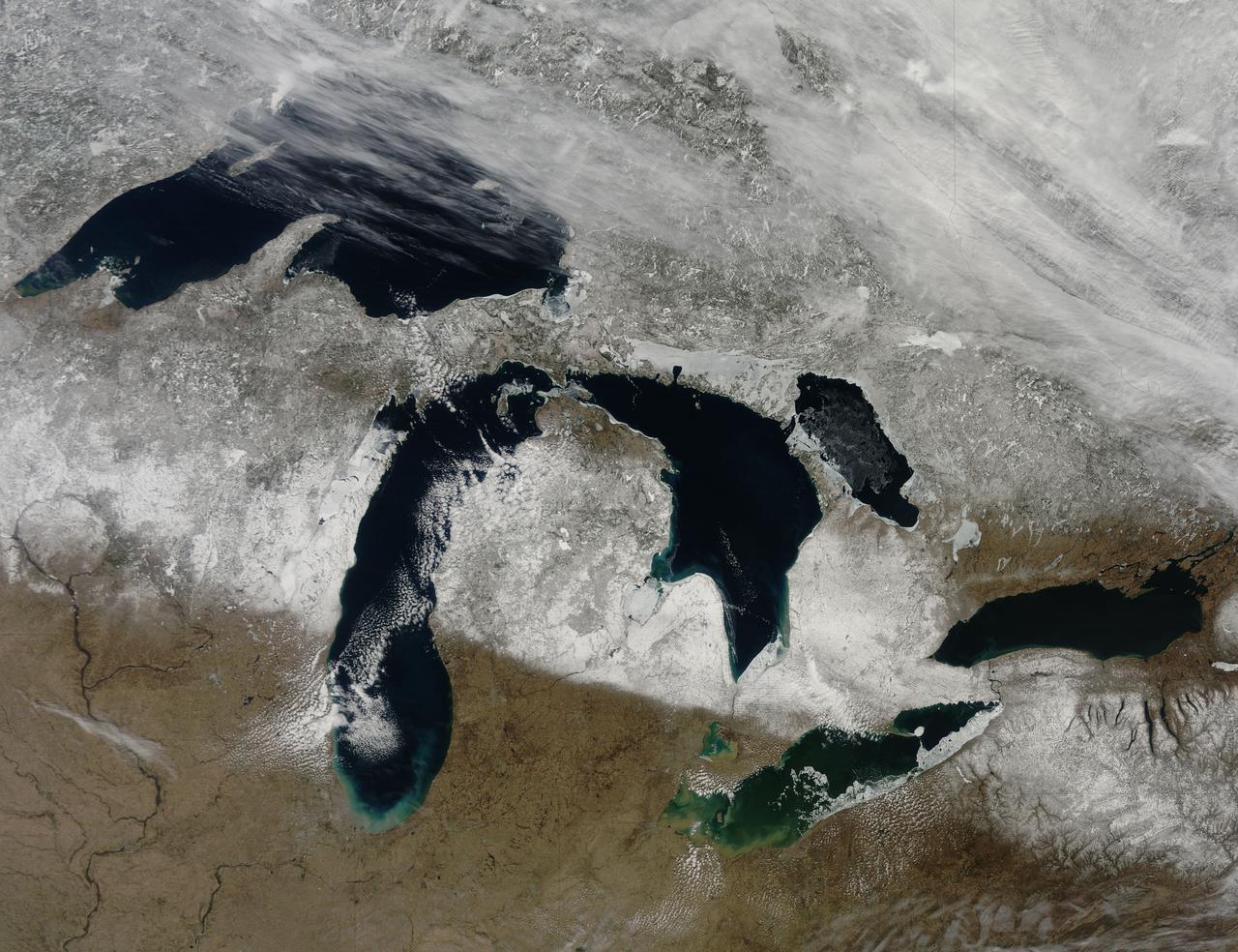
Though North America is a full month into astronomical spring, the Great Lakes have been slow to give up on winter. As of April 22, 2014, the Great Lakes were 33.9 percent ice covered. The lake they call Superior dominated the pack. In the early afternoon on April 20, 2014, the Moderate Resolution Imaging Spectroradiometer (MODIS) on NASA’s Aqua satellite captured this natural-color image of Lake Superior, which straddles the United States–Canada border. At the time Aqua passed over, the lake was 63.5 percent ice covered, according to the NOAA Great Lakes Environmental Research Lab (GLERL). Averaged across Lake Superior, ice was 22.6 centimeters (8.9 inches) thick; it was as much as twice that thickness in some locations. GLERL researcher George Leshkevich affirmed that ice cover this spring is significantly above normal. For comparison, Lake Superior had 3.6 percent ice cover on April 20, 2013; in 2012, ice was completely gone by April 12. In the last winter that ice cover grew so thick on Lake Superior (2009), it reached 93.7 percent on March 2 but was down to 6.7 percent by April 21. Average water temperatures on all of the Great Lakes have been rising over the past 30 to 40 years and ice cover has generally been shrinking. (Lake Superior ice was down about 79 percent since the 1970s.) But chilled by persistent polar air masses throughout the 2013-14 winter, ice cover reached 88.4 percent on February 13 and 92.2 percent on March 6, 2014, the second highest level in four decades of record-keeping. Air temperatures in the Great Lakes region were well below normal for March, and the cool pattern is being reinforced along the coasts because the water is absorbing less sunlight and warming less than in typical spring conditions. The graph below, based on data from Environment Canada, shows the 2014 conditions for all of the Great Lakes in mid-April compared to the past 33 years. Lake Superior ice cover got as high as 95.3 percent on March 19. By April 22, it was reported at 59.9 percent; Lake Huron was nearly 30.4 percent. News outlets noted that as many as 70 ships have been backed up in Lakes Michigan, Huron, and Erie, waiting for passage into ports on Lake Superior. The U.S. Coast Guard has been grouping ships together into small convoys after they pass through locks at Sault Ste. Marie, in order to maximize ice-breaking efficiency and to protect ships from damage. Superior is the world’s largest freshwater lake by area (82,100 square kilometers or 31,700 square miles) and the third largest by volume. The waters average 147 meters (483 feet) in depth, and the basin is believed to hold about 10 percent of the world’s liquid fresh water. NASA image courtesy Jeff Schmaltz LANCE/EOSDIS MODIS Rapid Response Team, GSFC. Caption by Mike Carlowicz. Read more: <a href="http://earthobservatory.nasa.gov/IOTD/view.php?id=83541&eocn=home&eoci=iotd_title" rel="nofollow">earthobservatory.nasa.gov/IOTD/view.php?id=83541&eocn...</a> Credit: <b><a href="http://www.earthobservatory.nasa.gov/" rel="nofollow"> NASA Earth Observatory</a></b> <b><a href="http://www.nasa.gov/audience/formedia/features/MP_Photo_Guidelines.html" rel="nofollow">NASA image use policy.</a></b> <b><a href="http://www.nasa.gov/centers/goddard/home/index.html" rel="nofollow">NASA Goddard Space Flight Center</a></b> enables NASA’s mission through four scientific endeavors: Earth Science, Heliophysics, Solar System Exploration, and Astrophysics. Goddard plays a leading role in NASA’s accomplishments by contributing compelling scientific knowledge to advance the Agency’s mission. <b>Follow us on <a href="http://twitter.com/NASAGoddardPix" rel="nofollow">Twitter</a></b> <b>Like us on <a href="http://www.facebook.com/pages/Greenbelt-MD/NASA-Goddard/395013845897?ref=tsd" rel="nofollow">Facebook</a></b> <b>Find us on <a href="http://instagram.com/nasagoddard?vm=grid" rel="nofollow">Instagram</a></b>
NASA image captured March 28, 2011 The Great Lakes Satellite: Terra <b><a href="http://www.nasa.gov/centers/goddard/home/index.html" rel="nofollow">NASA Goddard Space Flight Center</a></b> enables NASA’s mission through four scientific endeavors: Earth Science, Heliophysics, Solar System Exploration, and Astrophysics. Goddard plays a leading role in NASA’s accomplishments by contributing compelling scientific knowledge to advance the Agency’s mission. <b>Follow us on <a href="http://twitter.com/NASA_GoddardPix" rel="nofollow">Twitter</a></b> <b>Join us on <a href="http://www.facebook.com/pages/Greenbelt-MD/NASA-Goddard/395013845897?ref=tsd" rel="nofollow">Facebook</a></b>
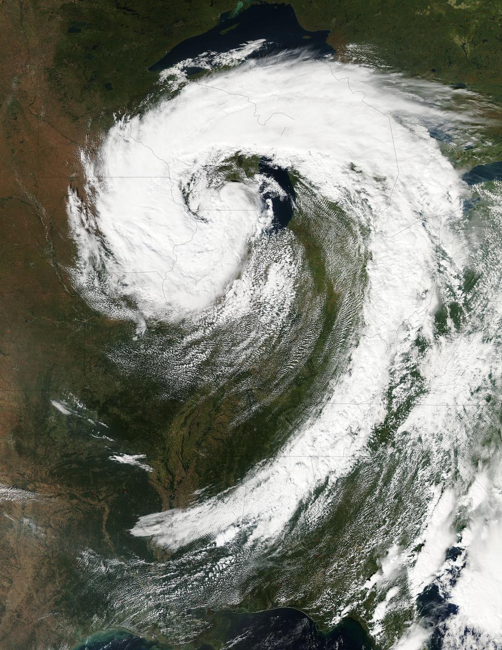
This visible image of the Great Lakes low pressure area was taken from the Moderate Resolution Imaging Spectroradiometer (MODIS) instrument on NASA's Aqua satellite. It was taken at 19:05 UTC (3:05 p.m. EDT) on Monday, Sept. 26, 2011. Credit: NASA Goddard MODIS Rapid Response Team Two Instruments on NASA's Aqua Satellite Catch the Pesky Great Lakes Low A low pressure area has been sitting over the Great Lakes region for about a week now, keeping the region and the U.S. northeast and Mid-Atlantic under cloud cover. NASA's Aqua satellite flew over head yesterday, Sept. 26, and captured two views of it from space. That low pressure area continues to spin counter-clockwise today over the Great Lakes. Its centered over northern Illinois and southeastern Wisconsin and is once again going to keep the region cloudy, cool and wet with showers. When the Aqua satellite passed overhead Monday afternoon at 3:05 p.m. EDT (Sept. 26) a detailed, clear image was captured from the Moderate Resolution Imaging Spectroradiometer (MODIS) instrument . The clouds from the low spread over Illinois, Wisconsin, parts of Iowa, northeastern Missouri, southeastern Minnesota, Michigan, Ohio, Indiana, Pennsylvania, Kentucky, Tennessee, Alabama, Mississippi, Georgia, and the northeastern and Mid-Atlantic states. A second visible image was captured by the Atmospheric Infrared Sounder (AIRS) instrument that also flies aboard NASA's Aqua satellite and showed the huge comma shape of the storm that spans the U.S. from its northern to southern borders. (seen here: <a href="http://www.flickr.com/photos/gsfc/6188946564">www.flickr.com/photos/gsfc/6188946564</a> ) According to the National Weather Service, the low will finally start moving to the east as an upper-atmospheric trough (an elongated area of low pressure) continues to strengthen and move into the upper Midwest. However, a ridge (elongated area) of high pressure will slow its move eastward, so it will be slow clearing this week in the northeastern and Mid-Atlantic U.S. Rob Gutro NASA's Goddard Space Flight Center <b><a href="http://www.nasa.gov/audience/formedia/features/MP_Photo_Guidelines.html" rel="nofollow">NASA image use policy.</a></b> <b><a href="http://www.nasa.gov/centers/goddard/home/index.html" rel="nofollow">NASA Goddard Space Flight Center</a></b> enables NASA’s mission through four scientific endeavors: Earth Science, Heliophysics, Solar System Exploration, and Astrophysics. Goddard plays a leading role in NASA’s accomplishments by contributing compelling scientific knowledge to advance the Agency’s mission. <b>Follow us on <a href="http://twitter.com/NASA_GoddardPix" rel="nofollow">Twitter</a></b> <b>Like us on <a href="http://www.facebook.com/pages/Greenbelt-MD/NASA-Goddard/395013845897?ref=tsd" rel="nofollow">Facebook</a></b> <b>Find us on <a href="http://instagrid.me/nasagoddard/?vm=grid" rel="nofollow">Instagram</a></b>
As icy cold Canadian air settled over the eastern two-thirds of the U.S. bringing snow and bitter cold, NOAA's GOES-East satellite captured this infrared view of what looks like a frozen blanket over the region. NOAA's GOES-East satellite provides visible and infrared images over the eastern U.S. and the Atlantic Ocean from its fixed orbit in space. In an infrared image taken on Nov. 18 at 12:30 UTC (7:30 a.m. EST), the cold air over the eastern and central U.S. appears to look like a blanket of white, but it's not all snow. Infrared data shows temperature, so although the eastern two-thirds of the U.S. appears to appear is if snow covers the ground, the blanket is in fact cold clouds. However, snow does lie under that blanket in the Upper Midwest, Ohio Valley, and Canada, where it will continue in those areas through Thursday, Nov. 20. "Dozens of lakes behind dams in the Southeast USA stand out as dark spots in a grey landscape," said Dennis Chesters of NASA/NOAA's GOES Project at NASA's Goddard Space Flight Center in Greenbelt, Md. "That is because we invert the display of infrared emission to make cold cloud tops appear white, frozen land grey, and warm water dark." NOAA's National Weather Service Weather Prediction Center said that the deep low pressure system pushing that polar air over the Eastern U.S. is centered over southeastern Canada. On Tuesday, Nov. 18, freeze and frost warnings stretch from the upper Great Lakes to Florida. Some areas in the Upper Great Lakes are forecast to receive over two feet of snow. Well below average temperatures are forecast to reach the Gulf Coast, with most of the Mid-Atlantic States barely getting above freezing Tuesday and Wednesday. In the Midwest, periods of lake effect snow are forecast to continue south and east of the Great Lakes through Wednesday. Read more: <a href="http://www.nasa.gov/content/goddard/satellite-view-of-the-us-wrapped-in-a-frozen-blanket/index.html#.VGuxFd6FzeN" rel="nofollow">www.nasa.gov/content/goddard/satellite-view-of-the-us-wra...</a> <b><a href="http://goes.gsfc.nasa.gov/" rel="nofollow">Credit: NOAA/NASA GOES Project</a></b> <b><a href="http://www.nasa.gov/audience/formedia/features/MP_Photo_Guidelines.html" rel="nofollow">NASA image use policy.</a></b> <b><a href="http://www.nasa.gov/centers/goddard/home/index.html" rel="nofollow">NASA Goddard Space Flight Center</a></b> enables NASA’s mission through four scientific endeavors: Earth Science, Heliophysics, Solar System Exploration, and Astrophysics. Goddard plays a leading role in NASA’s accomplishments by contributing compelling scientific knowledge to advance the Agency’s mission. <b>Follow us on <a href="http://twitter.com/NASAGoddardPix" rel="nofollow">Twitter</a></b> <b>Like us on <a href="http://www.facebook.com/pages/Greenbelt-MD/NASA-Goddard/395013845897?ref=tsd" rel="nofollow">Facebook</a></b> <b>Find us on <a href="http://instagram.com/nasagoddard?vm=grid" rel="nofollow">Instagram</a></b>

NOAA's GOES-East satellite provided a look at the frigid eastern two-thirds of the U.S. on Jan. 7, 2015, that shows a blanket of northern snow, lake-effect snow from the Great Lakes and clouds behind the Arctic cold front. A visible picture captured at 1600 UTC (11 a.m. EST) showed the effects of the latest Arctic outbreak. The cold front that brought the Arctic air has moved as far south as Florida, and stretches back over the Gulf of Mexico and just west of Texas today. The image shows clouds behind the frontal boundary stretching from the Carolinas west over the Heartland. Farther north, a wide band of fallen snow covers the ground from New England west to Montana, with rivers appearing like veins. The GOES-East satellite image also shows wind-whipped lake-effect snows off the Great Lakes, blowing to the southeast. Meanwhile, Florida, the nation's warm spot appeared almost cloud-free. To create the image, NASA/NOAA's GOES Project used cloud data from NOAA's GOES-East satellite and overlaid it on a true-color image of land and ocean created by data from the Moderate Resolution Imaging Spectroradiometer, or MODIS, instrument that flies aboard NASA's Aqua and Terra satellites. Together, those data created the entire picture of the Arctic outbreak. The forecast from NOAA's National Weather Service Weather Prediction Center (WPC) calls for more snow along the Appalachian Mountains from Tennessee north to upstate New York. Snow is also expected to fall from New England west to Montana, and in eastern New Mexico and the Colorado Rockies. The WPC summary for Jan. 7 noted: Bitter cold will be felt from the western High Plains to the Mid-Atlantic and Northeast U.S. for the next few days. Widespread subzero overnight lows are forecast for the Dakotas, Upper Midwest, Great Lakes, and interior New England. Wind Chill Advisories and Warnings are in effect for many of these areas. GOES-East provides visible and infrared images over the eastern U.S. and the Atlantic Ocean from its fixed orbit in space. NOAA's GOES satellites provide the kind of continuous monitoring necessary for intensive data analysis. Geostationary describes an orbit in which a satellite is always in the same position with respect to the rotating Earth. This allows GOES to hover continuously over one position on Earth's surface, appearing stationary. As a result, GOES provide a constant vigil for the atmospheric triggers for severe weather conditions such as tornadoes, flash floods, hail storms and hurricanes. For updated information about the storm system, visit NOAA's NWS website: <a href="http://www.weather.gov" rel="nofollow">www.weather.gov</a> For more information about GOES satellites, visit: <a href="http://www.goes.noaa.gov/" rel="nofollow">www.goes.noaa.gov/</a> or goes.gsfc.nasa.gov/ Rob Gutro NASA's Goddard Space Flight Center, Greenbelt, Md. <b><a href="http://www.nasa.gov/audience/formedia/features/MP_Photo_Guidelines.html" rel="nofollow">NASA image use policy.</a></b> <b><a href="http://www.nasa.gov/centers/goddard/home/index.html" rel="nofollow">NASA Goddard Space Flight Center</a></b> enables NASA’s mission through four scientific endeavors: Earth Science, Heliophysics, Solar System Exploration, and Astrophysics. Goddard plays a leading role in NASA’s accomplishments by contributing compelling scientific knowledge to advance the Agency’s mission. <b>Follow us on <a href="http://twitter.com/NASAGoddardPix" rel="nofollow">Twitter</a></b> <b>Like us on <a href="http://www.facebook.com/pages/Greenbelt-MD/NASA-Goddard/395013845897?ref=tsd" rel="nofollow">Facebook</a></b> <b>Find us on <a href="http://instagram.com/nasagoddard?vm=grid" rel="nofollow">Instagram</a></b>
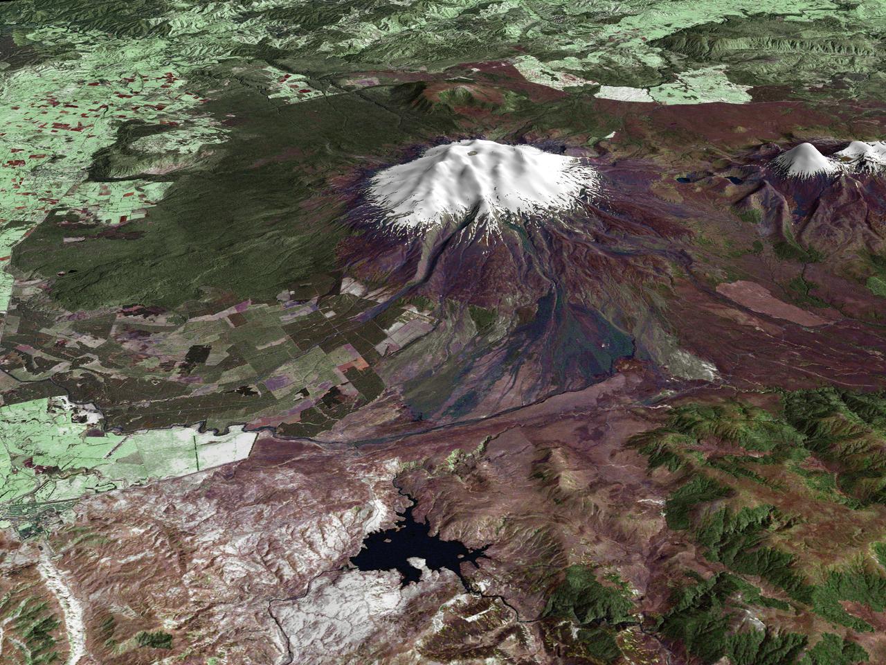
All around the world, people live in places where the threat of natural disaster is high. On the North Island of New Zealand, the Mount Ruapehu volcano is just such a threat. A towering, active stratovolcano (the classic cone-shaped volcano), snow-capped Ruapehu Volcano is pictured in this enhanced-color image. The image is made from topography data collected by the Shuttle Radar Topography Mission aboard the Space Shuttle Endeavour, launched on February 11, 2000, and imagery collected by the Landsat satellite on October 23, 2002. Ruapehu is one of New Zealand’s most active volcanoes, with ten eruptions since 1861. The eruptions aren’t the only threat from the volcano, however. Among the most serious threats is a volcanic mudflow called a lahar. In between eruptions, a lake forms in the volcano’s caldera from melting snow. If a previous eruption has deposited a dam of ash, rocks and mud in the lake’s natural overflow point, then the lake becomes dangerously full, held back only by the temporary dam. In this scene, the lake is nestled among the ridges at the top of the volcano. Eventually, the dam gives way and a massive flow of mud and debris churns down the mountain toward farmland and towns below. Scientists estimate that Ruapehu has experienced 60 lahars in the last 150 years. A devastating lahar in 1953 killed more than 150 people, who died when a passenger train plunged into a ravine when a railroad bridge was taken out by the lahar. The flank of the volcano below the lake is deeply carved by the path of previous lahars; the gouge can be seen just left of image center. Currently scientists in the region are predicting that the lake will overflow in a lahar sometime in the next year. There is great controversy about how to deal with the threat. News reports from the region indicate that the government is planning to invest in a high-tech warning system that will alert those who might be affected well in advance of any catastrophic release. Others feel that the government should combat the threat through engineering at the top of the mountain, for example, by undertaking a controlled release of the lake. Credit Landsat data provided courtesy of the University of Maryland Global Land Cover Facility Landsat processing by Laura Rocchio, Landsat Project Science Office SRTM 3-arcsecond elevation data courtesy of SRTM Team NASA/JPL/NIMA Visualization created by Earth Observatory staff. <b><a href="http://www.nasa.gov/centers/goddard/home/index.html" rel="nofollow">NASA Goddard Space Flight Center</a></b> enables NASA’s mission through four scientific endeavors: Earth Science, Heliophysics, Solar System Exploration, and Astrophysics. Goddard plays a leading role in NASA’s accomplishments by contributing compelling scientific knowledge to advance the Agency’s mission. <b>Follow us on <a href="http://twitter.com/NASA_GoddardPix" rel="nofollow">Twitter</a></b> <b>Join us on <a href="http://www.facebook.com/pages/Greenbelt-MD/NASA-Goddard/395013845897?ref=tsd" rel="nofollow">Facebook</a></b>

A strong late-winter cyclone brought significant snows and blizzard conditions to the upper Great Lakes/northern Plains on 21 February 2014. In the warm sector of the storm, there were numerous reports of tornadoes, large hail, and damaging winds in the eastern US. Suomi NPP viewed the storm multiple times, including just before 1800 UTC on 21 February. Credit: NASA/Goddard/UWM/SSEC/CIMSS/Suomi NPP <b><a href="http://www.nasa.gov/audience/formedia/features/MP_Photo_Guidelines.html" rel="nofollow">NASA image use policy.</a></b> <b><a href="http://www.nasa.gov/centers/goddard/home/index.html" rel="nofollow">NASA Goddard Space Flight Center</a></b> enables NASA’s mission through four scientific endeavors: Earth Science, Heliophysics, Solar System Exploration, and Astrophysics. Goddard plays a leading role in NASA’s accomplishments by contributing compelling scientific knowledge to advance the Agency’s mission. <b>Follow us on <a href="http://twitter.com/NASAGoddardPix" rel="nofollow">Twitter</a></b> <b>Like us on <a href="http://www.facebook.com/pages/Greenbelt-MD/NASA-Goddard/395013845897?ref=tsd" rel="nofollow">Facebook</a></b> <b>Find us on <a href="http://instagram.com/nasagoddard?vm=grid" rel="nofollow">Instagram</a></b>
This image shows the strom system on Dec. 10, 2013 at 1445 UTC. According to the National Weather Service snow is falling from Tennessee Valley into the Mid-Atlantic and New England Tuesday . The fast moving system is creating swath of 2 to 7 inches of snow from southwest Virginia to the New England coast. Heavy Lake Effect snows will also impact the Lower Great Lakes into later this week, with up to two feet of accumulation. <b><a href="http://goes.gsfc.nasa.gov/" rel="nofollow">Credit: NOAA/NASA GOES Project</a></b> <b><a href="http://www.nasa.gov/audience/formedia/features/MP_Photo_Guidelines.html" rel="nofollow">NASA image use policy.</a></b> <b><a href="http://www.nasa.gov/centers/goddard/home/index.html" rel="nofollow">NASA Goddard Space Flight Center</a></b> enables NASA’s mission through four scientific endeavors: Earth Science, Heliophysics, Solar System Exploration, and Astrophysics. Goddard plays a leading role in NASA’s accomplishments by contributing compelling scientific knowledge to advance the Agency’s mission. <b>Follow us on <a href="http://twitter.com/NASA_GoddardPix" rel="nofollow">Twitter</a></b> <b>Like us on <a href="http://www.facebook.com/pages/Greenbelt-MD/NASA-Goddard/395013845897?ref=tsd" rel="nofollow">Facebook</a></b> <b>Find us on <a href="http://instagrid.me/nasagoddard/?vm=grid" rel="nofollow">Instagram</a></b>
This full disc image of earth shows the strom system on Dec. 10, 2013 at 1445 UTC. According to the National Weather Service snow is falling from Tennessee Valley into the Mid-Atlantic and New England Tuesday . The fast moving system is creating swath of 2 to 7 inches of snow from southwest Virginia to the New England coast. Heavy Lake Effect snows will also impact the Lower Great Lakes into later this week, with up to two feet of accumulation. <b><a href="http://goes.gsfc.nasa.gov/" rel="nofollow">Credit: NOAA/NASA GOES Project</a></b> <b><a href="http://www.nasa.gov/audience/formedia/features/MP_Photo_Guidelines.html" rel="nofollow">NASA image use policy.</a></b> <b><a href="http://www.nasa.gov/centers/goddard/home/index.html" rel="nofollow">NASA Goddard Space Flight Center</a></b> enables NASA’s mission through four scientific endeavors: Earth Science, Heliophysics, Solar System Exploration, and Astrophysics. Goddard plays a leading role in NASA’s accomplishments by contributing compelling scientific knowledge to advance the Agency’s mission. <b>Follow us on <a href="http://twitter.com/NASA_GoddardPix" rel="nofollow">Twitter</a></b> <b>Like us on <a href="http://www.facebook.com/pages/Greenbelt-MD/NASA-Goddard/395013845897?ref=tsd" rel="nofollow">Facebook</a></b> <b>Find us on <a href="http://instagrid.me/nasagoddard/?vm=grid" rel="nofollow">Instagram</a></b>
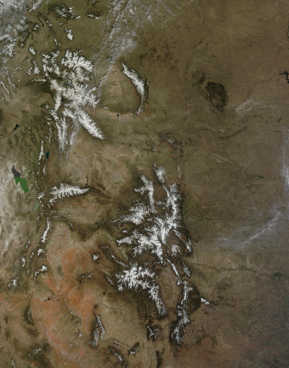
On April 29, 2015 the Moderate Resolution Imaging Spectroradiometer (MODIS) aboard NASA’s Terra satellite captured a true-color image of a typical spring scene in the western United State: snow-crowned Rocky Mountains rising above the faintly greening plains. The Rocky Mountains stretch from British Columbia, Canada to the Rio Grande in New Mexico, a span of roughly 3,000 miles, and contains many of the highest peaks in the continental United States. The tallest, Mount Elbert, rises 14,400 ft. (4,401 m) above sea level, and is located in the San Isabel National Forest, near Leadville, Colorado. This image covers seven Rocky Mountain states. From north to south they are: Montana and Idaho, Wyoming; Utah (with the Great Salt Lake visible) and Colorado; Arizona and New Mexico. To the east, the Great Plain states captured are, from north to south: North Dakota, South Dakota, Nebraska, Kansas, Oklahoma and northwestern Texas. Credit: NASA/GSFC/Jeff Schmaltz/MODIS Land Rapid Response Team <b><a href="http://www.nasa.gov/audience/formedia/features/MP_Photo_Guidelines.html" rel="nofollow">NASA image use policy.</a></b> <b><a href="http://www.nasa.gov/centers/goddard/home/index.html" rel="nofollow">NASA Goddard Space Flight Center</a></b> enables NASA’s mission through four scientific endeavors: Earth Science, Heliophysics, Solar System Exploration, and Astrophysics. Goddard plays a leading role in NASA’s accomplishments by contributing compelling scientific knowledge to advance the Agency’s mission. <b>Follow us on <a href="http://twitter.com/NASAGoddardPix" rel="nofollow">Twitter</a></b> <b>Like us on <a href="http://www.facebook.com/pages/Greenbelt-MD/NASA-Goddard/395013845897?ref=tsd" rel="nofollow">Facebook</a></b> <b>Find us on <a href="http://instagrid.me/nasagoddard/?vm=grid" rel="nofollow">Instagram</a></b>
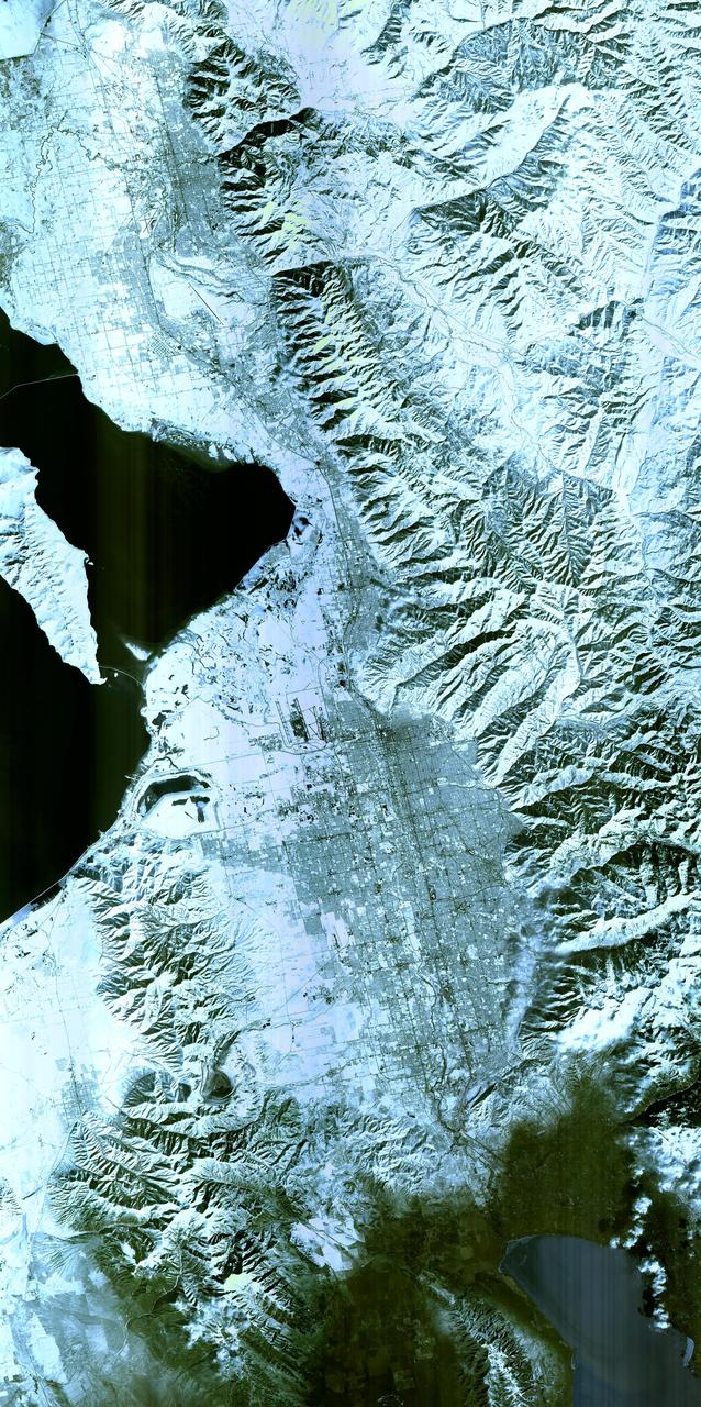
Salt Lake City, Utah, Winter 2001 The 2002 Winter Olympics are hosted by Salt Lake City at several venues within the city, in nearby cities, and within the adjacent Wasatch Mountains. This simulated natural color image presents a snowy, winter view of north central Utah that includes all of the Olympic sites. The image extends from Ogden in the north, to Provo in the south; and includes the snow-capped Wasatch Mountains and the eastern part of the Great Salt Lake. This image was acquired on February 8, 2001 by the Advanced Spaceborne Thermal Emission and Reflection Radiometer (ASTER) on NASA's Terra satellite. With its 14 spectral bands from the visible to the thermal infrared wavelength region, and its high spatial resolution of 15 to 90 meters (about 50 to 300 feet), ASTER will image Earth for the next 6 years to map and monitor the changing surface of our planet. ASTER is one of five Earth-observing instruments launched December 18,1999, on NASA's Terra satellite. The instrument was built by Japan's Ministry of Economy, Trade and Industry. A joint U.S./Japan science team is responsible for validation and calibration of the instrument and the data products. Dr. Anne Kahle at NASA's Jet Propulsion Laboratory, Pasadena, California, is the U.S. Science team leader; Bjorn Eng of JPL is the project manager. ASTER is the only high resolution imaging sensor on Terra. The Terra mission is part of NASA's Earth Science Enterprise, along-term research and technology program designed to examine Earth's land, oceans, atmosphere, ice and life as a total integrated system. The broad spectral coverage and high spectral resolution of ASTER will provide scientists in numerous disciplines with critical information for surface mapping, and monitoring dynamic conditions and temporal change. Example applications are: monitoring glacial advances and retreats; monitoring potentially active volcanoes; identifying crop stress; determining cloud morphology and physical properties; wetlands evaluation; thermal pollution monitoring; coral reef degradation; surface temperature mapping of soils and geology; and measuring surface heat balance. Image credit: NASA/GSFC/METI/ERSDAC/JAROS, and U.S./Japan ASTER Science Team Credit: <b><a href="http://www.earthobservatory.nasa.gov/" rel="nofollow"> NASA Earth Observatory</a></b> <b><a href="http://www.nasa.gov/audience/formedia/features/MP_Photo_Guidelines.html" rel="nofollow">NASA image use policy.</a></b> <b><a href="http://www.nasa.gov/centers/goddard/home/index.html" rel="nofollow">NASA Goddard Space Flight Center</a></b> enables NASA’s mission through four scientific endeavors: Earth Science, Heliophysics, Solar System Exploration, and Astrophysics. Goddard plays a leading role in NASA’s accomplishments by contributing compelling scientific knowledge to advance the Agency’s mission. <b>Follow us on <a href="http://twitter.com/NASAGoddardPix" rel="nofollow">Twitter</a></b> <b>Like us on <a href="http://www.facebook.com/pages/Greenbelt-MD/NASA-Goddard/395013845897?ref=tsd" rel="nofollow">Facebook</a></b> <b>Find us on <a href="http://instagram.com/nasagoddard?vm=grid" rel="nofollow">Instagram</a></b>
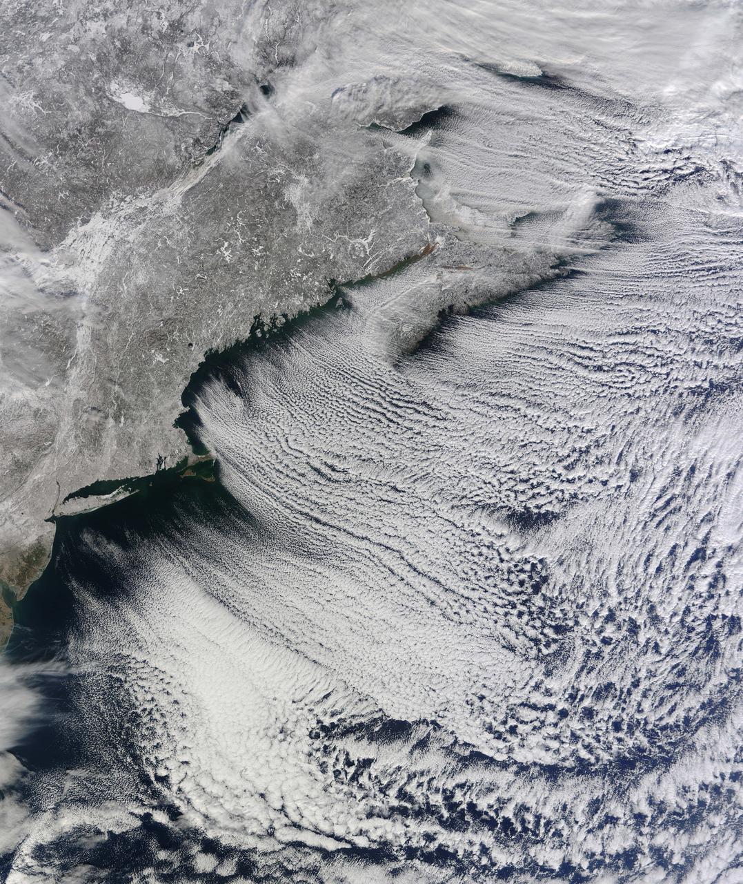
NASA image acquired January 24, 2011 What do you get when you mix below-freezing air temperatures, frigid northwest winds from Canada, and ocean temperatures hovering around 39 to 40 degrees Fahrenheit (4 to 5 degrees Celsius)? Paved highways of clouds across the skies of the North Atlantic. The Moderate Resolution Imaging Spectroradiometer (MODIS) on NASA’s Terra satellite collected this natural-color view of New England, the Canadian Maritimes, and coastal waters at 10:25 a.m. U.S. Eastern Standard Time on January 24, 2011. Lines of clouds stretch from northwest to southeast over the North Atlantic, while the relatively cloudless skies over land afford a peek at the snow that blanketed the Northeast just a few days earlier. Cloud streets form when cold air blows over warmer waters, while a warmer air layer—or temperature inversion—rests over top of both. The comparatively warm water of the ocean gives up heat and moisture to the cold air mass above, and columns of heated air—thermals—naturally rise through the atmosphere. As they hit the temperature inversion like a lid, the air rolls over like the circulation in a pot of boiling water. The water in the warm air cools and condenses into flat-bottomed, fluffy-topped cumulus clouds that line up parallel to the wind. Though they are easy to explain in a broad sense, cloud streets have a lot of mysteries on the micro scale. A NASA-funded researcher from the University of Wisconsin recently observed an unusual pattern in cloud streets over the Great Lakes. Cloud droplets that should have picked up moisture from the atmosphere and grown in size were instead shrinking as they moved over Lake Superior. Read more in an interview at What on Earth? NASA image by Jeff Schmaltz, MODIS Rapid Response Team, Goddard Space Flight Center. Caption by Michael Carlowicz. Instrument: Terra - MODIS Credit: <b><a href="http://www.earthobservatory.nasa.gov/" rel="nofollow"> NASA Earth Observatory</a></b> <b><a href="http://www.nasa.gov/centers/goddard/home/index.html" rel="nofollow">NASA Goddard Space Flight Center</a></b> enables NASA’s mission through four scientific endeavors: Earth Science, Heliophysics, Solar System Exploration, and Astrophysics. Goddard plays a leading role in NASA’s accomplishments by contributing compelling scientific knowledge to advance the Agency’s mission. <b>Follow us on <a href="http://twitter.com/NASA_GoddardPix" rel="nofollow">Twitter</a></b> <b>Join us on <a href="http://www.facebook.com/pages/Greenbelt-MD/NASA-Goddard/395013845897?ref=tsd" rel="nofollow">Facebook</a></b>
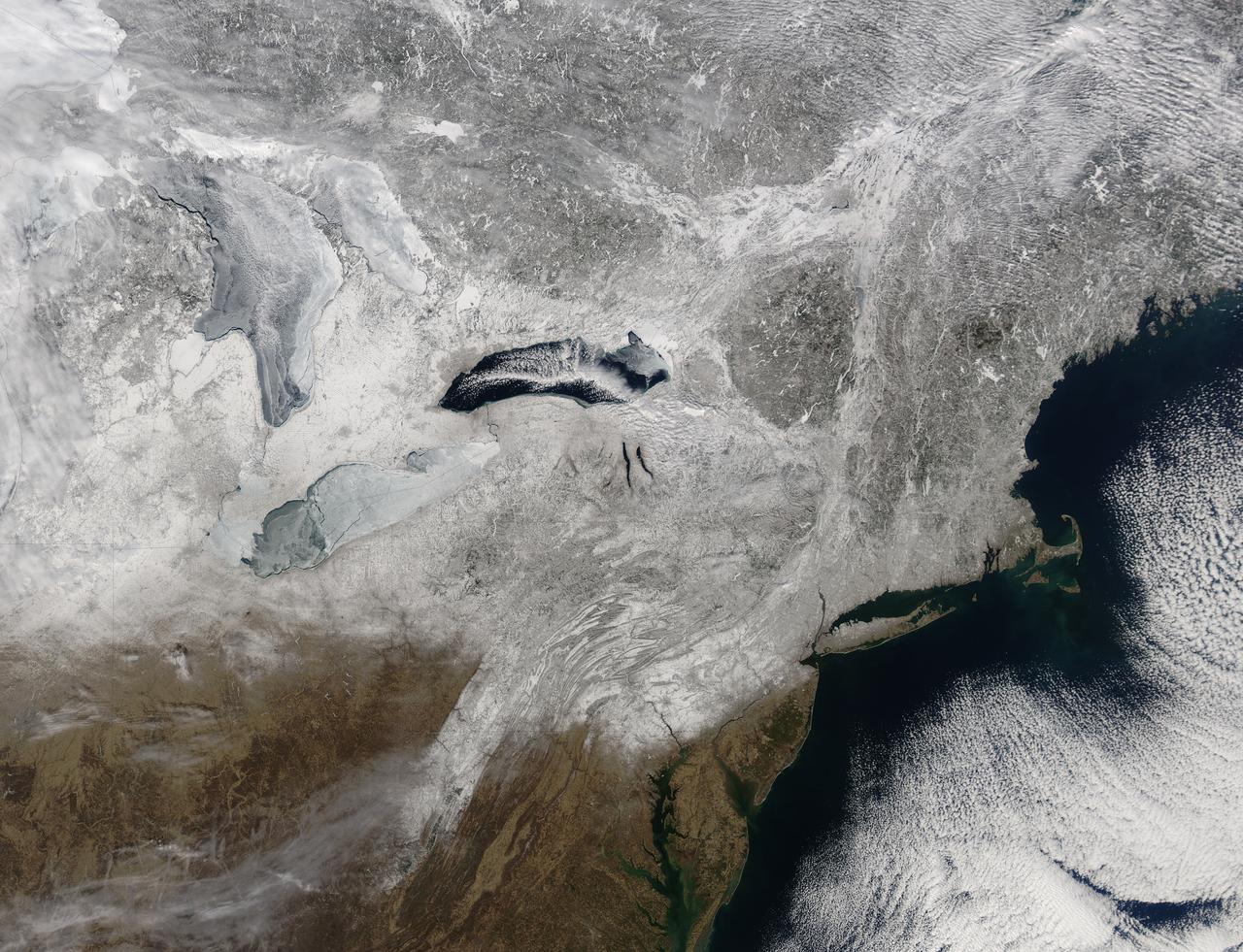
Snow covered the northeastern United States on last day of meteorological winter, 2014. Climatologists and meteorologists break seasons down into three-month groups, based on annual temperature and our calendar. This method is helpful for weather observing and forecasting, and for planning consistent agricultural dates, such as expected first frosts or best planting date. Meteorological winter – the season where temperatures are, on average, coldest and when snow is most likely to fall – runs from December 1 to February 28 in the United States and Canada. Winter can also be defined by the astronomical calendar, which is based on the rotation of the Earth around the sun. In this method, the seasons are defined by two solstices (times when the sun’s path is furthest from the Earth’s equator) and two equinoxes (the times when the sun passes directly above the equator). In the Northern Hemisphere, winter begins on the winter solstice, which falls on or around December 22 and ends on or around March 21, at the vernal (spring) equinox. On February 28, 2014, the Moderate Resolution Imaging Spectroradiometer aboard NASA’s Aqua satellite captured this true-color image of a sunny winter day in the northeastern United States. Snow stretches from Maine west to Indiana and south along the ridges of the Appalachian Mountains well into West Virginia. In Canada, the landscape appears greener, primarily because snow lies on conifers (evergreen) trees in the boreal forest regions. The Great Lakes, with the exception of Lake Ontario, are almost completely covered with ice. Credit: NASA/GSFC/Jeff Schmaltz/MODIS Land Rapid Response Team <b><a href="http://www.nasa.gov/audience/formedia/features/MP_Photo_Guidelines.html" rel="nofollow">NASA image use policy.</a></b> <b><a href="http://www.nasa.gov/centers/goddard/home/index.html" rel="nofollow">NASA Goddard Space Flight Center</a></b> enables NASA’s mission through four scientific endeavors: Earth Science, Heliophysics, Solar System Exploration, and Astrophysics. Goddard plays a leading role in NASA’s accomplishments by contributing compelling scientific knowledge to advance the Agency’s mission. <b>Follow us on <a href="http://twitter.com/NASAGoddardPix" rel="nofollow">Twitter</a></b> <b>Like us on <a href="http://www.facebook.com/pages/Greenbelt-MD/NASA-Goddard/395013845897?ref=tsd" rel="nofollow">Facebook</a></b> <b>Find us on <a href="http://instagram.com/nasagoddard?vm=grid" rel="nofollow">Instagram</a></b>

The GOES-East satellite captured a Midwestern wintertime "White Out" at 2015 UTC/3:15 p.m. EST on January 6, 2014. Blowing snow and intensely cold air created dangerous white-out conditions over the Midwest, particularly around the Great Lakes, where daytime temperatures averaged -20F with a wind chill near -50F. The GOES-East satellite is managed by NOAA. The image was created at NASA's GOES Project at NASA's Goddard Space Flight Center, Greenbelt, Md. Credit: NASA NOAA GOES Project, Dennis Chesters <b><a href="http://www.nasa.gov/audience/formedia/features/MP_Photo_Guidelines.html" rel="nofollow">NASA image use policy.</a></b> <b><a href="http://www.nasa.gov/centers/goddard/home/index.html" rel="nofollow">NASA Goddard Space Flight Center</a></b> enables NASA’s mission through four scientific endeavors: Earth Science, Heliophysics, Solar System Exploration, and Astrophysics. Goddard plays a leading role in NASA’s accomplishments by contributing compelling scientific knowledge to advance the Agency’s mission. <b>Follow us on <a href="http://twitter.com/NASA_GoddardPix" rel="nofollow">Twitter</a></b> <b>Like us on <a href="http://www.facebook.com/pages/Greenbelt-MD/NASA-Goddard/395013845897?ref=tsd" rel="nofollow">Facebook</a></b> <b>Find us on <a href="http://instagram.com/nasagoddard?vm=grid" rel="nofollow">Instagram</a></b>

NOAA's GOES-14 satellite captured a visible image of a low pressure area that will affect the Mid-Atlantic, Ohio Valley and northeast over the next couple of days. The low pressure area, the rounded area of clouds near southern Louisiana, is now moving in a northerly direction from the Gulf coast, and will track northward to the Great Lakes, passing west of the Mid-Atlantic region and bringing clouds and showers. It's associated warm front will also move up the U.S. East coast bringing a surge of warmth before a cold front sweeps in from the west. The clouds draped across the Mid-Atlantic today, Oct. 1, are from an area of low pressure and trailing frontal boundary located over the Atlantic Ocean just off the North Carolina coast and stretching back to the Gulf low. The image was created at NASA's Goddard Space Flight Center in Greenbelt, Md. by the NASA GOES Project. Credit: NASA GOES Project <b><a href="http://www.nasa.gov/audience/formedia/features/MP_Photo_Guidelines.html" rel="nofollow">NASA image use policy.</a></b> <b><a href="http://www.nasa.gov/centers/goddard/home/index.html" rel="nofollow">NASA Goddard Space Flight Center</a></b> enables NASA’s mission through four scientific endeavors: Earth Science, Heliophysics, Solar System Exploration, and Astrophysics. Goddard plays a leading role in NASA’s accomplishments by contributing compelling scientific knowledge to advance the Agency’s mission. <b>Follow us on <a href="http://twitter.com/NASA_GoddardPix" rel="nofollow">Twitter</a></b> <b>Like us on <a href="http://www.facebook.com/pages/Greenbelt-MD/NASA-Goddard/395013845897?ref=tsd" rel="nofollow">Facebook</a></b> <b>Find us on <a href="http://instagrid.me/nasagoddard/?vm=grid" rel="nofollow">Instagram</a></b>
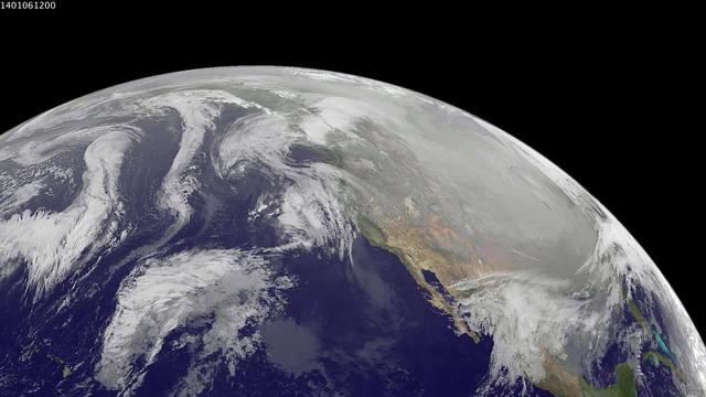
1-9 January 2014. The full-disk images every 3 hours from GOES-WEST capture the sweep of a polar vortex that emerged from the arctic at the beginning of the new year, pushing a blizzard into the northeastern USA on January 3, followed by extensive bitter cold (-20 F, windchill -50 F) around the Great Lakes, and single digit temperatures as far south as Atlanta, Georgia. This western viewpoint displays the persistent flow of arctic air from northern Alaska and Yukon into North America. <b><a href="http://goes.gsfc.nasa.gov/" rel="nofollow">Credit: NOAA/NASA GOES Project</a></b> <b><a href="http://www.nasa.gov/audience/formedia/features/MP_Photo_Guidelines.html" rel="nofollow">NASA image use policy.</a></b> <b><a href="http://www.nasa.gov/centers/goddard/home/index.html" rel="nofollow">NASA Goddard Space Flight Center</a></b> enables NASA’s mission through four scientific endeavors: Earth Science, Heliophysics, Solar System Exploration, and Astrophysics. Goddard plays a leading role in NASA’s accomplishments by contributing compelling scientific knowledge to advance the Agency’s mission. <b>Follow us on <a href="http://twitter.com/NASA_GoddardPix" rel="nofollow">Twitter</a></b> <b>Like us on <a href="http://www.facebook.com/pages/Greenbelt-MD/NASA-Goddard/395013845897?ref=tsd" rel="nofollow">Facebook</a></b> <b>Find us on <a href="http://instagram.com/nasagoddard?vm=grid" rel="nofollow">Instagram</a></b>
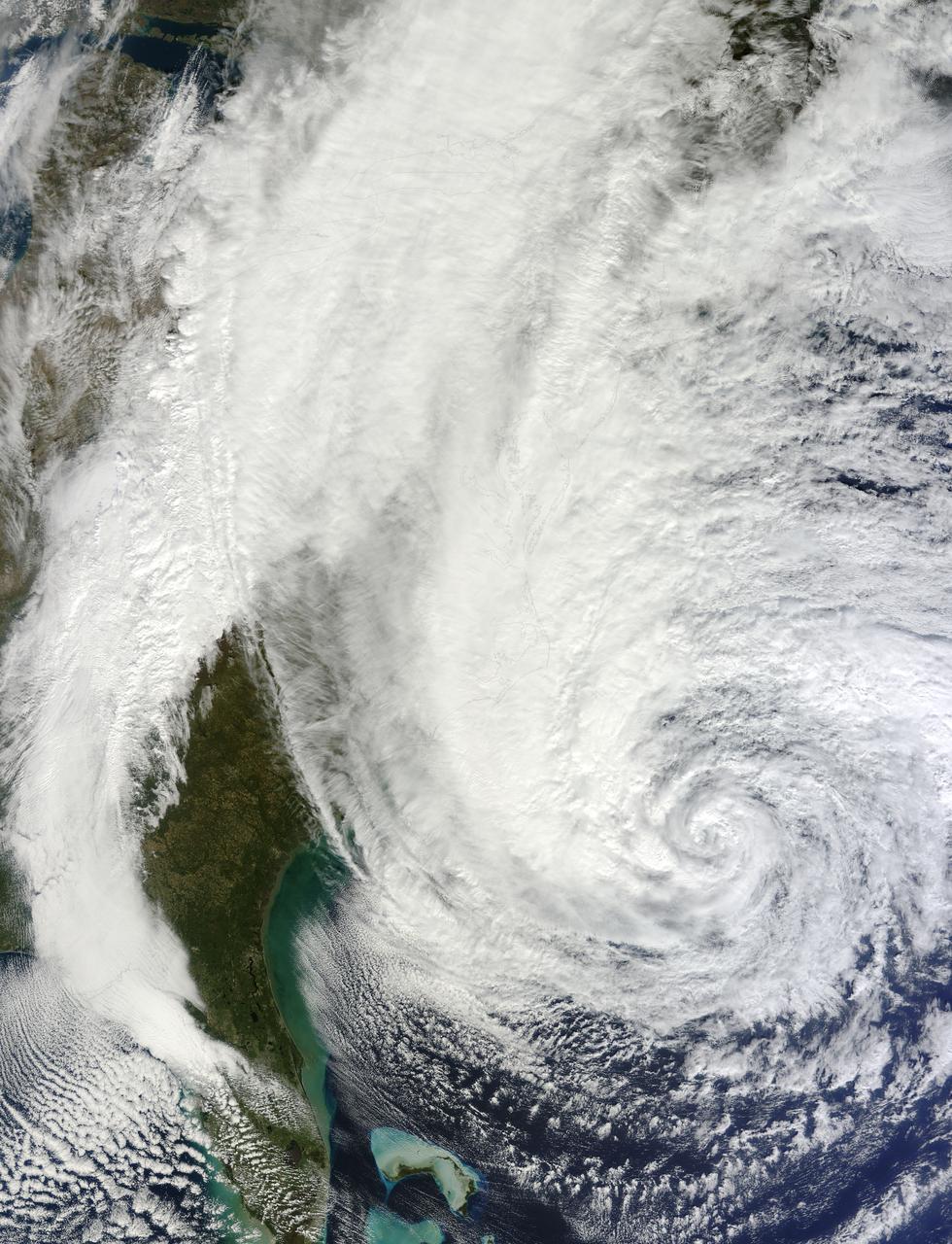
NASA image acquired acquired October 28, 2012 <b>For the latest info from NASA on Hurricane Sandy go to: <a href="http://1.usa.gov/Ti5SgS" rel="nofollow">1.usa.gov/Ti5SgS</a></b> At noon Eastern Daylight Time (16:00 Universal Time) on October 28, 2012, the Moderate Resolution Imaging Spectroradiometer (MODIS) on NASA’s Terra satellite acquired this image of Hurricane Sandy off the southeastern United States. At 11 a.m. local time (one hour before the image was captured), the U.S. National Hurricane Center reported that the storm was located at 32.5° North and 72.6° West, about 250 miles (400 kilometers) southeast of Cape Hatteras, North Carolina, and 575 miles (930 kilometers) south of New York City. Maximum sustained winds were 75 miles (120 kilometers) per hour, and the central pressure was 951 millibars (28.08 inches). Forecasters predicted that the storm would continue heading north-northeast until the morning of October and then take a hard turn to the northwest into the coastaline of Delaware, New Jersey, or New York. The wind field from the storm was said to stretch 500 to 700 miles and was likely to affect an area from South Carolina to Maine, and as far inland as the Great Lakes. The storm has already caused significant damage in the Bahamas, Cuba, Jamaica, Puerto Rico, the Dominican Republic, and Haiti; at least 65 lives have been lost to the storm. NASA image courtesy LANCE MODIS Rapid Response Team at NASA GSFC. Caption by Michael Carlowicz. Instrument: Terra - MODIS Credit: <b><a href="http://www.earthobservatory.nasa.gov/" rel="nofollow"> NASA Earth Observatory</a></b> <b><a href="http://www.nasa.gov/audience/formedia/features/MP_Photo_Guidelines.html" rel="nofollow">NASA image use policy.</a></b> <b><a href="http://www.nasa.gov/centers/goddard/home/index.html" rel="nofollow">NASA Goddard Space Flight Center</a></b> enables NASA’s mission through four scientific endeavors: Earth Science, Heliophysics, Solar System Exploration, and Astrophysics. Goddard plays a leading role in NASA’s accomplishments by contributing compelling scientific knowledge to advance the Agency’s mission. <b>Follow us on <a href="http://twitter.com/NASA_GoddardPix" rel="nofollow">Twitter</a></b> <b>Like us on <a href="http://www.facebook.com/pages/Greenbelt-MD/NASA-Goddard/395013845897?ref=tsd" rel="nofollow">Facebook</a></b> <b>Find us on <a href="http://instagrid.me/nasagoddard/?vm=grid" rel="nofollow">Instagram</a></b>
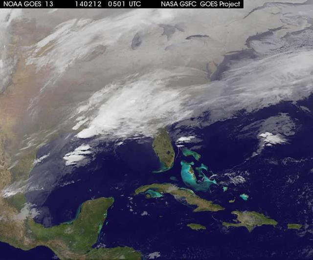
A new NASA video of NOAA's GOES satellite imagery shows three days of movement of the massive winter storm that stretches from the southern U.S. to the northeast. Visible and infrared imagery from NOAA's GOES-East or GOES-13 satellite from Feb. 10 at 1815 UTC/1:15 p.m. EST to Feb. 12 to 1845 UTC/1:45 p.m. EST were compiled into a video made by NASA/NOAA's GOES Project at NASA's Goddard Space Flight Center in Greenbelt, Md. In the video, viewers can see the development and movement of the clouds associated with the progression of the frontal system and related low pressure areas that make up the massive storm. The video also shows the snow covered ground over the Great Lakes region and Ohio Valley that stretches to northern New England. The clouds and fallen snow data from NOAA's GOES-East satellite were overlaid on a true-color image of land and ocean created by data from the Moderate Resolution Imaging Spectroradiometer or MODIS instrument that flies aboard NASA's Aqua and Terra satellites. On February 12 at 10 a.m. EST, NOAA's National Weather Service or NWS continued to issue watches and warnings from Texas to New England. Specifically, NWS cited Winter Storm Warnings and Winter Weather Advisories were in effect from eastern Texas eastward across the interior section of southeastern U.S. states and across much of the eastern seaboard including the Appalachians. Winter storm watches are in effect for portions of northern New England as well as along the western slopes of northern and central Appalachians. For updates on local forecasts, watches and warnings, visit NOAA's <a href="http://www.weather.gov" rel="nofollow">www.weather.gov</a> webpage. NOAA's Weather Prediction Center or WPC noted the storm is expected to bring "freezing rain spreading into the Carolinas, significant snow accumulations are expected in the interior Mid-Atlantic states tonight into Thursday and ice storm warnings and freezing rain advisories are in effect across much of central Georgia. GOES satellites provide the kind of continuous monitoring necessary for intensive data analysis. Geostationary describes an orbit in which a satellite is always in the same position with respect to the rotating Earth. This allows GOES to hover continuously over one position on Earth's surface, appearing stationary. As a result, GOES provide a constant vigil for the atmospheric "triggers" for severe weather conditions such as tornadoes, flash floods, hail storms and hurricanes. For updated information about the storm system, visit NOAA's WPC website; <a href="http://www.hpc.ncep.noaa.gov/" rel="nofollow">www.hpc.ncep.noaa.gov/</a> For more information about GOES satellites, visit: <a href="http://www.goes.noaa.gov/" rel="nofollow">www.goes.noaa.gov/</a> or <a href="http://goes.gsfc.nasa.gov/" rel="nofollow">goes.gsfc.nasa.gov/</a> Rob Gutro NASA's Goddard Space Flight Center <b><a href="http://goes.gsfc.nasa.gov/" rel="nofollow">Credit: NOAA/NASA GOES Project</a></b> <b><a href="http://www.nasa.gov/audience/formedia/features/MP_Photo_Guidelines.html" rel="nofollow">NASA image use policy.</a></b> <b><a href="http://www.nasa.gov/centers/goddard/home/index.html" rel="nofollow">NASA Goddard Space Flight Center</a></b> enables NASA’s mission through four scientific endeavors: Earth Science, Heliophysics, Solar System Exploration, and Astrophysics. Goddard plays a leading role in NASA’s accomplishments by contributing compelling scientific knowledge to advance the Agency’s mission. <b>Follow us on <a href="http://twitter.com/NASAGoddardPix" rel="nofollow">Twitter</a></b> <b>Like us on <a href="http://www.facebook.com/pages/Greenbelt-MD/NASA-Goddard/395013845897?ref=tsd" rel="nofollow">Facebook</a></b> <b>Find us on <a href="http://instagrid.me/nasagoddard/?vm=grid" rel="nofollow">Instagram</a></b>
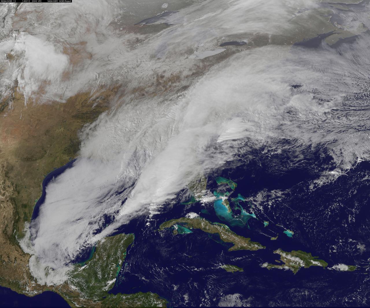
<b>View a video of the storm here: <a href="http://bit.ly/1m9aJFY" rel="nofollow">bit.ly/1m9aJFY</a></b> This visible image of the winter storm over the U.S. south and East Coast was taken by NOAA's GOES-13 satellite on Feb. 12 at 1855 UTC/1:55 p.m. EST. Snow covered ground can be seen over the Great Lakes region and Ohio Valley. On February 12 at 10 a.m. EST, NOAA's National Weather Service or NWS continued to issue watches and warnings from Texas to New England. Specifically, NWS cited Winter Storm Warnings and Winter Weather Advisories were in effect from eastern Texas eastward across the interior section of southeastern U.S. states and across much of the eastern seaboard including the Appalachians. Winter storm watches are in effect for portions of northern New England as well as along the western slopes of northern and central Appalachians. For updates on local forecasts, watches and warnings, visit NOAA's <a href="http://www.weather.gov" rel="nofollow">www.weather.gov</a> webpage. NOAA's Weather Prediction Center or WPC noted the storm is expected to bring "freezing rain spreading into the Carolinas, significant snow accumulations are expected in the interior Mid-Atlantic states tonight into Thursday and ice storm warnings and freezing rain advisories are in effect across much of central Georgia. GOES satellites provide the kind of continuous monitoring necessary for intensive data analysis. Geostationary describes an orbit in which a satellite is always in the same position with respect to the rotating Earth. This allows GOES to hover continuously over one position on Earth's surface, appearing stationary. As a result, GOES provide a constant vigil for the atmospheric "triggers" for severe weather conditions such as tornadoes, flash floods, hail storms and hurricanes. For updated information about the storm system, visit NOAA's WPC website; <a href="http://www.hpc.ncep.noaa.gov/" rel="nofollow">www.hpc.ncep.noaa.gov/</a> For more information about GOES satellites, visit: <a href="http://www.goes.noaa.gov/" rel="nofollow">www.goes.noaa.gov/</a> or <a href="http://goes.gsfc.nasa.gov/" rel="nofollow">goes.gsfc.nasa.gov/</a> Rob Gutro NASA's Goddard Space Flight Center <b><a href="http://goes.gsfc.nasa.gov/" rel="nofollow">Credit: NOAA/NASA GOES Project</a></b> <b><a href="http://www.nasa.gov/audience/formedia/features/MP_Photo_Guidelines.html" rel="nofollow">NASA image use policy.</a></b> <b><a href="http://www.nasa.gov/centers/goddard/home/index.html" rel="nofollow">NASA Goddard Space Flight Center</a></b> enables NASA’s mission through four scientific endeavors: Earth Science, Heliophysics, Solar System Exploration, and Astrophysics. Goddard plays a leading role in NASA’s accomplishments by contributing compelling scientific knowledge to advance the Agency’s mission. <b>Follow us on <a href="http://twitter.com/NASAGoddardPix" rel="nofollow">Twitter</a></b> <b>Like us on <a href="http://www.facebook.com/pages/Greenbelt-MD/NASA-Goddard/395013845897?ref=tsd" rel="nofollow">Facebook</a></b> <b>Find us on <a href="http://instagrid.me/nasagoddard/?vm=grid" rel="nofollow">Instagram</a></b>
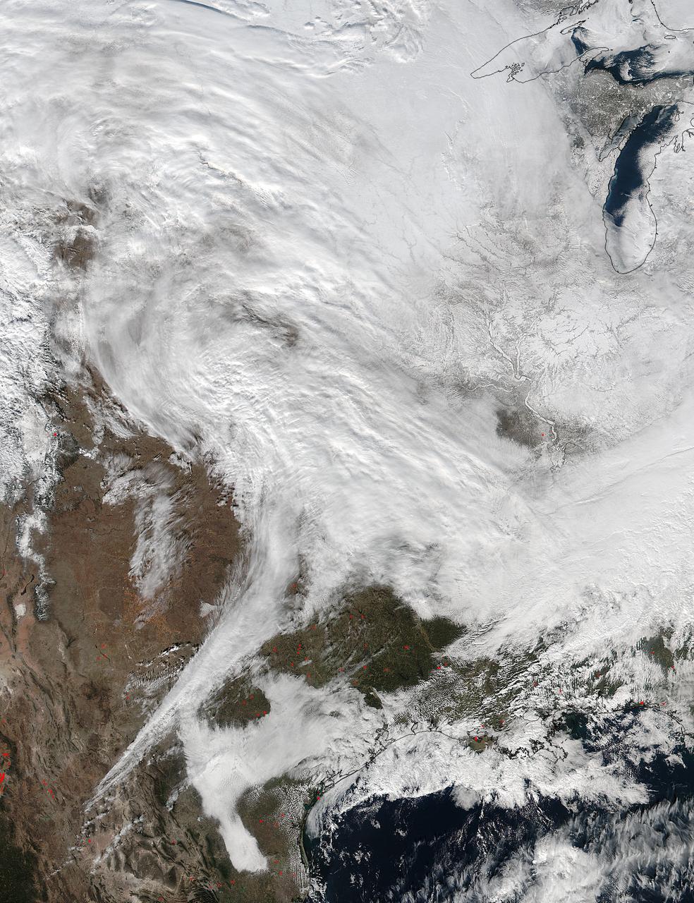
On Jan. 20 at 2:30 p.m. EST the VIIRS instrument aboard NASA-NOAA's Suomi NPP captured this image of the winter storm moving through the central U.S. Credits: NASA Goddard Rapid Response The low pressure area from the Eastern Pacific Ocean moved into the western U.S. and tracked across the four corners region into Texas where NASA-NOAA's Suomi NPP satellite observed the clouds associated with the storm. The Visible Infrared Imaging Radiometer Suite (VIIRS) instrument aboard Suomi NPP satellite captured the visible image on January 20, 2016 at 19:30 UTC (2:30 p.m. EST) when the storm was over the central U.S. In the image, snow cover is visible in the Rockies and southern Great Lakes states. VIIRS collects visible and infrared imagery and global observations of land, atmosphere, cryosphere and oceans. That low pressure system located over the south central United States on Jan. 21 is expected to track east across the Tennessee Valley and will give way to a deepening coastal low pressure area. The National Weather Service said "This latter feature takes over and becomes a dominant force in setting up heavy snow bands over the Mid-Atlantic and very gusty winds." The storm system is expected to bring an increased risk of severe weather from far southeastern Texas across southern Louisiana/Mississippi, and into the far western Florida Panhandle on Thursday, Jan. 21. That threat for severe weather will move east as the low pressure area continues heading in that direction. The National Weather Service Weather Prediction Center in College Park, Maryland said "A potentially crippling winter storm is anticipated for portions of the mid-Atlantic Friday into early Saturday. Snowfall may approach two feet for some locations, including the Baltimore and Washington, D.C. metro areas. Farther north, there is uncertainty in snowfall for the New York City-to-Boston corridor. Farther south, significant icing is likely for portions of Kentucky and North Carolina." <b><a href="http://www.nasa.gov/audience/formedia/features/MP_Photo_Guidelines.html" rel="nofollow">NASA image use policy.</a></b> <b><a href="http://www.nasa.gov/centers/goddard/home/index.html" rel="nofollow">NASA Goddard Space Flight Center</a></b> enables NASA’s mission through four scientific endeavors: Earth Science, Heliophysics, Solar System Exploration, and Astrophysics. Goddard plays a leading role in NASA’s accomplishments by contributing compelling scientific knowledge to advance the Agency’s mission. <b>Follow us on <a href="http://twitter.com/NASAGoddardPix" rel="nofollow">Twitter</a></b> <b>Like us on <a href="http://www.facebook.com/pages/Greenbelt-MD/NASA-Goddard/395013845897?ref=tsd" rel="nofollow">Facebook</a></b> <b>Find us on <a href="http://instagram.com/nasagoddard?vm=grid" rel="nofollow">Instagram</a></b>