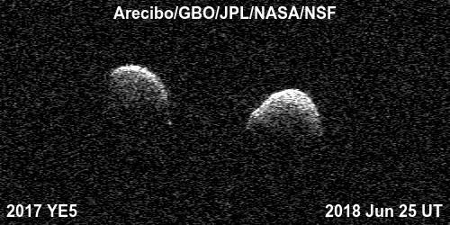
Bi-static radar images of the binary asteroid 2017 YE5 from the Arecibo Observatory and the Green Bank Observatory on June 25. The observations show that the asteroid consists of two separate objects in orbit around each other. A movie is available at https://photojournal.jpl.nasa.gov/catalog/PIA22559
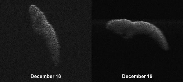
These two radar images of near-Earth asteroid 2003 SD220 were obtained on Dec. 18 and 19 by coordinating observations with the Arecibo Observatory's 1,000-foot (305-meter) antenna in Puerto Rico and the National Science Foundation's (NSF) 330-foot (100-meter) Green Bank Telescope in West Virginia. The radar images reveal the asteroid is at least one mile (1.6 kilometers) long. https://photojournal.jpl.nasa.gov/catalog/PIA22969
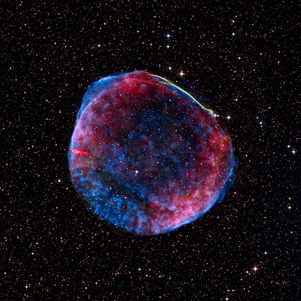
Release date: July 1, 2008 This image is a composite of visible (or optical), radio, and X-ray data of the full shell of the supernova remnant from SN 1006. The radio data show much of the extent that the X-ray image shows. In contrast, only a small linear filament in the northwest corner of the shell is visible in the optical data. The object has an angular size of roughly 30 arcminutes (0.5 degree, or about the size of the full moon), and a physical size of 60 light-years (18 parsecs) based on its distance of nearly 7,000 light-years. The small green box along the bright filament at the top of the image corresponds to the dimensions of the Hubble release image. The optical data was obtained at the University of Michigan's 0.9-meter Curtis Schmidt telescope at the National Science Foundation's Cerro Tololo Inter-American Observatory (CTIO) near La Serena, Chile. H-alpha, continuum-subtracted data were provided by F. Winkler (Middlebury COllege) et al. The X-ray data were acquired from the Chandra X-ray Observatory's AXAF CCD Imaging Spectrometer (ACIS) at 0.5-3keV, and were provided by J. Hughes (Rutgers University) et al. The radio data, supplied by K. Dyer (NRAO, Socorro) et al., were a composite from the National Radio Astronomy Observatory's Very Large Array (NRAO/VLA) in Socorro, New Mexico, along with the Green Bank Telescope (GBT) in Green Bank, West Virginia. Data of the supernova remnant were blended on a visible-light stellar background created using the Digitized Sky Survey's Anglo-Australian Observatory (AAO2) blue and red plates. Photo Credit: NASA, ESA, and Z. Levay (STScI) Science Credit: Radio: NRAO/AUI/NSF GBT+VLA 1.4 GHz mosaic (Dyer, Maddalena and Cornwell, NRAO); X-ray: NASA/CXC/Rutgers/G. Cassam-Chenai and J. Hughes et al.; Optical: F.Winkler/Middlebury College and NOAO/AURA/NSF; and DSS To learn more about the Hubble Space Telescope go here: <a href="http://www.nasa.gov/mission_pages/hubble/main/index.html" rel="nofollow">www.nasa.gov/mission_pages/hubble/main/index.html</a> <b><a href="http://www.nasa.gov/centers/goddard/home/index.html" rel="nofollow">NASA Goddard Space Flight Center</a></b> is home to the nation's largest organization of combined scientists, engineers and technologists that build spacecraft, instruments and new technology to study the Earth, the sun, our solar system, and the universe. <b>Follow us on <a href="http://twitter.com/NASAGoddardPix" rel="nofollow">Twitter</a></b> <b>Join us on <a href="http://www.facebook.com/pages/Greenbelt-MD/NASA-Goddard/395013845897?ref=tsd" rel="nofollow">Facebook</a><b> </b></b>

This image of the Andromeda galaxy, or M31, includes data from the ESA (European Space Agency) Herschel mission, supplemented with data from ESA's retired Planck observatory and two retired NASA missions: the Infrared Astronomical Satellite (IRAS) and Cosmic Background Explorer (COBE). Operated from 2009 to 2013, Herschel detected wavelengths of light in the far-infrared and microwave ranges, and was ideal for studying dust in nearby galaxies because it could capture small-scale structures in the dust clouds in high resolution. However, Herschel often couldn't detect light from diffuse dust clouds – especially in the outer regions of galaxies, where the gas and dust become sparse and thus fainter. As a result, the mission missed up to 30% of all the light given off by dust. Combining the Herschel observations with data from other observatories creates a more complete picture of the dust in the galaxy. In the image, red indicates hydrogen gas; green indicates cold dust; and warmer dust is shown in blue. Launched in 1983, IRAS was the first space telescope to detect infrared light, setting the stage for future observatories like NASA's Spitzer Space Telescope and James Webb Space Telescope. The Planck observatory, launched in 2009, and COBE, launched in 1989, both studied the cosmic microwave background, or light left over from the big bang. Red indicates hydrogen gas detected using the Green Bank Telescope in West Virginia, the Westerbork Synthesis Radio Telescope in the Netherlands, and the Institute for Radio Astronomy in the Millimeter Range 30-meter telescope in Spain. https://photojournal.jpl.nasa.gov/catalog/PIA25163
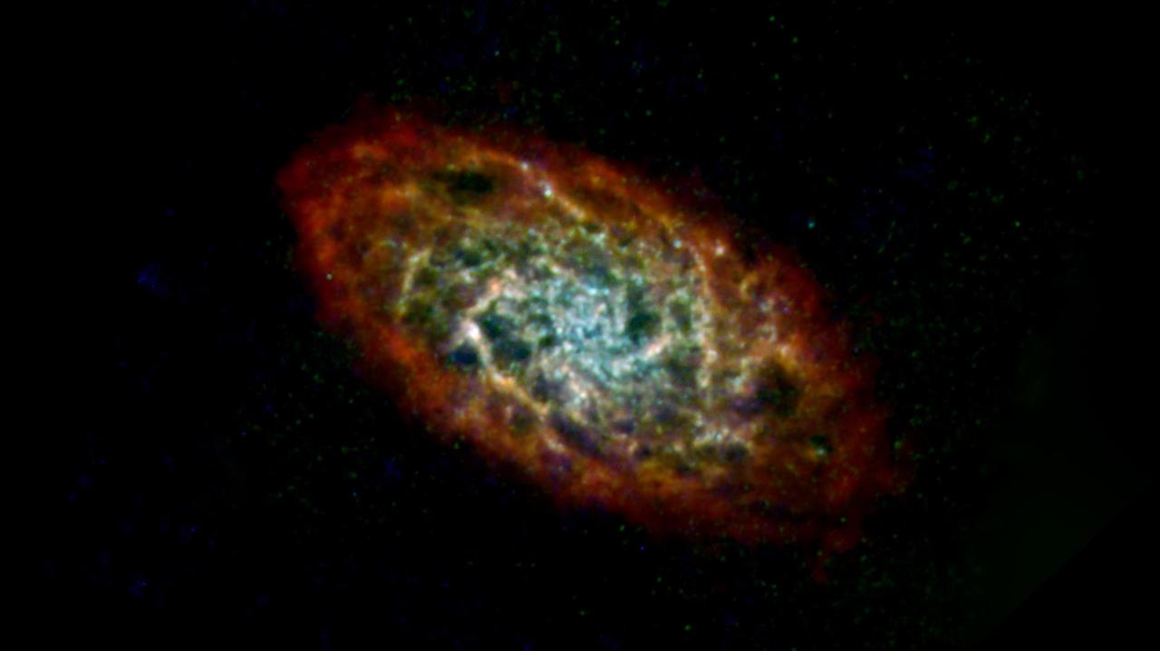
This image of the Triangulum galaxy, or M33, includes data from the ESA (European Space Agency) Herschel mission, supplemented with data from ESA's retired Planck observatory and two retired NASA missions: the Infrared Astronomical Satellite (IRAS) and Cosmic Background Explorer (COBE). Operated from 2009 to 2013, Herschel detected wavelengths of light in the far-infrared and microwave ranges, and was ideal for studying dust in nearby galaxies because it could capture small-scale structures in the dust clouds in high resolution. However, Herschel often couldn't detect light from diffuse dust clouds – especially in the outer regions of galaxies, where the gas and dust become sparse and thus fainter. As a result, the mission missed up to 30% of all the light given off by dust. Combining the Herschel observations with data from other observatories creates a more complete picture of the dust in the galaxy. In the image, red indicates hydrogen gas; green indicates cold dust; and warmer dust is shown in blue. Launched in 1983, IRAS was the first space telescope to detect infrared light, setting the stage for future observatories like NASA's Spitzer Space Telescope and James Webb Space Telescope. The Planck observatory, launched in 2009, and COBE, launched in 1989, both studied the cosmic microwave background, or light left over from the big bang. The hydrogen gas was detected using the Green Bank Telescope in West Virginia, the Karl G. Jansky Very Large Array in New Mexico, and the Institute for Radio Astronomy in the Millimeter Range 30-meter telescope in Spain. https://photojournal.jpl.nasa.gov/catalog/PIA25165
On the left is a radar image of asteroid 1998 WT24 taken in December 2001 by scientists using NASA's the 230-foot (70-meter) DSS-14 antenna at Goldstone, California. On the right is a radar image of the same asteroid acquired on Dec. 11, 2015, during the asteroid's most recent Earth flyby. The radar images from 2001 (on the left), have a resolution of about 60 feet (19 meters) per pixel. The radar image from 2015 (on the right) achieved a spatial resolution as fine as 25 feet (7.5 meters) per pixel. The 2015 radar image was obtained using the same DSS-14 antenna at Goldstone to transmit high-power microwaves toward the asteroid. However, this time, the radar echoes bounced off the asteroid were received by the National Radio Astronomy Observatory's 100-meter (330-foot) Green Bank Telescope in West Virginia. The next visit of asteroid 1998 WT24 to Earth's neighborhood will be on Nov. 11, 2018, when it will make a distant pass at about 12.5-million miles (52 lunar distances). http://photojournal.jpl.nasa.gov/catalog/PIA20216
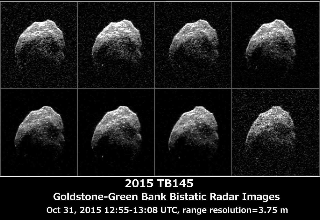
The 230-foot 70-meter DSS-14 antenna at Goldstone, Ca. obtained these radar images of asteroid 2015 TB145 on Oct. 31, 2015. Asteroid 2015 TB145 is depicted in eight individual radar images collected on Oct. 31, 2015 between 5:55 a.m. PDT (8:55 a.m. EDT) and 6:08 a.m. PDT (9:08 a.m. EDT). At the time the radar images were taken, the asteroid was between 440,000 miles (710,000 kilometers) and about 430,000 miles (690,000 kilometers) distant. Asteroid 2015 TB145 safely flew past Earth on Oct. 31, at 10:00 a.m. PDT (1 p.m. EDT) at about 1.3 lunar distances (300,000 miles, 480,000 kilometers). To obtain the radar images, the scientists used the 230-foot (70-meter) DSS-14 antenna at Goldstone, California, to transmit high power microwaves toward the asteroid. The signal bounced of the asteroid, and their radar echoes were received by the National Radio Astronomy Observatory's 100-meter (330-foot) Green Bank Telescope in West Virginia. The images achieve a spatial resolution of about 13 feet (4 meters) per pixel. http://photojournal.jpl.nasa.gov/catalog/PIA20043
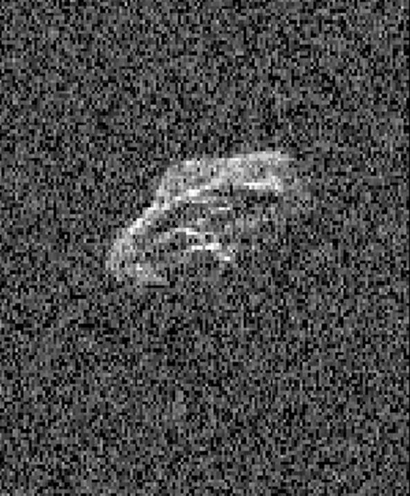
Scientists using two giant, Earth-based radio telescopes bounced radar signals off passing asteroid 2011 UW158 to create images for this animation showing the rocky body's fast rotation. The passing asteroid made its closest approach to Earth on July 19, 2015 at 7:37 a.m. PST (4:37 a.m. EST) at a distance of about 1.5 million miles (2.4 million kilometers, or 6 times the distance from Earth to the moon). The close proximity during the pass made 2011 UW158 one of the best asteroid flybys of 2015 for imaging from Earth using radar. The radar images reveal that the shape of the asteroid is extremely irregular and quite elongated. Prominent parallel, linear features run along the length of the object that cause a large increase in brightness of the radar images as they rotate into view. Scientists note that the asteroid appears to be fairly unusual. Its fast rotation suggests the object has greater mechanical strength than other asteroids its size. A fast-rotating asteroid with lower mechanical strength would tend to split apart. To obtain the views, researchers paired the 230-foot- (70-meter-) wide Deep Space Network antenna at Goldstone, California, in concert with the National Radio Astronomy Observatory's 330-foot (100-meter) Green Bank Telescope. Using this technique, the Goldstone antenna beams a radar signal at an asteroid and Green Bank receives the reflections. The technique, referred to as a bi-static observation, dramatically improves the amount of detail that can be seen in radar images. The new views obtained with the technique show features as small as about 24 feet (7.5 meters) wide. The 171 individual images used in the movie were generated from data collected on July 18. They show the asteroid is approximately 2000 by 1000 feet (600 by 300 meters) across. The observations also confirm earlier estimates by astronomers that the asteroid rotates quickly, completing one spin in just over half an hour. The movie spans a period of about an hour and 45 minutes. The trajectory of asteroid 2011 UW158 is well understood. This flyby was the closest approach the asteroid will make to Earth for at least the next 93 years. Asteroid 2011 UW158 was discovered on October 25, 2011, by the PanSTARRS 1 telescope, located on the summit of Haleakala on Maui, Hawaii. Managed by the University of Hawaii, the PanSTARRS survey receives NASA funding. Radar is a powerful technique for studying an asteroid's size, shape, rotation state, surface features and surface roughness, and for improving the calculation of asteroid orbits. Radar measurements of asteroid distances and velocities often enable computation of asteroid orbits much further into the future than if radar observations weren't available. http://photojournal.jpl.nasa.gov/catalog/PIA19644
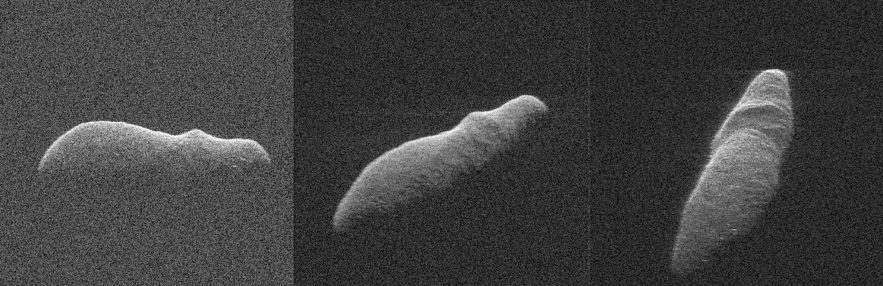
These three radar images of near-Earth asteroid 2003 SD220 were obtained on Dec. 15-17, by coordinating observations with NASA's 230-foot (70-meter) antenna at the Goldstone Deep Space Communications Complex in California and the National Science Foundation's (NSF) 330-foot (100-meter) Green Bank Telescope in West Virginia. The radar image on the left was obtained on Dec. 15 when asteroid 2003 SD220 was 2.8 million miles (4.5 million kilometers) from Earth. The radar image in the middle was generated from data collected on Dec. 16 when the asteroid was 2.5 million miles (4.0 million kilometers) from Earth. The image on the right was obtained on Dec. 17 when 2003 SD220 was 2.2 million miles (3.6 million kilometers) from Earth. The spatial resolution on the images is as fine as 12 feet (3.7 meters) per pixel. The radar images reveal the asteroid is at least one mile (1.6 kilometers) long. Asteroid 2003 SD220 was discovered on Sept. 29, 2003, by astronomers at the Lowell Observatory Near-Earth-Object Search (LONEOS) in Flagstaff, Arizona -- an early Near-Earth Object (NEO) survey project supported by NASA that is no longer in operation. The asteroid will fly safely past Earth on Saturday, Dec. 22, 2018, at a distance of about 1.8 million miles (2.9 million kilometers). This will be the asteroid's closest approach in more than 400 years and the closest until 2070, when the asteroid will safely fly by slightly closer. https://photojournal.jpl.nasa.gov/catalog/PIA22970
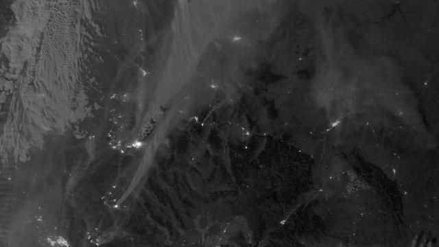
On August 29, 2012, the Visible Infrared Imaging Radiometer Suite (VIIRS) on the Suomi NPP satellite captured this nighttime view of wildfires burning in Idaho and Montana. The image was captured by the VIIRS “day-night band,” which detects light in a range of wavelengths from green to near-infrared and uses filtering techniques to observe signals such as gas flares, auroras, wildfires, city lights, and reflected moonlight. When the image was acquired, the moon was in its waxing gibbous phase, meaning it was more than half-lit, but less than full. Numerous hot spots from the Mustang Complex Fire are visible in northern Idaho. A plume of thick, billowing smoke streams west from the brightest fires near the Idaho-Montana border. The Halstead and Trinity Ridge fires are visible to the south. In addition to the fires, city lights from Boise and other smaller cities appear throughout the image. A bank of clouds is located west of the Mustang Complex, over southeastern Washington and northeastern Oregon. The Operational Line System (OLS)—an earlier generation of night-viewing sensors on the U.S. Defense Meteorological Satellite Program (DMSP) satellites—was also capable of detecting fires at night. But the VIIRS “day-night band” is far better than OLS at resolving them. Each pixel of an VIIRS image shows roughly 740 meters (0.46 miles), compared to the 3-kilometer footprint (1.86 miles) on the OLS system. NASA Earth Observatory image by Jesse Allen and Robert Simmon, using VIIRS Day-Night Band data from the Suomi National Polar-orbiting Partnership. Suomi NPP is the result of a partnership between NASA, the National Oceanic and Atmospheric Administration, and the Department of Defense. Caption by Adam Voiland. Instrument: Suomi NPP - VIIRS Credit: <b><a href="http://www.earthobservatory.nasa.gov/" rel="nofollow"> NASA Earth Observatory</a></b> <b>Click here to view all of the <a href="http://earthobservatory.nasa.gov/Features/NightLights/" rel="nofollow"> Earth at Night 2012 images </a></b> <b>Click here to <a href="http://earthobservatory.nasa.gov/NaturalHazards/view.php?id=79754" rel="nofollow"> read more </a> about this image </b> <b><a href="http://www.nasa.gov/audience/formedia/features/MP_Photo_Guidelines.html" rel="nofollow">NASA image use policy.</a></b> <b><a href="http://www.nasa.gov/centers/goddard/home/index.html" rel="nofollow">NASA Goddard Space Flight Center</a></b> enables NASA’s mission through four scientific endeavors: Earth Science, Heliophysics, Solar System Exploration, and Astrophysics. Goddard plays a leading role in NASA’s accomplishments by contributing compelling scientific knowledge to advance the Agency’s mission. <b>Follow us on <a href="http://twitter.com/NASA_GoddardPix" rel="nofollow">Twitter</a></b> <b>Like us on <a href="http://www.facebook.com/pages/Greenbelt-MD/NASA-Goddard/395013845897?ref=tsd" rel="nofollow">Facebook</a></b> <b>Find us on <a href="http://instagram.com/nasagoddard?vm=grid" rel="nofollow">Instagram</a></b>
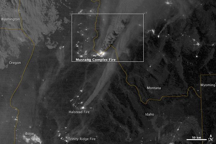
On August 29, 2012, the Visible Infrared Imaging Radiometer Suite (VIIRS) on the Suomi NPP satellite captured this nighttime view of wildfires burning in Idaho and Montana. The image was captured by the VIIRS “day-night band,” which detects light in a range of wavelengths from green to near-infrared and uses filtering techniques to observe signals such as gas flares, auroras, wildfires, city lights, and reflected moonlight. When the image was acquired, the moon was in its waxing gibbous phase, meaning it was more than half-lit, but less than full. Numerous hot spots from the Mustang Complex Fire are visible in northern Idaho. A plume of thick, billowing smoke streams west from the brightest fires near the Idaho-Montana border. The Halstead and Trinity Ridge fires are visible to the south. In addition to the fires, city lights from Boise and other smaller cities appear throughout the image. A bank of clouds is located west of the Mustang Complex, over southeastern Washington and northeastern Oregon. The Operational Line System (OLS)—an earlier generation of night-viewing sensors on the U.S. Defense Meteorological Satellite Program (DMSP) satellites—was also capable of detecting fires at night. But the VIIRS “day-night band” is far better than OLS at resolving them. Each pixel of an VIIRS image shows roughly 740 meters (0.46 miles), compared to the 3-kilometer footprint (1.86 miles) on the OLS system. NASA Earth Observatory image by Jesse Allen and Robert Simmon, using VIIRS Day-Night Band data from the Suomi National Polar-orbiting Partnership. Suomi NPP is the result of a partnership between NASA, the National Oceanic and Atmospheric Administration, and the Department of Defense. Caption by Adam Voiland. Instrument: Suomi NPP - VIIRS Credit: <b><a href="http://www.earthobservatory.nasa.gov/" rel="nofollow"> NASA Earth Observatory</a></b> <b>Click here to view all of the <a href="http://earthobservatory.nasa.gov/Features/NightLights/" rel="nofollow"> Earth at Night 2012 images </a></b> <b>Click here to <a href="http://earthobservatory.nasa.gov/NaturalHazards/view.php?id=79754" rel="nofollow"> read more </a> about this image </b> <b><a href="http://www.nasa.gov/audience/formedia/features/MP_Photo_Guidelines.html" rel="nofollow">NASA image use policy.</a></b> <b><a href="http://www.nasa.gov/centers/goddard/home/index.html" rel="nofollow">NASA Goddard Space Flight Center</a></b> enables NASA’s mission through four scientific endeavors: Earth Science, Heliophysics, Solar System Exploration, and Astrophysics. Goddard plays a leading role in NASA’s accomplishments by contributing compelling scientific knowledge to advance the Agency’s mission. <b>Follow us on <a href="http://twitter.com/NASA_GoddardPix" rel="nofollow">Twitter</a></b> <b>Like us on <a href="http://www.facebook.com/pages/Greenbelt-MD/NASA-Goddard/395013845897?ref=tsd" rel="nofollow">Facebook</a></b> <b>Find us on <a href="http://instagram.com/nasagoddard?vm=grid" rel="nofollow">Instagram</a></b>
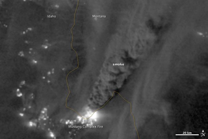
On August 29, 2012, the Visible Infrared Imaging Radiometer Suite (VIIRS) on the Suomi NPP satellite captured this nighttime view of wildfires burning in Idaho and Montana. The image was captured by the VIIRS “day-night band,” which detects light in a range of wavelengths from green to near-infrared and uses filtering techniques to observe signals such as gas flares, auroras, wildfires, city lights, and reflected moonlight. When the image was acquired, the moon was in its waxing gibbous phase, meaning it was more than half-lit, but less than full. Numerous hot spots from the Mustang Complex Fire are visible in northern Idaho. A plume of thick, billowing smoke streams west from the brightest fires near the Idaho-Montana border. The Halstead and Trinity Ridge fires are visible to the south. In addition to the fires, city lights from Boise and other smaller cities appear throughout the image. A bank of clouds is located west of the Mustang Complex, over southeastern Washington and northeastern Oregon. The Operational Line System (OLS)—an earlier generation of night-viewing sensors on the U.S. Defense Meteorological Satellite Program (DMSP) satellites—was also capable of detecting fires at night. But the VIIRS “day-night band” is far better than OLS at resolving them. Each pixel of an VIIRS image shows roughly 740 meters (0.46 miles), compared to the 3-kilometer footprint (1.86 miles) on the OLS system. NASA Earth Observatory image by Jesse Allen and Robert Simmon, using VIIRS Day-Night Band data from the Suomi National Polar-orbiting Partnership. Suomi NPP is the result of a partnership between NASA, the National Oceanic and Atmospheric Administration, and the Department of Defense. Caption by Adam Voiland. Instrument: Suomi NPP - VIIRS Credit: <b><a href="http://www.earthobservatory.nasa.gov/" rel="nofollow"> NASA Earth Observatory</a></b> <b>Click here to view all of the <a href="http://earthobservatory.nasa.gov/Features/NightLights/" rel="nofollow"> Earth at Night 2012 images </a></b> <b>Click here to <a href="http://earthobservatory.nasa.gov/NaturalHazards/view.php?id=79754" rel="nofollow"> read more </a> about this image </b> <b><a href="http://www.nasa.gov/audience/formedia/features/MP_Photo_Guidelines.html" rel="nofollow">NASA image use policy.</a></b> <b><a href="http://www.nasa.gov/centers/goddard/home/index.html" rel="nofollow">NASA Goddard Space Flight Center</a></b> enables NASA’s mission through four scientific endeavors: Earth Science, Heliophysics, Solar System Exploration, and Astrophysics. Goddard plays a leading role in NASA’s accomplishments by contributing compelling scientific knowledge to advance the Agency’s mission. <b>Follow us on <a href="http://twitter.com/NASA_GoddardPix" rel="nofollow">Twitter</a></b> <b>Like us on <a href="http://www.facebook.com/pages/Greenbelt-MD/NASA-Goddard/395013845897?ref=tsd" rel="nofollow">Facebook</a></b> <b>Find us on <a href="http://instagram.com/nasagoddard?vm=grid" rel="nofollow">Instagram</a></b>