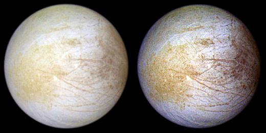
This color composite view combines violet, green, and infrared images of Jupiter intriguing moon, Europa, for a view of the moon in natural color left and in enhanced color designed to bring out subtle color differences in the surface right.
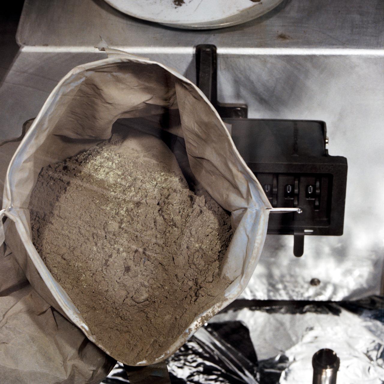
S71-43052 (August 1971) --- A close-up view of a container full of green-colored lunar soil in the Non-Sterile Nitrogen Processing Line (NNPL) in the Lunar Receiving Laboratory (LRL) at the Manned Spacecraft Center (MSC). This sample, broken down into six separate samples after this photo was made, was made up of comprehensive fines from near Spur Crater on the Apennine Front. The numbers assigned to the sample include numbers 15300 through 15305. Astronauts David R. Scott and James B. Irwin took the sample during their second extravehicular activity (EVA) at a ground elapsed time (GET) of 146:05 to 146:06.
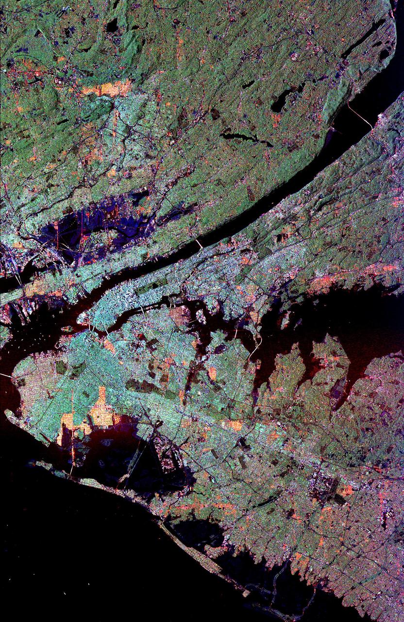
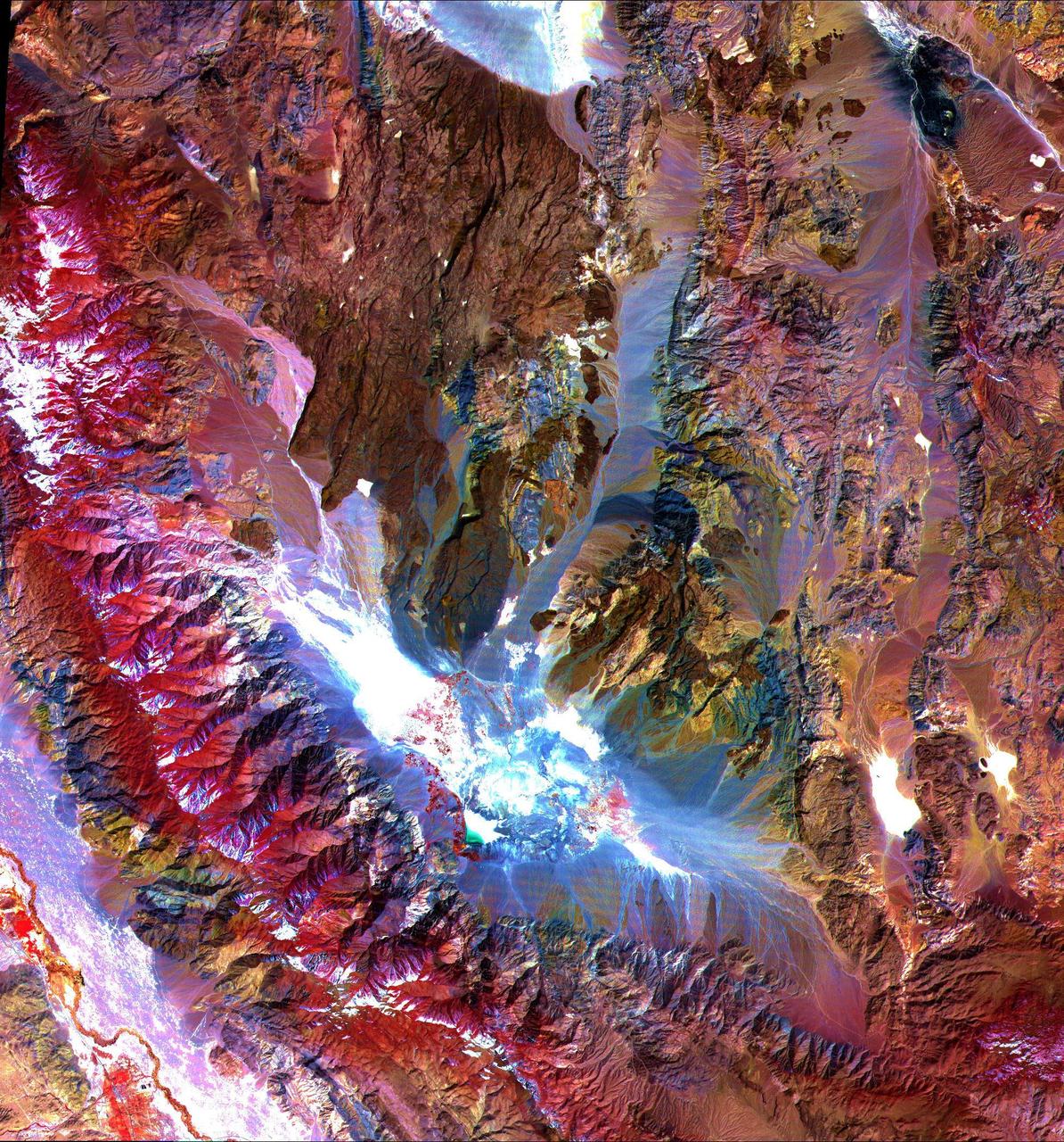
This radar image of the New York city metropolitan area. The island of Manhattan appears in the center of the image. The green-colored rectangle on Manhattan is Central Park.
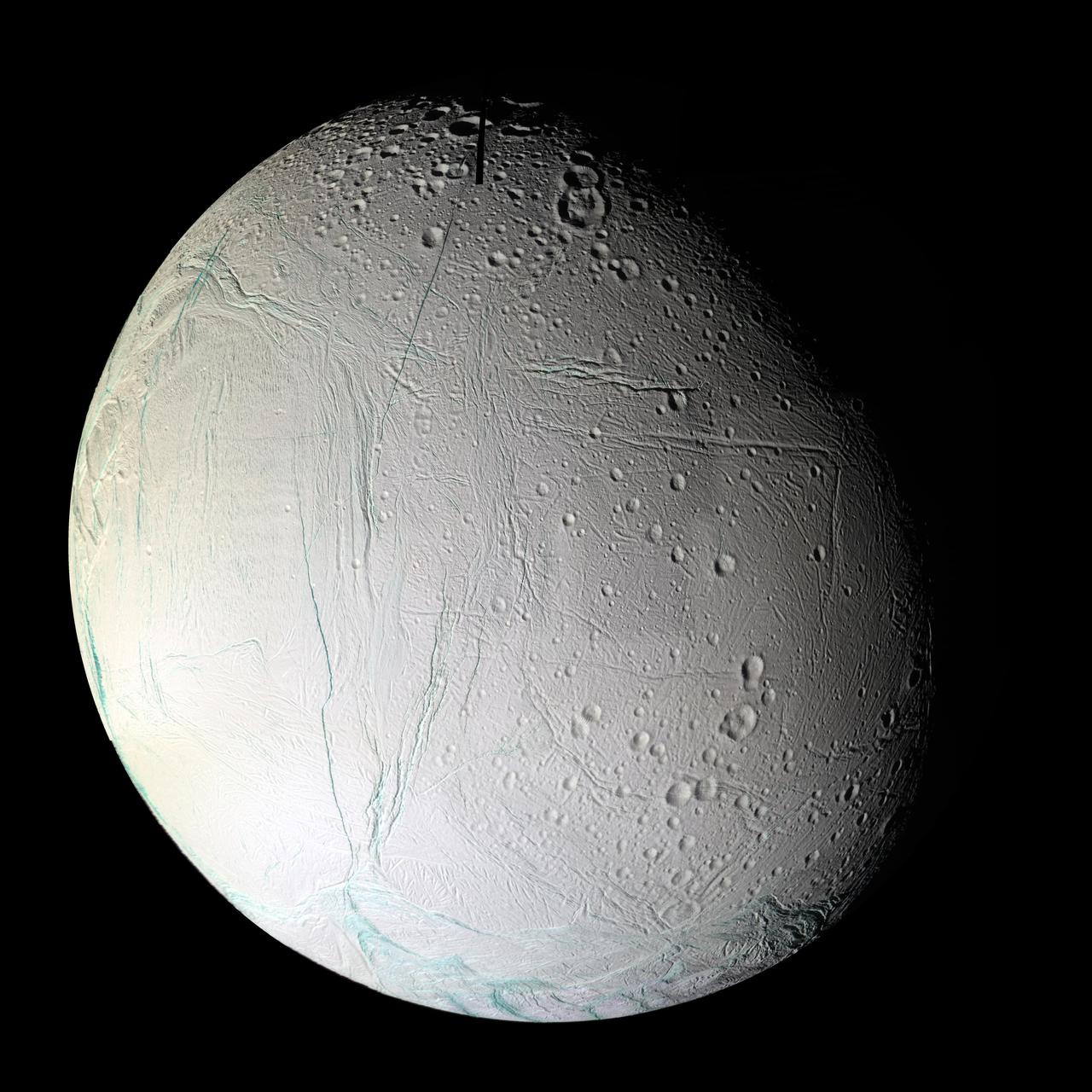
Numerous blue-green fractures can be seen in this false-color mosaic taken during Cassini second close flyby of Enceladus, on March 9, 2005
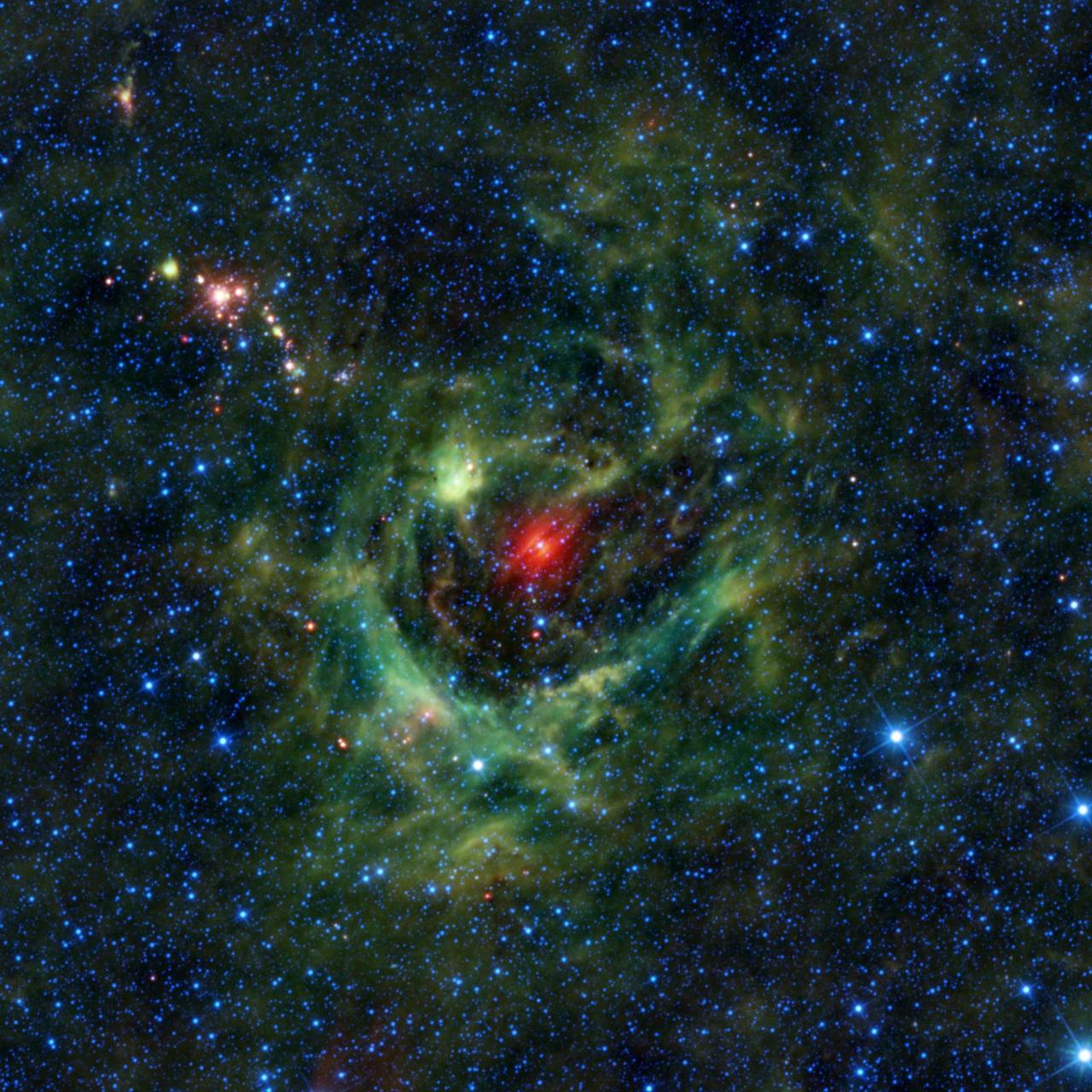
This image from NASA Wide-field Infrared Survey Explorer, or WISE, features a region of star birth wrapped in a blanket of dust, colored green in this infrared view.

Looking like a colorful holiday card, a new image from NASA Hubble Space Telescope reveals a vibrant green and red nebula far from Earth.
![The images indicate that the bubble of gas that makes up the supernova remnant appears different in various types of light. Chandra reveals the hottest gas [colored blue and colored green], which radiates in X-rays. http://photojournal.jpl.nasa.gov/catalog/PIA06908](https://images-assets.nasa.gov/image/PIA06908/PIA06908~medium.jpg)
The images indicate that the bubble of gas that makes up the supernova remnant appears different in various types of light. Chandra reveals the hottest gas [colored blue and colored green], which radiates in X-rays. http://photojournal.jpl.nasa.gov/catalog/PIA06908
This image of Jupiter moon Io and its surrounding sky is shown in false color. This image was taken on Nov. 9, 1996 through the green-yellow filter of the solid state imaging CCD system aboard NASA Galileo spacecraft.
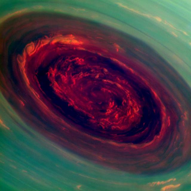
The spinning vortex of Saturn north polar storm resembles a deep red rose of giant proportions surrounded by green foliage in this false-color image from NASA Cassini spacecraft.
Color composite of condensate clouds over Tharsis made from red and blue images with a synthesized green channel. Mars Orbiter Camera wide angle frames from Orbit 48. http://photojournal.jpl.nasa.gov/catalog/PIA00812
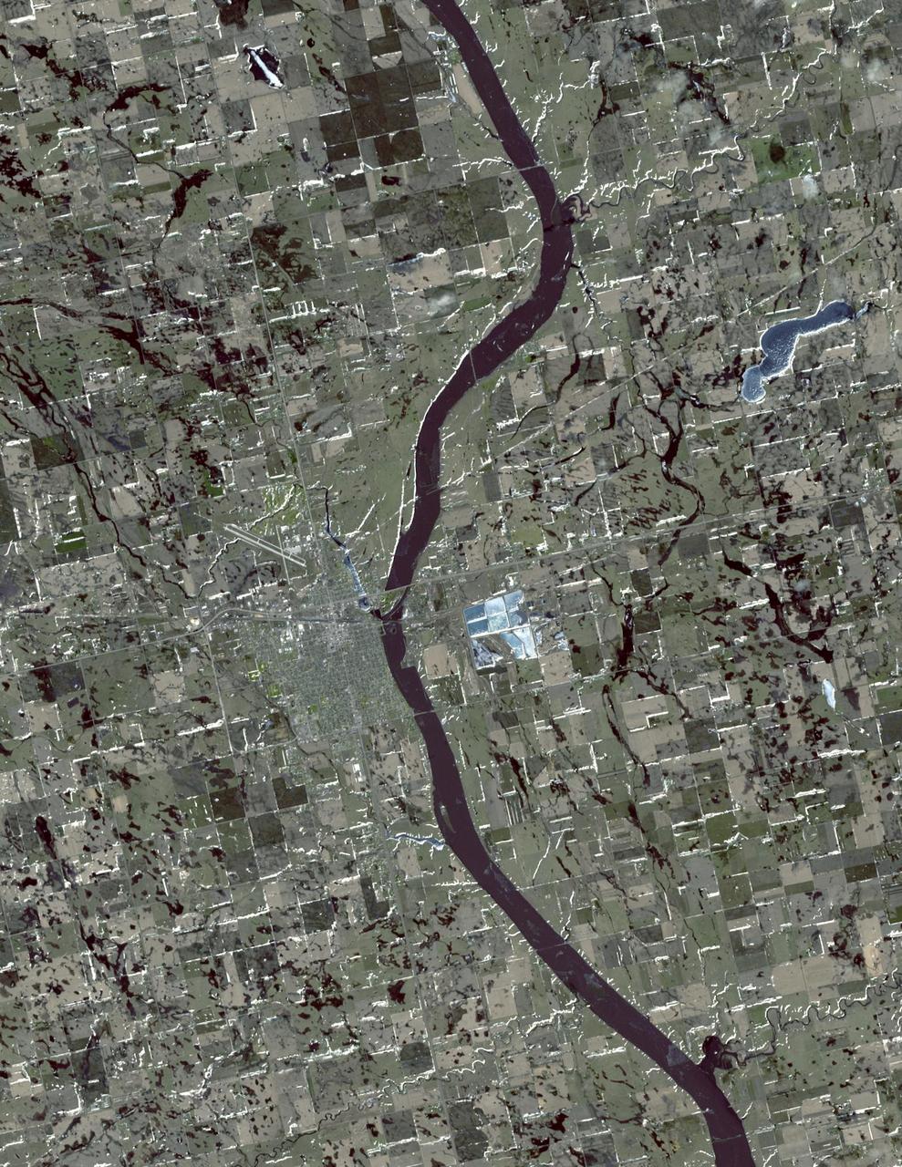
In this simulated natural color image of Huron, South Dakota, captured by NASA Terra spacecraft on March 20, 2010, frozen lakes and ponds appear blue, bare fields are tan, and fields with minor vegetation are gray-green.
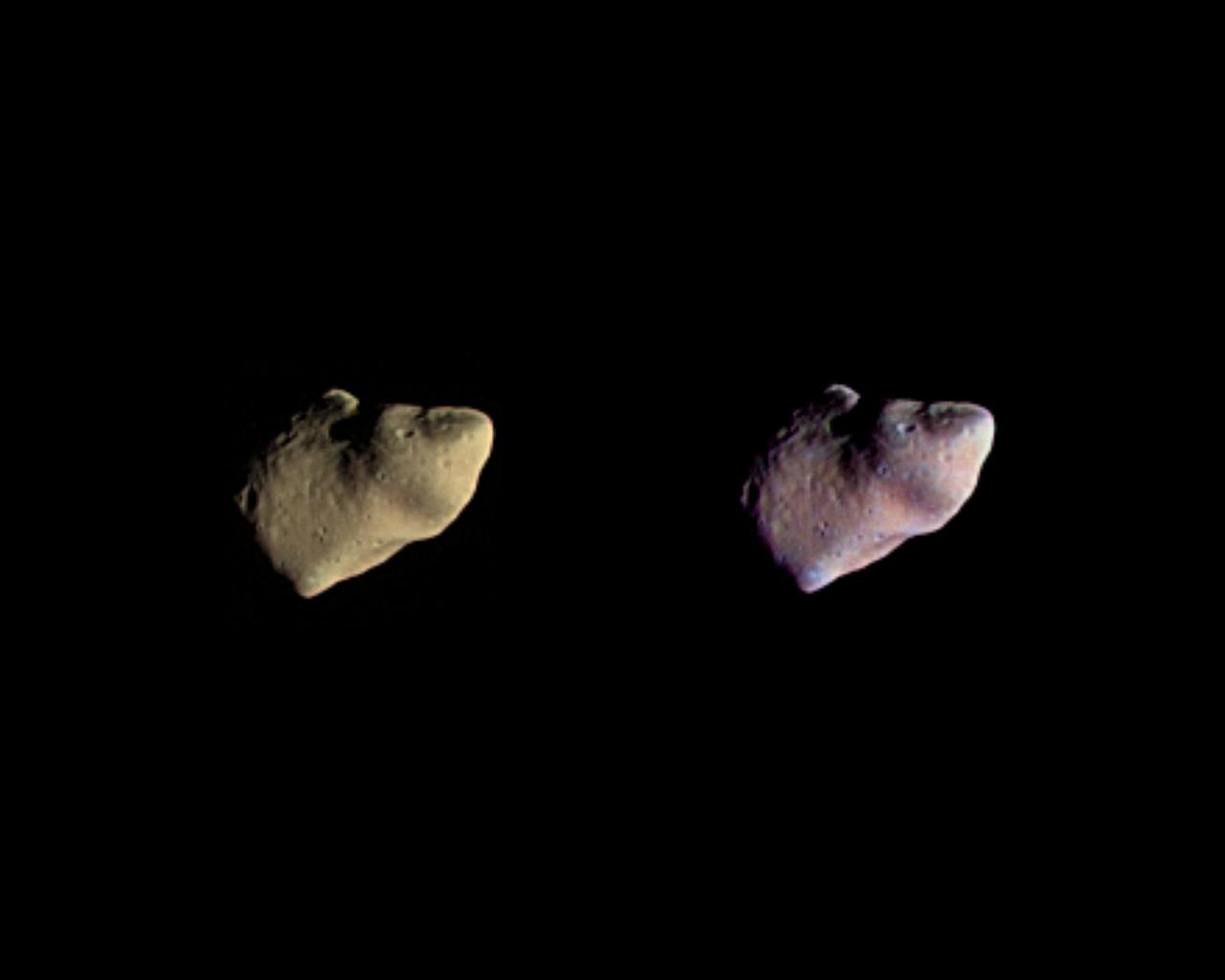
These two color views of the asteroid Gaspra were produced by combining three images taken through violet, green, and infrared filters by NASA's Galileo spacecraft on October 29, 1991. http://photojournal.jpl.nasa.gov/catalog/PIA00125
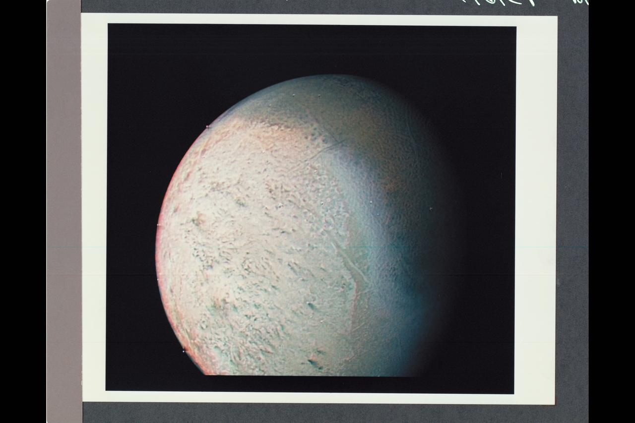
This color image from NASA Voyager 2 was reconstructed by making a computer composite of three black and white images taken through red, green, and blue filters. Details on Triton surface unfold dramatically in this sequence of approach images. http://photojournal.jpl.nasa.gov/catalog/PIA00329
Color has been added to highlight minerals in this image of Jezero Crater on Mars, the landing site for NASA's Mars 2020 mission. The green color represents minerals called carbonates, which are especially good at preserving fossilized life on Earth. Red represents olivine sand eroding out of carbonate-containing rocks. The image was created using data taken by NASA's Mars Reconnaissance Orbiter and its Compact Reconnaissance Imaging Spectrometer for Mars (CRISM) and Context Camera (CTX). https://photojournal.jpl.nasa.gov/catalog/PIA23380
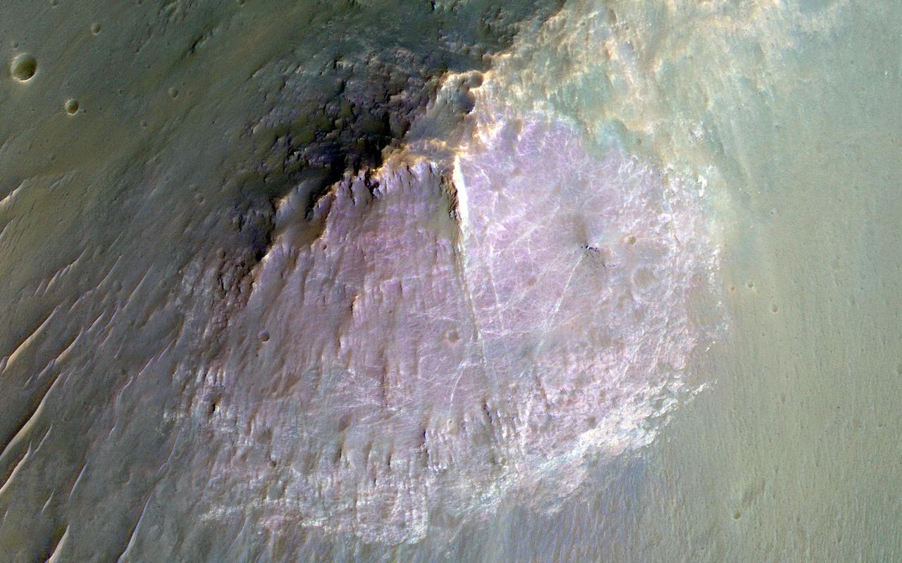
NASA Mars Reconnaissance Orbite observed this image of an isolated mountain in the Southern highlands reveals a large exposure of purplish bedrock. Since HiRISE color is shifted to longer wavelengths than visible color and given relative stretches, this really means that the bedrock is roughly dark in the broad red bandpass image compared to the blue-green and near-infrared bandpass images. In the RGB (red-green-blue) color image, which excludes the near-infrared bandpass image, the bedrock appears bluish in color. This small mountain is located near the northeastern rim of the giant Hellas impact basin, and could be impact ejecta. http://photojournal.jpl.nasa.gov/catalog/PIA19854
This false color image of Triton is a composite of images taken through the violet, green and ultraviolet filters. The image was taken early on Aug. 25, 1989 when Voyager 2 was about 190,000 kilometers 118,000 miles from Triton surface.
This image shows an outflow of gas from a new star as it jets from a space object dubbed IRAS 21078+5211. The reddish blob in its center, as picked up by NASA Spitzer Space Telescope contrasts nicely with the clouds, colored green, that surround it.

ISS048e056981 (0813/2016) --- Sparkling aurora colors of magenta and green color the sky's while the International Space Station orbits above the planet every 90 minutes. SpaceX’s Dragon resupply vehicle is seen docked to the Earth-facing port of the Harmony module.
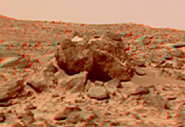
This view of the "Hippo," 25 meters to the west of the lander, was produced by combining the "Super Panorama" frames from the IMP camera. Super resolution was applied to help to address questions about the texture of this rock and what it might tell us about its mode of origin. The composite color frames that make up this anaglyph were produced for both the right and left eye of the IMP. These composites consist of more than 15 frames per eye (because multiple sequences covered the same area), taken with different color filters that were enlarged by 500% and then co-added using Adobe Photoshop to produce, in effect, a super-resolution panchromatic frame that is sharper than an individual frame would be. These panchromatic frames were then colorized with the red, green, and blue filtered images from the same sequence. The color balance was adjusted to approximate the true color of Mars. The anaglyph view was produced by combining the left with the right eye color composite frames by assigning the left eye composite view to the red color plane and the right eye composite view to the green and blue color planes (cyan), to produce a stereo anaglyph mosaic. This mosaic can be viewed in 3-D on your computer monitor or in color print form by wearing red-blue 3-D glasses. http://photojournal.jpl.nasa.gov/catalog/PIA01421
This image shows a crater on the floor of Eos Chasma, part of the Valles Marineris canyon system. Craters on Mars are useful for geologists because they provide cross-sections into the subsurface. The south wall of this crater shows evidence of several different types of rock, with diverse colors. In the black and white parts of the image, it appears that there are two types of rock: one relatively light and one dark. However, in the 1.1 kilometer-wide color swath we can see that the dark rocks are more complicated, as some have a greenish tint and others are purple. Note that these are not the colors your eyes would see if you were there! In enhanced color, the HiRISE near-infrared data appears as red, the red is shown as green, and the blue-green data is shown as blue, allowing us to see more information at once. https://photojournal.jpl.nasa.gov/catalog/PIA25182
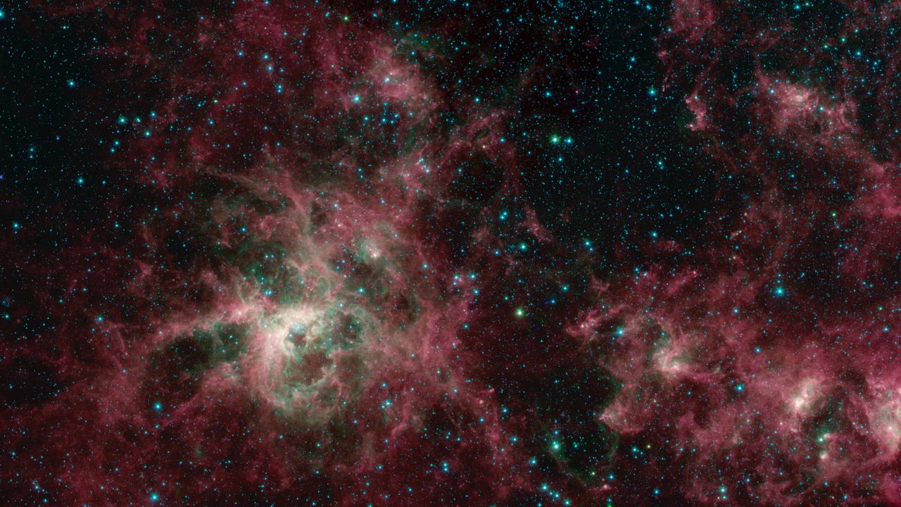
This image from NASA's Spitzer Space Telescope shows the Tarantula Nebula in three wavelengths of infrared light, each represented by a different color. The magenta-colored regions are dust composed of molecules called polycyclic aromatic hydrocarbons (PAHs), which are also found in ash from coal, wood and oil fires on Earth. PAHs emit in multiple wavelengths. The PAHs emit in multiple wavelengths, so the magenta color is a combination of red (corresponding to an infrared wavelength of 8 micrometers) and blue (3.6 micrometers). The green color in this image shows the presence of particularly hot gas emitting infrared light at a wavelength of 4.5 micrometers. The stars in the image are mostly a combination of green and blue. White hues indicate regions that radiate in all three wavelengths. https://photojournal.jpl.nasa.gov/catalog/PIA23647

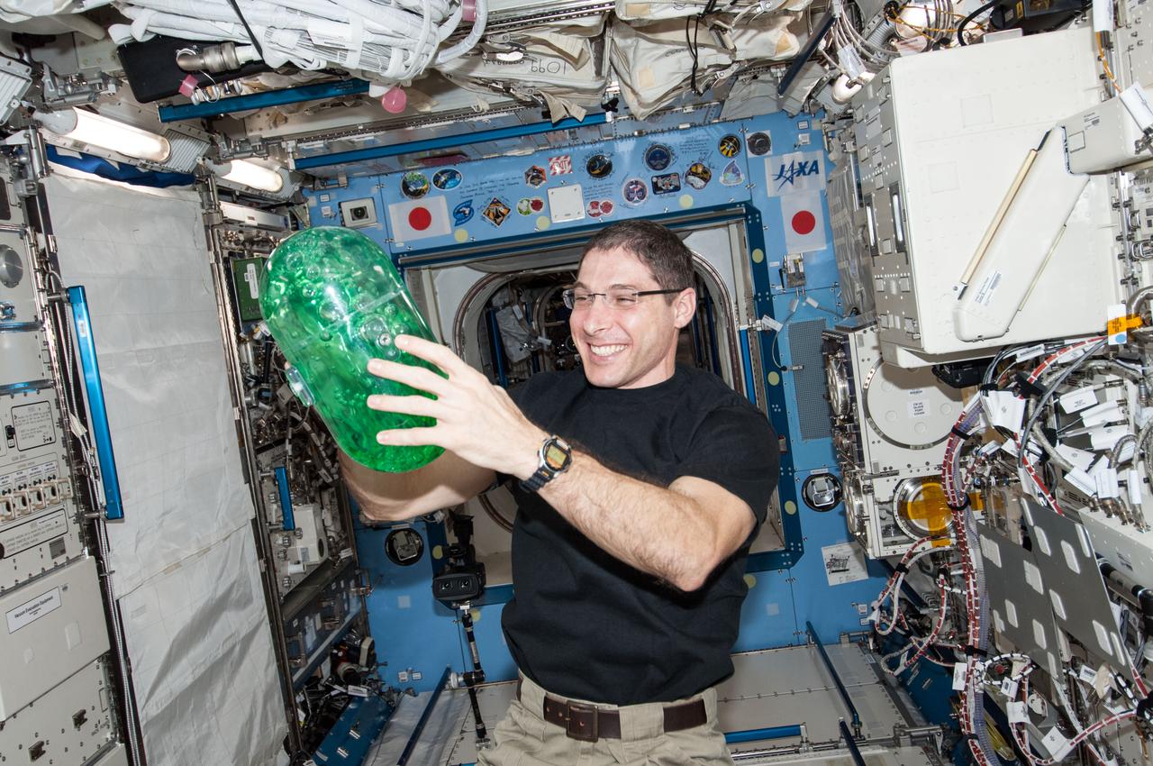
iss068e051617 (Feb. 12, 2023) --- Roscosmos cosmonaut and Expedition 68 Flight Engineer Anna Kikina plays with a sphere of water flying in microgravity that has been dyed with green food coloring and is bubbling due to an antacid that was placed inside.
iss068e051621 (Feb. 12, 2023) --- NASA astronaut and Expedition 68 Flight Engineer Josh Cassada plays with a sphere of water flying in microgravity that has been dyed with green food coloring and is bubbling due to an antacid that was placed inside.
4.17 million miles (2.59 million miles) Resolution : 40 km. (25mi.) P-29498C This false color, Voyager 2 composite view of all nine of Uranian rings was made from six 15 second exposures through the narrow angle camera. The special computer processing used to extract color information from the extremely dark and faint rings, causing the even fainter, pastel lines seen between the rings. Two images, each in the green, clear, & violet filters, were added together and averaged to find the proper color difference between the rings. the final image was made from these three color averages and represents an enhanced, false color view. The image shows that the brightest, or Epsilon ring, at top ,is neutral in color, with the fainter eight other rings showing color differences between them. moving down, toward, Uranus, we see the Delta, Gamma, & Eta rings in shades of blue and green; the Beta & Alpha rings in somewhat lighter tones; and then finally, a set of three, known simply as 4, 5, & 6 rings, in faint off-white tones. Scientists will use this color information to try to understand the nature and origin of the ring material.
ISS038-E-033884 (22 Jan. 2014) --- In the International Space Station's Kibo laboratory, NASA astronaut Mike Hopkins, Expedition 38 flight engineer, holds a plastic container partially filled with green-colored water which will be used in a new experiment using the soccer-ball-sized, free-flying satellites known as Synchronized Position Hold, Engage, Reorient, Experimental Satellites, or SPHERES, which are already on the station. For the SPHERES-Slosh experiment, two SPHERES robots are attached to opposite ends of a metal frame holding the plastic tank with the green-colored water. The new hardware for the SPHERES-Slosh study was delivered to the station aboard Orbital Sciences' Cygnus cargo craft on Jan. 12.
Some regions of Mars are not very colorful, but we can be surprised by local features. This image of an impact crater in the south Syrtis Major region was acquired as a "ride-along" with a CRISM observation, which targeted this location because that instrument's team expected a distinct composition. Our enhanced image reveals colors ranging from red to green to blue. These are infra-red shifted colors (infrared-red-blue) so it's different than what we would see with our eyes. https://photojournal.jpl.nasa.gov/catalog/PIA22727
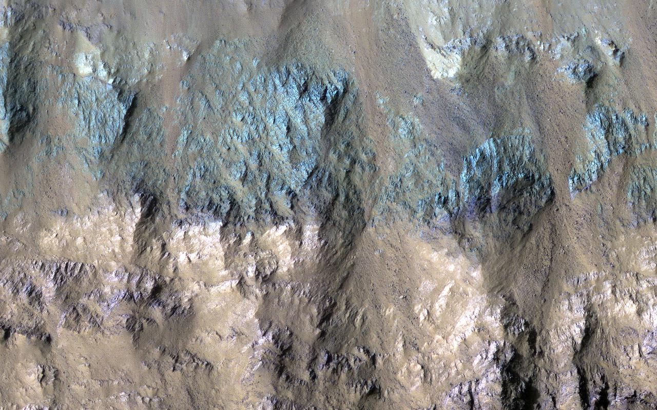
This image samples the excellent bedrock exposures north of Terby Crater, which lies on the northern rim of the giant Hellas basin. An enhanced-color cutout shows a sample of this bedrock, which has a variety of colors and textures. The warm-colored bedrock probably contains hydrated minerals such as clays, whereas the blue-green bedrock is dominated by unaltered mafic minerals. These may be some of the oldest rocks exposed at the Martian surface. Such ancient rocks are extremely rare on Earth. http://photojournal.jpl.nasa.gov/catalog/PIA20737
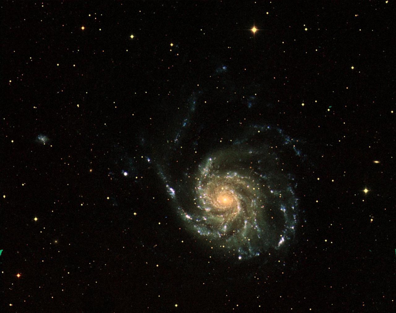
This three-color image of galaxy M101 was taken by NASA's Galaxy Evolution Explorer on June 20, 2003. The far ultraviolet emissions are shown in blue, the near ultraviolet emissions are green, and the red emissions, which were taken from NASA's Digital Sky Survey, represent visible light. This image combines short, medium, and long "exposure" pictures to best display the evolution of star formation in a spiral galaxy. http://photojournal.jpl.nasa.gov/catalog/PIA04630
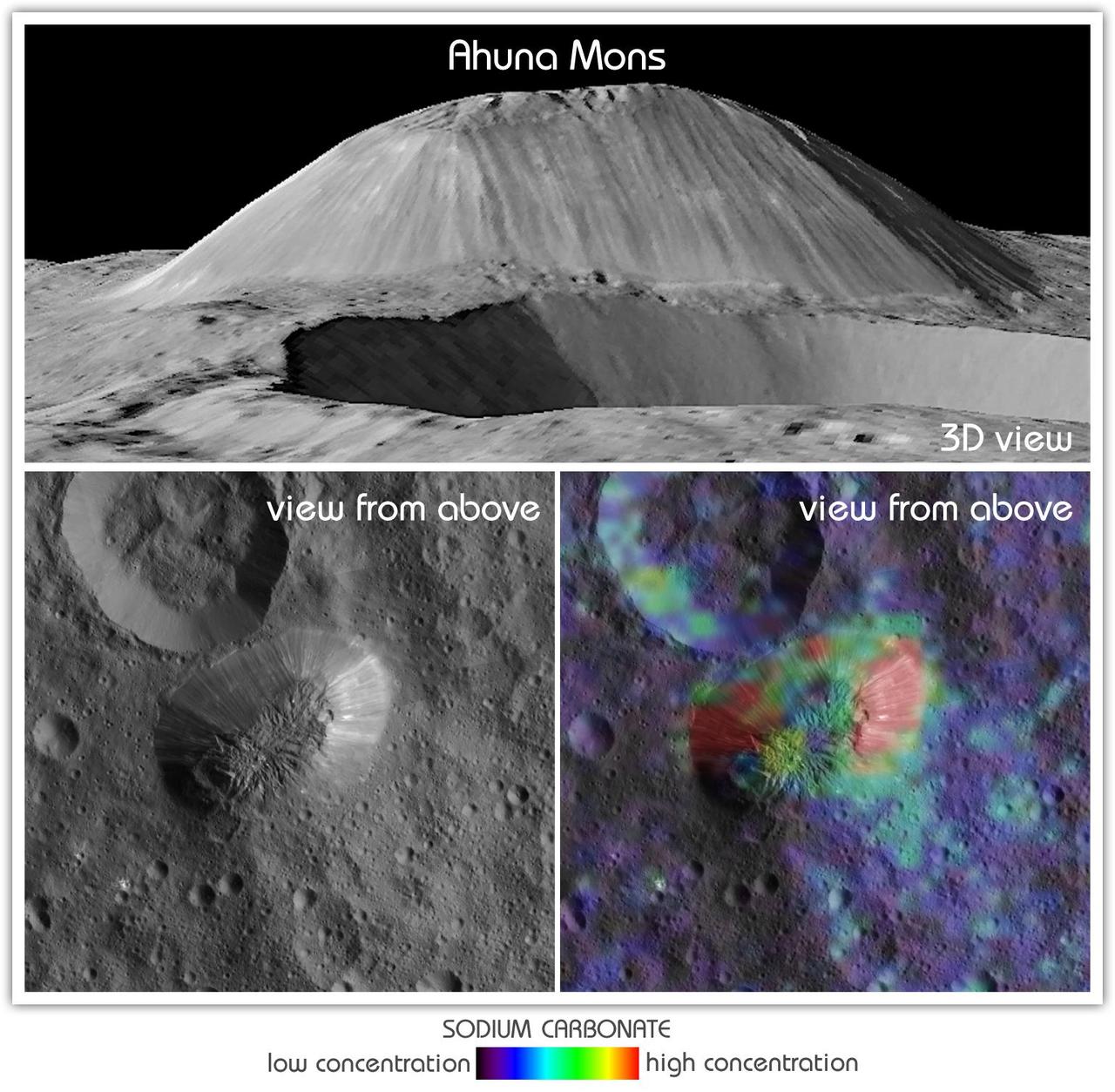
This view from NASA's Dawn mission shows Ceres' tallest mountain, Ahuna Mons, 2.5 miles (4 kilometers) high and 11 miles (17 kilometers) wide. This is one of the few sites on Ceres at which a significant amount of sodium carbonate has been found, shown in green and red colors in the lower right image. The top and lower left images were collected by Dawn's framing camera. The top image is a 3D view reconstructed with the help of topography data. A non-annotated version is available at https://photojournal.jpl.nasa.gov/catalog/PIA21919
This enhanced color composite image from Dawn's visible and infrared mapping spectrometer shows the area around Ernutet Crater on Ceres. The instrument detected the evidence of organic materials in this area, as reported in a 2017 study in the journal Science. In this view, areas that appear pink with respect to the background appear to be rich in organics, and green areas are where organic material appears to be less abundant. Light with a wavelength of 2000 nanometers is shown in blue, 3400 nanometers is shown in green and 1700 nanometers is shown in red. http://photojournal.jpl.nasa.gov/catalog/PIA21420
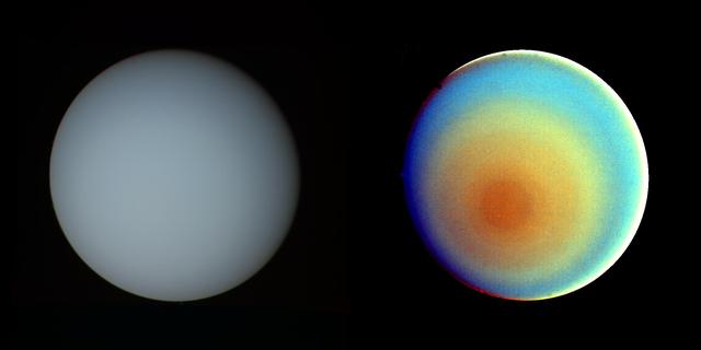
These two pictures of Uranus -- one in true color (left) and the other in false color -- were compiled from images returned Jan. 17, 1986, by the narrow-angle camera of Voyager 2. The spacecraft was 9.1 million kilometers (5.7 million miles) from the planet, several days from closest approach. The picture at left has been processed to show Uranus as human eyes would see it from the vantage point of the spacecraft. The picture is a composite of images taken through blue, green and orange filters. The darker shadings at the upper right of the disk correspond to the day-night boundary on the planet. Beyond this boundary lies the hidden northern hemisphere of Uranus, which currently remains in total darkness as the planet rotates. The blue-green color results from the absorption of red light by methane gas in Uranus' deep, cold and remarkably clear atmosphere. The picture at right uses false color and extreme contrast enhancement to bring out subtle details in the polar region of Uranus. Images obtained through ultraviolet, violet and orange filters were respectively converted to the same blue, green and red colors used to produce the picture at left. The very slight contrasts visible in true color are greatly exaggerated here. In this false-color picture, Uranus reveals a dark polar hood surrounded by a series of progressively lighter concentric bands. One possible explanation is that a brownish haze or smog, concentrated over the pole, is arranged into bands by zonal motions of the upper atmosphere. The bright orange and yellow strip at the lower edge of the planet's limb is an artifact of the image enhancement. In fact, the limb is dark and uniform in color around the planet. http://photojournal.jpl.nasa.gov/catalog/PIA00032

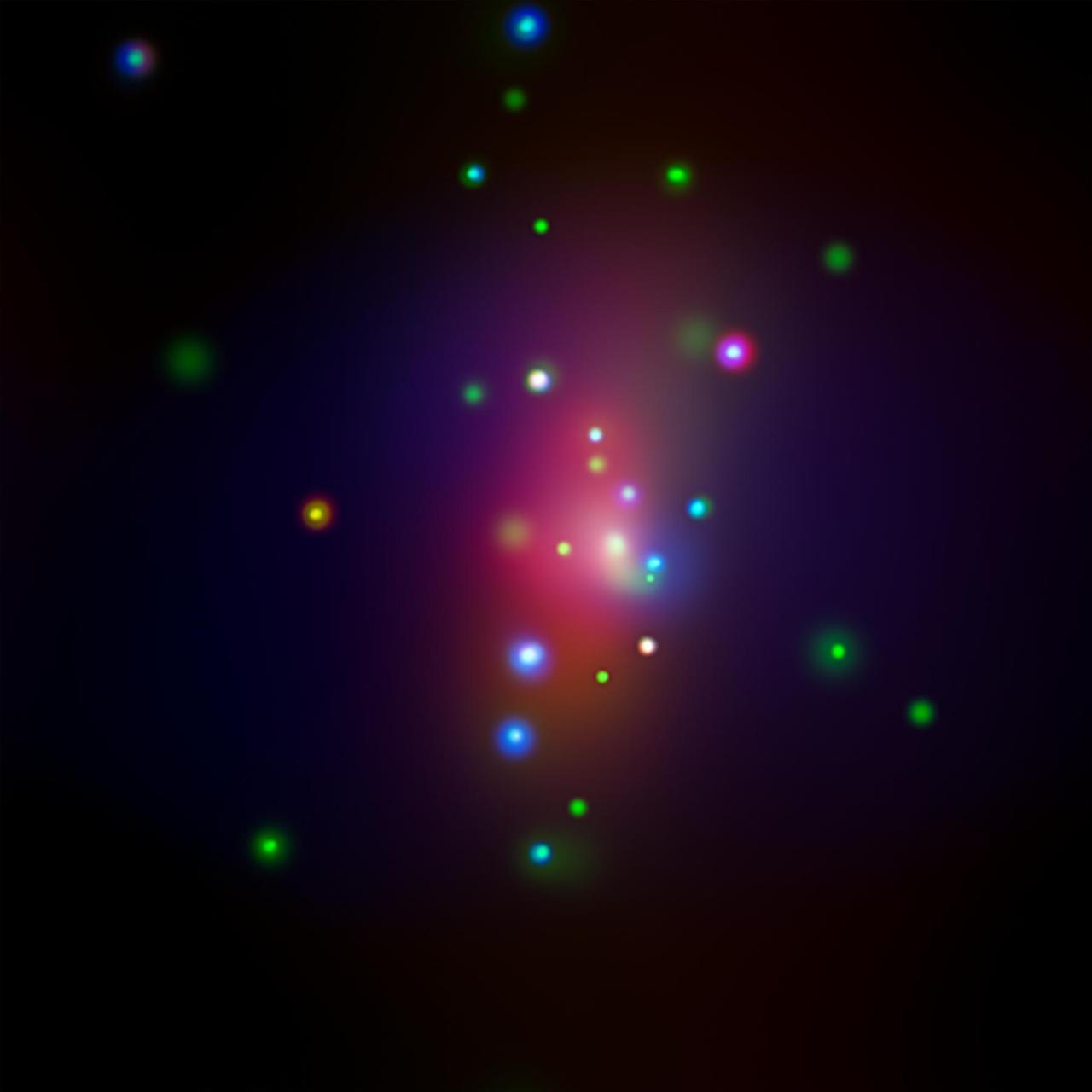
Astronomers combined observations from three different observatories (Atacama Large Millimeter/submillimeter Array, red; Hubble, green; Chandra X-ray Observatory, blue) to produce this colorful, multiwavelength image of the intricate remains of Supernova 1987A. Credits: NASA, ESA, and A. Angelich (NRAO/AUI/NSF)
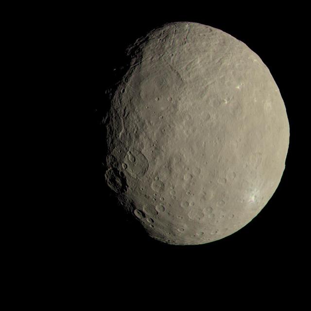
This image of Ceres approximates how the dwarf planet's colors would appear to the eye. This view of Ceres, produced by the German Aerospace Center in Berlin, combines images taken during Dawn's first science orbit in 2015 using the framing camera's red, green and blue spectral filters. The color was calculated using a reflectance spectrum, which is based on the way that Ceres reflects different wavelengths of light and the solar wavelengths that illuminate Ceres. http://photojournal.jpl.nasa.gov/catalog/PIA21079
This image from NASA's Chandra X-ray Observatory shows spiral galaxy NGC 7331, center, in a three-color X-ray image. Red, green and blue colors are used for low, medium and high-energy X-rays, respectively. An unusual supernova called SN 2014C has been spotted in this galaxy. http://photojournal.jpl.nasa.gov/catalog/PIA21089
This image captures some of the geologic diversity of Mars. There are hills of ancient terrains on the floor of Juventae Chasma, surrounded by younger sediments, including dark sand sheets and dunes that are likely active today. The hills are heavily eroded by landslides, forming gullies in some places. Diverse colors represent unaltered volcanic minerals (blue and green) and altered minerals (brighter and reddish colors). https://photojournal.jpl.nasa.gov/catalog/PIA23104
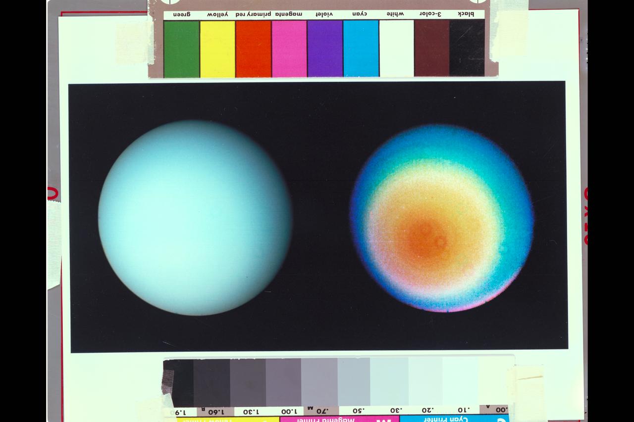
Range : 9.1 million miles (5.7 million miles) P-29478C These two images pictures of Uranus, one in true color and the other in false color, were shot by Voyager 2's narrow angle camera. The picture at left has been processed to show Uranus as the human eye would see from the vantage point of the spacecraft. The image is a composite of shots taken through blue, green, and orange filters. The darker shadings on the upper right of the disk correspond to day-night boundaries on the planet. Beyond this boundary lies the hidden northern hemisphere of Uranus, which currently remains in total darkness as the planet rotates. The blue-green color results from the aborption of red light by methane gas in Uranus' deep, cold, and remarkably clear atmosphere. The picture at right uses false color and extreme contrast to bring out subtle details in the polar region of Uranus. Images obtained through ultraviolet, violet, and orange filters were respectively converted to the same blue, green, and red colors used to produce the picture at left. The very slight contrasts visible in true color are greatly exaggerated here. In this false colr picture, Uranus reveals a dark polar hood surrounded by aseries of progressively lighter concentric bands. One possible explanation is that a brownish haze or smog, concentrated around the pole, is arranged into bands of zonal motions of the upper atmosphere. Several artifacts of the optics and processing are visible. The occasional donut shapes are shadows cast by dust in the camera optics;the processing needed to bring ot faint features also bring out camera blemishes. in addition, the bright pink strip at the lower edge of the planets limb is an artifact of the image enhancement. In fact, the limb is dark and uniform in color around the planet.
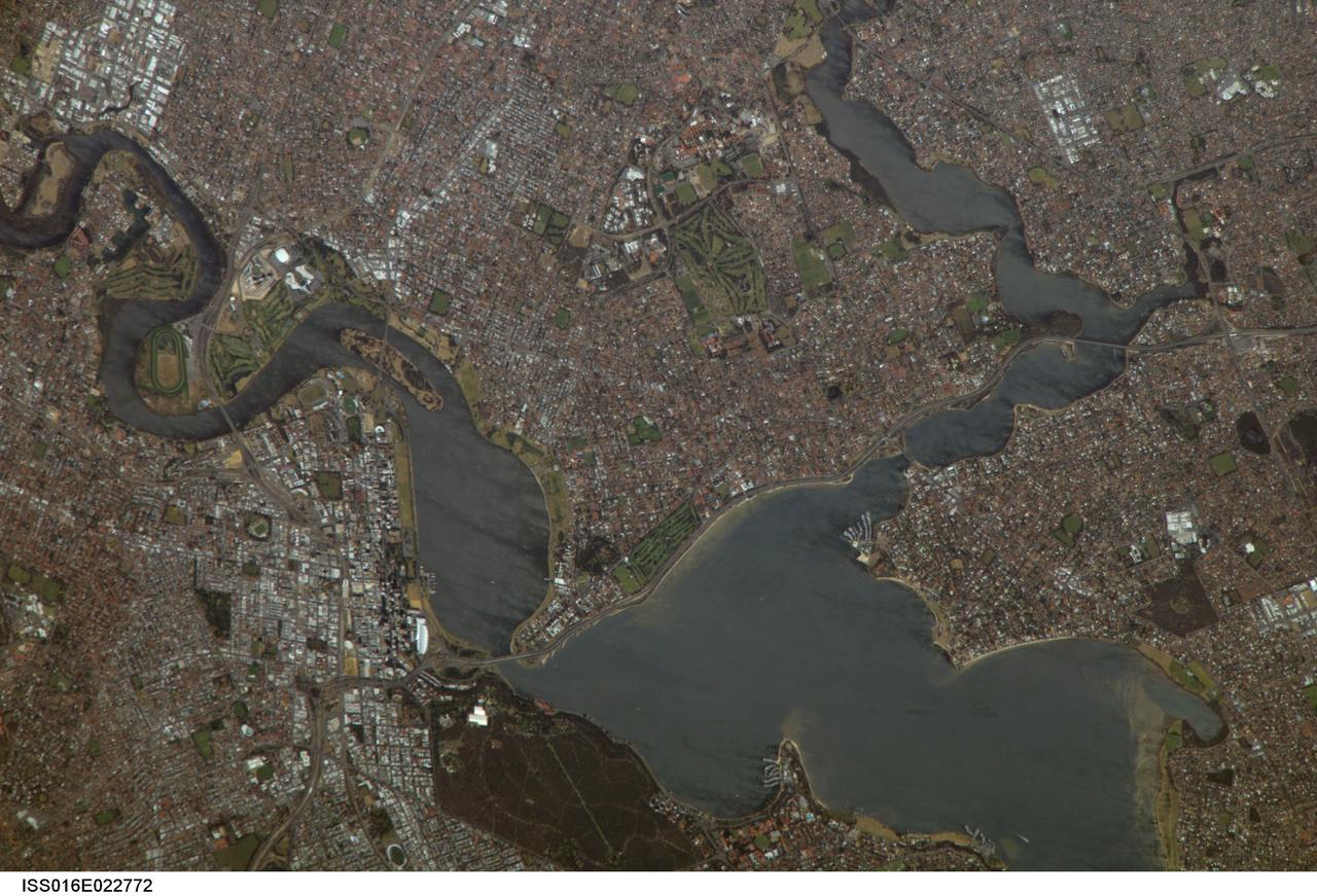
ISS016-E-022772 (11 Jan. 2008) --- Perth, Australia is featured in this image photographed by an Expedition 16 crewmember on the International Space Station (ISS). Perth is the capital of the state of Western Australia, and the largest city of the southwestern continent of Australia with an estimated population of over 1.5 million (December 2006). The downtown area of Perth and the surrounding suburbs are located on flood plain deposits of the Swan and Canning Rivers that flow through the center of the metropolitan area. Perth enjoys a Mediterranean climate, where the summers are hot and dry and winters are cool and moist. Wildfires can develop during the summer months; several large fires threatened the eastern portion of the metropolitan area in 2005. This view captures variations in urban land cover in the visible wavelengths to which the human eye is sensitive (visible red, green, and blue). The downtown center of Perth at left is characterized by large buildings (such as skyscrapers) with white reflective rooftops. Suburbs to the south (across the Swan River) are characterized by higher density of small buildings with predominantly reddish-purple roofs. Several areas of green vegetation are visible in the image. Parks and golf courses comprised mainly of grass present an even green coloration, while the dense tree canopy of Kings Park appears dark green. Variations in the coloration of the Swan and Canning Rivers is due to sunglint, or light reflected off the water surface back to the observer (in this case, a crewmember onboard the ISS).
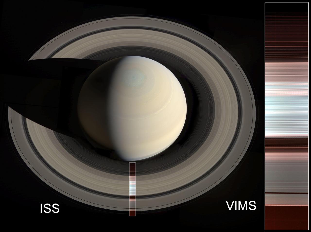
The false-color image at right shows spectral mapping of Saturn's A, B and C rings, captured by Cassini's Visible and Infrared Mapping Spectrometer (VIMS). It displays an infrared view of the rings, rather than an image in visible light. The blue-green areas are the regions with the purest water ice and/or largest grain size (primarily the A and B rings), while the reddish color indicates increasing amounts of non-icy material and/or smaller grain sizes (primarily in the C ring and Cassini Division). At left, the same image is overlaid on a natural-color mosaic of Saturn taken by Cassini's Imaging Science Subsystem. https://photojournal.jpl.nasa.gov/catalog/PIA23170
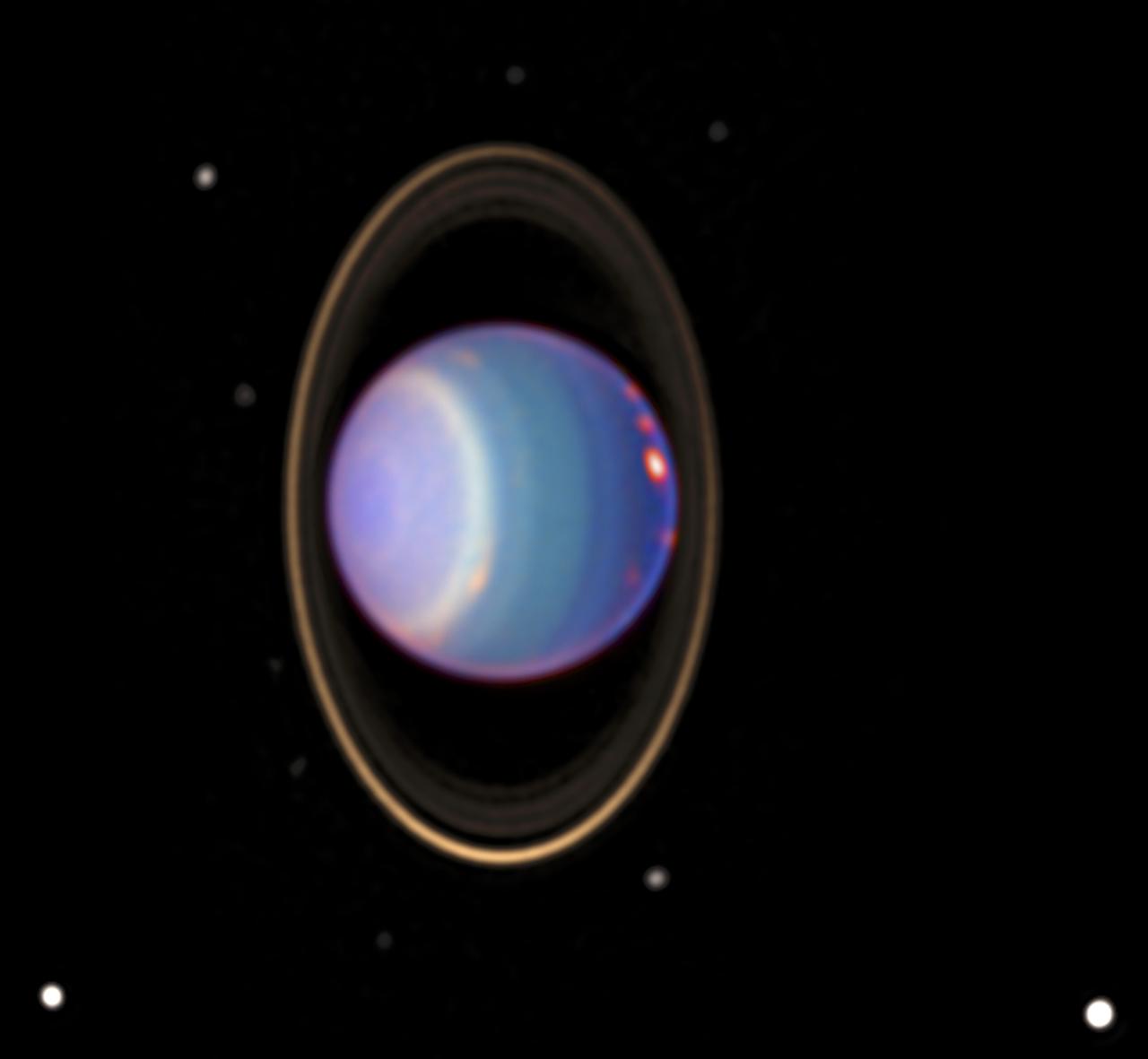
A recent Hubble Space Telescope (HST) view reveals Uranus surrounded by its 4 major rings and 10 of its 17 known satellites. This false color image was generated by Erich Karoschka using data taken with Hubble's Near Infrared Camera and Multi-Object Spectrometer. The HST recently found about 20 clouds. The colors in the image indicate altitude. The green and blue regions show where the atmosphere is clear and can be penetrated by sunlight. In yellow and grey regions, the sunlight reflects from a higher haze or cloud layer. The orange and red colors indicate very high clouds, such as cirrus clouds on Earth.
Range : 530,000 km (330,000 mi.) This color photo of Neptune's large satellite Triton has a resolution of about 10 km (6.2 mi), sufficient to begin to show topographic detail. The image was made from pictures taken through the green, violet and ultraviolet filters. In this technique, regions that are highly reflective in the ultraviolet appear blue in color. In reality, there is no part of Triton that would appear blue to the eye. The bright southern hemisphere of Triton, which fills most of this frame, is generally pink in tone as is the even brighter equatorial band. The darker regions north of the equator also tend to be pink or reddish in color.
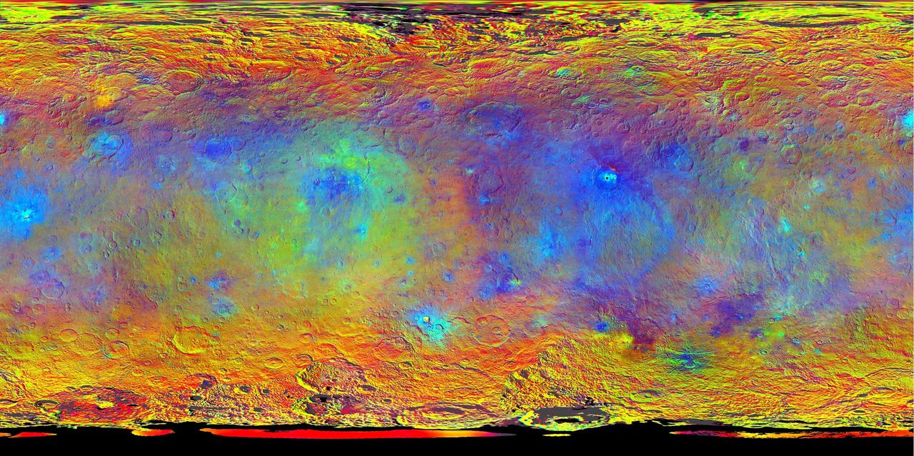
This map-projected view of Ceres was created from images taken by NASA's Dawn spacecraft during its high-altitude mapping orbit, in August and September, 2015. Images taken using infrared (920 nanometers), red (750 nanometers) and blue (440 nanometers) spectral filters were combined to create this false-color view. Redder colors indicate places on Ceres' surface that reflect light strongly in the infrared, while bluish colors indicate enhanced reflectivity at short (bluer) wavelengths; green indicates places where albedo, or overall brightness, is strongly enhanced. Scientists use this technique in order to highlight subtle color differences across Ceres, which would appear fairly uniform in natural color. This can provide valuable insights into the mineral composition of the surface, as well as the relative ages of surface features. http://photojournal.jpl.nasa.gov/catalog/PIA19977
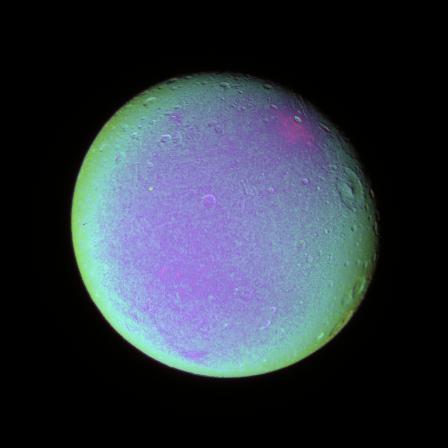
The leading hemisphere of Dione displays subtle variations in color across its surface in this false color view. To create this view, ultraviolet, green and infrared images were combined into a single black and white picture that isolates and maps regional color differences. This "color map" was then superposed over a clear-filter image. The origin of the color differences is not yet understood, but may be caused by subtle differences in the surface composition or the sizes of grains making up the icy soil. Terrain visible here is on the moon's leading hemisphere. North on Dione (1,126 kilometers, or 700 miles across) is up and rotated 17 degrees to the right. All images were acquired with the Cassini spacecraft narrow-angle camera on Dec. 24, 2005 at a distance of approximately 597,000 kilometers (371,000 miles) from Dione and at a Sun-Dione-spacecraft, or phase, angle of 21 degrees. Image scale is 4 kilometers (2 miles) per pixel. http://photojournal.jpl.nasa.gov/catalog/PIA07688

"Barnacle Bill" is a small rock immediately west-northwest of the Mars Pathfinder lander and was the first rock visited by the Sojourner Rover's alpha proton X-ray spectrometer (APXS) instrument. This image shows super resolution techniques applied to the first APXS target rock, which was never imaged with the rover's forward cameras. Super resolution was applied to help to address questions about the texture of this rock and what it might tell us about its mode of origin. This view of Barnacle Bill was produced by combining the "Super Panorama" frames from the IMP camera. Super resolution was applied to help to address questions about the texture of these rocks and what it might tell us about their mode of origin. The composite color frames that make up this anaglyph were produced for both the right and left eye of the IMP. The composites consist of 7 frames in the right eye and 8 frames in the left eye, taken with different color filters that were enlarged by 500% and then co-added using Adobe Photoshop to produce, in effect, a super-resolution panchromatic frame that is sharper than an individual frame would be. These panchromatic frames were then colorized with the red, green, and blue filtered images from the same sequence. The color balance was adjusted to approximate the true color of Mars. The anaglyph view was produced by combining the left with the right eye color composite frames by assigning the left eye composite view to the red color plane and the right eye composite view to the green and blue color planes (cyan), to produce a stereo anaglyph mosaic. This mosaic can be viewed in 3-D on your computer monitor or in color print form by wearing red-blue 3-D glasses. http://photojournal.jpl.nasa.gov/catalog/PIA01409
Range : 5.4 million km (3.3 million miles) Features as small as 100 km (62 miles) across can be seen in this color image of Neptune's satellite Triton, photographed by Voyager 2. Triton's overall pinkish color may be due to reddish materials produced by irradiation of methane gas and ice on the satellite. The dark areas near the top of the image seem to be part of a belt of dark markings observed near Trition's equator at different longitudes. Generally, darker areas on Triton appear to be somewhat redder in color than brighter areas. The central longitude in the image is 123 degrees. Here the south pole is at about 6 o'clock, approximately 1/6th of the way up from the bottom. The color image was made from three black-and-white frames, taken through clear, violet and green filters.
In this enhanced color view from NASA MESSENGER spacecraft of the peak-ring basin Derain, the different colors accentuate the different rocks associated with the basin. The smooth, interior volcanic fill of the basin, in addition to the large pits on the floor of Derain, are brighter and redder. This view was created by draping a color composite from the MDIS Wide Angle Camera (WAC) over an MDIS monochrome Narrow Angle Camera (NAC) image mosaic. The WAC enhanced color image was created with the following image channels: red = Principal Component 2, green = Principal Component 1, and blue = 430 nm to 1000 nm band ratio. Instrument: Mercury Dual Imaging System (MDIS) Latitude: -9.0° Longitude: 17.3° E Scale: Derain peak-ring basin has a diameter of 167 km (104 miles) http://photojournal.jpl.nasa.gov/catalog/PIA19412
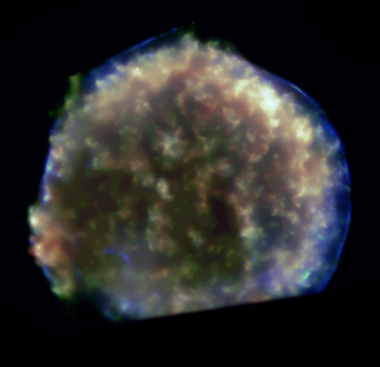
This Chandra image reveals, in detail, the turbulent debris created by a supernova explosion that was observed by the Danish Astronomer Tycho Brahe in the year 1572. The colors show different x-ray energies, with red, green, and blue representing low, medium, and high energies, respectively. Most likely caused by the destruction of a white dwarf star, a shock wave produced by the expanding debris is outlined by the sharp blue circular arcs of 20 million degree Celsius gas seen on the outer rim. The stellar debris, visible only by x-ray, has a temperature of about 10 million degrees, and shows up as mottled yellow, green, and red fingers of gas.
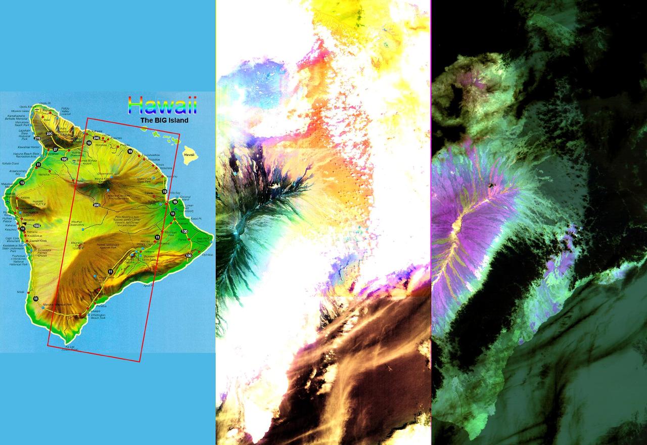
These images of the Island of Hawaii were acquired on March 19, 2000 by the Advanced Spaceborne Thermal Emission and Reflection Radiometer (ASTER) on NASA's Terra satellite. With its 14 spectral bands from the visible to the thermal infrared wavelength region, and its high spatial resolution of 15 to 90 meters (about 50 to 300 feet), ASTER will image Earth for the next 6 years to map and monitor the changing surface of our planet. Data are shown from the short wavelength and thermal infrared spectral regions, illustrating how different and complementary information is contained in different parts of the spectrum. Left image: This false-color image covers an area 60 kilometers (37 miles) wide and 120 kilometers (75 miles) long in three bands of the short wavelength infrared region. While, much of the island was covered in clouds, the dominant central Mauna Loa volcano, rising to an altitude of 4115 meters (13,500 feet), is cloud-free. Lava flows can be seen radiating from the central crater in green and black tones. As they reach lower elevations, the flows become covered with vegetation, and their image color changes to yellow and orange. Mauna Kea volcano to the north of Mauna Loa has a thin cloud-cover, producing a bluish tone on the image. The ocean in the lower right appears brown due to the color processing. Right image: This image is a false-color composite of three thermal infrared bands. The brightness of the colors is proportional to the temperature, and the hues display differences in rock composition. Clouds are black, because they are the coldest objects in the scene. The ocean and thick vegetation appear dark green because they are colder than bare rock surfaces, and have no thermal spectral features. Lava flows are shades of magenta, green, pink and yellow, reflecting chemical changes due to weathering and relative age differences. http://photojournal.jpl.nasa.gov/catalog/PIA02604
There have been several proposals to send people to Mars but not land them on the surface. Instead, they would either fly by Mars once and return to Earth, or orbit Mars for a period of time. Would they at least get spectacular naked-eye views of the Martian surface? Some parts of Mars would be interesting: for example the polar ice caps, and the bright (dust-covered) regions would be seen reasonably well, although the color is very uniform. The dark (low reflectance) regions of Mars are some of the most interesting and important regions studied by our orbiters and rovers, but they would appear very bland to humans outside of the planet's atmosphere. This is because the thin atmosphere of Mars is quite bright and dusty, so when looking at dark surface areas, most of what you would see is scattered light from the atmospheric dust, and the surface would have a very low contrast. It would also appear reddish, even if the surface materials are not reddish, from the scattered light. Here is an example from the Nili Patera region of Mars, a candidate future landing site. At the top is an approximation of the natural color as seen by people with normal color vision -- almost no surface detail is visible. In the middle is the standard HiRISE IRB color product, consisting of the infrared, red, and blue-green images displayed as red, green, and blue, respectively, and with a min-max stretch applied to each color. In other words, the darkest pixel in the entire image is set to black, the brightest pixel is set to white, and all others are linearly interpolated. At bottom is an enhanced color product, in which each bandpass is given a linear stretch for the local subimage, sometimes saturating a small percentage of data to black or white to give the rest of the scene more contrast, followed by color saturation enhancement. Now we can see a diversity of colors that distinguish different surface units: dust, sand, and rocks with different minerals. http://photojournal.jpl.nasa.gov/catalog/PIA21040
This false color picture of Saturn’s northern hemisphere was assembled from ultraviolet, violet and green images obtained Aug. 19 by Voyager 2 from a range of 7.1 million kilometers (4.4 million miles). The several weather patterns evident include three spots flowing westward at about 15 meters-per-second (33 mph). Although the cloud system associated with the western-most spot is part of this flow, the spot itself moves eastward at about 30 meters-per-second (65 mph). Their joint flow shows the anti-cyclonic rotation of the spot, which is about 3,000 km. (1,900 mi.) in diameter. The ribbon- like feature to the north marks a high-speed jet where wind speeds approach 150 meters-per-second (330 mph). http://photojournal.jpl.nasa.gov/catalog/PIA01365
STS058-92-064 (18 Oct-1 Nov 1993) --- This oblique view, looking northeast from central Egypt, shows great expanses of the sand covered and rocky Western Desert in the foreground (bottom). The dark patches bottom right are the Dakhla Oases on the south side of an escarpment. For centuries camel trains have moved from here to the Nile Valley, seen here as a broad green line winding through the desert. The northern half of Egypt's Nile appears here, from about the latitude of Luxor to the delta. Green colors indicate the small area of crops which feed Egypt's population of 55 million. The Nile Delta is partly obscured by a band of clouds, but can be discerned at the coast as a flattened triangle of green. The smaller triangle close by is the Faiyum Basin, a depression irrigated by water from the Nile. The coast of the Mediterranean Sea appears left.
These images of the Saline Valley area, California, were acquired March 30, 2000 and cover a full ASTER scene (60 by 60 km). Each image displays data from a different spectral region, and illustrates the complementary nature of surface compositional information available as a function of wavelength. This image displays visible and near infrared bands 3, 2, and 1 in red, green, and blue (RGB). Vegetation appears red, snow and dry salt lakes are white, and exposed rocks are brown, gray, yellow and blue. Rock colors mainly reflect the presence of iron minerals, and variations in albedo. Figure 1 displays short wavelength infrared bands 4, 6, and 8 as RGB. In this wavelength region, clay, carbonate, and sulfate minerals have diagnostic absorption features, resulting in distinct colors on the image. For example, limestones are yellow-green, and purple areas are kaolinite-rich. Figure 2 displays thermal infrared bands 13, 12 and 10 as RGB. In this wavelength region, variations in quartz content appear as more or less red; carbonate rocks are green, and mafic volcanic rocks are purple. The image is located at 36.8 degrees north latitude and 117.7 degrees west longitude. http://photojournal.jpl.nasa.gov/catalog/PIA11164

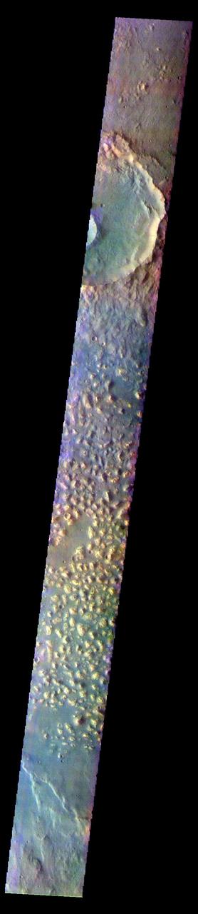
The THEMIS VIS camera contains 5 filters. The data from different filters can be combined in multiple ways to create a false color image. These false color images may reveal subtle variations of the surface not easily identified in a single band image. Today's false color image shows an unnamed crater in Arabia Terra. Arabia Terra is one of the oldest surface regions on Mars and contains a large variety of surface features. The region is dissected with numerous unnamed channels of all sizes and complexities, as well as numerous pits of unknown origin. The blue features on the crater floor are sand dunes, in this false color combination blue indicates basaltic sands. The THEMIS VIS camera is capable of capturing color images of the Martian surface using five different color filters. In this mode of operation, the spatial resolution and coverage of the image must be reduced to accommodate the additional data volume produced from using multiple filters. To make a color image, three of the five filter images (each in grayscale) are selected. Each is contrast enhanced and then converted to a red, green, or blue intensity image. These three images are then combined to produce a full color, single image. Because the THEMIS color filters don't span the full range of colors seen by the human eye, a color THEMIS image does not represent true color. Also, because each single-filter image is contrast enhanced before inclusion in the three-color image, the apparent color variation of the scene is exaggerated. Nevertheless, the color variation that does appear is representative of some change in color, however subtle, in the actual scene. Note that the long edges of THEMIS color images typically contain color artifacts that do not represent surface variation. Orbit Number: 88036 Latitude: -7.46789 Longitude: 356.08 Instrument: VIS Captured: 2021-10-19 04:28 https://photojournal.jpl.nasa.gov/catalog/PIA25385
The THEMIS VIS camera contains 5 filters. The data from different filters can be combined in multiple ways to create a false color image. These false color images may reveal subtle variations of the surface not easily identified in a single band image. Today's false color image shows part of Ariadnes Colles. The term colles means hills or knobs. In this false color combination the hills stand out against the darker surrounding plains. This difference is due to the amount of dust covering the hills versus the plains. The THEMIS VIS camera is capable of capturing color images of the Martian surface using five different color filters. In this mode of operation, the spatial resolution and coverage of the image must be reduced to accommodate the additional data volume produced from using multiple filters. To make a color image, three of the five filter images (each in grayscale) are selected. Each is contrast enhanced and then converted to a red, green, or blue intensity image. These three images are then combined to produce a full color, single image. Because the THEMIS color filters don't span the full range of colors seen by the human eye, a color THEMIS image does not represent true color. Also, because each single-filter image is contrast enhanced before inclusion in the three-color image, the apparent color variation of the scene is exaggerated. Nevertheless, the color variation that does appear is representative of some change in color, however subtle, in the actual scene. Note that the long edges of THEMIS color images typically contain color artifacts that do not represent surface variation. Orbit Number: 92641 Latitude: -34.2832 Longitude: 171.529 Instrument: VIS Captured: 2022-11-02 07:59 https://photojournal.jpl.nasa.gov/catalog/PIA26090
The THEMIS VIS camera contains 5 filters. The data from different filters can be combined in multiple ways to create a false color image. These false color images may reveal subtle variations of the surface not easily identified in a single band image. Today's false color image shows part of Margaritifer Terra just east of Ares Vallis. If you look closely at the bottom of the image, you will see spots of purple and yellow, with similar 'shapes'. These features are not image artifacts. These are clouds. When this image was collected there were high altitude ice clouds being blown across the sky, moving fast enough to reach a different location between the time each filter was collected. Color VIS images are typically the only image type where ice clouds can be identified. The THEMIS VIS camera is capable of capturing color images of the Martian surface using five different color filters. In this mode of operation, the spatial resolution and coverage of the image must be reduced to accommodate the additional data volume produced from using multiple filters. To make a color image, three of the five filter images (each in grayscale) are selected. Each is contrast enhanced and then converted to a red, green, or blue intensity image. These three images are then combined to produce a full color, single image. Because the THEMIS color filters don't span the full range of colors seen by the human eye, a color THEMIS image does not represent true color. Also, because each single-filter image is contrast enhanced before inclusion in the three-color image, the apparent color variation of the scene is exaggerated. Nevertheless, the color variation that does appear is representative of some change in color, however subtle, in the actual scene. Note that the long edges of THEMIS color images typically contain color artifacts that do not represent surface variation. Orbit Number: 85890 Latitude: 2.8487 Longitude: 344.415 Instrument: VIS Captured: 2021-04-25 11:47 https://photojournal.jpl.nasa.gov/catalog/PIA25097
The THEMIS VIS camera contains 5 filters. The data from different filters can be combined in multiple ways to create a false color image. These false color images may reveal subtle variations of the surface not easily identified in a single band image. Today's false color image shows part of the floor of Firsoff Crater. Located in southern Arabia Terra, Firsoff Crater, and the neighboring Crommelin Crater, have large layered deposits on the crater floor. The circular feature at the bottom of the image is a smaller crater within Firsoff Crater. The layering of the interior deposit can be seen in the northern side of this smaller crater. Wind action has modified the large deposit. In this color combination dark blue typically indicates basaltic sand. Firsoff Crater is 90 km (56 miles) in diameter. The THEMIS VIS camera is capable of capturing color images of the Martian surface using five different color filters. In this mode of operation, the spatial resolution and coverage of the image must be reduced to accommodate the additional data volume produced from using multiple filters. To make a color image, three of the five filter images (each in grayscale) are selected. Each is contrast enhanced and then converted to a red, green, or blue intensity image. These three images are then combined to produce a full color, single image. Because the THEMIS color filters don't span the full range of colors seen by the human eye, a color THEMIS image does not represent true color. Also, because each single-filter image is contrast enhanced before inclusion in the three-color image, the apparent color variation of the scene is exaggerated. Nevertheless, the color variation that does appear is representative of some change in color, however subtle, in the actual scene. Note that the long edges of THEMIS color images typically contain color artifacts that do not represent surface variation. Orbit Number: 94812 Latitude: 2.77617 Longitude: 350.268 Instrument: VIS Captured: 2023-04-30 02:58 https://photojournal.jpl.nasa.gov/catalog/PIA26134
The THEMIS VIS camera contains 5 filters. The data from different filters can be combined in multiple ways to create a false color image. These false color images may reveal subtle variations of the surface not easily identified in a single band image. Today's false color image shows part of Ariadnes Colles. The term colles means hills or knobs. In this false color combination the hills stand out against the darker surrounding plains. This difference is due to the amount of dust covering the hills versus the plains. The THEMIS VIS camera is capable of capturing color images of the Martian surface using five different color filters. In this mode of operation, the spatial resolution and coverage of the image must be reduced to accommodate the additional data volume produced from using multiple filters. To make a color image, three of the five filter images (each in grayscale) are selected. Each is contrast enhanced and then converted to a red, green, or blue intensity image. These three images are then combined to produce a full color, single image. Because the THEMIS color filters don't span the full range of colors seen by the human eye, a color THEMIS image does not represent true color. Also, because each single-filter image is contrast enhanced before inclusion in the three-color image, the apparent color variation of the scene is exaggerated. Nevertheless, the color variation that does appear is representative of some change in color, however subtle, in the actual scene. Note that the long edges of THEMIS color images typically contain color artifacts that do not represent surface variation. Orbit Number: 91474 Latitude: -34.2924 Longitude: 174.12 Instrument: VIS Captured: 2022-07-29 06:26 https://photojournal.jpl.nasa.gov/catalog/PIA26081
The THEMIS VIS camera contains 5 filters. The data from different filters can be combined in multiple ways to create a false color image. These false color images may reveal subtle variations of the surface not easily identified in a single band image. Today's false color image shows a small section of Cydonia Colles, a group of hills located in southeastern Acidalia Planitia. The THEMIS VIS camera is capable of capturing color images of the Martian surface using five different color filters. In this mode of operation, the spatial resolution and coverage of the image must be reduced to accommodate the additional data volume produced from using multiple filters. To make a color image, three of the five filter images (each in grayscale) are selected. Each is contrast enhanced and then converted to a red, green, or blue intensity image. These three images are then combined to produce a full color, single image. Because the THEMIS color filters don't span the full range of colors seen by the human eye, a color THEMIS image does not represent true color. Also, because each single-filter image is contrast enhanced before inclusion in the three-color image, the apparent color variation of the scene is exaggerated. Nevertheless, the color variation that does appear is representative of some change in color, however subtle, in the actual scene. Note that the long edges of THEMIS color images typically contain color artifacts that do not represent surface variation. Orbit Number: 88036 Latitude: 38.7031 Longitude: 349.62 Instrument: VIS Captured: 2021-10-19 04:44 https://photojournal.jpl.nasa.gov/catalog/PIA25386
The THEMIS VIS camera contains 5 filters. The data from different filters can be combined in multiple ways to create a false color image. These false color images may reveal subtle variations of the surface not easily identified in a single band image. Today's false color image shows a cross section of Crommelin Crater. This crater contains a large mound of layered materials on the crater floor (center of image). This material was deposited after the crater formed. Crommelin Crater is one a several craters in the vicinity that contain large mounds of material on the crater floor. Crommelin Crater is 114 km (71 miles) in diameter and is located near Meridiani Planum. The THEMIS VIS camera is capable of capturing color images of the Martian surface using five different color filters. In this mode of operation, the spatial resolution and coverage of the image must be reduced to accommodate the additional data volume produced from using multiple filters. To make a color image, three of the five filter images (each in grayscale) are selected. Each is contrast enhanced and then converted to a red, green, or blue intensity image. These three images are then combined to produce a full color, single image. Because the THEMIS color filters don't span the full range of colors seen by the human eye, a color THEMIS image does not represent true color. Also, because each single-filter image is contrast enhanced before inclusion in the three-color image, the apparent color variation of the scene is exaggerated. Nevertheless, the color variation that does appear is representative of some change in color, however subtle, in the actual scene. Note that the long edges of THEMIS color images typically contain color artifacts that do not represent surface variation. Orbit Number: 85478 Latitude: 4.57872 Longitude: 349.844 Instrument: VIS Captured: 2021-03-22 13:38 https://photojournal.jpl.nasa.gov/catalog/PIA25059
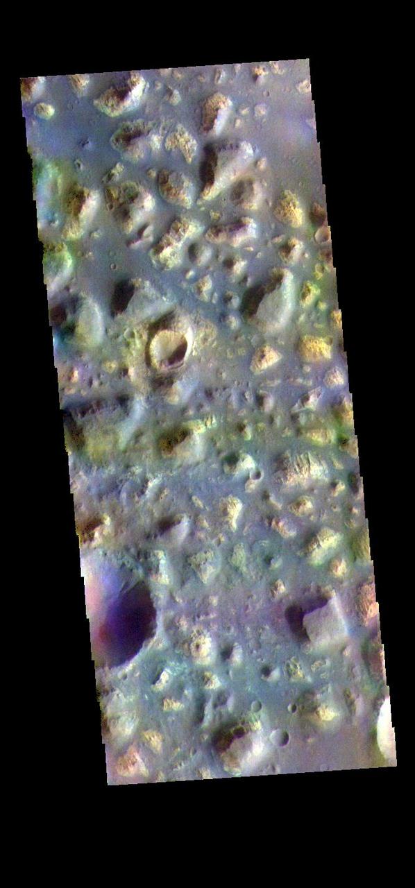
The THEMIS VIS camera contains 5 filters. The data from different filters can be combined in multiple ways to create a false color image. These false color images may reveal subtle variations of the surface not easily identified in a single band image. Today's false color image shows part of Arabia Terra. Arabia Terra is one of the oldest surface regions on Mars and contains a large variety of features. This image is located east of Mawrth Valles. The THEMIS VIS camera is capable of capturing color images of the Martian surface using five different color filters. In this mode of operation, the spatial resolution and coverage of the image must be reduced to accommodate the additional data volume produced from using multiple filters. To make a color image, three of the five filter images (each in grayscale) are selected. Each is contrast enhanced and then converted to a red, green, or blue intensity image. These three images are then combined to produce a full color, single image. Because the THEMIS color filters don't span the full range of colors seen by the human eye, a color THEMIS image does not represent true color. Also, because each single-filter image is contrast enhanced before inclusion in the three-color image, the apparent color variation of the scene is exaggerated. Nevertheless, the color variation that does appear is representative of some change in color, however subtle, in the actual scene. Note that the long edges of THEMIS color images typically contain color artifacts that do not represent surface variation. Orbit Number: 85216 Latitude: 22.2165 Longitude: 345.858 Instrument: VIS Captured: 2021-02-28 23:59 https://photojournal.jpl.nasa.gov/catalog/PIA25052

The THEMIS VIS camera contains 5 filters. The data from different filters can be combined in multiple ways to create a false color image. These false color images may reveal subtle variations of the surface not easily identified in a single band image. Today's false color image shows part of Argentea Planum. The edge of the south polar cap is visible at the bottom of the image. The THEMIS VIS camera is capable of capturing color images of the Martian surface using five different color filters. In this mode of operation, the spatial resolution and coverage of the image must be reduced to accommodate the additional data volume produced from using multiple filters. To make a color image, three of the five filter images (each in grayscale) are selected. Each is contrast enhanced and then converted to a red, green, or blue intensity image. These three images are then combined to produce a full color, single image. Because the THEMIS color filters don't span the full range of colors seen by the human eye, a color THEMIS image does not represent true color. Also, because each single-filter image is contrast enhanced before inclusion in the three-color image, the apparent color variation of the scene is exaggerated. Nevertheless, the color variation that does appear is representative of some change in color, however subtle, in the actual scene. Note that the long edges of THEMIS color images typically contain color artifacts that do not represent surface variation. Orbit Number: 85035 Latitude: -82.5422 Longitude: 335.069 Instrument: VIS Captured: 2021-02-14 01:40 https://photojournal.jpl.nasa.gov/catalog/PIA25051
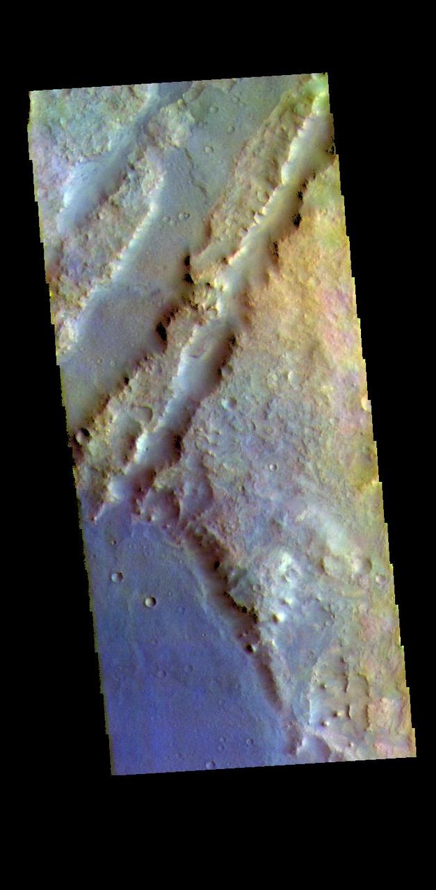
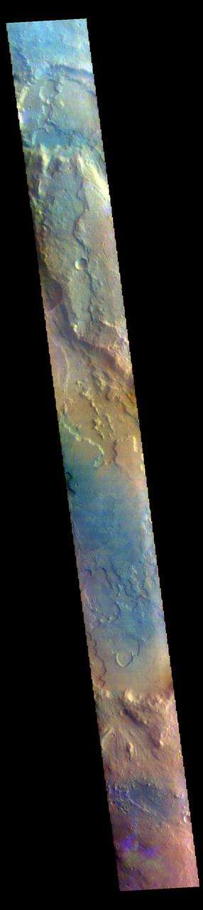
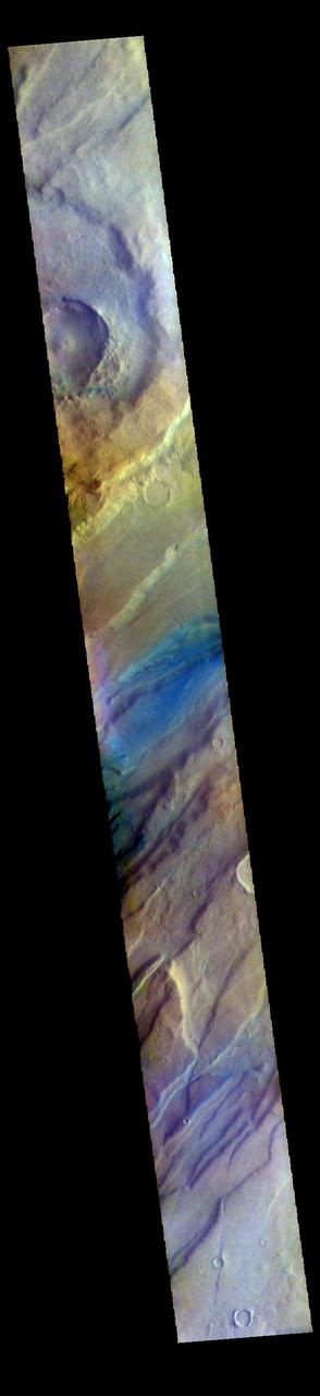
The THEMIS VIS camera contains 5 filters. The data from different filters can be combined in multiple ways to create a false color image. These false color images may reveal subtle variations of the surface not easily identified in a single band image. The linear depressions in today's false color image are part of Nili Fossae. Nili Fossae is a collection of curved faults and down-dropped blocks of crust between the faults. The "fossae," or graben, lie northeast of the large volcano Syrtis Major and northwest of the ancient impact basin Isidis Planitia. The troughs, which can be almost 500 meters (1,600 feet) deep , make concentric curves that follow the outline of Isidis Planitia. The graben likely formed as the crust sagged under the weight of lava flows filling the Isidis Planitia impact basin. The THEMIS VIS camera is capable of capturing color images of the Martian surface using five different color filters. In this mode of operation, the spatial resolution and coverage of the image must be reduced to accommodate the additional data volume produced from using multiple filters. To make a color image, three of the five filter images (each in grayscale) are selected. Each is contrast enhanced and then converted to a red, green, or blue intensity image. These three images are then combined to produce a full color, single image. Because the THEMIS color filters don't span the full range of colors seen by the human eye, a color THEMIS image does not represent true color. Also, because each single-filter image is contrast enhanced before inclusion in the three-color image, the apparent color variation of the scene is exaggerated. Nevertheless, the color variation that does appear is representative of some change in color, however subtle, in the actual scene. Note that the long edges of THEMIS color images typically contain color artifacts that do not represent surface variation. Orbit Number: 88158 Latitude: 20.507 Longitude: 72.6076 Instrument: VIS Captured: 2021-10-29 05:43 https://photojournal.jpl.nasa.gov/catalog/PIA25388

The THEMIS VIS camera contains 5 filters. The data from different filters can be combined in multiple ways to create a false color image. These false color images may reveal subtle variations of the surface not easily identified in a single band image. Today's false color image shows part of Chia Crater. Chia Crater is 92 km (57 miles) in diameter and is located in Xanthe Terra just east of Maja Valles. The THEMIS VIS camera is capable of capturing color images of the Martian surface using five different color filters. In this mode of operation, the spatial resolution and coverage of the image must be reduced to accommodate the additional data volume produced from using multiple filters. To make a color image, three of the five filter images (each in grayscale) are selected. Each is contrast enhanced and then converted to a red, green, or blue intensity image. These three images are then combined to produce a full color, single image. Because the THEMIS color filters don't span the full range of colors seen by the human eye, a color THEMIS image does not represent true color. Also, because each single-filter image is contrast enhanced before inclusion in the three-color image, the apparent color variation of the scene is exaggerated. Nevertheless, the color variation that does appear is representative of some change in color, however subtle, in the actual scene. Note that the long edges of THEMIS color images typically contain color artifacts that do not represent surface variation. Orbit Number: 86503 Latitude: 1.79687 Longitude: 300.299 Instrument: VIS Captured: 2021-06-14 23:07 https://photojournal.jpl.nasa.gov/catalog/PIA25102
The THEMIS VIS camera contains 5 filters. The data from different filters can be combined in multiple ways to create a false color image. These false color images may reveal subtle variations of the surface not easily identified in a single band image. Today's false color image shows part of Terra Sirenum. The THEMIS VIS camera is capable of capturing color images of the Martian surface using five different color filters. In this mode of operation, the spatial resolution and coverage of the image must be reduced to accommodate the additional data volume produced from using multiple filters. To make a color image, three of the five filter images (each in grayscale) are selected. Each is contrast enhanced and then converted to a red, green, or blue intensity image. These three images are then combined to produce a full color, single image. Because the THEMIS color filters don't span the full range of colors seen by the human eye, a color THEMIS image does not represent true color. Also, because each single-filter image is contrast enhanced before inclusion in the three-color image, the apparent color variation of the scene is exaggerated. Nevertheless, the color variation that does appear is representative of some change in color, however subtle, in the actual scene. Note that the long edges of THEMIS color images typically contain color artifacts that do not represent surface variation. Orbit Number: 92940 Latitude: -36.9577 Longitude: 185.11 Instrument: VIS Captured: 2022-11-26 22:52 https://photojournal.jpl.nasa.gov/catalog/PIA26123
The THEMIS VIS camera contains 5 filters. The data from different filters can be combined in multiple ways to create a false color image. These false color images may reveal subtle variations of the surface not easily identified in a single band image. Today's false color image shows a cross section of Hebes Chasma, including Hebes Mensa (middle of image). Hebes Chasma is an inclosed basin not connected to Valles Marineris. It is 319 km long (east/west, 198 miles), 130 km wide (north/south, 81miles) and up to 8km (5 miles) deep. Hebes Mensa is a large deposit of layered material within the chasma. Extensive erosion has created gullies in the mensa and distributed fine sand size materials to create dunes and sand drifts. Hebes Mensa is 7.5 km (4.7 miles) high, 120 km (75 miles) long and 43 km (27 miles) wide. The THEMIS VIS camera is capable of capturing color images of the Martian surface using five different color filters. In this mode of operation, the spatial resolution and coverage of the image must be reduced to accommodate the additional data volume produced from using multiple filters. To make a color image, three of the five filter images (each in grayscale) are selected. Each is contrast enhanced and then converted to a red, green, or blue intensity image. These three images are then combined to produce a full color, single image. Because the THEMIS color filters don't span the full range of colors seen by the human eye, a color THEMIS image does not represent true color. Also, because each single-filter image is contrast enhanced before inclusion in the three-color image, the apparent color variation of the scene is exaggerated. Nevertheless, the color variation that does appear is representative of some change in color, however subtle, in the actual scene. Note that the long edges of THEMIS color images typically contain color artifacts that do not represent surface variation. Orbit Number: 88026 Latitude: -1.1753 Longitude: 283.709 Instrument: VIS Captured: 2021-10-18 08:45 https://photojournal.jpl.nasa.gov/catalog/PIA25384
The THEMIS VIS camera contains 5 filters. The data from different filters can be combined in multiple ways to create a false color image. These false color images may reveal subtle variations of the surface not easily identified in a single band image. Today's false color image shows part of Terra Sirenum. The THEMIS VIS camera is capable of capturing color images of the Martian surface using five different color filters. In this mode of operation, the spatial resolution and coverage of the image must be reduced to accommodate the additional data volume produced from using multiple filters. To make a color image, three of the five filter images (each in grayscale) are selected. Each is contrast enhanced and then converted to a red, green, or blue intensity image. These three images are then combined to produce a full color, single image. Because the THEMIS color filters don't span the full range of colors seen by the human eye, a color THEMIS image does not represent true color. Also, because each single-filter image is contrast enhanced before inclusion in the three-color image, the apparent color variation of the scene is exaggerated. Nevertheless, the color variation that does appear is representative of some change in color, however subtle, in the actual scene. Note that the long edges of THEMIS color images typically contain color artifacts that do not represent surface variation. Orbit Number: 92366 Latitude: -37.8538 Longitude: 184.585 Instrument: VIS Captured: 2022-10-10 16:34 https://photojournal.jpl.nasa.gov/catalog/PIA26089
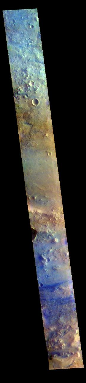
The THEMIS VIS camera contains 5 filters. The data from different filters can be combined in multiple ways to create a false color image. These false color images may reveal subtle variations of the surface not easily identified in a single band image. Today's false color image shows part of Terra Sabaea. The THEMIS VIS camera is capable of capturing color images of the Martian surface using five different color filters. In this mode of operation, the spatial resolution and coverage of the image must be reduced to accommodate the additional data volume produced from using multiple filters. To make a color image, three of the five filter images (each in grayscale) are selected. Each is contrast enhanced and then converted to a red, green, or blue intensity image. These three images are then combined to produce a full color, single image. Because the THEMIS color filters don't span the full range of colors seen by the human eye, a color THEMIS image does not represent true color. Also, because each single-filter image is contrast enhanced before inclusion in the three-color image, the apparent color variation of the scene is exaggerated. Nevertheless, the color variation that does appear is representative of some change in color, however subtle, in the actual scene. Note that the long edges of THEMIS color images typically contain color artifacts that do not represent surface variation. Orbit Number: 87197 Latitude: 18.0891 Longitude: 77.0112 Instrument: VIS Captured: 2021-08-11 02:38 https://photojournal.jpl.nasa.gov/catalog/PIA25380
The THEMIS VIS camera contains 5 filters. The data from different filters can be combined in multiple ways to create a false color image. These false color images may reveal subtle variations of the surface not easily identified in a single band image. Today's false color image shows part of eastern Terra Sabaea. The THEMIS VIS camera is capable of capturing color images of the Martian surface using five different color filters. In this mode of operation, the spatial resolution and coverage of the image must be reduced to accommodate the additional data volume produced from using multiple filters. To make a color image, three of the five filter images (each in grayscale) are selected. Each is contrast enhanced and then converted to a red, green, or blue intensity image. These three images are then combined to produce a full color, single image. Because the THEMIS color filters don't span the full range of colors seen by the human eye, a color THEMIS image does not represent true color. Also, because each single-filter image is contrast enhanced before inclusion in the three-color image, the apparent color variation of the scene is exaggerated. Nevertheless, the color variation that does appear is representative of some change in color, however subtle, in the actual scene. Note that the long edges of THEMIS color images typically contain color artifacts that do not represent surface variation. Orbit Number: 89805 Latitude: 18.8055 Longitude: 76.997 Instrument: VIS Captured: 2022-03-13 20:29 https://photojournal.jpl.nasa.gov/catalog/PIA26056
The THEMIS VIS camera contains 5 filters. The data from different filters can be combined in multiple ways to create a false color image. These false color images may reveal subtle variations of the surface not easily identified in a single band image. Today's false color image shows part of Terra Sabaea, in the region between Nili Fossae and Isidis Planitia. This image is located just east of Jezero Crater, the home of the Mars 2020 rover (Perserverance) and its little helicopter buddy (Ingenuity). The THEMIS VIS camera is capable of capturing color images of the Martian surface using five different color filters. In this mode of operation, the spatial resolution and coverage of the image must be reduced to accommodate the additional data volume produced from using multiple filters. To make a color image, three of the five filter images (each in grayscale) are selected. Each is contrast enhanced and then converted to a red, green, or blue intensity image. These three images are then combined to produce a full color, single image. Because the THEMIS color filters don't span the full range of colors seen by the human eye, a color THEMIS image does not represent true color. Also, because each single-filter image is contrast enhanced before inclusion in the three-color image, the apparent color variation of the scene is exaggerated. Nevertheless, the color variation that does appear is representative of some change in color, however subtle, in the actual scene. Note that the long edges of THEMIS color images typically contain color artifacts that do not represent surface variation. Orbit Number: 95021 Latitude: 18.3774 Longitude: 78.6869 Instrument: VIS Captured: 2023-05-17 08:04 https://photojournal.jpl.nasa.gov/catalog/PIA26138
The THEMIS VIS camera contains 5 filters. The data from different filters can be combined in multiple ways to create a false color image. These false color images may reveal subtle variations of the surface not easily identified in a single band image. Today's false color image shows part of Lunae Planum. The THEMIS VIS camera is capable of capturing color images of the Martian surface using five different color filters. In this mode of operation, the spatial resolution and coverage of the image must be reduced to accommodate the additional data volume produced from using multiple filters. To make a color image, three of the five filter images (each in grayscale) are selected. Each is contrast enhanced and then converted to a red, green, or blue intensity image. These three images are then combined to produce a full color, single image. Because the THEMIS color filters don't span the full range of colors seen by the human eye, a color THEMIS image does not represent true color. Also, because each single-filter image is contrast enhanced before inclusion in the three-color image, the apparent color variation of the scene is exaggerated. Nevertheless, the color variation that does appear is representative of some change in color, however subtle, in the actual scene. Note that the long edges of THEMIS color images typically contain color artifacts that do not represent surface variation. Orbit Number: 95001 Latitude: 18.596 Longitude: 295.651 Instrument: VIS Captured: 2023-05-15 16:32 https://photojournal.jpl.nasa.gov/catalog/PIA26137
The THEMIS VIS camera contains 5 filters. The data from different filters can be combined in multiple ways to create a false color image. These false color images may reveal subtle variations of the surface not easily identified in a single band image. Today's false color image shows part of Terra Sabaea. The THEMIS VIS camera is capable of capturing color images of the Martian surface using five different color filters. In this mode of operation, the spatial resolution and coverage of the image must be reduced to accommodate the additional data volume produced from using multiple filters. To make a color image, three of the five filter images (each in grayscale) are selected. Each is contrast enhanced and then converted to a red, green, or blue intensity image. These three images are then combined to produce a full color, single image. Because the THEMIS color filters don't span the full range of colors seen by the human eye, a color THEMIS image does not represent true color. Also, because each single-filter image is contrast enhanced before inclusion in the three-color image, the apparent color variation of the scene is exaggerated. Nevertheless, the color variation that does appear is representative of some change in color, however subtle, in the actual scene. Note that the long edges of THEMIS color images typically contain color artifacts that do not represent surface variation. Orbit Number: 85450 Latitude: 17.5377 Longitude: 75.8334 Instrument: VIS Captured: 2021-03-20 06:22 https://photojournal.jpl.nasa.gov/catalog/PIA25056
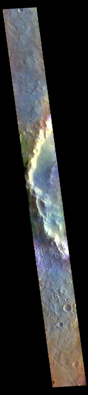
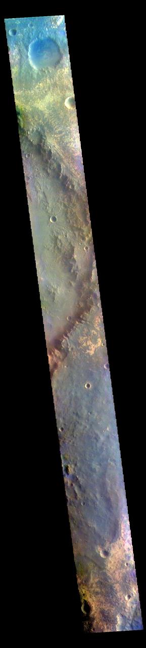
The THEMIS VIS camera contains 5 filters. The data from different filters can be combined in multiple ways to create a false color image. These false color images may reveal subtle variations of the surface not easily identified in a single band image. Today's false color image shows the rim of an unnamed crater on the floor of the much larger Schroeter Crater. These craters are located in Terra Sabaea. The THEMIS VIS camera is capable of capturing color images of the Martian surface using five different color filters. In this mode of operation, the spatial resolution and coverage of the image must be reduced to accommodate the additional data volume produced from using multiple filters. To make a color image, three of the five filter images (each in grayscale) are selected. Each is contrast enhanced and then converted to a red, green, or blue intensity image. These three images are then combined to produce a full color, single image. Because the THEMIS color filters don't span the full range of colors seen by the human eye, a color THEMIS image does not represent true color. Also, because each single-filter image is contrast enhanced before inclusion in the three-color image, the apparent color variation of the scene is exaggerated. Nevertheless, the color variation that does appear is representative of some change in color, however subtle, in the actual scene. Note that the long edges of THEMIS color images typically contain color artifacts that do not represent surface variation. Orbit Number: 85900 Latitude: -2.28902 Longitude: 56.6146 Instrument: VIS Captured: 2021-04-26 07:31 https://photojournal.jpl.nasa.gov/catalog/PIA25098
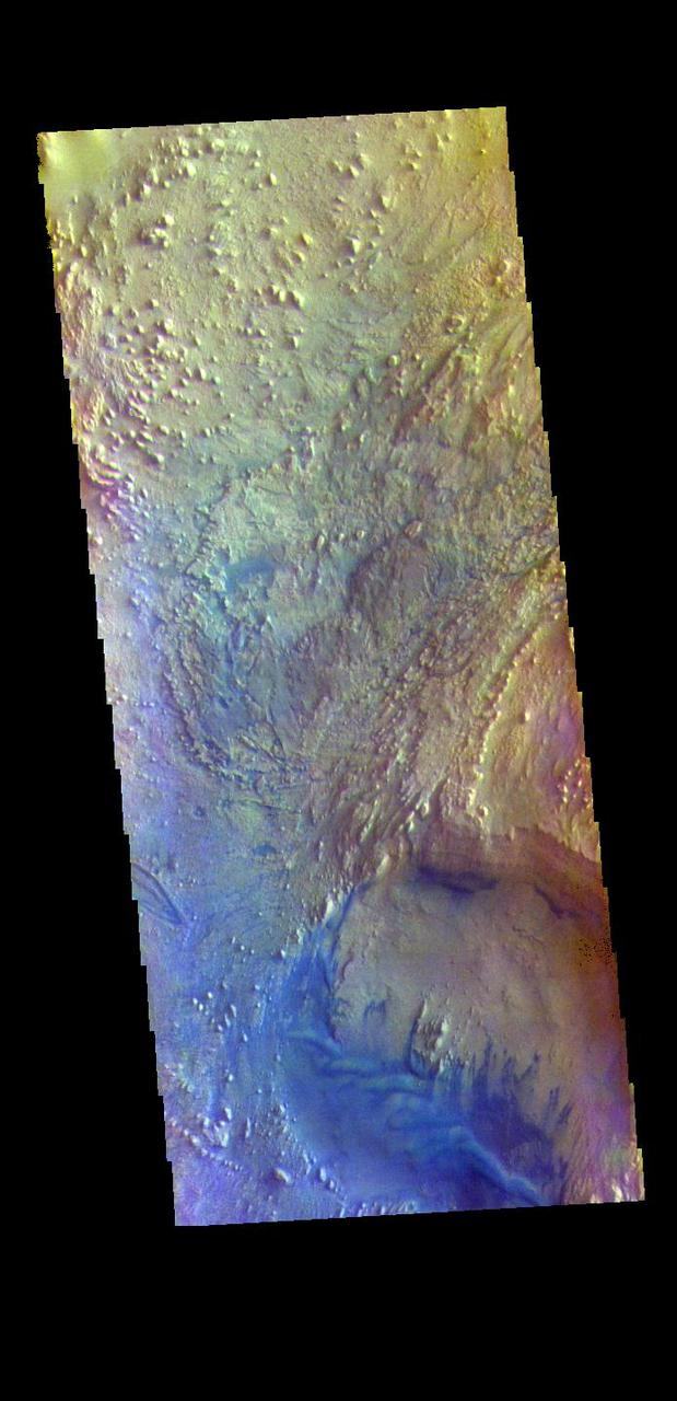
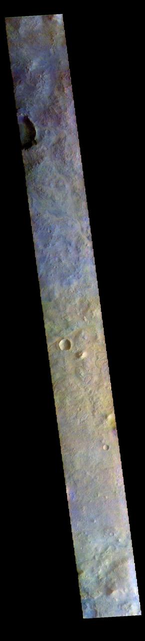
The THEMIS VIS camera contains 5 filters. The data from different filters can be combined in multiple ways to create a false color image. These false color images may reveal subtle variations of the surface not easily identified in a single band image. Today's false color image shows part of Cydonia Mensae. Cydonia Mensae is located in the region between the cratered highlands of northwestern Arabia Terra and the southern lowlands of Acidalia Planitia. This area contains many different landforms, including tectonic features, chaos terrain and impact craters. This VIS image shows a portion of chaos in the top left of the frame, and several tectonic depressions. The THEMIS VIS camera is capable of capturing color images of the Martian surface using five different color filters. In this mode of operation, the spatial resolution and coverage of the image must be reduced to accommodate the additional data volume produced from using multiple filters. To make a color image, three of the five filter images (each in grayscale) are selected. Each is contrast enhanced and then converted to a red, green, or blue intensity image. These three images are then combined to produce a full color, single image. Because the THEMIS color filters don't span the full range of colors seen by the human eye, a color THEMIS image does not represent true color. Also, because each single-filter image is contrast enhanced before inclusion in the three-color image, the apparent color variation of the scene is exaggerated. Nevertheless, the color variation that does appear is representative of some change in color, however subtle, in the actual scene. Note that the long edges of THEMIS color images typically contain color artifacts that do not represent surface variation. Orbit Number: 95074 Latitude: 35.0203 Longitude: 347.284 Instrument: VIS Captured: 2023-05-21 16:54 https://photojournal.jpl.nasa.gov/catalog/PIA26152
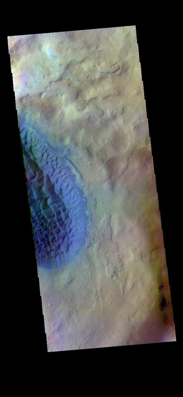
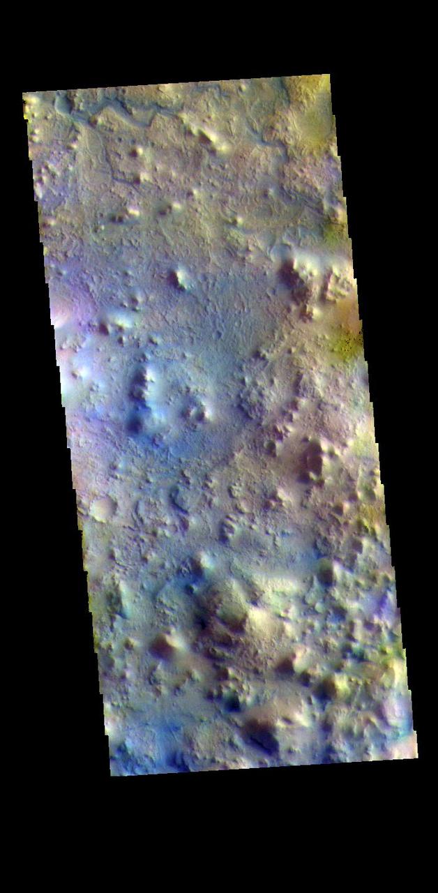
The THEMIS VIS camera contains 5 filters. The data from different filters can be combined in multiple ways to create a false color image. These false color images may reveal subtle variations of the surface not easily identified in a single band image. Today's false color image shows the floor of Matara Crater. A large sand sheet dominates the floor of this crater located in Noachis Terra. The top of the sand sheet has been sculpted by the wind, creating dune forms. Matara Crater is 48km (30 miles) in diameter. The THEMIS VIS camera is capable of capturing color images of the Martian surface using five different color filters. In this mode of operation, the spatial resolution and coverage of the image must be reduced to accommodate the additional data volume produced from using multiple filters. To make a color image, three of the five filter images (each in grayscale) are selected. Each is contrast enhanced and then converted to a red, green, or blue intensity image. These three images are then combined to produce a full color, single image. Because the THEMIS color filters don't span the full range of colors seen by the human eye, a color THEMIS image does not represent true color. Also, because each single-filter image is contrast enhanced before inclusion in the three-color image, the apparent color variation of the scene is exaggerated. Nevertheless, the color variation that does appear is representative of some change in color, however subtle, in the actual scene. Note that the long edges of THEMIS color images typically contain color artifacts that do not represent surface variation. Orbit Number: 83817 Latitude: -49.4554 Longitude: 34.8949 Instrument: VIS Captured: 2020-11-05 19:05 https://photojournal.jpl.nasa.gov/catalog/PIA25002
The THEMIS VIS camera contains 5 filters. The data from different filters can be combined in multiple ways to create a false color image. These false color images may reveal subtle variations of the surface not easily identified in a single band image. Today's false color image shows part of Terra Sabaea. Dark blue in this filter combination is usually basalt sand. The THEMIS VIS camera is capable of capturing color images of the Martian surface using five different color filters. In this mode of operation, the spatial resolution and coverage of the image must be reduced to accommodate the additional data volume produced from using multiple filters. To make a color image, three of the five filter images (each in grayscale) are selected. Each is contrast enhanced and then converted to a red, green, or blue intensity image. These three images are then combined to produce a full color, single image. Because the THEMIS color filters don't span the full range of colors seen by the human eye, a color THEMIS image does not represent true color. Also, because each single-filter image is contrast enhanced before inclusion in the three-color image, the apparent color variation of the scene is exaggerated. Nevertheless, the color variation that does appear is representative of some change in color, however subtle, in the actual scene. Note that the long edges of THEMIS color images typically contain color artifacts that do not represent surface variation. Orbit Number: 94160 Latitude: 18.2445 Longitude: 77.6595 Instrument: VIS Captured: 2023-03-07 10:37 https://photojournal.jpl.nasa.gov/catalog/PIA26127
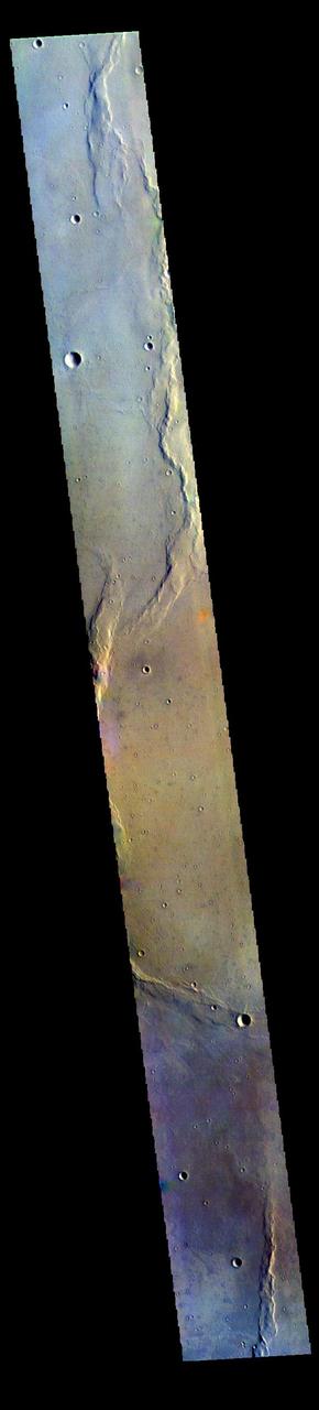
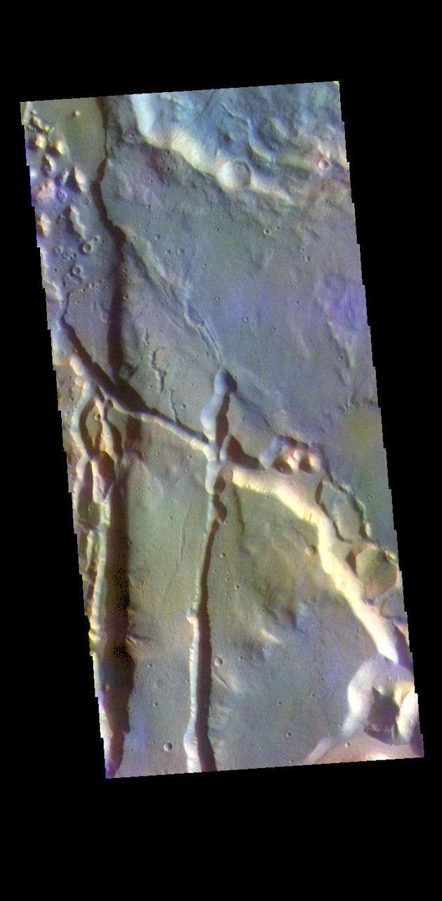
The THEMIS VIS camera contains 5 filters. The data from different filters can be combined in multiple ways to create a false color image. These false color images may reveal subtle variations of the surface not easily identified in a single band image. Today's false color image shows a small portion of Tempe Fossae. The linear features are tectonic graben. Graben are formed by extension of the crust and faulting. When large amounts of pressure or tension are applied to rocks on timescales that are fast enough that the rock cannot respond by deforming, the rock breaks along faults. In the case of a graben, two parallel faults are formed by extension of the crust and the rock in between the faults drops downward into the space created by the extension. The complete fossae system in almost 2000 km (1242 miles) long. The THEMIS VIS camera is capable of capturing color images of the Martian surface using five different color filters. In this mode of operation, the spatial resolution and coverage of the image must be reduced to accommodate the additional data volume produced from using multiple filters. To make a color image, three of the five filter images (each in grayscale) are selected. Each is contrast enhanced and then converted to a red, green, or blue intensity image. These three images are then combined to produce a full color, single image. Because the THEMIS color filters don't span the full range of colors seen by the human eye, a color THEMIS image does not represent true color. Also, because each single-filter image is contrast enhanced before inclusion in the three-color image, the apparent color variation of the scene is exaggerated. Nevertheless, the color variation that does appear is representative of some change in color, however subtle, in the actual scene. Note that the long edges of THEMIS color images typically contain color artifacts that do not represent surface variation. Orbit Number: 94065 Latitude: 46.5357 Longitude: 293.867 Instrument: VIS Captured: 2023-02-27 15:03 https://photojournal.jpl.nasa.gov/catalog/PIA26125
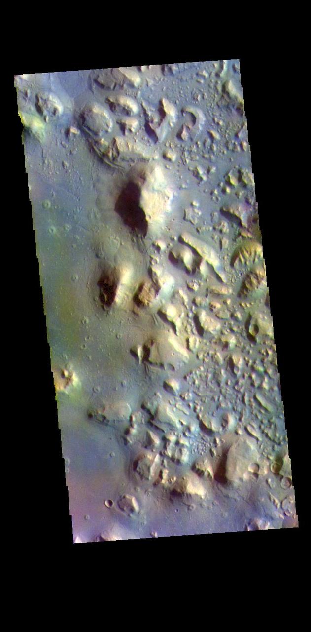
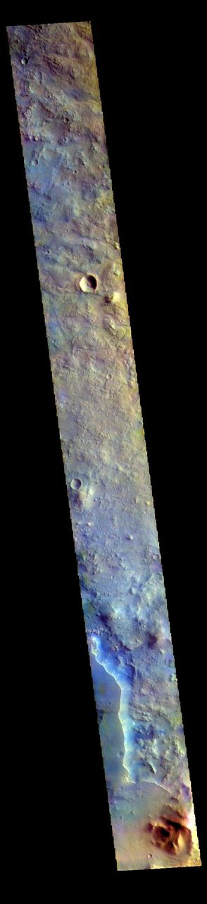
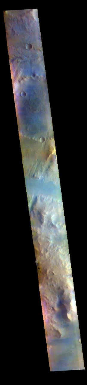
The THEMIS VIS camera contains 5 filters. The data from different filters can be combined in multiple ways to create a false color image. These false color images may reveal subtle variations of the surface not easily identified in a single band image. Today's false color image shows part of Oyama Crater. Located in Arabia Terra near Mawrth Vallis, Oyama Crater is 101km (63 miles) in diameter. The THEMIS VIS camera is capable of capturing color images of the Martian surface using five different color filters. In this mode of operation, the spatial resolution and coverage of the image must be reduced to accommodate the additional data volume produced from using multiple filters. To make a color image, three of the five filter images (each in grayscale) are selected. Each is contrast enhanced and then converted to a red, green, or blue intensity image. These three images are then combined to produce a full color, single image. Because the THEMIS color filters don't span the full range of colors seen by the human eye, a color THEMIS image does not represent true color. Also, because each single-filter image is contrast enhanced before inclusion in the three-color image, the apparent color variation of the scene is exaggerated. Nevertheless, the color variation that does appear is representative of some change in color, however subtle, in the actual scene. Note that the long edges of THEMIS color images typically contain color artifacts that do not represent surface variation. Orbit Number: 94363 Latitude: 23.2241 Longitude: 340.695 Instrument: VIS Captured: 2023-03-24 03:48 https://photojournal.jpl.nasa.gov/catalog/PIA26128
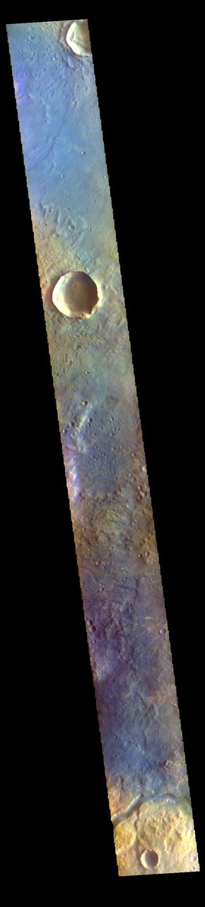
The THEMIS VIS camera contains 5 filters. The data from different filters can be combined in multiple ways to create a false color image. These false color images may reveal subtle variations of the surface not easily identified in a single band image. Today's false color image shows part of the eastern boundary of Syrtis Major Planum. The channel at the bottom of the image is unnamed. The THEMIS VIS camera is capable of capturing color images of the Martian surface using five different color filters. In this mode of operation, the spatial resolution and coverage of the image must be reduced to accommodate the additional data volume produced from using multiple filters. To make a color image, three of the five filter images (each in grayscale) are selected. Each is contrast enhanced and then converted to a red, green, or blue intensity image. These three images are then combined to produce a full color, single image. Because the THEMIS color filters don't span the full range of colors seen by the human eye, a color THEMIS image does not represent true color. Also, because each single-filter image is contrast enhanced before inclusion in the three-color image, the apparent color variation of the scene is exaggerated. Nevertheless, the color variation that does appear is representative of some change in color, however subtle, in the actual scene. Note that the long edges of THEMIS color images typically contain color artifacts that do not represent surface variation. Orbit Number: 85812 Latitude: 17.5754 Longitude: 72.5741 Instrument: VIS Captured: 2021-04-19 01:44 https://photojournal.jpl.nasa.gov/catalog/PIA25095
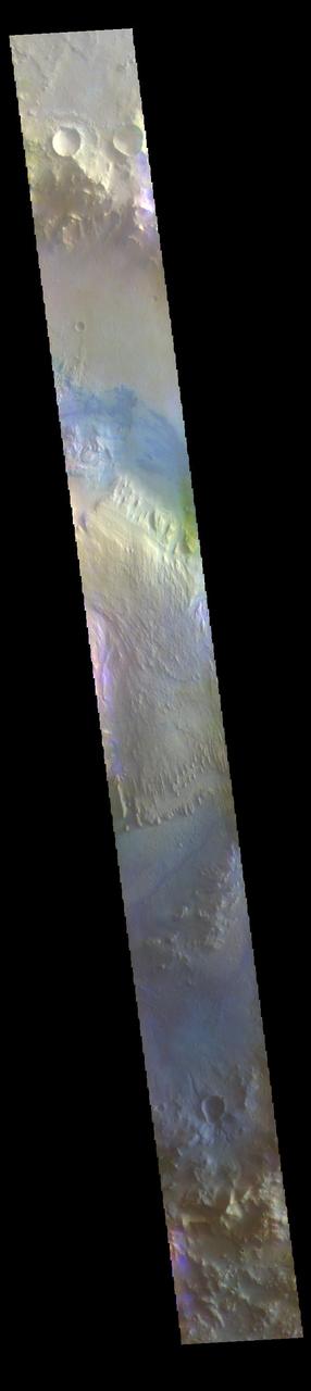
The THEMIS VIS camera contains 5 filters. The data from different filters can be combined in multiple ways to create a false color image. These false color images may reveal subtle variations of the surface not easily identified in a single band image. Today's false color image shows Gale Crater. Gale Crater is the home of the Curiosity Rover. Gale Crater is 154 km (95 miles) in diameter. The THEMIS VIS camera is capable of capturing color images of the Martian surface using five different color filters. In this mode of operation, the spatial resolution and coverage of the image must be reduced to accommodate the additional data volume produced from using multiple filters. To make a color image, three of the five filter images (each in grayscale) are selected. Each is contrast enhanced and then converted to a red, green, or blue intensity image. These three images are then combined to produce a full color, single image. Because the THEMIS color filters don't span the full range of colors seen by the human eye, a color THEMIS image does not represent true color. Also, because each single-filter image is contrast enhanced before inclusion in the three-color image, the apparent color variation of the scene is exaggerated. Nevertheless, the color variation that does appear is representative of some change in color, however subtle, in the actual scene. Note that the long edges of THEMIS color images typically contain color artifacts that do not represent surface variation. Orbit Number: 95044 Latitude: -5.28468 Longitude: 138.309 Instrument: VIS Captured: 2023-05-19 05:23 https://photojournal.jpl.nasa.gov/catalog/PIA26139
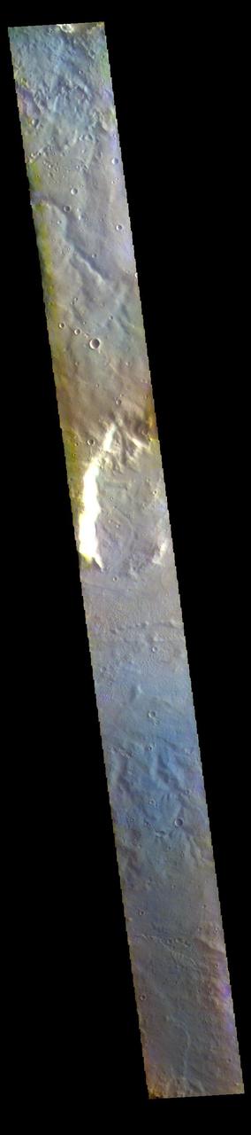
The THEMIS VIS camera contains 5 filters. The data from different filters can be combined in multiple ways to create a false color image. These false color images may reveal subtle variations of the surface not easily identified in a single band image. Today's false color image shows part of the northern rim of Huygens Crater (bright feature in center of image). Huygens Crater is 467 km (290 miles) in diameter and is located in Terra Sabaea. The THEMIS VIS camera is capable of capturing color images of the Martian surface using five different color filters. In this mode of operation, the spatial resolution and coverage of the image must be reduced to accommodate the additional data volume produced from using multiple filters. To make a color image, three of the five filter images (each in grayscale) are selected. Each is contrast enhanced and then converted to a red, green, or blue intensity image. These three images are then combined to produce a full color, single image. Because the THEMIS color filters don't span the full range of colors seen by the human eye, a color THEMIS image does not represent true color. Also, because each single-filter image is contrast enhanced before inclusion in the three-color image, the apparent color variation of the scene is exaggerated. Nevertheless, the color variation that does appear is representative of some change in color, however subtle, in the actual scene. Note that the long edges of THEMIS color images typically contain color artifacts that do not represent surface variation. Orbit Number: 86000 Latitude: -11.048 Longitude: 52.8798 Instrument: VIS Captured: 2021-05-04 13:04 https://photojournal.jpl.nasa.gov/catalog/PIA25101
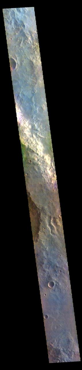
The THEMIS VIS camera contains 5 filters. The data from different filters can be combined in multiple ways to create a false color image. These false color images may reveal subtle variations of the surface not easily identified in a single band image. Today's false color image shows part of Oenotria Scopuli, which is the bright cliff in the center of the image. Oenotria Scopuli is located in Terra Sabaea. The THEMIS VIS camera is capable of capturing color images of the Martian surface using five different color filters. In this mode of operation, the spatial resolution and coverage of the image must be reduced to accommodate the additional data volume produced from using multiple filters. To make a color image, three of the five filter images (each in grayscale) are selected. Each is contrast enhanced and then converted to a red, green, or blue intensity image. These three images are then combined to produce a full color, single image. Because the THEMIS color filters don't span the full range of colors seen by the human eye, a color THEMIS image does not represent true color. Also, because each single-filter image is contrast enhanced before inclusion in the three-color image, the apparent color variation of the scene is exaggerated. Nevertheless, the color variation that does appear is representative of some change in color, however subtle, in the actual scene. Note that the long edges of THEMIS color images typically contain color artifacts that do not represent surface variation. Orbit Number: 85962 Latitude: -5.59203 Longitude: 68.4149 Instrument: VIS Captured: 2021-05-01 10:01 https://photojournal.jpl.nasa.gov/catalog/PIA25099
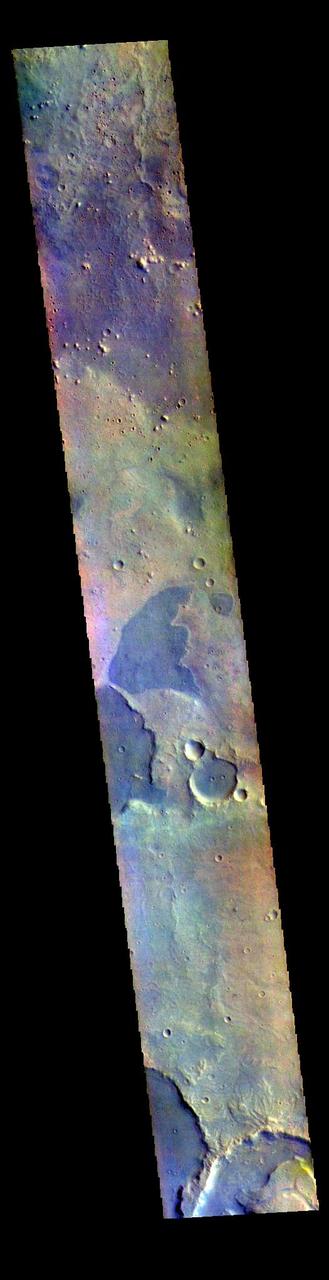
The THEMIS VIS camera contains 5 filters. The data from different filters can be combined in multiple ways to create a false color image. These false color images may reveal subtle variations of the surface not easily identified in a single band image. Today's false color image shows part of northern Arabia Terra. Arabia Terra is one of the oldest surface regions on Mars and contains a large variety of surface features. The region is dissected with numerous unnamed channels of all sizes and complexities, as well as numerous pits of unknown origin. The THEMIS VIS camera is capable of capturing color images of the Martian surface using five different color filters. In this mode of operation, the spatial resolution and coverage of the image must be reduced to accommodate the additional data volume produced from using multiple filters. To make a color image, three of the five filter images (each in grayscale) are selected. Each is contrast enhanced and then converted to a red, green, or blue intensity image. These three images are then combined to produce a full color, single image. Because the THEMIS color filters don't span the full range of colors seen by the human eye, a color THEMIS image does not represent true color. Also, because each single-filter image is contrast enhanced before inclusion in the three-color image, the apparent color variation of the scene is exaggerated. Nevertheless, the color variation that does appear is representative of some change in color, however subtle, in the actual scene. Note that the long edges of THEMIS color images typically contain color artifacts that do not represent surface variation. Orbit Number: 87213 Latitude: 18.2378 Longitude: 335.439 Instrument: VIS Captured: 2021-08-12 10:16 https://photojournal.jpl.nasa.gov/catalog/PIA25381
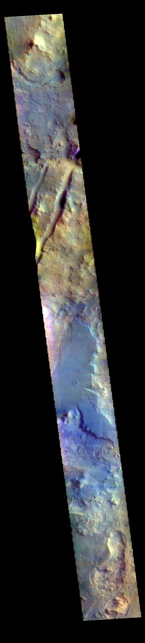
The THEMIS VIS camera contains 5 filters. The data from different filters can be combined in multiple ways to create a false color image. These false color images may reveal subtle variations of the surface not easily identified in a single band image. The linear depressions in today's false color image are part of Nili Fossae. Nili Fossae is a collection of curved faults and down-dropped blocks of crust between the faults. The "fossae," or graben, lie northeast of the large volcano Syrtis Major and northwest of the ancient impact basin Isidis Planitia. The troughs, which can be almost 500 meters (1,600 feet) deep , make concentric curves that follow the outline of Isidis Planitia. The graben likely formed as the crust sagged under the weight of lava flows filling the Isidis Planitia impact basin. The THEMIS VIS camera is capable of capturing color images of the Martian surface using five different color filters. In this mode of operation, the spatial resolution and coverage of the image must be reduced to accommodate the additional data volume produced from using multiple filters. To make a color image, three of the five filter images (each in grayscale) are selected. Each is contrast enhanced and then converted to a red, green, or blue intensity image. These three images are then combined to produce a full color, single image. Because the THEMIS color filters don't span the full range of colors seen by the human eye, a color THEMIS image does not represent true color. Also, because each single-filter image is contrast enhanced before inclusion in the three-color image, the apparent color variation of the scene is exaggerated. Nevertheless, the color variation that does appear is representative of some change in color, however subtle, in the actual scene. Note that the long edges of THEMIS color images typically contain color artifacts that do not represent surface variation. Orbit Number: 95071 Latitude: 17.8666 Longitude: 76.2766 Instrument: VIS Captured: 2023-05-21 10:52 https://photojournal.jpl.nasa.gov/catalog/PIA26151
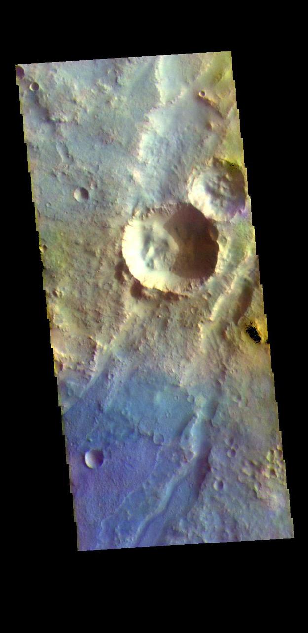
The THEMIS VIS camera contains 5 filters. The data from different filters can be combined in multiple ways to create a false color image. These false color images may reveal subtle variations of the surface not easily identified in a single band image. The linear depressions in today's false color image are part of Nili Fossae. Nili Fossae is a collection of curved faults and down-dropped blocks of crust between the faults. The "fossae," or graben, lie northeast of the large volcano Syrtis Major and northwest of the ancient impact basin Isidis Planitia. The troughs, which can be almost 500 meters (1,600 feet) deep , make concentric curves that follow the outline of Isidis Planitia. The graben likely formed as the crust sagged under the weight of lava flows filling the Isidis Planitia impact basin. The THEMIS VIS camera is capable of capturing color images of the Martian surface using five different color filters. In this mode of operation, the spatial resolution and coverage of the image must be reduced to accommodate the additional data volume produced from using multiple filters. To make a color image, three of the five filter images (each in grayscale) are selected. Each is contrast enhanced and then converted to a red, green, or blue intensity image. These three images are then combined to produce a full color, single image. Because the THEMIS color filters don't span the full range of colors seen by the human eye, a color THEMIS image does not represent true color. Also, because each single-filter image is contrast enhanced before inclusion in the three-color image, the apparent color variation of the scene is exaggerated. Nevertheless, the color variation that does appear is representative of some change in color, however subtle, in the actual scene. Note that the long edges of THEMIS color images typically contain color artifacts that do not represent surface variation. Orbit Number: 94834 Latitude: 21.5829 Longitude: 73.0022 Instrument: VIS Captured: 2023-05-01 22:33 https://photojournal.jpl.nasa.gov/catalog/PIA26136

The THEMIS VIS camera contains 5 filters. The data from different filters can be combined in multiple ways to create a false color image. These false color images may reveal subtle variations of the surface not easily identified in a single band image. Today's false color image shows part of Australe Montes. This region of highlands is located near the south polar cap. The pale blue surface at the bottom of the image is likely surface frost. The THEMIS VIS camera is capable of capturing color images of the Martian surface using five different color filters. In this mode of operation, the spatial resolution and coverage of the image must be reduced to accommodate the additional data volume produced from using multiple filters. To make a color image, three of the five filter images (each in grayscale) are selected. Each is contrast enhanced and then converted to a red, green, or blue intensity image. These three images are then combined to produce a full color, single image. Because the THEMIS color filters don't span the full range of colors seen by the human eye, a color THEMIS image does not represent true color. Also, because each single-filter image is contrast enhanced before inclusion in the three-color image, the apparent color variation of the scene is exaggerated. Nevertheless, the color variation that does appear is representative of some change in color, however subtle, in the actual scene. Note that the long edges of THEMIS color images typically contain color artifacts that do not represent surface variation. Orbit Number: 84934 Latitude: -81.7965 Longitude: 10.5697 Instrument: VIS Captured: 2021-02-05 18:05 https://photojournal.jpl.nasa.gov/catalog/PIA25008
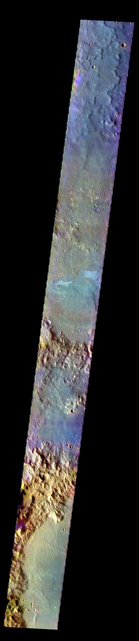
The THEMIS VIS camera contains 5 filters. The data from different filters can be combined in multiple ways to create a false color image. These false color images may reveal subtle variations of the surface not easily identified in a single band image. Today's false color image shows several craters in Terra Cimmeria. The THEMIS VIS camera is capable of capturing color images of the Martian surface using five different color filters. In this mode of operation, the spatial resolution and coverage of the image must be reduced to accommodate the additional data volume produced from using multiple filters. To make a color image, three of the five filter images (each in grayscale) are selected. Each is contrast enhanced and then converted to a red, green, or blue intensity image. These three images are then combined to produce a full color, single image. Because the THEMIS color filters don't span the full range of colors seen by the human eye, a color THEMIS image does not represent true color. Also, because each single-filter image is contrast enhanced before inclusion in the three-color image, the apparent color variation of the scene is exaggerated. Nevertheless, the color variation that does appear is representative of some change in color, however subtle, in the actual scene. Note that the long edges of THEMIS color images typically contain color artifacts that do not represent surface variation. Orbit Number: 83681 Latitude: -31.6763 Longitude: 180.725 Instrument: VIS Captured: 2020-10-25 13:48 https://photojournal.jpl.nasa.gov/catalog/PIA24999
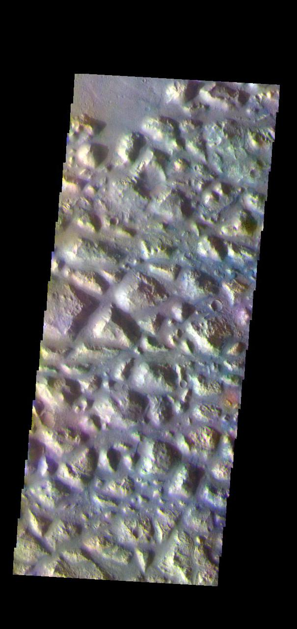
The THEMIS VIS camera contains 5 filters. The data from different filters can be combined in multiple ways to create a false color image. These false color images may reveal subtle variations of the surface not easily identified in a single band image. Today's false color image shows part of Atlantis Chaos. Chaos terrain is typified by regions of blocky, often steep sided, mesas interspersed with deep valleys. With time and erosion the valleys widen and the mesas become smaller. The mesas in this image appear brighter than the surrounding lowlands, likely due to relatively less dust cover. Atlantis Chaos is located in Terra Sirenum. The THEMIS VIS camera is capable of capturing color images of the Martian surface using five different color filters. In this mode of operation, the spatial resolution and coverage of the image must be reduced to accommodate the additional data volume produced from using multiple filters. To make a color image, three of the five filter images (each in grayscale) are selected. Each is contrast enhanced and then converted to a red, green, or blue intensity image. These three images are then combined to produce a full color, single image. Because the THEMIS color filters don't span the full range of colors seen by the human eye, a color THEMIS image does not represent true color. Also, because each single-filter image is contrast enhanced before inclusion in the three-color image, the apparent color variation of the scene is exaggerated. Nevertheless, the color variation that does appear is representative of some change in color, however subtle, in the actual scene. Note that the long edges of THEMIS color images typically contain color artifacts that do not represent surface variation. Orbit Number: 83918 Latitude: -34.6847 Longitude: 183.217 Instrument: VIS Captured: 2020-11-14 02:09 https://photojournal.jpl.nasa.gov/catalog/PIA25003
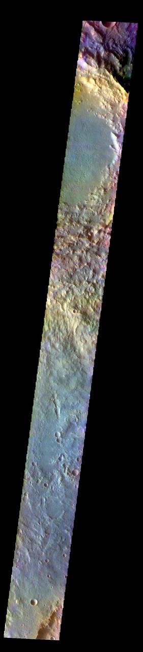
The THEMIS VIS camera contains 5 filters. The data from different filters can be combined in multiple ways to create a false color image. These false color images may reveal subtle variations of the surface not easily identified in a single band image. Today's false color image shows part of Terra Cimmeria. Soffen Crater is at the top of the image, and is 58 km (36 miles) in diameter. The THEMIS VIS camera is capable of capturing color images of the Martian surface using five different color filters. In this mode of operation, the spatial resolution and coverage of the image must be reduced to accommodate the additional data volume produced from using multiple filters. To make a color image, three of the five filter images (each in grayscale) are selected. Each is contrast enhanced and then converted to a red, green, or blue intensity image. These three images are then combined to produce a full color, single image. Because the THEMIS color filters don't span the full range of colors seen by the human eye, a color THEMIS image does not represent true color. Also, because each single-filter image is contrast enhanced before inclusion in the three-color image, the apparent color variation of the scene is exaggerated. Nevertheless, the color variation that does appear is representative of some change in color, however subtle, in the actual scene. Note that the long edges of THEMIS color images typically contain color artifacts that do not represent surface variation. Orbit Number: 91831 Latitude: -24.6619 Longitude: 141.019 Instrument: VIS Captured: 2022-08-27 15:15 https://photojournal.jpl.nasa.gov/catalog/PIA26085
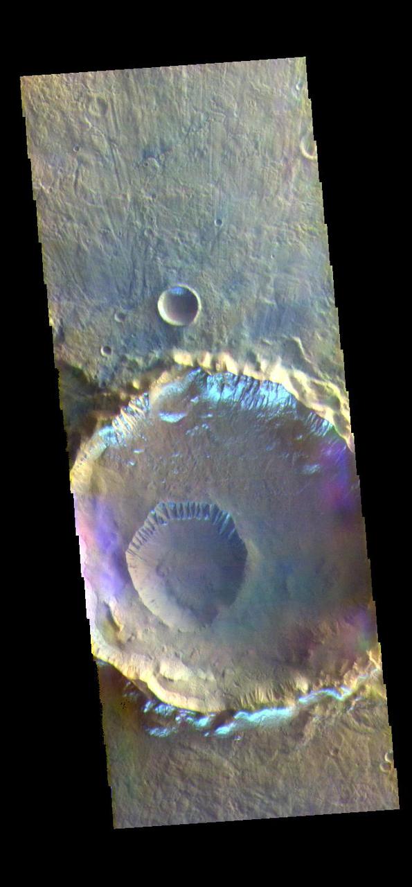
The THEMIS VIS camera contains 5 filters. The data from different filters can be combined in multiple ways to create a false color image. These false color images may reveal subtle variations of the surface not easily identified in a single band image. Today's false color image shows several craters in Eridania Planitia. The small crater inside the larger crater is Gasa Crater. The larger crater is unnamed. The bright silver-blue region on the inner and outer crater rim is morning frost. Collected during the winter, south facing slopes stay in shadow and retain frost longer than the rest of the rim already in sunlight. Frosts are only identifiable in multi filter images. The THEMIS VIS camera is capable of capturing color images of the Martian surface using five different color filters. In this mode of operation, the spatial resolution and coverage of the image must be reduced to accommodate the additional data volume produced from using multiple filters. To make a color image, three of the five filter images (each in grayscale) are selected. Each is contrast enhanced and then converted to a red, green, or blue intensity image. These three images are then combined to produce a full color, single image. Because the THEMIS color filters don't span the full range of colors seen by the human eye, a color THEMIS image does not represent true color. Also, because each single-filter image is contrast enhanced before inclusion in the three-color image, the apparent color variation of the scene is exaggerated. Nevertheless, the color variation that does appear is representative of some change in color, however subtle, in the actual scene. Note that the long edges of THEMIS color images typically contain color artifacts that do not represent surface variation. Orbit Number: 88618 Latitude: -35.5932 Longitude: 129.422 Instrument: VIS Captured: 2021-12-06 02:28 https://photojournal.jpl.nasa.gov/catalog/PIA25389
The THEMIS VIS camera contains 5 filters. The data from different filters can be combined in multiple ways to create a false color image. These false color images may reveal subtle variations of the surface not easily identified in a single band image. Today's false color image shows part of Lomonosov Crater. Lomonosov Crater is 130km (81 miles) in diameter and is located in northern Acidalia Planitia. The THEMIS VIS camera is capable of capturing color images of the Martian surface using five different color filters. In this mode of operation, the spatial resolution and coverage of the image must be reduced to accommodate the additional data volume produced from using multiple filters. To make a color image, three of the five filter images (each in grayscale) are selected. Each is contrast enhanced and then converted to a red, green, or blue intensity image. These three images are then combined to produce a full color, single image. Because the THEMIS color filters don't span the full range of colors seen by the human eye, a color THEMIS image does not represent true color. Also, because each single-filter image is contrast enhanced before inclusion in the three-color image, the apparent color variation of the scene is exaggerated. Nevertheless, the color variation that does appear is representative of some change in color, however subtle, in the actual scene. Note that the long edges of THEMIS color images typically contain color artifacts that do not represent surface variation. Orbit Number: 85559 Latitude: 65.0395 Longitude: 350.752 Instrument: VIS Captured: 2021-03-29 06:19 https://photojournal.jpl.nasa.gov/catalog/PIA25091
The THEMIS VIS camera contains 5 filters. The data from different filters can be combined in multiple ways to create a false color image. These false color images may reveal subtle variations of the surface not easily identified in a single band image. Today's false color image shows part of the vast volcanic plains in the Tharsis region, in this case east of Pavonis Mons. The mottled appearance of the image is being caused by high altitude cloud cover. These clouds will be primarily composed of ice rather than dust. The THEMIS VIS camera is capable of capturing color images of the Martian surface using five different color filters. In this mode of operation, the spatial resolution and coverage of the image must be reduced to accommodate the additional data volume produced from using multiple filters. To make a color image, three of the five filter images (each in grayscale) are selected. Each is contrast enhanced and then converted to a red, green, or blue intensity image. These three images are then combined to produce a full color, single image. Because the THEMIS color filters don't span the full range of colors seen by the human eye, a color THEMIS image does not represent true color. Also, because each single-filter image is contrast enhanced before inclusion in the three-color image, the apparent color variation of the scene is exaggerated. Nevertheless, the color variation that does appear is representative of some change in color, however subtle, in the actual scene. Note that the long edges of THEMIS color images typically contain color artifacts that do not represent surface variation. Orbit Number: 85818 Latitude: 6.41017 Longitude: 260.984 Instrument: VIS Captured: 2021-04-19 13:31 https://photojournal.jpl.nasa.gov/catalog/PIA25096
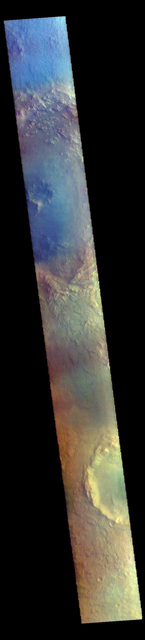
The THEMIS VIS camera contains 5 filters. The data from different filters can be combined in multiple ways to create a false color image. These false color images may reveal subtle variations of the surface not easily identified in a single band image. Today's false color image shows a cross section of Bamberg Crater (top of image). Bamberg Crater is 56km (35 miles) in diameter and located along the boundary between Arabia Terra and Acidalia Planitia. The THEMIS VIS camera is capable of capturing color images of the Martian surface using five different color filters. In this mode of operation, the spatial resolution and coverage of the image must be reduced to accommodate the additional data volume produced from using multiple filters. To make a color image, three of the five filter images (each in grayscale) are selected. Each is contrast enhanced and then converted to a red, green, or blue intensity image. These three images are then combined to produce a full color, single image. Because the THEMIS color filters don't span the full range of colors seen by the human eye, a color THEMIS image does not represent true color. Also, because each single-filter image is contrast enhanced before inclusion in the three-color image, the apparent color variation of the scene is exaggerated. Nevertheless, the color variation that does appear is representative of some change in color, however subtle, in the actual scene. Note that the long edges of THEMIS color images typically contain color artifacts that do not represent surface variation. Orbit Number: 85228 Latitude: 39.07 Longitude: 357.124 Instrument: VIS Captured: 2021-03-01 23:48 https://photojournal.jpl.nasa.gov/catalog/PIA25053
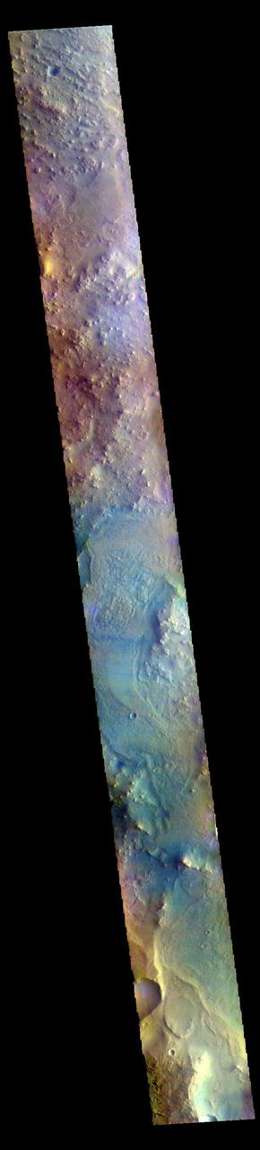
The THEMIS VIS camera contains 5 filters. The data from different filters can be combined in multiple ways to create a false color image. These false color images may reveal subtle variations of the surface not easily identified in a single band image. Today's false color image shows part of northern Syrtis Major Planum. The THEMIS VIS camera is capable of capturing color images of the Martian surface using five different color filters. In this mode of operation, the spatial resolution and coverage of the image must be reduced to accommodate the additional data volume produced from using multiple filters. To make a color image, three of the five filter images (each in grayscale) are selected. Each is contrast enhanced and then converted to a red, green, or blue intensity image. These three images are then combined to produce a full color, single image. Because the THEMIS color filters don't span the full range of colors seen by the human eye, a color THEMIS image does not represent true color. Also, because each single-filter image is contrast enhanced before inclusion in the three-color image, the apparent color variation of the scene is exaggerated. Nevertheless, the color variation that does appear is representative of some change in color, however subtle, in the actual scene. Note that the long edges of THEMIS color images typically contain color artifacts that do not represent surface variation. Orbit Number: 85463 Latitude: 17.4847 Longitude: 60.8084 Instrument: VIS Captured: 2021-03-21 08:04 https://photojournal.jpl.nasa.gov/catalog/PIA25058
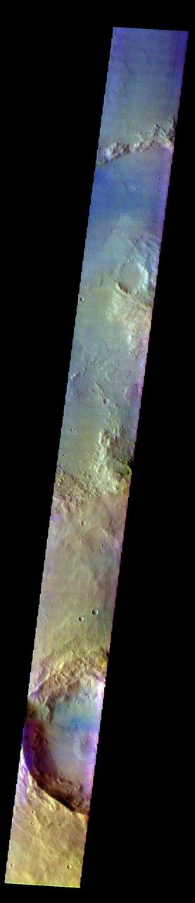
The THEMIS VIS camera contains 5 filters. The data from different filters can be combined in multiple ways to create a false color image. These false color images may reveal subtle variations of the surface not easily identified in a single band image. Today's false color image shows part of Terra Sirenum. The THEMIS VIS camera is capable of capturing color images of the Martian surface using five different color filters. In this mode of operation, the spatial resolution and coverage of the image must be reduced to accommodate the additional data volume produced from using multiple filters. To make a color image, three of the five filter images (each in grayscale) are selected. Each is contrast enhanced and then converted to a red, green, or blue intensity image. These three images are then combined to produce a full color, single image. Because the THEMIS color filters don't span the full range of colors seen by the human eye, a color THEMIS image does not represent true color. Also, because each single-filter image is contrast enhanced before inclusion in the three-color image, the apparent color variation of the scene is exaggerated. Nevertheless, the color variation that does appear is representative of some change in color, however subtle, in the actual scene. Note that the long edges of THEMIS color images typically contain color artifacts that do not represent surface variation. Orbit Number: 92415 Latitude: -38.6129 Longitude: 210.798 Instrument: VIS Captured: 2022-10-14 17:24 https://photojournal.jpl.nasa.gov/catalog/PIA26121

The THEMIS VIS camera contains 5 filters. The data from different filters can be combined in multiple ways to create a false color image. These false color images may reveal subtle variations of the surface not easily identified in a single band image. Today's false color image shows part of Angustus Labyrinthus. Angustus Labyrinthus is a unique region near the south polar cap. In the center of this image squares formed by intersecting ridges are visible. The feature earned the informal name of the Inca City when it was discovered in Mariner 9 images in 1972.The linear ridges are believed to have formed by volcanic and tectonic forces, where magma filled fractures in the subsurface and then erosion revealed the magmatic material. The THEMIS VIS camera is capable of capturing color images of the Martian surface using five different color filters. In this mode of operation, the spatial resolution and coverage of the image must be reduced to accommodate the additional data volume produced from using multiple filters. To make a color image, three of the five filter images (each in grayscale) are selected. Each is contrast enhanced and then converted to a red, green, or blue intensity image. These three images are then combined to produce a full color, single image. Because the THEMIS color filters don't span the full range of colors seen by the human eye, a color THEMIS image does not represent true color. Also, because each single-filter image is contrast enhanced before inclusion in the three-color image, the apparent color variation of the scene is exaggerated. Nevertheless, the color variation that does appear is representative of some change in color, however subtle, in the actual scene. Note that the long edges of THEMIS color images typically contain color artifacts that do not represent surface variation. Orbit Number: 85049 Latitude: -81.1305 Longitude: 295.000 Instrument: VIS Captured: 2021-02-15 05:19 https://photojournal.jpl.nasa.gov/catalog/PIA25010
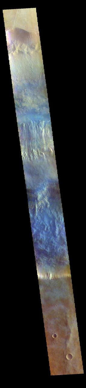
The THEMIS VIS camera contains 5 filters. The data from different filters can be combined in multiple ways to create a false color image. These false color images may reveal subtle variations of the surface not easily identified in a single band image. Today's false color image shows a cross section of Hebes Chasma, including Hebes Mensa (middle of image). Hebes Chasma is an inclosed basin not connected to Valles Marineris. It is 319 km long (east/west, 198 miles), 130 km wide (north/south, 81miles) and up to 8km (5 miles) deep. Hebes Mensa is a large deposit of layered material within the chasma. Extensive erosion has created gullies in the mensa and distributed fine sand size materials to create dunes and sand drifts. Hebes Mensa is 7.5 km (4.7 miles) high, 120 km (75 miles) long and 43 km (27 miles) wide. The THEMIS VIS camera is capable of capturing color images of the Martian surface using five different color filters. In this mode of operation, the spatial resolution and coverage of the image must be reduced to accommodate the additional data volume produced from using multiple filters. To make a color image, three of the five filter images (each in grayscale) are selected. Each is contrast enhanced and then converted to a red, green, or blue intensity image. These three images are then combined to produce a full color, single image. Because the THEMIS color filters don't span the full range of colors seen by the human eye, a color THEMIS image does not represent true color. Also, because each single-filter image is contrast enhanced before inclusion in the three-color image, the apparent color variation of the scene is exaggerated. Nevertheless, the color variation that does appear is representative of some change in color, however subtle, in the actual scene. Note that the long edges of THEMIS color images typically contain color artifacts that do not represent surface variation. Orbit Number: 85967 Latitude: -1.25893 Longitude: 283.562 Instrument: VIS Captured: 2021-05-01 19:55 https://photojournal.jpl.nasa.gov/catalog/PIA25100
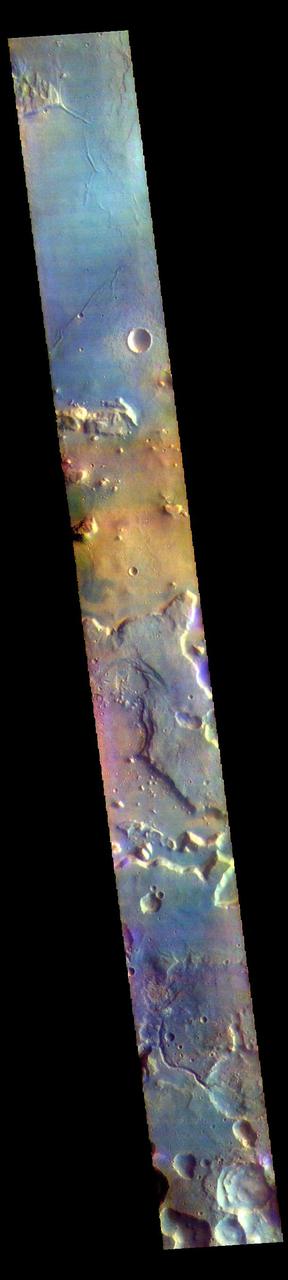
The THEMIS VIS camera contains 5 filters. The data from different filters can be combined in multiple ways to create a false color image. These false color images may reveal subtle variations of the surface not easily identified in a single band image. Today's false color image shows part of northern Arabia Terra. Arabia Terra is one of the oldest surface regions on Mars and contains a large variety of surface features. The region is dissected with numerous unnamed channels of all sizes and complexities, as well as numerous pits of unknown origin. The THEMIS VIS camera is capable of capturing color images of the Martian surface using five different color filters. In this mode of operation, the spatial resolution and coverage of the image must be reduced to accommodate the additional data volume produced from using multiple filters. To make a color image, three of the five filter images (each in grayscale) are selected. Each is contrast enhanced and then converted to a red, green, or blue intensity image. These three images are then combined to produce a full color, single image. Because the THEMIS color filters don't span the full range of colors seen by the human eye, a color THEMIS image does not represent true color. Also, because each single-filter image is contrast enhanced before inclusion in the three-color image, the apparent color variation of the scene is exaggerated. Nevertheless, the color variation that does appear is representative of some change in color, however subtle, in the actual scene. Note that the long edges of THEMIS color images typically contain color artifacts that do not represent surface variation. Orbit Number: 85790 Latitude: 32.1208 Longitude: 345.196 Instrument: VIS Captured: 2021-04-17 06:20 https://photojournal.jpl.nasa.gov/catalog/PIA25094
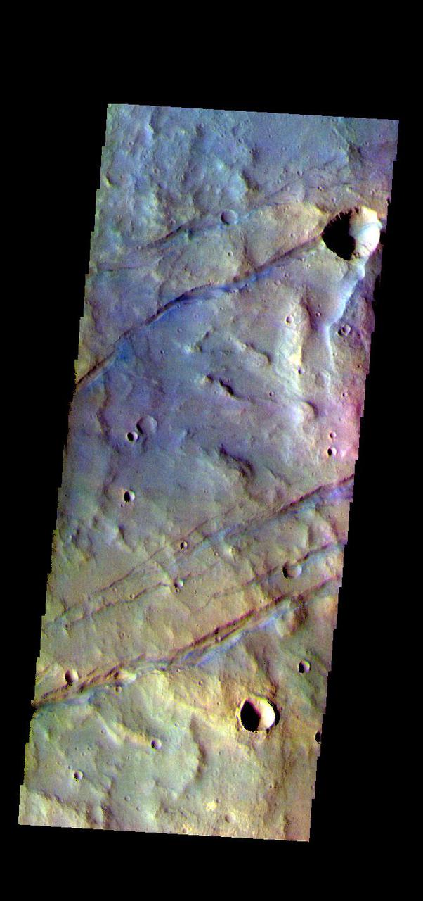
The THEMIS VIS camera contains 5 filters. The data from different filters can be combined in multiple ways to create a false color image. These false color images may reveal subtle variations of the surface not easily identified in a single band image. Today's false color image shows some of the graben that comprise Sirenum Fossae. The linear features, called graben, are created in regions of extensional tectonic stress, where the bedrock is faulted and pulled apart, allowing linear sections of the surface to drop downward along paired faults. The Sirenum Fossae graben are 2735km (1700 miles) long. The THEMIS VIS camera is capable of capturing color images of the Martian surface using five different color filters. In this mode of operation, the spatial resolution and coverage of the image must be reduced to accommodate the additional data volume produced from using multiple filters. To make a color image, three of the five filter images (each in grayscale) are selected. Each is contrast enhanced and then converted to a red, green, or blue intensity image. These three images are then combined to produce a full color, single image. Because the THEMIS color filters don't span the full range of colors seen by the human eye, a color THEMIS image does not represent true color. Also, because each single-filter image is contrast enhanced before inclusion in the three-color image, the apparent color variation of the scene is exaggerated. Nevertheless, the color variation that does appear is representative of some change in color, however subtle, in the actual scene. Note that the long edges of THEMIS color images typically contain color artifacts that do not represent surface variation. Orbit Number: 83743 Latitude: -37.2437 Longitude: 191.251 Instrument: VIS Captured: 2020-10-30 16:21 https://photojournal.jpl.nasa.gov/catalog/PIA25000
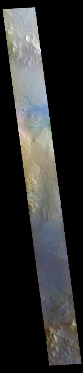
The THEMIS VIS camera contains 5 filters. The data from different filters can be combined in multiple ways to create a false color image. These false color images may reveal subtle variations of the surface not easily identified in a single band image. Today's false color image shows a cross section of Gale Crater, including the large layered deposit in the center of the crater. The Curiosity Rover is located on the floor of Gale Crater. Gale Crater is 154 km (95 miles) in diameter and is located near Terra Cimmeria. The THEMIS VIS camera is capable of capturing color images of the Martian surface using five different color filters. In this mode of operation, the spatial resolution and coverage of the image must be reduced to accommodate the additional data volume produced from using multiple filters. To make a color image, three of the five filter images (each in grayscale) are selected. Each is contrast enhanced and then converted to a red, green, or blue intensity image. These three images are then combined to produce a full color, single image. Because the THEMIS color filters don't span the full range of colors seen by the human eye, a color THEMIS image does not represent true color. Also, because each single-filter image is contrast enhanced before inclusion in the three-color image, the apparent color variation of the scene is exaggerated. Nevertheless, the color variation that does appear is representative of some change in color, however subtle, in the actual scene. Note that the long edges of THEMIS color images typically contain color artifacts that do not represent surface variation. Orbit Number: 85710 Latitude: -5.28449 Longitude: 138.202 Instrument: VIS Captured: 2021-04-10 16:02 https://photojournal.jpl.nasa.gov/catalog/PIA25092
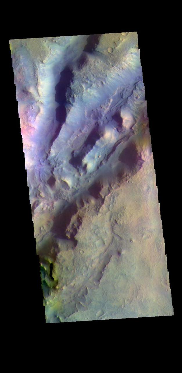
The THEMIS VIS camera contains 5 filters. The data from different filters can be combined in multiple ways to create a false color image. These false color images may reveal subtle variations of the surface not easily identified in a single band image. The linear depressions in today's false color image are part of Nili Fossae. Nili Fossae is a collection of curved faults and down-dropped blocks of crust between the faults. The "fossae," or graben, lie northeast of the large volcano Syrtis Major and northwest of the ancient impact basin Isidis Planitia. The troughs, which can be almost 500 meters (1,600 feet) deep , make concentric curves that follow the outline of Isidis Planitia. The graben likely formed as the crust sagged under the weight of lava flows filling the Isidis Planitia impact basin. The THEMIS VIS camera is capable of capturing color images of the Martian surface using five different color filters. In this mode of operation, the spatial resolution and coverage of the image must be reduced to accommodate the additional data volume produced from using multiple filters. To make a color image, three of the five filter images (each in grayscale) are selected. Each is contrast enhanced and then converted to a red, green, or blue intensity image. These three images are then combined to produce a full color, single image. Because the THEMIS color filters don't span the full range of colors seen by the human eye, a color THEMIS image does not represent true color. Also, because each single-filter image is contrast enhanced before inclusion in the three-color image, the apparent color variation of the scene is exaggerated. Nevertheless, the color variation that does appear is representative of some change in color, however subtle, in the actual scene. Note that the long edges of THEMIS color images typically contain color artifacts that do not represent surface variation. Orbit Number: 88919 Latitude: 22.3384 Longitude: 77.6092 Instrument: VIS Captured: 2021-12-30 21:37 https://photojournal.jpl.nasa.gov/catalog/PIA25390
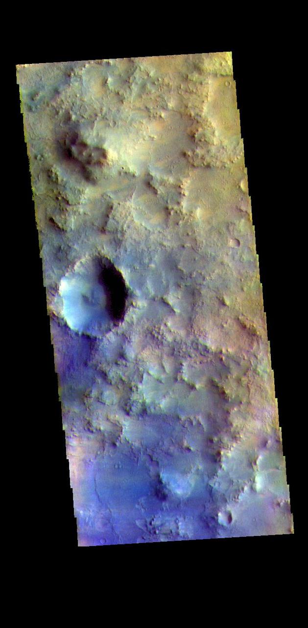
The THEMIS VIS camera contains 5 filters. The data from different filters can be combined in multiple ways to create a false color image. These false color images may reveal subtle variations of the surface not easily identified in a single band image. Today's false color image shows part of Terra Sabaea. The THEMIS VIS camera is capable of capturing color images of the Martian surface using five different color filters. In this mode of operation, the spatial resolution and coverage of the image must be reduced to accommodate the additional data volume produced from using multiple filters. To make a color image, three of the five filter images (each in grayscale) are selected. Each is contrast enhanced and then converted to a red, green, or blue intensity image. These three images are then combined to produce a full color, single image. Because the THEMIS color filters don't span the full range of colors seen by the human eye, a color THEMIS image does not represent true color. Also, because each single-filter image is contrast enhanced before inclusion in the three-color image, the apparent color variation of the scene is exaggerated. Nevertheless, the color variation that does appear is representative of some change in color, however subtle, in the actual scene. Note that the long edges of THEMIS color images typically contain color artifacts that do not represent surface variation. Orbit Number: 88083 Latitude: 17.9048 Longitude: 76.7013 Instrument: VIS Captured: 2021-10-23 01:30 https://photojournal.jpl.nasa.gov/catalog/PIA25387