
Kennedy continues to expand use of alternate fuel vehicles on center. As of 2021, 75% of the fleet uses alternative fuels (electricity, E-85, and biodiesel) to power them. There are 20 hybrids (gas/electric) 15 plug in hybrids, and 14 dedicated electric vehicles. Kennedy is working with commercial partner Florida Power and Light to build 56 additional vehicle chargers for government-owned vehicles by the end of 2021.

Family members of the original Vehicle Assembly Building (VAB) architect ride in an elevator during a tour of the iconic facility on Nov. 22, 2019 at NASA’s Kennedy Space Center in Florida. Among the visitors are Phil Moyer, in front, original project lead for the VAB; and Dick Bergmann, in the light green shirt, original lead designer for the VAB. The Florida Section American Society of Civil Engineers bestowed its National Historic Civil Engineering Landmark award to the facility. The VAB is the first building at Kennedy Space Center to earn this distinction. At the time of its completion, the 129-million-cubic-foot structure was the largest building in the world. Originally designed and built to accommodate the Saturn V/Apollo used in Project Apollo, the VAB was later modified for its role in the Space Shuttle Program.
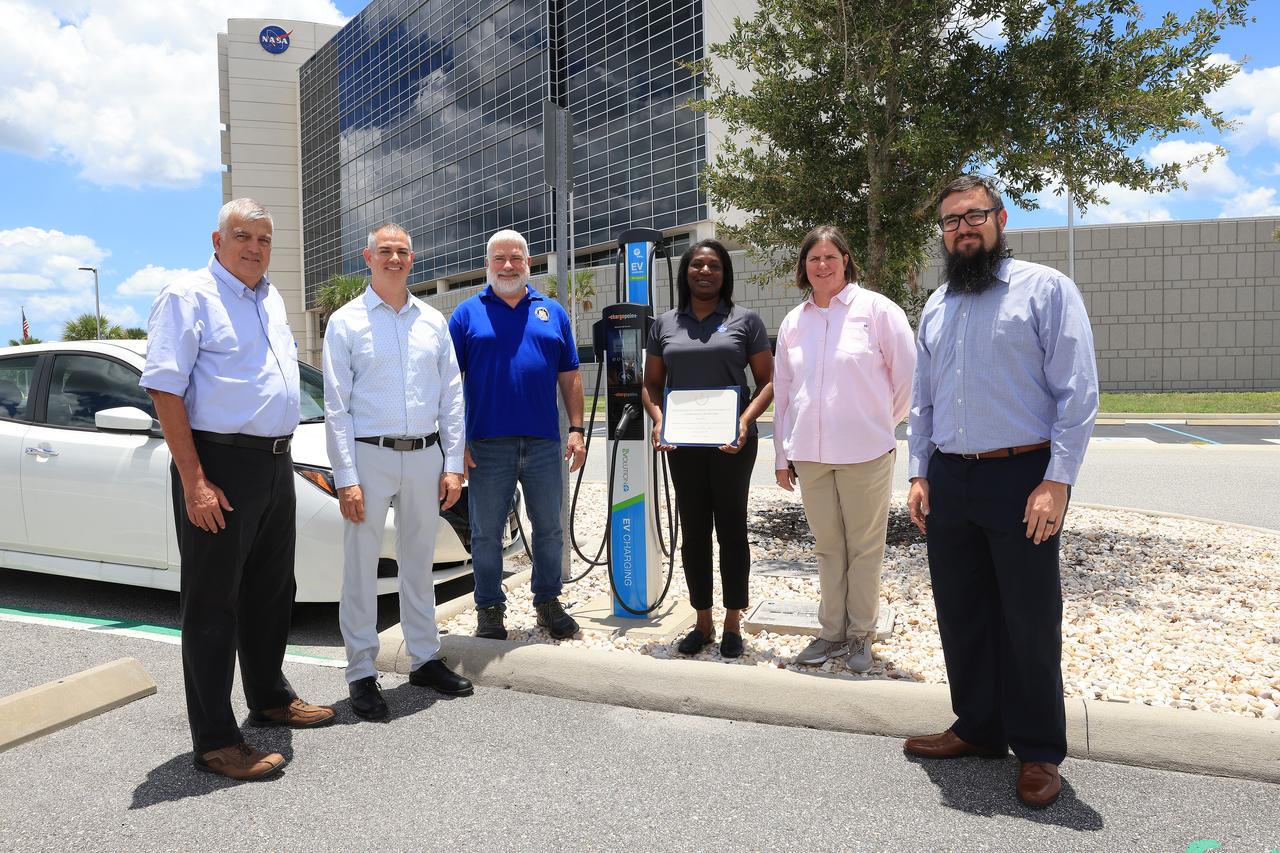
Six of the seven members of the NASA Kennedy Space Center team recognized by the White House on Tuesday, June 25, 2024, during the Presidential Federal Sustainability Awards stand next to an electric vehicle (EV) charging station in front of Kennedy's Central Campus Headquarters Building. Those members are, from left to right, center services division chief Gustavo Diaz, partnership development office chief Matthew Jimenez, then branch chief Gerald “Jay” Green, sustainability lead Lashanda Battle, transportation officer Melissa Coleman, and then transportation specialist Spencer Davis. This EV station is one of 28 installed on center through a partnership with local utility provider Florida Power & Light, allowing up to 56 electric vehicles to be charged at the same time. An additional 31 EV stations are planned at Kennedy by fall 2024, increasing the center's vehicle charging capacity by up to 118 vehicles simultaneously once they're operational.
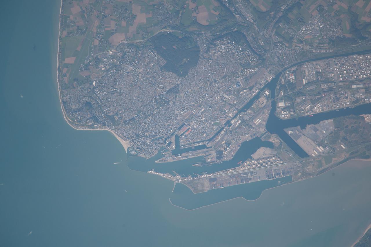
ISS037-E-021618 (26 Oct. 2013) --- Le Havre, France is featured in this image photographed by an Expedition 37 crew member on the International Space Station. The port city of Le Havre, France is located at the confluence of the Seine River and the English Channel along the northern coastline of the country (Upper Normandy region). Le Havre is the largest container port in France, and the second largest in terms of total traffic after Marseille. The extensive port facilities, visible at center, include numerous docks (large cargo ships are clearly visible in this detailed photograph), storage tanks for petro- and other chemicals, and large industrial and warehouse facilities with white rooftops. The port also serves seagoing pleasure cruise vessels. The southern edge of the port facility along the Seine includes a seawall-enclosed ship turning area (lower center). The Montgeon Forest, visible as a large green region at upper center, includes 200 hectares of woodland and 30 hectares of meadows and lawns. The urban area of Le Havre, to the north of the port facilities, was largely destroyed during World War II. After the war, the city was rebuilt following the vision of architect Auguste Perret. Perret favored the use of reinforced and precast concrete in building structures, and much of the city built between 1945 and 1964 follows his plan in both form and materials ? leading to the designation of Le Havre as a UNESCO World Heritage Site.
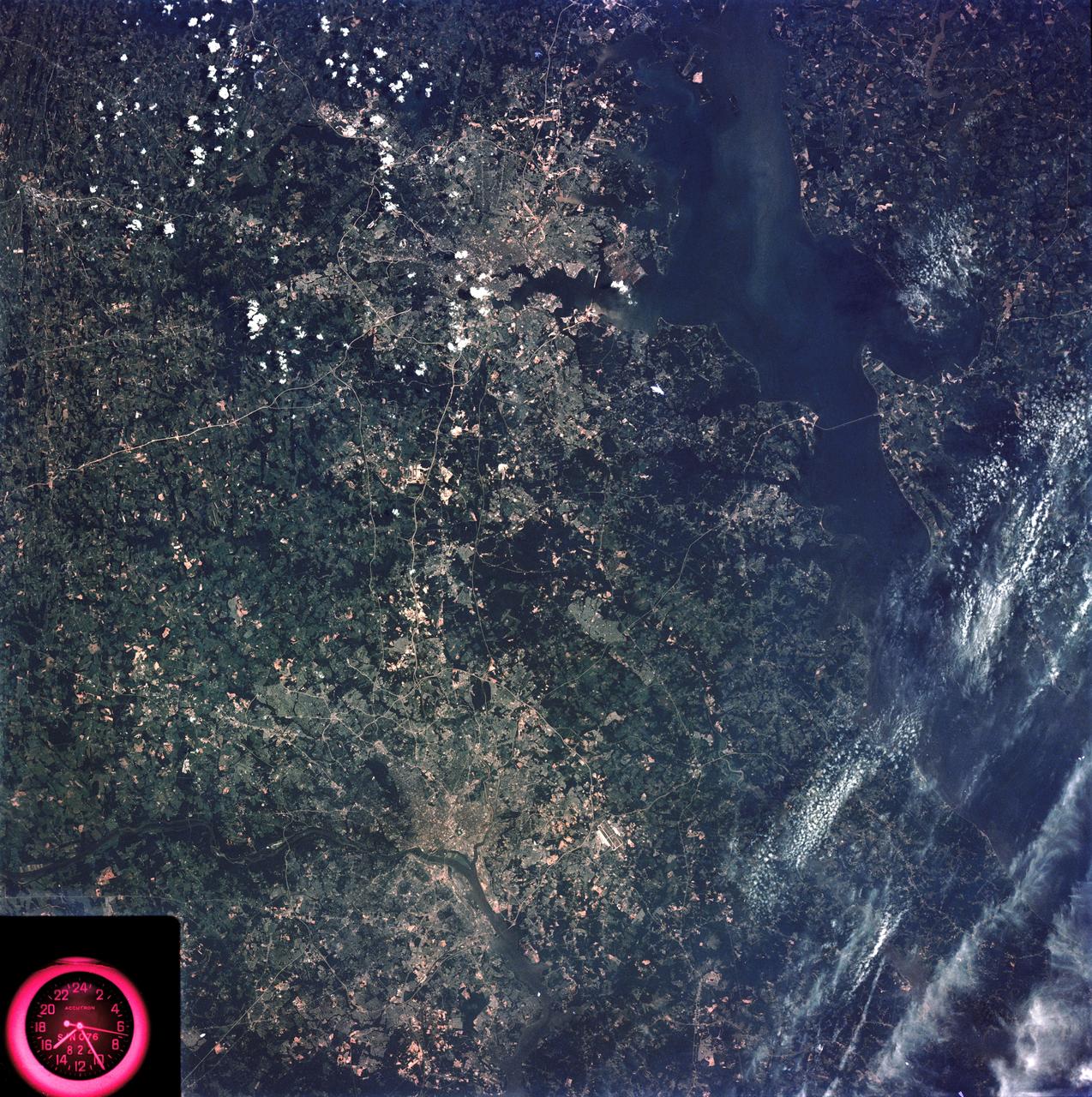
SL3-83-166 (July-September 1973) --- A vertical view of the Washington D.C. and the Baltimore, Maryland area is seen in the Skylab 3 Earth Resources Experiments Package S190-B (five-inch Earth terrain camera) photograph taken from the Skylab space station in Earth orbit. The Chesapeake Bay is on the right (east) side of the picture. The Potomac River flows through the Washington area in the lower left (southwest) corner of the photograph. Several transportation routes and major highways stand out very distinctly. Especially conspicuous are the beltways around the cities, Interstate 95 between Baltimore and the nation?s capitol and Interstate 70N leading west from Baltimore. The tunnel and harbor facilities in Baltimore show clearly, also. Identifiable features in the Washington area include the Capitol Building, the Mall area, Robert F. Kennedy Stadium (white circle), the five bridges across the Potomac, Andrews Air Force Base (on east loop), and the smaller Anacostia River. The extent of the urbanization in this area is dramatically illustrated in this picture. The photograph has sufficient resolution that the housing patterns for individual suburban areas are clearly defined with the houses shown as pink gray, wooded areas as dark green and cleared areas light green. Chesapeake Bay circulation patterns are indicated by contrast of dark and light blue. Sediment plumes (red) are seen entering the bay north and east of Baltimore. The bay bridge stands out white against the blue water. The detailed information contained in this one photograph will be of direct use to several EREP investigator teams in land use analysis, sedimentation and circulation patterns in the bay, and resource surveys of Maryland. All EREP photography is available to the public through the Department of Interior?s Earth Resources Observations Systems Data Center, Sioux Falls, South Dakota, 57198. Photo credit: NASA
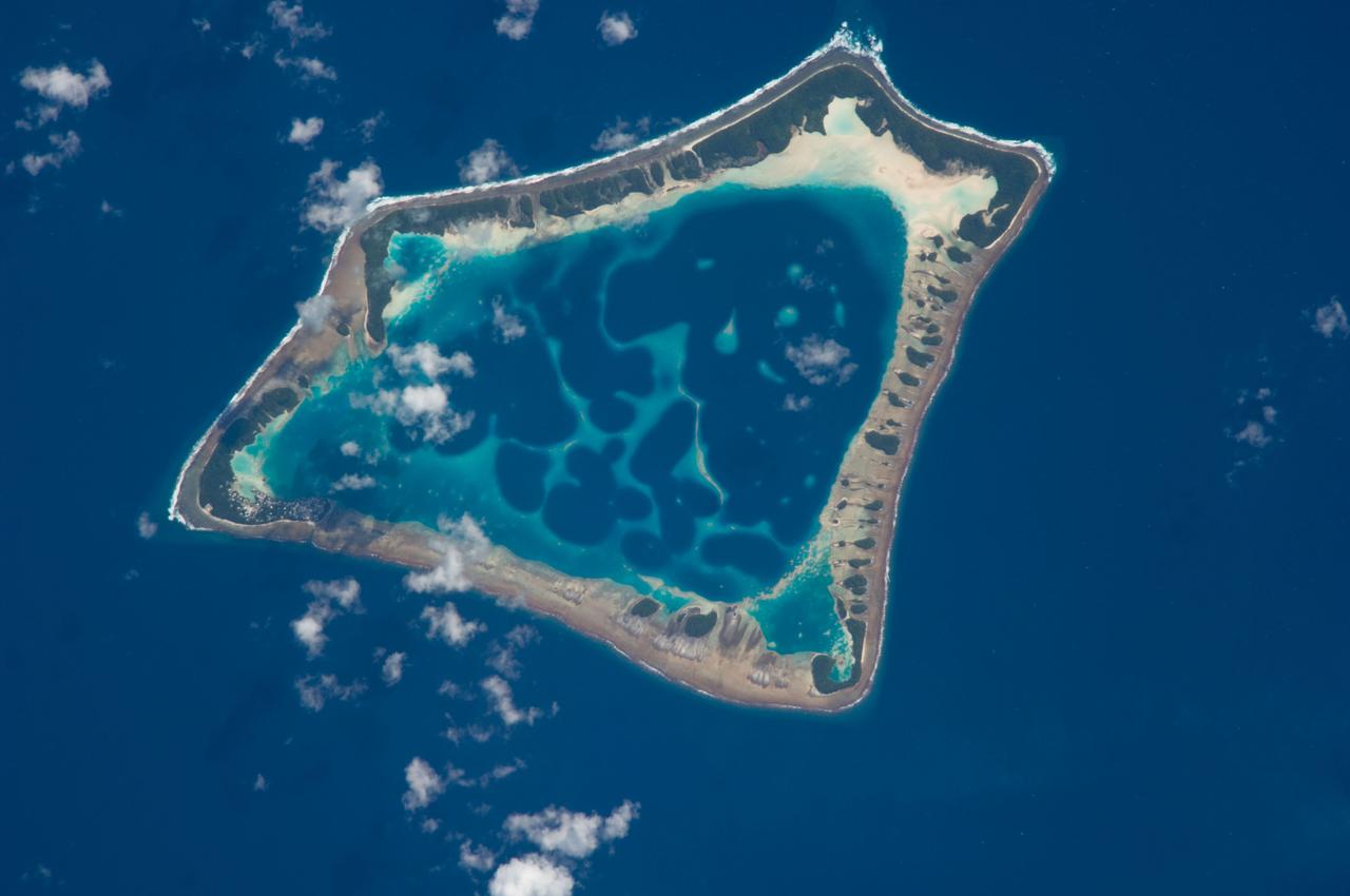
ISS018-E-018129 (6 Jan. 2009) --- Atafu Atoll in the Southern Pacific Ocean is featured in this image photographed by an Expedition 18 crewmember on the International Space Station. At roughly eight kilometers wide, Atafu Atoll is the smallest of three atolls (with Nukunonu and Fakaofo atolls to the southeast, not shown) comprising the Tokelau Islands group located in the southern Pacific Ocean. Swains Island to the south (not shown) is also considered part of the Tokelau group. The political entity of Tokelau is currently a territory of New Zealand. In recent years, public referendums on independence within the islands have been held, but have not received sufficient support to move forward. The primary settlement on Atafu is a village located at the northwestern corner of the atoll ? indicated by an area of light gray dots in this photograph. The typical ring shape of the atoll is the result of coral reefs building up around a former volcanic island. Over geologic time, the central volcano has subsided beneath the water surface, leaving the fringing reefs and a central lagoon that contains submerged coral reefs. Erosion and soil development on the surfaces of the exposed fringing reefs has lead to formation of tan to light brown beach deposits (southern and western sides of the atoll) and green vegetation cover (northern and eastern sides of the atoll). The Tokelau Islands, including Atafu Atoll, suffered significant inundation and erosion during Tropical Cyclone Percy in 2005. The approximate elevation of Atafu Atoll is only two meters above the tidal high water level. Vulnerability to tropical cyclones and potential sea level rise makes the long-term habitability of the atoll uncertain.
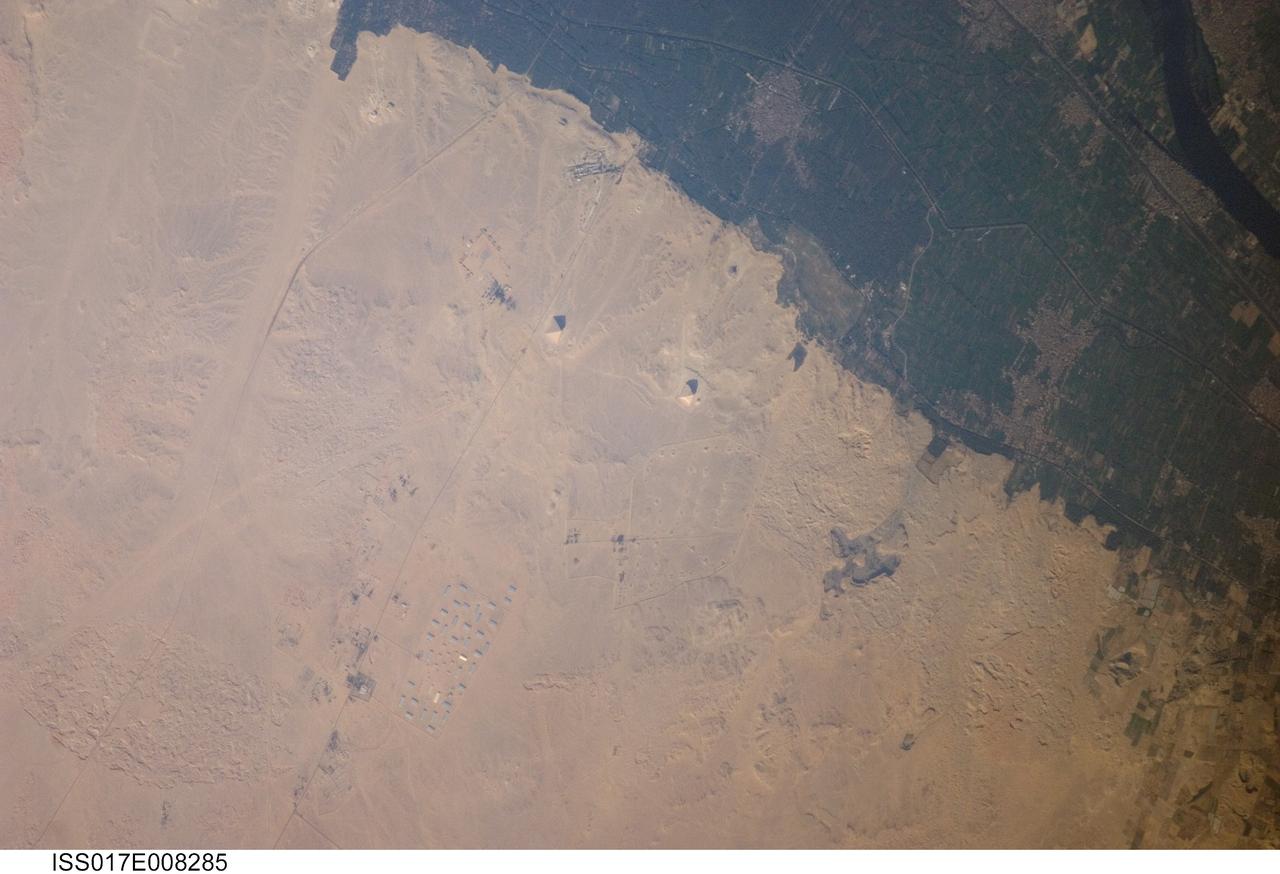
ISS017-E-008285 (30 May 2008) --- Pyramids of Dashur, Egypt are featured in this image photographed by an Expedition 17 crewmember on the International Space Station. While the pyramids of Giza are perhaps the most famous, there are several other ancient Egyptian royal necropolis ("city of the dead") sites situated along the Nile River and its delta. One of these sites is located near the village of Dashur (upper right). The gray-brown built area of Dashur is surrounded by green agricultural land of the Nile Delta, which forms a distinct boundary with the tan desert to the west. It is in the desert that the monuments of the ancient rulers of Egypt are found. Several monuments are visible in this image, including the large Red and Bent Pyramids built by Snofru, first king of the 4th Dynasty that lasted from 2575-2465 BC. Other visible monuments include the pyramid complexes of Amenemhat III and Sesostris III, both kings of the 12th Dynasty (1991-1783 BC). Both of these complexes are poorly preserved, due both to unstable ground conditions, and dismantling of the limestone blocks forming the outer pyramid casings during later historical periods. The Bent Pyramid (lower right) is so called as the slope of the outer face was lessened halfway through construction, leading to a distinctive "bent" profile -- explanations for why this was done include decreasing the mass of the pyramid to prevent collapse, or to reduce the work necessary to complete it. The Red Pyramid to the north (center) was built after the Bent Pyramid, and is named for the coloration of the building stone at the structure's core. An irregular dark feature to the southeast of the Bent Pyramid is not a shadow cast by a monument; it is an irrigation feature extending into the desert.
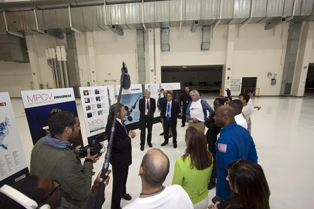
CAPE CANAVERAL, Fla. – At NASA Kennedy Space Center in Florida, presenters in a NASA Tweetup tour the Operations and Checkout Building (O&C). Listening to a briefing from from Larry Price, Lockheed Martin deputy program manager, on the Orion Multi Purpose Crew Vehicle are, from left, NASA Deputy Administrator Lori Garver (green jacket); former astronaut Leland Melvin, NASA associate administrator for Education (blue flight suit); Yves Lamothe, lead systems engineer for the 21st Century Ground Systems Program at Kennedy; Will.i.am, entertainer and member of The Black Eyed Peas; and Lars Perkins, chair of the Education and Public Outreach Committee of the NASA Advisory Council. The visit to the O&C followed their participation in a NASA Tweetup. The Tweetup is part of prelaunch activities for the agency’s Mars Science Laboratory (MSL) launch and provides the opportunity for tweeters will share their experiences with followers through the social networking site Twitter. The MSL mission will pioneer precision landing technology and a sky-crane touchdown to place a car-sized rover, Curiosity, near the foot of a mountain inside Gale Crater on Aug. 6, 2012. During a nearly two-year prime mission after landing, the rover will investigate whether the region has ever offered conditions favorable for microbial life, including the chemical ingredients for life. Liftoff of MSL aboard a United Launch Alliance Atlas V rocket from Space Launch Complex-41 on Cape Canaveral Air Force Station was at 10:02 a.m. EST on Nov. 26. For more information, visit http://www.nasa.gov/msl. Photo credit: NASA/Jim Grossmann
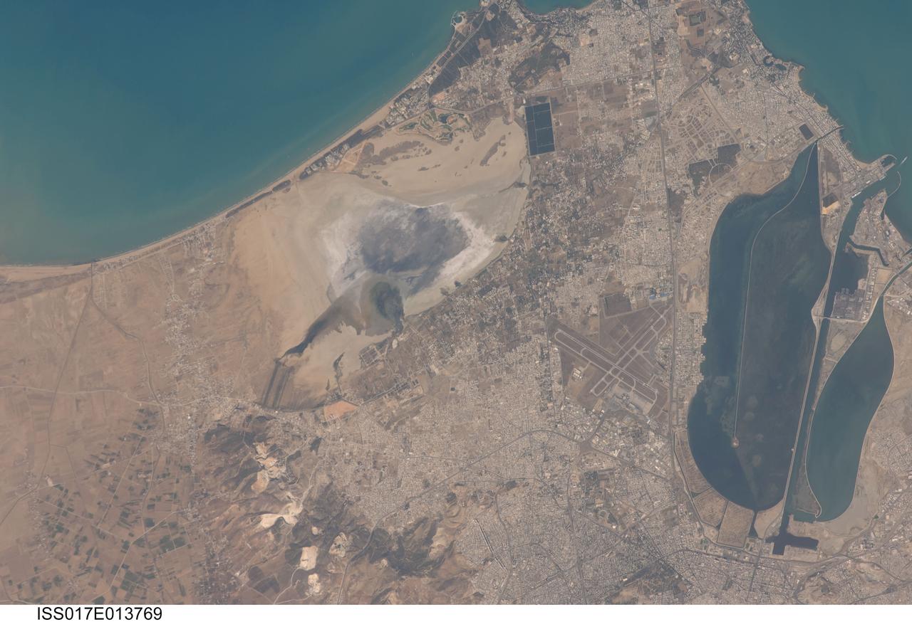
ISS017-E-013769 (19 Aug. 2008) --- Tunis, Tunisia is featured in this image photographed by an Expedition 17 crewmember on the International Space Station. The city of Tunis, capital of Tunisia, is a rapidly modernizing city located along the Mediterranean coast of northern Africa. Sharing much of its history with famous Carthage to the north, Tunis was also destroyed by Rome in approximately 146 BC. Tunis, however, was rebuilt by the Romans and became an important agricultural center. Modern Tunis serves as the administrative center for the whole of Tunisia, and as a commercial hub for trade in the northern part of the country. The urban area of Tunis is located on a flat coastal plain, and is distinguished in this view from the surrounding desert by the pattern of grey to tan buildings and darker street grid. The city is bordered by an evaporating saline lake to the northeast known as Sebkhet Arina (upper left) -- evaporite minerals such as halite (table salt) and gypsum produce the white deposits surrounding the darker lake center where there is more moisture. To the southeast of the city is Lake Tunis, a lagoon that has been significantly altered by human activities -- such as closing off water exchange with the Mediterranean Sea - dating back to Roman times. The general lack of water circulation and input of nutrients from sewage has lead to the establishment of marine worm reefs, and occasional fish kills. The western urban-rural fringe is defined by a range of low hills (lower left); dark green agricultural fields are visible on the western side of these hills.
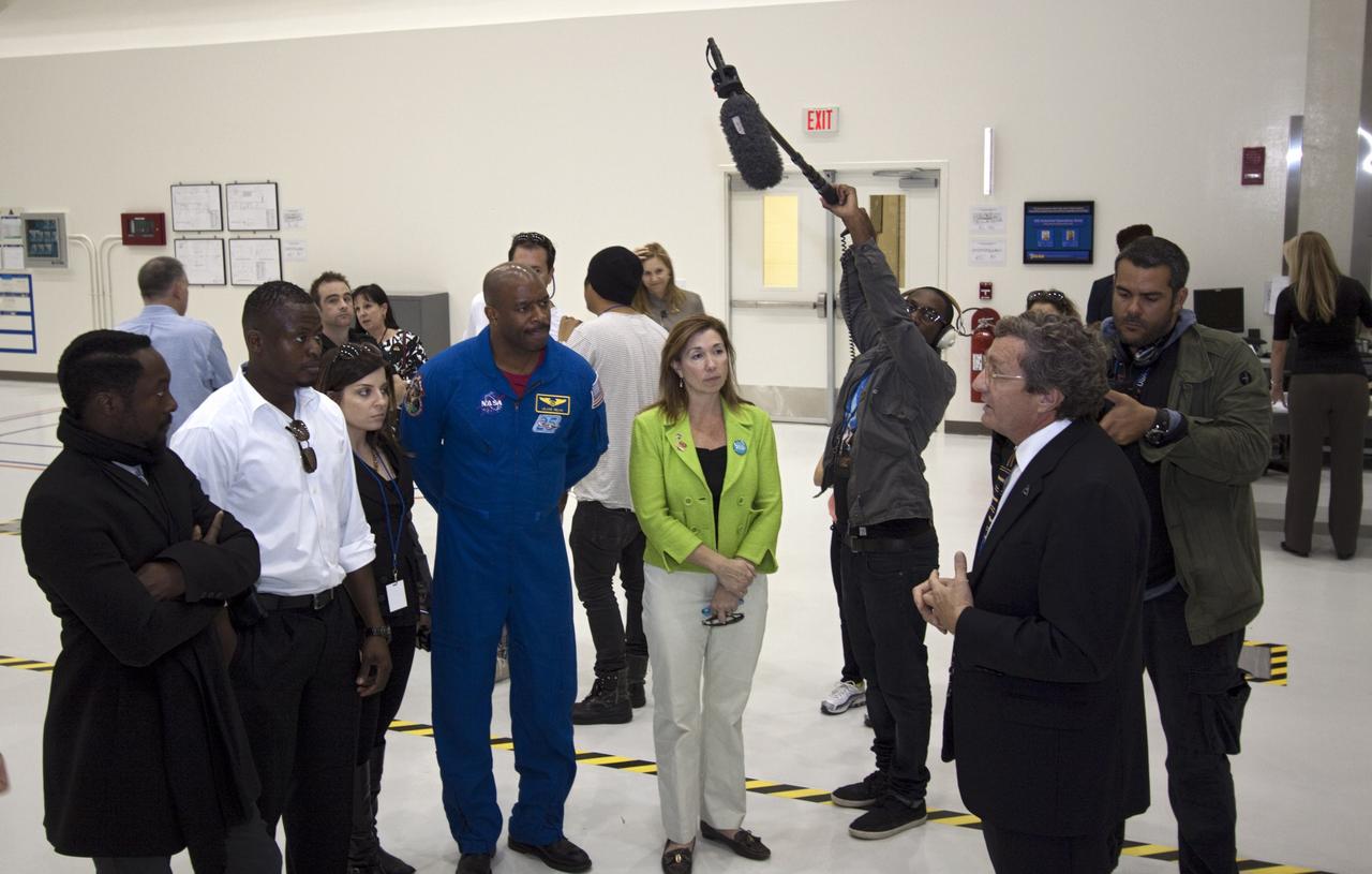
CAPE CANAVERAL, Fla. – At NASA Kennedy Space Center in Florida, Will.i.am (left), entertainer and member of The Black Eyed Peas, accompanied by Yves Lamothe, lead systems engineer for the 21st Century Ground Systems Program at Kennedy; former astronaut Leland Melvin, NASA associate administrator for Education (blue flight suit), and NASA Deputy Administrator Lori Garver (green jacket), receives a tour of the Operations and Checkout Building (O&C) from Larry Price, Lockheed Martin deputy program manager. The visit to the O&C followed their participation in a NASA Tweetup. The Tweetup is part of prelaunch activities for the agency’s Mars Science Laboratory (MSL) launch and provides the opportunity for tweeters will share their experiences with followers through the social networking site Twitter. The MSL mission will pioneer precision landing technology and a sky-crane touchdown to place a car-sized rover, Curiosity, near the foot of a mountain inside Gale Crater on Aug. 6, 2012. During a nearly two-year prime mission after landing, the rover will investigate whether the region has ever offered conditions favorable for microbial life, including the chemical ingredients for life. Liftoff of MSL aboard a United Launch Alliance Atlas V rocket from Space Launch Complex-41 on Cape Canaveral Air Force Station was at 10:02 a.m. EST on Nov. 26. For more information, visit http://www.nasa.gov/msl. Photo credit: NASA/Jim Grossmann
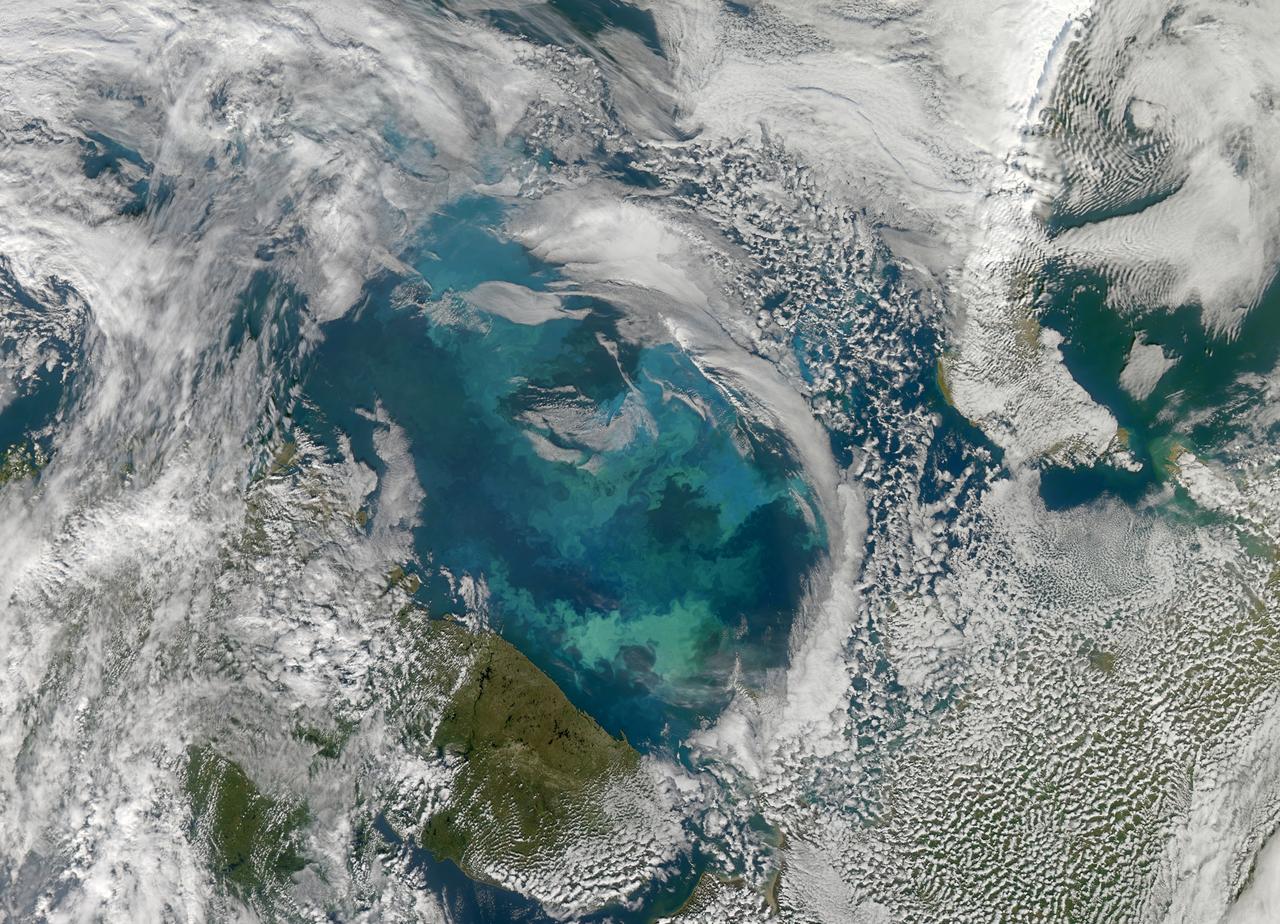
NASA image acquired August 31, 2010 To see a detail of this image go to: <a href="http://www.flickr.com/photos/gsfc/4971318856/">www.flickr.com/photos/gsfc/4971318856/</a> In this natural-color image from August 31, 2010, the ocean’s canvas swirls with turquoise, teal, navy, and green, the abstract art of the natural world. The colors were painted by a massive phytoplankton bloom made up of millions of tiny, light-reflecting organisms growing in the sunlit surface waters of the Barents Sea. Such blooms peak every August in the Barents Sea. The variations in color are caused by different species and concentrations of phytoplankton. The bright blue colors are probably from coccolithophores, a type of phytoplankton that is coated in a chalky shell that reflects light, turning the ocean a milky turquoise. Coccolithophores dominate the Barents Sea in August. Shades of green are likely from diatoms, another type of phytoplankton. Diatoms usually dominate the Barents Sea earlier in the year, giving way to coccolithophores in the late summer. However, field measurements of previous August blooms have also turned up high concentrations of diatoms. The Barents Sea is a shallow sea sandwiched between the coastline of northern Russia and Scandinavia and the islands of Svalbard, Franz Josef Land, and Novaya Zemlya. Within the shallow basin, currents carrying warm, salty water from the Atlantic collide with currents carrying cold, fresher water from the Arctic. During the winter, strong winds drive the currents and mix the waters. When winter’s sea ice retreats and light returns in the spring, diatoms thrive, typically peaking in a large bloom in late May. The shift between diatoms and coccolithophores occurs as the Barents Sea changes during the summer months. Throughout summer, perpetual light falls on the waters, gradually warming the surface. Eventually, the ocean stratifies into layers, with warm water sitting on top of cooler water. The diatoms deplete most of the nutrients in the surface waters and stop growing. Coccolithophores, on the other hand, do well in warm, nutrient-depleted water with a lot of light. In the Barents Sea, these conditions are strongest in August. The shifting conditions and corresponding change in species lead to strikingly beautiful multicolored blooms such as this one. The Moderate Resolution Imaging Spectroradiometer (MODIS) on NASA’s Aqua satellite acquired this image. NASA image courtesy Norman Kuring, NASA Ocean Color Group. Caption by Holli Riebeek. Instrument: Aqua - MODIS Click here to see more images from <b><a href="#//earthobservatory.nasa.gov/" rel="nofollow"> NASA Goddard’s Earth Observatory</a></b> <b><a href="http://www.nasa.gov/centers/goddard/home/index.html" rel="nofollow">NASA Goddard Space Flight Center</a></b> is home to the nation's largest organization of combined scientists, engineers and technologists that build spacecraft, instruments and new technology to study the Earth, the sun, our solar system, and the universe. <b>Follow us on <a href="http://twitter.com/NASA_GoddardPix" rel="nofollow">Twitter</a></b> <b>Join us on <a href="http://www.facebook.com/pages/Greenbelt-MD/NASA-Goddard/395013845897?ref=tsd" rel="nofollow">Facebook</a></b>
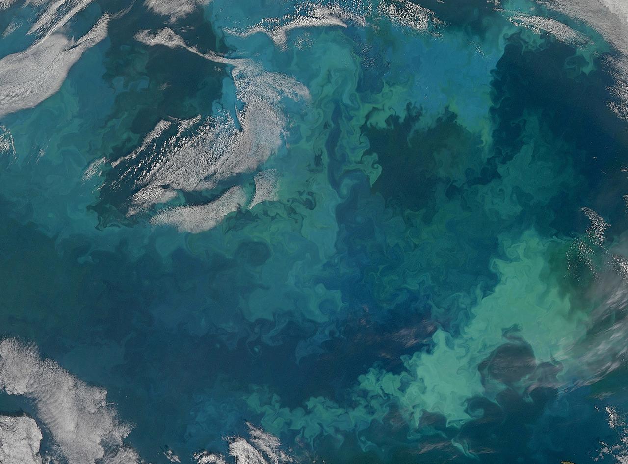
NASA image acquired August 31, 2010 To see the full view of this image go to: <a href="http://www.flickr.com/photos/gsfc/4970549945">www.flickr.com/photos/gsfc/4970549945</a> In this natural-color image from August 31, 2010, the ocean’s canvas swirls with turquoise, teal, navy, and green, the abstract art of the natural world. The colors were painted by a massive phytoplankton bloom made up of millions of tiny, light-reflecting organisms growing in the sunlit surface waters of the Barents Sea. Such blooms peak every August in the Barents Sea. The variations in color are caused by different species and concentrations of phytoplankton. The bright blue colors are probably from coccolithophores, a type of phytoplankton that is coated in a chalky shell that reflects light, turning the ocean a milky turquoise. Coccolithophores dominate the Barents Sea in August. Shades of green are likely from diatoms, another type of phytoplankton. Diatoms usually dominate the Barents Sea earlier in the year, giving way to coccolithophores in the late summer. However, field measurements of previous August blooms have also turned up high concentrations of diatoms. The Barents Sea is a shallow sea sandwiched between the coastline of northern Russia and Scandinavia and the islands of Svalbard, Franz Josef Land, and Novaya Zemlya. Within the shallow basin, currents carrying warm, salty water from the Atlantic collide with currents carrying cold, fresher water from the Arctic. During the winter, strong winds drive the currents and mix the waters. When winter’s sea ice retreats and light returns in the spring, diatoms thrive, typically peaking in a large bloom in late May. The shift between diatoms and coccolithophores occurs as the Barents Sea changes during the summer months. Throughout summer, perpetual light falls on the waters, gradually warming the surface. Eventually, the ocean stratifies into layers, with warm water sitting on top of cooler water. The diatoms deplete most of the nutrients in the surface waters and stop growing. Coccolithophores, on the other hand, do well in warm, nutrient-depleted water with a lot of light. In the Barents Sea, these conditions are strongest in August. The shifting conditions and corresponding change in species lead to strikingly beautiful multicolored blooms such as this one. The Moderate Resolution Imaging Spectroradiometer (MODIS) on NASA’s Aqua satellite acquired this image. NASA image courtesy Norman Kuring, NASA Ocean Color Group. Caption by Holli Riebeek. Instrument: Aqua - MODIS Click here to see more images from <b><a href="#//earthobservatory.nasa.gov/" rel="nofollow"> NASA Goddard’s Earth Observatory</a></b> <b><a href="http://www.nasa.gov/centers/goddard/home/index.html" rel="nofollow">NASA Goddard Space Flight Center</a></b> is home to the nation's largest organization of combined scientists, engineers and technologists that build spacecraft, instruments and new technology to study the Earth, the sun, our solar system, and the universe. <b>Follow us on <a href="http://twitter.com/NASA_GoddardPix" rel="nofollow">Twitter</a></b> <b>Join us on <a href="http://www.facebook.com/pages/Greenbelt-MD/NASA-Goddard/395013845897?ref=tsd" rel="nofollow">Facebook</a></b>
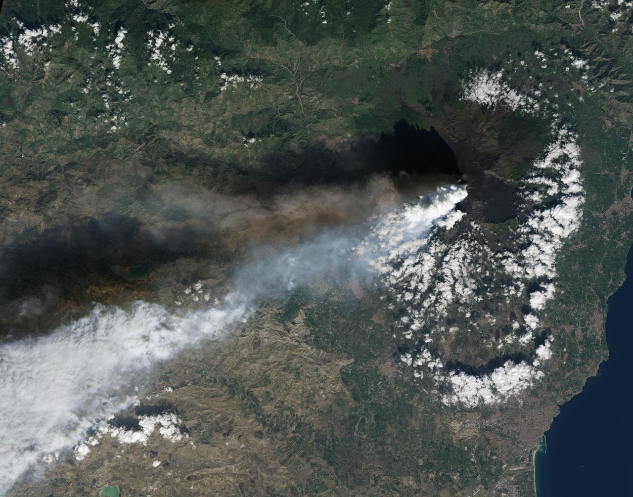
Twin volcanic plumes—one of ash, one of gas—rose from Sicily’ Mount Etna on the morning of October 26, 2013. L’Istituto Nazionale di Geofisica e Vulcanologia (INGV) Osservatorio Etneo (National Institute of Geophysics and Volcanology Etna Observatory) reported that Etna was experiencing its first paroxysm in six months. Multiple eruption columns are common at Etna, a result of complex plumbing within the volcano. The Northeast Crater, one of several on Etna’s summit, was emitting the ash column, while the New Southeast Crater was simultaneously venting mostly gas. This natural-color image collected by Landsat 8 shows the view from space at 11:38 a.m. local time. The towering, gas-rich plume cast a dark shadow over the lower, ash-rich plume and Etna’s northwestern flank. Relatively fresh lava flows (less than a century or so old) are dark gray; vegetation is green; and the tile-roofed buildings of Bronte and Biancavilla lend the towns an ochre hue. NASA Earth Observatory image by Jesse Allen and Robert Simmon, using Landsat data from the USGS Earth Explorer. Photograph ©2013, Boris Behncke. Caption by Robert Simmon with contributions from Boris Behncke. Instrument: Landsat 8 - OLI More info: <a href="http://1.usa.gov/1cEcOFi" rel="nofollow">1.usa.gov/1cEcOFi</a> Credit: <b><a href="http://www.earthobservatory.nasa.gov/" rel="nofollow"> NASA Earth Observatory</a></b> <b><a href="http://www.nasa.gov/audience/formedia/features/MP_Photo_Guidelines.html" rel="nofollow">NASA image use policy.</a></b> <b><a href="http://www.nasa.gov/centers/goddard/home/index.html" rel="nofollow">NASA Goddard Space Flight Center</a></b> enables NASA’s mission through four scientific endeavors: Earth Science, Heliophysics, Solar System Exploration, and Astrophysics. Goddard plays a leading role in NASA’s accomplishments by contributing compelling scientific knowledge to advance the Agency’s mission. <b>Follow us on <a href="http://twitter.com/NASA_GoddardPix" rel="nofollow">Twitter</a></b> <b>Like us on <a href="http://www.facebook.com/pages/Greenbelt-MD/NASA-Goddard/395013845897?ref=tsd" rel="nofollow">Facebook</a></b> <b>Find us on <a href="http://instagram.com/nasagoddard?vm=grid" rel="nofollow">Instagram</a></b>
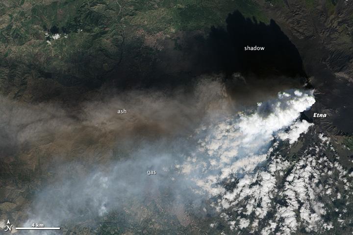
Twin volcanic plumes—one of ash, one of gas—rose from Sicily’ Mount Etna on the morning of October 26, 2013. L’Istituto Nazionale di Geofisica e Vulcanologia (INGV) Osservatorio Etneo (National Institute of Geophysics and Volcanology Etna Observatory) reported that Etna was experiencing its first paroxysm in six months. Multiple eruption columns are common at Etna, a result of complex plumbing within the volcano. The Northeast Crater, one of several on Etna’s summit, was emitting the ash column, while the New Southeast Crater was simultaneously venting mostly gas. This natural-color image collected by Landsat 8 shows the view from space at 11:38 a.m. local time. The towering, gas-rich plume cast a dark shadow over the lower, ash-rich plume and Etna’s northwestern flank. Relatively fresh lava flows (less than a century or so old) are dark gray; vegetation is green; and the tile-roofed buildings of Bronte and Biancavilla lend the towns an ochre hue. NASA Earth Observatory image by Jesse Allen and Robert Simmon, using Landsat data from the USGS Earth Explorer. Photograph ©2013, Boris Behncke. Caption by Robert Simmon with contributions from Boris Behncke. Instrument: Landsat 8 - OLI More info: <a href="http://1.usa.gov/1cEcOFi" rel="nofollow">1.usa.gov/1cEcOFi</a> Credit: <b><a href="http://www.earthobservatory.nasa.gov/" rel="nofollow"> NASA Earth Observatory</a></b> <b><a href="http://www.nasa.gov/audience/formedia/features/MP_Photo_Guidelines.html" rel="nofollow">NASA image use policy.</a></b> <b><a href="http://www.nasa.gov/centers/goddard/home/index.html" rel="nofollow">NASA Goddard Space Flight Center</a></b> enables NASA’s mission through four scientific endeavors: Earth Science, Heliophysics, Solar System Exploration, and Astrophysics. Goddard plays a leading role in NASA’s accomplishments by contributing compelling scientific knowledge to advance the Agency’s mission. <b>Follow us on <a href="http://twitter.com/NASA_GoddardPix" rel="nofollow">Twitter</a></b> <b>Like us on <a href="http://www.facebook.com/pages/Greenbelt-MD/NASA-Goddard/395013845897?ref=tsd" rel="nofollow">Facebook</a></b> <b>Find us on <a href="http://instagram.com/nasagoddard?vm=grid" rel="nofollow">Instagram</a></b>