
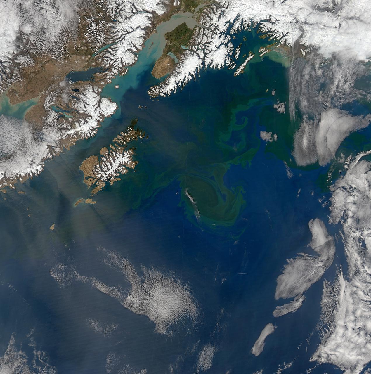
The spring bloom in the Gulf of Alaska was well underway on April 12, 2017, when the Aqua/MODIS and Suomi-NPP/VIIRS data from which the above image was created were collected. Credit: NASA/Goddard/NPP <b><a href="http://www.nasa.gov/audience/formedia/features/MP_Photo_Guidelines.html" rel="nofollow">NASA image use policy.</a></b> <b><a href="http://www.nasa.gov/centers/goddard/home/index.html" rel="nofollow">NASA Goddard Space Flight Center</a></b> enables NASA’s mission through four scientific endeavors: Earth Science, Heliophysics, Solar System Exploration, and Astrophysics. Goddard plays a leading role in NASA’s accomplishments by contributing compelling scientific knowledge to advance the Agency’s mission. <b>Follow us on <a href="http://twitter.com/NASAGoddardPix" rel="nofollow">Twitter</a></b> <b>Like us on <a href="http://www.facebook.com/pages/Greenbelt-MD/NASA-Goddard/395013845897?ref=tsd" rel="nofollow">Facebook</a></b> <b>Find us on <a href="http://instagrid.me/nasagoddard/?vm=grid" rel="nofollow">Instagram</a></b>
Increasing solar illumination brings increased phytoplankton growth to the Gulf of Alaska every spring, and this year is no exception. This image was collected on May 9, 2014 during a single orbit of Aqua-MODIS. High res: <a href="http://oceancolor.gsfc.nasa.gov/FEATURE/IMAGES/A2014129224500.GulfOfAlaska.half.jpg" rel="nofollow">oceancolor.gsfc.nasa.gov/FEATURE/IMAGES/A2014129224500.Gu...</a> Credit: NASA/Goddard/OceanColor/MODIS <b><a href="http://www.nasa.gov/audience/formedia/features/MP_Photo_Guidelines.html" rel="nofollow">NASA image use policy.</a></b> <b><a href="http://www.nasa.gov/centers/goddard/home/index.html" rel="nofollow">NASA Goddard Space Flight Center</a></b> enables NASA’s mission through four scientific endeavors: Earth Science, Heliophysics, Solar System Exploration, and Astrophysics. Goddard plays a leading role in NASA’s accomplishments by contributing compelling scientific knowledge to advance the Agency’s mission. <b>Follow us on <a href="http://twitter.com/NASAGoddardPix" rel="nofollow">Twitter</a></b> <b>Like us on <a href="http://www.facebook.com/pages/Greenbelt-MD/NASA-Goddard/395013845897?ref=tsd" rel="nofollow">Facebook</a></b> <b>Find us on <a href="http://instagram.com/nasagoddard?vm=grid" rel="nofollow">Instagram</a></b>
Increasing solar illumination brings increased phytoplankton growth to the Gulf of Alaska every spring, and this year is no exception. The above image was collected on May 2, 2014 several orbits of Aqua-MODIS. High res: <a href="http://oceancolor.gsfc.nasa.gov/FEATURE/IMAGES/A2014122.GulfOfAlaska.half.jpg" rel="nofollow">oceancolor.gsfc.nasa.gov/FEATURE/IMAGES/A2014122.GulfOfAl...</a> Credit: NASA/Goddard/OceanColor/MODIS <b><a href="http://www.nasa.gov/audience/formedia/features/MP_Photo_Guidelines.html" rel="nofollow">NASA image use policy.</a></b> <b><a href="http://www.nasa.gov/centers/goddard/home/index.html" rel="nofollow">NASA Goddard Space Flight Center</a></b> enables NASA’s mission through four scientific endeavors: Earth Science, Heliophysics, Solar System Exploration, and Astrophysics. Goddard plays a leading role in NASA’s accomplishments by contributing compelling scientific knowledge to advance the Agency’s mission. <b>Follow us on <a href="http://twitter.com/NASAGoddardPix" rel="nofollow">Twitter</a></b> <b>Like us on <a href="http://www.facebook.com/pages/Greenbelt-MD/NASA-Goddard/395013845897?ref=tsd" rel="nofollow">Facebook</a></b> <b>Find us on <a href="http://instagram.com/nasagoddard?vm=grid" rel="nofollow">Instagram</a></b>
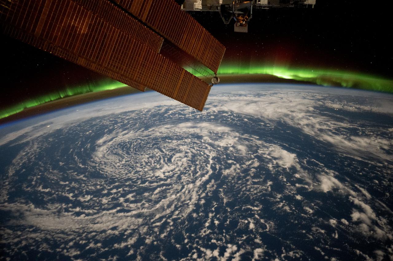
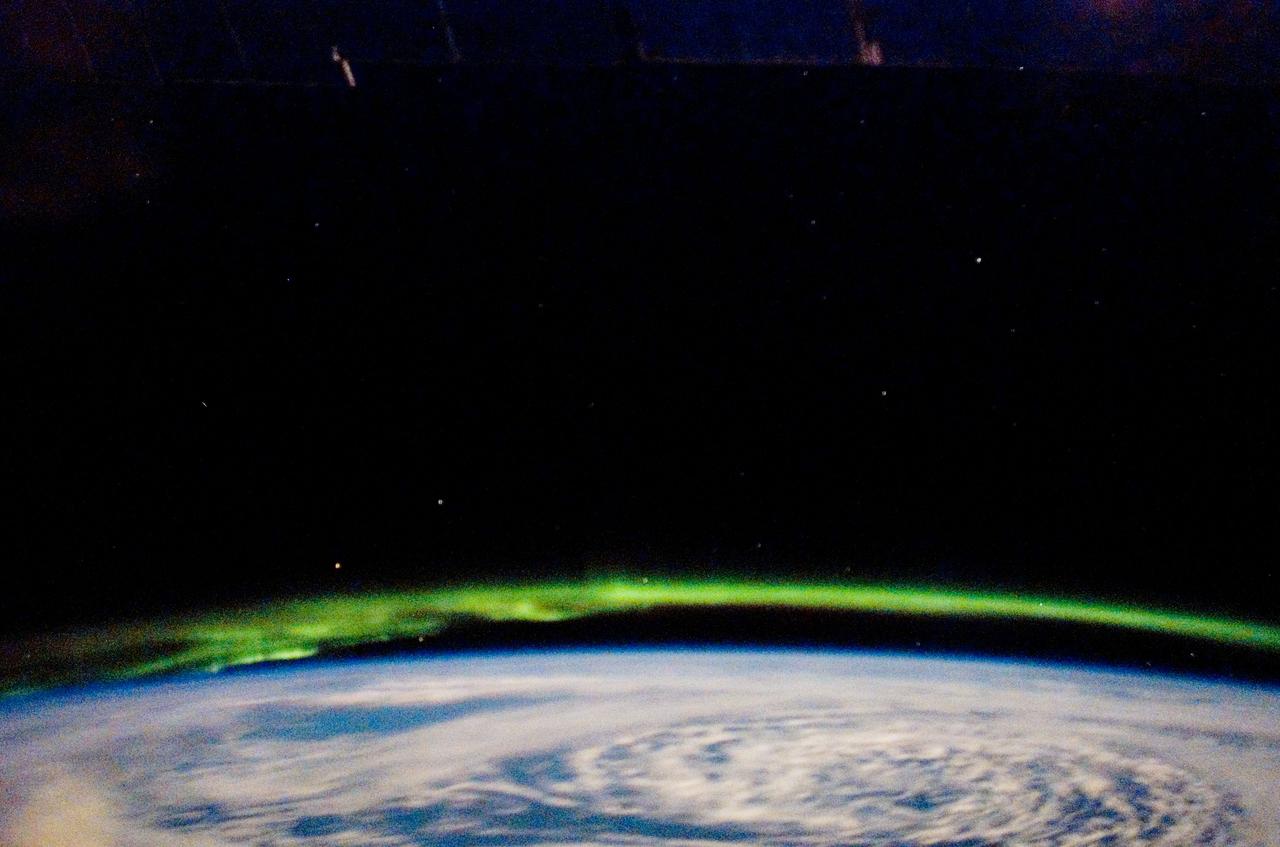
iss072e820937 (March 12, 2025) --- Clouds swirl over the Gulf of Alaska and underneath the aurora borealis blanketing Earth's horizon in this photograph from the International Space Station as it orbited 261 miles above.
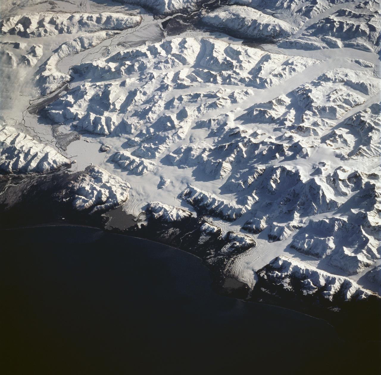
STS059-228-094 (9-20 April 1994) --- The spring thaw along the coast of the Gulf of Alaska has not touched the St. Elias Mountains, southeast of Yakutat Bay and Malaspina Glacier. A prominent glacier flows from Mt. Fairweather (15,300 feet) at right center, to form Cape Fairweather. Another glacier to the northwest almost reaches the sea; the valley of the Alsek River forms a broad, braided plan at upper left. The low sun elevation and oblique angle of this photograph provide a striking 3-dimensional appearance to the black-and-white landscape. SRL investigators will study microwave response to varying depths and conditions of ice and snow along this coast, in Spring and Summer. Hasselblad photograph.
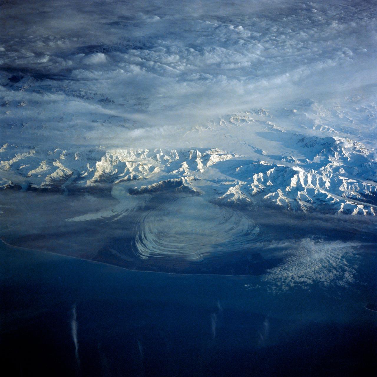
41G-43-016 (5-13 Oct 1984) --- The Gulf of Alaska, with the great peaks of the Saint Elias Range of Alaska, Yukon, and British Columbia. Mount Logan, Canada's highest mountain peak at 19,850 feet, is to the left of the center of the photograph. Between Saint Elias Peak and Mount Vancouver, right of center, flows the great Malaspina Glacier in a great lobe of ice shaped like a human ear.
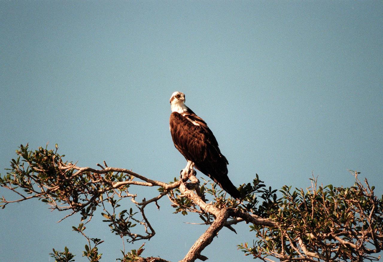
KENNEDY SPACE CENTER, FLA. -- An osprey perches on a treetop at Kennedy Space Center. This long-winged "fish hawk" inhabits lakes, rivers and seacoasts, surviving solely on fish which it captures from the water, grasping them in its talons when they near the surface. They range from Alaska and Newfoundland south to Florida and the Gulf Coast
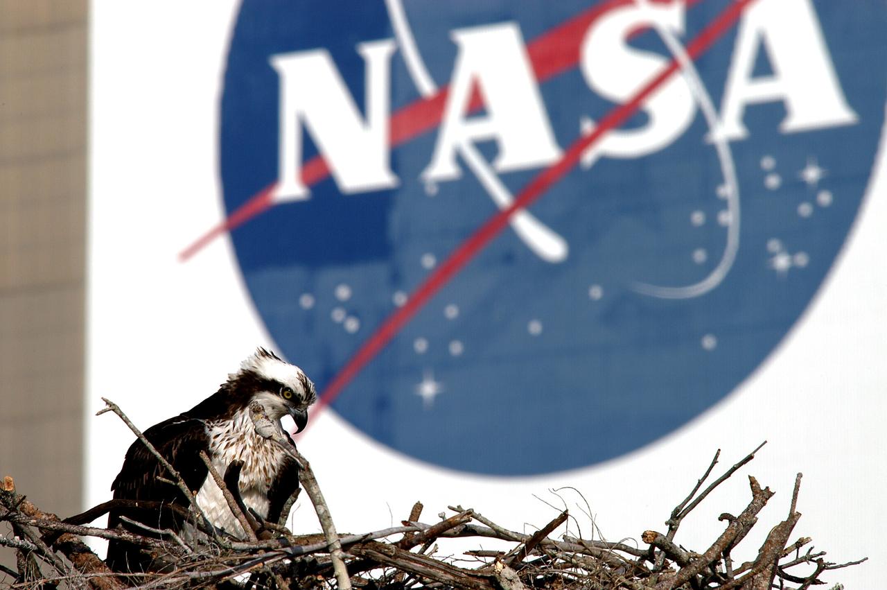
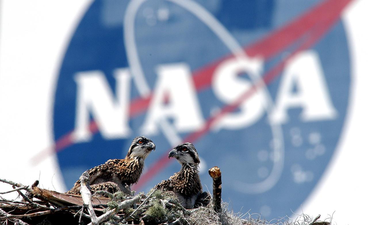
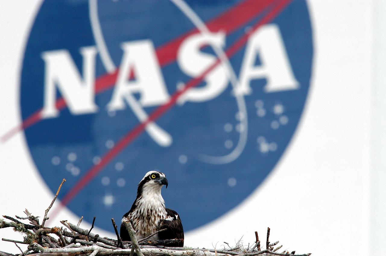
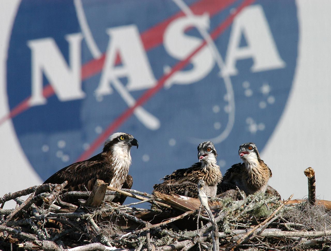
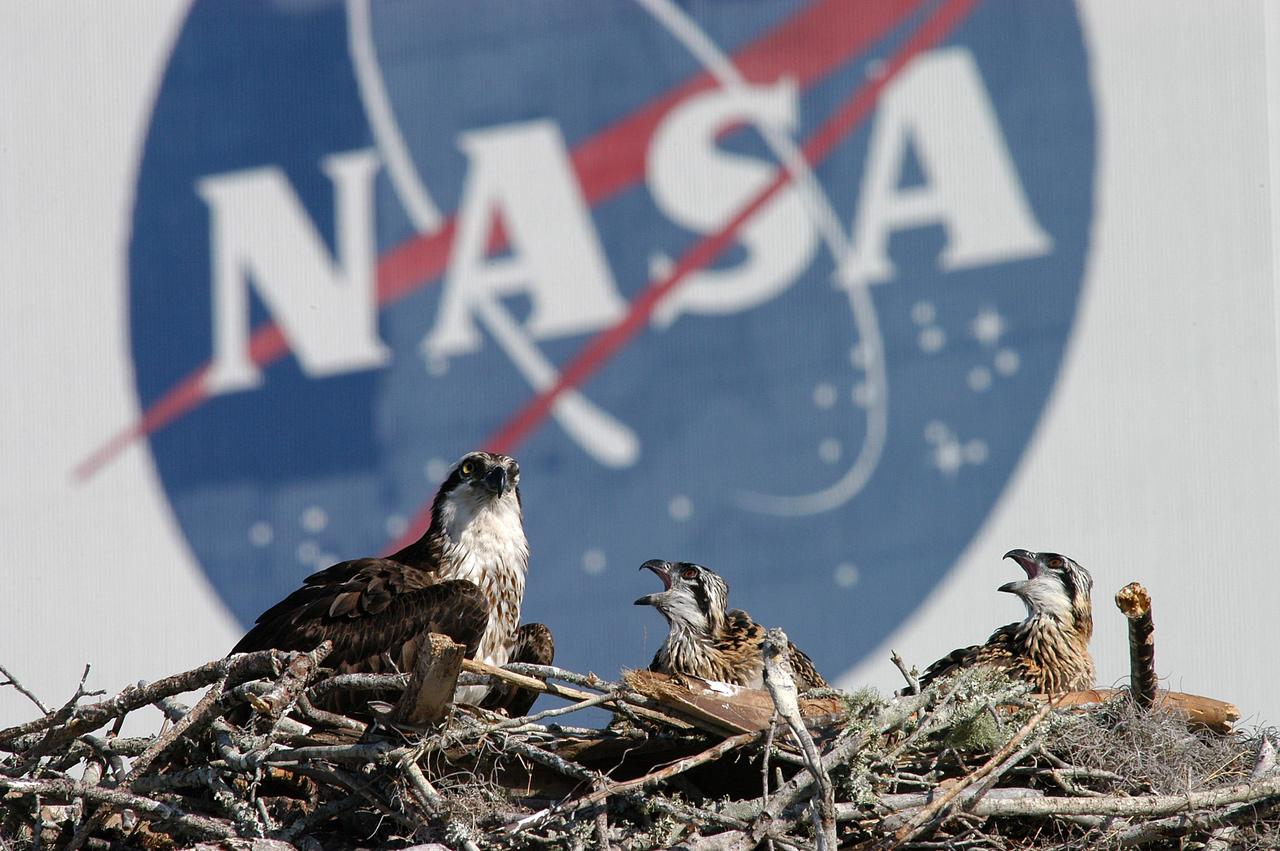
KENNEDY SPACE CENTER, FLA. -- A breeding osprey occupies a nest constructed on a speaker pole in the lower parking lot of the KSC Press Site. Eggs have been sighted in the nest. The NASA logo in the background is painted on an outer wall of the 525-foot-tall Vehicle Assembly Building nearby. Known as a fish hawk, the osprey selects sites of opportunity in which to nest -- from trees and telephone poles to rocks or even flat ground. In North America, it is found from Alaska and Newfoundland to Florida and the Gulf Coast. Osprey nests are found throughout the Kennedy Space Center and surrounding Merritt Island National Wildlife Refuge.

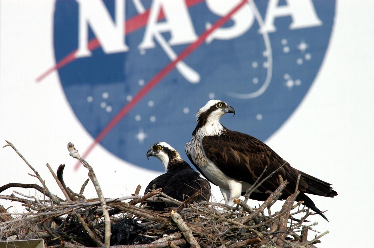
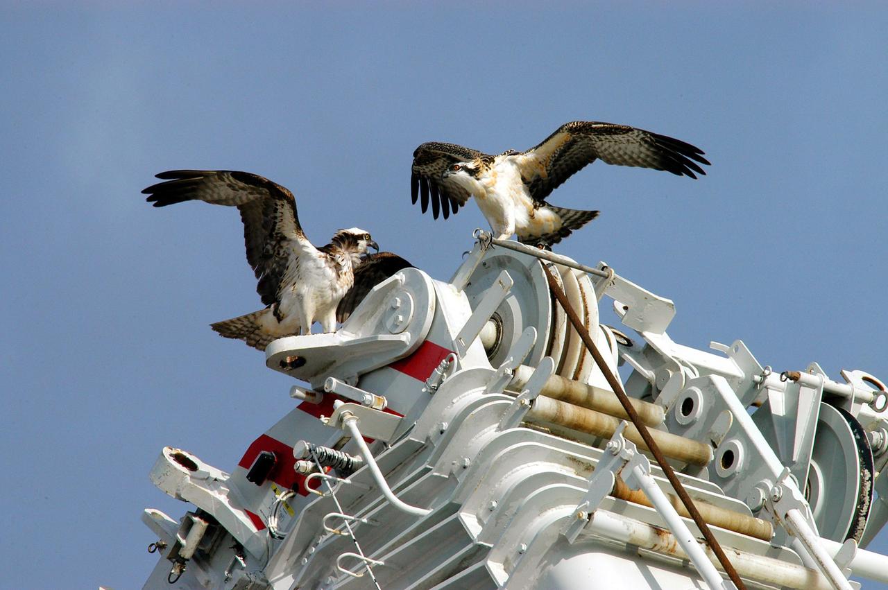
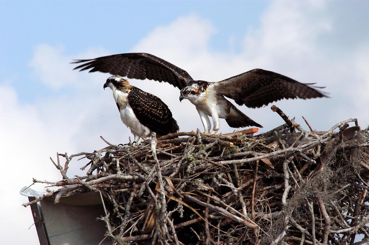
KENNEDY SPACE CENTER, FLA. -- A pair of breeding ospreys share a nest constructed on a speaker pole in the lower parking lot of the KSC Press Site. Eggs have been sighted in the nest. The NASA logo in the background is painted on an outer wall of the 525-foot-tall Vehicle Assembly Building nearby. Known as a fish hawk, the osprey selects sites of opportunity in which to nest -- from trees and telephone poles to rocks or even flat ground. In North America, it is found from Alaska and Newfoundland to Florida and the Gulf Coast. Osprey nests are found throughout the Kennedy Space Center and surrounding Merritt Island National Wildlife Refuge.
KENNEDY SPACE CENTER, FLA. -- A pair of breeding ospreys have taken up residence in a nest constructed on a speaker pole in the lower parking lot of the KSC Press Site. Eggs have been sighted in the nest. The NASA logo in the background is painted on an outer wall of the 525-foot-tall Vehicle Assembly Building nearby. Known as a fish hawk, the osprey selects sites of opportunity in which to nest -- from trees and telephone poles to rocks or even flat ground. In North America, it is found from Alaska and Newfoundland to Florida and the Gulf Coast. Osprey nests are found throughout the Kennedy Space Center and surrounding Merritt Island National Wildlife Refuge.

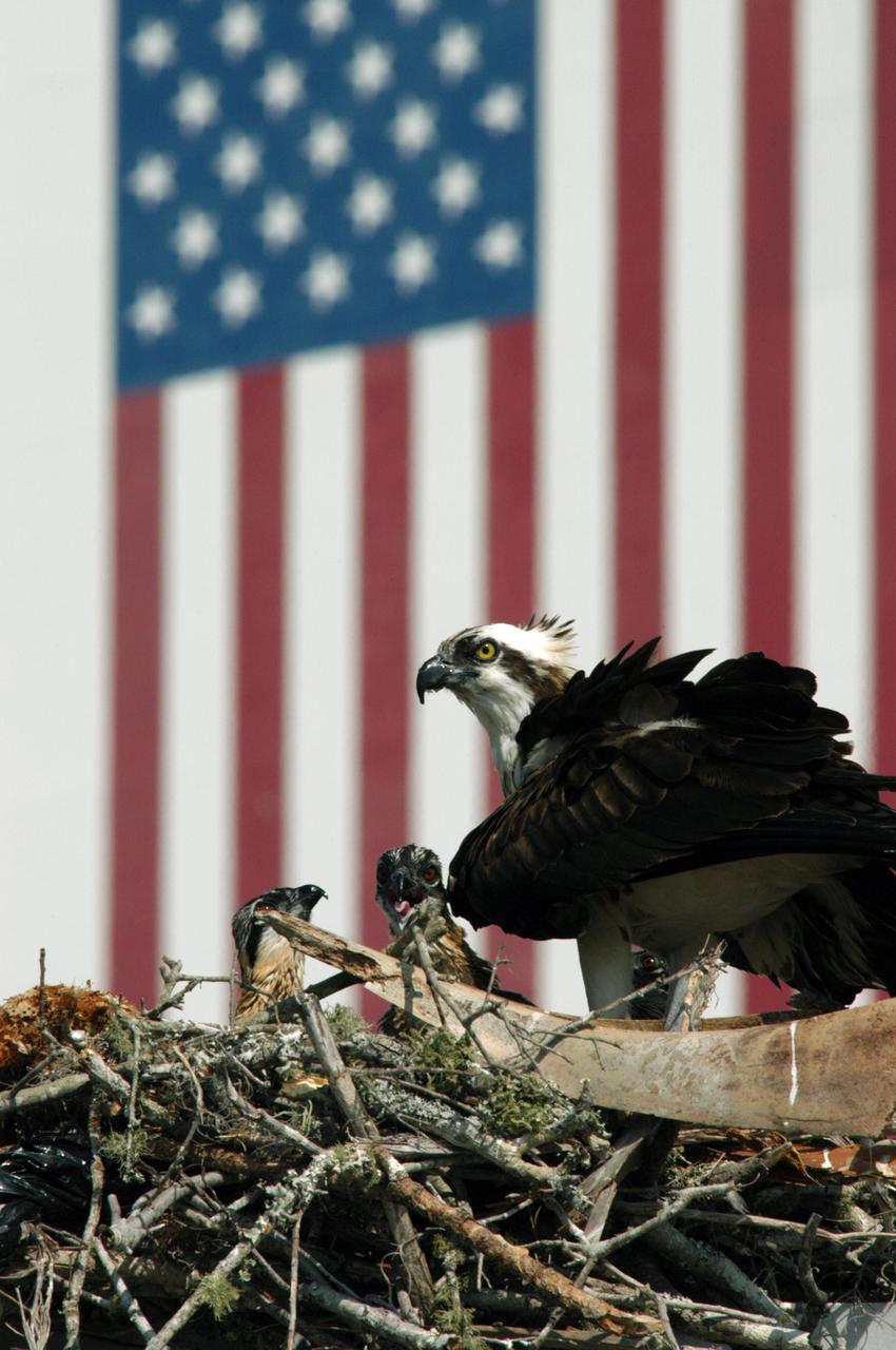
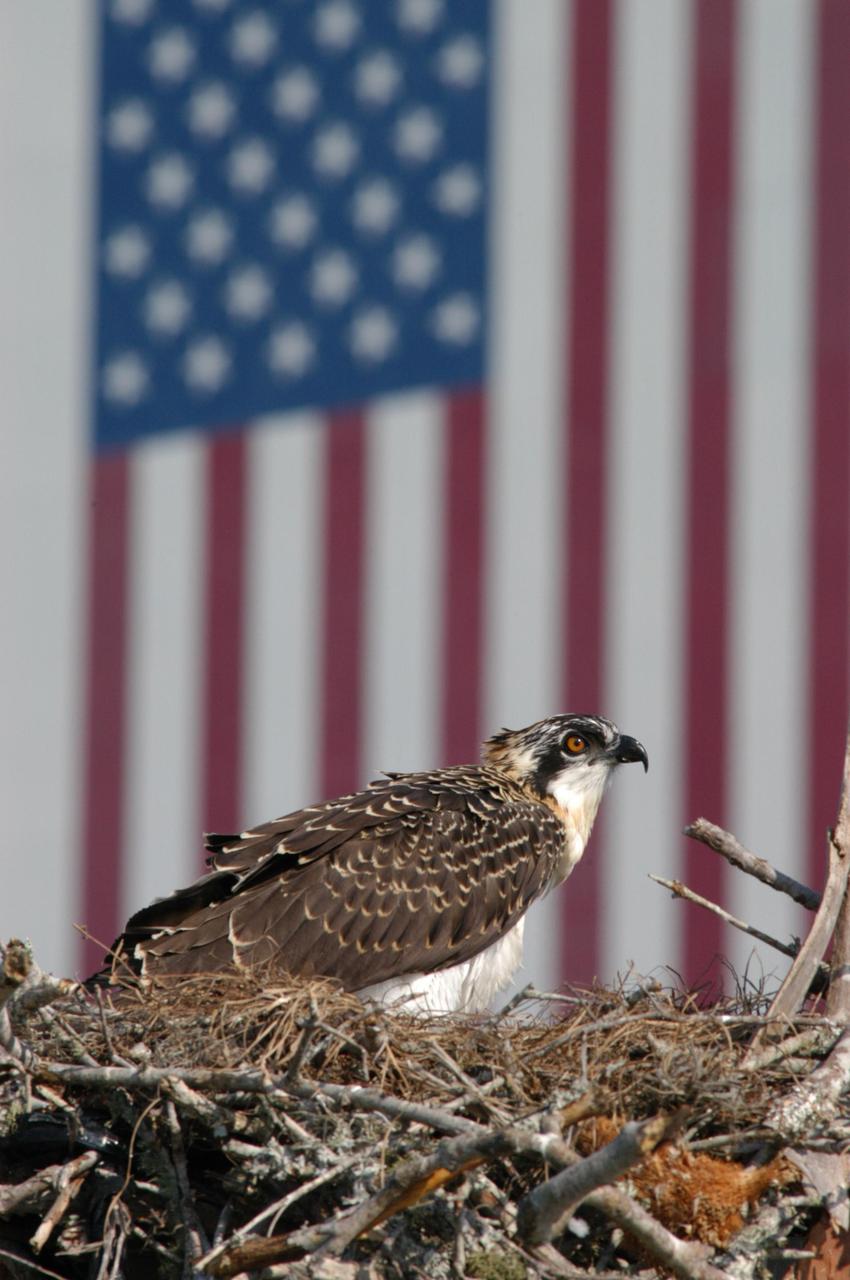
KENNEDY SPACE CENTER, FLA. - An osprey likes the view atop this American flag, which flies near the NASA KSC News Center. It’s nest is located atop a speaker in the parking lot. Known as a fish hawk, ospreys select sites of opportunity, from trees and telephone poles to rocks or even flat ground. In the United States they are found from Alaska to Florida and the Gulf Coast. Osprey nests are found throughout the Kennedy Space Center and nearby Merritt Island National Wildlife Refuge.
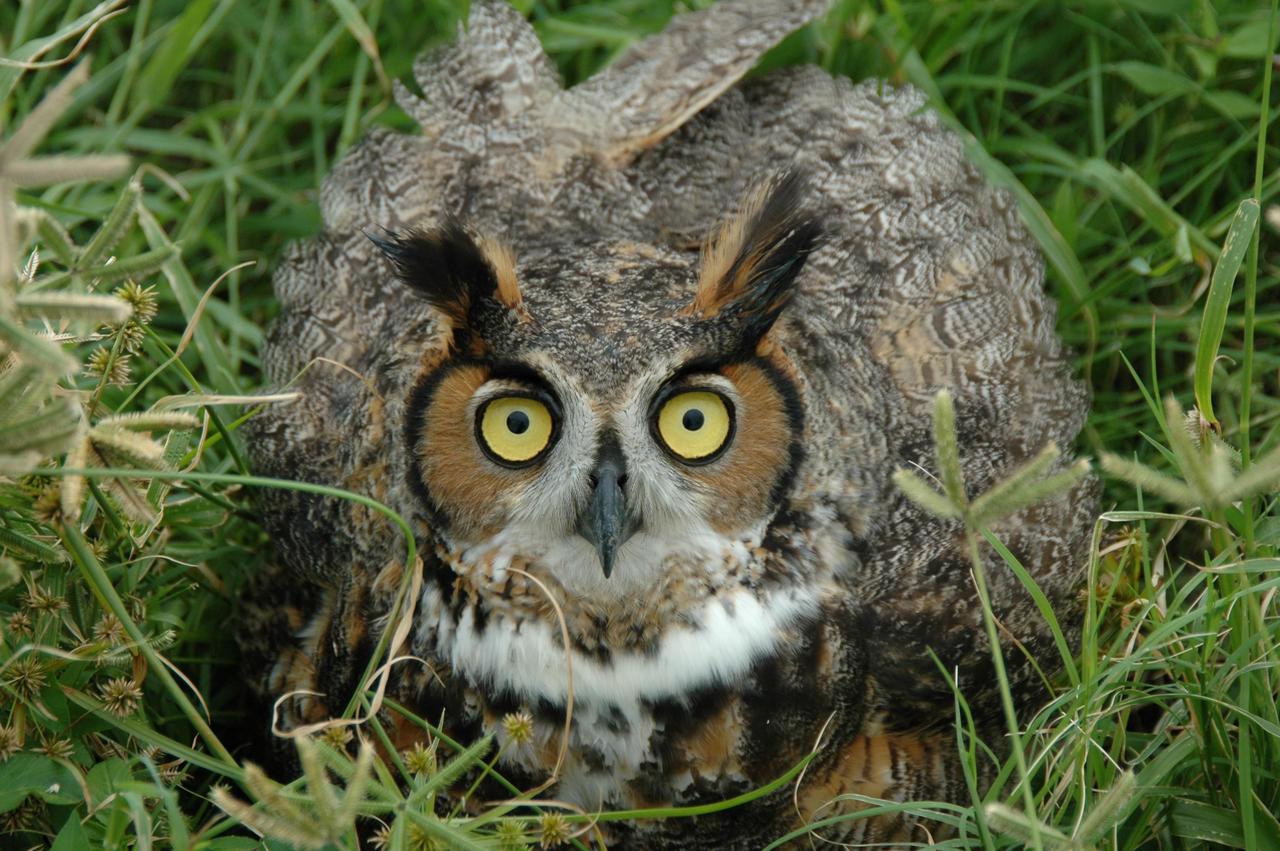
KENNEDY SPACE CENTER, FLA. - A Long-Eared Owl is spotted on Launch Complex 41 at Cape Canaveral Air Force Station in Florida. This one holds a typical stance for protecting its young. These owls range from Alaska and Canada to the Gulf states and Mexico, as far east as Central Florida. Their habitat is deciduous and evergreen forests. They nest in deserted nests of crows, hawks or squirrels.
KENNEDY SPACE CENTER, FLA. - Two fledgling ospreys occupy a nest near the NASA-KSC News Center, across from the Vehicle Assembly Building. Known as a fish hawk, ospreys select sites of opportunity, from trees and telephone poles to rocks or even flat ground. In the United States they are found from Alaska to Florida and the Gulf Coast. Osprey nests are found throughout the Kennedy Space Center and nearby Merritt Island National Wildlife Refuge.
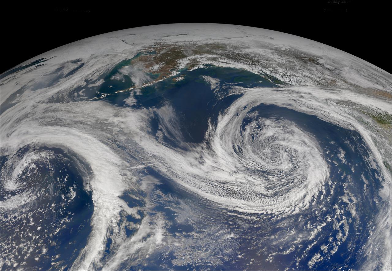
S123-E-008018 (21 March 2008) --- While docked and onboard the International Space Station, a STS-123 Endeavour crewmember captured the glowing green beauty of the Aurora Borealis. Looking northward across the Gulf of Alaska, over a low pressure area (cloud vortex), the aurora brightens the night sky. This image was taken on March 21, 2008 at 09:08:46 (GMT) with a 28 mm lens from the nadir point of 47.9 degrees north latitude and 146.8 degrees west longitude.

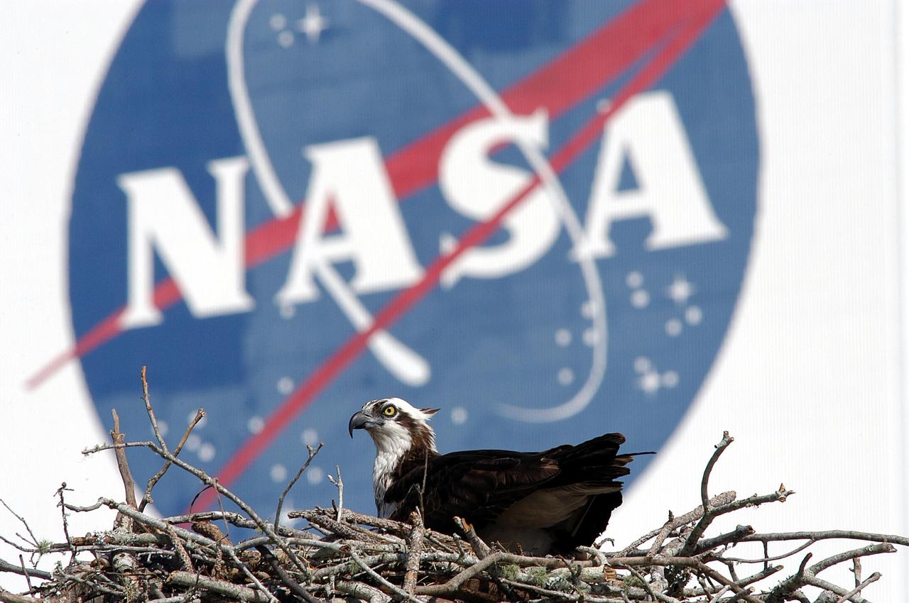
KENNEDY SPACE CENTER, FLA. - Framed by the NASA insignia, on the outside of the Vehicle Assembly Building, this osprey stares out from the nest it has built on top of speakers in a nearby parking lot. Known as a fish hawk, the osprey selects sites of opportunity, from trees and telephone poles to rocks or even flat ground. In the United States it is found from Alaska and Newfoundland to Florida and the Gulf Coast. Osprey nests are found throughout the Kennedy Space Center and nearby Merritt Island National Wildlife Refuge.
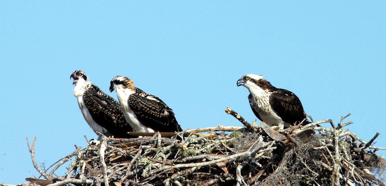
KENNEDY SPACE CENTER, FLA. -- - Three osprey fledglings are ready to test their wings from the nest at the NASA News Center parking lot. Ospreys select nesting sites of opportunity, from trees and telephone poles to rocks or even flat ground. In the United States they are found from Alaska to Florida and the Gulf Coast. Osprey nests are found throughout the Kennedy Space Center and nearby Merritt Island National Wildlife Refuge. Known as a fish hawk, ospreys often can be seen flying overhead with a fish in their talons.
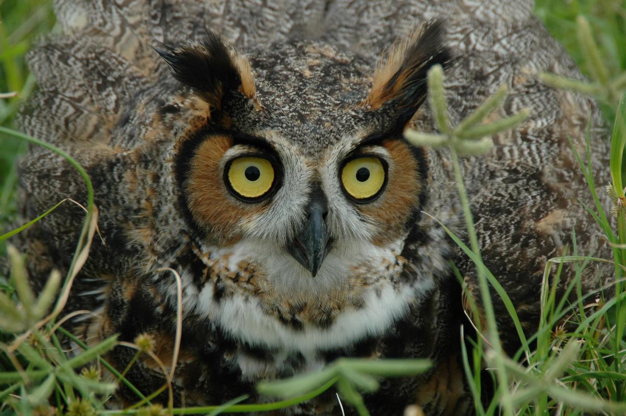
KENNEDY SPACE CENTER, FLA. - A Long-Eared Owl is spotted on Launch Complex 41 at Cape Canaveral Air Force Station in Florida. This one holds a typical stance for protecting its young. These owls range from Alaska and Canada to the Gulf states and Mexico, as far east as Central Florida. Their habitat is deciduous and evergreen forests. They nest in deserted nests of crows, hawks or squirrels.
KENNEDY SPACE CENTER, Fla. - Framed by the NASA insignia, on the outside of the Vehicle Assembly Building, this osprey stares out from the nest it has built on top of speakers in a nearby parking lot. Known as a fish hawk, the osprey selects sites of opportunity, from trees and telephone poles to rocks or even flat ground. In the United States it is found from Alaska and Newfoundland to Florida and the Gulf Coast. Osprey nests are found throughout the Kennedy Space Center and nearby Merritt Island National Wildlife Refuge.
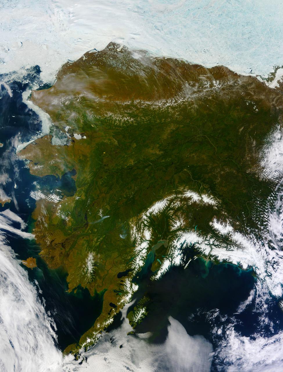
On most days, relentless rivers of clouds wash over Alaska, obscuring most of the state’s 6,640 miles (10,690 kilometers) of coastline and 586,000 square miles (1,518,000 square kilometers) of land. The south coast of Alaska even has the dubious distinction of being the cloudiest region of the United States, with some locations averaging more than 340 cloudy days per year. That was certainly not the case on June 17, 2013, the date that the Moderate Resolution Imaging Spectroradiometer (MODIS) on NASA’s Terra satellite acquired this rare, nearly cloud-free view of the state. The absence of clouds exposed a striking tapestry of water, ice, land, forests, and even wildfires. Snow-covered mountains such as the Alaska Range and Chugach Mountains were visible in southern Alaska, while the arc of mountains that make up the Brooks Range dominated the northern part of the state. The Yukon River—the longest in Alaska and the third longest in the United States—wound its way through the green boreal forests that inhabit the interior of the state. Plumes of sediment and glacial dust poured into the Gulf of Alaska from the Copper River. And Iliamna Lake, the largest in Alaska, was ice free. The same ridge of high pressure that cleared Alaska’s skies also brought stifling temperatures to many areas accustomed to chilly June days. Talkeetna, a town about 100 miles north of Anchorage, saw temperatures reach 96°F (36°C) on June 17. Other towns in southern Alaska set all-time record highs, including Cordova, Valez, and Seward. The high temperatures also helped fuel wildfires and hastened the breakup of sea ice in the Chukchi Sea. NASA image courtesy Jeff Schmaltz, LANCE MODIS Rapid Response Team at NASA GSFC. Caption by Adam Voiland. Instrument: Terra - MODIS More info: <a href="http://1.usa.gov/102MAEj" rel="nofollow">1.usa.gov/102MAEj</a> Credit: <b><a href="http://www.earthobservatory.nasa.gov/" rel="nofollow"> NASA Earth Observatory</a></b> <b><a href="http://www.nasa.gov/audience/formedia/features/MP_Photo_Guidelines.html" rel="nofollow">NASA image use policy.</a></b> <b><a href="http://www.nasa.gov/centers/goddard/home/index.html" rel="nofollow">NASA Goddard Space Flight Center</a></b> enables NASA’s mission through four scientific endeavors: Earth Science, Heliophysics, Solar System Exploration, and Astrophysics. Goddard plays a leading role in NASA’s accomplishments by contributing compelling scientific knowledge to advance the Agency’s mission. <b>Follow us on <a href="http://twitter.com/NASA_GoddardPix" rel="nofollow">Twitter</a></b> <b>Like us on <a href="http://www.facebook.com/pages/Greenbelt-MD/NASA-Goddard/395013845897?ref=tsd" rel="nofollow">Facebook</a></b> <b>Find us on <a href="http://instagram.com/nasagoddard?vm=grid" rel="nofollow">Instagram</a></b>
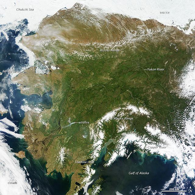
On most days, relentless rivers of clouds wash over Alaska, obscuring most of the state’s 6,640 miles (10,690 kilometers) of coastline and 586,000 square miles (1,518,000 square kilometers) of land. The south coast of Alaska even has the dubious distinction of being the cloudiest region of the United States, with some locations averaging more than 340 cloudy days per year. That was certainly not the case on June 17, 2013, the date that the Moderate Resolution Imaging Spectroradiometer (MODIS) on NASA’s Terra satellite acquired this rare, nearly cloud-free view of the state. The absence of clouds exposed a striking tapestry of water, ice, land, forests, and even wildfires. Snow-covered mountains such as the Alaska Range and Chugach Mountains were visible in southern Alaska, while the arc of mountains that make up the Brooks Range dominated the northern part of the state. The Yukon River—the longest in Alaska and the third longest in the United States—wound its way through the green boreal forests that inhabit the interior of the state. Plumes of sediment and glacial dust poured into the Gulf of Alaska from the Copper River. And Iliamna Lake, the largest in Alaska, was ice free. The same ridge of high pressure that cleared Alaska’s skies also brought stifling temperatures to many areas accustomed to chilly June days. Talkeetna, a town about 100 miles north of Anchorage, saw temperatures reach 96°F (36°C) on June 17. Other towns in southern Alaska set all-time record highs, including Cordova, Valez, and Seward. The high temperatures also helped fuel wildfires and hastened the breakup of sea ice in the Chukchi Sea. NASA image courtesy Jeff Schmaltz, LANCE MODIS Rapid Response Team at NASA GSFC. Caption by Adam Voiland. Instrument: Terra - MODIS More info: <a href="http://1.usa.gov/102MAEj" rel="nofollow">1.usa.gov/102MAEj</a> Credit: <b><a href="http://www.earthobservatory.nasa.gov/" rel="nofollow"> NASA Earth Observatory</a></b> <b><a href="http://www.nasa.gov/audience/formedia/features/MP_Photo_Guidelines.html" rel="nofollow">NASA image use policy.</a></b> <b><a href="http://www.nasa.gov/centers/goddard/home/index.html" rel="nofollow">NASA Goddard Space Flight Center</a></b> enables NASA’s mission through four scientific endeavors: Earth Science, Heliophysics, Solar System Exploration, and Astrophysics. Goddard plays a leading role in NASA’s accomplishments by contributing compelling scientific knowledge to advance the Agency’s mission. <b>Follow us on <a href="http://twitter.com/NASA_GoddardPix" rel="nofollow">Twitter</a></b> <b>Like us on <a href="http://www.facebook.com/pages/Greenbelt-MD/NASA-Goddard/395013845897?ref=tsd" rel="nofollow">Facebook</a></b> <b>Find us on <a href="http://instagram.com/nasagoddard?vm=grid" rel="nofollow">Instagram</a></b>
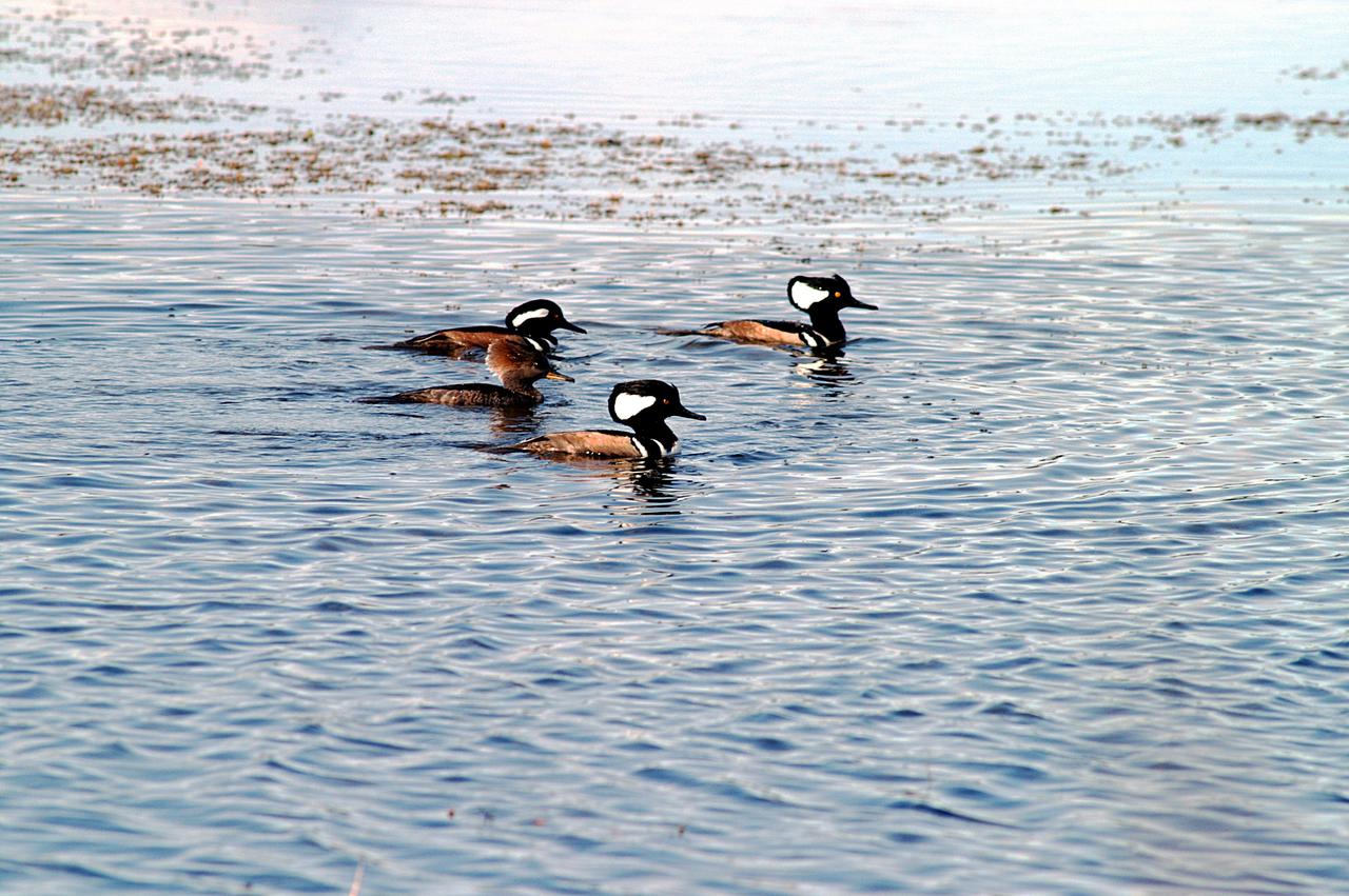
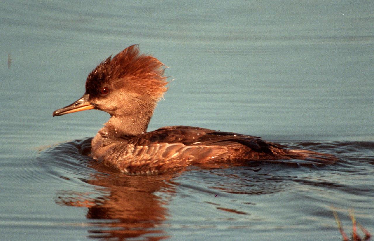
KENNEDY SPACE CENTER, FLA. -- Three male and one female hooded mergansers swim in the quicksilver water of the Merritt Island National Wildlife Refuge, which shares a boundary with Kennedy Space Center. Usually found from Alaska and Canada south to Nebraska, Oregon and Tennessee, hooded mergansers winter south to Mexico and the Gulf Coast, including KSC. The open water of the refuge provides wintering areas for 23 species of migratory waterfowl, as well as a year-round home for great blue herons, great egrets, wood storks, cormorants, brown pelicans and other species of marsh and shore birds. The 92,000-acre refuge is also habitat for more than 310 species of birds, 25 mammals, 117 fishes and 65 amphibians and reptiles.
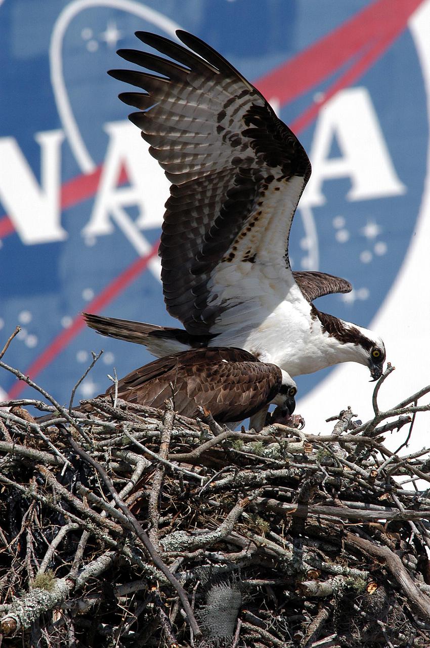
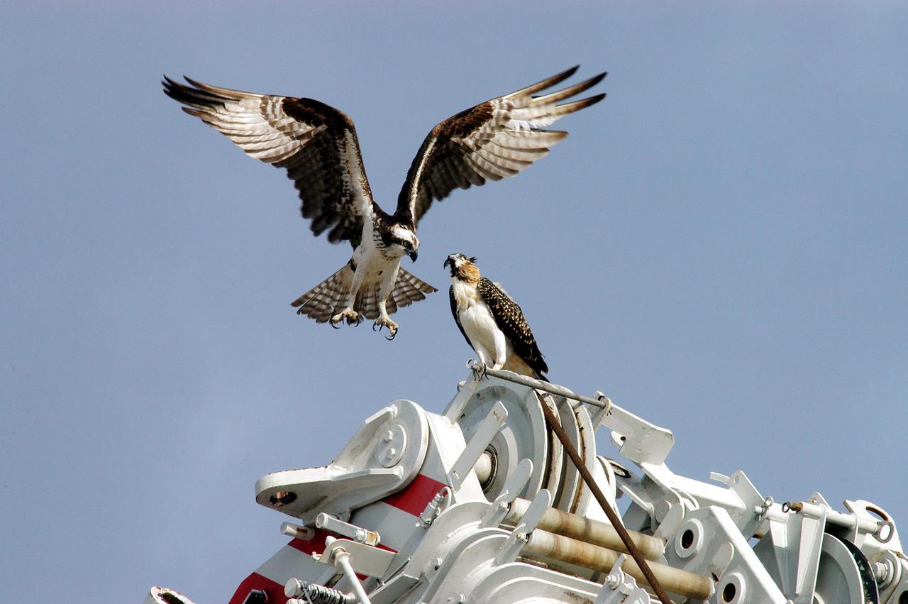
KENNEDY SPACE CENTER, FLA. -- While the female osprey eats fish brought by her mate, the male guards the nest, recently constructed on a speaker in the lower parking lot of the Press Site. Eggs have been sighted in the nest. The NASA logo seen in the background is on the nearby Vehicle Assembly Building. Known as a fish hawk, the osprey selects sites of opportunity, from trees and telephone poles to rocks or even flat ground. In the United States it is found from Alaska and Newfoundland to Florida and the Gulf Coast. Osprey nests are found throughout the Kennedy Space Center and surrounding Merritt Island National Wildlife Refuge.
KENNEDY SPACE CENTER, FLA. -- - Two young ospreys flex their wings for flight. Their nest is located in the NASA KSC News Center parking lot. Ospreys select nesting sites of opportunity, from trees and telephone poles to rocks or even flat ground. In the United States they are found from Alaska to Florida and the Gulf Coast. Osprey nests are found throughout the Kennedy Space Center and nearby Merritt Island National Wildlife Refuge. Known as a fish hawk, ospreys often can be seen flying overhead with a fish in their talons. Fish are their sole source of food.
KENNEDY SPACE CENTER, FLA. - A female osprey occupies a nest recently constructed on a speaker in the lower parking lot of the Press Site. Eggs have been sighted in the nest. The NASA logo seen in the background is on the nearby Vehicle Assembly Building. Known as a fish hawk, the osprey selects sites of opportunity, from trees and telephone poles to rocks or even flat ground. In the United States it is found from Alaska to Florida and the Gulf Coast. Osprey nests are found throughout the Kennedy Space Center and surrounding Merritt Island National Wildlife Refuge.
KENNEDY SPACE CENTER, FLA. -- One of two fledgling ospreys still in the nest stretches its wings to fly away. The stick-built nest is located in the NASA KSC News Center parking lot. Ospreys select nesting sites of opportunity, from trees and telephone poles to rocks or even flat ground. In the United States they are found from Alaska to Florida and the Gulf Coast. Osprey nests are found throughout the Kennedy Space Center and nearby Merritt Island National Wildlife Refuge. Known as a fish hawk, ospreys often can be seen flying overhead with a fish in their talons. Fish are their sole source of food.
KENNEDY SPACE CENTER, FLA. -- A mother osprey watches over her chicks in a nest near the NASA News Center at Kennedy Space Center. This is the third year the ospreys have raised a family at the site. Known as a fish hawk, ospreys select sites of opportunity, from trees and telephone poles to rocks or even flat ground. In the United States they are found from Alaska and Newfoundland to Florida and the Gulf Coast. Osprey nests are found throughout the Kennedy Space Center and nearby Merritt Island National Wildlife Refuge, which shares a boundary with the Center. Photo credit: NASA/George Shelton
KENNEDY SPACE CENTER, FLA. -- A pair of nesting ospreys now occupy a nest recently constructed on a speaker in the lower parking lot of the Press Site. Eggs have been sighted in the nest. The NASA logo seen in the background is on the nearby Vehicle Assembly Building. Known as a fish hawk, the osprey selects sites of opportunity, from trees and telephone poles to rocks or even flat ground. In the United States it is found from Alaska to Florida and the Gulf Coast. Osprey nests are found throughout the Kennedy Space Center and surrounding Merritt Island National Wildlife Refuge.
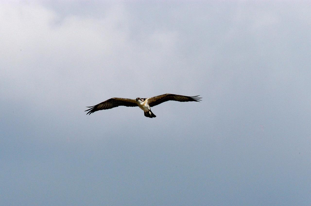
KENNEDY SPACE CENTER, FLA. -- A fledgling osprey soars above its nest, located in the NASA KSC News Center parking lot. Ospreys select nesting sites of opportunity, from trees and telephone poles to rocks or even flat ground. In the United States they are found from Alaska to Florida and the Gulf Coast. Osprey nests are found throughout the Kennedy Space Center and nearby Merritt Island National Wildlife Refuge. Known as a fish hawk, ospreys often can be seen flying overhead with a fish in their talons. Fish are their sole source of food.
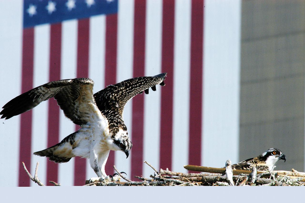
KENNEDY SPACE CENTER, FLA. -- One of three osprey fledglings spreads its wings, anticipating flight. The nest is in the NASA News Center parking lot, across from the Vehicle Assembly Building, with its 209-foot-high American flag painted on the south side. Ospreys select nesting sites of opportunity, from trees and telephone poles to rocks or even flat ground. In the United States they are found from Alaska to Florida and the Gulf Coast. Osprey nests are found throughout the Kennedy Space Center and nearby Merritt Island National Wildlife Refuge. Known as a fish hawk, ospreys often can be seen flying overhead with a fish in their talons.
KENNEDY SPACE CENTER, FLA. -- One of three osprey fledglings exercises its wings, anticipating flight. The nest is in the NASA News Center parking lot, across from the Vehicle Assembly Building, with its 209-foot-high American flag painted on the south side. Ospreys select nesting sites of opportunity, from trees and telephone poles to rocks or even flat ground. In the United States they are found from Alaska to Florida and the Gulf Coast. Osprey nests are found throughout the Kennedy Space Center and nearby Merritt Island National Wildlife Refuge. Known as a fish hawk, ospreys often can be seen flying overhead with a fish in their talons.
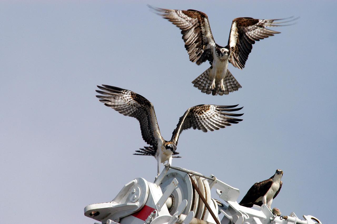
KENNEDY SPACE CENTER, FLA. -- Two fledgling ospreys begin flight lessons with their parent nearby (right). Their nest is located in the NASA KSC News Center parking lot. Ospreys select nesting sites of opportunity, from trees and telephone poles to rocks or even flat ground. In the United States they are found from Alaska to Florida and the Gulf Coast. Osprey nests are found throughout the Kennedy Space Center and nearby Merritt Island National Wildlife Refuge. Known as a fish hawk, ospreys often can be seen flying overhead with a fish in their talons. Fish are their sole source of food.
KENNEDY SPACE CENTER, FLA. -- These osprey chicks wait for lunch from one of their parents (look for the fish in the claws of the upper osprey). The nest is located on a pole in the parking lot of the NASA News Center. This is the third year the ospreys have raised a family at the site. Known as a fish hawk, ospreys select sites of opportunity, from trees and telephone poles to rocks or even flat ground. In the United States they are found from Alaska and Newfoundland to Florida and the Gulf Coast. Osprey nests are found throughout the Kennedy Space Center and nearby Merritt Island National Wildlife Refuge, which shares a boundary with the Center. Photo credit: NASA/George Shelton
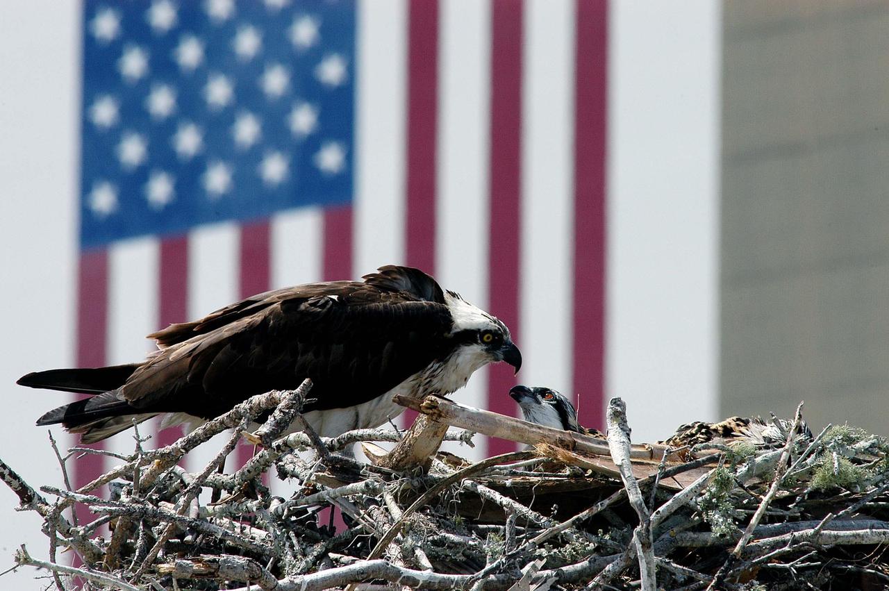
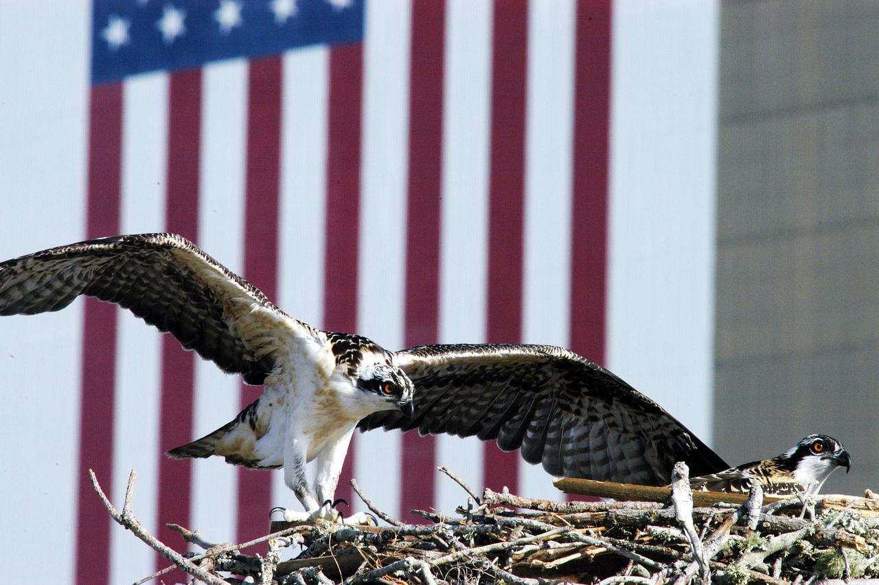
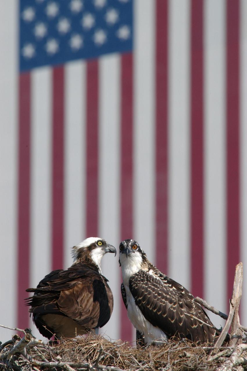
KENNEDY SPACE CENTER, FLA. - Against the backdrop of the American flag, painted on the side of the Vehicle Assembly Building, an osprey checks its fledglings in the nest. The young bird seen is one of three hatched this season. The osprey nest sits atop a speaker in the parking lot of the NASA KSC News Center. Known as a fish hawk, ospreys select sites of opportunity, from trees and telephone poles to rocks or even flat ground. In the United States they are found from Alaska to Florida and the Gulf Coast. Osprey nests are found throughout the Kennedy Space Center and nearby Merritt Island National Wildlife Refuge.

KENNEDY SPACE CENTER, FLA. -- A pair of nesting ospreys now occupy a nest recently constructed on a speaker in the lower parking lot of the Press Site. Eggs have been sighted in the nest. The NASA logo seen in the background is on the nearby Vehicle Assembly Building. Known as a fish hawk, the osprey selects sites of opportunity, from trees and telephone poles to rocks or even flat ground. In the United States it is found from Alaska to Florida and the Gulf Coast. Osprey nests are found throughout the Kennedy Space Center and surrounding Merritt Island National Wildlife Refuge.
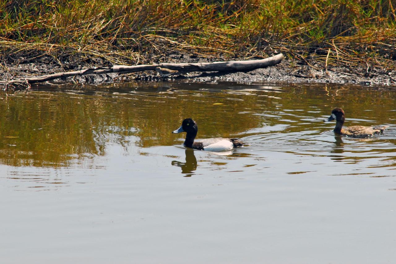
KENNEDY SPACE CENTER, FLA. -- A female greater scaup duck (right) follows her mate through the water on Kennedy Space Center. Normally found in Alaska and northern Canada, this species winters along the Atlantic, Pacific and Gulf coasts. KSC shares a boundary with the Merritt Island Wildlife Nature Refuge. The refuge is a habitat for more than 310 species of birds, 25 mammals, 117 fishes and 65 amphibians and reptiles. In addition, the Refuge supports 19 endangered or threatened wildlife species on Federal or State lists, more than any other single refuge in the U.S. Photo credit: NASA/Dimitri Gerondidakis
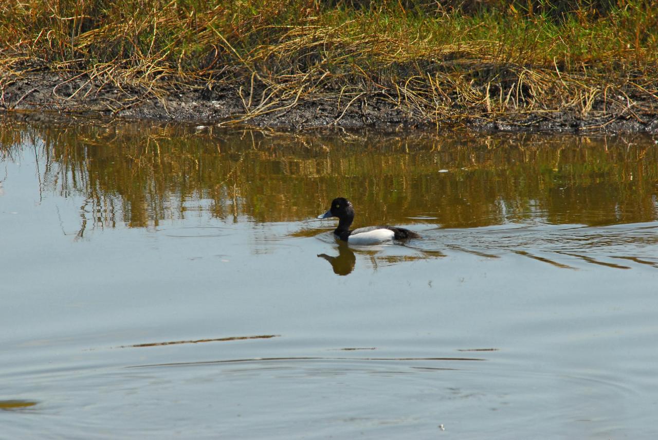
KENNEDY SPACE CENTER, FLA. -- A male greater scaup duck is mirrored in the water on Kennedy Space Center. Normally found in Alaska and northern Canada, this species winters along the Atlantic, Pacific and Gulf coasts. KSC shares a boundary with the Merritt Island Wildlife Nature Refuge. The refuge is a habitat for more than 310 species of birds, 25 mammals, 117 fishes and 65 amphibians and reptiles. In addition, the Refuge supports 19 endangered or threatened wildlife species on Federal or State lists, more than any other single refuge in the U.S. Photo credit: NASA/Dimitri Gerondidakis
KENNEDY SPACE CENTER, FLA. -- One of three osprey fledglings exercises its wings, anticipating flight. The nest is in the NASA News Center parking lot, across from the Vehicle Assembly Building, with its 209-foot-high American flag painted on the south side. Ospreys select nesting sites of opportunity, from trees and telephone poles to rocks or even flat ground. In the United States they are found from Alaska to Florida and the Gulf Coast. Osprey nests are found throughout the Kennedy Space Center and nearby Merritt Island National Wildlife Refuge. Known as a fish hawk, ospreys often can be seen flying overhead with a fish in their talons.
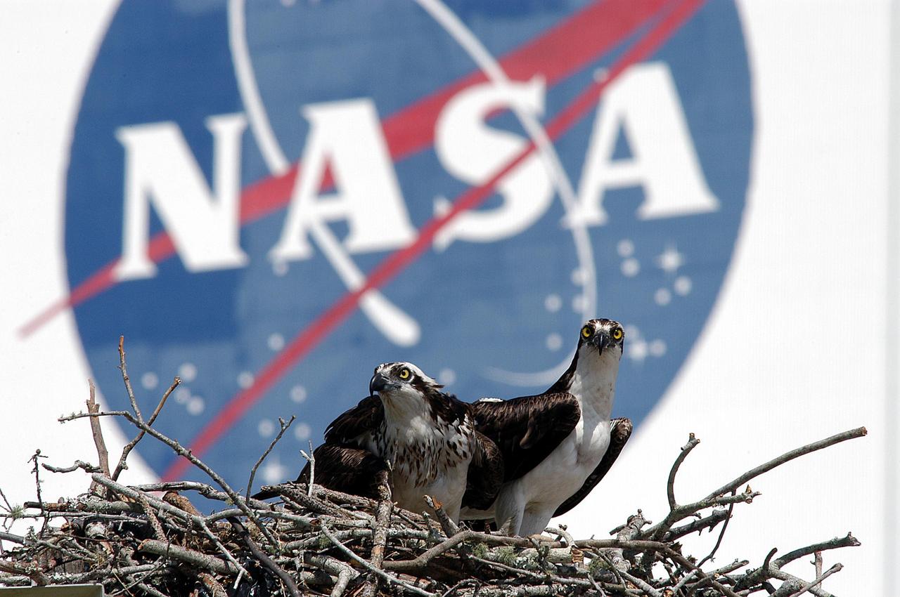
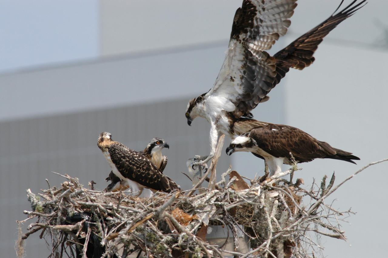
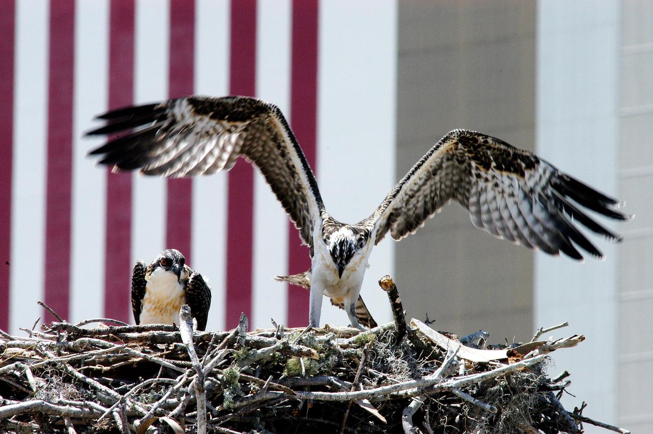
KENNEDY SPACE CENTER, FLA. - Against the background of the NASA logo on the Vehicle Assembly Building, the osprey nest in the nearby parking lot reveals two fledglings and one of the adult ospreys. Known as a fish hawk, they often can be seen flying overhead with a fish in their talons. Ospreys select nesting sites of opportunity, from trees and telephone poles to rocks or even flat ground. In the United States they are found from Alaska to Florida and the Gulf Coast. Osprey nests are found throughout the Kennedy Space Center and nearby Merritt Island National Wildlife Refuge.
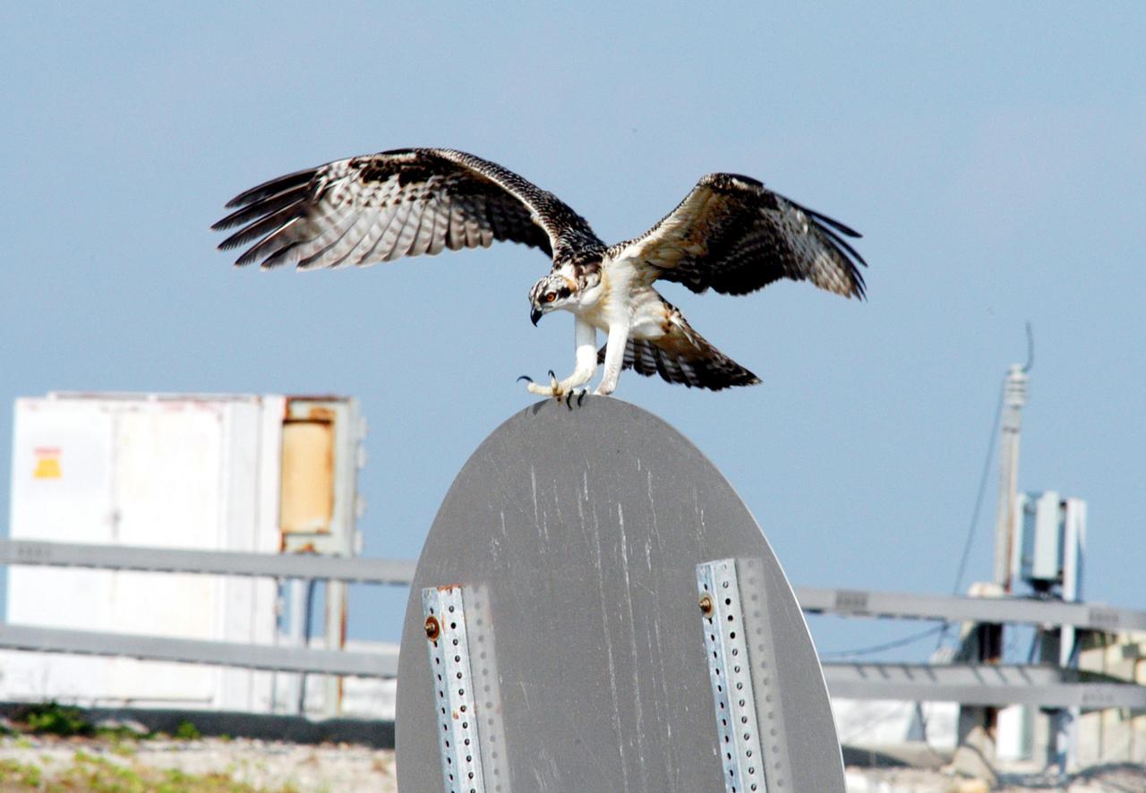
KENNEDY SPACE CENTER, FLA. -- One of the fledgling ospreys from the nest in the NASA KSC News Center parking lot lands on a sign after testing its wings. Ospreys select nesting sites of opportunity, from trees and telephone poles to rocks or even flat ground. In the United States they are found from Alaska to Florida and the Gulf Coast. Osprey nests are found throughout the Kennedy Space Center and nearby Merritt Island National Wildlife Refuge. Known as a fish hawk, ospreys often can be seen flying overhead with a fish in their talons. Fish are their sole source of food.
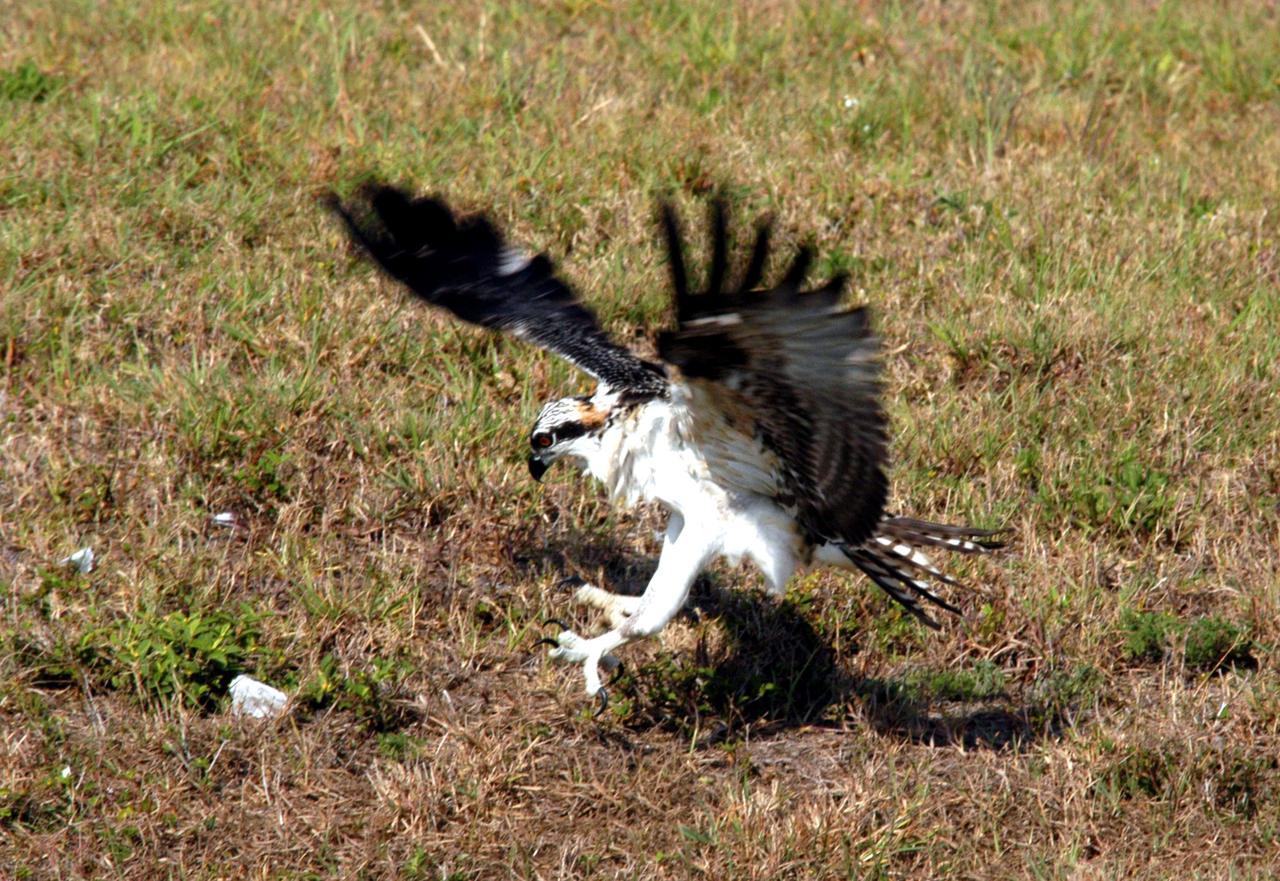
KENNEDY SPACE CENTER, FLA. -- One of the fledgling ospreys from the nest in the NASA KSC News Center parking lot comes down for a rough landing in the nearby grass. Ospreys select nesting sites of opportunity, from trees and telephone poles to rocks or even flat ground. In the United States they are found from Alaska and Newfoundland to Florida and the Gulf Coast. Osprey nests are found throughout the Kennedy Space Center and nearby Merritt Island National Wildlife Refuge. Known as a fish hawk, ospreys often can be seen flying overhead with a fish in their talons. Fish are their sole source of food.
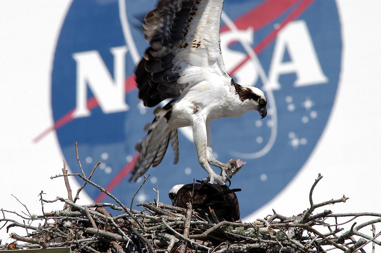
KENNEDY SPACE CENTER, FLA. -- A male osprey returns to its nest with a piece of fish in its talons for its mate. The nest was recently constructed on a speaker in the lower parking lot of the Press Site. Eggs have been sighted in the nest. The NASA logo seen in the background is on the nearby Vehicle Assembly Building. Known as a fish hawk, the osprey selects sites of opportunity, from trees and telephone poles to rocks or even flat ground. In the United States it is found from Alaska and Newfoundland to Florida and the Gulf Coast. Osprey nests are found throughout the Kennedy Space Center and surrounding Merritt Island National Wildlife Refuge.
KENNEDY SPACE CENTER, FLA. - Against the background of the NASA logo on the Vehicle Assembly Building, the osprey nest in the nearby parking lot reveals two fledglings and one of the adult ospreys. Known as a fish hawk, they often can be seen flying overhead with a fish in their talons. Ospreys select nesting sites of opportunity, from trees and telephone poles to rocks or even flat ground. In the United States they are found from Alaska to Florida and the Gulf Coast. Osprey nests are found throughout the Kennedy Space Center and nearby Merritt Island National Wildlife Refuge.
KENNEDY SPACE CENTER, FLA. -- One young osprey tests its wings while another waits nearby. Their nest is located in the NASA KSC News Center parking lot. Ospreys select nesting sites of opportunity, from trees and telephone poles to rocks or even flat ground. In the United States they are found from Alaska to Florida and the Gulf Coast. Osprey nests are found throughout the Kennedy Space Center and nearby Merritt Island National Wildlife Refuge. Known as a fish hawk, ospreys often can be seen flying overhead with a fish in their talons. Fish are their sole source of food.
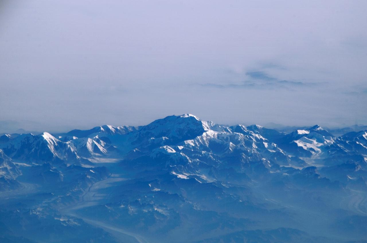
ISS011-E-11806 (14 August 2005) --- Mount McKinley, Alaska is featured in this image photographed by an Expedition 11 crewmember on the international space station. This view – of the highest point in North America (20,230 feet) looks as if it were taken from an aircraft. The station crewmember took advantage of cloud free skies and the powerful 800 mm lens to photograph this peak, fully 800 miles to the north of the spacecraft, which was located over the Gulf of Alaska. The powerful lenses are difficult to use, requiring motion compensation by the astronaut, so that these kinds of detailed images of horizon detail are seldom taken. The rising sun casts long shadows across the Kahiltna Glacier that angles down from Mt. McKinley (lower left). Other glaciers with moraine lines appear at far left and far right. Despite the blueness inherent in images taken at great distance, this image also shows unusually dense atmospheric haze at lower altitudes: all the valleys in the foreground appear murky due to forest fire smoke.
KENNEDY SPACE CENTER, FLA. -- A female hooded merganser swims solo in the waters of the Merritt Island National Wildlife Refuge at Kennedy Space Center. The male is distinguished by a fan-shaped, black-bordered crest and striped breast. Usually found from Alaska and Canada south to Nebraska, Oregon and Tennessee, hooded mergansers winter south to Mexico and the Gulf Coast, including KSC. The open water of the refuge provides wintering areas for 23 species of migratory waterfowl, as well as a year-round home for great blue herons, great egrets, wood storks, cormorants, brown pelicans and other species of marsh and shore birds. The 92,000-acre refuge is also habitat for more than 310 species of birds, 25 mammals, 117 fishes and 65 amphibians and reptiles
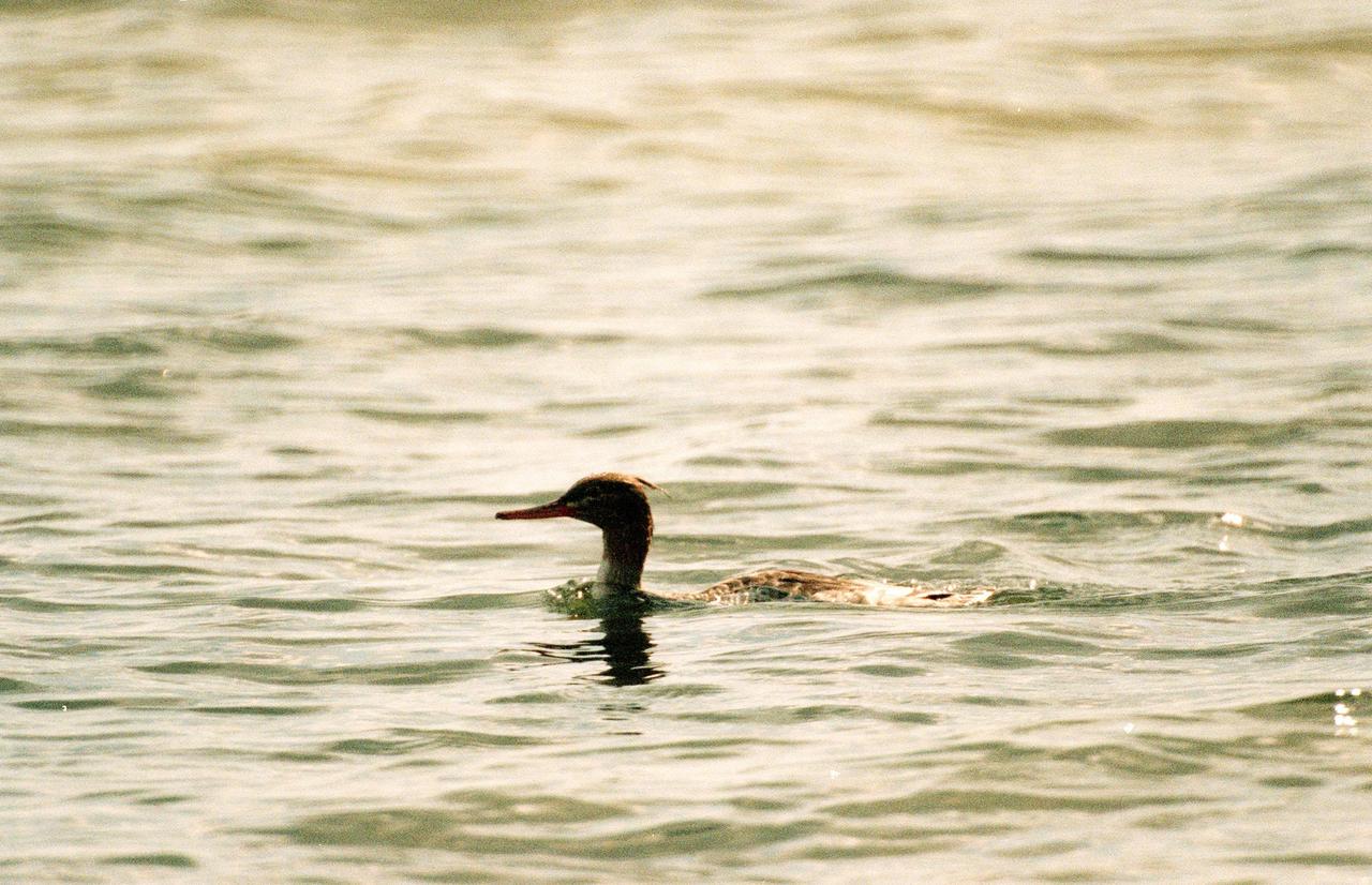
KENNEDY SPACE CENTER, FLA. -- A female red-breasted merganser swims low in the water at the Merritt Island National Wildlife Refuge, which shares a boundary with Kennedy Space Center. Usually found from Alaska and Canada south to Nebraska, Oregon and Tennessee, hooded mergansers winter south to Mexico and the Gulf Coast, including KSC. The open water of the refuge provides wintering areas for 23 species of migratory waterfowl, as well as a year-round home for great blue herons, great egrets, wood storks, cormorants, brown pelicans and other species of marsh and shore birds. The 92,000-acre refuge is also habitat for more than 310 species of birds, 25 mammals, 117 fishes and 65 amphibians and reptiles
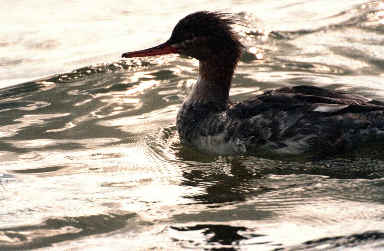
KENNEDY SPACE CENTER, FLA. -- A young female red-breasted merganser swims in the quicksilver water of the Merritt Island National Wildlife Refuge, which shares a boundary with Kennedy Space Center. Usually found from Alaska and Canada south to Nebraska, Oregon and Tennessee, hooded mergansers winter south to Mexico and the Gulf Coast, including KSC. The open water of the refuge provides wintering areas for 23 species of migratory waterfowl, as well as a year-round home for great blue herons, great egrets, wood storks, cormorants, brown pelicans and other species of marsh and shore birds. The 92,000-acre refuge is also habitat for more than 310 species of birds, 25 mammals, 117 fishes and 65 amphibians and reptiles
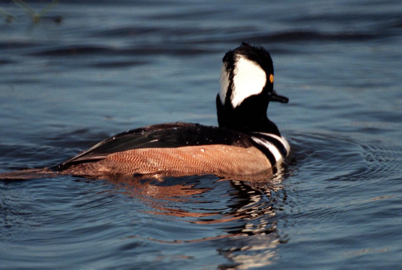
KENNEDY SPACE CENTER, FLA. -- The distinctive fan-shaped, black-bordered crest and striped breast identify this hooded merganser, swimming in the waters of the Merritt Island National Wildlife Refuge at Kennedy Space Center. Usually found from Alaska and Canada south to Nebraska, Oregon and Tennessee, hooded mergansers winter south to Mexico and the Gulf Coast, including KSC. The open water of the refuge provides wintering areas for 23 species of migratory waterfowl, as well as a year-round home for great blue herons, great egrets, wood storks, cormorants, brown pelicans and other species of marsh and shore birds. The 92,000-acre refuge is also habitat for more than 310 species of birds, 25 mammals, 117 fishes and 65 amphibians and reptiles
KENNEDY SPACE CENTER, FLA. -- A baby osprey sits on its nest situated at the top of a pole in the parking lot at the NASA News Center at Kennedy Space Center. Behind the nest can be seen the immense flag painted on the side of the Vehicle Assembly Building. This is the third year the ospreys have raised a family at the News Center. Known as a fish hawk, ospreys select sites of opportunity, from trees and telephone poles to rocks or even flat ground. In the United States they are found from Alaska and Newfoundland to Florida and the Gulf Coast. Osprey nests are found throughout the Kennedy Space Center and nearby Merritt Island National Wildlife Refuge, which shares a boundary with the Center. Photo credit: NASA/George Shelton
KENNEDY SPACE CENTER, FLA. -- A mother osprey (left) sits protectively next to one of her chicks in the nest situated at the top of a pole in the parking lot at the NASA News Center at Kennedy Space Center. Behind the nest can be seen the immense flag painted on the side of the Vehicle Assembly Building. This is the third year the ospreys have raised a family at the News Center. Known as a fish hawk, ospreys select sites of opportunity, from trees and telephone poles to rocks or even flat ground. In the United States they are found from Alaska and Newfoundland to Florida and the Gulf Coast. Osprey nests are found throughout the Kennedy Space Center and nearby Merritt Island National Wildlife Refuge, which shares a boundary with the Center. Photo credit: NASA/George Shelton

KENNEDY SPACE CENTER, FLA. -- A male and two female hooded mergansers swim in the waters of the Merritt Island National Wildlife Refuge at Kennedy Space Center. The male displays its distinctive fan-shaped, black-bordered crest. Usually found from Alaska and Canada south to Nebraska, Oregon and Tennessee, hooded mergansers winter south to Mexico and the Gulf Coast, including KSC. The open water of the refuge provides wintering areas for 23 species of migratory waterfowl, as well as a year-round home for great blue herons, great egrets, wood storks, cormorants, brown pelicans and other species of marsh and shore birds. The 92,000-acre refuge is also habitat for more than 310 species of birds, 25 mammals, 117 fishes and 65 amphibians and reptiles
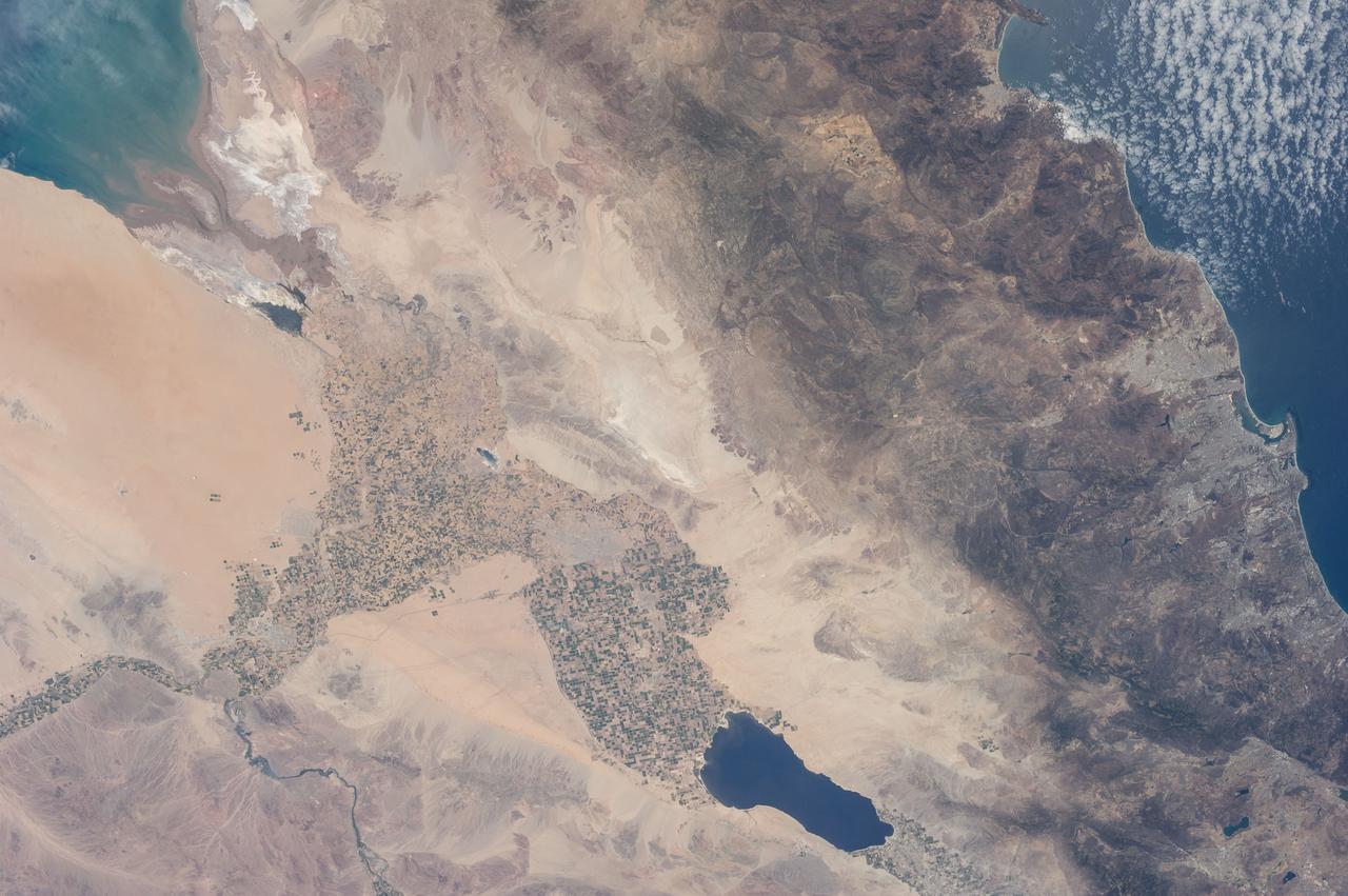
ISS036-E-011034 (21 June 2013) --- The Salton Trough is featured in this image photographed by an Expedition 36 crew member on the International Space Station. The Imperial and Coachella Valleys of southern California – and the corresponding Mexicali Valley and Colorado River Delta in Mexico – are part of the Salton Trough, a large geologic structure known to geologists as a graben or rift valley that extends into the Gulf of California. The trough is a geologically complex zone formed by interaction of the San Andreas transform fault system that is, broadly speaking, moving southern California towards Alaska; and the northward motion of the Gulf of California segment of the East Pacific Rise that continues to widen the Gulf of California by sea-floor spreading. According to scientists, sediments deposited by the Colorado River have been filling the northern rift valley (the Salton Trough) for the past several million years, excluding the waters of the Gulf of California and providing a fertile environment – together with irrigation—for the development of extensive agriculture in the region (visible as green and yellow-brown fields at center). The Salton Sea, a favorite landmark of astronauts in low Earth orbit, was formed by an irrigation canal rupture in 1905, and today is sustained by agricultural runoff water. A wide array of varying landforms and land uses in the Salton Trough are visible from space. In addition to the agricultural fields and Salton Sea, easily visible metropolitan areas include Yuma, AZ (lower left); Mexicali, Baja California, Mexico (center); and the San Diego-Tijuana conurbation on the Pacific Coast (right). The approximately 72-kilometer-long Algodones Dunefield is visible at lower left.
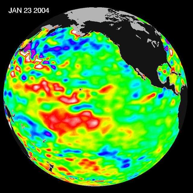
The latest remote sensing data from NASA's Jason satellite show that the equatorial Pacific sea surface levels are higher, indicating warmer sea surface temperatures in the central and west Pacific Ocean. This pattern has the appearance of La Niña rather than El Niño. This contrasts with the Bering Sea, Gulf of Alaska and U.S. West Coast where lower-than-normal sea surface levels and cool ocean temperatures continue (indicated by blue and purple areas). The image above is a global map of sea surface height, accurate to within 30 millimeters. The image represents data collected and composited over a 10-day period, ending on Jan 23, 2004. The height of the water relates to the temperature of the water. As the ocean warms, its level rises; and as it cools, its level falls. Yellow and red areas indicate where the waters are relatively warmer and have expanded above sea level, green indicates near normal sea level, and blue and purple areas show where the waters are relatively colder and the surface is lower than sea level. The blue areas are between 5 and 13 centimeters (2 and 5 inches) below normal, whereas the purple areas range from 14 to 18 centimeters (6 to 7 inches) below normal. http://photojournal.jpl.nasa.gov/catalog/PIA05071
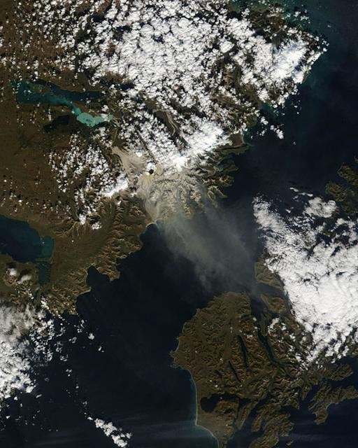
The Valley of Ten Thousand Smokes, located in Katmai National Park, forms a unique and ashen landscape. Encircled by volcanoes – both active and inactive – it has served as a perfect collection area for huge amounts of volcanic ash. According to the Alaska Historical Society (AHS), 2012 marked the centennial anniversary of the volcanic eruption that formed the valley, and led to the establishment, in 1918, of Katmai National Park. A massive eruption rocked the region on June 6, 1912 as the then-unknown volcano, Novarupta, became suddenly and violently active. According to the AHS, it erupted with “such force that mountains collapsed, ash darkened summer skies, earthquakes rocked population centers and were recorded as far away as Washington, D.C.” Glowing hot ash was reported to have smothered an area covering 40 square miles, and up to 700 feet deep. While the active volcanoes surrounding the valley - Novarupta, Mt. Mageik, Trident Volcano, Mt. Griggs, Mt. Martin and Mt. Katmai - have remained relatively quiescent, their ashen legacy continues to affect the landscape – and air traffic - even a century after it was laid down. The Moderate Resolution Imaging Spectroradiometer (MODIS) aboard NASA’s Terra satellite captured this true-color image on September 29, 2014. Volcanic ash from the Katmai region has been lifted aloft by strong winds, and is blowing to the southeast, over Shelikof Strait, Kodiak Island, and the Gulf of Alaska. Although such clouds are not from active volcanoes, the remobilized volcanic ash still provides a potential hazard to aircraft flying through the region. Credit: NASA/GSFC/Jeff Schmaltz/MODIS Land Rapid Response Team <b><a href="http://www.nasa.gov/audience/formedia/features/MP_Photo_Guidelines.html" rel="nofollow">NASA image use policy.</a></b> <b><a href="http://www.nasa.gov/centers/goddard/home/index.html" rel="nofollow">NASA Goddard Space Flight Center</a></b> enables NASA’s mission through four scientific endeavors: Earth Science, Heliophysics, Solar System Exploration, and Astrophysics. Goddard plays a leading role in NASA’s accomplishments by contributing compelling scientific knowledge to advance the Agency’s mission. <b>Follow us on <a href="http://twitter.com/NASAGoddardPix" rel="nofollow">Twitter</a></b> <b>Like us on <a href="http://www.facebook.com/pages/Greenbelt-MD/NASA-Goddard/395013845897?ref=tsd" rel="nofollow">Facebook</a></b> <b>Find us on <a href="http://instagram.com/nasagoddard?vm=grid" rel="nofollow">Instagram</a></b>
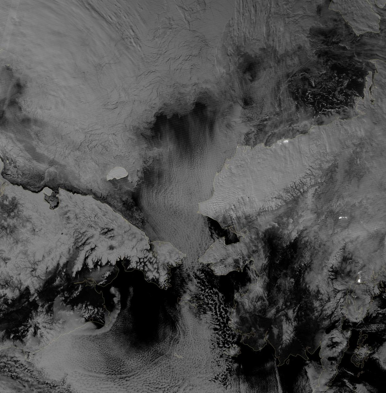
Image acquired October 30, 2012 Scientists watched the Arctic with particular interest in the summer of 2012, when Arctic sea ice set a new record low. The behavior of sea ice following such a low extent also interests scientists, but as Arctic sea ice was advancing in the autumn of 2012, so was polar darkness. Fortunately, the Visible Infrared Imaging Radiometer Suite (VIIRS) on the Suomi NPP satellite can see in the dark. The VIIRS “day-night band” detects light in a range of wavelengths from green to near-infrared and uses filtering techniques to observe signals such as gas flares, auroras, wildfires, city lights, and reflected moonlight. VIIRS acquired this nighttime view of sea ice north of Russia and Alaska on October 30, 2012. The day-night band takes advantage of moonlight, airglow (the atmosphere’s self-illumination through chemical reactions), zodiacal light (sunlight scattered by interplanetary dust), and starlight from the Milky Way. By using these dim light sources, the day-night band can detect changes in clouds, snow cover, and sea ice. The VIIRS day-night band offers a unique perspective because once polar night has descended, satellite sensors relying on visible light can no longer produce photo-like images. And although passive microwave sensors can monitor sea ice through the winter, they offer much lower resolution. Steve Miller of the Cooperative Institute for Research in the Atmosphere at Colorado State University has used the day-night band to study nighttime behavior of weather systems and sees advantages in studying the polar regions. “There’s a lot of use with these measurements as we look back at a season of record ice melt in the Arctic,” Miller says. “We can observe areas where there is ice melt and reformation, where there’s clear water and ships can pass through—especially as the ‘great darkness’ approaches with winter.” Ted Scambos of the National Snow and Ice Data Center at the University of Colorado concurs. “Things start changing rapidly in the late fall: sea ice formation and snow cover extent at the highest latitudes. This lets us see rapid-growth areas in detail.” The day-night band is also useful for following weather systems, including severe storms, which can develop and strike populous areas at night as well as day. Geostationary Operational Environmental Satellites orbit the Earth’s equator. The satellites offer uninterrupted observations of North America, but high-latitude areas such as Alaska may benefit more from polar-orbiting satellites. Miller explains, “In the high latitudes, the orbits begin to overlap considerably, which gives you a lot more passes in Alaska. If you start to look at multiple passes and stitch them together, you can get a version of a poor man’s geostationary time loop of the weather.” Day-night band imagery at high latitudes has already proven useful for tracking rapid ice movement and diagnosing Gulf of Alaska circulations. The day-night band is even useful at tracking ship movement at high latitudes. NASA Earth Observatory image by Jesse Allen and Robert Simmon, using VIIRS Day-Night Band data from the Suomi National Polar-orbiting Partnership. Suomi NPP is the result of a partnership between NASA, the National Oceanic and Atmospheric Administration, and the Department of Defense. Caption by Michon Scott. Instrument: Suomi NPP - VIIRS Credit: <b><a href="http://www.earthobservatory.nasa.gov/" rel="nofollow"> NASA Earth Observatory</a></b> <b>Click here to view all of the <a href="http://earthobservatory.nasa.gov/Features/NightLights/" rel="nofollow"> Earth at Night 2012 images </a></b> <b>Click here to <a href="http://earthobservatory.nasa.gov/NaturalHazards/view.php?id=79825" rel="nofollow"> read more </a> about this image </b> <b><a href="http://www.nasa.gov/audience/formedia/features/MP_Photo_Guidelines.html" rel="nofollow">NASA image use policy.</a></b> <b><a href="http://www.nasa.gov/centers/goddard/home/index.html" rel="nofollow">NASA Goddard Space Flight Center</a></b> enables NASA
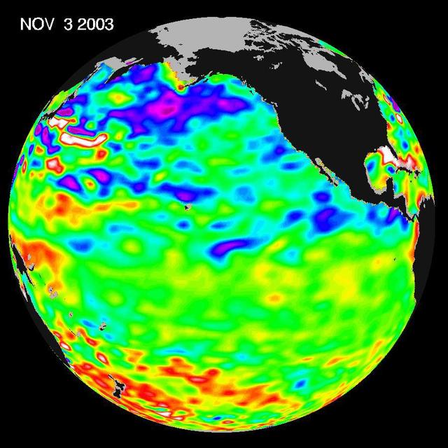
Some climate forecast models indicate there is an above average chance that there could be a weak to borderline El Niño by the end of November 2003. However, the trade winds, blowing from east to west across the equatorial Pacific Ocean, remain strong. Thus, there remains some uncertainty among climate scientists as to whether the warm temperature anomaly will form again this year. The latest remote sensing data from NASA's Jason satellite show near normal conditions across the equatorial Pacific. There are currently no visible signs in sea surface height of an impending El Niño. This equatorial quiet contrasts with the Bering Sea, Gulf of Alaska and U.S. West Coast where lower-than-normal sea surface levels and cool ocean temperatures continue (indicated by blue and purple areas). The image above is a global map of sea surface height, accurate to within 30 millimeters. The image represents data collected and composited over a 10-day period, ending on Nov. 3, 2003. The height of the water relates to the temperature of the water. As the ocean warms, its level rises; and as it cools, its level falls. Yellow and red areas indicate where the waters are relatively warmer and have expanded above sea level, green indicates near normal sea level, and blue and purple areas show where the waters are relatively colder and the surface is lower than sea level. The blue areas are between 5 and 13 centimeters (2 and 5 inches) below normal, whereas the purple areas range from 14 to 18 centimeters (6 to 7 inches) below normal. http://photojournal.jpl.nasa.gov/catalog/PIA04878
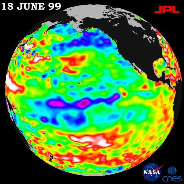
Lingering just a month ago in the eastern Pacific Ocean, the La Niña phenomenon, with its large volume of chilly water, barely has a pulse this month, according to new satellite data from NASA U.S.-French TOPEX/Poseidon mission. The data, taken during a 10-day cycle of data collection ending June 18, show that the equatorial Pacific Ocean is warming up and returning to normal (green) as La Niña all but vanishes. The warming trend is most apparent in the equatorial Pacific Ocean, where only a few patches of cooler, low sea levels (seen in blue and purple) remain. The blue areas are between 5 and 13 centimeters (2 and 5 inches) below normal, whereas the purple areas range from 14 to 18 centimeters (6 to 7 inches) below normal. Like its counterpart, El Niño, a La Niña condition will influence global climate and weather until it has completely subsided. As summer begins in the northern hemisphere, lower-than-normal sea surface levels and cool ocean temperatures persist in the northeastern Gulf of Alaska and along the western coast of North America. In contrast, the trend is the opposite over most of the Pacific, where above-normal sea surface heights and warmer ocean temperatures (indicated by the red and white areas) appear to be increasing and dominating the overall Pacific Ocean. Red areas are about 10 centimeters (4 inches) above normal; white areas show the sea surface height is between 14 and 32 centimeters (6 and 13 inches) above normal. Scientists are not ready to administer last rites to La Niña, though. In the last 12 months, the pool of unusually cold water in the Pacific has shrunk (warmed) several times before cooling (expanding) again. This summer's altimeter data will help them determine whether La Niña has truly dissipated or whether they will see another resurgence of cool water in the Pacific. http://photojournal.jpl.nasa.gov/catalog/PIA01586