NASA’s Subsonic Research Aircraft Testbed, or SCRAT, is a modified Gulfstream III that operates out of Armstrong Flight Research Center in Edwards, California. SCRAT the test bed aircraft for the ACTE flexible-flap research project, which examines flexible wing flap technology’s benefits to aerodynamic efficiency.

C-20A (Gulfstream III) in flight over the NASA Dryden Flight Research Center

Manny Rodriguez, Gulfstream G-III crew chief, completes flight control checks with the pilots on Friday, March 27, 2026, at NASA’s Armstrong Flight Research Center in Edwards, California. The G-III will join other NASA aircraft to capture imagery of the Orion spacecraft’s heat shield during Artemis II reentry. The mission is part of NASA’s Scientifically Calibrated In-Flight Imagery (SCIFLI) project, based at NASA’s Langley Research Center in Hampton, Virginia.

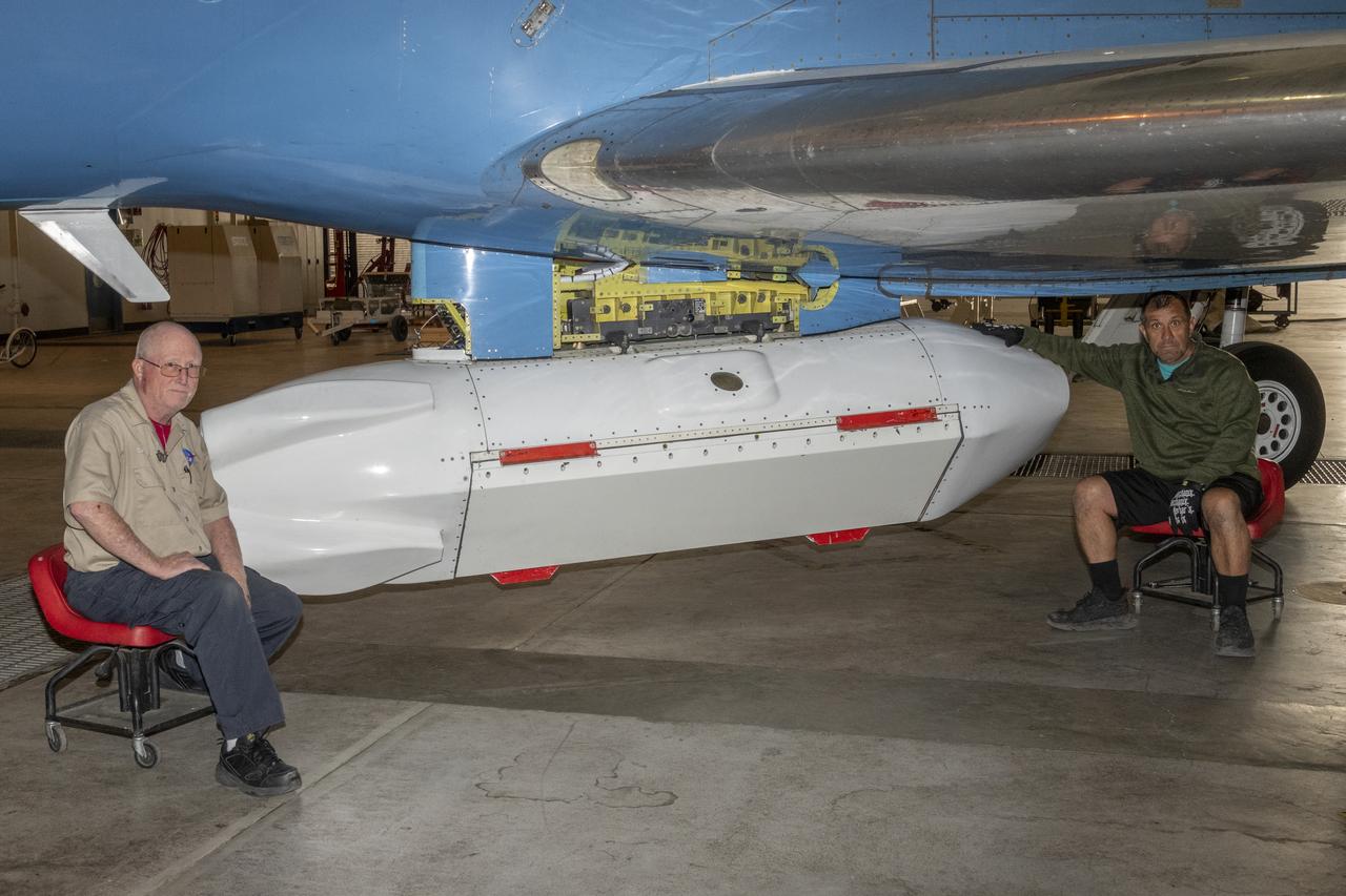
The synthetic aperture radar pod developed by JPL is slung beneath NASA's Gulfstream-III research testbed during flight tests.

During the total solar eclipse, the Sun’s corona, only visible during the total eclipse, is shown as a crown of white flares from the surface. The red spots called Bailey's beads occurs where the moon grazes by the Sun and the rugged lunar limb topography allows beads of sunlight to shine through in some areas as photographed from NASA Armstrong’s Gulfstream III. Photo Credit: (NASA/Carla Thomas)

The Moon is seen passing in front of the Sun during a total solar eclipse on Monday, August 21, 2017 from onboard a NASA Gulfstream III aircraft flying 25,000 feet above the Oregon coast. A total solar eclipse swept across a narrow portion of the contiguous United States from Lincoln Beach, Oregon to Charleston, South Carolina. A partial solar eclipse was visible across the entire North American continent along with parts of South America, Africa, and Europe. Photo Credit: (NASA/Carla Thomas)

During the total solar eclipse, the Sun’s corona, only visible during the total eclipse, is shown as a crown of white flares from the surface. The red spots called Bailey's beads occurs where the moon grazes by the Sun and the rugged lunar limb topography allows beads of sunlight to shine through in some areas as photographed from NASA Armstrong’s Gulfstream III. Photo Credit: (NASA/Carla Thomas)
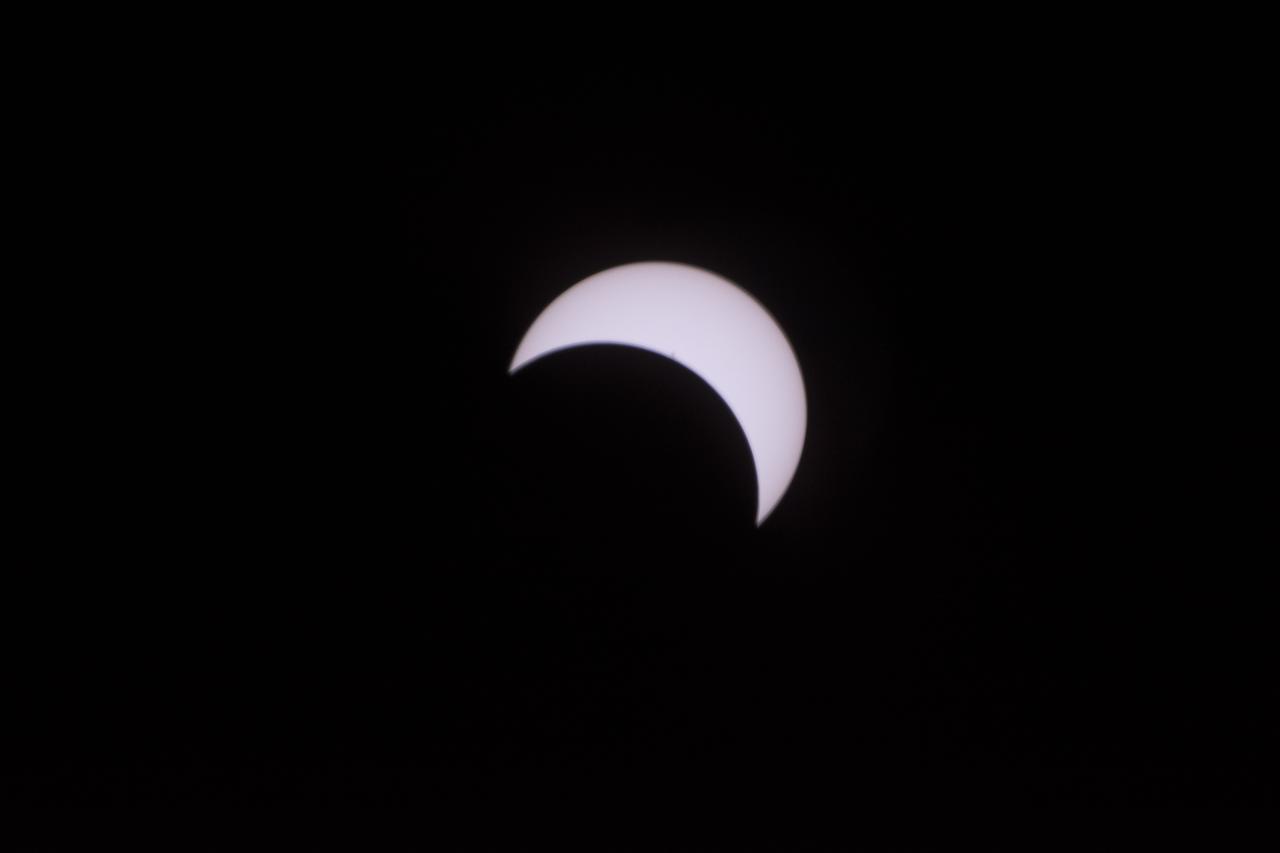
The Moon is seen passing in front of the Sun during a total solar eclipse on Monday, August 21, 2017 from onboard a NASA Gulfstream III aircraft flying 25,000 feet above the Oregon coast. A total solar eclipse swept across a narrow portion of the contiguous United States from Lincoln Beach, Oregon to Charleston, South Carolina. A partial solar eclipse was visible across the entire North American continent along with parts of South America, Africa, and Europe. Photo Credit: (NASA/Carla Thomas)

A total solar eclipse is seen on Monday, August 21, 2017 from onboard a NASA Armstrong Flight Research Center’s Gulfstream III 25,000 feet above the Oregon coast. A total solar eclipse swept across a narrow portion of the contiguous United States from Lincoln Beach, Oregon to Charleston, South Carolina. Photo Credit: (NASA/Carla Thomas)

The Moon is seen passing in front of the Sun during a total solar eclipse on Monday, August 21, 2017 from onboard a NASA Gulfstream III aircraft flying 25,000 feet above the Oregon coast. A total solar eclipse swept across a narrow portion of the contiguous United States from Lincoln Beach, Oregon to Charleston, South Carolina. A partial solar eclipse was visible across the entire North American continent along with parts of South America, Africa, and Europe. Photo Credit: (NASA/Carla Thomas)

The Moon is seen passing in front of the Sun during a total solar eclipse on Monday, August 21, 2017 from onboard a NASA Gulfstream III aircraft flying 25,000 feet above the Oregon coast. A total solar eclipse swept across a narrow portion of the contiguous United States from Lincoln Beach, Oregon to Charleston, South Carolina. A partial solar eclipse was visible across the entire North American continent along with parts of South America, Africa, and Europe. Photo Credit: (NASA/Carla Thomas)

The Moon is seen passing in front of the Sun during a total solar eclipse on Monday, August 21, 2017 from onboard a NASA Gulfstream III aircraft flying 25,000 feet above the Oregon coast. A total solar eclipse swept across a narrow portion of the contiguous United States from Lincoln Beach, Oregon to Charleston, South Carolina. A partial solar eclipse was visible across the entire North American continent along with parts of South America, Africa, and Europe. Photo Credit: (NASA/Carla Thomas)

A total solar eclipse is seen on Monday, August 21, 2017 from onboard a NASA Armstrong Flight Research Center’s Gulfstream III 25,000 feet above the Oregon coast. A total solar eclipse swept across a narrow portion of the contiguous United States from Lincoln Beach, Oregon to Charleston, South Carolina. Photo Credit: (NASA/Carla Thomas)

During the total solar eclipse, the Sun’s corona, only visible during the total eclipse, is shown as a crown of white flares from the surface. The red spots called Bailey's beads occurs where the moon grazes by the Sun and the rugged lunar limb topography allows beads of sunlight to shine through in some areas as photographed from NASA Armstrong’s Gulfstream III. Photo Credit: (NASA/Carla Thomas)

A total solar eclipse is seen on Monday, August 21, 2017 from onboard a NASA Armstrong Flight Research Center’s Gulfstream III 25,000 feet above the Oregon coast. A total solar eclipse swept across a narrow portion of the contiguous United States from Lincoln Beach, Oregon to Charleston, South Carolina. Photo Credit: (NASA/Carla Thomas)

The Moon is seen passing in front of the Sun during a total solar eclipse on Monday, August 21, 2017 from onboard a NASA Gulfstream III aircraft flying 25,000 feet above the Oregon coast. A total solar eclipse swept across a narrow portion of the contiguous United States from Lincoln Beach, Oregon to Charleston, South Carolina. A partial solar eclipse was visible across the entire North American continent along with parts of South America, Africa, and Europe. Photo Credit: (NASA/Carla Thomas)

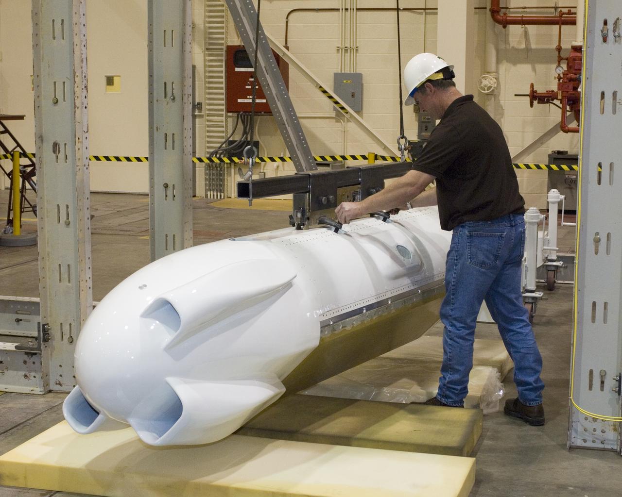
An eight-foot-long pod designed to carry a synthetic aperture radar hangs from the underbelly of NASA's Gulfstream-III research testbed.

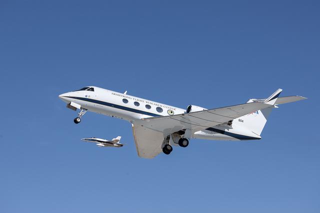
NASA's Gulfstream-III research testbed lifts off the Edwards AFB runway on an envelope-expansion flight test with the UAV synthetic aperture radar pod.

A forest of tufts are mounted on the underbelly and pylon of NASA's Gulfstream-III research aircraft to help engineers determine airflow around the UAVSAR pod.

The effect of the underbelly UAVSAR pod on the aerodynamics of NASA's Gulfstream-III research aircraft was evaluated during several check flights in early 2007.

Shimmering heat waves trail behind NASA's Gulfstream-III research aircraft as it departs the Edwards AFB runway on a UAVSAR pod checkout test flight.

A half-dozen test flights in early 2007 evaluated the aerodynamic effect of the UAVSAR pod on the performance of NASA's Gulfstream-III research testbed.

The UAVSAR underbelly pod is in clear view as NASA's Gulfstream-III research aircraft banks away over Edwards AFB during aerodynamic clearance flights.
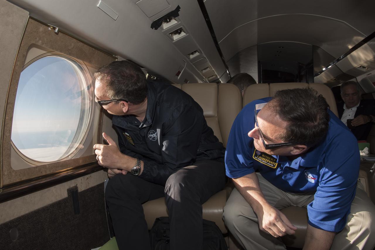
Robert Lightfoot, acting NASA administrator and Thomas Zurbuchen NASA AA for the science mission directorate view a partial eclipse solar eclipse Monday, August 21, 2017, from onboard a NASA Armstrong Flight Research Center’s Gulfstream III 35,000 feet above the Oregon Coast. A total solar eclipse swept across a narrow portion of the contiguous United States from Lincoln Beach, Oregon to Charleston, South Carolina. Photo Credit: (NASA/Carla Thomas)

Robert Lightfoot, acting NASA administrator and Thomas Zurbuchen NASA AA for the science mission directorate view a partial eclipse solar eclipse Monday, August 21, 2017, from onboard a NASA Armstrong Flight Research Center’s Gulfstream III 35,000 feet above the Oregon Coast. A total solar eclipse swept across a narrow portion of the contiguous United States from Lincoln Beach, Oregon to Charleston, South Carolina. Photo Credit: (NASA/Carla Thomas)

Robert Lightfoot, acting NASA administrator and Thomas Zurbuchen NASA AA for the science mission directorate view a partial eclipse solar eclipse Monday, August 21, 2017, from onboard a NASA Armstrong Flight Research Center’s Gulfstream III 35,000 feet above the Oregon Coast. A total solar eclipse swept across a narrow portion of the contiguous United States from Lincoln Beach, Oregon to Charleston, South Carolina. Photo Credit: (NASA/Carla Thomas)

NASA pilot Carrie Worth, center, and Tracy Phelps, left, board the Gulfstream G-III aircraft on Friday, March 27, 2026, at NASA’s Armstrong Flight Research Center in Edwards, California. Manny Rodriguez, crew chief, prepares the aircraft for flight. The G-III will join other NASA aircraft to capture imagery of the Orion spacecraft’s heat shield during Artemis II reentry. The mission is part of NASA’s Scientifically Calibrated In-Flight Imagery (SCIFLI) project, based at NASA’s Langley Research Center in Hampton, Virginia.

A Gulfstream G-III takes off Friday, March 27, 2026, from NASA’s Armstrong Flight Research Center in Edwards, California. The G-III will join other NASA aircraft to capture imagery of the Orion spacecraft’s heat shield during Artemis II reentry. The mission is part of NASA’s Scientifically Calibrated In-Flight Imagery (SCIFLI) project, based at NASA’s Langley Research Center in Hampton, Virginia.

NASA pilot Tracy Phelps inspects the Gulfstream G-III aircraft on Friday, March 27, 2026, at NASA’s Armstrong Flight Research Center in Edwards, California. The G-III will join other NASA aircraft to capture imagery of the Orion spacecraft’s heat shield during Artemis II reentry. The mission is part of NASA’s Scientifically Calibrated In-Flight Imagery (SCIFLI) project, based at NASA’s Langley Research Center in Hampton, Virginia.

A Gulfstream G-III takes off Friday, March 27, 2026, from NASA’s Armstrong Flight Research Center in Edwards, California. The G-III will join other NASA aircraft to capture imagery of the Orion spacecraft’s heat shield during Artemis II reentry. The mission is part of NASA’s Scientifically Calibrated In-Flight Imagery (SCIFLI) project, based at NASA’s Langley Research Center in Hampton, Virginia.
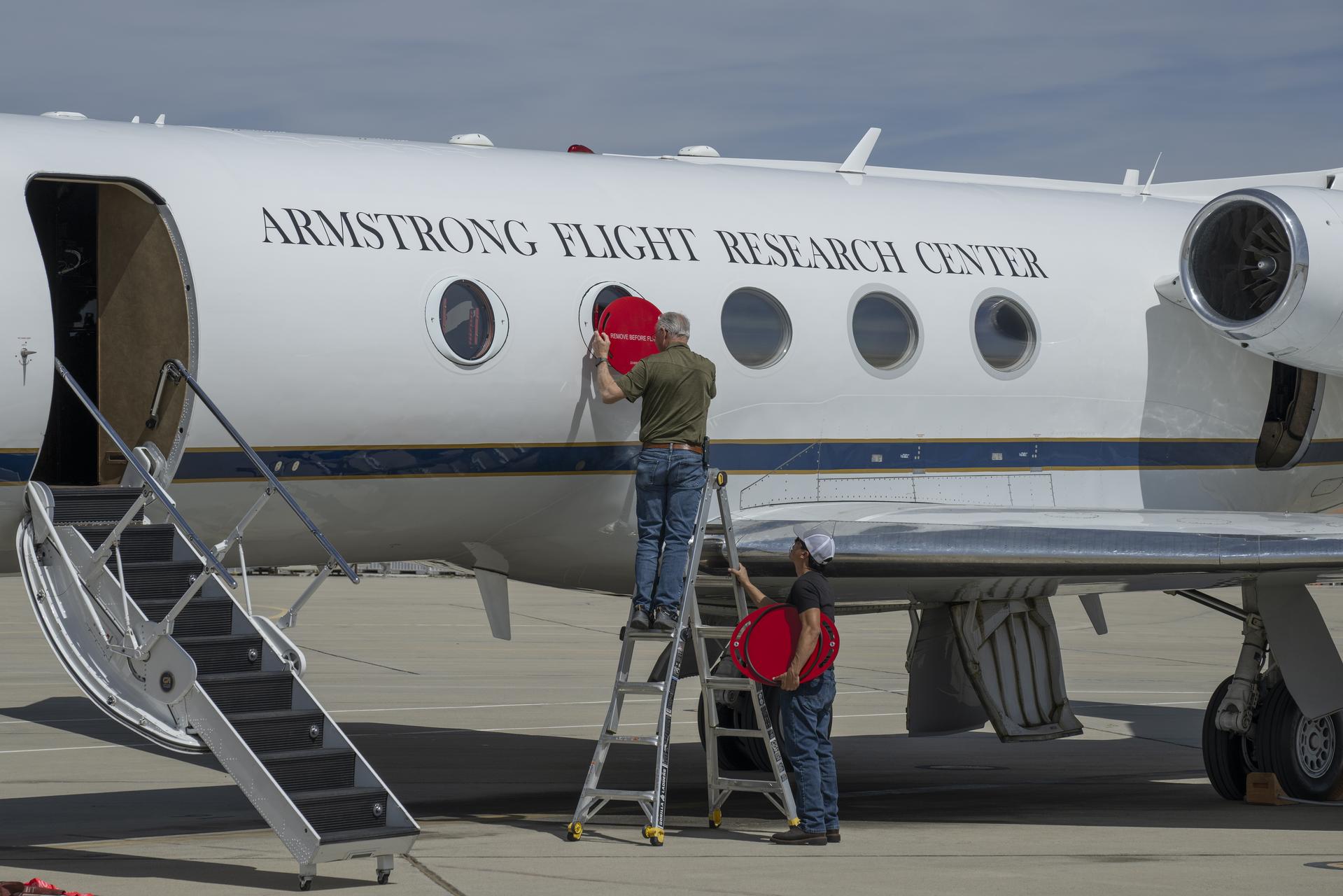
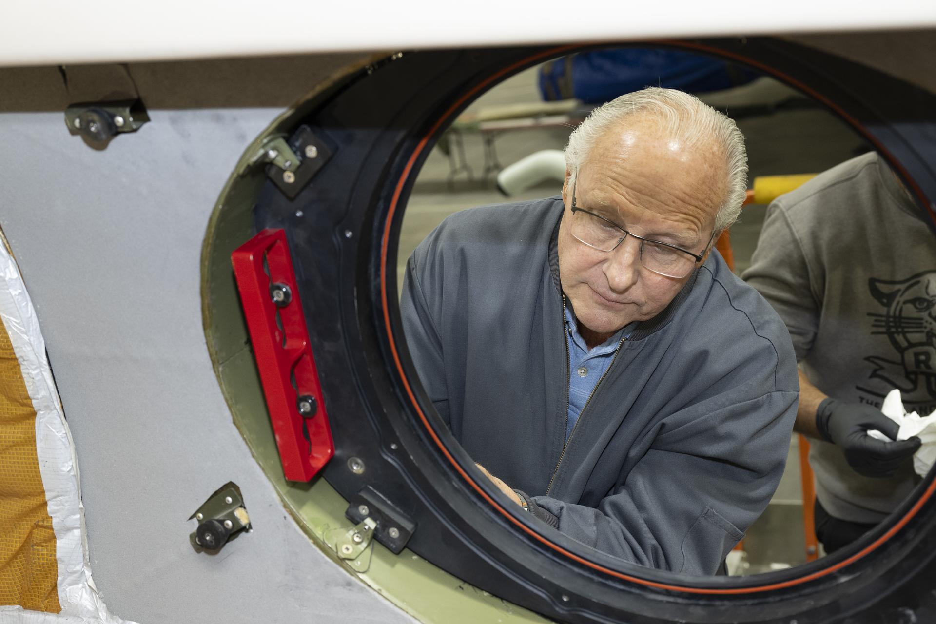
Scott Erickson, left, a quality assurance inspector, and Manny Rodriguez, Gulfstream G-III aircraft crew chief, remove window coverings from the aircraft on Friday, March 27, 2026, at NASA’s Armstrong Flight Research Center in Edwards, California. The G-III will join other NASA aircraft to capture imagery of the Orion spacecraft’s heat shield during Artemis II reentry. The mission is part of NASA’s Scientifically Calibrated In-Flight Imagery (SCIFLI) project, based at NASA’s Langley Research Center in Hampton, Virginia.

A Gulfstream G-III takes off Friday, March 27, 2026, from NASA’s Armstrong Flight Research Center in Edwards, California. The G-III will join other NASA aircraft to capture imagery of the Orion spacecraft’s heat shield during Artemis II reentry. The mission is part of NASA’s Scientifically Calibrated In-Flight Imagery (SCIFLI) project, based at NASA’s Langley Research Center in Hampton, Virginia.

Scott Erickson, left, a quality assurance inspector, and Manny Rodriguez, Gulfstream G-III crew chief, prepare the aircraft for flight on Friday, March 27, 2026, at NASA’s Armstrong Flight Research Center in Edwards, California. The G-III will join other NASA aircraft to capture imagery of the Orion spacecraft’s heat shield during Artemis II reentry. The mission is part of NASA’s Scientifically Calibrated In-Flight Imagery (SCIFLI) project, based at NASA’s Langley Research Center in Hampton, Virginia.

NASA's Gulfstream-III research testbed lifts off from Edwards AFB on a checkout test flight with the UAV synthetic aperture radar pod under its belly.
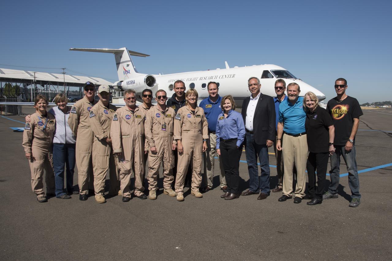
NASA Armstrong and NASA senior management Gulfstream III team pose for group shot by aircraft after return from covering Total solar eclipse. Photo Credit: (NASA/Carla Thomas)
Initial flight-testing of the ACTE followed extensive wind tunnel experiments. For the first phase of ACTE flights, the experimental control surfaces were locked at a specified setting. Varied flap settings on subsequent tests are now demonstrating the capability of the flexible surfaces under actual flight conditions.

Manny Rodriguez, center, Gulfstream G-III aircraft crew chief, drives a tug while mechanic Marlon Espinoza, left, and Scott Erickson, a quality assurance inspector, prepare the aircraft for takeoff on Friday, March 27, 2026, at NASA’s Armstrong Flight Research Center in Edwards, California. The G-III will join other NASA aircraft to capture imagery of the Orion spacecraft’s heat shield during Artemis II reentry. The mission is part of NASA’s Scientifically Calibrated In-Flight Imagery (SCIFLI) project, based at NASA’s Langley Research Center in Hampton, Virginia.

Manny Rodriguez, Gulfstream G-III aircraft crew chief, left, and Eric Apikian, aircraft mechanic, attach an instrumented seat onto a G-III on Wednesday, Jan. 7, 2026, at NASA’s Armstrong Flight Research Center in Edwards, California. The modifications prepare the aircraft to join three others flying at different altitudes to capture a complete view of the Orion spacecraft’s heat shield during Artemis II reentry. This effort is part of NASA’s Scientifically Calibrated In-Flight Imagery project.
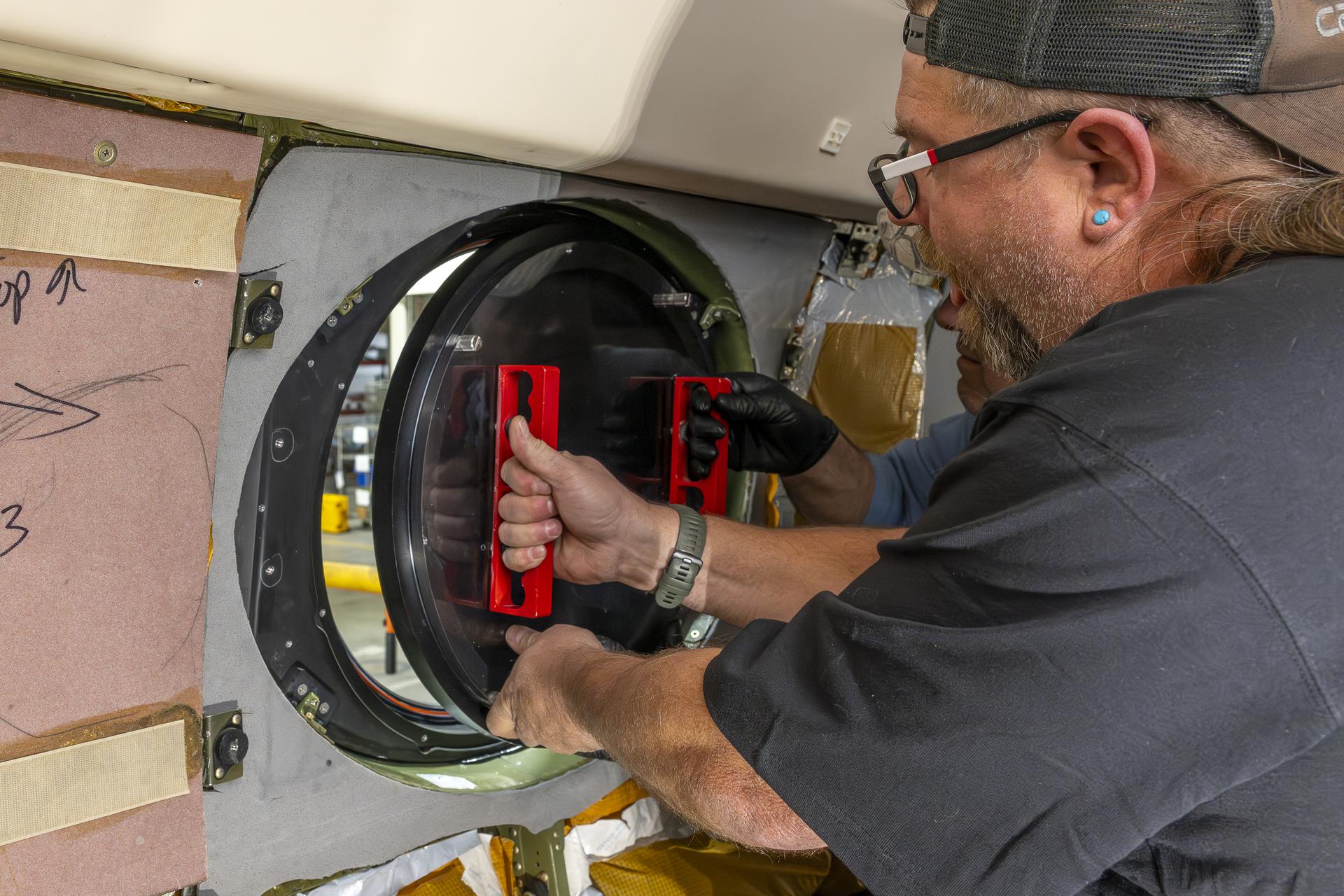
Aircraft mechanic Brian Harness, left, and mechanic Eric Apikian install a temporary aircraft window on a NASA Gulfstream G-III aircraft on Wednesday, Jan. 7, 2026, at NASA’s Armstrong Flight Research Center in Edwards, California. The modifications prepare the aircraft to join three others flying at different altitudes to capture a complete view of the Orion spacecraft’s heat shield during Artemis II reentry. This effort is part of NASA’s Scientifically Calibrated In-Flight Imagery project.
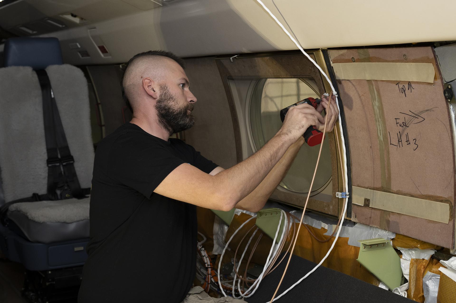
Kelly Jellison, an avionics lead, installs a clip to secure wiring installed on a NASA Gulfstream G-III aircraft on Wednesday, Jan. 7, 2026, at NASA’s Armstrong Flight Research Center in Edwards, California. The modifications prepare the aircraft to join three others flying at different altitudes to capture a complete view of the Orion spacecraft’s heat shield during Artemis II reentry. This effort is part of NASA’s Scientifically Calibrated In-Flight Imagery project.

A NASA Gulfstream G-III aircraft lifts off from NASA’s Armstrong Flight Research Center in Edwards, California, on Tuesday, Jan. 20, 2026. Modifications were made to the aircraft to enable it to join three others flying at different altitudes to capture a complete view of the Orion spacecraft’s heat shield during Artemis II reentry. This effort is part of NASA’s Scientifically Calibrated In-Flight Imagery project.

A NASA Gulfstream G-III aircraft lifts off from NASA’s Armstrong Flight Research Center in Edwards, California, on Tuesday, Jan. 20, 2026. Modifications were made to the aircraft to enable it to join three others flying at different altitudes to capture a complete view of the Orion spacecraft’s heat shield during Artemis II reentry. This effort is part of NASA’s Scientifically Calibrated In-Flight Imagery project.
Scott Erickson, a quality assurance inspector, reviews installation of a temporary aircraft window on a NASA Gulfstream G-III aircraft on Wednesday, Jan. 7, 2026, at NASA’s Armstrong Flight Research Center in Edwards, California. The modifications prepare the aircraft to join three others flying at different altitudes to capture a complete view of the Orion spacecraft’s heat shield during Artemis II reentry. This effort is part of NASA’s Scientifically Calibrated In-Flight Imagery project.
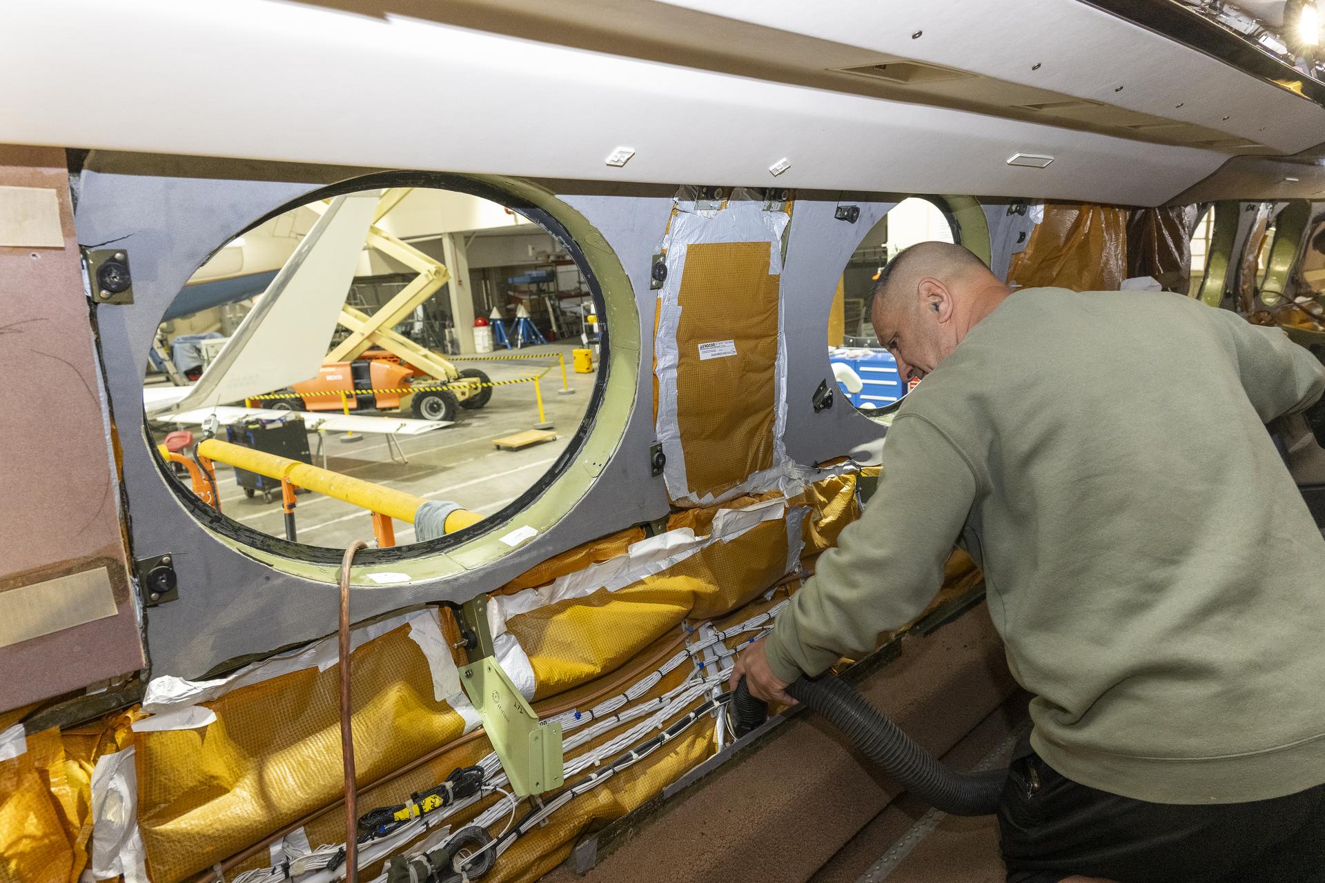
Eric Apikian, an aircraft mechanic, vacuums a NASA Gulfstream G-III aircraft compartment after wiring was added for sensors on Wednesday, Jan. 7, 2026, at NASA’s Armstrong Flight Research Center in Edwards, California. The modifications prepare the aircraft to join three others flying at different altitudes to capture a complete view of the Orion spacecraft’s heat shield during Artemis II reentry. This effort is part of NASA’s Scientifically Calibrated In-Flight Imagery project.

NASA's Gulfstream III was one of several research aircraft that NASA's Oceans Melting Greenland mission used during its six-year field campaign to record the temperature, salinity, and depth of the ocean around the entire island. OMG used airports in Greenland, Iceland, and Norway as bases for research flights. This image was taken at Thule Air Base, Greenland, on Sept. 18, 2016. https://photojournal.jpl.nasa.gov/catalog/PIA24984

Armstrong videographer Mike Agnew operates spectrograph instrument on the 20th to prepare for eclipse day, the 21st. Photo Credit: (NASA/Carla Thomas)
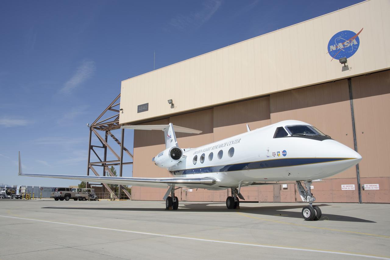
Claudia Sales, NASA’s acting X-59 deputy chief engineer and airworthiness certification lead for the quiet supersonic research aircraft, stands in front of a Gulfstream G-III, also known as Subsonic Research Aircraft Testbed (SCRAT). Sales supported ground testing as test conductor for Acoustics Research Measurements (ARM) flights at NASA’s Armstrong Research Flight Center in Edwards, California, in 2018.

C-20A on NASA Dryden Ramp

Johanna Lucht, observing data from the Mission Control Center at NASA’s Armstrong Flight Research Center in California, received flight communications from an interpreter, seen on Lucht’s monitor, through American Sign Language. Two-way visual communication was established between Lucht and the interpreter, located at NASA’s Langley Research Center in Virginia, for the flight. Interpreting technical terminology often requires cooperation to develop specific signs to ease communication. Using a familiar interpreter who is adept or practiced in the technical terminology of a NASA flight was beneficial, Lucht says.

NASA Armstrong’s Mission Control Center, or MCC, is where culmination of all data-gathering occurs. Engineers, flight controllers and researchers monitor flights and missions as they are carried out. Data and video run through the MCC and are recorded, displayed and archived. Data is then processed and prepared for post-flight analysis.

The diamond-ring effect occurred at the beginning and end of totality during a total solar eclipse. As the last bits of sunlight pass through the valleys on the moon's limb, and the faint corona around the sun is just becoming visible, it looks like a ring with glittering diamonds on it. Credit: (NASA/Carla Thomas)

Bob Meyer (right), acting deputy director of NASA Dryden, shakes hands with Les Bordelon, executive director of Edwards Air Force Base.

NASA's Thomas Zurbuchen, AA for science mission directorate explains to Lesa Roe, acting deputy administrator, how the spectrograph showing different colors correlate to different elements, such as helium, in the Sun's atmosphere. Photo Credit: (NASA/Carla Thomas)

NASA's Thomas Zurbuchen, AA for science missiond directorate and NASA's Robert Lightfoot, acting administrator, waiting for partial eclipse to occur. Photo Credit: (NASA/Carla Thomas)

NASA's Thomas Zurbuchen, AA for science mission directorate explains to Lesa Roe, acting deputy administrator, how the spectrograph showing different colors correlate to different elements, such as helium, in the Sun's atmosphere. Photo Credit: (NASA/Carla Thomas)

NASA's Lesa Roe, Acting Deputy Administrator, waiting for partial eclipse to occur. Photo Credit: (NASA/Carla Thomas)
Robert Lightfoot, acting NASA administrator, takes photo of eclipse using eclipse glasses on cell phone. Photo Credit: (NASA/Carla Thomas)

NASA's Thomas Zurbuchen, AA for science mission directorate explains to Lesa Roe, acting deputy administrator, how the spectrograph showing different colors correlate to different elements, such as helium, in the Sun's atmosphere. Photo Credit: (NASA/Carla Thomas)

NASA’s Ikhana remotely piloted aircraft (front-right) is situated near NASA Armstrong Flight Research Center’s Hangar 4802 after an Unmanned Aircraft Systems Integration into the National Airspace System Flight Test Series 4 flight, along with five flight “intruders.” These intruders, which include NASA’s TG-14 (front-left), T-34C (front-center), B-200 King Air (back-left), Gulfstream-III (back-center) and a Honeywell C-90 King Air (back-right), fly within a pre-determined distance to Ikhana to test Detect-and-Avoid technology during research flights.
NASA Dryden lead technician David Neufeld prepares JPL's unmanned aircraft Synthetic Aperture Radar pod for inertial swing tests in Dryden's loads laboratory.

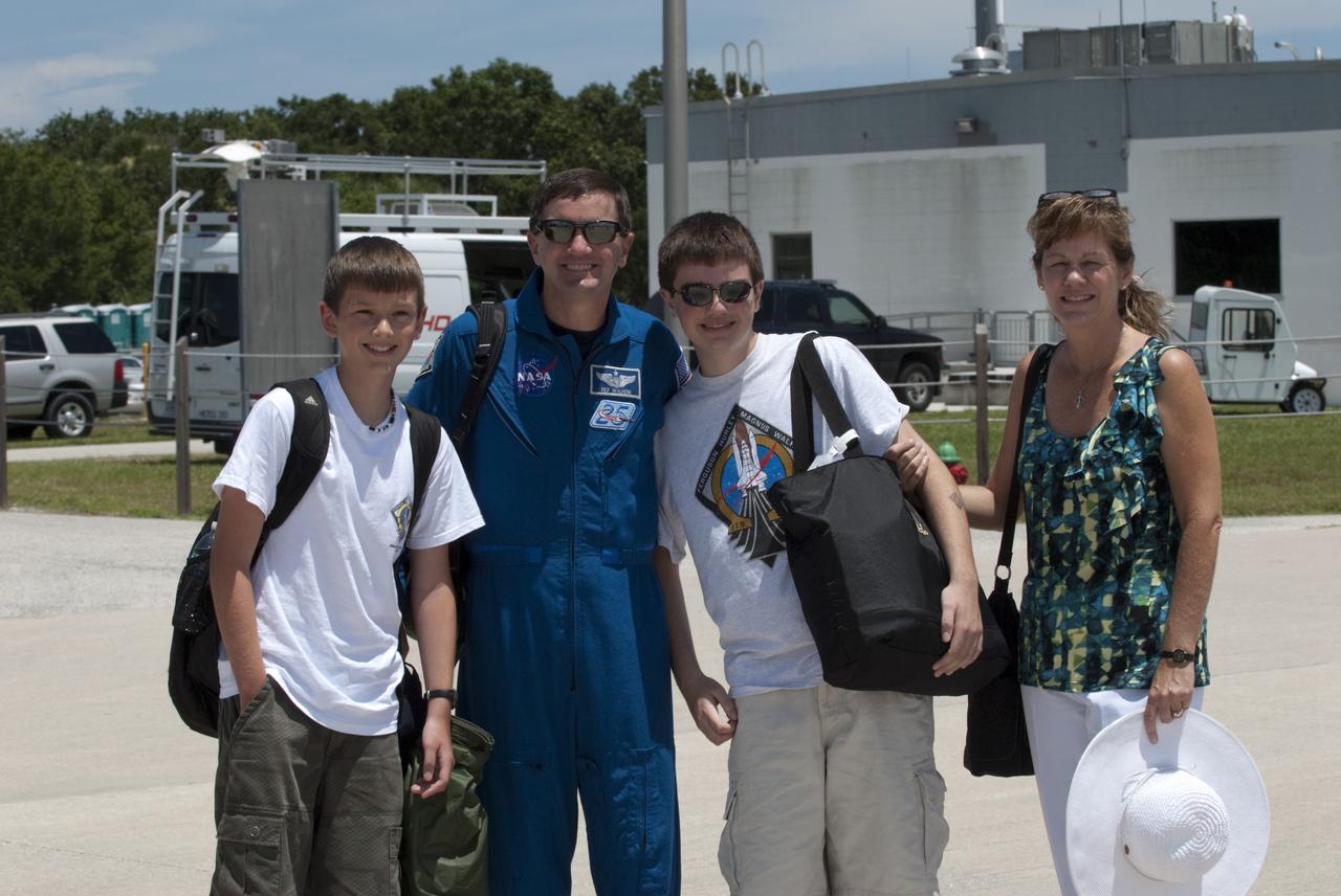
CAPE CANAVERAL, Fla. -- At NASA Kennedy Space Center's Shuttle Landing Facility, a Gulfstream III jet is preparing to take off with space shuttle Atlantis' four STS-135 astronauts and their families for the return trip home to NASA's Johnson Space Center in Houston. Space shuttle Atlantis and its crew touched down on Kennedy's Shuttle Landing Facility runway 5:57 a.m., July 21, 2011, bringing a close to 30 years of space shuttle missions. Securing the space shuttle fleet's place in history, Atlantis marked the 26th nighttime landing of the Space Shuttle Program and the 78th landing at Kennedy. Atlantis and its crew delivered to the International Space Station the Raffaello multi-purpose logistics module packed with more than 9,400 pounds of spare parts, equipment and supplies that will sustain station operations for the next year. STS-135 was the 33rd and final flight for Atlantis and the final mission of the Space Shuttle Program. For more information, visit www.nasa.gov/mission_pages/shuttle/shuttlemissions/sts135/index.html. Photo credit: NASA/Kim Shiflett

CAPE CANAVERAL, Fla. -- The STS-135 astronauts prepare to depart NASA's Kennedy Space Center in Florida to return to NASA's Johnson Space Center in Houston. Space shuttle Atlantis and its crew touched down on Kennedy's Shuttle Landing Facility runway 5:57 a.m., July 21, 2011, bringing a close to 30 years of space shuttle missions. Here, STS-135 Pilot Doug Hurley and his family walk toward a Gulfstream III jet that will take them back home. Securing the space shuttle fleet's place in history, Atlantis marked the 26th nighttime landing of the Space Shuttle Program and the 78th landing at Kennedy. Atlantis and its crew delivered to the International Space Station the Raffaello multi-purpose logistics module packed with more than 9,400 pounds of spare parts, equipment and supplies that will sustain station operations for the next year. STS-135 was the 33rd and final flight for Atlantis and the final mission of the Space Shuttle Program. For more information, visit www.nasa.gov/mission_pages/shuttle/shuttlemissions/sts135/index.html. Photo credit: NASA/Kim Shiflett
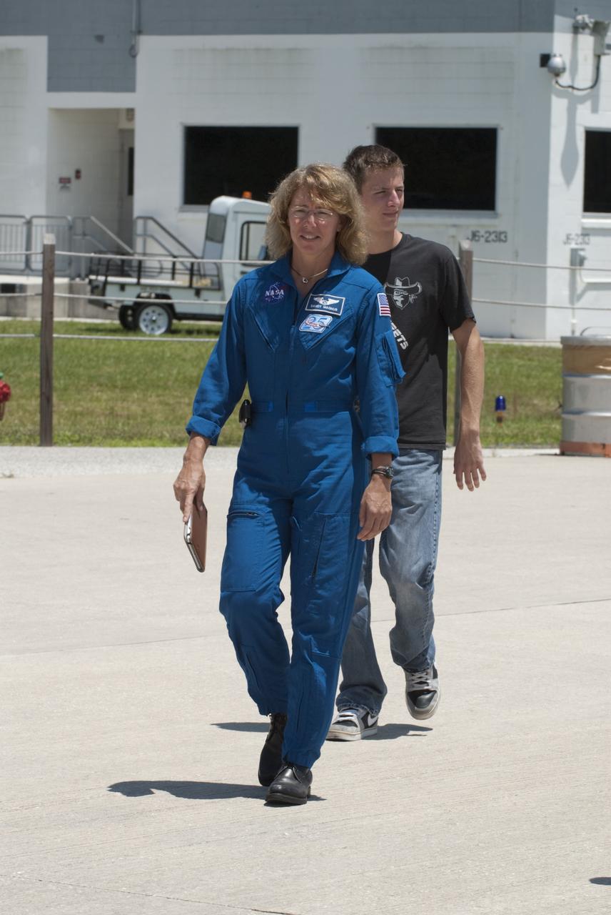
CAPE CANAVERAL, Fla. -- The STS-135 astronauts prepare to depart NASA's Kennedy Space Center in Florida to return to NASA's Johnson Space Center in Houston. Space shuttle Atlantis and its crew touched down on Kennedy's Shuttle Landing Facility runway 5:57 a.m., July 21, 2011, bringing a close to 30 years of space shuttle missions. Here, STS-135 Mission Specialist Sandy Magnus walks toward a Gulfstream III jet that will take her back home. Securing the space shuttle fleet's place in history, Atlantis marked the 26th nighttime landing of the Space Shuttle Program and the 78th landing at Kennedy. Atlantis and its crew delivered to the International Space Station the Raffaello multi-purpose logistics module packed with more than 9,400 pounds of spare parts, equipment and supplies that will sustain station operations for the next year. STS-135 was the 33rd and final flight for Atlantis and the final mission of the Space Shuttle Program. For more information, visit www.nasa.gov/mission_pages/shuttle/shuttlemissions/sts135/index.html. Photo credit: NASA/Kim Shiflett
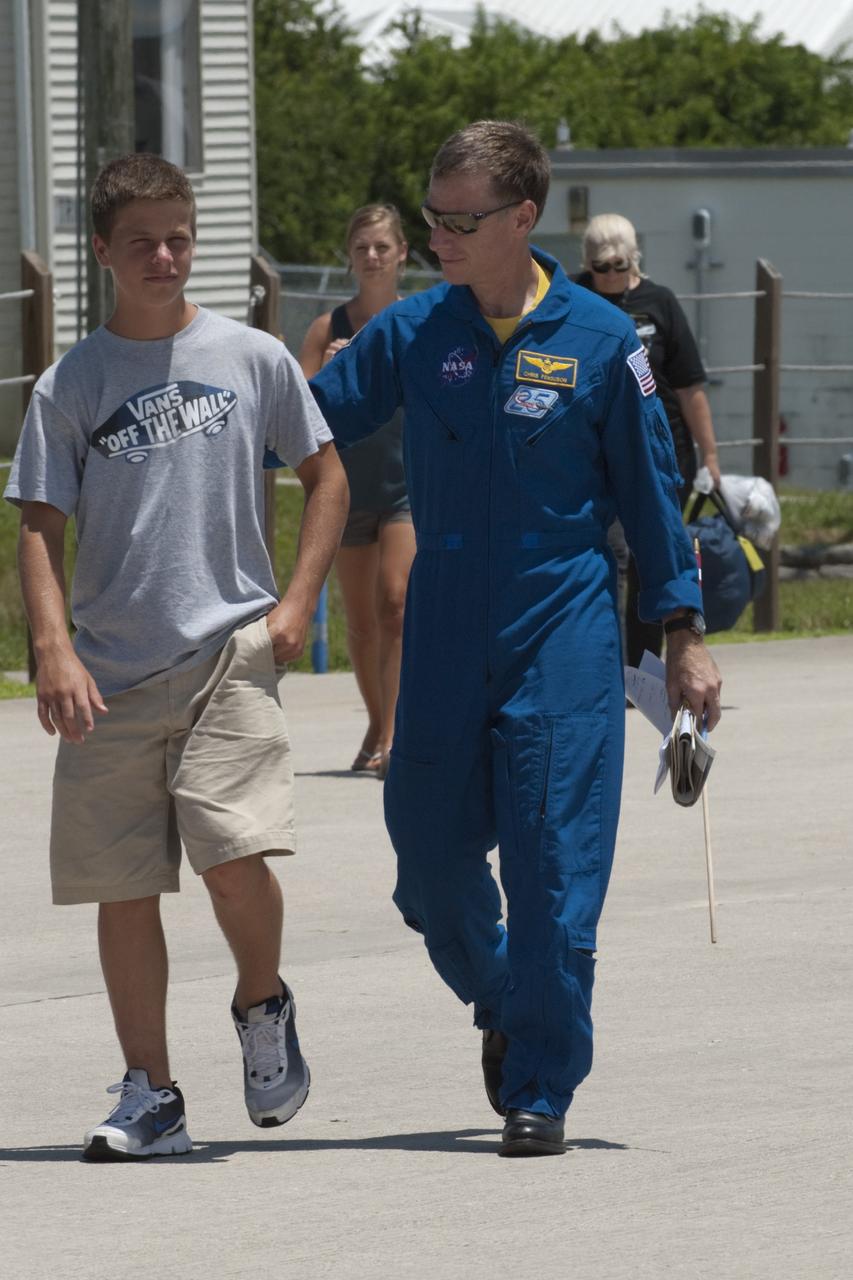
CAPE CANAVERAL, Fla. -- The STS-135 astronauts prepare to depart NASA's Kennedy Space Center in Florida to return to NASA's Johnson Space Center in Houston. Space shuttle Atlantis and its crew touched down on Kennedy's Shuttle Landing Facility runway 5:57 a.m., July 21, 2011, bringing a close to 30 years of space shuttle missions. Here, STS-135 Commander Chris Ferguson and his son walk toward a Gulfstream III jet that will take them back home. Securing the space shuttle fleet's place in history, Atlantis marked the 26th nighttime landing of the Space Shuttle Program and the 78th landing at Kennedy. Atlantis and its crew delivered to the International Space Station the Raffaello multi-purpose logistics module packed with more than 9,400 pounds of spare parts, equipment and supplies that will sustain station operations for the next year. STS-135 was the 33rd and final flight for Atlantis and the final mission of the Space Shuttle Program. For more information, visit www.nasa.gov/mission_pages/shuttle/shuttlemissions/sts135/index.html. Photo credit: NASA/Kim Shiflett
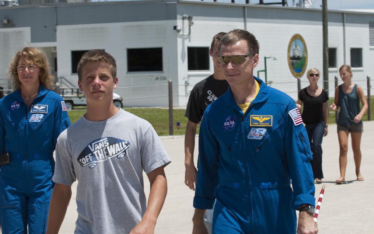
CAPE CANAVERAL, Fla. -- The STS-135 astronauts prepare to depart NASA's Kennedy Space Center in Florida to return to NASA's Johnson Space Center in Houston. Space shuttle Atlantis and its crew touched down on Kennedy's Shuttle Landing Facility runway 5:57 a.m., July 21, 2011, bringing a close to 30 years of space shuttle missions. Here, STS-135 Commander Chris Ferguson and his son walk toward a Gulfstream III jet that will take them back home. STS-135 Mission Specialist Sandy Magnus follows close behind them, at left. Securing the space shuttle fleet's place in history, Atlantis marked the 26th nighttime landing of the Space Shuttle Program and the 78th landing at Kennedy. Atlantis and its crew delivered to the International Space Station the Raffaello multi-purpose logistics module packed with more than 9,400 pounds of spare parts, equipment and supplies that will sustain station operations for the next year. STS-135 was the 33rd and final flight for Atlantis and the final mission of the Space Shuttle Program. For more information, visit www.nasa.gov/mission_pages/shuttle/shuttlemissions/sts135/index.html. Photo credit: NASA/Kim Shiflett

CAPE CANAVERAL, Fla. -- At NASA Kennedy Space Center's Shuttle Landing Facility, a Gulfstream III jet is preparing to take off with space shuttle Atlantis' four STS-135 astronauts and their families for the return trip home to NASA's Johnson Space Center in Houston. Space shuttle Atlantis and its crew touched down on Kennedy's Shuttle Landing Facility runway 5:57 a.m., July 21, 2011, bringing a close to 30 years of space shuttle missions. Securing the space shuttle fleet's place in history, Atlantis marked the 26th nighttime landing of the Space Shuttle Program and the 78th landing at Kennedy. Atlantis and its crew delivered to the International Space Station the Raffaello multi-purpose logistics module packed with more than 9,400 pounds of spare parts, equipment and supplies that will sustain station operations for the next year. STS-135 was the 33rd and final flight for Atlantis and the final mission of the Space Shuttle Program. For more information, visit www.nasa.gov/mission_pages/shuttle/shuttlemissions/sts135/index.html. Photo credit: NASA/Kim Shiflett

CAPE CANAVERAL, Fla. -- At NASA Kennedy Space Center's Shuttle Landing Facility, STS-135 Mission Specialist Sandy Magnus is seated in a Gulfstream III jet that will fly her back to NASA's Johnson Space Center in Houston. Space shuttle Atlantis and its crew touched down on Kennedy's Shuttle Landing Facility runway 5:57 a.m., July 21, 2011, bringing a close to 30 years of space shuttle missions. Securing the space shuttle fleet's place in history, Atlantis marked the 26th nighttime landing of the Space Shuttle Program and the 78th landing at Kennedy. Atlantis and its crew delivered to the International Space Station the Raffaello multi-purpose logistics module packed with more than 9,400 pounds of spare parts, equipment and supplies that will sustain station operations for the next year. STS-135 was the 33rd and final flight for Atlantis and the final mission of the Space Shuttle Program. For more information, visit www.nasa.gov/mission_pages/shuttle/shuttlemissions/sts135/index.html. Photo credit: NASA/Kim Shiflett

CAPE CANAVERAL, Fla. -- At NASA Kennedy Space Center's Shuttle Landing Facility, STS-135 Mission Specialist Rex Walheim is seated in a Gulfstream III jet that will fly him and his family back to NASA's Johnson Space Center in Houston. Space shuttle Atlantis and its crew touched down on Kennedy's Shuttle Landing Facility runway 5:57 a.m., July 21, 2011, bringing a close to 30 years of space shuttle missions. Securing the space shuttle fleet's place in history, Atlantis marked the 26th nighttime landing of the Space Shuttle Program and the 78th landing at Kennedy. Atlantis and its crew delivered to the International Space Station the Raffaello multi-purpose logistics module packed with more than 9,400 pounds of spare parts, equipment and supplies that will sustain station operations for the next year. STS-135 was the 33rd and final flight for Atlantis and the final mission of the Space Shuttle Program. For more information, visit www.nasa.gov/mission_pages/shuttle/shuttlemissions/sts135/index.html. Photo credit: NASA/Kim Shiflett

CAPE CANAVERAL, Fla. -- At NASA Kennedy Space Center's Shuttle Landing Facility, a Gulfstream III jet is preparing to take off with space shuttle Atlantis' four STS-135 astronauts and their families for the return trip home to NASA's Johnson Space Center in Houston. Space shuttle Atlantis and its crew touched down on Kennedy's Shuttle Landing Facility runway 5:57 a.m., July 21, 2011, bringing a close to 30 years of space shuttle missions. Securing the space shuttle fleet's place in history, Atlantis marked the 26th nighttime landing of the Space Shuttle Program and the 78th landing at Kennedy. Atlantis and its crew delivered to the International Space Station the Raffaello multi-purpose logistics module packed with more than 9,400 pounds of spare parts, equipment and supplies that will sustain station operations for the next year. STS-135 was the 33rd and final flight for Atlantis and the final mission of the Space Shuttle Program. For more information, visit www.nasa.gov/mission_pages/shuttle/shuttlemissions/sts135/index.html. Photo credit: NASA/Kim Shiflett

CAPE CANAVERAL, Fla. -- At NASA Kennedy Space Center's Shuttle Landing Facility, STS-135 Pilot Doug Hurley is seated in a Gulfstream III jet that will fly him and his family back to NASA's Johnson Space Center in Houston. Space shuttle Atlantis and its crew touched down on Kennedy's Shuttle Landing Facility runway 5:57 a.m., July 21, 2011, bringing a close to 30 years of space shuttle missions. Securing the space shuttle fleet's place in history, Atlantis marked the 26th nighttime landing of the Space Shuttle Program and the 78th landing at Kennedy. Atlantis and its crew delivered to the International Space Station the Raffaello multi-purpose logistics module packed with more than 9,400 pounds of spare parts, equipment and supplies that will sustain station operations for the next year. STS-135 was the 33rd and final flight for Atlantis and the final mission of the Space Shuttle Program. For more information, visit www.nasa.gov/mission_pages/shuttle/shuttlemissions/sts135/index.html. Photo credit: NASA/Kim Shiflett

CAPE CANAVERAL, Fla. -- At NASA Kennedy Space Center's Shuttle Landing Facility, STS-135 Commander Chris Ferguson is seated in a Gulfstream III jet that will fly him and his family back to NASA's Johnson Space Center in Houston. Space shuttle Atlantis and its crew touched down on Kennedy's Shuttle Landing Facility runway 5:57 a.m., July 21, 2011, bringing a close to 30 years of space shuttle missions. Securing the space shuttle fleet's place in history, Atlantis marked the 26th nighttime landing of the Space Shuttle Program and the 78th landing at Kennedy. Atlantis and its crew delivered to the International Space Station the Raffaello multi-purpose logistics module packed with more than 9,400 pounds of spare parts, equipment and supplies that will sustain station operations for the next year. STS-135 was the 33rd and final flight for Atlantis and the final mission of the Space Shuttle Program. For more information, visit www.nasa.gov/mission_pages/shuttle/shuttlemissions/sts135/index.html. Photo credit: NASA/Kim Shiflett

CAPE CANAVERAL, Fla. -- The STS-135 astronauts are preparing to depart NASA's Kennedy Space Center in Florida to return to NASA's Johnson Space Center in Houston. Here, a Gulfstream III jet is waiting for the crew members and their families to board for the flight home. Space shuttle Atlantis and its crew touched down on Kennedy's Shuttle Landing Facility runway 5:57 a.m., July 21, 2011, bringing a close to 30 years of space shuttle missions. Securing the space shuttle fleet's place in history, Atlantis marked the 26th nighttime landing of the Space Shuttle Program and the 78th landing at Kennedy. Atlantis and its crew delivered to the International Space Station the Raffaello multi-purpose logistics module packed with more than 9,400 pounds of spare parts, equipment and supplies that will sustain station operations for the next year. STS-135 was the 33rd and final flight for Atlantis and the final mission of the Space Shuttle Program. For more information, visit www.nasa.gov/mission_pages/shuttle/shuttlemissions/sts135/index.html. Photo credit: NASA/Kim Shiflett
CAPE CANAVERAL, Fla. -- The STS-135 astronauts prepare to depart NASA's Kennedy Space Center in Florida to return to NASA's Johnson Space Center in Houston. Space shuttle Atlantis and its crew touched down on Kennedy's Shuttle Landing Facility runway 5:57 a.m., July 21, 2011, bringing a close to 30 years of space shuttle missions. Here, STS-135 Mission Specialist Rex Walheim and his family stop for a photo before boarding a Gulfstream III jet that will take them back home. Securing the space shuttle fleet's place in history, Atlantis marked the 26th nighttime landing of the Space Shuttle Program and the 78th landing at Kennedy. Atlantis and its crew delivered to the International Space Station the Raffaello multi-purpose logistics module packed with more than 9,400 pounds of spare parts, equipment and supplies that will sustain station operations for the next year. STS-135 was the 33rd and final flight for Atlantis and the final mission of the Space Shuttle Program. For more information, visit www.nasa.gov/mission_pages/shuttle/shuttlemissions/sts135/index.html. Photo credit: NASA/Kim Shiflett
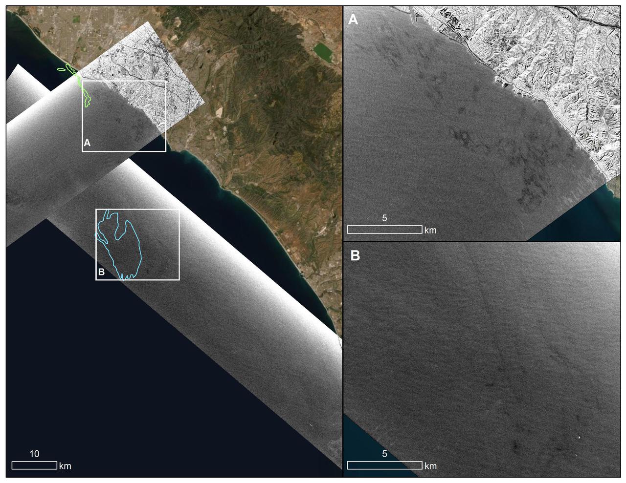
An oil spill off the Southern California coast – first reported to the U.S. Coast Guard on Oct. 2, 2021 – prompted an effort by NASA's Applied Sciences Disasters Program to determine what NASA resources and capabilities could be available to support response efforts for the spill. As part of those efforts, a team from NASA's Jet Propulsion Laboratory in Southern California flew an airplane equipped with an instrument known as the Uninhabited Aerial Vehicle Synthetic Aperture Radar (UAVSAR) over the spill area on Oct. 6 to corroborate the presence and location of oil slicks. Mapping the location of oil slicks and determining how thick the oil is can also help with clean-up activities. The JPL researchers collected the UAVSAR data in support of the National Oceanic and Atmospheric Administration (NOAA), which regularly monitors U.S. coastal waters for potential spills. This image shows a composite of two images taken during passes (grayscale regions) made by the UAVSAR instrument off the coast of Huntington Beach. Dark smudges off the coast in the close-up images to the right (labeled A and B) are potential oil slicks – NOAA researchers will analyze the data to look for the presence of oil. The area outlined in light green (image on the left) was identified by NOAA using satellite data as a region possibly containing oil on Oct.3, while the blue outline shows an area on Oct. 6 that could also contain oil. Attached to the bottom of a Gulfstream-III based at NASA's Armstrong Flight Research Center near Palmdale, California, UAVSAR is an all-weather tool that bounces radar signals off of Earth's surface. Repeated images of the same areas, taken at different times, enable scientists to detect changes in those regions. The radar signals will reflect differently off of different surfaces, including oil and seawater. These signal variations can tell researchers about the presence of an oil slick in the ocean, and in some cases provide information about its thickness. https://photojournal.jpl.nasa.gov/catalog/PIA23782

The Boeing KC-135 Stratotanker, besides being used extensively in its primary role as an inflight aircraft refueler, has assisted in several projects at the NASA Dryden Flight Research Center, Edwards, California. In 1957 and 1958, Dryden was asked by what was then the Civil Aeronautics Administration (later absorbed into the Federal Aviation Administration (FAA) in 1958) to help establish new approach procedure guidelines on cloud-ceiling and visibility minimums for Boeing's first jet airliner, the B-707. Dryden used a KC-135 (the military variant of the 707), seen here on the runway at Edwards Air Force Base, to aid the CAA in these tests. In 1979 and 1980, Dryden was again involved with general aviation research with the KC-135. This time, a special wingtip "winglet", developed by Richard Whitcomb of Langley Research Center, was tested on the jet aircraft. Winglets are small, nearly vertical fins installed on an airplane's wing tips to help produce a forward thrust in the vortices that typically swirl off the end of the wing, thereby reducing drag. This winglet idea was tested at the Dryden Flight Research Center on a KC-135A tanker loaned to NASA by the Air Force. The research showed that the winglets could increase an aircraft's range by as much as 7 percent at cruise speeds. The first application of NASA's winglet technology in industry was in general aviation business jets, but winglets are now being incorporated into most new commercial and military transport jets, including the Gulfstream III and IV business jets, the Boeing 747-400 and MD-11 airliners, and the C-17 military transport. In the 1980's, a KC-135 was used in support of the Space Shuttle program. Since the Shuttle was to be launched from Florida, researchers wanted to test the effect of rain on the sensitive thermal tiles. Tiles were mounted on special fixtures on an F-104 aircraft and a P-3 Orion. The F-104 was flown in actual rain conditions, and also behind the KC-135 spray tanker as it rel

Researchers at NASA's Jet Propulsion Laboratory in Southern California used data from an airborne radar to measure the movement of the slow-moving landslides on the Palos Verdes Peninsula in Los Angeles County. The analysis determined that, during a period of four weeks in the fall of 2024, land in the residential area slid toward the ocean by as much as 4 inches (10 centimeters) per week. Portions of the peninsula, which juts into the Pacific Ocean just south of the city of Los Angeles, is part of an ancient complex of landslides and has been moving for at least the past six decades, affecting hundreds of buildings in local communities. The motion accelerated and the active area expanded following record-breaking rainfall in Southern California in 2023 and another heavy-precipitation winter in 2024. To create this visualization, the Advanced Rapid Imaging and Analysis (ARIA) team used data from four flights of NASA's Uninhabited Aerial Vehicle Synthetic Aperture Radar (UAVSAR) that took place between Sept. 18 and Oct. 17. The UAVSAR instrument was mounted to a Gulfstream III jet flown out of NASA's Armstrong Flight Research Center in Edwards, California, and the four flights were planned to estimate the speed and direction of the landslides in three dimensions. In the image, colors indicate how fast parts of the landslide complex were moving in late September and October, with the darkest reds indicating the highest speeds. The arrows represent the direction of horizontal motion. The white solid lines are the boundaries of active landslide areas as defined in 2007 by the California Geological Survey. The insights from the UAVSAR flights were part of a package of analyses by the ARIA team that also used data from ESA's (the European Space Agency's) Copernicus Sentinel-1A/B satellites. The analyses were provided to California officials to support the state's response to the landslides and made available to the public at NASA's Disaster Mapping Portal. The ARIA mission is a collaboration between JPL and Caltech, which manages JPL for NASA, to leverage radar and optical remote-sensing, GPS, and seismic observations for science as well as to aid in disaster response. The project investigates the processes and impacts of earthquakes, volcanoes, landslides, fires, subsurface fluid movement, and other natural hazards. UAVSAR has flown thousands of radar missions around the world since 2007 studying phenomena such as glaciers and ice sheets, vegetation in ecosystems, and natural hazards like earthquakes, volcanoes, and landslides. https://photojournal.jpl.nasa.gov/catalog/PIA26495
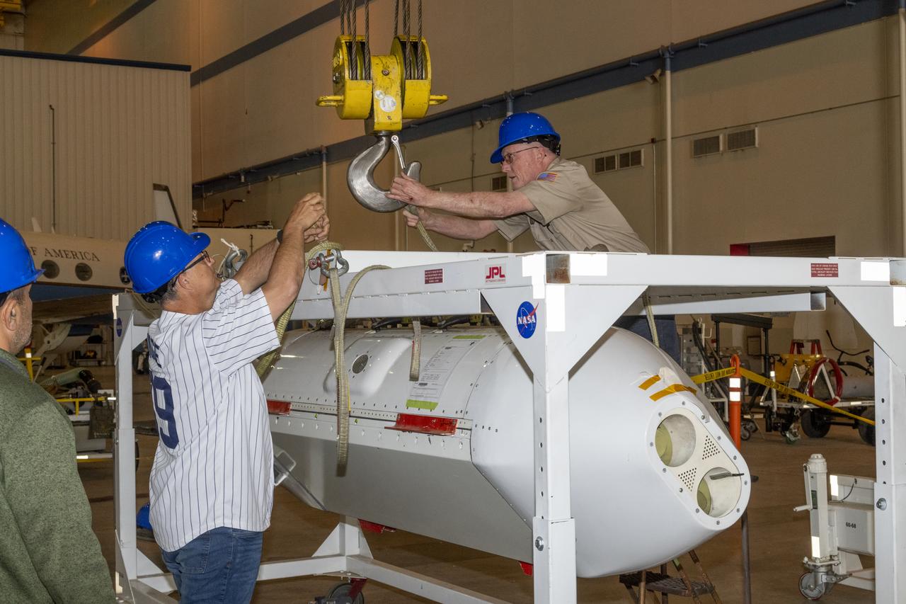
The Uninhabited Aerial Vehicle Synthetic Aperture Radar, UAVSAR, is prepared for installation onto NASA’s C-20A aircraft. THE UAVSAR uses a technique called interferometry to detect and measure very subtle deformations in the Earth’s surface, and the pod is specially designed to be interoperable with unmanned aircraft in the future. It will gather data from Gabon, Africa in September of 2023.

The Uninhabited Aerial Vehicle Synthetic Aperture Radar, UAVSAR, is prepared for installation onto NASA’s C-20A aircraft. THE UAVSAR uses a technique called interferometry to detect and measure very subtle deformations in the Earth’s surface, and the pod is specially designed to be interoperable with unmanned aircraft in the future. It will gather data from Gabon, Africa in September of 2023.
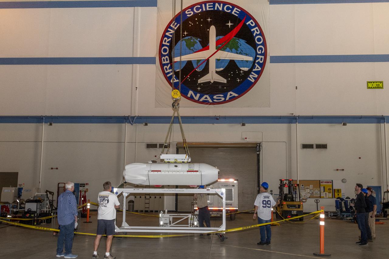
The Uninhabited Aerial Vehicle Synthetic Aperture Radar, UAVSAR, is prepared for installation onto NASA’s C-20A aircraft. THE UAVSAR uses a technique called interferometry to detect and measure very subtle deformations in the Earth’s surface, and the pod is specially designed to be interoperable with unmanned aircraft in the future. It will gather data from Gabon, Africa in September of 2023.

The Uninhabited Aerial Vehicle Synthetic Aperture Radar, UAVSAR, is prepared for installation onto NASA’s C-20A aircraft. THE UAVSAR uses a technique called interferometry to detect and measure very subtle deformations in the Earth’s surface, and the pod is specially designed to be interoperable with unmanned aircraft in the future. It will gather data from Gabon, Africa in September of 2023.
The Uninhabited Aerial Vehicle Synthetic Aperture Radar, UAVSAR, is prepared for installation onto NASA’s C-20A aircraft. THE UAVSAR uses a technique called interferometry to detect and measure very subtle deformations in the Earth’s surface, and the pod is specially designed to be interoperable with unmanned aircraft in the future. It will gather data from Gabon, Africa in September of 2023.
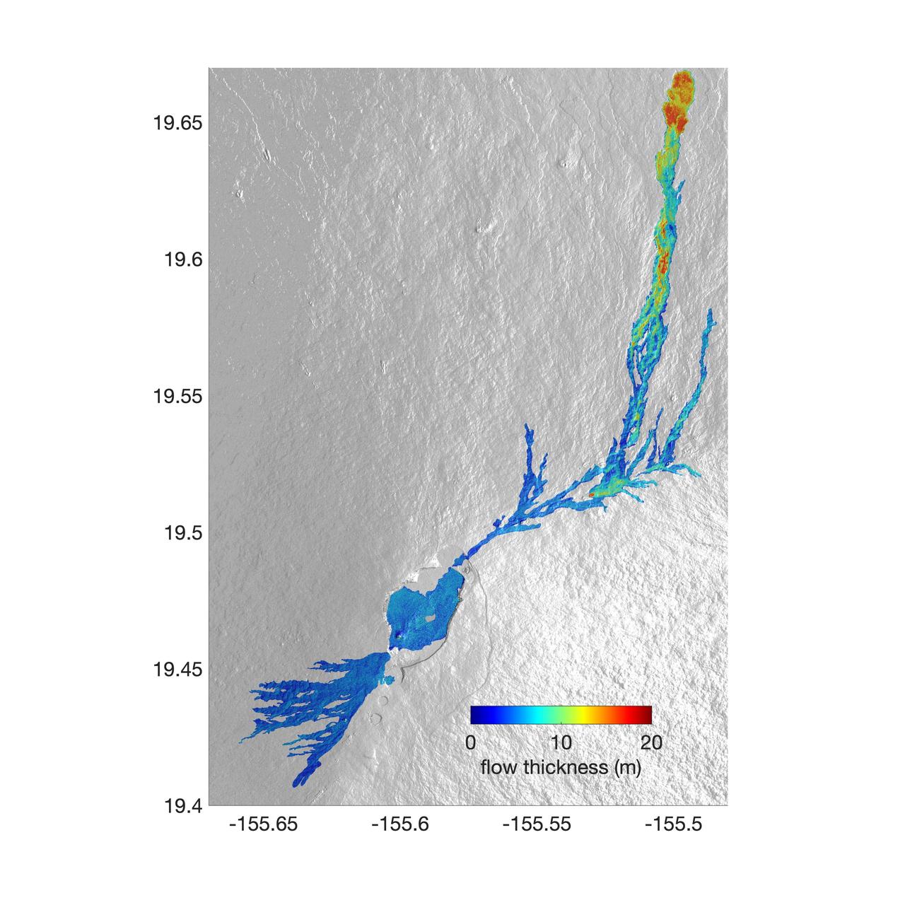
The world's largest active volcano – Hawaii's Mauna Loa – had been quiet for 38 years. But in 2022, the volcano began to stir, showing increased numbers of small earthquakes and subtle swelling of certain land surfaces in September. On November 27, fountains of lava began spurting from the mountain's Northeast Rift Zone and streams of molten rock flowed to the north. Ten days into the eruption, a NASA aircraft conducted its first flight over the erupting volcano. It carried NASA's Uninhabited Aerial Vehicle Synthetic Aperture Radar (UAVSAR) system, which was used to map the volcano's topography in fine detail with a Ka-band instrument called GLISTIN-A. Teams from NASA's Jet Propulsion Laboratory and the United States Geological Survey (USGS) used data from that sensor to map the thickness of those flows during a series of flights on December 7, 8, and 10. The map above shows the thickness of the lava flows during the flight on December 7, the day before USGS scientists noticed a significant decline in the pace of the eruption. A few days later, they declared the eruption had stopped. The map shows the thickness of the lava flows in the summit caldera, where the eruption began, and of lava flows on Mauna Loa's northeastern flank. The color variation from blue to orange indicates increasing lava flow thickness. A maximum thickness of roughly 25 meters (82 feet) is shown, though values exceeding 40 meters (131 feet) were observed in some areas. The thickening at the northern end of the flow is due to lava accumulating away from the vent, along with a flattening of the terrain at the saddle between the Mauna Loa and Mauna Kea volcanoes. By comparing to pre-eruption maps of this area's topography, including GLISTIN-A data collected in 2017, the USGS researchers were able to calculate the size and volume of the lava flow. Over the roughly 14-day eruption, Mauna Loa erupted more than 8.8 billion cubic feet (230 million cubic meters) along a lava flow that extended up to 16.5 miles (19.5 kilometers) from the vent, according to the USGS. The UAVSAR operates from a pod mounted beneath a crewed Gulfstream III jet from NASA's Armstrong Flight Research Center in California. Repeated topographic maps generated with each flight reveal the progression and thickening of lava with time – important information for scientific understanding of volcano processes and for emergency response. For the Mauna Loa science flights, the instrument suite featured an additional state-of-the-art imaging tool: the synthetic aperture radar-fusion optical short-wave infrared (SAR-Fusion Optical/SWIR) camera system. SAR-Fusion collects data over the same ground swath as GLISTIN-A to map land surface changes using optical/SWIR photogrammetry methods. GLISTIN-A was designed to provide all-weather, high-resolution surface topography not available through existing lidar or radar sensors. GLISTIN-A was originally demonstrated as a new radar technique for mapping ice surfaces. Science demonstration flights began in 2013 over alpine glaciers and sea ice in Alaska, and a floodplain in California. Its applications have since expanded to other areas, such as snow accumulation and volcano dynamics. The first time the instrument was deployed for volcano response was in 2018 during the three-month eruption of Kilauea. The success of that operation paved the way for deployment to Mauna Loa. https://photojournal.jpl.nasa.gov/catalog/PIA25526

An oil slick in the Gulf of Mexico following Hurricane Ida – a high-end Category 4 when it made landfall near Port Fourchon, Louisiana, on Aug. 29, 2021 – appears as a green trail in the inset false-color graphic provided by NASA's Delta-X project, while the surrounding seawater appears orange. The National Oceanic and Atmospheric Administration (NOAA) regularly monitors U.S. coastal waters for potential spills and noticed slicks that appeared just off the coast after the hurricane. They were able to use this information from Delta-X to corroborate other data they had about oil slicks in the area (satellite image in the second inset picture). The blue-green swath crossing from the Gulf of Mexico over the Louisiana coast denotes the flight path of the Delta-X radar instrument on Sept. 1, just before 11:30 a.m. CDT. Charged with studying the Mississippi River Delta, Delta-X was gearing up to collect data on Louisiana's coastal wetlands when Hurricane Ida barreled ashore in late August. The storm damaged buildings and infrastructure alike, resulting in power outages, flooding, and oil slicks in the Gulf of Mexico. Oil tends to smooth out the bumps on the ocean's surface, which results in a distinct radar signal that the Delta-X mission was able to pick out of their data. Delta-X added flight paths to their planned schedule – with the support of NASA's Applied Science Disaster Program – in order to collect information over the gulf in areas of interest to NOAA. Delta-X is studying two wetlands – the Atchafalaya and Terrebonne Basins – by land, boat, and air to quantify water and sediment flow as well as vegetation growth. While the Atchafalaya Basin has been gaining land through sediment accumulation, Terrebonne Basin, which is right next to the Atchafalaya, has been rapidly losing land. The data collected by the project will be applied to models used to forecast which areas of the delta are likely to gain or lose land under various sea level rise, river flow, and watershed management scenarios. The mission uses several instruments to collect its data. Affixed to the bottom of a Gulfstream-III airplane, one of those instruments, the all-weather Uninhabited Aerial Vehicle Synthetic Aperture Radar (UAVSAR), bounces radar signals off of Earth's surface, forming a kind of image of a particular area. Repeated images of the same regions, captured at different times, enable researchers to detect changes in those areas, such as fluctuating water levels beneath the vegetation as the tides move in and out of these wetlands. In addition to radar measurements, teams from Caltech, Louisiana State University, Florida International University, and other collaborating institutions gather water and vegetation samples – among other data – by boat, other airborne sensors, and from instruments on the ground. Funded by NASA's Earth Venture Suborbital (EVS-3) program, Delta-X is managed by the agency's Jet Propulsion Laboratory. Caltech in Pasadena, California, manages JPL for NASA. Fall 2021 was Delta-X's last scheduled field campaign, although the five-year mission will run through the end of 2023. https://photojournal.jpl.nasa.gov/catalog/PIA24540