The Japanese H-IIA rocket will be launching the GPM Core Observatory into orbit in 2014. Credit: JAXA The Global Precipitation Measurement (GPM) mission is an international partnership co-led by NASA and the Japan Aerospace Exploration Agency (JAXA) that will provide next-generation global observations of precipitation from space. GPM will study global rain, snow and ice to better understand our climate, weather, and hydrometeorological processes. As of Novermber 2013 the GPM Core Observatory is in the final stages of testing at NASA Goddard Space Flight Center. The satellite will be flown to Japan in the fall of 2013 and launched into orbit on an HII-A rocket in early 2014. For more on the GPM mission, visit <a href="http://gpm.gsfc.nasa.gov/" rel="nofollow">gpm.gsfc.nasa.gov/</a>. <b><a href="http://www.nasa.gov/audience/formedia/features/MP_Photo_Guidelines.html" rel="nofollow">NASA image use policy.</a></b> <b><a href="http://www.nasa.gov/centers/goddard/home/index.html" rel="nofollow">NASA Goddard Space Flight Center</a></b> enables NASA’s mission through four scientific endeavors: Earth Science, Heliophysics, Solar System Exploration, and Astrophysics. Goddard plays a leading role in NASA’s accomplishments by contributing compelling scientific knowledge to advance the Agency’s mission. <b>Follow us on <a href="http://twitter.com/NASA_GoddardPix" rel="nofollow">Twitter</a></b> <b>Like us on <a href="http://www.facebook.com/pages/Greenbelt-MD/NASA-Goddard/395013845897?ref=tsd" rel="nofollow">Facebook</a></b> <b>Find us on <a href="http://instagram.com/nasagoddard?vm=grid" rel="nofollow">Instagram</a></b>
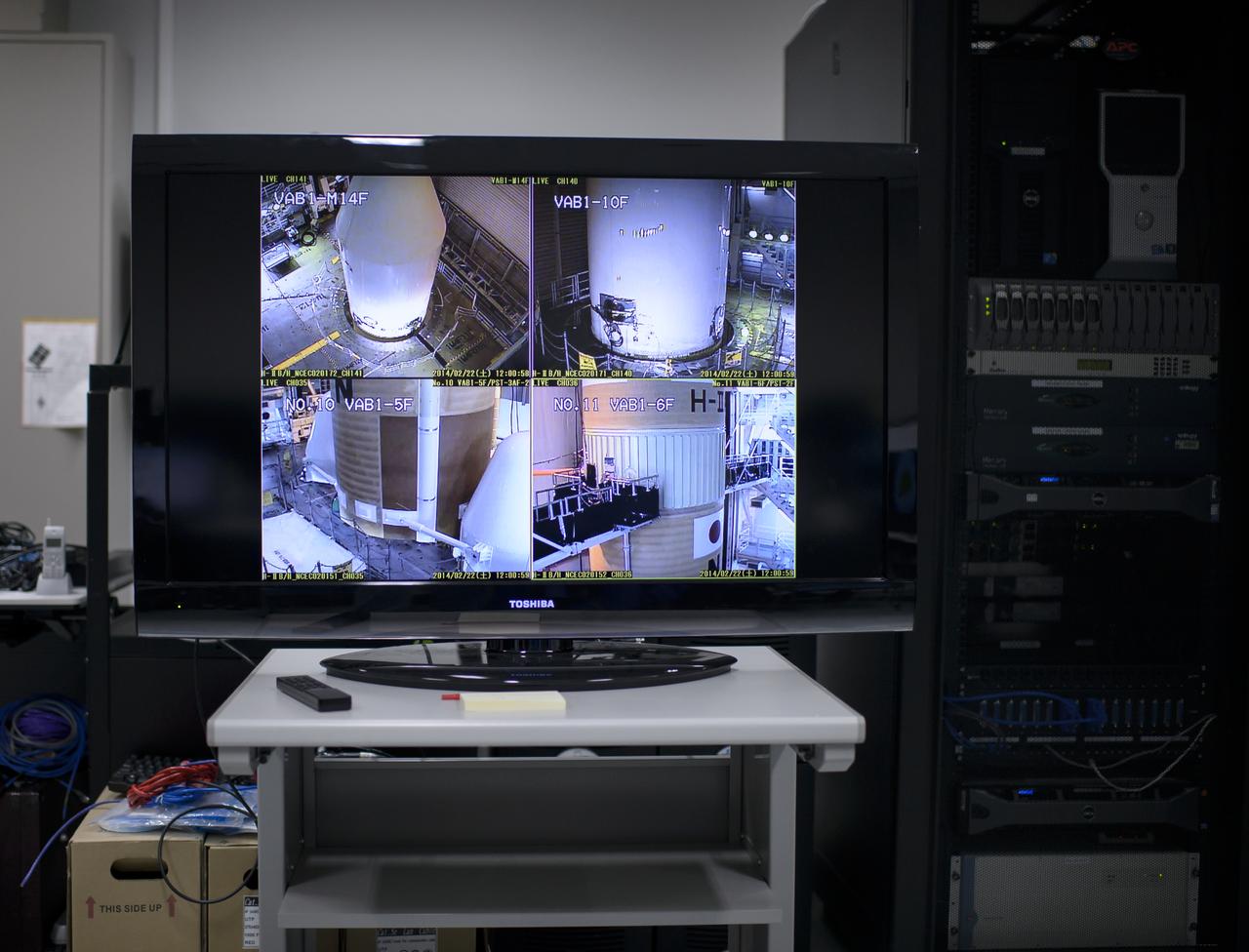
A live television view of the H-IIA rocket, with the Global Precipitation Measurement (GPM) Core Observatory onboard, is seen inside the Spacecraft Test and Assembly Building 2 (STA2) during an all-day launch simulation, Saturday, Feb. 22, 2014, Tanegashima Space Center (TNSC), Tanegashima Island, Japan. Japan Aerospace Exploration Agency (JAXA) plans to launch an H-IIA rocket carrying the GPM Core Observatory on Feb. 28, 2014. The NASA-JAXA GPM spacecraft will collect information that unifies data from an international network of existing and future satellites to map global rainfall and snowfall every three hours. Photo Credit: (NASA/Bill Ingalls)
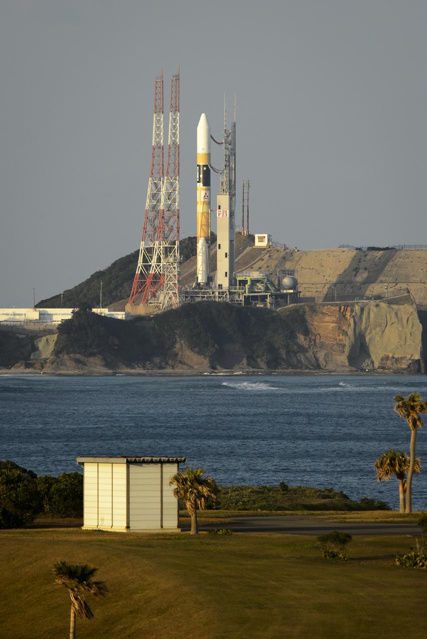
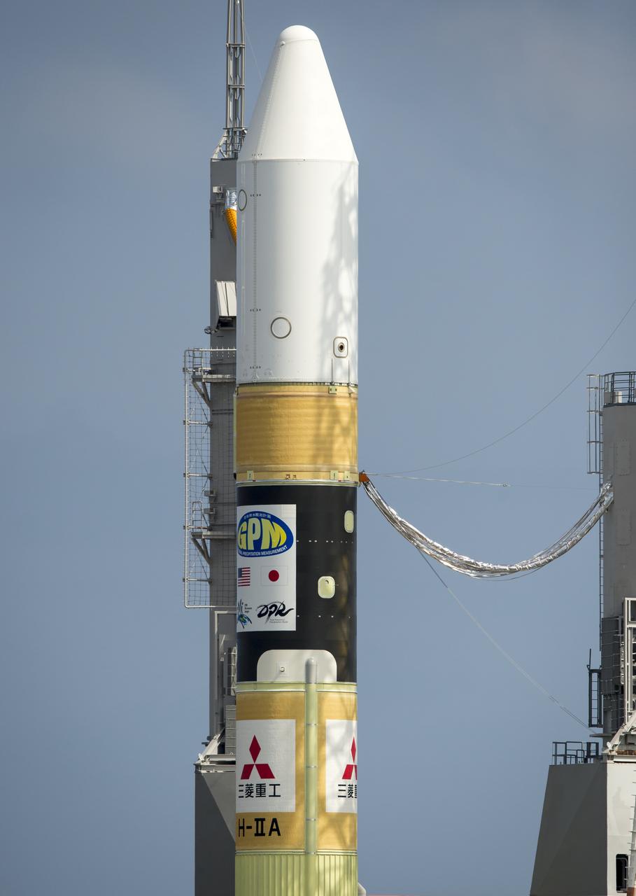
A Japanese H-IIA rocket with the NASA-Japan Aerospace Exploration Agency (JAXA), Global Precipitation Measurement (GPM) Core Observatory onboard is seen on launch pad 1 of the Tanegashima Space Center, Thursday, Feb. 27, 2014, Tanegashima, Japan. Once launched, the GPM spacecraft will collect information that unifies data from an international network of existing and future satellites to map global rainfall and snowfall every three hours. Photo Credit: (NASA/Bill Ingalls)
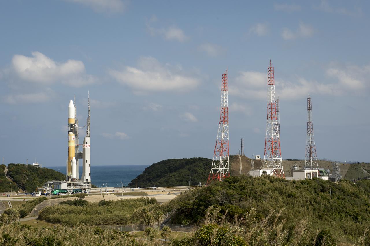
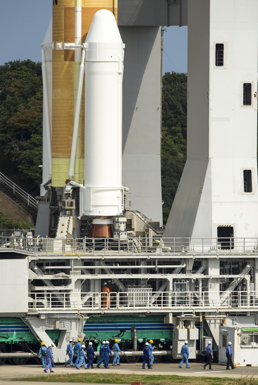
A Japanese H-IIA rocket carrying the NASA-Japan Aerospace Exploration Agency (JAXA), Global Precipitation Measurement (GPM) Core Observatory is seen as it rolls out to launch pad 1 of the Tanegashima Space Center, Thursday, Feb. 27, 2014, Tanegashima, Japan. Once launched, the GPM spacecraft will collect information that unifies data from an international network of existing and future satellites to map global rainfall and snowfall every three hours. Photo Credit: (NASA/Bill Ingalls)
A Japanese H-IIA rocket carrying the NASA-Japan Aerospace Exploration Agency (JAXA), Global Precipitation Measurement (GPM) Core Observatory is seen as it rolls out to launch pad 1 of the Tanegashima Space Center, Thursday, Feb. 27, 2014, Tanegashima, Japan. Once launched, the GPM spacecraft will collect information that unifies data from an international network of existing and future satellites to map global rainfall and snowfall every three hours. Photo Credit: (NASA/Bill Ingalls)
A Japanese H-IIA rocket carrying the NASA-Japan Aerospace Exploration Agency (JAXA), Global Precipitation Measurement (GPM) Core Observatory is seen as it rolls out to launch pad 1 of the Tanegashima Space Center, Thursday, Feb. 27, 2014, Tanegashima, Japan. Once launched, the GPM spacecraft will collect information that unifies data from an international network of existing and future satellites to map global rainfall and snowfall every three hours. Photo Credit: (NASA/Bill Ingalls)

A Japanese H-IIA rocket carrying the NASA-Japan Aerospace Exploration Agency (JAXA), Global Precipitation Measurement (GPM) Core Observatory is seen as it rolls out to launch pad 1 of the Tanegashima Space Center, Thursday, Feb. 27, 2014, Tanegashima, Japan. Once launched, the GPM spacecraft will collect information that unifies data from an international network of existing and future satellites to map global rainfall and snowfall every three hours. Photo Credit: (NASA/Bill Ingalls)
A Japanese H-IIA rocket carrying the NASA-Japan Aerospace Exploration Agency (JAXA), Global Precipitation Measurement (GPM) Core Observatory is seen in this 10 second exposure as it rolls out to launch pad 1 of the Tanegashima Space Center, Thursday, Feb. 27, 2014, Tanegashima, Japan. Once launched, the GPM spacecraft will collect information that unifies data from an international network of existing and future satellites to map global rainfall and snowfall every three hours. Photo Credit: (NASA/Bill Ingalls)
A Japanese H-IIA rocket carrying the NASA-Japan Aerospace Exploration Agency (JAXA), Global Precipitation Measurement (GPM) Core Observatory is seen as it rolls out to launch pad 1 of the Tanegashima Space Center, Thursday, Feb. 27, 2014, Tanegashima, Japan. Once launched, the GPM spacecraft will collect information that unifies data from an international network of existing and future satellites to map global rainfall and snowfall every three hours. Photo Credit: (NASA/Bill Ingalls)
A Japanese H-IIA rocket carrying the NASA-Japan Aerospace Exploration Agency (JAXA), Global Precipitation Measurement (GPM) Core Observatory is seen as it rolls out to launch pad 1 of the Tanegashima Space Center, Thursday, Feb. 27, 2014, Tanegashima, Japan. Once launched, the GPM spacecraft will collect information that unifies data from an international network of existing and future satellites to map global rainfall and snowfall every three hours. Photo Credit: (NASA/Bill Ingalls)
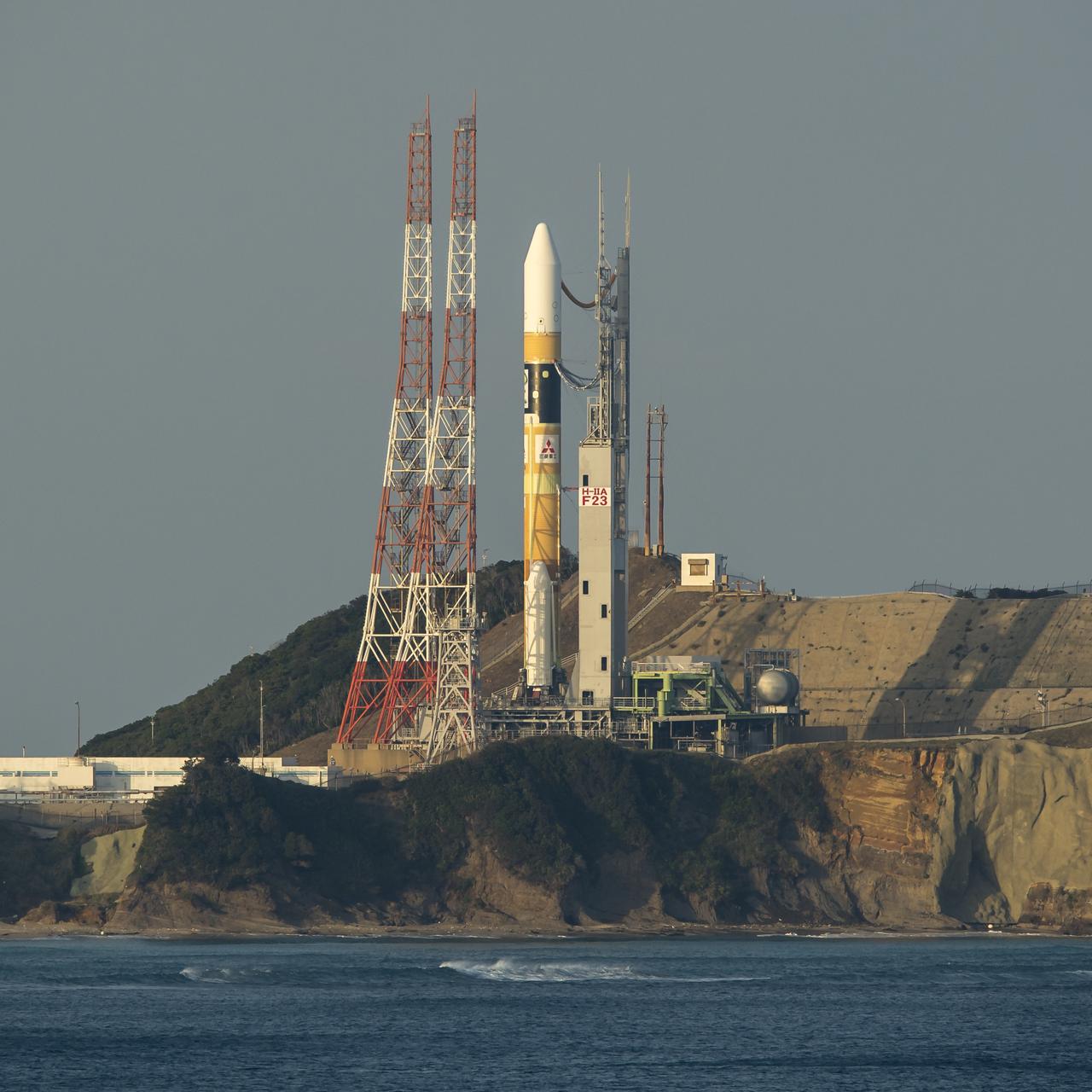
A Japanese H-IIA rocket with the NASA-Japan Aerospace Exploration Agency (JAXA), Global Precipitation Measurement (GPM) Core Observatory onboard is seen on launch pad 1 of the Tanegashima Space Center, Thursday, Feb. 27, 2014, Tanegashima, Japan. Once launched, the GPM spacecraft will collect information that unifies data from an international network of existing and future satellites to map global rainfall and snowfall every three hours. Photo Credit: (NASA/Bill Ingalls)
A Japanese H-IIA rocket carrying the NASA-Japan Aerospace Exploration Agency (JAXA), Global Precipitation Measurement (GPM) Core Observatory is seen as it rolls out to launch pad 1 of the Tanegashima Space Center, Thursday, Feb. 27, 2014, Tanegashima, Japan. Once launched, the GPM spacecraft will collect information that unifies data from an international network of existing and future satellites to map global rainfall and snowfall every three hours. Photo Credit: (NASA/Bill Ingalls)
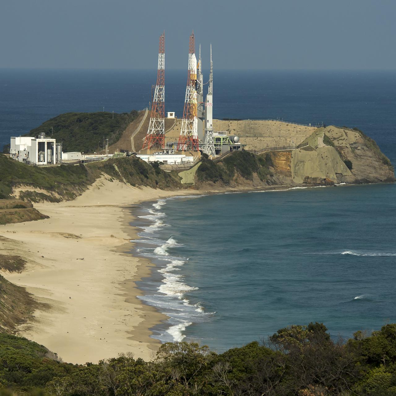
A Japanese H-IIA rocket with the NASA-Japan Aerospace Exploration Agency (JAXA), Global Precipitation Measurement (GPM) Core Observatory onboard is seen on launch pad 1 of the Tanegashima Space Center, Thursday, Feb. 27, 2014, Tanegashima, Japan. Once launched, the GPM spacecraft will collect information that unifies data from an international network of existing and future satellites to map global rainfall and snowfall every three hours. Photo Credit: (NASA/Bill Ingalls)
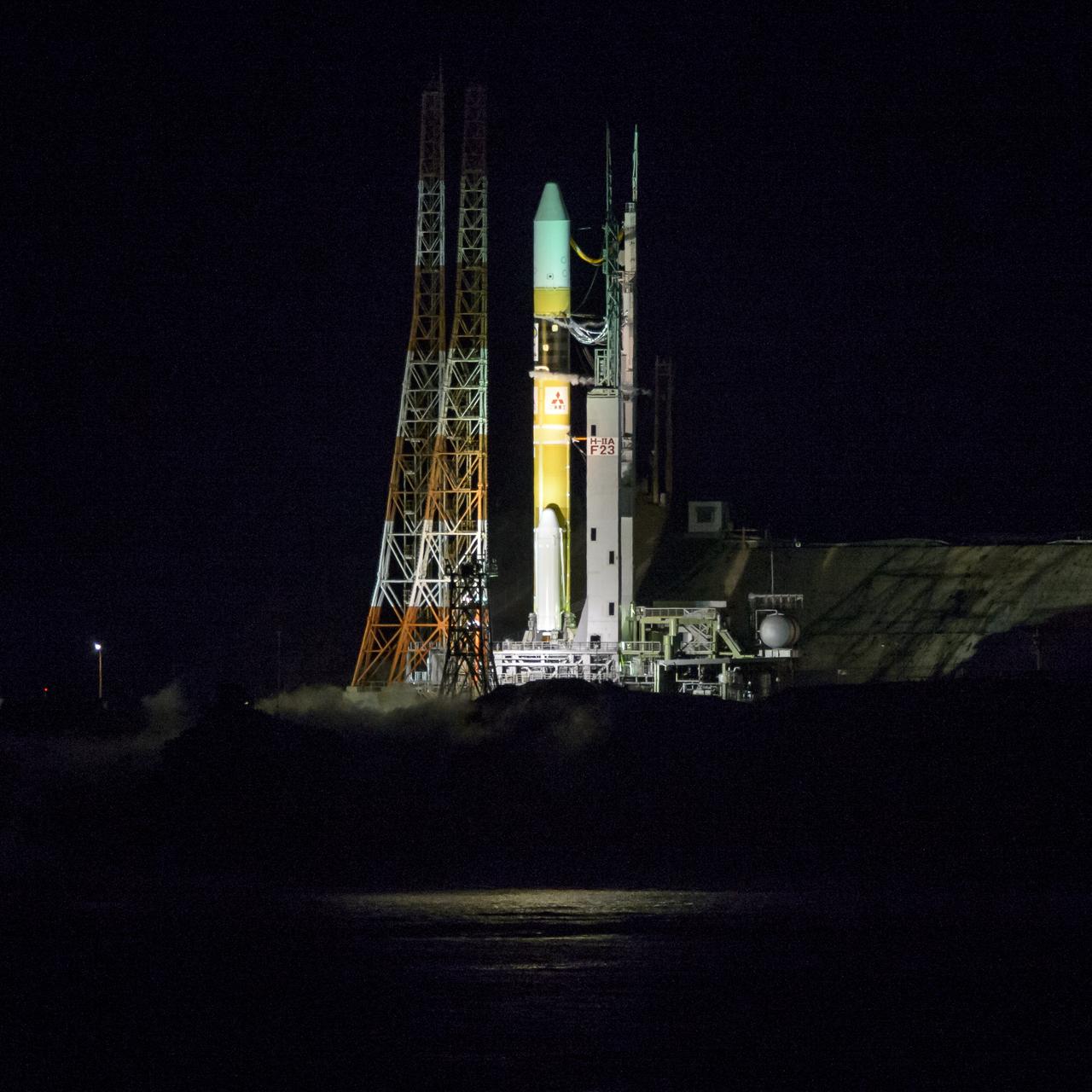
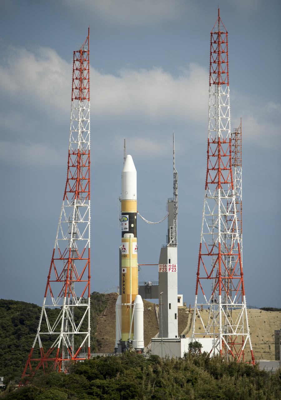
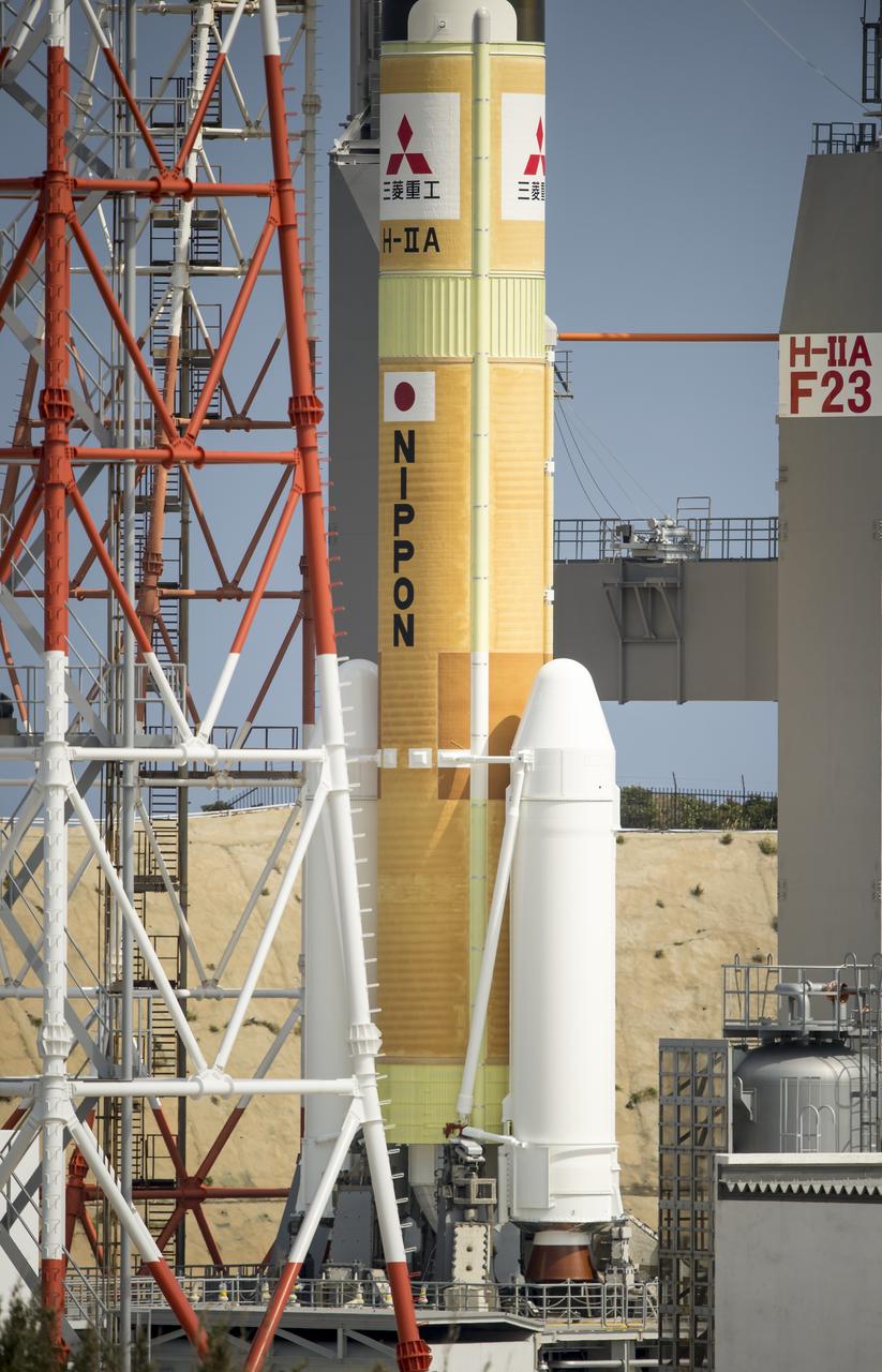
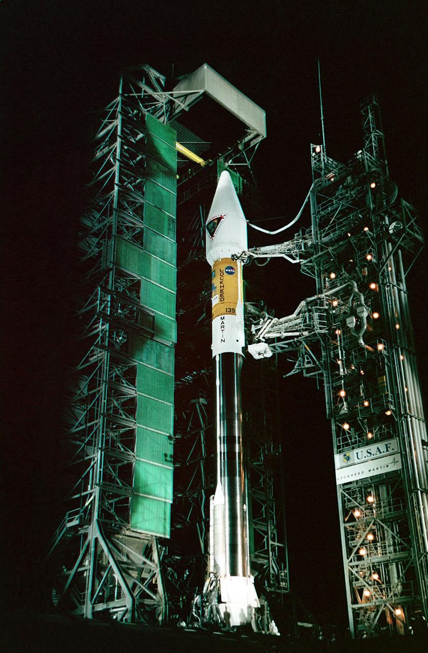
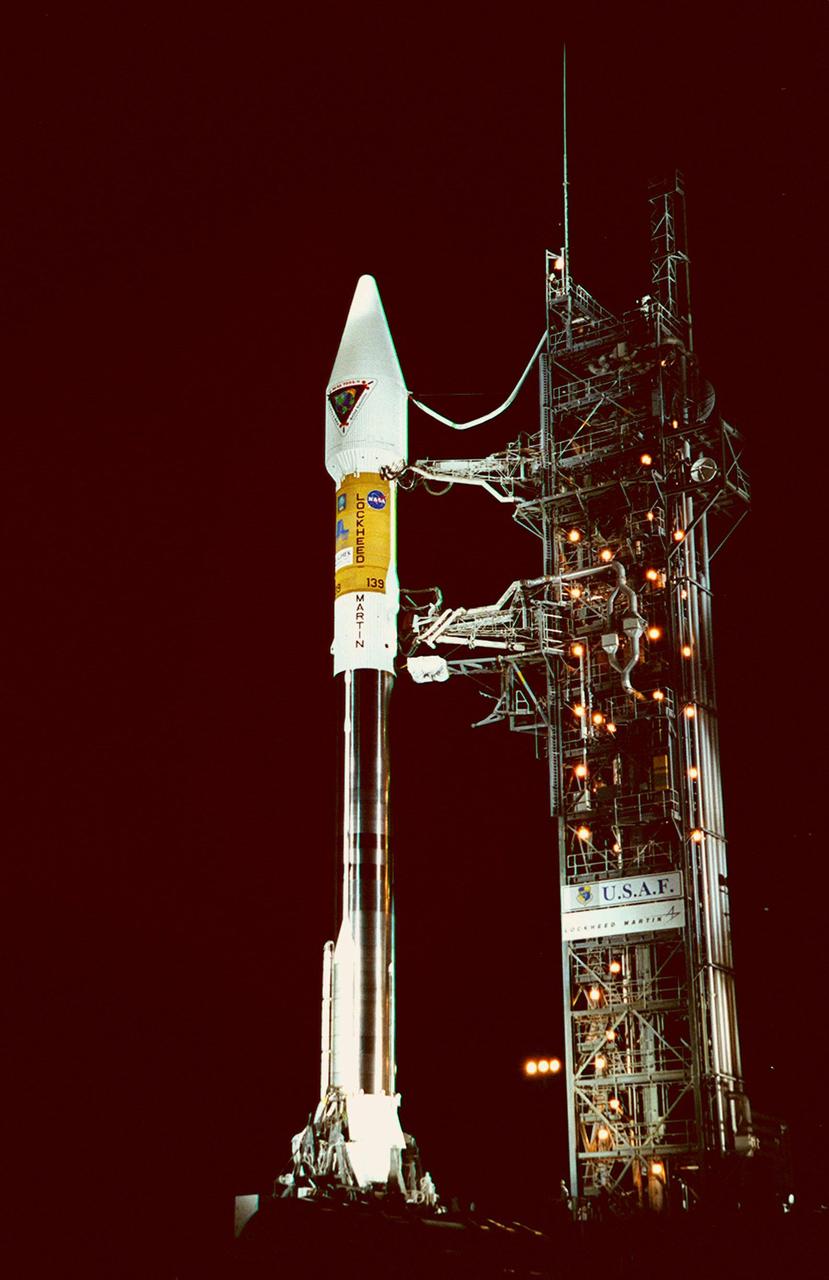
A Japanese H-IIA rocket with the NASA-Japan Aerospace Exploration Agency (JAXA), Global Precipitation Measurement (GPM) Core Observatory onboard, is seen on launch pad 1 of the Tanegashima Space Center, Friday, Feb. 28, 2014, Tanegashima, Japan. Once launched, the GPM spacecraft will collect information that unifies data from an international network of existing and future satellites to map global rainfall and snowfall every three hours. Photo Credit: (NASA/Bill Ingalls)
A Japanese H-IIA rocket with the NASA-Japan Aerospace Exploration Agency (JAXA), Global Precipitation Measurement (GPM) Core Observatory onboard is seen on launch pad 1 of the Tanegashima Space Center, Thursday, Feb. 27, 2014, Tanegashima, Japan. Once launched, the GPM spacecraft will collect information that unifies data from an international network of existing and future satellites to map global rainfall and snowfall every three hours. Photo Credit: (NASA/Bill Ingalls)
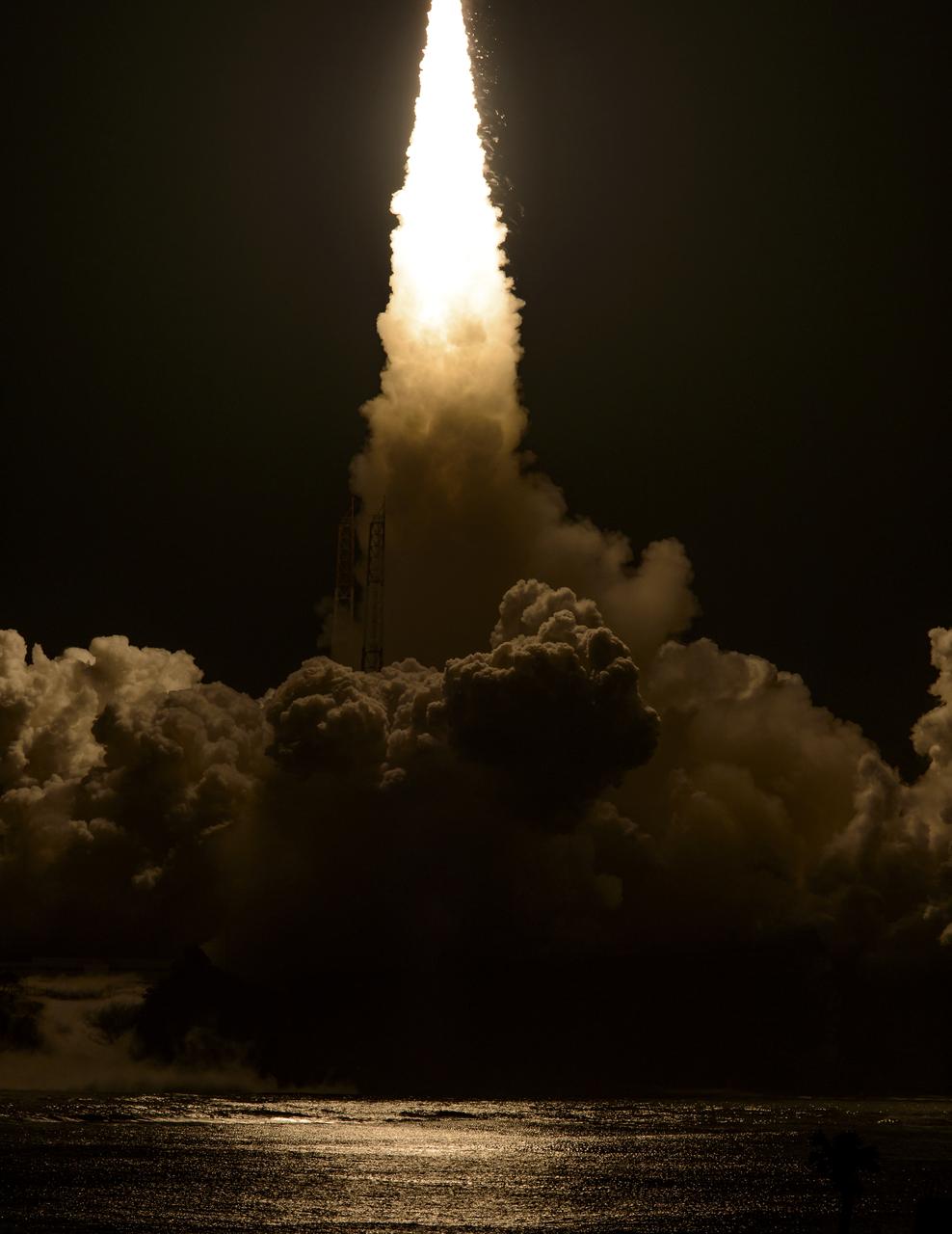
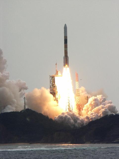
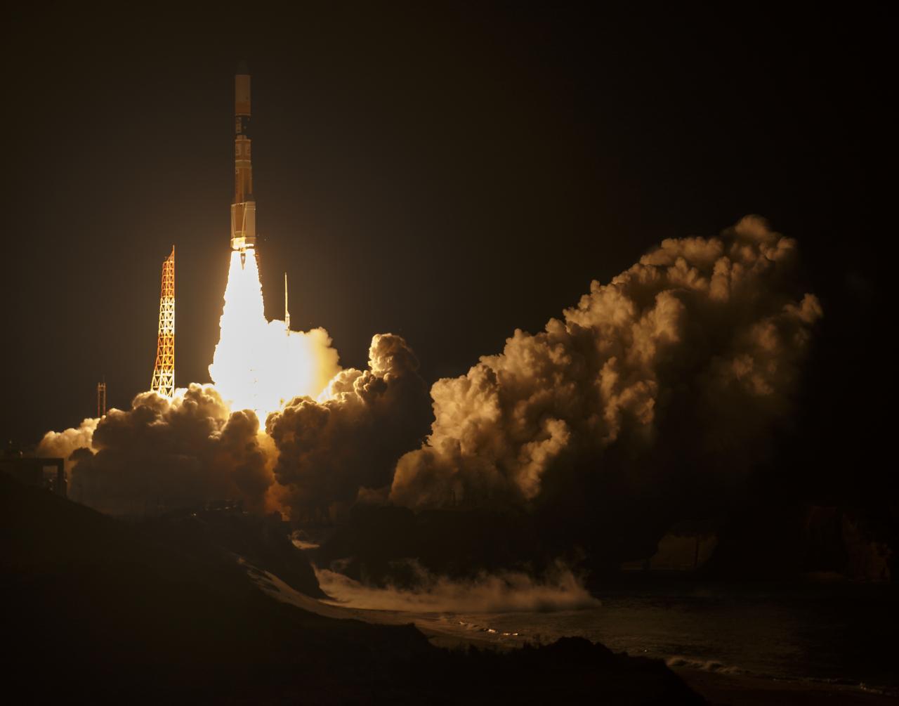
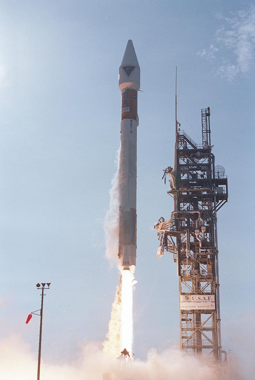
Flames and smoke from a Japanese H-IIA rocket with the NASA-Japan Aerospace Exploration Agency (JAXA), Global Precipitation Measurement (GPM) Core Observatory onboard, are seen during the launch from the Tanegashima Space Center, Friday, Feb. 28, 2014, Tanegashima, Japan. The GPM spacecraft will collect information that unifies data from an international network of existing and future satellites to map global rainfall and snowfall every three hours. Photo Credit: (NASA/Bill Ingalls)
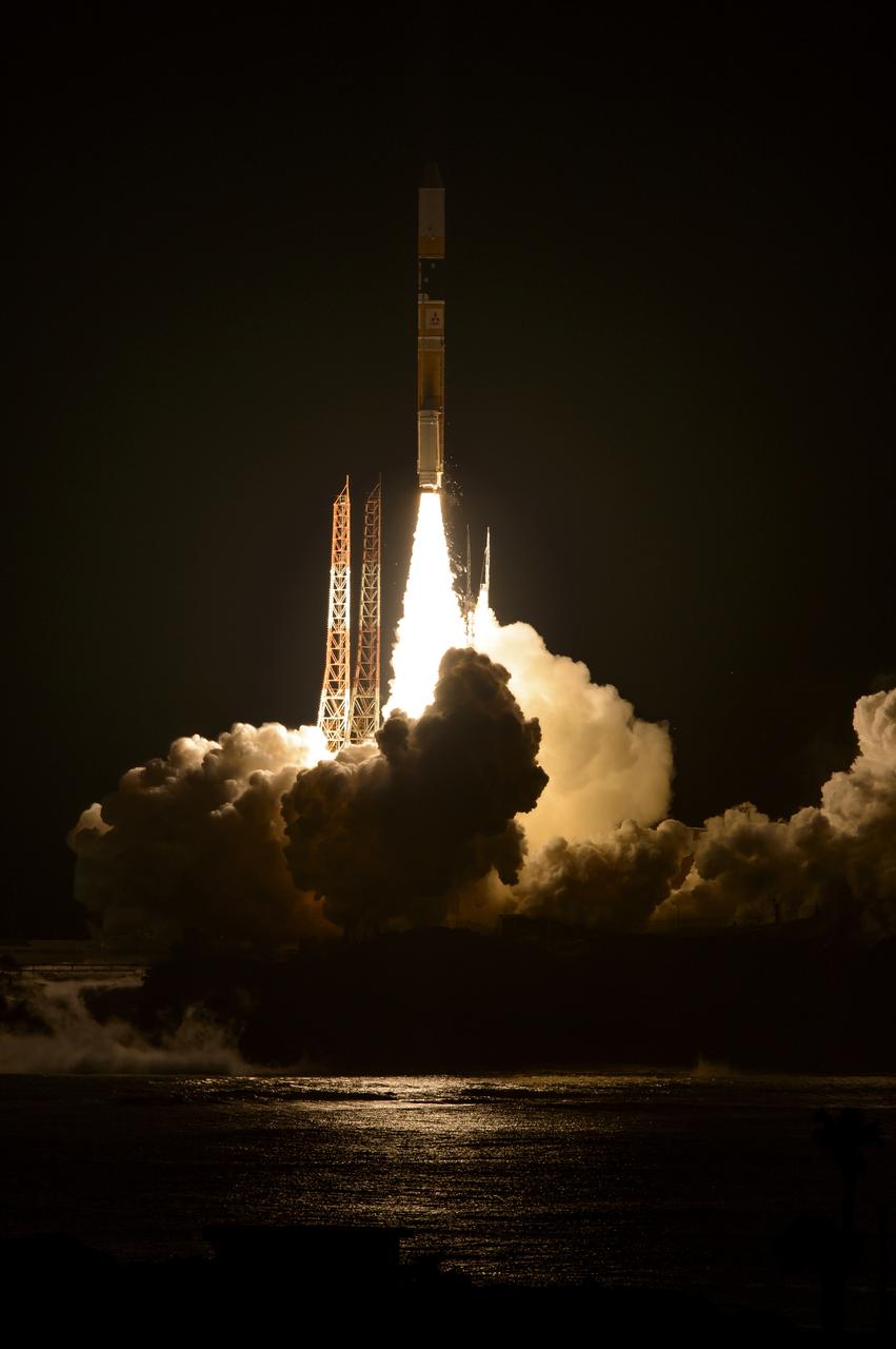
A Japanese H-IIA rocket with the NASA-Japan Aerospace Exploration Agency (JAXA), Global Precipitation Measurement (GPM) Core Observatory onboard, is seen launching from the Tanegashima Space Center, Friday, Feb. 28, 2014, Tanegashima, Japan. The GPM spacecraft will collect information that unifies data from an international network of existing and future satellites to map global rainfall and snowfall every three hours. Photo Credit: (NASA/Bill Ingalls)
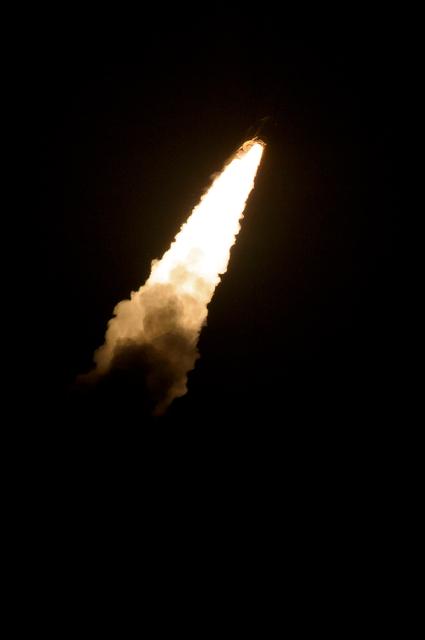
A Japanese H-IIA rocket with the NASA-Japan Aerospace Exploration Agency (JAXA), Global Precipitation Measurement (GPM) Core Observatory onboard, fades into the dark as it launches from the Tanegashima Space Center, Friday, Feb. 28, 2014, Tanegashima, Japan. The GPM spacecraft will collect information that unifies data from an international network of existing and future satellites to map global rainfall and snowfall every three hours. Photo Credit: (NASA/Bill Ingalls)
A Japanese H-IIA rocket with the NASA-Japan Aerospace Exploration Agency (JAXA), Global Precipitation Measurement (GPM) Core Observatory onboard, is seen launching from the Tanegashima Space Center, Friday, Feb. 28, 2014, Tanegashima, Japan. The GPM spacecraft will collect information that unifies data from an international network of existing and future satellites to map global rainfall and snowfall every three hours. Photo Credit: (NASA/Bill Ingalls)
A Japanese H-IIA rocket with the NASA-Japan Aerospace Exploration Agency (JAXA), Global Precipitation Measurement (GPM) Core Observatory onboard, is seen launching from the Tanegashima Space Center, Friday, Feb. 28, 2014, Tanegashima, Japan. The GPM spacecraft will collect information that unifies data from an international network of existing and future satellites to map global rainfall and snowfall every three hours. Photo Credit: (NASA/Bill Ingalls)

Caroline Kennedy, U.S. Ambassador Extraordinary and Plenipotentiary to Japan, congratulated both NASA and the Japan Aerospace Exploration Agency (JAXA) Global Precipitation Measurement (GPM) Core Observatory teams and noted it was an example of over 40 years of strong U.S. and Japan relations, Friday Feb. 28, 2014, Tanegashima Space Center (TNSC) Tanegashima, Japan. The Ambassador witnessed the launch of a Japanese H-IIA rocket carrying the NASA-JAXA, GPM Core Observatory. The GPM spacecraft will collect information that unifies data from an international network of existing and future satellites to map global rainfall and snowfall every three hours. Photo Credit: (NASA/Bill Ingalls)
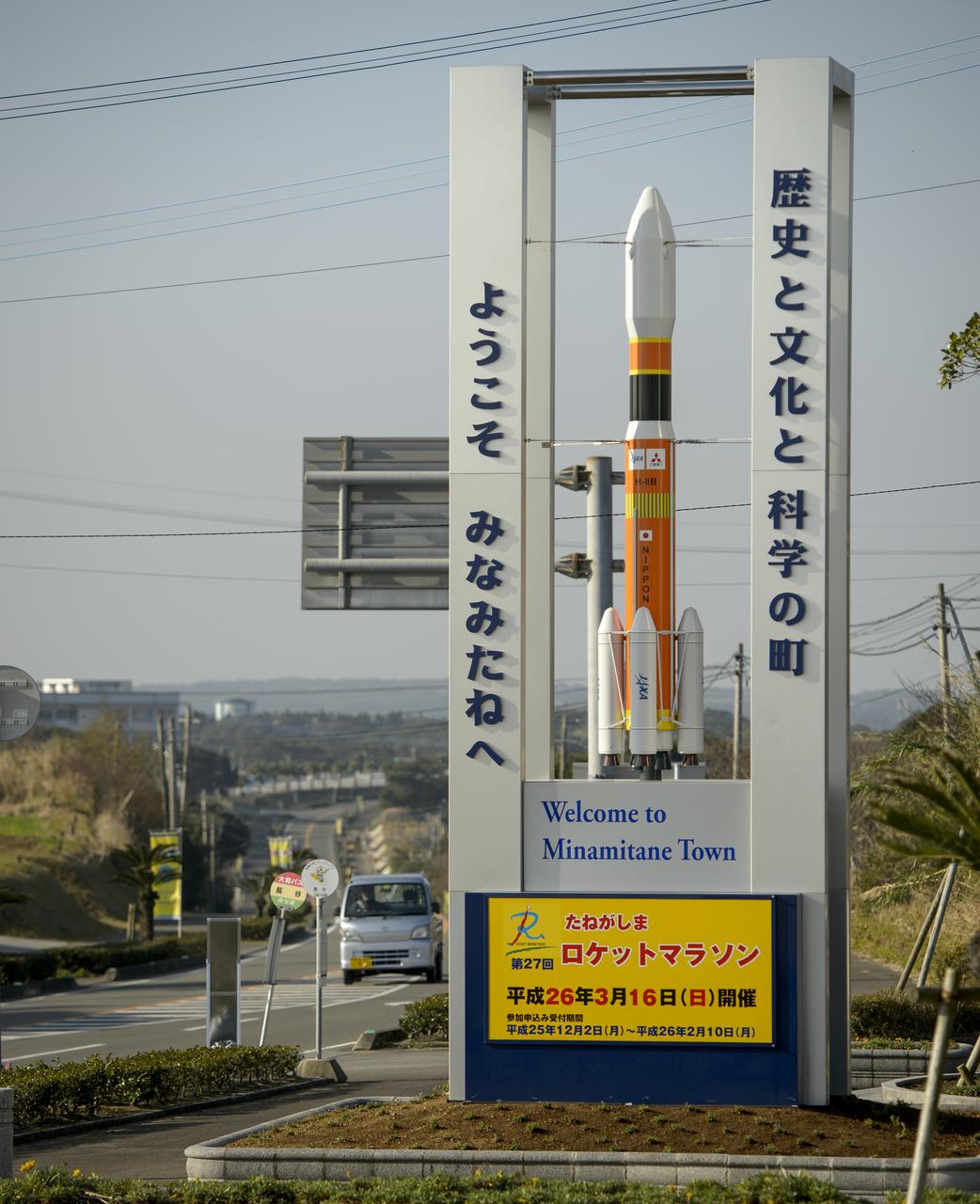
A sign with a model of the Japanese H-IIB rocket welcomes visitors to Minamitane Town, one of only a few small towns located outside of the Japan Aerospace Exploration Agency’s (JAXA) Tanegashima Space Center (TNSC), where the launch of an H-IIA rocket carrying the Global Precipitation Measurement (GPM) Core Observatory will take place in the next week, Saturday, Feb. 22, 2014, Tanegashima Island, Japan. The NASA-Japan Aerospace Exploration Agency (JAXA) GPM spacecraft will collect information that unifies data from an international network of existing and future satellites to map global rainfall and snowfall every three hours. Photo Credit: (NASA/Bill Ingalls)
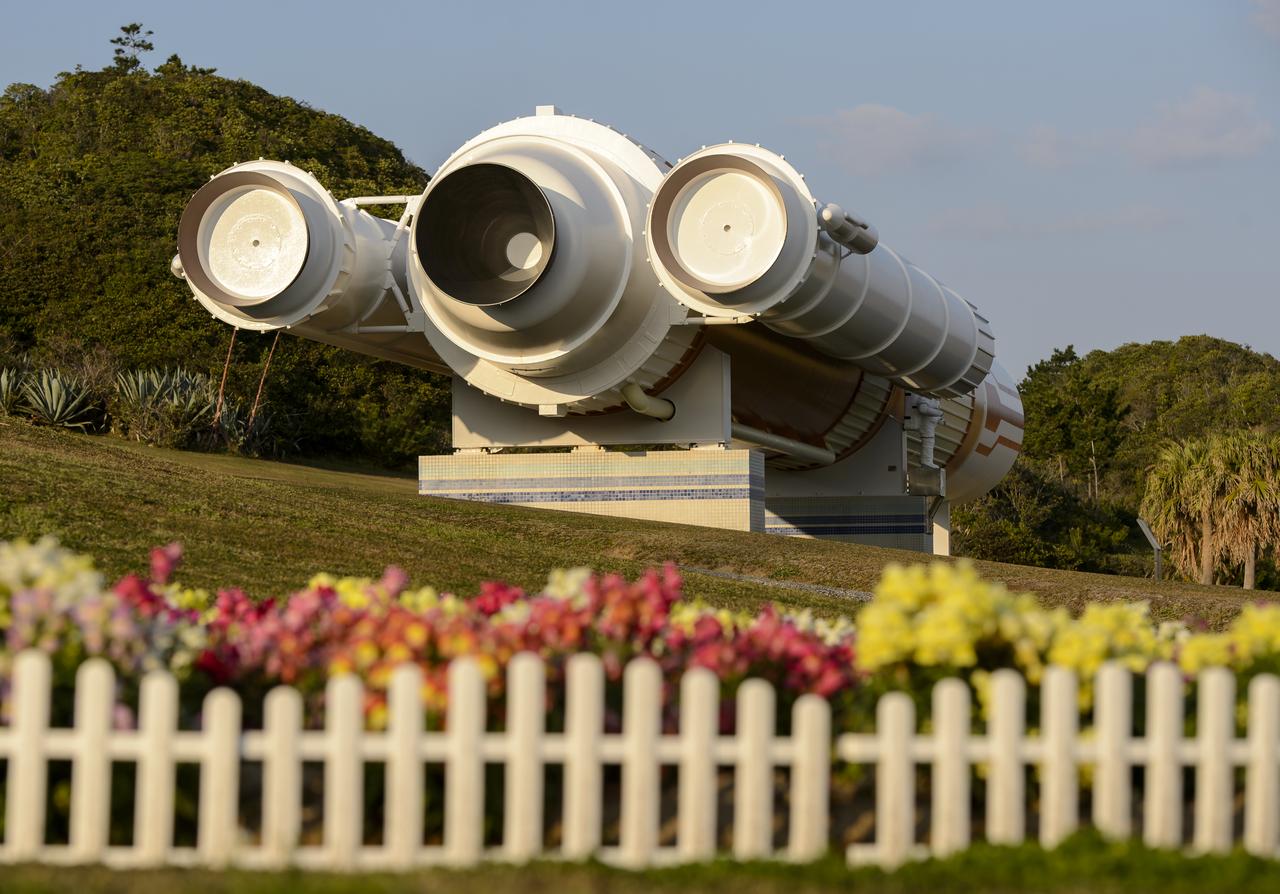
A full size model of an H-II rocket is seen at the Japan Aerospace Exploration Agency’s (JAXA) Tanegashima Space Center (TNSC) visitors center a week ahead of the planned launch of an H-IIA rocket carrying the Global Precipitation Measurement (GPM) Core Observatory, Friday, Feb. 21, 2014, Tanegashima Island, Japan. The NASA-JAXA GPM spacecraft will collect information that unifies data from an international network of existing and future satellites to map global rainfall and snowfall every three hours. Photo Credit: (NASA/Bill Ingalls)
A full size model of an H-II rocket is seen at the Japan Aerospace Exploration Agency’s (JAXA) Tanegashima Space Center (TNSC) visitors center a week ahead of the planned launch of an H-IIA rocket carrying the Global Precipitation Measurement (GPM) Core Observatory, Friday, Feb. 21, 2014, Tanegashima Island, Japan. The NASA-JAXA GPM spacecraft will collect information that unifies data from an international network of existing and future satellites to map global rainfall and snowfall every three hours. Photo Credit: (NASA/Bill Ingalls)
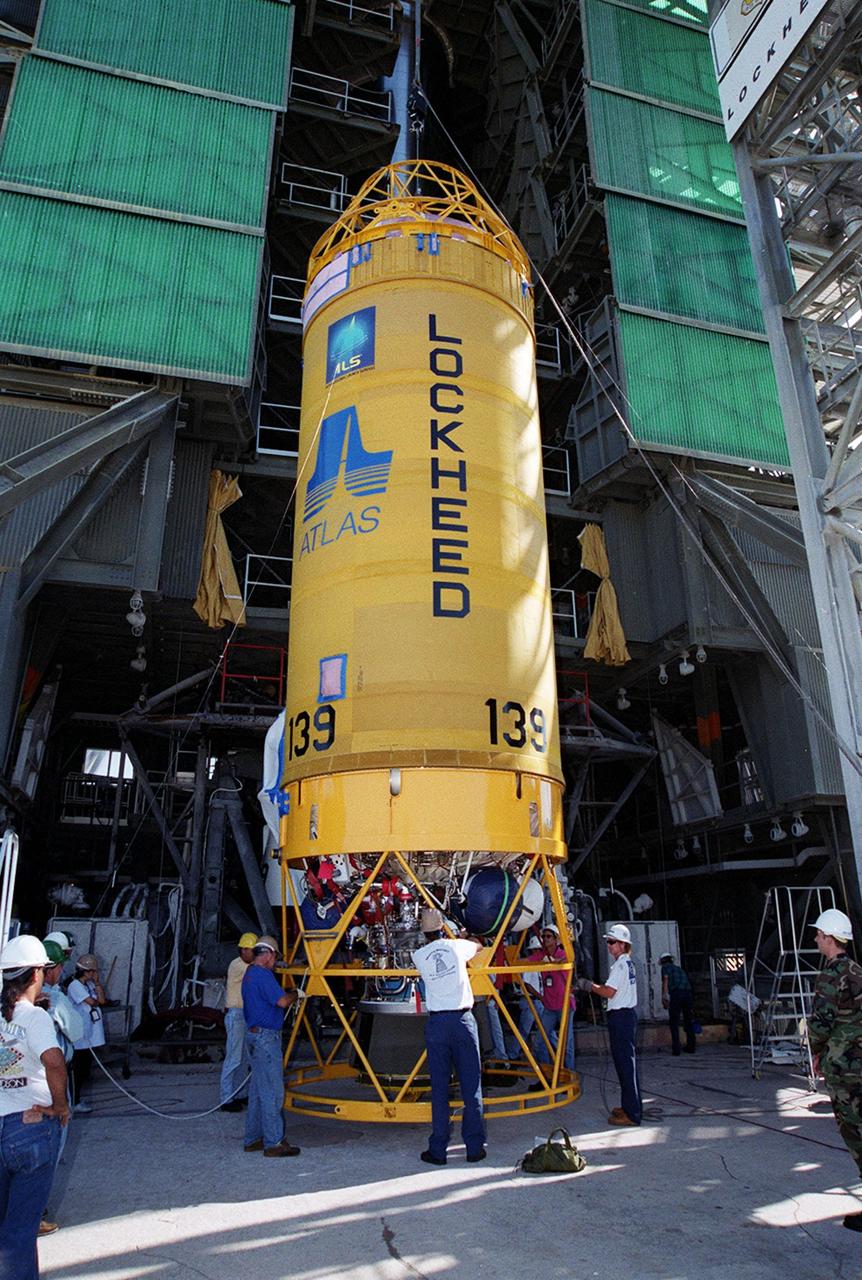
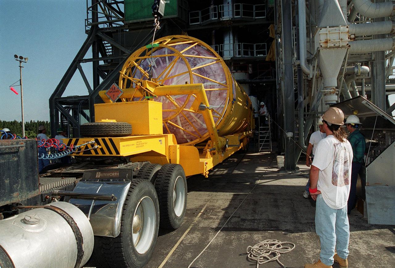
At Launch Pad 36A, Cape Canaveral Air Force Station, workers check out a Centaur rocket for its lift up the launch tower to be mated with the lower stage Atlas IIA rocket already in the tower. The Lockheed-built Atlas IIA/Centaur rocket will launch the latest Tracking and Data Relay Satellite (TDRS) June 29 from CCAFS. The TDRS is one of three (labeled H, I and J) being built in the Hughes Space and Communications Company Integrated Satellite Factory in El Segundo, Calif. The new satellites will augment the TDRS system’s existing Sand Ku-band frequencies by adding Ka-band capability. TDRS will serve as the sole means of continuous, high-data-rate communication with the space shuttle, with the International Space Station upon its completion, and with dozens of unmanned scientific satellites in low earth orbit

At Launch Pad 36A, Cape Canaveral Air Force Station, a Centaur rocket arrives for mating with the Atlas IIA rocket already in the tower. The Centaur upper stage is 10.0 m (33-ft) long and 3.05 m (10 ft) in diameter. The Lockheed-built Atlas IIA/Centaur rocket will launch the latest Tracking and Data Relay Satellite (TDRS) June 29 from CCAFS. The TDRS is one of three (labeled H, I and J) being built in the Hughes Space and Communications Company Integrated Satellite Factory in El Segundo, Calif. The new satellites will augment the TDRS system’s existing Sand Ku-band frequencies by adding Ka-band capability. TDRS will serve as the sole means of continuous, high-data-rate communication with the space shuttle, with the International Space Station upon its completion, and with dozens of unmanned scientific satellites in low earth orbit

At Launch Pad 36A, Cape Canaveral Air Force Station, workers guide the ascent of a Centaur rocket up the launch tower where it will be mated with the lower stage Atlas IIA rocket already in the tower. The Lockheed-built Atlas IIA/Centaur rocket will launch the latest Tracking and Data Relay Satellite (TDRS) June 29 from CCAFS. The TDRS is one of three (labeled H, I and J) being built in the Hughes Space and Communications Company Integrated Satellite Factory in El Segundo, Calif. The new satellites will augment the TDRS system’s existing Sand Ku-band frequencies by adding Ka-band capability. TDRS will serve as the sole means of continuous, high-data-rate communication with the space shuttle, with the International Space Station upon its completion, and with dozens of unmanned scientific satellites in low earth orbit
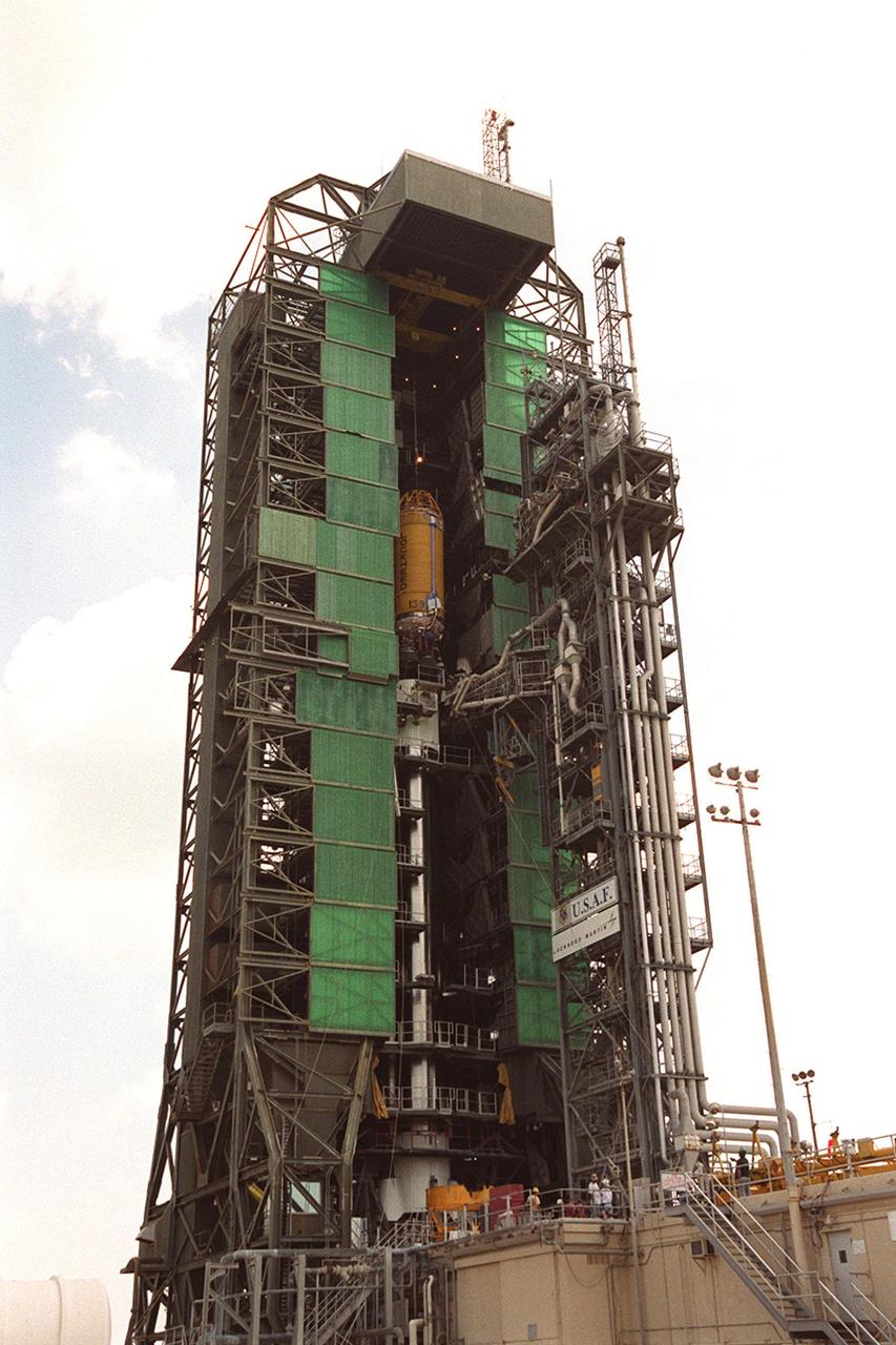
In this long view of the launch tower at Pad 36A, Cape Canaveral Air Force Station, the upper stage Centaur rocket can be seen as it rises up the tower to be mated to the lower stage Atlas IIA rocket already there. The Lockheed-built Atlas IIA/Centaur rocket will launch the latest Tracking and Data Relay Satellite (TDRS) June 29 from CCAFS. The TDRS is one of three (labeled H, I and J) being built in the Hughes Space and Communications Company Integrated Satellite Factory in El Segundo, Calif. The new satellites will augment the TDRS system’s existing Sand Ku-band frequencies by adding Ka-band capability. TDRS will serve as the sole means of continuous, high-data-rate communication with the space shuttle, with the International Space Station upon its completion, and with dozens of unmanned scientific satellites in low earth orbit
At Launch Pad 36A, Cape Canaveral Air Force Station, a Centaur rocket arrives for mating with the Atlas IIA rocket already in the tower. The Centaur upper stage is 10.0 m (33-ft) long and 3.05 m (10 ft) in diameter. The Lockheed-built Atlas IIA/Centaur rocket will launch the latest Tracking and Data Relay Satellite (TDRS) June 29 from CCAFS. The TDRS is one of three (labeled H, I and J) being built in the Hughes Space and Communications Company Integrated Satellite Factory in El Segundo, Calif. The new satellites will augment the TDRS system’s existing Sand Ku-band frequencies by adding Ka-band capability. TDRS will serve as the sole means of continuous, high-data-rate communication with the space shuttle, with the International Space Station upon its completion, and with dozens of unmanned scientific satellites in low earth orbit
At Launch Pad 36A, Cape Canaveral Air Force Station, workers guide the ascent of a Centaur rocket up the launch tower where it will be mated with the lower stage Atlas IIA rocket already in the tower. The Lockheed-built Atlas IIA/Centaur rocket will launch the latest Tracking and Data Relay Satellite (TDRS) June 29 from CCAFS. The TDRS is one of three (labeled H, I and J) being built in the Hughes Space and Communications Company Integrated Satellite Factory in El Segundo, Calif. The new satellites will augment the TDRS system’s existing Sand Ku-band frequencies by adding Ka-band capability. TDRS will serve as the sole means of continuous, high-data-rate communication with the space shuttle, with the International Space Station upon its completion, and with dozens of unmanned scientific satellites in low earth orbit

In this long view of the launch tower at Pad 36A, Cape Canaveral Air Force Station, the upper stage Centaur rocket can be seen as it rises up the tower to be mated to the lower stage Atlas IIA rocket already there. The Lockheed-built Atlas IIA/Centaur rocket will launch the latest Tracking and Data Relay Satellite (TDRS) June 29 from CCAFS. The TDRS is one of three (labeled H, I and J) being built in the Hughes Space and Communications Company Integrated Satellite Factory in El Segundo, Calif. The new satellites will augment the TDRS system’s existing Sand Ku-band frequencies by adding Ka-band capability. TDRS will serve as the sole means of continuous, high-data-rate communication with the space shuttle, with the International Space Station upon its completion, and with dozens of unmanned scientific satellites in low earth orbit

At Launch Pad 36A, Cape Canaveral Air Force Station, workers check out a Centaur rocket for its lift up the launch tower to be mated with the lower stage Atlas IIA rocket already in the tower. The Lockheed-built Atlas IIA/Centaur rocket will launch the latest Tracking and Data Relay Satellite (TDRS) June 29 from CCAFS. The TDRS is one of three (labeled H, I and J) being built in the Hughes Space and Communications Company Integrated Satellite Factory in El Segundo, Calif. The new satellites will augment the TDRS system’s existing Sand Ku-band frequencies by adding Ka-band capability. TDRS will serve as the sole means of continuous, high-data-rate communication with the space shuttle, with the International Space Station upon its completion, and with dozens of unmanned scientific satellites in low earth orbit
At Launch Pad 36A, Cape Canaveral Air Force Station, lines help guide the ascent of a Centaur rocket up the launch tower where it will be mated with the lower stage Atlas IIA rocket already in the tower. The Lockheed-built Atlas IIA/Centaur rocket will launch the latest Tracking and Data Relay Satellite (TDRS) June 29 from CCAFS. The TDRS is one of three (labeled H, I and J) being built in the Hughes Space and Communications Company Integrated Satellite Factory in El Segundo, Calif. The new satellites will augment the TDRS system’s existing Sand Ku-band frequencies by adding Ka-band capability. TDRS will serve as the sole means of continuous, high-data-rate communication with the space shuttle, with the International Space Station upon its completion, and with dozens of unmanned scientific satellites in low earth orbit

At Launch Pad 36A, Cape Canaveral Air Force Station, lines help guide the ascent of a Centaur rocket up the launch tower where it will be mated with the lower stage Atlas IIA rocket already in the tower. The Lockheed-built Atlas IIA/Centaur rocket will launch the latest Tracking and Data Relay Satellite (TDRS) June 29 from CCAFS. The TDRS is one of three (labeled H, I and J) being built in the Hughes Space and Communications Company Integrated Satellite Factory in El Segundo, Calif. The new satellites will augment the TDRS system’s existing Sand Ku-band frequencies by adding Ka-band capability. TDRS will serve as the sole means of continuous, high-data-rate communication with the space shuttle, with the International Space Station upon its completion, and with dozens of unmanned scientific satellites in low earth orbit

A Japanese H-IIA rocket carrying the NASA-Japan Aerospace Exploration Agency (JAXA), Global Precipitation Measurement (GPM) Core Observatory is seen as it rolls out to launch pad 1 of the Tanegashima Space Center, Thursday, Feb. 27, 2014, Tanegashima, Japan. Once launched, the GPM spacecraft will collect information that unifies data from an international network of existing and future satellites to map global rainfall and snowfall every three hours. Photo Credit: (NASA/Bill Ingalls)

A Japanese H-IIA rocket carrying the NASA-Japan Aerospace Exploration Agency (JAXA), Global Precipitation Measurement (GPM) Core Observatory is seen as it rolls out to launch pad 1 of the Tanegashima Space Center, Thursday, Feb. 27, 2014, Tanegashima, Japan. Once launched, the GPM spacecraft will collect information that unifies data from an international network of existing and future satellites to map global rainfall and snowfall every three hours. Photo Credit: (NASA/Bill Ingalls)

A Japanese H-IIA rocket carrying the NASA-Japan Aerospace Exploration Agency (JAXA), Global Precipitation Measurement (GPM) Core Observatory is seen as it rolls out to launch pad 1 of the Tanegashima Space Center, Thursday, Feb. 27, 2014, Tanegashima, Japan. Once launched, the GPM spacecraft will collect information that unifies data from an international network of existing and future satellites to map global rainfall and snowfall every three hours. Photo Credit: (NASA/Bill Ingalls)

A Japanese H-IIA rocket with the NASA-Japan Aerospace Exploration Agency (JAXA), Global Precipitation Measurement (GPM) Core Observatory onboard, is seen on launch pad 1 of the Tanegashima Space Center, Friday, Feb. 28, 2014, Tanegashima, Japan. Once launched, the GPM spacecraft will collect information that unifies data from an international network of existing and future satellites to map global rainfall and snowfall every three hours. Photo Credit: (NASA/Bill Ingalls)

Gail Skofronick-Jackson, NASA GPM Project Scientist, talks during a science briefing for the launch of the Global Precipitation Measurement (GPM) Core Observatory aboard an H-IIA rocket, Wednesday, Feb. 26, 2014, Tanegashima Space Center, Japan. Launch is scheduled for early in the morning of Feb. 28 Japan time. Once launched, the GPM spacecraft will collect information that unifies data from an international network of existing and future satellites to map global rainfall and snowfall every three hours. Photo Credit: (NASA/Bill Ingalls)

A Japanese H-IIA rocket carrying the NASA-Japan Aerospace Exploration Agency (JAXA), Global Precipitation Measurement (GPM) Core Observatory is seen as it rolls out to launch pad 1 of the Tanegashima Space Center, Thursday, Feb. 27, 2014, Tanegashima, Japan. Once launched, the GPM spacecraft will collect information that unifies data from an international network of existing and future satellites to map global rainfall and snowfall every three hours. Photo Credit: (NASA/Bill Ingalls)
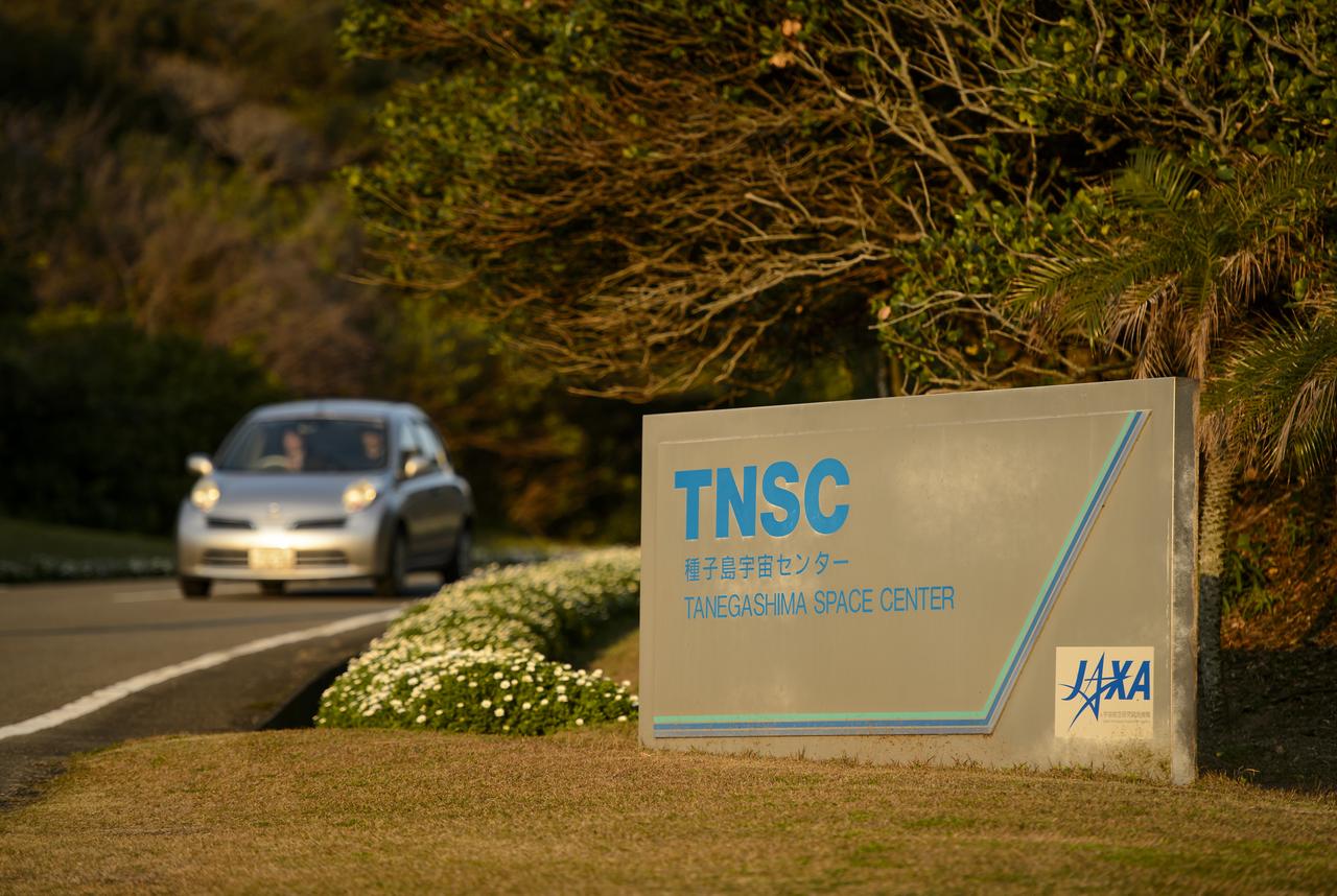
The entrance sign to the Japan Aerospace Exploration Agency’s (JAXA) Tanegashima Space Center (TNSC) is seen a week ahead of the planned launch of an H-IIA rocket carrying the Global Precipitation Measurement (GPM) Core Observatory, Friday, Feb. 21, 2014, Tanegashima Island, Japan. The NASA-JAXA GPM spacecraft will collect information that unifies data from an international network of existing and future satellites to map global rainfall and snowfall every three hours. Photo Credit: (NASA/Bill Ingalls)

A Japanese H-IIA rocket carrying the NASA-Japan Aerospace Exploration Agency (JAXA), Global Precipitation Measurement (GPM) Core Observatory is seen as it rolls out to launch pad 1 of the Tanegashima Space Center, Thursday, Feb. 27, 2014, Tanegashima, Japan. Once launched, the GPM spacecraft will collect information that unifies data from an international network of existing and future satellites to map global rainfall and snowfall every three hours. Photo Credit: (NASA/Bill Ingalls)

Topiary shaped into the logo of the Japan Aerospace Exploration Agency (JAXA) is seen at the Tanegashima Space Center (TNSC) a week ahead of the planned launch of an H-IIA rocket carrying the Global Precipitation Measurement (GPM) Core Observatory, Friday, Feb. 21, 2014, Tanegashima Island, Japan. The NASA-JAXA GPM spacecraft will collect information that unifies data from an international network of existing and future satellites to map global rainfall and snowfall every three hours. Photo Credit: (NASA/Bill Ingalls)
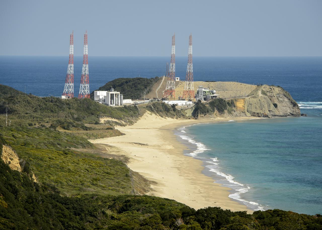
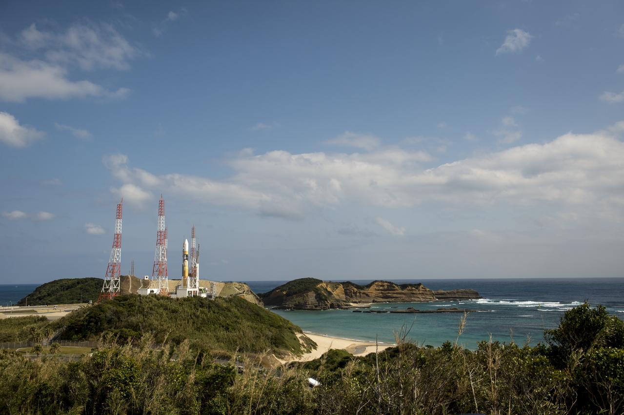
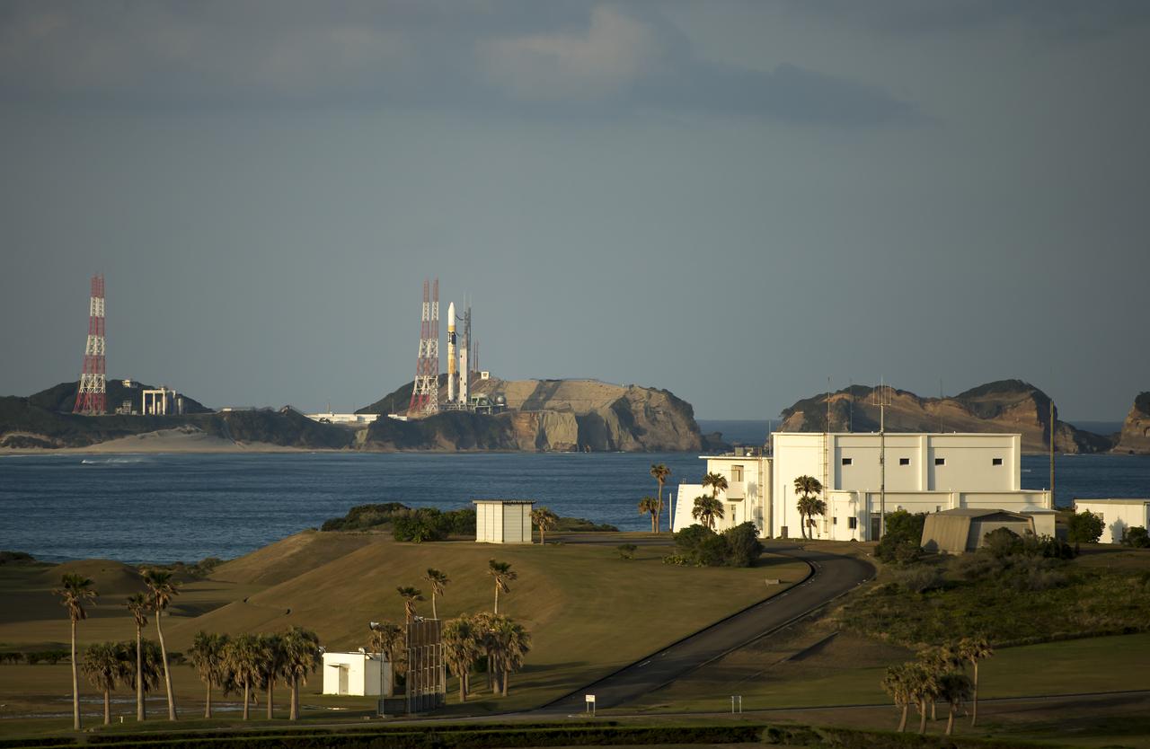
The launch pads at the Japan Aerospace Exploration Agency’s (JAXA) Tanegashima Space Center are seen a week ahead of the planned launch of an H-IIA rocket carrying the Global Precipitation Measurement (GPM) Core Observatory, Friday, Feb. 21, 2014, Tanegashima Island, Japan. The NASA-JAXA GPM spacecraft will collect information that unifies data from an international network of existing and future satellites to map global rainfall and snowfall every three hours. Photo Credit: (NASA/Bill Ingalls)

The sun sets just outside the Japan Aerospace Exploration Agency’s (JAXA) Tanegashima Space Center (TNSC) a week ahead of the planned launch of an H-IIA rocket carrying the Global Precipitation Measurement (GPM) Core Observatory, Friday, Feb. 21, 2014, Tanegashima Island, Japan. The NASA-JAXA GPM spacecraft will collect information that unifies data from an international network of existing and future satellites to map global rainfall and snowfall every three hours. Photo Credit: (NASA/Bill Ingalls)
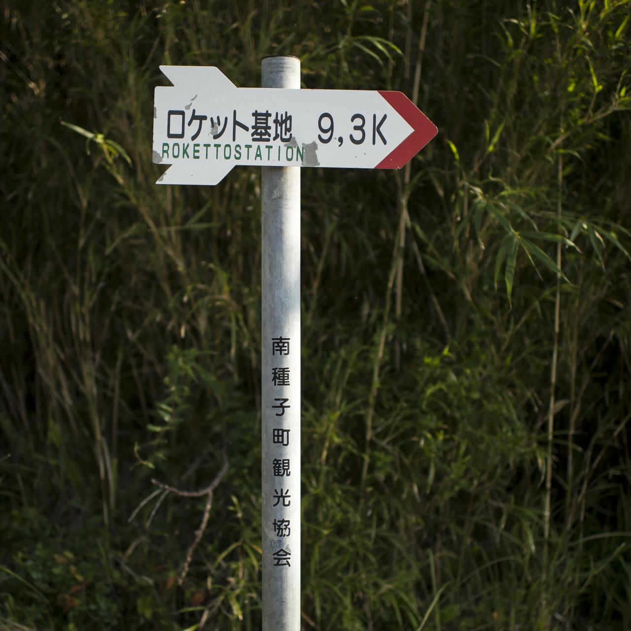
A sign guides travelers to the Japan Aerospace Exploration Agency’s (JAXA) Tanegashima Space Center (TNSC), Saturday, Feb. 22, 2014, Tanegashima Island, Japan. A launch of an H-IIA rocket carrying the Global Precipitation Measurement (GPM) Core Observatory is planned for Feb. 28, 2014 from the space center. The NASA-JAXA GPM spacecraft will collect information that unifies data from an international network of existing and future satellites to map global rainfall and snowfall every three hours. Photo Credit: (NASA/Bill Ingalls)
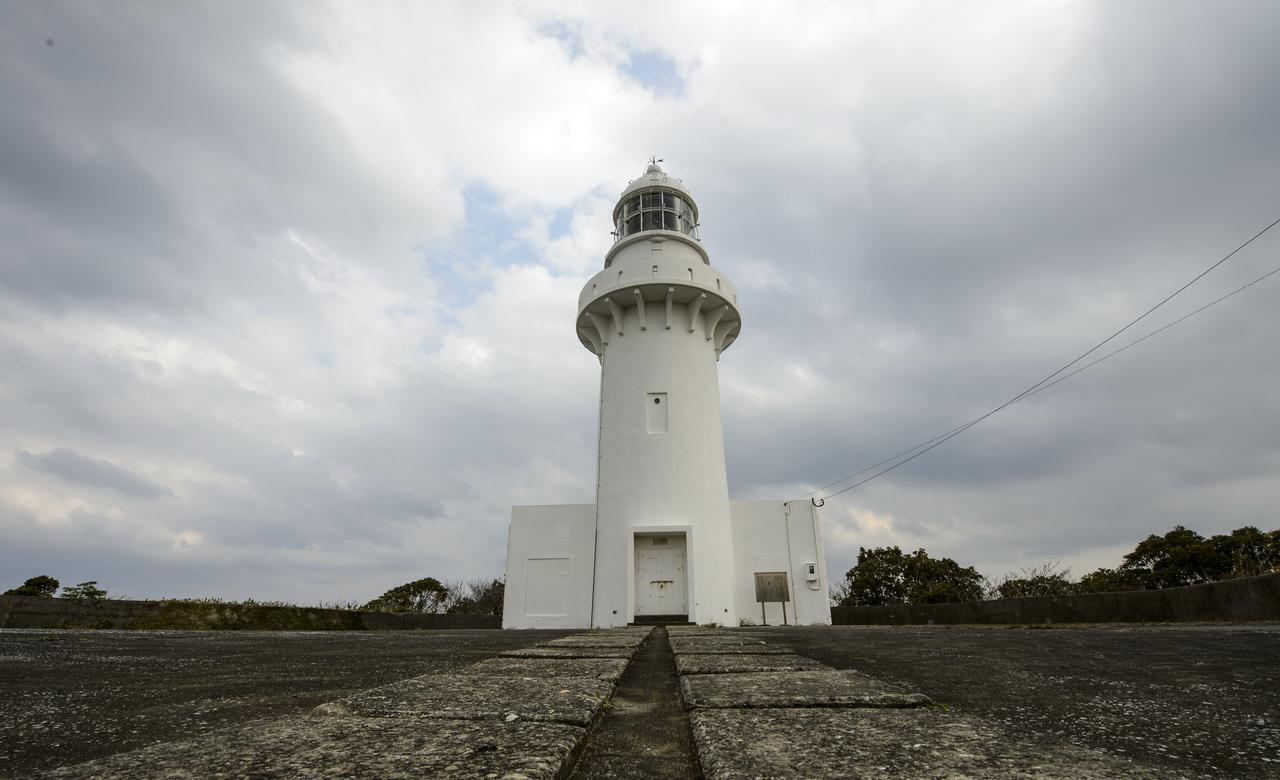
The Tanegashima Space Center (TNSC) lighthouse is seen on Sunday, Feb. 23, 2014, Tanegashima Island, Japan. A Japanese H-IIA rocket carrying the NASA-Japan Aerospace Exploration Agency (JAXA), Global Precipitation Measurement (GPM) Core Observatory is planned for launch from the space center on Feb. 28, 2014. Once launched, the GPM spacecraft will collect information that unifies data from an international network of existing and future satellites to map global rainfall and snowfall every three hours. Photo Credit: (NASA/Bill Ingalls)

A Japanese H-IIA rocket carrying the NASA-Japan Aerospace Exploration Agency (JAXA), Global Precipitation Measurement (GPM) Core Observatory is seen as it rolls out to launch pad 1 of the Tanegashima Space Center, Thursday, Feb. 27, 2014, Tanegashima, Japan. Once launched, the GPM spacecraft will collect information that unifies data from an international network of existing and future satellites to map global rainfall and snowfall every three hours. Photo Credit: (NASA/Bill Ingalls)

A light house and weather station is seen at the Japan Aerospace Exploration Agency’s (JAXA) Tanegashima Space Center (TNSC) a week ahead of the planned launch of an H-IIA rocket carrying the Global Precipitation Measurement (GPM) Core Observatory, Friday, Feb. 21, 2014, Tanegashima Island, Japan. The NASA-JAXA GPM spacecraft will collect information that unifies data from an international network of existing and future satellites to map global rainfall and snowfall every three hours. Photo Credit: (NASA/Bill Ingalls)

The Takesaki Observation Center is seen at the Japan Aerospace Exploration Agency’s (JAXA) Tanegashima Space Center (TNSC) a week ahead of the planned launch of an H-IIA rocket carrying the Global Precipitation Measurement (GPM) Core Observatory, Friday, Feb. 21, 2014, Tanegashima Island, Japan. The NASA-JAXA GPM spacecraft will collect information that unifies data from an international network of existing and future satellites to map global rainfall and snowfall every three hours. Photo Credit: (NASA/Bill Ingalls)
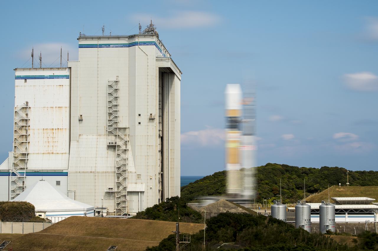
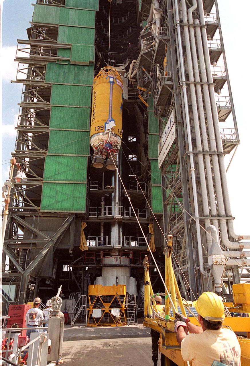
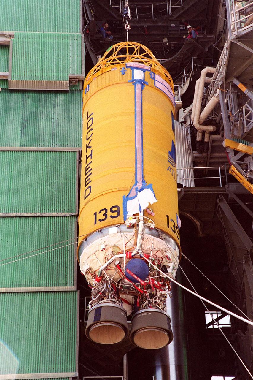
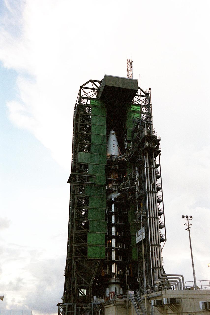
The H-IIA No. 23 rocket that will carry the GPM Core Observatory into space arrived at Tanegashima Space Center on Jan. 20, 2014. The rocket has two stages, an lower first stage that, with the help of two solid rocket boosters gets them off the ground, and an upper second stage that lights up a few minutes after launch to boost the satellite the rest of the way to orbit. The launch services provider, Mitsubishi Heavy Industries (MHI), immediately began assembling the rocket. On Jan. 22, the GPM team in Tanegashima was invited to participate in a blessing ceremony for the rocket. Lynette Marbley, the Instruments Chief Safety and Mission Assurance Officer for GPM, represented the NASA team.
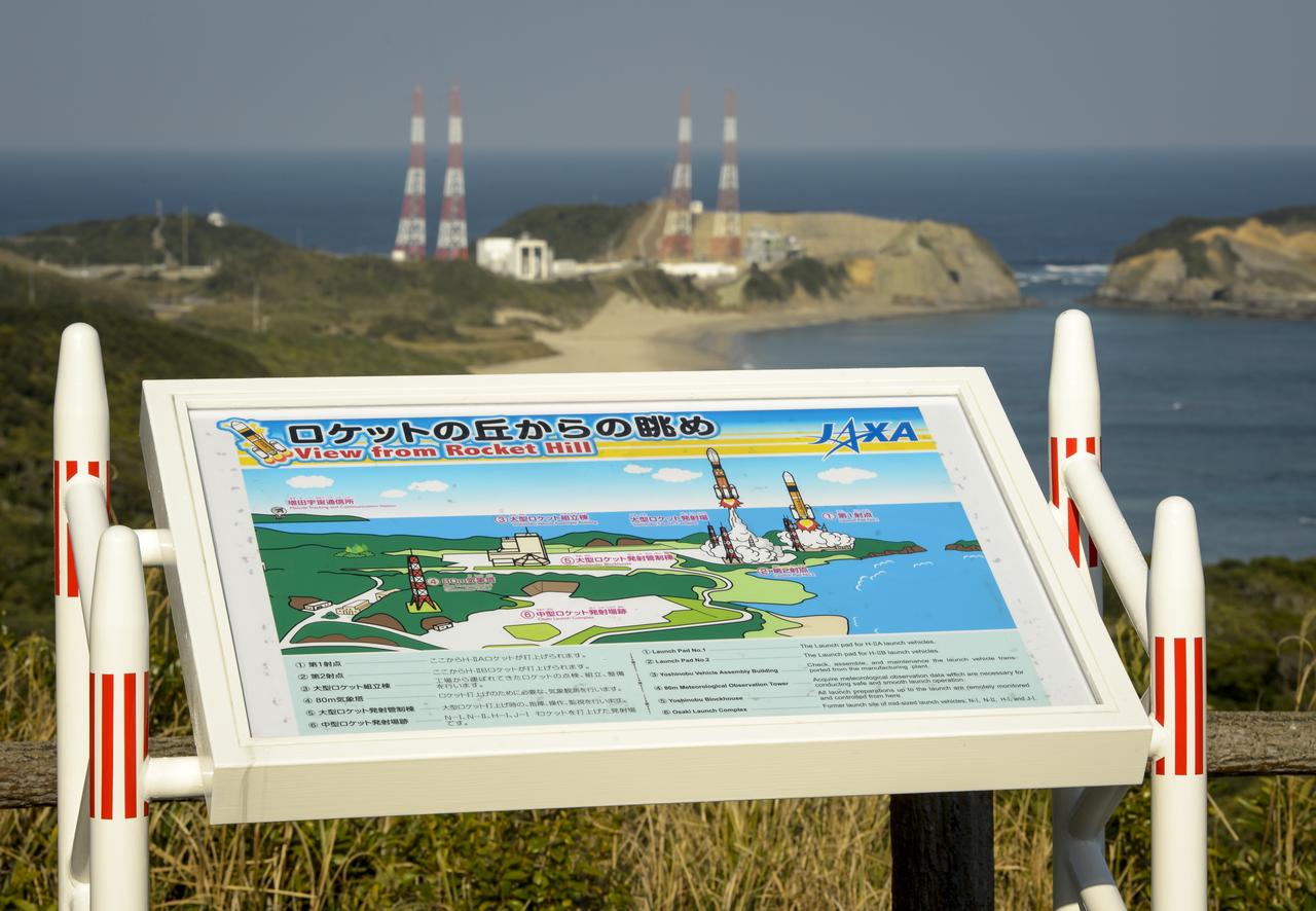
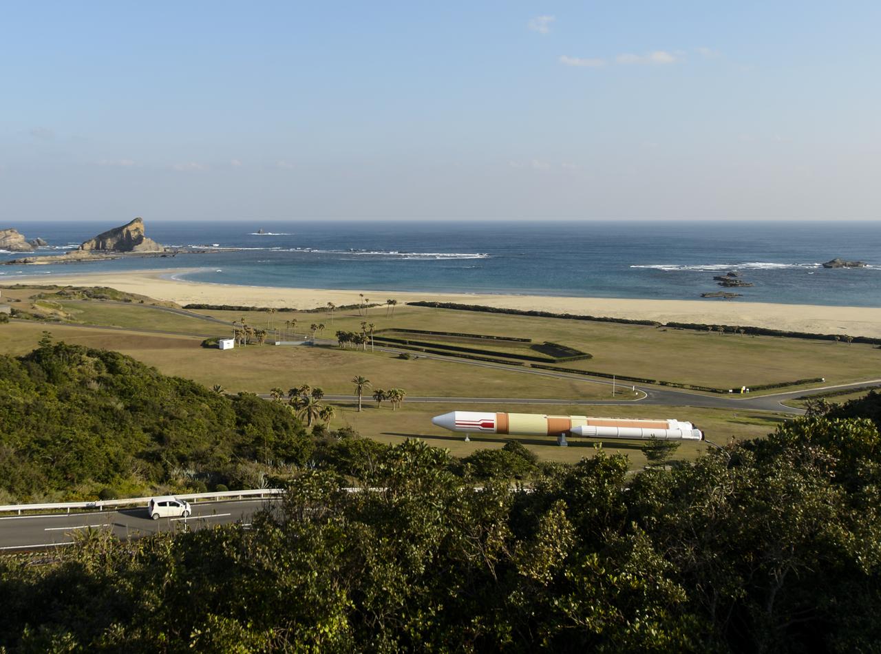
A sign at an overlook, named Rocket Hill, helps viewers identify the various facilities of the Tanegashima Space Center (TNSC), including launch pad 1 that will be used Feb. 28, 2014 for the launch of an H-IIA rocket carrying the Global Precipitation Measurement (GPM) Core Observatory, Friday, Feb. 21, 2014, Tanegashima Island, Japan. The NASA-Japan Aerospace Exploration Agency (JAXA) GPM spacecraft will collect information that unifies data from an international network of existing and future satellites to map global rainfall and snowfall every three hours. Photo Credit: (NASA/Bill Ingalls)
A roadside sign shows visitors of Minamitane Town various locations for activities, including the viewing of rocket launches from the Japan Aerospace Exploration Agency’s (JAXA) Tanegashima Space Center (TNSC), where the launch of an H-IIA rocket carrying the Global Precipitation Measurement (GPM) Core Observatory is scheduled to take place in the next week, Saturday, Feb. 22, 2014, Minamitane Town, Tanegashima Island, Japan. The NASA-JAXA GPM spacecraft will collect information that unifies data from an international network of existing and future satellites to map global rainfall and snowfall every three hours. Launch is planned for Feb. 28, 2014. Photo Credit: (NASA/Bill Ingalls)
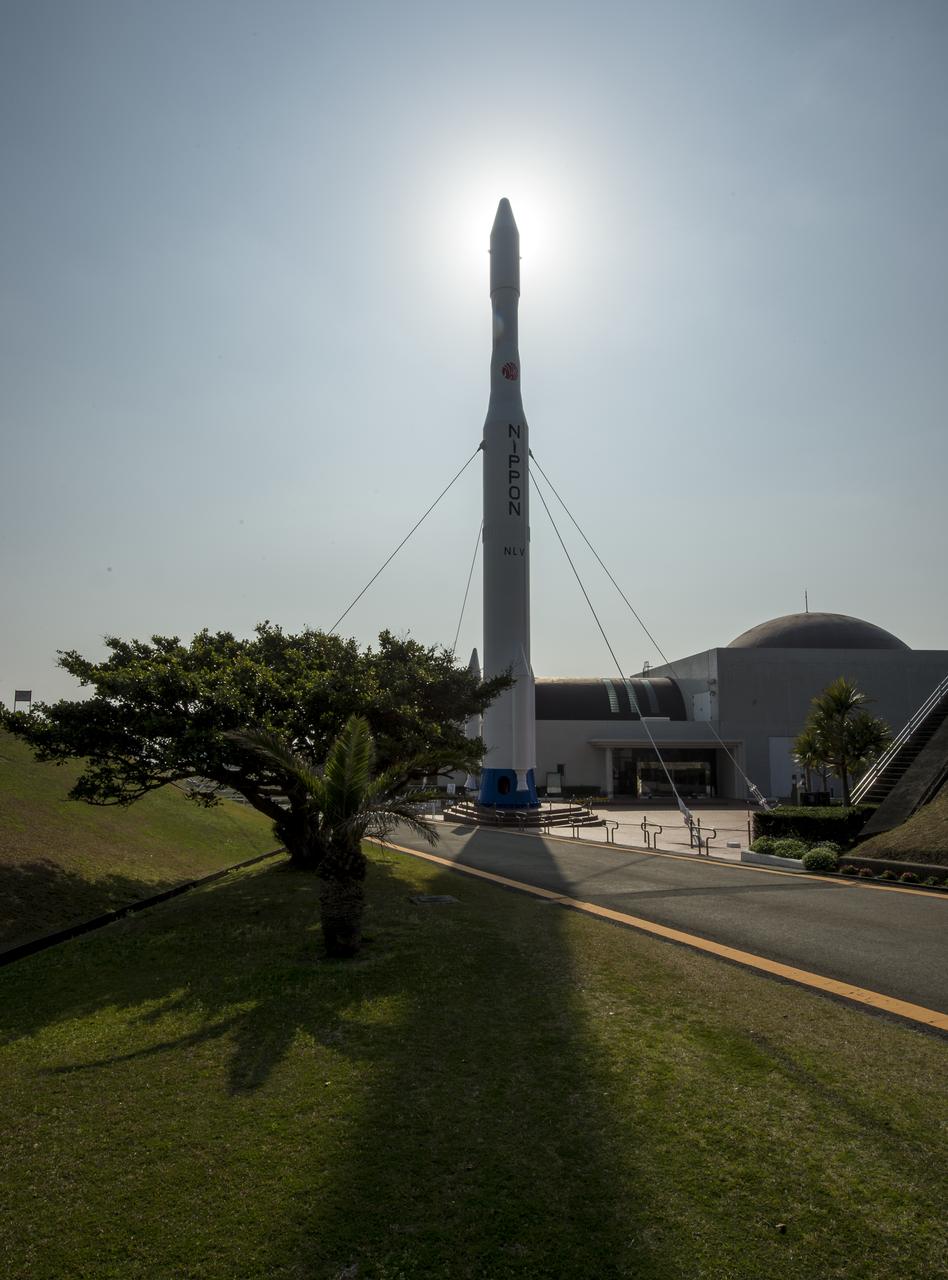
A rocket is seen at the entrance to the visitor's center of the Tanegashima Space Center (TNSC), Sunday, Feb. 23, 2014, Tanegashima Island, Japan. A Japanese H-IIA rocket carrying the NASA-Japan Aerospace Exploration Agency (JAXA), Global Precipitation Measurement (GPM) Core Observatory is planned for launch from the space center on Feb. 28, 2014. Once launched, the GPM spacecraft will collect information that unifies data from an international network of existing and future satellites to map global rainfall and snowfall every three hours. Photo Credit: (NASA/Bill Ingalls)
A rocket is seen at the entrance to the visitor's center of the Tanegashima Space Center (TNSC), Sunday, Feb. 23, 2014, Tanegashima Island, Japan. A Japanese H-IIA rocket carrying the NASA-Japan Aerospace Exploration Agency (JAXA), Global Precipitation Measurement (GPM) Core Observatory is planned for launch from the space center on Feb. 28, 2014. Once launched, the GPM spacecraft will collect information that unifies data from an international network of existing and future satellites to map global rainfall and snowfall every three hours. Photo Credit: (NASA/Bill Ingalls)
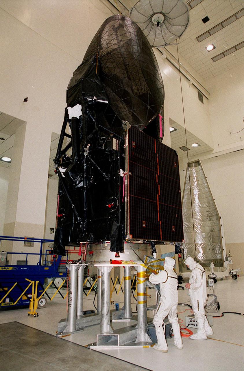
The Tracking and Data Relay Satellite (TDRS-H) sits on a workstand in KSC’s Spacecraft Assembly and Encapsulation Facility (SAEF-2) in order to undergo electrical testing. The TDRS is scheduled to be launched from CCAFS June 29 aboard an Atlas IIA/Centaur rocket. One of three satellites (labeled H, I and J) being built in the Hughes Space and Communications Company Integrated Satellite Factory in El Segundo, Calif., the latest TDRS uses an innovative springback antenna design. A pair of 15-foot-diameter, flexible mesh antenna reflectors fold up for launch, then spring back into their original cupped circular shape on orbit. The new satellites will augment the TDRS system’s existing Sand Ku-band frequencies by adding Ka-band capability. TDRS will serve as the sole means of continuous, high-data-rate communication with the space shuttle, with the International Space Station upon its completion, and with dozens of unmanned scientific satellites in low earth orbit

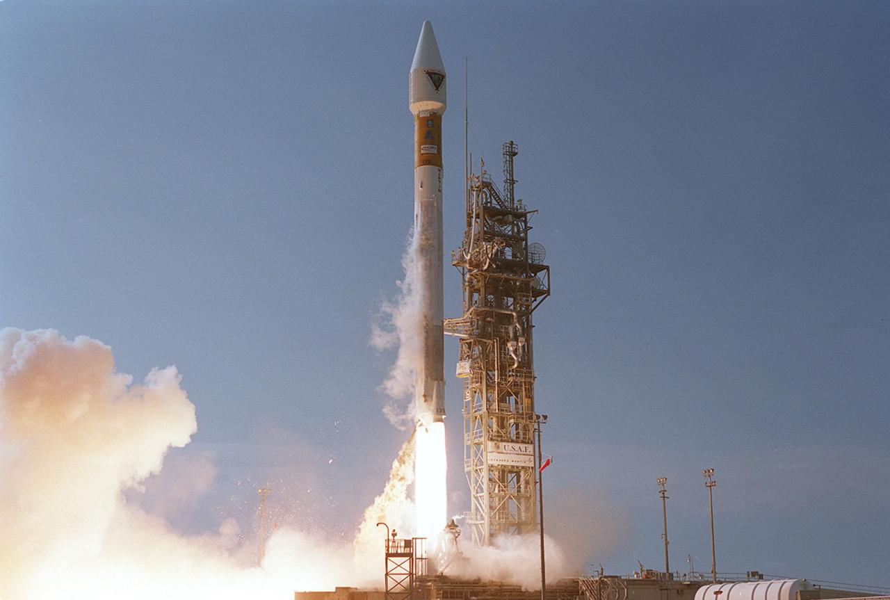
Leaving billowing clouds of steam and smoke behind, NASA’s Tracking and Data Relay Satellite (TDRS-H) shoots into the blue sky aboard an Atlas IIA/Centaur rocket from Pad 36A, Cape Canaveral Air Force Station. Liftoff occurred at 8:56 a.m. EDT. One of three satellites (labeled H, I and J) being built by the Hughes Space and Communications Company, the latest TDRS uses an innovative springback antenna design. A pair of 15-foot-diameter, flexible mesh antenna reflectors fold up for launch, then spring back into their original cupped circular shape on orbit. The new satellites will augment the TDRS system’s existing Sand Ku-band frequencies by adding Ka-band capability. TDRS will serve as the sole means of continuous, high-data-rate communication with the space shuttle, with the International Space Station upon its completion, and with dozens of unmanned scientific satellites in low earth orbit
In the early morning hours on Launch Pad 36A, Cape Canaveral Air Force Station, the tower rolls back from NASA’s Tracking and Data Relay Satellite (TDRS-H) before liftoff atop an Atlas IIA/Centaur rocket. One of three satellites (labeled H, I and J) being built by the Hughes Space and Communications Company, the latest TDRS uses an innovative springback antenna design. A pair of 15-foot-diameter, flexible mesh antenna reflectors fold up for launch, then spring back into their original cupped circular shape on orbit. The new satellites will augment the TDRS system’s existing Sand Ku-band frequencies by adding Ka-band capability. TDRS will serve as the sole means of continuous, high-data-rate communication with the Space Shuttle, with the International Space Station upon its completion, and with dozens of unmanned scientific satellites in low earth orbit
Looking like a Roman candle, NASA’s Tracking and Data Relay Satellite (TDRS-H) shoots into the blue sky aboard an Atlas IIA/Centaur rocket from Pad 36A, Cape Canaveral Air Force Station. Liftoff occurred at 8:56 a.m. EDT. One of three satellites (labeled H, I and J) being built by the Hughes Space and Communications Company, the latest TDRS uses an innovative springback antenna design. A pair of 15-foot-diameter, flexible mesh antenna reflectors fold up for launch, then spring back into their original cupped circular shape on orbit. The new satellites will augment the TDRS system’s existing Sand Ku-band frequencies by adding Ka-band capability. TDRS will serve as the sole means of continuous, high-data-rate communication with the space shuttle, with the International Space Station upon its completion, and with dozens of unmanned scientific satellites in low earth orbit
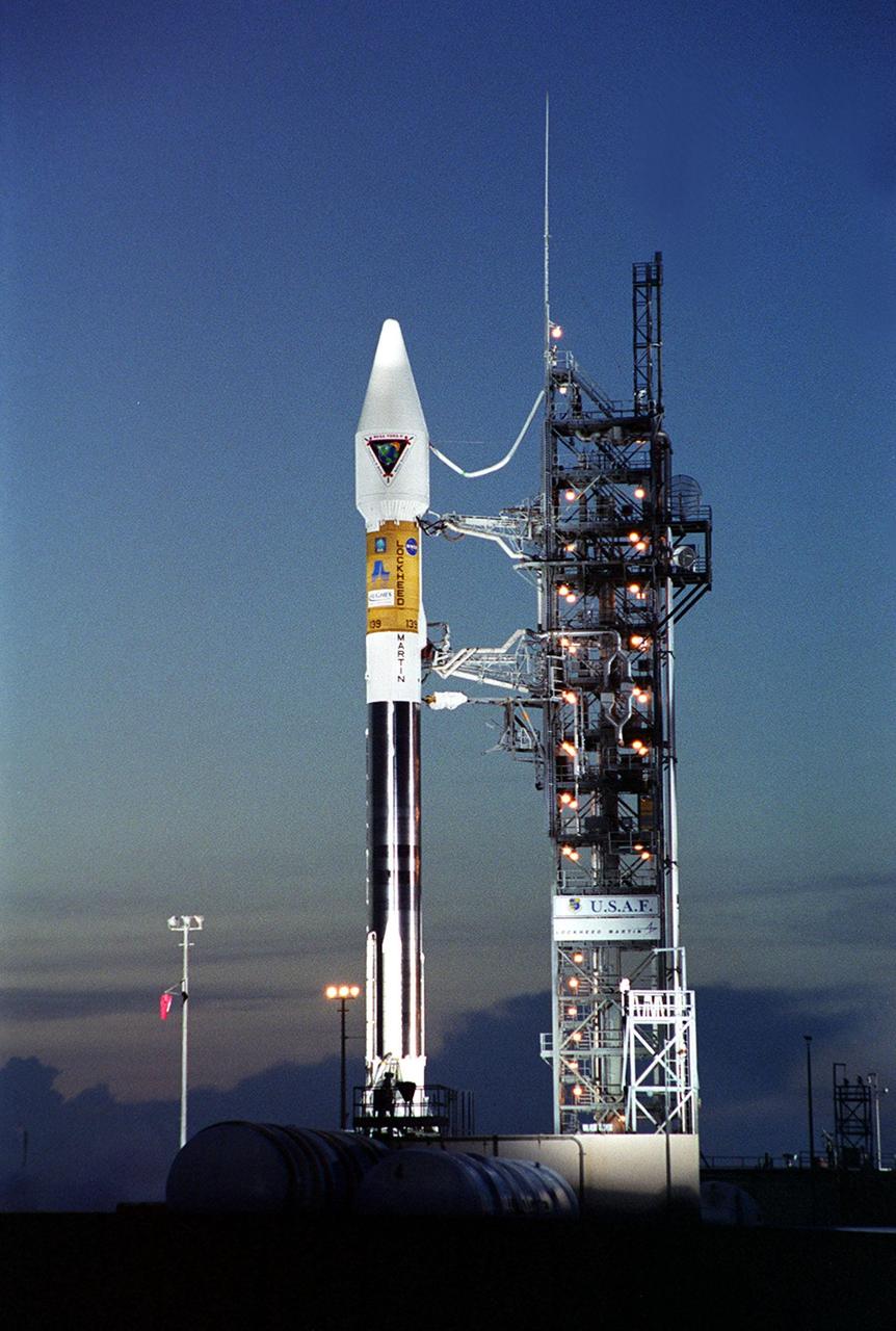
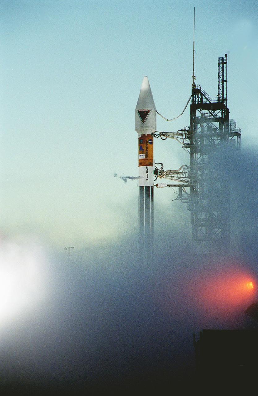
In the early morning hours, NASA’s Tracking and Data Relay Satellite (TDRS-H) sits poised on Launch Pad 36A, Cape Canaveral Air Force Station, before its scheduled launch aboard an Atlas IIA/Centaur rocket. One of three satellites (labeled H, I and J) being built by the Hughes Space and Communications Company, the latest TDRS uses an innovative springback antenna design. A pair of 15-foot-diameter, flexible mesh antenna reflectors fold up for launch, then spring back into their original cupped circular shape on orbit. The new satellites will augment the TDRS system’s existing Sand Ku-band frequencies by adding Ka-band capability. TDRS will serve as the sole means of continuous, high-data-rate communication with the Space Shuttle, with the International Space Station upon its completion, and with dozens of unmanned scientific satellites in low earth orbit
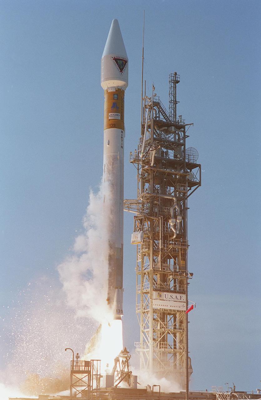
NASA’s Tracking and Data Relay Satellite (TDRS-H) rises into the blue sky from Pad 36A, Cape Canaveral Air Force Station. Liftoff occurred at 8:56 a.m. EDT aboard an Atlas IIA/Centaur rocket. One of three satellites (labeled H, I and J) being built by the Hughes Space and Communications Company, the latest TDRS uses an innovative springback antenna design. A pair of 15-foot-diameter, flexible mesh antenna reflectors fold up for launch, then spring back into their original cupped circular shape on orbit. The new satellites will augment the TDRS system’s existing Sand Ku-band frequencies by adding Ka-band capability. TDRS will serve as the sole means of continuous, high-data-rate communication with the space shuttle, with the International Space Station upon its completion, and with dozens of unmanned scientific satellites in low earth orbit

Workers in KSC’s Spacecraft Assembly and Encapsulation Facility (SAEF-2) prepare the Tracking and Data Relay Satellite (TDRS-H) above them for electrical testing. The TDRS is scheduled to be launched from CCAFS June 29 aboard an Atlas IIA/Centaur rocket. One of three satellites (labeled H, I and J) being built in the Hughes Space and Communications Company Integrated Satellite Factory in El Segundo, Calif., the latest TDRS uses an innovative springback antenna design. A pair of 15-foot-diameter, flexible mesh antenna reflectors fold up for launch, then spring back into their original cupped circular shape on orbit. The new satellites will augment the TDRS system’s existing Sand Ku-band frequencies by adding Ka-band capability. TDRS will serve as the sole means of continuous, high-data-rate communication with the space shuttle, with the International Space Station upon its completion, and with dozens of unmanned scientific satellites in low earth orbit

In the early morning hours on Launch Pad 36A, Cape Canaveral Air Force Station, the tower rolls back from NASA’s Tracking and Data Relay Satellite (TDRS-H) before liftoff atop an Atlas IIA/Centaur rocket. One of three satellites (labeled H, I and J) being built by the Hughes Space and Communications Company, the latest TDRS uses an innovative springback antenna design. A pair of 15-foot-diameter, flexible mesh antenna reflectors fold up for launch, then spring back into their original cupped circular shape on orbit. The new satellites will augment the TDRS system’s existing Sand Ku-band frequencies by adding Ka-band capability. TDRS will serve as the sole means of continuous, high-data-rate communication with the Space Shuttle, with the International Space Station upon its completion, and with dozens of unmanned scientific satellites in low earth orbit

NASA’s Tracking and Data Relay Satellite (TDRS-H) sits poised on Launch Pad 36A, Cape Canaveral Air Force Station, before its scheduled launch aboard an Atlas IIA/Centaur rocket. One of three satellites (labeled H, I and J) being built by the Hughes Space and Communications Company, the latest TDRS uses an innovative springback antenna design. A pair of 15-foot-diameter, flexible mesh antenna reflectors fold up for launch, then spring back into their original cupped circular shape on orbit. The new satellites will augment the TDRS system’s existing Sand Ku-band frequencies by adding Ka-band capability. TDRS will serve as the sole means of continuous, high-data-rate communication with the space shuttle, with the International Space Station upon its completion, and with dozens of unmanned scientific satellites in low earth orbit

At dawn on Launch Pad 36A, Cape Canaveral Air Force Station, an Atlas IIA/Centaur rocket is fueled for launch of NASA’s Tracking and Data Relay Satellite (TDRS-H). One of three satellites (labeled H, I and J) being built by the Hughes Space and Communications Company, the latest TDRS uses an innovative springback antenna design. A pair of 15-foot-diameter, flexible mesh antenna reflectors fold up for launch, then spring back into their original cupped circular shape on orbit. The new satellites will augment the TDRS system’s existing Sand Ku-band frequencies by adding Ka-band capability. TDRS will serve as the sole means of continuous, high-data-rate communication with the Space Shuttle, with the International Space Station upon its completion, and with dozens of unmanned scientific satellites in low earth orbit

Looking like a Roman candle, NASA’s Tracking and Data Relay Satellite (TDRS-H) shoots into the blue sky aboard an Atlas IIA/Centaur rocket from Pad 36A, Cape Canaveral Air Force Station. Liftoff occurred at 8:56 a.m. EDT. One of three satellites (labeled H, I and J) being built by the Hughes Space and Communications Company, the latest TDRS uses an innovative springback antenna design. A pair of 15-foot-diameter, flexible mesh antenna reflectors fold up for launch, then spring back into their original cupped circular shape on orbit. The new satellites will augment the TDRS system’s existing Sand Ku-band frequencies by adding Ka-band capability. TDRS will serve as the sole means of continuous, high-data-rate communication with the space shuttle, with the International Space Station upon its completion, and with dozens of unmanned scientific satellites in low earth orbit

The Tracking and Data Relay Satellite (TDRS-H) sits on a workstand in KSC’s Spacecraft Assembly and Encapsulation Facility (SAEF-2) in order to undergo electrical testing. The TDRS is scheduled to be launched from CCAFS June 29 aboard an Atlas IIA/Centaur rocket. One of three satellites (labeled H, I and J) being built in the Hughes Space and Communications Company Integrated Satellite Factory in El Segundo, Calif., the latest TDRS uses an innovative springback antenna design. A pair of 15-foot-diameter, flexible mesh antenna reflectors fold up for launch, then spring back into their original cupped circular shape on orbit. The new satellites will augment the TDRS system’s existing Sand Ku-band frequencies by adding Ka-band capability. TDRS will serve as the sole means of continuous, high-data-rate communication with the space shuttle, with the International Space Station upon its completion, and with dozens of unmanned scientific satellites in low earth orbit
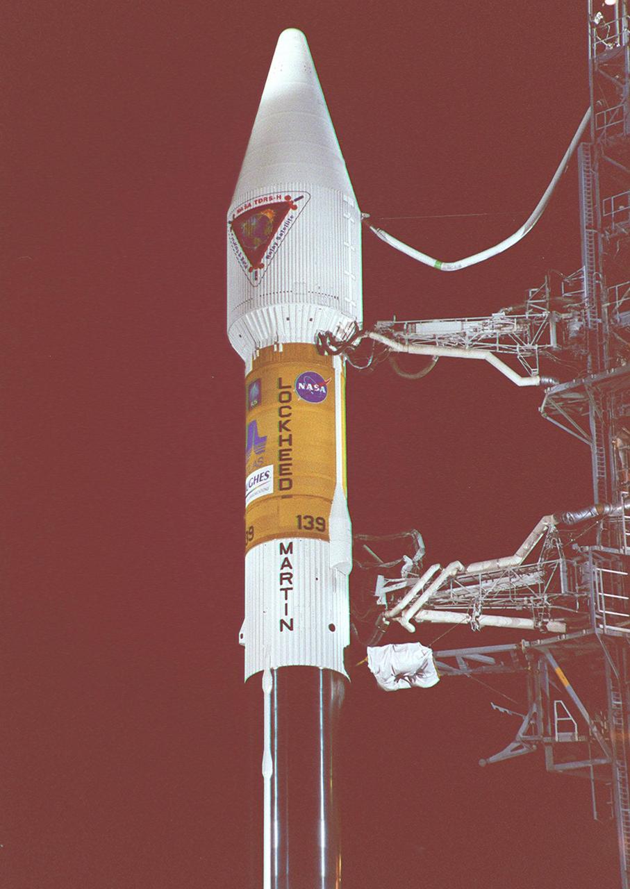
NASA’s Tracking and Data Relay Satellite (TDRS-H) sits poised on Launch Pad 36A, Cape Canaveral Air Force Station, before its scheduled launch aboard an Atlas IIA/Centaur rocket. One of three satellites (labeled H, I and J) being built by the Hughes Space and Communications Company, the latest TDRS uses an innovative springback antenna design. A pair of 15-foot-diameter, flexible mesh antenna reflectors fold up for launch, then spring back into their original cupped circular shape on orbit. The new satellites will augment the TDRS system’s existing Sand Ku-band frequencies by adding Ka-band capability. TDRS will serve as the sole means of continuous, high-data-rate communication with the space shuttle, with the International Space Station upon its completion, and with dozens of unmanned scientific satellites in low earth orbit
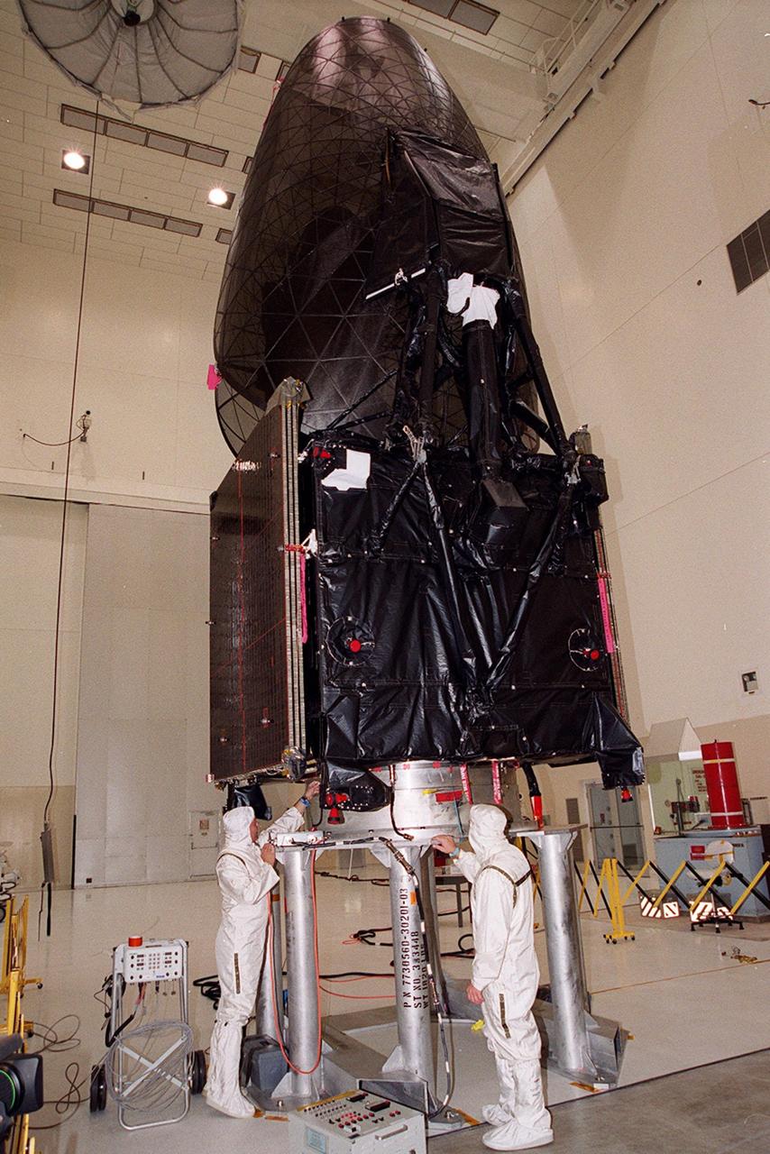
Workers in KSC’s Spacecraft Assembly and Encapsulation Facility (SAEF-2) conduct electrical testing on the Tracking and Data Relay Satellite (TDRS-H) above them. The TDRS is scheduled to be launched from CCAFS June 29 aboard an Atlas IIA/Centaur rocket. One of three satellites (labeled H, I and J) being built in the Hughes Space and Communications Company Integrated Satellite Factory in El Segundo, Calif., the latest TDRS uses an innovative springback antenna design. A pair of 15-foot-diameter, flexible mesh antenna reflectors fold up for launch, then spring back into their original cupped circular shape on orbit. The new satellites will augment the TDRS system’s existing Sand Ku-band frequencies by adding Ka-band capability. TDRS will serve as the sole means of continuous, high-data-rate communication with the space shuttle, with the International Space Station upon its completion, and with dozens of unmanned scientific satellites in low earth orbit

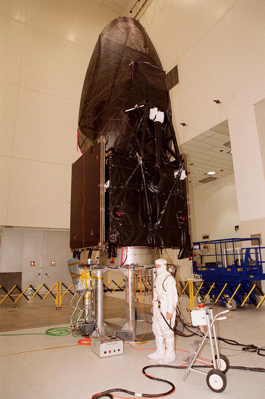
The Tracking and Data Relay Satellite (TDRS-H) sits fully encapsulated inside the fairing. Next, it will be transported to Launch Pad 36A, Cape Canaveral Air Force Station for launch scheduled June 29 aboard an Atlas IIA/Centaur rocket. One of three satellites (labeled H, I and J) being built in the Hughes Space and Communications Company Integrated Satellite Factory in El Segundo, Calif., the latest TDRS uses an innovative springback antenna design. A pair of 15-foot-diameter, flexible mesh antenna reflectors fold up for launch, then spring back into their original cupped circular shape on orbit. The new satellites will augment the TDRS system’s existing Sand Ku-band frequencies by adding Ka-band capability. TDRS will serve as the sole means of continuous, high-data-rate communication with the space shuttle, with the International Space Station upon its completion, and with dozens of unmanned scientific satellites in low earth orbit

After tower rollback just before dawn on Launch Pad 36A, Cape Canaveral Air Force Station, NASA’s Tracking and Data Relay Satellite (TDRS-H) sits bathed in spotlights before liftoff atop an Atlas IIA/Centaur rocket. One of three satellites (labeled H, I and J) being built by the Hughes Space and Communications Company, the latest TDRS uses an innovative springback antenna design. A pair of 15-foot-diameter, flexible mesh antenna reflectors fold up for launch, then spring back into their original cupped circular shape on orbit. The new satellites will augment the TDRS system’s existing Sand Ku-band frequencies by adding Ka-band capability. TDRS will serve as the sole means of continuous, high-data-rate communication with the Space Shuttle, with the International Space Station upon its completion, and with dozens of unmanned scientific satellites in low earth orbit
Leaving billowing clouds of steam and smoke behind, NASA’s Tracking and Data Relay Satellite (TDRS-H) shoots into the blue sky aboard an Atlas IIA/Centaur rocket from Pad 36A, Cape Canaveral Air Force Station. Liftoff occurred at 8:56 a.m. EDT. One of three satellites (labeled H, I and J) being built by the Hughes Space and Communications Company, the latest TDRS uses an innovative springback antenna design. A pair of 15-foot-diameter, flexible mesh antenna reflectors fold up for launch, then spring back into their original cupped circular shape on orbit. The new satellites will augment the TDRS system’s existing Sand Ku-band frequencies by adding Ka-band capability. TDRS will serve as the sole means of continuous, high-data-rate communication with the space shuttle, with the International Space Station upon its completion, and with dozens of unmanned scientific satellites in low earth orbit
After tower rollback just before dawn on Launch Pad 36A, Cape Canaveral Air Force Station, NASA’s Tracking and Data Relay Satellite (TDRS-H) sits bathed in spotlights before liftoff atop an Atlas IIA/Centaur rocket. One of three satellites (labeled H, I and J) being built by the Hughes Space and Communications Company, the latest TDRS uses an innovative springback antenna design. A pair of 15-foot-diameter, flexible mesh antenna reflectors fold up for launch, then spring back into their original cupped circular shape on orbit. The new satellites will augment the TDRS system’s existing Sand Ku-band frequencies by adding Ka-band capability. TDRS will serve as the sole means of continuous, high-data-rate communication with the Space Shuttle, with the International Space Station upon its completion, and with dozens of unmanned scientific satellites in low earth orbit
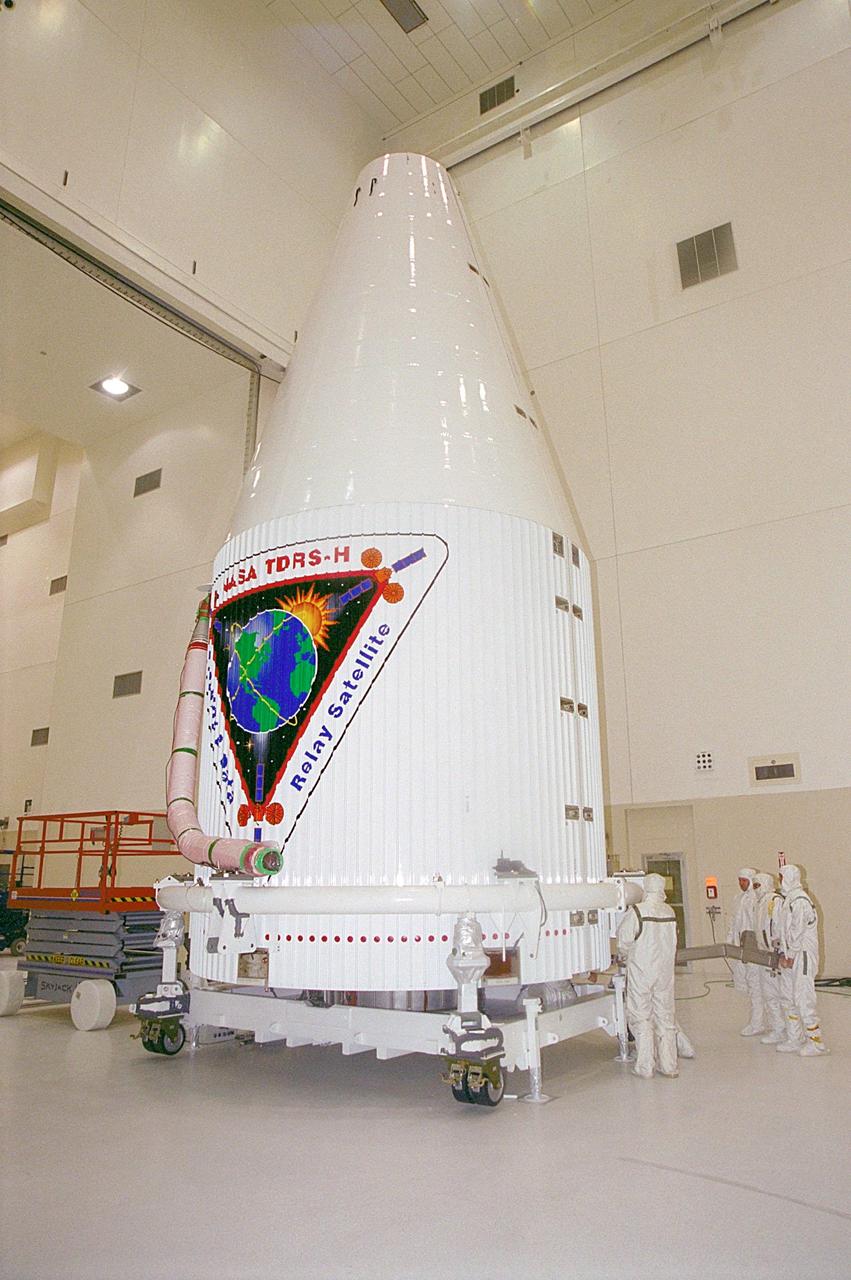
The Tracking and Data Relay Satellite (TDRS-H) sits fully encapsulated inside the fairing. Next, it will be transported to Launch Pad 36A, Cape Canaveral Air Force Station for launch scheduled June 29 aboard an Atlas IIA/Centaur rocket. One of three satellites (labeled H, I and J) being built in the Hughes Space and Communications Company Integrated Satellite Factory in El Segundo, Calif., the latest TDRS uses an innovative springback antenna design. A pair of 15-foot-diameter, flexible mesh antenna reflectors fold up for launch, then spring back into their original cupped circular shape on orbit. The new satellites will augment the TDRS system’s existing Sand Ku-band frequencies by adding Ka-band capability. TDRS will serve as the sole means of continuous, high-data-rate communication with the space shuttle, with the International Space Station upon its completion, and with dozens of unmanned scientific satellites in low earth orbit
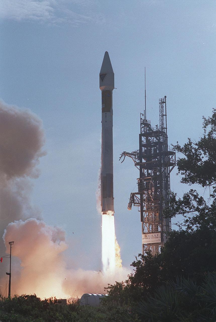
NASA’s Tracking and Data Relay Satellite (TDRS-H) rises into the blue sky from Pad 36A, Cape Canaveral Air Force Station. Liftoff occurred at 8:56 a.m. EDT aboard an Atlas IIA/Centaur rocket. One of three satellites (labeled H, I and J) being built by the Hughes Space and Communications Company, the latest TDRS uses an innovative springback antenna design. A pair of 15-foot-diameter, flexible mesh antenna reflectors fold up for launch, then spring back into their original cupped circular shape on orbit. The new satellites will augment the TDRS system’s existing Sand Ku-band frequencies by adding Ka-band capability. TDRS will serve as the sole means of continuous, high-data-rate communication with the space shuttle, with the International Space Station upon its completion, and with dozens of unmanned scientific satellites in low earth orbit
At dawn on Launch Pad 36A, Cape Canaveral Air Force Station, an Atlas IIA/Centaur rocket is fueled for launch of NASA’s Tracking and Data Relay Satellite (TDRS-H). One of three satellites (labeled H, I and J) being built by the Hughes Space and Communications Company, the latest TDRS uses an innovative springback antenna design. A pair of 15-foot-diameter, flexible mesh antenna reflectors fold up for launch, then spring back into their original cupped circular shape on orbit. The new satellites will augment the TDRS system’s existing Sand Ku-band frequencies by adding Ka-band capability. TDRS will serve as the sole means of continuous, high-data-rate communication with the Space Shuttle, with the International Space Station upon its completion, and with dozens of unmanned scientific satellites in low earth orbit

NASA’s Tracking and Data Relay Satellite (TDRS-H) rises into the blue sky from Pad 36A, Cape Canaveral Air Force Station. Liftoff occurred at 8:56 a.m. EDT aboard an Atlas IIA/Centaur rocket. One of three satellites (labeled H, I and J) being built by the Hughes Space and Communications Company, the latest TDRS uses an innovative springback antenna design. A pair of 15-foot-diameter, flexible mesh antenna reflectors fold up for launch, then spring back into their original cupped circular shape on orbit. The new satellites will augment the TDRS system’s existing Sand Ku-band frequencies by adding Ka-band capability. TDRS will serve as the sole means of continuous, high-data-rate communication with the space shuttle, with the International Space Station upon its completion, and with dozens of unmanned scientific satellites in low earth orbit

NASA’s Tracking and Data Relay Satellite (TDRS-H) rises into the blue sky from Pad 36A, Cape Canaveral Air Force Station. Liftoff occurred at 8:56 a.m. EDT aboard an Atlas IIA/Centaur rocket. One of three satellites (labeled H, I and J) being built by the Hughes Space and Communications Company, the latest TDRS uses an innovative springback antenna design. A pair of 15-foot-diameter, flexible mesh antenna reflectors fold up for launch, then spring back into their original cupped circular shape on orbit. The new satellites will augment the TDRS system’s existing Sand Ku-band frequencies by adding Ka-band capability. TDRS will serve as the sole means of continuous, high-data-rate communication with the space shuttle, with the International Space Station upon its completion, and with dozens of unmanned scientific satellites in low earth orbit

In the early morning hours, NASA’s Tracking and Data Relay Satellite (TDRS-H) sits poised on Launch Pad 36A, Cape Canaveral Air Force Station, before its scheduled launch aboard an Atlas IIA/Centaur rocket. One of three satellites (labeled H, I and J) being built by the Hughes Space and Communications Company, the latest TDRS uses an innovative springback antenna design. A pair of 15-foot-diameter, flexible mesh antenna reflectors fold up for launch, then spring back into their original cupped circular shape on orbit. The new satellites will augment the TDRS system’s existing Sand Ku-band frequencies by adding Ka-band capability. TDRS will serve as the sole means of continuous, high-data-rate communication with the Space Shuttle, with the International Space Station upon its completion, and with dozens of unmanned scientific satellites in low earth orbit
Workers in KSC’s Spacecraft Assembly and Encapsulation Facility (SAEF-2) prepare the Tracking and Data Relay Satellite (TDRS-H) above them for electrical testing. The TDRS is scheduled to be launched from CCAFS June 29 aboard an Atlas IIA/Centaur rocket. One of three satellites (labeled H, I and J) being built in the Hughes Space and Communications Company Integrated Satellite Factory in El Segundo, Calif., the latest TDRS uses an innovative springback antenna design. A pair of 15-foot-diameter, flexible mesh antenna reflectors fold up for launch, then spring back into their original cupped circular shape on orbit. The new satellites will augment the TDRS system’s existing Sand Ku-band frequencies by adding Ka-band capability. TDRS will serve as the sole means of continuous, high-data-rate communication with the space shuttle, with the International Space Station upon its completion, and with dozens of unmanned scientific satellites in low earth orbit
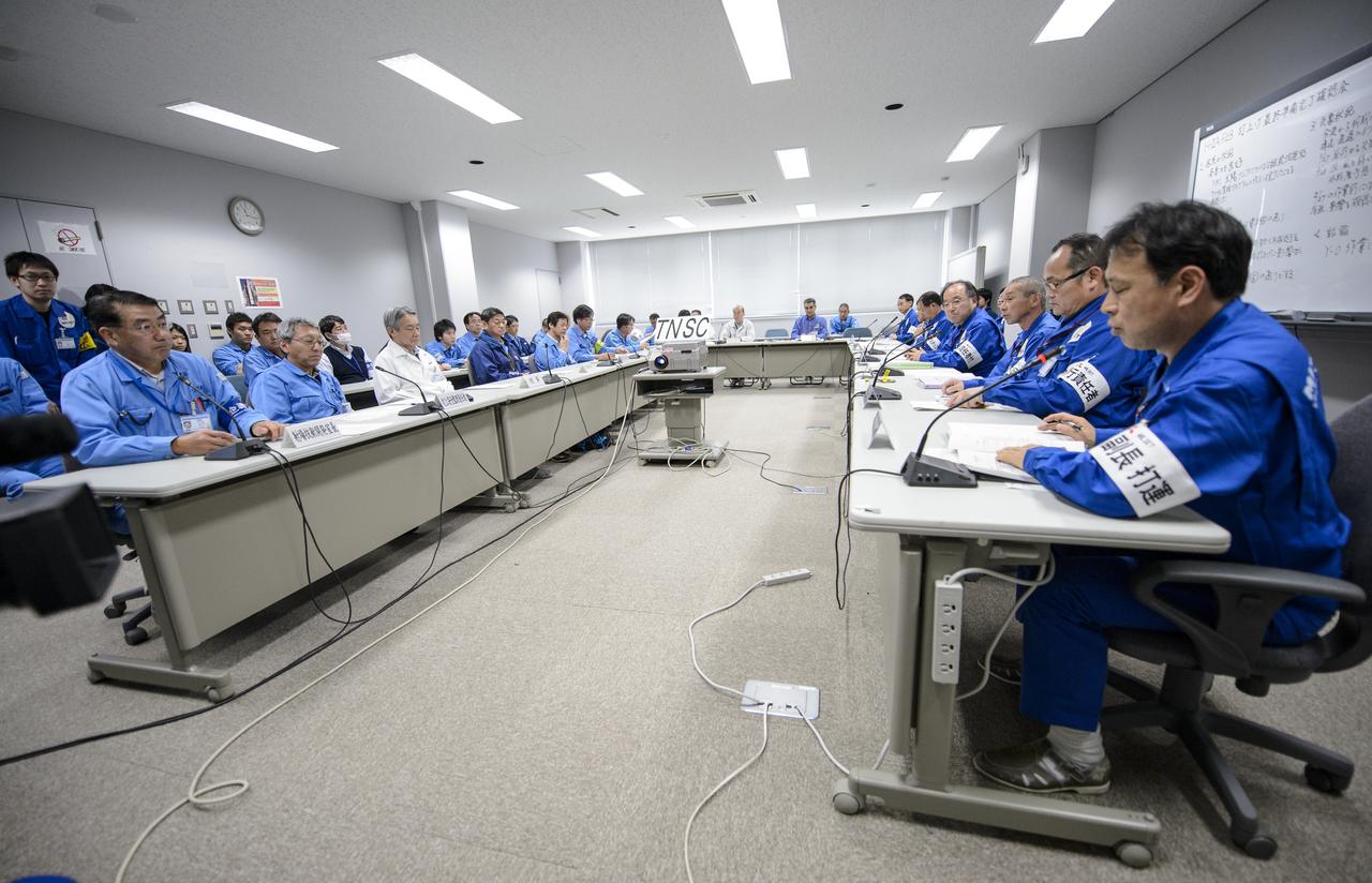
Chief officers from Mitsubishi Heavy Industries, Ltd., the Japan Aerospace Exploration Agency (JAXA) and NASA met on Wednesday, Feb. 26, 2014 in the Range Control Center (RCC) of the Tanegashima Space Center, Japan, to review the readiness of the Global Precipitation Measurement (GPM) Core Observatory for launch. The spacecraft is scheduled to launch aboard an H-IIA rocket early on the morning of Feb. 28 Japan time. Once launched, the GPM spacecraft will collect information that unifies data from an international network of existing and future satellites to map global rainfall and snowfall every three hours. Photo Credit: (NASA/Bill Ingalls)
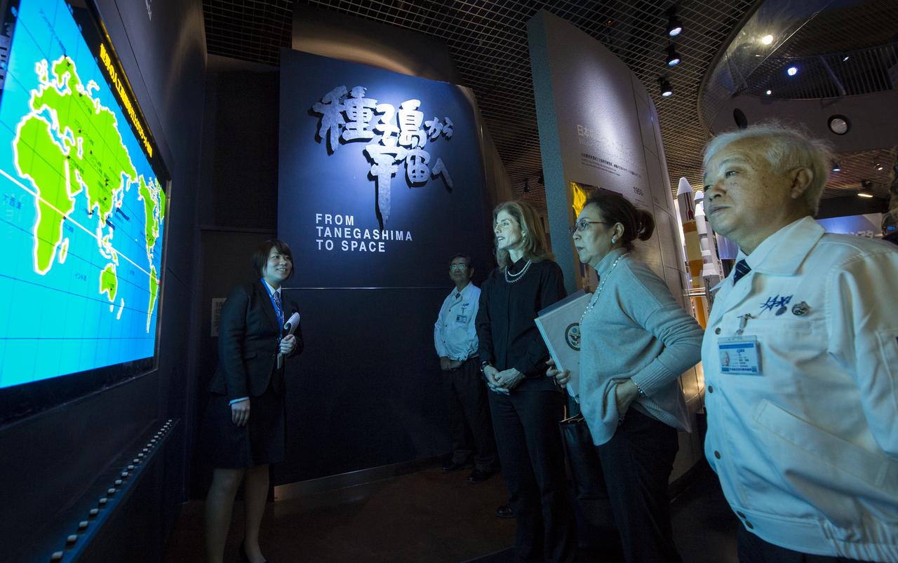
Caroline Bouvier Kennedy, U.S. Ambassador Extraordinary and Plenipotentiary to Japan, center, tours the Tanegashima Space Center, Visitors Center with Japan Aerospace Exploration Agency (JAXA), President, Naoki Okumura, right, on Thursday, Feb. 27, 2014, Tanegashima, Japan. The Ambassador visiting the space center and hopes to witness the planned launch of a Japanese H-IIA rocket carrying the NASA-JAXA, Global Precipitation Measurement (GPM) Core Observatory. Once launched, the GPM spacecraft will collect information that unifies data from an international network of existing and future satellites to map global rainfall and snowfall every three hours. Photo Credit: (NASA/Bill Ingalls)

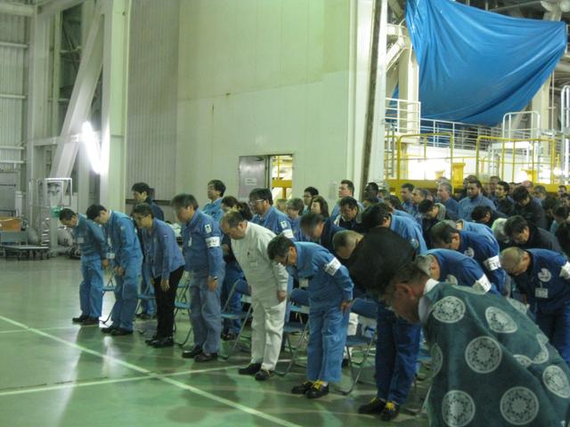
The Ebisu Shrine, the first shrine in a traditional San-ja Mairi, or Three Shrine Pilgrimage, is seen just after members of the Japan Aerospace Exploration Agency (JAXA) team prayed for a successful launch, Tuesday, Feb. 25, 2014, Tanegashima Island, Japan. A Japanese H-IIA rocket carrying the NASA-JAXA, Global Precipitation Measurement (GPM) Core Observatory is planned for launch from the Tanegashima Space Center (TNSC) on Feb. 28, 2014. Once launched, the GPM spacecraft will collect information that unifies data from an international network of existing and future satellites to map global rainfall and snowfall every three hours. Photo Credit: (NASA/Bill Ingalls)
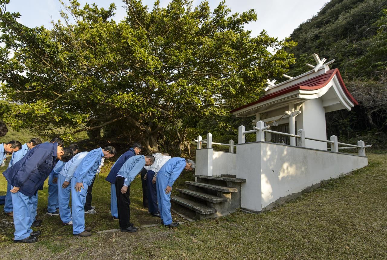
Japan Aerospace Exploration Agency (JAXA) team members bow at the Ebisu Shrine, the first shrine in a traditional San-ja Mairi, or Three Shrine Pilgrimage, where the team prays for a successful launch, Tuesday, Feb. 25, 2014, Tanegashima Island, Japan. A Japanese H-IIA rocket carrying the NASA-JAXA, Global Precipitation Measurement (GPM) Core Observatory is planned for launch from the Tanegashima Space Center (TNSC) on Feb. 28, 2014. Once launched, the GPM spacecraft will collect information that unifies data from an international network of existing and future satellites to map global rainfall and snowfall every three hours. Photo Credit: (NASA/Bill Ingalls)
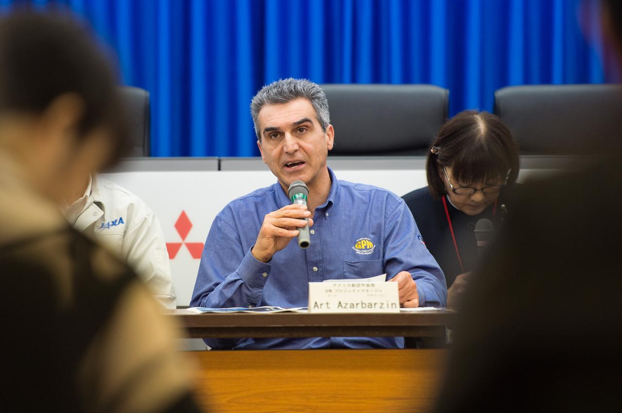
Art Azarbarzin, NASA Global Precipitation Measurement (GPM) project manager talks during a technical briefing for the launch of the Global Precipitation Measurement (GPM) Core Observatory aboard an H-IIA rocket, Wednesday, Feb. 26, 2014, Tanegashima Space Center, Japan. Launch is scheduled for early in the morning of Feb. 28 Japan time. Once launched, the GPM spacecraft will collect information that unifies data from an international network of existing and future satellites to map global rainfall and snowfall every three hours. Photo Credit: (NASA/Bill Ingalls)
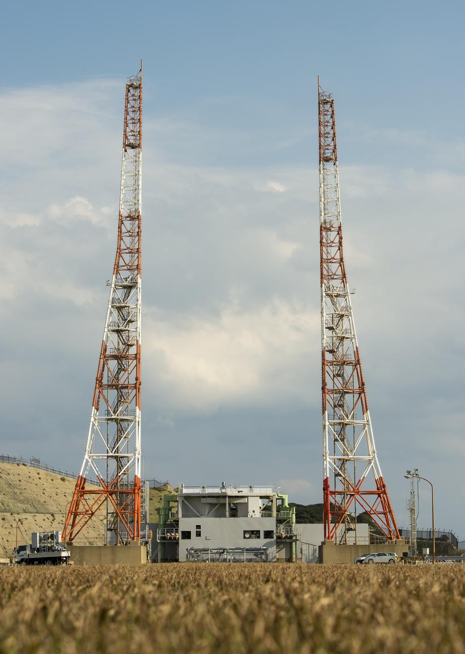
Launch pad 1 is seen at the Tanegashima Space Center (TNSC) on Monday, Feb. 24, 2014 in Tanegashima, Japan. A Japanese H-IIA rocket carrying the NASA-Japan Aerospace Exploration Agency (JAXA), Global Precipitation Measurement (GPM) Core Observatory is planned for launch from pad 1 on Feb. 28, 2014. Once launched, the GPM spacecraft will collect information that unifies data from an international network of existing and future satellites to map global rainfall and snowfall every three hours. Photo Credit: (NASA/Bill Ingalls)
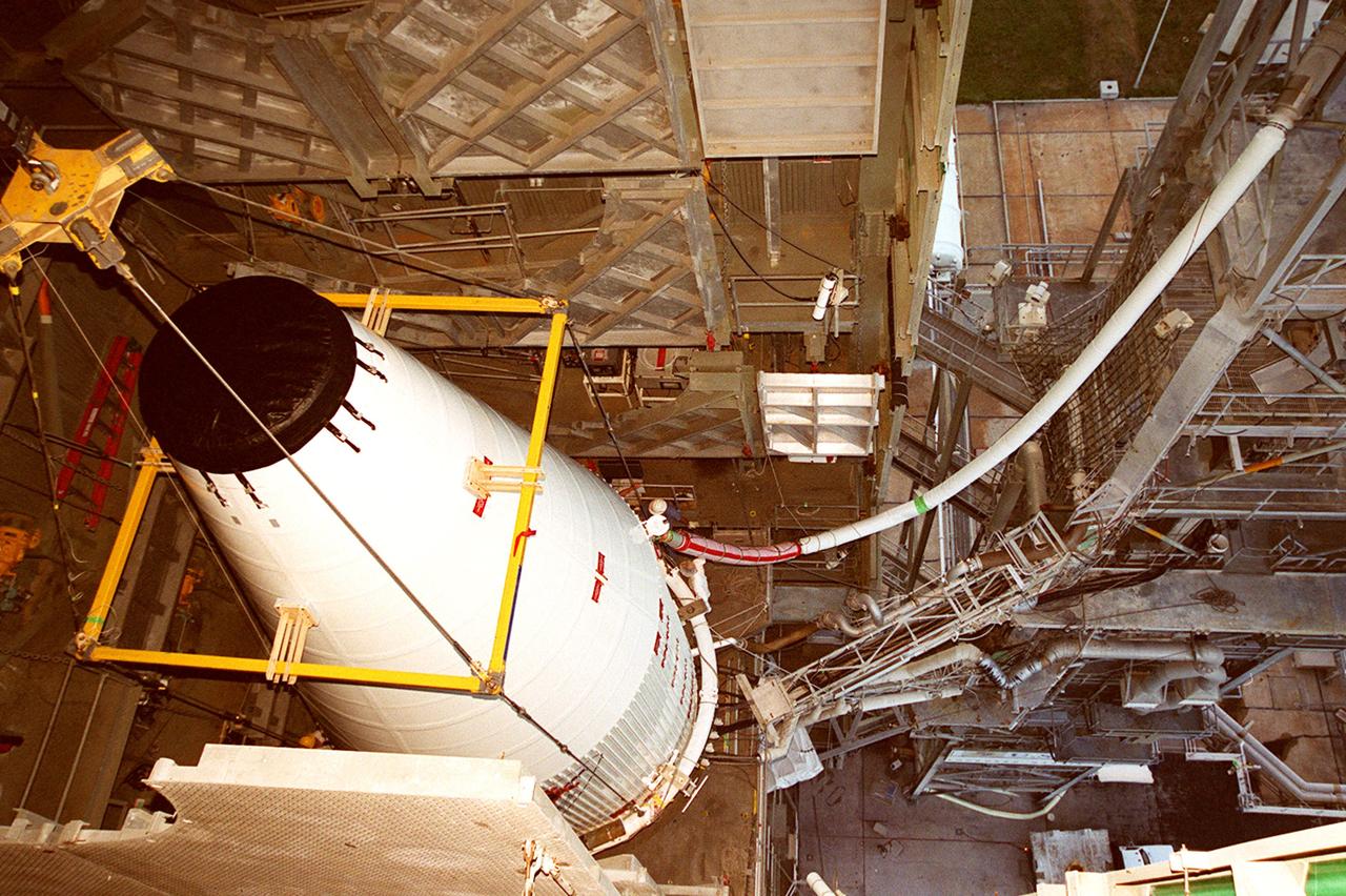
KENNEDY SPACE CENTER, FLA. -- In a view taken near the top of the launch tower at Launch Pad 36A, Cape Canaveral Air Force Station, the nose fairing with the Tracking and Data Relay Satellite (TDRS-H) inside is hoisted up the tower by the overhead crane (left). The fairing will be mated with the Atlas IIA/Centaur rocket, which is already stacked, for launch on June 29. The satellite will augment the TDRS system's existing S- and Ku-band frequencies by adding Ka-band capability. TDRS will serve as the sole means of continuous, high-data-rate communications with the Space Shuttle, with the International Space Station upon its completion, and with dozens of unmanned scientific satellites in low-earth orbit.
The nose fairing covering the Tracking and Data Relay Satellite (TDRS-H) is close to the top of the launch tower at Launch Pad 36A, Cape Canaveral Air Force Station. It is being lifted to mate with the Atlas IIA/Centaur rocket, which is already stacked, for launch on June 29. The satellite will augment the TDRS system’s existing Sand Ku-band frequencies by adding Ka-band capability. TDRS will serve as the sole means of continuous, high-data-rate communication with the Space Shuttle, with the International Space Station upon its completion, and with dozens of unmanned scientific satellites in low earth orbit
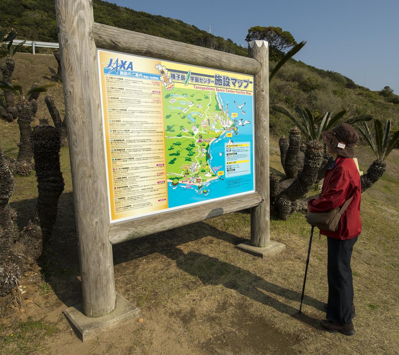
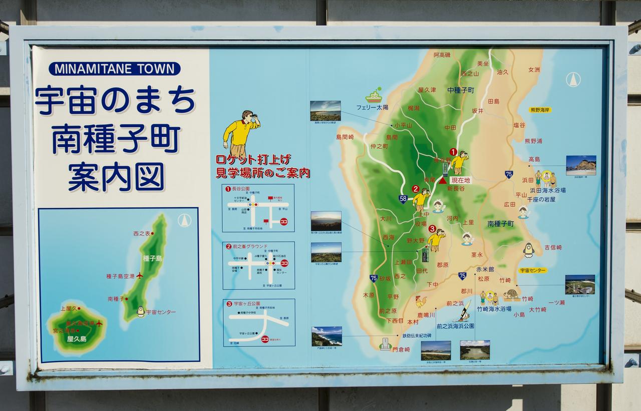
A visitor looks over a Tanegashima Space Center (TNSC) Facility Map, Sunday, Feb. 23, 2014, Tanegashima Island, Japan. A Japanese H-IIA rocket carrying the NASA-Japan Aerospace Exploration Agency's (JAXA), Global Precipitation Measurement (GPM) Core Observatory is planned for launch from the space center on Feb. 28, 2014. Once launched, the GPM spacecraft will collect information that unifies data from an international network of existing and future satellites to map global rainfall and snowfall every three hours. Photo Credit: (NASA/Bill Ingalls)
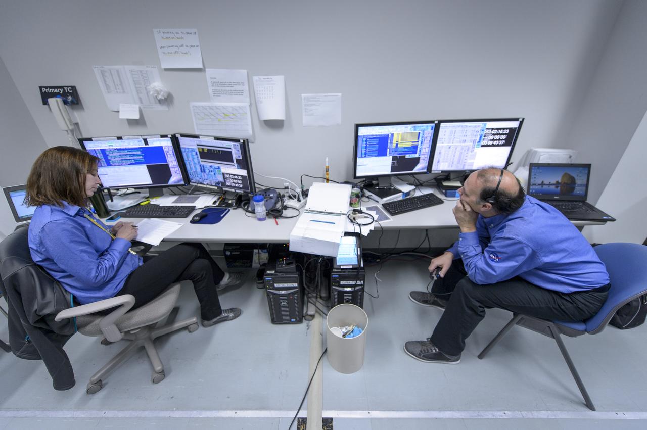
NASA GPM Test Conductors, Michelle Lacombe, left, and Bill Dehaven participate in an all-day launch simulation for the Global Precipitation Measurement (GPM) Core Observatory at the Spacecraft Test and Assembly Building 2 (STA2), Saturday, Feb. 22, 2014, Tanegashima Space Center (TNSC), Tanegashima Island, Japan. Japan Aerospace Exploration Agency (JAXA) plans to launch an H-IIA rocket carrying the GPM Core Observatory on Feb. 28, 2014. The NASA-JAXA GPM spacecraft will collect information that unifies data from an international network of existing and future satellites to map global rainfall and snowfall every three hours. Photo Credit: (NASA/Bill Ingalls)

Shrubs and flowers in the shape of a space shuttle, star and planet are seen just outside the visitor's center of the Tanegashima Space Center (TNSC), Sunday, Feb. 23, 2014, Tanegashima Island, Japan. A Japanese H-IIA rocket carrying the NASA-Japan Aerospace Exploration Agency (JAXA), Global Precipitation Measurement (GPM) Core Observatory is planned for launch from the space center on Feb. 28, 2014. Once launched, the GPM spacecraft will collect information that unifies data from an international network of existing and future satellites to map global rainfall and snowfall every three hours. Photo Credit: (NASA/Bill Ingalls)

NASA GPM Test Conductors John Pope, and, Michelle Lacombe talk during the all-day launch simulation for the Global Precipitation Measurement (GPM) Core Observatory at the Spacecraft Test and Assembly Building 2 (STA2), Saturday, Feb. 22, 2014, Tanegashima Space Center (TNSC), Tanegashima Island, Japan. Japan Aerospace Exploration Agency (JAXA) plans to launch an H-IIA rocket carrying the GPM Core Observatory on Feb. 28, 2014. The NASA-JAXA GPM spacecraft will collect information that unifies data from an international network of existing and future satellites to map global rainfall and snowfall every three hours. Photo Credit: (NASA/Bill Ingalls)

Japan Aerospace Exploration Agency (JAXA) are seen as they depart the Houman Shrine, the third, and final, shrine in a traditional San-ja Mairi, or Three Shrine Pilgrimage, where the team prays for a successful launch, Tuesday, Feb. 25, 2014, Tanegashima Island, Japan. A Japanese H-IIA rocket carrying the NASA-JAXA, Global Precipitation Measurement (GPM) Core Observatory is planned for launch from the Tanegashima Space Center (TNSC) on Feb. 28, 2014. Once launched, the GPM spacecraft will collect information that unifies data from an international network of existing and future satellites to map global rainfall and snowfall every three hours. Photo Credit: (NASA/Bill Ingalls)

A car drives on the twisty roads that hug the coast line of the Tanegashima Space Center (TNSC) on Sunday, Feb. 23, 2014, Tanegashima Island, Japan. A Japanese H-IIA rocket carrying the NASA-Japan Aerospace Exploration Agency (JAXA), Global Precipitation Measurement (GPM) Core Observatory is planned for launch from the space center on Feb. 28, 2014. Once launched, the GPM spacecraft will collect information that unifies data from an international network of existing and future satellites to map global rainfall and snowfall every three hours. Photo Credit: (NASA/Bill Ingalls)
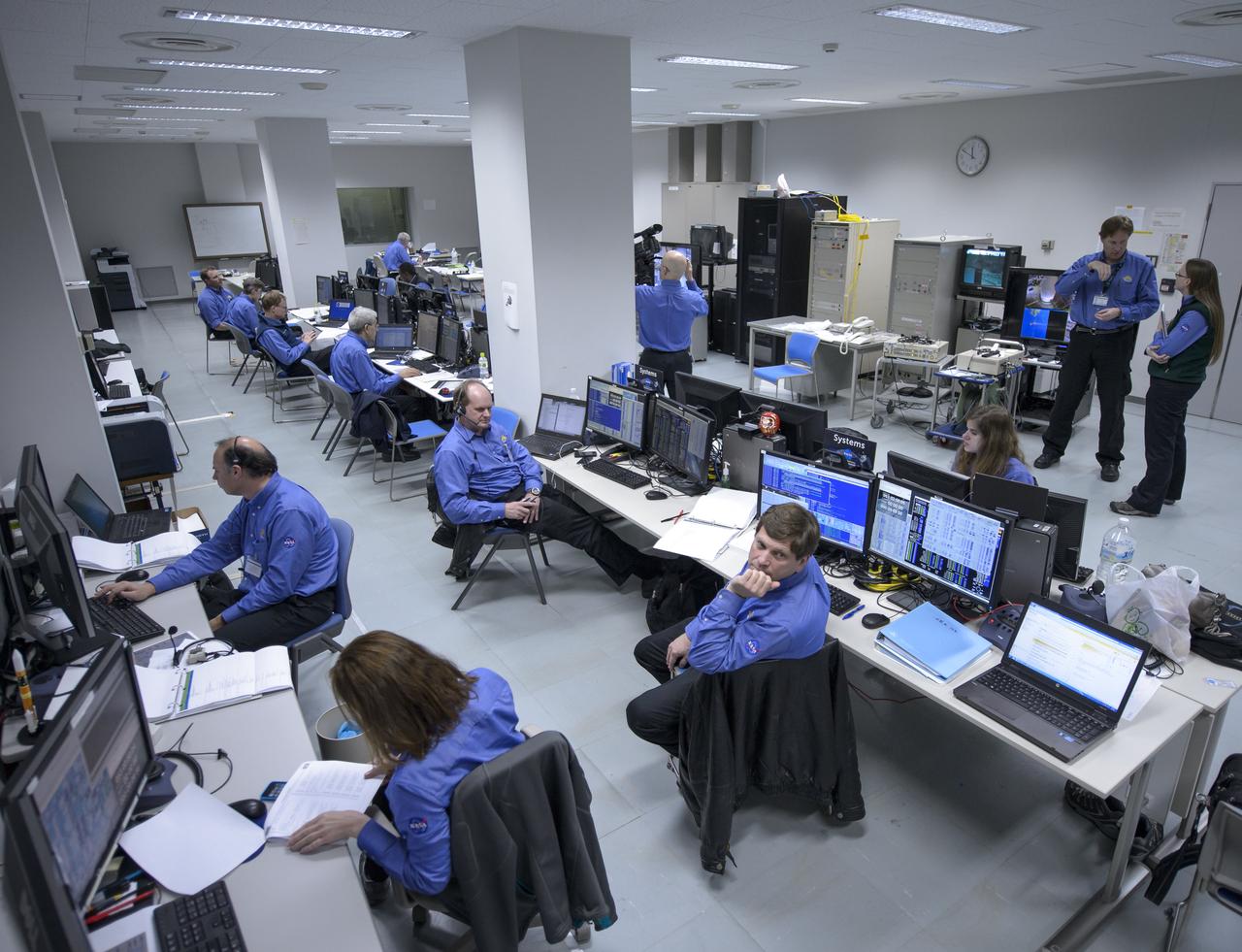
The NASA Global Precipitation Measurement (GPM) Core Observatory team is seen during an all-day launch simulation for GPM at the Spacecraft Test and Assembly Building 2 (STA2), Saturday, Feb. 22, 2014, Tanegashima Space Center (TNSC), Tanegashima Island, Japan. Japan Aerospace Exploration Agency (JAXA) plans to launch an H-IIA rocket carrying the GPM Core Observatory on Feb. 28, 2014. The NASA-JAXA GPM spacecraft will collect information that unifies data from an international network of existing and future satellites to map global rainfall and snowfall every three hours. Photo Credit: (NASA/Bill Ingalls)
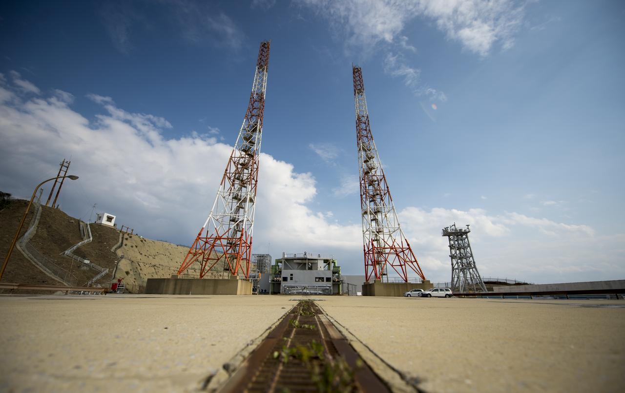
Launch pad 1 is seen at the Tanegashima Space Center (TNSC) on Monday, Feb. 24, 2014 in Tanegashima, Japan. A Japanese H-IIA rocket carrying the NASA-Japan Aerospace Exploration Agency (JAXA), Global Precipitation Measurement (GPM) Core Observatory is planned for launch from pad 1 on Feb. 28, 2014. Once launched, the GPM spacecraft will collect information that unifies data from an international network of existing and future satellites to map global rainfall and snowfall every three hours. Photo Credit: (NASA/Bill Ingalls)
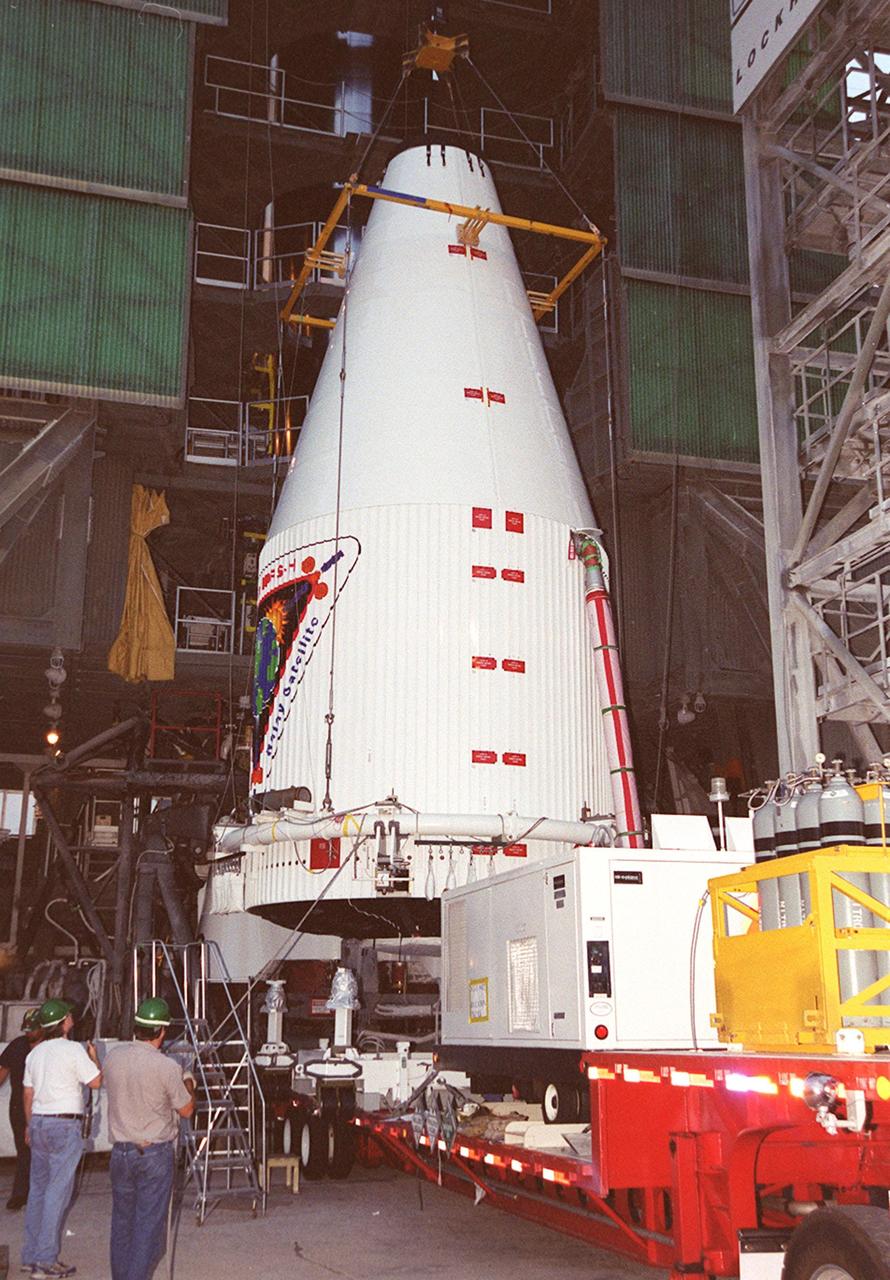
At Launch Pad 36A, Cape Canaveral Air Force Station, workers (at left) oversee the lifting of the nose fairing covering the Tracking and Data Relay Satellite (TDRS-H). Once at the top, the fairing will be mated with the Atlas IIA/Centaur rocket, which is already stacked, for launch on June 29. The satellite will augment the TDRS system’s existing Sand Ku-band frequencies by adding Ka-band capability. TDRS will serve as the sole means of continuous, high-data-rate communication with the Space Shuttle, with the International Space Station upon its completion, and with dozens of unmanned scientific satellites in low earth orbit

Roadside flags welcome the NASA team and visitors to Minamitame Town, one of only a few small towns located outside of the Japan Aerospace Exploration Agency’s (JAXA) Tanegashima Space Center (TNSC), where the launch of an H-IIA rocket carrying the Global Precipitation Measurement (GPM) Core Observatory will take place in the next week, Saturday, Feb. 22, 2014, Tanegashima Island, Japan. The NASA-Japan Aerospace Exploration Agency (JAXA) GPM spacecraft will collect information that unifies data from an international network of existing and future satellites to map global rainfall and snowfall every three hours. The launch is planned for Feb. 28, 2014. Photo Credit: (NASA/Bill Ingalls)

Caroline Bouvier Kennedy, U.S. Ambassador Extraordinary and Plenipotentiary to Japan, right, is welcomed by Japan Aerospace Exploration Agency (JAXA), President, Naoki Okumura, at the Tanegashima Space Center Visitors Center on Thursday, Feb. 27, 2014, Tanegashima, Japan. The Ambassador is visiting the space center and hopes to witness the planned launch of a Japanese H-IIA rocket carrying the NASA-JAXA, Global Precipitation Measurement (GPM) Core Observatory. Once launched, the GPM spacecraft will collect information that unifies data from an international network of existing and future satellites to map global rainfall and snowfall every three hours. Photo Credit: (NASA/Bill Ingalls)

An overhead crane is positioned on the nose fairing covering the Tracking and Data Relay Satellite (TDRS-H) in order to lift it up the tower at Launch Pad 36A, Cape Canaveral Air Force Station. It will be mated with the Atlas IIA/Centaur rocket, which is already stacked, for launch on June 29. The satellite will augment the TDRS system’s existing Sand Ku-band frequencies by adding Ka-band capability. TDRS will serve as the sole means of continuous, high-data-rate communication with the Space Shuttle, with the International Space Station upon its completion, and with dozens of unmanned scientific satellites in low earth orbit