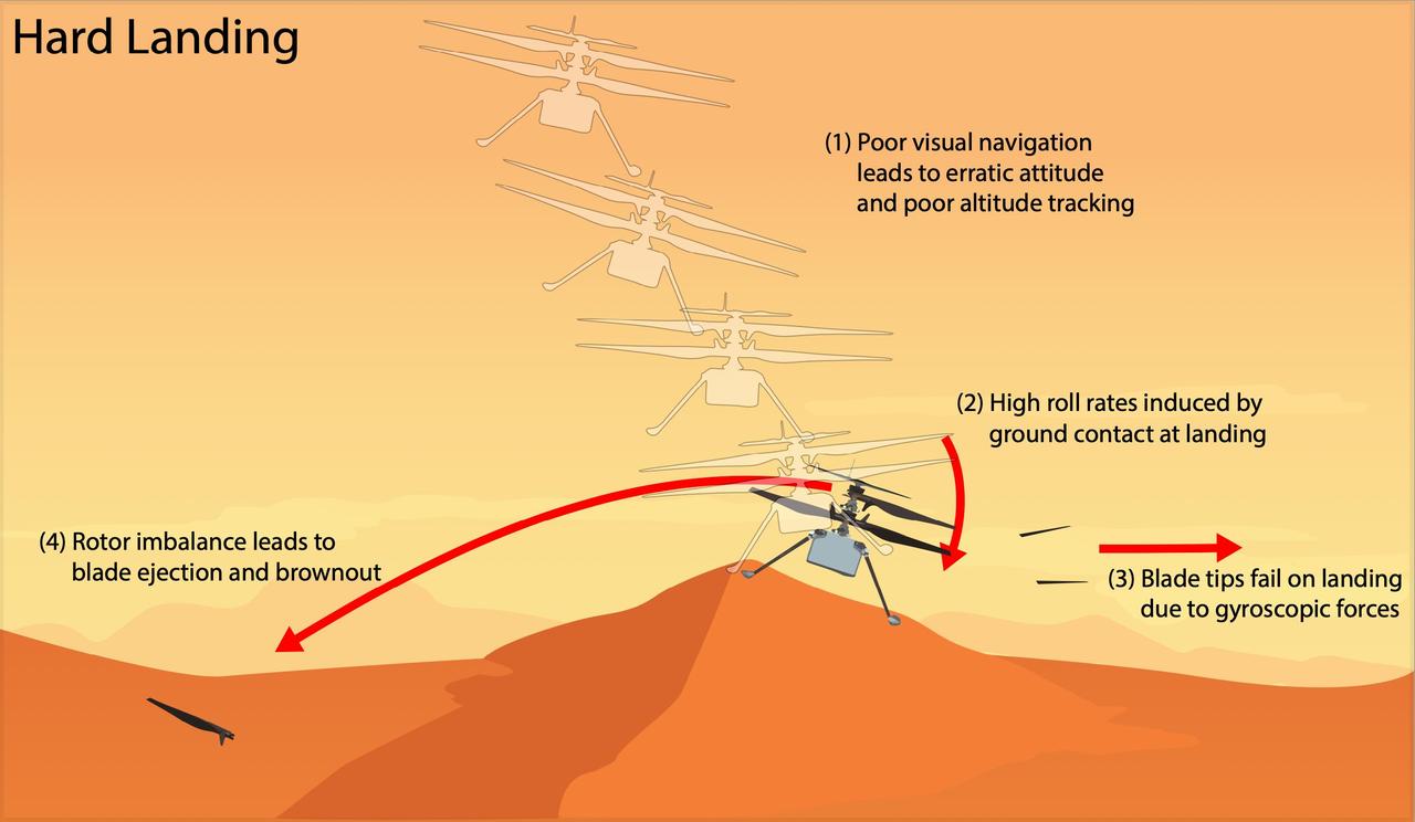
This graphic depicts the most likely scenario for the hard landing NASA's Ingenuity Mars Helicopter took during its 72nd and final flight on Jan. 18, 2024. Engineers at JPL and AeroVironment, which collaborated with NASA on the helicopter's design and development, are completing a detailed assessment of the final flight that will be published as an agency technical report. Flight 72 was planned as a brief vertical hop to assess Ingenuity's flight systems and photograph the surrounding area. Data from the flight shows Ingenuity climbing to 40 feet (12 meters), hovering, and capturing images. It initiated its descent at 19 seconds, and by 32 seconds the helicopter was back on the surface and had halted communications. The assessment describes the mostly likely scenario for Flight 72, as follows. Lack of suitable features on the planet's surface for the helicopter's navigation system to track resulted in high horizontal velocities at the time the helicopter touched down. This caused a hard impact on a sloping sand ripple, making Ingenuity pitch and roll. The rapid attitude change resulted in loads on the fast-rotating rotor blades beyond their design limits, snapping all four of them off at their weakest point – about a third of the way from the tip. The damaged blades caused excessive vibration in the rotor system, ripping the remainder of one blade from its root and generating an excessive power demand that resulted in loss of communications. https://photojournal.jpl.nasa.gov/catalog/PIA26482
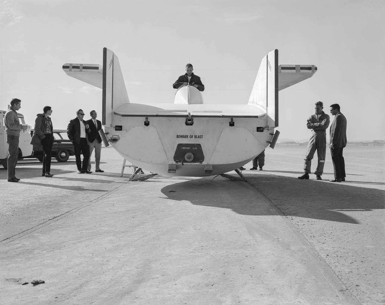
The M2-F1 following a hard landing on Rogers Dry Lake in 1963. It hit the lakebed so hard the rolling gear completely separated.
PAO news release material for the 5th and final FF of the ALT series. Precise moment of separation captured by camera from a T-38 chase plane.

Photography from Shuttle ALT FF-5. S77-30393: ALT Fr. 3258, a higher-up shot of the Enterprise approaching runway for landing. EAFB, CA
MSFC Director Todd May, (green hard hat), poses with FBI Associate Deputy Director Paul Abbate, (4th from right), and agents atop SLS Test Stand 4693 with view toward land being cleared for FBI complex.
This prototype of a collapsible Mars lander base is part of SHIELD (Simplified High Impact Energy Landing Device), a project aimed at developing spacecraft that would intentionally crash land on the Red Planet, using an accordion-like, collapsible base that acts like the crumple zone of a car to absorb the energy of a hard impact. The design could drastically reduce the cost of landing on Mars by simplifying the harrowing entry, descent, and landing process and expanding options for possible landing sites. Developed at NASA's Jet Propulsion Laboratory in Southern California, the prototype was attached to a drop tower on Aug. 12, 2022, at JPL. https://photojournal.jpl.nasa.gov/catalog/PIA25420

This colorful illustration depicts NASA's Perseverance Rover on Mars, where it landed in February 2021. The Perseverance team faced numerous technical and logistical challenges, including those presented by the COVID-19 pandemic, before and after launch and landing. Because they know how hard it can be to overcome obstacles, they're celebrating students who have persevered in the face of academic challenges. Awardees will receive a personal message beamed back from Mars by the rover. Find out how to nominate a student for "You've Got Perseverance!" at: go.nasa.gov/gotperseverance Animation available at https://photojournal.jpl.nasa.gov/catalog/PIA24948

On December 3, 1999) Mars Polar Lander (MPL) was set to touchdown on the enigmatic layered terrain located near the South Pole. Unfortunately, communications with the spacecraft were lost and never regained. The Mars Program Independent Assessment Team concluded that this loss was most likely due to premature retrorocket shutdown resulting in the crash of the lander. The image primarily shows what appears to be a ridged surface with some small isolated hills. Historically, exploration has and will continue to be a very hard and risky endeavor and sometimes you lose. But the spirit of exploration and discovery has served mankind well throughout the ages and it has now driven us to the far reaches of space. Therefore, with this in mind the THEMIS Team today is releasing an image of the region where MPL was set to land in memory of this mission and the unquenchable spirit of exploration. It is hoped that in the near future we will once again attempt another landing in the Martian polar regions. http://photojournal.jpl.nasa.gov/catalog/PIA04016
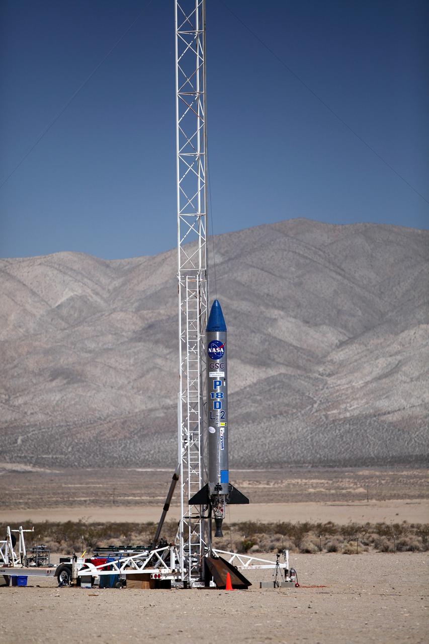
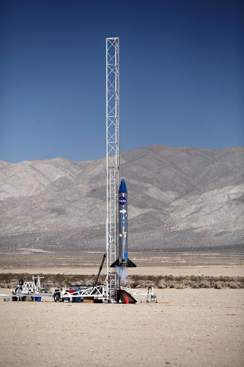
MOJAVE DESERT, Calif. – In the Mojave Desert in California, final checkouts are completed on the Garvey Spacecraft Corporation's Prospector P-18D rocket positioned for launch with the RUBICS-1 payload on a high-altitude, suborbital flight. The rocket will carry four satellites made from four-inch cube sections. The rocket reached a peak altitude of about 9,000 feet, however the parachute deployed prematurely and the vehicle continued on its trajectory, coasting and tumbling to a hard landing on its side. In spite of the rough ride, all four CubeSats were recovered. PhoneSat and RUBICS received data in flight, but sustained structural damage. CP-9 and StangSat fared better, and their teams are working to recover as much information as possible. Collectively known as CubeSats, the satellites were designed to record shock, vibrations and heat inside the rocket. The results will be used to prove or strengthen their designs before they are carried into orbit in 2014 on a much larger rocket. Built by several different organizations, including a university, a NASA field center and a high school, the spacecraft are four-inch cubes designed to fly on their own eventually, but will remain firmly attached to the rocket during the upcoming mission. For more information, visit http://www.nasa.gov/mission_pages/smallsats/elana/cubesatlaunchpreview.html Photo credit: NASA/Dimitri Gerondidakis
MOJAVE DESERT, Calif. – In the Mojave Desert in California, Kevin Baxter, a range representative of the Friends of Amateur Rocketry launch site, ensures all is ready for launch of the Garvey Spacecraft Corporation's Prospector P-18D rocket with the RUBICS-1 payload on a high-altitude, suborbital flight. The rocket will carry four satellites made from four-inch cube sections. The rocket reached a peak altitude of about 9,000 feet, however the parachute deployed prematurely and the vehicle continued on its trajectory, coasting and tumbling to a hard landing on its side. In spite of the rough ride, all four CubeSats were recovered. PhoneSat and RUBICS received data in flight, but sustained structural damage. CP-9 and StangSat fared better, and their teams are working to recover as much information as possible. Collectively known as CubeSats, the satellites were designed to record shock, vibrations and heat inside the rocket. The results will be used to prove or strengthen their designs before they are carried into orbit in 2014 on a much larger rocket. Built by several different organizations, including a university, a NASA field center and a high school, the spacecraft are four-inch cubes designed to fly on their own eventually, but will remain firmly attached to the rocket during the upcoming mission. For more information, visit http://www.nasa.gov/mission_pages/smallsats/elana/cubesatlaunchpreview.html Photo credit: NASA/Dimitri Gerondidakis
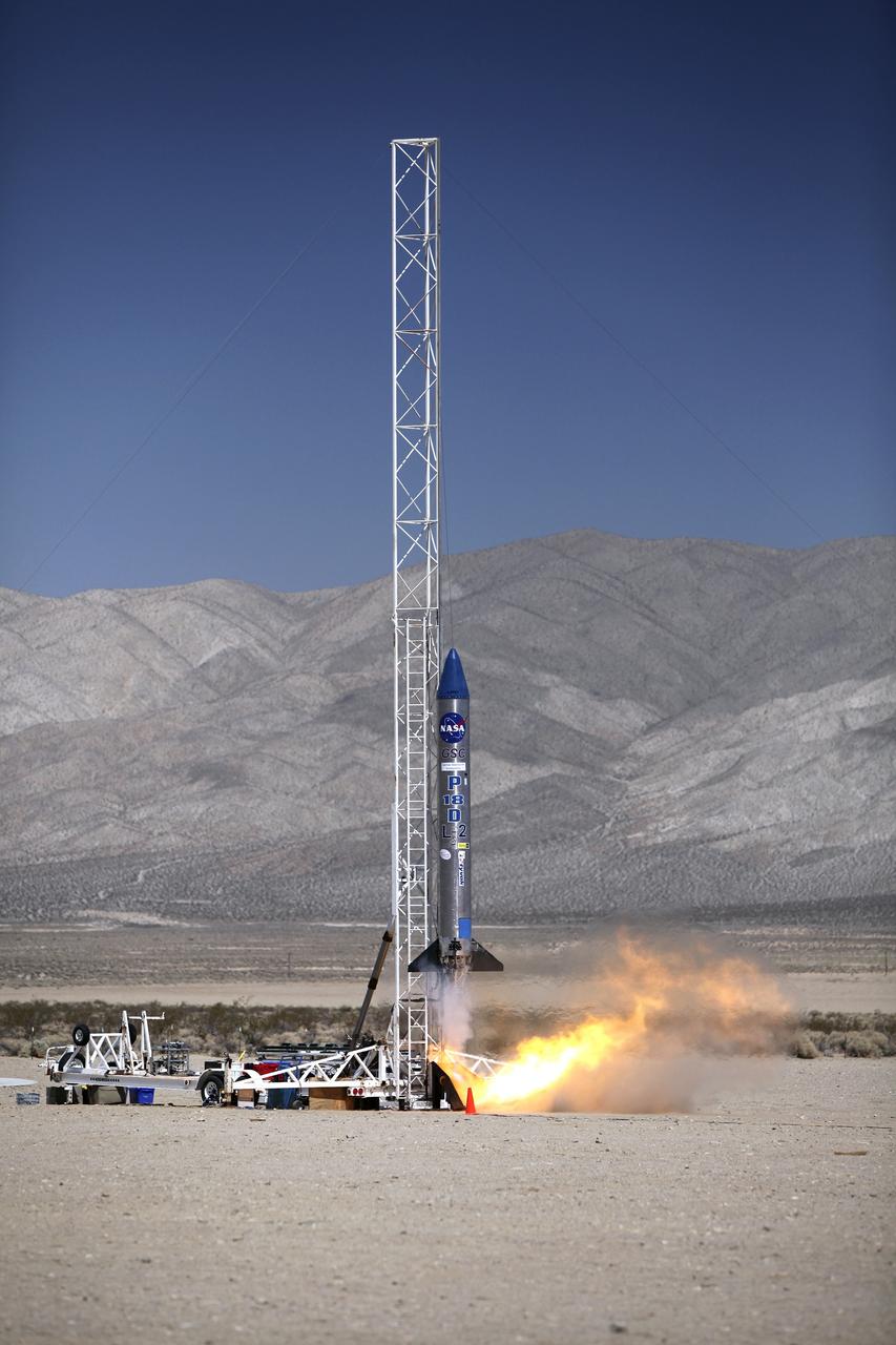
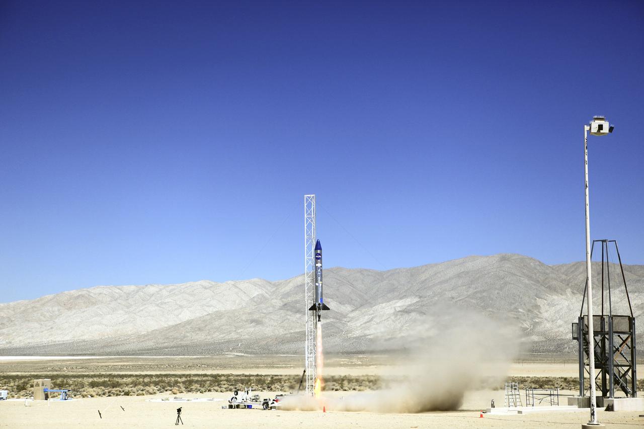
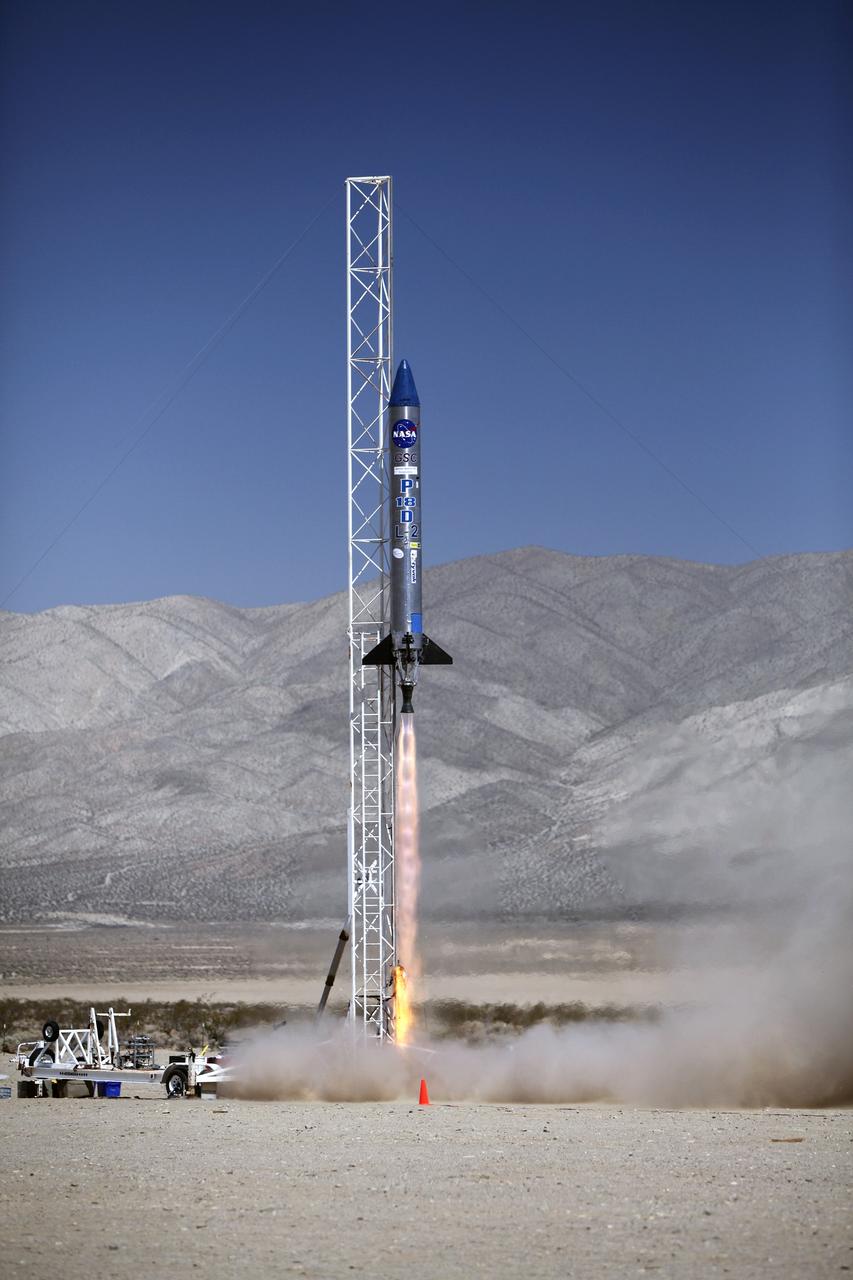
MOJAVE DESERT, Calif. – In the Mojave Desert in California, the Garvey Spacecraft Corporation's Prospector P-18D rocket lifts off at 10:52 a.m. PDT carrying the RUBICS-1 payload on a high-altitude, suborbital flight. The rocket carried four satellites made from four-inch cube sections. The rocket reached a peak altitude of about 9,000 feet, however the parachute deployed prematurely and the vehicle continued on its trajectory, coasting and tumbling to a hard landing on its side. In spite of the rough ride, all four CubeSats were recovered. PhoneSat and RUBICS received data in flight, but sustained structural damage. CP-9 and StangSat fared better, and their teams are working to recover as much information as possible. Collectively known as CubeSats, the satellites were designed to record shock, vibrations and heat inside the rocket. The results will be used to prove or strengthen their designs before they are carried into orbit in 2014 on a much larger rocket. Built by several different organizations, including a university, a NASA field center and a high school, the spacecraft are four-inch cubes designed to fly on their own eventually, but will remain firmly attached to the rocket during the upcoming mission. For more information, visit http://www.nasa.gov/mission_pages/smallsats/elana/cubesatlaunchpreview.html Photo credit: NASA/Dimitri Gerondidakis
MOJAVE DESERT, Calif. – In the Mojave Desert in California, the Garvey Spacecraft Corporation's Prospector P-18D rocket lifts off at 10:52 a.m. PDT carrying the RUBICS-1 payload on a high-altitude, suborbital flight. The rocket carried four satellites made from four-inch cube sections. The rocket reached a peak altitude of about 9,000 feet, however the parachute deployed prematurely and the vehicle continued on its trajectory, coasting and tumbling to a hard landing on its side. In spite of the rough ride, all four CubeSats were recovered. PhoneSat and RUBICS received data in flight, but sustained structural damage. CP-9 and StangSat fared better, and their teams are working to recover as much information as possible. Collectively known as CubeSats, the satellites were designed to record shock, vibrations and heat inside the rocket. The results will be used to prove or strengthen their designs before they are carried into orbit in 2014 on a much larger rocket. Built by several different organizations, including a university, a NASA field center and a high school, the spacecraft are four-inch cubes designed to fly on their own eventually, but will remain firmly attached to the rocket during the upcoming mission. For more information, visit http://www.nasa.gov/mission_pages/smallsats/elana/cubesatlaunchpreview.html Photo credit: NASA/Dimitri Gerondidakis
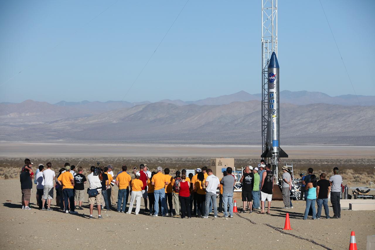
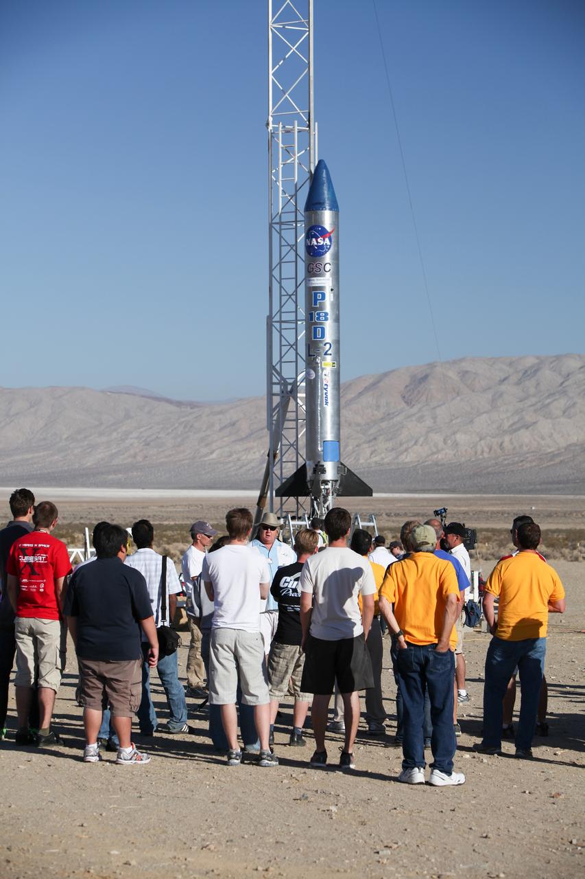
MOJAVE DESERT, Calif. – In the Mojave Desert in California, students and engineers participate in a pre-launch briefing before the lift off of the Garvey Spacecraft Corporation's Prospector P-18D rocket. The rocket is scheduled to launch the RUBICS-1 payload on a high-altitude, suborbital flight. The rocket will carry four satellites made from four-inch cube sections. The rocket reached a peak altitude of about 9,000 feet, however the parachute deployed prematurely and the vehicle continued on its trajectory, coasting and tumbling to a hard landing on its side. In spite of the rough ride, all four CubeSats were recovered. PhoneSat and RUBICS received data in flight, but sustained structural damage. CP-9 and StangSat fared better, and their teams are working to recover as much information as possible. Collectively known as CubeSats, the satellites were designed to record shock, vibrations and heat inside the rocket. The results will be used to prove or strengthen their designs before they are carried into orbit in 2014 on a much larger rocket. Built by several different organizations, including a university, a NASA field center and a high school, the spacecraft are four-inch cubes designed to fly on their own eventually, but will remain firmly attached to the rocket during the upcoming mission. For more information, visit http://www.nasa.gov/mission_pages/smallsats/elana/cubesatlaunchpreview.html Photo credit: NASA/Dimitri Gerondidakis

MOJAVE DESERT, Calif. – In the Mojave Desert in California, the Garvey Spacecraft Corporation's Prospector P-18D rocket lifts off at 10:52 a.m. PDT carrying the RUBICS-1 payload on a high-altitude, suborbital flight. The rocket carried four satellites made from four-inch cube sections. The rocket reached a peak altitude of about 9,000 feet, however the parachute deployed prematurely and the vehicle continued on its trajectory, coasting and tumbling to a hard landing on its side. In spite of the rough ride, all four CubeSats were recovered. PhoneSat and RUBICS received data in flight, but sustained structural damage. CP-9 and StangSat fared better, and their teams are working to recover as much information as possible. Collectively known as CubeSats, the satellites were designed to record shock, vibrations and heat inside the rocket. The results will be used to prove or strengthen their designs before they are carried into orbit in 2014 on a much larger rocket. Built by several different organizations, including a university, a NASA field center and a high school, the spacecraft are four-inch cubes designed to fly on their own eventually, but will remain firmly attached to the rocket during the upcoming mission. For more information, visit http://www.nasa.gov/mission_pages/smallsats/elana/cubesatlaunchpreview.html Photo credit: NASA/Dimitri Gerondidakis
MOJAVE DESERT, Calif. – In the Mojave Desert in California, students and engineers participate in a pre-launch briefing before the lift off of the Garvey Spacecraft Corporation's Prospector P-18D rocket. The rocket is scheduled to launch the RUBICS-1 payload on a high-altitude, suborbital flight. The rocket will carry four satellites made from four-inch cube sections. The rocket reached a peak altitude of about 9,000 feet, however the parachute deployed prematurely and the vehicle continued on its trajectory, coasting and tumbling to a hard landing on its side. In spite of the rough ride, all four CubeSats were recovered. PhoneSat and RUBICS received data in flight, but sustained structural damage. CP-9 and StangSat fared better, and their teams are working to recover as much information as possible. Collectively known as CubeSats, the satellites were designed to record shock, vibrations and heat inside the rocket. The results will be used to prove or strengthen their designs before they are carried into orbit in 2014 on a much larger rocket. Built by several different organizations, including a university, a NASA field center and a high school, the spacecraft are four-inch cubes designed to fly on their own eventually, but will remain firmly attached to the rocket during the upcoming mission. For more information, visit http://www.nasa.gov/mission_pages/smallsats/elana/cubesatlaunchpreview.html Photo credit: NASA/Dimitri Gerondidakis
MOJAVE DESERT, Calif. – In the Mojave Desert in California, the Garvey Spacecraft Corporation's Prospector P-18D rocket lifts off at 10:52 a.m. PDT carrying the RUBICS-1 payload on a high-altitude, suborbital flight. The rocket carried four satellites made from four-inch cube sections. The rocket reached a peak altitude of about 9,000 feet, however the parachute deployed prematurely and the vehicle continued on its trajectory, coasting and tumbling to a hard landing on its side. In spite of the rough ride, all four CubeSats were recovered. PhoneSat and RUBICS received data in flight, but sustained structural damage. CP-9 and StangSat fared better, and their teams are working to recover as much information as possible. Collectively known as CubeSats, the satellites were designed to record shock, vibrations and heat inside the rocket. The results will be used to prove or strengthen their designs before they are carried into orbit in 2014 on a much larger rocket. Built by several different organizations, including a university, a NASA field center and a high school, the spacecraft are four-inch cubes designed to fly on their own eventually, but will remain firmly attached to the rocket during the upcoming mission. For more information, visit http://www.nasa.gov/mission_pages/smallsats/elana/cubesatlaunchpreview.html Photo credit: NASA/Dimitri Gerondidakis
MOJAVE DESERT, Calif. – In the Mojave Desert in California, the Garvey Spacecraft Corporation's Prospector P-18D rocket is positioned for launch with the RUBICS-1 payload on a high-altitude, suborbital flight. The rocket will carry four satellites made from four-inch cube sections. The rocket reached a peak altitude of about 9,000 feet, however the parachute deployed prematurely and the vehicle continued on its trajectory, coasting and tumbling to a hard landing on its side. In spite of the rough ride, all four CubeSats were recovered. PhoneSat and RUBICS received data in flight, but sustained structural damage. CP-9 and StangSat fared better, and their teams are working to recover as much information as possible. Collectively known as CubeSats, the satellites were designed to record shock, vibrations and heat inside the rocket. The results will be used to prove or strengthen their designs before they are carried into orbit in 2014 on a much larger rocket. Built by several different organizations, including a university, a NASA field center and a high school, the spacecraft are four-inch cubes designed to fly on their own eventually, but will remain firmly attached to the rocket during the upcoming mission. For more information, visit http://www.nasa.gov/mission_pages/smallsats/elana/cubesatlaunchpreview.html Photo credit: NASA/Dimitri Gerondidakis
S70-34421 (April 1970) --- Prime crew men and backup crew men, of the Apollo 14 lunar landing mission, look over an area near the site of a volcanic eruption on Dec. 30, 1969. Astronauts Alan B. Shepard Jr. (leaning with left hand on ground) and Edgar D. Mitchell (behind Shepard, wearing dark glasses) are the prime crew men scheduled to walk on the moon. Astronauts Eugene A. Cernan (almost obscured at extreme left) and Joe H. Engle (partially visible, on Cernan's right) are backup crew commander and lunar module pilot, respectively, for the mission. Others in the photograph are Pat Crosland (in hard hat), a geologist and a park ranger in Hawaii Volcanoes State Park; Michael C. McEwen (facing Mitchell) of the Geology Branch, Lunar and Earth Sciences Division, Manned Spacecraft Center (MSC); and astronaut Bruce McCandless II, who made the trip to serve as a spacecraft communicator during simulations of extravehicular activity (EVA) on the lunar surface.
NASA research pilot John A. Manke is seen here in front of the M2-F3 Lifting Body. Manke was hired by NASA on May 25, 1962, as a flight research engineer. He was later assigned to the pilot's office and flew various support aircraft including the F-104, F5D, F-111 and C-47. After leaving the Marine Corps in 1960, Manke worked for Honeywell Corporation as a test engineer for two years before coming to NASA. He was project pilot on the X-24B and also flew the HL-10, M2-F3, and X-24A lifting bodies. John made the first supersonic flight of a lifting body and the first landing of a lifting body on a hard surface runway. Manke served as Director of the Flight Operations and Support Directorate at the Dryden Flight Research Center prior to its integration with Ames Research Center in October 1981. After this date John was named to head the joint Ames-Dryden Directorate of Flight Operations. He also served as site manager of the NASA Ames-Dryden Flight Research Facility. John is a member of the Society of Experimental Test Pilots. He retired on April 27, 1984.
MOJAVE DESERT, Calif. – In the Mojave Desert in California, the Garvey Spacecraft Corporation's Prospector P-18D rocket lifts off at 10:52 a.m. PDT carrying the RUBICS-1 payload on a high-altitude, suborbital flight. The rocket carried four satellites made from four-inch cube sections. The rocket reached a peak altitude of about 9,000 feet, however the parachute deployed prematurely and the vehicle continued on its trajectory, coasting and tumbling to a hard landing on its side. In spite of the rough ride, all four CubeSats were recovered. PhoneSat and RUBICS received data in flight, but sustained structural damage. CP-9 and StangSat fared better, and their teams are working to recover as much information as possible. Collectively known as CubeSats, the satellites were designed to record shock, vibrations and heat inside the rocket. The results will be used to prove or strengthen their designs before they are carried into orbit in 2014 on a much larger rocket. Built by several different organizations, including a university, a NASA field center and a high school, the spacecraft are four-inch cubes designed to fly on their own eventually, but will remain firmly attached to the rocket during the upcoming mission. For more information, visit http://www.nasa.gov/mission_pages/smallsats/elana/cubesatlaunchpreview.html Photo credit: NASA/Dimitri Gerondidakis
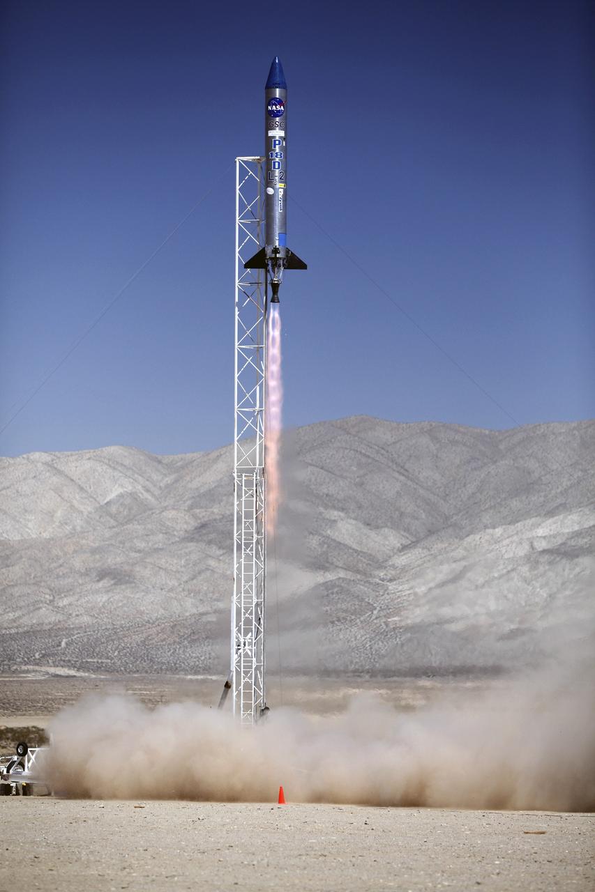
MOJAVE DESERT, Calif. – In the Mojave Desert in California, the ignition sequence begins on the Garvey Spacecraft Corporation's Prospector P-18D rocket. The vehicle is carrying the RUBICS-1 payload on a high-altitude, suborbital flight. The rocket carried four satellites made from four-inch cube sections. The rocket reached a peak altitude of about 9,000 feet, however the parachute deployed prematurely and the vehicle continued on its trajectory, coasting and tumbling to a hard landing on its side. In spite of the rough ride, all four CubeSats were recovered. PhoneSat and RUBICS received data in flight, but sustained structural damage. CP-9 and StangSat fared better, and their teams are working to recover as much information as possible. Collectively known as CubeSats, the satellites were designed to record shock, vibrations and heat inside the rocket. The results will be used to prove or strengthen their designs before they are carried into orbit in 2014 on a much larger rocket. Built by several different organizations, including a university, a NASA field center and a high school, the spacecraft are four-inch cubes designed to fly on their own eventually, but will remain firmly attached to the rocket during the upcoming mission. For more information, visit http://www.nasa.gov/mission_pages/smallsats/elana/cubesatlaunchpreview.html Photo credit: NASA/Dimitri Gerondidakis
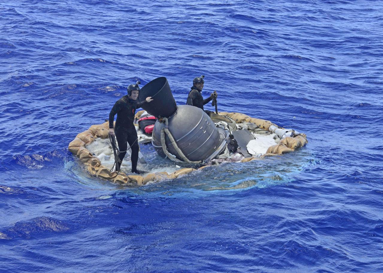
Two members of the U.S. Navy's Mobile Diving Salvage Unit (MDSU) 1 Explosive Ordnance Detachment work on recovering the test vehicle for NASA's Low-Density Supersonic Decelerator (LDSD) project. The saucer-shaped LDSD craft splashed down at 11:49 a.m. HST (2:49 PDT/5:49 p.m. EDT) Monday, June 8, 2015, in the Pacific Ocean off the west coast of the Kauai, Hawaii, after a four-hour experimental flight test that investigated new technologies for landing future robotic and human Mars missions. During the flight test, a Supersonic Inflatable Aerodynamic Decelerator (SIAD) and a supersonic parachute were deployed. The SIAD operated as expected, dramatically slowing the test vehicle's velocity. When the parachute was deployed into the supersonic slipstream, it appeared to blossom to full inflation prior to the emergence of a tear which then propagated and destroyed the parachute's canopy. As a result, the saucer's splashdown in the Pacific Ocean was hard, resulting in fracturing parts of the structure. Memory cards containing comprehensive test data -- including high-speed, high-resolution imagery recorded during the flight -- were successfully recovered. Also recovered were the test vehicle and its components, the supersonic parachute, the ballute used to deploy the parachute, and a large weather balloon that initially carried the saucer to an altitude of 120,000 feet. http://photojournal.jpl.nasa.gov/catalog/PIA19684
MOJAVE DESERT, Calif. – In the Mojave Desert in California, the Garvey Spacecraft Corporation's Prospector P-18D rocket lifts off at 10:52 a.m. PDT carrying the RUBICS-1 payload on a high-altitude, suborbital flight. The rocket carried four satellites made from four-inch cube sections. The rocket reached a peak altitude of about 9,000 feet, however the parachute deployed prematurely and the vehicle continued on its trajectory, coasting and tumbling to a hard landing on its side. In spite of the rough ride, all four CubeSats were recovered. PhoneSat and RUBICS received data in flight, but sustained structural damage. CP-9 and StangSat fared better, and their teams are working to recover as much information as possible. Collectively known as CubeSats, the satellites were designed to record shock, vibrations and heat inside the rocket. The results will be used to prove or strengthen their designs before they are carried into orbit in 2014 on a much larger rocket. Built by several different organizations, including a university, a NASA field center and a high school, the spacecraft are four-inch cubes designed to fly on their own eventually, but will remain firmly attached to the rocket during the upcoming mission. For more information, visit http://www.nasa.gov/mission_pages/smallsats/elana/cubesatlaunchpreview.html Photo credit: NASA/Dimitri Gerondidakis
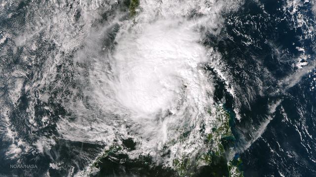
Tropical Storm Hagupit's low level circulation center is being obscured by its deep central convection and intensities are hard to pinpoint as the storm interacts with land. Once clear over the waters of the South China Sea Hagupit is forecast to continue weakening as it approaches the southern coast of Vietnam. This image was taken by the Suomi NPP satellite's VIIRS instrument around 0510Z on December 8, 2014. NASA/NOAA/NPP Credit: NASA/NOAA via <b><a href="www.nnvl.noaa.gov/" rel="nofollow"> NOAA Environmental Visualization Laboratory</a></b> <b><a href="http://www.nasa.gov/audience/formedia/features/MP_Photo_Guidelines.html" rel="nofollow">NASA image use policy.</a></b> <b><a href="http://www.nasa.gov/centers/goddard/home/index.html" rel="nofollow">NASA Goddard Space Flight Center</a></b> enables NASA’s mission through four scientific endeavors: Earth Science, Heliophysics, Solar System Exploration, and Astrophysics. Goddard plays a leading role in NASA’s accomplishments by contributing compelling scientific knowledge to advance the Agency’s mission. <b>Follow us on <a href="http://twitter.com/NASAGoddardPix" rel="nofollow">Twitter</a></b> <b>Like us on <a href="http://www.facebook.com/pages/Greenbelt-MD/NASA-Goddard/395013845897?ref=tsd" rel="nofollow">Facebook</a></b> <b>Find us on <a href="http://instagram.com/nasagoddard?vm=grid" rel="nofollow">Instagram</a></b>
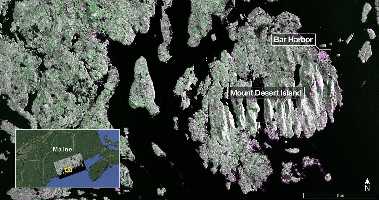
The NISAR (NASA-ISRO Synthetic Aperture Radar) Earth-observing radar satellite's L-band synthetic aperture radar (SAR) system captured this image of Mount Desert Island off the Maine coast on Aug. 21, 2025. Dark areas represent water, green areas are forest, and magenta areas are hard or regular surfaces, such as bare ground or buildings. The bright magenta area on the island's northeast end is the town of Bar Harbor. The satellite is a joint effort between NASA and the Indian Space Research Organisation (ISRO) and is the first satellite to combine L-band and S-band radar systems. The L-band system uses a 10-inch (25-centimeter) wavelength that enables its signal to penetrate forest canopies and measure soil moisture as well as motion of ice surfaces and land down to fractions of an inch – a key measurement in understanding how the land surface moves before, during, and after earthquakes, volcanic eruptions, and landslides. The S-band radar, provided by ISRO's Space Applications Centre, uses a 4-inch (10-centimeter) microwave signal that's more sensitive to small vegetation, which makes it effective at monitoring certain types of agriculture and grassland ecosystems. Data used to create the image was collected during NISAR's commissioning phase, when the spacecraft's systems and instruments are powered on and tested. The NISAR mission will begin science operations in November, roughly 90 days after its July 30, 2025, launch from Satish Dhawan Space Centre on India's southeastern coast. Observations from NISAR will benefit humanity by helping researchers around the world better understand changes in our planet's surface, including its ice sheets, glaciers, and sea ice. It also will capture changes in forest and wetland ecosystems and track movement and deformation of our planet's crust by phenomena such as earthquakes, landslides, and volcanic activity. The global and rapid coverage from NISAR will provide unprecedented support for disaster response, producing data to assist in mitigating and assessing damage, with observations before and after catastrophic events available in short time frames. https://photojournal.jpl.nasa.gov/catalog/PIA26616
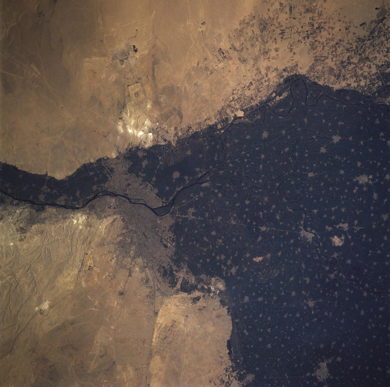
STS081-717-096 (12-22 Jan. 1997) --- The crewmembers, like astronauts 30 years ago, found the Nile River and its conspicuous delta an irresistible photo target from space, in this case from the Space Shuttle Atlantis' overhead windows. The majority of people living in Egypt reside in the city of Cairo. One of the most intensely cultivated lands in the world, the Nile delta can lay claim to some of the highest levels of soil salinity, as well as to being one of the highest users of fertilizer. The majority of Egypt's arable land is located in the delta. Cairo is "young" when compared to Egypt's long history, and has been a city since the Roman Empire. Although the city itself is relatively young, a site on the eastern bank of the Nile became the first capital of Egypt around 4225 BC. The city was called "Oun", but later was renamed Heliopolis by the Greeks. In 1991 the population of Cairo was estimated to be 54,600,000. The Pyramids of Gizai, one of the Seven Wonders of the Ancient World, can be seen on the western edge of the Nile delta and Cairo. The smallest and youngest of three Old Kingdom pyramids, Menkaure, is hard to distinguish because of its small size which casts a small shadow. Khafre is located between Menkaure and the Great Pyramid, and was originally 143 meters high. From the ground it appears that Khafre is taller than the other pyramids but this is an illusion caused by Khafre being built on higher ground. Khufu, or the Great Pyramid, was the first of the three to be built, and at an original height of 147 meters, is the tallest pyramid.
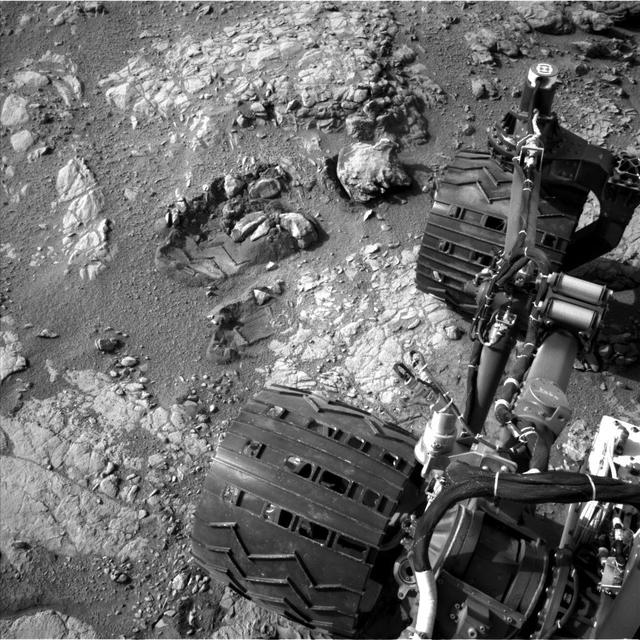
This view of Curiosity's left-front and left-center wheels and of marks made by wheels on the ground in the "Yellowknife Bay" area comes from one of six cameras used on Mars for the first time more than six months after the rover landed. The left Navigation Camera (Navcam) linked to Curiosity's B-side computer took this image during the 223rd Martian day, or sol, of Curiosity's work on Mars (March 22, 2013). The wheels are 20 inches (50 centimeters) in diameter. Curiosity carries a pair of main computers, redundant to each other, in order to have a backup available if one fails. Each of the computers, A-side and B-side, also has other redundant subsystems linked to just that computer. Curiosity operated on its A-side from before the August 2012 landing until Feb. 28, when engineers commanded a switch to the B-side in response to a memory glitch on the A-side. One set of activities after switching to the B-side computer has been to check the six engineering cameras that are hard-linked to that computer. The rover's science instruments, including five science cameras, can each be operated by either the A-side or B-side computer, whichever is active. However, each of Curiosity's 12 engineering cameras is linked to just one of the computers. The engineering cameras are the Navigation Camera (Navcam), the Front Hazard-Avoidance Camera (Front Hazcam) and Rear Hazard-Avoidance Camera (Rear Hazcam). Each of those three named cameras has four cameras as part of it: two stereo pairs of cameras, with one pair linked to each computer. Only the pairs linked to the active computer can be used, and the A-side computer was active from before landing, in August, until Feb. 28. All six of the B-side engineering cameras have been used during March 2013 and checked out OK. Image Credit: NASA/JPL-Caltech <b><a href="http://www.nasa.gov/audience/formedia/features/MP_Photo_Guidelines.html" rel="nofollow">NASA image use policy.</a></b> <b><a href="http://www.nasa.gov/centers/goddard/home/index.html" rel="nofollow">NASA Goddard Space Flight Center</a></b> enables NASA’s mission through four scientific endeavors: Earth Science, Heliophysics, Solar System Exploration, and Astrophysics. Goddard plays a leading role in NASA’s accomplishments by contributing compelling scientific knowledge to advance the Agency’s mission. <b>Follow us on <a href="http://twitter.com/NASA_GoddardPix" rel="nofollow">Twitter</a></b> <b>Like us on <a href="http://www.facebook.com/pages/Greenbelt-MD/NASA-Goddard/395013845897?ref=tsd" rel="nofollow">Facebook</a></b> <b>Find us on <a href="http://instagram.com/nasagoddard?vm=grid" rel="nofollow">Instagram</a></b>

ISS012-E-15918 (24 Jan. 2006) --- Belle Isle and a portion of Newfoundland, Canada are featured in this image photographed by an Expedition 12 crew member on the International Space Station. Belle Isle (center) is surrounded by sea ice in this recent winter view. Belle Isle lies in the strait between the Island of Newfoundland and Labrador (the mainland portion of Canada’s province of Newfoundland). Small islands along the coast of Labrador appear in the top left corner. In this key location Belle Isle lies on the shortest shipping lanes between the Great Lakes and Europe, and also on the main north-south shipping route to Hudson Bay and the Northwest Territories. Snow and ice in this recent winter view obliterate the dozens of glacier-scoured lakes that dot the surface of the island. The single community of Belle Isle Landing on the southeast tip is equally hard to see. Ice patterns also show that the island lies at the meeting point of two sea currents. The Labrador Current flows from the northwest (top left), and a smaller current, driven by dominant westerly winds, flows from the southwest (lower left) out of the narrow Belle Isle Strait (out of frame lower left). Flow lines in sea ice indicate the sense of movement of the ice. Ice floes embedded in the Labrador Current appear in the upper part of the image as a relatively open pattern. Sea ice with a denser pattern enters from the lower left corner, banking against the west side of Belle Isle. Tendrils flow around capes at either end of the island, with an ice-free “shadow” on the opposite, downstream side. Eddies (center) in the ice patterns show where the currents interact, north and west of the island.
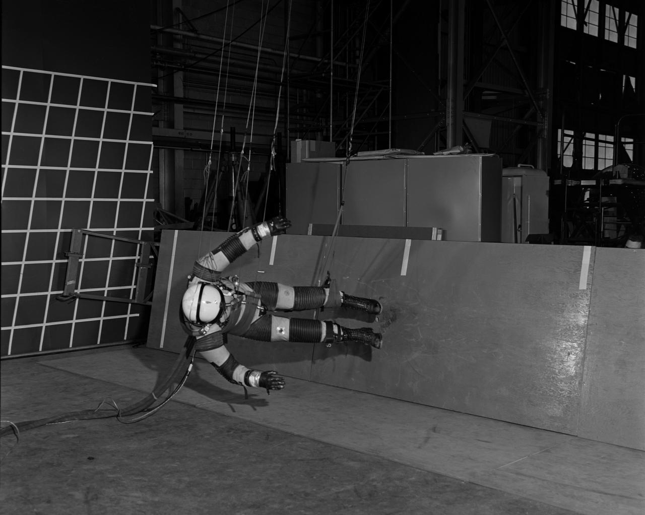
A "suited" test subject on the Reduced Gravity Walking Simulator located in the hangar at Langley Research Center. The initial version of this simulator was located inside the hangar. Later a larger version would be located at the Lunar Landing Facility. The purpose of this simulator was to study the subject while walking, jumping or running. Researchers conducted studies of various factors such as fatigue limit, energy expenditure, and speed of locomotion. Francis B. Smith wrote in "Simulators For Manned Space Research:" "The cables which support the astronaut are supported by an overhead trolley about 150 feet above the center line of the walkway and the support is arranged so that the subject is free to walk, run, jump, and perform other self-locomotive tasks in a more-or-less normal manner, even though he is constrained to move in one place." "The studies thus far show that an astronaut should have no particular difficulty in walking in a pressurized space suit on a hard lunar surface. Rather, the pace was faster and the suit was found to be more comfortable and less fatiguing under lunar "g" than under earth "g." When the test subject wished to travel hurriedly any appreciable distance, a long loping gait at about 10 feet per second was found to be most comfortable." -- Published in James R. Hansen, Spaceflight Revolution: NASA Langley Research Center From Sputnik to Apollo, (Washington: NASA, 1995), p. 377; Francis B. Smith, "Simulators For Manned Space Research," Paper for 1966 IEEE International Convention, New York, NY, March 21-25, 1966.
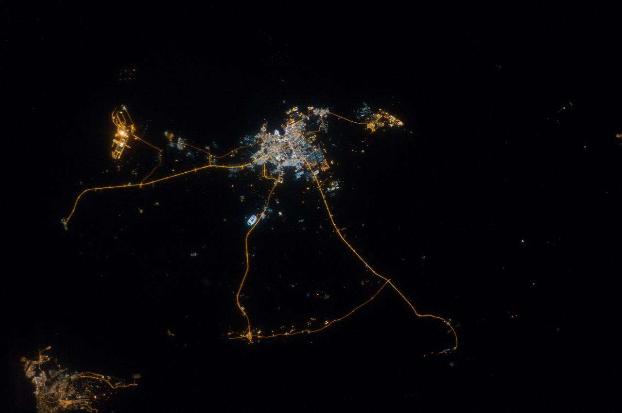
ISS033-E-014856 (13 Oct. 2012) --- A nighttime view of Qatar is featured in this image photographed by an Expedition 33 crew member on the International Space Station. Night lights can be very revealing regarding the distribution of people on the landscape. Here the lights of Qatar show the precise demographic geography of the country. The brightest group at center shows the capital city Doha with the neighboring smaller ports of Ad-Dahira and Umm Sa?id to the north and south, respectively. Even highways and their relative importance can be discerned. Highways are clearly visible leading from the capital west to the Dukhan oil fields, to Saudi Arabia, and to the north of the country--where, judging by the lack of night lights, the population is very low. The relatively low-traffic coast road between the oil fields and the Saudi frontier also stands out. This kind of highly informative human geographic detail is very difficult to discern in daylight images, in which even larger cities, especially in deserts, are hard to see. Almost the entire island nation of Bahrain appears at lower left, with its capital city Manama nearly as bright as the lights of Doha. The difference in light intensity reflects a difference in population?Doha has 1.45 million inhabitants, while the very dense Manama metro area has a population of 1.2 million. While some night views are highly informative about a landscape, they can also be difficult and confusing to identify. Astronauts learn to recognize where they are at night by flying over populated places repeatedly, even though coastlines?one of their best geographic indicators?are generally lost to view because water surfaces and unpopulated land surfaces look the same without illumination (such as from a full moon). Thus the thumb-shaped Qatari peninsula, so well-known in Middle Eastern geography, cannot be discerned at all in this night image. The inset at top right overlays the coastline as seen in daylight onto the night patterns of the image. It shows the Qatari peninsula, with the long arm of the Gulf of Bahrain separating it from Saudi Arabia.
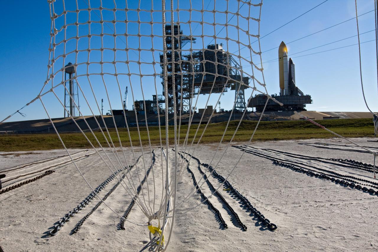
CAPE CANAVERAL, Fla. – At NASA's Kennedy Space Center in Florida, space shuttle Endeavour approaches Launch Pad 39A as seen through a catch net for a slidewire basket, part of the emergency egress system at the pad. The system includes seven baskets suspended from seven slidewires that extend from the fixed service structure to a landing zone 1,200 feet west of the pad. Endeavour's first motion on its 3.4-mile trek from the Vehicle Assembly Building, known as rollout, was at 4:13 a.m. EST Jan. 6. Endeavour was secure or "hard down" on the pad at 10:37 a.m. Rollout is a significant milestone in launch processing activities. The primary payload for the STS-130 mission is the International Space Station's Node 3, Tranquility, a pressurized module that will provide room for many of the station's life support systems. Attached to one end of Tranquility is a cupola, a unique work area with six windows on its sides and one on top. The cupola resembles a circular bay window and will provide a vastly improved view of the station's exterior. The multi-directional view will allow the crew to monitor spacewalks and docking operations, as well as provide a spectacular view of Earth and other celestial objects. The module was built in Turin, Italy, by Thales Alenia Space for the European Space Agency. Endeavour's STS-130 launch is targeted for 4:39 a.m. EST Feb. 7. For information on the STS-130 mission and crew, visit http://www.nasa.gov/mission_pages/shuttle/shuttlemissions/sts130/index.html. Photo credit: NASA/Amanda Diller
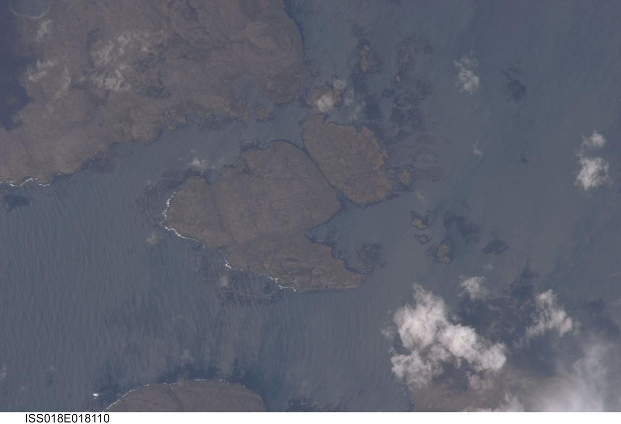
ISS018-E-018110 (6 Jan. 2009) --- Kerguelen Kelp Beds in the Southern Indian Ocean are featured in this image photographed by an Expedition 18 crewmember on the International Space Station. MacMurdo and Howe Islands are two of the 300 islands of the Kerguelen Archipelago, a remote place located in the Southern Indian Ocean that belongs to the French Southern and Antarctic Lands. The Kerguelen Archipelago is also known as the "Desolation Islands". The coastal regions of the islands support low vegetation (mainly genus Acaena), while elevations above 50 meters are rocky. There are no permanent inhabitants of the islands, but there is a permanent settlement (Port aux Francais) that hosts scientists mainly interested in biology, oceanography and earth sciences ? in addition, the settlement maintains a weather station and satellite/rocket tracking station. Latitudinal weather conditions are typical from the ?roaring forties? through the ?furious fifties? - on the day this image was taken, the mean daily temperature was 4.5 degrees Celsius with mean westerly winds of 9 meters per second. A substantial proportion of the coastlines of sub-Antarctic islands, like the Kerguelen Islands, are occupied by highly productive giant kelp beds (Macrocystis pyrifera). One of the largest marine macroalgaes, the species can grow up to 50 meters in length, forming undersea forests in hard-bottom subtidal areas. Fronds can spread out to form a canopy which can totally cover the water surface ? we interpret that the black patches surrounding coastal areas in this astronaut photograph are the offshore kelp beds. These forests serve as a habitat for marine fauna, and due to their large biomass and relatively long turnover act as an efficient sink for atmospheric carbon dioxide. The surface wave pattern traveling southeastward along the gray-blue ocean surface, and through the kelp beds, are visible due to the sunglint from the water surface. This also improves the identification of the kelp beds by creating a different water texture (and therefore a contrast) between the dark vegetation and the ocean surface. Kerguelen Archipelago hosts thousands of marine birds (penguins, albatrosses, and petrels among others) and seals (elephant and Antarctic fur species). Whales (humpback) and dolphins (killer whales and Commerson's dolphin) are very common in the area. Fishing boats also frequent the Archipelago ? including unlicensed, so-called ?pirate? fishing vessels.
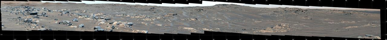
This mosaic features a rover-eye view of the "South Séítah" geologic unit of Jezero Crater. Composed of 84 enhanced-color images that were later stitched together, the mosaic was taken on Sept. 12, 2021 (the 201st Martian day, or sol, of the mission), by the Mastcam-Z imager as the rover was parked on an elevated overlook just outside its entry point into South Séítah. An annotated version of this image (Figure 1) indicates the location of several prominent geologic features. At the top left and running about a third of the way to the center of the image is a portion of the delta front, a river delta that billions of years ago fed the lake at Jezero Crater. Below and to the right of that is a ridge nicknamed "Faillefeu" (after a medieval abbey in the French Alps). Farther to the right, at the top of the image is the distant peak called "Santa Cruz." While not a planned destination of the rover, Santa Cruz is geologically interesting since it has mineral signatures – seen both from orbit and by the rover (from its landing site) – consistent with alteration minerals, primarily clays. Near the top at the far right is a portion of the route Perseverance took to get to this location. At the time, Perseverance was traveling south, skirting the outside of the Séítah geologic unit. To the right (and out of frame), Perseverance would take a hard right and head northwest along a ridgeline just outside of Séítah. The Mastcam-Z investigation is led and operated by Arizona State University in Tempe, working in collaboration with Malin Space Science Systems in San Diego, California, on the design, fabrication, testing, and operation of the cameras, and in collaboration with the Neils Bohr Institute of the University of Copenhagen on the design, fabrication, and testing of the calibration targets. A key objective for Perseverance's mission on Mars is astrobiology, including the search for signs of ancient microbial life. The rover will characterize the planet's geology and past climate, pave the way for human exploration of the Red Planet, and be the first mission to collect and cache Martian rock and regolith (broken rock and dust). Subsequent NASA missions, in cooperation with ESA (European Space Agency), would send spacecraft to Mars to collect these sealed samples from the surface and return them to Earth for in-depth analysis. The Mars 2020 Perseverance mission is part of NASA's Moon to Mars exploration approach, which includes Artemis missions to the Moon that will help prepare for human exploration of the Red Planet. https://photojournal.jpl.nasa.gov/catalog/PIA24816