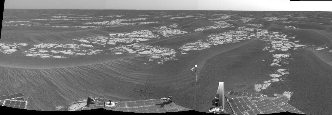
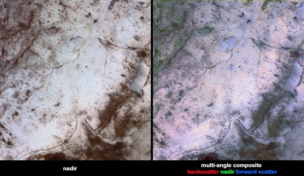
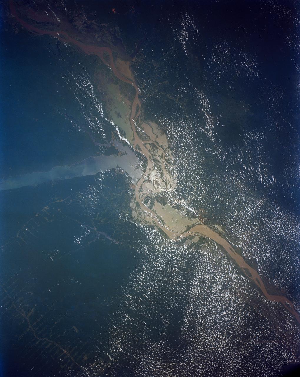
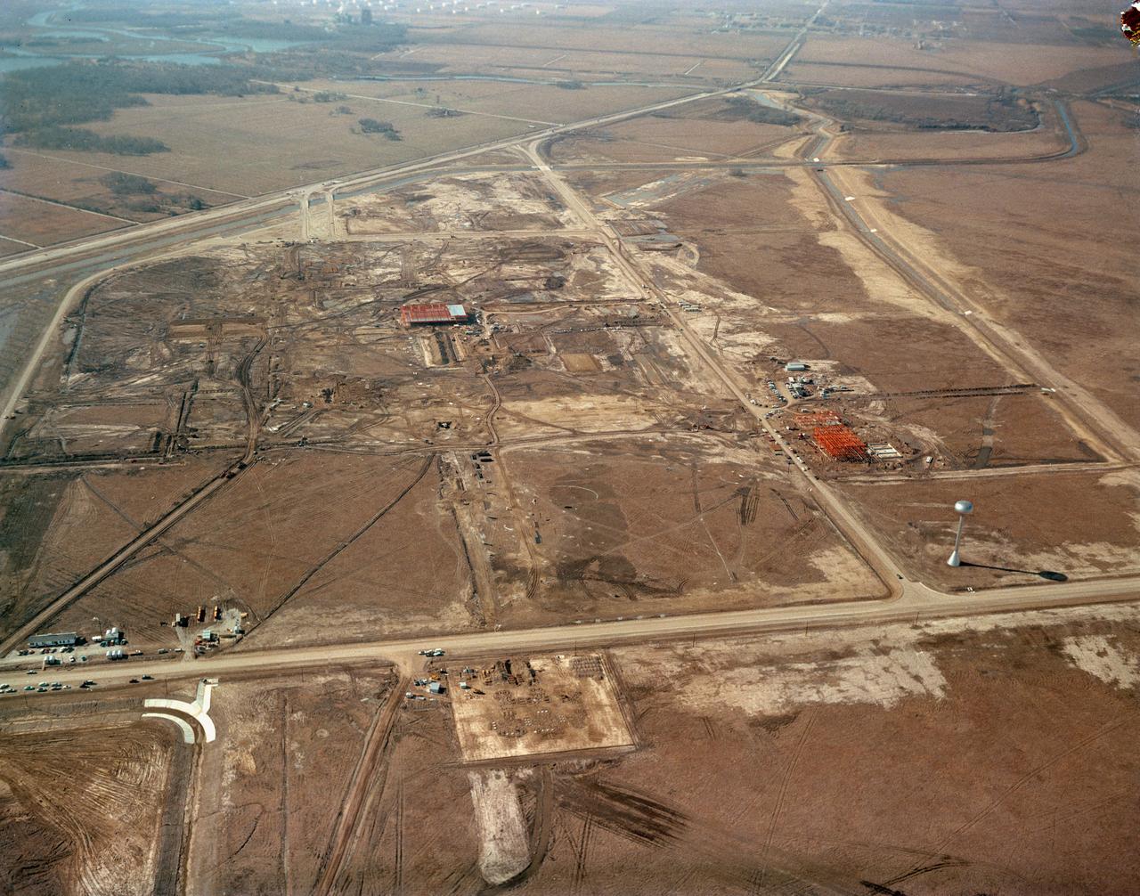
Heading South on Erebus Highway
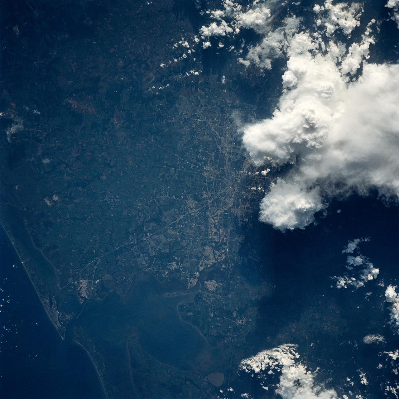
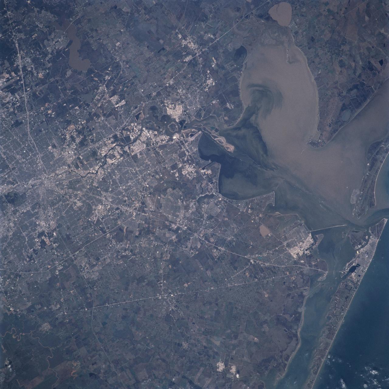
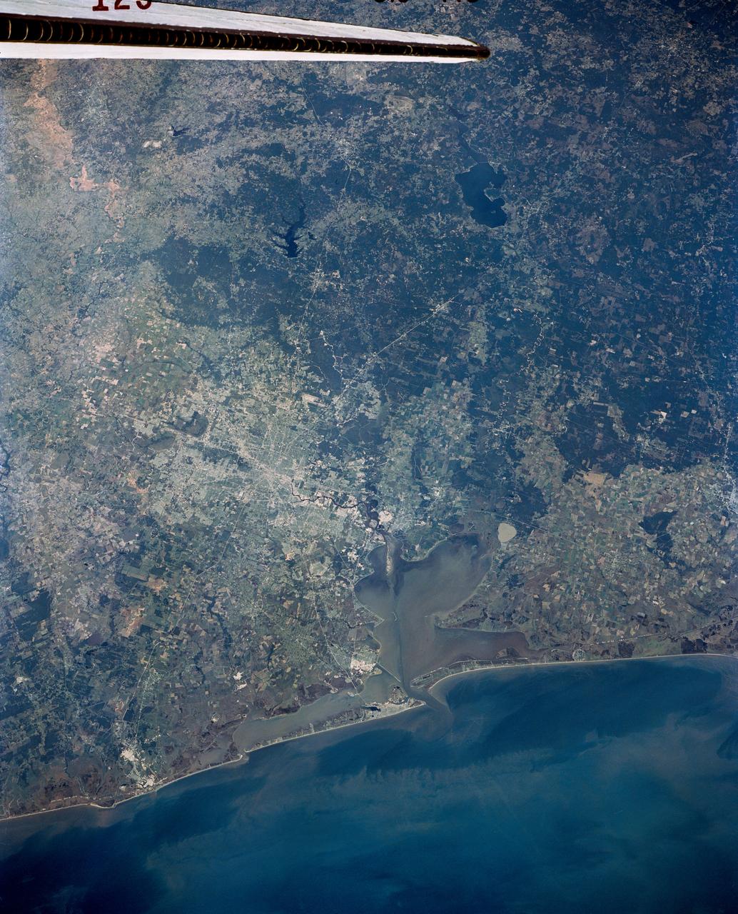
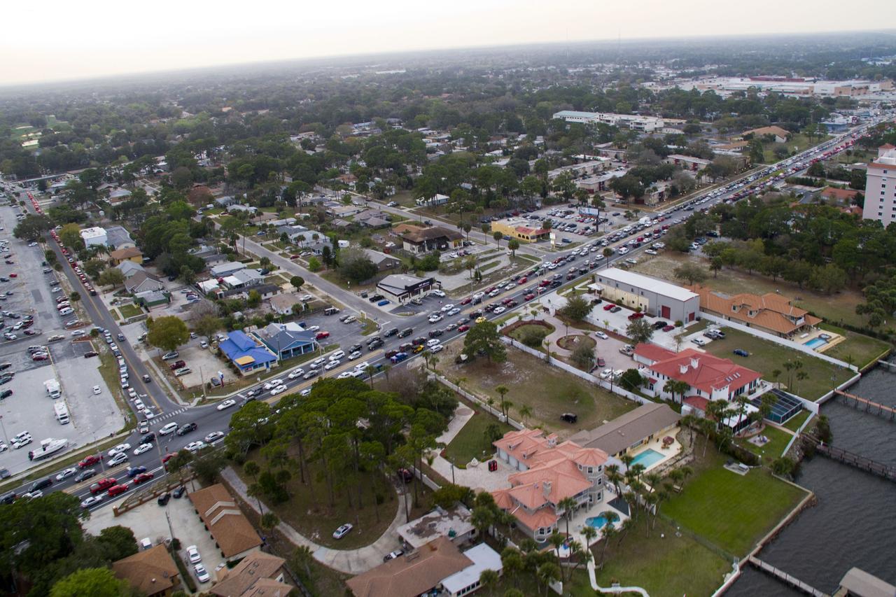
In this view of Houston/Galveston, Texas, USA (29.5N, 95.5W), heavy spring rains emphasize the several bodies of water in the area. Even though partially cloud covered, the progressive nature of the Houston highway and freeway system can easily be observed in this highly detailed view. To the south, the NASA, Clear Lake area just off of Galveston Bay can easily be seen. In the center, is the downtown business district.
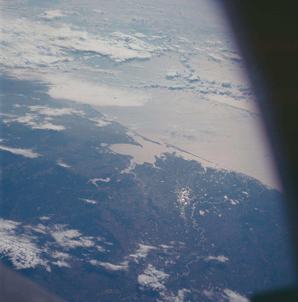
AS09-22-3463 (9 March 1969) --- Oblique view of the Houston, Texas area as photographed from the Apollo 9 spacecraft during its Earth-orbital mission. This picture was taken from an altitude of 103 nautical miles, at about 1:40 p.m. (CST), on March 9, 1969. Prominent features visible include highways leading out of the city, Lake Houston, San Jacinto River, Trinity Bay, Galveston Bay, Brazos River, Baytown, and Texas City.

This view of deforestation in Rondonia, far western Brazil, (10.0S, 63.0W) is part of an agricultural resettlement project which ultimately covers an area about 80% the size of France. The patterns of deforestation in this part of the Amazon River Basin are usually aligned adjacent to highways, secondary roads, and streams for ease of access and transportation. Compare this view with the earlier 51G-37-062 for a comparison of deforestation in the region.
AS09-21-3299 (3-13 March 1969) --- Dallas-Fort Worth area as photographed from the Apollo 9 spacecraft during its Earth-orbital mission. The superhighways leading out of two cities are clearly visible. The largest body of water north of Dallas is the Garza-Little Elm Reservoir. Cedar Creek Reservoir is located to the southeast of Dallas. The City of Denton is near left center edge of picture at junction of two highways leading from Fort Worth and Dallas.
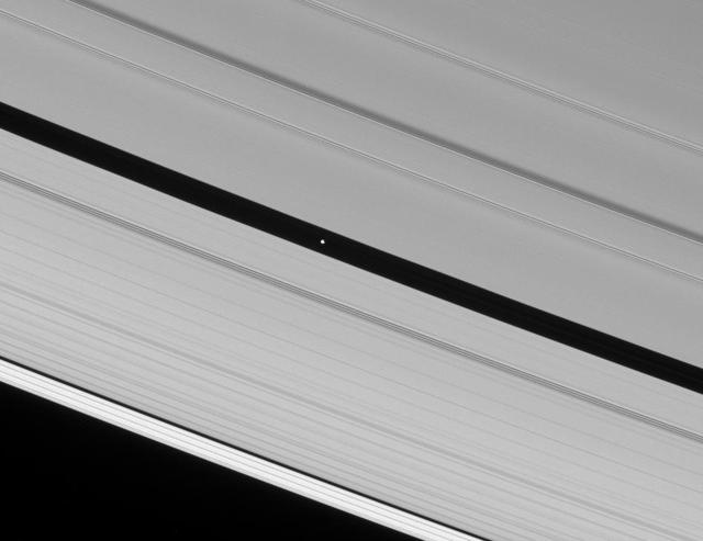
The Cassini spacecraft spies Pan speeding through the Encke Gap, its own private path around Saturn
STS040-152-100 (5-14 June 1991) --- Although clouds obscure part of the city of San Francisco and the mouth of San Francisco Bay, development and physiographic features in the immediate vicinity of the bay are well displayed. The photograph clearly shows the eastern part of the city, including the Embarcadero, the Bay Bridge, which was damaged in the 1989 earthquake, and Candlestick Park, San Mateo, and Dumbarton Bridges, cross the southern portion of the bay. Vari-colored salt ponds also rim the southern Bay near Moffett Field. Highway 280 runs along the San Andreas fault south of the city. On the eastern margin of the bay are Berkeley the Sacramento River and the Haywood and Calaveras faults.

This image from a set of animations show NASA Voyager 1 spacecraft exploring a new region in our solar system called the magnetic highway.
STS039-151-175 (28 April-6 May 1991) --- Large format (five-inch) frame of part of the greater Houston metropolitan area photographed from the Earth-orbiting Space Shuttle Discovery. (Hold photo vertically with Galveston at bottom so that north will be at top.) Heavier than normal spring rains emphasize the several bodies of water in the area. Thanks to Sun angle, the interstate highways, Houston's belt and loop systems and even city streets, farm-to-market roads and airport runways are easily observed in the frame. NASA and Clear Lake City, work and home areas of the seven Discovery astronaut crew members, are easily spotted near upper Galveston Bay in bottom (south portion) of the frame. Houston's central business district and the Harris County Domed Stadium are seen in the upper left quadrant.
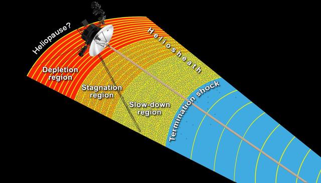
This artist concept shows NASA Voyager 1 spacecraft exploring a region called the depletion region or magnetic highway at the outer limits of our heliosphere, the bubble the sun blows around itself.

NASA Spitzer Space Telescope surveyed the danger zones around five O-stars in the Rosette nebula. This artist animation illustrates how this process works.
Heavy snowfall on March 12, 2004, across north China Inner Mongolia Autonomous Region, Mongolia and Russia, caused train and highway traffic to stop for several days along the Russia-China border shown here by NASA Terra spacecraft.
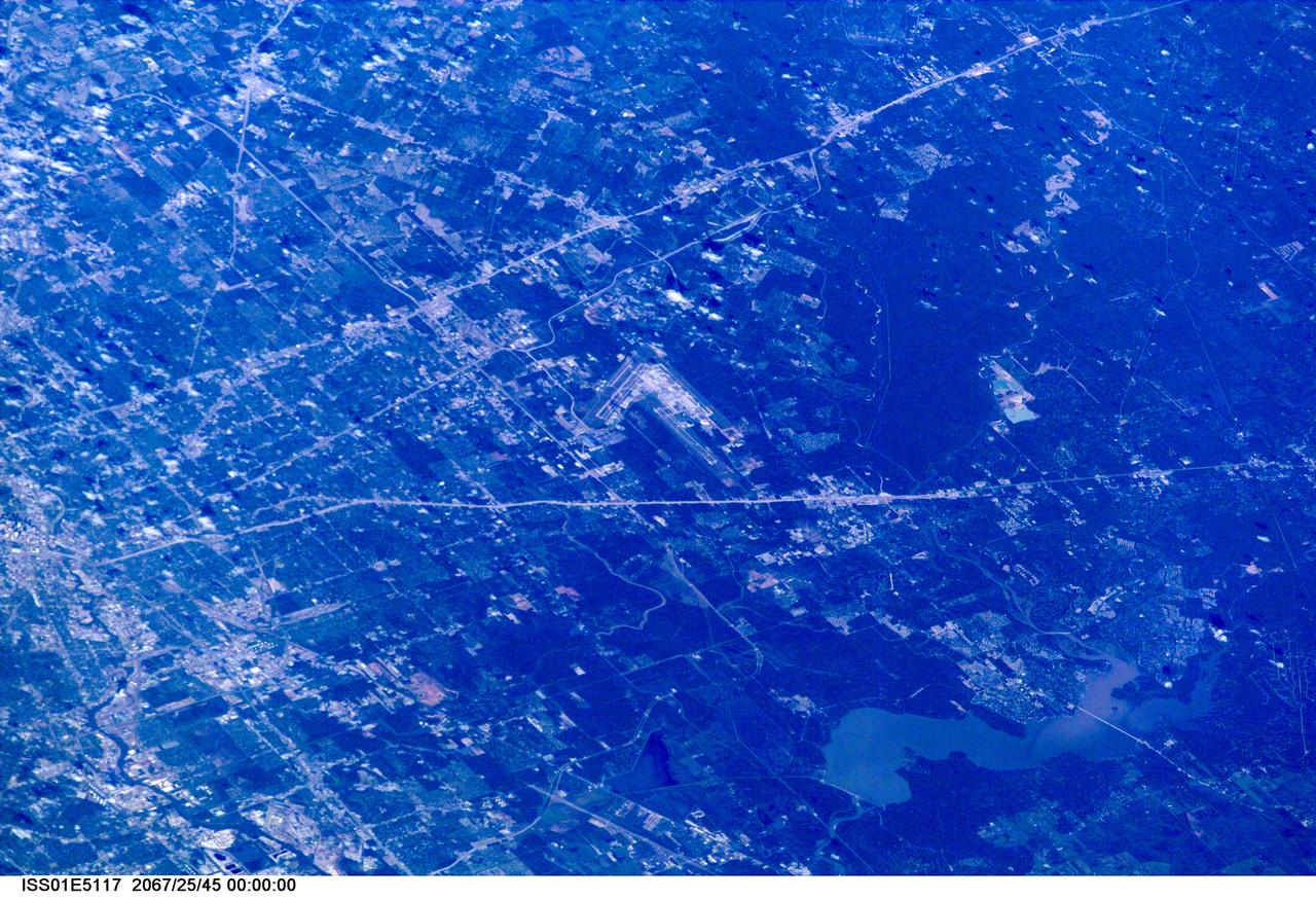
ISS01-E-5117 (December 2000) --- This westerly-looking view over north Harris County featuring Lake Houston and the Bush Intercontinental Airport was photographed with a digital still camera from the Earth-orbiting International Space Station (ISS). Parts of the 610 Loop, Interstate Highway 45, U.S. Highway 59 and the Sam Houston Toll Way can be easily delineated in the view. Part of the downtown area is just below center at left edge of the frame.
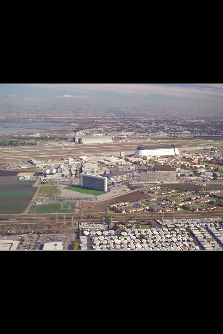
Ames Research Center, Moffett Field, CA Aerials showing the National Full Scale Aerodynamic Complex (NFAC) sign which can be seen from U.S. Highway 101 in Northern California

AS06-02-1462 (4 April 1968) --- View of the Dallas-Fort Worth, Texas, area as photographed from the unmanned Apollo 6 (Spacecraft 020/Saturn 502) space mission. The highway and expressway system in and around both cities is clearly visible. North is toward left side of picture. Grapevine Reservoir and Garza-Little Elm Reservoir are to the north-west of Dallas. The city of Denton can be seen in left center of picture at conjunction of highways leading to both Fort Worth and Dallas. The Brazos River is in lower right corner. This photograph was made three hours and nine minutes after liftoff of the Apollo 6 space flight.

Stennis Space Center Director Patrick Scheuermann (second from left) stands at the historical marker erected by the state of Mississippi in honor of the 50th anniversary of the NASA facility. Joining Scheuermann are: (l to r) Ron Magee, Al Watkins, Tish Williams and Ken P'Pool.
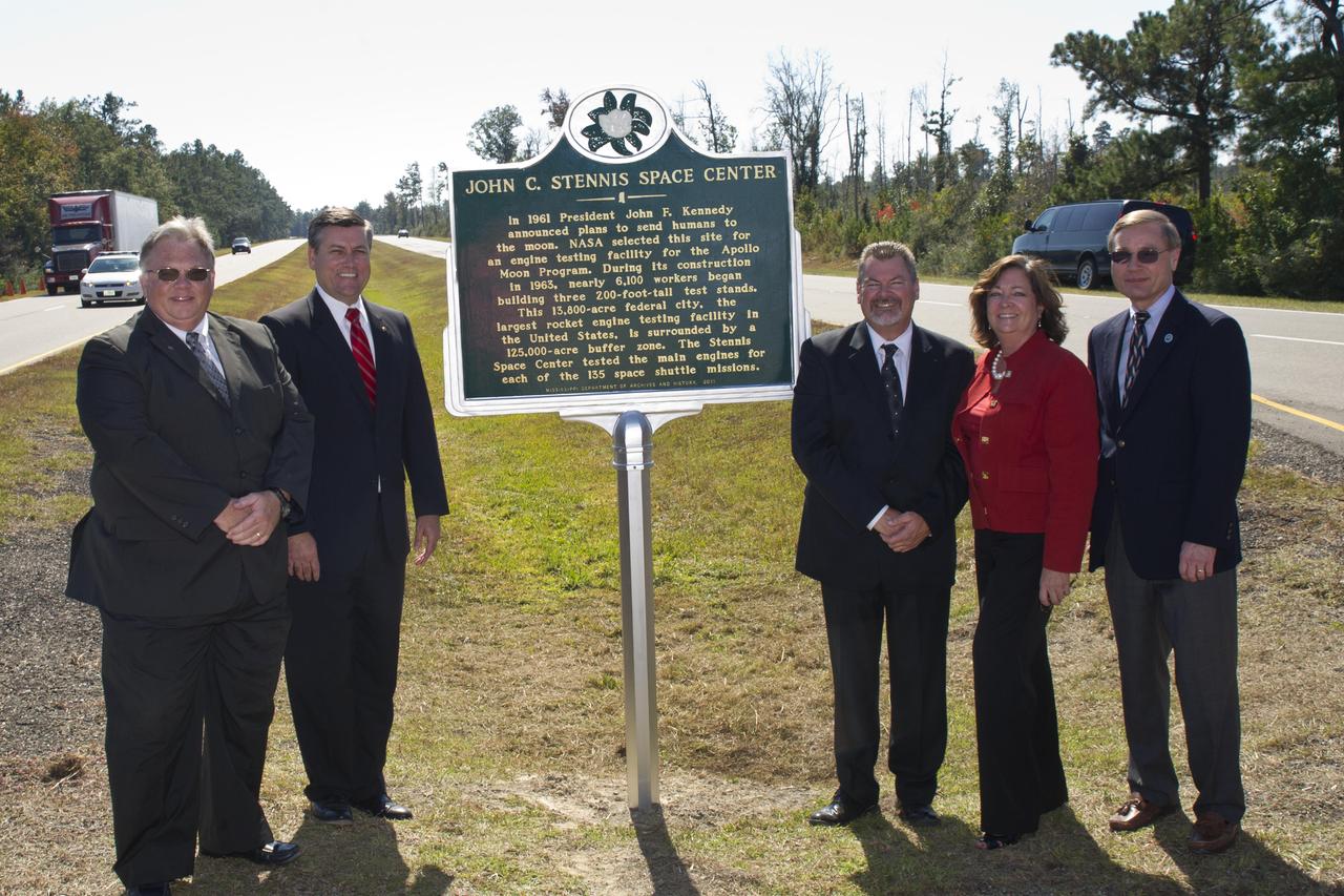
Stennis Space Center Director Patrick Scheuermann (second from left) stands at the historical marker erected by the state of Mississippi in honor of the 50th anniversary of the NASA facility. Joining Scheuermann are: (l to r) Ron Magee, Al Watkins, Tish Williams and Ken P'Pool.

Lawrence Livermore National Labs (LLNL), Navistar and the Department of Energy conduct tests in the NASA Ames National Full-scale Aerodynamic Complex 80x120_foot wind tunnel. The LLNL project is aimed at aerodynamic truck and trailer devices that can reduce fuel consumption at highway speed by 10 percent. Smoke test demo.

Lawrence Livermore National Labs (LLNL), Navistar and the Department of Energy conduct tests in the NASA Ames National Full-scale Aerodynamic Complex 80x120_foot wind tunnel. The LLNL project is aimed at aerodynamic truck and trailer devices that can reduce fuel consumption at highway speed by 10 percent. Cab being lifted into the tunnel.
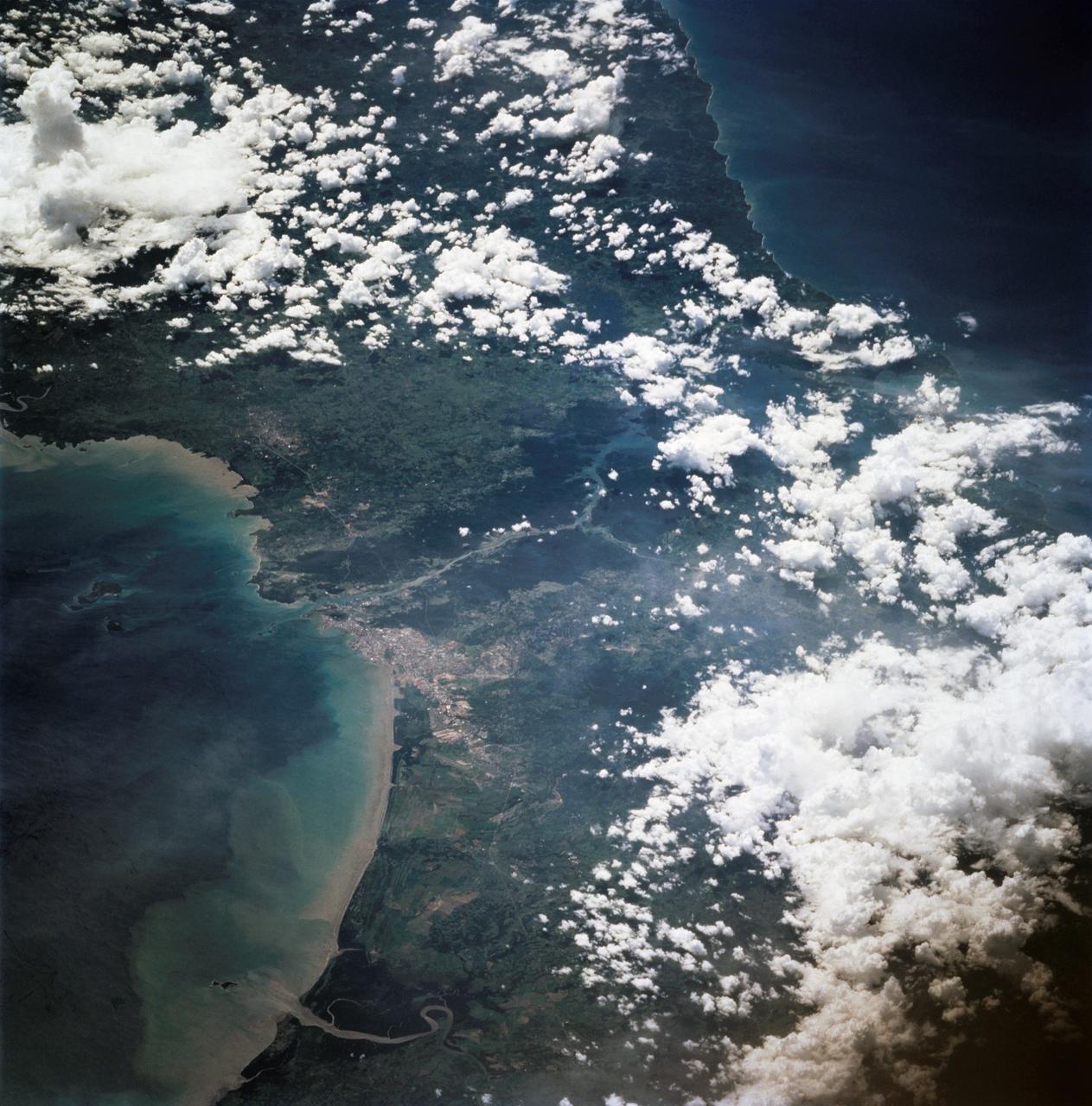
This view shows the confluence of the Amazon and the Topajos Rivers at Santarem, Brazil (2.0S, 55.0W). The Am,azon flows from lower left to upper right of the photo. Below the river juncture of the Amazon and Tapajos, there is considerable deforestation activity along the Trans-Amazon Highway.
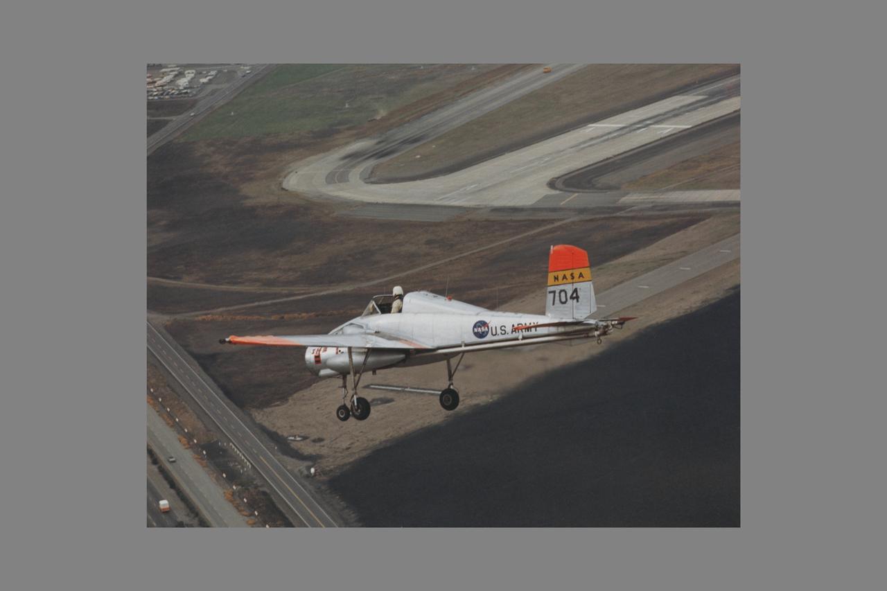
X-14B NASA-704: A Bell single-place, open cockpit, twin-engine, jet-lift VTOL aircraft over Highway 101 in approach to Moffett Field, California. The X-14 was used by NASA Ames Research Center to advance state-of-the-art jet-powered VTOL aircraft.

Lawrence Livermore National Labs (LLNL), Navistar and the Department of Energy conduct tests in the NASA Ames National Full-scale Aerodynamic Complex 80x120_foot wind tunnel. The LLNL project is aimed at aerodynamic truck and trailer devices that can reduce fuel consumption at highway speed by 10 percent. Smoke test demo.
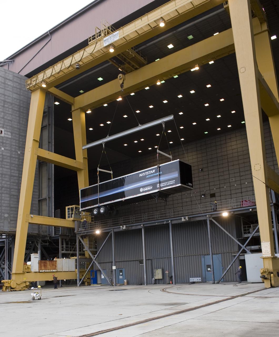
Lawrence Livermore National Labs (LLNL), Navistar and the Department of Energy conduct tests in the NASA Ames National Full-scale Aerodynamic Complex 80x120_foot wind tunnel. The LLNL project is aimed at aerodynamic truck and trailer devices that can reduce fuel consumption at highway speed by 10 percent. Trailer being lifted into the tunnel.
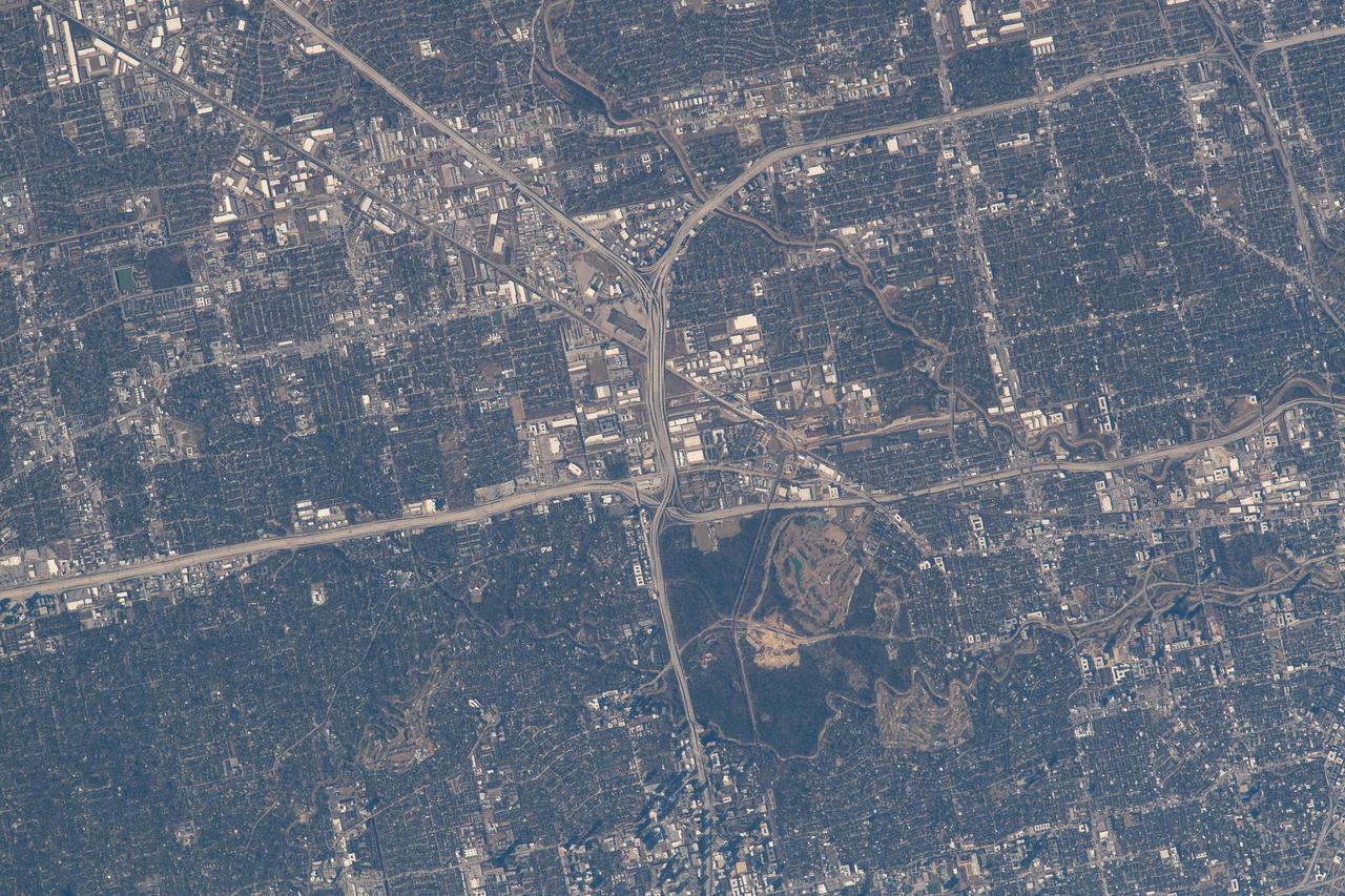
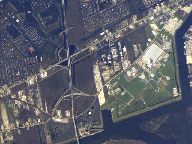
iss066e143699 (Feb. 13, 2022) --- The northwest corner of Houston, Texas, with the major highways of Interstate 610 looping around the city, Interstate 10 moving east to west, and U.S. 290 heading northwest, are pictured from the International Space Station as it orbited 258 miles above the Lone Star state.
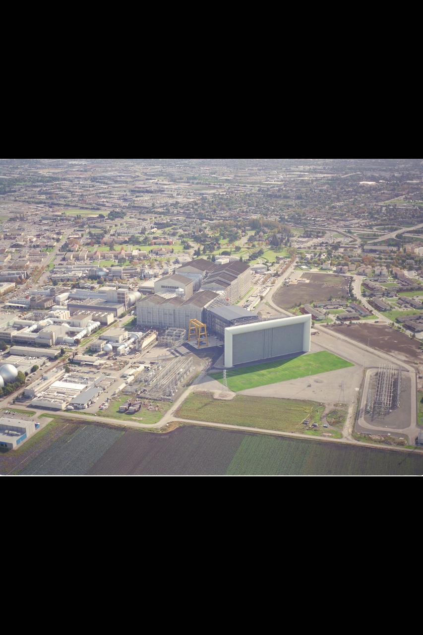
Ames Research Center, Moffett Field, CA Aerials showing the National Full Scale Aerodynamic Complex (NFAC) which can be seen from U.S. Highway 101 in Northern California (NOTE: this image in a vertical cropped version was used on the cover of the NFAC dedication brochure)
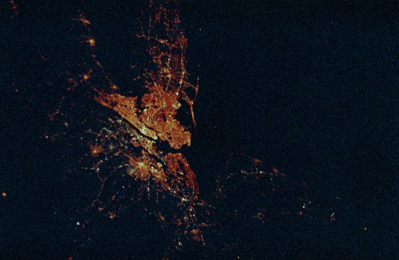
STS-36 Earth observation shows New York City, New York at night lit up along the Eastern seaboard of the United States and the Atlantic Ocean. The city lights designate the densely populated central city and the major highways surrounding it.
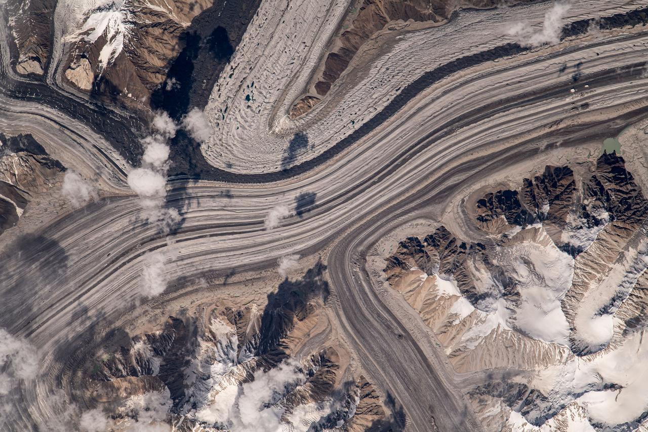
iss069e060266 (Aug. 15, 2023) --- What looks like highways going through a metropolitan area are actually a series of glaciers carving their way through the Karakoram mountain range north of the Himalayas. This photograph was taken from the International Space Station as it orbited 263 miles above.
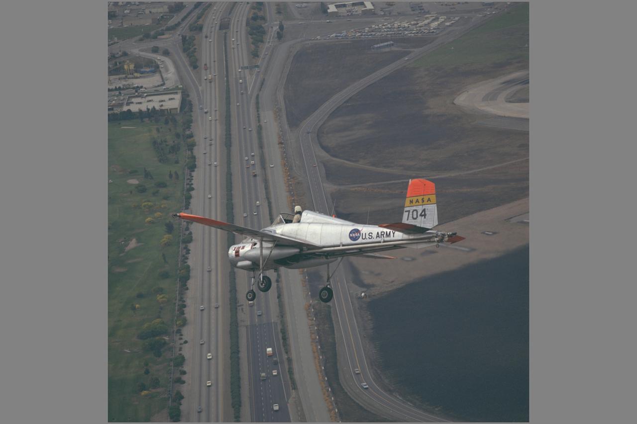
X-14B NASA-704: A Bell single-place, open cockpit, twin-engine, jet-lift VTOL aircraft over Highway 101 in approach to Moffett Field, California. The X-14 was used by NASA Ames Research Center to advance state-of-the-art jet-powered VTOL aircraft.

NASA photographer Jim Ross captured this shot while pilot Troy Asher flew inverted in an F-15D. The F-15B is seen here flying over the mirror farm, AKA the Abengoa Mojave Solar Project, east of Four Corners off of Highway 58 in Southern California.
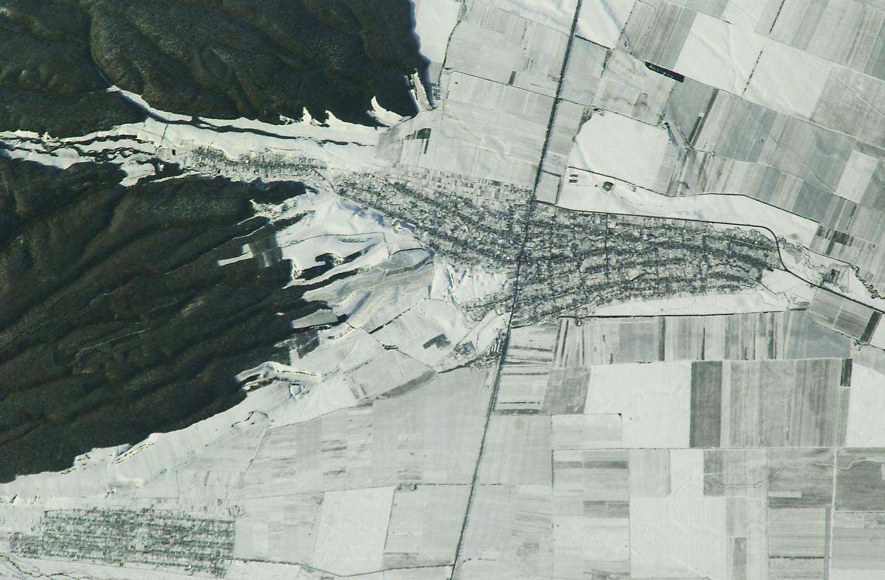
ISS008-E-09603 (20 December 2003) --- The village of Argudan near the north slopes of the Greater Caucasus Mountains in Russia is featured in this photo taken by an Expedition 8 crewmember onboard the International Space Station (ISS). The striking land use pattern, seen through a high magnification lens and highlighted by winter snow and low sun angles, produces this unique view. This rural, agricultural community sits astride the main highway about 15 kilometers east-southeast of the city of Nalchik. Shadows from a line of trees planted as a windbreak near the highway give the road a ragged appearance. A small stream flowing northeastward exits heavily forested foothills through the village and fields of intensely cultivated croplands on the plains. Snow falls through the vegetation, making the woodlands appear extremely dark compared to the snow-covered fields.
STS098-819-038 (17 February 2001) --- Much of Metropolitan Houston appears in this nearly vertical image photographed with a handheld 70mm camera onboard the Earth-orbiting Space Shuttle Atlantis. Interstate 45 and Highways 146 and 6 can be traced from lower right in Galveston County as they head into different directions toward a wide range of points in the city and its suburbs. NASA's Johnson Space Center can be easily pin-pointed just above the center point in the frame. Other points of interest in the area can be located by tracking over the various U.S., state and interstate highways---10, 51, 610 loop, Beltway 8 and others. Downtown Houston is at left center, but the so-called Uptown area is just out of frame at left. Galveston Bay takes up most of the upper right quadrant. Lake Houston is at upper left. A small piece of the Gulf of Mexico is in lower right.
STS109-714-035 (1-12 March 2002) --- The astronauts on board the Space Shuttle Columbia took this 70mm picture featuring the greater metropolitan Houston, Texas area. The view direction is northwest, with Houston's downtown as the brightest region (center) where major highways converge. Interstate 10 is a fine line extending towards the lower right, around the north side of Galveston Bay, part of which appears in the lower right corner. The interstate also appears as a line cutting through the wooded parts of west Houston (just west of downtown). Bush Intercontinental Airport is the largest light patch on the view north of downtown, and lies next to Highway 59, a thin white line that stretches toward the right side of the picture. Forests of East Texas make the top right corner of the view a dark green.

ISS007-E-07360 (14 June 2003) --- This regional view of Salt Lake City, Utah taken by an Expedition 7 crewmember onboard the International Space Station (ISS) shows the city and its suburbs nestled between the Wasatch Front and the Great Salt Lake. The core of Interstate Highway 15 runs North-South through the valley, with suburbs arrayed east and west of the highway. An important issue facing Salt Lake City’s growing population is preservation and allocation of water resources. Utah is in its fifth year of drought. One of the most dramatic effects of the drought visible in this picture is the fact that the lake levels are so low that Antelope Island is separated from the mainland by dry lakebed. Expansive productive wetlands occur where freshwater flows from the Wasatch Range and into the lake. The southern end of this network of wetlands can be seen in the image.
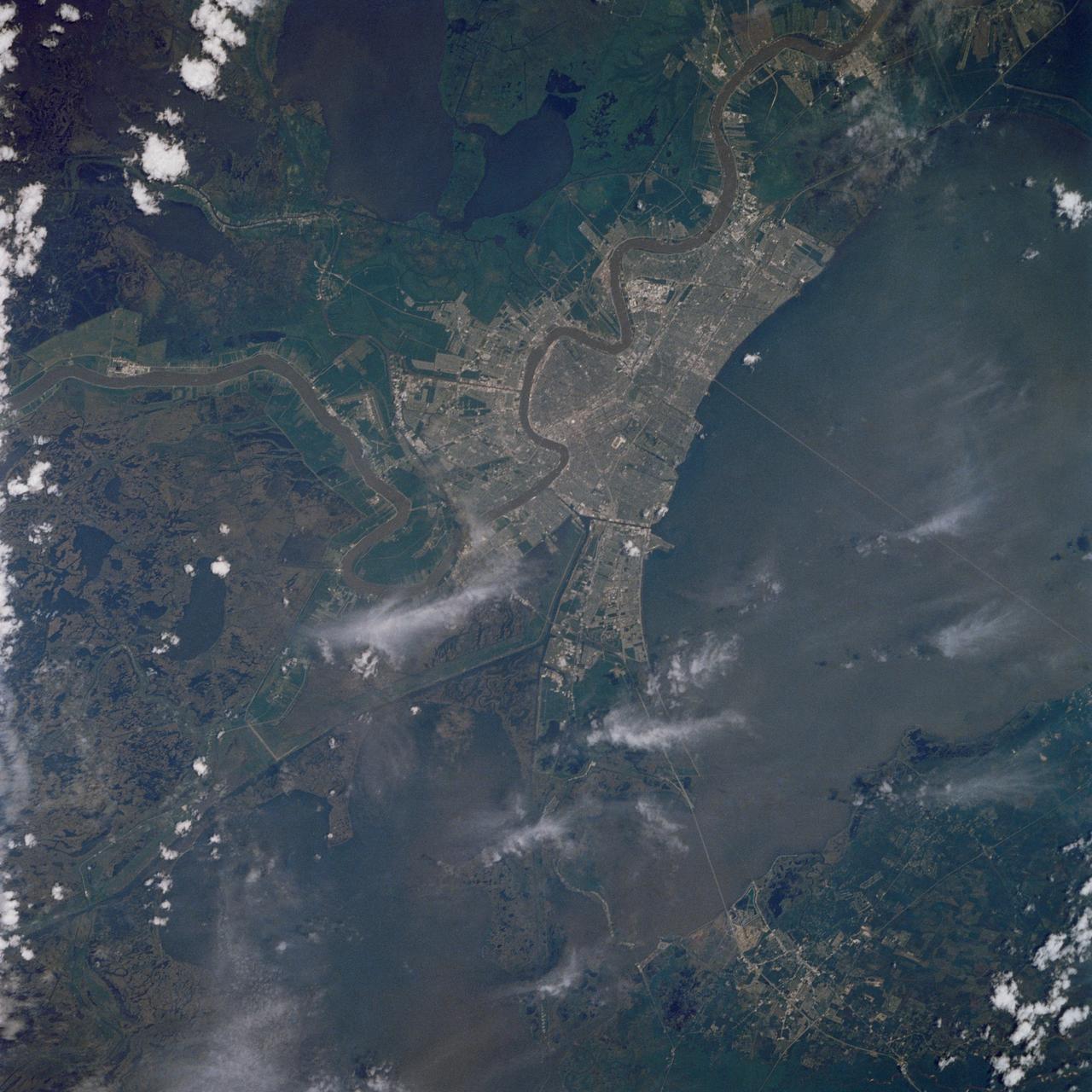
As one of the best ever views of the city of New Orleans, LA (30.0N, 90.0W) from space, this image allows the study of the city and the region in minute detail. Major city street and highway patterns can easily be traced. Even the Superdome near the old French Quarter can be seen as a large round white circle near the middle of the photo. The French Napoleonic Code land distribution system of long narrow fields fronting the river is also evident.

The greater New Orleans area, including portions of Louisiana and Mississippi, as seen from the Apollo 7 spacecraft during its 120th revolution of the earth. Photographed from an altitude of 95 nautical miles, at ground elapsed time of 190 hours and 45 minutes. The largest body of water in the picture is Lake Pontchartrain. The Mississippi River is clearly visible as it meanders past New Orleans. Note highway network, and 25-mile causeway across lake.

ISS010-E-13680 (17 January 2005) --- The border of Galveston and Brazoria Counties in Texas is visible in this electronic still camera's image, as photographed by the Expedition 10 crew onboard the International Space Station. Polly Ranch, near Friendswood, is visible west of Interstate Highway 45 (right side). FM528 goes horizontally through the middle, and FM518 runs vertically through frame center, with the two roads intersecting near Friendswood.

Lawrence Livermore National Labs (LLNL), Navistar and the Department of Energy conduct tests in the NASA Ames National Full-scale Aerodynamic Complex 80x120_foot wind tunnel. The LLNL project is aimed at aerodynamic truck and trailer devices that can reduce fuel consumption at highway speed by 10 percent. Smoke test demo with Ron Schoon, Navistar.
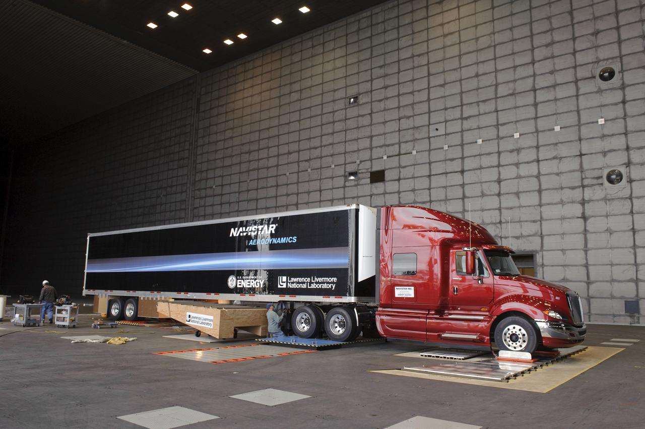
Lawrence Livermore National Labs (LLNL), Navistar and the Department of Energy conduct tests in the NASA Ames National Full-scale Aerodynamic Complex 80x120_foot wind tunnel. The LLNL project is aimed at aerodynamic truck and trailer devices that can reduce fuel consumption at highway speed by 10 percent. LLNL's test piece is being installed on truck.
The Sherpa fire in Santa Barbara County, CA has burned over 12 square miles since it started on June 15. Smoke from the fire reached Los Angeles on the weekend. The fire caused closures of US Highway 101, one of the main routes between southern and northern California. The image was acquired June 19, 2016, covers an area of 25 by 30 kilometers, and is located at 34.4 degrees north, 119.8 degrees west. http://photojournal.jpl.nasa.gov/catalog/PIA20734
Long regarded as one of the best photo of Houston, Texas (29.5N, 95.0W), this view from space shows the entire greater Houston/Galveston region in remarkable detail and clarity. The dark north/south line in the water between Houston and Galveston is the Houston Ship Channel. NASA's Johnson Space Center and Mission Control is located on the north shore of Clear Lake west of the channel. The extensive road and highway network can be seen in great detail.

Lawrence Livermore National Labs (LLNL), Navistar and the Department of Energy conduct tests in the NASA Ames National Full-scale Aerodynamic Complex 80x120_foot wind tunnel. The LLNL project is aimed at aerodynamic truck and trailer devices that can reduce fuel consumption at highway speed by 10 percent. Smoke test demo with Ron Schoon, Navistar.
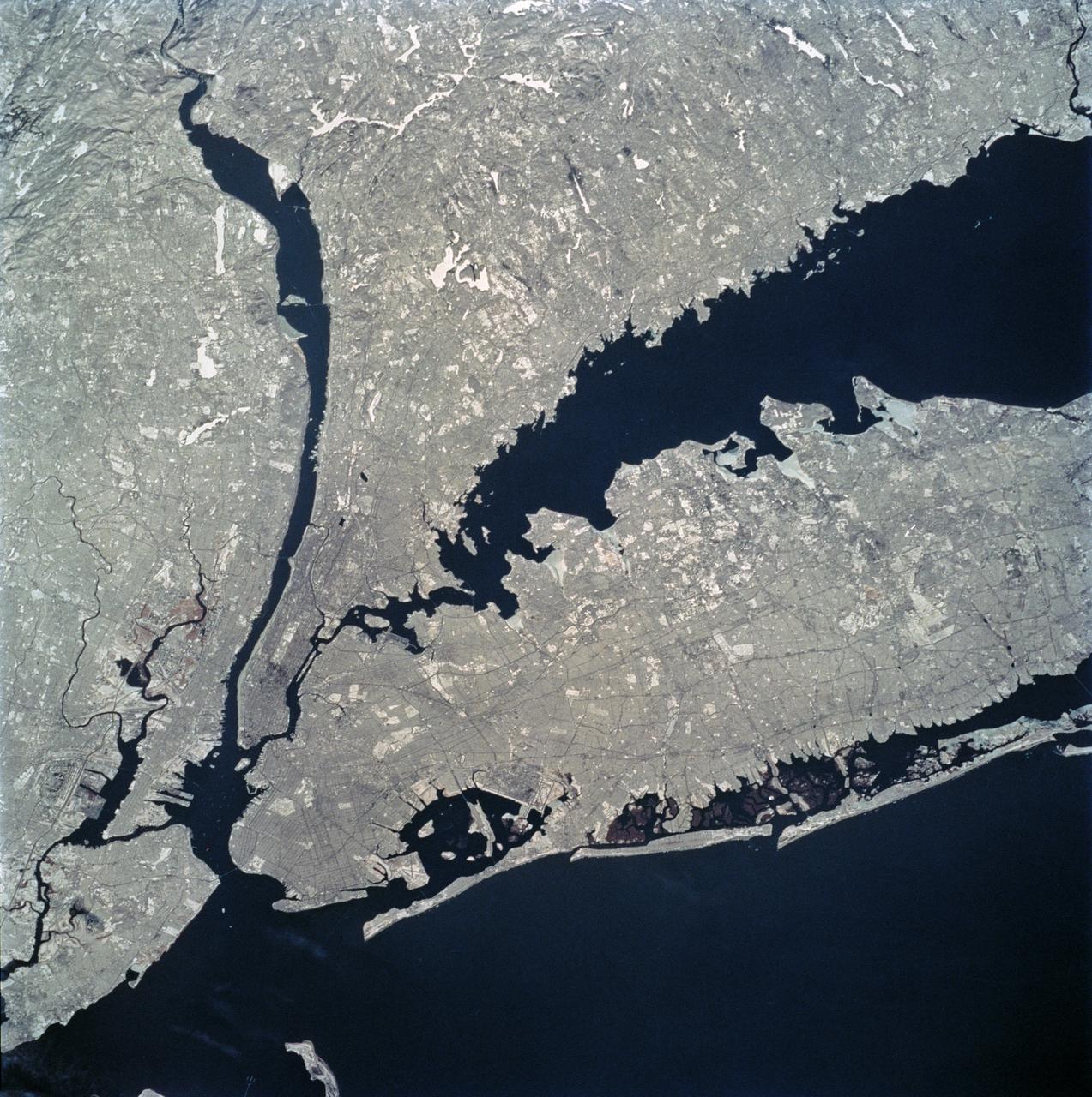
STS062-81-010 (4-18 March 1994) --- The recent heavy snowfalls help to accentuate the major transportation networks, (railroads, highways and airports), throughout the New York City metropolitan area. This particular scene also highlights the land-water boundaries and the lighter open spaces, such as parks, cemeteries and recreational areas. The snows have produced a white blanket effect on these areas. Even some of the snow-covered lakes can be discerned. The boroughs of Staten Island, Brooklyn, Queens, The Bronx and Manhattan are also recognizable on the photograph.
JSC2005-E-37991 (8 September 2005) --- NASA Michoud Test Facility is located at right center of this image acquired from the International Space Station on September 8, 2005. While the facility itself is largely dry, the adjacent neighborhoods are extensively flooded (dark greenish brown regions to the left and right of I-510, left of image center); portions of the highway cloverleaf are also inundated. Image is cropped from the parent frame, ISS011-E-12527 and is oriented with north to the top.
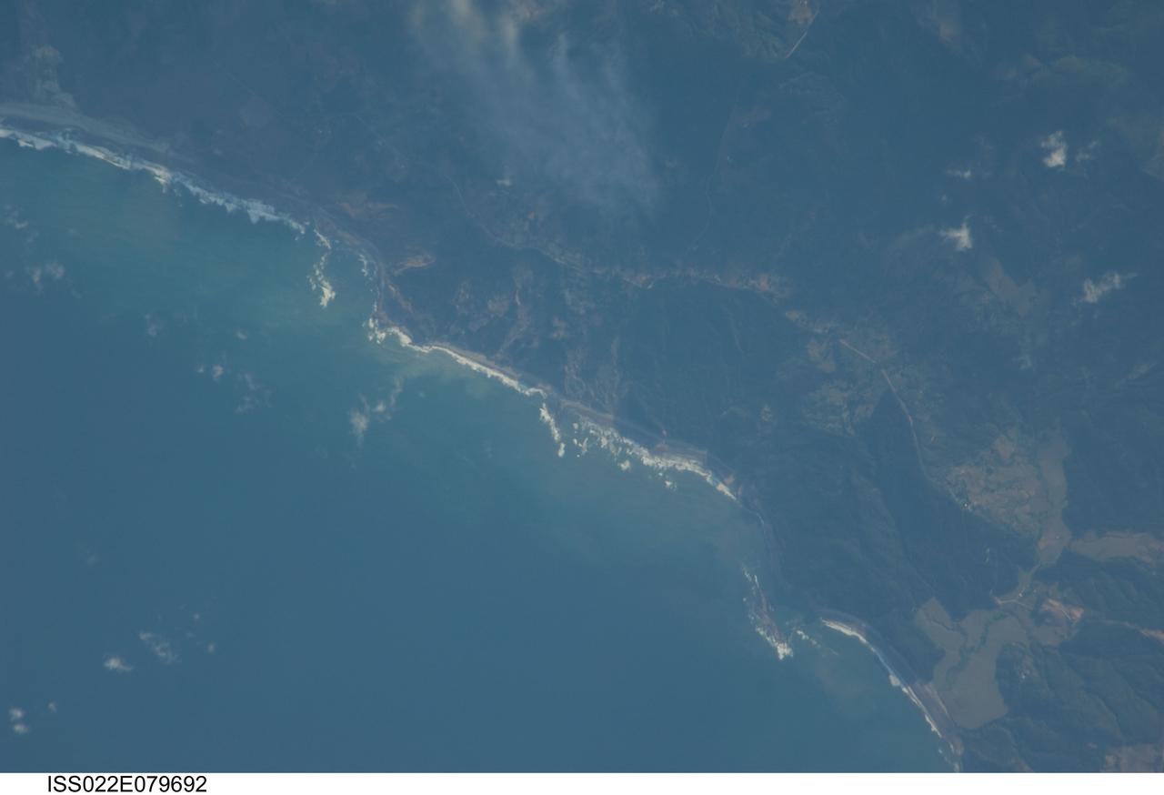
ISS022-E-079692 (3 March 2010) --- A rugged, isolated section of coast on Carnero Bay, about 60 miles south-southwest of Concepcion, Chile, is featured in this image photographed by an Expedition 22 crew member on the International Space Station. The area includes forested hills, a couple of highways, and perhaps some cleared pastureland. The narrow beach appears to be rocky with breakers and some sediment in the waters near-shore. The small coastal town of Labu (out of frame) lies less than ten miles to the south-southwest.
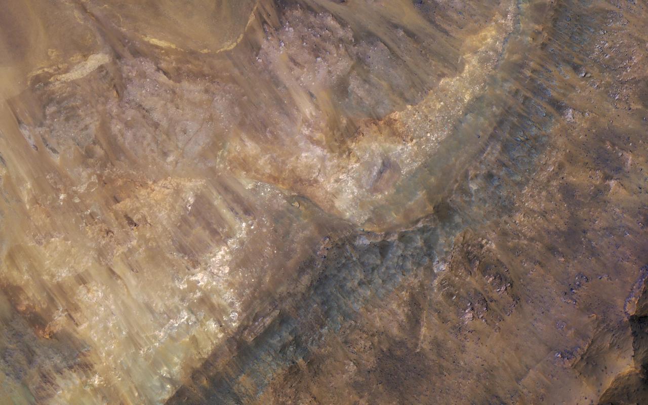
Geologists love roadcuts because they reveal the bedrock stratigraphy (layering). Until we have highways on Mars, we can get the same information from fresh impact craters as shown in this image from NASA's Mars Reconnaissance Orbiter. This image reveals these layers filling a larger crater, perhaps a combination of lava, impact ejecta, and sediments. https://photojournal.jpl.nasa.gov/catalog/PIA21631
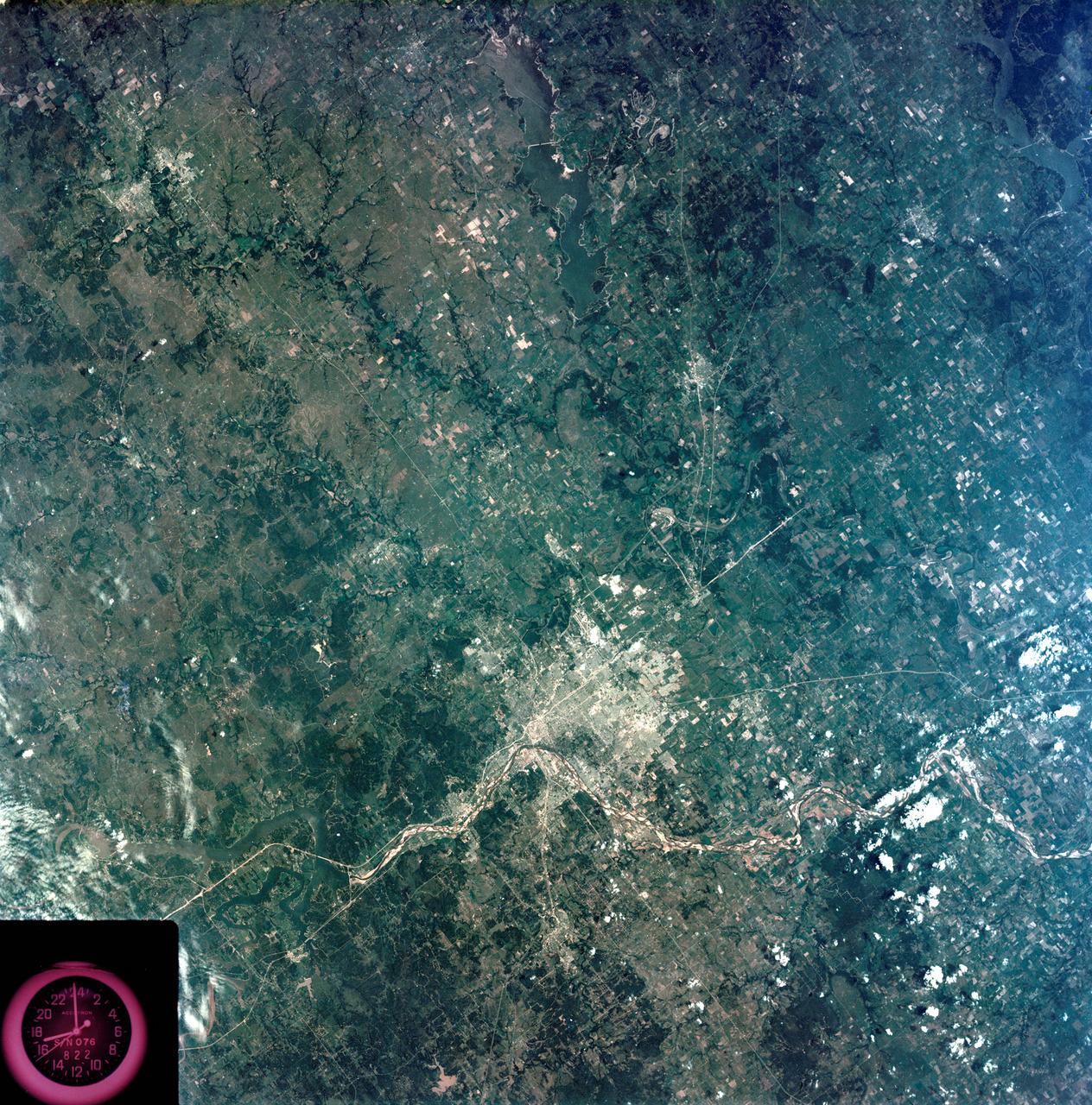
S73-35080 (July-September 1973) --- A vertical view of northeast Oklahoma and the metropolitan Tulsa area is seen in this Skylab 3 Earth Resources Experiments Package S190-B (five-inch Earth terrain camera) photograph taken from the Skylab space station in Earth orbit. THE PICTURE SHOULD BE HELD WITH THE CLOCK ON THE LEFT AND THE LAKE IN THE CORNER ON THE RIGHT. THE LONG STRETCH OF HIGHWAY (U.S. 75) RUNS STRAIGHT NORTH FROM TULSA. Tulsa, a rapidly expanding city in the heart of the mid-continent oil field, has a population of approximately 330,000. The Arkansas River meanders across the southern (lower) portion of the photograph passing through Tulsa as it flows southeastward. Oologah Reservoir, the long body of water, is located northeast of Tulsa. Lake Hudson is the body of water in the right corner of the picture. Keystone Reservoir is to the west and upstream from Tulsa. Westward from Tulsa U.S. 64 makes a 45 degree bend as it turns northwest to cross the Keystone Reservoir. The thin white line over the Oologah Reservoir is a highway bridge. Bartlesville is on U.S. 75 near the north (top) corner of the picture. The Tulsa International Airport is immediately northeast of downtown Tulsa. Several smaller airfields are visible in the surrounding area. The toll roads and other major highways are clearly visible in the picture. Claremore is northeast of Tulsa on U.S. 66 with the Will Rogers Turnpike passing nearby. Sapulpa is southwest of Tulsa on the Turner Turnpike which leads toward Oklahoma City. The detailed information contained in this photograph can be extracted by direct observation and applied to updating land use and cultural maps of Tulsa and to numerous surrounding satellite cities. All EREP photography is available to the public through the Department of Interior?s Earth Resources Observations Systems Data Center, Sioux Falls, South Dakota, 57198. (Alternate number SL3-83-206) Photo credit: NASA
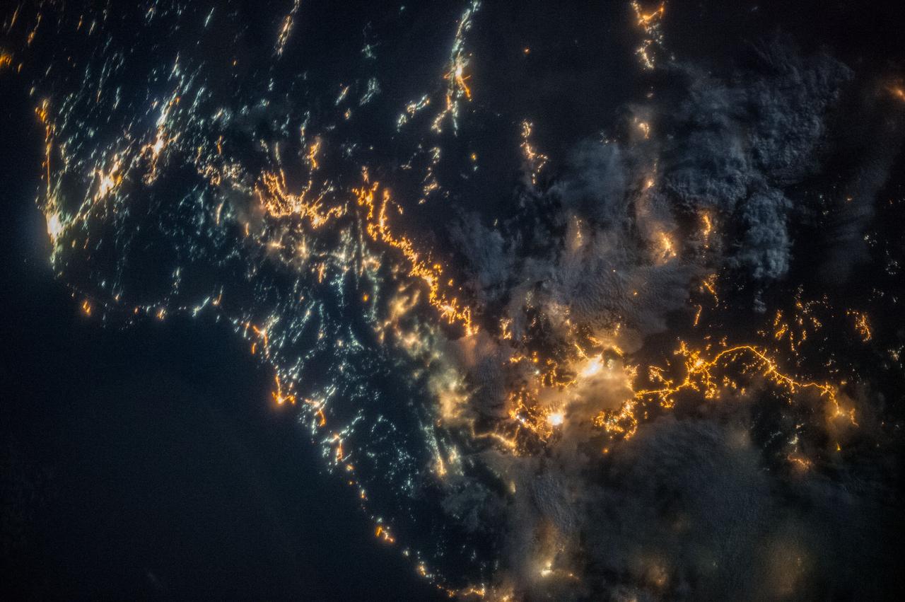
ISS036-E-025802 (26 July 2013) --- A nighttime view of southwestern Saudi Arabia is featured in this image photographed by an Expedition 36 crew member on the International Space Station. In addition to city lights, patchy cloud cover partially obscures and blurs city lights, especially in the vicinity of Khamis Mushait and Abha. While much of the country is lightly populated desert ? and relatively dark at night due to lack of city and roadway lights ? the southwestern coastal region has more moderate climate and several large cities. Three brightly lit urban centers are visible at top left; Jeddah, Mecca, and Taif. Jeddah is the gateway city for Islamic pilgrims going to nearby Mecca (a religious journey known as the hajj). Taif to the east is located on the slopes of the Sarawat Mountains, and provides a summer retreat for the Saudi government from the desert heat of the capital city of Riyadh. Bright yellow-orange lighting marks highways that parallel the trend of the Asir Mountains at center, connecting Mecca to the resort cities of Al Bahah and Abha (lower right). Smaller roadways, lit with blue lights, extend to the west to small cities along the Red Sea coastline. The bright yellow-orange glow of the city of Abha is matched by that of the city of Khamis Mushait (or Khamis Mushayt) to the northeast. The brightly lit ribbon of highway continues onward towards other large cities to the south (Jazan, not shown) and southeast (Najran, not shown).
SL2-03-118 (June 1973) --- An infrared photograph of the San Francisco Bay, California area, taken from the Skylab 1/2 space station in Earth orbit. THE PICTURE SHOULD BE HELD WITH THE CLOUDS AND PACIFIC OCEAN ON THE LEFT. This photograph was taken by one of the six lenses of the Itek-furnished S190-A Multispectral Photographic Facility Experiment in the Multiple Docking Adapter of the space station. Type 2443 film was used. Note the thickly populated and highly developed area around the bay. Among the cities visible in this photograph are San Francisco, Oakland, Berkeley and San Jose. This view extends eastward to show a portion of the San Joaquin Valley. The S190-A experiment is part of the Skylab Earth Resources Experiment Package (EREP). Photo credit: NASA
STS039-151-181A (28 April-6 May 1991) --- Large format (five-inch) frame of the San Francisco/Oakland Bay Area of northern California. Stratus clouds at 35,000 feet and cumulus clouds at about 15,000 feet are seen over the Pacific Coast, obscuring the Golden Gate Bridge.

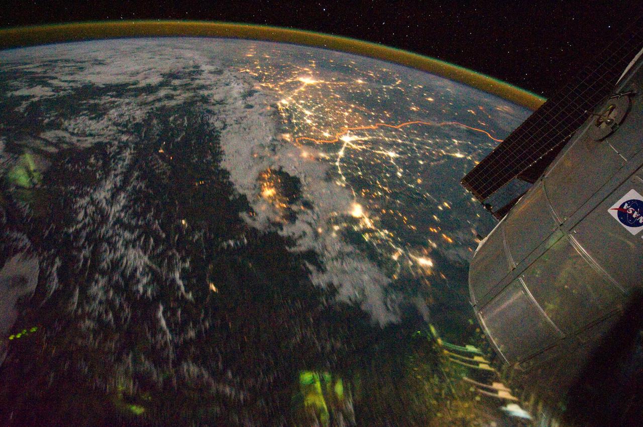
ISS039-E-009160 (2 April 2014) --- This nighttime view featuring the aurora borealis, the moon and Moscow was photographed by an Expedition 39 crew member on the International Space Station. A thin green line of the aurora borealis crosses the top of this image. The moon appears as a white disc just above the aurora. Airglow appears as a blue-white cusp on Earth's limb. Russia's capital city Moscow makes a splash of yellow (lower left), with its easily recognized radial pattern of highways. Other cities are Nizhni Novgorod (lower center) 400 kilometers from Moscow, St. Petersburg (left) 625 kilometers from Moscow, and Finland?s capital city Helsinki.

ISS025-E-010008 (29 Oct. 2010) --- From 220 miles above Earth, one of the Expedition 25 crew members onboard the International Space Station shot this night time image of the northern Gulf coast. Mobile Bay and the city of Mobile (top left, beneath one of the solar panels of a docked Russian Soyuz spacecraft), New Orleans and Houston are visible as the view ?moves? southeastward. The Interstate Highway 20 cities of Jackson, Shreveport, Dallas and Fort Worth are also visible further inland. The view extends northward (left) to Little Rock and Oklahoma City.
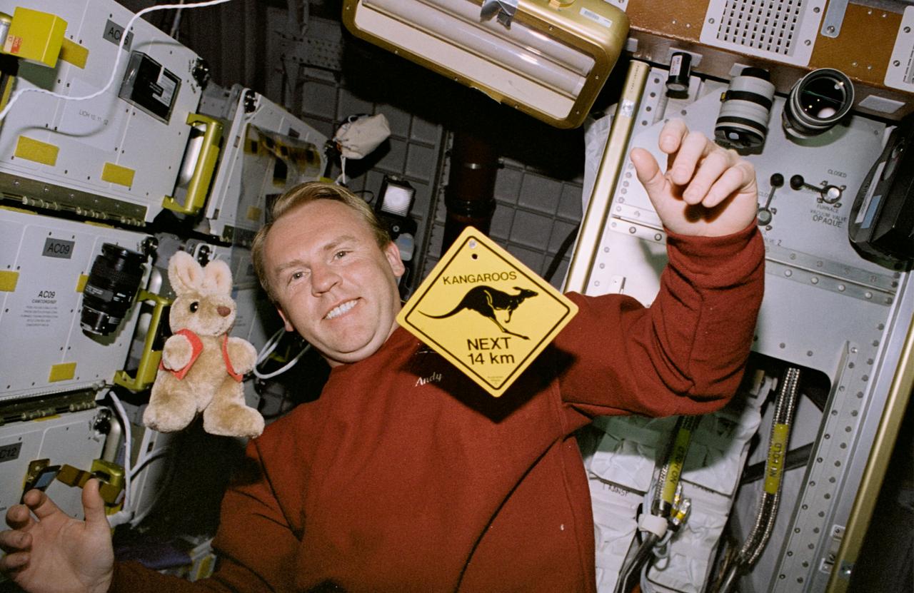
STS077-368-026 (19-29 May 1996) --- On his off-duty time, Australian-native Andrew S. W. Thomas, mission specialist, has a little fun with Australian mementos in the Spacehab Module onboard the Space Shuttle Endeavour. Floating in the foreground are a stuffed toy kangaroo and a miniaturized typical highway warning sign about the plentiful four-legged Australian resident. Astronaut Thomas and five other crew members went on to spend almost ten-days aboard Endeavour in support of the Spacehab 4 mission and a number of other payloads.
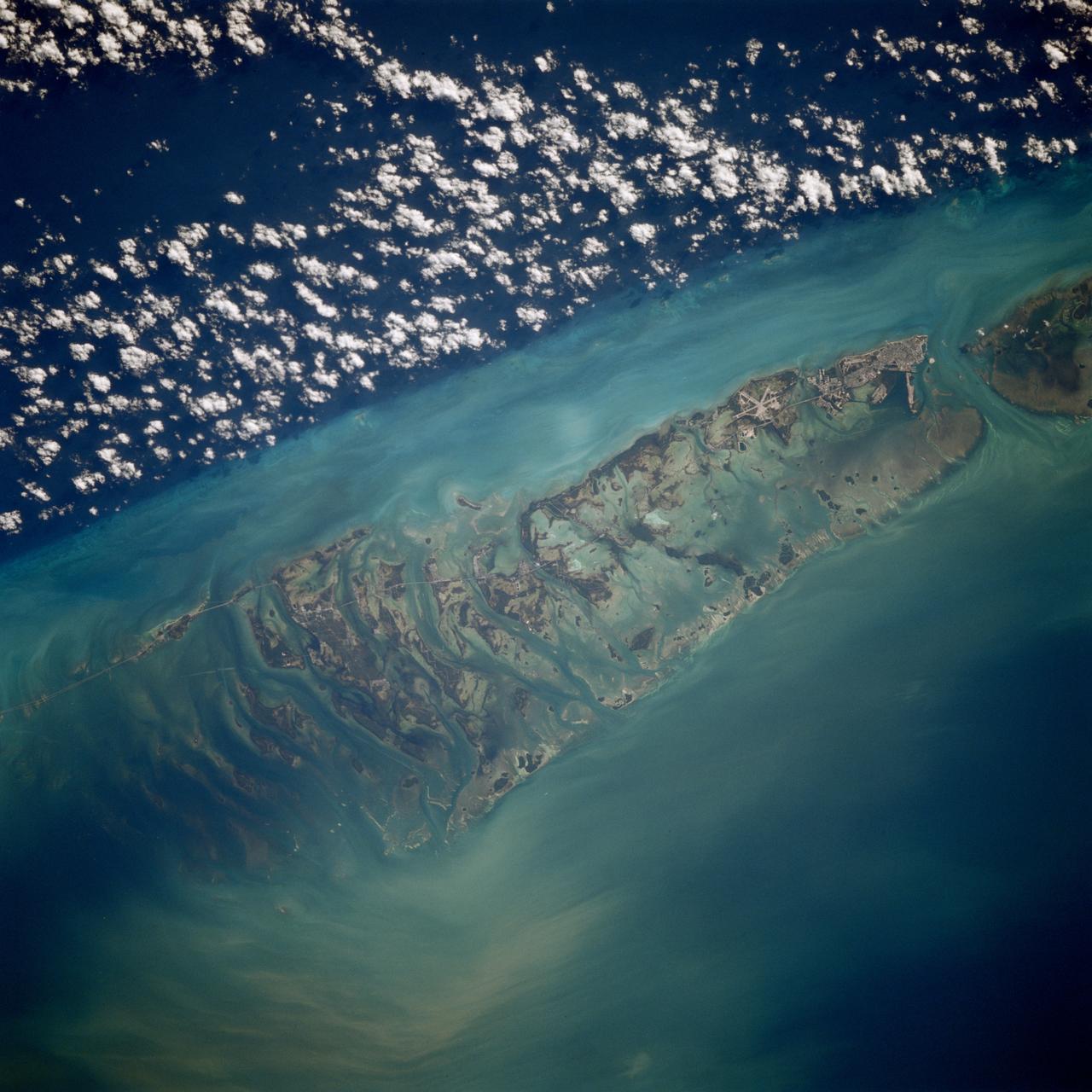
STS080-709-094 (19 Nov.-7 Dec. 1996) --- This is a view of the western portion of the Florida Keys. The view shows the city of Key West, bottom mid-right, with Marathon Key, near top middle left, and the edge of the Straits of Florida, the dark water on the right edge. Clouds form over the cooler waters of the strait. The runways at Boca Chica Key Naval Air Station are seen near Key West. The bottom can be seen clearly in the shallow water, the deeper water has depths of over a half a mile. The thin line of the Overseas Highway can be traced east from Key West. Prior to a hurricane in 1935, this route was a railway line.
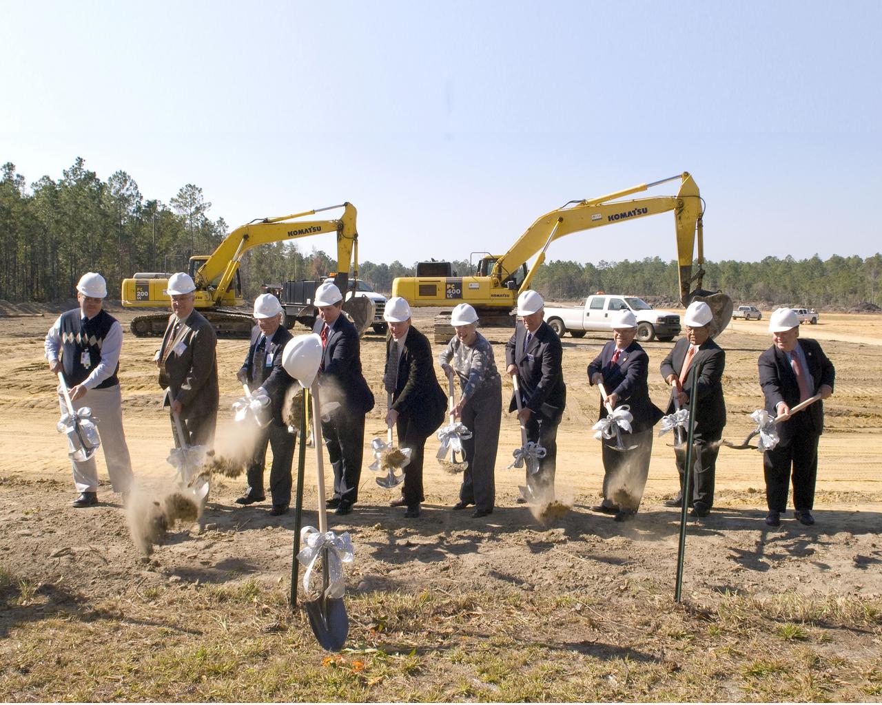
Community leaders from Mississippi and Louisiana break ground for the new INFINITY at NASA Stennis Space Center facility during a Nov. 20 ceremony. Groundbreaking participants included (l to r): Gottfried Construction representative John Smith, Mississippi Highway Commissioner Wayne Brown, INFINITY board member and Apollo 13 astronaut Fred Haise, Stennis Director Gene Goldman, Studio South representative David Hardy, Leo Seal Jr. family representative Virginia Wagner, Hancock Bank President George Schloegel, Mississippi Rep. J.P. Compretta, Mississippi Band of Choctaw Indians representative Charlie Benn and Louisiana Sen. A.G. Crowe.
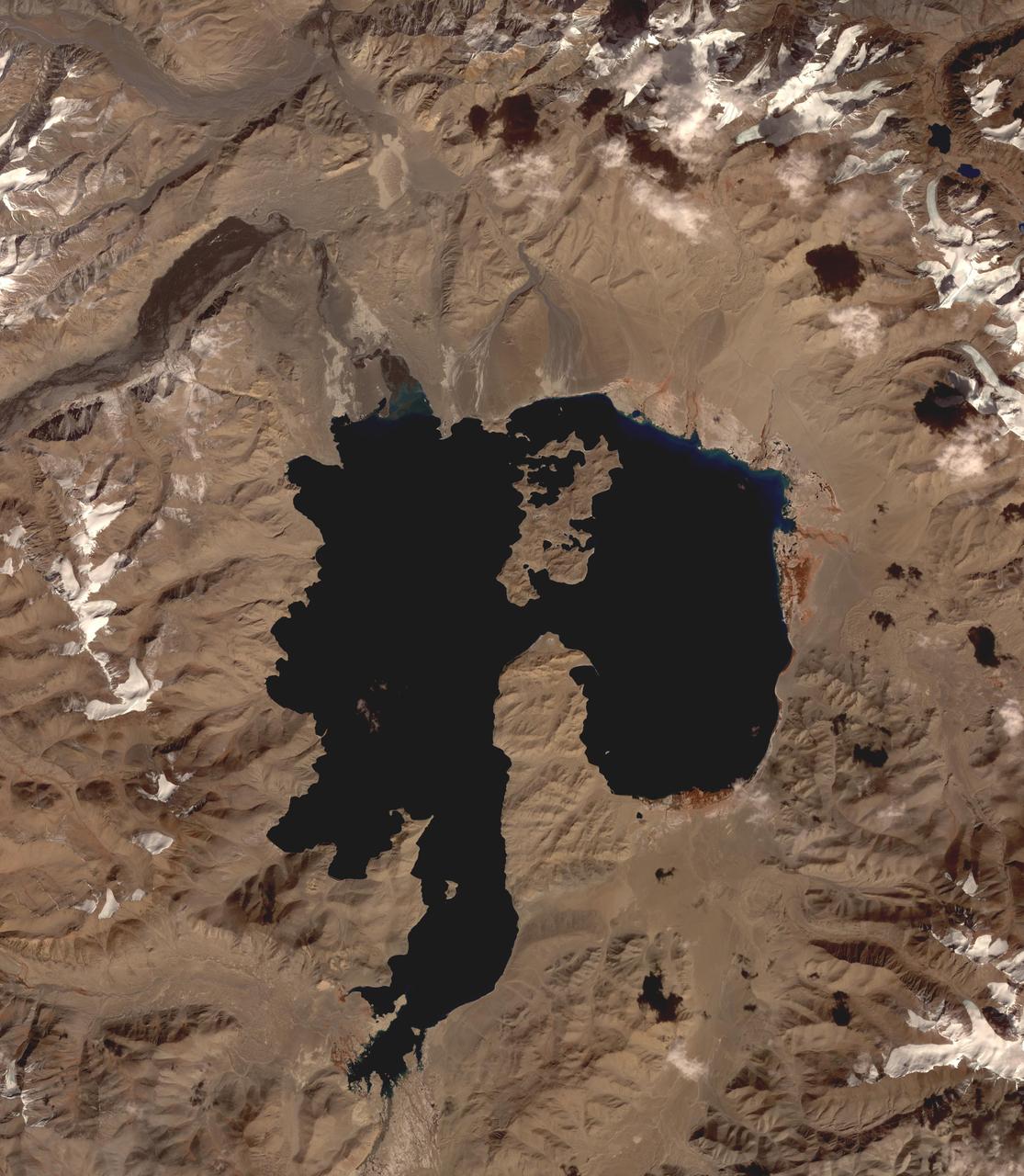
Lake Karakul in northeast Tajikistan is a hypersaline lake with no external drainage, receiving less than 3 cm precipitation per year. It is on the highest part of the fabled Pamir highway at 3900 m. In the local Kyrgyz language, the lake is called "The Black Lake". Recently, Russian scientists have suggested that the lake occupies a 200 million year old meteor impact crater. The image was acquired October 16, 2016, covers an area of 48 by 55 km, and is located at 39 degrees north, 73.4 degrees east. https://photojournal.jpl.nasa.gov/catalog/PIA23102
AS07-07-1872 (11-22 Oct. 1968) --- The Houston, Texas, and Gulf Coast area, looking southeast, as seen from the Apollo 7 spacecraft at an altitude of 101 nautical miles. This photograph was made during the spacecraft's 91st revolution of Earth, at ground elapsed time of 144 hours and 26 minutes. The morning sun causes a spectacular reflection on water surfaces such as the Gulf of Mexico, Galveston Bay, Buffalo Bayou, and the Brazos River, and causes a unique reflection in the canals and rice fields west of Alvin. Some of the landmarks visible in this picture include highways and freeways, the Astrodome, the new Intercontinental Airport, and the Manned Spacecraft Center.
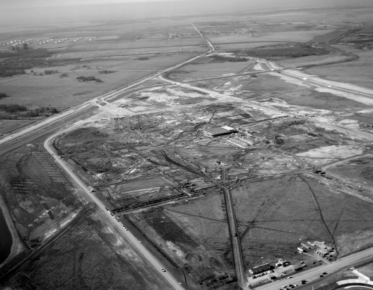
S63-01074 (1963) --- A black and white aerial view of Site 1, the Manned Spacecraft Center, in 1963 during early construction. The view faces the southwest. Highway 528 is at the top of the picture. Second Street runs basically north and south on the right side of the image, to the right or west and running parallel to that avenue is a drainage ditch. Winding through the site a Houston Lighting and Power Co. canal crosses over the drainage ditch near the top of the frame. Twin bridges over the canal are pictured at upper left which were constructed to allow traffic to enter and leave through MSC's secondary gateway. In frame center, construction appears very far along on the Central Data Office.
In Iran, near the southwest shore of the Caspian Sea, folded sedimentary rocks are part of the Greater Caucasus Mountain Belt. In false color infrared, the blue colored rocks are white sediments, greenish-toned rocks are redbeds. The vegetated river channel is bright red. The black line going across the image from east to west is Iran Highway 2 that starts in Teheran and ends in Tabriz. The image was acquired June 22, 2020, covers an area of 37.6 by 40.9 km, and is located at 37.1 degrees north, 47.6 degrees east. https://photojournal.jpl.nasa.gov/catalog/PIA25946
STS030-152-066 (4-8 May 1989) --- The upper Texas and Louisiana Gulf Coast area was clearly represented in this large format frame photographed by the astronaut crew of the Earth-orbiting Space Shuttle Atlantis. The area covered stretches almost 300 miles from Aransas Pass, Texas to Cameron, Louisiana. The sharp detail of both the natural and cultural features noted throughout the scene is especially evident in the Houston area, where highways, major streets, airport runways and even some neighborhood lanes are easily seen. Other major areas seen are Austin, San Antonio and the Golden Triangle. An Aero Linhof camera was used to expose the frame.
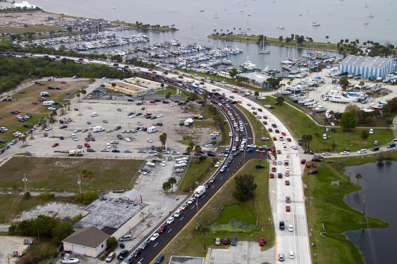
CAPE CANAVERAL, Fla. -- This image of U. S. Highway 1 and surrounding roadways in Titusville, Florida, was taken from a traffic survey helicopter after the successful launch of space shuttle Discovery at 4:53 p.m. EST on its final flight to the International Space Station. Discovery's six-member crew will deliver the Permanent Multipurpose Module, packed with supplies and critical spare parts, as well as Robonaut 2, the dexterous humanoid astronaut helper, to the orbiting outpost. Discovery is flying on its 39th and final mission and is scheduled to be retired following STS-133. This is the 133rd Space Shuttle Program mission and the 35th shuttle voyage to the space station. For more information on the STS-133 mission, visit www.nasa.gov/mission_pages/shuttle/shuttlemissions/sts133/. Photo credit: NASA/Jack Pfaller
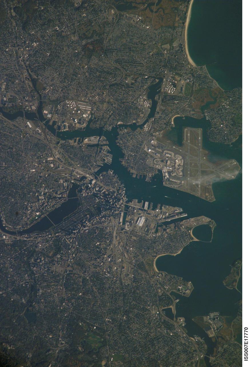
ISS007-E-17770 (20 October 2003) --- Boston, Massachusetts was featured in this image taken by one of the Expedition 7 crewmembers onboard the International Space Station (ISS). The image provides a good view of the center of the city, including famous colonial and independence locations extending from Boston Common to the North End. Wispy clouds hover over the south end of Logan Airport. Ship traffic in the Charles and Mystic Rivers is marked by wakes of the ships. And highly reflective construction locations, including the new I-93 and the bridge over the Charles River, and highway exchanges at Logan Airport mark the new elements of Boston's Big Dig, which is the local transportation project that is now believed to be the largest civil engineering endeavor in U.S. history.
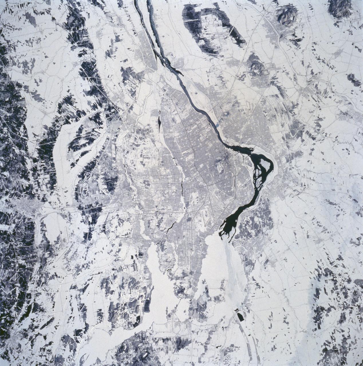
STS060-94-072 (3-11 Feb 1994) --- The city of Montreal is located on the island of Montreal at the confluence of the St. Lawrence and Ottawa Rivers. Despite its distance from the sea (1,000 miles) Montreal is a large inland port. It is also Canada's largest city and the second largest French speaking city in the world. This particular snow covered scene highlights the major highways and street patterns throughout the metropolitan Montreal area. The runways of the two large international airports of Mirabel (located 25 miles northwest of downtown Montreal) and Dorval (located approximately 8 miles west of the downtown area) are clearly visible on this photograph. Even the outline of Mount Royal Park, an imposing hilly feature near the downtown central business district, can be seen. Patches of open, ice-free (very dark areas) are detectable as the St. Lawrence River (Seaway) makes its way along the south and southeastern side of Montreal.
CAPE CANAVERAL, Fla. -- This image of U. S. Highway 1 and surrounding roadways in Titusville, Florida, was taken from a traffic survey helicopter after the successful launch of space shuttle Discovery at 4:53 p.m. EST on its final flight to the International Space Station. Discovery's six-member crew will deliver the Permanent Multipurpose Module, packed with supplies and critical spare parts, as well as Robonaut 2, the dexterous humanoid astronaut helper, to the orbiting outpost. Discovery is flying on its 39th and final mission and is scheduled to be retired following STS-133. This is the 133rd Space Shuttle Program mission and the 35th shuttle voyage to the space station. For more information on the STS-133 mission, visit www.nasa.gov/mission_pages/shuttle/shuttlemissions/sts133/. Photo credit: NASA/Jack Pfaller
CAPE CANAVERAL, Fla. -- This image of U. S. Highway 1 and surrounding roadways in Titusville, Florida, was taken from a traffic survey helicopter after the successful launch of space shuttle Discovery at 4:53 p.m. EST on its final flight to the International Space Station. Discovery's six-member crew will deliver the Permanent Multipurpose Module, packed with supplies and critical spare parts, as well as Robonaut 2, the dexterous humanoid astronaut helper, to the orbiting outpost. Discovery is flying on its 39th and final mission and is scheduled to be retired following STS-133. This is the 133rd Space Shuttle Program mission and the 35th shuttle voyage to the space station. For more information on the STS-133 mission, visit www.nasa.gov/mission_pages/shuttle/shuttlemissions/sts133/. Photo credit: NASA/Jack Pfaller
CAPE CANAVERAL, Fla. -- This image of U. S. Highway 1 and surrounding roadways in Titusville, Florida, was taken from a traffic survey helicopter after the successful launch of space shuttle Discovery at 4:53 p.m. EST on its final flight to the International Space Station. Discovery's six-member crew will deliver the Permanent Multipurpose Module, packed with supplies and critical spare parts, as well as Robonaut 2, the dexterous humanoid astronaut helper, to the orbiting outpost. Discovery is flying on its 39th and final mission and is scheduled to be retired following STS-133. This is the 133rd Space Shuttle Program mission and the 35th shuttle voyage to the space station. For more information on the STS-133 mission, visit www.nasa.gov/mission_pages/shuttle/shuttlemissions/sts133/. Photo credit: NASA/Jack Pfaller
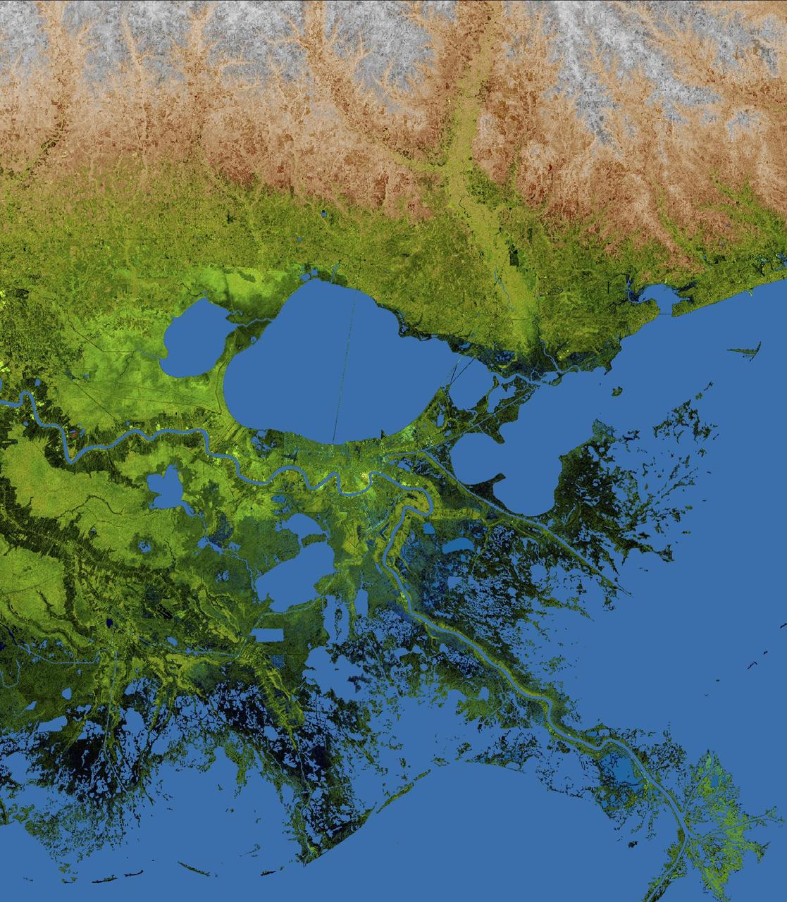
The geography of the New Orleans and Mississippi delta region is well shown in this radar image from the Shuttle Radar Topography Mission. In this image, bright areas show regions of high radar reflectivity, such as from urban areas, and elevations have been coded in color using height data also from the mission. Dark green colors indicate low elevations, rising through yellow and tan, to white at the highest elevations. New Orleans is situated along the southern shore of Lake Pontchartrain, the large, roughly circular lake near the center of the image. The line spanning the lake is the Lake Pontchartrain Causeway, the world's longest over water highway bridge. Major portions of the city of New Orleans are below sea level, and although it is protected by levees and sea walls, flooding during storm surges associated with major hurricanes is a significant concern. http://photojournal.jpl.nasa.gov/catalog/PIA04175

CAPE CANAVERAL, Fla. -- This image of U. S. Highway 1 and surrounding roadways in Titusville, Florida, was taken from a traffic survey helicopter after the successful launch of space shuttle Discovery at 4:53 p.m. EST on its final flight to the International Space Station. Discovery's six-member crew will deliver the Permanent Multipurpose Module, packed with supplies and critical spare parts, as well as Robonaut 2, the dexterous humanoid astronaut helper, to the orbiting outpost. Discovery is flying on its 39th and final mission and is scheduled to be retired following STS-133. This is the 133rd Space Shuttle Program mission and the 35th shuttle voyage to the space station. For more information on the STS-133 mission, visit www.nasa.gov/mission_pages/shuttle/shuttlemissions/sts133/. Photo credit: NASA/Jack Pfaller

CAPE CANAVERAL, Fla. -- This image of U. S. Highway 1 and surrounding roadways in Titusville, Florida, was taken from a traffic survey helicopter after the successful launch of space shuttle Discovery at 4:53 p.m. EST on its final flight to the International Space Station. Discovery's six-member crew will deliver the Permanent Multipurpose Module, packed with supplies and critical spare parts, as well as Robonaut 2, the dexterous humanoid astronaut helper, to the orbiting outpost. Discovery is flying on its 39th and final mission and is scheduled to be retired following STS-133. This is the 133rd Space Shuttle Program mission and the 35th shuttle voyage to the space station. For more information on the STS-133 mission, visit www.nasa.gov/mission_pages/shuttle/shuttlemissions/sts133/. Photo credit: NASA/Jack Pfaller
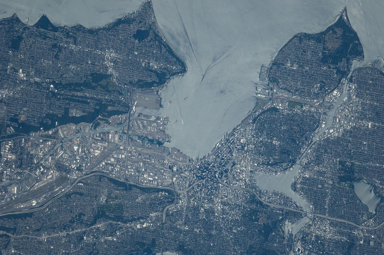
ISS040-E-124198 (6 Sept. 2014) --- Puget Sound is partly reflecting the sun in this detailed image taken by an Expedition 40 crew member on the International Space Station. Patterns of boat wakes are prominent in the sun’s partial reflection zone. The difference between the boat wakes in this view relates to the speed of the boat and the particular patterns (of several) that happen to be captured in the specific light reflection angles at the time the image was taken. The land areas show parts of Seattle. The darkest areas with rectangular grids are suburbs richly covered with trees. The broadly gray zones of the central city (bottom center) are brighter where structures are lower, as in the harbor zone (Harbor Island), and darker where the shadows of high-rise buildings downtown cast black shadows. Interstate Highway 5 bisects downtown.
The Sand fire, in the mountains northwest of Los Angeles, has burned more than 39,000 acres, destroyed 18 houses, and caused one fatality. By August 1, 2016, when the Advanced Spaceborne Thermal Emission and Reflection Radiometer (ASTER) instrument on NASA's Terra spacecraft acquired this image, the fire was more than 90 percent contained. The fire began 10 days earlier in a brushy area near Highway 14. It grew explosively to thousands of acres, driven by high winds and temperatures over 100 degrees Fahrenheit. At one time, more than 20,000 residents were evacuated from their homes. In this image, vegetation is displayed in red, and the burn area is dark grey to black. The image covers an area of 16.4 by 19.4 miles (26.4 by 31.3 kilometers), and is located at 34.4 degrees north, 118.3 degrees west. http://photojournal.jpl.nasa.gov/catalog/PIA20723
STS068-237-099 (30 September-11 October 1994) --- This 70mm frame shows the Panama Canal (center, between the two dark green belts) the main ship way to travel from the Atlantic to the Pacific Ocean. Also seen is a great deal of detail in Panama City (left center, on the Pacific Ocean coastline). Geologists studying the photography returned by Shuttle astronauts feel this picture is the best ever of the city. Agricultural fields can be seen on the east side of Panama City and on both sides of the Pan American Highway (the straight thin line extending to the left). Sedimentation in the Chepo River (upper left) is thought to be due to eroded soil from the agricultural lands near the sea. This river is surrounded by swamps lying along the Pacific coastline.
SL2-16-281 (June 1973) --- A vertical view of the Orlando and central Florida area photographed from the Skylab space station in Earth orbit. (The picture should be held with the heaviest cloud cover at the bottom.) The extensive road and highway network in the area is clearly visible. The Lakeland and Winter Haven area is near the center of the picture. Interstate 4 extends southwesterly out of Orlando through the center of the picture. The urban growth caused by the opening of the Disney World amusement complex is clearly evident. The giant recreational facility is just southwest of Orlando. This picture was taken by one of the six lenses of the Itek-furnished S190-A Multispectral Photographic Facility Experiment in the Multiple Docking Adapter of the space station. Type SO-356 film was used. Photo credit: NASA
STS062-85-147 (4-18 March 1994) --- Hartsfield Atlanta International Airport is visible to the south of Atlanta, situated near the center of the photograph. Dobbins Air Force Base and the city of Marietta can also be seen to the north of Atlanta in this south-looking low-oblique view. The complex system of transportation routes and interstate highways surrounding and traversing Atlanta can also be seen in the photograph. The white dot near the center of the photograph is the Georgia Dome, a major sports and entertainment complex in downtown Atlanta. Atlanta is the cultural, industrial, transportation, financial and commercial center of the South. It has one of the busies air traffic hubs in the United States. A major aircraft assembly plant is located north of Atlanta in Marietta. The Stone Mountain Memorial, with its enormous relief carvings of Confederate figures, is located east of Atlanta and is visible on the photograph.
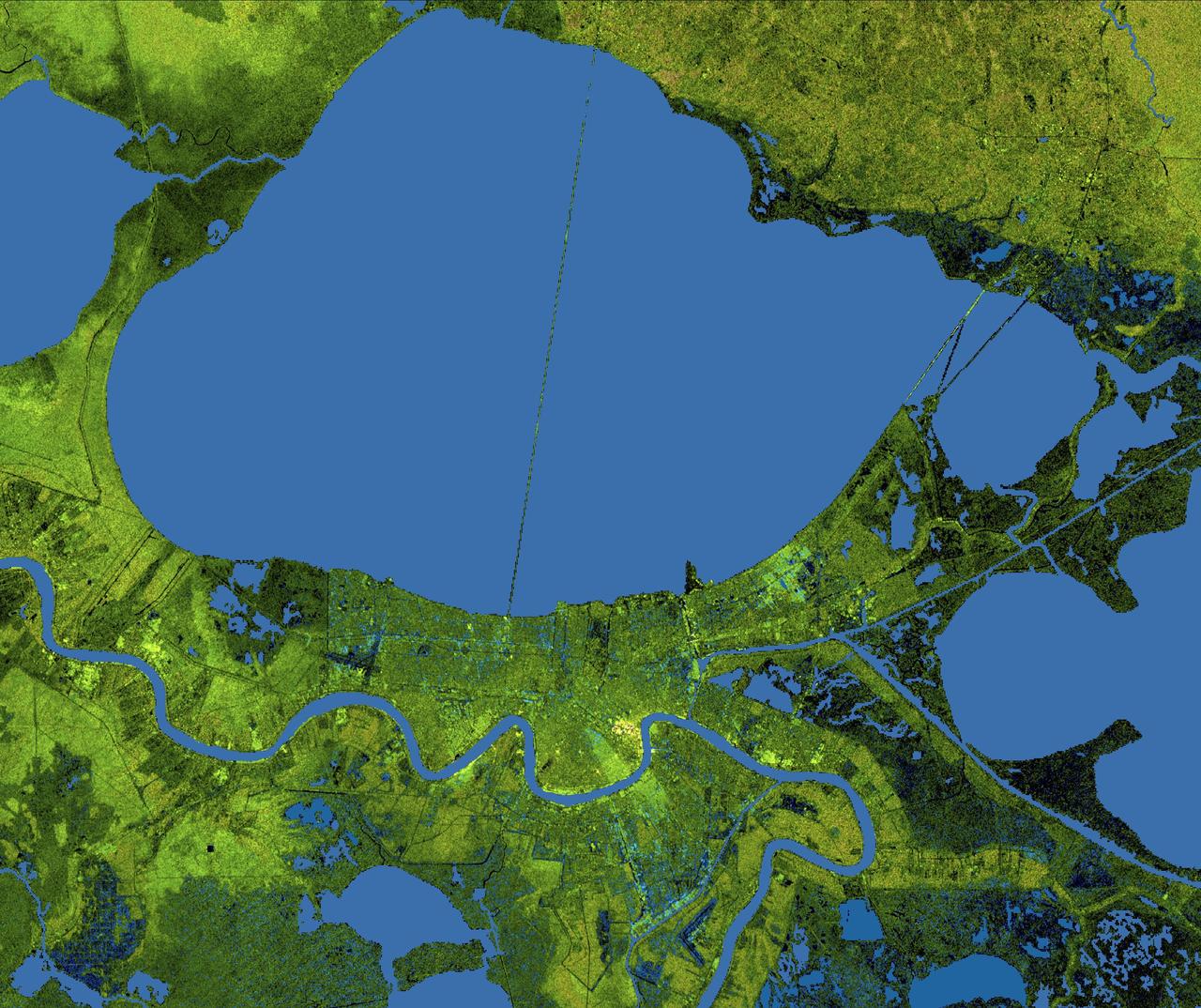
The city of New Orleans, situated on the southern shore of Lake Pontchartrain, is shown in this radar image from the Shuttle Radar Topography Mission (SRTM). In this image bright areas show regions of high radar reflectivity, such as from urban areas, and elevations have been coded in color using height data also from the SRTM mission. Dark green colors indicate low elevations, rising through yellow and tan, to white at the highest elevations. New Orleans is near the center of this scene, between the lake and the Mississippi River. The line spanning the lake is the Lake Pontchartrain Causeway, the world’s longest overwater highway bridge. Major portions of the city of New Orleans are actually below sea level, and although it is protected by levees and sea walls that are designed to protect against storm surges of 18 to 20 feet, flooding during storm surges associated with major hurricanes is a significant concern. http://photojournal.jpl.nasa.gov/catalog/PIA04174
S63-00950 (1963) --- An aerial view of Site 1, the Manned Spacecraft Center, in 1963 during early construction. The view faces the southwest. Highway 528 is at the top of the picture. Second Street runs basically north and south on the right side of the image, to the right or west and running parallel to that avenue is a drainage ditch. Winding through the site a Houston Lighting and Power Co. canal crosses over the drainage ditch near the top of the frame. Twin bridges over the canal are pictured at upper left which were constructed to allow traffic to enter and leave through MSC's secondary gateway. The unfinished red structure to the right of center and roughly 100 yards south of the elevated water storage tank is the Central Heating and Cooling Plant. In the upper left quadrant of the frame, construction appears very far along on the Central Data Office.
STS078-751-076 (20 June-7 July 1996) --- Metropolitan Atlanta, Georgia, host area for 1996 Summer Olympics was captured on film by one of the crew members using a 70mm handheld camera. Hartsfield Atlanta International Airport is visible to the south of Atlanta, near the center of the photograph. Dobbins Air Force Base and a portion of the city of Marietta can also be seen to the north of Atlanta in the upper left hand corner. The complex system of transportation routes and interstate highways is seen surrounding and traversing Atlanta. The white dot near the center of the city is the Georgia Dome, a major sports and entertainment complex in downtown Atlanta. Atlanta is the cultural, industrial, transportation, financial, and commercial center of the South. It has one of the busiest air traffic hubs in the United States. A major aircraft assembly plant is located north of Atlanta in Marietta. The Stone Mountain Memorial, with its enormous relief carvings of Confederate figures, is located east of Atlanta and is visible on the photograph.
CAPE CANAVERAL, Fla. -- This image of U. S. Highway 1 and surrounding roadways in Titusville, Florida, was taken from a traffic survey helicopter after the successful launch of space shuttle Discovery at 4:53 p.m. EST on its final flight to the International Space Station. Discovery's six-member crew will deliver the Permanent Multipurpose Module, packed with supplies and critical spare parts, as well as Robonaut 2, the dexterous humanoid astronaut helper, to the orbiting outpost. Discovery is flying on its 39th and final mission and is scheduled to be retired following STS-133. This is the 133rd Space Shuttle Program mission and the 35th shuttle voyage to the space station. For more information on the STS-133 mission, visit www.nasa.gov/mission_pages/shuttle/shuttlemissions/sts133/. Photo credit: NASA/Jack Pfaller
STS072-738-036 (11-20 Jan. 1996) --- The astronauts used a 70mm handheld camera to expose this frame of the west-flowing Orange River, which constitutes the international boundary between Namibia and the Republic of South Africa. The railroad and highway connecting the two countries is seen as a ribbon crossing the corner of the view. The broad color difference between strong browns/reds in the northern half of the view and lighter yellows in the southern corresponds to two land surfaces. The darker is a higher, flat land surface developed on horizontal Nama Sandstone’s, with rock surfaces widely coated with a dark manganese stain, typical of desert regions. This region is known as Namaqualand and borders the Namib Desert. Where rivers have cut down into this surface, the lighter underlying rock and soil colors show up.
ISS028-E-029679 (21 Aug. 2011) --- A night time view of India-Pakistan borderlands is featured in this image photographed by an Expedition 28 crew member on the International Space Station. Clusters of yellow lights on the Indo-Gangetic Plain of northern India and northern Pakistan reveal numerous cities both large and small in this photograph. Of the hundreds of clusters, the largest are the metropolitan areas associated with the capital cities of Islamabad, Pakistan in the foreground and New Delhi, India at the top?for scale these metropolitan areas are approximately 700 kilometers apart. The lines of major highways connecting the larger cities also stand out. More subtle but still visible at night are the general outlines of the towering and partly cloud-covered Himalayan ranges immediately to the north (left). A striking feature of this photograph is the line of lights, with a distinctly more orange hue, snaking across the central part of the image. It appears to be more continuous and brighter than most highways in the view. This is the fenced and floodlit border zone between the countries of India and Pakistan. The fence is designed to discourage smuggling and arms trafficking between the two countries. A similar fenced zone separates India?s eastern border from Bangladesh (not visible). This image was taken with a 16-mm lens, which provides the wide field of view, as the space station was tracking towards the southeast across the subcontinent of India. The station crew took the image as part of a continuous series of frames, each frame taken with a one-second exposure time to maximize light collection ? unfortunately, this also causes blurring of some ground features. The distinct, bright zone above the horizon (visible at top) is produced by airglow, a phenomena caused by excitation of atoms and molecules high in the atmosphere (above 80 kilometers, or 50 miles altitude) by ultraviolet radiation from the sun. Part of the ISS Permanent Multipurpose Module, or PMM, and a solar panel array are visible at right.
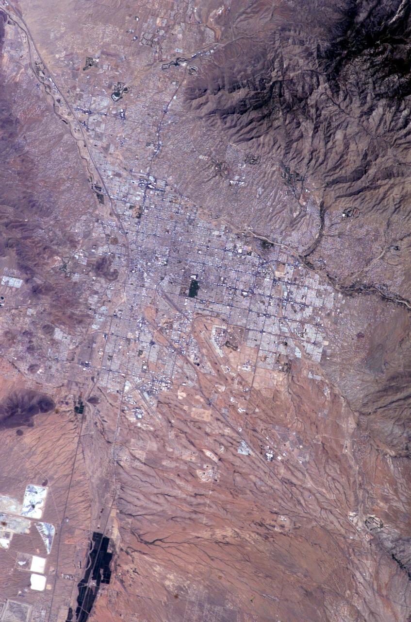
ISS009-E-10382 (7 June 2004) --- Tucson, Arizona is featured in this image photographed by an Expedition 9 crewmember on the International Space Station (ISS). Tucson lies between the forested Catalina Mountains and the Tucson Mountains (dark reddish brown at left). The typical western North American cityscape is a pattern of regular north-south aligned rectangles outlined by major streets set one mile apart. Tucson’s Randolph golf course is the large rectangular dark zone in the image center. The striking contrast between the golf course and its surroundings is due to dense grass cover maintained by frequent watering. The rectangular grid pattern disappears in the small streets of the original city center, situated along the Santa Cruz River (enters the view lower left and exits in the top left corner). Newer and less densely built-up neighborhoods in the foothills of the Catalina Mountains are designed to incorporate natural landscape features, and retain major washes with natural vegetation. This portion of the cityscape seen from space is consequently quite different from the main city grid. The foothills afford views of the city to the south and the mountains to the north and are major areas of development. Large white dots within the urban grid are the reflective rooftops of shopping malls. Tucson enjoys an important position along several major crossroads. Interstate highway I-10, which connects southern California to Florida, appears as a straight line running parallel with the Santa Cruz River northwest from Tucson in the direction of Phoenix. The I-10 traverses a well-marked alluvial fan that extends from the Santa Rita Mountains to the southeast (fine drainage pattern lower center) and exits the view lower right. Highway I-19 is the straight line (lower left) leading south from the city center, between the Santa Cruz River and rectangular spoil heaps of nearby copper mines. The I-19 connects Tucson with Nogales on the Mexican border.
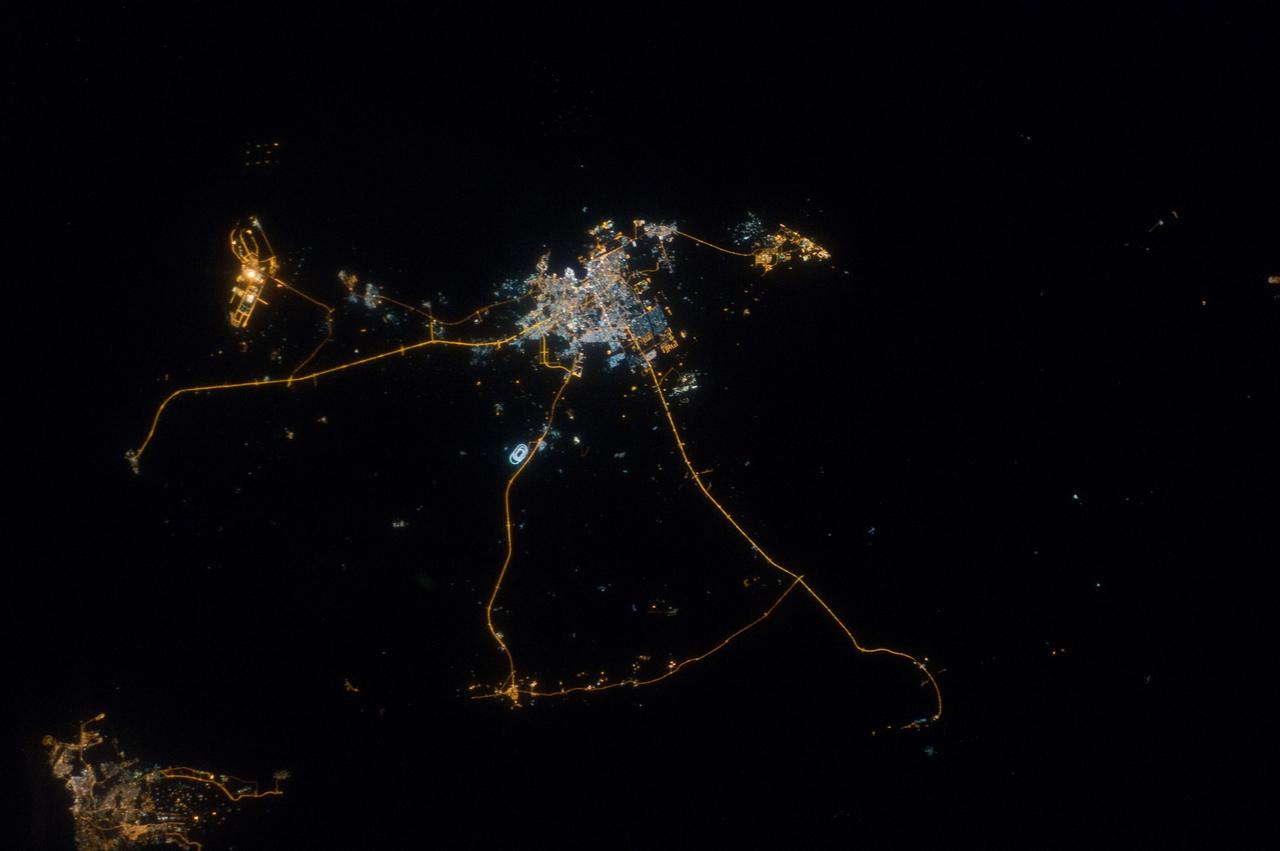
ISS033-E-014856 (13 Oct. 2012) --- A nighttime view of Qatar is featured in this image photographed by an Expedition 33 crew member on the International Space Station. Night lights can be very revealing regarding the distribution of people on the landscape. Here the lights of Qatar show the precise demographic geography of the country. The brightest group at center shows the capital city Doha with the neighboring smaller ports of Ad-Dahira and Umm Sa?id to the north and south, respectively. Even highways and their relative importance can be discerned. Highways are clearly visible leading from the capital west to the Dukhan oil fields, to Saudi Arabia, and to the north of the country--where, judging by the lack of night lights, the population is very low. The relatively low-traffic coast road between the oil fields and the Saudi frontier also stands out. This kind of highly informative human geographic detail is very difficult to discern in daylight images, in which even larger cities, especially in deserts, are hard to see. Almost the entire island nation of Bahrain appears at lower left, with its capital city Manama nearly as bright as the lights of Doha. The difference in light intensity reflects a difference in population?Doha has 1.45 million inhabitants, while the very dense Manama metro area has a population of 1.2 million. While some night views are highly informative about a landscape, they can also be difficult and confusing to identify. Astronauts learn to recognize where they are at night by flying over populated places repeatedly, even though coastlines?one of their best geographic indicators?are generally lost to view because water surfaces and unpopulated land surfaces look the same without illumination (such as from a full moon). Thus the thumb-shaped Qatari peninsula, so well-known in Middle Eastern geography, cannot be discerned at all in this night image. The inset at top right overlays the coastline as seen in daylight onto the night patterns of the image. It shows the Qatari peninsula, with the long arm of the Gulf of Bahrain separating it from Saudi Arabia.
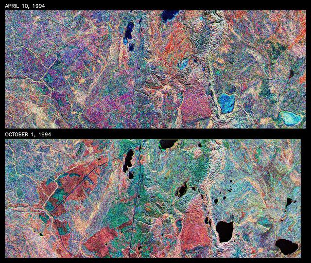
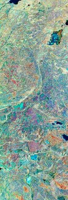
This is a comparison of images over Prince Albert, produced by NASA Spaceborne Imaging Radar-C and X-band Synthetic Aperture Radar aboard the space shuttle Endeavour on its 20th orbit on April 10, 1994. The area is centered at 53.91 degrees north latitude and 104.69 degrees west longitude and is located 40 kilometers (25 miles) north and 30 kilometers (18.5 miles) east of the town of Prince Albert in the Saskatchewan province of Canada. The image covers the area east of Candle Lake, between the gravel highway of 120 and west of highway 106. The area imaged is near the southern limit of the boreal forest. The boreal forest of North America is a continuous vegetation belt at high latitudes stretching across the continent from the Atlantic shoreline of central Labrador and then westward across Canada to the interior mountains and central coastal plains of Alaska. The forest is also part of a larger northern hemisphere circumpolar boreal forest belt. Coniferous trees dominate the entire forest but deciduous trees are also present. During the month of April, the forest experiences seasonal changes from a frozen condition to a thawed condition. The trees are completely frozen over the winter season and the forest floor is covered by snow. As the average temperature rises in the spring, the trees are thawed and the snow melts. This transition has an impact on the rate of moisture evaporation and release of carbon dioxide into the atmosphere. In late September and early October, the boreal forest experiences a relatively different seasonal change. At this time, the leaves on deciduous trees start changing color and dropping off. The soil and trees are quite often moist due to frequent rainfall and cloud cover. The evaporation of moisture and carbon dioxide into the atmosphere also diminishes at this time. SIR-C/X-SAR is sensitive to the moisture of soil and vegetation and can sense this freeze-thaw cycle and the summer-fall seasonal transition over forested areas in particular. Optical sensors, by contrast, are blind to these regions, which are perpetually obscured by thick cloud cover. These changes were detected by comparing the April and October color composite images of L-band data in red, C-band data in green and X-band (vertically received and transmitted) in blue. The changes in intensity of each color over lakes, various forest stands and clear cuts in the two images is striking. Lakes such as Lake Heiberg, Crabtree Lake and Williams Lake, in the right middle part of the image, are frozen in April (appearing in bright blue) and melted (appearing in black) in October. The higher intensity of blue over lakes in April is due to low penetration of the X-band (vertically received and transmitted) and the radar's high sensitivity to surface features. Forest stands also exhibit major changes between the two images. The red areas in the October image are old jack pine canopies that cause higher return at L-band because of their moist condition in late summer compared to their partially frozen condition in April (in purple). Similarly, in the areas near the middle of the image, where black spruce and mixed aspen and jack pine trees dominate, the contrast between blue in October and red and green in April is an indication that the top of the canopy (needles and branches) were frozen in April and moist in October. The changes due to deforestation by logging companies or natural fires can also be detected by comparing the images. For example, the small blue area near the intersection of Harding Road and Highway 120 is the result of logging which occurred after the April data was acquired. The surface area of clear cut is approximately 4 hectares, which is calculated from the high-resolution capability of the radar images and verified by scientists participating in field work during the mission. http://photojournal.jpl.nasa.gov/catalog/PIA01732

STS059-S-039 (11 April 1994) --- This is a false-color composite of Prince Albert, Canada, centered at 53.91 north latitude and 104.69 west longitude. This image was acquired by the Spaceborne Imaging Radar-C and X-Band Synthetic Aperture Radar (SIR-C/X-SAR) aboard the Space Shuttle Endeavour on its 20th orbit. The area is located 40 kilometers (25 miles) north and 30 kilometers (20 miles) east of the town of Prince Albert in the Saskatchewan province of Canada. The image covers the area east of the Candle Lake, between gravel surface Highways 120 and 106 and west of 106. The area in the middle of the image covers the entire Nipawin (Narrow Hills) provincial park. The look angle of the radar is 30 degrees and the size of the image is approximately 20 kilometers by 50 kilometers (12 by 30 miles). The image was produced by using only the L-Band. The three polarization channels HH, HV and VV are illustrated by red, green and blue respectively. The changes in the intensity of each color are related to various surface conditions such as variations in forest stands, frozen or thawed condition of the surface, disturbances (fire and deforestation), and areas of re-growth. Most of the dark areas in the image are the ice-covered lakes in the region. The dark area on the top right corner of the image is the White Gull Lake north of the intersection of Highway 120 and 913. The right middle part of the image shows Lake Ispuchaw and Lower Fishing Lake. The deforested areas are also shown by dark areas in the image. Since most of the logging practice at the Prince Albert area is around the major highways, the deforested areas can be easily detected as small geometrically shaped dark regions along the roads. At the time of the SIR-C/X-SAR overpass, a major part of the forest is either frozen or undergoing the spring thaw. The L-Band HH shows a high return in the jack pine forest. The reddish areas in the image are old jack pine forest, 12-17 meters (40-55 feet) in height and 60-75 years old. The orange-greenish areas are young jack pine trees, 3-5 meters (10-16 feet) in height and 11-16 years old. The green areas are due to the relative high intensity of the HV channel which is strongly correlated with the amount of biomass. L-Band HV channel shows the biomass variations over the entire region. Most of the green areas, when compared to the forest cover maps are identified as black spruce trees. The dark blue and dark purple colors show recently harvested or re-growth areas respectively. SIR-C/X-SAR is part of NASA's Mission to Planet Earth (MTPE). SIR-C/X-SAR radars illuminate Earth with microwaves allowing detailed observations at any time, regardless of weather or sunlight conditions. SIR-C/X-SAR uses three microwave wavelengths: L-Band (24 cm), C-Band (6 cm), and X-Band (3 cm). The multi-frequency data will be used by the international scientific community to better understand the global environment and how it is changing. The SIR-C/X-SAR data, complemented by aircraft and ground studies, will give scientists clearer insights into those environmental changes which are caused by nature and those changes which are induced by human activity. SIR-C was developed by NASA's Jet Propulsion Laboratory (JPL). X-SAR was developed by the Dornire and Alenia Spazio Companies for the German Space Agency, Deutsche Agentur fuer Raumfahrtangelegenheiten (DARA), and the Italian Space Agency, Agenzia Spaziale Italiana (ASI). JPL Photo ID: P-43886
STS059-S-079 (18 April 1994) --- This is a false-color, three frequency image of Prince Albert, Canada, centered at 53.91 north latitude and 104.69 west longitude. It was produced using data from the X-Band, C-Band and L-Band radars that comprise the Spaceborne Imaging Radar-C and X-Band Synthetic Aperture Radar (SIR-C/X-SAR). SIR-C/X-SAR acquired this image on the 20th orbit of the Space Shuttle Endeavour. The area is located 40 kilometers north and 30 kilometers east of the town of Prince Albert in the Saskatchewan province of Canada. The image covers the area east of the Candle Lake, between gravel surface Highways 120 and 106 and west of 106. The area in the middle of the image covers the entire Nipawin (Narrow Hills) provincial park. The look angle of the radar is 30 degrees and the size of the image is approximately 20 by 50 kilometers. The red, green, and blue colors represent L-Band total power, C-Band total power, and XVV respectively. The changes in the intensity of each color are related to various surface conditions such as frozen or thawed forest, fire, deforestation and areas of regrowth. Most of the dark blue areas in the image are the ice covered lakes. The dark area on the top right corner of the image is the White Gull Lake north of the intersection of Highway 120 and 913. The right middle part of the image shows Lake Ispuchaw and Lower Fishing Lake. The deforested areas are shown by light blue in the image. Since most of the logging practice at the Prince Albert area is around the major highways, the deforested areas can be easily detected as small geometrically shaped dark regions along the roads. At the time these data were taken, a major part of the forest was either frozen or undergoing the spring thaw. In such conditions, due to low volume of water in the vegetation, a deeper layer of the canopy is imaged by the radar, revealing valuable information about the type of trees, the amount of vegetation biomass and the condition of the surface. As the frequency increases, the penetration depth in the canopy decreases. Over forest canopies, the X-Band radar contains information about the top of the canopy. Whereas, C-Band and L-Band radar returns show contributions from the crown and trunk areas respectively. The bright areas in the image are dense mixed aspen and old jackpine forests where the return from all three bands is high. The reddish area corresponds to more sparse old jack pine (12 to 17 meters in height and 60 to 75 years old) where the L-Band signal penetrates deeper in the canopy and dominates C-Band and X-Band returns. Comparison of the image with the forest cover map of the area indicates that the three band radar can be used to classify various stands. SIR-C/X-SAR is part of NASA's Mission to Planet Earth (MTPE). SIR-C/X-SAR radars illuminate Earth with microwaves allowing detailed observations at any time, regardless of weather or sunlight conditions. SIR-C/X-SAR uses three microwave wavelengths: L-Band (24 cm), C-Band (6 cm), and X-Band (3 cm). The multi-frequency data will be used by the international scientific community to better understand the global environment and how it is changing. The SIR-C/X-SAR data, complemented by aircraft and ground studies, will give scientists clearer insights into those environmental changes which are caused by nature and those changes which are induced by human activity. SIR-C was developed by NASA's Jet Propulsion Laboratory (JPL). X-SAR was developed by the Dornire and Alenia Spazio Companies for the German Space Agency, Deutsche Agentur fuer Raumfahrtangelegenheiten (DARA), and the Italian Space Agency, Agenzia Spaziale Italiana (ASI). JPL Photo ID: P-43929
ISS040-E-103496 (19 Aug. 2014) --- On an unusually cloud-free day at the height of the dry season in Amazonia, several fires were burning, giving rise to a broad smoke pall easily seen from the International Space Station, photographed by an Expedition 40 crew member. Parts of the space station appear along the margins of the image. Against the backdrop of the dark green rainforest, several fires follow the major highway BR 163 (lower center of the image to the top left). Fires are set to clear patches of forest for agriculture, a process that reveals red-brown soils. A long line of new cleared patches snakes east from BR 163 towards the remote valley of the Rio Crepori. Extensive deforested areas in Brazil?s state of Mato Grosso appear as tan areas across the top of the image. Fires show the advance of deforestation into the state of Para, the area shown in most of this view. Para is now second after Mato Grosso in terms of deforestation acreage.
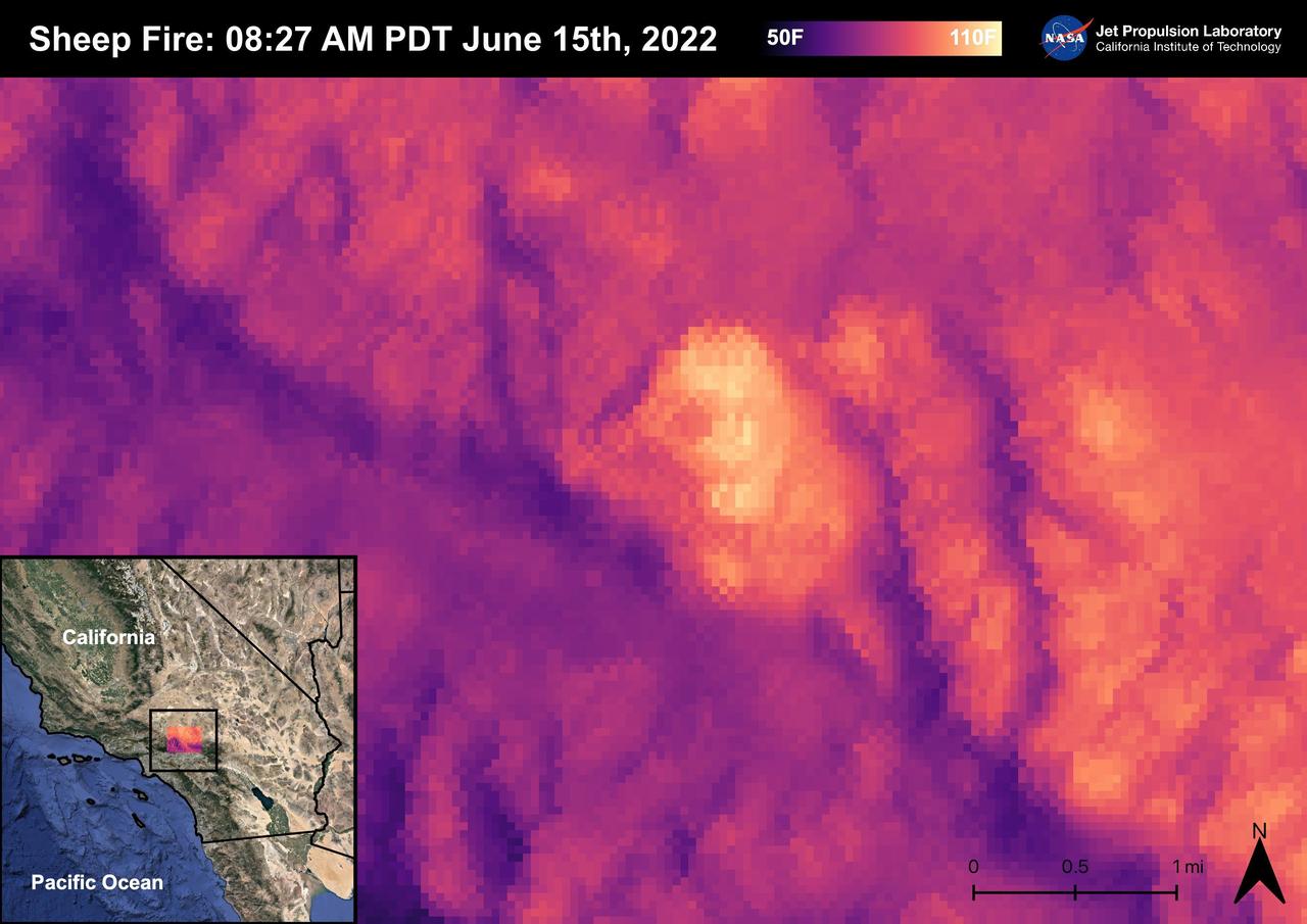
The Sheep Fire started on June 12th, 2022, Northeast of the town of Wrightwood in San Bernardino County. The fire burned 865 acres and was contained on June 19th, 2022. Due to the proximity of the Sheep Fire to Wrightwood, the town was evacuated. The Pacific Crest Trail in the San Gabriel Mountains and part of Highway 2 were closed due to the fire. There were no casualties or injuries as a result of the Sheep Fire. The fire was captured in an ECOSTRESS Land Surface Temperature image on 08:27 AM PDT on June 15th and shows the temperature of the fire surpassing 100 degrees Fahrenheit. As California is currently in a drought, there are concerns that 2022 will see a severe wildfire season; ECOSTRESS allows for the monitoring of the drought and of wildfires. ECOSTRESS is a thermal instrument on the International Space Station that measures the temperature of the ground, which is hotter than the air temperature during the day. It was launched to the space station in 2018. Its primary mission is to identify critical thresholds of water use and water stress in plants and to detect the timing, location, and predictive factors leading to plant water uptake decline and/or cessation. The nature of the high-resolution data provided by ECOSTRESS allows it to record heat related phenomena such as heat waves, droughts and wildfires. https://photojournal.jpl.nasa.gov/catalog/PIA25356
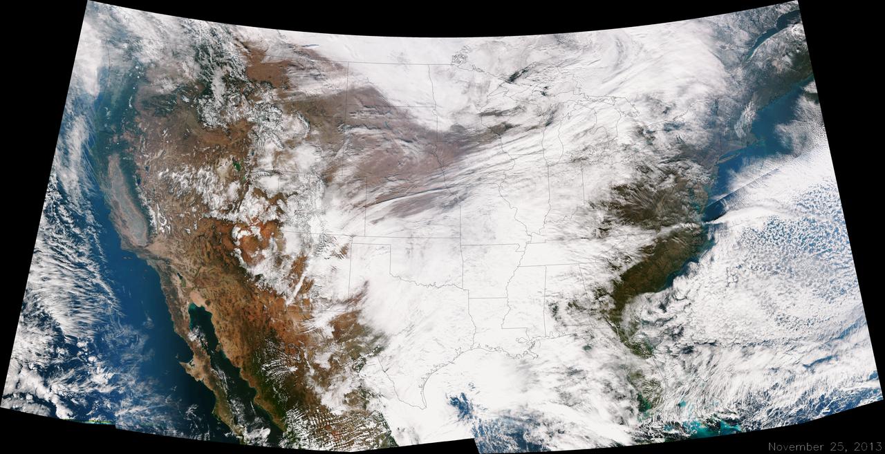
A large winter system is moving across the United States and is combining with cold air moving down from Canada, bringing snow to some areas. Major travel impacts are expected along the main highways throughout the eastern U.S. This true color image of the Continental U.S. was taken on November 25, 2013 by the Suomi NPP satellite and shows the system as it moves through the South and Midwest. <b><a href="http://www.nasa.gov/audience/formedia/features/MP_Photo_Guidelines.html" rel="nofollow">NASA image use policy.</a></b> <b><a href="http://www.nasa.gov/centers/goddard/home/index.html" rel="nofollow">NASA Goddard Space Flight Center</a></b> enables NASA’s mission through four scientific endeavors: Earth Science, Heliophysics, Solar System Exploration, and Astrophysics. Goddard plays a leading role in NASA’s accomplishments by contributing compelling scientific knowledge to advance the Agency’s mission. <b>Follow us on <a href="http://twitter.com/NASA_GoddardPix" rel="nofollow">Twitter</a></b> <b>Like us on <a href="http://www.facebook.com/pages/Greenbelt-MD/NASA-Goddard/395013845897?ref=tsd" rel="nofollow">Facebook</a></b> <b>Find us on <a href="http://instagrid.me/nasagoddard/?vm=grid" rel="nofollow">Instagram</a></b>

ISS029-E-037471 (3 Nov. 2011) --- Egypt?Israel borderlands, northern Sinai Peninsula and northern Negev Desert are featured in this image photographed by an Expedition 29 crew member on the International Space Station. A clearly visible line that marks approximately 50 kilometers of the international border between Egypt and Israel?10-60 kilometers from the Mediterranean Sea to the northwest (not shown)?crosses the center of this photograph from left to right. The reason for the color difference is likely the slightly higher level of grazing by the animal herds of Bedouin herdsmen on the Egyptian side of the border. A major highway also follows the border, making the demarcation more prominent in this recent image taken from the space station. A patch of the Gaza Strip appears under scattered cloud at far right. In the arid to semiarid climate of the region illustrated in the image the natural grass vegetation is sparse at best. Irrigated commercial agriculture in Israel nearest the Mediterranean coast appears as a series of large angular patterns and circular center pivot fields, with darker greens indicating growing crops (right). Smaller plot sizes appear on the Egyptian side of the border at upper right. The image shows how the active sand dunes, which dominate most of the landscape in this view, mark the southern limit of the agriculture.
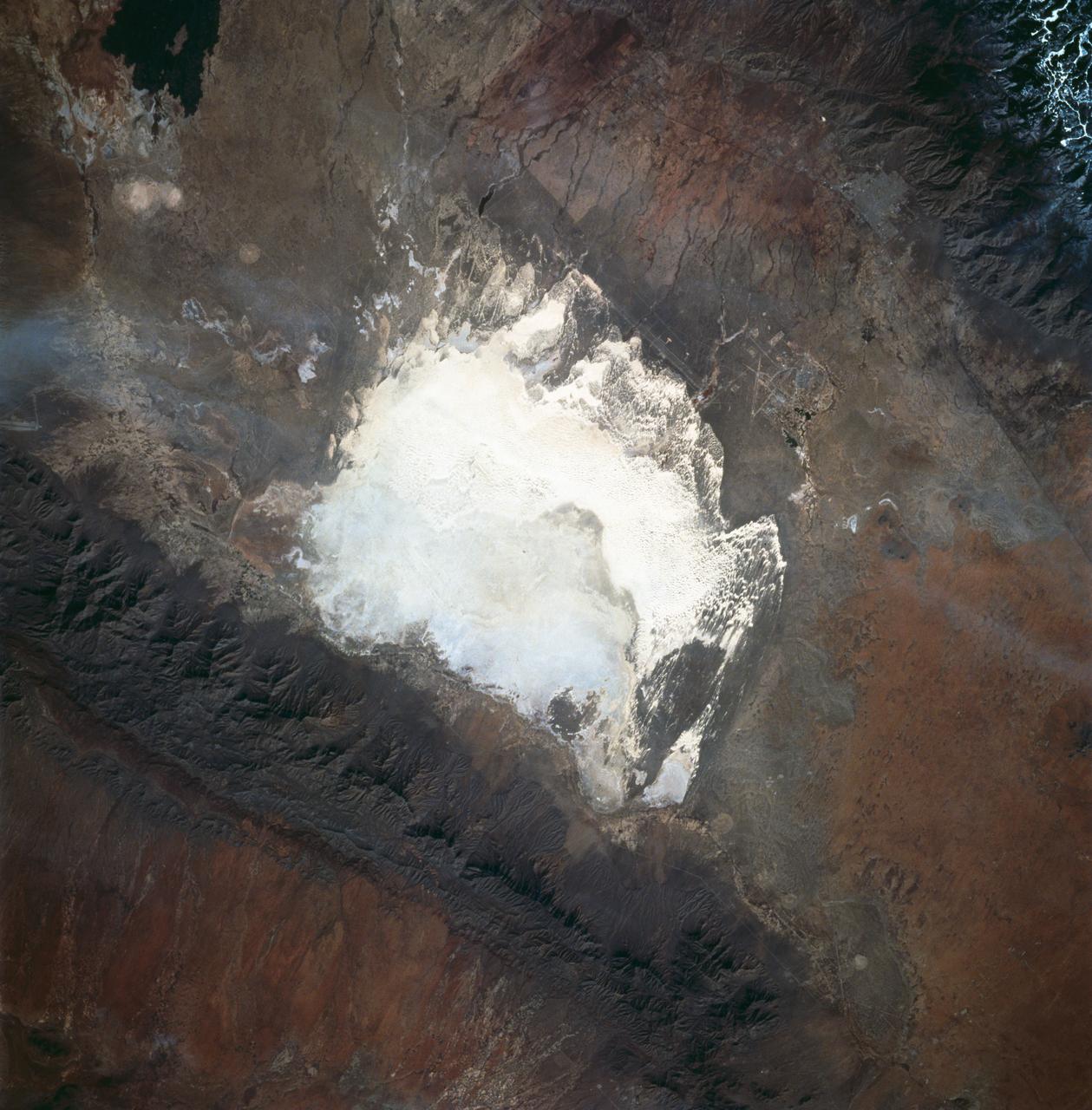
STS060-83-016 (3-11 Feb 1994) --- White Sands National Monument (Park) is easily recognized in the center of this near-vertical color photograph. White Sands is the world's largest gypsum dune field. It represents an alabaster sea that covers nearly 300 square miles. The National Park Service has the responsibility to preserve this unique feature, allowing the dune world to unfold in its natural environment, but without interference from humans. White Sands lies within a spectacular, oblong geological depression called the Tularosa Basin bounded by the Sacramento Mountains on the east and the San Andres Mountains on the west. Climatically the basin is a true desert, averaging less than 10 inches of rainfall per year. In terms of topographic relief the Sacramento Mountains attain elevations greater than 9,000 feet above sea level, while the San Andres Mountains on the west exceed altitudes of 8,000 feet. At the southwest corner of the White Sands is dry lake, Lucero. This lake is the lowest point in the Tularosa Basin at 3,900 feet. In terms of cultural features the city of Alamogordo (over 20,000 population) and Holloman Air Force Base can be seen with great clarity on this photograph. The area is accessible by highways U.S.70 & 82 from Las Cruces, New Mexico, and U.S.54 from El Paso, Texas.
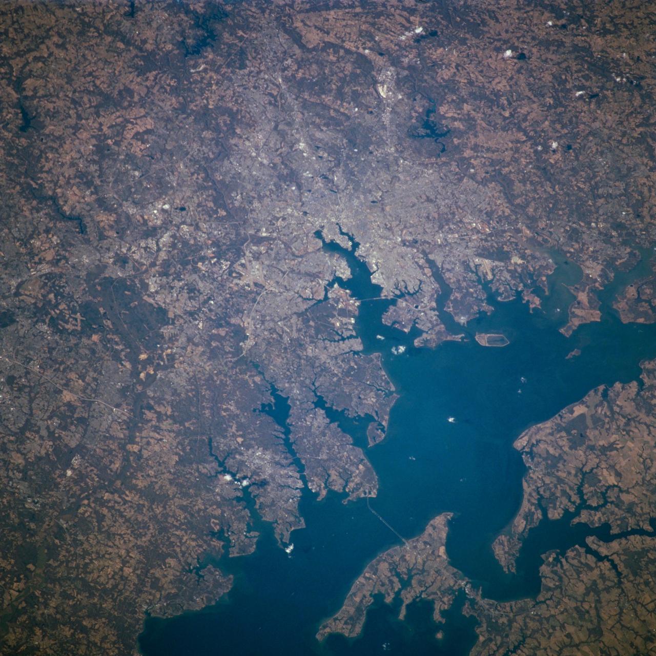
STS098-716-057 (7-20 February 2001) --- Baltimore, Maryland can be identified in this northwest-looking view, photographed with a 70mm handheld camera from the Space Shuttle Atlantis, which shows the western shore of Chesapeake Bay. Numerous drowned river valleys provide excellent natural harbors along the periphery of the bay. Baltimore’s harbor has been developed along one of these drowned valleys, the Patapsco River. With a population of over 2.5 million people, the greater Baltimore urban area is part of the northeastern U.S. Megalopolis that extends from the Boston (MA) area to Richmond (VA). Specific features that can be seen in the image include a short segment of Interstate Highway 95 that connects southwest Baltimore with northeast Washington, D.C.; the intersecting runways of Baltimore-Washington International Airport south of downtown Baltimore; Francis Scott Key Bridge that skirts around the southeast side of Baltimore; the Chesapeake Bay Bridge that spans the bay and connects the Baltimore area with the eastern shore of Maryland; and the central business district of Baltimore where the two arms of the inner harbor terminate. The darker-looking vegetation cover is mixed hardwood forests (notice that many wooded areas are located along streambeds and floodplains of small river valleys), while lighter-looking land parcels in the rural countryside is used for crops or pasturelands.

Sand boil or sand volcano measuring 2 m (6.6 ft.) in length erupted in median of Interstate Highway 80 west of the Bay Bridge toll plaza when ground shaking transformed loose water-saturated deposit of subsurface sand into a sand-water slurry (liquefaction) in the October 17, 1989, Loma Prieta earthquake. Vented sand contains marine-shell fragments. Sand and soil grains have faces that can cause friction as they roll and slide against each other, or even cause sticking and form small voids between grains. This complex behavior can cause soil to behave like a liquid under certain conditions such as earthquakes or when powders are handled in industrial processes. Mechanics of Granular Materials (MGM) experiments aboard the Space Shuttle use the microgravity of space to simulate this behavior under conditions that carnot be achieved in laboratory tests on Earth. MGM is shedding light on the behavior of fine-grain materials under low effective stresses. Applications include earthquake engineering, granular flow technologies (such as powder feed systems for pharmaceuticals and fertilizers), and terrestrial and planetary geology. Nine MGM specimens have flown on two Space Shuttle flights. Another three are scheduled to fly on STS-107. The principal investigator is Stein Sture of the University of Colorado at Boulder. (Credit: J.C. Tinsley, U.S. Geological Survey)
51J-143-126 (5 Oct. 1985) --- The vertical stabilizer of the Earth-orbiting Space Shuttle Atlantis serves to partially frame this scene of Metropolitan Houston. Hold photo with vertical tail at top so that north will be at top. America's fourth largest city, with its radiating highway network, lies at the junction between the East Texas piney woods, containing lakes Conroe and Livingston (near top center and top right, respectively), and the coastal prairie, now largely farmland (left side of frame). The coast stretches from the left at Freeport and the mouth of the Brazos River, past Galveston and Texas City, and the circle of the High Island Salt Dome (clearly seen at lower right near the Bolivar Peninsula), to Port Arthur on the Neches River (far right). Patterns of muddy and clear water are particularly well-displayed in Galveston and Trinity Bays, as well as in the Gulf of Mexico. With a close look, the Harris County Domed Stadium (Astrodome) can be recognized on Houston's south side. The NASA Johnson Space Center (JSC) and the Clear Lake City area are easily delineated some 25 miles southeast of downtown Houston. The scene was recorded on film by one of the STS-51J crewmembers using a handheld Hasselblad camera and 70mm film.
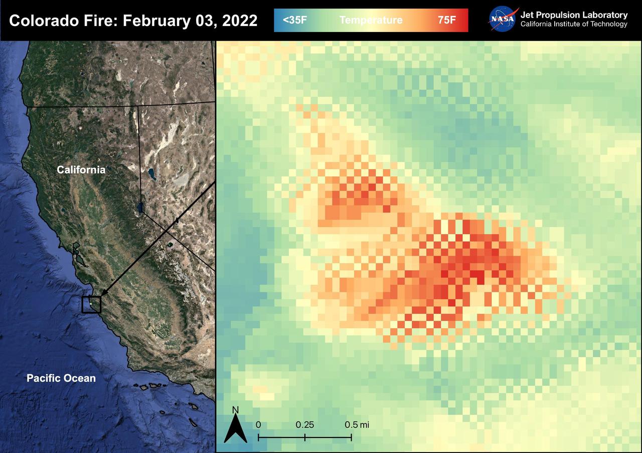
The Colorado Fire began on January 21st, 2022 was started by an escaped fire by the Palo Colorado Road. The wildfire burned 687 acres between Carmel-by-the-Sea and Big Sur. The Colorado Fire was driven towards the coast by strong winds leading to the shut down of the Bixby Bridge and a section of Highway 1. The fire was completely contained as of February 5th, 2022. No injuries or causalities have been reported; one structure was destroyed. The image above shows the fire captured in a Land Surface Temperature image from ECOSTRESS on February 3rd, 2022 at 01:11 PM PDT. As California is currently in a drought, there are concerns that 2022 will see a severe wildfire season; ECOSTRESS allows for the monitoring of the drought and of wildfires. ECOSTRESS is a thermal instrument on the International Space Station that measures the temperature of the ground, which is hotter than the air temperature during the day. It was launched to the space station in 2018. Its primary mission is to identify critical thresholds of water use and water stress in plants and to detect the timing, location, and predictive factors leading to plant water uptake decline and/or cessation. The nature of the high-resolution data provided by ECOSTRESS allows it to record heat related phenomena such as heat waves, droughts and wildfires. https://photojournal.jpl.nasa.gov/catalog/PIA25280
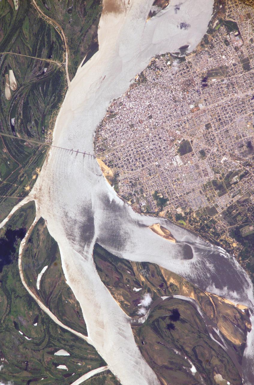
ISS010-E-05070 (25 October 2004) --- Corrientes, Argentina, and the Parana River are featured in this image photographed by an Expedition 10 crewmember on the International Space Station (ISS). Corrientes, Argentina sits on the east bank of the Parana River, South America’s third largest river (after the Negro and Amazon Rivers). From its headwaters in southeastern Brazil, the river flows southwestward around southern Paraguay, and then into Argentina. Corrientes is located just inside Argentina, across the river from the southwestern tip of Paraguay. The bridge over the Parana, built in the 1970s, connects Corrientes to its sister city, Resistencia, (beyond the left edge of image) on the western bank of the river. Sun glint on the river gives it a silvery glow and emphasizes channel islands in the river, side channels, and meander scars on the floodplain opposite the city, and even reveals the pattern of disturbed flow downstream of the bridge pylons. The old part of the city appears as a zone of smaller, more densely clustered city blocks along the river to the north of a major highway, which runs through Corrientes from the General Belgrano Bridge to the northeast (upper right of image). Larger blocks of the younger cityscape, with more green space, surround these core neighborhoods.
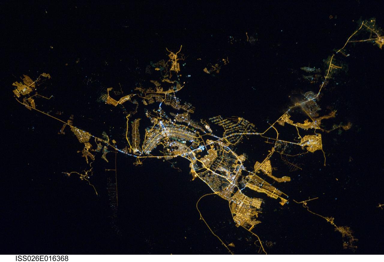
ISS026-E-016368 (8 Jan. 2011) --- Brasilia, Brazil at night time is featured in this image photographed by an Expedition 26 crew member on the International Space Station. Whether seen at night or during the day, the capital city of Brazil is unmistakable from orbit. Brasilia is located on a plateau (the Planalto Central) in the west-central part of the country, and is widely considered to be one of the best examples of 20th century urban planning in the world. One of its most distinctive design features—as seen from above—suggests a bird, butterfly, or airplane traveling along a northwest-southeast direction, and is made dramatically visible by city light patterns (center left, directly to the west of Lake Paranoa). Following the establishment of Brasilia in the early 1960s informal settlements began to form around the original planned city. Ceilandia, located to the west of Brasilia, was one such informal settlement. In 1970 the settlement was formalized by the government and is now a satellite city of Brasilia with its own distinct urban identity. The developed areas of Brasilia and its satellite cities are clearly outlined by street grid and highway light patterns at night in this photograph taken from the space station. The large unlit region to the northwest of the city is the Brasilia National Park (lower left); other dark regions to the south and southwest contain agricultural fields and expanses of Cerrado tropical savanna.
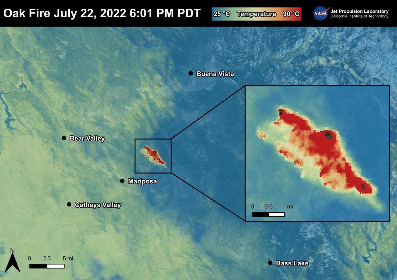
The Oak Fire started on July 22nd, 2022 at 2:10 PM PDT near Carstens Road and Highway 140 in Mariposa County, west of Yosemite. The fire has burned over 19,000 acres. In the first few days of the Oak Fire, over 1,400 structures were threatened, 3 were damaged, and 41 destroyed. Evacuation orders and road closures were issued throughout the region. The Oak Fire was captured in an ECOSTRESS Land Surface Temperature image on July 22nd with temperatures exceeding 90 degrees Celsius. ECOSTRESS is a thermal instrument on the International Space Station that measures the temperature of the ground, which is hotter than the air temperature during the day. It was launched to the space station in 2018. Its primary mission is to identify critical thresholds of water use and water stress in plants and to detect the timing, location, and predictive factors leading to plant water uptake decline and/or cessation. The nature of the high-resolution data provided by ECOSTRESS allows it to record heat related phenomena such as heat waves and wildfires. https://photojournal.jpl.nasa.gov/catalog/PIA25481
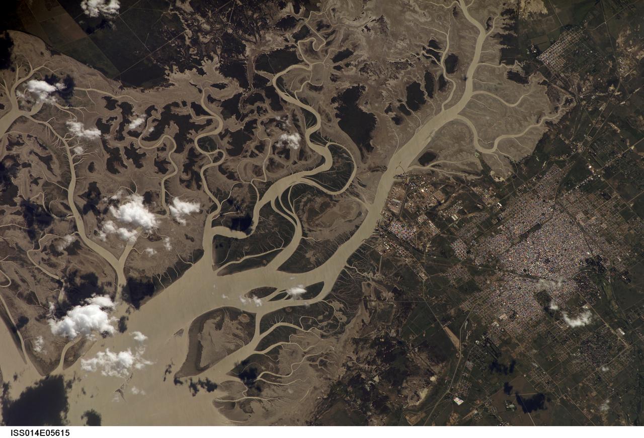
ISS014-E-05615 (14 Oct. 2006) --- Bahia Blanca, Buenos Aires Province, Argentina is featured in this image photographed by an Expedition 14 crewmember on the International Space Station. The port city of Bahia Blanca lies almost 600 kilometers southwest of Buenos Aires on the southern rim of the Argentine economic heartland. This small city of 275,000 people is captured in one frame which shows its position near the mouth of the Arroyo Naposta. The salt flats (gray) and wetlands bordering this estuary, characterized by twisting, light colored tidal channels and dark swamps, lie mainly on the south side of the river. The yellow tinge to the water surfaces arises from the partial sunglint reflection on this particular day. The name Bahia Blanca (White Bay) derives from the white color of the salt and was applied to the major bay--noted by Magellan as he probed the coast of South America for a passage to the Pacific Ocean in 1520--and then to the city at the head of this bay. Highways, airline routes and pipelines from oil and gas fields to the west and south all converge on Bahia Blanca. The city is a major cultural center and historically has acted as a gateway for immigration. Higher ground on the north side of the estuary affords stable ground for the growth of the city and for intensive agriculture, a mainstay of the Argentine economy. The city is set back from the waterfront where an industrial park, a petrochemical center, and dockyards (white ellipse) are located.
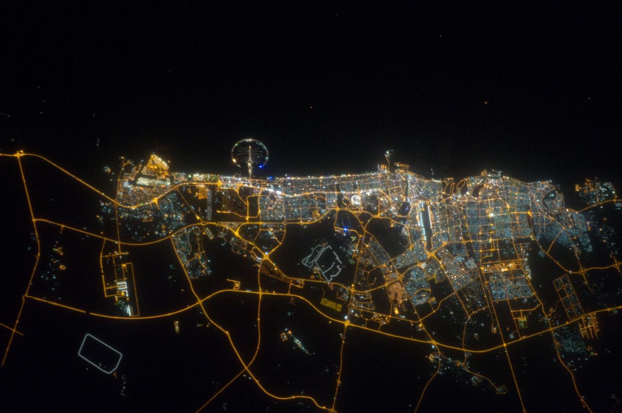
ISS032-E-023718 (11 Aug. 2012) --- The city of Dubai, United Arab Emirates, is featured in this night view photographed by an Expedition 32 crew member on the International Space Station. The city of Dubai is the largest metropolitan area in the emirate of Dubai, one of the member states of the United Arab Emirates. Dubai is located along the southern Persian Gulf on the Arabian Peninsula, and its signature city is known for high profile architectural and development projects. Among the most notable is the Palm Island Resort, a manmade peninsula and surrounding islands built from over 50 million cubic meters of sand. Two other island projects (out of frame), one similar to the Palm Island Resort and another crafted to look like a map of the world, are also visible in other space station imagery along the Dubai coastline. Orange sodium vapor lights trace out the major highways and surface street grid in and around the metropolitan area, while grey-white mercury vapor lamps fill in the commercial and residential areas. The lighted islands and peninsula of the Palm Island Resort are clearly visible along the coastline. An interesting spiral pattern of lights on the southeastern fringe of the urban area is a camel racetrack. Night time images like this are useful to climate modelers, urban planners, and geographers as they allow for simple definition of urban (densely lit) and rural (sparsely lit) areas.
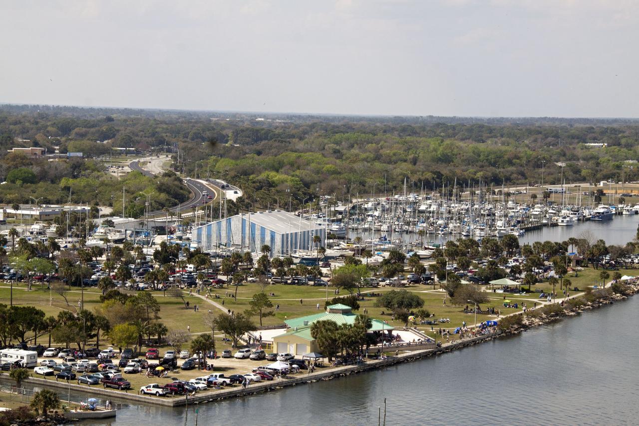
CAPE CANAVERAL, Fla. -- Folks from across the country camped out in communities surrounding NASA's Kennedy Space Center in Florida to witness space shuttle Discovery make history by lifting off on its final scheduled mission from Launch Pad 39A. Seen here is Sand Point Park near U. S. Highway 1 and State Road 406, also known as the A. Max Brewer Causeway, in Titusville, Fla. Liftoff is set for 4:50 p.m. EST on Feb. 24. Discovery and its six-member STS-133 crew will deliver the Permanent Multipurpose Module, packed with supplies and critical spare parts, as well as Robonaut 2, the dexterous humanoid astronaut helper, to the International Space Station. Discovery, which will fly its 39th mission, is scheduled to be retired following STS-133. This will be the 133rd Space Shuttle Program mission and the 35th shuttle voyage to the space station. For more information on the STS-133 mission, visit www.nasa.gov/mission_pages/shuttle/shuttlemissions/sts133/. Photo credit: NASA/Jack Pfaller
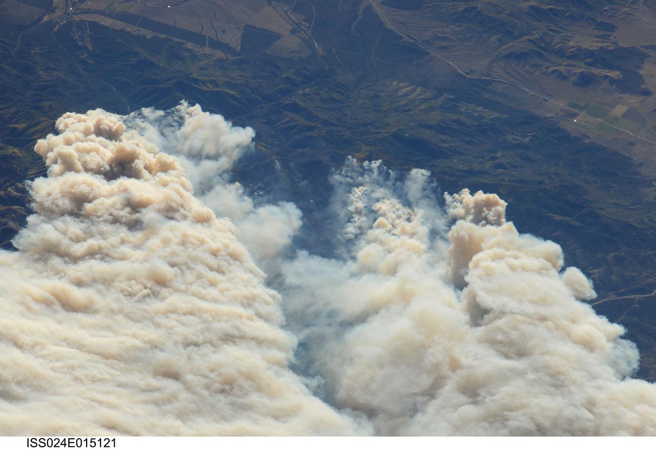
ISS024-E-015121 (20 Sept. 2010) --- Twitchell Canyon Fire in central Utah is featured in this image photographed by an Expedition 24 crew member on the International Space Station (ISS). The Twitchell Canyon Fire near central Utah?s Fishlake National Forest is reported to have an area of approximately 13,383 hectares (approximately 134 square kilometers, or 33,071 acres). This detailed image shows smoke plumes generated by several fire spots close to the southwestern edge of the burned area. The fire was started by a lightning strike on July 20, 2010. Whereas many of the space station images of Earth are looking straight down (nadir), this photograph was exposed at an angle. The space station was located over a point approximately 509 kilometers (316 miles) to the northeast, near the Colorado/Wyoming border, at the time the image was taken on Sept. 20. Southwesterly winds were continuing to extend smoke plumes from the fire to the northeast. While the Twitchell Canyon region is sparsely populated, Interstate Highway 15 is visible at upper left.