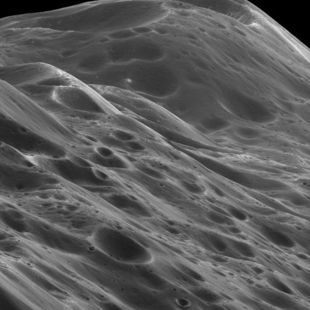
The Himalayas of Iapetus
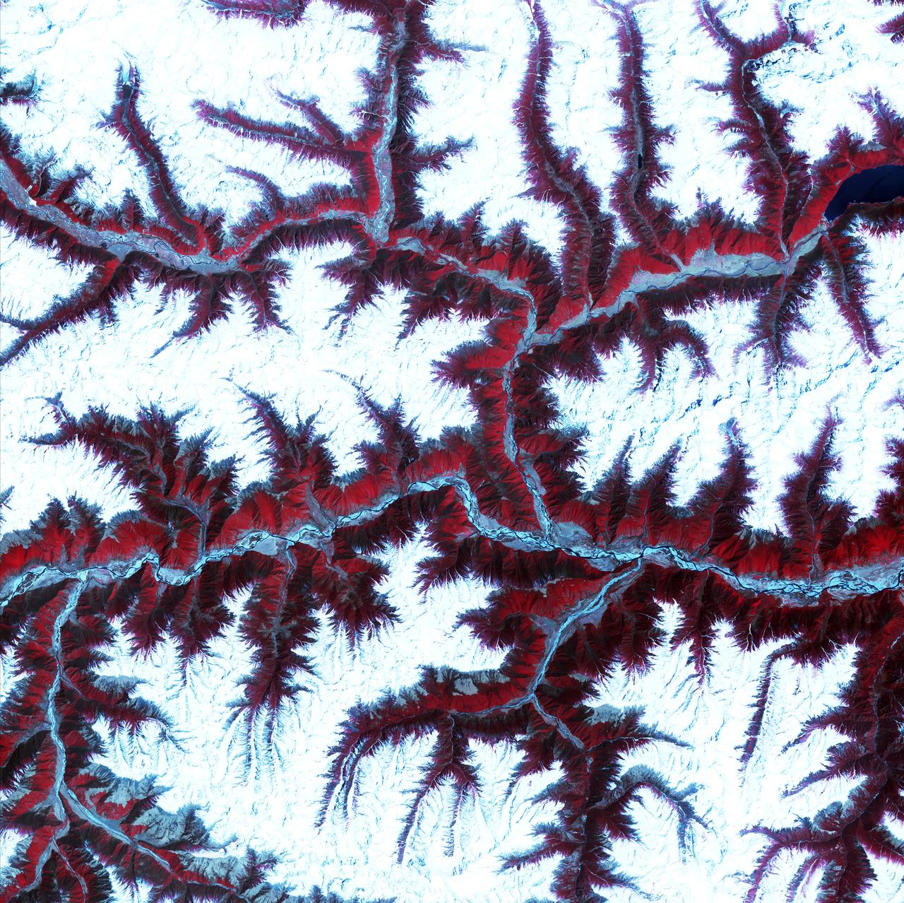
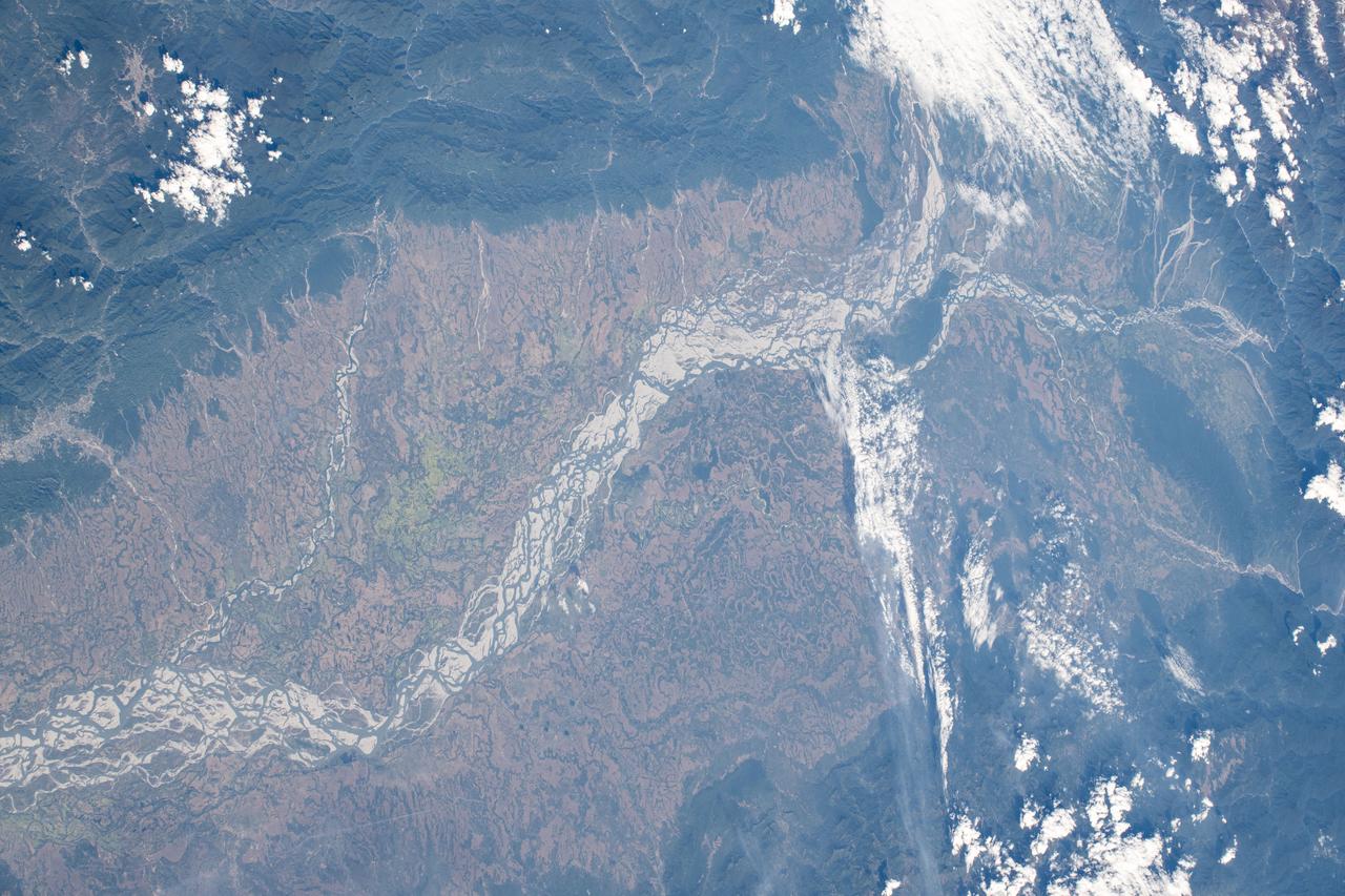
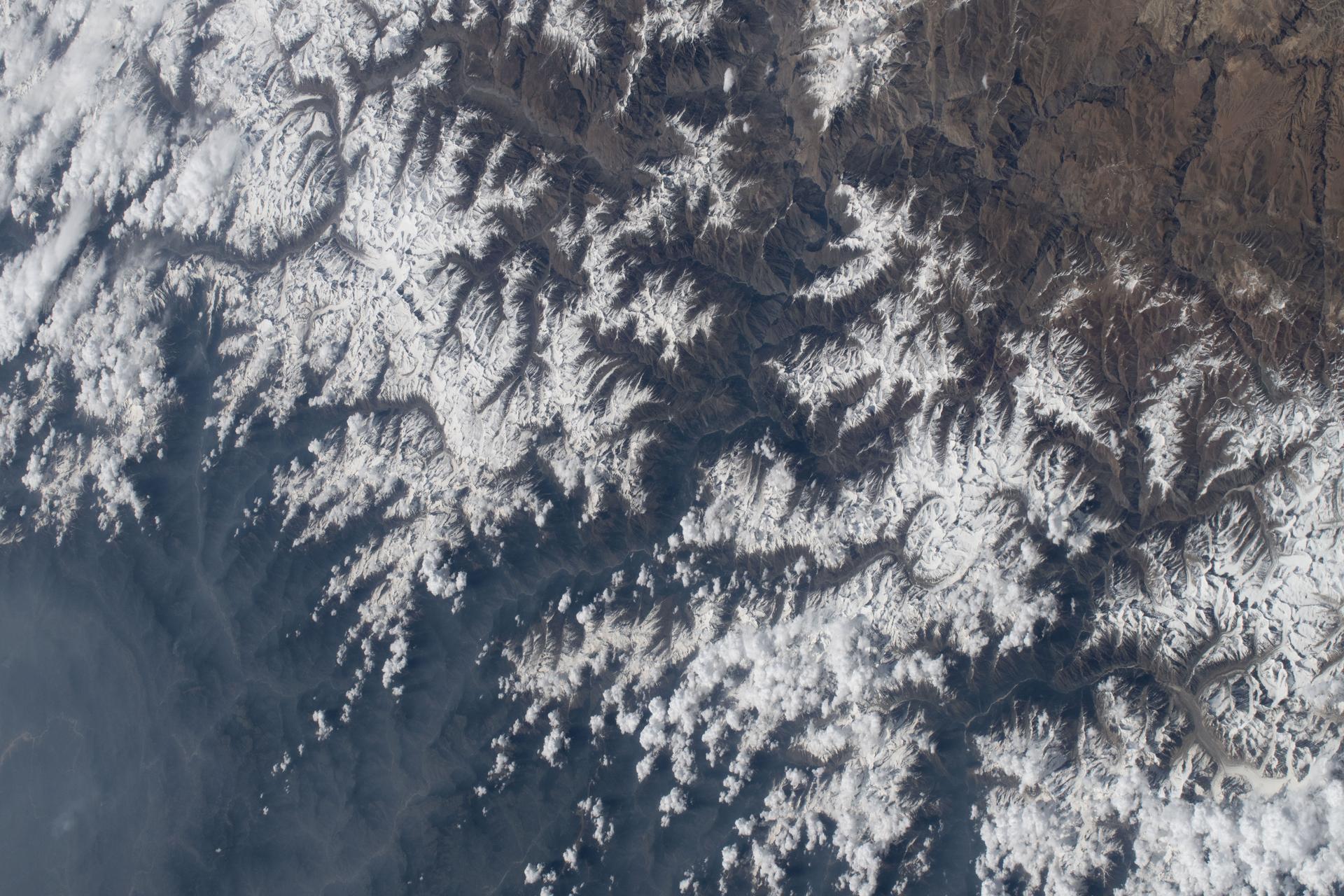
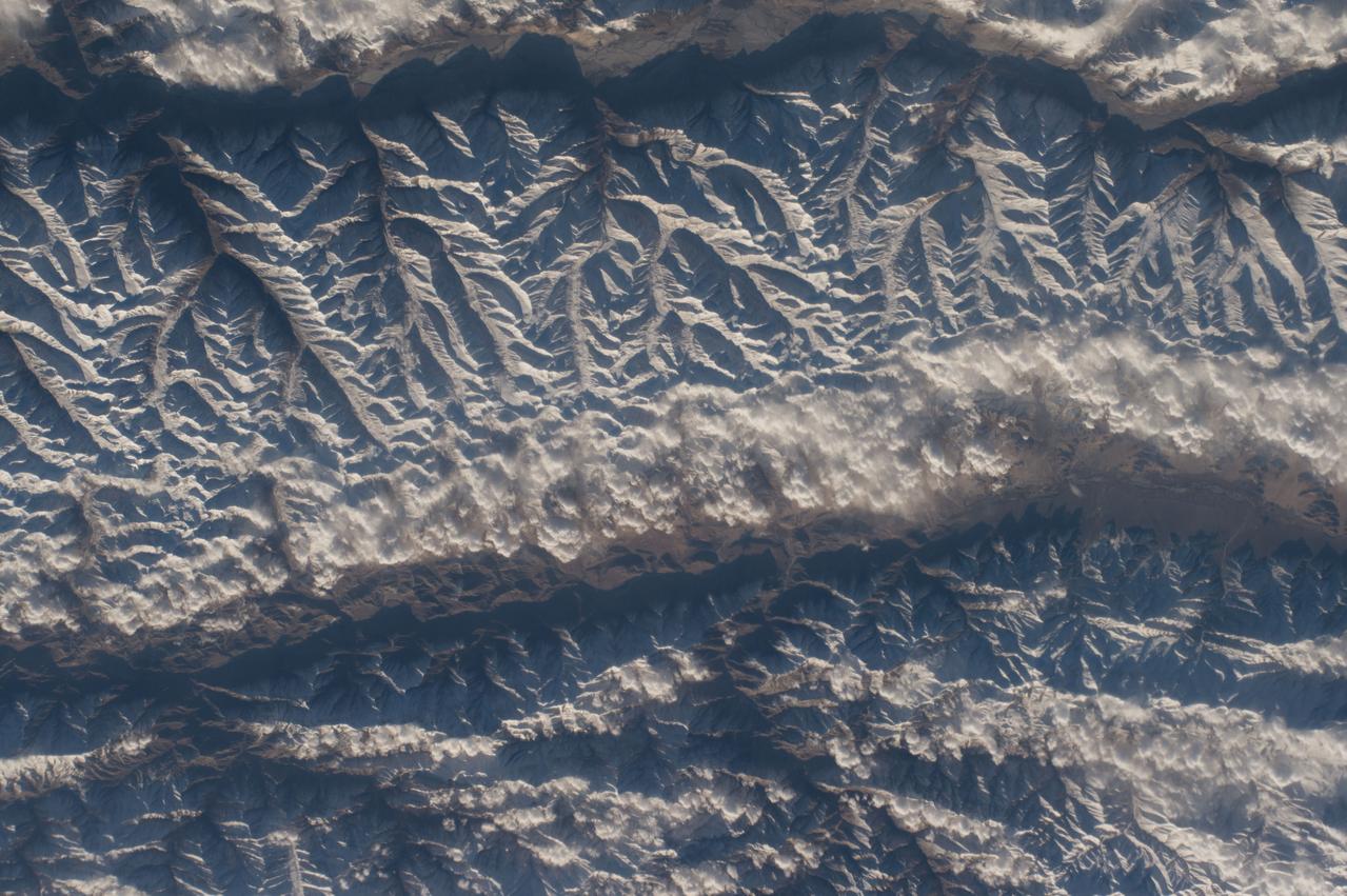
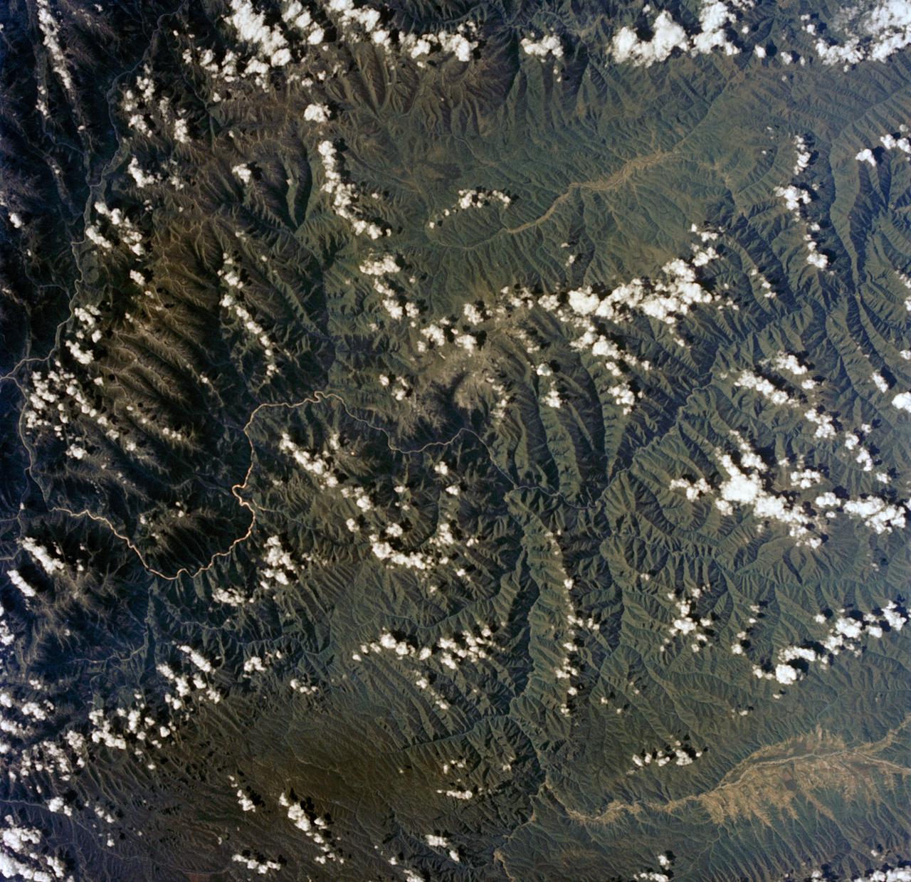
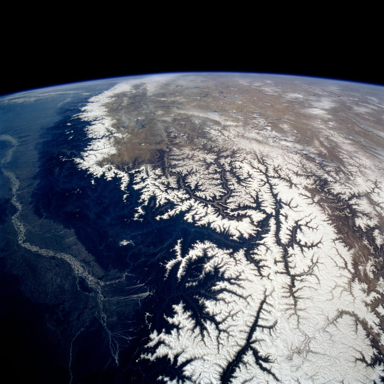
April 12th, 2001: Description: Soaring, snow-capped peaks and ridges of the eastern Himalaya Mountains create an irregular white-on-red patchwork between major rivers in southwestern China. The Himalayas are made up of three parallel mountain ranges that together extend more than 2,900 kilometers. Source: ASTER To learn more about the Landsat satellite go to: <a href="http://landsat.gsfc.nasa.gov/" rel="nofollow">landsat.gsfc.nasa.gov/</a>
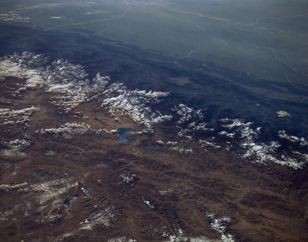
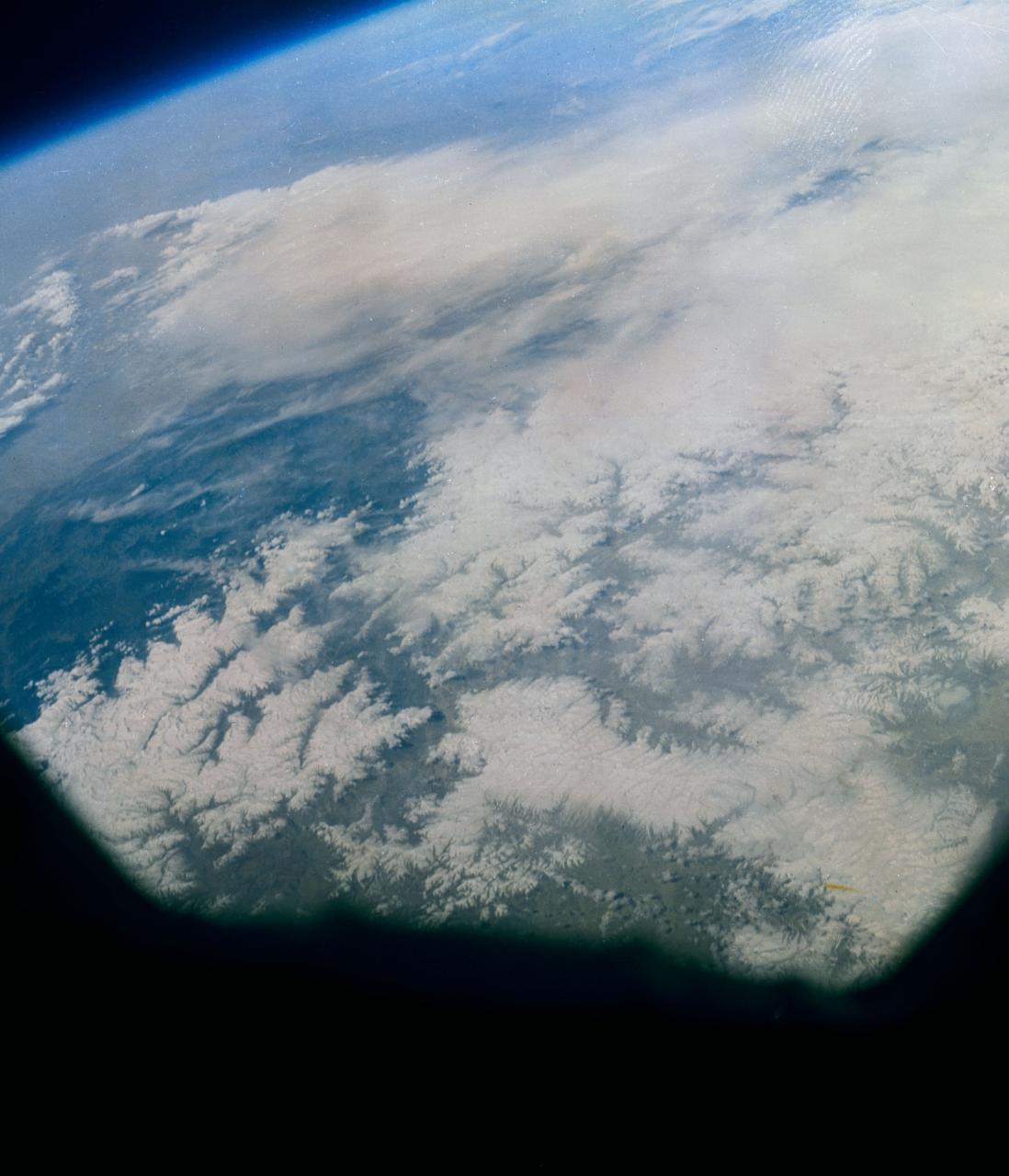
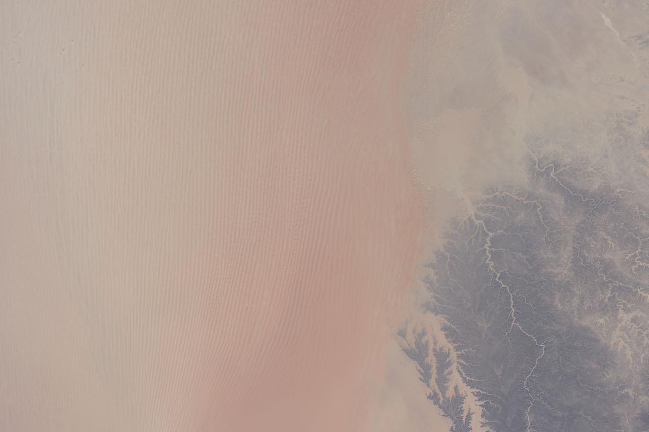
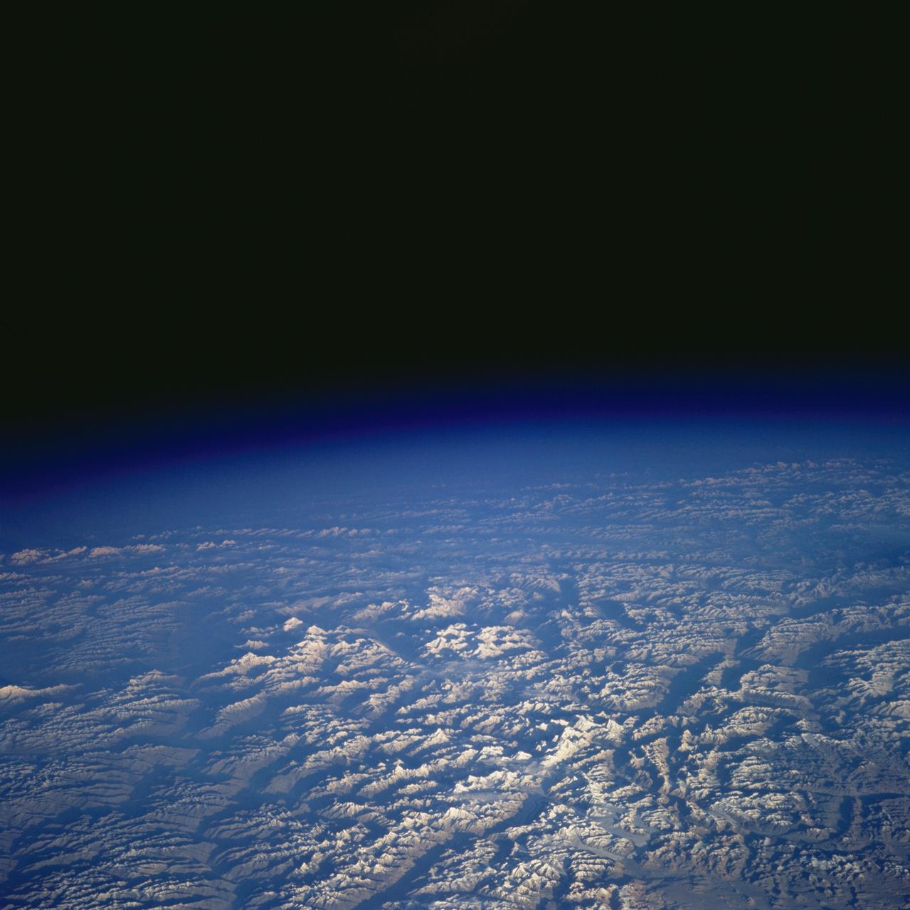
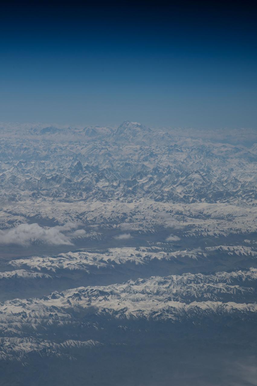
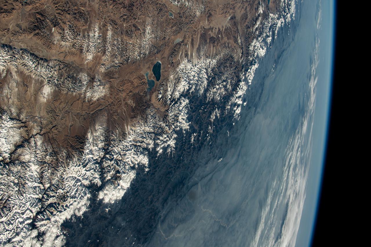
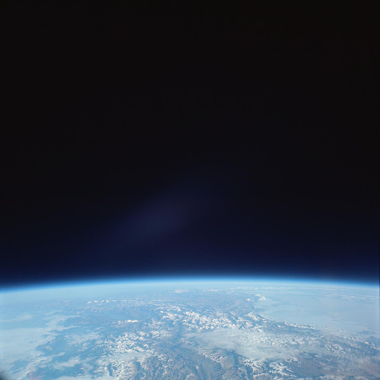
View is southeastward across China (Tibet), half of Nepal and India. The partly frozen lake near the center of the frame is Pei-Ku T'so ("Bos-tie Lake"). The central Himalaya stretches from Mount Everest on the left past Annapurna on the right. Large tributaries converge to form the Ganges River, flowing through the lowland basin south of the Himalaya. This photograph illustrates the rain shadow effect of the Himalaya Chain; wet, warm air from the Indian Ocean is driven against the mountains, lifted, and drained of water that forms ice caps, the abundant rivers, and forests of the foothills. In contrast the high plateau of Tibet is arid, composed largely of topographically-closed basins because stream flow is inadequate to form integrated drainage networks.

Researchers at NASA Jet Propulsion Laboratory in Pasadena, California, use a cryostat instrument, nicknamed Himalaya, to study the icy conditions under which comets form.
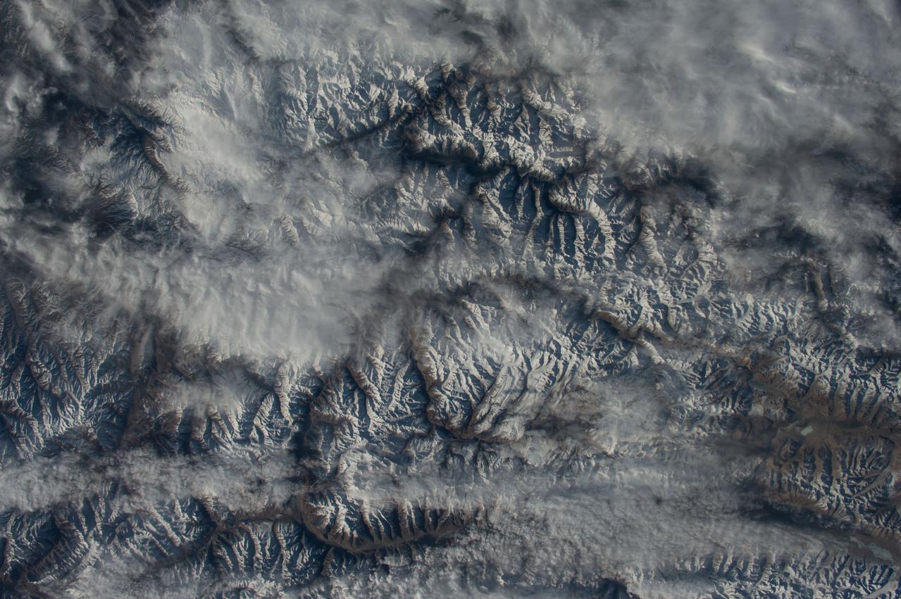
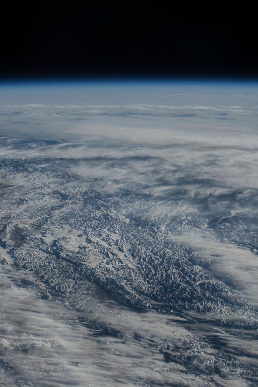
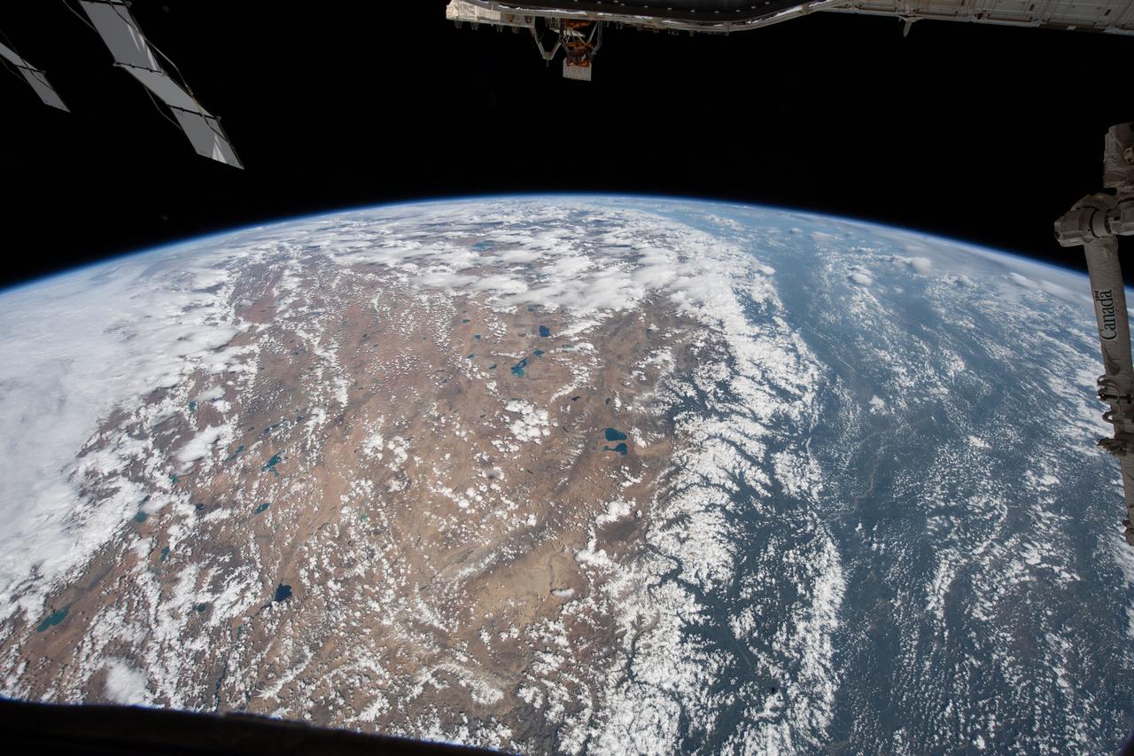
iss069e003192 (April 13, 2023) --- Clouds gather on Nepal's sub-tropical side of the Himalayas with Mount Everest at the center of this photograph taken by an external high definition camera on the International Space Station as it orbited 263 miles above the Indian subcontinent.
iss072e397228 (Dec. 19, 2024) --- The Brahmaputra River, in eastern India at the foot of the Himalayas near China, is pictured from the International Space Station as it orbited 261 miles above.

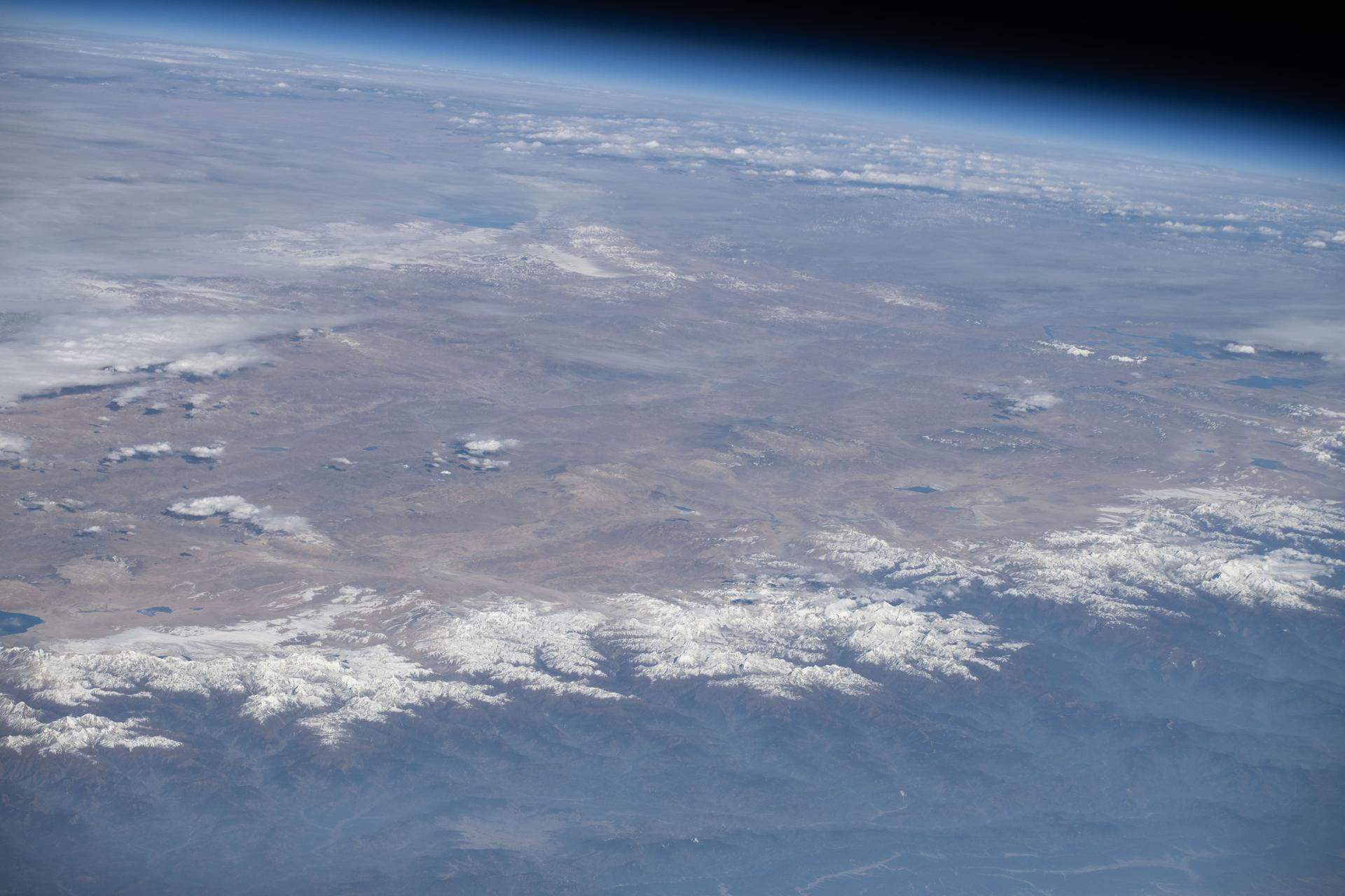
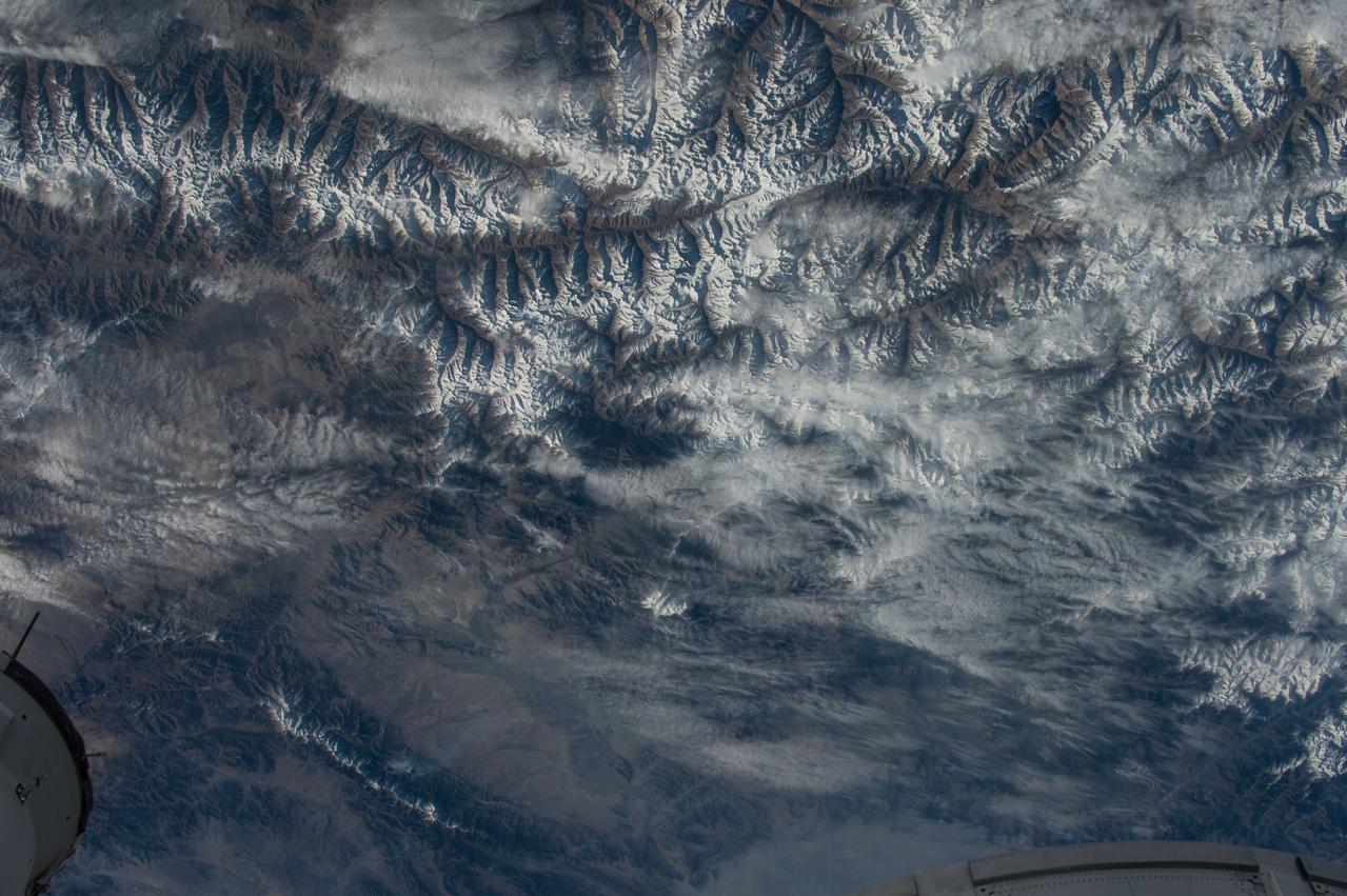
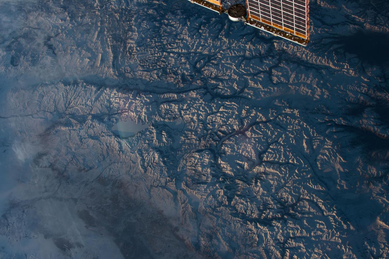
iss072e397138 (Dec. 19, 2024) --- The Himalayas separate the arid steppe of China's Tibetan Plateau from a cloudy Indian subcontinent in this photograph from the International Space Station as it soared 261 miles above Asia.
iss074e0002581 (Dec. 14, 2025) --- The International Space Station was orbiting 260 miles above Indravati National Park in central India when this photograph of the Himalayas—more than 700 miles away—was taken, showing the mountain range that separates the Indian subcontinent from Asia.
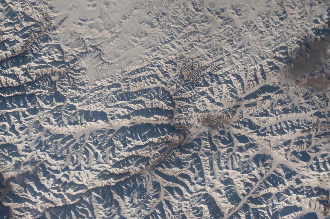
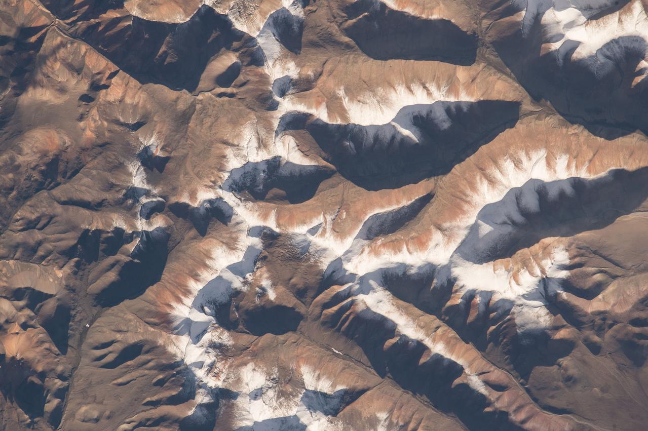
STS001-12-350 (12-14 April 1981) --- India and China, the Ladokh and Zaskar Ranges of the Great Himalaya are clearly etched by snow and shadow. A detailed view shows the glaciation process over a wide area. Photo credit: NASA
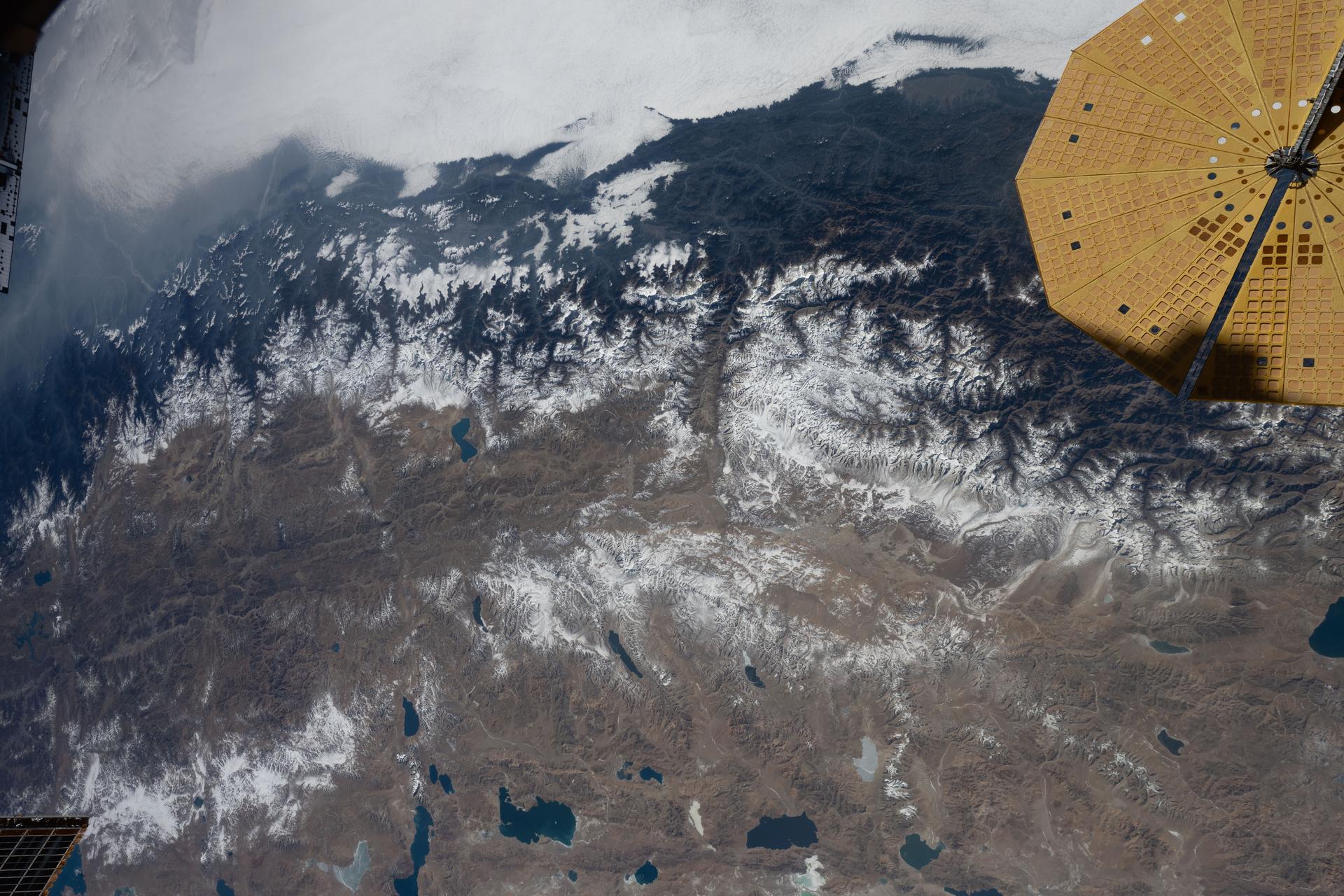
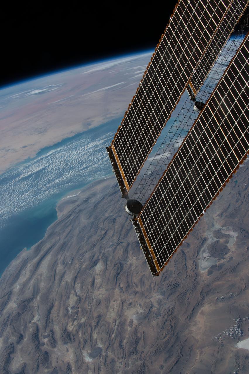
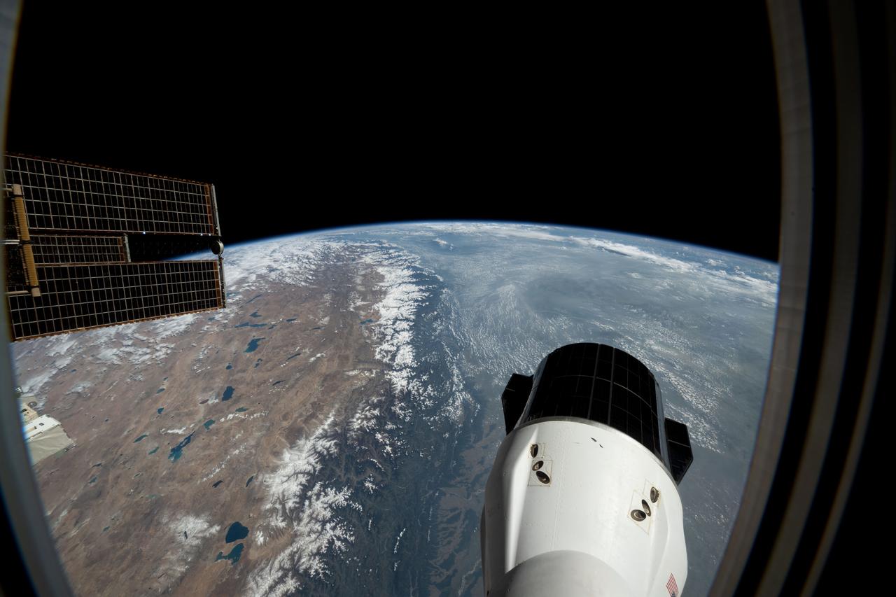
iss074e0002506 (Dec. 13, 2025) --- The Himalayas—separating the moisture-laden portion of the Indian subcontinent from the arid geography of Tibet, China—are pictured from the International Space Station as it orbited 261 miles above Nepal. At upper right is one of two UltraFlex solar arrays that power the Cygnus XL cargo craft from Northrop Grumman.
iss074e0603570 (May 20, 2026) --- The snow‑capped Himalayas separate Nepal from China in this photograph from the International Space Station as it orbited 259 miles above the Asian mountain range. The range acts as a climate barrier, trapping cooler, moisture‑laden air on the Nepal side and creating a sharp contrast between Nepal’s lush forests and the much drier Tibetan Plateau to the north. Credit: NASA/Jessica Meir
S63-06429 (15-16 May 1963) --- Photograph taken of the eastern Himalayas, Tibet, China, India and Burma from the Mercury-Atlas 9 capsule taken by astronaut L. Gordon Cooper Jr., during his 22-orbit Mercury-Atlas 9 (MA-9) spaceflight. Photo credit: NASA
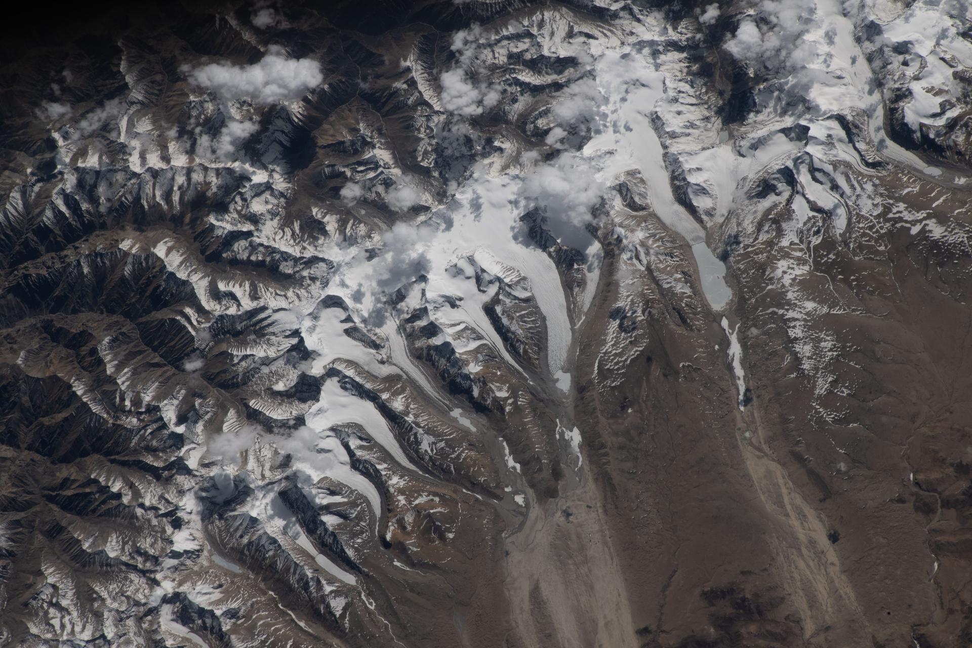
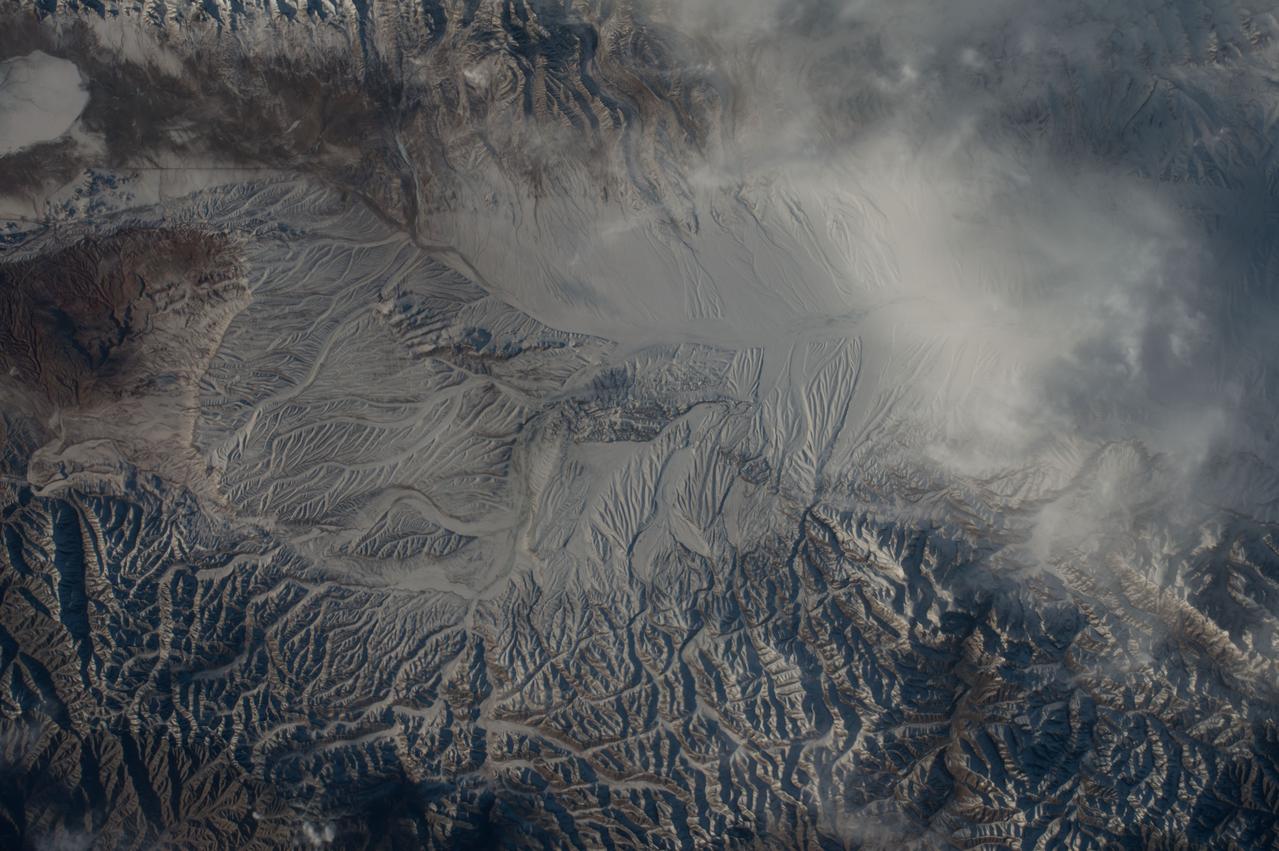
iss074e0603582 (May 20, 2026) --- The Himalayas separate Nepal from China in this photograph from the International Space Station as it orbited 259 miles above the western Tibetan Plateau. Glaciers—slow‑moving rivers of ice that carve paths into mountainsides—flow downhill from the Himalayas’ northern slopes onto China's Tibetan Plateau. Credit: NASA/Jessica Meir

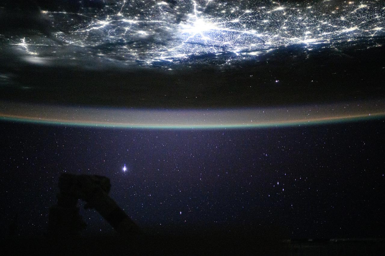
iss074e0351753 (March 6, 2026) --- The snow‑capped Himalayas form a natural boundary between Asia and the well‑lit nighttime cityscape of the Indian subcontinent. At center is Delhi, the capital territory of India, with a metropolitan population of about 33.8 million. The International Space Station was orbiting 264 miles above southwestern China at approximately 11:22 p.m. local time when this photograph was taken. Credit: NASA/Chris Williams
Onboard NASA Terra spacecraft, the Advanced Spaceborne Thermal Emission and Reflection Radiometer data have revealed significant spatial variability in glacier flow in the Bhutan Himalayas.
GMT352_11_24_Terry Virts_mideast afghanistan himalayas moon_129
GMT352_11_24_Terry Virts_mideast afghanistan himalayas moon_129
GMT350_20_43_Terry Virts_moonset himalayas dm cb_129
GMT352_11_24_Terry Virts_mideast afghanistan himalayas moon_129
GMT352_11_24_Terry Virts_mideast afghanistan himalayas moon_129
GMT352_11_24_Terry Virts_mideast afghanistan himalayas moon_129
GMT352_11_24_Terry Virts_mideast afghanistan himalayas moon_129
GMT350_20_43_Terry Virts_moonset himalayas dm cb_129

GMT352_11_24_Terry Virts_mideast afghanistan himalayas moon_129
GMT352_11_24_Terry Virts_mideast afghanistan himalayas moon_129
ISS044E044204 (08/07/2015) --- NASA astronaut Scott Kelly, on board the International Space Station, took this interesting picture of the Himalayas on Aug 7, 2015 and sent it out as a twitter with these comments: " #Himalayas in #EarthArt form look a bit like funnel cake. #YearInSpace".
Earth observation taken by the Expedition 39 crew aboard the ISS. Image was released by astronaut on Instagram and downlinked in folder: Himalayas.
S65-45717 (21-29 Aug. 1965) --- View of the Himalayas and Northern India photographed from the Gemini-5 spacecraft in orbit over Earth.
ISS010-E-15457 (1 February 2005) --- The Himalaya Mountains are featured in this image photographed by an Expedition 10 crewmember on the International Space Station.
iss070e091714 (Feb. 10, 2024) --- The Kashmir Valley (bottom) and the Himalayas are pictured from the International Space Station as it orbited 261 miles above the Afghanistan-Pakistan border.
iss067e107529 (June 3, 2022) --- This photograph from the International Space Station looks across the snow-capped Himalayas and into southern China as the orbiting lab flew 262 miles above India.
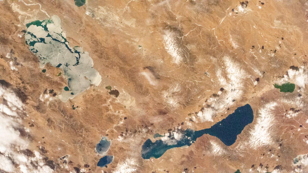
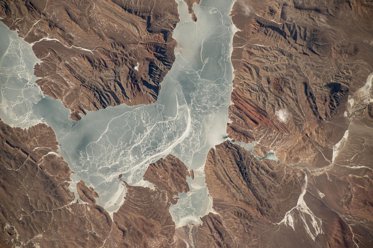
iss069e000174 (March 31, 2023) --- Salt lakes in southern China near the Himalayas are pictured by an external high definition camera on the International Space Station as it orbited 261 miles above.
iss066e123378 (Jan. 21, 2022) --- Xuru Co and Deng Reyongcuo, two lakes in southern China just north of the Himalayas, are pictured in this oblique image from the International Space Station as it orbited 257 miles above Bangladesh.
Earth observation taken during a day pass by an Expedition 37 crew member on board the International Space Station (ISS). Identified via Twitter message as dusk on the Himalayas.
iss070e091704 (Feb. 10, 2024) --- A portion of the Pamir Mountains, a mountain range at the northwest junction of the Himalayas and crossing several Central Asia countries, is pictured from the Interntional Space Station as it orbited 261 miles above Uzbekistan.
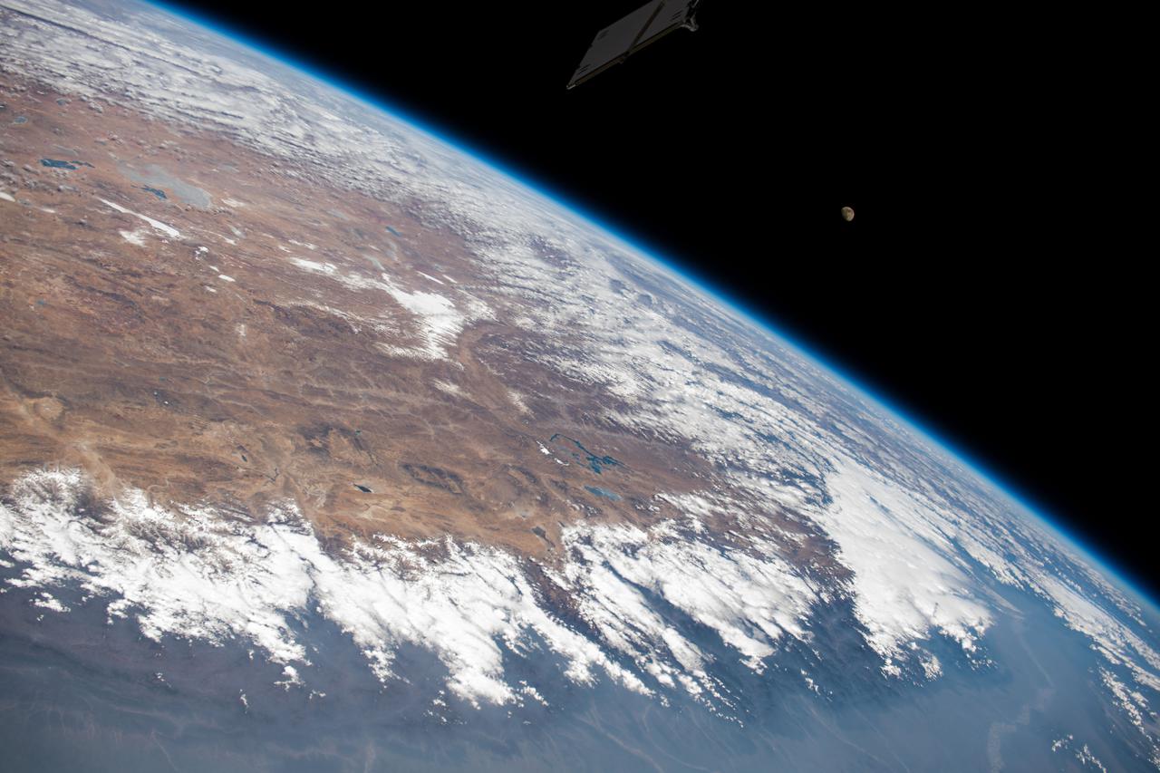
iss064e037041 (Feb. 23, 2021) --- The photograph looks across India, the Himalayas, and into China as the International Space Station orbited 264 miles above. A waxing gibbous Moon is pictured above the Earth's horizon.

iss070e075556 (Jan. 20, 2024) --- The SpaceX Dragon Freedom spacecraft carrying the four-member Axiom Mission 3 (Ax-3) crew is pictured approaching the International Space Station 260 miles above China north of the Himalayas.
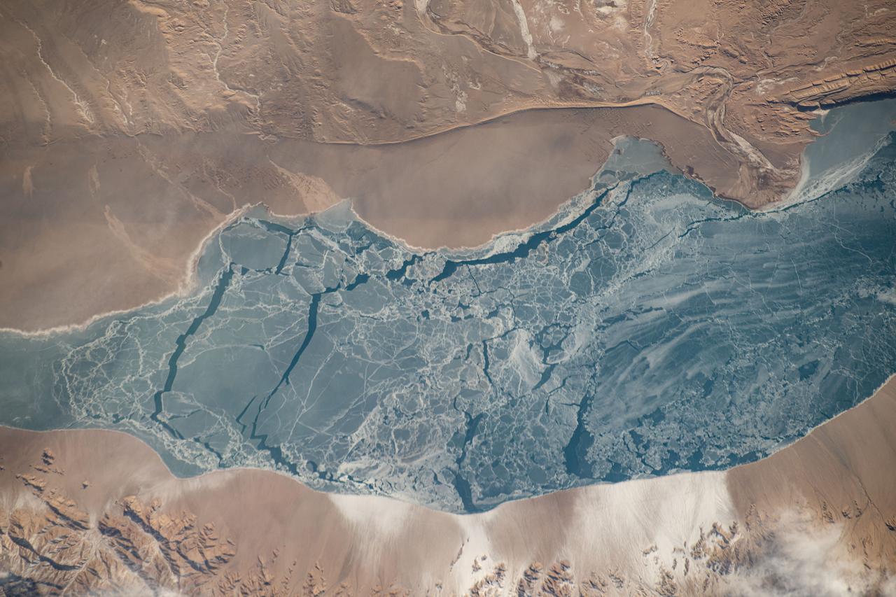
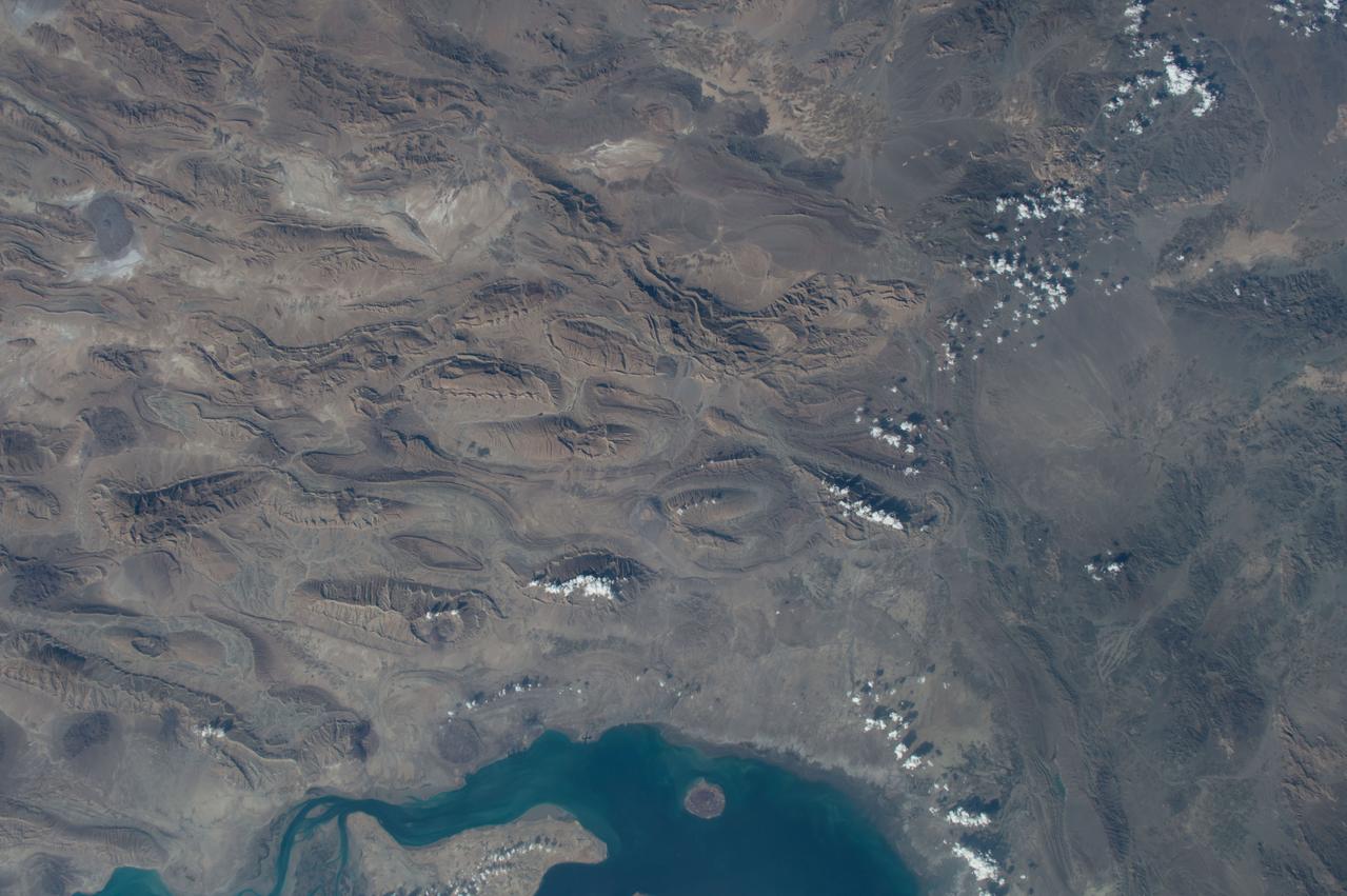
iss072e363445 (Dec. 13, 2024) --- An icy lake in southwestern China's high plateau region north of the Himalayas is pictured from the International Space Station as it orbited 262 miles above the Asian continent.
iss072e363454 (Dec. 13, 2024) --- An icy lake in southwestern China's high plateau region north of the Himalayas is pictured from the International Space Station as it orbited 262 miles above the Asian continent.

iss066e141209 (Feb. 12, 2022) --- Mt. Everest (at center right) peaks in the Himalayas in this photograph from the International Space Station as it orbited 258 miles above southwest China.
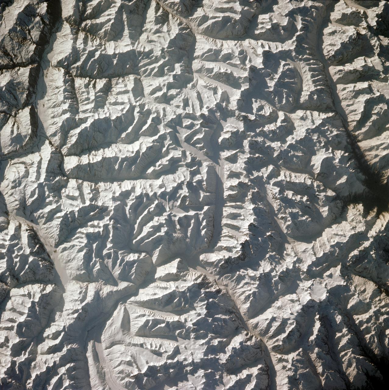
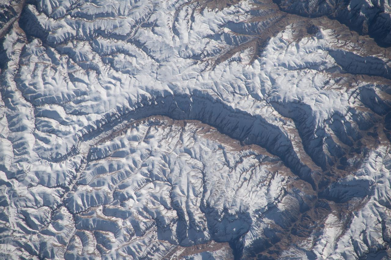
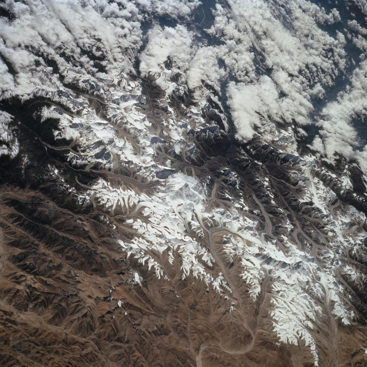
STS058-78-021 (18 Oct-1 Nov 1993) --- A clear three-dimensional view of the Karakorum Range. This northwestern extension of the Himalaya contains glaciated peaks having elevations of 7,000 to 8,000 meters.
ISS047e087333 (04/30/2016) ---NASA Astronaut Jeff Williams captured this soaring mountain visa image and twitted "up to the amazing array of white peaks on the Himalaya Mountains".
iss064e031247 (Feb. 11, 2021) --- The Himalayas separating China from India and Nepal are pictured from the International Space Station as it orbited 263 miles above northern Pakistan.
S63-06445 (15-16 May 1963) --- View of the Himalaya Mountain Range in the India-Nepal-Tibet border area, as photographed from the Mercury-Atlas 9 capsule by astronaut L. Gordon Cooper Jr., during his 22-orbit MA-9 spaceflight. Photo credit: NASA

iss073e0982727 (Oct. 25, 2025) --- A bright yellow-green airglow blankets Earth's horizon, dotted with the city lights of northern India, beneath a star-filled sky. This long-exposure photograph was taken from the International Space Station as it orbited 260 miles above the Himalayas at approximately 1:11 a.m. local time.
iss071e207474 (June 24, 2024) --- The snow-covered Himalayas separate the Indian sub-continent from China in this photograph from the International Space Station as it orbited 264 miles above. At left, is the Soyuz MS-25 crew ship docked to the Prichal docking module.
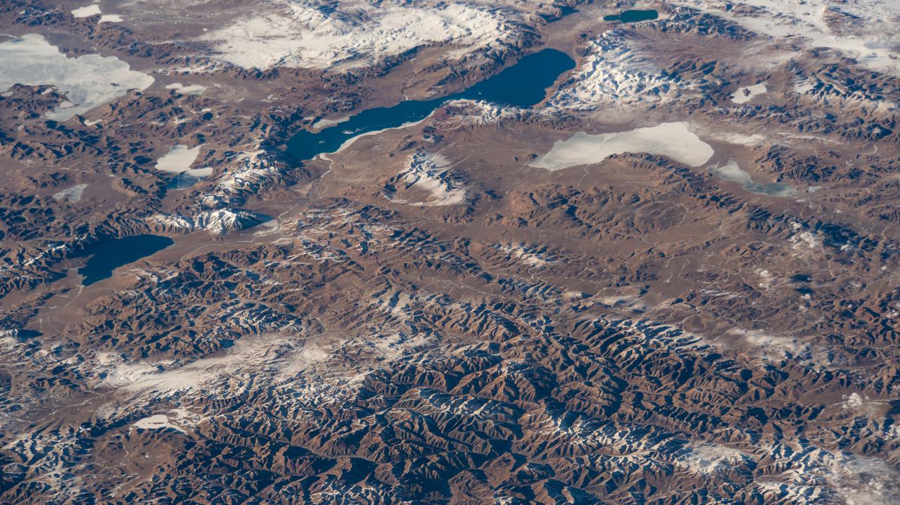
iss070e097638 (Feb. 11, 2024) --- The Himalayas, separating the Indian subcontinent from China, home to the South Asian nations of Nepal and Bhutan, and with Lakes Mansarovar and Rakshastal on the Chinese side, are pictured from the International Space Station as it orbited 261 miles above.
STS068-259-009 (30 September-11 October 1994) --- This south-looking, summer-time view of Mt. Everest (center) - with strong sense of three dimension because of reduced amount of snow - and neighboring peaks of the Himalayas. Clouds cover lower slopes in India.
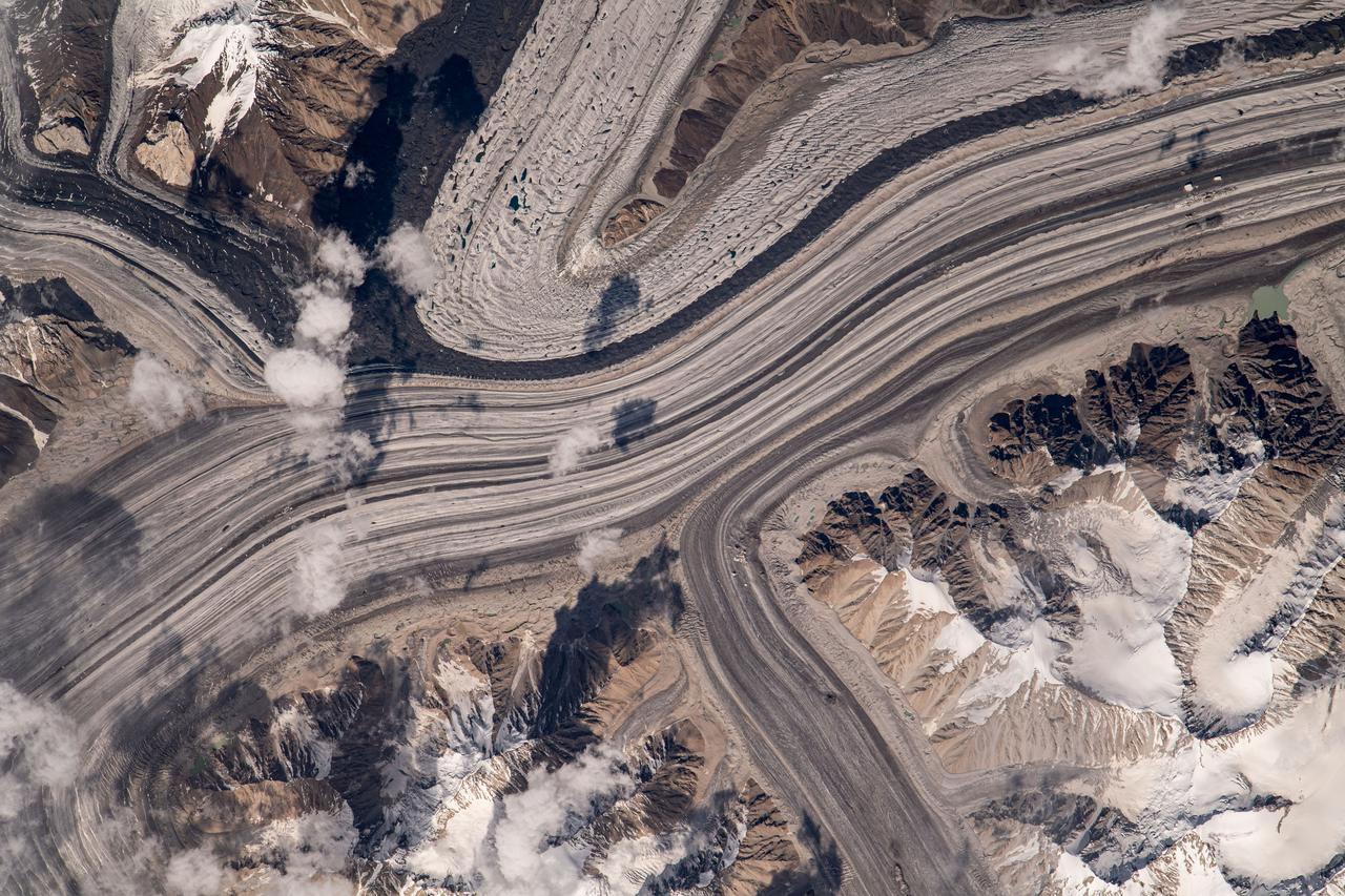
iss069e060266 (Aug. 15, 2023) --- What looks like highways going through a metropolitan area are actually a series of glaciers carving their way through the Karakoram mountain range north of the Himalayas. This photograph was taken from the International Space Station as it orbited 263 miles above.
iss073e0685684 (Aug. 21, 2025) --- Underneath a starry night sky, the city lights of New Delhi, India, and its surrounding suburbs glitter below Earth's atmospheric glow and at the edge of the Himalayas. This photograph was taken at approximately 2:55 a.m. local time as the International Space Station orbited 260 miles above.
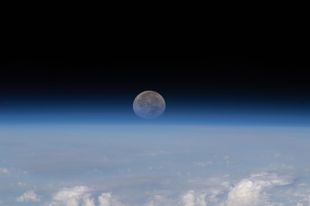
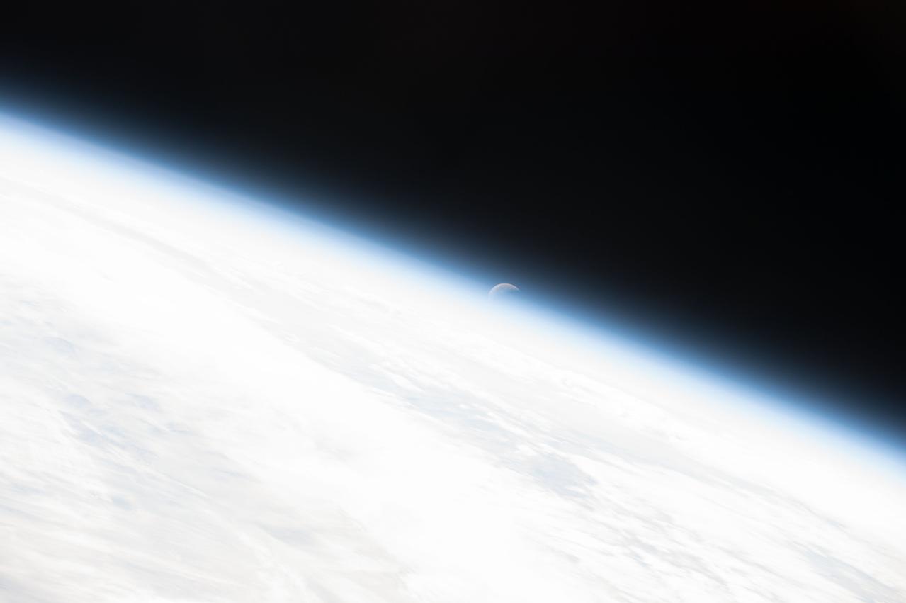
iss067e139457 (June 15, 2022) --- As the Moon sets below Earth's horizon the atmosphere refracts, or bends, its light making it appear flatter in this photograph taken from the International Space Station as it orbited 261 miles above the Himalayas near Kathmandu, the capital of Nepal.
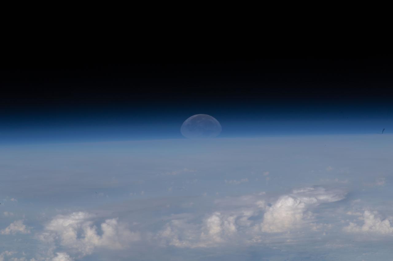
iss067e139458 (June 15, 2022) --- As the Moon sets below Earth's horizon the atmosphere refracts, or bends, its light making it appear flatter in this photograph taken from the International Space Station as it orbited 261 miles above the Himalayas near Kathmandu, the capital of Nepal.
S66-54839 (14 Sept. 1966) --- China, India, and Nepal, looking east, as seen from the Gemini-11 spacecraft during its 37th revolution of Earth. The Great Himalaya Mountain Range is clearly visible. Photo credit: NASA
STS075-721-013 (22 Feb.-9 March 1996) --- Snow caps the line of the Himalayas in this 70mm frame photographed by a crew member using a handheld 70mm camera. The green plain of the Ganges-lower Brahamaputra is to the south (left) and the brown Tibetan Plateau desert to the right. The Brahamaputra River, 1,800 miles long, rises on the Tibetan Plateau (top) at the foot of a glacier at the elevation of 22,000 feet. It flows east (towards the camera) for more than half its length, and then descends onto the low plains through some of the deepest gorges in the world. In the low country of northeastern India (left side of photo), it flows west to meet the Ganges. Rainfall totals in this part of the Himalayas are some of the highest in the world, measuring 400 inches at Cherapunji on the Himalayan slopes center left. It has a drainage area of 250,000 square miles.
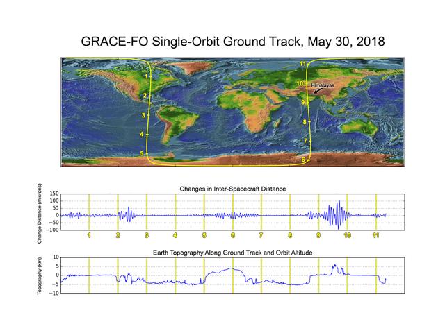
GRACE-FO has completed its first mission phase and demonstrated the performance of the precise ranging system that enables its measurements of how mass migrates around Earth. Along the satellites' ground track (top), the inter-spacecraft distance between them changes as the mass distribution underneath (i.e., from mountains, etc.) varies. The small changes measured by the Microwave Ranging Instrument (middle) agree well with topographic features along the orbit (bottom). https://photojournal.jpl.nasa.gov/catalog/PIA22507
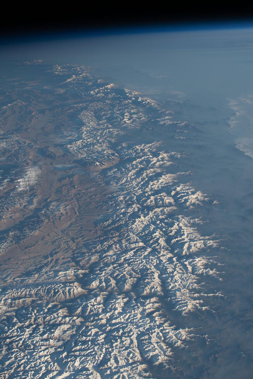
iss067e268010 (Aug. 17, 2022) --- The Himalayas, separating the Indian subcontinent from the Asian continent, are pictured from the International Space Station as it orbited 257 miles above northern India. The Asian mountain range prevents the northern colder air from blowing south allowing the subcontinent's tropical zone to extend farther north than anywhere else in the world.

41G-120-009 (5-13 Oct 1984) --- A large format camera's frame from the STS41-G/space shuttle Challenger mission provides a southwestern view of the Greater Himalayas bordering the Karakoram Range, whose great peaks are near the lower left edge of the frame. India is in the upper left; Pakistan, at lower right; and China is in the lower left foreground. The valley of the Indus River is in the right bottom corner. Photo credit: NASA
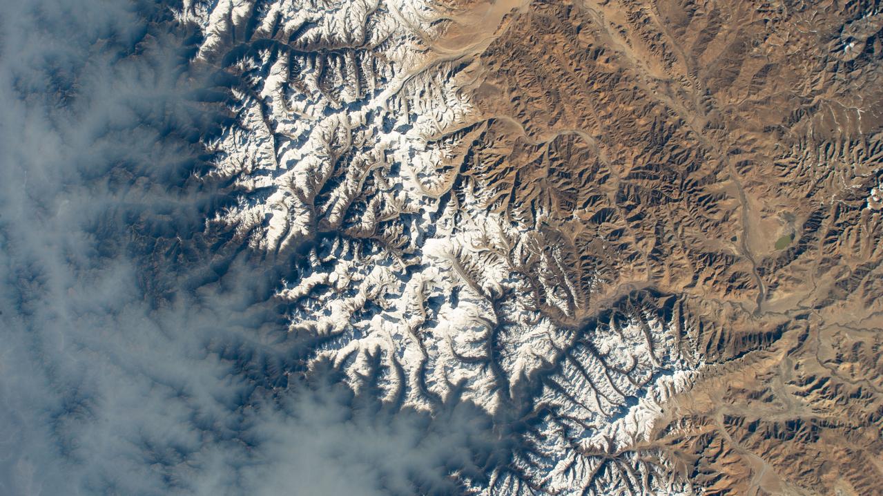
iss073e1025732 (Oct. 18, 2025) --- The Himalayas separate mainland Asia from the Indian subcontinent, revealing an arid, desert-like terrain on the Asian side, known as the Tibetan Plateau. On the southern slopes of the mountain range, moist air rises, cools, and condenses, producing rainfall that supports a humid, subtropical climate. As the air descends on the northern slopes, it warms and dries, creating barren conditions due to the rain shadow effect. This photograph was taken from a window aboard the SpaceX Dragon crew spacecraft as the International Space Station orbited 263 miles above India.
STS099-735-046 (11-22 February 2000) ---Mt. Everest (29,028 feet or 8,848 meters), is featured in the center of this 70mm frame photographed by one of the STS-99 crew members. Everest, also called Qomolangma Feng, is just north of the border between Nepal and China. The Himalayas and the Tibetan Plateau are products of the collision of the Indian and Eurasian tectonic plates. With the continuing northward march of India, the crust of the Earth has become thicker and the Tibetan Plateau has been uplifted to an average elevation of about 15,000 feet. According to NASA scientists studying the STS-99 imagery, fossil-bearing limestones are at the summit of the mountain. The scientists say that these limestones were deposited beneath the sea around 510 million years ago (Cambrian to Ordovician time). Glaciers, moraines, and outwash plains are spectacularly displayed. Glacial meltwaters in this area feed the Arun River, eventually reaching the Ganges on the plains of India.

Tim Mayer, Mekong Regional Science Associate for SERVIR, and Helen Baldwin, Hindu Kush Himalaya Regional Science Associate for SERVIR, speak about SERVIR's water related disaster services during the 2019 Annual Earth Science Applications Showcase, Thursday, Aug. 1, 2019 at NASA Headquarters in Washington, DC. Every summer students and young professionals from NASA’s Applied Sciences’ DEVELOP National Program come to NASA Headquarters and present their research projects. DEVELOP is a training and development program where students work on Earth science research projects, mentored by science advisers from NASA and partner agencies, and extend research results to local communities. Photo Credit: (NASA/Joel Kowsky)
![ISS008-E-13304 (28 January 2004) --- This image featuring Mt. Everest and Makalu was taken by an Expedition 8 crewmember on the International Space Station (ISS). Crewmembers on board the Station have a unique view of the world because of their position in a low orbit (200 nautical miles, 360 kilometers) relative to satellites and their ability to look at any angle out the windows of the spacecraft. ISS crewmembers recently took advantage of their vantage point to photograph this oblique view of the Himalayas looking south from over the Tibetan Plateau. At first glance, one might think that the image looks like a picture taken from an airplane; until you remember that the summits of Makalu [left (8,462 meters: 27,765 feet)] and Everest [right (8,850 meters; 29,035 feet)] are at the heights typically flown by commercial aircraft, and could never be seen this way from an airplane.](https://images-assets.nasa.gov/image/iss008e13304/iss008e13304~medium.jpg)
ISS008-E-13304 (28 January 2004) --- This image featuring Mt. Everest and Makalu was taken by an Expedition 8 crewmember on the International Space Station (ISS). Crewmembers on board the Station have a unique view of the world because of their position in a low orbit (200 nautical miles, 360 kilometers) relative to satellites and their ability to look at any angle out the windows of the spacecraft. ISS crewmembers recently took advantage of their vantage point to photograph this oblique view of the Himalayas looking south from over the Tibetan Plateau. At first glance, one might think that the image looks like a picture taken from an airplane; until you remember that the summits of Makalu [left (8,462 meters: 27,765 feet)] and Everest [right (8,850 meters; 29,035 feet)] are at the heights typically flown by commercial aircraft, and could never be seen this way from an airplane.

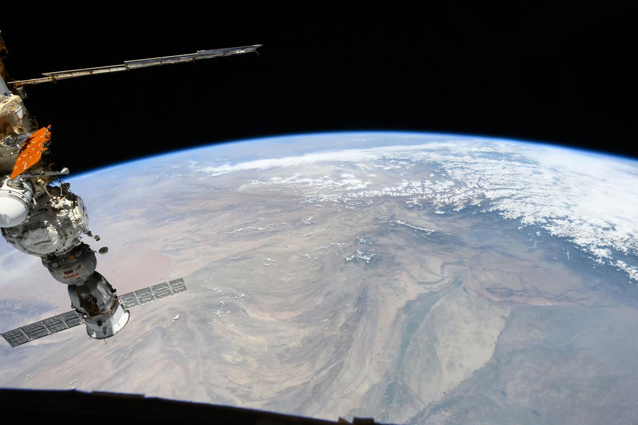
S135-E-011867 (19 July 2011) --- This picture of the International Space Station was photographed from the space shuttle Atlantis as the orbiting complex and the shuttle performed their relative separation in the early hours of July 19, 2011 The western Himalayas and the Tibetan Plateau are visible below. Onboard the station were Russian cosmonauts Andrey Borisenko, Expedition 28 commander; Sergei Volkov and Alexander Samokutyaev, both flight engineers; Japan Aerospace Exploration astronaut Satoshi Furukawa, and NASA astronauts Mike Fossum and Ron Garan, all flight engineers. Onboard the shuttle were NASA astronauts Chris Ferguson, STS-135 commander; Doug Hurley, pilot; and Sandy Magnus and Rex Walheim, both mission specialists. Photo credit: NASA
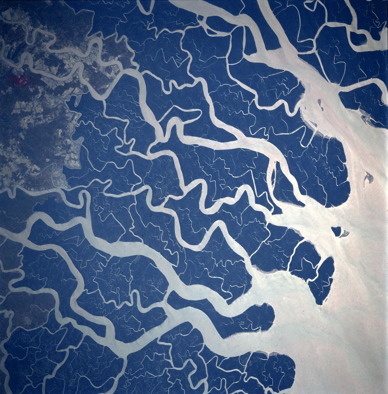
STS087-707-092 (19 November – 5 December 1997) --- Featured in this view is the Ganges River delta. A glacier at about 22,100 feet in the Himalayas is the source of the Ganges River. Hundreds of miles later and joined by other tributaries the Ganges delta enters the Bay of Bengal. The delta, at 200 miles wide (320 kilometers) is one of the most fertile and densely populated regions of the world. The eastern side of the delta changes rapidly and forms new land because of rapid sedimentation. The southern part of the delta has a darker appearance because of tidal forests, swampland, and mangroves. The Sundarbans is the name of this forested area and it is the site of a tiger preservation project for the governments of India and Bangladesh. This picture is one of the 70mm Earth observations visuals used by the crew at its post flight presentation events.
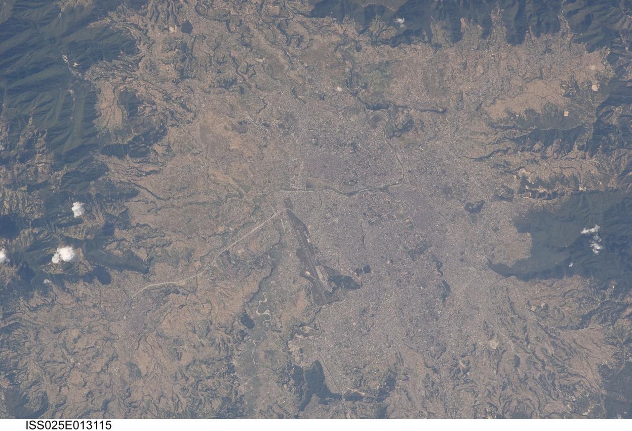
ISS025-E-013115 (9 Nov. 2010) --- Kathmandu, Nepal is featured in this image photographed by an Expedition 25 crew member on the International Space Station. The capital and largest city of Nepal, Kathmandu occupies much of the Kathmandu Valley located near the center of the country. Nepal itself contains much of the Himalaya mountain range between China (Tibet) to the north and India to the south. Geological and fossil evidence indicates that the Kathmandu Valley was filled by a large lake (Paleo-Kathmandu Lake) between approximately 2.8 million and 10,000 years ago, according to scientists. Geologists believe the lake drained in phases over time due both to a drier regional climate, continuing tectonic uplift and faulting in the region, and formation of an integrated valley drainage system as river channels cut through previous natural rock ridge dams. The green vegetated slopes that ring the Kathmandu metro area (light gray, center) include both forest reserves and national parks. The metropolitan area is relatively flat compared to the surrounding high mountains. Tribhuvan International Airport, located near the current eastern margin of the metro area, is the only international airport in Nepal. Archeological evidence suggests that the development of Kathmandu, together with the nearby “sister cities” of Lalitpur and Bhaktapur, began almost 2,000 years ago. Today, Kathmandu and its sister cities form the governmental, cultural, and—as a main access point to the Himalayas for tourism—economic center of the country.
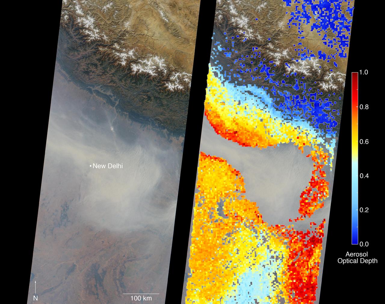
New Delhi, India's capital city, is currently suffering though a period of particularly poor air quality. In early November 2016, monitors at various locations in the area posted air quality index measurements as high as the 900s (the most severe ranking, "hazardous," is any air quality index measurement over 300). Thousands of schools have been closed, and a survey by the Associate Chambers of Commerce and Industry of India reports that 10 percent of the city's workers called in sick due to air-pollution-related health issues. According to several published news reports, the extreme air pollution may be due to a combination of nearby agricultural burning after harvest, urban construction and solid-waste burning, as well as remnants of firecracker smoke and additional car emissions after the celebration of Diwali, the Hindu festival of lights, on October 30. The Multi-angle Imaging SpectroRadiometer (MISR) instrument aboard NASA's Terra satellite passed over the region on Saturday, Nov. 5, 2016, at around 11:05 a.m. local time. At left is an image acquired from MISR's vertical viewing camera. The Himalayas stretch across the northern portion of the image. This towering mountain range tends to concentrate pollution in the region immediately to the south, including New Delhi, by preventing pollutants from blowing northwards. New Delhi, whose location is indicated on the image, is under a patch of especially thick haze. At 6:00 a.m. local time on that date, the U.S. Mission India NowCast Air Quality Index for New Delhi was reported at 751, more than twice the threshold for hazardous air quality. At right, a map of aerosol optical depth is superimposed on the image. Optical depth is a quantitative measure of the abundance of aerosols (tiny particles in the atmosphere). Optical depths for the area around New Delhi have not been calculated because the haze is so thick that the algorithm has classified the area as a cloud. In the region immediately surrounding the thick haze, optical depths approach 1.0. An optical depth of 1.0 means that only about 37 percent of direct sunlight reaches the surface due to interactions with particles in the atmosphere. These data were acquired during Terra orbit 89805. Other MISR data are available through the NASA Langley Research Center; for more information, go to https://eosweb.larc.nasa.gov/project/misr/misr_table. MISR was built and is managed by NASA's Jet Propulsion Laboratory, Pasadena, California, for NASA's Science Mission Directorate, Washington, D.C. The Terra spacecraft is managed by NASA's Goddard Space Flight Center, Greenbelt, Maryland. The MISR data were obtained from the NASA Langley Research Center Atmospheric Science Data Center, Hampton, Virginia. JPL is a division of the California Institute of Technology in Pasadena. http://photojournal.jpl.nasa.gov/catalog/PIA21100
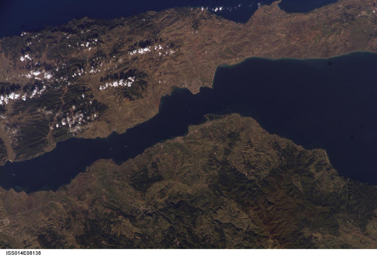
ISS014-E-08138 (9 Nov. 2006) --- Gallipoli and Dardanelles Strait, Turkey are featured in this image photographed by an Expedition 14 crewmember on the International Space Station. The city of Gallipoli (or Gelibolu in Turkish) sits at a crossroads between the Marmara and Aegean Seas, connected by the Dardanelles Strait. According to scientists, the strait is a 61 kilometer-long drowned fault valley formed during tectonic activity during the Tertiary period as the Arabian, Indian, and African plates collided with the Eurasian plate. This faulting, which formed the great mountain ranges of the Alps and Himalayas, also created the rugged terrain of western Turkey visible in the lower half of this image. Plate collision continues today, leading to frequent strike-slip (side-by-side relative motion along a fault, rather than up or down motion) earthquakes in the region as Turkey moves westward in relation to Eurasia (sometimes called escape tectonics). The urbanized area of modern Gallipoli is visible as a light gray to pink region at the entrance to the Dardanelles Strait. Water in the Strait flows in both northeast and southwest directions due to opposite surface and undercurrents. Several ships are visible in the Strait to the southwest of Gallipoli (center left).
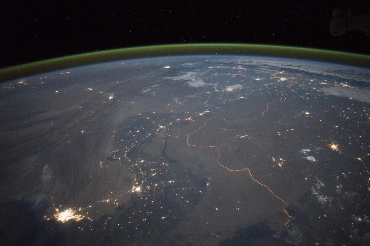
An astronaut aboard the International Space Station took this nighttime panorama while looking north across Pakistan’s Indus River valley. The port city of Karachi is the bright cluster of lights facing the Arabian Sea, which appears completely black. City lights and the dark color of dense agriculture closely track with the great curves of the Indus valley. For scale, the distance from Karachi to the foothills of the Himalaya Mountains is 1,160 kilometers (720 miles). This photograph shows one of the few places on Earth where an international boundary can be seen at night. The winding border between Pakistan and India is lit by security lights that have a distinct orange tone. Astronaut photograph ISS045-E-27869 was acquired on September 23, 2015, with a Nikon D4 digital camera using a 28 millimeter lens, and is provided by the ISS Crew Earth Observations Facility and the Earth Science and Remote Sensing Unit, Johnson Space Center. via NASA Earth Observatory Read more: <a href="http://earthobservatory.nasa.gov/IOTD/view.php?id=86725&eocn=home&eoci=iotd_title" rel="nofollow">earthobservatory.nasa.gov/IOTD/view.php?id=86725&eocn...</a>
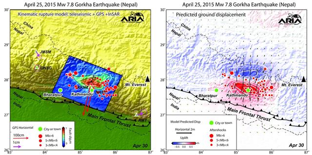
Using a combination of GPS-measured ground motion data, satellite radar data, and seismic observations from instruments distributed around the world, scientists have constructed preliminary estimates of how much the fault responsible for the April 25, 2015, magnitude 7.8 Gorkha earthquake in Nepal moved below Earth's surface (Figure 1). This information is useful for understanding not only what happened in the earthquake but also the potential for future events. It can also be used to infer a map of how Earth's surface moved due to the earthquake over a broader region (Figure 2). The maps created from these data can be viewed at PIA19384. In the first figure, the modeled slip on the fault is shown as viewed from above and indicated by the colors and contours within the rectangle. The peak slip in the fault exceeds 19.7 feet (6 meters). The ground motion measured with GPS is shown by the red and purple arrows and was used to develop the fault slip model. In the second figure, color represents vertical movement and the scaled arrows indicate direction and magnitude of horizontal movement. In both figures, aftershocks are indicated by red dots. Background color and shaded relief reflect regional variations in topography. The barbed lines show where the main fault reaches Earth's surface. The main fault dives northward into the Earth below the Himalaya. http://photojournal.jpl.nasa.gov/catalog/PIA19384
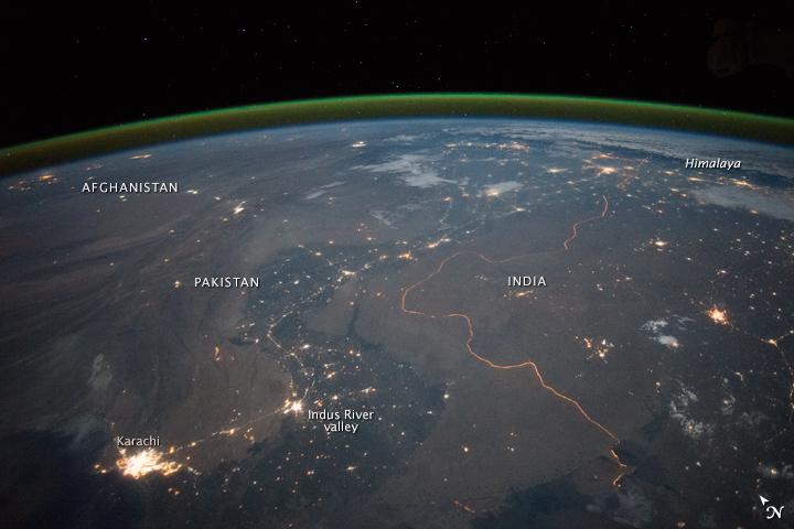
An astronaut aboard the International Space Station took this nighttime panorama while looking north across Pakistan’s Indus River valley. The port city of Karachi is the bright cluster of lights facing the Arabian Sea, which appears completely black. City lights and the dark color of dense agriculture closely track with the great curves of the Indus valley. For scale, the distance from Karachi to the foothills of the Himalaya Mountains is 1,160 kilometers (720 miles). This photograph shows one of the few places on Earth where an international boundary can be seen at night. The winding border between Pakistan and India is lit by security lights that have a distinct orange tone. Astronaut photograph ISS045-E-27869 was acquired on September 23, 2015, with a Nikon D4 digital camera using a 28 millimeter lens, and is provided by the ISS Crew Earth Observations Facility and the Earth Science and Remote Sensing Unit, Johnson Space Center. via NASA Earth Observatory Read more: <a href="http://earthobservatory.nasa.gov/IOTD/view.php?id=86725&eocn=home&eoci=iotd_title" rel="nofollow">earthobservatory.nasa.gov/IOTD/view.php?id=86725&eocn...</a>

National Advisory Committee for Aeronautics (NACA) design engineers added the Icing Research Tunnel to the new Aircraft Engine Research Laboratory’s original layout to take advantage of the massive refrigeration system being constructed for the Altitude Wind Tunnel. The Icing Research Tunnel was built to study the formation of ice on aircraft surfaces and methods of preventing or eradicating that ice. Ice buildup adds extra weight, effects aerodynamics, and sometimes blocks airflow through engines. The Icing Research Tunnel is a closed-loop atmospheric wind tunnel with a 6- by 9-foot test section. The tunnel can produce speeds up to 300 miles per hour and temperatures from about 30 to –45⁰ F. Initially the tunnel used a spray bar system to introduce moisture into the airstream. NACA engineers struggled for nearly 10 years to perfect the spray system. The Icing Research Tunnel began testing in June of 1944. Initial testing, seen in this photograph, studied ice accumulation on propellers of a military aircraft. NACA reserach also produced a protected air scoop for the C–46 transport aircraft. A large number of C–46 aircraft were lost due to icing while flying supply runs over the Himalayas during World War II.
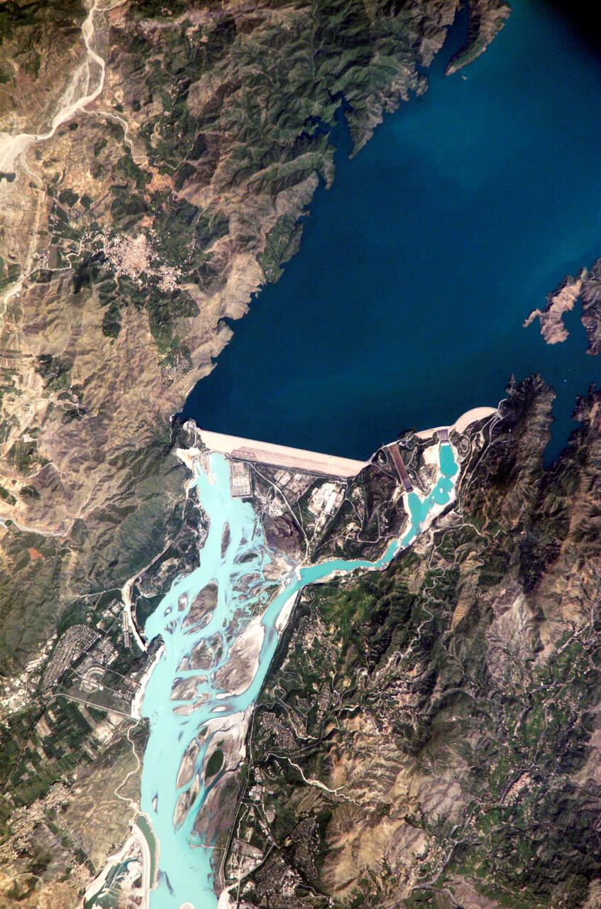
ISS005-E-12804 (6 September 2002) --- Tarbela Dam, Pakistan is featured in this image photographed by an Expedition 5 crewmember on the International Space Station (ISS). The Indus River basin extends from the Himalaya mountain ranges forming the northeastern boundary of Pakistan, to the alluvial plains of Sindh near the Arabian Sea coastline. Tarbela Dam is part of the Indus Basin Project that resulted from a water treaty signed in 1960 between India and Pakistan. This treaty guaranteed Pakistan water supplies independent of upstream control by India. Designed primarily for water storage rather than power generation, the dam was completed in 1977. Turquoise waters of the Indus River (to the south of the dam) reflect the high proportion of silt and clay suspended in waters released by the spillways (chutes on either of side of the main dam). With a volume of 142,000,000 cubic meters, the Tarbela Dam is the largest earth and rockfill dam in the world and stands 147 meters above the Indus riverbed. Its reservoir occupies an area of 37 square kilometers. While the dam has fulfilled its purpose in storing water for agricultural use in Pakistan, there have been environmental consequences to the Indus river delta, according to NASA scientists who are studying the Space Station photography. Reduction of seasonal flooding and reduced water flows to the delta have resulted in decrease of mangrove stands and abundance of some fish species.
STS106-705-009 (8-20 September 2000) --- One of the STS-106 crew members on board the Space Shuttle Atlantis used a handheld 70mm camera to photograph this image of Qogir Feng (8,611 meters), which appears at the far upper left in this view of the northwestern Karakoram Range. Also called K2 or Mt. Godwin Austen, the mountain is the second highest peak in the world. The Tarim sedimentary basin borders the range on the north and the Lesser Himalayas on the south. Melt waters from vast glaciers, such as those south and east of K2, feed agriculture in the valleys (dark green) and contribute significantly to the regional fresh-water supply. The Karakoram Range lies along the southern edge of the Eurasian tectonic plate and is made up of ancient sedimentary rocks (more than 390 million years old, according to geologists studying the shuttle imagery). Those strata were folded and thrust-faulted, and granite masses were intruded, say the geologists, when the Indo-Pakistan plate collided with Eurasia, beginning more than 100 million years ago.
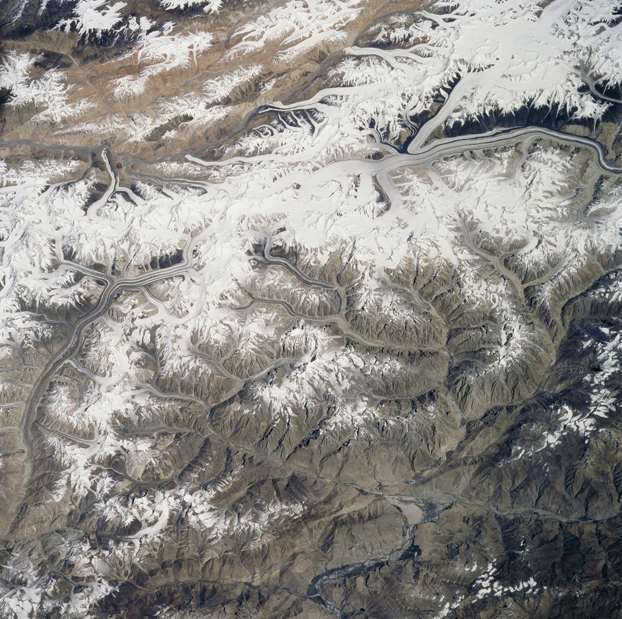
ISS027-E-005274 (16 March 2011) --- Central Tien Shan in the People?s Republic of China is featured in this image photographed by an Expedition 27 crew member on the International Space Station (ISS). The Tien Shan (or ?celestial mountains? in Chinese) is one of the largest continuous mountain ranges in the world, extending approximately 2,500 kilometers roughly east-west across Central Asia. This photograph provides a detailed view of part of the central Tien Shan, located approximately 64 kilometers east of a point where the borders of China, Kyrgyzstan, and Kazakhstan meet. While the image looks like it might have been taken from an airplane, it was taken from the space station at an altitude of 341 kilometers. The distance between the ISS ground track position (approximately 304 kilometers to the southwest) and the imaged area produces an oblique ? looking outwards an angle, rather than straight down ? view that, together with shadowing of valleys, accentuates the mountainous topography. Like the Himalayas to the south, the uplift of the Tien Shan results from the ongoing collision between the Eurasian and Indian continental tectonic plates. The rugged topography of the range is the result of subsequent erosion by water, wind, and in the highest parts of the range, active glaciers. Two types of glaciers are visible in the image; cirque glaciers occupy amphitheater-like depressions on the upper slopes of the mountains, and feed ice downslope to aggregate into large valley glaciers such as the one visible at center. Low clouds obscure an adjacent valley and glaciers to the north (upper left). Two high peaks of the central Tien Shan are identifiable in the image. Xuelian Feng has a high summit of 6,527 meters above sea level. To the east, the aptly-named Peak 6231 has summit of 6,231 meters above sea level.
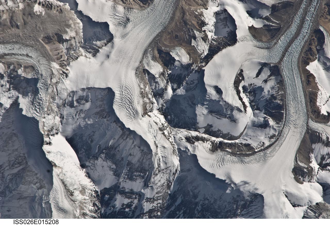
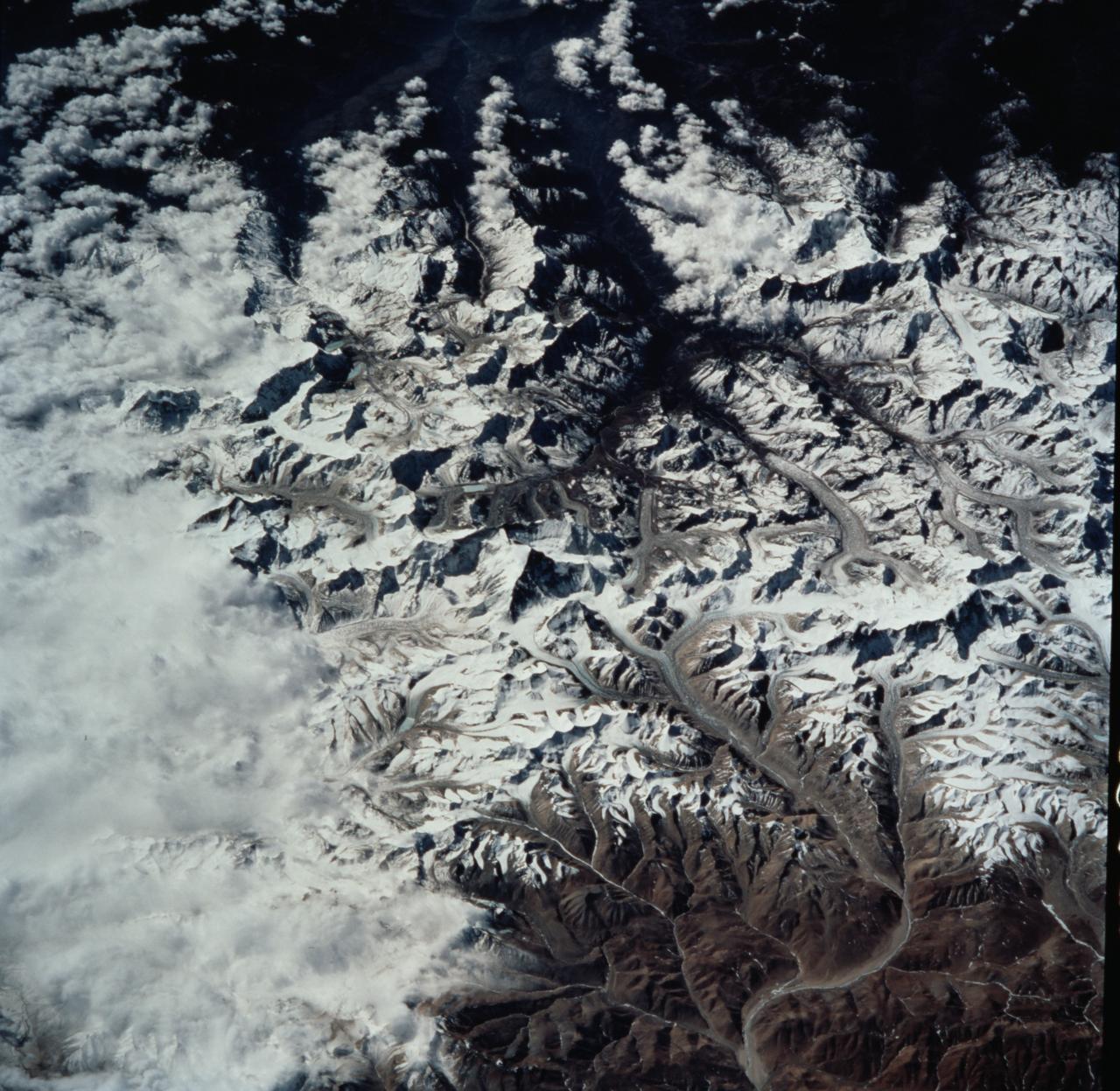
ISS026-E-015208 (6 Jan. 2011) --- Photographed by an Expedition 26 crew member on the International Space Station, this detailed photograph highlights the northern approach to Mount Everest from Tibet. Known as the northeast ridge route, climbers travel along the East Rongbuk Glacier (top right) to camp at the base of Changtse mountain. From this point at approximately 6,100 meters above sea level, the North Col--a sharp-edged pass carved by glaciers, center--is ascended to reach a series of progressively higher camps along the North Face of Everest, culminating in Camp VI at 8,230 meters above sea level. Climbers make their final push to the summit (not visible, just off the bottom edge of the image) from this altitude. While the near-nadir viewing angle--almost looking "straight down" from the International Space Station--tends to flatten the topography, crew members have also taken images that highlight the rugged nature of the area. Everest (or Sagarmatha in Nepali), located within the Himalaya mountain chain, is Earth’s highest mountain with its summit at 8,848 meters above sea level. Khumbutse mountain, visible at top left, has a summit elevation of 6,640 meters above sea level. Climbing to the summit of Everest requires much advance planning, conditioning, and situational awareness on the part of mountaineers to avoid potentially fatal consequences--as of 2010, there have been over 200 reported fatalities.
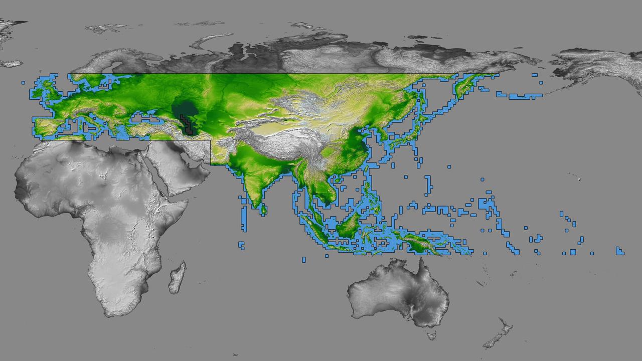
inal Caption Released with Image: The colored regions of this map show the extent of digital elevation data recently released by the Shuttle Radar Topography Mission (SRTM). This release includes data for most of Europe and Asia plus numerous islands in the Indian and Pacific Oceans. SRTM flew on board the Space Shuttle Endeavour in February 2000 and used an interferometric radar system to map the topography of Earth's landmass between latitudes 56 degrees south and 60 degrees north. The data were processed into geographic "tiles," each of which represents one by one degree of latitude and longitude. A degree of latitude measures 111 kilometers (69 miles) north-south, and a degree of longitude measures 111 kilometers or less east-west, decreasing away from the equator. The data are being released to the public on a continent-by-continent basis. This Eurasia segment includes 5,940 tiles, more than a third of the total data set. Previous releases covered North America and South America. Forthcoming releases will include Africa-Arabia and Australia plus an "Islands" release for those islands not included in the continental releases. Together these data releases constitute the world's first high-resolution, near-global elevation model. The resolution of the publicly released data is three arcseconds (1/1,200 of a degree of latitude and longitude), which is about 90 meters (295 feet). European coverage in the current data release stretches eastward from the British Isles and the Iberian Peninsula in the west, across the Alps and Carpathian Mountains, as well as the Northern European Plain, to the Ural and Caucasus Mountains bordering Asia. The Asian coverage includes a great diversity of landforms, including the Tibetan Plateau, Tarin Basin, Mongolian Plateau, and the mountains surrounding Lake Baikal, the world's deepest lake. Mt. Everest in the Himalayas, at 8,848 meters (29,029 feet) is the world's highest mountain. From India's Deccan Plateau, to Southeast Asia, coastal China, and Korea, various landforms place constraints upon land use planning for a great population. Volcanoes in the East Indies, the Philippines, Japan, and the Kamchatka Peninsula form the western part of the "Ring of Fire" around the Pacific Ocean. Many of these regions were previously very poorly mapped due to persistent cloud cover or the inaccessibility of the terrain. Digital elevation data, such as provided by SRTM, are particularly in high demand by scientists studying earthquakes, volcanism, and erosion patterns for use in mapping and modeling hazards to human habitation. But the shape of Earth's surface affects nearly every natural process and human endeavor that occurs there, so elevation data are used in a wide range of applications. In this index map color-coding is directly related to topographic height, with green at the lower elevations, rising through yellow and tan, to white at the highest elevations. The large, very dark green feature in western Asia is the Caspian Sea, which is below sea level. Blue areas on the map represent water within the mapped tiles, each of which includes shorelines or islands. http://photojournal.jpl.nasa.gov/catalog/PIA03398

In January 2013, a new Earth-observing instrument was installed on the International Space Station (ISS). ISERV Pathfinder consists of a commercial camera, a telescope, and a pointing system, all positioned to look through the Earth-facing window of ISS’s Destiny module. ISERV Pathfinder is intended as an engineering exercise, with the long-term goal of developing a system for providing imagery to developing nations as they monitor natural disasters and environmental concerns. The image above is the “first light” from the new ISERV camera system, taken at 1:44 p.m. local time on February 16, 2013. It shows the Rio San Pablo as it empties into the Golfo de Montijo in Veraguas, Panama. It is an ecological transition zone, changing from agriculture and pastures to mangrove forests, swamps, and estuary systems. The area has been designated a protected area by the National Environmental Authority (ANAM) of Panama and is listed as a “wetland of international importance” under the Ramsar Convention. (Note that the image is rotated so that north is to the upper right.) “ISERV’s full potential is yet to be seen, but we hope it will really make a difference in people’s lives,” said principal investigator Burgess Howell of NASA’s Marshall Space Flight Center. “For example, if an earthen dam gives way in Bhutan, we want to be able to show officials where the bridge is out or where a road is washed out or a power substation is inundated. This kind of information is critical to focus and speed rescue efforts.” The instrument will be controlled from NASA Marshall in Huntsville, Alabama, in collaboration with researchers at hubs in Central America, East Africa, and the Hindu Kush–Himalaya region. They will rely on positioning software to know where the space station is at each moment and to calculate the next chance to view a particular area on the ground. If there's a good viewing opportunity, the SERVIR team will instruct the camera to take high-resolution photographs at 3 to 7 frames per second, totaling as many as 100 images per pass. With a resolution down to 3.2 meters (10 feet), it will be possible to spot fairly small details and objects. The current mission will test the limitations of Pathfinder and identify measures for improvements in a more permanent system. For instance, the engineering team is working to determine how the geometry of the ISS window affects the imagery; how much sunlight is needed to capture clear images; and how the atmosphere affects that clarity. This characterization phase will last several weeks to a few months. Eventually, ISERV should be made available to the natural hazards community and to basic research scientists. ISERV is short for ISS SERVIR Environmental Research and Visualization system. Together with the U.S. Agency for International Development, NASA runs the SERVIR program to provide satellite data, maps, and other tools to environmental decisionmakers in developing countries. (Servir is a Spanish word meaning “to serve.”) Learn more about the SERVIR program by clicking here: <a href="https://servirglobal.net/Global.aspx" rel="nofollow">servirglobal.net/Global.aspx</a> NASA image by Burgess Howell, SERVIR Global program. Caption by Dauna Coulter, NASA Marshall Space Flight Center, and Mike Carlowicz, NASA Earth Observatory. Instrument: ISS - ISERV Pathfinder Credit: <b><a href="http://www.earthobservatory.nasa.gov/" rel="nofollow"> NASA Earth Observatory</a></b> - <a href="http://1.usa.gov/12Aqmg9" rel="nofollow">1.usa.gov/12Aqmg9</a> <b><a href="http://www.nasa.gov/audience/formedia/features/MP_Photo_Guidelines.html" rel="nofollow">NASA image use policy.</a></b> <b><a href="http://www.nasa.gov/centers/goddard/home/index.html" rel="nofollow">NASA Goddard Space Flight Center</a></b> enables NASA’s mission through four scientific endeavors: Earth Science, Heliophysics, Solar System Exploration, and Astrophysics. Goddard plays a leading role in NASA’s accomplishments by contributing compelling scientific knowledge to advance the Agency’s mission. <b>Follow us on <a href="http://twitter.com/NASA_GoddardPix" rel="nofollow">Twitter</a></b> <b>Like us on <a href="http://www.facebook.com/pages/Greenbelt-MD/NASA-Goddard/395013845897?ref=tsd" rel="nofollow">Facebook</a></b> <b>Find us on <a href="http://instagram.com/nasagoddard?vm=grid" rel="nofollow">Instagram</a></b>