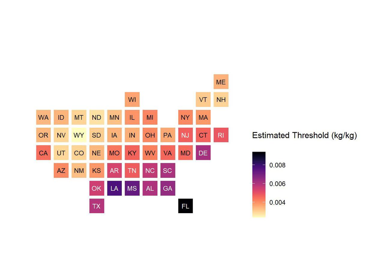
This chart shows low-humidity thresholds that signal flu outbreaks in 48 U.S. states, calculated using water vapor data from NASA's Atmospheric Infrared Sounder (AIRS) instrument on the Aqua satellite with data on U.S. flu cases from 2003 to 2015. The color range from lighter to darker indicates lower to higher humidity thresholds, with the driest state, Wyoming, having the lowest threshold and Florida the highest. Units are kilograms of water per kilogram of air. https://photojournal.jpl.nasa.gov/catalog/PIA24986
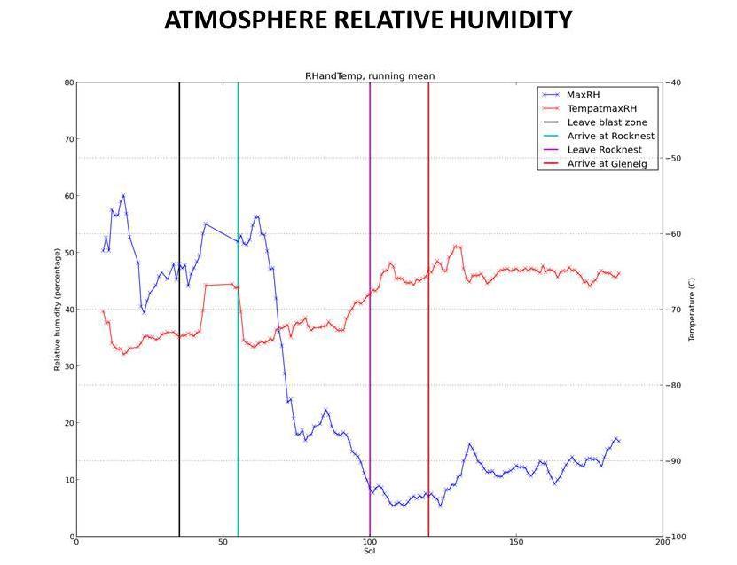
This graphic tracks the maximum relative humidity and the temperature at which that maximum occurred each Martian day, or sol, for about one-fourth of a Martian year, as measured by REMS on NASA Curiosity Mars rover.
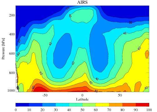
The average tropospheric relative humidity from the Atmospheric Infrared Sounder AIRS onboard NASA Aqua satellite for the four December-February periods during 2002 through 2005.
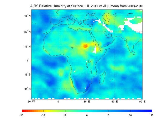
Surface relative humidity anomalies in percent, during July 2011 compared to the average surface relative humidity over the previous eight years, as measured by NASA Aqua instrument AIRS. The driest areas are shown in oranges and reds.
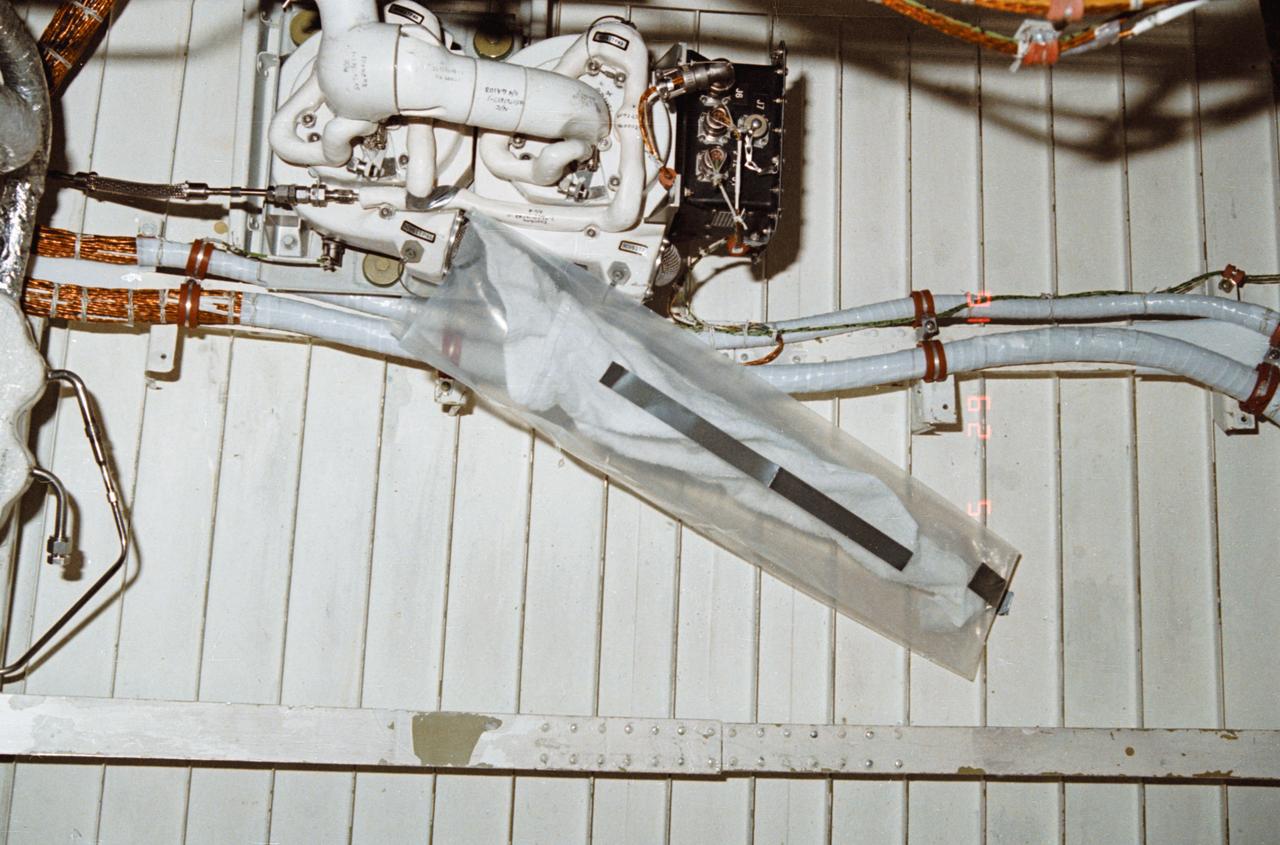
During STS-32, onboard Columbia, Orbiter Vehicle (OV) 102, a leakage problem at environmental control and life support system (ECLSS) air revitalization system (ARS) humidity separator A below the middeck is solved with a plastic bag and a towel. The towel inserted inside a plastic bag absorbed the water that had collected at the separator inlet.
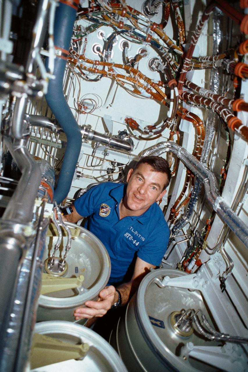
STS-44 Mission Specialist (MS) James S. Voss works under the middeck subfloor of Atlantis, Orbiter Vehicle (OV) 104, to repair humidity separator leakage problems. Voss is surrounded by several water tanks and a maze of shuttle wiring and plumbing. Voss earned the nickname of "Bilge Man" because of his time spent on the lower deck tending to the leakage problem. This is the first photo released of a crewmember in this area of the shuttle.
STS047-35-022 (12 - 20 Sept 1992) --- Astronauts Curtis L. Brown, Jr., pilot, and N. Jan Davis, mission specialist, team up to cure a high humidity problem in the hornet experiment in the Spacelab-J Science Module of the Earth-orbiting Space Shuttle Endeavour. Via a jury-rigged hose hook-up, the two were able to blow air from a spacesuit fan into the experiment, thus eliminating condensation that obscured the viewing of the Israeli hornet experiment. The experiment examined the effects of microgravity on the orientation, reproductive capability and social activity of 180 female Oriental Hornets.

This chart plots the minimum daily atmospheric temperature measured by NASA Phoenix Mars Lander spacecraft since landing on Mars. As the temperature increased through the summer season, the atmospheric humidity also increased.

The McMurdo Dry Valleys are a row of valleys west of McMurdo Sound, Antarctica. They are so named because of their extremely low humidity and lack of snow and ice cover. This image was acquired December 8, 2002 by NASA Terra spacecraft.
The Rover Environmental Monitoring Station (REMS) on NASA's Curiosity Mars rover includes temperature and humidity sensors mounted on the rover's mast. One of the REMS booms extends to the left from the mast in this view. Spain provided REMS to NASA's Mars Science Laboratory Project. The monitoring station has provided information about air pressure, relative humidity, air temperature, ground temperature, wind and ultraviolet radiation in all Martian seasons and at all times of day or night. This view is a detail from a January 2015 Curiosity self-portrait. The self-portrait, at PIA19142, was assembled from images taken by Curiosity's Mars Hand Lens Imager. http://photojournal.jpl.nasa.gov/catalog/PIA19164

iss071e439833 (Aug. 8, 2024) --- Xiang River runs through the city of Changsha (center) in China's province of Hunan. At far left, the city of Yueyang lies on the bank of Dongdongting Lake in Hunan's humid, subtropical region. The International Space Station was orbiting 262 miles above the Asian nation at the time of this photograph.
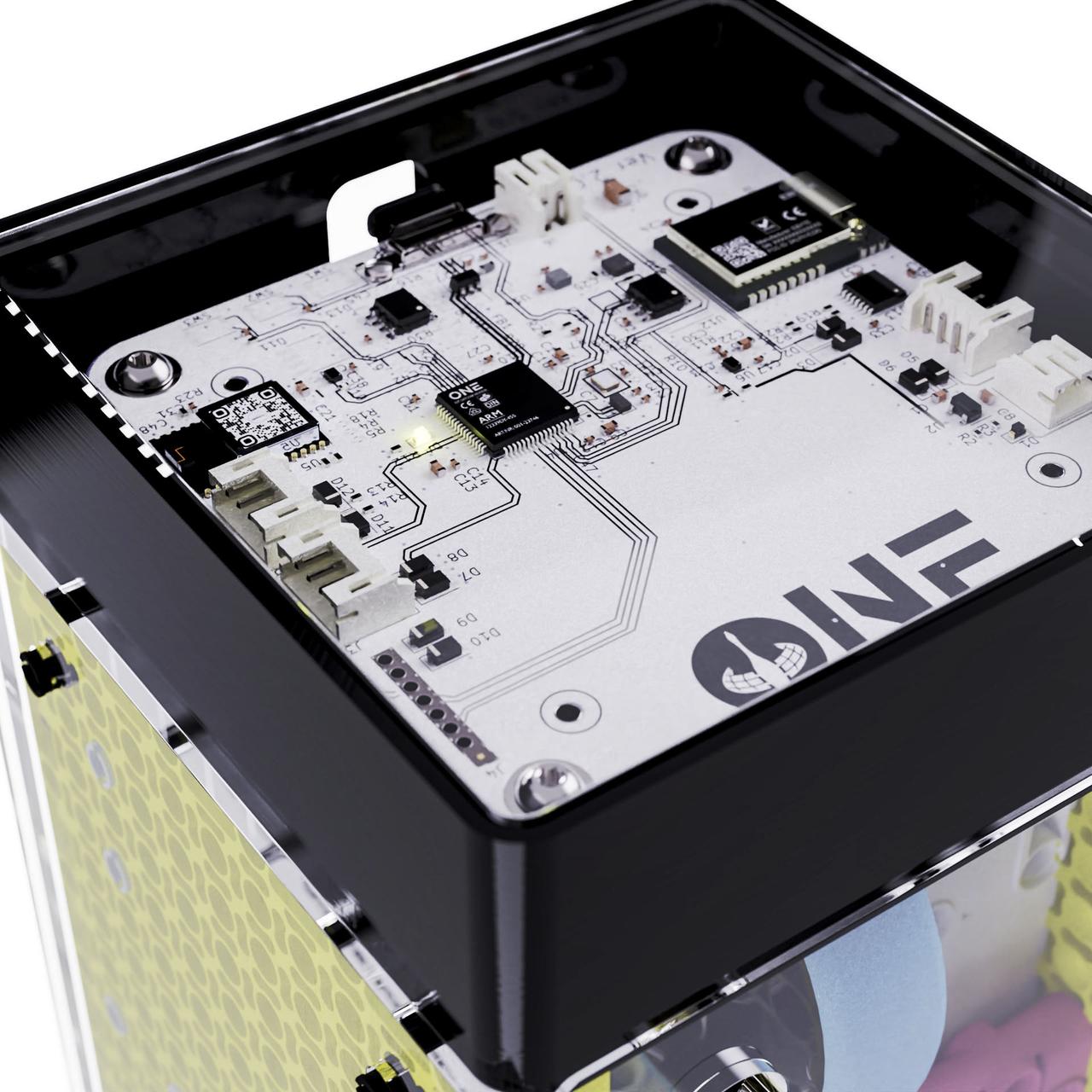
jsc2023e053550 (7/27/2023) --- The denMACH ONE IoT modem complete with inbuilt sensors to measure temperature, humidity, CO2, barometric pressure, compass points, accelerometer, GPS. Image courtesy SpaceTech denMACH.
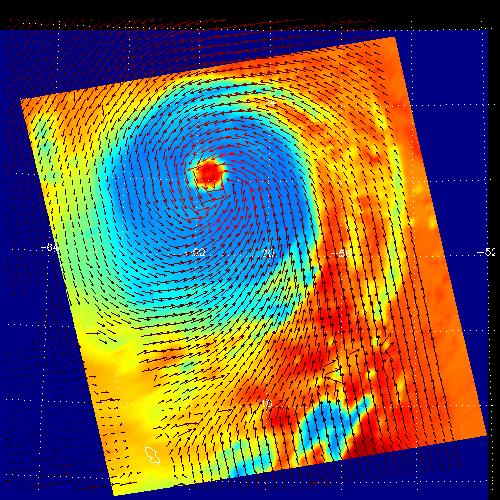
These two images show Hurricane Isabel as viewed by AIRS and SeaWinds scatterometers on NASA ADEOS-2 and QuikScat satellites in September, 2003. AIRS data are used to create global three-dimensional maps of temperature, humidity and clouds, while scatterometers measure surface wind speed and direction. http://photojournal.jpl.nasa.gov/catalog/PIA00429
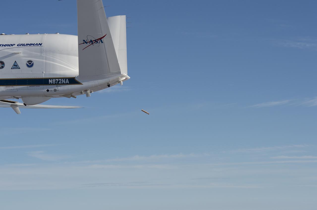
NASA’s Global Hawk aircraft deploys a dropsonde during a test flight over the Dryden Aeronautical Test Range in August 2015. The small, tube-shaped sensor will transmit data on temperature, humidity, and wind speed, which will be used to help improve weather model forecasts

NASA Glenn’s Propulsion Systems Lab (PSL) is conducting research to characterize ice crystal clouds that can create a hazard to aircraft engines under certain conditions. The isokinetic probe (in gold) samples particles and another series of probes can measure everything from humidity to air pressure.
STS040-34-001 (5-14 June 1991) --- This 35mm scene shows a close-up of a prototype filter designed to remove contamination from air and water, before it flows into the Orbiter's humidity separators. This experiment is part of Development Test Objective (DTO) 647, Water Separator Filter Performance Evaluation. Astronauts Bryan D. O'Connor, mission commander, and Sidney M. Gutierrez, pilot, carried out the test and down linked television to the ground for engineering analysis.
A crated National Oceanic and Atmospheric Administration (NOAA-L) satellite is moved inside the B16-10 spacecraft processing hangar at Vandenberg Air Force Base, Calif. NOAA-L is part of the Polar-Orbiting Operational Environmental Satellite (POES) program that provides atmospheric measurements of temperature, humidity, ozone and cloud images, tracking weather patterns that affect the global weather and climate. The launch of the NOAA-L satellite is scheduled no earlier than Sept. 12 aboard a Lockheed Martin Titan II rocket
KENNEDY SPACE CENTER, FLA. - United Space Alliance employee James Calloway checks the temperature and humidity level recorder in the Orbiter Processing Facility following Hurricane Frances. The storm's path over Florida took it through Cape Canaveral and KSC property during Labor Day weekend. There was no damage to the Space Shuttle orbiters or to any other flight hardware.
Inside the B16-10 spacecraft processing hangar at Vandenberg Air Force Base, Calif., workers oversee the uncrating of the National Oceanic and Atmospheric Administration (NOAA-L) satellite. NOAA-L is part of the Polar-Orbiting Operational Environmental Satellite (POES) program that provides atmospheric measurements of temperature, humidity, ozone and cloud images, tracking weather patterns that affect the global weather and climate. The launch of the NOAA-L satellite is scheduled no earlier than Sept. 12 aboard a Lockheed Martin Titan II rocket
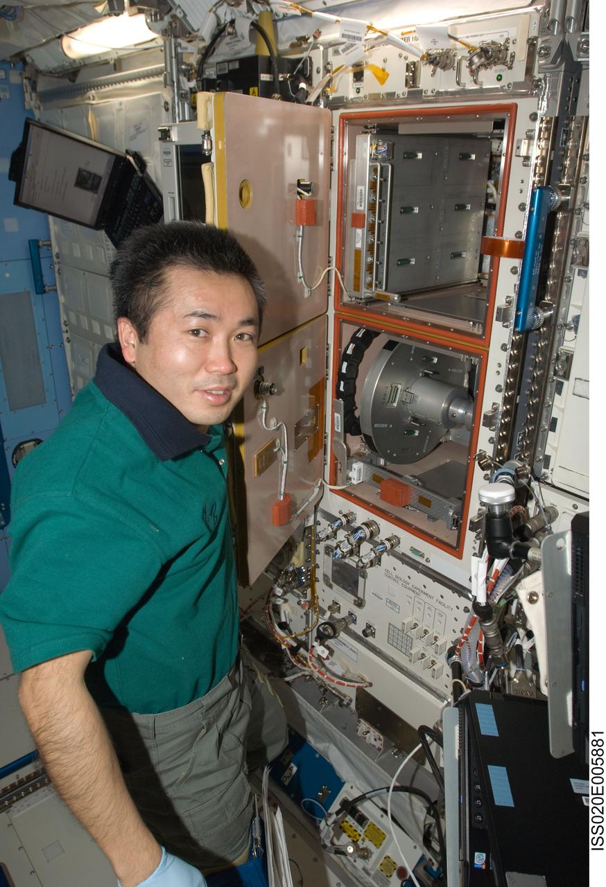
ISS020-E-005881 (1 June 2009) --- Japan Aerospace Exploration Agency (JAXA) astronaut Koichi Wakata, Expedition 20 flight engineer, conducts the current periodic humidity check on the Cell Biology Experiment Facility (CBEF) in the Saibo Rack in the Kibo laboratory of the International Space Station. Wakata opened the facility’s door for wiping up any condensation inside the micro-G & 1G section, if present, and also secured floating fan mesh with Kapton tape.

KENNEDY SPACE CENTER, FLA. - A crop of strawberries grown in a controlled environment chamber at the Space Life Sciences Lab is displayed during a tour of the facility for members of the news media. In missions to the International Space Station or early planetary outposts, plant production systems will likely be small and rely upon the spacecraft or habitat environment to regulate temperature, relative humidity, and carbon dioxide concentrations. Various crops are being grown in conditions that might be experienced in a spacecraft to evaluate the effects of different environmental conditions on plant growth, crop yield, and product quality.
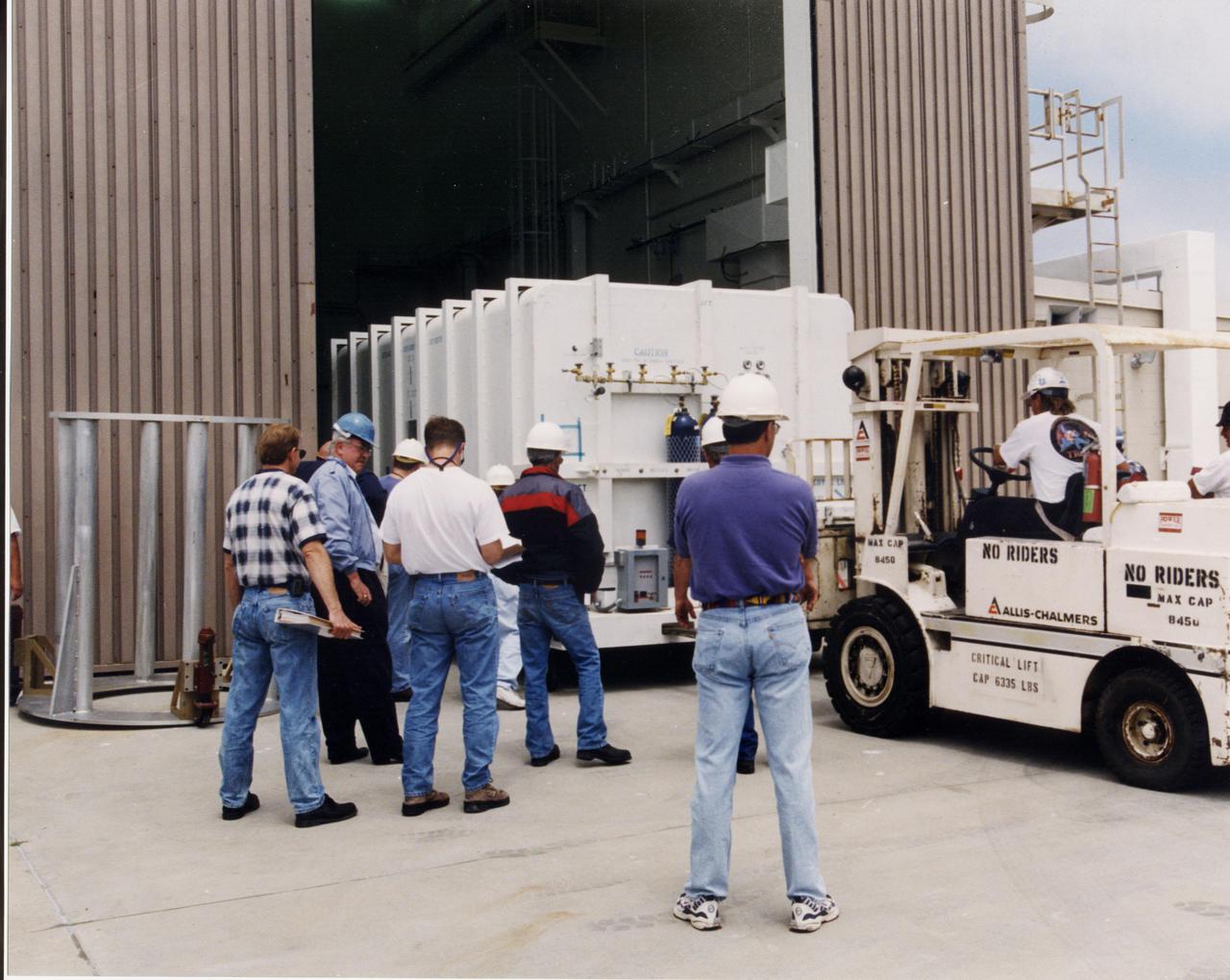
A crated National Oceanic and Atmospheric Administration (NOAA-L) satellite is moved inside the B16-10 spacecraft processing hangar at Vandenberg Air Force Base, Calif. NOAA-L is part of the Polar-Orbiting Operational Environmental Satellite (POES) program that provides atmospheric measurements of temperature, humidity, ozone and cloud images, tracking weather patterns that affect the global weather and climate. The launch of the NOAA-L satellite is scheduled no earlier than Sept. 12 aboard a Lockheed Martin Titan II rocket

Inside the B16-10 spacecraft processing hangar at Vandenberg Air Force Base, Calif., workers oversee the uncrating of the National Oceanic and Atmospheric Administration (NOAA-L) satellite. NOAA-L is part of the Polar-Orbiting Operational Environmental Satellite (POES) program that provides atmospheric measurements of temperature, humidity, ozone and cloud images, tracking weather patterns that affect the global weather and climate. The launch of the NOAA-L satellite is scheduled no earlier than Sept. 12 aboard a Lockheed Martin Titan II rocket
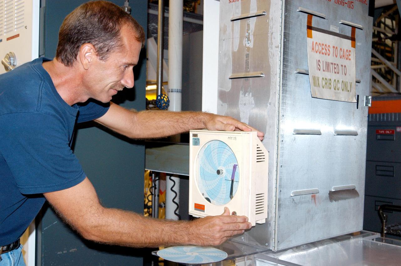
KENNEDY SPACE CENTER, FLA. - United Space Alliance employee James Calloway changes out equipment in the temperature and humidity level recorder in the Orbiter Processing Facility following Hurricane Frances. The storm's path over Florida took it through Cape Canaveral and KSC property during Labor Day weekend. There was no damage to the Space Shuttle orbiters or to any other flight hardware.
At the launch tower, Vandenberg Air Force Base, Calif., the second stage of a Titan II rocket is lifted to vertical. The Titan will power the launch of a National Oceanic and Atmospheric Administration (NOAA-L) satellite scheduled no earlier than Sept. 12. NOAA-L is part of the Polar-Orbiting Operational Environmental Satellite (POES) program that provides atmospheric measurements of temperature, humidity, ozone and cloud images, tracking weather patterns that affect the global weather and climate

At the launch tower, Vandenberg Air Force Base, Calif., the second stage of a Titan II rocket is lifted to vertical. The Titan will power the launch of a National Oceanic and Atmospheric Administration (NOAA-L) satellite scheduled no earlier than Sept. 12. NOAA-L is part of the Polar-Orbiting Operational Environmental Satellite (POES) program that provides atmospheric measurements of temperature, humidity, ozone and cloud images, tracking weather patterns that affect the global weather and climate

KENNEDY SPACE CENTER, FLA. - United Space Alliance employee James Calloway adjusts the temperature and humidity level recorder in the Orbiter Processing Facility following Hurricane Frances. The storm's path over Florida took it through Cape Canaveral and KSC property during Labor Day weekend. There was no damage to the Space Shuttle orbiters or to any other flight hardware.
A crated National Oceanic and Atmospheric Administration (NOAA-L) satellite arrives at Vandenberg Air Force Base, Calif.; It is part of the Polar-Orbiting Operational Environmental Satellite (POES) program that provides atmospheric measurements of temperature, humidity, ozone and cloud images, tracking weather patterns that affect the global weather and climate. The launch of the NOAA-L satellite is scheduled no earlier than Sept. 12 aboard a Lockheed Martin Titan II rocket

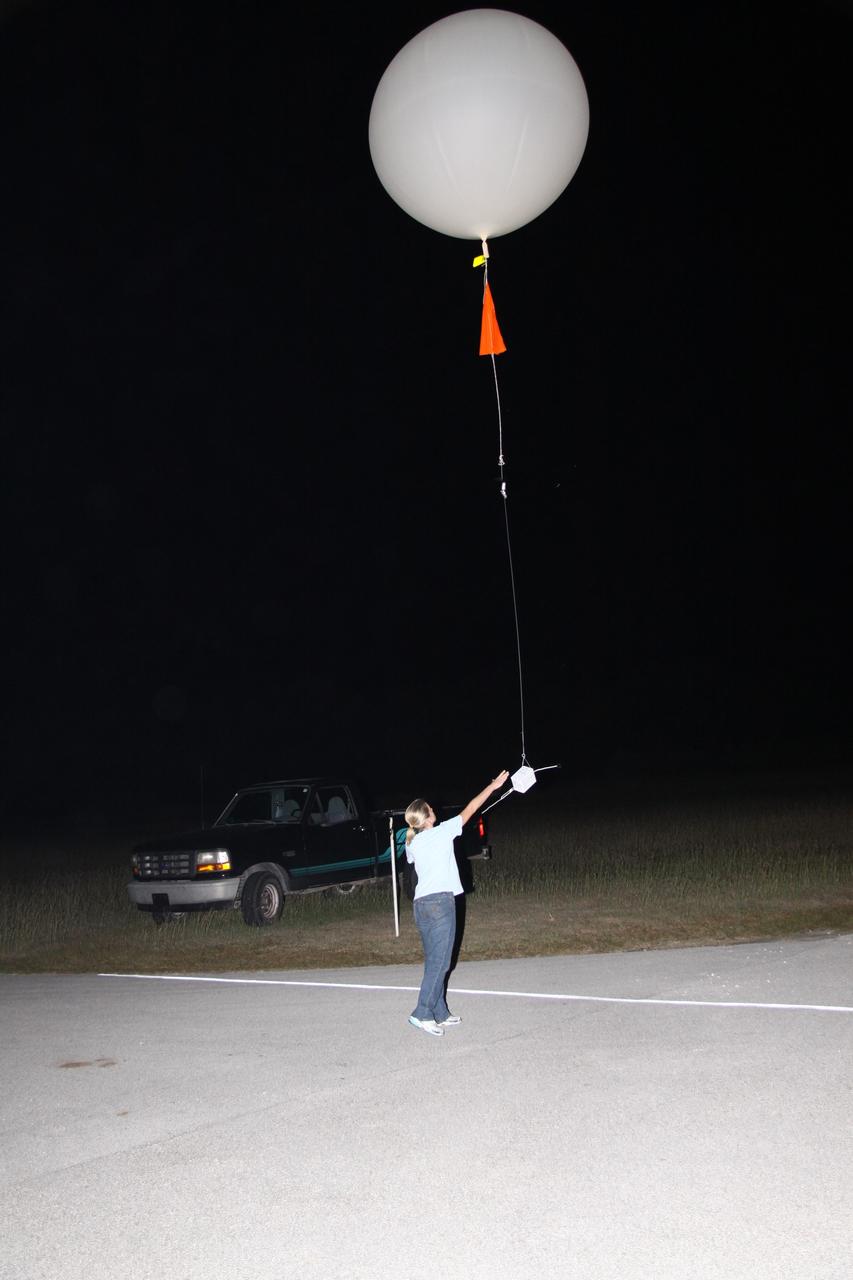
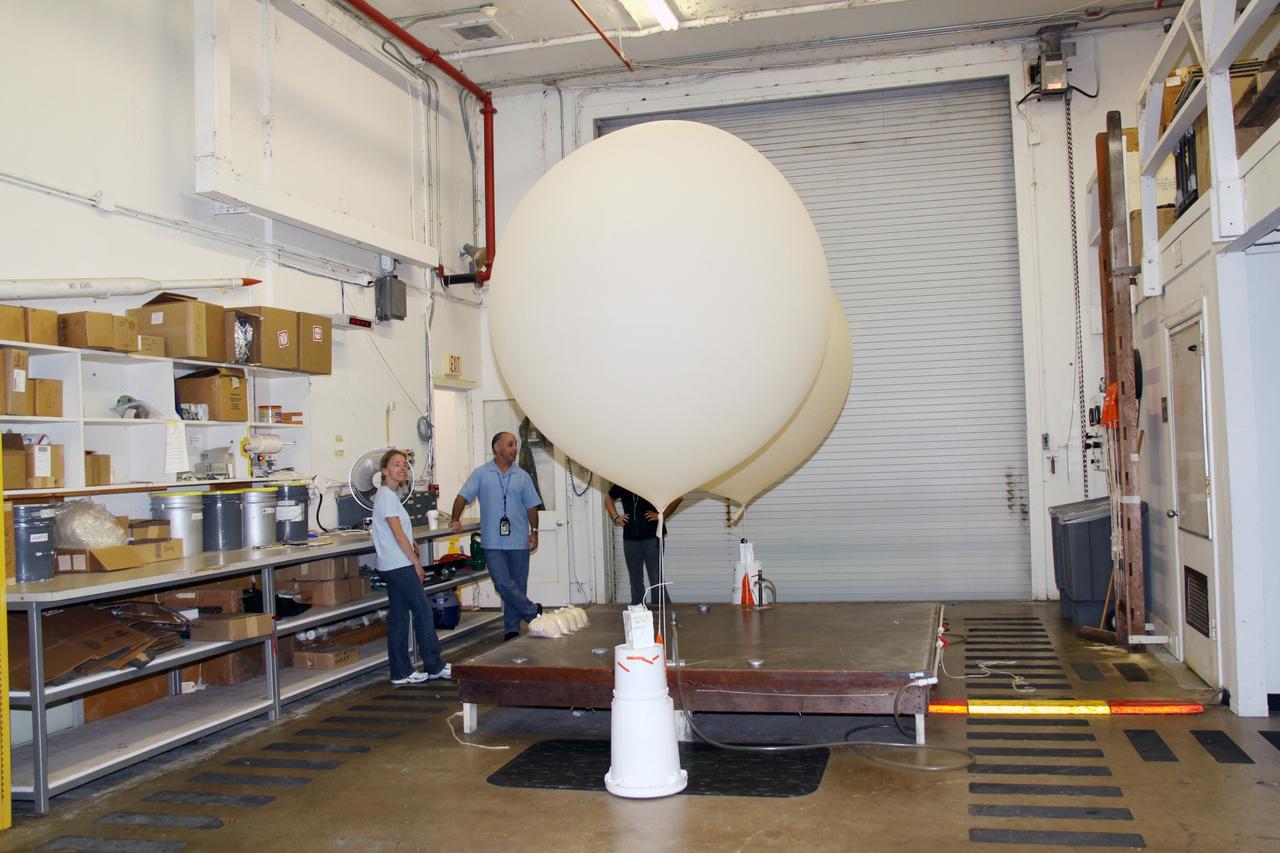
KENNEDY SPACE CENTER, FLA. -- Stephen Ezell, meteorological systems operator at Weather Station A, Cape Canaveral Air Force Station, releases a weather balloon. Such balloons are released twice a day. The package at the bottom is a radio sonde that collects temperature and humidity data as the balloon rises. The data is released to agencies nationwide, including the 45th Space Wing, which uses the data for its daily weather reports. The weather station provides additional data to NASA for launches -- releasing 12 balloons in eight hours prior to liftoff - and landings - releasing 5 balloons in six and a half hours before expected touchdown.
CAPE CANAVERAL, Fla. - At the weather station on Cape Canaveral Air Force Station in Florida, a meteorological data specialist releases a low resolution flight element rawinsonde to support the countdown for the flight test of NASA's Ares I-X rocket. A GPS-tracked weather balloon, a rawinsonde has a tethered instrument package which radios its altitude to the ground along with atmospheric data such as temperature, dewpoint and humidity, and wind speed and direction. Rawinsondes can reach altitudes up to 110,000 feet. For information on the Ares I-X vehicle and flight test, visit http://www.nasa.gov/aresIX. Photo credit: NASA/Jack Pfaller
Inside the B16-10 spacecraft processing hangar at Vandenberg Air Force Base, Calif., workers oversee the mating of the Apogee Kick Motor (below) to the National Oceanic and Atmospheric Administration (NOAA-L) satellite above. NOAA-L is part of the Polar-Orbiting Operational Environmental Satellite (POES) program that provides atmospheric measurements of temperature, humidity, ozone and cloud images, tracking weather patterns that affect the global weather and climate. The launch of the NOAA-L satellite is scheduled no earlier than Sept. 12 aboard a Lockheed Martin Titan II rocket

CAPE CANAVERAL, Fla. – Dense fog engulfs Launch Complex 39 at NASA's Kennedy Space Center in Florida, obscuring the view of the 525-foot-tall Vehicle Assembly Building. The fog pushed onshore from the Atlantic Ocean for the second time in one day to create atypical conditions on this humid December afternoon. Space Shuttle Endeavour currently is in the VAB's High Bay 1 where it is being attached to its external fuel tank and solid rocket boosters in preparation for its targeted launch in early February 2010. Photo credit: NASA/Jack Pfaller
CAPE CANAVERAL, Fla. - At the weather station on Cape Canaveral Air Force Station in Florida, a meteorological data specialist prepares to release a low resolution flight element rawinsonde to support the countdown for the flight test of NASA's Ares I-X rocket. A GPS-tracked weather balloon, a rawinsonde has a tethered instrument package which radios its altitude to the ground along with atmospheric data such as temperature, dewpoint and humidity, and wind speed and direction. Rawinsondes can reach altitudes up to 110,000 feet. For information on the Ares I-X vehicle and flight test, visit http://www.nasa.gov/aresIX. Photo credit: NASA/Jack Pfaller
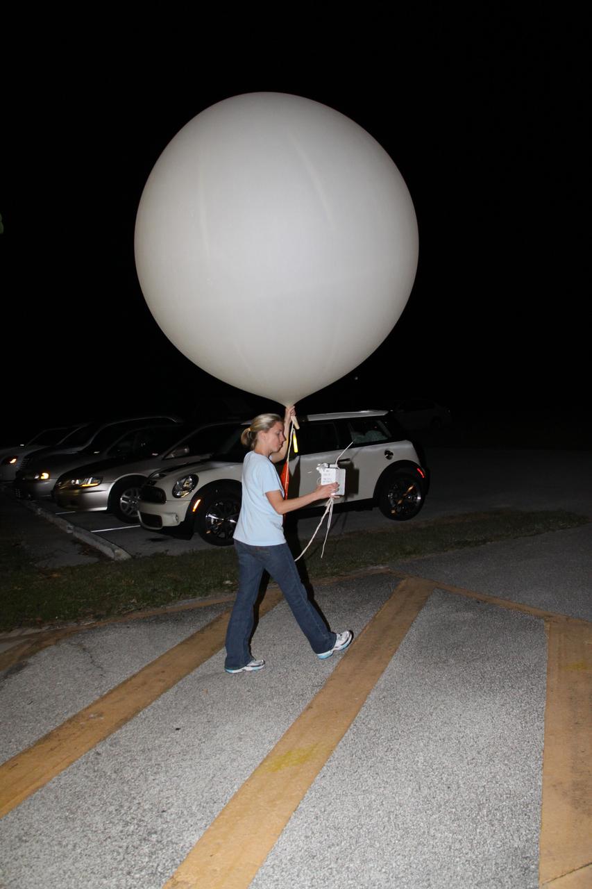
Tegan French and Rocky Garcia are at a weather balloon system’s ground station monitoring temperature, humidity, pressure, and winds transmitted from an instrument package on the balloon as it ascends. The balloon is part of the different methods to collect wind and weather data for the Advanced Exploration of Reliable Operation at Low Altitudes: Meteorology, Simulation and Technology campaign. The weather study was at NASA’s Armstrong Flight Research Center in Edwards, California. The focus was to study wind from the ground to 2,000 feet to provide data to assist future drones to safely land on rooftop hubs called vertiports and to potentially improve weather prediction.
Inside the B16-10 spacecraft processing hangar at Vandenberg Air Force Base, Calif., workers oversee the lifting and rotating of the National Oceanic and Atmospheric Administration (NOAA-L) satellite to allow for mating of the Apogee Kick Motor (AKM). NOAA-L is part of the Polar-Orbiting Operational Environmental Satellite (POES) program that provides atmospheric measurements of temperature, humidity, ozone and cloud images, tracking weather patterns that affect the global weather and climate. The launch of the NOAA-L satellite is scheduled no earlier than Sept. 12 aboard a Lockheed Martin Titan II rocket
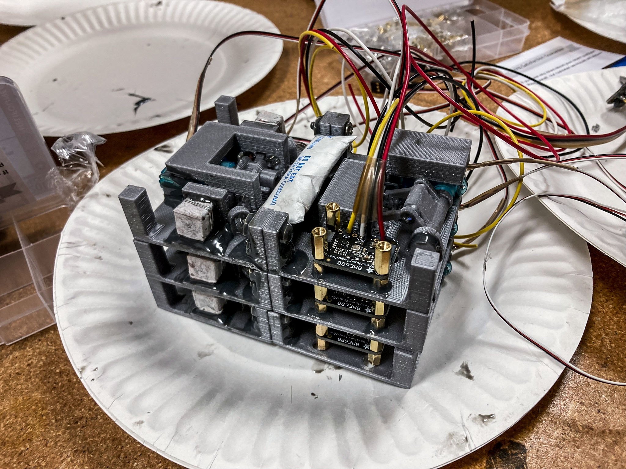
jsc2022e042479 (2/3/2022) --- This image shows three modules of flight hardware for the Biopolymer Research for In-Situ Capabilities investigation, launching aboard SpaceX’s 25th commercial resupply services mission to the International Space Station. The hardware is 3D printed in gray PLA, a desiccant packet is epoxied in the center of the module, and a pressure and humidity sensor is fastened to the left. Each module makes two bricks, for a total of six bricks that will be made in space. This investigation studies how microgravity affects the process of creating biopolymer soil composite (BSC), a concrete alternative that could be made with on-site material such as lunar or Martian dust. Image curtsey of James Wall.
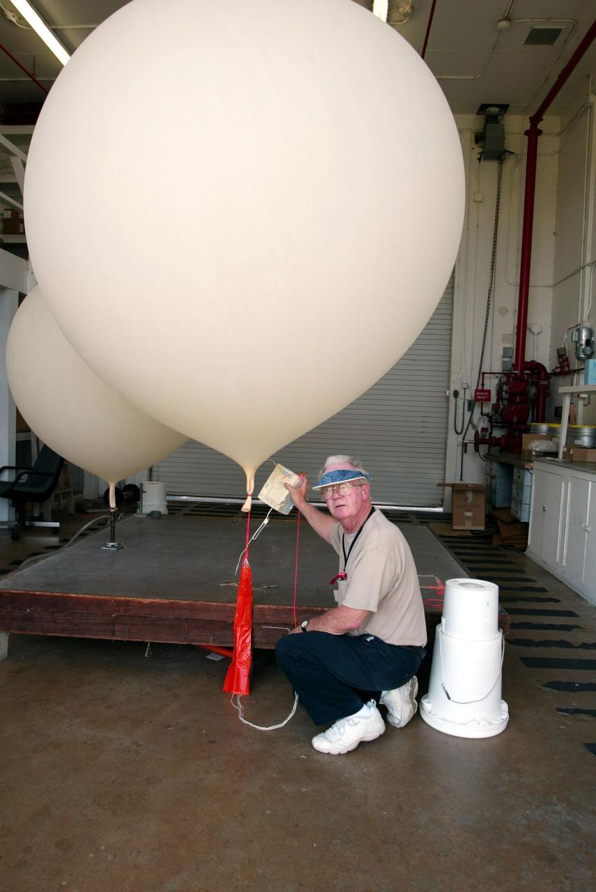
KENNEDY SPACE CENTER, FLA. - Stephen Ezell, meteorological systems operator at Weather Station A, Cape Canaveral Air Force Station, gets ready to release a weather balloon. Such balloons are released twice a day collecting data such as temperature and humidity as they rise. The data is released to agencies nationwide, including the 45th Space Wing which uses the data for its daily weather reports. The weather station provides additional data to NASA for launches -- releasing 12 balloons in eight hours prior to liftoff - and landings - releasing 5 balloons in six and a half hours before expected touchdown.
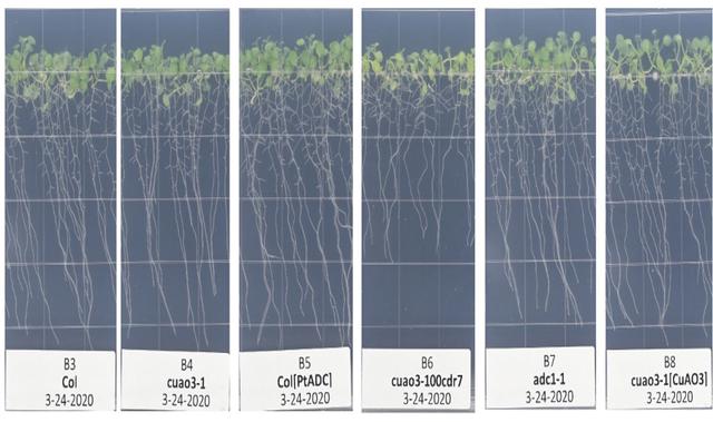
jsc2021e036657 (8/11/2021) --- Arabidopsis thaliana seedlings following 9 days of growth on 1.2% agar-based media in petri dishes in the VEGGIE growth chamber under temperature, humidity and CO2 conditions mimicking those recorded at the International Space Station. The genotypes of these plants are indicated at the bottom of each panel. These images were taken during the Science Verification Test carried out at NASA Kennedy Space Center. All genotypes grew equally well under these conditions except for the cuao3-100cdr7 mutant, which grew more slowly.
CAPE CANAVERAL, Fla. - In the weather station on Cape Canaveral Air Force Station in Florida, meteorological data specialists prepare two low resolution flight element rawinsonde to support the countdown for the flight test of NASA's Ares I-X rocket. A GPS-tracked weather balloon, a rawinsonde has a tethered instrument package which radios its altitude to the ground along with atmospheric data such as temperature, dewpoint and humidity, and wind speed and direction. Rawinsondes can reach altitudes up to 110,000 feet. For information on the Ares I-X vehicle and flight test, visit http://www.nasa.gov/aresIX. Photo credit: NASA/Jack Pfaller
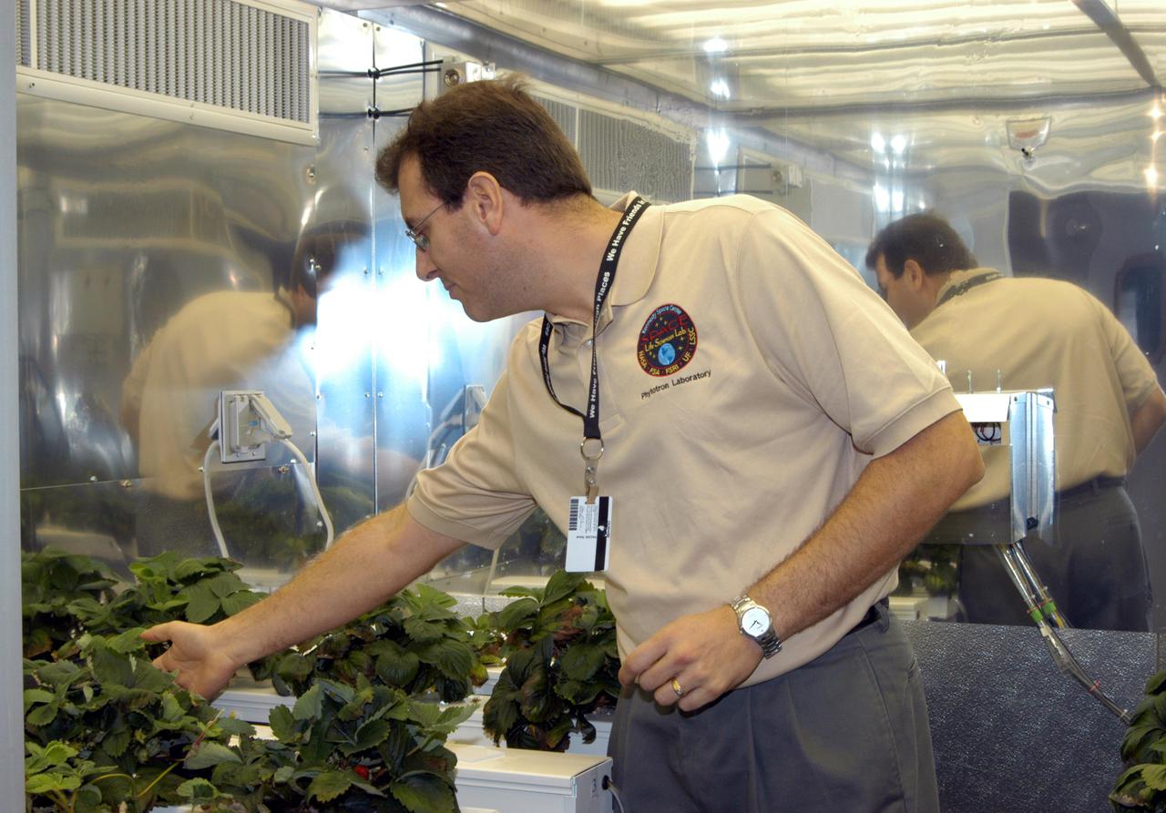
KENNEDY SPACE CENTER, FLA. - Jeff Richards, a plant physiologist with Dynamac Corporation, displays a crop of strawberries grown in a controlled environment chamber at the Space Life Sciences Lab during a tour of the facility for members of the news media. In missions to the International Space Station or early planetary outposts, plant production systems will likely be small and rely upon the spacecraft or habitat environment to regulate temperature, relative humidity, and carbon dioxide concentrations. Various crops are being grown in conditions that might be experienced in a spacecraft to evaluate the effects of different environmental conditions on plant growth, crop yield, and product quality.
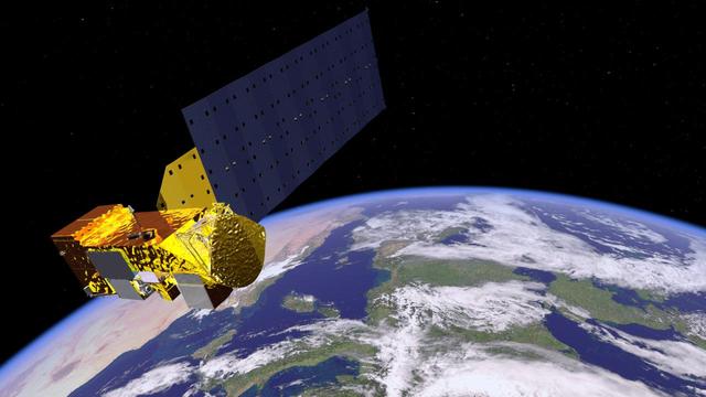
NASA Aqua satellite carries six state-of-the-art instruments in a near-polar low-Earth orbit. Aqua is seen in this artist concept orbiting Earth. The six instruments are the Atmospheric Infrared Sounder (AIRS), the Advanced Microwave Sounding Unit (AMSU-A), the Humidity Sounder for Brazil (HSB), the Advanced Microwave Scanning Radiometer for EOS (AMSR-E), the Moderate Resolution Imaging Spectroradiometer (MODIS), and Clouds and the Earth's Radiant Energy System (CERES). Each has unique characteristics and capabilities, and all six serve together to form a powerful package for Earth observations. http://photojournal.jpl.nasa.gov/catalog/PIA18156
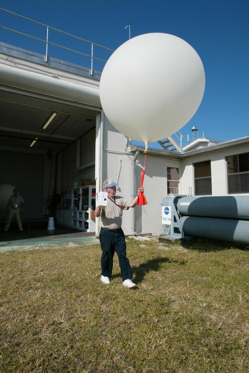
KENNEDY SPACE CENTER, FLA. - Stephen Ezell, meteorological systems operator at Weather Station A, Cape Canaveral Air Force Station, gets ready to release a weather balloon. Such balloons are released twice a day. The package in Ezell's hand is a radio sonde that collects temperature and humidity data as the balloon rises. The data is released to agencies nationwide, including the 45th Space Wing, which uses the data for its daily weather reports. The weather station provides additional data to NASA for launches -- releasing 12 balloons in eight hours prior to liftoff - and landings - releasing 5 balloons in six and a half hours before expected touchdown.
Outside the B16-10 spacecraft processing hangar at Vandenberg Air Force Base, Calif., a crated National Oceanic and Atmospheric Administration (NOAA-L) satellite is lowered to the ground before being moved inside. NOAA-L is part of the Polar-Orbiting Operational Environmental Satellite (POES) program that provides atmospheric measurements of temperature, humidity, ozone and cloud images, tracking weather patterns that affect the global weather and climate. The launch of the NOAA-L satellite is scheduled no earlier than Sept. 12 aboard a Lockheed Martin Titan II rocket

Inside the B16-10 spacecraft processing hangar at Vandenberg Air Force Base, Calif., workers oversee the mating of the Apogee Kick Motor (below) to the National Oceanic and Atmospheric Administration (NOAA-L) satellite above. NOAA-L is part of the Polar-Orbiting Operational Environmental Satellite (POES) program that provides atmospheric measurements of temperature, humidity, ozone and cloud images, tracking weather patterns that affect the global weather and climate. The launch of the NOAA-L satellite is scheduled no earlier than Sept. 12 aboard a Lockheed Martin Titan II rocket
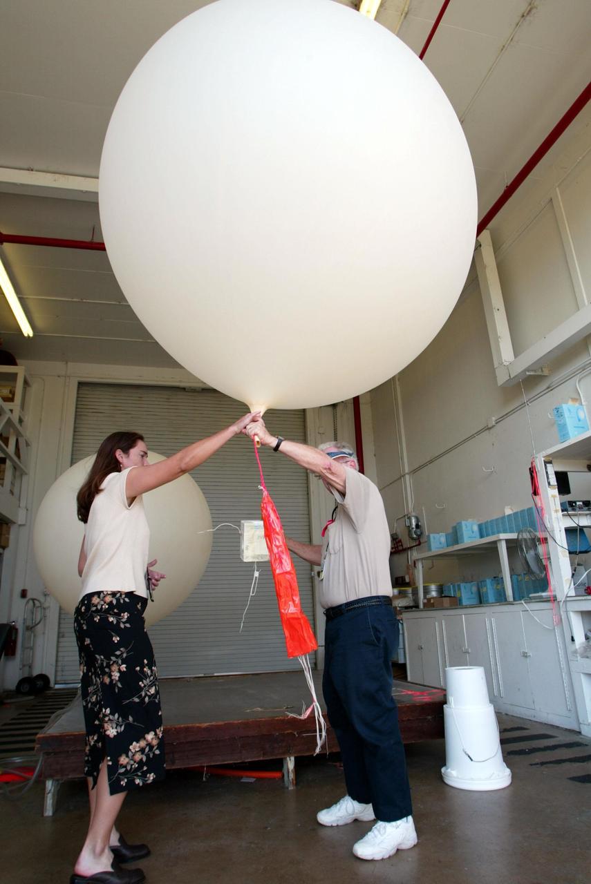
KENNEDY SPACE CENTER, FLA. - At Weather Station A, Cape Canaveral Air Force Station, Judy Kelley, supervisor of Meteorology Operations, and Stephen Ezell, meteorological systems operator, get ready to release a weather balloon. Such balloons are released twice a day. The package at the bottom is a radio sonde that collects temperature and humidity data as the balloon rises. The data is released to agencies nationwide, including the 45th Space Wing, which uses the data for its daily weather reports. The weather station provides additional data to NASA for launches -- releasing 12 balloons in eight hours prior to liftoff - and landings - releasing 5 balloons in six and a half hours before expected touchdown.

CAPE CANAVERAL, Fla. - In the weather station on Cape Canaveral Air Force Station in Florida, a meteorological data specialist prepares a low resolution flight element rawinsonde to support the countdown for the flight test of NASA's Ares I-X rocket. A GPS-tracked weather balloon, a rawinsonde has a tethered instrument package which radios its altitude to the ground along with atmospheric data such as temperature, dewpoint and humidity, and wind speed and direction. Rawinsondes can reach altitudes up to 110,000 feet. For information on the Ares I-X vehicle and flight test, visit http://www.nasa.gov/aresIX. Photo credit: NASA/Jack Pfaller
Inside the B16-10 spacecraft processing hangar at Vandenberg Air Force Base, Calif., workers oversee the lifting and rotating of the National Oceanic and Atmospheric Administration (NOAA-L) satellite to allow for mating of the Apogee Kick Motor (AKM). NOAA-L is part of the Polar-Orbiting Operational Environmental Satellite (POES) program that provides atmospheric measurements of temperature, humidity, ozone and cloud images, tracking weather patterns that affect the global weather and climate. The launch of the NOAA-L satellite is scheduled no earlier than Sept. 12 aboard a Lockheed Martin Titan II rocket
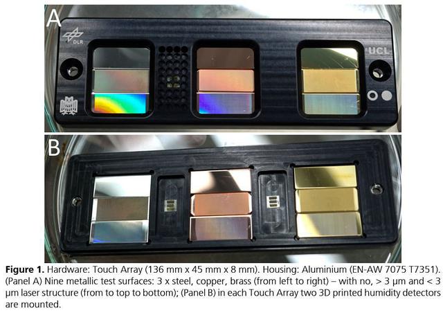
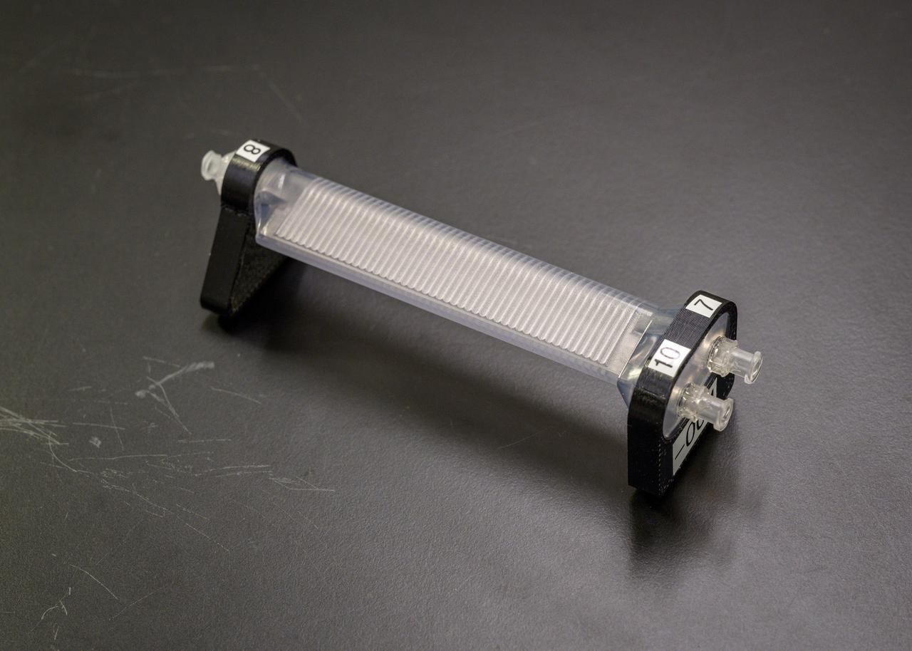
jsc2021e037879 (8/24/2021) --- A preflight view of the Touching Surfaces investigation hardware. The Touch Array (136 mm x 45 mm x 8 mm). Housing : Aluminum (EN-AW 7075 T7351). (Panel A) Nine metallic test surfaces: 3 x steel, copper, brass (from left to right) – with no greater than 3 ?m and less than 3 ?m laser structure (from top to bottom); (Panel B) in each Touch Array two 3 printed humidity detectors are mounted. Image Courtesy DLR

Outside the B16-10 spacecraft processing hangar at Vandenberg Air Force Base, Calif., a crated National Oceanic and Atmospheric Administration (NOAA-L) satellite is lowered to the ground before being moved inside. NOAA-L is part of the Polar-Orbiting Operational Environmental Satellite (POES) program that provides atmospheric measurements of temperature, humidity, ozone and cloud images, tracking weather patterns that affect the global weather and climate. The launch of the NOAA-L satellite is scheduled no earlier than Sept. 12 aboard a Lockheed Martin Titan II rocket
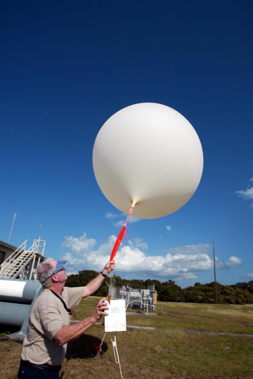
KENNEDY SPACE CENTER, FLA. - Stephen Ezell, meteorological systems operator at Weather Station A, Cape Canaveral Air Force Station, gets ready to release a weather balloon. Such balloons are released twice a day. The package in Ezell's hand is a radio sonde that collects temperature and humidity data as the balloon rises. The data is released to agencies nationwide, including the 45th Space Wing, which uses the data for its daily weather reports. The weather station provides additional data to NASA for launches -- releasing 12 balloons in eight hours prior to liftoff - and landings - releasing 5 balloons in six and a half hours before expected touchdown.
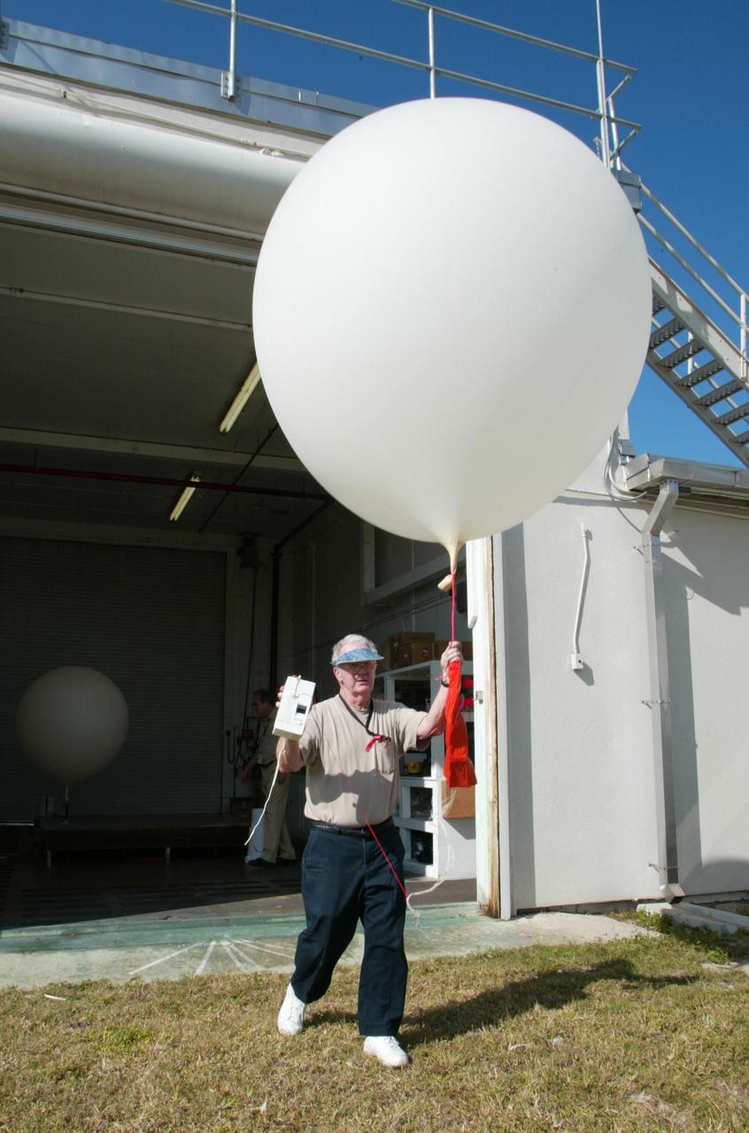
KENNEDY SPACE CENTER, FLA. - Stephen Ezell, meteorological systems operator at Weather Station A, Cape Canaveral Air Force Station, walks out with a weather balloon that he will release. Such balloons are released twice a day. The package in Ezell's hand is a radio sonde that collects temperature and humidity data as the balloon rises. The data is released to agencies nationwide, including the 45th Space Wing which uses the data for its daily weather reports. The weather station provides additional data to NASA for launches - releasing 12 balloons in eight hours prior to liftoff - and landings - releasing 5 balloons in six and a half hours before expected touchdown.
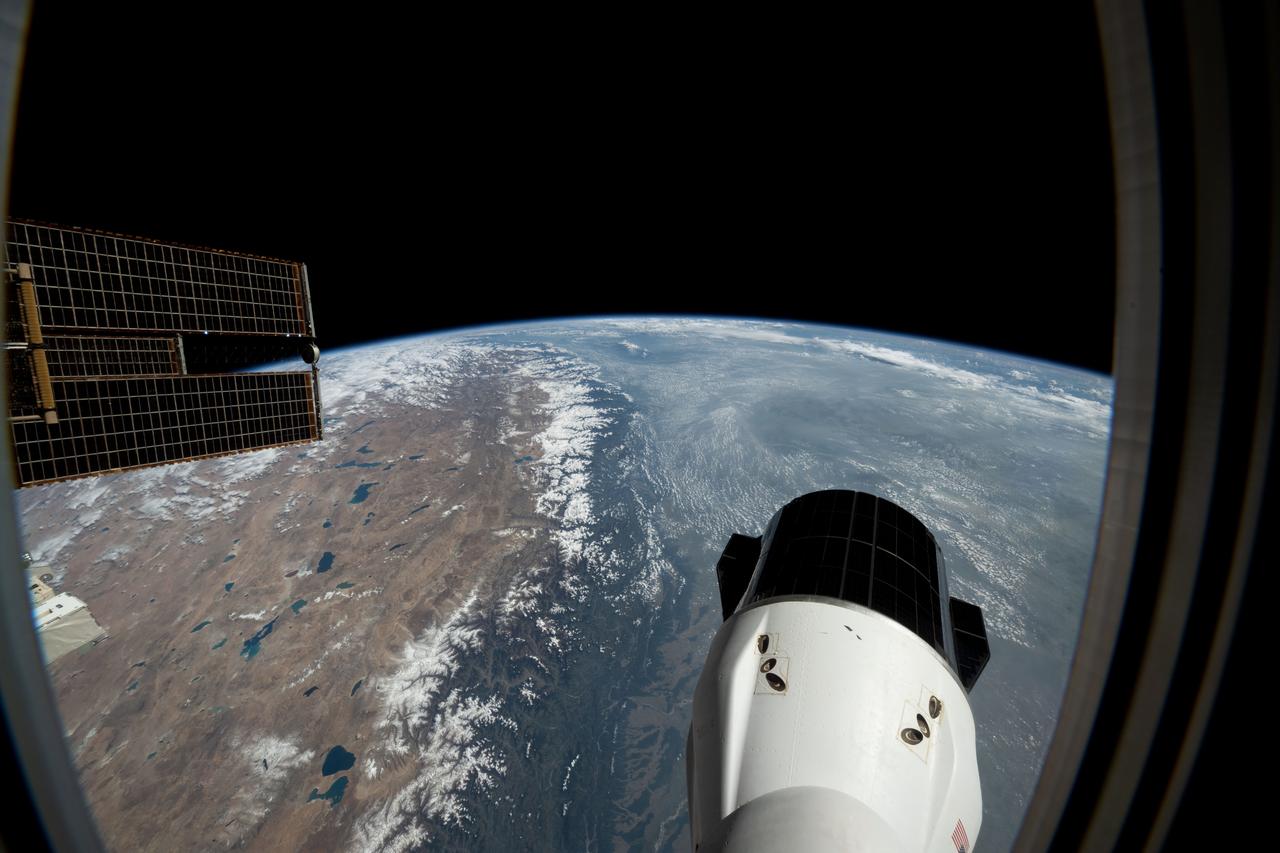
iss073e1025732 (Oct. 18, 2025) --- The Himalayas separate mainland Asia from the Indian subcontinent, revealing an arid, desert-like terrain on the Asian side, known as the Tibetan Plateau. On the southern slopes of the mountain range, moist air rises, cools, and condenses, producing rainfall that supports a humid, subtropical climate. As the air descends on the northern slopes, it warms and dries, creating barren conditions due to the rain shadow effect. This photograph was taken from a window aboard the SpaceX Dragon crew spacecraft as the International Space Station orbited 263 miles above India.
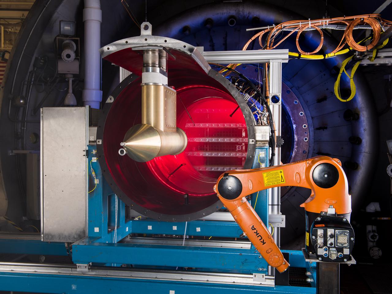
NASA Glenn’s Propulsion Systems Lab (PSL) is conducting research to characterize ice crystal clouds that can create a hazard to aircraft engines in certain conditions. With specialized equipment, scientists can create a simulated ice crystal cloud with the set of bars in the back spraying out a mist. The red area includes lasers, which measure the intensity of the cloud and a series of probes to measure everything from humidity to air pressure. The isokinetic probe (in gold) samples particles and the robotic arm (in orange) has a test tube on the end that catches ice particles for further measuring. NASA Glenn’s PSL is the only place in the world which can create these kind of ice crystal cloud conditions.
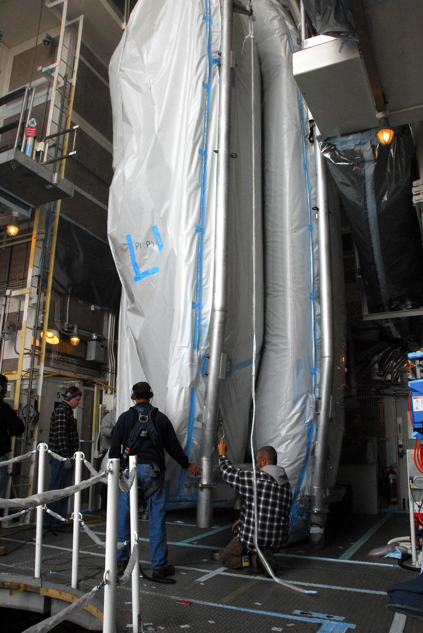
CAPE CANAVERAL, Fla. -- On Launch Pad 39A at NASA's Kennedy Space Center in Florida, a technician climbs into an environmental enclosure on space shuttle Discovery's external fuel tank. The enclosure will provide protection from wind, temperature and humidity changes while foam is re-applied and cured on the tank. The foam cracked during initial loading operations for Discovery’s launch attempt on Nov. 5. The cracks are on one of the 108 stringers, which are the composite aluminum ribs located vertically on the intertank area. Discovery's next launch attempt is no earlier than Nov. 30 at 4:02 a.m. EST. For more information on STS-133, visit www.nasa.gov/mission_pages/shuttle/shuttlemissions/sts133/. Photo credit: NASA/Dimitri Gerondidakis
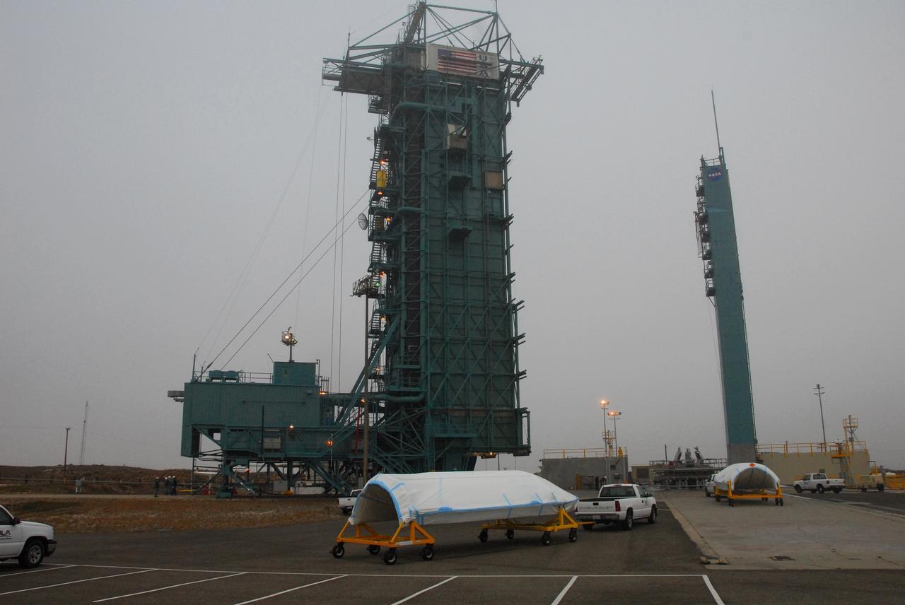
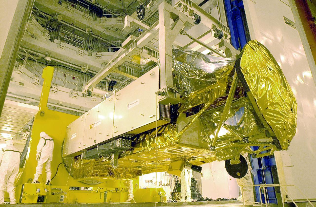
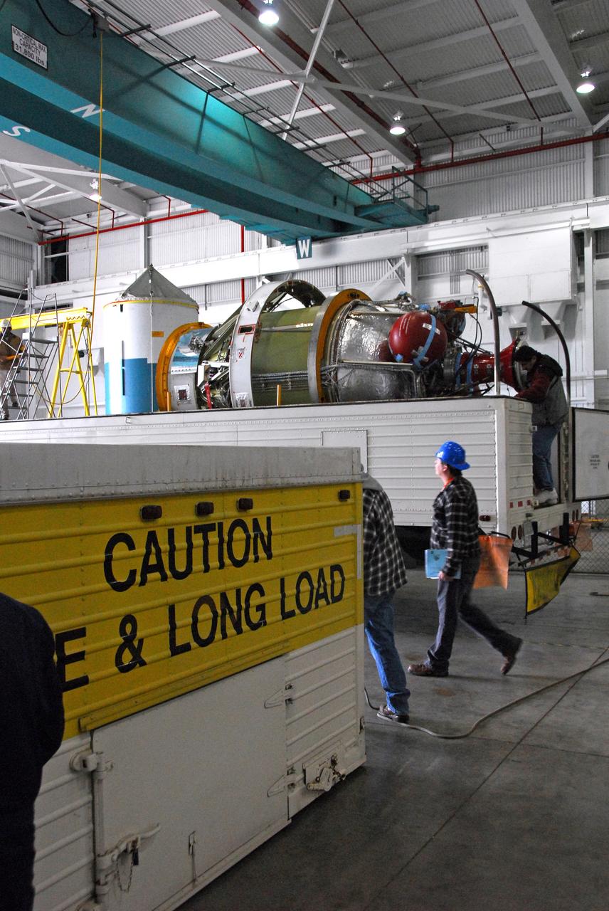
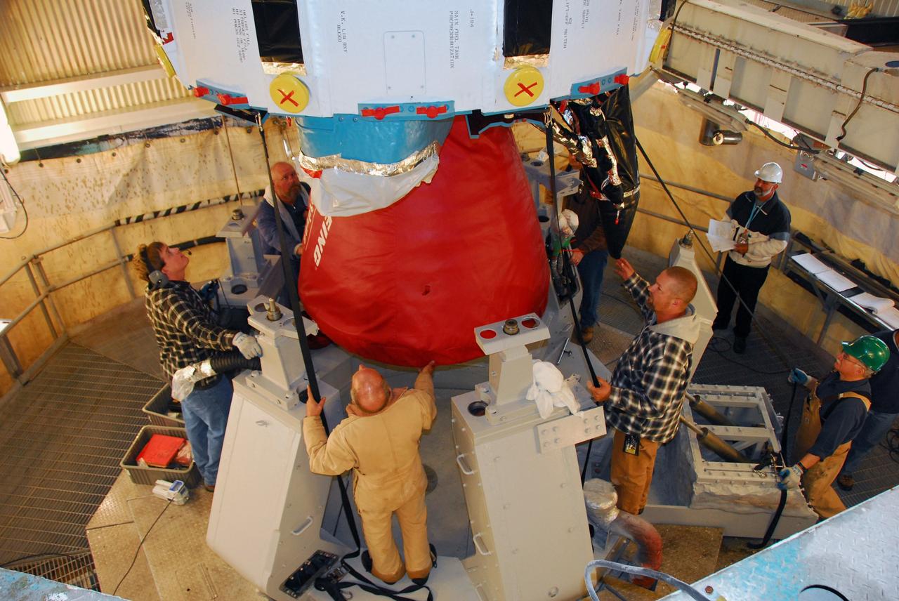
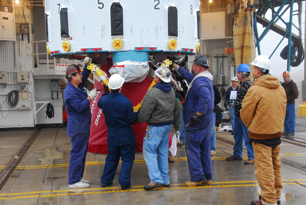
VANDENBERG AIR FORCE BASE, Calif. -- On Level 5 of Space Launch Complex-2 at Vandenberg Air Force Base in California, workers secure the payload fairing that will protect NASA's National Polar-orbiting Operational Environmental Satellite System Preparatory Project (NPP) satellite as it launches aboard a United Launch Alliance Delta II. NPP will be positioned 512 miles above the Earth's surface and will orbit about 16 times each day to observe nearly the entire globe. The NPP mission for NASA and the National Oceanic and Atmospheric Administration (NOAA) is to measure Earth's atmospheric and sea surface temperatures, humidity sounding, land and ocean biological activity, and cloud and aerosol properties. For more information, visit www.nasa.gov/NPP. Photo credit: NASA/VAFB, Roy Allison
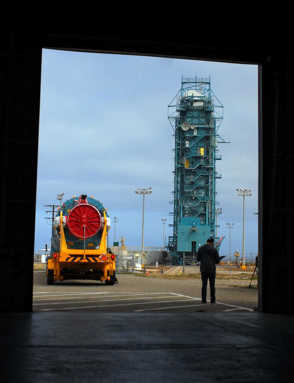
VANDENBERG AIR FORCE BASE, Calif. -- A United Launch Alliance Delta II stands tall on Space Launch Complex-2 at Vandenberg Air Force Base in California for the launch of NASA's National Polar-orbiting Operational Environmental Satellite System Preparatory Project (NPP) satellite. Next up for the rocket configuration is the lifting to Level 5 of the payload fairing that will protect NPP as it launches. NPP will be positioned 512 miles above the Earth's surface and will orbit about 16 times each day to observe nearly the entire globe. The NPP mission for NASA and the National Oceanic and Atmospheric Administration (NOAA) is to measure Earth's atmospheric and sea surface temperatures, humidity sounding, land and ocean biological activity, and cloud and aerosol properties. For more information, visit www.nasa.gov/NPP. Photo credit: NASA/VAFB, Roy Allison
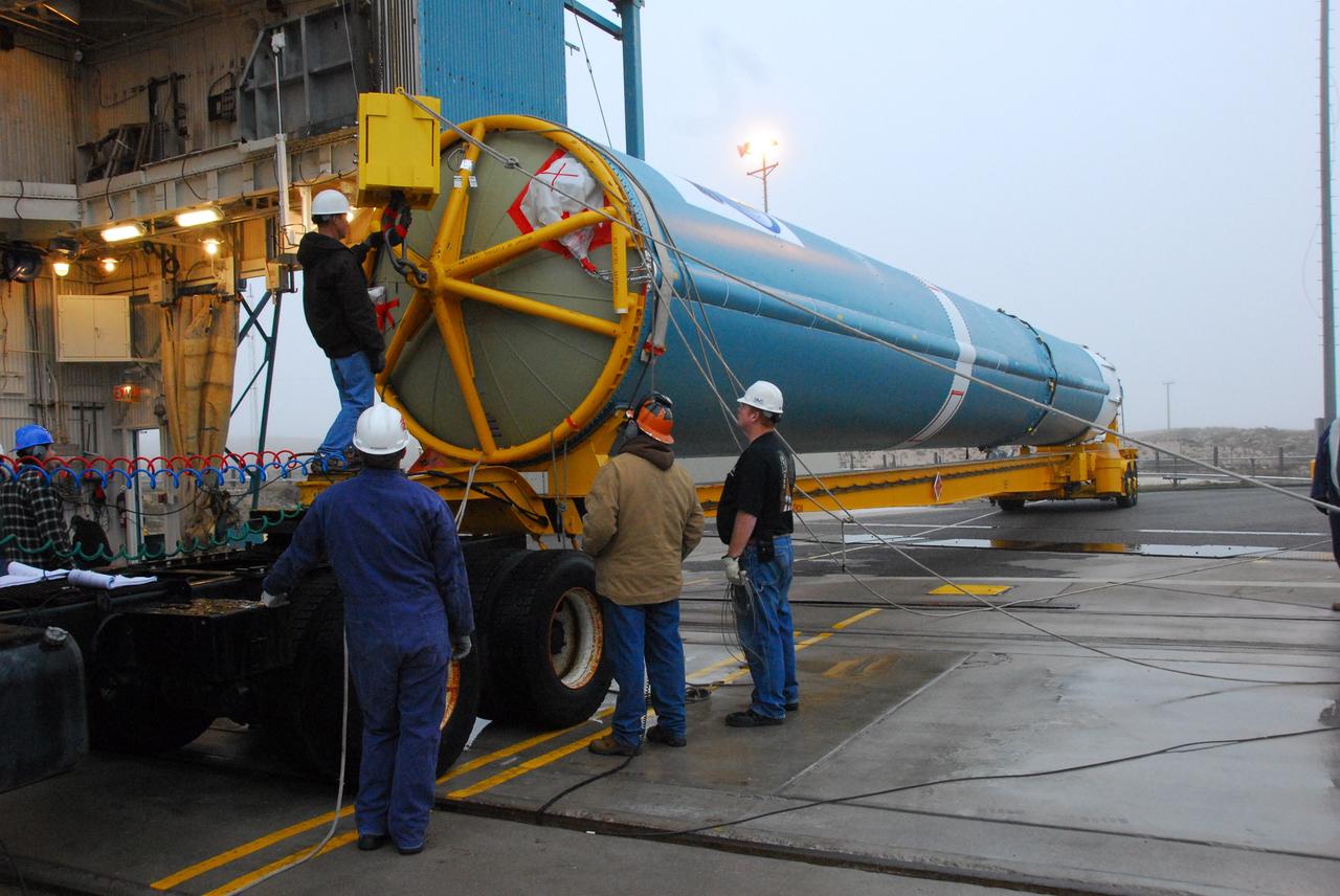
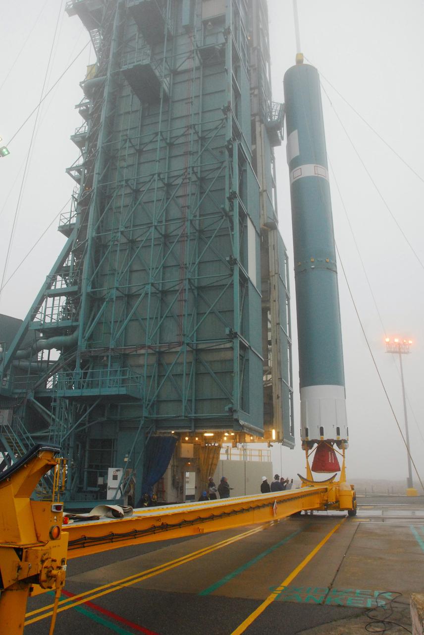
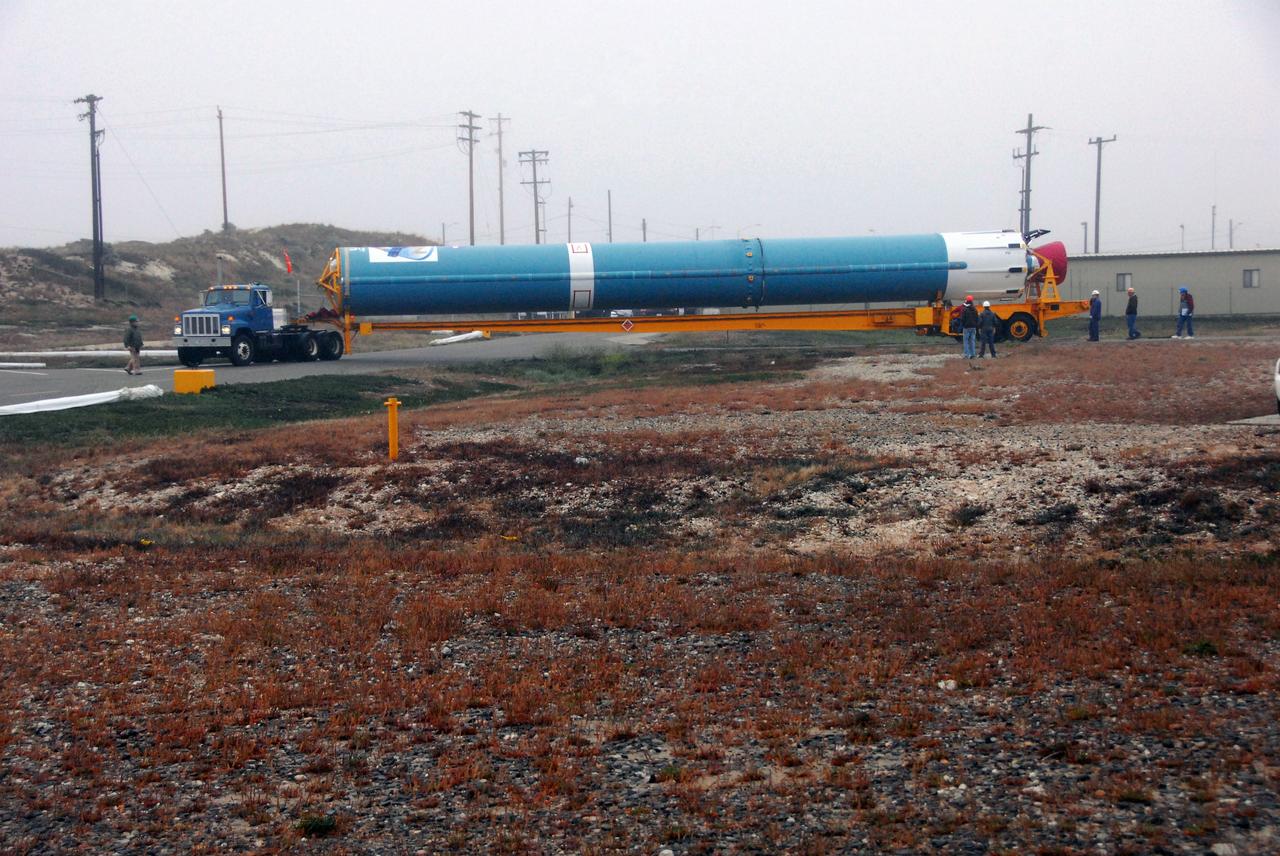
VANDENBERG AIR FORCE BASE, Calif. -- At Vandenberg Air Force Base in California, the first stage of a United Launch Alliance Delta II that will carry the National Polar-orbiting Operational Environmental Satellite System Preparatory Project (NPP) satellite into space has arrived at NASA's Launch Complex-2. The vehicle will undergo initial testing at the United Launch Alliance Delta Mission Checkout Facility. NPP will be positioned 512 miles above the Earth's surface and will orbit about 16 times each day to observe nearly the entire globe. The NPP mission for NASA and the National Oceanic and Atmospheric Administration (NOAA) is to measure Earth's atmospheric and sea surface temperatures, humidity sounding, land and ocean biological activity, and cloud and aerosol properties. For more information, visit www.nasa.gov/NPP. Photo credit: NASA/VAFB
VANDENBERG AIR FORCE BASE, Calif. -- The first stage of a United Launch Alliance Delta II is lifted at NASA's Space Launch Complex-2 on Vandenberg Air Force Base in California. The rocket will carry NASA's National Polar-orbiting Operational Environmental Satellite System Preparatory Project (NPP) satellite into space. NPP will be positioned 512 miles above the Earth's surface and will orbit about 16 times each day to observe nearly the entire globe. The NPP mission for NASA and the National Oceanic and Atmospheric Administration (NOAA) is to measure Earth's atmospheric and sea surface temperatures, humidity sounding, land and ocean biological activity, and cloud and aerosol properties. For more information, visit www.nasa.gov/NPP. Photo credit: NASA/VAFB, Mark Mackley
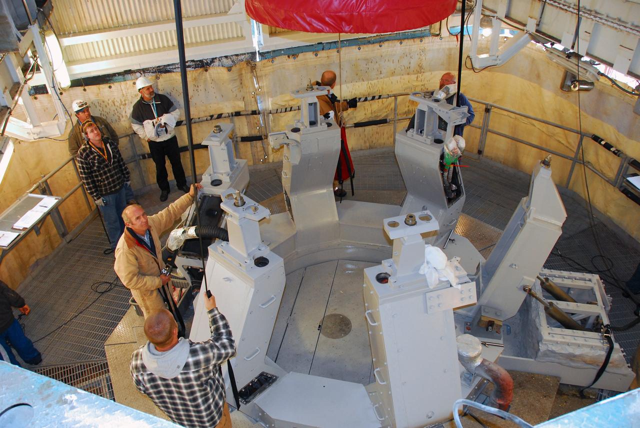
KENNEDY SPACE CENTER, FLA. - Ted Mosteller (right), NASA test director, briefs the media about Firing Room 4 (FR4), which has been undergoing renovations for two years. FR4 is now designated the primary firing room for all remaining shuttle launches, and will also be used daily to manage operations in the Orbiter Processing Facilities and for integrated processing for the shuttle. The firing room now includes sound-suppressing walls and floors, new humidity control, fire-suppression systems and consoles, support tables with computer stations, communication systems and laptop computer ports. FR 4 also has power and computer network connections and a newly improved Checkout, Control and Monitor Subsystem. The renovation is part of the Launch Processing System Extended Survivability Project that began in 2003. United Space Alliance's Launch Processing System directorate managed the FR 4 project for NASA. Photo credit: NASA/Dimitri Gerondidakis
VANDENBERG AIR FORCE BASE, Calif. -- The first stage of a United Launch Alliance Delta II is lifted at NASA's Space Launch Complex-2 on Vandenberg Air Force Base in California. The rocket will carry NASA's National Polar-orbiting Operational Environmental Satellite System Preparatory Project (NPP) satellite into space. NPP will be positioned 512 miles above the Earth's surface and will orbit about 16 times each day to observe nearly the entire globe. The NPP mission for NASA and the National Oceanic and Atmospheric Administration (NOAA) is to measure Earth's atmospheric and sea surface temperatures, humidity sounding, land and ocean biological activity, and cloud and aerosol properties. For more information, visit www.nasa.gov/NPP. Photo credit: NASA/VAFB, Mark Mackley
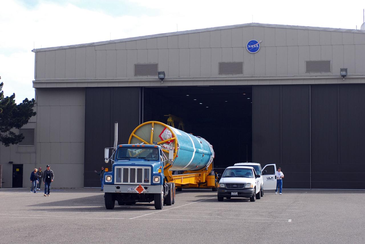
VANDENBERG AIR FORCE BASE, Calif. -- At Vandenberg Air Force Base in California, the first stage of a United Launch Alliance Delta II that will carry the National Polar-orbiting Operational Environmental Satellite System Preparatory Project (NPP) satellite into space is on its way from NASA Hangar 836 to NASA's Launch Complex-2. The vehicle then will undergo initial testing at the United Launch Alliance Delta Mission Checkout Facility. NPP will be positioned 512 miles above the Earth's surface and will orbit about 16 times each day to observe nearly the entire globe. The NPP mission for NASA and the National Oceanic and Atmospheric Administration (NOAA) is to measure Earth's atmospheric and sea surface temperatures, humidity sounding, land and ocean biological activity, and cloud and aerosol properties. For more information, visit www.nasa.gov/NPP. Photo credit: NASA/VAFB

CAPE CANAVERAL, Fla. -- On Launch Pad 39A at NASA's Kennedy Space Center in Florida, a technician brings tools into an environmental enclosure on space shuttle Discovery's external fuel tank. The enclosure will provide protectiong from wind, temperature and humidity changes while foam is re-applied and cured on the tank. The foam cracked during initial loading operations for Discovery’s launch attempt on Nov. 5. The cracks are on one of the 108 stringers, which are the composite aluminum ribs located vertically on the intertank area. Discovery's next launch attempt is no earlier than Nov. 30 at 4:02 a.m. EST. For more information on STS-133, visit www.nasa.gov/mission_pages/shuttle/shuttlemissions/sts133/. Photo credit: NASA/Dimitri Gerondidakis
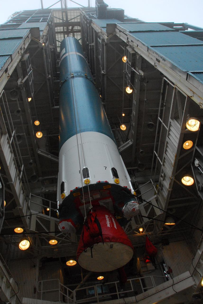
VANDENBERG AIR FORCE BASE, Calif. -- The first stage of a United Launch Alliance Delta II is lowered into place at NASA's Space Launch Complex-2 on Vandenberg Air Force Base in California. Seen here in red is the Rocketdyne engine that will help loft the rocket off the pad. The rocket will carry NASA's National Polar-orbiting Operational Environmental Satellite System Preparatory Project (NPP) satellite into space. NPP will be positioned 512 miles above the Earth's surface and will orbit about 16 times each day to observe nearly the entire globe. The NPP mission for NASA and the National Oceanic and Atmospheric Administration (NOAA) is to measure Earth's atmospheric and sea surface temperatures, humidity sounding, land and ocean biological activity, and cloud and aerosol properties. For more information, visit www.nasa.gov/NPP. Photo credit: NASA/VAFB, Mark Mackley
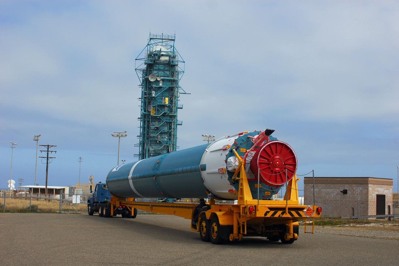
VANDENBERG AIR FORCE BASE, Calif. -- At Vandenberg Air Force Base in California, the first stage of a United Launch Alliance Delta II that will carry the National Polar-orbiting Operational Environmental Satellite System Preparatory Project (NPP) satellite into space has arrived at NASA's Launch Complex-2. The vehicle will undergo initial testing at the United Launch Alliance Delta Mission Checkout Facility. NPP will be positioned 512 miles above the Earth's surface and will orbit about 16 times each day to observe nearly the entire globe. The NPP mission for NASA and the National Oceanic and Atmospheric Administration (NOAA) is to measure Earth's atmospheric and sea surface temperatures, humidity sounding, land and ocean biological activity, and cloud and aerosol properties. For more information, visit www.nasa.gov/NPP. Photo credit: NASA/VAFB
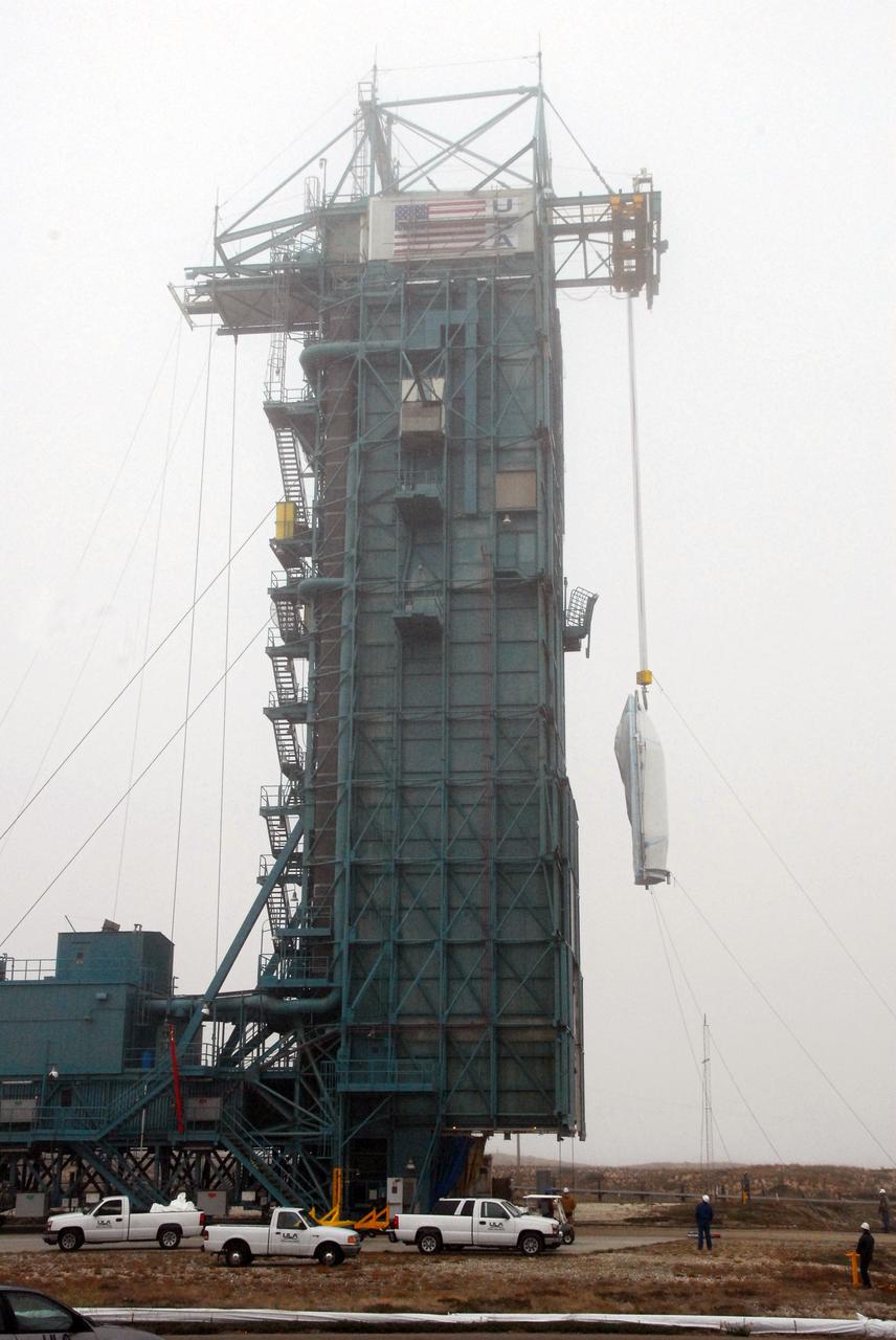
VANDENBERG AIR FORCE BASE, Calif. -- The payload fairing that will protect NASA's National Polar-orbiting Operational Environmental Satellite System Preparatory Project (NPP) satellite as it launches aboard a United Launch Alliance Delta II is lifted to Level 5 of Space Launch Complex-2 at Vandenberg Air Force Base in California. NPP will be positioned 512 miles above the Earth's surface and will orbit about 16 times each day to observe nearly the entire globe. The NPP mission for NASA and the National Oceanic and Atmospheric Administration (NOAA) is to measure Earth's atmospheric and sea surface temperatures, humidity sounding, land and ocean biological activity, and cloud and aerosol properties. For more information, visit www.nasa.gov/NPP. Photo credit: NASA/VAFB, Roy Allison
VANDENBERG AIR FORCE BASE, Calif. -- At Vandenberg Air Force Base in California, the first stage of a United Launch Alliance Delta II that will carry the National Polar-orbiting Operational Environmental Satellite System Preparatory Project (NPP) satellite into space is on its way from NASA Hangar 836 to NASA's Launch Complex-2. The vehicle then will undergo initial testing at the United Launch Alliance Delta Mission Checkout Facility. NPP will be positioned 512 miles above the Earth's surface and will orbit about 16 times each day to observe nearly the entire globe. The NPP mission for NASA and the National Oceanic and Atmospheric Administration (NOAA) is to measure Earth's atmospheric and sea surface temperatures, humidity sounding, land and ocean biological activity, and cloud and aerosol properties. For more information, visit www.nasa.gov/NPP. Photo credit: NASA/VAFB
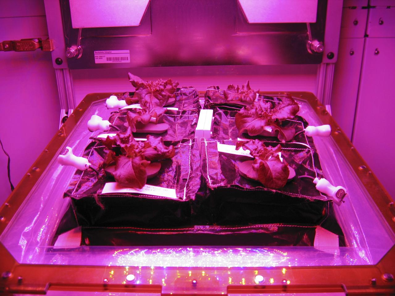
CAPE CANAVERAL, Fla. –Outredgeous red romaine lettuce plants grow inside in a prototype VEGGIE flight pillow. The bellows of the hardware have been lowered to better observe the plants. A small temperature and relative humidity data logger is placed between the pillows small white box, central. U.S. astronauts living and working aboard the International Space Station are going to receive a newly developed Vegetable Production System VEGGIE. VEGGIE is set to launch aboard SpaceX's Dragon capsule on NASA's third Commercial Resupply Services mission targeted to launch Dec. 9 from Space Launch Complex 40 at Cape Canaveral Air Force Station in Florida. Photo credit: NASA/Gioia Massa
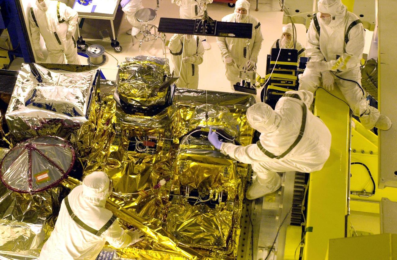
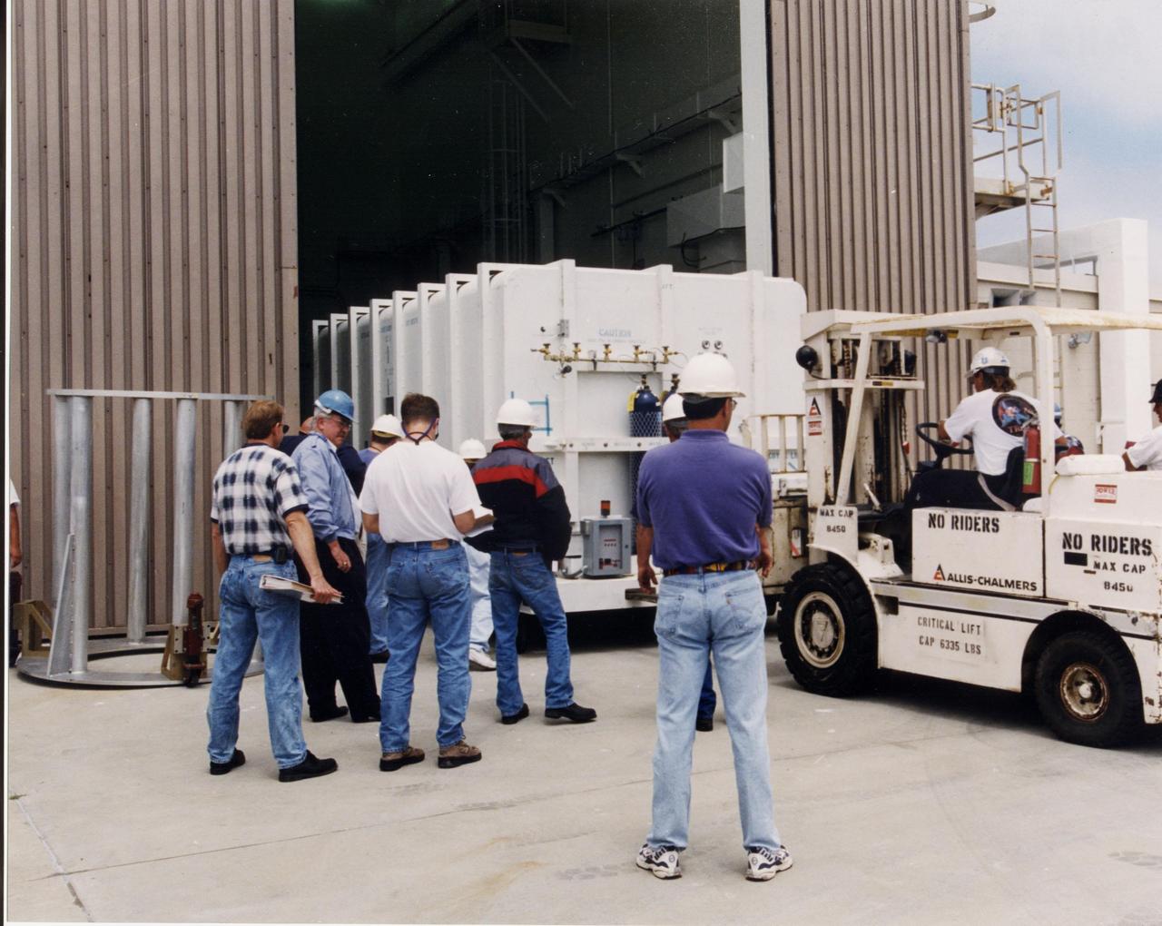
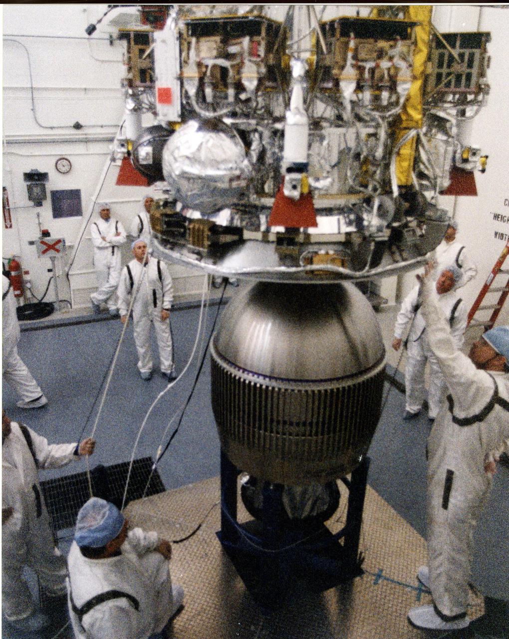
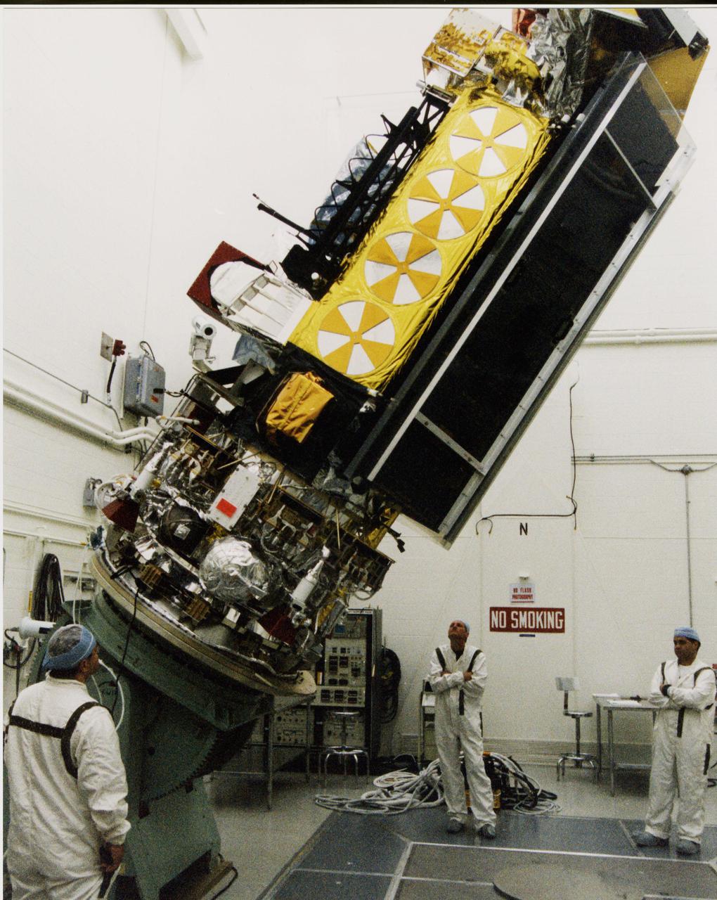
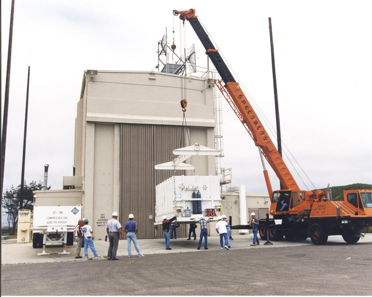
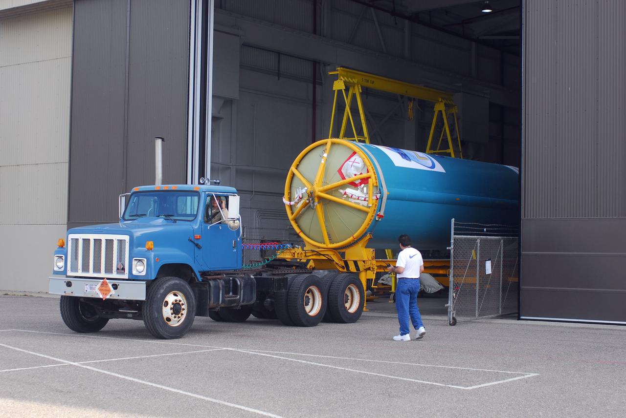
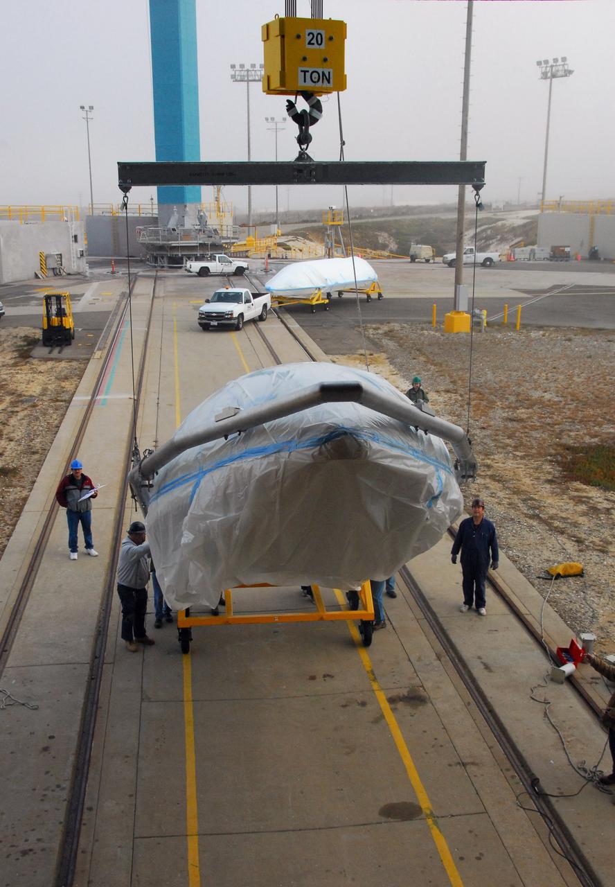
VANDENBERG AFB, CALIF. -- Workers in the Spaceport Systems International (SSI) payload processing facility on South Vandenberg AFB work on instrument deployment of the Aqua-EOS satellite. Aqua will provide a six year chronology of the planet and its processes. Comprehensive measurements taken by its onboard instruments will allow scientists to assess long-term change, identify its human and natural causes and advance the development of models for long-term forecasting. The Focus for the Aqua Project is the multi-disciplinary study of the Earth's Interrelated Processes (atmosphere, oceans, and land surface) and their relationship to earth system changes. The global change research emphasized with the Aqua instrument data sets include: atmospheric temperature and humidity profiles, clouds, precipitation and radiative balance; terrestrial snow and sea ice; sea surface temperature and ocean productivity; soil moisture; and the improvement of numerical weather prediction. Aqua-EOS is scheduled for launch aboard a Delta II 7920-10L vehicle on April 18, 2002
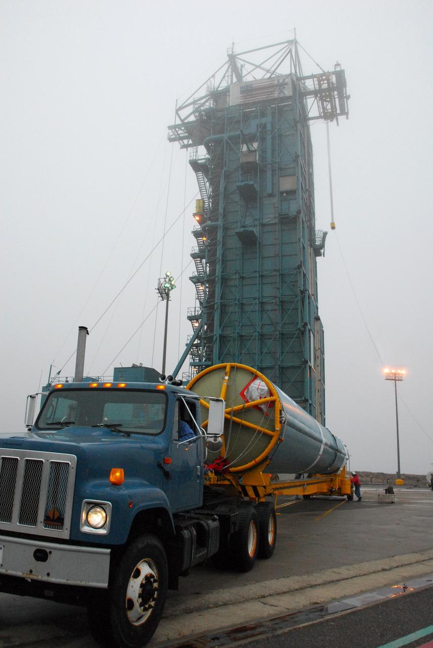
VANDENBERG AIR FORCE BASE, Calif. -- The second stage of a United Launch Alliance Delta II that will carry NASA's National Polar-orbiting Operational Environmental Satellite System Preparatory Project (NPP) satellite into space arrives at the United Launch Alliance Delta Mission Checkout Facility at Space Launch Complex-2 on Vandenberg Air Force Base in California. NPP will be positioned 512 miles above the Earth's surface and will orbit about 16 times each day to observe nearly the entire globe. The NPP mission for NASA and the National Oceanic and Atmospheric Administration (NOAA) is to measure Earth's atmospheric and sea surface temperatures, humidity sounding, land and ocean biological activity, and cloud and aerosol properties. For more information, visit www.nasa.gov/NPP. Photo credit: NASA/VAFB
VANDENBERG AIR FORCE BASE, Calif. -- The second stage of a United Launch Alliance Delta II that will carry NASA's National Polar-orbiting Operational Environmental Satellite System Preparatory Project (NPP) satellite into space is prepared for its move from NASA Hangar 836 to Space Launch Complex-2 at Vandenberg Air Force Base in California. NPP will be positioned 512 miles above the Earth's surface and will orbit about 16 times each day to observe nearly the entire globe. The NPP mission for NASA and the National Oceanic and Atmospheric Administration (NOAA) is to measure Earth's atmospheric and sea surface temperatures, humidity sounding, land and ocean biological activity, and cloud and aerosol properties. For more information, visit www.nasa.gov/NPP. Photo credit: NASA/VAFB
VANDENBERG AIR FORCE BASE, Calif. -- The payload fairing that will protect NASA's National Polar-orbiting Operational Environmental Satellite System Preparatory Project (NPP) satellite as it launches aboard a United Launch Alliance Delta II is ready to be lifted to Level 5 of Space Launch Complex-2 at Vandenberg Air Force Base in California. NPP will be positioned 512 miles above the Earth's surface and will orbit about 16 times each day to observe nearly the entire globe. The NPP mission for NASA and the National Oceanic and Atmospheric Administration (NOAA) is to measure Earth's atmospheric and sea surface temperatures, humidity sounding, land and ocean biological activity, and cloud and aerosol properties. For more information, visit www.nasa.gov/NPP. Photo credit: NASA/VAFB, Roy Allison
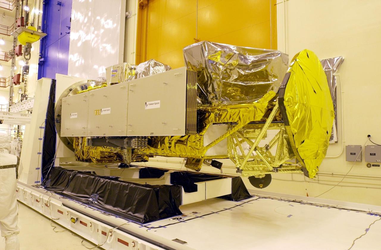
VANDENBERG AFB, CALIF. -- The Aqua-EOS satellite rests on a stand in the Spaceport Systems International (SSI) payload processing facility on South Vandenberg AFB. Aqua will provide a six year chronology of the planet and its processes. Comprehensive measurements taken by its onboard instruments will allow scientists to assess long-term change, identify its human and natural causes and advance the development of models for long-term forecasting. The Focus for the Aqua Project is the multi-disciplinary study of the Earth's Interrelated Processes (atmosphere, oceans, and land surface) and their relationship to earth system changes. The global change research emphasized with the Aqua instrument data sets include: atmospheric temperature and humidity profiles, clouds, precipitation and radiative balance; terrestrial snow and sea ice; sea surface temperature and ocean productivity; soil moisture; and the improvement of numerical weather prediction. Aqua-EOS is scheduled for launch aboard a Delta II 7920-10L vehicle on April 18, 2002
VANDENBERG AIR FORCE BASE, Calif. -- The second stage of a United Launch Alliance Delta II that will carry NASA's National Polar-orbiting Operational Environmental Satellite System Preparatory Project (NPP) satellite into space is on its way from NASA Hangar 836 to Space Launch Complex-2 at Vandenberg Air Force Base in California. NPP will be positioned 512 miles above the Earth's surface and will orbit about 16 times each day to observe nearly the entire globe. The NPP mission for NASA and the National Oceanic and Atmospheric Administration (NOAA) is to measure Earth's atmospheric and sea surface temperatures, humidity sounding, land and ocean biological activity, and cloud and aerosol properties. For more information, visit www.nasa.gov/NPP. Photo credit: NASA/VAFB
VANDENBERG AIR FORCE BASE, Calif. -- The second stage of a United Launch Alliance Delta II that will carry NASA's National Polar-orbiting Operational Environmental Satellite System Preparatory Project (NPP) satellite into space arrives at the United Launch Alliance Delta Mission Checkout Facility at Space Launch Complex-2 on Vandenberg Air Force Base in California. NPP will be positioned 512 miles above the Earth's surface and will orbit about 16 times each day to observe nearly the entire globe. The NPP mission for NASA and the National Oceanic and Atmospheric Administration (NOAA) is to measure Earth's atmospheric and sea surface temperatures, humidity sounding, land and ocean biological activity, and cloud and aerosol properties. For more information, visit www.nasa.gov/NPP. Photo credit: NASA/VAFB
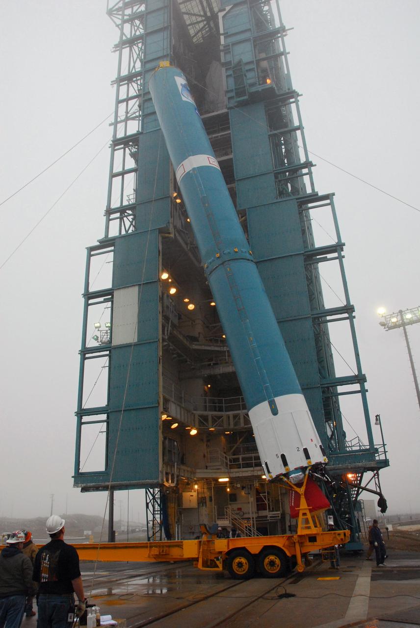
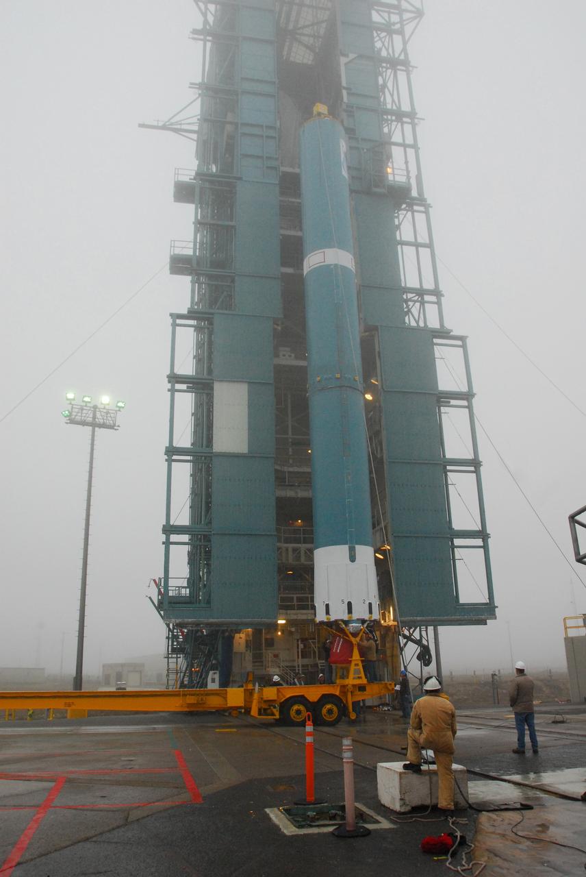
VANDENBERG AIR FORCE BASE, Calif. -- The first stage of a United Launch Alliance Delta II is hoisted into place at NASA's Space Launch Complex-2 on Vandenberg Air Force Base in California. The rocket will carry NASA's National Polar-orbiting Operational Environmental Satellite System Preparatory Project (NPP) satellite into space. NPP will be positioned 512 miles above the Earth's surface and will orbit about 16 times each day to observe nearly the entire globe. The NPP mission for NASA and the National Oceanic and Atmospheric Administration (NOAA) is to measure Earth's atmospheric and sea surface temperatures, humidity sounding, land and ocean biological activity, and cloud and aerosol properties. For more information, visit www.nasa.gov/NPP. Photo credit: NASA/VAFB, Mark Mackley
VANDENBERG AFB, CALIF. -- The Aqua-EOS satellite is attached to a platform in the Spaceport Systems International (SSI) payload processing facility on South Vandenberg AFB. Aqua will provide a six year chronology of the planet and its processes. Comprehensive measurements taken by its onboard instruments will allow scientists to assess long-term change, identify its human and natural causes and advance the development of models for long-term forecasting. The Focus for the Aqua Project is the multi-disciplinary study of the Earth's Interrelated Processes (atmosphere, oceans, and land surface) and their relationship to earth system changes. The global change research emphasized with the Aqua instrument data sets include: atmospheric temperature and humidity profiles, clouds, precipitation and radiative balance; terrestrial snow and sea ice; sea surface temperature and ocean productivity; soil moisture; and the improvement of numerical weather prediction. Aqua-EOS is scheduled for launch aboard a Delta II 7920-10L vehicle on April 18, 2002
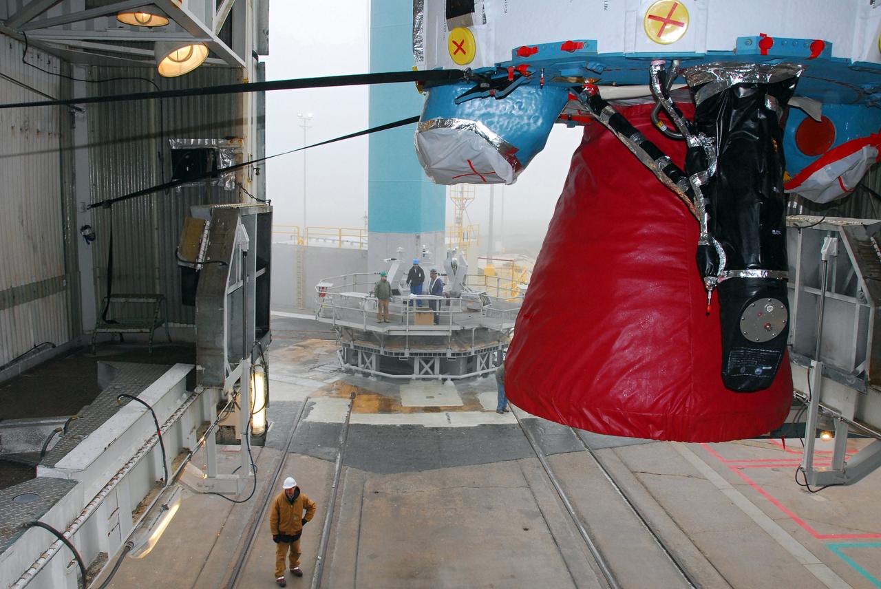
VANDENBERG AIR FORCE BASE, Calif. -- The first stage of a United Launch Alliance Delta II is hoisted into place at NASA's Space Launch Complex-2 on Vandenberg Air Force Base in California. Seen here in red is the Rocketdyne engine that will help loft the rocket off the pad. The rocket will carry NASA's National Polar-orbiting Operational Environmental Satellite System Preparatory Project (NPP) satellite into space. NPP will be positioned 512 miles above the Earth's surface and will orbit about 16 times each day to observe nearly the entire globe. The NPP mission for NASA and the National Oceanic and Atmospheric Administration (NOAA) is to measure Earth's atmospheric and sea surface temperatures, humidity sounding, land and ocean biological activity, and cloud and aerosol properties. For more information, visit www.nasa.gov/NPP. Photo credit: NASA/VAFB, Mark Mackley
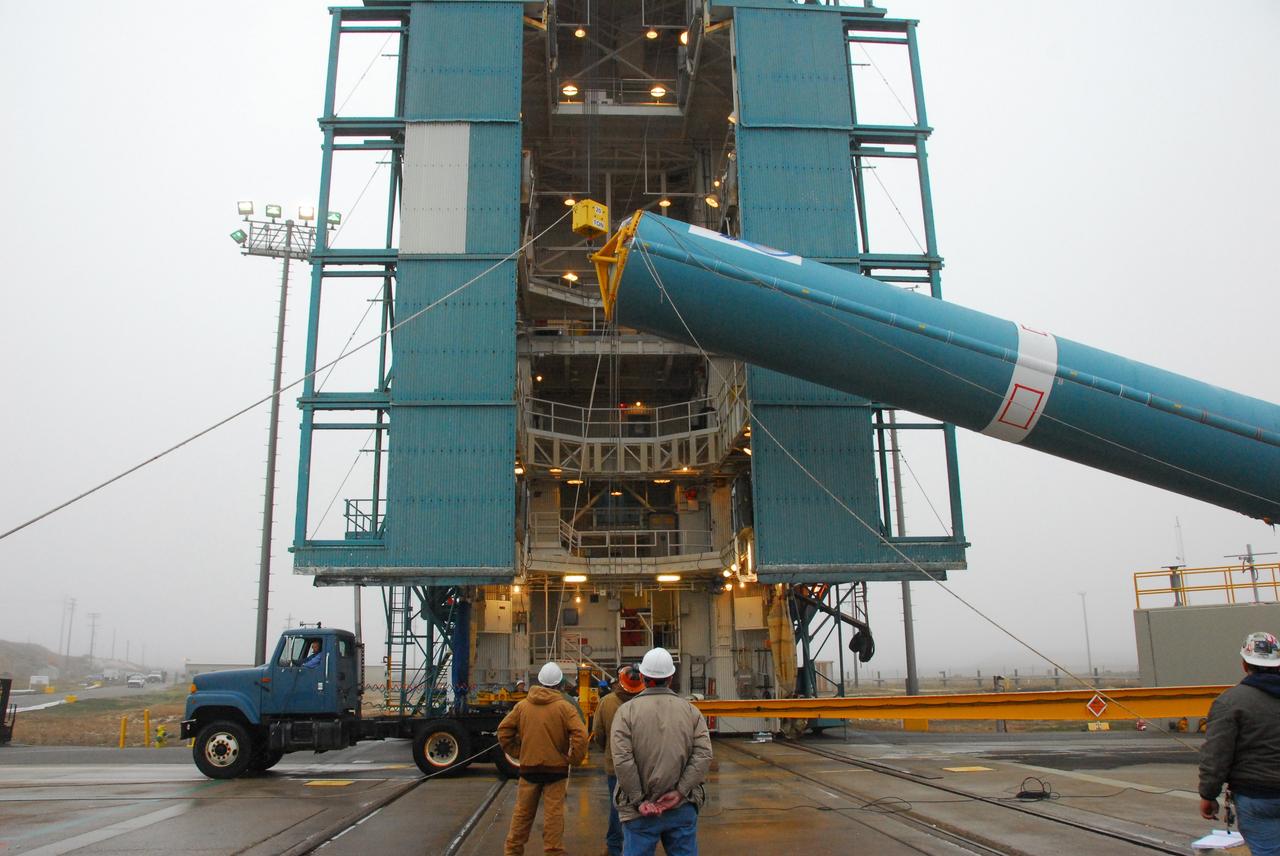
VANDENBERG AIR FORCE BASE, Calif. -- At NASA's Space Launch Complex-2 on Vandenberg Air Force Base in California, workers prepare to lift the first stage of a United Launch Alliance Delta II that will carry NASA's National Polar-orbiting Operational Environmental Satellite System Preparatory Project (NPP) satellite into space. NPP will be positioned 512 miles above the Earth's surface and will orbit about 16 times each day to observe nearly the entire globe. The NPP mission for NASA and the National Oceanic and Atmospheric Administration (NOAA) is to measure Earth's atmospheric and sea surface temperatures, humidity sounding, land and ocean biological activity, and cloud and aerosol properties. For more information, visit www.nasa.gov/NPP. Photo credit: NASA/VAFB, Mark Mackley

VANDENBERG AFB, CALIF. -- The Aqua-EOS satellite is uncovered in the Spaceport Systems International (SSI) payload processing facility on South Vandenberg AFB. Aqua will provide a six year chronology of the planet and its processes. Comprehensive measurements taken by its onboard instruments will allow scientists to assess long-term change, identify its human and natural causes and advance the development of models for long-term forecasting. The Focus for the Aqua Project is the multi-disciplinary study of the Earth's Interrelated Processes (atmosphere, oceans, and land surface) and their relationship to earth system changes. The global change research emphasized with the Aqua instrument data sets include: atmospheric temperature and humidity profiles, clouds, precipitation and radiative balance; terrestrial snow and sea ice; sea surface temperature and ocean productivity; soil moisture; and the improvement of numerical weather prediction. Aqua-EOS is scheduled for launch aboard a Delta II 7920-10L vehicle on April 18, 2002
jsc2023e010169 (1/30/2023) --- CapiSorb Visible System flight unit capillary condensing heat exchanger (CCHX) in N240 room 133B. The CapiSorb Visible System will be launched on SpaceX CRS-27 in March 2023 to the International Space Station to demonstrate a liquid sorbent-based system that leverages the advantages of liquid control through capillary action to remove carbon dioxide from crewed atmospheres...The CapiSorb Visible System Capillary Condensing Heat Exchanger, shown here pre-flight, uses capillary surfaces and active cooling to condense water vapor from heated, humid air during microgravity experimentation. The capillary surfaces enable control and passive transport of fluids. The CapiSorb Visible System investigation demonstrates a liquid control using capillary forces, over a range of liquid properties that are characteristic of liquid carbon dioxide sorbents. Image courtesy of NASA's Ames Research Center.
VANDENBERG AIR FORCE BASE, Calif. -- The first stage of a United Launch Alliance Delta II is lifted at NASA's Space Launch Complex-2 on Vandenberg Air Force Base in California. The rocket will carry NASA's National Polar-orbiting Operational Environmental Satellite System Preparatory Project (NPP) satellite into space. NPP will be positioned 512 miles above the Earth's surface and will orbit about 16 times each day to observe nearly the entire globe. The NPP mission for NASA and the National Oceanic and Atmospheric Administration (NOAA) is to measure Earth's atmospheric and sea surface temperatures, humidity sounding, land and ocean biological activity, and cloud and aerosol properties. For more information, visit www.nasa.gov/NPP. Photo credit: NASA/VAFB, Mark Mackley
VANDENBERG AIR FORCE BASE, Calif. -- The first stage of a United Launch Alliance Delta II that will carry NASA's National Polar-orbiting Operational Environmental Satellite System Preparatory Project (NPP) satellite into space is on its way from NASA Hangar 836 to NASA's Space Launch Complex-2 at Vandenberg Air Force Base in California. NPP will be positioned 512 miles above the Earth's surface and will orbit about 16 times each day to observe nearly the entire globe. The NPP mission for NASA and the National Oceanic and Atmospheric Administration (NOAA) is to measure Earth's atmospheric and sea surface temperatures, humidity sounding, land and ocean biological activity, and cloud and aerosol properties. For more information, visit www.nasa.gov/NPP. Photo credit: NASA/VAFB, Mark Mackley
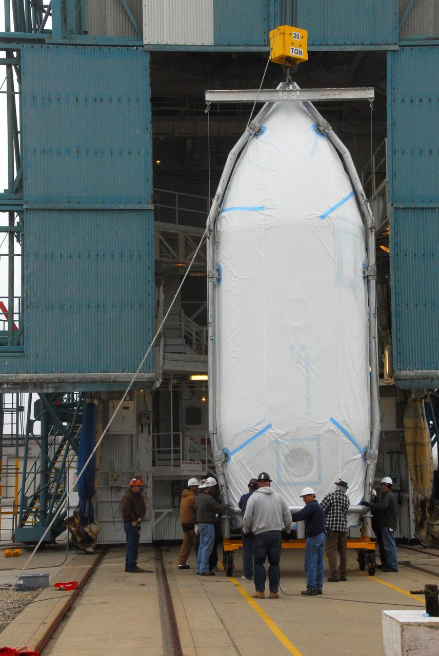
VANDENBERG AIR FORCE BASE, Calif. -- The payload fairing that will protect NASA's National Polar-orbiting Operational Environmental Satellite System Preparatory Project (NPP) satellite as it launches aboard a United Launch Alliance Delta II begins its lift to Level 5 of Space Launch Complex-2 at Vandenberg Air Force Base in California. NPP will be positioned 512 miles above the Earth's surface and will orbit about 16 times each day to observe nearly the entire globe. The NPP mission for NASA and the National Oceanic and Atmospheric Administration (NOAA) is to measure Earth's atmospheric and sea surface temperatures, humidity sounding, land and ocean biological activity, and cloud and aerosol properties. For more information, visit www.nasa.gov/NPP. Photo credit: NASA/VAFB, Roy Allison
VANDENBERG AIR FORCE BASE, Calif. -- The first stage of a United Launch Alliance Delta II is lifted at NASA's Space Launch Complex-2 on Vandenberg Air Force Base in California. The rocket will carry NASA's National Polar-orbiting Operational Environmental Satellite System Preparatory Project (NPP) satellite into space. NPP will be positioned 512 miles above the Earth's surface and will orbit about 16 times each day to observe nearly the entire globe. The NPP mission for NASA and the National Oceanic and Atmospheric Administration (NOAA) is to measure Earth's atmospheric and sea surface temperatures, humidity sounding, land and ocean biological activity, and cloud and aerosol properties. For more information, visit www.nasa.gov/NPP. Photo credit: NASA/VAFB, Mark Mackley
VANDENBERG AIR FORCE BASE, Calif. -- The first stage of a United Launch Alliance Delta II that will carry NASA's National Polar-orbiting Operational Environmental Satellite System Preparatory Project (NPP) satellite into space arrives at NASA's Space Launch Complex-2 on Vandenberg Air Force Base in California. NPP will be positioned 512 miles above the Earth's surface and will orbit about 16 times each day to observe nearly the entire globe. The NPP mission for NASA and the National Oceanic and Atmospheric Administration (NOAA) is to measure Earth's atmospheric and sea surface temperatures, humidity sounding, land and ocean biological activity, and cloud and aerosol properties. For more information, visit www.nasa.gov/NPP. Photo credit: NASA/VAFB, Mark Mackley
VANDENBERG AIR FORCE BASE, Calif. -- At Vandenberg Air Force Base in California, the first stage of a United Launch Alliance Delta II that will carry the National Polar-orbiting Operational Environmental Satellite System Preparatory Project (NPP) satellite into space has arrived at NASA's Launch Complex-2. The vehicle will undergo initial testing at the United Launch Alliance Delta Mission Checkout Facility. NPP will be positioned 512 miles above the Earth's surface and will orbit about 16 times each day to observe nearly the entire globe. The NPP mission for NASA and the National Oceanic and Atmospheric Administration (NOAA) is to measure Earth's atmospheric and sea surface temperatures, humidity sounding, land and ocean biological activity, and cloud and aerosol properties. For more information, visit www.nasa.gov/NPP. Photo credit: NASA/VAFB
KENNEDY SPACE CENTER, FLA. - NASA Test Director Ted Mosteller (center) briefs the media about Firing Room 4 (FR4), which has been undergoing renovations for two years. FR4 is now designated the primary firing room for all remaining shuttle launches, and will also be used daily to manage operations in the Orbiter Processing Facilities and for integrated processing for the shuttle. The firing room now includes sound-suppressing walls and floors, new humidity control, fire-suppression systems and consoles, support tables with computer stations, communication systems and laptop computer ports. FR 4 also has power and computer network connections and a newly improved Checkout, Control and Monitor Subsystem. The renovation is part of the Launch Processing System Extended Survivability Project that began in 2003. United Space Alliance's Launch Processing System directorate managed the FR 4 project for NASA. Photo credit: NASA/Dimitri Gerondidakis
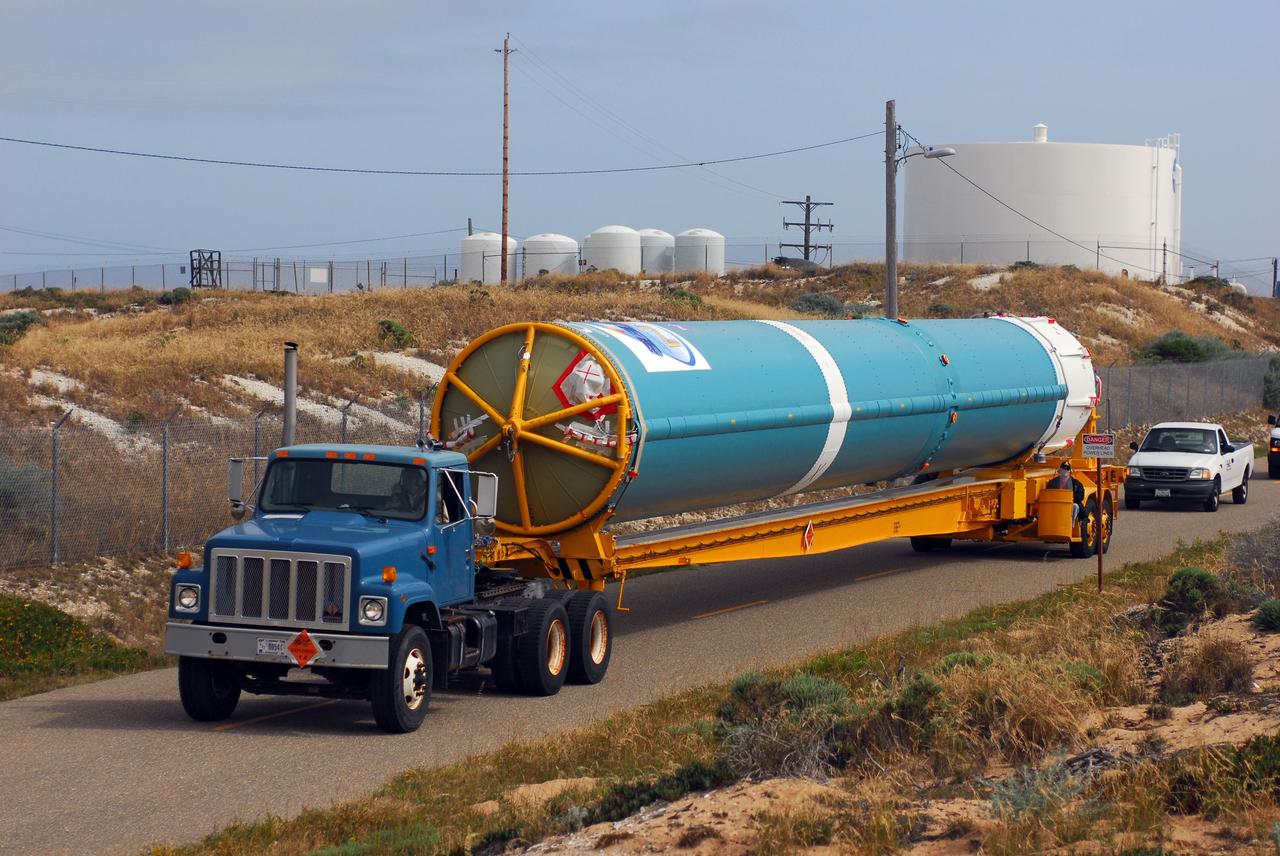
VANDENBERG AIR FORCE BASE, Calif. -- At Vandenberg Air Force Base in California, the first stage of a United Launch Alliance Delta II that will carry the National Polar-orbiting Operational Environmental Satellite System Preparatory Project (NPP) satellite into space is on its way from NASA Hangar 836 to NASA's Launch Complex-2. The vehicle then will undergo initial testing at the United Launch Alliance Delta Mission Checkout Facility. NPP will be positioned 512 miles above the Earth's surface and will orbit about 16 times each day to observe nearly the entire globe. The NPP mission for NASA and the National Oceanic and Atmospheric Administration (NOAA) is to measure Earth's atmospheric and sea surface temperatures, humidity sounding, land and ocean biological activity, and cloud and aerosol properties. For more information, visit www.nasa.gov/NPP. Photo credit: NASA/VAFB
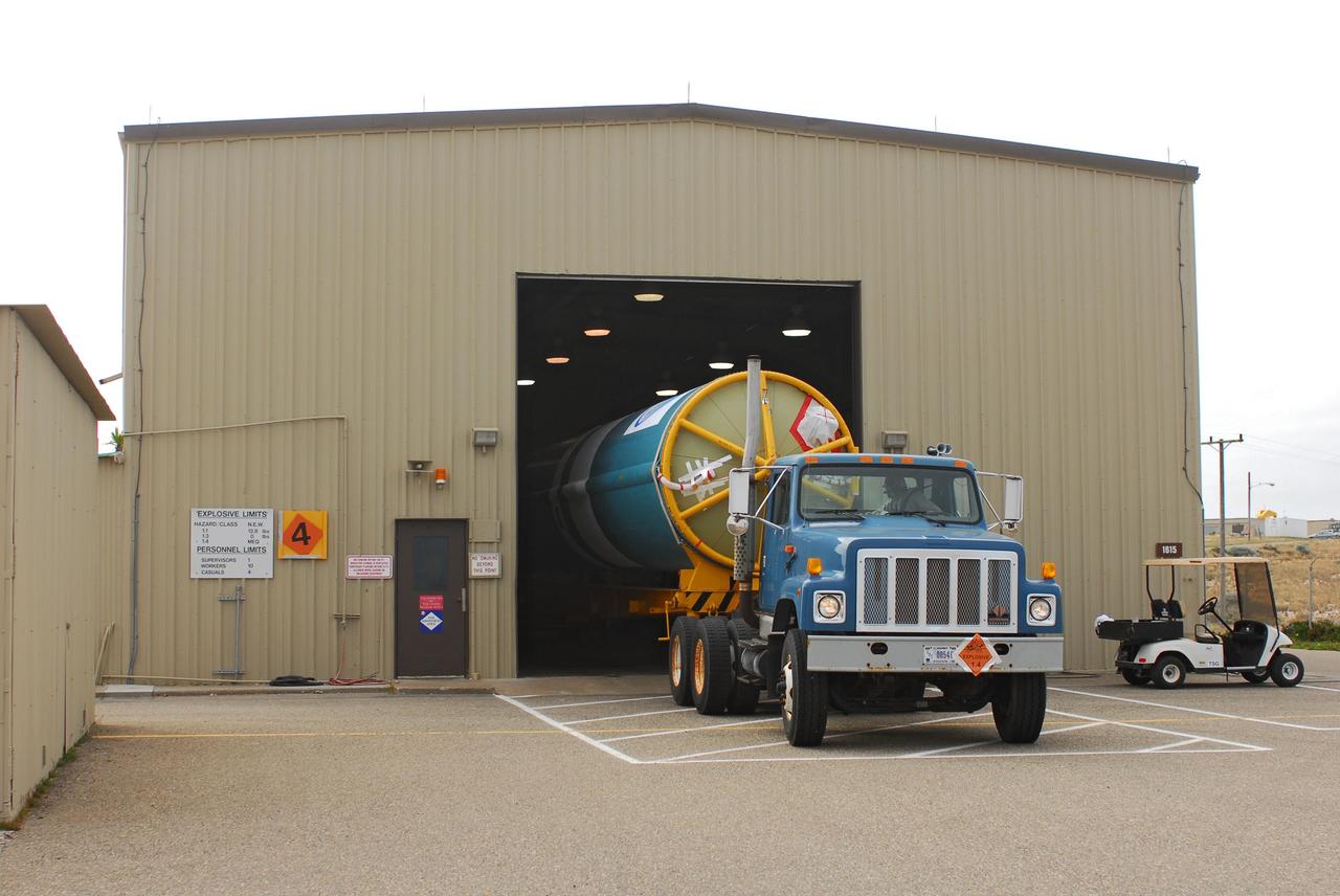
VANDENBERG AIR FORCE BASE, Calif. -- At Vandenberg Air Force Base in California, the first stage of a United Launch Alliance Delta II that will carry the National Polar-orbiting Operational Environmental Satellite System Preparatory Project (NPP) satellite into space has arrived at NASA's Launch Complex-2. The vehicle will undergo initial testing at the United Launch Alliance Delta Mission Checkout Facility. NPP will be positioned 512 miles above the Earth's surface and will orbit about 16 times each day to observe nearly the entire globe. The NPP mission for NASA and the National Oceanic and Atmospheric Administration (NOAA) is to measure Earth's atmospheric and sea surface temperatures, humidity sounding, land and ocean biological activity, and cloud and aerosol properties. For more information, visit www.nasa.gov/NPP. Photo credit: NASA/VAFB
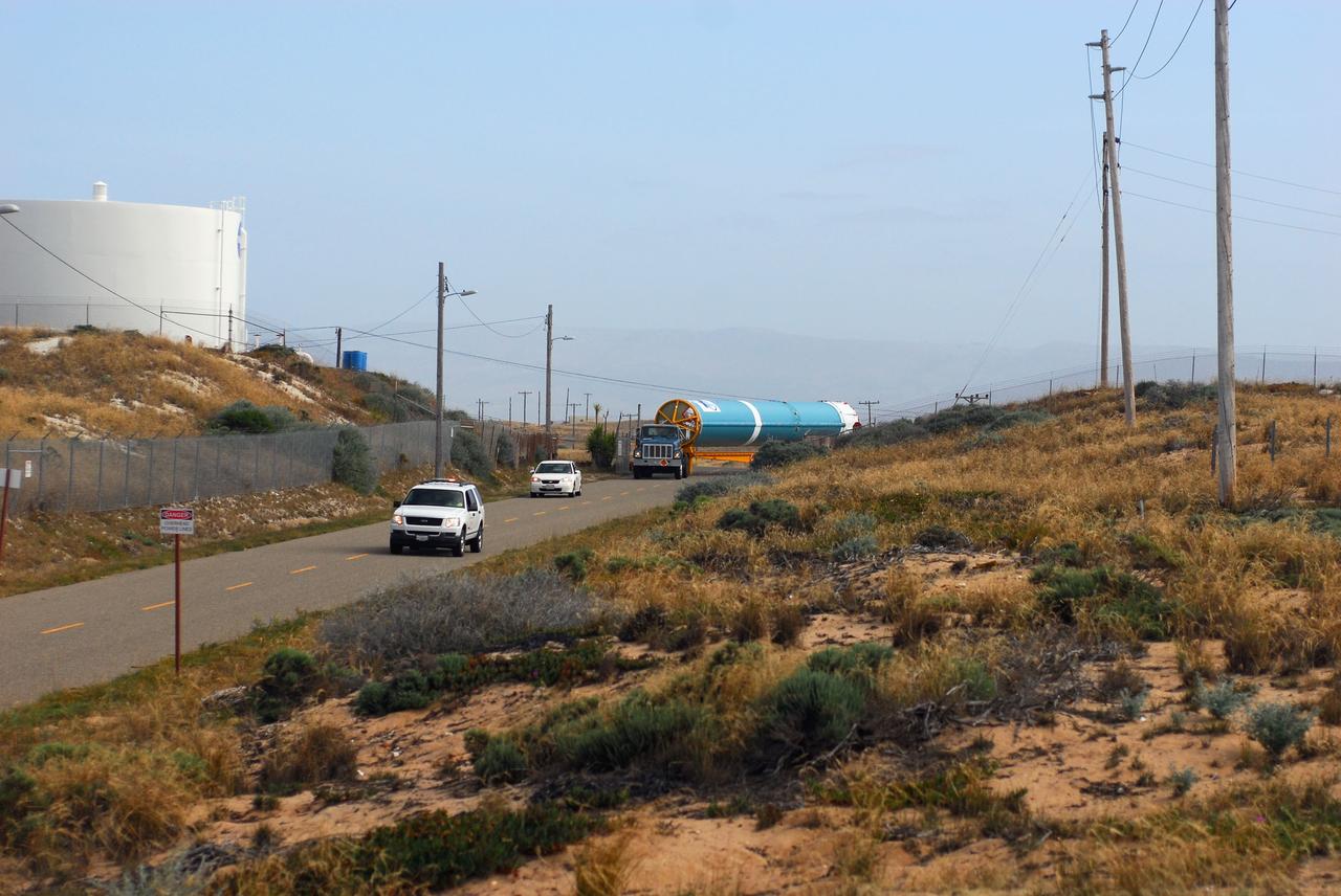
VANDENBERG AIR FORCE BASE, Calif. -- At Vandenberg Air Force Base in California, the first stage of a United Launch Alliance Delta II that will carry the National Polar-orbiting Operational Environmental Satellite System Preparatory Project (NPP) satellite into space is on its way from NASA Hangar 836 to NASA's Launch Complex-2. The vehicle then will undergo initial testing at the United Launch Alliance Delta Mission Checkout Facility. NPP will be positioned 512 miles above the Earth's surface and will orbit about 16 times each day to observe nearly the entire globe. The NPP mission for NASA and the National Oceanic and Atmospheric Administration (NOAA) is to measure Earth's atmospheric and sea surface temperatures, humidity sounding, land and ocean biological activity, and cloud and aerosol properties. For more information, visit www.nasa.gov/NPP. Photo credit: NASA/VAFB
CAPE CANAVERAL, Fla. -- On Launch Pad 39A at NASA's Kennedy Space Center in Florida, a technician climbs toward an environmental enclosure on space shuttle Discovery's external fuel tank. The enclosure will provide protection from wind, temperature and humidity changes while foam is re-applied and cured on the tank. The foam cracked during initial loading operations for Discovery’s launch attempt on Nov. 5. The cracks are on one of the 108 stringers, which are the composite aluminum ribs located vertically on the intertank area. Discovery's next launch attempt is no earlier than Nov. 30 at 4:02 a.m. EST. For more information on STS-133, visit www.nasa.gov/mission_pages/shuttle/shuttlemissions/sts133/. Photo credit: NASA/Dimitri Gerondidakis
VANDENBERG AIR FORCE BASE, Calif. -- A United Launch Alliance Delta II stands tall on Space Launch Complex-2 at Vandenberg Air Force Base in California for the launch of NASA's National Polar-orbiting Operational Environmental Satellite System Preparatory Project (NPP) satellite. Next up for the rocket configuration is the lifting to Level 5 of the payload fairing that will protect NPP as it launches. NPP will be positioned 512 miles above the Earth's surface and will orbit about 16 times each day to observe nearly the entire globe. The NPP mission for NASA and the National Oceanic and Atmospheric Administration (NOAA) is to measure Earth's atmospheric and sea surface temperatures, humidity sounding, land and ocean biological activity, and cloud and aerosol properties. For more information, visit www.nasa.gov/NPP. Photo credit: NASA/VAFB, Roy Allison
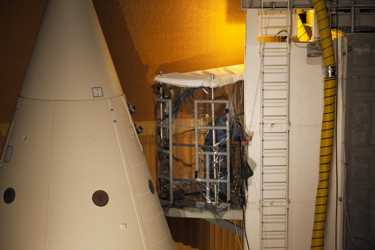
KENNEDY SPACE CENTER, FLA. - In the Vehicle Assembly Building, United Space Alliance technicians Rob Williams (left) and Ed Carillion (background) work in the enclosure that is pumping warm, dry air around the External Tank (ET) to maintain the proper temperature and humidity prior to the aft hard-point closeout spray. The spray is being applied on an area of the tank where the ET is mated to the transporter. Foam is not applied to that area at the Michoud Assembly Facility in Louisiana to avoid damage to the foam during travel. The ET, which arrived at KSC Jan. 5, is in the checkout cell for final processing. The tank is scheduled to fly on Space Shuttle Discovery on Return to Flight mission STS-114. The launch window is May 12 to June 3.
VANDENBERG AIR FORCE BASE, Calif. -- At Vandenberg Air Force Base in California, the first stage of a United Launch Alliance Delta II that will carry the National Polar-orbiting Operational Environmental Satellite System Preparatory Project (NPP) satellite into space is on its way from NASA Hangar 836 to NASA's Launch Complex-2. The vehicle then will undergo initial testing at the United Launch Alliance Delta Mission Checkout Facility. NPP will be positioned 512 miles above the Earth's surface and will orbit about 16 times each day to observe nearly the entire globe. The NPP mission for NASA and the National Oceanic and Atmospheric Administration (NOAA) is to measure Earth's atmospheric and sea surface temperatures, humidity sounding, land and ocean biological activity, and cloud and aerosol properties. For more information, visit www.nasa.gov/NPP. Photo credit: NASA/VAFB
VANDENBERG AIR FORCE BASE, Calif. -- The first stage of a United Launch Alliance Delta II that will carry NASA's National Polar-orbiting Operational Environmental Satellite System Preparatory Project (NPP) satellite into space is on its way from NASA Hangar 836 to NASA's Space Launch Complex-2 at Vandenberg Air Force Base in California. NPP will be positioned 512 miles above the Earth's surface and will orbit about 16 times each day to observe nearly the entire globe. The NPP mission for NASA and the National Oceanic and Atmospheric Administration (NOAA) is to measure Earth's atmospheric and sea surface temperatures, humidity sounding, land and ocean biological activity, and cloud and aerosol properties. For more information, visit www.nasa.gov/NPP. Photo credit: NASA/VAFB, Mark Mackley
VANDENBERG AIR FORCE BASE, Calif. -- The second stage of a United Launch Alliance Delta II that will carry NASA's National Polar-orbiting Operational Environmental Satellite System Preparatory Project (NPP) satellite into space is prepared for its move from NASA Hangar 836 to Space Launch Complex-2 at Vandenberg Air Force Base in California. NPP will be positioned 512 miles above the Earth's surface and will orbit about 16 times each day to observe nearly the entire globe. The NPP mission for NASA and the National Oceanic and Atmospheric Administration (NOAA) is to measure Earth's atmospheric and sea surface temperatures, humidity sounding, land and ocean biological activity, and cloud and aerosol properties. For more information, visit www.nasa.gov/NPP. Photo credit: NASA/VAFB
VANDENBERG AIR FORCE BASE, Calif. -- The first stage of a United Launch Alliance Delta II is lowered into place at NASA's Space Launch Complex-2 on Vandenberg Air Force Base in California. Seen here in red is the Rocketdyne engine that will help loft the rocket off the pad. The rocket will carry NASA's National Polar-orbiting Operational Environmental Satellite System Preparatory Project (NPP) satellite into space. NPP will be positioned 512 miles above the Earth's surface and will orbit about 16 times each day to observe nearly the entire globe. The NPP mission for NASA and the National Oceanic and Atmospheric Administration (NOAA) is to measure Earth's atmospheric and sea surface temperatures, humidity sounding, land and ocean biological activity, and cloud and aerosol properties. For more information, visit www.nasa.gov/NPP. Photo credit: NASA/VAFB, Mark Mackley
VANDENBERG AIR FORCE BASE, Calif. -- At NASA's Space Launch Complex-2 on Vandenberg Air Force Base in California, workers secure the Rocketdyne engine in the first stage of a United Launch Alliance Delta II. The rocket will carry NASA's National Polar-orbiting Operational Environmental Satellite System Preparatory Project (NPP) satellite into space. NPP will be positioned 512 miles above the Earth's surface and will orbit about 16 times each day to observe nearly the entire globe. The NPP mission for NASA and the National Oceanic and Atmospheric Administration (NOAA) is to measure Earth's atmospheric and sea surface temperatures, humidity sounding, land and ocean biological activity, and cloud and aerosol properties. For more information, visit www.nasa.gov/NPP. Photo credit: NASA/VAFB, Mark Mackley

VANDENBERG AIR FORCE BASE, Calif. -- The second stage of a United Launch Alliance Delta II that will carry NASA's National Polar-orbiting Operational Environmental Satellite System Preparatory Project (NPP) satellite into space is prepared for its move from NASA Hangar 836 to Space Launch Complex-2 at Vandenberg Air Force Base in California. NPP will be positioned 512 miles above the Earth's surface and will orbit about 16 times each day to observe nearly the entire globe. The NPP mission for NASA and the National Oceanic and Atmospheric Administration (NOAA) is to measure Earth's atmospheric and sea surface temperatures, humidity sounding, land and ocean biological activity, and cloud and aerosol properties. For more information, visit www.nasa.gov/NPP. Photo credit: NASA/VAFB
VANDENBERG AIR FORCE BASE, Calif. -- At Vandenberg Air Force Base in California, the first stage of a United Launch Alliance Delta II that will carry the National Polar-orbiting Operational Environmental Satellite System Preparatory Project (NPP) satellite into space has arrived at NASA's Launch Complex-2. The vehicle will undergo initial testing at the United Launch Alliance Delta Mission Checkout Facility. NPP will be positioned 512 miles above the Earth's surface and will orbit about 16 times each day to observe nearly the entire globe. The NPP mission for NASA and the National Oceanic and Atmospheric Administration (NOAA) is to measure Earth's atmospheric and sea surface temperatures, humidity sounding, land and ocean biological activity, and cloud and aerosol properties. For more information, visit www.nasa.gov/NPP. Photo credit: NASA/VAFB