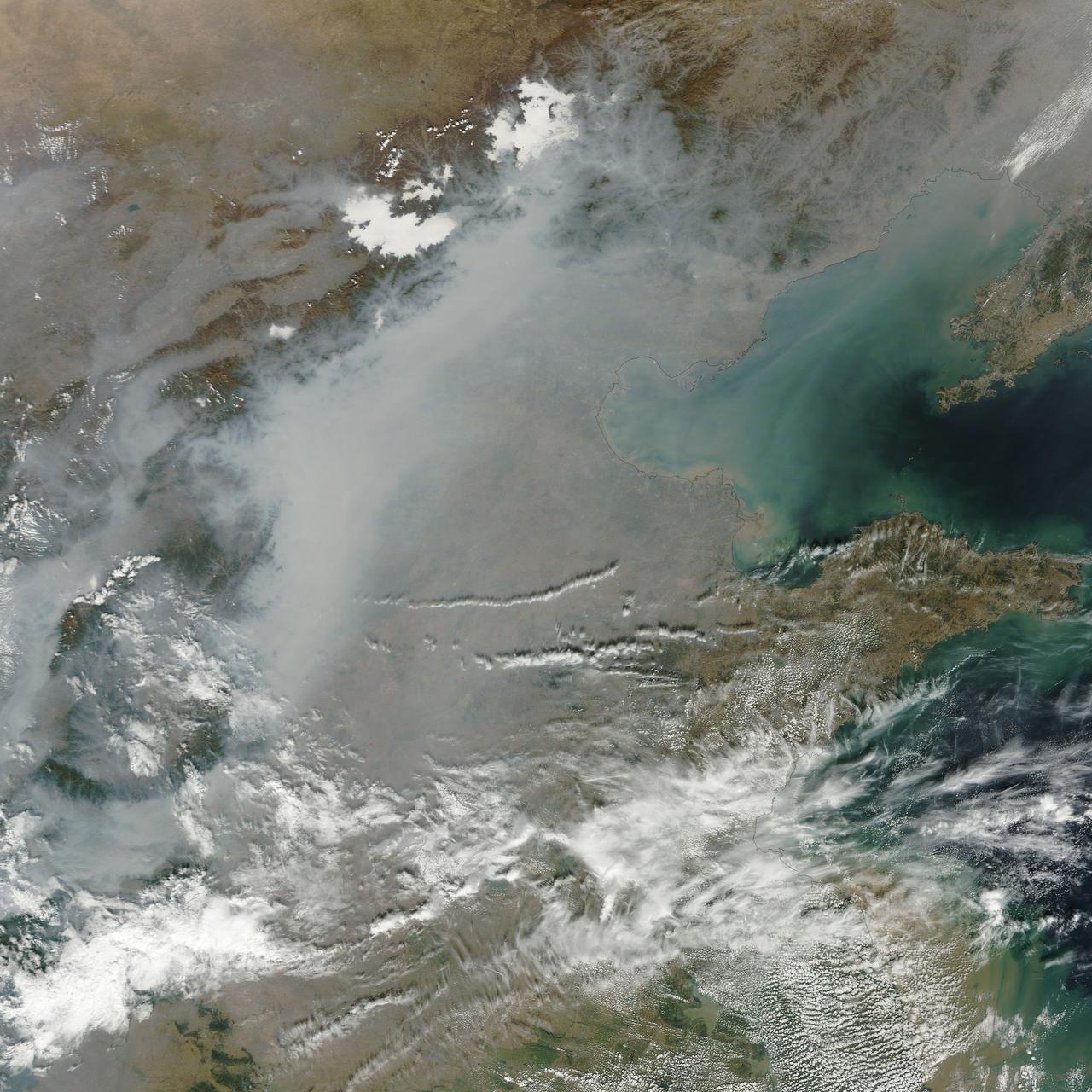
A thick layer of haze blanketed the North China Plain on October 9, 2014, when the Moderate Resolution Imaging Spectroradiometer (MODIS) on NASA’s Terra satellite acquired this natural-color image at 2:50 Coordinated Universal Time (10:50 a.m. local time). The haze obscured many features usually visible in MODIS imagery of the area, including China’s largest city, Beijing. On the day this image was acquired, measurements from ground-based sensors at the U.S. Consulate in Beijing reported PM2.5 measurements of 334 micrograms per cubic meter of air. Fine, airborne particulate matter (PM) that is smaller than 2.5 microns (about one thirtieth the width of a human hair) is considered dangerous because it is small enough to enter the passages of the human lungs. Most PM2.5 aerosol particles come from the burning of fossil fuels and biomass (wood fires and agricultural burning). The World Health Organization considers PM2.5 to be safe when it is below 25. Haze in this region tends to worsen in the fall and winter, when cold, heavy air traps pollutants near the surface. In this case, the haze was likely trapped by a temperature inversion. Normally, air is warmest near the surface of the Earth. Occasionally, a mass of warm air will move over cooler air so that the atmosphere actually warms with altitude. Since the cool air does not have the energy to rise through the warm air, vertical circulation slows and air becomes trapped near the surface. Any pollutant that enters the air gets trapped as well, and haze builds up over time. Daily satellite images of the North China Plain show that visible haze began to accumulate on October 7, 2014. NASA image courtesy Jeff Schmaltz, LANCE MODIS Rapid Response. Caption by Adam Voiland. Read more: <a href="http://earthobservatory.nasa.gov/NaturalHazards/view.php?id=84530&eocn=home&eoci=nh" rel="nofollow">earthobservatory.nasa.gov/NaturalHazards/view.php?id=8453...</a> Credit: <b><a href="http://www.earthobservatory.nasa.gov/" rel="nofollow"> NASA Earth Observatory</a></b> <b><a href="http://www.nasa.gov/audience/formedia/features/MP_Photo_Guidelines.html" rel="nofollow">NASA image use policy.</a></b> <b><a href="http://www.nasa.gov/centers/goddard/home/index.html" rel="nofollow">NASA Goddard Space Flight Center</a></b> enables NASA’s mission through four scientific endeavors: Earth Science, Heliophysics, Solar System Exploration, and Astrophysics. Goddard plays a leading role in NASA’s accomplishments by contributing compelling scientific knowledge to advance the Agency’s mission. <b>Follow us on <a href="http://twitter.com/NASAGoddardPix" rel="nofollow">Twitter</a></b> <b>Like us on <a href="http://www.facebook.com/pages/Greenbelt-MD/NASA-Goddard/395013845897?ref=tsd" rel="nofollow">Facebook</a></b> <b>Find us on <a href="http://instagram.com/nasagoddard?vm=grid" rel="nofollow">Instagram</a></b>
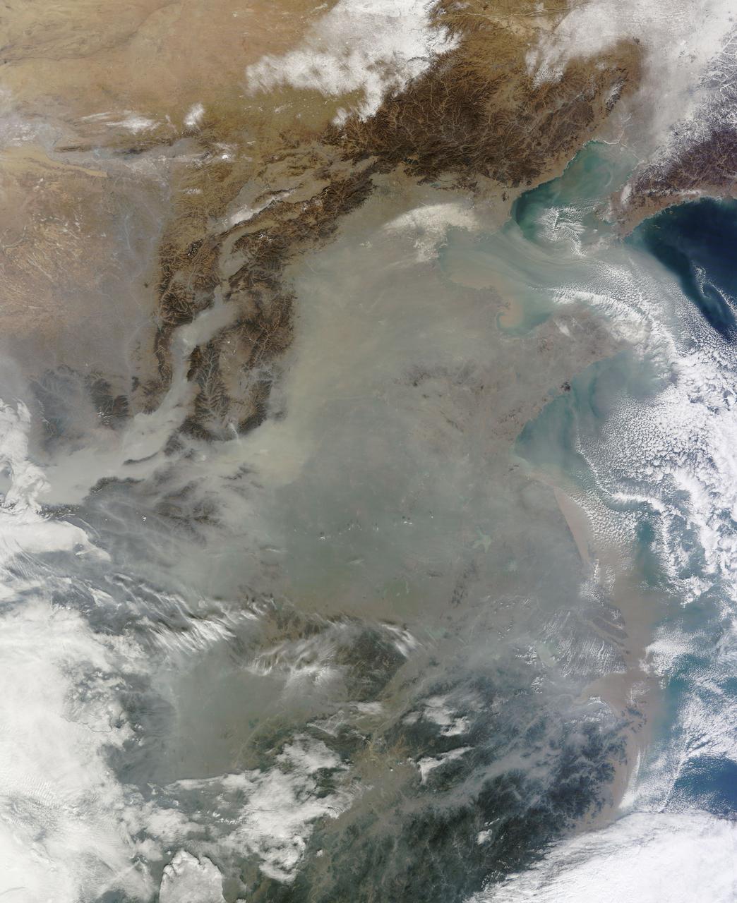
The skies over northern China were shrouded with a thick haze in late December, 2013. The Moderate Resolution Imaging Spectroradiometer (MODIS) aboard the Terra satellite captured this true-color image on December 23. The dense, gray haze obscures almost all the land and much of the coastal waters from view south and east of the Taihang Mountains. Clearer air covers the region north of the mountains, although fingers of haze roll through most river valleys. The cities of Beijing and Hebei, both west of the Bohai Sea are complete enshrouded. By December 24 the smog levels in some area exceeded World Health Organization-recommended levels by 30 times, according to Bloomberg News. The concentration of PM2.5, which are fine air particulates, were reported at 421 micrograms per cubic meter at 2 p.m. near Tiananmen Square in Beijing, while levels were 795 in Xi’an and 740 in Zhengzhou. The World Health Organization (WHO) recommends 24-hour exposure to PM2.5 concentrations no higher than 25 micrograms per cubic meter. While not the sole cause of haze and pollution, the use of coal as a very cheap energy source adds to the problem, particularly north of the Huai River. Prior to 1980, the government policy provided free coal for fuel boilers for all people living north of the Huai River. The widespread use of coal allows people in the north to stay warm in winter, but they have paid a price in air quality. According to Michael Greenstone, a Professor of Environmental Economics at Massachusetts Institute of Technology (MIT), whose research team published a paper on sustained exposure to air pollution on life expectancy in the region, air pollution, as measured by total suspended particulates, was about 55% higher north of the Huai River than south of it, for a difference of around 184 micrograms of particulate matter per cubic meter. The research, published in Proceedings of the National Academy of Sciences in July, 2013, also noted life expectancies were about 5.5 years lower in the north, owing to an increased incidence of cardiorespiratory mortality. Air pollution is an on-going issue for the government of China, and Beijing’s Five-Year Clean Air Action Plan aims to reduce overall particle density by over 25 percent on the PM2.5 scale by 2017, and also takes aim at shutting down all coal-burning plants. Credit: NASA/GSFC/Jeff Schmaltz/MODIS Land Rapid Response Team <b><a href="http://www.nasa.gov/audience/formedia/features/MP_Photo_Guidelines.html" rel="nofollow">NASA image use policy.</a></b> <b><a href="http://www.nasa.gov/centers/goddard/home/index.html" rel="nofollow">NASA Goddard Space Flight Center</a></b> enables NASA’s mission through four scientific endeavors: Earth Science, Heliophysics, Solar System Exploration, and Astrophysics. Goddard plays a leading role in NASA’s accomplishments by contributing compelling scientific knowledge to advance the Agency’s mission. <b>Follow us on <a href="http://twitter.com/NASA_GoddardPix" rel="nofollow">Twitter</a></b> <b>Like us on <a href="http://www.facebook.com/pages/Greenbelt-MD/NASA-Goddard/395013845897?ref=tsd" rel="nofollow">Facebook</a></b> <b>Find us on <a href="http://instagram.com/nasagoddard?vm=grid" rel="nofollow">Instagram</a></b>
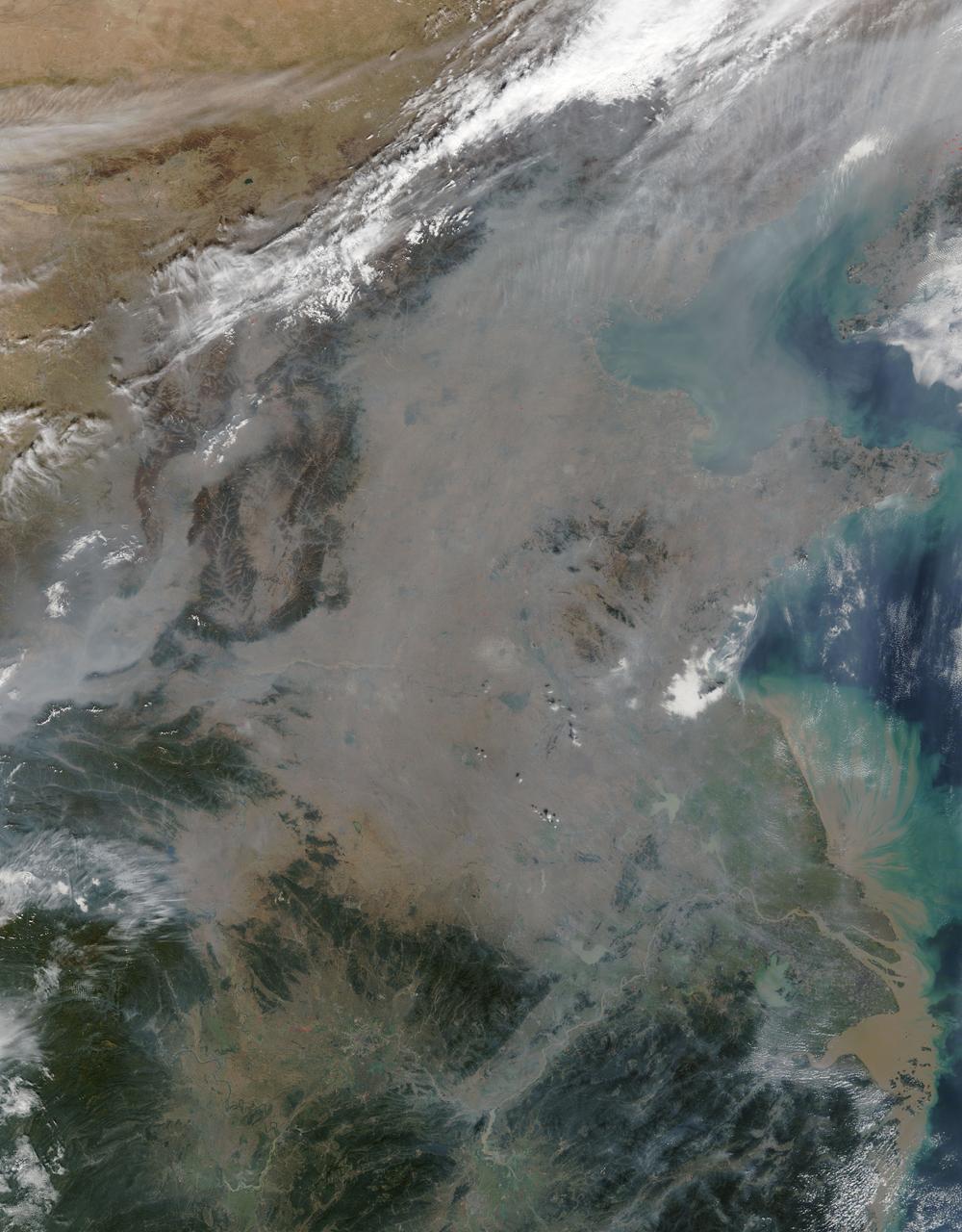
On October 17, 2015, the Moderate Resolution Imaging Spectroradiometer (MODIS) aboard NASA’s Terra satellite captured this true-color image of a thick haze hanging over eastern China. In the north, the large city of Beijing is completely obscured from view, as is much of the landscape. The haze thins slightly over the Bohai Sea. Further south, sediment pours into the East China Sea near the city of Shanghai. Heavy haze is common in this region, and tends to worsen in October through January, when cold, heavy air traps pollutants near the surface of the Earth. It is likely that this scene was caused by such a temperature inversion. Normally, air is warmest near the surface of the Earth. But sometimes a mass of warm air will move the cooler air, so the atmosphere actually warms with the altitude. Cool air does not have energy to rise through the warm air, vertical circulation slows and air becomes trapped near the surface. Any pollution that is emitted into the cooler air will also get trapped, increasing low-level air pollution and haze. Credit: NASA/GSFC/Jeff Schmaltz/MODIS Land Rapid Response Team