In October 2012, satellites measured subtle signals that suggested volcanic activity on remote Heard Island. These images, captured several months later, show proof of an eruption on Mawson Peak. By April 7, 2013, Mawson's steep-walled summit crater had filled, and a trickle of lava had spilled down the volcano’s southwestern flank. On April 20, the lava flow remained visible and had even widened slightly just below the summit. These natural-color images were collected by the Advanced Land Imager (ALI) on the Earth Observing-1 (EO-1) satellite. Image Credit: NASA Earth Observatory Read more: <a href="http://earthobservatory.nasa.gov/NaturalHazards/view.php?id=81024" rel="nofollow">earthobservatory.nasa.gov/NaturalHazards/view.php?id=81024</a> <b><a href="http://www.nasa.gov/audience/formedia/features/MP_Photo_Guidelines.html" rel="nofollow">NASA image use policy.</a></b> <b><a href="http://www.nasa.gov/centers/goddard/home/index.html" rel="nofollow">NASA Goddard Space Flight Center</a></b> enables NASA’s mission through four scientific endeavors: Earth Science, Heliophysics, Solar System Exploration, and Astrophysics. Goddard plays a leading role in NASA’s accomplishments by contributing compelling scientific knowledge to advance the Agency’s mission. <b>Follow us on <a href="http://twitter.com/NASA_GoddardPix" rel="nofollow">Twitter</a></b> <b>Like us on <a href="http://www.facebook.com/pages/Greenbelt-MD/NASA-Goddard/395013845897?ref=tsd" rel="nofollow">Facebook</a></b> <b>Find us on <a href="http://instagram.com/nasagoddard?vm=grid" rel="nofollow">Instagram</a></b>
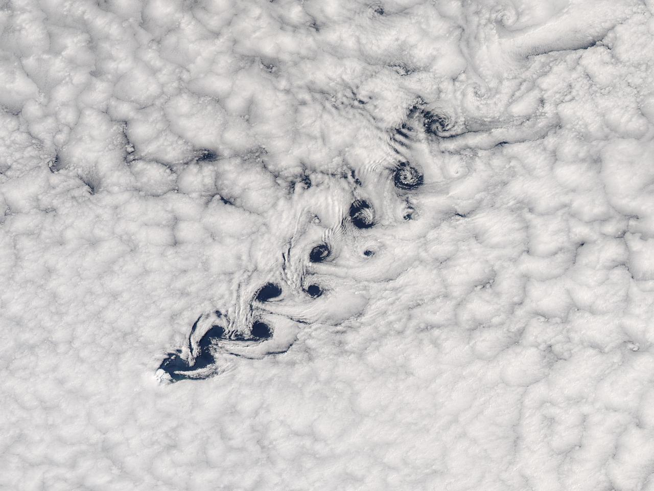
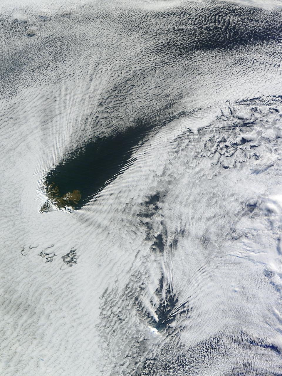
Cloud vortices off Heard Island, south Indian Ocean. The Moderate Resolution Imaging Spectroradiometer (MODIS) aboard NASA’s Aqua satellite captured this true-color image of sea ice off Heard Island on Nov 2, 2015 at 5:02 AM EST (09:20 UTC). Credit: NASA/GSFC/Jeff Schmaltz/MODIS Land Rapid Response Team
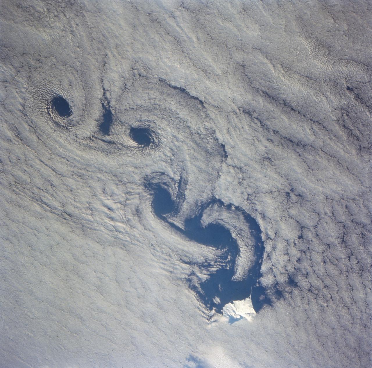
As the air blows over the tops of the mountain peaks, seen here in the clear region, the direction of the air flow is disturbed. These disturbances in the flow pattern are generally small circular eddies with one circulating in a clockwise direction and the next in the reverse direction. The wind here has caused the shallow cloud cover to change accordingly. These eddies are commonly called von Karmen Vortices.
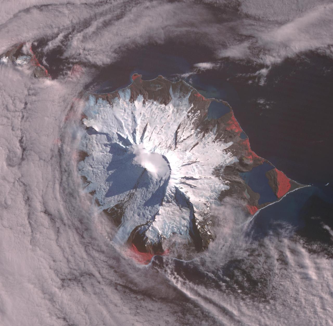
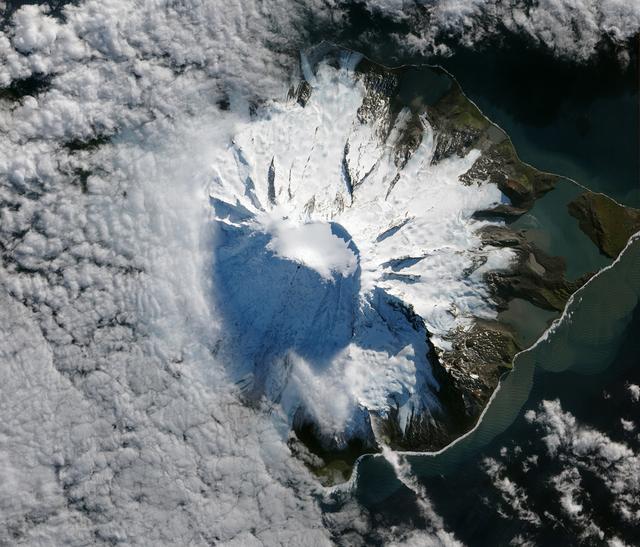
Heard, a remote volcanic island located in the southern Indian Ocean, is an Australian Territory. It consists of two volcanic structures: Big Ben and the smaller Mt. Dixon. The active Mawson Peak is located within a 5-6 km-wide caldera breached to the SW side of Big Ben. Intermittent eruptions have occurred since 1910; the latest in May 2023. The image was acquired March 18, 2025, covers an area of 39.7 by 40.4 km, and is located at 53 degrees south, 73.5 degrees east. https://photojournal.jpl.nasa.gov/catalog/PIA26509
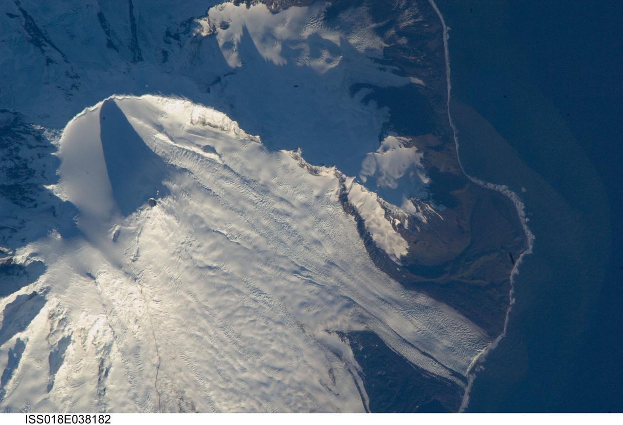
ISS018-E-038182 (28 Feb. 2009) --- Mawson Peak, Heard Island is featured in this image photographed by an Expedition 18 crewmember on the International Space Station. Heard Island is located in the southern Indian Ocean, approximately 1,550 kilometers to the north of Antarctica. The island is a visible part of the Kerguelen Plateau, a submerged feature on the seafloor formed by large amounts of volcanic rock erupted over a geologically short time period within an oceanic tectonic plate ? features like these are termed large igneous provinces by geologists. Most of Heard Island is formed from volcanic rocks associated with the Big Ben stratovolcano. The northeastern slopes of the volcano are visible in shadow at the top left of this detailed astronaut photograph. Recent observed volcanic activity at Heard Island has occurred at 2,745 meters high Mawson Peak, which sits within a breached caldera (collapsed and empty magma chamber beneath a volcano) on the southwestern side of the Big Ben volcano ? the shadow cast by Mawson Peak in the image points directly to the crescent-shaped caldera rim. Detailed geologic study of the Big Ben volcano is made difficult by the presence of several glaciers, including Gotley and Lied Glaciers on the southwestern slopes. This image, taken during Southern Hemisphere summer, also reveals some of the non-glaciated, light to dark brown volcanic rock forming the island on either side of Gotley Glacier.

Cloud vortices off Heard Island, south Indian Ocean. The Moderate Resolution Imaging Spectroradiometer (MODIS) aboard NASA’s Aqua satellite captured this true-color image of sea ice off Heard Island on Nov 2, 2015 at 5:02 AM EST (09:20 UTC). Credit: NASA/GSFC/Jeff Schmaltz/MODIS Land Rapid Response Team <b><a href="http://www.nasa.gov/audience/formedia/features/MP_Photo_Guidelines.html" rel="nofollow">NASA image use policy.</a></b> <b><a href="http://www.nasa.gov/centers/goddard/home/index.html" rel="nofollow">NASA Goddard Space Flight Center</a></b> enables NASA’s mission through four scientific endeavors: Earth Science, Heliophysics, Solar System Exploration, and Astrophysics. Goddard plays a leading role in NASA’s accomplishments by contributing compelling scientific knowledge to advance the Agency’s mission. <b>Follow us on <a href="http://twitter.com/NASAGoddardPix" rel="nofollow">Twitter</a></b> <b>Like us on <a href="http://www.facebook.com/pages/Greenbelt-MD/NASA-Goddard/395013845897?ref=tsd" rel="nofollow">Facebook</a></b> <b>Find us on <a href="http://instagrid.me/nasagoddard/?vm=grid" rel="nofollow">Instagram</a></b>
Ship-wave-shaped wave clouds induced by Kerguelen and Heard Islands, South Indian Ocean. Terra/MODIS 2013/190 07/09/2013 05:00 UTC Credit: NASA/GSFC/Jeff Schmaltz/MODIS Land Rapid Response Team <b><a href="http://www.nasa.gov/audience/formedia/features/MP_Photo_Guidelines.html" rel="nofollow">NASA image use policy.</a></b> <b><a href="http://www.nasa.gov/centers/goddard/home/index.html" rel="nofollow">NASA Goddard Space Flight Center</a></b> enables NASA’s mission through four scientific endeavors: Earth Science, Heliophysics, Solar System Exploration, and Astrophysics. Goddard plays a leading role in NASA’s accomplishments by contributing compelling scientific knowledge to advance the Agency’s mission. <b>Follow us on <a href="http://twitter.com/NASA_GoddardPix" rel="nofollow">Twitter</a></b> <b>Like us on <a href="http://www.facebook.com/pages/Greenbelt-MD/NASA-Goddard/395013845897?ref=tsd" rel="nofollow">Facebook</a></b> <b>Find us on <a href="http://instagram.com/nasagoddard?vm=grid" rel="nofollow">Instagram</a></b>

STS079-817-034 (16-26 Sept. 1996) --- The Russian Mir Space Station is backdropped over a storm in the Roaring 40's near Heard Island in the south Indian Ocean. This photograph is one of four 70mm frames (along with fifteen 35mm frames) of still photography documenting the activities of NASA's STS-79 mission, which began with a Sept. 16, 1996, liftoff from Launch Pad 39A the Kennedy Space Center (KSC) and ended with a landing at KSC on Sept. 26, 1996. Onboard for the launch were astronauts William F. Readdy, commander; Terrence W. Wilcutt, pilot; John E. Blaha, Jerome (Jay) Apt, Thomas D. Akers and Carl E. Walz, all mission specialists. On flight day 4, the crew docked with Russia's Mir Space Station. Shannon W. Lucid, who had spent six months aboard Mir, switched cosmonaut guest researcher roles with Blaha. The latter joined fellow Mir-22 crewmembers Valeri G. Korzun, commander, and Aleksandr Y. Kaleri, flight engineer.