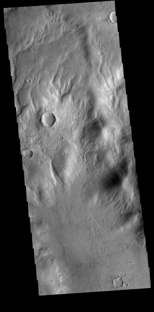
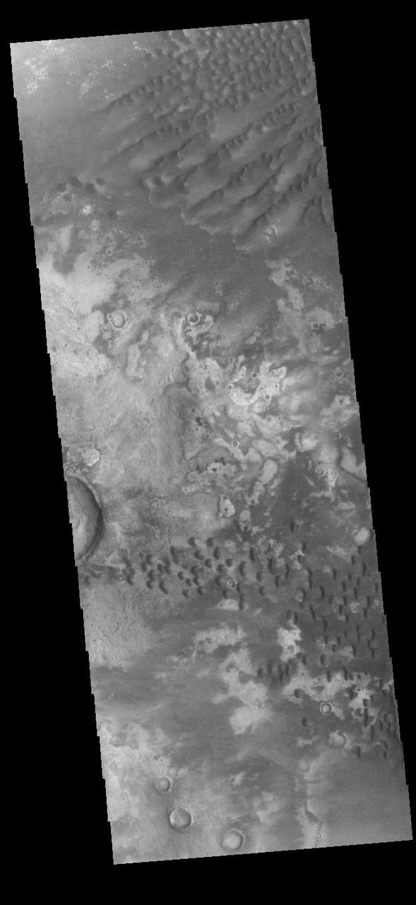
Hellas Planitia
Hellas Planitia
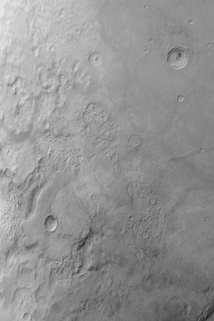
Hellas Planitia
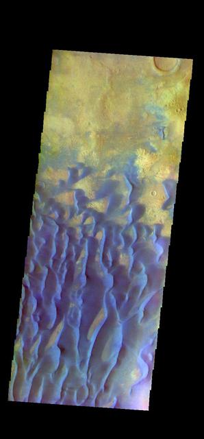
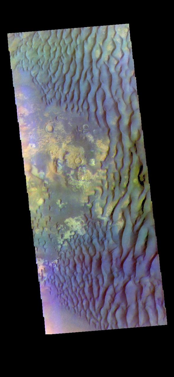
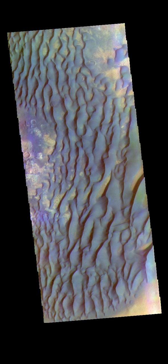
The THEMIS VIS camera contains 5 filters. The data from different filters can be combined in multiple ways to create a false color image. These false color images may reveal subtle variations of the surface not easily identified in a single band image. Today's false color image shows plains in the northern part of Hellas Planitia. Orbit Number: 51518 Latitude: -29.4065 Longitude: 70.2082 Instrument: VIS Captured: 2013-07-25 22:23 http://photojournal.jpl.nasa.gov/catalog/PIA21310
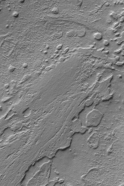
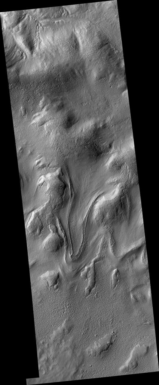
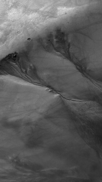
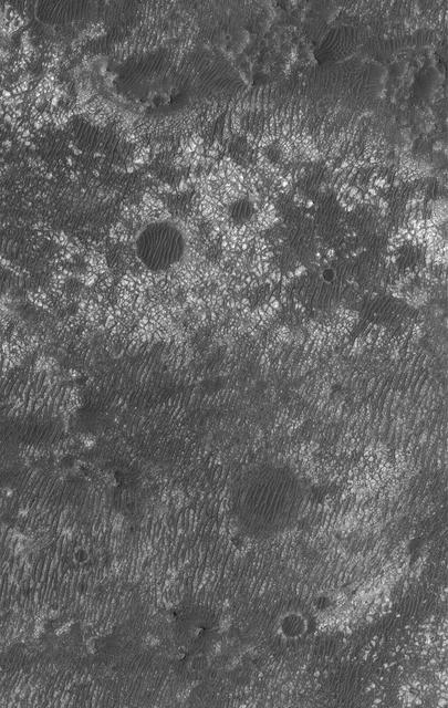
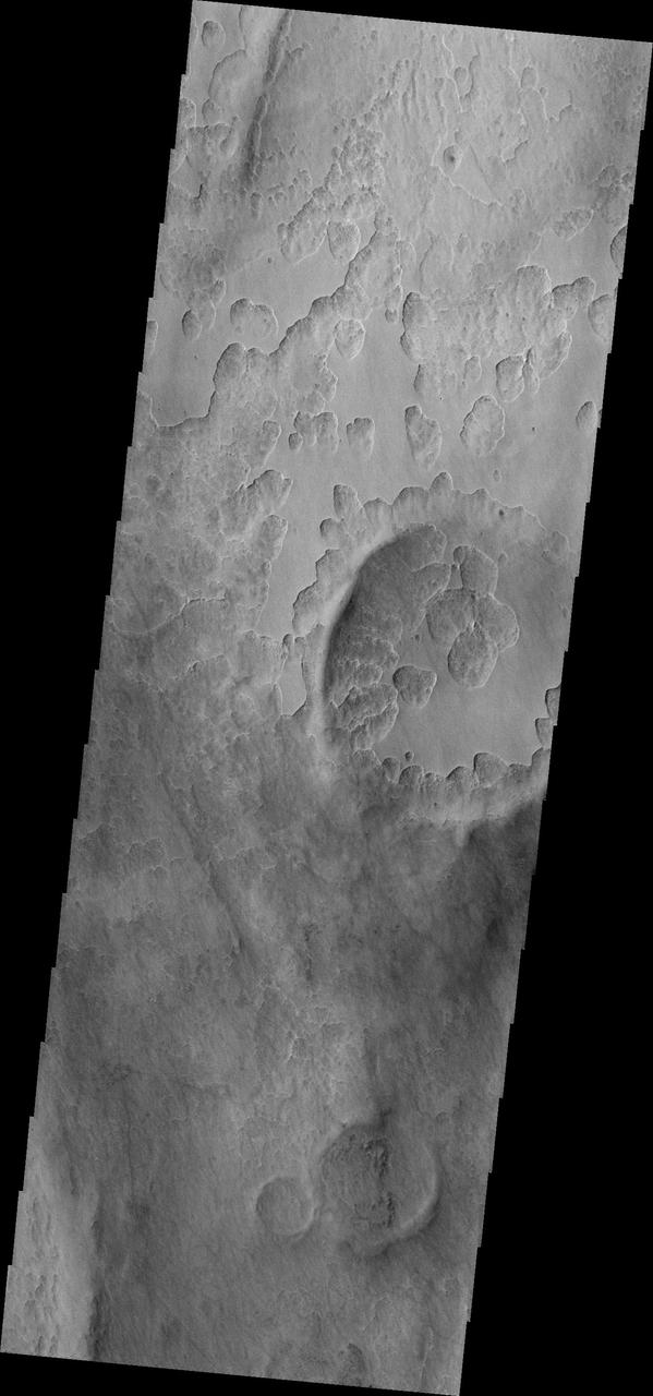
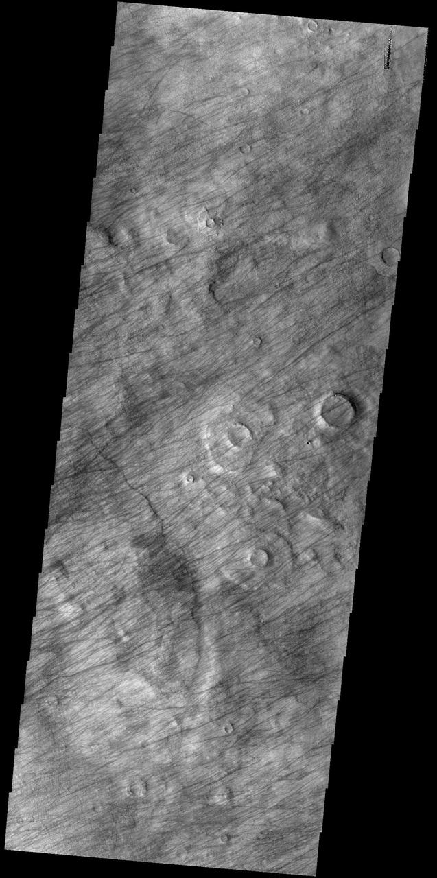
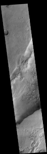
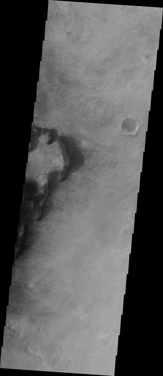
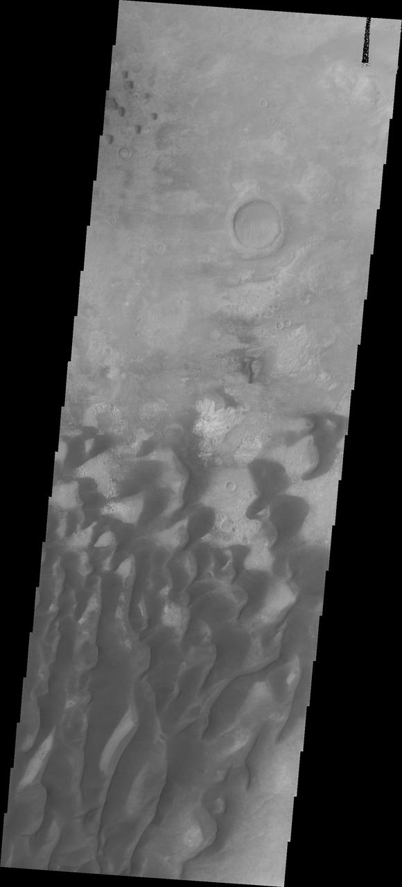
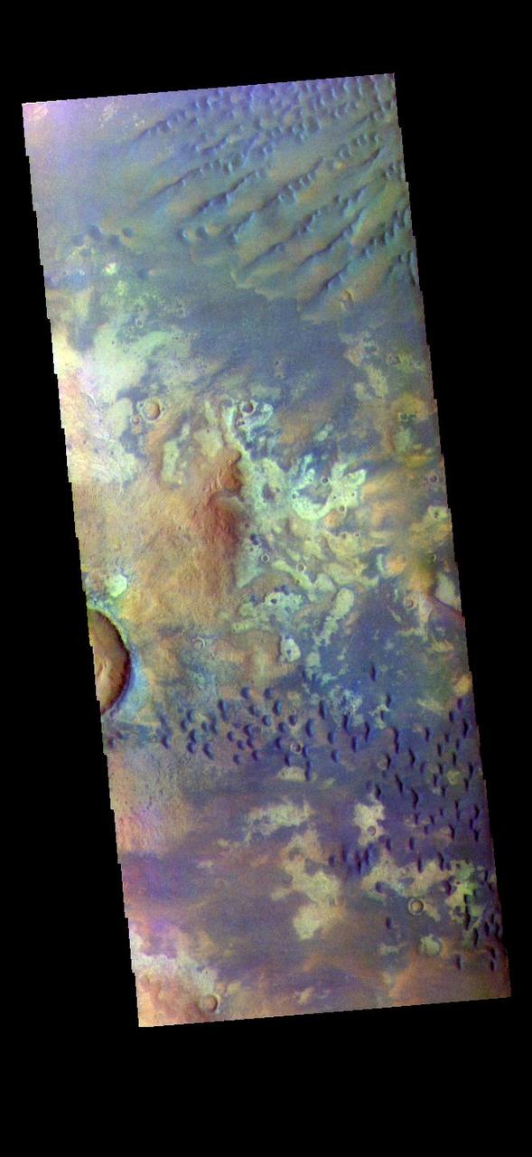
Strange Surfaces of Hellas Planitia
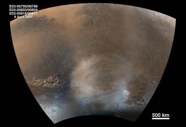
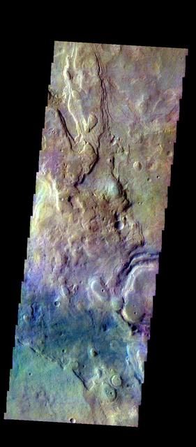
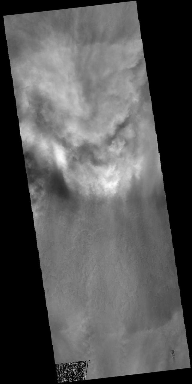
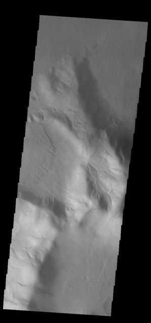
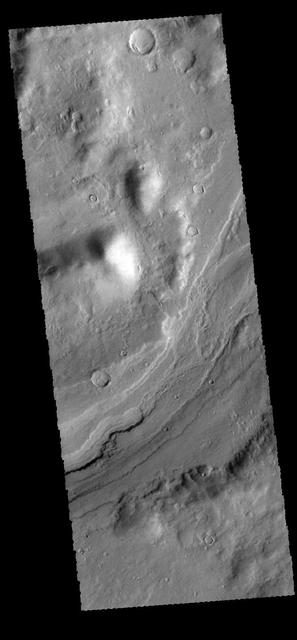
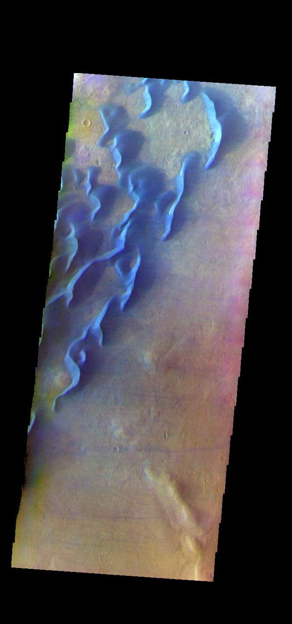
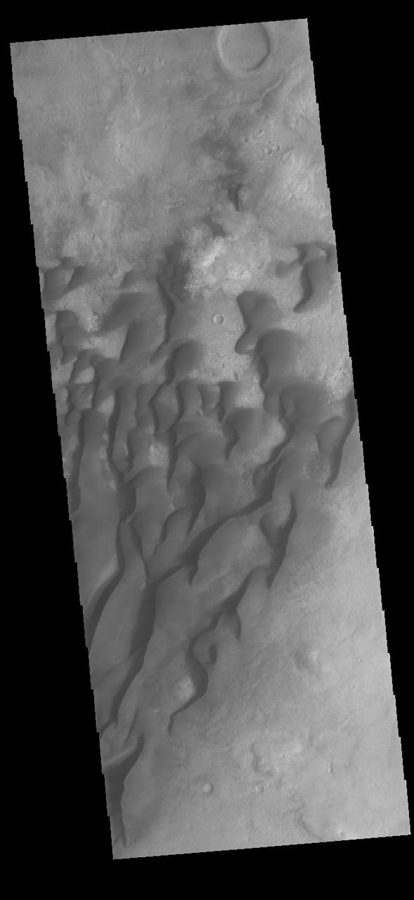
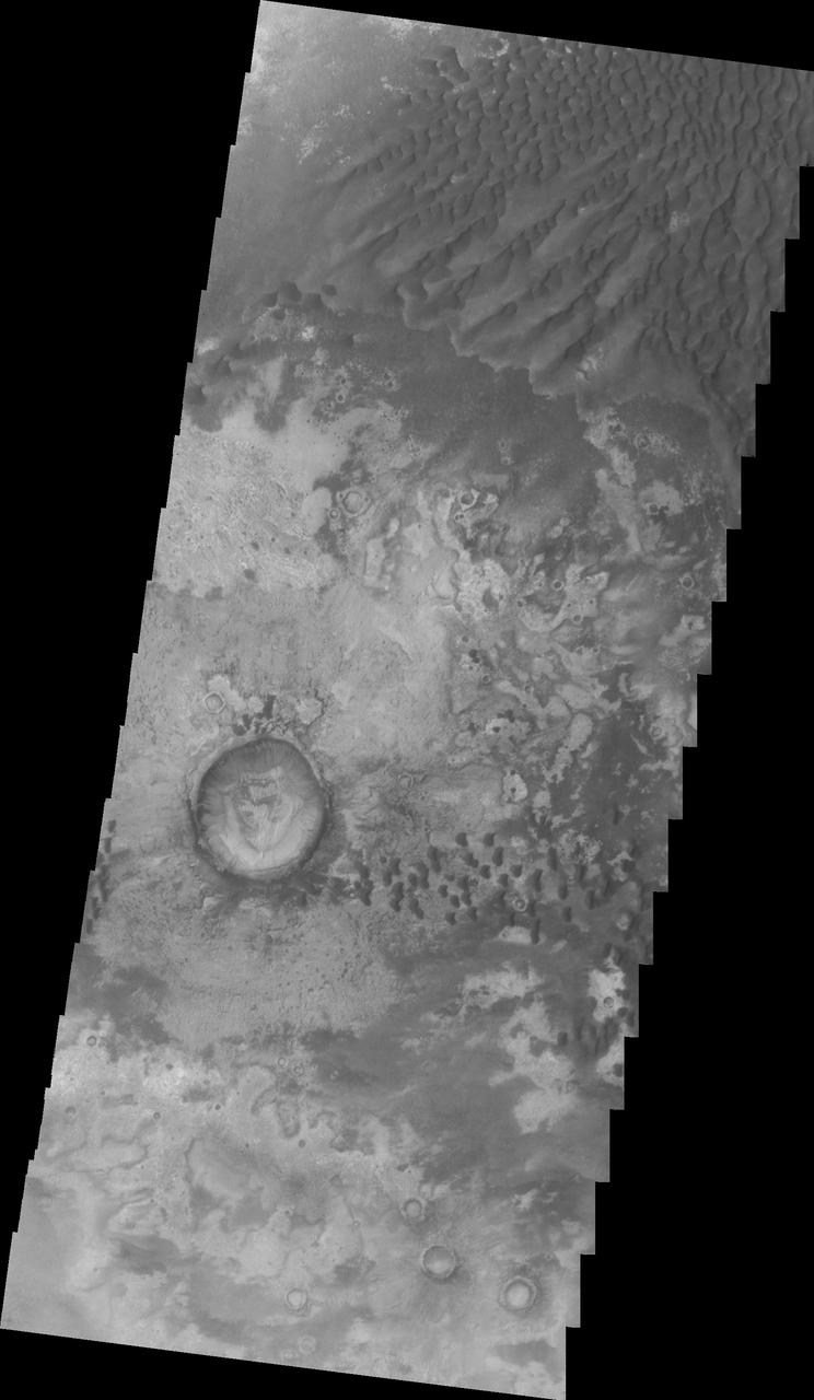
Mid-Winter Dust Storms Near Hellas Planitia
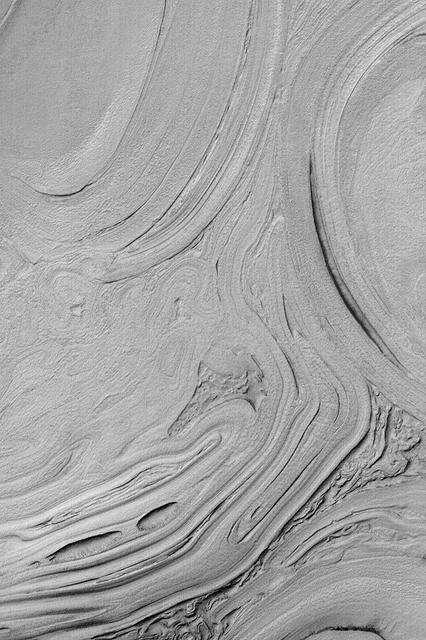
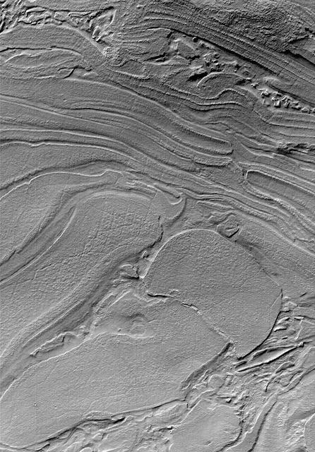
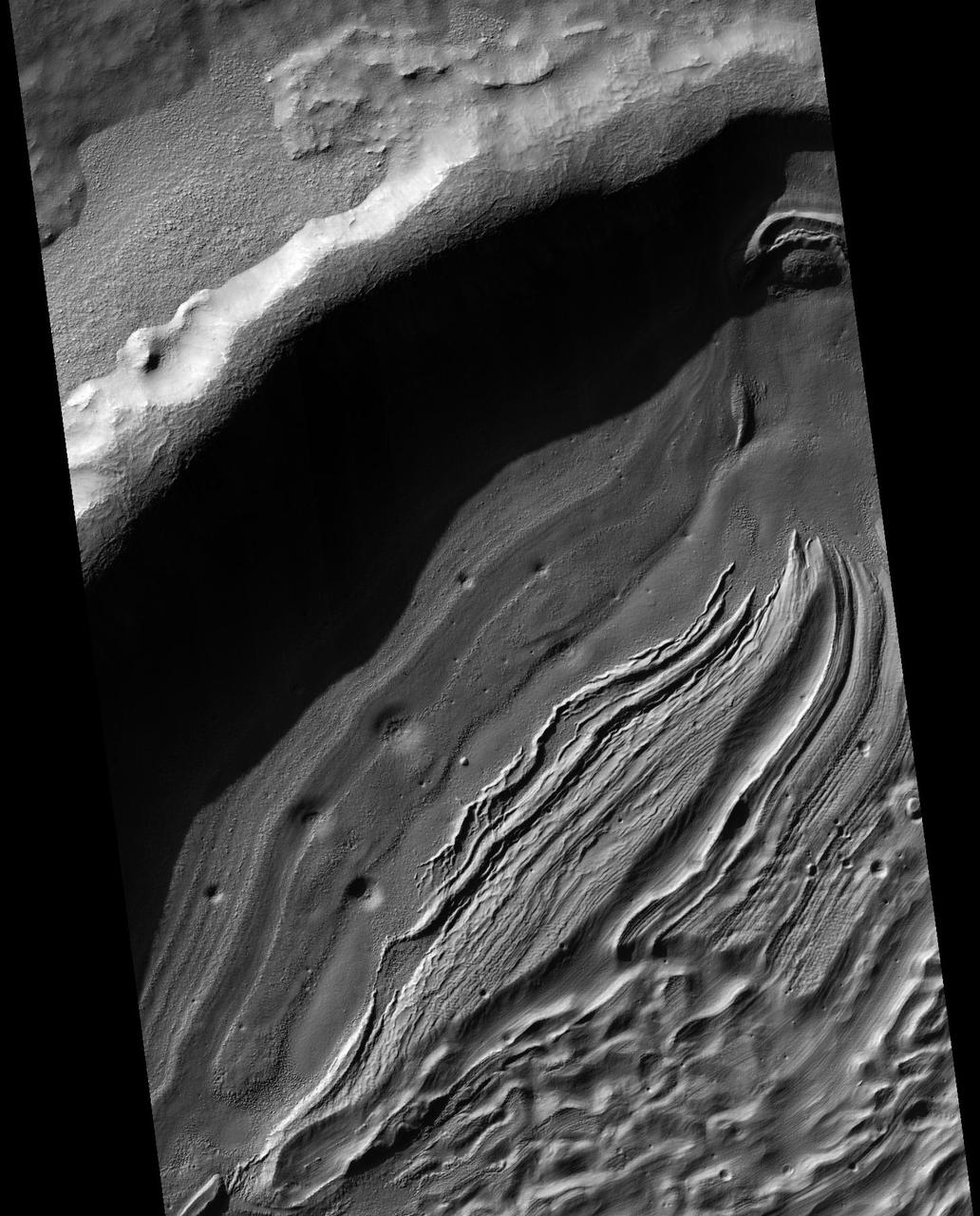
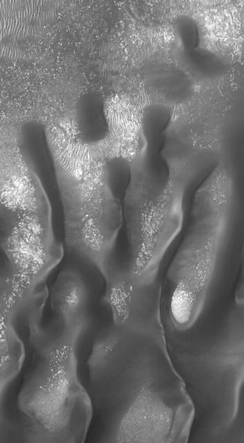
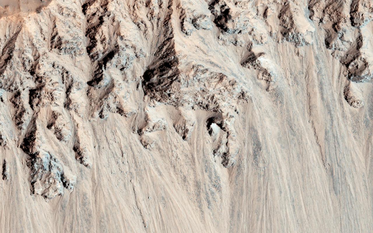
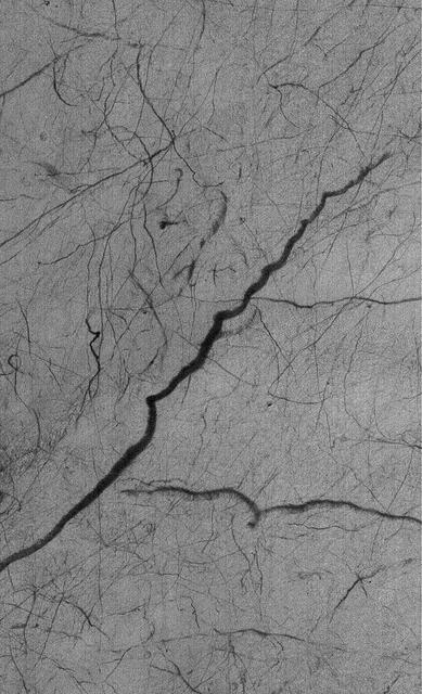
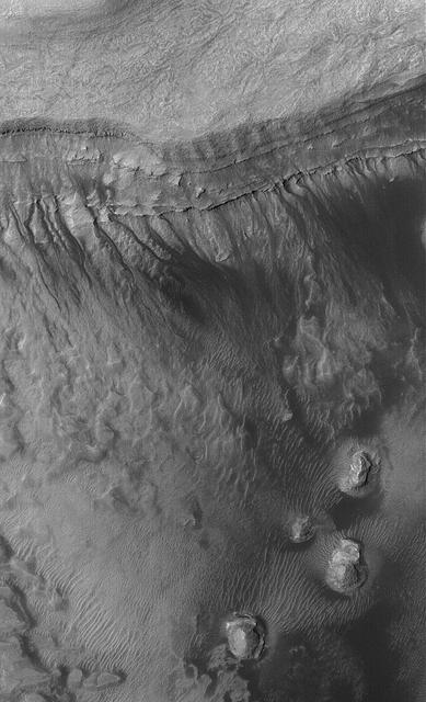
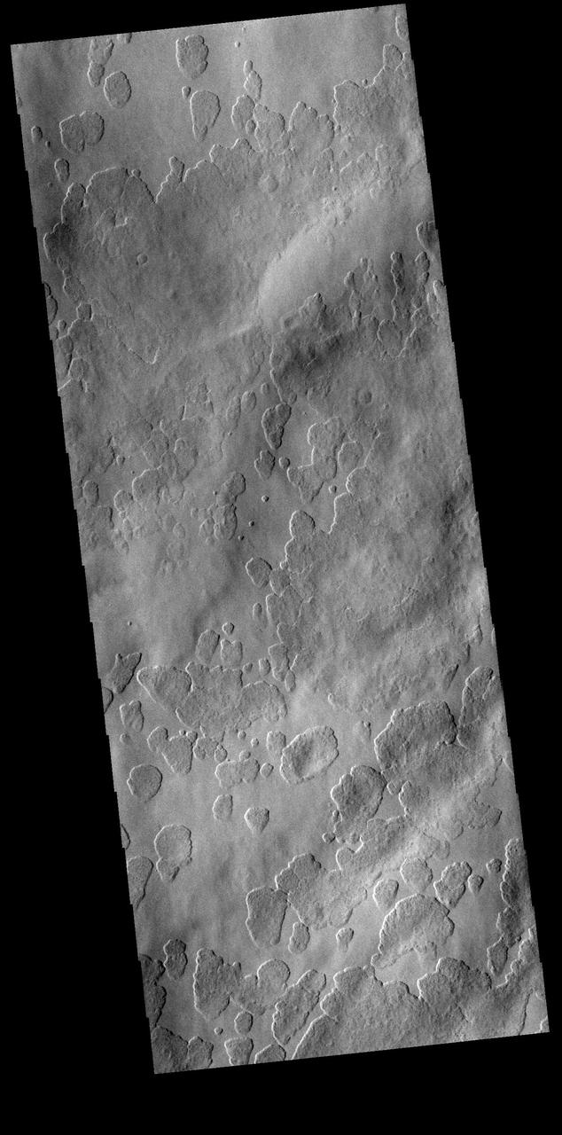
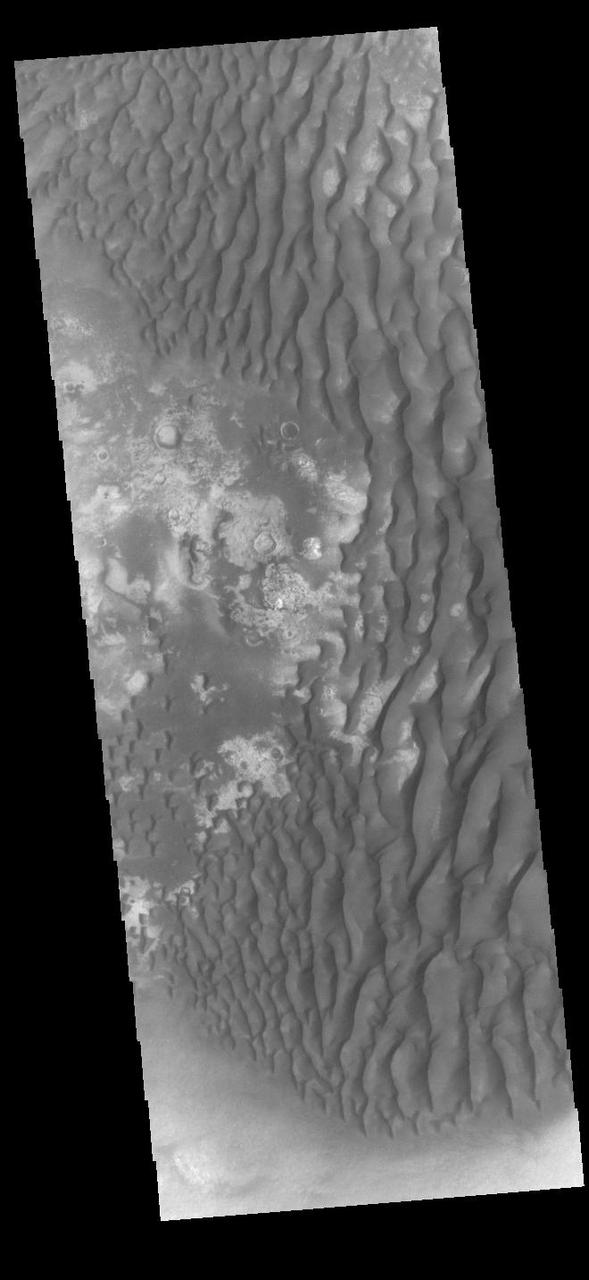
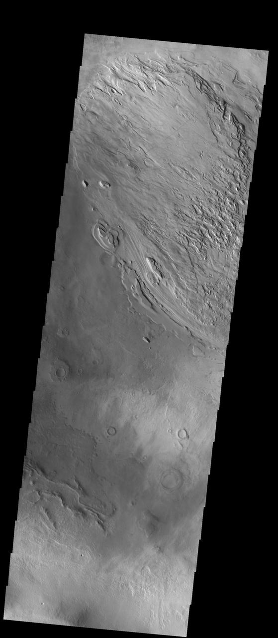
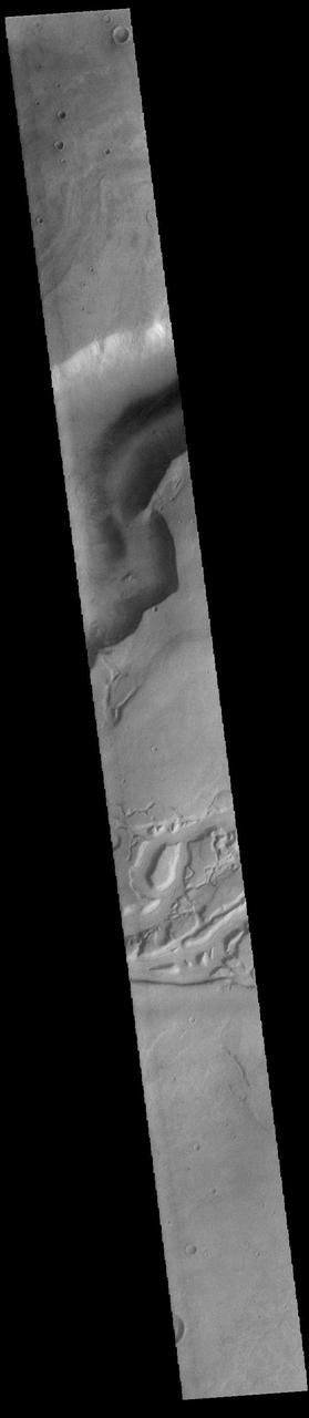
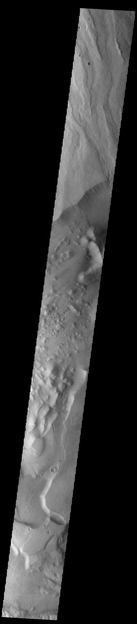
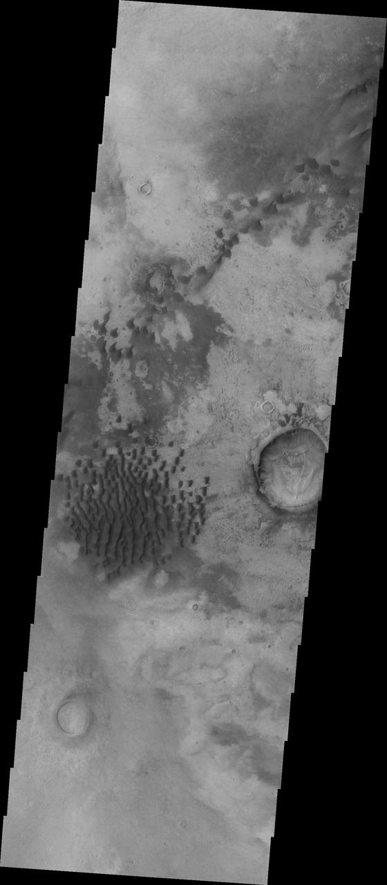
Tongue-Shaped Flow Feature in Hellas Planitia
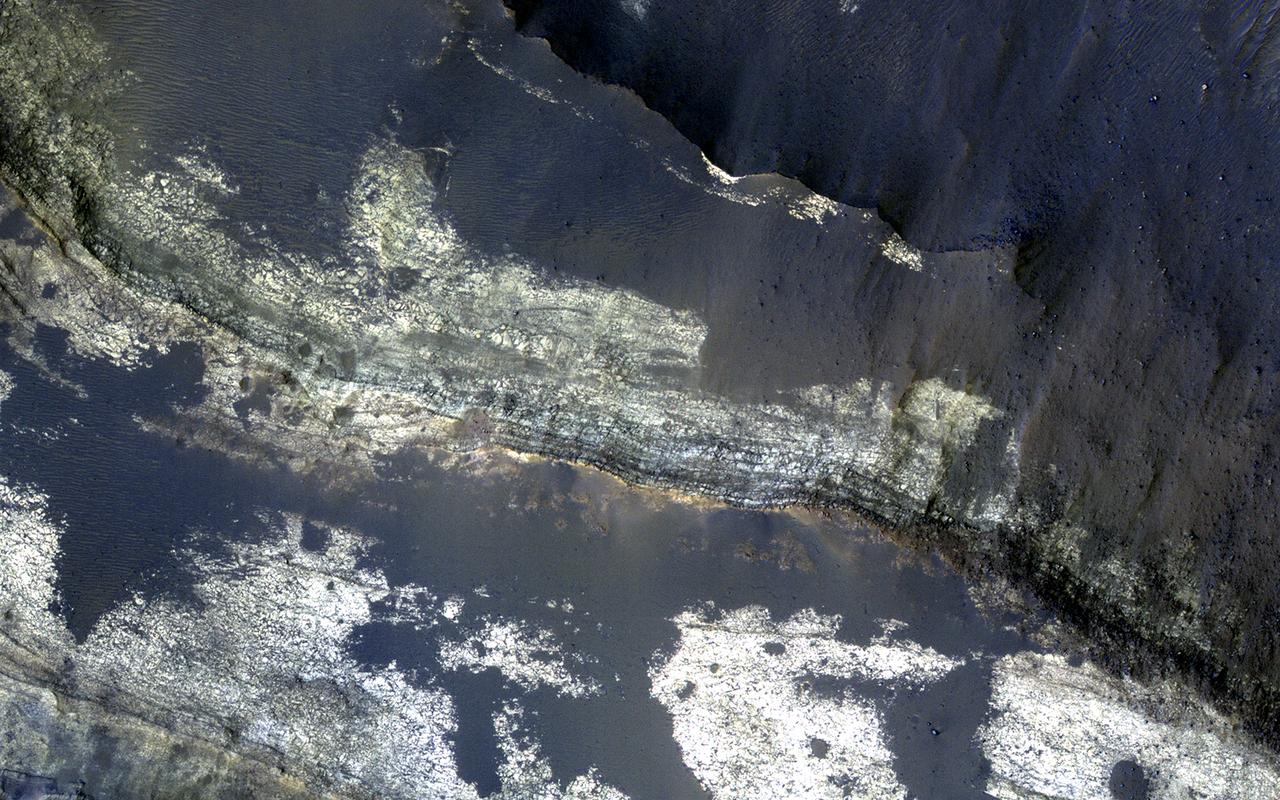
This image shows the floor of Suzhi Crater, an approximately 25-kilometer diameter impact crater located northeast of Hellas Planitia. The crater floor is mostly covered by dark-toned deposits; however some patches of the underlying light-toned bedrock are now exposed, like in this Context Camera image. This enhanced-color infrared image shows a close up of the exposed bedrock on the floor of the crater. Here we can see the lighter-toned bedrock partially covered up by darker-toned bedrock and a few wind-blown bedforms. The lighter-toned bedrock appears to lie over yet another type of bedrock in our image, which appears to be yellowish and heavily fractured. What complex tale of Martian geologic and climate history might these rocks tell us if we were able to sample them in person? Perhaps, one day we'll know. The University of Arizona, Tucson, operates HiRISE, which was http://photojournal.jpl.nasa.gov/catalog/PIA21273
![This image from NASA's Mars Reconnaissance Orbiter is of Saheki Crater, about 84 kilometers across, and located in the Southern highlands of Mars, to the north of Hellas Planitia. It's filled with beautiful alluvial fans that formed when water (likely melting snow) carried fine material, such as sand, silt and mud, from the interior crater rim down to the bottom of the crater. Two smaller craters impacted into the alluvial fan surface in Saheki, excavating holes that allow us to see what the fans look like beneath the surface. Exposed along the crater's interior walls, we can see that the fan is made up of multiple individual layers (white and purple tones in the enhanced color image) that were deposited on the floor (the green and brown tones). The brown, circular shapes on the fan layers are small impact craters. The map is projected here at a scale of 25 centimeters (9.8 inches) per pixel. [The original image scale is 26.2 centimeters (10.3 inches) per pixel (with 1 x 1 binning); objects on the order of 78 centimeters (30.7 inches) across are resolved.] North is up. https://photojournal.jpl.nasa.gov/catalog/PIA21577](https://images-assets.nasa.gov/image/PIA21577/PIA21577~medium.jpg)
This image from NASA's Mars Reconnaissance Orbiter is of Saheki Crater, about 84 kilometers across, and located in the Southern highlands of Mars, to the north of Hellas Planitia. It's filled with beautiful alluvial fans that formed when water (likely melting snow) carried fine material, such as sand, silt and mud, from the interior crater rim down to the bottom of the crater. Two smaller craters impacted into the alluvial fan surface in Saheki, excavating holes that allow us to see what the fans look like beneath the surface. Exposed along the crater's interior walls, we can see that the fan is made up of multiple individual layers (white and purple tones in the enhanced color image) that were deposited on the floor (the green and brown tones). The brown, circular shapes on the fan layers are small impact craters. The map is projected here at a scale of 25 centimeters (9.8 inches) per pixel. [The original image scale is 26.2 centimeters (10.3 inches) per pixel (with 1 x 1 binning); objects on the order of 78 centimeters (30.7 inches) across are resolved.] North is up. https://photojournal.jpl.nasa.gov/catalog/PIA21577
This image from NASA Mars Reconnaissance Orbiter covers a small portion of the northwest quadrant of Hellas Basin, or Hellas Planitia, on southern Mars; Hellas is one of the largest impact craters in the solar system.
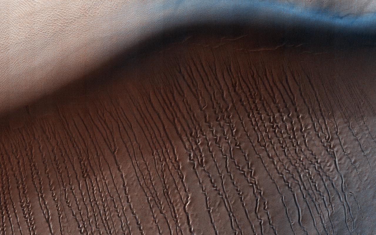
At around 2,200 kilometers in diameter, Hellas Planitia is the largest visible impact basin in the Solar System, and hosts the lowest elevations on Mars' surface as well as a variety of landscapes. This image from NASA's Mars Reconnaisance Orbiter (MRO) covers a small central portion of the basin and shows a dune field with lots of dust devil trails. In the middle, we see what appears to be long and straight "scratch marks" running down the southeast (bottom-right) facing dune slopes. If we look closer, we can see these scratch marks actually squiggle back and forth on their way down the dune. These scratch marks are linear gullies. Just like on Earth, high-latitude regions on Mars are covered with frost in the winter. However, the winter frost on Mars is made of carbon dioxide ice (dry ice) instead of water ice. We believe linear gullies are the result of this dry ice breaking apart into blocks, which then slide or roll down warmer sandy slopes, sublimating and carving as they go. The linear gullies exhibit exceptional sinuosity (the squiggle pattern) and we believe this to be the result of repeated movement of dry ice blocks in the same path, possibly in combination with different hardness or flow resistance of the sand within the dune slopes. Determining the specific process that causes the formation and evolution of sinuosity in linear gullies is a question scientists are still trying to answer. What do you think causes the squiggles? https://photojournal.jpl.nasa.gov/catalog/PIA22052
![This image from NASA's Mars Reconnaissance Orbiter (MRO) targets a portion of a group of honeycomb-textured landforms in northwestern Hellas Planitia, which is part of one of the largest and most ancient impact basins on Mars. In a larger Context Camera image, the individual "cells" are about 5 to 10 kilometers wide. With HiRISE, we see much greater detail of these cells, like sand ripples that indicate wind erosion has played some role here. We also see distinctive exposures of bedrock that cut across the floor and wall of the cells. These resemble dykes, which are usually formed by volcanic activity. Additionally, the lack of impact craters suggests that the landscape, along with these features, have been recently reshaped by a process, or number of processes that may even be active today. Scientists have been debating how these honeycombed features are created, theorizing from glacial events, lake formation, volcanic activity, and tectonic activity, to wind erosion. The map is projected here at a scale of 50 centimeters (19.7 inches) per pixel. [The original image scale is 53.8 centimeters (21.2 inches) per pixel (with 2 x 2 binning); objects on the order of 161 centimeters (23.5 inches) across are resolved.] North is up. https://photojournal.jpl.nasa.gov/catalog/PIA22118](https://images-assets.nasa.gov/image/PIA22118/PIA22118~medium.jpg)
This image from NASA's Mars Reconnaissance Orbiter (MRO) targets a portion of a group of honeycomb-textured landforms in northwestern Hellas Planitia, which is part of one of the largest and most ancient impact basins on Mars. In a larger Context Camera image, the individual "cells" are about 5 to 10 kilometers wide. With HiRISE, we see much greater detail of these cells, like sand ripples that indicate wind erosion has played some role here. We also see distinctive exposures of bedrock that cut across the floor and wall of the cells. These resemble dykes, which are usually formed by volcanic activity. Additionally, the lack of impact craters suggests that the landscape, along with these features, have been recently reshaped by a process, or number of processes that may even be active today. Scientists have been debating how these honeycombed features are created, theorizing from glacial events, lake formation, volcanic activity, and tectonic activity, to wind erosion. The map is projected here at a scale of 50 centimeters (19.7 inches) per pixel. [The original image scale is 53.8 centimeters (21.2 inches) per pixel (with 2 x 2 binning); objects on the order of 161 centimeters (23.5 inches) across are resolved.] North is up. https://photojournal.jpl.nasa.gov/catalog/PIA22118
This image captured by NASA 2001 Mars Odyssey spacecraft shows the dunes on the floor of Bogia Crater, a crater in Hellas Planitia.
As seen by NASA 2001 Mars Odyssey spacecraft, the dunes in this image are located on the western margin of Hellas Planitia.
This MOC image shows material on the floor of a crater in Noachis Terra, west of Hellas Planitia
This MOC image shows neighboring networks of gullies in the northwest wall of a south middle-latitude crater west of Hellas Planitia
This image from NASA Mars Odyssey spacecraft shows an unnamed channel located in Terra Sabaea, near Hellas Planitia.
This MOC image shows gullies overlain by seasonal frost in the north wall of an unnamed crater west of Hellas Planitia
This MOC image shows a variety of materials found on the floor of an impact crater northwest of Hellas Planitia
This well-preserved impact crater in Tyrrhena Terra, northeast of Hellas Planitia, is approximately 6 kilometers in diameter as seen by NASA Mars Reconnaissance Orbiter.
Clouds fill half of this unnamed crater located in the region between Malea Planum and Hellas Planitia, as shown in this image from NASA 2001 Mars Odyssey spacecraft.
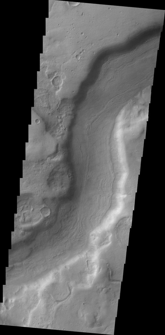
A small section of Dao Vallis in shown in this image from NASA 2001 Mars Odyssey spacecraft. Dao Vallis is a major channel that drains into Hellas Planitia.
This Mars Global Surveyor MGS Mars Orbiter Camera MOC image shows dark streaks created by dust devils on a plain southwest of Hellas Planitia
This small channel dissects the rim of an unnamed crater north of Terby Crater and Hellas Planitia as seen by NASA 2001 Mars Odyssey spacecraft.
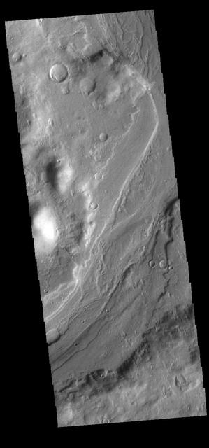
This image captured by NASA 2001 Mars Odyssey spacecraft shows a section of Reull Vallis, a major channel that empties into Hellas Planitia. Orbit Number: 58040 Latitude: -39.0604 Longitude: 111.349 Instrument: VIS Captured: 2015-01-13 17:56 http://images.nasa.gov/#/details-PIA19226.html
This image shows a variety of textures observed on a south middle-latitude plain east-southeast of Hellas Planitia. Dark streaks left by passing dust devils are practically ubiquitous across the scene
This Mars Global Surveyor MGS Mars Orbiter Camera MOC image shows gullies formed in the wall of a depression located on the floor of Rabe Crater west of the giant impact basin, Hellas Planitia
This MOC image shows dark sand dunes on the floor of an impact crater west of Hellas Planitia. Portions of the crater floor are exposed near the center and lower right corner of the image but, in general, the floor is covered by large, windblown ripples
This MOC image shows billowing clouds of dust rising from a storm southeast of Hellas Planitia. The dust storm in this case obscured the Mars Orbiter Camera view of the martian surface
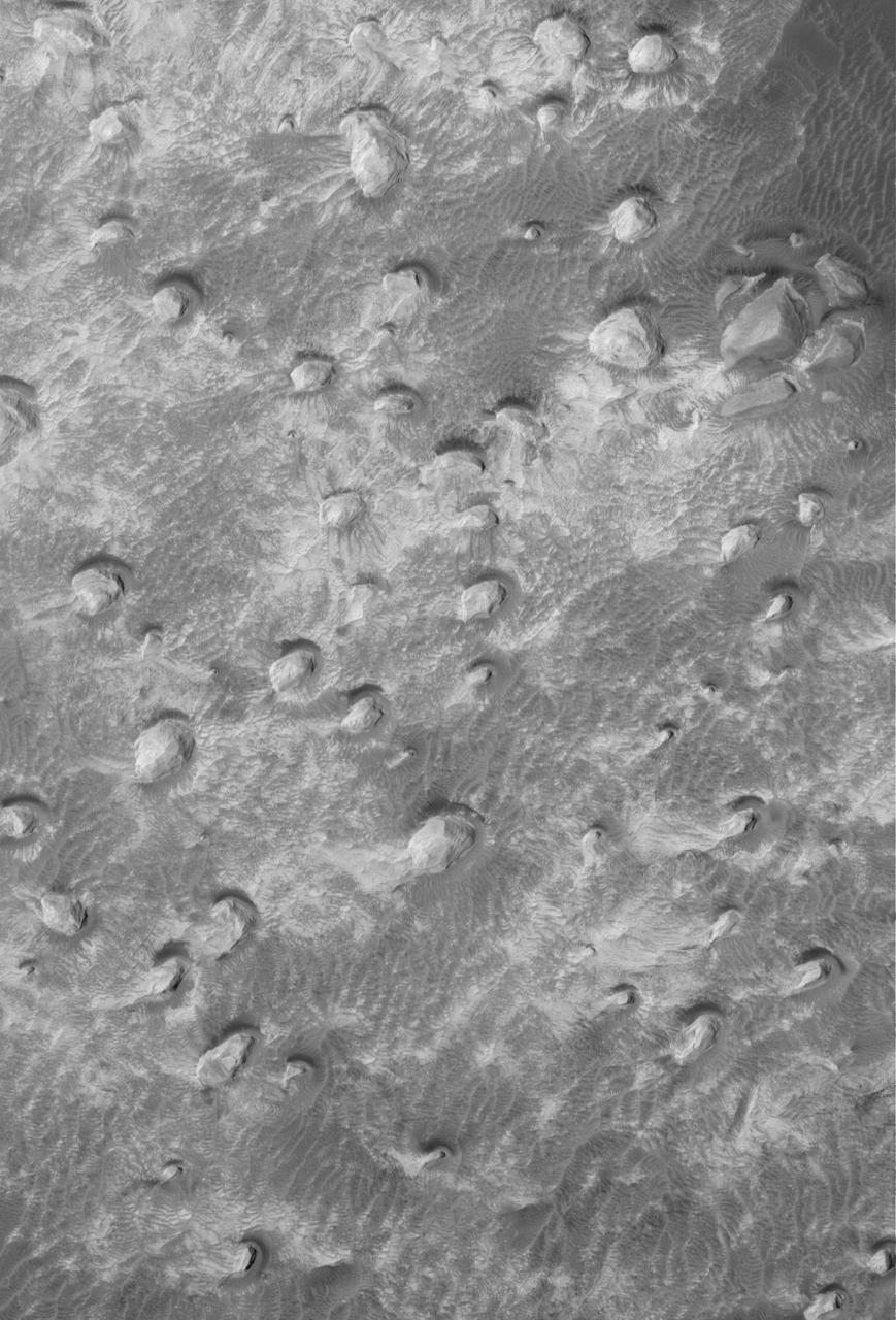
image shows a variety of textures observed on a south middle-latitude plain east-southeast of Hellas Planitia. Dark streaks left by passing dust devils are practically ubiquitous across the scene
The unusual shallow, scalloped depressions in this image from NASA 2001 Mars Odyssey spacecraft are located on the margin Peneus Patera, south of Hellas Planitia. It may be that volatiles, such as ice, are involved in the formation of these depressions.
Amphitrites Patera is an old volcanic complex located south of Hellas Planitia. The surface in this VIS image has a unusual texture, one seen more commonly on the nearby south polar ice. The surface appears to be eroding in a fashion that creates small circular features which grow and coalesce into larger circles. Orbit Number: 74545 Latitude: -57.6389 Longitude: 66.7121 Instrument: VIS Captured: 2018-10-04 06:51 https://photojournal.jpl.nasa.gov/catalog/PIA22854
This VIS image shows an isolated mountain east of Hellas Planitia. Erosion is moving material down hill towards the lower elevations. The linear features on the hill debris indicate that volatiles such as ice may play a part in the erosion. Orbit Number: 74924 Latitude: -42.7071 Longitude: 108.078 Instrument: VIS Captured: 2018-11-04 11:37 https://photojournal.jpl.nasa.gov/catalog/PIA22999

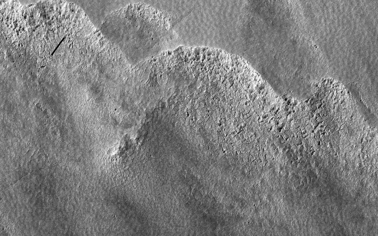
This image shows a portion of an enigmatic formation called banded terrain, which is only observed in the northwest of the Hellas basin. This basin was formed by a giant impact around 4 billion years ago. It is the deepest impact basin on the planet, and banded terrain is in the deepest part of the basin (at elevations around 7 kilometers). This terrain is characterized by smooth bands of material separated by ridges or troughs, with circular and lobe shapes that are typically several kilometers long and a few hundred meters wide. A closeup shows banded terrain deforming around a mesa (bottom) and the transition of smooth banded terrain into surrounding rough terrain (top). Other banded terrain appears to have undergone deformation, like by a glacier, though it is not quite like terrestrial landforms. There are several ideas for what it could be, including a thin, flowing, ice-rich layer or sediment that was deformed beneath a former ice sheet. https://photojournal.jpl.nasa.gov/catalog/PIA24947
Today's VIS image shows several small channels. These channels are along the break in topography, that leads down into Argyre Planitia. Argyre Planitia and Hellas Planitia are deep basins in the southern hemisphere. Orbit Number: 74586 Latitude: -34.8073 Longitude: 318.916 Instrument: VIS Captured: 2018-10-07 16:02 https://photojournal.jpl.nasa.gov/catalog/PIA22857
This VIS image shows a region dense with dust devil tracks. Located in Promethei Terra, these tracks run parallel to the nearby southeastern margin of Hellas Planitia. The number of tracks and amount of overlapping indicates that there are long term winds in this region. Orbit Number: 74962 Latitude: -54.2492 Longitude: 89.1339 Instrument: VIS Captured: 2018-11-07 14:48 https://photojournal.jpl.nasa.gov/catalog/PIA22987

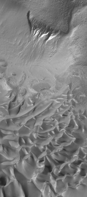
This beautiful dune field is located along the western margin of Hellas Planitia, the floor of a giant depression in the Southern Hemisphere of Mars. Scientists on the HiRISE team take multiple pictures of the same dune fields on the Red Planet to see if they can detect subtle changes that would indicate if the dunes are moving. Some Martian dune fields do shift and move under the present day environmental conditions, but at a rate that is typically much slower than dunes move on Earth. https://photojournal.jpl.nasa.gov/catalog/PIA25704
This VIS image shows part of the floor of Kaiser Crater. Kaiser Crater is 207 km (129 miles) in diameter and is located in Noachis Terra west of Hellas Planitia. This sand dune field is one of several regions of sand dunes located on the southern part of the crater floor. The image also shows the complex crater floor beneath the dunes. Orbit Number: 91155 Latitude: -46.9828 Longitude: 19.3481 Instrument: VIS Captured: 2022-07-02 23:58 https://photojournal.jpl.nasa.gov/catalog/PIA25534
![Hellas is an ancient impact structure and is the deepest and broadest enclosed basin on Mars. It measures about 2,300 kilometers across and the floor of the basin, Hellas Planitia, contains the lowest elevations on Mars. The Hellas region can often be difficult to view from orbit due to seasonal frost, water-ice clouds and dust storms, yet this region is intriguing because of its diverse, and oftentimes bizarre, landforms. This image from eastern Hellas Planitia shows some of the unusual features on the basin floor. These relatively flat-lying "cells" appear to have concentric layers or bands, similar to a honeycomb. This "honeycomb" terrain exists elsewhere in Hellas, but the geologic process responsible for creating these features remains unresolved. The map is projected here at a scale of 50 centimeters (19.7 inches) per pixel. [The original image scale is 52.2 centimeters (20.6 inches) per pixel (with 2 x 2 binning); objects on the order of 157 centimeters (61.8 inches) across are resolved.] North is up. http://photojournal.jpl.nasa.gov/catalog/PIA21570](https://images-assets.nasa.gov/image/PIA21570/PIA21570~medium.jpg)
Hellas is an ancient impact structure and is the deepest and broadest enclosed basin on Mars. It measures about 2,300 kilometers across and the floor of the basin, Hellas Planitia, contains the lowest elevations on Mars. The Hellas region can often be difficult to view from orbit due to seasonal frost, water-ice clouds and dust storms, yet this region is intriguing because of its diverse, and oftentimes bizarre, landforms. This image from eastern Hellas Planitia shows some of the unusual features on the basin floor. These relatively flat-lying "cells" appear to have concentric layers or bands, similar to a honeycomb. This "honeycomb" terrain exists elsewhere in Hellas, but the geologic process responsible for creating these features remains unresolved. The map is projected here at a scale of 50 centimeters (19.7 inches) per pixel. [The original image scale is 52.2 centimeters (20.6 inches) per pixel (with 2 x 2 binning); objects on the order of 157 centimeters (61.8 inches) across are resolved.] North is up. http://photojournal.jpl.nasa.gov/catalog/PIA21570
This image is of a portion of the Southern plains region within Hellas, the largest impact basin on Mars, with a diameter of about 2300 kilometers 1400 miles, as observed by NASA Mars Reconnaissance Orbiter. There are three main phenomena apparent in this image. First, the faint dark streaks that criss-cross the terrain are dust devil tracks that clear the bright dust along their way. Second, the subtle overall bumpy "basketball" texture of the surface is formed by repeated seasonal freezing and thawing of the ice-rich regolith and is common at higher latitudes. Third, the large, elliptical, scalloped depressions are common in permafrost terrains in both hemispheres, where thick, latitude-dependent sedimentary mantles comprise the surface units. These mantles are composed of ice-rich sediments that degrade as the ice sublimates away and is heated either by the Sun or by locally higher geothermal gradients. Sublimation, or the direct change in phase from ice to gas, occurs on Mars because of its low density atmosphere. These depressions have steeper pole-facing slopes, whereas the equator-facing slopes gently fade into the surrounding terrain. At full resolution (see close up view), numerous sublimation pits and networks of polygonal cracks are visible on the steeper, unstable pole-ward facing slopes. The overall morphology of this terrain is characteristic of what is called "thermokarstic degradation processes," which is a term used to describe the formation of pits in an ice-rich terrain due to loss of ice creating pits and collapse features. http://photojournal.jpl.nasa.gov/catalog/PIA19350
This image captured by NASA 2001 Mars Odyssey spacecraft shows a small portion of Reull Vallis. Reull Vallis is one of the major channels entering eastern Hellas Planitia. Orbit Number: 66499 Latitude: -39.1457 Longitude: 111.246 Instrument: VIS Captured: 2016-12-10 10:06 http://photojournal.jpl.nasa.gov/catalog/PIA21298
This VIS image shows part of the floor of Kaiser Crater. Kaiser Crater is 207 km (129 miles) in diameter and is located in Noachis Terra west of Hellas Planitia. This sand dune field is one of several regions of sand dunes located in the southern part of the crater floor. The small individual dunes at the bottom of the image indicate that in this region there is only limited amounts of sand available to form dunes. The image also shows the complex crater floor around the dunes. Orbit Number: 90294 Latitude: -46.9286 Longitude: 18.9726 Instrument: VIS Captured: 2022-04-23 02:29 https://photojournal.jpl.nasa.gov/catalog/PIA25471
Today's VIS image shows a small portion of Dao Vallis. Located south of Hadriacus Mons (a volcano), this channel is approximately 1200km (750 miles) long. It has been proposed that heating of the region due to volcanic activity melted subsurface ice which was released to the surface to carve the channel. Dao Vallis empties into the Hellas Planitia basin. Orbit Number: 83191 Latitude: -34.7957 Longitude: 91.6287 Instrument: VIS Captured: 2020-09-15 06:07 https://photojournal.jpl.nasa.gov/catalog/PIA24241
This VIS image shows part of the floor of Spallanzani Crater. At some point after the crater was created the floor was covered by a fill material. The material was laid down in layers, which are easily identifiable at the eroded margins of the desposit. Spallanzani Crater is located near the southeast margin of Hellas Planitia in Promethei Terra. Orbit Number: 75249 Latitude: -58.0904 Longitude: 86.3064 Instrument: VIS Captured: 2018-12-01 06:07 https://photojournal.jpl.nasa.gov/catalog/PIA23025
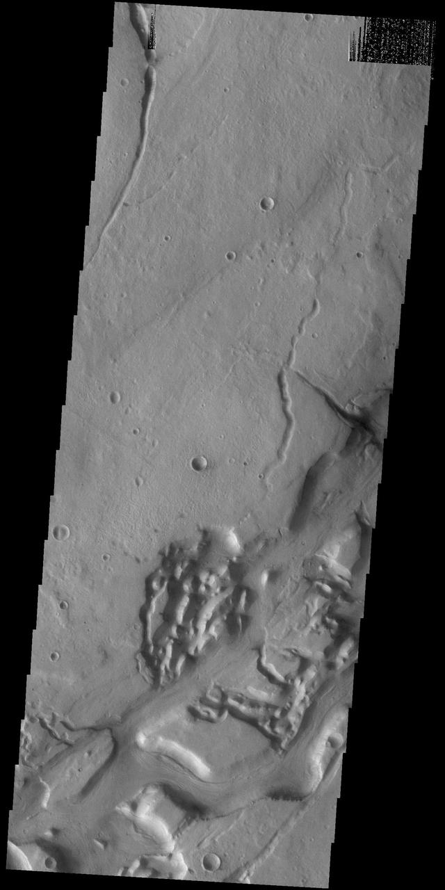
This VIS image shows a portion of Niger Vallis. The channel is 333 km (207 miles) long. Arising from the volcano Hadriacus Mons, Niger Vallis merges with Dao Vallis and flows southwestward into Hellas Planitia. The channel is named for the Niger Rivier in Africa. Orbit Number: 83734 Latitude: -36.231 Longitude: 90.9557 Instrument: VIS Captured: 2020-10-29 22:33 https://photojournal.jpl.nasa.gov/catalog/PIA24279
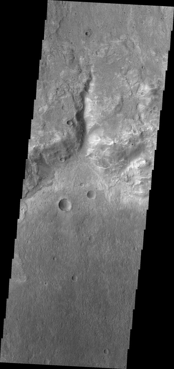
This image from NASA's Mars Reconnaissance Orbiter shows the north-facing wall of a moat-like depression in the middle of Terby Crater, exposing a beautiful 400 meter-high sequence of light-toned, repetitive sedimentary layers. These deposits are often obscured by darker-toned patches of material as well as ripples and dunes. The deposits in Terby, located on the northern rim of Hellas Planitia, are consistent with deposition in a standing body of water. The layers have been proposed as science targets for future landed missions. https://photojournal.jpl.nasa.gov/catalog/PIA21952
This false color image shows part of the floor of Kaiser Crater. Kaiser Crater is 207 km (129 miles) in diameter and is located in Noachis Terra west of Hellas Planitia. This sand dune field is one of several regions of sand dunes located in the southern part of the crater floor. Dark blue in this false color combination are typically basaltic sand. The dunes in this image are moving west - towards the left side of the image. The THEMIS VIS camera contains 5 filters. The data from different filters can be combined in multiple ways to create a false color image. These false color images may reveal subtle variations of the surface not easily identified in a single band image. Orbit Number: 66602 Latitude: -47.0551 Longitude: 19.446 Instrument: VIS Captured: 2016-12-18 21:42 https://photojournal.jpl.nasa.gov/catalog/PIA23630
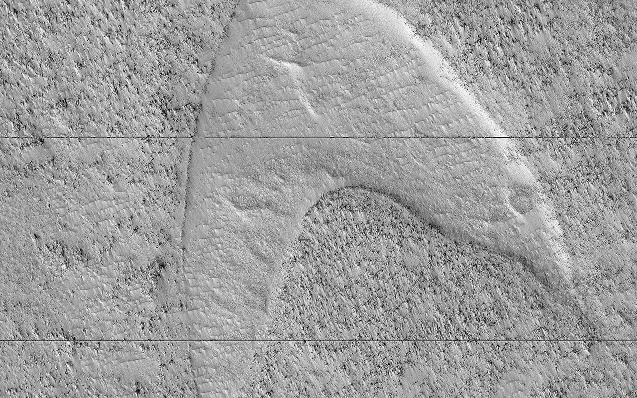
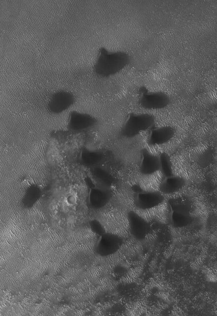
These curious chevron shapes in southeast Hellas Planitia are the result of a complex story of dunes, lava, and wind. Long ago, there were large crescent-shaped (barchan) dunes that moved across this area, and at some point, there was an eruption. The lava flowed out over the plain and around the dunes, but not over them. The lava solidified, but these dunes still stuck up like islands. However, they were still just dunes, and the wind continued to blow. Eventually, the sand piles that were the dunes migrated away, leaving these "footprints" in the lava plain. These are also called "dune casts" and record the presence of dunes that were surrounded by lava. Enterprising viewers will make the discovery that these features look conspicuously like a famous logo: and you'd be right, but it's only a coincidence. https://photojournal.jpl.nasa.gov/catalog/PIA23288
The THEMIS VIS camera contains 5 filters. The data from different filters can be combined in multiple ways to create a false color image. These false color images may reveal subtle variations of the surface not easily identified in a single band image. Today's false color image shows a cross section of Isil Crater and its surrounding ejecta blanket. Isil Crater is located in Tyrrhena Terra near Hellas Planitia and is 77km (48 miles) in diameter. Orbit Number: 80608 Latitude: -26.7188 Longitude: 87.9754 Instrument: VIS Captured: 2020-02-15 13:46 https://photojournal.jpl.nasa.gov/catalog/PIA24677
Today's VIS image shows a small portion of both Dao Vallis (top of image) and Niger Vallis (middle of image). Arising from the volcano Hadriacus Mons, Dao Vallis is approximately 1200km (750 miles) long. Niger Vallis is 333 km (207 miles) long. It has been proposed that heating of the region due to volcanic activity melted subsurface ice which was released to the surface to carve the two channels. Niger Vallis merges with Dao Vallis just off the image and then flow southwestward into the Hellas Planitia basin. Orbit Number: 91427 Latitude: -36.3071 Longitude: 90.4526 Instrument: VIS Captured: 2022-07-25 09:32 https://photojournal.jpl.nasa.gov/catalog/PIA25601
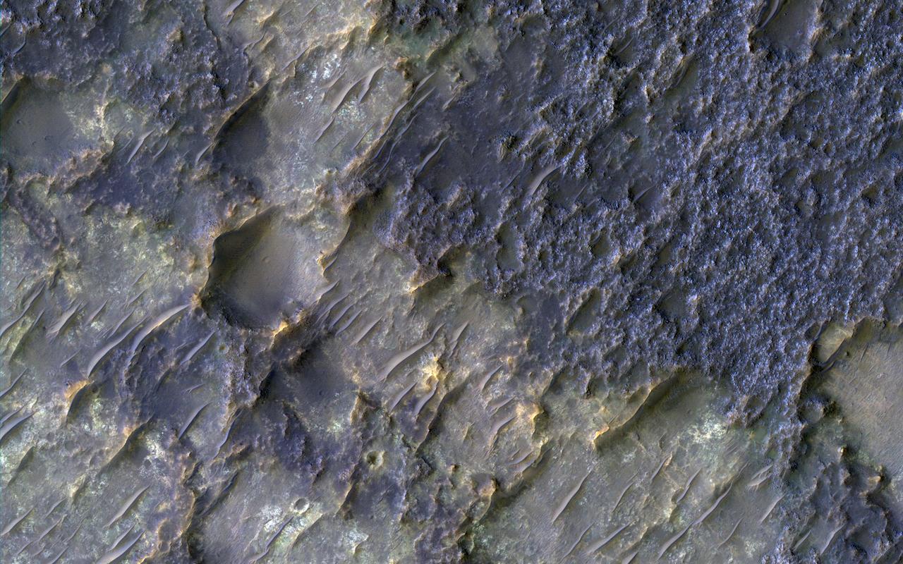
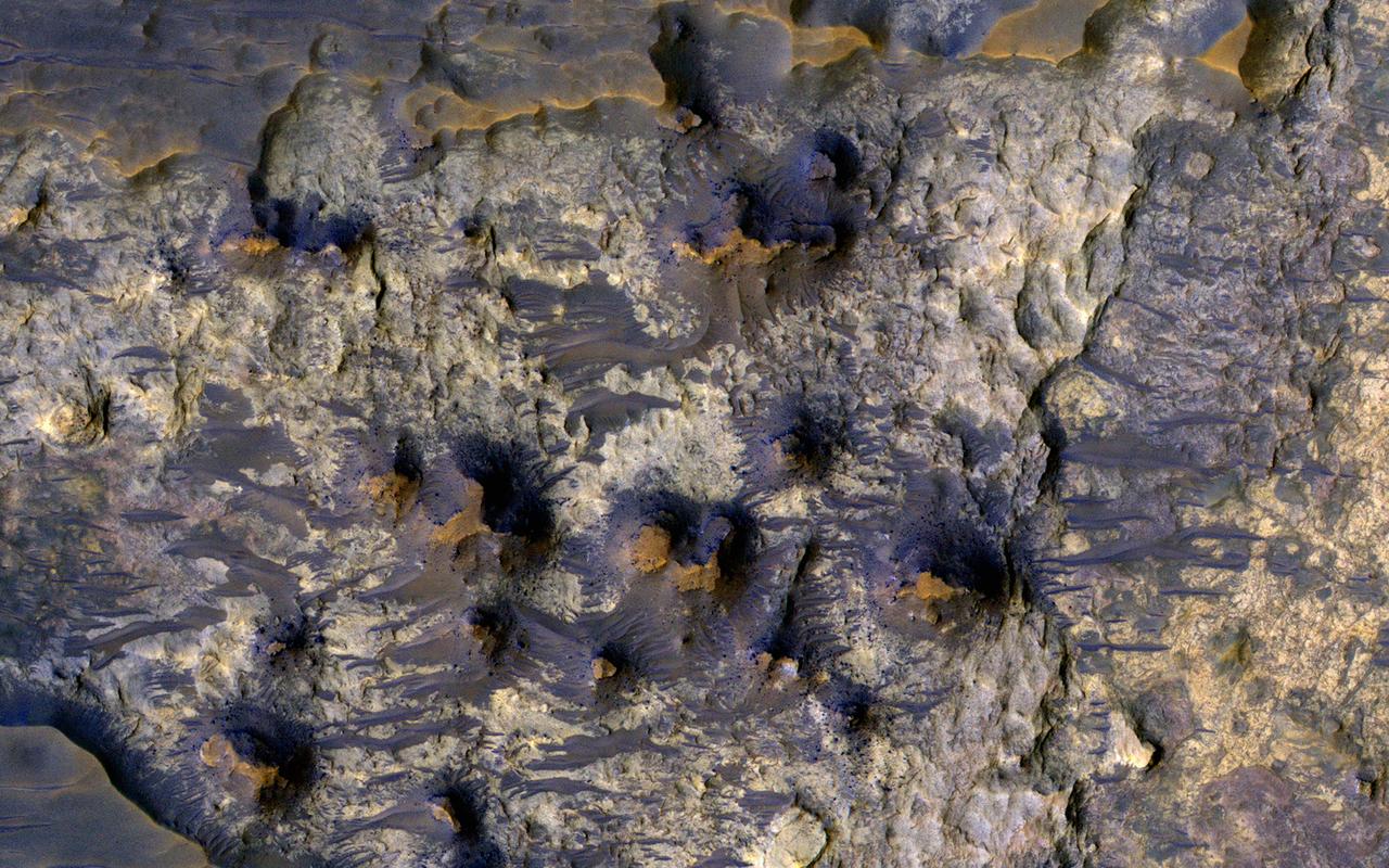
In this image from NASA Mars Reconnaissance Orbiter is an old degraded crater that has undergone a complex history of burial and erosion. The image shows a surface with at least two types of exposed bedrock, one that is light-toned and one that is dark. The overlying, rougher blueish-toned bedrock appears to have undergone the most extensive erosion, revealing the smoother, fractured yellowish-toned bedrock below. We see windblown (aeolian) bedforms across the image, possibly the culprit behind the erosive forces that have removed and uncovered the underlying yellowish-toned bedrock visible today. http://photojournal.jpl.nasa.gov/catalog/PIA11705
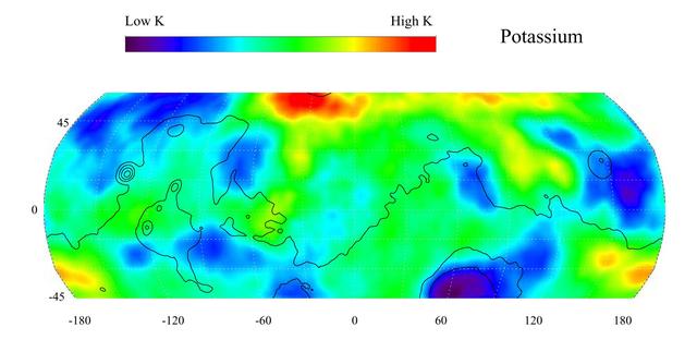
This gamma ray spectrometer map of the mid-latitude region of Mars is based on gamma-rays from the element potassium. Potassium, having the chemical symbol K, is a naturally radioactive element and is a minor constituent of rocks on the surface of both Mars and Earth. The region of highest potassium content, shown in red, is concentrated in the northern part of Acidalia Planitia (centered near 55 degrees N, -30 degrees). Several areas of low potassium content, shown in blue, are distributed across the mid-latitudes, with two significant low concentrations, one associated with the Hellas Basin (centered near 35 degrees S, 70 degrees) and the other lying southeast of Elysium Mons (centered near 10 degrees N, 160 degrees). Contours of constant surface elevation are also shown. The long continuous line running from east to west marks the approximate separation of the younger lowlands in the north from the older highlands in the south. http://photojournal.jpl.nasa.gov/catalog/PIA04255
The THEMIS VIS camera contains 5 filters. The data from different filters can be combined in multiple ways to create a false color image. These false color images may reveal subtle variations of the surface not easily identified in a single band image. Today's false color image shows dunes in several craters in Noachis Terra. As with other craters in this region, large mounds of sand dunes are located on the crater floors. Wind directions that blow from east south east to west north west (lower right corner to upper left corner of the image) are arising from Hellas Planitia. Orbit Number: 67462 Latitude: -48.7336 Longitude: 34.0451 Instrument: VIS Captured: 2017-02-27 18:15 https://photojournal.jpl.nasa.gov/catalog/PIA24059
Today's VIS image shows a small portion of both Dao Vallis (middle of image) and Niger Vallis (bottom of image). Arising from the volcano Hadriacus Mons (top of image), Dao Vallis is approximately 1200km (750 miles) long. Niger Vallis is 333 km (207 miles) long. It has been proposed that heating of the region due to volcanic activity melted subsurface ice which was released to the surface to carve the two channels. Niger Vallis merges with Dao Vallis south of this image and then flow southwestward into the Hellas Planitia basin. Orbit Number: 93355 Latitude: -33.4749 Longitude: 93.0394 Instrument: VIS Captured: 2022-12-31 02:58 https://photojournal.jpl.nasa.gov/catalog/PIA25852

The THEMIS VIS camera contains 5 filters. The data from different filters can be combined in multiple ways to create a false color image. These false color images may reveal subtle variations of the surface not easily identified in a single band image. Today's false color image shows a large dune covered sand sheet on the floor of this unnamed crater in Noachis Terra. Large scale dunes and dune fields cover the floor of many craters in this region west of Hellas Planitia — including Rabe, Proctor, and Matara craters and numerous other unnamed craters. In this false color combination blue indicates basaltic sands. Orbit Number: 67250 Latitude: -49.0136 Longitude: 34.0967 Instrument: VIS Captured: 2017-02-10 07:02 https://photojournal.jpl.nasa.gov/catalog/PIA24058

This VIS image of the floor of Kaiser Crater contains several sand dune shapes and sizes. The "whiter" material is the hard crater floor surface. Kaiser Crater is located in the southern hemisphere in the Noachis region west of Hellas Planitia. Kaiser Crater is just one of several large craters with extensive dune fields on the crater floor. Other nearby dune filled craters are Proctor, Russell, and Rabe. Kaiser Crater is 207 km (129 miles) in diameter. The dunes are located in the southern part of the crater floor. The Odyssey spacecraft has spent over 15 years in orbit around Mars, circling the planet more than 71,000 times. It holds the record for longest working spacecraft at Mars. THEMIS, the IR/VIS camera system, has collected data for the entire mission and provides images covering all seasons and lighting conditions. Over the years many features of interest have received repeated imaging, building up a suite of images covering the entire feature. From the deepest chasma to the tallest volcano, individual dunes inside craters and dune fields that encircle the north pole, channels carved by water and lava, and a variety of other feature, THEMIS has imaged them all. For the next several months the image of the day will focus on the Tharsis volcanoes, the various chasmata of Valles Marineris, and the major dunes fields. We hope you enjoy these images! Orbit Number: 39910 Latitude: -46.9063 Longitude: 19.8112 Instrument: VIS Captured: 2010-12-13 11:17 https://photojournal.jpl.nasa.gov/catalog/PIA22264
The THEMIS VIS camera contains 5 filters. The data from different filters can be combined in multiple ways to create a false color image. These false color images may reveal subtle variations of the surface not easily identified in a single band image. This false color image shows part of the floor of Kaiser Crater. Kaiser Crater is 207 km (129 miles) in diameter and is located in Noachis Terra west of Hellas Planitia. This sand dune field is one of several regions of sand dunes located in the southern part of the crater floor. With enough wind and sand, sand dunes are formed. Dune morphology typically has a shallow slope on the side the wind is blowing from and a steep face on the other side. The lighter part of the dunes in this image are the steep slopes. Wind blows sand particles up the shallow slope and then the particles 'fall' off the crest of the dune down the steep side. With time, the constant wind will move the crest of the dune forward. Depending on the amount of available sand, dunes can grow to large heights and sizes. The dunes in this image are moving west – towards the left side of the image. Dark blue in this false color combination are typically basaltic sand. The THEMIS VIS camera is capable of capturing color images of the Martian surface using five different color filters. In this mode of operation, the spatial resolution and coverage of the image must be reduced to accommodate the additional data volume produced from using multiple filters. To make a color image, three of the five filter images (each in grayscale) are selected. Each is contrast enhanced and then converted to a red, green, or blue intensity image. These three images are then combined to produce a full color, single image. Because the THEMIS color filters don't span the full range of colors seen by the human eye, a color THEMIS image does not represent true color. Also, because each single-filter image is contrast enhanced before inclusion in the three-color image, the apparent color variation of the scene is exaggerated. Nevertheless, the color variation that does appear is representative of some change in color, however subtle, in the actual scene. Note that the long edges of THEMIS color images typically contain color artifacts that do not represent surface variation. Orbit Number: 84872 Latitude: -47.0102 Longitude: 20.0034 Instrument: VIS Captured: 2021-01-31 15:23 https://photojournal.jpl.nasa.gov/catalog/PIA25006
Kaiser Crater is located in the southern hemisphere in the Noachis region west of Hellas Planitia. Kaiser Crater is just one of several large craters with extensive dune fields on the crater floor. Other nearby dune filled craters are Proctor, Russell, and Rabe. Kaiser Crater is 207 km (129 miles) in diameter. The dunes are located in the southeastern part of the crater floor. Most of the individual dunes in Kaiser Crater are barchan dunes. Barchan dunes are crescent shaped with the points of the crescent pointing downwind. The sand is blown up the low angle side of the dune and then tumbles down the steep slip face. This dune type forms on hard surfaces where there is limited amounts of sand. Barchan dunes can merge together over time with increased sand in the local area. The Odyssey spacecraft has spent over 15 years in orbit around Mars, circling the planet more than 69000 times. It holds the record for longest working spacecraft at Mars. THEMIS, the IR/VIS camera system, has collected data for the entire mission and provides images covering all seasons and lighting conditions. Over the years many features of interest have received repeated imaging, building up a suite of images covering the entire feature. From the deepest chasma to the tallest volcano, individual dunes inside craters and dune fields that encircle the north pole, channels carved by water and lava, and a variety of other feature, THEMIS has imaged them all. For the next several months the image of the day will focus on the Tharsis volcanoes, the various chasmata of Valles Marineris, and the major dunes fields. We hope you enjoy these images! Orbit Number: 1036 Latitude: -46.7795 Longitude: 20.2075 Instrument: VIS Captured: 2002-03-09 20:07 https://photojournal.jpl.nasa.gov/catalog/PIA22172
This VIS image is located in Kaiser Crater and shows a dune field on the crater floor. The crater floor is visible between the dunes, indicating that there is a limited sand supply creating the dunes. Local winds continue to move the sand dunes across the crater floor. There are two sides to a dune, the low angle slope of the windward face and the high angle slope of the leeward side. The steep side is called the slip face. Wind blows sand grains up the low angle slope of the dunes which then "fall down" the slip face. In this way the whole dune moves towards the slip face. The winds blow from the windward to the leeward side of the dunes. In this image the slip faces are on the left side of the dune, so the dunes are slowly moving to the left side of this image. Kaiser Crater is 207 km (129 miles) in diameter and is located in Noachis Terra west of Hellas Planitia. Orbit Number: 84585 Latitude: -45.8116 Longitude: 19.5816 Instrument: VIS Captured: 2021-01-08 00:14 https://photojournal.jpl.nasa.gov/catalog/PIA24415
The THEMIS VIS camera contains 5 filters. The data from different filters can be combined in multiple ways to create a false color image. These false color images may reveal subtle variations of the surface not easily identified in a single band image. This false color image shows part of the floor of Kaiser Crater. Kaiser Crater is 207 km (129 miles) in diameter and is located in Noachis Terra west of Hellas Planitia. This sand dune field is one of several regions of sand dunes located in the southern part of the crater floor. With enough wind and sand, sand dunes are formed. Dune morphology typically has a shallow slope on the side the wind is blowing from and a steep face on the other side. The lighter part of the dunes in this image are the steep slopes. Wind blows sand particles up the shallow slope and then the particles 'fall' off the crest of the dune down the steep side. With time, the constant wind will move the crest of the dune forward. Depending on the amount of available sand, dunes can grow to large heights and sizes. The dunes in this image are moving west - towards the left side of the image. Dark blue in this false color combination are typically basaltic sand. Orbit Number: 83387 Latitude: -46.8031 Longitude: 19.7369 Instrument: VIS Captured: 2020-10-01 08:54 https://photojournal.jpl.nasa.gov/catalog/PIA24708
This false color image shows part of Harris crater (center of image) and an unnamed crater (top of image). These craters are located north of Hellas Planitia. At the upper right part of the Harris Crater rim, there is a fan shaped form. Fans can be created by different processes. Delta deposit fans are created under water, when a river flow slows down and drops sediments from the water column. These sediments are typically fine grained silts. Deltas form over time and can take many shapes as the river changes channels. The Mississippi River delta is formed this way. Alluvial fans are created in dry climates with short fluid seasons. In this case a single stream hits a topographic opening (think ravine) and sheds the rocks and sand down hill. The alluvial fan shape is created from the single opening. Either way, fans form by the action of a fluid. The THEMIS VIS camera contains 5 filters. The data from different filters can be combined in multiple ways to create a false color image. These false color images may reveal subtle variations of the surface not easily identified in a single band image. Orbit Number: 64642 Latitude: -21.9957 Longitude: 67.2664 Instrument: VIS Captured: 2016-07-10 10:43 https://photojournal.jpl.nasa.gov/catalog/PIA23611
The THEMIS VIS camera contains 5 filters. The data from different filters can be combined in multiple ways to create a false color image. These false color images may reveal subtle variations of the surface not easily identified in a single band image. This false color image shows part of the floor of Kaiser Crater. Kaiser Crater is 207 km (129 miles) in diameter and is located in Noachis Terra west of Hellas Planitia. This sand dune field is one of several regions of sand dunes located in the southern part of the crater floor. With enough wind and sand, sand dunes are formed. Dune morphology typically has a shallow slope on the side the wind is blowing from and a steep face on the other side. The lighter part of the dunes in this image are the steep slopes. Wind blows sand particles up the shallow slope and then the particles 'fall' off the crest of the dune down the steep side. With time, the constant wind will move the crest of the dune forward. Depending on the amount of available sand, dunes can grow to large heights and sizes. The dunes in this image are moving west – towards the left side of the image. Dark blue in this false color combination are typically basaltic sand. The THEMIS VIS camera is capable of capturing color images of the Martian surface using five different color filters. In this mode of operation, the spatial resolution and coverage of the image must be reduced to accommodate the additional data volume produced from using multiple filters. To make a color image, three of the five filter images (each in grayscale) are selected. Each is contrast enhanced and then converted to a red, green, or blue intensity image. These three images are then combined to produce a full color, single image. Because the THEMIS color filters don't span the full range of colors seen by the human eye, a color THEMIS image does not represent true color. Also, because each single-filter image is contrast enhanced before inclusion in the three-color image, the apparent color variation of the scene is exaggerated. Nevertheless, the color variation that does appear is representative of some change in color, however subtle, in the actual scene. Note that the long edges of THEMIS color images typically contain color artifacts that do not represent surface variation. Orbit Number: 92016 Latitude: -46.8341 Longitude: 19.8564 Instrument: VIS Captured: 2022-09-11 21:26 https://photojournal.jpl.nasa.gov/catalog/PIA26086
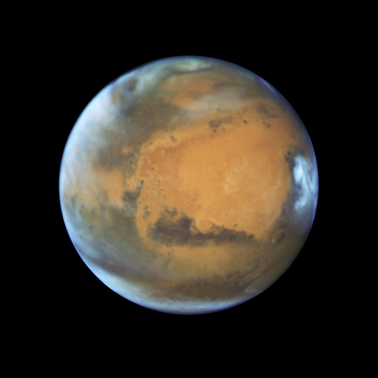
Mars is looking mighty fine in this portrait nabbed by the Hubble Space Telescope on a near close approach! Read more: <a href="http://go.nasa.gov/1rWYiBT" rel="nofollow">go.nasa.gov/1rWYiBT</a> The Hubble Space Telescope is more well known for its picturesque views of nebulae and galaxies, but it's also useful for studying our own planets, including Mars. Hubble imaged Mars on May 12, 2016 - ten days before Mars would be on the exact opposite side of the Earth from the Sun. Bright, frosty polar caps, and clouds above a vivid, rust-colored landscape reveal Mars as a dynamic seasonal planet in this NASA Hubble Space Telescope view taken on May 12, 2016, when Mars was 50 million miles from Earth. The Hubble image reveals details as small as 20 to 30 miles across. The large, dark region at far right is Syrtis Major Planitia, one of the first features identified on the surface of the planet by seventeenth-century observers. Christiaan Huygens used this feature to measure the rotation rate of Mars. (A Martian day is about 24 hours and 37 minutes.) Today we know that Syrtis Major is an ancient, inactive shield volcano. Late-afternoon clouds surround its summit in this view. A large oval feature to the south of Syrtis Major is the bright Hellas Planitia basin. About 1,100 miles across and nearly five miles deep, it was formed about 3.5 billion years ago by an asteroid impact. The orange area in the center of the image is Arabia Terra, a vast upland region in northern Mars that covers about 2,800 miles. The landscape is densely cratered and heavily eroded, indicating that it could be among the oldest terrains on the planet. Dried river canyons (too small to be seen here) wind through the region and empty into the large northern lowlands. Credit: NASA, ESA, the Hubble Heritage Team (STScI/AURA), J. Bell (ASU), and M. Wolff (Space Science Institute) #nasagoddard #mars #hubble #space <b><a href="http://www.nasa.gov/audience/formedia/features/MP_Photo_Guidelines.html" rel="nofollow">NASA image use policy.</a></b> <b><a href="http://www.nasa.gov/centers/goddard/home/index.html" rel="nofollow">NASA Goddard Space Flight Center</a></b> enables NASA’s mission through four scientific endeavors: Earth Science, Heliophysics, Solar System Exploration, and Astrophysics. Goddard plays a leading role in NASA’s accomplishments by contributing compelling scientific knowledge to advance the Agency’s mission. <b>Follow us on <a href="http://twitter.com/NASAGoddardPix" rel="nofollow">Twitter</a></b> <b>Like us on <a href="http://www.facebook.com/pages/Greenbelt-MD/NASA-Goddard/395013845897?ref=tsd" rel="nofollow">Facebook</a></b> <b>Find us on <a href="http://instagrid.me/nasagoddard/?vm=grid" rel="nofollow">Instagram</a></b>
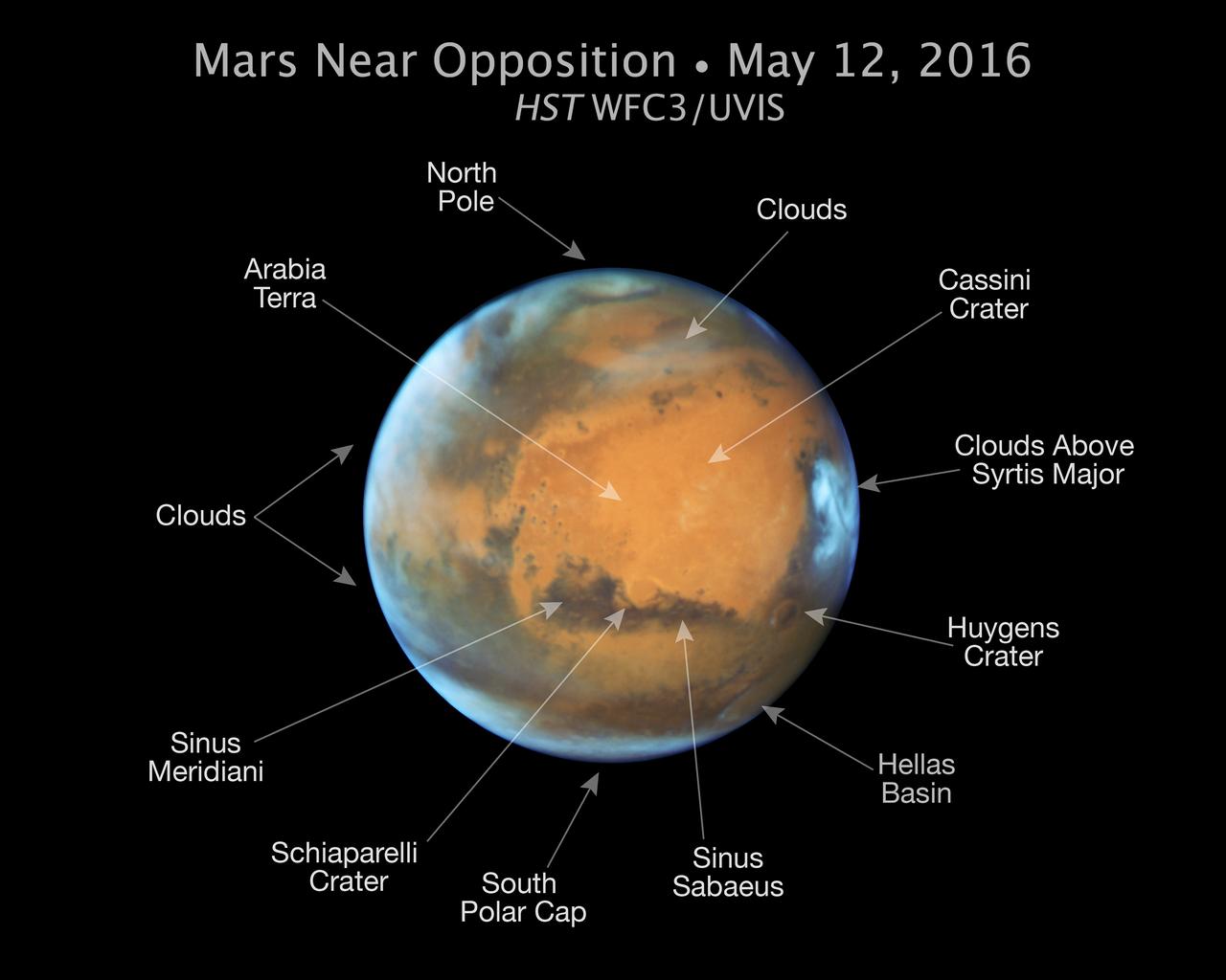
Mars is looking mighty fine in this portrait nabbed by the Hubble Space Telescope on a near close approach! Read more: <a href="http://go.nasa.gov/1rWYiBT" rel="nofollow">go.nasa.gov/1rWYiBT</a> The Hubble Space Telescope is more well known for its picturesque views of nebulae and galaxies, but it's also useful for studying our own planets, including Mars. Hubble imaged Mars on May 12, 2016 - ten days before Mars would be on the exact opposite side of the Earth from the Sun. Bright, frosty polar caps, and clouds above a vivid, rust-colored landscape reveal Mars as a dynamic seasonal planet in this NASA Hubble Space Telescope view taken on May 12, 2016, when Mars was 50 million miles from Earth. The Hubble image reveals details as small as 20 to 30 miles across. The large, dark region at far right is Syrtis Major Planitia, one of the first features identified on the surface of the planet by seventeenth-century observers. Christiaan Huygens used this feature to measure the rotation rate of Mars. (A Martian day is about 24 hours and 37 minutes.) Today we know that Syrtis Major is an ancient, inactive shield volcano. Late-afternoon clouds surround its summit in this view. A large oval feature to the south of Syrtis Major is the bright Hellas Planitia basin. About 1,100 miles across and nearly five miles deep, it was formed about 3.5 billion years ago by an asteroid impact. The orange area in the center of the image is Arabia Terra, a vast upland region in northern Mars that covers about 2,800 miles. The landscape is densely cratered and heavily eroded, indicating that it could be among the oldest terrains on the planet. Dried river canyons (too small to be seen here) wind through the region and empty into the large northern lowlands. Credit: NASA, ESA, the Hubble Heritage Team (STScI/AURA), J. Bell (ASU), and M. Wolff (Space Science Institute) #nasagoddard #mars #hubble #space <b><a href="http://www.nasa.gov/audience/formedia/features/MP_Photo_Guidelines.html" rel="nofollow">NASA image use policy.</a></b> <b><a href="http://www.nasa.gov/centers/goddard/home/index.html" rel="nofollow">NASA Goddard Space Flight Center</a></b> enables NASA’s mission through four scientific endeavors: Earth Science, Heliophysics, Solar System Exploration, and Astrophysics. Goddard plays a leading role in NASA’s accomplishments by contributing compelling scientific knowledge to advance the Agency’s mission. <b>Follow us on <a href="http://twitter.com/NASAGoddardPix" rel="nofollow">Twitter</a></b> <b>Like us on <a href="http://www.facebook.com/pages/Greenbelt-MD/NASA-Goddard/395013845897?ref=tsd" rel="nofollow">Facebook</a></b> <b>Find us on <a href="http://instagrid.me/nasagoddard/?vm=grid" rel="nofollow">Instagram</a></b>

Mars is looking mighty fine in this portrait nabbed by the Hubble Space Telescope on a near close approach! Read more: <a href="http://go.nasa.gov/1rWYiBT" rel="nofollow">go.nasa.gov/1rWYiBT</a> The Hubble Space Telescope is more well known for its picturesque views of nebulae and galaxies, but it's also useful for studying our own planets, including Mars. Hubble imaged Mars on May 12, 2016 - ten days before Mars would be on the exact opposite side of the Earth from the Sun. Bright, frosty polar caps, and clouds above a vivid, rust-colored landscape reveal Mars as a dynamic seasonal planet in this NASA Hubble Space Telescope view taken on May 12, 2016, when Mars was 50 million miles from Earth. The Hubble image reveals details as small as 20 to 30 miles across. The large, dark region at far right is Syrtis Major Planitia, one of the first features identified on the surface of the planet by seventeenth-century observers. Christiaan Huygens used this feature to measure the rotation rate of Mars. (A Martian day is about 24 hours and 37 minutes.) Today we know that Syrtis Major is an ancient, inactive shield volcano. Late-afternoon clouds surround its summit in this view. A large oval feature to the south of Syrtis Major is the bright Hellas Planitia basin. About 1,100 miles across and nearly five miles deep, it was formed about 3.5 billion years ago by an asteroid impact. The orange area in the center of the image is Arabia Terra, a vast upland region in northern Mars that covers about 2,800 miles. The landscape is densely cratered and heavily eroded, indicating that it could be among the oldest terrains on the planet. Dried river canyons (too small to be seen here) wind through the region and empty into the large northern lowlands. Credit: NASA, ESA, the Hubble Heritage Team (STScI/AURA), J. Bell (ASU), and M. Wolff (Space Science Institute) #nasagoddard #mars #hubble #space <b><a href="http://www.nasa.gov/audience/formedia/features/MP_Photo_Guidelines.html" rel="nofollow">NASA image use policy.</a></b> <b><a href="http://www.nasa.gov/centers/goddard/home/index.html" rel="nofollow">NASA Goddard Space Flight Center</a></b> enables NASA’s mission through four scientific endeavors: Earth Science, Heliophysics, Solar System Exploration, and Astrophysics. Goddard plays a leading role in NASA’s accomplishments by contributing compelling scientific knowledge to advance the Agency’s mission. <b>Follow us on <a href="http://twitter.com/NASAGoddardPix" rel="nofollow">Twitter</a></b> <b>Like us on <a href="http://www.facebook.com/pages/Greenbelt-MD/NASA-Goddard/395013845897?ref=tsd" rel="nofollow">Facebook</a></b> <b>Find us on <a href="http://instagrid.me/nasagoddard/?vm=grid" rel="nofollow">Instagram</a></b>
This VIS image is located in Kaiser Crater and shows several regions of sand dunes located on the southern part of the crater floor. The crater floor is visible between the dunes, indicating that there is a limited sand supply creating the dunes. These dunes are composed of basaltic sand that has collected in the bottom of the crater. The topographic depression of the crater forms a sand trap that prevents the sand from escaping. Dune fields are common in the bottoms of craters on Mars and appear as dark splotches that often lean up against the downwind walls of the craters. Dunes are useful for studying both the geology and meteorology of Mars. The sand forms by erosion of larger rocks, but it is unclear when and where this erosion took place on Mars or how such large volumes of sand could be formed. Local winds continue to move the sand dunes across the crater floor. There are two sides to a dune, the low angle slope of the windward face and the high angle slope of the leeward side. The steep side is called the slip face. Wind blows sand grains up the low angle slope of the dunes which then "fall down" the slip face. In this way the whole dune moves towards the slip face. The winds blow from the windward to the leeward side of the dunes. In this image the slip faces are on the left side of the dune, so the dunes are slowly moving to the left side of this image. Kaiser Crater is 207km in diameter (129 miles) and is located in Noachis Terra west of Hellas Planitia. Orbit Number: 92902 Latitude: -47.3127 Longitude: 19.2697 Instrument: VIS Captured: 2022-11-23 20:18 https://photojournal.jpl.nasa.gov/catalog/PIA25802
This VIS image of Kaiser Crater shows a region of the dunes with varied appearances. The different dune forms developed due to different amounts of available sand, different wind directions, and the texture of the crater floor. Dune size, shape, and spacing is controlled by a variety of factors. Note the dune that fills half of the crater in the center of the image. Kaiser Crater is located in the southern hemisphere in the Noachis region west of Hellas Planitia. Kaiser Crater is just one of several large craters with extensive dune fields on the crater floor. Other nearby dune filled craters are Proctor, Russell, and Rabe. Kaiser Crater is 207 km (129 miles) in diameter. The dunes are located in the southern part of the crater floor. The Odyssey spacecraft has spent over 15 years in orbit around Mars, circling the planet more than 71000 times. It holds the record for longest working spacecraft at Mars. THEMIS, the IR/VIS camera system, has collected data for the entire mission and provides images covering all seasons and lighting conditions. Over the years many features of interest have received repeated imaging, building up a suite of images covering the entire feature. From the deepest chasma to the tallest volcano, individual dunes inside craters and dune fields that encircle the north pole, channels carved by water and lava, and a variety of other feature, THEMIS has imaged them all. For the next several months the image of the day will focus on the Tharsis volcanoes, the various chasmata of Valles Marineris, and the major dunes fields. We hope you enjoy these images! Orbit Number: 14953 Latitude: -46.7919 Longitude: 18.4314 Instrument: VIS Captured: 2005-04-28 12:59 https://photojournal.jpl.nasa.gov/catalog/PIA22175
This VIS image of the floor of Kaiser Crater contains a large variety of sand dune shapes and sizes. The "whiter" material is the hard crater floor surface. Kaiser Crater is located in the southern hemisphere in the Noachis region west of Hellas Planitia. Kaiser Crater is just one of several large craters with extensive dune fields on the crater floor. Other nearby dune filled craters are Proctor, Russell, and Rabe. Kaiser Crater is 207 km (129 miles) in diameter. The dunes are located in the southern part of the crater floor. The Odyssey spacecraft has spent over 15 years in orbit around Mars, circling the planet more than 71,000 times. It holds the record for longest working spacecraft at Mars. THEMIS, the IR/VIS camera system, has collected data for the entire mission and provides images covering all seasons and lighting conditions. Over the years many features of interest have received repeated imaging, building up a suite of images covering the entire feature. From the deepest chasma to the tallest volcano, individual dunes inside craters and dune fields that encircle the north pole, channels carved by water and lava, and a variety of other feature, THEMIS has imaged them all. For the next several months the image of the day will focus on the Tharsis volcanoes, the various chasmata of Valles Marineris, and the major dunes fields. We hope you enjoy these images! Orbit Number: 35430 Latitude: -46.8699 Longitude: 19.4731 Instrument: VIS Captured: 2009-12-09 14:09 https://photojournal.jpl.nasa.gov/catalog/PIA22263
This VIS image of Kaiser Crater shows a region of the dunes with varied appearances. The different dune forms developed due to different amounts of available sand, different wind directions, and the texture of the crater floor. The dune forms change from the bottom to the top of the image - large long connected dunes, to large individual dunes, to the very small individual dunes at the top of the image. Kaiser Crater is located in the southern hemisphere in the Noachis region west of Hellas Planitia. Kaiser Crater is just one of several large craters with extensive dune fields on the crater floor. Other nearby dune filled craters are Proctor, Russell, and Rabe. Kaiser Crater is 207 km (129 miles) in diameter. The dunes are located in the southern part of the crater floor. The Odyssey spacecraft has spent over 15 years in orbit around Mars, circling the planet more than 71,000 times. It holds the record for longest working spacecraft at Mars. THEMIS, the IR/VIS camera system, has collected data for the entire mission and provides images covering all seasons and lighting conditions. Over the years many features of interest have received repeated imaging, building up a suite of images covering the entire feature. From the deepest chasma to the tallest volcano, individual dunes inside craters and dune fields that encircle the north pole, channels carved by water and lava, and a variety of other feature, THEMIS has imaged them all. For the next several months the image of the day will focus on the Tharsis volcanoes, the various chasmata of Valles Marineris, and the major dunes fields. We hope you enjoy these images! Orbit Number: 17686 Latitude: -46.6956 Longitude: 19.8394 Instrument: VIS Captured: 2005-12-09 13:25 https://photojournal.jpl.nasa.gov/catalog/PIA22261

This is a false color image of Kaiser Crater. In this combination of filters "blue" typically means basaltic sand. This VIS image crosses 3/4 of the crater and demonstrates how extensive the dunes are on the floor of Kaiser Crater. Kaiser Crater is located in the southern hemisphere in the Noachis region west of Hellas Planitia. Kaiser Crater is just one of several large craters with extensive dune fields on the crater floor. Other nearby dune filled craters are Proctor, Russell, and Rabe. Kaiser Crater is 207 km (129 miles) in diameter. The dunes are located in the southern part of the crater floor. The THEMIS VIS camera contains 5 filters. The data from different filters can be combined in multiple ways to create a false color image. These false color images may reveal subtle variations of the surface not easily identified in a single band image. The Odyssey spacecraft has spent over 15 years in orbit around Mars, circling the planet more than 71,000 times. It holds the record for longest working spacecraft at Mars. THEMIS, the IR/VIS camera system, has collected data for the entire mission and provides images covering all seasons and lighting conditions. Over the years many features of interest have received repeated imaging, building up a suite of images covering the entire feature. From the deepest chasma to the tallest volcano, individual dunes inside craters and dune fields that encircle the north pole, channels carved by water and lava, and a variety of other feature, THEMIS has imaged them all. For the next several months the image of the day will focus on the Tharsis volcanoes, the various chasmata of Valles Marineris, and the major dunes fields. We hope you enjoy these images! Orbit Number: 66602 Latitude: -47.0551 Longitude: 19.446 Instrument: VIS Captured: 2016-12-18 21:42 https://photojournal.jpl.nasa.gov/catalog/PIA22265
This VIS image of Kaiser Crater shows individual dunes and where the dunes have coalesced into longer dune forms. The addition of sand makes the dunes larger and the intra-dune areas go from sand-free to complete coverage of the hard surface of the crater floor. With a continued influx of sand the region will transition from individual dunes to a sand sheet with surface dune forms. Kaiser Crater is located in the southern hemisphere in the Noachis region west of Hellas Planitia. Kaiser Crater is just one of several large craters with extensive dune fields on the crater floor. Other nearby dune filled craters are Proctor, Russell, and Rabe. Kaiser Crater is 207 km (129 miles) in diameter. The dunes are located in the southern part of the crater floor. The Odyssey spacecraft has spent over 15 years in orbit around Mars, circling the planet more than 69000 times. It holds the record for longest working spacecraft at Mars. THEMIS, the IR/VIS camera system, has collected data for the entire mission and provides images covering all seasons and lighting conditions. Over the years many features of interest have received repeated imaging, building up a suite of images covering the entire feature. From the deepest chasma to the tallest volcano, individual dunes inside craters and dune fields that encircle the north pole, channels carved by water and lava, and a variety of other feature, THEMIS has imaged them all. For the next several months the image of the day will focus on the Tharsis volcanoes, the various chasmata of Valles Marineris, and the major dunes fields. We hope you enjoy these images! Orbit Number: 1423 Latitude: -46.9573 Longitude: 18.6192 Instrument: VIS Captured: 2002-04-10 16:44 https://photojournal.jpl.nasa.gov/catalog/PIA22173
This VIS image is located in Kaiser Crater and shows many individual dunes. This sand dune field is one of several regions of sand dunes located on the southern part of the crater floor. The crater floor is visible between the dunes, indicating that there is a limited sand supply creating the dunes. These dunes are composed of basaltic sand that has collected in the bottom of the crater. The topographic depression of the crater forms a sand trap that prevents the sand from escaping. Dune fields are common in the bottoms of craters on Mars and appear as dark splotches that often lean up against the downwind walls of the craters. Dunes are useful for studying both the geology and meteorology of Mars. The sand forms by erosion of larger rocks, but it is unclear when and where this erosion took place on Mars or how such large volumes of sand could be formed. Local winds continue to move the sand dunes across the crater floor. There are two sides to a dune, the low angle slope of the windward face and the high angle slope of the leeward side. The steep side is called the slip face. Wind blows sand grains up the low angle slope of the dunes which then "fall down" the slip face. In this way the whole dune moves towards the slip face. The winds blow from the windward to the leeward side of the dunes. In this image the slip faces are on the left side of the dune, so the dunes are slowly moving to the left side of this image. Kaiser Crater is 207km in diameter (129 miles) and is located in Noachis Terra west of Hellas Planitia. Orbit Number: 92016 Latitude: -46.8341 Longitude: 19.8564 Instrument: VIS Captured: 2022-09-11 21:26 https://photojournal.jpl.nasa.gov/catalog/PIA25719
This VIS image of Kaiser Crater shows the central part of the crater floor. At the bottom of the image there is a topographic rise. The change in topography has altered the winds in this region, forming a linear pattern at the edge of the high land. Kaiser Crater is located in the southern hemisphere in the Noachis region west of Hellas Planitia. Kaiser Crater is just one of several large craters with extensive dune fields on the crater floor. Other nearby dune filled craters are Proctor, Russell, and Rabe. Kaiser Crater is 207 km (129 miles) in diameter. The dunes are located in the southern part of the crater floor. The Odyssey spacecraft has spent over 15 years in orbit around Mars, circling the planet more than 71000 times. It holds the record for longest working spacecraft at Mars. THEMIS, the IR/VIS camera system, has collected data for the entire mission and provides images covering all seasons and lighting conditions. Over the years many features of interest have received repeated imaging, building up a suite of images covering the entire feature. From the deepest chasma to the tallest volcano, individual dunes inside craters and dune fields that encircle the north pole, channels carved by water and lava, and a variety of other feature, THEMIS has imaged them all. For the next several months the image of the day will focus on the Tharsis volcanoes, the various chasmata of Valles Marineris, and the major dunes fields. We hope you enjoy these images! Orbit Number: 5505 Latitude: -46.2432 Longitude: 19.028 Instrument: VIS Captured: 2003-03-12 17:05 https://photojournal.jpl.nasa.gov/catalog/PIA22174
At the top of this VIS image crescent shaped dunes are visible. As the dunes approach a break in elevation the forms change to connect the crescents together forming long aligned dune forms. Kaiser Crater is located in the southern hemisphere in the Noachis region west of Hellas Planitia. Kaiser Crater is just one of several large craters with extensive dune fields on the crater floor. Other nearby dune filled craters are Proctor, Russell, and Rabe. Kaiser Crater is 207 km (129 miles) in diameter. The dunes are located in the southern part of the crater floor. The Odyssey spacecraft has spent over 15 years in orbit around Mars, circling the planet more than 71,000 times. It holds the record for longest working spacecraft at Mars. THEMIS, the IR/VIS camera system, has collected data for the entire mission and provides images covering all seasons and lighting conditions. Over the years many features of interest have received repeated imaging, building up a suite of images covering the entire feature. From the deepest chasma to the tallest volcano, individual dunes inside craters and dune fields that encircle the north pole, channels carved by water and lava, and a variety of other feature, THEMIS has imaged them all. For the next several months the image of the day will focus on the Tharsis volcanoes, the various chasmata of Valles Marineris, and the major dunes fields. We hope you enjoy these images! Orbit Number: 34157 Latitude: -46.9336 Longitude: 18.9272 Instrument: VIS Captured: 2009-08-26 18:49 https://photojournal.jpl.nasa.gov/catalog/PIA22262
The THEMIS VIS camera contains 5 filters. The data from different filters can be combined in multiple ways to create a false color image. These false color images may reveal subtle variations of the surface not easily identified in a single band image. Today's false color image shows part of the floor of Kaiser Crater. Kaiser Crater is 207 km (129 miles) in diameter and is located in Noachis Terra west of Hellas Planitia. This sand dune field is one of several regions of sand dunes located on the southern part of the crater floor. The image also shows the complex crater floor beneath the dunes. These dunes are composed of basaltic sand that has collected in the bottom of the crater. The topographic depression of the crater forms a sand trap that prevents the sand from escaping. Dune fields are common in the bottoms of craters on Mars and appear as dark splotches that often lean up against the downwind walls of the craters. Dunes are useful for studying both the geology and meteorology of Mars. The sand forms by erosion of larger rocks, but it is unclear when and where this erosion took place on Mars or how such large volumes of sand could be formed. The dunes also indicate the local wind directions by their morphology. The THEMIS VIS camera is capable of capturing color images of the Martian surface using five different color filters. In this mode of operation, the spatial resolution and coverage of the image must be reduced to accommodate the additional data volume produced from using multiple filters. To make a color image, three of the five filter images (each in grayscale) are selected. Each is contrast enhanced and then converted to a red, green, or blue intensity image. These three images are then combined to produce a full color, single image. Because the THEMIS color filters don't span the full range of colors seen by the human eye, a color THEMIS image does not represent true color. Also, because each single-filter image is contrast enhanced before inclusion in the three-color image, the apparent color variation of the scene is exaggerated. Nevertheless, the color variation that does appear is representative of some change in color, however subtle, in the actual scene. Note that the long edges of THEMIS color images typically contain color artifacts that do not represent surface variation. Orbit Number: 90294 Latitude: -46.9314 Longitude: 18.9731 Instrument: VIS Captured: 2022-04-23 02:29 https://photojournal.jpl.nasa.gov/catalog/PIA26058
The THEMIS VIS camera contains 5 filters. The data from different filters can be combined in multiple ways to create a false color image. These false color images may reveal subtle variations of the surface not easily identified in a single band image. Today's false color image shows part of the floor of Kaiser Crater. Kaiser Crater is 207 km (129 miles) in diameter and is located in Noachis Terra west of Hellas Planitia. This sand dune field is one of several regions of sand dunes located on the southern part of the crater floor. The image also shows the complex crater floor beneath the dunes. These dunes are composed of basaltic sand that has collected in the bottom of the crater. The topographic depression of the crater forms a sand trap that prevents the sand from escaping. Dune fields are common in the bottoms of craters on Mars and appear as dark splotches that often lean up against the downwind walls of the craters. Dunes are useful for studying both the geology and meteorology of Mars. The sand forms by erosion of larger rocks, but it is unclear when and where this erosion took place on Mars or how such large volumes of sand could be formed. The dunes also indicate the local wind directions by their morphology. The THEMIS VIS camera is capable of capturing color images of the Martian surface using five different color filters. In this mode of operation, the spatial resolution and coverage of the image must be reduced to accommodate the additional data volume produced from using multiple filters. To make a color image, three of the five filter images (each in grayscale) are selected. Each is contrast enhanced and then converted to a red, green, or blue intensity image. These three images are then combined to produce a full color, single image. Because the THEMIS color filters don't span the full range of colors seen by the human eye, a color THEMIS image does not represent true color. Also, because each single-filter image is contrast enhanced before inclusion in the three-color image, the apparent color variation of the scene is exaggerated. Nevertheless, the color variation that does appear is representative of some change in color, however subtle, in the actual scene. Note that the long edges of THEMIS color images typically contain color artifacts that do not represent surface variation. Orbit Number: 91155 Latitude: -46.9827 Longitude: 19.3481 Instrument: VIS Captured: 2022-07-02 23:58 https://photojournal.jpl.nasa.gov/catalog/PIA26059
The THEMIS VIS camera contains 5 filters. The data from different filters can be combined in multiple ways to create a false color image. These false color images may reveal subtle variations of the surface not easily identified in a single band image. Today's false color image shows part of the floor of Kaiser Crater. Kaiser Crater is 207 km (129 miles) in diameter and is located in Noachis Terra west of Hellas Planitia. This sand dune field is one of several regions of sand dunes located on the southern part of the crater floor. The image also shows the complex crater floor beneath the dunes. These dunes are composed of basaltic sand that has collected in the bottom of the crater. The topographic depression of the crater forms a sand trap that prevents the sand from escaping. Dune fields are common in the bottoms of craters on Mars and appear as dark splotches that often lean up against the downwind walls of the craters. Dunes are useful for studying both the geology and meteorology of Mars. The sand forms by erosion of larger rocks, but it is unclear when and where this erosion took place on Mars or how such large volumes of sand could be formed. The dunes also indicate the local wind directions by their morphology. In this case, there are few clear slipfaces that would indicate the downwind direction. The crests of the dunes also typically run north-south in the image. This dune form indicates that there are probably two prevailing wind directions that run east and west (left to right and right to left). The THEMIS VIS camera is capable of capturing color images of the Martian surface using five different color filters. In this mode of operation, the spatial resolution and coverage of the image must be reduced to accommodate the additional data volume produced from using multiple filters. To make a color image, three of the five filter images (each in grayscale) are selected. Each is contrast enhanced and then converted to a red, green, or blue intensity image. These three images are then combined to produce a full color, single image. Because the THEMIS color filters don't span the full range of colors seen by the human eye, a color THEMIS image does not represent true color. Also, because each single-filter image is contrast enhanced before inclusion in the three-color image, the apparent color variation of the scene is exaggerated. Nevertheless, the color variation that does appear is representative of some change in color, however subtle, in the actual scene. Note that the long edges of THEMIS color images typically contain color artifacts that do not represent surface variation. Orbit Number: 91442 Latitude: -46.9777 Longitude: 19.5189 Instrument: VIS Captured: 2022-07-26 15:07 https://photojournal.jpl.nasa.gov/catalog/PIA26060