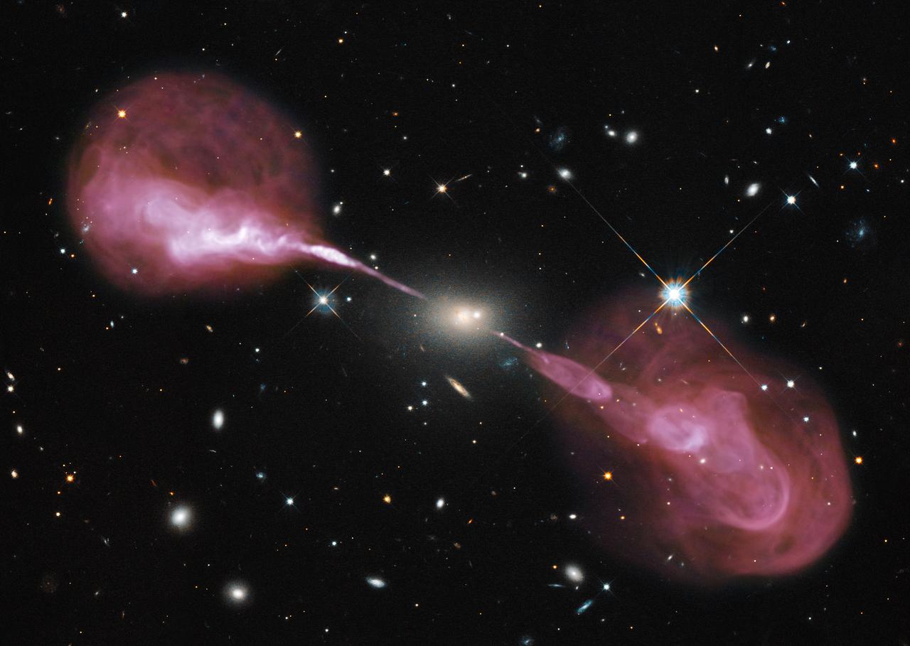
Spectacular jets powered by the gravitational energy of a super massive black hole in the core of the elliptical galaxy Hercules A illustrate the combined imaging power of two of astronomy's cutting-edge tools, the Hubble Space Telescope's Wide Field Camera 3, and the recently upgraded Karl G. Jansky Very Large Array (VLA) radio telescope in New Mexico. <b>To view a video of this go to: <a href="http://bit.ly/Ue2ypS" rel="nofollow">bit.ly/Ue2ypS</a> </b> Some two billion light-years away, the yellowish elliptical galaxy in the center of the image appears quite ordinary as seen by Hubble in visible wavelengths of light. The galaxy is roughly 1,000 times more massive than the Milky Way and harbors a 2.5-billion-solar-mass central black hole that is 1,000 times more massive than the black hole in the Milky Way. But the innocuous-looking galaxy, also known as 3C 348, has long been known as the brightest radio-emitting object in the constellation Hercules. Emitting nearly a billion times more power in radio wavelengths than our Sun, the galaxy is one of the brightest extragalactic radio sources in the entire sky. Credit: NASA, ESA, S. Baum and C. O'Dea (RIT), R. Perley and W. Cotton (NRAO/AUI/NSF), and the Hubble Heritage Team (STScI/AURA) To read more about this image go to: <a href="http://1.usa.gov/Yu7uvX" rel="nofollow">1.usa.gov/Yu7uvX</a> <b><a href="http://www.nasa.gov/audience/formedia/features/MP_Photo_Guidelines.html" rel="nofollow">NASA image use policy.</a></b> <b><a href="http://www.nasa.gov/centers/goddard/home/index.html" rel="nofollow">NASA Goddard Space Flight Center</a></b> enables NASA’s mission through four scientific endeavors: Earth Science, Heliophysics, Solar System Exploration, and Astrophysics. Goddard plays a leading role in NASA’s accomplishments by contributing compelling scientific knowledge to advance the Agency’s mission. <b>Follow us on <a href="http://twitter.com/NASA_GoddardPix" rel="nofollow">Twitter</a></b> <b>Like us on <a href="http://www.facebook.com/pages/Greenbelt-MD/NASA-Goddard/395013845897?ref=tsd" rel="nofollow">Facebook</a></b> <b>Find us on <a href="http://instagram.com/nasagoddard?vm=grid" rel="nofollow">Instagram</a></b>
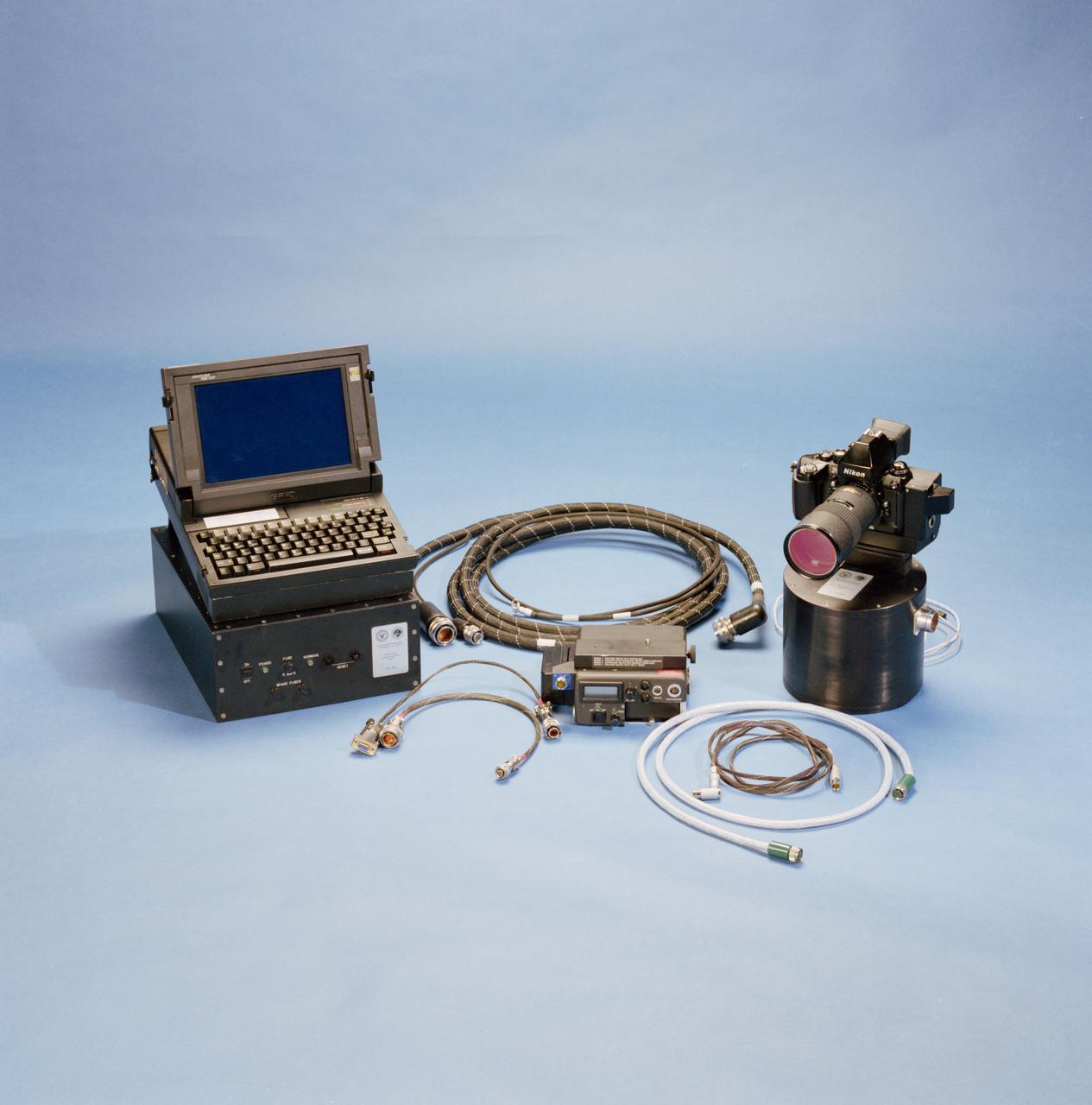
STS-53 Discovery, Orbiter Vehicle (OV) 103, Department of Defense (DOD) mission Hand-held Earth-oriented Real-time Cooperative, User-friendly, Location, targeting, and Environmental System (Hercules) spaceborne experiment equipment is documented in this table top view. HERCULES is a joint NAVY-NASA-ARMY payload designed to provide real-time high resolution digital electronic imagery and geolocation (latitude and longitude determination) of earth surface targets of interest. HERCULES system consists of (from left to right): a specially modified GRID Systems portable computer mounted atop NASA developed Playback-Downlink Unit (PDU) and the Naval Research Laboratory (NRL) developed HERCULES Attitude Processor (HAP); the NASA-developed Electronic Still Camera (ESC) Electronics Box (ESCEB) including removable imagery data storage disks and various connecting cables; the ESC (a NASA modified Nikon F-4 camera) mounted atop the NRL HERCULES Inertial Measurement Unit (HIMU) containing the three-axis ring-laser gyro.
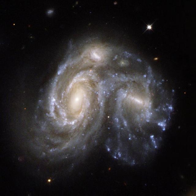
NGC 6050/IC 1179 Arp 272 is a remarkable collision between two spiral galaxies, NGC 6050 and IC 1179, and is part of the Hercules Galaxy Cluster, located in the constellation of Hercules. This image is from NASA Hubble Space Telescope.
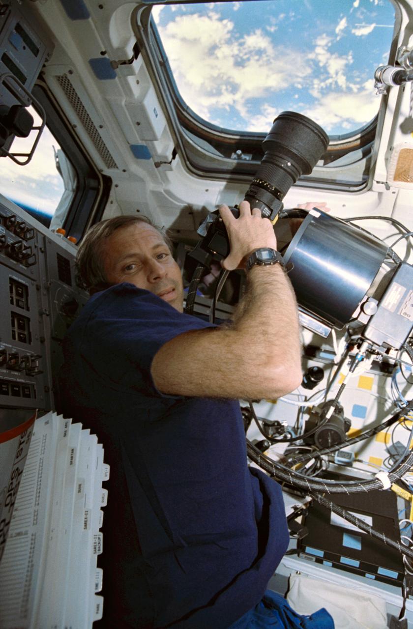
STS056-08-018 (8-17 April 1993) --- Aboard Discovery, astronaut Kenneth D. Cockrell, mission specialist, records Earth imagery with the Hand-Held, Earth-Oriented, Real-Time, Cooperative, User-Friendly, Location-Targeting and Environmental System (HERCULES). HERCULES is a device that makes it simple for Shuttle crew members to take pictures of Earth, as they merely point a modified 35mm camera and shoot any interesting feature, whose latitude and longitude are automatically determined in real-time. The powder-box shaped attachment is the Inertial Measurement Unit (IMU) for the system. The STS-56 crew downlinked a number of the still images during the flight, while others are likely to be stored on disc and returned to Earth with the crew.
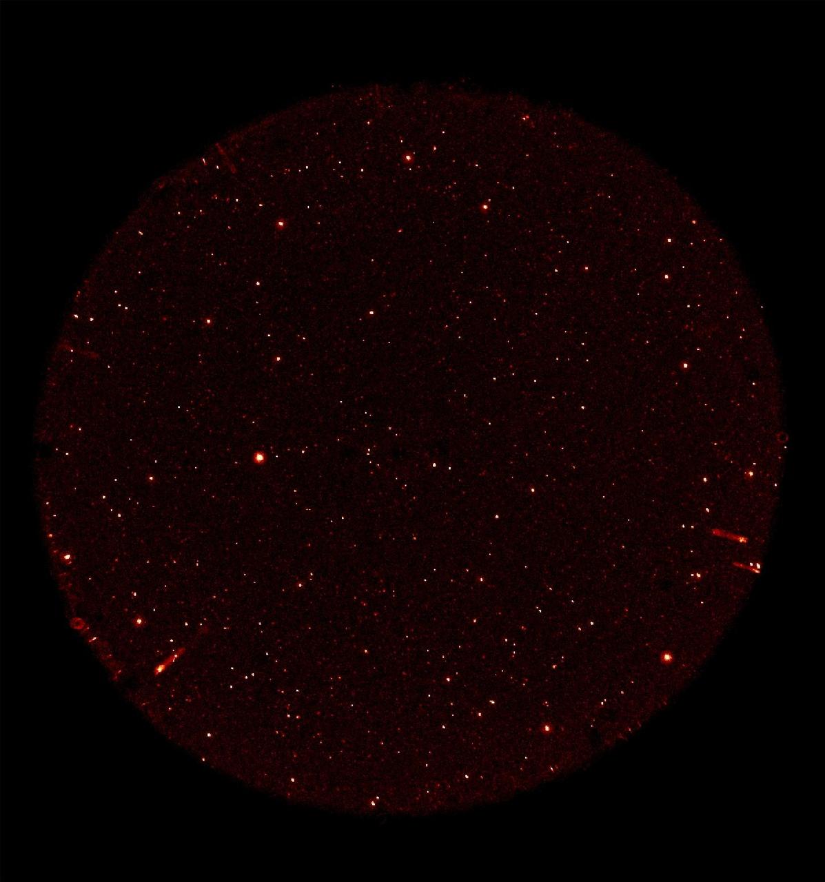
This image was taken on May 21 and 22, 2003, by NASA Galaxy Evolution Explorer. The image was made from data gathered during the missions first light milestone, and shows celestial objects in the constellation Hercules.

This compilation shows the constellation Hercules, as imaged on May 21 and 22, 2003, by NASA Galaxy Evolution Explorer. The images were captured by the two channels of the spacecraft camera during the mission first light milestone.

NASA and Boeing teams pose for a group photo as a USAF HC-130J Hercules aircraft from the 79th rescue squadron flys over the Boeing CST-100 Starliner spacecraft after Starliner landed at White Sands Missile Range’s Space Harbor, Wednesday, May 25, 2022, in New Mexico. The United States Air Force, NASA, and Boeing conducted a Line of Sight (LOS) communications test to access the strength and intelligibility of LOS communications between the just flown Starliner and the Hercules aircraft. Boeing’s Orbital Flight Test-2 (OFT-2) is Starliner’s second uncrewed flight test to the International Space Station as part of NASA's Commercial Crew Program. OFT-2 serves as an end-to-end test of the system's capabilities. Photo Credit: (NASA/Bill Ingalls)
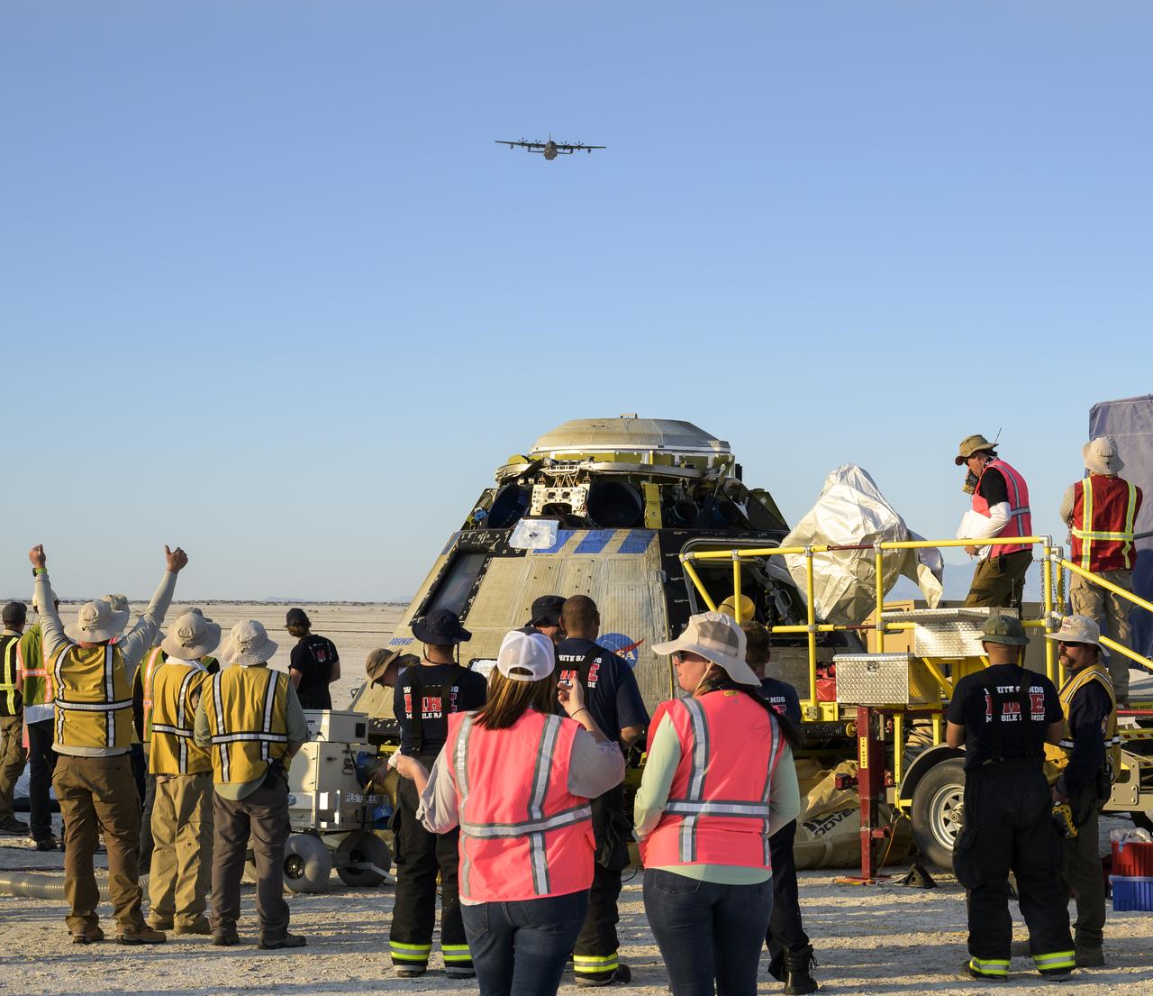
A USAF HC-130J Hercules aircraft from the 79th rescue squadron flys over the Boeing CST-100 Starliner spacecraft as a Line of Sight (LOS) communications test is conducted between the two shortly after Starliner landed at White Sands Missile Range’s Space Harbor, Wednesday, May 25, 2022, in New Mexico. Boeing’s Orbital Flight Test-2 (OFT-2) is Starliner’s second uncrewed flight test to the International Space Station as part of NASA's Commercial Crew Program. OFT-2 serves as an end-to-end test of the system's capabilities. Photo Credit: (NASA/Bill Ingalls)
NASA's Galaxy Evolution Explorer took this image on May 21 and 22, 2003. The image was made from data gathered by the two channels of the spacecraft camera during the mission's "first light" milestone. It shows about 100 celestial objects in the constellation Hercules. The reddish objects represent those detected by the camera's near ultraviolet channel over a 5-minute period, while bluish objects were detected over a 3-minute period by the camera's far ultraviolet channel. The Galaxy Evolution Explorer's first light images are dedicated to the crew of the Space Shuttle Columbia. The Hercules region was directly above Columbia when it made its last contact with NASA Mission Control on February 1, over the skies of Texas. The Galaxy Evolution Explorer launched on April 28 on a mission to map the celestial sky in the ultraviolet and determine the history of star formation in the universe over the last 10 billion years. http://photojournal.jpl.nasa.gov/catalog/PIA04281

In this photo, Director of the US Army Ballistic Missile Agency (ABMA) Development Operations Division, Dr. Wernher von Braun, is standing before a display of Army missiles celebrating ABMA's Fourth Open House. The missiles in the background include (left to right) a satellite on a Juno II shroud with a Nike Ajax pointing left in front of a Jupiter missile. The Lacrosse is in front of the Juno II. The Nike Hercules points skyward in front of the Juno II and the Redstone.
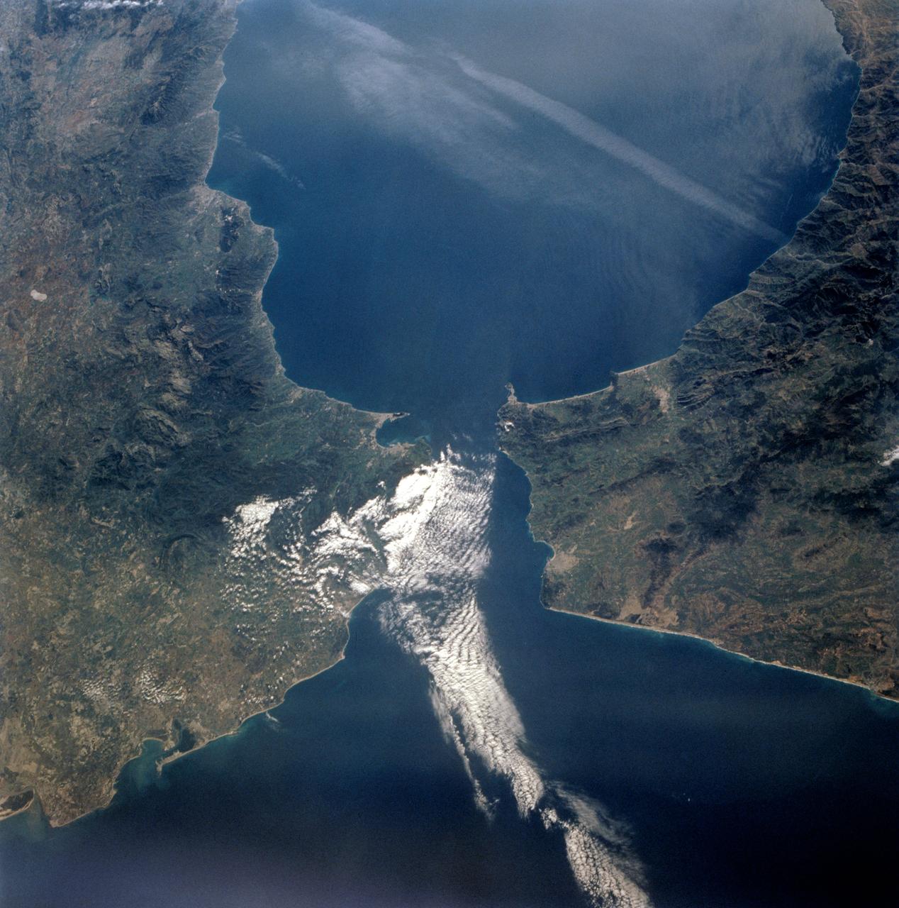
STS-56 Earth observation taken aboard Discovery, Orbiter Vehicle (OV) 103, is of the Strait of Gibraltar. A small bank of clouds marks the passage between Spain and Morocco at the western edge of the Mediterranean Sea. This passage, one of the two Pilars of Hercules of the Ancient Greeks, is now known as the Strait of Gibraltar. The cities of Cadiz on the Atlantic Coast of Spain and Malaga on the Mediterranean coast, as well as Tangier, Morocco (facing the strait), can be seen. According to NASA scientists studying the STS-56 photos, a subtle difference in the water color on the Atlantic side suggests that a pulse of surface water had recently flowed out of the Mediterranean into the Atlantic.
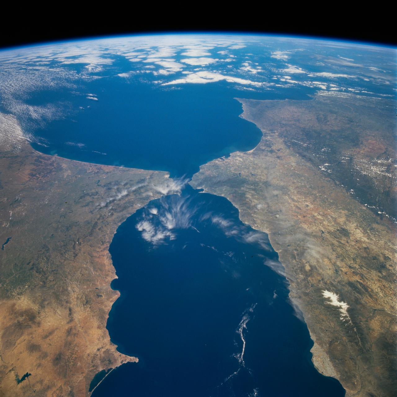
STS077-718-088 (19-29 May 1996) --- A popular photographic target of Space Shuttle astronauts has always been the Strait of Gibraltar seen at center in this wide photograph, shot from the Space Shuttle Endeavour. Spain is to the north (right) and Morocco to the south. The strait is 36 miles (58 kilometers) long and narrows to 8 miles (13 kilometers) at it’s most narrow point. The winds in the strait are either easterly or westerly. The British colony of Gibraltar is the semi-circular feature north of the strait. Gibraltar is considered to be one of the Pillars of Hercules. The white colored area to the southeast of Gibraltar on the Moroccan coast is the city of Tanger (Tangier). The snow covered mountains in Spain are the Sistemas Penibeticos.
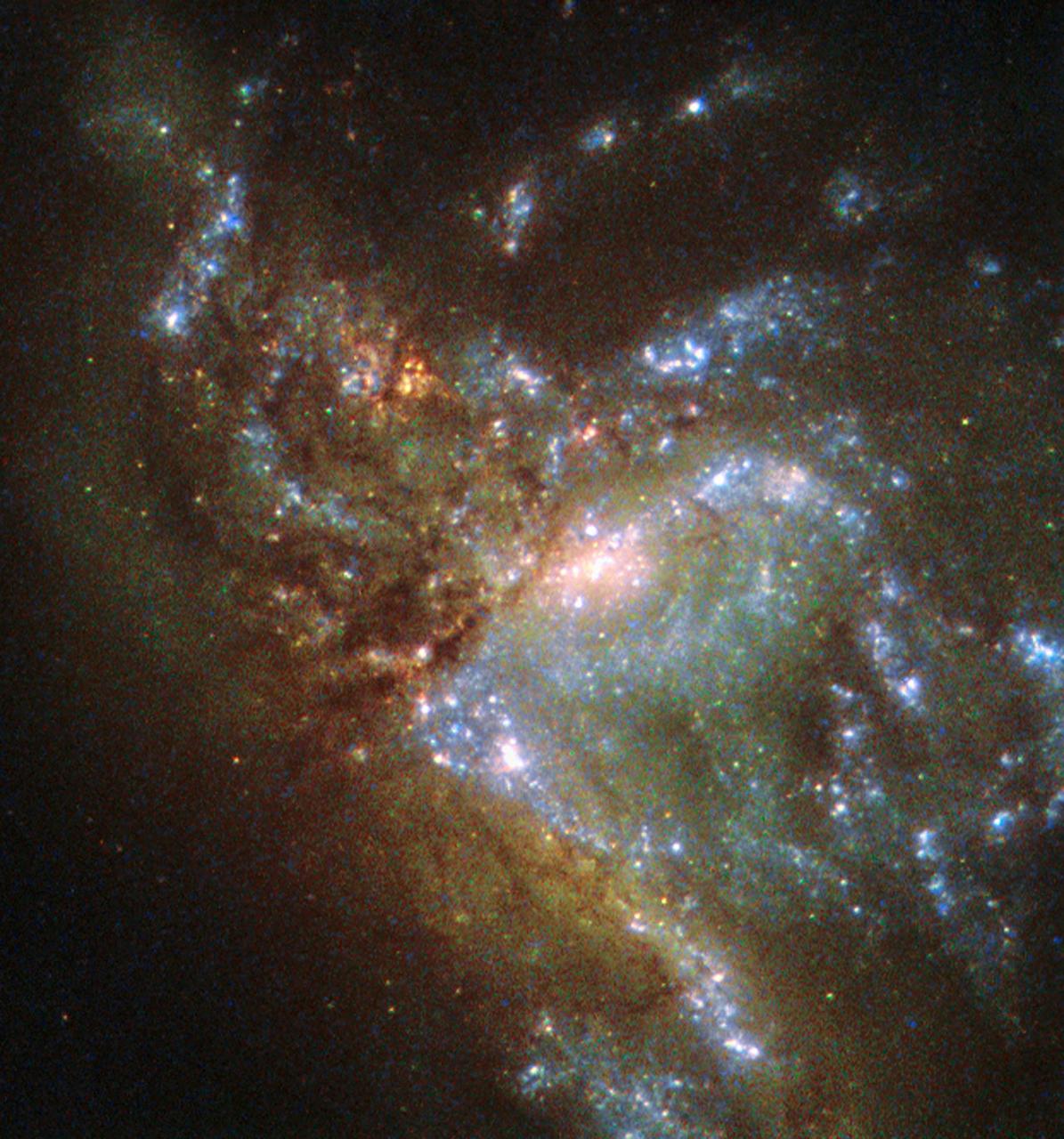
This image, taken with the Wide Field Planetary Camera 2 on board the NASA/ESA Hubble Space Telescope, shows the galaxy NGC 6052, located around 230 million light-years away in the constellation of Hercules. It would be reasonable to think of this as a single abnormal galaxy, and it was originally classified as such. However, it is in fact a “new” galaxy in the process of forming. Two separate galaxies have been gradually drawn together, attracted by gravity, and have collided. We now see them merging into a single structure. As the merging process continues, individual stars are thrown out of their original orbits and placed onto entirely new paths, some very distant from the region of the collision itself. Since the stars produce the light we see, the “galaxy” now appears to have a highly chaotic shape. Eventually, this new galaxy will settle down into a stable shape, which may not resemble either of the two original galaxies.
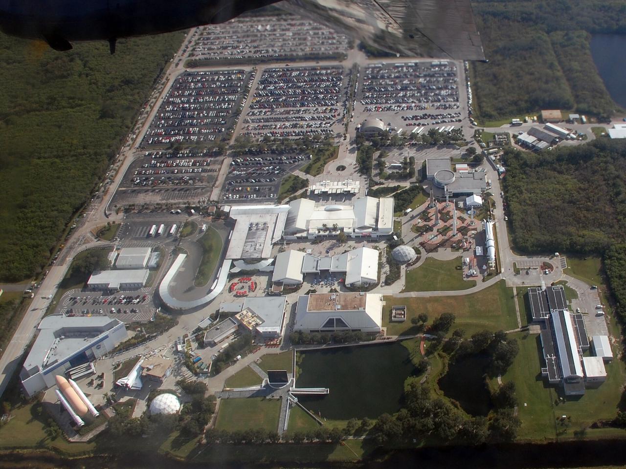
CAPE CANAVERAL, Fla. – During a flight aboard the U.S. Navy Blue Angel's support aircraft, a C-130T Hercules known as "Fat Albert," the photographer was able to capture the entire Kennedy Space Center Visitor Complex. Well-known structures are the genuine, full-size solid rocket boosters and external tank at left, Astronaut Memorial Mirror at center in the foreground, and the Rocket Garden at center right. The Blue Angels performed during the Kennedy Space Center Visitor Complex Space and Air Show held Nov. 8-9. This year’s show brought together the best in military aircraft, such as the F/A-18 Super Hornet and F-16 Fighting Falcon, coupled with precision pilots and veteran astronauts to celebrate spaceflight and aviation. The event included a water rescue demonstration by the 920th Rescue Wing. Photo credit: NASA/Ben Smegelsky
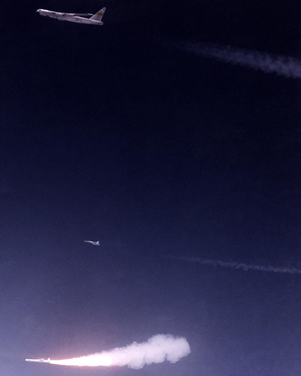
Against the midnight blue of a high-altitude sky, Orbital Sciences’ Pegasus winged rocket booster ignites after being dropped from NASA’s B-52 mothership on a July 1991 flight. A NASA chase plane for the flight is also visible above the rocket and below the B-52.
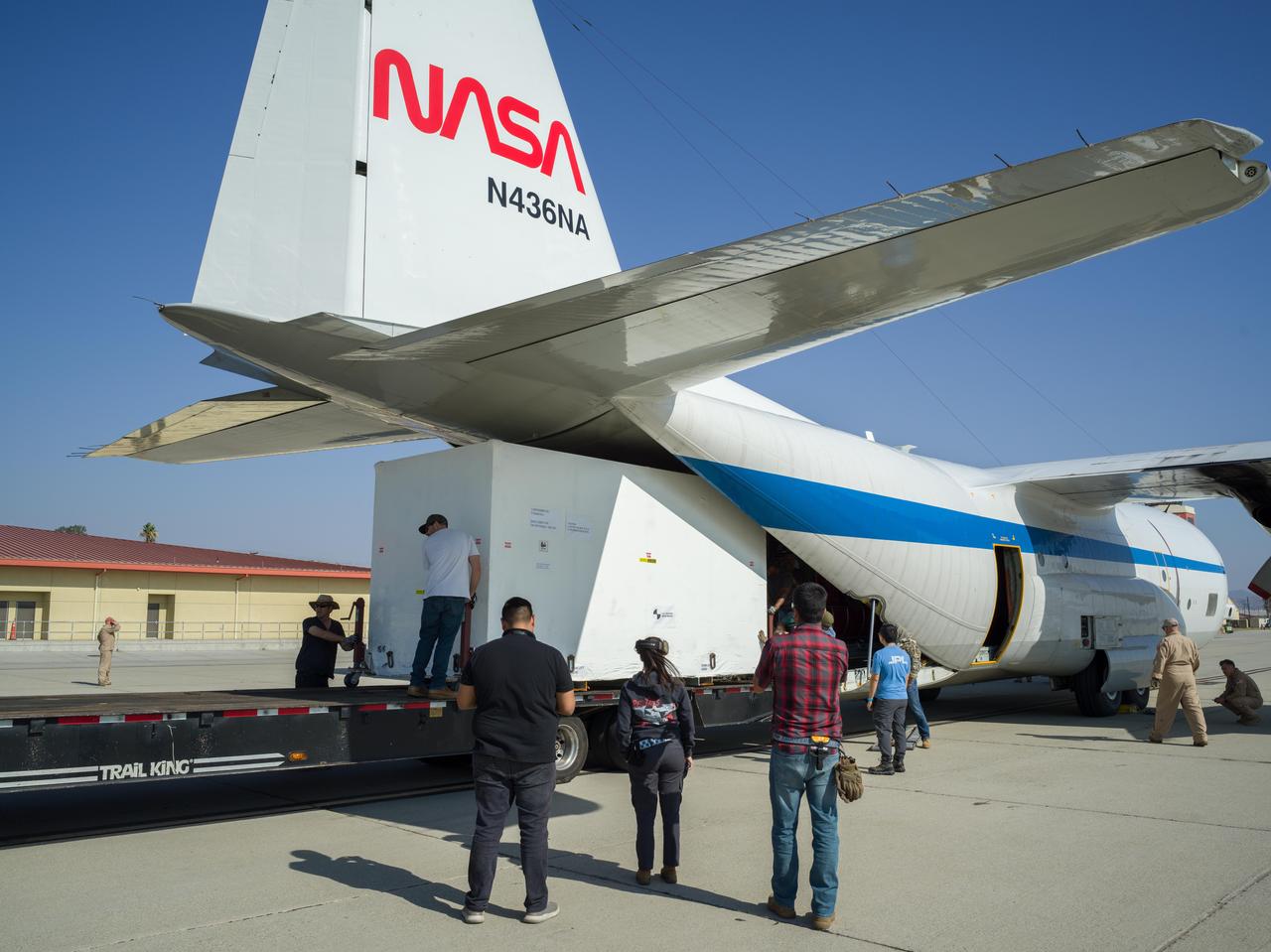
Crews at March Air Reserve Base in Riverside County, California, on Oct. 15, 2024, load a specialized shipping container carrying the NISAR (NASA ISRO Synthetic Aperture Radar) mission's radar antenna reflector into the hold of NASA's C-130 Hercules plane. The aircraft later departed on a multistage journey to Bengaluru, India, arriving on Oct. 22. A key piece of science hardware for the mission, which is a joint effort of NASA and the Indian Space Research Organisation, the reflector had been undergoing work at a specialized facility in California. Engineers there applied reflective tape and took other precautionary measures to mitigate temperature increases that could potentially have affected the deployment of the reflector from its stowed configuration. Drum-shaped and about 39 feet (12 meters) across, the reflector is among NASA's contributions to the mission. The reflector is designed to transmit and receive microwave signals to and from Earth's surface, enabling NISAR to scan nearly all the planet's land and ice surfaces twice every 12 days to collect science data. Once NISAR is in operation, its observations will benefit humanity by helping researchers around the world better understand changes in the planet's surface, including its ice sheets, glaciers, and sea ice. The spacecraft will also capture changes in forest and wetland ecosystems as well as movement and deformation of our planet's crust. https://photojournal.jpl.nasa.gov/catalog/PIA26419
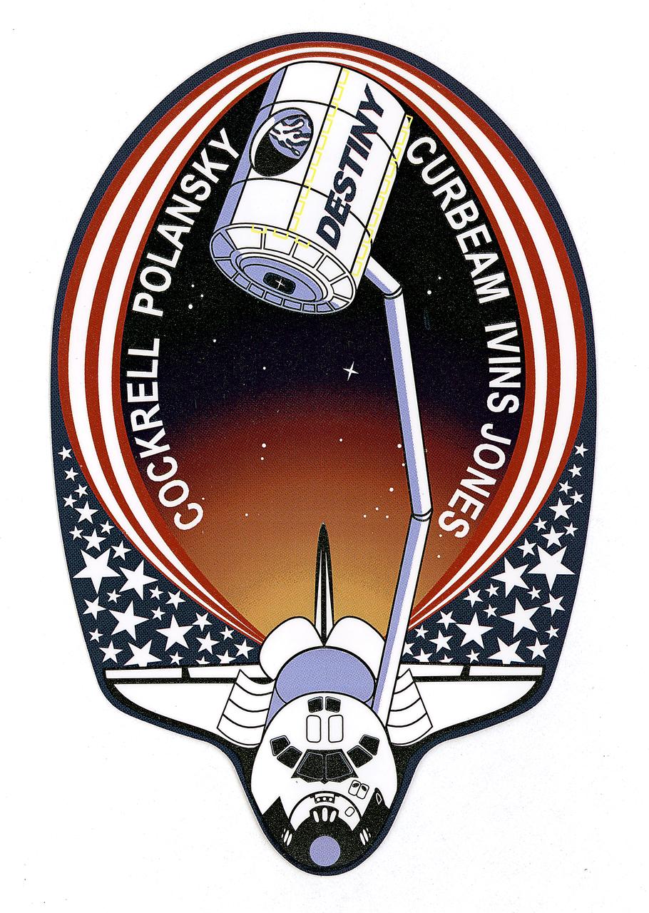
This is the insignia for STS-98, which marks a major milestone in assembly of the International Space Station (ISS). Atlantis' crew delivered the United States Laboratory, Destiny, to the ISS. Destiny will be the centerpiece of the ISS, a weightless laboratory where expedition crews will perform unprecedented research in the life sciences, materials sciences, Earth sciences, and microgravity sciences. The laboratory is also the nerve center of the Station, performing guidance, control, power distribution, and life support functions. With Destiny's arrival, the Station will begin to fulfill its promise of returning the benefits of space research to Earth's citizens. The crew patch depicts the Space Shuttle with Destiny held high above the payload bay just before its attachment to the ISS. Red and white stripes, with a deep blue field of white stars, border the Shuttle and Destiny to symbolize the continuing contribution of the United States to the ISS. The constellation Hercules, seen just below Destiny, captures the Shuttle and Station's team efforts in bringing the promise of orbital scientific research to life. The reflection of Earth in Destiny's window emphasizes the connection between space exploration and life on Earth.

The Strait of Gibraltar separates Spain from Morocco. This image, acquired on July 5, 2000, covers an area 34 kilometers (21 miles) wide and 59 kilometers (37 miles) long in three bands of the reflected visible and infrared wavelength region. The promontory on the eastern side of the conspicuous Spanish port is the Rock of Gibraltar. Once one of the two classical Pillars of Hercules, the Rock was crowned with silver columns by Phoenician mariners to mark the limits of safe navigation for the ancient Mediterranean peoples. The rocky promontory still commands the western entrance to the Mediterranean Sea. The rocky limestone and shale ridge rises abruptly from the sea, to a maximum elevation of 426 meters (1,398 feet). A British colony, Gibraltar occupies a narrow strip of land at the southernmost tip of the Iberian Peninsula. It is separated from the Spanish mainland by a neutral zone contained on a narrow, sandy isthmus. Because of its strategic location and formidable topography, Gibraltar serves mainly as a British fortress. Most of its sparse land is taken up by air and naval installations, and the civilian population is small. http://photojournal.jpl.nasa.gov/catalog/PIA02657

Scientists and crew with NASA’s Operation IceBridge, which makes annual aerial surveys of polar ice, are wrapping up their seventh campaign over the Arctic. In spring 2015, the team began using a different research aircraft—an adapted C-130 Hercules. They also added four new high-priority targets in the rapidly changing region of northeast Greenland. Many of the flights, however, were routine. And that’s exactly the point; making measurements over the same path each year provides continuity between NASA’s Ice, Cloud, and Land Elevation Satellite (ICESat) missions—the first of which ended in 2009 and the second of which is scheduled for launch in 2017. Repeat measurements show how a landscape changes over time. One area that has been surveyed repeatedly is northern Greenland’s Ryder Glacier. This photograph, taken during the IceBridge flight on May 6, 2015, shows a large moulin—dozens of meters across—atop this glacier. Moulins are holes in the ice sheet that drain melt water from the ice sheet’s surface to the bottom or out to the sea. Scientists are working to figure out what happens to melt water once it enters a moulin.
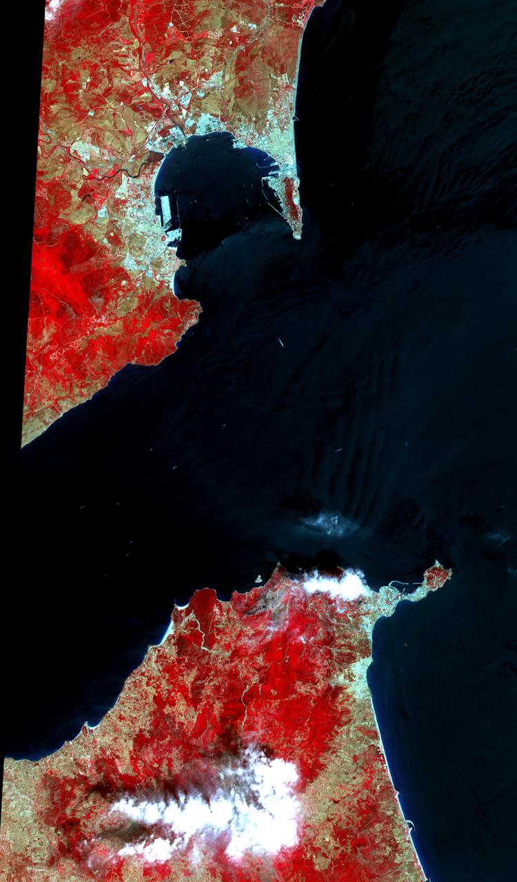
This 34 by 59 km sub-scene, acquired on July 5, 2000, covers the eastern part of the Strait of Gibraltar, separating Spain from Morocco. The promontory on the eastern side of the conspicuous Spanish port is the Rock of Gibraltar. The Rock of Gibraltar was once one of the two classical Pillars of Hercules, crowned with silver columns by Phoenician mariners to mark the limits of safe navigation for the ancient Mediterranean peoples. The rocky promontory still commands the western entrance to the Mediterranean Sea, separated from North Africa only by the narrow Strait of Gibraltar. A British colony, Gibraltar occupies a narrow strip of land at the southernmost tip of the Iberian Peninsula. It is separated from the Spanish mainland by a neutral zone contained on a narrow, sandy isthmus. The rocky limestone and shale ridge known as the Rock rises abruptly from the sea, to a maximum elevation of 426 meters (1,398 feet). Because of its strategic location and formidable topography, Gibraltar serves mainly as a British fortress. The Rock has traditionally been a symbol of British naval strength. Most of its sparse land is taken up by air and naval installations, and the civilian population is small. The image is centered at 36 degrees north latitude, 5.5 degrees west longitude. http://photojournal.jpl.nasa.gov/catalog/PIA11167

This image, taken with the Wide Field Planetary Camera 2 on board the NASA/ESA Hubble Space Telescope, shows the galaxy NGC 6052, located around 230 million light-years away in the constellation of Hercules. It would be reasonable to think of this as a single abnormal galaxy, and it was originally classified as such. However, it is in fact a “new” galaxy in the process of forming. Two separate galaxies have been gradually drawn together, attracted by gravity, and have collided. We now see them merging into a single structure. As the merging process continues, individual stars are thrown out of their original orbits and placed onto entirely new paths, some very distant from the region of the collision itself. Since the stars produce the light we see, the “galaxy” now appears to have a highly chaotic shape. Eventually, this new galaxy will settle down into a stable shape, which may not resemble either of the two original galaxies. Image credit: ESA/Hubble & NASA, Acknowledgement: Judy Schmidt
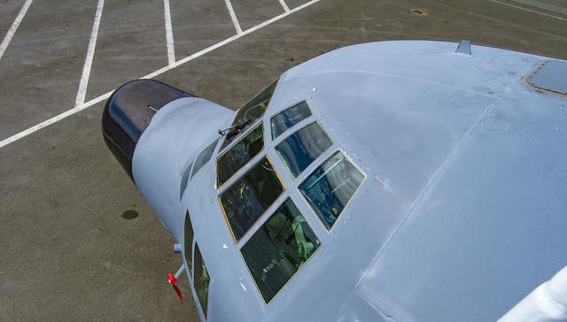
The C130 Hercules sports an unusually large windshield. The view it affords is typically spectacular. --- The <b><a href="http://naames.larc.nasa.gov/" rel="nofollow">North Atlantic Aerosols and Marine Ecosystems Study </a></b> (NAAMES) is a five year investigation to resolve key processes controlling ocean system function, their influences on atmospheric aerosols and clouds and their implications for climate. Michael Starobin joined the NAAMES field campaign on behalf of Earth Expeditions and NASA Goddard Space Flight Center’s Office of Communications. He presented stories about the important, multi-disciplinary research being conducted by the NAAMES team, with an eye towards future missions on the NASA drawing board. This is a NAAMES photo essay put together by Starobin, a collection of 49 photographs and captions. Photo and Caption Credit: Michael Starobin <b><a href="http://www.nasa.gov/audience/formedia/features/MP_Photo_Guidelines.html" rel="nofollow">NASA image use policy</a></b> <b><a href="http://www.nasa.gov/centers/goddard/home/index.html" rel="nofollow">NASA Goddard Space Flight Center</a></b> enables NASA’s mission through four scientific endeavors: Earth Science, Heliophysics, Solar System Exploration, and Astrophysics. Goddard plays a leading role in NASA’s accomplishments by contributing compelling scientific knowledge to advance the Agency’s mission. <b>Follow us on <a href="http://twitter.com/NASAGoddardPix" rel="nofollow">Twitter</a></b> <b>Like us on <a href="http://www.facebook.com/pages/Greenbelt-MD/NASA-Goddard/395013845897?ref=tsd" rel="nofollow">Facebook</a></b> <b>Find us on <a href="https://www.instagram.com/nasagoddard/?hl=en" rel="nofollow">Instagram</a></b>
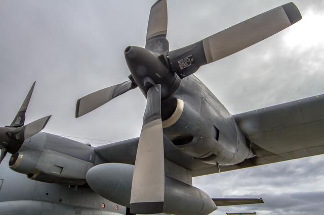
NASA’s C130 Hercules is a four-engine turboprop. This particular plane was built in 1966, but has been extensively retrofitted for scientific use. --- The <b><a href="http://naames.larc.nasa.gov/" rel="nofollow">North Atlantic Aerosols and Marine Ecosystems Study </a></b> (NAAMES) is a five year investigation to resolve key processes controlling ocean system function, their influences on atmospheric aerosols and clouds and their implications for climate. Michael Starobin joined the NAAMES field campaign on behalf of Earth Expeditions and NASA Goddard Space Flight Center’s Office of Communications. He presented stories about the important, multi-disciplinary research being conducted by the NAAMES team, with an eye towards future missions on the NASA drawing board. This is a NAAMES photo essay put together by Starobin, a collection of 49 photographs and captions. Photo and Caption Credit: Michael Starobin <b><a href="http://www.nasa.gov/audience/formedia/features/MP_Photo_Guidelines.html" rel="nofollow">NASA image use policy</a></b> <b><a href="http://www.nasa.gov/centers/goddard/home/index.html" rel="nofollow">NASA Goddard Space Flight Center</a></b> enables NASA’s mission through four scientific endeavors: Earth Science, Heliophysics, Solar System Exploration, and Astrophysics. Goddard plays a leading role in NASA’s accomplishments by contributing compelling scientific knowledge to advance the Agency’s mission. <b>Follow us on <a href="http://twitter.com/NASAGoddardPix" rel="nofollow">Twitter</a></b> <b>Like us on <a href="http://www.facebook.com/pages/Greenbelt-MD/NASA-Goddard/395013845897?ref=tsd" rel="nofollow">Facebook</a></b> <b>Find us on <a href="https://www.instagram.com/nasagoddard/?hl=en" rel="nofollow">Instagram</a></b>
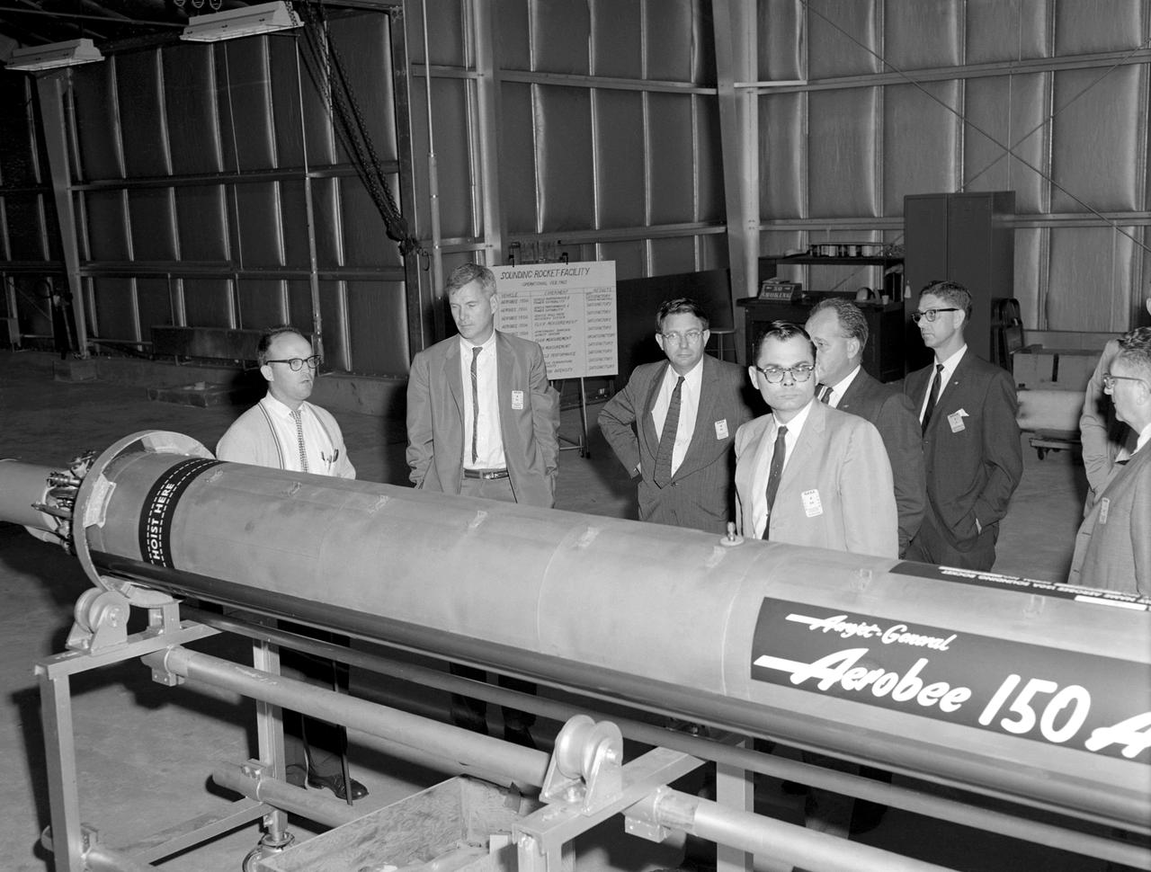
Photographed on 09/22/1960. -- An examination of the Aerojet-General "Aerobee 150A" propulsion system in February 1960. James Hansen described this as follows: "As for the technical definition of the rocket...the Langley engineers tried to keep developmental costs and time to a minimum by selecting components from off-the-shelf hardware. the majority of Scout's components were to come from an inventory of solid-fuel rockets produced for the military, although everyone involved understood that some improved motors would also have to be developed under contract. By early 1959, after intensive technical analysis and reviews, Langley settled on a design and finalized the selection of the major contractors. The rocket's 40-inch-diameter first stage was to be a new "Algol" motor, a combination of the Jupiter Senior and the navy Polaris produced by the Aerojet General Corporation, Sacramento, California. The 31-inch-diameter second stage, "Castor," was derived from the army's Sergeant and was to be manufactured by the Redstone Division of the Thiokol company in Huntsville, Alabama. the motor for the 30-inch-diameter third stage, "Antares," evolved under NASA contract from the ABL X248 design into a new version called the X254 (and subsequently into the X259); it was built under contract to NASA by ABL, a U.S. Navy Bureau of Ordnance facility operated by the Hercules Powder Company, Cumberland, Maryland. the final upper-stage propulsion unit, "Altair," which was 25.7 inches in diameter (34 inches at the heat shield), amounted to an improved edition of the X248 that was also manufactured by ABL." -- Published in James R. Hansen, Spaceflight Revolution: NASA Langley Research Center From Sputnik to Apollo, NASA SP-4308, pp.200-201.
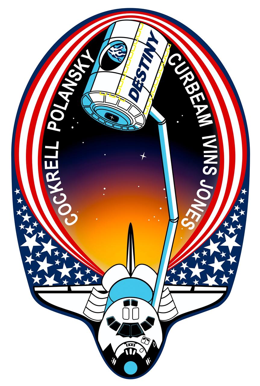
STS098-S-001 (November 2000) --- This is the insignia for STS-98, which marks a major milestone in assembly of the International Space Station (ISS). Atlantis' crew will deliver the United States Laboratory, Destiny, to the ISS. Destiny will be the centerpiece of the ISS, a weightless laboratory where expedition crews will perform unprecedented research in the life sciences, materials sciences, Earth sciences, and microgravity sciences. The laboratory is also the nerve center of the station, performing guidance, control, power distribution, and life support functions. With Destiny's arrival, the station will begin to fulfill its promise of returning the benefits of space research to Earth's citizens. The crew patch depicts the space shuttle with Destiny held high above the payload bay just before its attachment to the ISS. Red and white stripes, with a deep blue field of white stars, border the shuttle and Destiny to symbolize the continuing contribution of the United States to the ISS. The constellation Hercules, seen just below Destiny, captures the shuttle and station's team efforts in bringing the promise of orbital scientific research to life. The reflection of Earth in Destiny's window emphasizes the connection between space exploration and life on Earth. The NASA insignia design for space shuttle flights is reserved for use by the astronauts and for other official use as the NASA Administrator may authorize. Public availability has been approved only in the forms of illustrations by the various news media. When and if there is any change in this policy, which is not anticipated, the change will be publicly announced. Photo credit: NASA
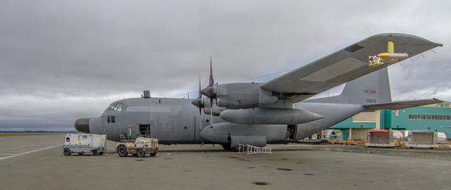
NASA’s C130 Hercules sits facing the runway in St. John’s Canada. That’s the staging area for the airborne part of the NAAMES research campaign. --- The <b><a href="http://naames.larc.nasa.gov/" rel="nofollow">North Atlantic Aerosols and Marine Ecosystems Study </a></b> (NAAMES) is a five year investigation to resolve key processes controlling ocean system function, their influences on atmospheric aerosols and clouds and their implications for climate. Michael Starobin joined the NAAMES field campaign on behalf of Earth Expeditions and NASA Goddard Space Flight Center’s Office of Communications. He presented stories about the important, multi-disciplinary research being conducted by the NAAMES team, with an eye towards future missions on the NASA drawing board. This is a NAAMES photo essay put together by Starobin, a collection of 49 photographs and captions. Photo and Caption Credit: Michael Starobin <b><a href="http://www.nasa.gov/audience/formedia/features/MP_Photo_Guidelines.html" rel="nofollow">NASA image use policy</a></b> <b><a href="http://www.nasa.gov/centers/goddard/home/index.html" rel="nofollow">NASA Goddard Space Flight Center</a></b> enables NASA’s mission through four scientific endeavors: Earth Science, Heliophysics, Solar System Exploration, and Astrophysics. Goddard plays a leading role in NASA’s accomplishments by contributing compelling scientific knowledge to advance the Agency’s mission. <b>Follow us on <a href="http://twitter.com/NASAGoddardPix" rel="nofollow">Twitter</a></b> <b>Like us on <a href="http://www.facebook.com/pages/Greenbelt-MD/NASA-Goddard/395013845897?ref=tsd" rel="nofollow">Facebook</a></b> <b>Find us on <a href="https://www.instagram.com/nasagoddard/?hl=en" rel="nofollow">Instagram</a></b>
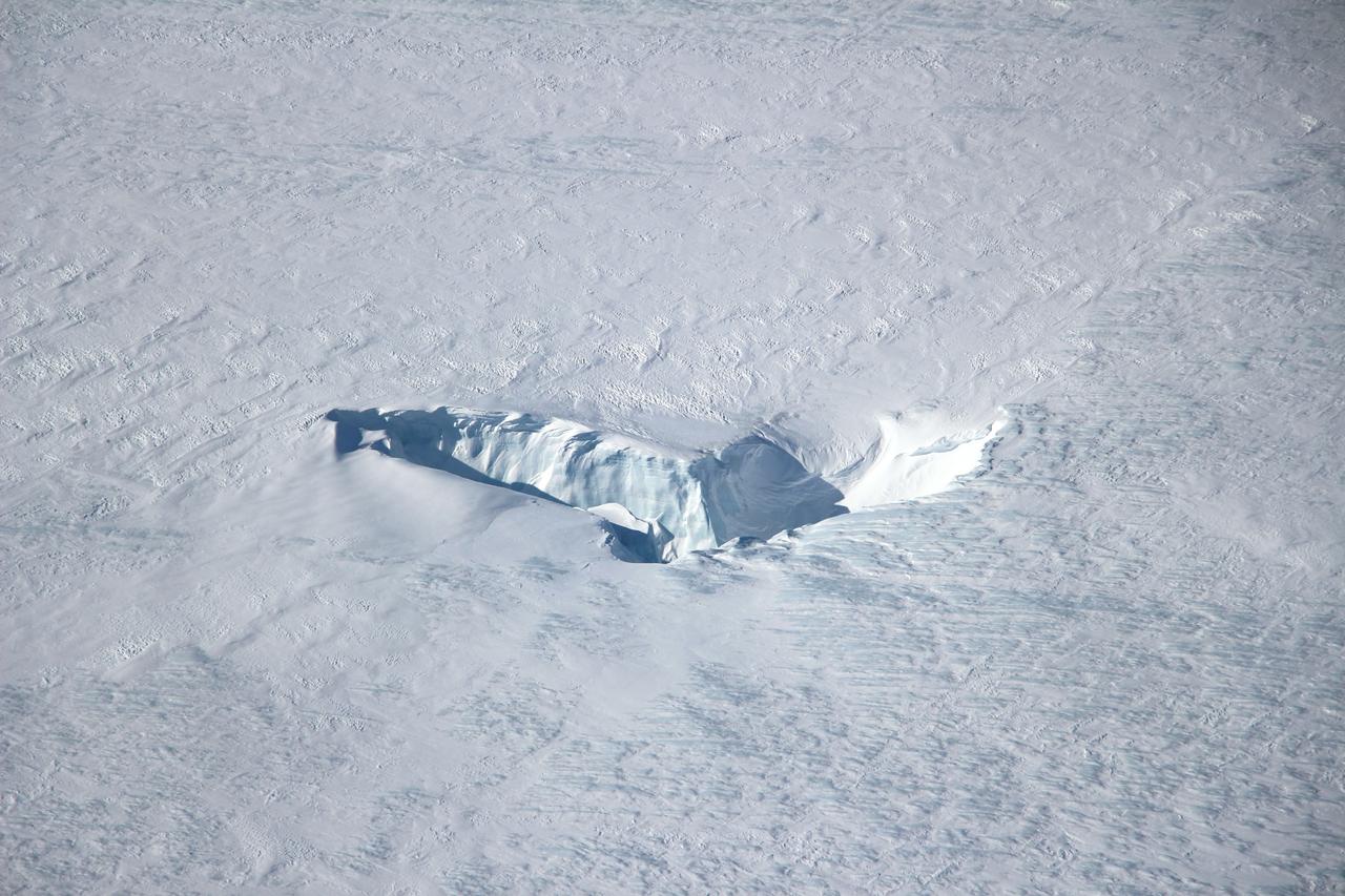
Scientists and crew with NASA’s Operation IceBridge, which makes annual aerial surveys of polar ice, are wrapping up their seventh campaign over the Arctic. In spring 2015, the team began using a different research aircraft—an adapted C-130 Hercules. They also added four new high-priority targets in the rapidly changing region of northeast Greenland. Many of the flights, however, were routine. And that’s exactly the point; making measurements over the same path each year provides continuity between NASA’s Ice, Cloud, and Land Elevation Satellite (ICESat) missions—the first of which ended in 2009 and the second of which is scheduled for launch in 2017. Repeat measurements show how a landscape changes over time. One area that has been surveyed repeatedly is northern Greenland’s Ryder Glacier. This photograph, taken during the IceBridge flight on May 6, 2015, shows a large moulin—dozens of meters across—atop this glacier. Moulins are holes in the ice sheet that drain melt water from the ice sheet’s surface to the bottom or out to the sea. Scientists are working to figure out what happens to melt water once it enters a moulin. Read more: <a href="http://earthobservatory.nasa.gov/IOTD/view.php?id=85858&eocn=home&eoci=iotd_title" rel="nofollow">earthobservatory.nasa.gov/IOTD/view.php?id=85858&eocn...</a> Credit: <b><a href="http://www.earthobservatory.nasa.gov/" rel="nofollow"> NASA Earth Observatory</a></b> <b><a href="http://www.nasa.gov/audience/formedia/features/MP_Photo_Guidelines.html" rel="nofollow">NASA image use policy.</a></b> <b><a href="http://www.nasa.gov/centers/goddard/home/index.html" rel="nofollow">NASA Goddard Space Flight Center</a></b> enables NASA’s mission through four scientific endeavors: Earth Science, Heliophysics, Solar System Exploration, and Astrophysics. Goddard plays a leading role in NASA’s accomplishments by contributing compelling scientific knowledge to advance the Agency’s mission. <b>Follow us on <a href="http://twitter.com/NASAGoddardPix" rel="nofollow">Twitter</a></b> <b>Like us on <a href="http://www.facebook.com/pages/Greenbelt-MD/NASA-Goddard/395013845897?ref=tsd" rel="nofollow">Facebook</a></b> <b>Find us on <a href="http://instagrid.me/nasagoddard/?vm=grid" rel="nofollow">Instagram</a></b>