First HiRISE Image of Mars
First Color HiRISE Image of Mars
The High-Resolution Science Experiment (HiRISE) camera aboard NASA's Mars Reconnaissance Orbiter (MRO) took this image of the Perseverance rover on Feb. 24, 2021. The false-color image shows a ring of blast marks where thrusters from the rover's descent stage blew away dust during landing on Feb. 18, 2021. By rolling MRO to the side (18 degrees for this image) as it passes over Perseverance every few days, the mission team enables HiRISE to see the rover. Perseverance is about 10 feet by 9 feet (3 by 2.7 meters) in size and is about 180 miles (290 kilometers) away from HiRISE in this image. https://photojournal.jpl.nasa.gov/catalog/PIA24427
First HiRISE Image of Mars: Topographic Model from Photoclinometry
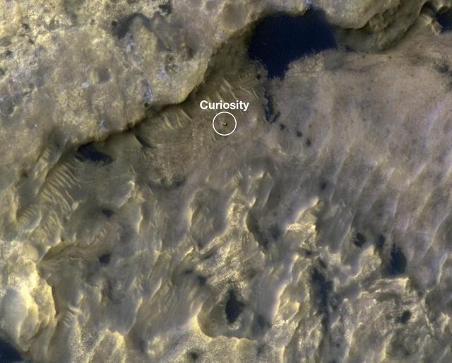
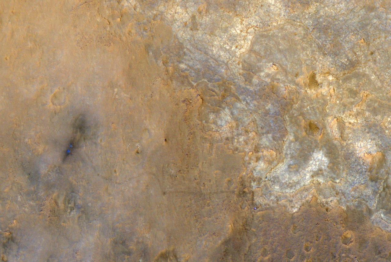
NASA's Curiosity Mars rover appears as a dark speck in this view captured on Feb. 28, 2025, by the High-Resolution Imaging Science Experiment (HiRISE) camera aboard NASA's Mars Reconnaissance Orbiter. At the time this image was taken, Curiosity was driving. It's likely the first time HiRISE has captured the rover while it was in motion. Trailing Curiosity are the rover's tracks, which can linger on the Martian surface for months before being erased by the wind. The tracks are evidence of multiple days of driving as Curiosity made its way to a region full of potential boxwork formations, believed to be the result of ancient groundwater in this region of Mount Sharp, a 3-mile-tall (5-kilometer-tall) mountain Curiosity has been ascending since 2014. When HiRISE takes an image, the majority of the scene is in black-and-white, with a strip of color down the middle. While HiRISE has captured Curiosity in color before, this time the rover happened to fall within the black-and-white part of the image. https://photojournal.jpl.nasa.gov/catalog/PIA26553
![This image from NASA's Mars Reconnaissance Orbiter (MRO) shows Mars' surface in detail. Mars has captured the imagination of astronomers for thousands of years, but it wasn't until the last half a century that we were able to capture images of its surface in detail. This particular site on Mars was first imaged in 1965 by the Mariner 4 spacecraft during the first successful fly-by mission to Mars. From an altitude of around 10,000 kilometers, this image (the ninth frame taken) achieved a resolution of approximately 1.25 kilometers per pixel. Since then, this location has been observed by six other visible cameras producing images with varying resolutions and sizes. This includes HiRISE (highlighted in yellow), which is the highest-resolution and has the smallest "footprint." This compilation, spanning Mariner 4 to HiRISE, shows each image at full-resolution. Beginning with Viking 1 and ending with our HiRISE image, this animation documents the historic imaging of a particular site on another world. In 1976, the Viking 1 orbiter began imaging Mars in unprecedented detail, and by 1980 had successfully mosaicked the planet at approximately 230 meters per pixel. In 1999, the Mars Orbiter Camera onboard the Mars Global Surveyor (1996) also imaged this site with its Wide Angle lens, at around 236 meters per pixel. This was followed by the Thermal Emission Imaging System on Mars Odyssey (2001), which also provided a visible camera producing the image we see here at 17 meters per pixel. Later in 2012, the High-Resolution Stereo Camera on the Mars Express orbiter (2003) captured this image of the surface at 25 meters per pixel. In 2010, the Context Camera on the Mars Reconnaissance Orbiter (2005) imaged this site at about 5 meters per pixel. Finally, in 2017, HiRISE acquired the highest resolution image of this location to date at 50 centimeters per pixel. When seen at this unprecedented scale, we can discern a crater floor strewn with small rocky deposits, boulders several meters across, and wind-blown deposits in the floors of small craters and depressions. This compilation of Mars images spanning over 50 years gives us a visual appreciation of the evolution of orbital Mars imaging over a single site. The map is projected here at a scale of 50 centimeters (19.7 inches) per pixel. [The original image scale is 52.2 centimeters (20.6 inches) per pixel (with 2 x 2 binning); objects on the order of 156 centimeters (61.4 inches) across are resolved.] North is up. https://photojournal.jpl.nasa.gov/catalog/PIA22115](https://images-assets.nasa.gov/image/PIA22115/PIA22115~medium.jpg)
This image from NASA's Mars Reconnaissance Orbiter (MRO) shows Mars' surface in detail. Mars has captured the imagination of astronomers for thousands of years, but it wasn't until the last half a century that we were able to capture images of its surface in detail. This particular site on Mars was first imaged in 1965 by the Mariner 4 spacecraft during the first successful fly-by mission to Mars. From an altitude of around 10,000 kilometers, this image (the ninth frame taken) achieved a resolution of approximately 1.25 kilometers per pixel. Since then, this location has been observed by six other visible cameras producing images with varying resolutions and sizes. This includes HiRISE (highlighted in yellow), which is the highest-resolution and has the smallest "footprint." This compilation, spanning Mariner 4 to HiRISE, shows each image at full-resolution. Beginning with Viking 1 and ending with our HiRISE image, this animation documents the historic imaging of a particular site on another world. In 1976, the Viking 1 orbiter began imaging Mars in unprecedented detail, and by 1980 had successfully mosaicked the planet at approximately 230 meters per pixel. In 1999, the Mars Orbiter Camera onboard the Mars Global Surveyor (1996) also imaged this site with its Wide Angle lens, at around 236 meters per pixel. This was followed by the Thermal Emission Imaging System on Mars Odyssey (2001), which also provided a visible camera producing the image we see here at 17 meters per pixel. Later in 2012, the High-Resolution Stereo Camera on the Mars Express orbiter (2003) captured this image of the surface at 25 meters per pixel. In 2010, the Context Camera on the Mars Reconnaissance Orbiter (2005) imaged this site at about 5 meters per pixel. Finally, in 2017, HiRISE acquired the highest resolution image of this location to date at 50 centimeters per pixel. When seen at this unprecedented scale, we can discern a crater floor strewn with small rocky deposits, boulders several meters across, and wind-blown deposits in the floors of small craters and depressions. This compilation of Mars images spanning over 50 years gives us a visual appreciation of the evolution of orbital Mars imaging over a single site. The map is projected here at a scale of 50 centimeters (19.7 inches) per pixel. [The original image scale is 52.2 centimeters (20.6 inches) per pixel (with 2 x 2 binning); objects on the order of 156 centimeters (61.4 inches) across are resolved.] North is up. https://photojournal.jpl.nasa.gov/catalog/PIA22115
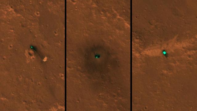
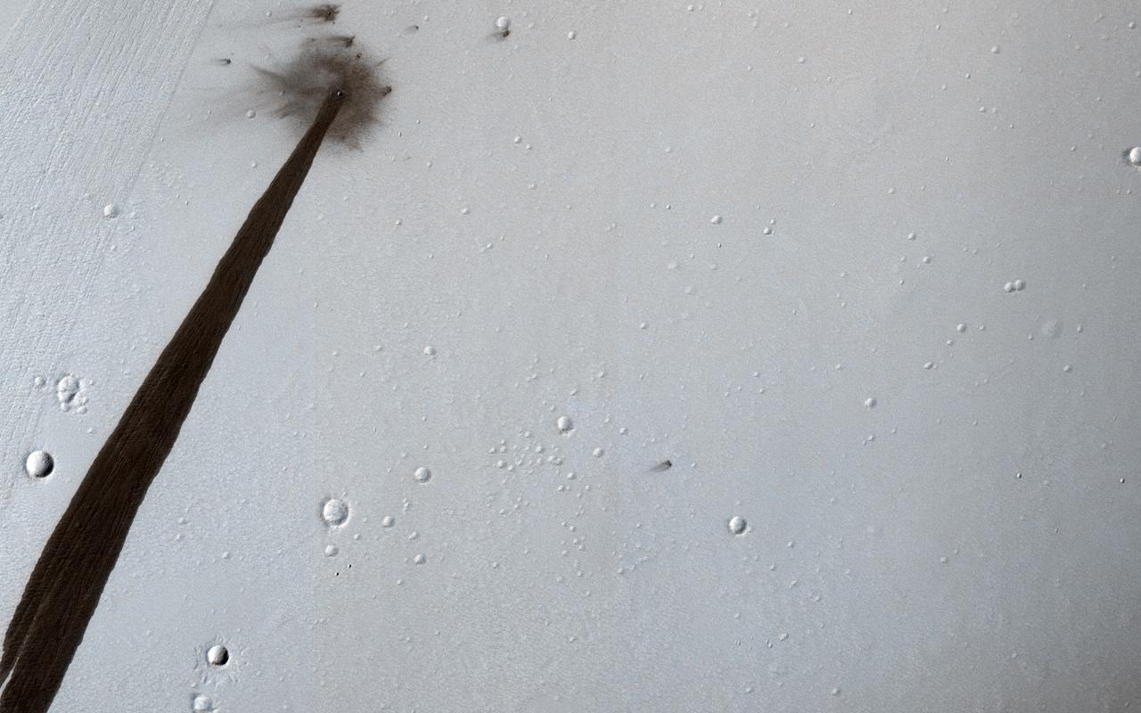
NASA's InSight Mars lander acquires the same reddish-brown hue as the rest of the planet in a set of images captured by the agency's Mars Reconnaissance Orbiter (MRO) using its High-Resolution Imagine Science Experiment (HiRISE) camera. This video shows images taken by HiRISE between Dec. 11, 2018, just a couple weeks after InSight landed on Mars, and Oct. 23, 2024. In the images, InSight often appears as a bright, blue dot due to its reflection of sunlight. A dark halo was scorched into the ground by the spacecraft's retrorocket thrusters; this halo fades away over time. Dark stripes that can be seen on the surface are tracks left by passing dust devils. Figure A is the single HiRISE image taken on Oct. 23, 2024. Monitoring the change in dust at the Martian surface helps scientists understand how quickly the surface changes at a given location over time. That's particularly helpful for ascertaining the age of meteoroid craters, which serve as time-keepers on surface: Understanding how quickly they're fading lets scientists estimate how long they've been there, and thus how old that particular surface is. Animation available at https://photojournal.jpl.nasa.gov/catalog/PIA26515
NASA's Ingenuity Mars Helicopter's fourth flight path is superimposed here atop terrain imaged by the HiRISE camera aboard the agency's Mars Reconnaissance Orbiter. https://photojournal.jpl.nasa.gov/catalog/PIA24629
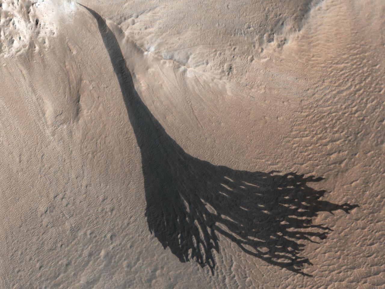
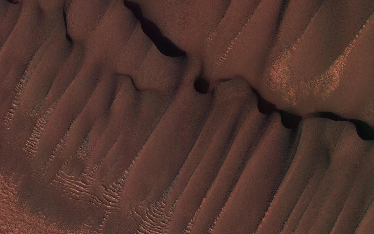
The High Resolution Imaging Science Experiment (HiRISE) camera aboard NASA's Mars Reconnaissance Orbiter captured these sand ripples and the large dune (at center) on Feb. 9, 2009. Color has been added to make textures easier to see. This area is in Proctor Crater at 47.8 degrees south latitude and 30.7 degrees east longitude. https://photojournal.jpl.nasa.gov/catalog/PIA24036
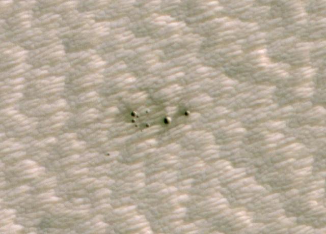
NASA's InSight spacecraft, its heat shield and its parachute were imaged on Dec. 6 and 11 by the HiRISE camera onboard NASA's Mars Reconnaissance Orbiter. In images released today, the three new features on the Martian landscape appear teal. That's not their actual color: Light reflected off their surfaces cause the color to be saturated. The ground around the lander is dark, blasted by its retrorockets during descent. Look carefully for a butterfly shape, and you can make out the lander's solar panels on either side. Unannotated, individual images of the lander, heat shield and parachute are also available. https://photojournal.jpl.nasa.gov/catalog/PIA22875
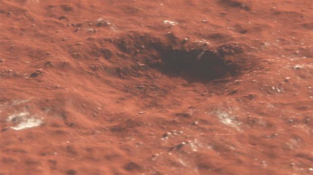
The High-Resolution Imaging Science Experiment (HiRISE) camera aboard NASA's Mars Reconnaissance Orbiter took this image of a crater cluster on Mars, the first ever to be discovered artificial intelligence (AI). The AI first spotted the craters in images taken the orbiter's Context Camera; scientists followed up with this HiRISE image to confirm the craters. The Context Camera's view of the craters can be found in PIA24091. These craters created by several pieces of a single meteor. The largest of the craters is about 13 feet (4 meters) wide. In total, the craters span about 100 feet (30 meters) of the Red Planet's surface. The craters were found in a region called Noctis Fossae, located at latitude -3.213, longitude 259.415. https://photojournal.jpl.nasa.gov/catalog/PIA24040
The descent stage holding NASA's Perseverance rover can be seen falling through the Martian atmosphere, its parachute trailing behind, in this image taken on Feb. 18, 2021, by the High Resolution Imaging Experiment (HiRISE) camera aboard the Mars Reconnaissance Orbiter. The ancient river delta, which is the target of the Perseverance mission, can be seen entering Jezero Crater from the left. HiRISE was approximately 435 miles (700 kilometers) from Perseverance and traveling at about 6750 mile per hour (3 kilometers per second) at the time the image was taken. The extreme distance and high speeds of the two spacecraft were challenging conditions that required precise timing and for Mars Reconnaissance Orbiter to both pitch upward and roll hard to the left so that Perseverance was viewable by HiRISE at just the right moment. https://photojournal.jpl.nasa.gov/catalog/PIA24270
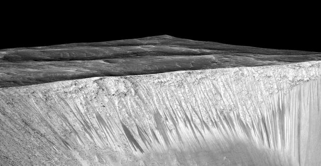
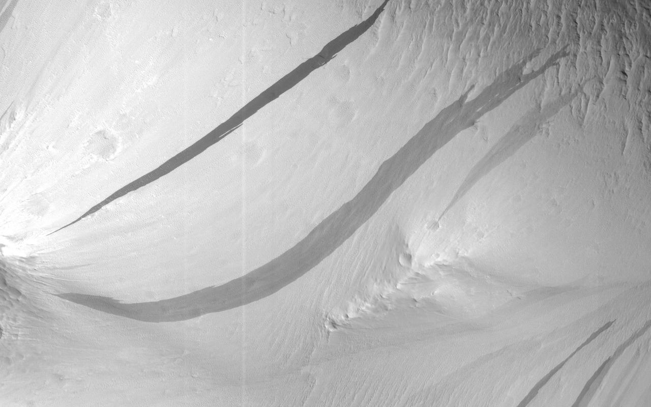
Dark narrow streaks, called "recurring slope lineae," emanate from the walls of Garni Crater on Mars, in this view constructed from observations by the High Resolution Imaging Science Experiment (HiRISE) camera on NASA's Mars Reconnaissance Orbiter. The dark streaks here are up to few hundred yards, or meters, long. They are hypothesized to be formed by flow of briny liquid water on Mars. The image was produced by first creating a 3-D computer model (a digital terrain map) of the area based on stereo information from two HiRISE observations, and then draping an image over the land-shape model. The vertical dimension is exaggerated by a factor of 1.5 compared to horizontal dimensions. The draped image is a red waveband (monochrome) product from HiRISE observation ESP_031059_1685, taken on March 12, 2013 at 11.5 degrees south latitude, 290.3 degrees east longitude. Other image products from this observation are at http://hirise.lpl.arizona.edu/ESP_031059_1685. http://photojournal.jpl.nasa.gov/catalog/PIA19917
These dark streaks, also known as "slope streaks," on Mars resulted from dust avalanches. They were captured by NASA's Mars Reconnaissance Orbiter using its High-Resolution Imaging Science Experiment (HiRISE) camera on Dec. 26, 2017. https://photojournal.jpl.nasa.gov/catalog/PIA25235
This series of images shows carbon dioxide ice sublimating (going directly from a solid to a gas) inside a pit at Mars' south pole. As ice is lost from the steep walls of pits like this, it reforms on nearby flat surfaces. Each frame of the animation was taken by the High Resolution Imaging Science Experiment camera (HiRISE) on NASA's Mars Reconnaissance Orbiter. The images used in this animation were taken between 2007 and 2013. The walls of the pit are about 656 feet (200 meters) across. Animation available at https://photojournal.jpl.nasa.gov/catalog/PIA23238
The white speck is NASA's Perseverance rover in the "South Séítah" area of Mars' Jezero Crater. The image was taken by the agency's Mars Reconnaissance Orbiter using its High-Resolution Imaging Science Experiment, or HiRISE, camera. The University of Arizona, in Tucson, operates HiRISE, which was built by Ball Aerospace & Technologies Corp., in Boulder, Colorado. NASA's Jet Propulsion Laboratory, a division of Caltech in Pasadena, California, manages the Mars Reconnaissance Orbiter Project for NASA's Science Mission Directorate in Washington. A key objective for Perseverance's mission on Mars is astrobiology, including the search for signs of ancient microbial life. The rover will characterize the planet's geology and past climate, pave the way for human exploration of the Red Planet, and be the first mission to collect and cache Martian rock and regolith (broken rock and dust). Subsequent NASA missions, in cooperation with ESA (European Space Agency), would send spacecraft to Mars to collect these sealed samples from the surface and return them to Earth for in-depth analysis. The Mars 2020 Perseverance mission is part of NASA's Moon to Mars exploration approach, which includes Artemis missions to the Moon that will help prepare for human exploration of the Red Planet. https://photojournal.jpl.nasa.gov/catalog/PIA24837
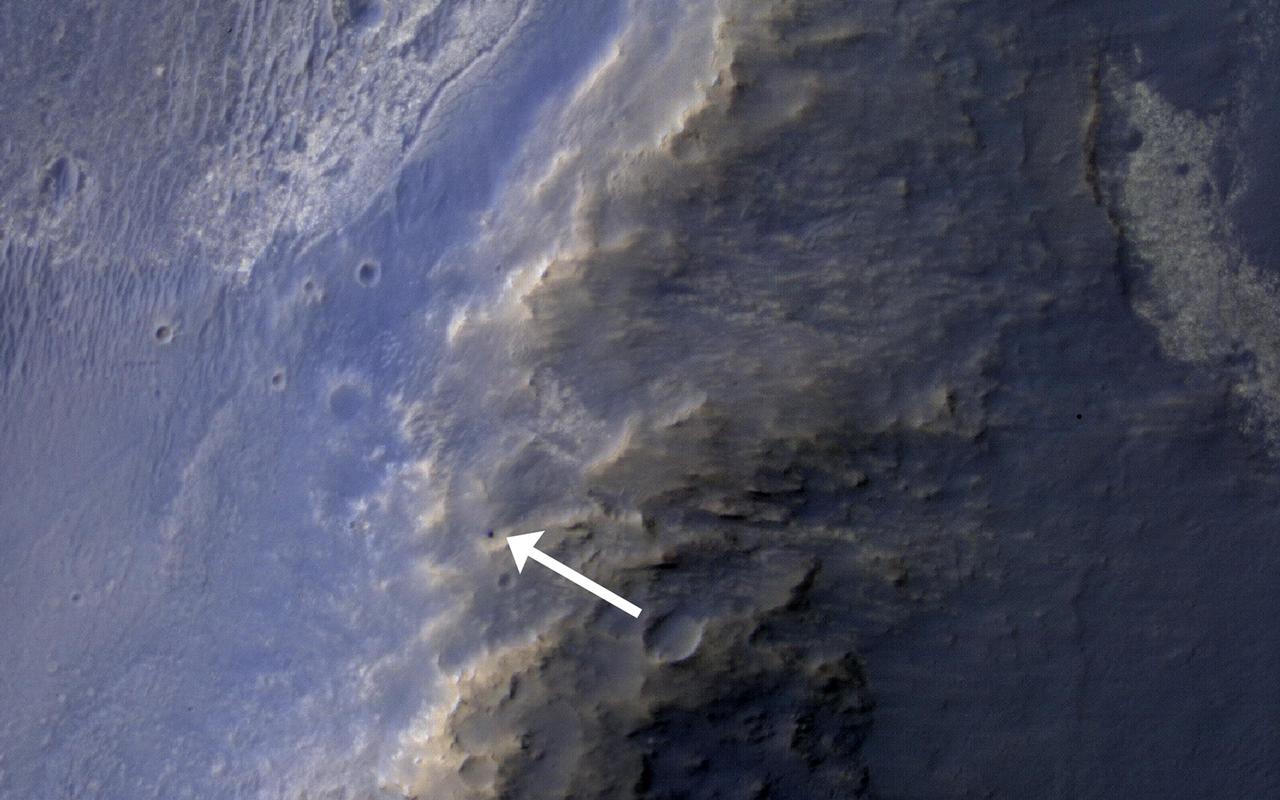
NASA's Curiosity Mars rover can be seen in this image taken from space on May 31, 2019, by the High Resolution Imaging Science Experiment (HiRISE) camera aboard the Mars Reconnaissance Orbiter (MRO). In the image, Curiosity appears as a bluish speck. The image shows Curiosity at a location called "Woodland Bay." It's just one of many stops the rover has made in an area referred to as the "clay-bearing unit" on the side of Mount Sharp, a 3-mile-tall (5-kilometer-tall) mountain inside of Gale Crater. Look carefully, and you can make out what it is likely Curiosity's "head," technically known as the remote sensing mast. A bright spot appears in the upper-left corner of the rover. At the time this image was acquired, the rover was facing 65 degrees counterclockwise from north, which would put the mast in about the right location to produce this bright spot. https://photojournal.jpl.nasa.gov/catalog/PIA23341
This animation depicts a flyover of a meteoroid impact crater on Mars that's surrounded by boulder-size chunks of ice. The animation was created using data from the High-Resolution Imaging Science Experiment (HiRISE) camera aboard NASA's Mars Reconnaissance Orbiter. The impact occurred on Dec. 24, 2021. Movie available at https://photojournal.jpl.nasa.gov/catalog/PIA25586
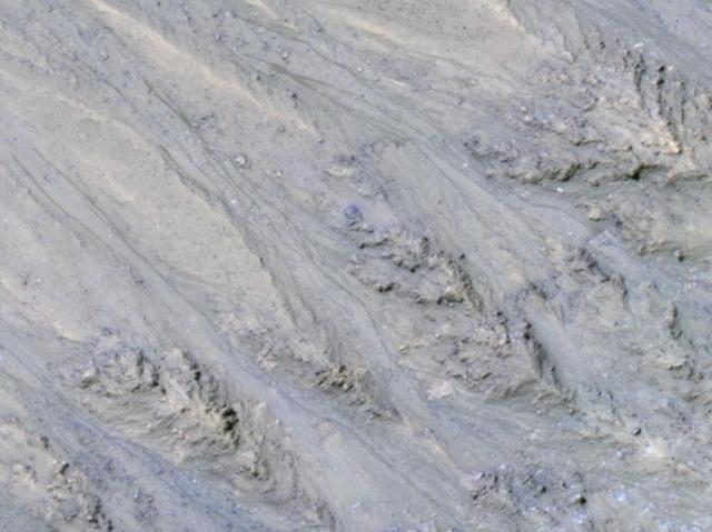
This image shows spidery channels eroded into Martian ground. It is an example from high-resolution observation of more than 20 places that were chosen in 2016 on the basis of about 10,000 volunteers' examination of lower-resolution images of larger areas near Mars' south pole. These sharper looks use the High Resolution Imaging Science Experiment (HiRISE) camera on NASA's Mars Reconnaissance Orbiter. The volunteers, through the Planet Four: Terrains website, categorize surface features in images from the same orbiter's Context Camera (CTX). This image is a portion of HiRISE observation ESP_047487_1005, taken on Sept. 12, 2016, of a site at 79.4 degrees south latitude, 18.8 degrees east longitude. The ground area shown is about half a mile (0.8 kilometer) wide. This terrain type, called spiders or "araneiform" (from the Latin word for spiders), appears in some areas of far-southern Mars that are covered by sheets of frozen carbon dioxide ("dry ice") during the winter. When the slab ice thaws from the underneath side in the spring, carbon dioxide gas trapped beneath the ice builds pressure until it rushes toward a fissure or vent where it bursts out. The venting gas carries dust and sand that it picks up as it carves these channels. At this location, the spiders are surrounded by ground called "basketball terrain" because of its texture. http://photojournal.jpl.nasa.gov/catalog/PIA21126
These Martian dunes in Mars' northern hemisphere were captured from above by NASA's Mars Reconnaissance Orbiter using its High-Resolution Imaging Science Experiment (HiRISE) camera on Sept. 8, 2022. Scientists use such images to track the amount of frost that settles on the landforms and then disappears as the weather warms in spring. Martian dunes migrate just like dunes on Earth, with wind blowing away sand on one side of the dune and building up on another. Recent research has shown that winter frost stops the movement of sand grains, locking the dunes in place until the spring thaw. https://photojournal.jpl.nasa.gov/catalog/PIA26517
This animation shows the position of NASA's Curiosity rover as it journeyed 1,106 feet (337 meters) through an area of Mount Sharp called "the clay-bearing unit" between May 31 and July 20, 2019. Each of these two images were taken by the HiRISE camera on NASA's Mars Reconnaissance Orbiter. The first image shows the rover, which appears as a gray speck, at a location called "Woodland Bay" (top center). The second shows "Sandside Harbour" (bottom center, near the dark sand patch). Look carefully and you can even see the rover's tracks arcing to the right of the second image. Animation available at https://photojournal.jpl.nasa.gov/catalog/PIA23377
This image from the High Resolution Imaging Science Experiment (HiRISE) camera on NASA's Mars Reconnaissance Orbiter shows a location on Mars associated with the best-selling novel and Hollywood movie, "The Martian." This area is in the Acidalia Planitia region. In the novel and the movie, it is the landing site of a crewed mission named Ares 3. For the story's central character, Acidalia Planitia is within driving distance from where NASA's Mars Pathfinder, with its Sojourner rover, landed in 1997. An initial HiRISE image of the site was taken in April 2015 and is online at http://hirise.lpl.arizona.edu/ESP_040776_2115. A second one was taken May 17, 2015, and is shown here. Figure 1 is a stereo combination of the two, appearing three-dimensional when viewed through blue-red glasses with the red lens on the left One of the main objectives of the HiRISE camera is to carry out "monitoring science", which involves taking images of certain areas of high scientific interest on regular intervals. The team usually does so to monitor a seasonal or recurring process such as seasonal changes in carbon-dioxide ice near the poles, dune movement or recurring flow-like features on some slopes. HiRISE also takes repeated images of areas with active rovers, such as Curiosity, to help plan safe routes toward areas of high scientific interest. Another key responsibility for the HiRISE camera is to provide information for use in selection of landing sites for future missions. One technique is to image a site of interest at least twice when the weather conditions are similar, but with a small difference in viewing angle, much like what you would experience if you looked at something with only your right eye, then looked at it again with the left. By doing this, we are able to build a stereo view of the site, providing a chance to identify high and low points in the site more effectively. This resulting 3-D information can combined with elevation data from laser altimeters to create a highly accurate "digital terrain model" or DTM for short. DTMs allow researchers to view the locations in 3-D and to analyze them by measuring the exact height of features that could be hazardous to the future mission, such as large boulders or small impact craters. DTMs from HiRISE were a key factor in choosing the landing site for NASA's Curiosity Mars rover in Gale Crater and are being used to evaluate sites under consideration for the NASA's 2016 InSight Mars lander and Mars 2020 rover missions. The location of the site in this image is 31.3 degrees north latitude, 331.3 degrees east latitude. The image is an excerpt from HiRISE observation ESP_041277_2115. http://photojournal.jpl.nasa.gov/catalog/PIA19913

In the best-selling novel "The Martian" and the movie based on it, stranded astronaut Mark Watney's adventures take him to the rim of Mawrth Crater. This image from the High Resolution Imaging Science Experiment (HiRISE) camera on NASA's Mars Reconnaissance Orbiter shows the nature of this terrain. The crater rim is not very distinct, and from the Martian surface it would be quite difficult to tell that you are even on the rim of a crater. The terrain is hummocky and rolling, punctuated by smaller impact craters and wind-blown drifts of sand or dust. This view is one image product from HiRISE observation ESP_042252_1930, taken Aug. 1, 2015, at 12.6 degrees north latitude, 355.7 degrees east longitude. http://photojournal.jpl.nasa.gov/catalog/PIA19915
This view taken from orbit around Mars shows the sand dune that will be the first to be visited by NASA's Curiosity Mars Rover along its route to higher layers of Mount Sharp. The view covers an area about 1,250 feet (about 380 meters) across, showing a site called "Dune 1" in the "Bagnold Dunes" dune field. It was taken by the High Resolution Imaging Science Experiment (HiRISE) camera on NASA's Mars Reconnaissance Orbiter. The image is in false color, combining information recorded by HiRISE in red, blue-green and infrared frequencies of light. http://photojournal.jpl.nasa.gov/catalog/PIA19930
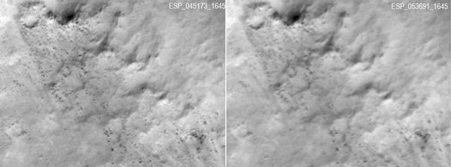
These two frames were taken of the same place on Mars by the same orbiting camera before (left) and after some images from the camera began showing unexpected blur. The images are from the High Resolution Imaging Science Experiment (HiRISE) camera on NASA's Mars Reconnaissance Orbiter. They show a patch of ground about 500 feet or 150 meters wide in Gusev Crater. The one on the left, from HiRISE observation ESP_045173_1645, was taken March 16, 2016. The one on the right was taken Jan. 9, 2018. Gusev Crater, at 15 degrees south latitude and 176 degrees east longitude, is the landing site of NASA's Spirit Mars rover in 2004 and a candidate landing site for a rover to be launched in 2020. HiRISE images provide important information for evaluating potential landing sites. The smallest boulders with measurable diameters in the left image are about 3 feet (90 centimeters) wide. In the blurred image, the smallest measurable are about double that width. As of early 2018, most full-resolution images from HiRISE are not blurred, and the cause of the blur is still under investigation. Even before blurred images were first seen, in 2017, observations with HiRISE commonly used a technique that covers more ground area at half the resolution. This shows features smaller than can be distinguished with any other camera orbiting Mars, and little blurring has appeared in these images. https://photojournal.jpl.nasa.gov/catalog/PIA22215
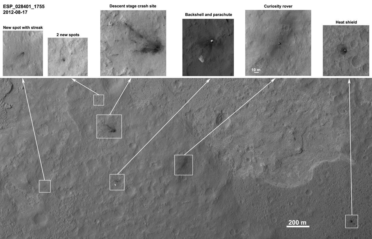
This frame from a sequence of images shows a blast zone where the sky crane from NASA Curiosity rover mission hit the ground after setting the rover down in August 2012. The images are from HiRISE on NASA Mars Reconnaissance Orbiter. http://photojournal.jpl.nasa.gov/catalog/PIA19159
This image from the High Resolution Imaging Science Experiment (HiRISE) camera on NASA's Mars Reconnaissance Orbiter shows a location on Mars associated with the best-selling novel and Hollywood movie, "The Martian." It is the science-fiction tale's planned landing site for the Ares 4 mission. The novel placed the Ares 4 site on the floor of a very shallow crater in the southwestern corner of Schiaparelli Crater. This HiRISE image shows a flat region there entirely mantled by bright Martian dust. There are no color variations, just uniform reddish dust. A pervasive, pitted texture visible at full resolution is characteristic of many dust deposits on Mars. No boulders are visible, so the dust is probably at least a meter thick. Past Martian rover and lander missions from NASA have avoided such pervasively dust-covered regions for two reasons. First, the dust has a low thermal inertia, meaning that it gets extra warm in the daytime and extra cold at night, a thermal challenge to survival of the landers and rovers (and people). Second, the dust hides the bedrock, so little is known about the bedrock composition and whether it is of scientific interest. This view is one image product from HiRISE observation ESP_042014_1760, taken July 14, 2015, at 3.9 degrees south latitude, 15.2 degrees east longitude. http://photojournal.jpl.nasa.gov/catalog/PIA19914
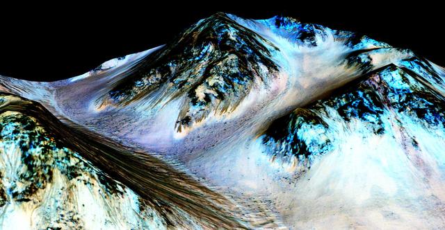
Dark, narrow streaks on Martian slopes such as these at Hale Crater are inferred to be formed by seasonal flow of water on contemporary Mars. The streaks are roughly the length of a football field. The imaging and topographical information in this processed, false-color view come from the High Resolution Imaging Science Experiment (HiRISE) camera on NASA's Mars Reconnaissance Orbiter. These dark features on the slopes are called "recurring slope lineae" or RSL. Planetary scientists using observations with the Compact Reconnaissance Imaging Spectrometer on the same orbiter detected hydrated salts on these slopes at Hale Crater, corroborating the hypothesis that the streaks are formed by briny liquid water. The image was produced by first creating a 3-D computer model (a digital terrain map) of the area based on stereo information from two HiRISE observations, and then draping a false-color image over the land-shape model. The vertical dimension is exaggerated by a factor of 1.5 compared to horizontal dimensions. The camera records brightness in three wavelength bands: infrared, red and blue-green. The draped image is one product from HiRISE observation ESP_03070_1440. http://photojournal.jpl.nasa.gov/catalog/PIA19916
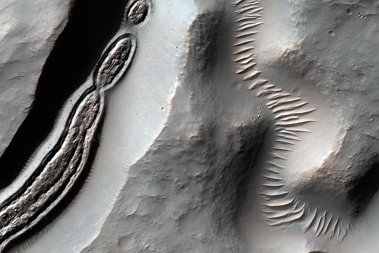
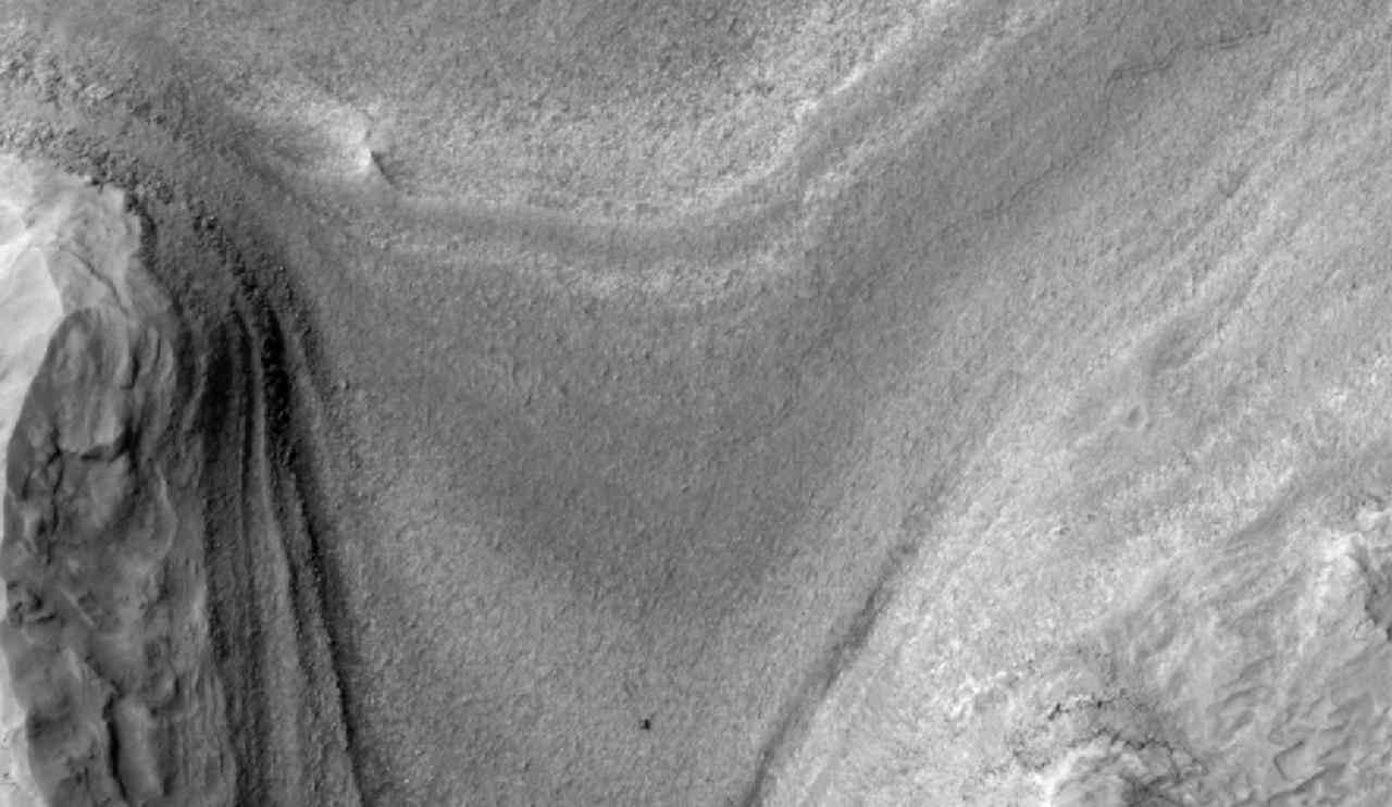
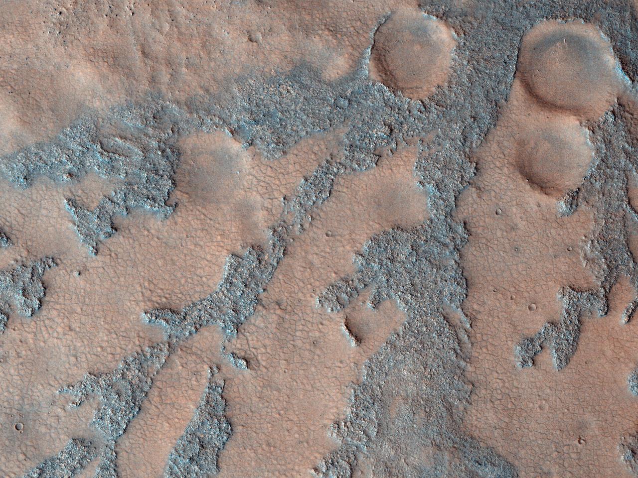
This image from NASA's Mars Reconnaissance Orbiter is a close-up of a trough, along with channels draining into the depression. Some HiRISE images show strange-looking formations. Sometimes it helps to look at Context Camera images to understand the circumstances of a scene -- like this cutout from CTX 033783_1509 -- which here shows an impact crater with a central peak, and a collapse depression with concentric troughs just north of that peak. On the floor of the trough is some grooved material that we typically see in middle latitude regions where there has been glacial flow. These depressions with concentric troughs exist elsewhere on Mars, and their origins remain a matter of debate. NB: The Context Camera is another instrument onboard MRO, and it has a larger viewing angle than HiRISE, but less resolution capability than our camera. https://photojournal.jpl.nasa.gov/catalog/PIA22348
Although Mars is known for having the largest volcano in our solar system, Olympus Mons, we also find small-scale volcanic features on its surface, as shown in this image from HiRISE onboard NASA's Mars Reconnaissance Orbiter (MRO). This fissure, less than 500 meters across at its widest point, lies in the Tharsis region and is believed to be a vent from which lava flowed in ancient eruptions. The total volume of lava released from this fissure is much less than what would erupt from nearby volcanoes, but the mark left on the landscape is dramatic nonetheless. https://photojournal.jpl.nasa.gov/catalog/PIA21601
Details such as the shadow of the mast on NASA Mars rover Curiosity appear in an image taken Aug. 17, 2012, by the HiRISE camera on NASA Mars Reconnaissance Orbiter, from more directly overhead than previous HiRISE images of Curiosity.
Gullies on Martian sand dunes, like these in Matara Crater, have been very active, with many flows in the last ten years. The flows typically occur when seasonal frost is present. In this image from NASA's Mars Reconnaissance Orbiter we see frost in and around two gullies, which have both been active before. There are no fresh flows so far this year, but HiRISE will keep watching. https://photojournal.jpl.nasa.gov/catalog/PIA22349
The target of this observation as seen by ASA Mars Reconnaissance Orbiter is a circular depression in a dark-toned unit associated with a field of cones to the northeast. At the image scale of a Context Camera image, the depression appears to expose layers especially on the sides or walls of the depression, which are overlain by dark sands presumably associated with the dark-toned unit. HiRISE resolution, which is far higher than that of the Context Camera and its larger footprint, can help identify possible layers. http://photojournal.jpl.nasa.gov/catalog/PIA19358
The extended-mission status of the Mars Reconnaissance Orbiter and the HiRISE camera has greatly increased our understanding of numerous active processes occurring on Mars. By taking carefully planned repeat images of surface, we now have an important record of how the surface evolves for a maximum of 5 Mars years. This image shows the central peak in Porter Crater. Although there are no repeat images here we can infer several active geologic processes, based on morphologic evidence and lessons learned from past well-monitored sites. Shallow gullies are located on the south and east facing slopes of the central peak. These features might have been carved by volatiles, such as carbon dioxide frost, sometime in the recent geologic past. Meanwhile on the northern slopes are several smaller slope features that have a morphology hinting at recurring slope lineae (RSL). Alternatively, these features could be the remnants of past active gullies. Several more HiRISE images would be needed to characterize their behavior and confirm their status as RSL (see "Recurring Slope Lineae in Equatorial Regions of Mars"). Southward on the slopes below the peak is a large dune field. Dunes show sharp crests with prominent ripples, both signs of actively migrating dunes. Also, we can see dust devil tracks crossing the nearby dusty surfaces and clear evidence for ongoing modification by swirling winds that persistently remove surface dust. Ongoing operations by HiRISE are dedicated to studying all of the active surface and atmospheric processes operating on Mars. http://photojournal.jpl.nasa.gov/catalog/PIA19853
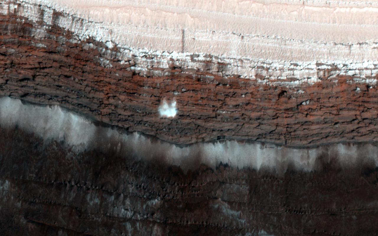
This image from NASA Mars Reconnaissance Orbiter spacecraft shows a channel system flowing to the southwest toward the huge Hellas impact basin. Click on the image for larger version The scarp at the edge of the North Polar layered deposits of Mars is the site of the most frequent frost avalanches seen by HiRISE. At this season, northern spring, frost avalanches are common and HiRISE monitors the scarp to learn more about the timing and frequency of the avalanches, and their relationship to the evolution of frost on the flat ground above and below the scarp. This picture managed to capture a small avalanche in progress, right in the color strip. See if you can spot it in the browse image, and then click on the cutout to see it at full resolution. The small white cloud in front of the brick red cliff is likely carbon dioxide frost dislodged from the layers above, caught in the act of cascading down the cliff. It is larger than it looks, more than 20 meters across, and (based on previous examples) it will likely kick up clouds of dust when it hits the ground. The avalanches tend to take place at a season when the North Polar region is warming, suggesting that the avalanches may be triggered by thermal expansion. The avalanches remind us, along with active sand dunes, dust devils, slope streaks and recurring slope lineae, that Mars is an active and dynamic planet. http://photojournal.jpl.nasa.gov/catalog/PIA19961
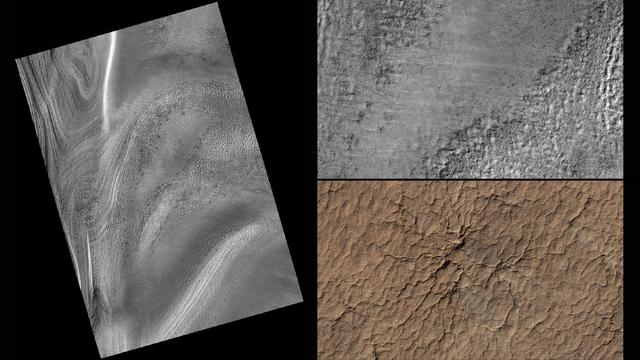
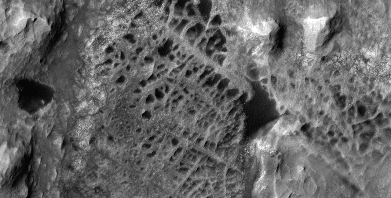
This series of images from NASA's Mars Reconnaissance Orbiter successively zooms into "spider" features -- or channels carved in the surface in radial patterns -- in the south polar region of Mars. In a new citizen-science project, volunteers will identify features like these using wide-scale images from the orbiter. Their input will then help mission planners decide where to point the orbiter's high-resolution camera for more detailed views of interesting terrain. Volunteers will start with images from the orbiter's Context Camera (CTX), which provides wide views of the Red Planet. The first two images in this series are from CTX; the top right image zooms into a portion of the image at left. The top right image highlights the geological spider features, which are carved into the terrain in the Martian spring when dry ice turns to gas. By identifying unusual features like these, volunteers will help the mission team choose targets for the orbiter's High Resolution Imaging Science Experiment (HiRISE) camera, which can reveal more detail than any other camera ever put into orbit around Mars. The final image is this series (bottom right) shows a HiRISE close-up of one of the spider features. http://photojournal.jpl.nasa.gov/catalog/PIA19823
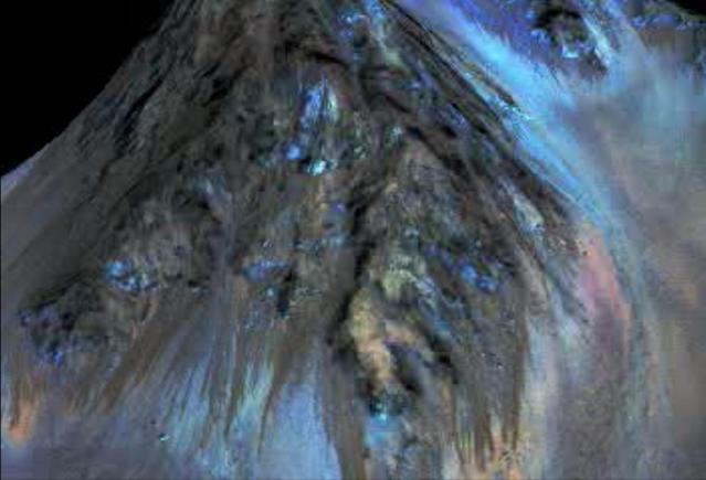
This frame from an animation simulates a fly-around look at one of the places on Mars where dark streaks advance down slopes during warm seasons, possibly involving liquid water. The streaks are roughly the length of a football field. The imaging and topographical information used in this false-color animation come from the High Resolution Imaging Science Experiment (HiRISE) camera on NASA's Mars Reconnaissance Orbiter. These dark features on the slopes are called "recurring slope lineae" or RSL. Planetary scientists using observations with the Compact Reconnaissance Imaging Spectrometer on the same orbiter detected hydrated salts on these slopes at Hale Crater, corroborating the hypothesis that the streaks are formed by briny liquid water. The image was produced by first creating a 3-D computer model (a digital terrain map) of the area based on stereo information from two HiRISE observations, and then draping a false-color image over the land-shape model. The vertical dimension is exaggerated by a factor of 1.5 compared to horizontal dimensions. http://photojournal.jpl.nasa.gov/catalog/PIA19919
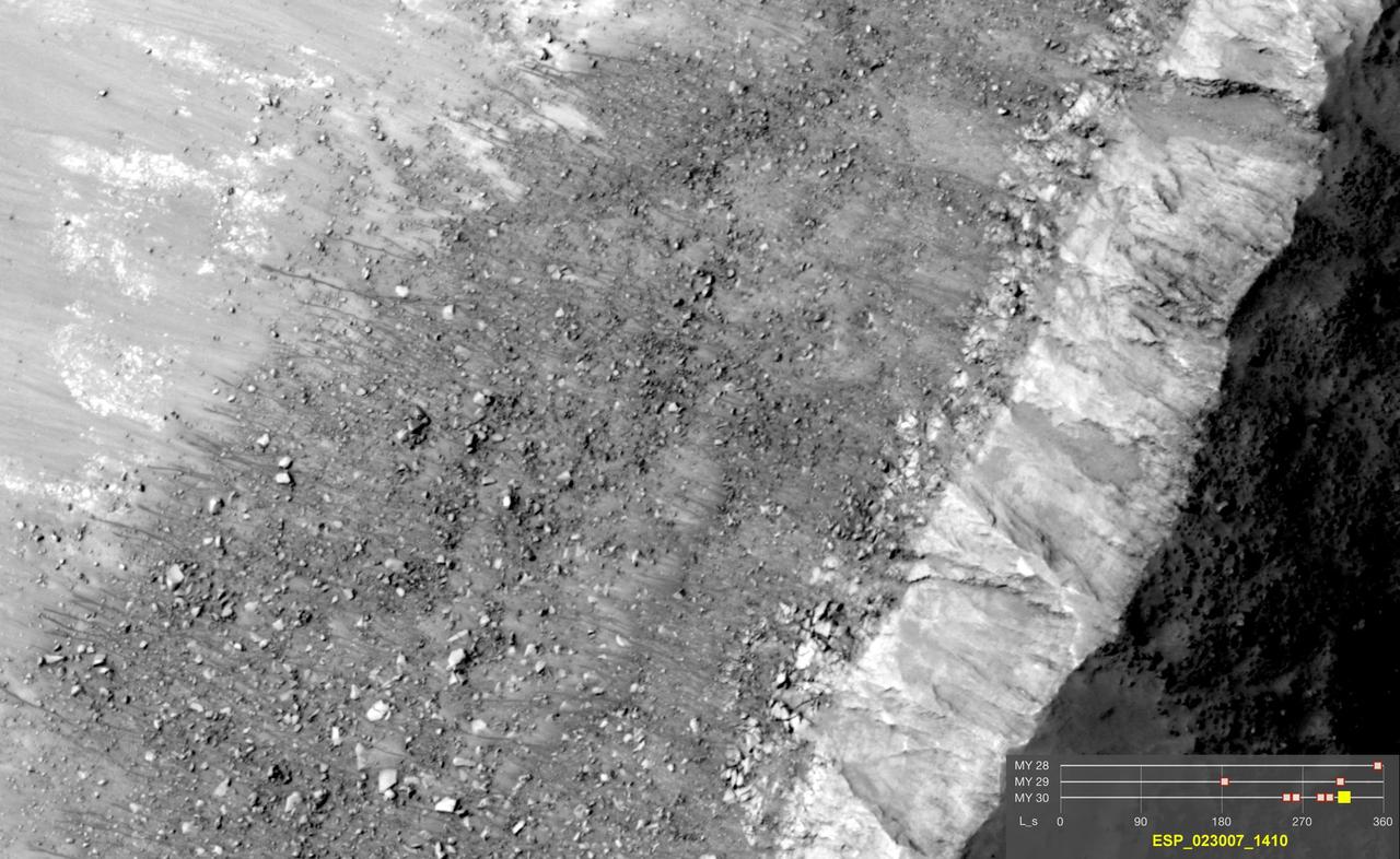
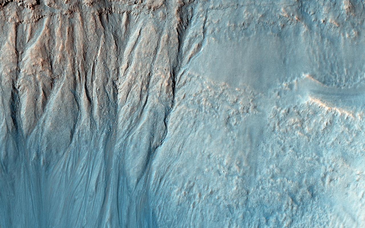
It's hard to see in the dark. Most HiRISE images are are taken when the sun is at least 15 degrees above the horizon. (If you hold your hand at arm's length with fingers together, it's about five degrees wide on average.) However, to see what's going on in winter, we need to look at times and places where the Sun is just barely over the horizon. This image was taken to look at seasonal frost in gullies during southern winter on Mars, with the Sun only about two degrees over the horizon (just before sunset). To make things more difficult, the gullies are on a steep slope facing away from the sun, so they are in deep shadow. Under these conditions, HiRISE takes what are called "bin 4" images. This means that the image shows less detail, but by adding up the light from 16 pixels (a 4x4 square) we can see details in shadows. Even with the reduced resolution, we can see plenty of detail in the gullies, and learn about the seasonal frost. http://photojournal.jpl.nasa.gov/catalog/PIA20480
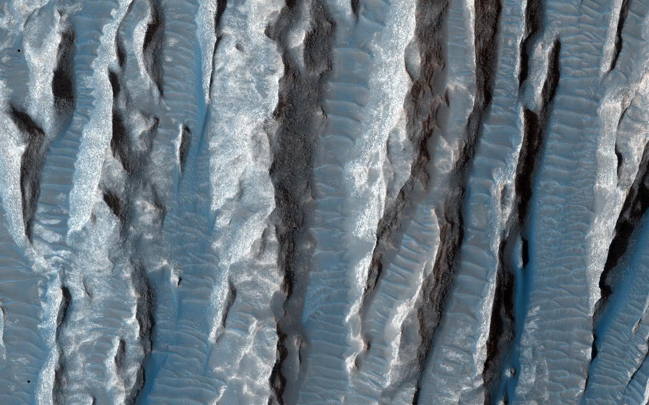
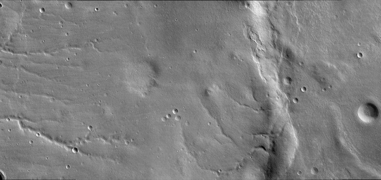
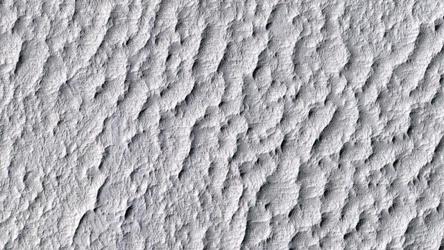
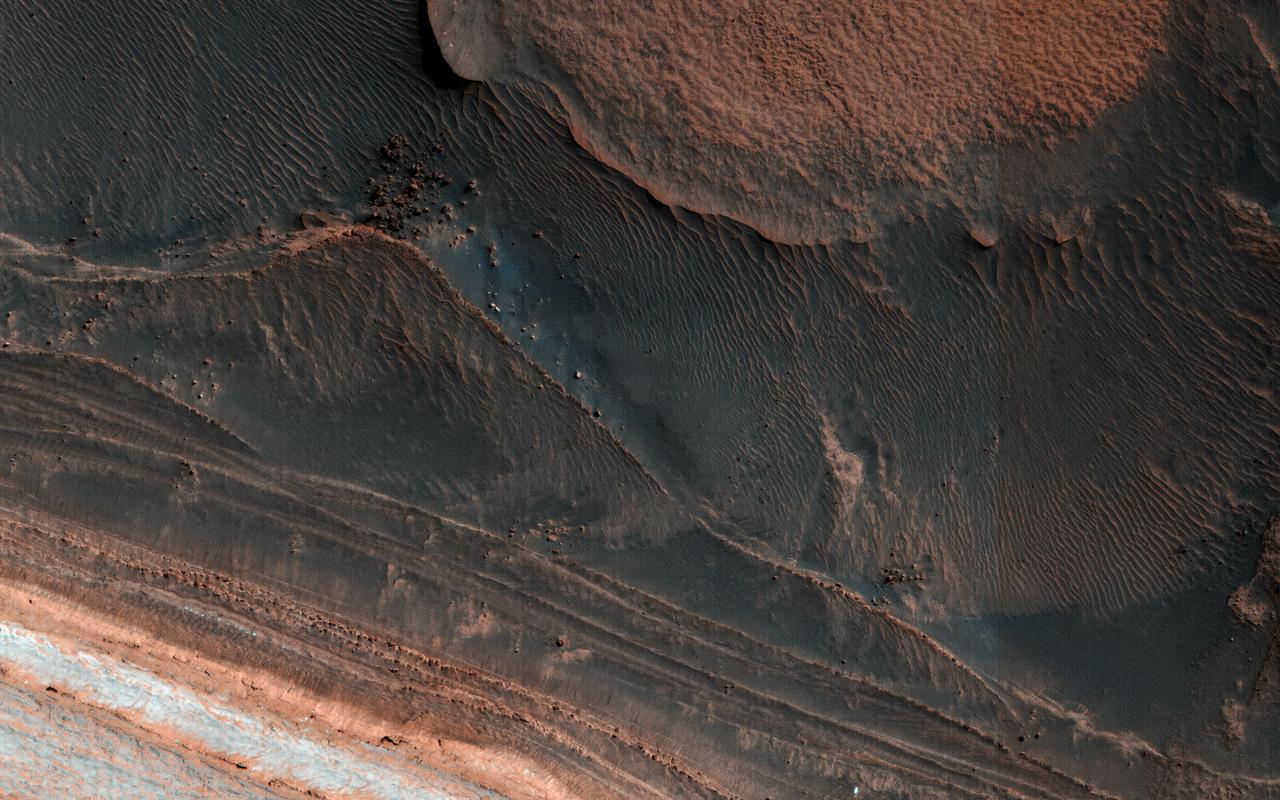
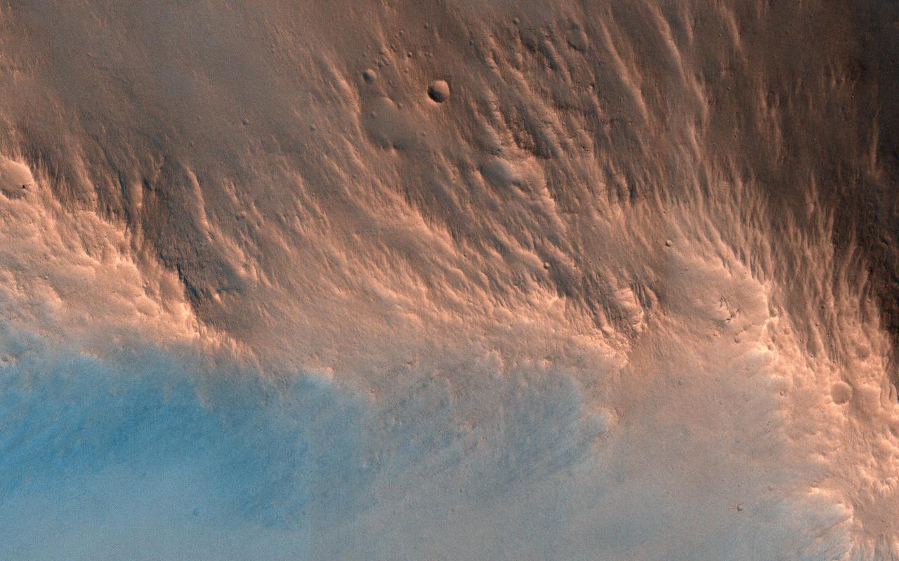
This view of Martian surface features shaped by effects of winds was captured by the High Resolution Imaging Science Experiment (HiRISE) camera on NASA's Mars Reconnaissance Orbiter on Jan. 4, 2015. The spacecraft has been orbiting Mars since March 2006. On Feb. 7, 2015, it completed its 40,000th orbit around Mars. Several terrain types converge in this scene from the Arsinoes Chaos region of Mars, which is in the far eastern portion of Mars' Valles Marineris canyon system. The jumbled chaos terrain is likely related to massive water-carved outflow channels that started in this area and flowed north onto Mars' northern plains. The slightly curving bright terrain is composed of yardangs. Yardangs are portions of rock that have been sandblasted into long, skinny ridges by saltating (or bouncing) sand particles blowing in the wind. Transverse sand ridges lie between the yardangs (zoom in). These sand ridges are termed "transverse aeolian ridges" and are not moving in Mars' current climate. They are a mystery -- midway in height between dunes (formed from saltating sand) and ripples (formed by "splashed" sand grains). The location is at 7 degrees south latitude, 332 degrees east latitude. The image is an excerpt from HiRISE observation ESP_039563_1730. http://photojournal.jpl.nasa.gov/catalog/PIA19291
![Over 500 new impact events have been detected from before-and-after images from NASA's Mars Reconnaissance Orbiter, mostly from MRO's Context Camera, with a HiRISE followup. Those new craters that expose shallow ice are of special interest, especially at latitudes where not previously detected, to better map the ice distribution. We hope to find ice at relatively low latitudes both for understanding recent climate change and as a resource for possible future humans on Mars. This new impact, which occurred between August and December 2016 (at 42.5 degree South latitude) would provide an important constraint if ice was detected. Alas, the HiRISE color image does not indicate that ice is exposed. There is an elongated cluster of new craters (or just dark spots where the craters are too small to resolve), due to an oblique impact in which the bolide fragmented in the Martian atmosphere. The map is projected here at a scale of 25 centimeters (9.8 inches) per pixel. [The original image scale is 25.1 centimeters (9.9 inches) per pixel (with 1 x 1 binning); objects on the order of 75 centimeters (29.5 inches) across are resolved.] North is up. https://photojournal.jpl.nasa.gov/catalog/PIA21578](https://images-assets.nasa.gov/image/PIA21578/PIA21578~medium.jpg)
Over 500 new impact events have been detected from before-and-after images from NASA's Mars Reconnaissance Orbiter, mostly from MRO's Context Camera, with a HiRISE followup. Those new craters that expose shallow ice are of special interest, especially at latitudes where not previously detected, to better map the ice distribution. We hope to find ice at relatively low latitudes both for understanding recent climate change and as a resource for possible future humans on Mars. This new impact, which occurred between August and December 2016 (at 42.5 degree South latitude) would provide an important constraint if ice was detected. Alas, the HiRISE color image does not indicate that ice is exposed. There is an elongated cluster of new craters (or just dark spots where the craters are too small to resolve), due to an oblique impact in which the bolide fragmented in the Martian atmosphere. The map is projected here at a scale of 25 centimeters (9.8 inches) per pixel. [The original image scale is 25.1 centimeters (9.9 inches) per pixel (with 1 x 1 binning); objects on the order of 75 centimeters (29.5 inches) across are resolved.] North is up. https://photojournal.jpl.nasa.gov/catalog/PIA21578

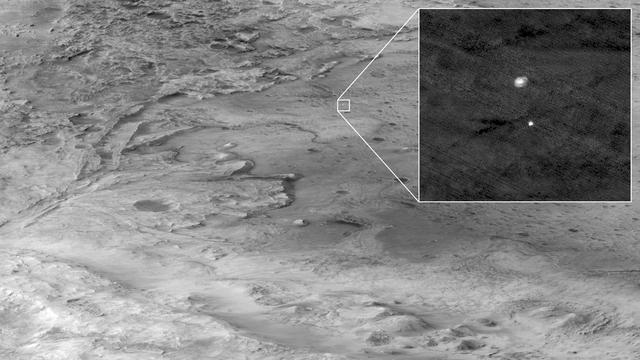
This Oct. 25, 2016, image shows the area where the European Space Agency's Schiaparelli test lander reached the surface of Mars, with magnified insets of three sites where components of the spacecraft hit the ground. It is the first view of the site from the High Resolution Imaging Science Experiment (HiRISE) camera on NASA's Mars Reconnaissance Orbiter taken after the Oct. 19, 2016, landing event. The Schiaparelli test lander was one component of ESA's ExoMars 2016 project, which placed the Trace Gas Orbiter into orbit around Mars on the same arrival date. This HiRISE observation adds information to what was learned from observation of the same area on Oct. 20 by the Mars Reconnaissance Orbiter's Context Camera (CTX). Of these two cameras, CTX covers more area and HiRISE shows more detail. A portion of the HiRISE field of view also provides color information. The impact scene was not within that portion for the Oct. 25 observation, but an observation with different pointing to add color and stereo information is planned. This Oct. 25 observation shows three locations where hardware reached the ground, all within about 0.9 mile (1.5 kilometer) of each other, as expected. The annotated version includes insets with six-fold enlargement of each of those three areas. Brightness is adjusted separately for each inset to best show the details of that part of the scene. North is about 7 degrees counterclockwise from straight up. The scale bars are in meters. At lower left is the parachute, adjacent to the back shell, which was its attachment point on the spacecraft. The parachute is much brighter than the Martian surface in this region. The smaller circular feature just south of the bright parachute is about the same size and shape as the back shell, (diameter of 7.9 feet or 2.4 meters). At upper right are several bright features surrounded by dark radial impact patterns, located about where the heat shield was expected to impact. The bright spots may be part of the heat shield, such as insulation material, or gleaming reflections of the afternoon sunlight. According to the ExoMars project, which received data from the spacecraft during its descent through the atmosphere, the heat shield separated as planned, the parachute deployed as planned but was released (with back shell) prematurely, and the lander hit the ground at a velocity of more than 180 miles per hour (more than 300 kilometers per hour). At mid-upper left are markings left by the lander's impact. The dark, approximately circular feature is about 7.9 feet (2.4 meters) in diameter, about the size of a shallow crater expected from impact into dry soil of an object with the lander's mass -- about 660 pounds (300 kilograms) -- and calculated velocity. The resulting crater is estimated to be about a foot and a half (half a meter) deep. This first HiRISE observation does not show topography indicating the presence of a crater. Stereo information from combining this observation with a future one may provide a way to check. Surrounding the dark spot are dark radial patterns expected from an impact event. The dark curving line to the northeast of the dark spot is unusual for a typical impact event and not yet explained. Surrounding the dark spot are several relatively bright pixels or clusters of pixels. They could be image noise or real features, perhaps fragments of the lander. A later image is expected to confirm whether these spots are image noise or actual surface features. http://photojournal.jpl.nasa.gov/catalog/PIA21131
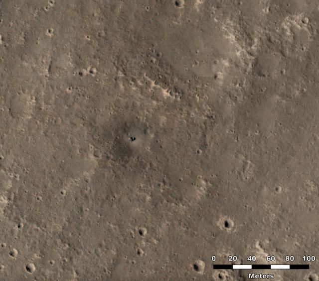
NASA's Mars Reconnaissance Orbiter used its High-Resolution Imaging Science Experiment (HiRISE) camera to capture this impact crater in Cerberus Fossae, a seismically active region of the Red Planet, on March 4, 2021. Scientists matched the crater's appearance on the surface with a quake detected by NASA's InSight lander, which was about 1,000 miles (1,640 kilometers) away. The crater is estimated to be about 71 feet (21.5 meters) in diameter. Most of the impacts detected by InSight, which was retired in 2022 after operating for more than four years, were thought to send their seismic signals through the Martian crust. But scientists concluded the energy from this impact traveled through the planet's mantle, much deeper than expected, after studying the location of the impact crater and seismic signals linked to it. Because of this finding, models of the composition and structure of the inner planet will have to be reassessed. This impact crater, along with others covered in a pair of papers published in Geophysical Research Letters in February 2025, was found with help from a machine learning algorithm developed at NASA's Jet Propulsion Laboratory in Southern California. The algorithm searched through tens of thousands of images captured by MRO's Context Camera in a matter of days, detecting 123 potential craters that may have occurred at the same time InSight was recording data. Traditional methods, in which human scientists carefully peer over images pixel by pixel, would have taken years of work to find these matches. Human scientists still had to narrow down the pool of candidate craters to 49 that matched InSight's quake data. After discovering this impact, scientists commanding MRO to take more detailed imagery with HiRISE. https://photojournal.jpl.nasa.gov/catalog/PIA26518
NASA's Perseverance Mars rover and Ingenuity helicopter were spotted on the surface of the Red Planet in this black-and-white image captured Feb. 26, 2022, by the HiRISE camera aboard NASA's Mars Reconnaissance Orbiter. The rover is viewed here sitting on fractured bedrock of the "Máaz" formation before its long drive to the Jezero Crater's delta. About 656 feet (200 meters) to the left is the Ingenuity helicopter, which is so small that it appears as a mere dot on the landscape. A key objective for Perseverance's mission on Mars is astrobiology, including the search for signs of ancient microbial life. The rover will characterize the planet's geology and past climate, pave the way for human exploration of the Red Planet, and be the first mission to collect and cache Martian rock and regolith (broken rock and dust). Subsequent NASA missions, in cooperation with ESA (European Space Agency), would send spacecraft to Mars to collect these sealed samples from the surface and return them to Earth for in-depth analysis. The Mars 2020 Perseverance mission is part of NASA's Moon to Mars exploration approach, which includes Artemis missions to the Moon that will help prepare for human exploration of the Red Planet. https://photojournal.jpl.nasa.gov/catalog/PIA25174
NASA Mars Reconnaissance Orbite observed this image of an isolated mountain in the Southern highlands reveals a large exposure of purplish bedrock. Since HiRISE color is shifted to longer wavelengths than visible color and given relative stretches, this really means that the bedrock is roughly dark in the broad red bandpass image compared to the blue-green and near-infrared bandpass images. In the RGB (red-green-blue) color image, which excludes the near-infrared bandpass image, the bedrock appears bluish in color. This small mountain is located near the northeastern rim of the giant Hellas impact basin, and could be impact ejecta. http://photojournal.jpl.nasa.gov/catalog/PIA19854

This image from NASA Mars Reconnaissance Orbiter spacecraft shows the nature of the terrain at the rim of Marth Crater. In the book "The Martian" by Andy Weir, stranded astronaut Mark Watney is headed for the Ares 4 landing site but encounters the rim of Marth Crater just as a dust storm arrives. This HiRISE image shows the nature of this terrain. The crater rim is not very distinct and from the ground it would be quite difficult to tell that you are even on the rim of a crater. The terrain is hummocky and rolling, punctuated by smaller impact craters and wind-blown drifts of sand or dust. http://photojournal.jpl.nasa.gov/catalog/PIA19959
One of the most actively changing areas on Mars are the steep edges of the North Polar layered deposits. This image from NASA's Mars Reconnaissance Orbiter (MRO) shows many new ice blocks compared to an earlier image in December 2006. An animation shows one example, where a section of ice cliff collapsed. The older image (acquired in bin-2 mode) is not as sharp as the newer one. HiRISE has been re-imaging regions first photographed in 2006 through 2007, six Mars years ago. This long baseline allows us to see large, rare changes as well as many smaller changes. More information is available at https://photojournal.jpl.nasa.gov/catalog/PIA22535
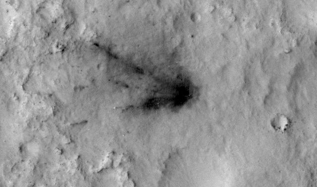
This HiRISE image from NASA's Mars Reconnaissance Orbiter (MRO) captures a new, dated (within about a decade) impact crater that triggered a slope streak. When the meteoroid hit the surface and exploded to make the crater, it also destabilized the slope and initiated this avalanche. The crater itself is only 5 meters across, but the streak it started is 1 kilometer long! Slope streaks are created when dry dust avalanches leave behind dark swaths on dusty Martian hills. The faded scar of an old avalanche is also visible to the side of the new dark streak. https://photojournal.jpl.nasa.gov/catalog/PIA22513
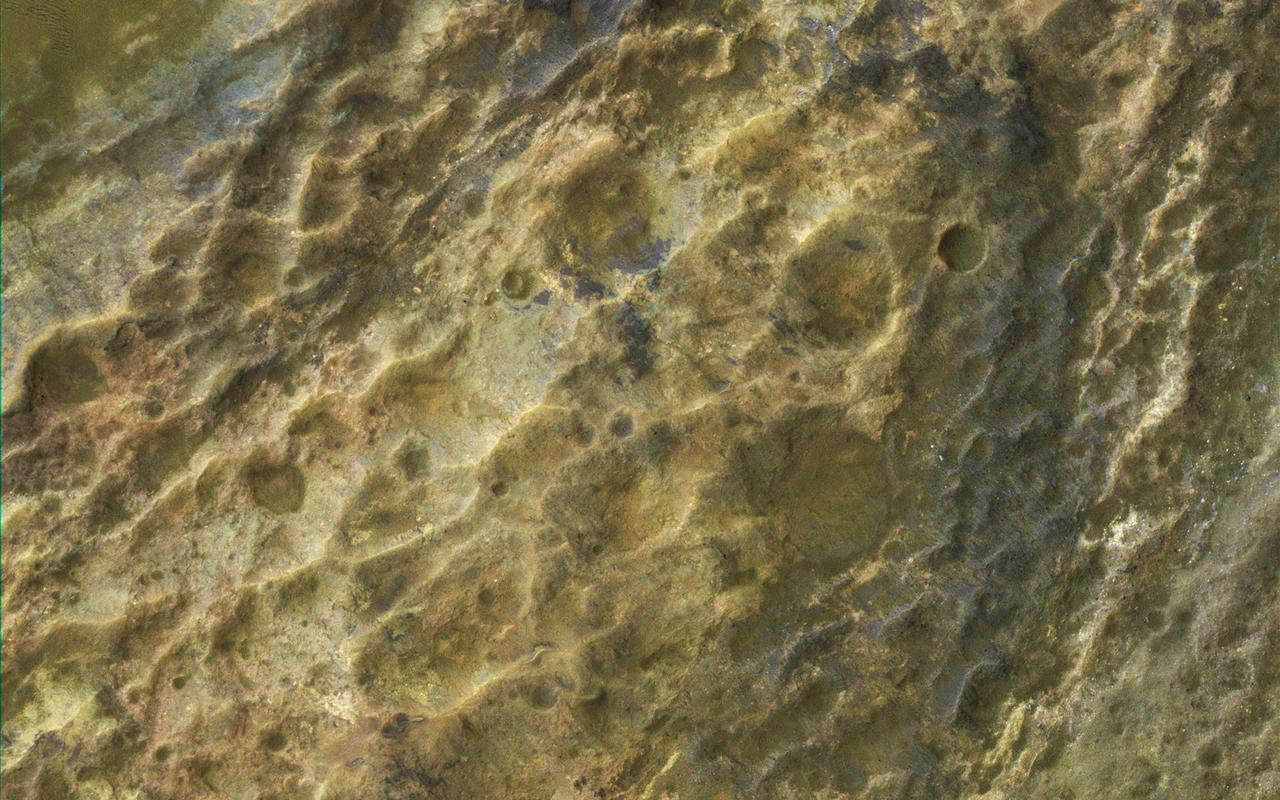
In this image, we see an approximately 500-meter crater that is fairly fresh (in geological terms), but the ejecta is already high-standing. Could this be an indication of early stage of pedestal development? A pedestal crater is when the ejecta from an impact settles around the new crater and is more erosion-resistant than the surrounding terrain. Over time, the surrounding terrain erodes much faster than the ejecta; in fact, some pedestal craters are measured to be hundreds of meters above the surrounding area. HiRISE has imaged many other pedestal craters before, and the ejecta isn't always symmetrical, as in this observation. http://photojournal.jpl.nasa.gov/catalog/PIA19849
This image from NASA Mars Reconnaissance Orbiter shows several seemingly active gullies and their associated fans near the Argyre region. As gullies form on slopes, sediment can become deposited to form lobe-shaped fans. Gullies can form with flowing water, but don't have to: sometimes they can be formed by the dry flow of sand and dust grains. This HiRISE image shows several seemingly active gullies and their associated fans. These particular gullies have many fine channels that are resolved nicely with a high resolution image. http://photojournal.jpl.nasa.gov/catalog/PIA19286
There is a candidate landing site in the Mawrth Vallis region for the European Space Agency's ExoMars rover, planned to launch in 2020. This is one of the HiRISE images acquired to evaluate this site. Mawrth Vallis has some of the most spectacular color variations seen anywhere on Mars. This color variability is due to a range of hydrated minerals -- water caused alteration of these ancient deposits -- which is why this site is of interest to study the past habitability of Mars. http://photojournal.jpl.nasa.gov/catalog/PIA21029
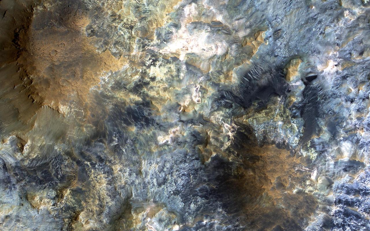
This image captured by NASA Mars Reconnaissance Orbiter MRO covers diverse surface units on the floor of eastern Coprates Chasma in eastern Valles Marineris. The bedrock has diverse minerals producing wonderful color contrasts. In over 10 years of orbiting Mars, HiRISE has acquired nearly 50,000 large images, but they cover less than 3 percent of the Martian surface. https://photojournal.jpl.nasa.gov/catalog/PIA21606
The high resolution imaging science experiment HiRISE is one of six science instruments for NASA Mars Reconnaissance Orbiter.
This image comes from observations of steep crater slopes on Terra Cimmeria by the HiRISE camera onboard NASA Mars Reconnaissance Orbiter.
This HiRISE image of the Opportunity rover was acquired as a coordinated ride-along observation with the CRISM instrument, also onboard the Mars Reconnaissance Orbiter.
This image comes from observations of a well-preserved crater on Terra Cimmeria by the HiRISE camera onboard NASA Mars Reconnaissance Orbiter.
NASA's Curiosity Mars rover appears as a dark speck in this image captured from directly overhead by the agency's Mars Reconnaissance Orbiter, or MRO. The orbiter is equipped with a camera capable of viewing objects the size of a dinner table on the Red Planet's surface. The camera, called the High-Resolution Imaging Science Experiment (HiRISE), has viewed spacecraft on the surface many times before. Here, it captured Curiosity driving up a steep slope on Dec. 29, 2023, the 4,051st Martian day, or sol, of the rover's mission. Curiosity is seen in an area striped with alternating dark and light bands. Scientists are interested in learning what differentiated the materials on the surface to form these different bands. https://photojournal.jpl.nasa.gov/catalog/PIA26245
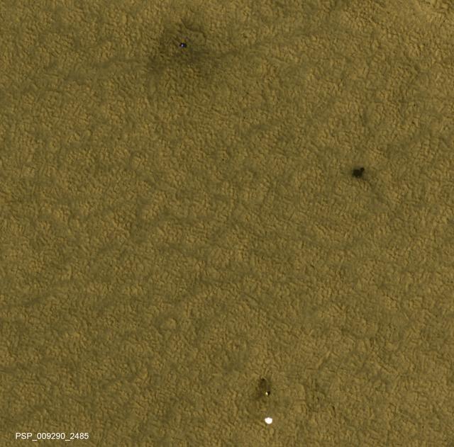
This is one of two images taken nearly a decade apart of NASA's Mars Phoenix Lander and related hardware around the mission's May 25, 2008, landing site on far-northern Mars. By late 2017, dust had obscured much of what was visible two months after the landing. Both images were taken by the High Resolution Imaging Science Experiment (HiRISE) camera on NASA's Mars Reconnaissance Orbiter. The one with three patches of darker ground -- where landing events removed dust -- was taken on July 20, 2008. It is Fig. 1, an excerpt of HiRISE observation PSP_009290_2485. The one with a more even coating of pale dust throughout the area was taken on Dec. 21, 2017. It is Fig. 2, an excerpt of HiRISE observation ESP_053451_2485. Both cover an area roughly 300 meters wide at 68 degrees north latitude, 234 degrees east longitude, and the two are closely matched in viewing and illumination geometry, from about five Martian years apart in northern hemisphere summers. An animation comparing the two images shows a number of changes between mid-2008 and late 2017. The lander (top) appears darker, and is now covered by dust. The dark spot created by the heat shield impact (right) is brighter, again due to dust deposition. The back shell and parachute (bottom) shows a darker parachute and brighter area of impact disturbance, thanks again to deposits of dust. We also see that the parachute has shifted in the wind, moving to the east. In August 2008, Phoenix completed its three-month mission studying Martian ice, soil and atmosphere. The lander worked for two additional months before reduced sunlight caused energy to become insufficient to keep the lander functioning. The solar-powered robot was not designed to survive through the dark and cold conditions of a Martian arctic winter. An animation and both images are available at https://photojournal.jpl.nasa.gov/catalog/PIA22223
This inner slope of a crater on southern Mars has several of the seasonal dark streaks called "recurrent slope lineae," or RSL, that a November 2017 report interprets as granular flows, rather than darkening due to flowing water. This 2011 view near the top of the southern rim of Tivat Crater comes from the High Resolution Imaging Science Experiment (HiRISE) camera on NASA's Mars Reconnaissance Orbiter. North is toward the top and the slope descends toward the northwest. The view spans an area about 1,000 feet (300 meters) wide. Figure 1 includes a scale bar of 50 meters (164 feet). HiRISE began viewing Mars in 2006. Multiple observations of some sites resulted in discovery of RSL in 2011 and has confirmed many thousands of them at more than 50 sites, from equatorial to mid-latitude north and south. These narrow, dark features appear in warm seasons, gradually extend downslope, fade away in winter and reappear the next year. On Earth, only seeping water is known to have these behaviors. Hydrated salts have been identified at RSL sites and RSL have previously been considered possible evidence of liquid water seeping down the slopes and darkening the ground. The Nov. 20, 2017, report in Nature Geosciences uses analysis of the steepness of slopes where RSL appear, including these RSL at Tivat Crater. The RSL all end, downhill, at approximately the same slope, which is similar to the angle of repose for sand. That is, the flows do not extend to slopes shallower than where dry grains of sand or dust could slip downhill, as on the face of a dune. Seeping water should readily extend to shallower slopes. This image is an excerpt from HiRISE observation ESP_023184_1335, taken on July 8, 2011, during Martian mid-afternoon at this site, at latitude 45.9 degrees south and longitude 9.5 degrees east. Tivat Crater is about 2.2 miles (3.6 kilometers) in diameter, and was named in 2011 for a town in Montenegro. https://photojournal.jpl.nasa.gov/catalog/PIA22070
Scientists think that ancient groundwater formed this weblike pattern of ridges, called boxwork, that were captured by NASA's Mars Reconnaissance Orbiter on Dec. 10, 2006. The agency's Curiosity rover will study ridges similar to these up close in 2025. Boxwork can form on Earth when groundwater flows through a web of rock fractures underground. Minerals carried by the water can coat the cracks and be deposited within the rock nearby. Eons later, if the rock erodes away, the minerals filling the cracks or the hardened rock leave a weblike pattern of ridges exposed. In the area captured by HiRISE, dark sand filled the spaces between these ridges, making them stand out more dramatically in the black-and-white image. The Martian boxwork Curiosity is headed toward formed in the foothills of lower Mount Sharp, a 3-mile-tall (5-kilometer-tall) mountain the rover has been ascending since 2014. Mount Sharp's boxwork structures stand apart from those on Earth, both because they formed as water was disappearing from Mars and because they're so extensive, running as long as 6 to 12 miles (10 to 20 kilometers). Scientists are eager to study them up close because minerals in the Martian boxwork crystallized underground, where it would have been warmer, with liquid flowing through. The rover's science team will study whether microbes could have survived in that ancient environment. https://photojournal.jpl.nasa.gov/catalog/PIA26306
Seasonal frost commonly forms at middle and high latitudes on Mars, much like winter snow on Earth. However, on Mars most frost is carbon dioxide dry ice rather than water ice. This image is from NASA Mars Reconnaissance Orbiter. This image shows frost in gully alcoves in a crater on the Northern plains. The frost highlights details of the alcoves, since it forms in different amounts depending on slopes and shadows as well as the type of material making up the ground. Rugged rock outcrops appear dark and shadowed, while frost highlights the upper alcove and the steepest route down the slope. Most changes associated with gullies are observed in the Southern hemisphere. However, some are seen in the Northern hemisphere, where steep slopes are less common. HiRISE is monitoring these gullies to look for changes and to understand the behavior of the frost. http://photojournal.jpl.nasa.gov/catalog/PIA19852
![The goal of this observation from NASA' Mars Reconnaissance Orbiter (MRO) is to determine the source of the ridge within a possible moraine that is also present in another HiRISE image. A moraine is a mass of rocks and sediment carried down and deposited by a glacier. If the structure is a moraine, we should expect to find two sources of debris converging in the valley. If the sources are carrying lots of debris, there is a good chance of finding more moraine features further up the valley. The map is projected here at a scale of 50 centimeters (19.7 inches) per pixel. [The original image scale is 59.5 centimeters (23.4 inches) per pixel (with 2 x 2 binning); objects on the order of 179 centimeters (70.5 inches) across are resolved.] North is up. https://photojournal.jpl.nasa.gov/catalog/PIA22124](https://images-assets.nasa.gov/image/PIA22124/PIA22124~medium.jpg)
The goal of this observation from NASA' Mars Reconnaissance Orbiter (MRO) is to determine the source of the ridge within a possible moraine that is also present in another HiRISE image. A moraine is a mass of rocks and sediment carried down and deposited by a glacier. If the structure is a moraine, we should expect to find two sources of debris converging in the valley. If the sources are carrying lots of debris, there is a good chance of finding more moraine features further up the valley. The map is projected here at a scale of 50 centimeters (19.7 inches) per pixel. [The original image scale is 59.5 centimeters (23.4 inches) per pixel (with 2 x 2 binning); objects on the order of 179 centimeters (70.5 inches) across are resolved.] North is up. https://photojournal.jpl.nasa.gov/catalog/PIA22124
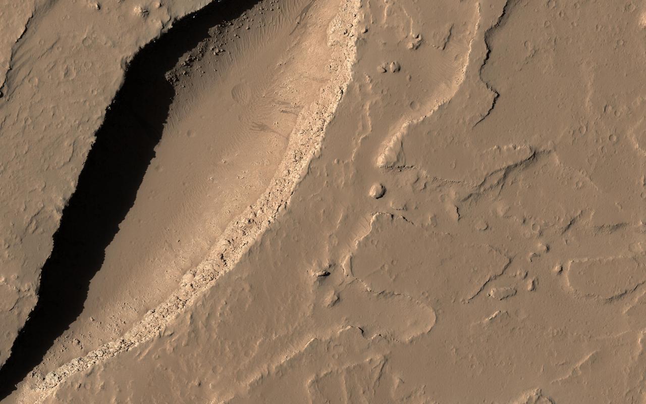
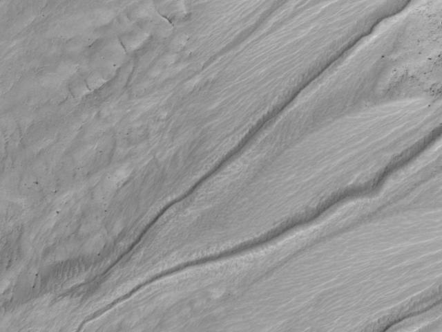
Gullies are commonly found in the southern mid-latitudes of Mars. In this image from NASA Mars Reconnaissance Orbiter they start near top of a long ridge, and descend into an impact crater that lies at the bottom of the ridge, moving through a rocky layer along the way. Below the layer, the surface is dark and blue in HiRISE enhanced color, suggesting that it is easily erodible sand coating the crater wall. The topography here is also interesting. There are two main features, an impact crater and a long trough called a graben, formed when the surface drops down between two faults. The eastern side of the crater is clearly cut by faulting, distorting the circular shape. On the north side, the crater rim is below the top of the graben fault. The crater could have dropped into the trough as it formed, but it is also possible that the trough partially formed before the crater and continued to widen later. http://photojournal.jpl.nasa.gov/catalog/PIA19308
found across the Martian surface. Each impact crater on Mars possesses a unique origin and composition, which makes the HiRISE team very interested in sampling as many of them as possible! Like the impact of a droplet into fluid, once an impact has occurred on the surface of Mars, an ejecta curtain forms immediately after, contributing to the raised rim visible at the top of the crater's walls. After the formation of the initial crater, if it is large enough, then a central peak appears as the surface rebounds. These central peaks can expose rocks that were previously deeply buried beneath the Martian surface. The blue and red colors in this enhanced-contrast image reflect the effects of post-impact sedimentation and weathering over time. http://photojournal.jpl.nasa.gov/catalog/PIA08395
![Recurring Slope Lineae (called "RSL") are seasonally-repeating dark flows that are active at the warmest times of the year. Some of these grow from the top of the steep slope downwards as expected for liquid or granular flows. Others show different darkening patterns, which suggests different processes. Although HiRISE has acquired many images to monitor RSL sites, it still is not certain how these features form. The map is projected here at a scale of 25 centimeters (9.8 inches) per pixel. [The original image scale is 25.8 centimeters (10.2 inches) per pixel (with 2 x 2 binning); objects on the order of 51.7 centimeters (20.4 inches) across are resolved.] North is up. http://photojournal.jpl.nasa.gov/catalog/PIA21558](https://images-assets.nasa.gov/image/PIA21558/PIA21558~medium.jpg)
Recurring Slope Lineae (called "RSL") are seasonally-repeating dark flows that are active at the warmest times of the year. Some of these grow from the top of the steep slope downwards as expected for liquid or granular flows. Others show different darkening patterns, which suggests different processes. Although HiRISE has acquired many images to monitor RSL sites, it still is not certain how these features form. The map is projected here at a scale of 25 centimeters (9.8 inches) per pixel. [The original image scale is 25.8 centimeters (10.2 inches) per pixel (with 2 x 2 binning); objects on the order of 51.7 centimeters (20.4 inches) across are resolved.] North is up. http://photojournal.jpl.nasa.gov/catalog/PIA21558
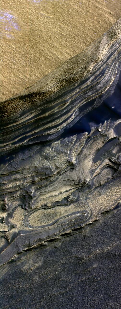
A variety of diverse morphological features are present in this image (21 by 5.5 kilometers) located in the southeastern area of the Nili Fossae region and just northeast of Syrtis Major. This particular region has been studied intensely due to the presence of volcanics from Syrtis Major and impact ejecta from the Isidis Basin. The region is rich in unaltered mafic deposits, in contact with diverse altered deposits rich in clays, carbonates, and sulfates. These deposits make the Nili Fossae region one of the most colorful regions on Mars, which is most distinctive in infrared color composites (IRB). HiRISE IRB color aids in chemical and mineral-type mapping, especially when correlated with other MRO instruments such as CRISM. http://photojournal.jpl.nasa.gov/catalog/PIA19940
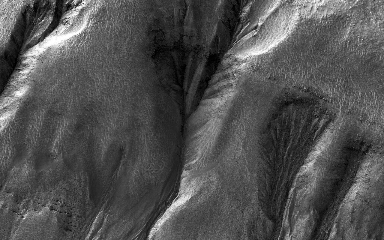
Gullies eroded into the steep inner slope of an impact crater at this location appear perfectly pristine in this image captured by NASA's Mars Reconnaissance Orbiter (MRO). Although at first glance it may appear that there are craters superimposed on the gully fans, inspection of HiRISE stereo coverage shows that the craters lie only on the pre-gully terrain. Distinctive colors in the gully channels and alcoves offer another indication of youth and recent activity. The pre-gully landscape is covered by secondary craters from nearby Gasa Crater, estimated to be about 1 million years old. Although some have suggested that the Martian gullies are also about a million years old and formed in a different environment, we now know that they are continuing to form today. https://photojournal.jpl.nasa.gov/catalog/PIA21599
This image shows a possible landing site for the 2020 Mission: Jezero Crater, as seen by NASA Mars Reconnaissance Orbiter. It's not only when trying to find a scientifically interesting place to land that the high-resolution images from HiRISE come in handy: it's also to identify potential hazards within a landing ellipse. This is one of the trickier aspects of selecting landing sites on Mars: a place to do good science but also where the risks of landing are low. Jezero Crater is an ancient crater where clay minerals have been detected, and with a delta deposit indicating that water was once flowing into a lake. Since clays form the in presence of water, this crater would be a very good candidate for a lander to explore and build on what we've learned from the Mars Science Laboratory. Could some form of ancient life have existed here and for how long? http://photojournal.jpl.nasa.gov/catalog/PIA19303
This dune field formed near the base of the North Polar cap. Dunes require a source of loose particulate material to form. The source of the northern dune fields around the polar cap may be from the layers of dusty ice that are eroded by strong polar winds. This image was taken during the Martian northern summer, so there is no frost present on the dunes. The dunes closest to the base of the polar cap are long and parallel, indicating strong winds from the direction of the cap. As they get farther away from the polar cap, they start to form more crescent shaped dunes, called barchan dunes. Repeated observations by HiRISE of dunes like these show measurable changes in some locations. This discovery adds to the growing evidence that there are active processes happening all over the surface of Mars today. http://photojournal.jpl.nasa.gov/catalog/PIA11181
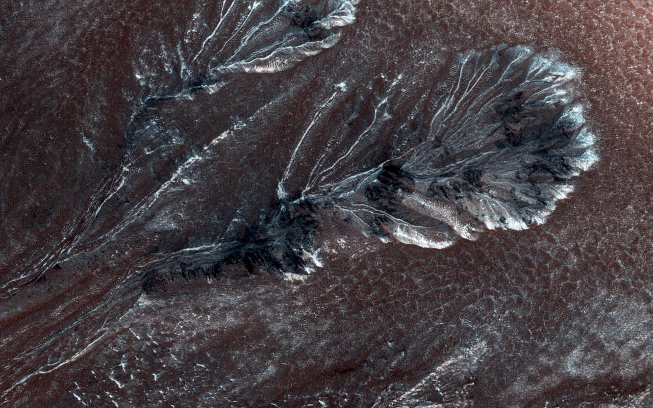
In this image from the High Resolution Imaging Science Experiment (HiRISE) camera on NASA's Mars Reconnaissance Orbiter, the dark branched features in the floor of Antoniadi Crater look like giant ferns, or fern casts. However, these ferns would be several miles in size and are composed of rough rocky materials. A more likely hypothesis is that this represents a channel network that now stands in inverted relief. The channels may have been lined or filled by indurated materials, making the channel fill more resistant to erosion by the wind than surrounding materials. After probably billions of years of wind erosion the resistant channels are now relatively high-standing. The material between the branched ridges has a fracture pattern and color similar to deposits elsewhere on Mars that are known to be rich in hydrated minerals such as clays. The inverted channels have short, stubby branches characteristic of formation by groundwater sapping. Spring water seeps into the channels and undercuts overlying layers, which collapse, so the channels grow headward. These images tell the story of an ancient wet environment on Mars, where life could have been possible. Ancient Martian life, if it existed, would most likely consist of microorganisms rather than giant tree ferns. This image, covering an area about 1 kilometer (0.6 mile) across, is a portion of the HiRISE observation catalogued as ESP_012435_2015, taken on March 22, 2009. The observation is centered at 21.4 degrees north latitude, 61.3 degrees east longitude. The image was taken at a local Mars time of 3:31 p.m. and the scene is illuminated from the west with a solar incidence angle of 66 degrees, thus the sun was about 24 degrees above the horizon. At a solar longitude of 232.1 degrees, the season on Mars is northern autumn. http://photojournal.jpl.nasa.gov/catalog/PIA12003
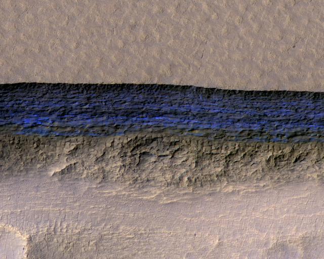
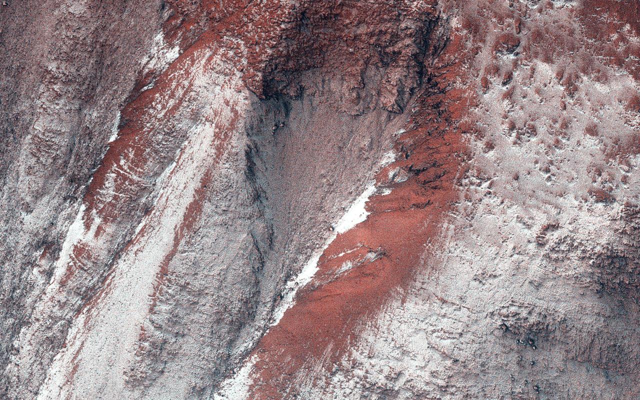
Click on the image for larger version A cross-section of a thick sheet of underground ice is exposed at the steep slope (or scarp) that appears bright blue in this enhanced-color view from the High Resolution Imaging Science Experiment (HiRISE) camera on NASA's Mars Reconnaissance Orbiter. The view covers an area about 550 yards (500 meters) wide. Figure 1 includes a 100-meter (109-yard) scale bar. North is toward the top. The upper third of the image shows level ground that is about 140 yards (130 meters) higher in elevation than the ground in the bottom third. In between, the scarp descends sharply, exposing about 260 vertical feet (80 vertical meters) of water ice. Color is exaggerated to make differences in surface materials easier to see. The presence of exposed water ice at this site was confirmed by observation with the same orbiter's Compact Reconnaissance Imaging Spectrometer for Mars (CRISM). In January 2018, in the journal Science, researchers reported finding and studying eight such ice-exposing scarps in the middle latitudes of Mars. The presence of vast underground ice deposits in Mars' middle latitudes was known previously. The report of unusual sites where they are exposed provides new information about their depth and layering. It also identifies potential water resources for future Mars missions and possibilities for studying Martian climate history by examining the ice layers holding a record of past climate cycles. The ice may have been deposited as snow when the tilt of Mars' rotation axis was greater than it is now. HiRISE observation ESP_022389_1230 was made on May 7, 2011, at 56.6 degrees south latitude, 114.1 degrees east longitude. https://photojournal.jpl.nasa.gov/catalog/PIA22077
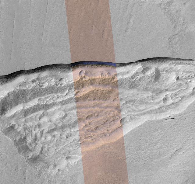
At this wedge-shaped pit on Mars, the steep slope (or scarp) at the northern edge (toward the top of the image) exposes a cross-section of a thick sheet of underground water ice. The image is from the High Resolution Imaging Stereo Experiment (HiRISE) camera on NASA's Mars Reconnaissance Orbiter. The gray-scale portions on left and right are from a single waveband in the red-light portion of the visible spectrum. The middle section, in enhanced color, combines data from red, near-infrared and blue-green wavebands. The scene covers an area about three miles (five kilometers) wide. Figure 1 includes a one-kilometer scale bar. One kilometer is about six-tenths of a mile. The ice-exposing scarp at the northern edge of the pit has a steepness of about 45 to 55 degrees, plunging from the relatively level ground outside the pit. The HiRISE observation ESP_022389_1230 was made on May 7, 2011, at 56.6 degrees south latitude, 114.1 degrees east longitude. In January 2018, in the journal Science, researchers reported finding and studying eight such ice-exposing scarps in the middle latitudes of Mars. The presence of vast underground ice deposits in Mars' middle latitudes was known previously. The report of unusual sites where they are exposed provides new information about their depth and layering. It also identifies potential water resources for future Mars missions and possibilities for studying Martian climate history by examining the ice layers holding a record of past climate cycles. The ice may have been deposited as snow when the tilt of Mars' rotation axis was greater than it is now. https://photojournal.jpl.nasa.gov/catalog/PIA22078
The image shows a region we see many slope streaks, typically dark features on slopes in the equatorial regions on Mars. They may extend for tens of meters in length and gradually fade away with time as new ones form. The most common hypothesis is that they are generated by dust avalanches that regularly occur on steep slopes exposing fresh dark materials from underneath the brighter dust. There are many types of slope streaks but one of the most recent and significant findings using HiRISE was the discovery of a new type called "recurring slope lineae," or RSL for short. Recent studies suggest that RSL may form through the flow of briny (extremely salty) liquid water that can be stable on the surface of Mars even under current climatic conditions for a limited time in summer when it is relatively warm. How can we distinguish between conventional slope streaks like the ones we see here and RSL? There are many criteria. For instance, RSL are usually smaller in size than regular slope streaks. However, one of the most important conditions is seasonal behavior, since RSL appear to be active only in summer while regular slope streaks can be active anytime of the year. This site is monitored regularly by HiRISE scientists because of the high density of slope streaks and their different sizes and orientations. If we look at a time-lapse sequence, we will see that a new slope streak has indeed formed in the period since April 2016 (and we can note how dark it is in comparison to the others indicating its freshness). However, this period corresponds mainly to the autumn season in this part of Mars, whereas we do not see any major changes in the summer season. This suggests that the feature that developed is a regular slope streak just like all the others in the area. http://photojournal.jpl.nasa.gov/catalog/PIA21272
This view shows part of an area on Mars where narrow rock ridges, some as tall as a 16-story building, intersect at angles forming corners of polygons. The area covered in the image spans about two-thirds of a mile (1.1 kilometers) wide, in the Gordii Dorsum portion of the Medusae Fossae region of Mars. The image is from the High Resolution Imaging Science Experiment (HiRISE) camera on the Mars Reconnaissance Orbiter. North is up. Note the shadows cast by some of the walls. These ridges likely formed as lava that hardened underground and later resisted erosion better than the surrounding material. From ground level, they would resemble hardened-lava walls on Earth http://photojournal.jpl.nasa.gov/catalog/PIA21264
Tectonic stresses highly modified this area of Ganges Catena, north of Valles Marineris. The long, skinny ridges (called "wrinkle ridges") are evidence of compressional stresses in Mars' crust that created a crack (fault) where one side was pushed on top of the other side, also known as a thrust fault. As shown by cross-cutting relationships, however, extensional stresses have more recently pulled the crust of Mars apart in this region. (HiRISE imaged this area in 2-by-2 binning mode, so a pixel represents a 50 x 50 square centimeter.) http://photojournal.jpl.nasa.gov/catalog/PIA21112
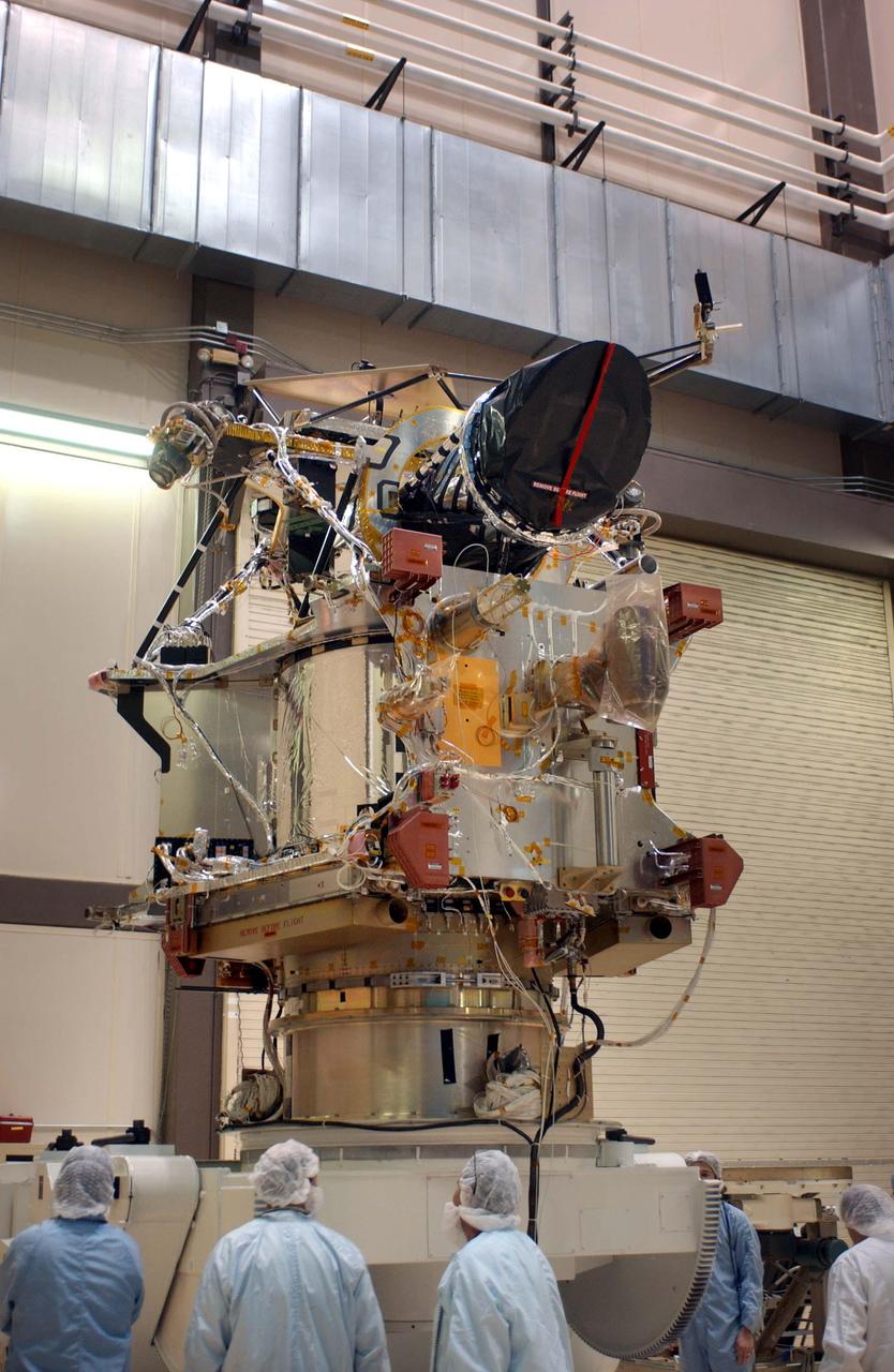
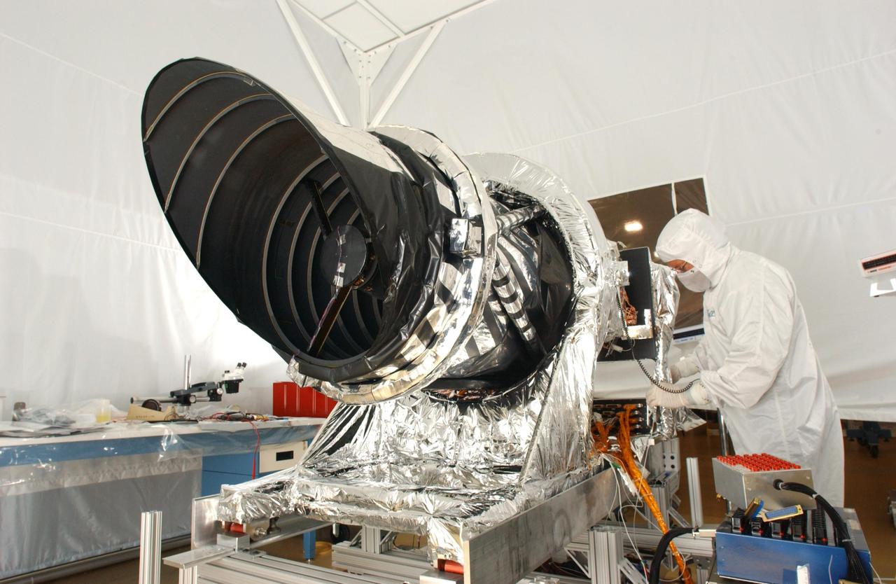
A telescopic camera called the High Resolution Imaging Science Experiment, or HiRISE, was installed onto the main structure of NASA Mars Reconnaissance Orbiter on Dec. 11, 2004 at Lockheed Martin Space Systems, Denver, Colo. HiRISE is at the top of the spacecraft in this image. Some other large components, including solar panels and the high-gain antenna, had not yet been installed. The orbiter is scheduled for launch in August 2005 carrying six science instruments. Ball Aerospace and Technology Corp., Boulder, Colo., built HiRISE for the University of Arizona, Tucson, to supply for the mission. http://photojournal.jpl.nasa.gov/catalog/PIA07210

Boulder-size blocks of water ice can be seen around the rim of this giant meteoroid impact crater on Mars, as viewed by the High-Resolution Imaging Science Experiment (HiRISE camera) aboard NASA's Mars Reconnaissance Orbiter. The crater was formed on Dec. 24, 2021, when a meteoroid struck the ground in a region of Mars called Amazonis Planitia. The impact churned up a layer of water ice buried under the ground here – the closest to the Martian equator buried water ice has ever been found. NASA scientists are interested in finding deposits of water ice as close to the Martian equator as possible, where it's warmer and safer to land. This ice would be a critical resource for astronauts as drinking water, for agriculture, and for rocket propellant. https://photojournal.jpl.nasa.gov/catalog/PIA25583
This observation from NASA Mars Reconnaissance Orbiter shows one of the first close HiRISE views of the enigmatic Valles Marineris interior layered deposits.
NASA rover Curiosity appears as a bluish dot near the lower right corner of this enhanced-color view from the HiRISE camera on NASA Mars Reconnaissance Orbiter.
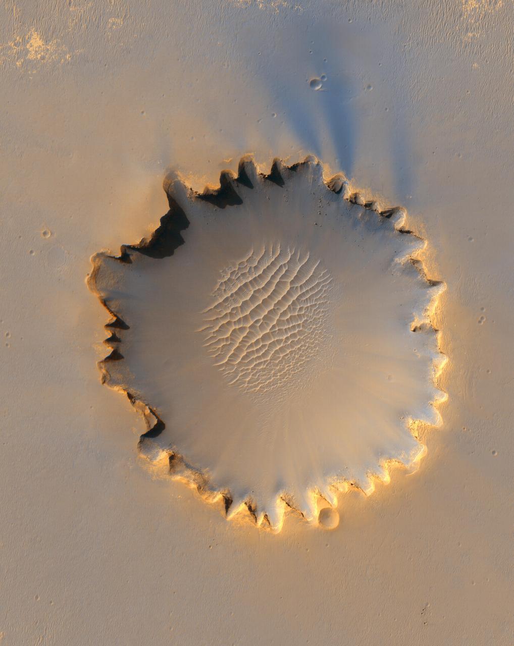
This image from the HiRISE instrument on NASA Mars Reconnaissance Orbiter shows Victoria crater, an impact crater at Meridiani Planum, near the equator of Mars.
With NASA Mars Reconnaissance Orbiter HiRISE camera and its powerful resolution, other mission teams can request images of potential future landing sites on Mars.
This image, taken by the HiRISE camera onboard NASA Mars Reconnaissance Orbiter is of a gully on a south-facing slope in middle southern latitudes of Mars.
Monitoring by NASA Mars Reconnaissance Orbiter HiRISE has shown that gully formation on Mars occurs in winter and early spring in times and places with frost on the ground.
This false-color subframe of an image from the HiRISE camera on NASA Mars Reconnaissance Orbiter shows the north polar layered deposits at top and darker materials at bottom.
This view of Murray Ridge was generated from data from NASA Mars Reconnaissance Rover and a digital topographic map generated from stereo HiRISE coverage.

Capri Chasma is located in the eastern portion of the Valles Marineris canyon system, the largest known canyon system in the Solar System. Deeply incised canyons such as this are excellent targets for studying the Martian crust, as the walls may reveal many distinct types of bedrock. This section of the canyon was targeted by HiRISE based on a previous spectral detection of hematite-rich deposits in the area. Hematite, a common iron-oxide mineral, was first identified here by the Mars Global Surveyor Thermal Emission Spectrometer (TES). In this TES image, red pixels indicate higher abundances of hematite, while the blue and green pixels represent different types of volcanic rocks (e.g., basalt). Hematite in the Meridiani Planum region was also detected with the TES instrument (which we can see with the bright red spot on the Global TES mineral map). As a consequence, Meridiani Planum was the first landing site selected on Mars due to the spectral detection of a mineral that may have formed in the presence of liquid water. Shortly after landing, the Opportunity rover detected the presence of hematite in the form of concretions called "blueberries." The blueberries are found in association with layers of sulfate salt-rich rocks. The salts are hypothesized to have formed through the raising and lowering of the groundwater table. During one such an event, the rock altered to form the hematite-rich blueberries. As the rock was eroded away, the more resistant hematite-rich blueberries were plucked out and concentrated on the plains as a "lag" deposit. Martian blueberries are observed to be scattered across the plains of Meridiani along Opportunity's traverse from Eagle Crater to Endeavor Crater, where Opportunity continues to explore after its mission began over 10 years ago. This infrared-color image close-up highlights what is possibly the hematite-rich deposits nestled between different types of bedrock terraces in Capri Chasma. The bluish terrace is likely volcanic in origin, possibly basaltic, whereas the greenish rocks remain unidentified. The central reddish terrace is possibly where some of the hematite may be concentrated. The higher elevation terrace with the lighter-colored materials is likely a sulfate-rich rock (based on CRISM data in the area). Given the presence of both sulfate salts and hematite in this area, akin to the deposits and associations explored by the Opportunity rover in Meridiani Planum, it might be that these materials in Capri Chasma may share a similar origin. The yellow rectangular box shown on the TES spectral map outlines the corresponding location of the HiRISE image. Although the outline does not appear to contain a high hematite abundance, we note that the lower resolution of TES (about 3 to 6 kilometers per pixel) may exclude smaller exposures and finer sub-pixel details not-yet captured, but could be with HiRISE. A follow-up observation by the CRISM spectrometer may reveal additional details and a spectral signature for hematite in the vicinity at a finer resolution than TES. http://photojournal.jpl.nasa.gov/catalog/PIA21274
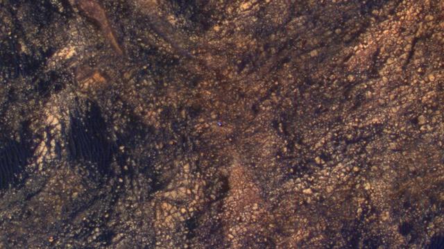
The feature that appears bright blue at the center of this scene is NASA's Curiosity Mars rover on the northwestern flank of Mount Sharp, viewed by NASA's Mars Reconnaissance Orbiter. Curiosity is approximately 10 feet long and 9 feet wide (3.0 meters by 2.8 meters). The view is a cutout from observation ESP_050897_1750 taken by the High Resolution Imaging Science Experiment (HiRISE) camera on the orbiter on June 5, 2017. HiRISE has been imaging Curiosity about every three months, to monitor the surrounding features for changes such as dune migration or erosion. When the image was taken, Curiosity was partway between its investigation of active sand dunes lower on Mount Sharp, and "Vera Rubin Ridge," a destination uphill where the rover team intends to examine outcrops where hematite has been identified from Mars orbit. The rover's surroundings include tan rocks and patches of dark sand. As in previous HiRISE color images of Curiosity since the rover was at its landing site, the rover appears bluer than it really is. HiRISE color observations are recorded in a red band, a blue-green band and an infrared band, and displayed in red, green and blue. This helps make differences in Mars surface materials apparent, but does not show natural color as seen by the human eye. Lower Mount Sharp was chosen as a destination for the Curiosity mission because the layers of the mountain offer exposures of rocks that record environmental conditions from different times in the early history of the Red Planet. Curiosity has found evidence for ancient wet environments that offered conditions favorable for microbial life, if Mars has ever hosted life. https://photojournal.jpl.nasa.gov/catalog/PIA21710
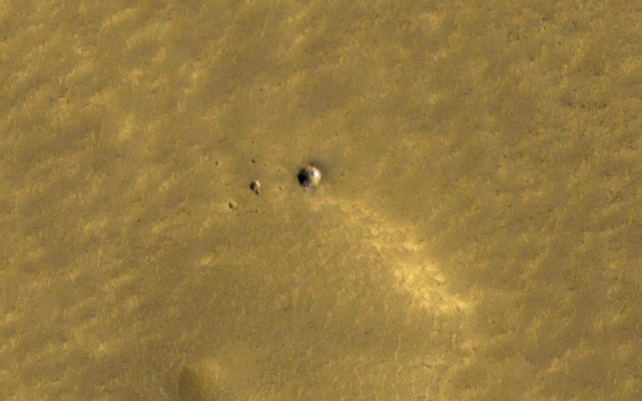
The HiRISE and Context Camera instruments on the Mars Reconnaissance Orbiter have worked together to image many new impact craters that have formed within the last few years. At middle and high latitudes, these craters often dig up ice, which is initially bright and then fades away as it sublimates. A small crater here was first seen by HiRISE in 2010, and some of the ice is still bright over a decade later. A theory suggests that many millimeters of ice should have been lost in that time. Since we can still see the ice, it must be very clean, without much dust or debris mixed in. How many changes can you spot? https://photojournal.jpl.nasa.gov/catalog/PIA24693
![On Nov. 1, 2016, the High Resolution Imaging Science Experiment (HiRISE) camera on NASA's Mars Reconnaissance Orbiter observed the impact site of Europe's Schiaparelli test lander, gaining the first color view of the site since the lander's Oct. 19, 2016, arrival. These cutouts from the observation cover three locations where parts of the spacecraft reached the ground: the lander module itself in the upper portion, the parachute and back shell at lower left, and the heat shield at lower right. The heat shield location was outside of the area covered in color. The scale bar of 10 meters (32.8 feet) applies to all three cutouts. Schiaparelli was one component of the European Space Agency's ExoMars 2016 project, which placed the Trace Gas Orbiter into orbit around Mars on the same arrival date. The ExoMars project received data from Schiaparelli during its descent through the atmosphere. ESA reports that the heat shield separated as planned, the parachute deployed as planned but was released (with back shell) prematurely, and the lander hit the ground at a velocity of more than 180 miles per hour (more than 300 kilometers per hour). Information gained from the Nov. 1 observation supplements what was learned from an Oct. 25 HiRISE observation, at PIA21131, which also shows the locations of these three cutouts relative to each other. Where the lander module struck the ground, dark radial patterns that extend from a dark spot are interpreted as "ejecta," or material thrown outward from the impact, which may have excavated a shallow crater. From the earlier image, it was not clear whether the relatively bright pixels and clusters of pixels scattered around the lander module's impact site are fragments of the module or image noise. Now it is clear that at least the four brightest spots near the impact are not noise. These bright spots are in the same location in the two images and have a white color, unusual for this region of Mars. The module may have broken up at impact, and some fragments might have been thrown outward like impact ejecta. The parachute has a different shape in the Nov. 1 image than in the Oct. 25 one, apparently from shifting in the wind. Similar shifting was observed in the parachute of NASA's Mars Science Laboratory mission during the first six months after the Mars arrival of that mission's Curiosity rover in 2012 [PIA16813]. At lower right are several bright features surrounded by dark radial impact patterns, located where the heat shield was expected to impact. The bright spots appear identical in the Nov. 1 and Oct. 25 images, which were taken from different angles, so these spots are now interpreted as bright material, such as insulation layers, not glinting reflections. http://photojournal.jpl.nasa.gov/catalog/PIA21132](https://images-assets.nasa.gov/image/PIA21132/PIA21132~thumb.jpg)
On Nov. 1, 2016, the High Resolution Imaging Science Experiment (HiRISE) camera on NASA's Mars Reconnaissance Orbiter observed the impact site of Europe's Schiaparelli test lander, gaining the first color view of the site since the lander's Oct. 19, 2016, arrival. These cutouts from the observation cover three locations where parts of the spacecraft reached the ground: the lander module itself in the upper portion, the parachute and back shell at lower left, and the heat shield at lower right. The heat shield location was outside of the area covered in color. The scale bar of 10 meters (32.8 feet) applies to all three cutouts. Schiaparelli was one component of the European Space Agency's ExoMars 2016 project, which placed the Trace Gas Orbiter into orbit around Mars on the same arrival date. The ExoMars project received data from Schiaparelli during its descent through the atmosphere. ESA reports that the heat shield separated as planned, the parachute deployed as planned but was released (with back shell) prematurely, and the lander hit the ground at a velocity of more than 180 miles per hour (more than 300 kilometers per hour). Information gained from the Nov. 1 observation supplements what was learned from an Oct. 25 HiRISE observation, at PIA21131, which also shows the locations of these three cutouts relative to each other. Where the lander module struck the ground, dark radial patterns that extend from a dark spot are interpreted as "ejecta," or material thrown outward from the impact, which may have excavated a shallow crater. From the earlier image, it was not clear whether the relatively bright pixels and clusters of pixels scattered around the lander module's impact site are fragments of the module or image noise. Now it is clear that at least the four brightest spots near the impact are not noise. These bright spots are in the same location in the two images and have a white color, unusual for this region of Mars. The module may have broken up at impact, and some fragments might have been thrown outward like impact ejecta. The parachute has a different shape in the Nov. 1 image than in the Oct. 25 one, apparently from shifting in the wind. Similar shifting was observed in the parachute of NASA's Mars Science Laboratory mission during the first six months after the Mars arrival of that mission's Curiosity rover in 2012 [PIA16813]. At lower right are several bright features surrounded by dark radial impact patterns, located where the heat shield was expected to impact. The bright spots appear identical in the Nov. 1 and Oct. 25 images, which were taken from different angles, so these spots are now interpreted as bright material, such as insulation layers, not glinting reflections. http://photojournal.jpl.nasa.gov/catalog/PIA21132
This unnamed, approximately 30-kilometer diameter crater, formed in the Southern highlands of Mars. This image from NASA's Mars Reconnaissance Orbiter shows regions of geologic diversity within, making this an interesting spot for scientists to study how different Martian processes interact with each other. Gullies, or channels formed by fluids such as water or lava, cut into the rim and sides of this crater. The presence of gullies can reveal clues about the ancient history of Mars, such as the amount of flowing fluid needed to form them and roughly how long ago that happened. This crater may also host features actively changing on the surface of Mars known as "recurring slope lineae" (RSL). Manifesting as dark streaks on steep slopes such as the walls of craters, scientists posit briny flows of small volumes of water as a possible RSL formation method. Studying the behavior of RSL further may provide evidence for the presence of water on Mars today. Moving toward the crater floor, one can observe patterns indicative of dunes. Dunes arise from the breakdown of exposed rocks by wind and subsequent manipulation of the eroded sand particles into wave-like structures. The presence of dust devil tracks provides additional evidence for significant wind activity at this location. These dunes are very dusty and so likely haven't been active (moved) in some time. HiRISE also captured a small, relatively fresh crater on the floor near the dunes. One of the most ubiquitous processes in the solar system, impact cratering can drastically change the surface of a planetary body. As such, craters provide sources of comparison between planets, moons, and other bodies across the solar system. Impacts still occur today, helping scientists find relative ages of different areas of a planet and discover materials buried under the surface. All of these processes have altered the surface of Mars in the past and continue to do so today. Since gully formation, wind erosion, and impact cratering could have interacted with each other for many years, planetary scientists find it difficult to work backwards and make definitive statements about ancient Martian history. However, HiRISE imagery has aided in closing these gaps in our scientific knowledge. https://photojournal.jpl.nasa.gov/catalog/PIA21654
![NASA's Mars Reconnaissance Orbiter (MRO) captured this crater featuring sand dunes and sand sheets on its floor. What are sand sheets? Snow fall on Earth is a good example of sand sheets: when it snows, the ground gets blanketed with up to a few meters of snow. The snow mantles the ground and "mimics" the underlying topography. Sand sheets likewise mantle the ground as a relatively thin deposit. This kind of environment has been monitored by HiRISE since 2007 to look for movement in the ripples covering the dunes and sheets. This is how scientists who study wind-blown sand can track the amount of sand moving through the area and possibly where the sand came from. Using the present environment is crucial to understanding the past: sand dunes, sheets, and ripples sometimes become preserved as sandstone and contain clues as to how they were deposited The map is projected here at a scale of 25 centimeters (9.8 inches) per pixel. [The original image scale is 25 centimeters (9.8 inches) per pixel (with 1 x 1 binning); objects on the order of 75 centimeters (29.5 inches) across are resolved.] North is up. https://photojournal.jpl.nasa.gov/catalog/PIA21757](https://images-assets.nasa.gov/image/PIA21757/PIA21757~medium.jpg)
NASA's Mars Reconnaissance Orbiter (MRO) captured this crater featuring sand dunes and sand sheets on its floor. What are sand sheets? Snow fall on Earth is a good example of sand sheets: when it snows, the ground gets blanketed with up to a few meters of snow. The snow mantles the ground and "mimics" the underlying topography. Sand sheets likewise mantle the ground as a relatively thin deposit. This kind of environment has been monitored by HiRISE since 2007 to look for movement in the ripples covering the dunes and sheets. This is how scientists who study wind-blown sand can track the amount of sand moving through the area and possibly where the sand came from. Using the present environment is crucial to understanding the past: sand dunes, sheets, and ripples sometimes become preserved as sandstone and contain clues as to how they were deposited The map is projected here at a scale of 25 centimeters (9.8 inches) per pixel. [The original image scale is 25 centimeters (9.8 inches) per pixel (with 1 x 1 binning); objects on the order of 75 centimeters (29.5 inches) across are resolved.] North is up. https://photojournal.jpl.nasa.gov/catalog/PIA21757
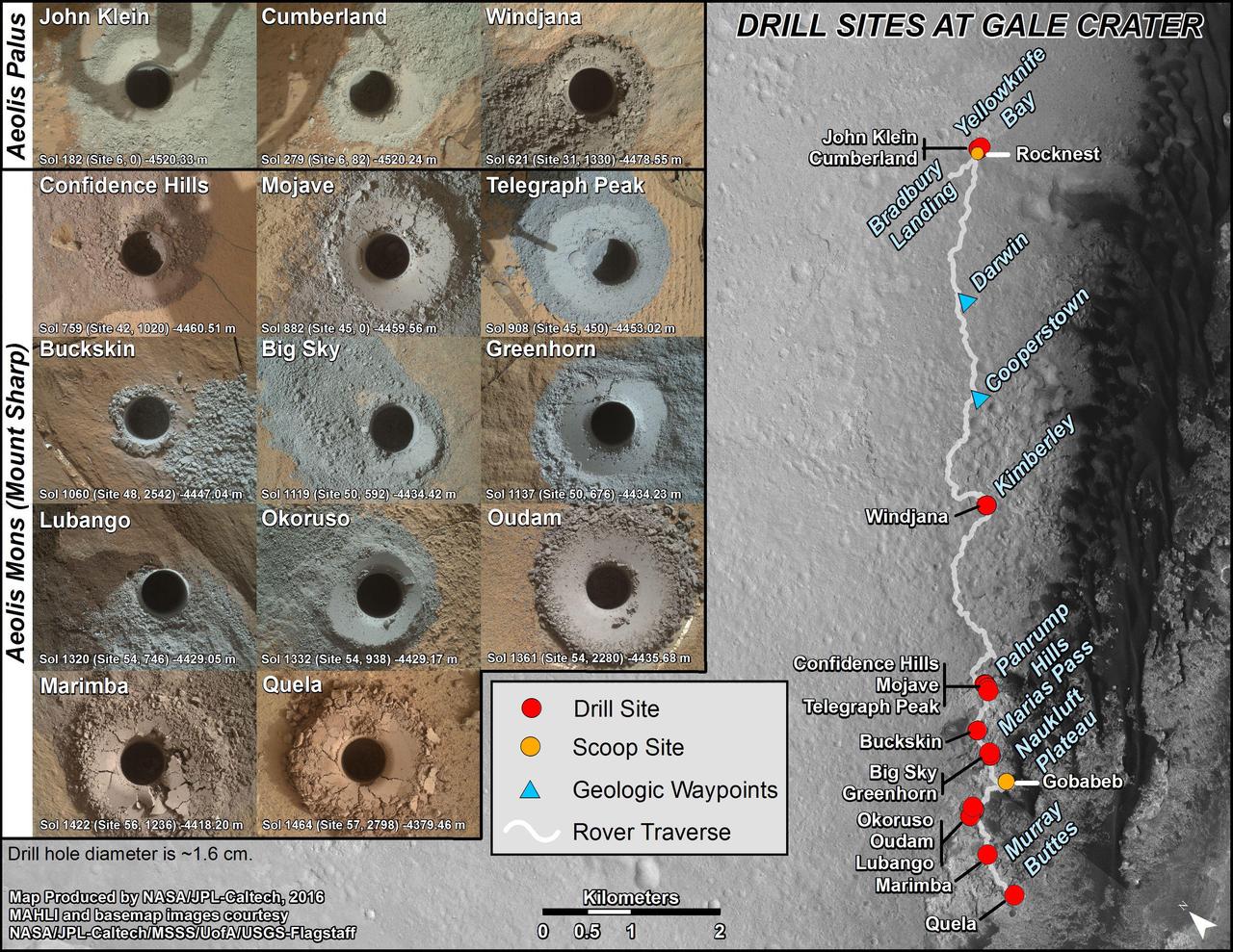
This graphic maps locations of the sites where NASA's Curiosity Mars rover collected its first 18 rock or soil samples for analysis by laboratory instruments inside the vehicle. It also presents images of the drilled holes where 14 rock-powder samples were acquired. Curiosity scooped two soil samples at each of the other two sites: Rocknest and Gobabeb. The diameter of each drill hole is about 0.6 inch (1.6 centimeters), slightly smaller than a U.S. dime. The images used here are raw color, as recorded by the rover's Mars Hand Lens Imager (MAHLI) camera. Notice the differences in color of the material at different drilling sites. For the map, north is toward upper left corner. The scale bar represents 2 kilometers (1.2 miles). The base map is from the High Resolution Imaging Science Experiment (HiRISE) camera on NASA's Mars Reconnaissance Orbiter. The latest sample site included is "Quela,"where Curiosity drilled into bedrock of the Murray formation on Sept. 18, 2016, during the 1,464th Martian day, or sol, of the mission. Curiosity landed in August 2012 on the plain (named Aeolis Palus) near Mount Sharp (or Aeolis Mons). More drilling samples collected by MSL are available at http://photojournal.jpl.nasa.gov/catalog/PIA20845
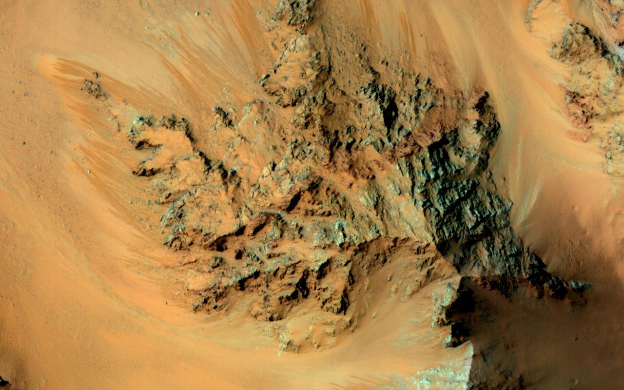
Recurring slope lineae are active flows on warm Martian slopes that might be caused by seeping water. One of the most active sites known is in the central peaks of Hale Crater as seen by NASA Mars Reconnaissance Orbiter. This image shows RSL extending downhill from bedrock cliffs, mostly towards the northwest (upper left). This image was acquired in middle summer when RSL are most active in the southern mid latitudes. The RSL in Hale have an unusually "reddish" color compared to most RSL, perhaps due to oxidized iron compounds, like rust. Since HiRISE color is shifted to infra-red wavelengths, they are actually especially bright the near-infrared just beyond the range of human vision. The Hale RSL are also unusual because they began activity much earlier than most RSL sites in the middle southern latitudes, and were well-developed in the early spring (see ESP_038073_1440). If seeping water causes RSL in Hale crater, it must be rich in salts to lower its freezing point significantly below the freezing point of pure water. http://photojournal.jpl.nasa.gov/catalog/PIA19359
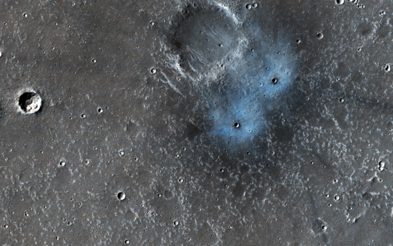
This new impact was found by NASA's Mars Reconnaissance Orbiter's Context Camera team (CTX), who asked HiRISE to take a high-resolution image. They estimated the impact happened between January 2012 and September 2016, because they have a picture from the THEMIS instrument without it before that time frame. These craters may be somewhere between two and four (Earth) years old, which is exceedingly young in geologic terms. Most of the craters we see on Mars (like others in this picture) are millions of years old. The blue appearance is due to the intense blast of the impact moving around dust on the surface. That dust is usually light-toned and reddish in color compared to what's beneath it. When you remove the dust, you're left with a dark spot that can sometimes be blue in comparison to the redder surroundings. These features are prominent only around young impacts, because all the old craters get covered with dust again over time. This blueish "blast zone" is very different than the exposed ice some new craters dig up. The shape, color, and brightness are distinct and tell scientists this is not ice. More information is available at https://photojournal.jpl.nasa.gov/catalog/PIA22534
![This image from NASA's Mars Reconnaissance Orbiter (MRO) captures details of an approximately 1-kilometer inverted crater west of Mawrth Vallis. A Context Camera image provides context for the erosional features observed at this site. The location of this HiRISE image is north of the proposed landing ellipse for the ExoMars 2020 rover mission that will investigate diverse rocks and minerals related to ancient water-related activity in this region. Prolonged erosion removed less resistant rocks leaving behind other rocks that stand up locally such as the crater seen here and other nearby remnants. These resistant layers may belong to a phase of volcanism and/or water-related activity that carved Mawrth Vallis and filled in existing craters, and other lower-lying depressions, with darker materials. Erosion has also exposed these layers down to older, more resistant lighter rocks that are clay-bearing. The diversity of exposed bedrock made this location an ideal candidate for exploring a potentially water-rich ancient environment that might have once harbored life. The map is projected here at a scale of 25 centimeters (9.8 inches) per pixel. [The original image scale is 28.7 centimeters (11.3 inches) per pixel (with 1 x 1 binning); objects on the order of 86 centimeters (33.9 inches) across are resolved.] North is up. https://photojournal.jpl.nasa.gov/catalog/PIA22117](https://images-assets.nasa.gov/image/PIA22117/PIA22117~medium.jpg)
This image from NASA's Mars Reconnaissance Orbiter (MRO) captures details of an approximately 1-kilometer inverted crater west of Mawrth Vallis. A Context Camera image provides context for the erosional features observed at this site. The location of this HiRISE image is north of the proposed landing ellipse for the ExoMars 2020 rover mission that will investigate diverse rocks and minerals related to ancient water-related activity in this region. Prolonged erosion removed less resistant rocks leaving behind other rocks that stand up locally such as the crater seen here and other nearby remnants. These resistant layers may belong to a phase of volcanism and/or water-related activity that carved Mawrth Vallis and filled in existing craters, and other lower-lying depressions, with darker materials. Erosion has also exposed these layers down to older, more resistant lighter rocks that are clay-bearing. The diversity of exposed bedrock made this location an ideal candidate for exploring a potentially water-rich ancient environment that might have once harbored life. The map is projected here at a scale of 25 centimeters (9.8 inches) per pixel. [The original image scale is 28.7 centimeters (11.3 inches) per pixel (with 1 x 1 binning); objects on the order of 86 centimeters (33.9 inches) across are resolved.] North is up. https://photojournal.jpl.nasa.gov/catalog/PIA22117
![This image from NASA's Mars Reconnaissance Orbiter (MRO) targets a portion of a group of honeycomb-textured landforms in northwestern Hellas Planitia, which is part of one of the largest and most ancient impact basins on Mars. In a larger Context Camera image, the individual "cells" are about 5 to 10 kilometers wide. With HiRISE, we see much greater detail of these cells, like sand ripples that indicate wind erosion has played some role here. We also see distinctive exposures of bedrock that cut across the floor and wall of the cells. These resemble dykes, which are usually formed by volcanic activity. Additionally, the lack of impact craters suggests that the landscape, along with these features, have been recently reshaped by a process, or number of processes that may even be active today. Scientists have been debating how these honeycombed features are created, theorizing from glacial events, lake formation, volcanic activity, and tectonic activity, to wind erosion. The map is projected here at a scale of 50 centimeters (19.7 inches) per pixel. [The original image scale is 53.8 centimeters (21.2 inches) per pixel (with 2 x 2 binning); objects on the order of 161 centimeters (23.5 inches) across are resolved.] North is up. https://photojournal.jpl.nasa.gov/catalog/PIA22118](https://images-assets.nasa.gov/image/PIA22118/PIA22118~medium.jpg)
This image from NASA's Mars Reconnaissance Orbiter (MRO) targets a portion of a group of honeycomb-textured landforms in northwestern Hellas Planitia, which is part of one of the largest and most ancient impact basins on Mars. In a larger Context Camera image, the individual "cells" are about 5 to 10 kilometers wide. With HiRISE, we see much greater detail of these cells, like sand ripples that indicate wind erosion has played some role here. We also see distinctive exposures of bedrock that cut across the floor and wall of the cells. These resemble dykes, which are usually formed by volcanic activity. Additionally, the lack of impact craters suggests that the landscape, along with these features, have been recently reshaped by a process, or number of processes that may even be active today. Scientists have been debating how these honeycombed features are created, theorizing from glacial events, lake formation, volcanic activity, and tectonic activity, to wind erosion. The map is projected here at a scale of 50 centimeters (19.7 inches) per pixel. [The original image scale is 53.8 centimeters (21.2 inches) per pixel (with 2 x 2 binning); objects on the order of 161 centimeters (23.5 inches) across are resolved.] North is up. https://photojournal.jpl.nasa.gov/catalog/PIA22118
![This enhanced color image from NASA's Mars Reconnaissance Orbiter (MRO) shows what are called "recurring slope lineae"s in Tivat Crater. The narrow, dark flows descend downhill (towards the upper left). Analysis shows that the flows all end at approximately the same slope, which is similar to the angle of repose for sand. RSL are mostly found on steep rocky slopes in dark regions of Mars, such as the southern mid-latitudes, Valles Marineris near the equator, and in Acidalia Planitia on the northern plains. The appearance and growth of these features resemble seeping liquid water, but how they form remains unclear, and this research demonstrated that the RSL flows seen by HiRISE are likely moving granular material like sand and dust. These findings indicate that present-day Mars may not have a significant volume of liquid water. The water-restricted conditions that exist on Mars would make it difficult for Earth-like life to exist near the surface of the planet. The map is projected here at a scale of 25 centimeters (9.8 inches) per pixel. [The original image scale is 25.6 centimeters (10.8 inches) per pixel (with 1 x 1 binning); objects on the order of 77 centimeters (30.3 inches) across are resolved.] North is up. https://photojournal.jpl.nasa.gov/catalog/PIA22114](https://images-assets.nasa.gov/image/PIA22114/PIA22114~medium.jpg)
This enhanced color image from NASA's Mars Reconnaissance Orbiter (MRO) shows what are called "recurring slope lineae"s in Tivat Crater. The narrow, dark flows descend downhill (towards the upper left). Analysis shows that the flows all end at approximately the same slope, which is similar to the angle of repose for sand. RSL are mostly found on steep rocky slopes in dark regions of Mars, such as the southern mid-latitudes, Valles Marineris near the equator, and in Acidalia Planitia on the northern plains. The appearance and growth of these features resemble seeping liquid water, but how they form remains unclear, and this research demonstrated that the RSL flows seen by HiRISE are likely moving granular material like sand and dust. These findings indicate that present-day Mars may not have a significant volume of liquid water. The water-restricted conditions that exist on Mars would make it difficult for Earth-like life to exist near the surface of the planet. The map is projected here at a scale of 25 centimeters (9.8 inches) per pixel. [The original image scale is 25.6 centimeters (10.8 inches) per pixel (with 1 x 1 binning); objects on the order of 77 centimeters (30.3 inches) across are resolved.] North is up. https://photojournal.jpl.nasa.gov/catalog/PIA22114

In this image, NASA's Mars Reconnaissance Orbiter (MRO) observes an impact crater with associated bright deposits that at first glance give the appearance of seasonal frost or ice accumulations. MRO has an onboard spectrometer called CRISM that can distinguish between ices and other minerals. Unfortunately, there is currently no coverage of this particular spot. However, it can be deduced through several lines of evidence that this is, in fact, not ice. Just like Earth, Mars experiences seasons that change as the planet orbits the Sun. Seasonal changes are most apparent at the higher latitudes. As these regions in each hemisphere enter their respective summer seasons, the Sun rises higher in the Martian sky causing frost and ice to sublimate, and illuminate more features across the landscape. As the high latitudes of each hemisphere move toward their respective winters, the days (called "sols") grow shorter and the sun hangs low on the horizon, giving rise to prolonged periods of cold, darkness, and frost accumulation. First, it should be noted that at the time this image was taken, the Southern hemisphere is at the end of the summer season, so any frost or ice deposits have long since sublimated away. Second, numerous HiRISE images of seasonal targets show that ice accumulates on pole-facing slopes. The deposits in question are situated on a slope that faces the equator, and would not accumulate deposits of frost. Thus, it can be concluded that these exposures are light-toned mineral deposits. https://photojournal.jpl.nasa.gov/catalog/PIA21766
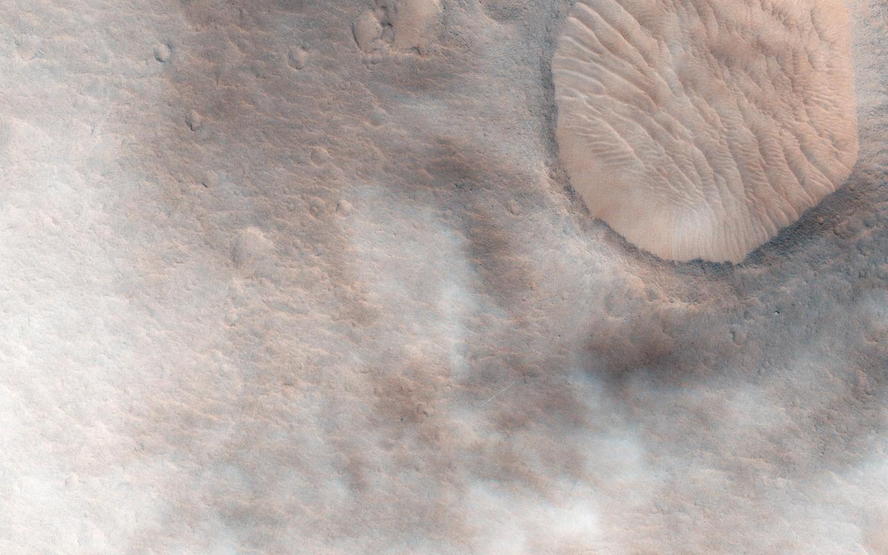
This observation from NASA Mars Reconnaissance Orbite shows a candidate 2018 European Space Agency ExoMars landing site in Hypanis Vallis. Instead of imaging ancient fluvial deposits (thought to be the remnants of a delta feed lake), the image shows patchy concentrations of dust clouds. These clouds are part of the annually occurring Acidalia storm track, a regional dust storm system that originates in the Acidalia-Chryse-Kasei region and propagates southward into equatorial Valles Marineris and beyond. While this image is only partially obscured by dust, many others captured around this time frame were completely dominated by think clouds of dust. For example, this image in Capri Chasma was rendered useless for geology and will have to be reacquired. Landing by the ExoMars rover in these kinds of atmospheric conditions would be complicated. That mission is set to touchdown on Mars in January 2019, hopefully with clear skies. HiRISE will continue to image Hypanis Vallis and other interesting sites on Mars despite the changing weather. http://photojournal.jpl.nasa.gov/catalog/PIA19846
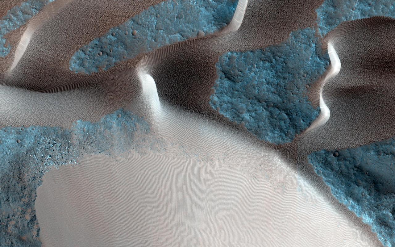
One of the major extended-mission objectives for HiRISE has been to re-image parts of the surface to look for changes. Such observations can tell us what processes are active today. This image was acquired as part of a series to look for sand movement in Meroe Patera, not far from the active sand dunes of Nili Patera. Our image shows that sand dunes are missing downwind (to the left) of a crater near the center of the observation, because sand falls into the crater and is trapped. Zooming in on the sand-coated crater wall and comparing it with older images revealed a surprise: several major sand flows slumped down into the crater (towards the upper left), leaving small ridges (called "levees") along their path and rounded piles of sand at the end. What caused these slumps? Dry ice, which is thought to cause flows in some gullies and the North polar dunes, does not occur this close to the equator. There is no sign of recurring slope lineae, the leading candidates for liquid on the Martian surface. Instead, it is most likely that these were dry flows. They are far larger than the avalanches commonly seen on sand dunes, typified by the shorter light streaks visible in the lower left part of the "after" image, so they might have been triggered by a Mars-quake or an unusually strong wind. http://photojournal.jpl.nasa.gov/catalog/PIA19305

Taken in late southern spring and when Mars is near perihelion (closest distance to the Sun), this image shows the effects of dry ice sublimation on a longitudinal dune in the far Southern hemisphere. The bright patches on the dune are still covered in frost, and the dark regions are frost-free. Longitudinal dunes form when the wind switches between two common directions*. Based on the direction of this dune's long crest and the orientation of the smaller ripples, it appears the wind blows from the east and from the northwest. However, it would require taking multiple HiRISE images of this location over time and noticing movement before we could say this definitively. The broad base of this dune may indicate that dune sand has spilled out from areas once covered in ice. During the next Martian Southern hemisphere winter (about half a Mars year or one Earth year from when this image was taken), this dune will again be covered in frost and possibly solid carbon dioxide ice, unable to blow in the wind until the volatiles begin to sublimate in the spring. *These are ripples indicating a wind out of the north/northwest. The scene is 250 m across. http://photojournal.jpl.nasa.gov/catalog/PIA19293