
A vigorous summer fire season continued through July, 2013 as many large wildfires continued to burn in the forests of northern Canada. The high fire activity not only laid waste to thousands of hectares of boreal forest, but sent thick smoke billowing high into the atmosphere, where it was carried far across the Atlantic Ocean. On July 30, the Moderate Resolution Imaging Spectroradiometer (MODIS) aboard NASA’s Aqua satellite captured this true-color image of a river of smoke spreading south across the Hudson Bay. The blue background is formed by the waters of Hudson Bay. In the southeast the green, forest-covered land of Quebec province peeks from under a large cloud bank. Another large bank of white cloud covers the water in the southwest, and a smaller cloud bank covers the territory of Nunavut in the northwest. A bit of Baffin Island can be seen near the top center of the image. Looking closely at the image, it appears that the gray smoke mixes with whiter cloud in the south, suggesting they may be at the same level in the atmosphere. In the northeast corner of the image, a ribbon of smoke appears to blow over a bank of popcorn clouds as well as over a few lower-lying clouds, causing some of the clouds to appear gray beneath the smoky veil. Where cloud meets smoke in the northeast, however, the line of the cloud bank remains sharp, while the smoke appears to continue traveling under the edge. Although these interpretations are somewhat subjective in this true-color image, the false-color image of the same scene (not shown here) lends strength to the interpretation. Data from other NASA instruments, designed to measure cloud height and characteristics, agree that clouds vary in height, and that smoke mingles with cloud in the south. Credit: NASA/GSFC/Jeff Schmaltz/MODIS Land Rapid Response Team <b><a href="http://www.nasa.gov/audience/formedia/features/MP_Photo_Guidelines.html" rel="nofollow">NASA image use policy.</a></b> <b><a href="http://www.nasa.gov/centers/goddard/home/index.html" rel="nofollow">NASA Goddard Space Flight Center</a></b> enables NASA’s mission through four scientific endeavors: Earth Science, Heliophysics, Solar System Exploration, and Astrophysics. Goddard plays a leading role in NASA’s accomplishments by contributing compelling scientific knowledge to advance the Agency’s mission. <b>Follow us on <a href="http://twitter.com/NASA_GoddardPix" rel="nofollow">Twitter</a></b> <b>Like us on <a href="http://www.facebook.com/pages/Greenbelt-MD/NASA-Goddard/395013845897?ref=tsd" rel="nofollow">Facebook</a></b> <b>Find us on <a href="http://instagram.com/nasagoddard?vm=grid" rel="nofollow">Instagram</a></b>

Each winter sea ice forms over the salty waters of frigid northeastern Canada's Hudson Bay. As sunlight lengthens and weather warms, ice begins to break up and melt, with retreat typically starting in May and melt-out completed sometime in July. Since the 1970s, the timing of sea ice breakup in Hudson Bay has changed, with melting beginning earlier in the spring. The Moderate Resolution Imaging Spectroradiometer (MODIS) aboard NASA’s Aqua satellite captured this a true-color image of Hudson Bay on March 26, 2013. Although snow still covers the surrounding land, ice has already begun to retreat from much of the eastern shore of the Bay visible in the image. A ring of bright white ice remains solidly frozen around the Belcher Islands in the southeast section of the Bay, but this ring is surrounded by blue waters and large chunks of ice. In the southwest, a similar situation is seen at Akimiski Island. The shelf of bright white ice gives way to open water in the south, as well as fractured, blue-tinted ice. The blue tint generally indicates water logging as ice begins to soften. The Aqua satellite captured a similar image of early ice melt on Hudson Bay on April 6, 2012. That image can be viewed at: <a href="http://modis.gsfc.nasa.gov/gallery/individual.php?db_date=2012-04-19" rel="nofollow">modis.gsfc.nasa.gov/gallery/individual.php?db_date=2012-0...</a> <b><a href="http://www.nasa.gov/audience/formedia/features/MP_Photo_Guidelines.html" rel="nofollow">NASA image use policy.</a></b> <b><a href="http://www.nasa.gov/centers/goddard/home/index.html" rel="nofollow">NASA Goddard Space Flight Center</a></b> enables NASA’s mission through four scientific endeavors: Earth Science, Heliophysics, Solar System Exploration, and Astrophysics. Goddard plays a leading role in NASA’s accomplishments by contributing compelling scientific knowledge to advance the Agency’s mission. <b>Follow us on <a href="http://twitter.com/NASA_GoddardPix" rel="nofollow">Twitter</a></b> <b>Like us on <a href="http://www.facebook.com/pages/Greenbelt-MD/NASA-Goddard/395013845897?ref=tsd" rel="nofollow">Facebook</a></b> <b>Find us on <a href="http://instagram.com/nasagoddard?vm=grid" rel="nofollow">Instagram</a></b>

NASA Wallops Flight Facility Public Affairs Specialist, Rebecca Hudson, Thursday, Feb. 6, 2020 at Wallops Flight Facility in Virginia. “What I really think stands out the most is when you go to a launch and you see people who have never seen one before. Some people get so emotional, they cry. It’s so energizing to see people get that excited. For me, every single time we launch a rocket —whether it be a sounding rocket or something as big as an Antares rocket or anything in between — all the hard work and long hours, all that leading up to it… you kind of forget it as soon as you see that emotion that people are experiencing. I always think about that as I drive home at night: “Do you know how many people we made happy today?” And so I think that is important — no matter what we do here, whether it’s my job or the test director’s or the administrator’s or all points in between — everybody’s got something to contribute. You ask little kids what their big dream is, and it’s not uncommon to hear “astronaut.” It’s not uncommon to hear they want to fly in a spaceship. That’s not uncommon. But we’re doing that. We’re making dreams for people.” Photo Credit: (NASA/Aubrey Gemignani)
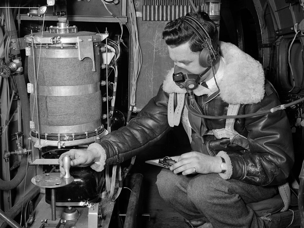
A flight engineer at the National Advisory Committee for Aeronautics (NACA) Aircraft Engine Research Laboratory monitors test equipment in the rear of the Lockheed RA–29 Hudson. Lockheed manufactured several variations of the light bomber in the late 1930s. The Hudson was one of the few military aircraft models available in large quantities during the early years of World War II, and both the US and British air forces utilized it as a patrol aircraft. The RA–29s were soon superseded by newer aircraft, but continued to serve as crew trainers, light cargo carriers and staff transports. The NACA flight engineers in the Planning and Analysis Section were responsible for working with researchers to install and monitor the experimental equipment on the NACA’s research aircraft. This process could require weeks or months. When larger aircraft, like the RA–29 Hudson, were utilized the flight engineers often participated in the flights. The NACA acquired their RA–29 in November 1943, and used the aircraft for fuel blend studies and instrumentation development. The Hudson also frequently served as a transportation vehicle for the staff and visitors. The RA–29 was transferred from the NACA in July 1945.

Brown and tan muddy water flows down the Hudson River are seen in this image acquired by NASA Terra spacecraft on Sept. 1, 2011. After the torrential rains from Hurricane Irene, many rivers in the eastern United States were filled with sediment.

Samara Karasyk, President and CEO of the Hudson Square Business Improvement District talks to a member of the media in front of the mural “To the Moon, and Back” by the New York-based artist team Geraluz and WERC that was created as part of the reimagined NASA Art Program, Tuesday, September 24, 2024, in New York City’s Hudson Square neighborhood. For the inaugural project of the reestablished NASA Art Program the agency collaborated with the Hudson Square Business Improvement District on an open call for New York-based artists to design and install a large-scale mural inspired by NASA’s work and missions. Photo Credit: (NASA/Joel Kowsky)
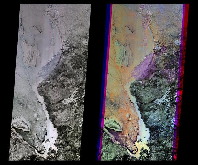
These multi-angle images of Hudson Bay and James Bay, Canada, taken 24 February 2000 from NASA Terra spacecraft, come from the downward-looking nadir camera on the MISR instrument onboard NASA Terra satellite.

Andrew Denio, a Marshall information technology specialist in the Office of the Chief Information Officer, and Judson Hudson, a lab technician and computer-aided designer in Marshall’s Valve & Component Laboratory, show off their Ghostbusters and Star Wars themed vehicles in front of MSFC building 4200, for Halloween 2019.
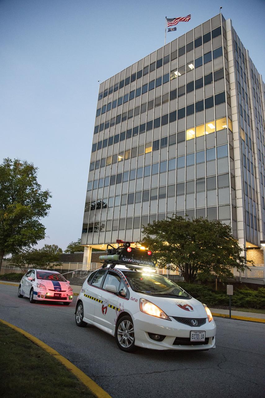
Andrew Denio, a Marshall information technology specialist in the Office of the Chief Information Officer, and Judson Hudson, a lab technician and computer-aided designer in Marshall’s Valve & Component Laboratory, show off their Ghostbusters and Star Wars themed vehicles in front of MSFC building 4200, for Halloween 2019.
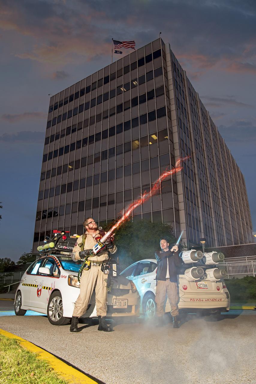
Andrew Denio, a Marshall information technology specialist in the Office of the Chief Information Officer, and Judson Hudson, a lab technician and computer-aided designer in Marshall’s Valve & Component Laboratory, show off their Ghostbusters and Star Wars themed vehicles in front of MSFC building 4200, for Halloween 2019.

Artist Geraluz talks to a member of the media in front of the mural “To the Moon, and Back” by the New York-based artist team Geraluz and WERC that was created as part of the reimagined NASA Art Program, Tuesday, September 24, 2024, in New York City’s Hudson Square neighborhood. For the inaugural project of the reestablished NASA Art Program the agency collaborated with the Hudson Square Business Improvement District on an open call for New York-based artists to design and install a large-scale mural inspired by NASA’s work and missions. Photo Credit: (NASA/Joel Kowsky)

Michelle Jones, NASA’s deputy associate administrator for communications, left, and Aya Collins, director of the engagement division of NASA’s Office of Communications, record a video for social media in front of the mural “To the Moon, and Back” by the New York-based artist team Geraluz and WERC that was created as part of the reimagined NASA Art Program, Tuesday, September 24, 2024, in New York City’s Hudson Square neighborhood. For the inaugural project of the reestablished NASA Art Program the agency collaborated with the Hudson Square Business Improvement District on an open call for New York-based artists to design and install a large-scale mural inspired by NASA’s work and missions. Photo Credit: (NASA/Joel Kowsky)

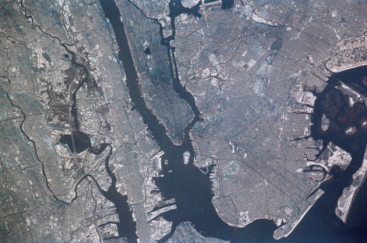
STS039-88-054 (28 April-6 May 1991) --- The dense urban development of the New York City metropolitan area in downstate New York, Long Island and New Jersey shows up as gray and white on this color Infrared photograph. The scene was taken on a remarkably clear spring day. Almost all the major man-made structures of the area are obvious, including ship traffic in and out of New York Harbor, the piers, all of the bridges spanning the area rivers and connecting Manhattan Island with New Jersey, the Bronx, Brooklyn and Queens, the three major airports (Newark, La Guardia and JFK), the New York State thruway, as well as Shea Stadium and Yankee Stadium. The reds and pinks are vegetated areas. Central Park clearly shows up on Manhattan, as do the string of parks along the cliffs (formed by the Palisades sill) along the west side of the Hudson north of the George Washington Bridge.
SL4-141-4316 (20 Jan. 1974) --- An oblique view of ice formations in Canada's Hudson Bay, as photographed from the Skylab space station in Earth orbit by one of the Skylab 4 crewmen. The camera used was a hand-held 70mm Hasselblad, with SO-368 medium-speed Ektachrome film. The southwestern part of the bay is prominent with the Nelson River in Manitoba flowing into it. Skylab never flew this far north in latitude. However, its orbital vantage point allowed observations and photography while over a point some 600 miles away as in the case of this picture. The ice formation along the southwest portion of Hudson Bay can be studied from photographs such as this one. The buildup of ice along the windward shore (very white) followed by the clear water gap (dark) caused by the wind blowing the newly formed ice toward the opposite shore, and finally the patterns in the ice structure itself are studied to learn more of the nature of the "winterization" of this area. Photo credit: NASA
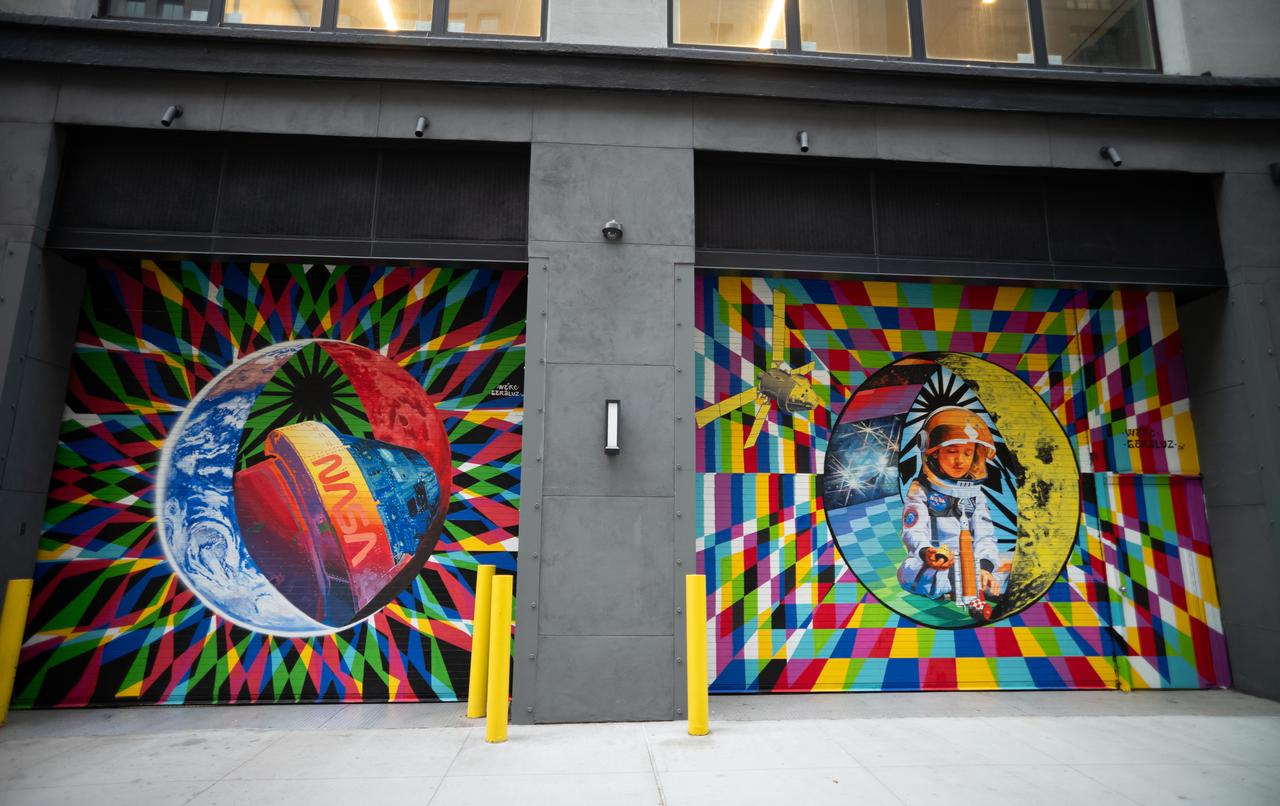
The inaugural murals for the relaunched NASA Art Program appear side-by-side at 350 Hudson Street, Monday, Sept. 23, 2024, in New York City. The murals, titled “To the Moon, and Back,” were created by New York-based artist team Geraluz and WERC and use geometrical patterns to invite deeper reflection on the exploration, creativity, and connection with the cosmos. Photo Credit: (NASA/Joel Kowsky)

Amaru Alvarez, 5, the son of the artist team Geraluz and WERC and model for the mural, poses for picture with the mural “To the Moon, and Back” by the New York-based artist team that was created as part of the reimagined NASA Art Program, Tuesday, September 24, 2024, at 350 Hudson Street in New York City. The murals use geometrical patterns to invite deeper reflection on the exploration, creativity, and connection with the cosmos. Photo Credit: (NASA/Joel Kowsky)

The inaugural murals for the relaunched NASA Art Program appear side-by-side at 350 Hudson Street, Tuesday, Sept. 24, 2024, in New York City. The murals, titled “To the Moon, and Back,” were created by New York-based artist team Geraluz and WERC and use geometrical patterns to invite deeper reflection on the exploration, creativity, and connection with the cosmos. Photo Credit: (NASA/Joel Kowsky)
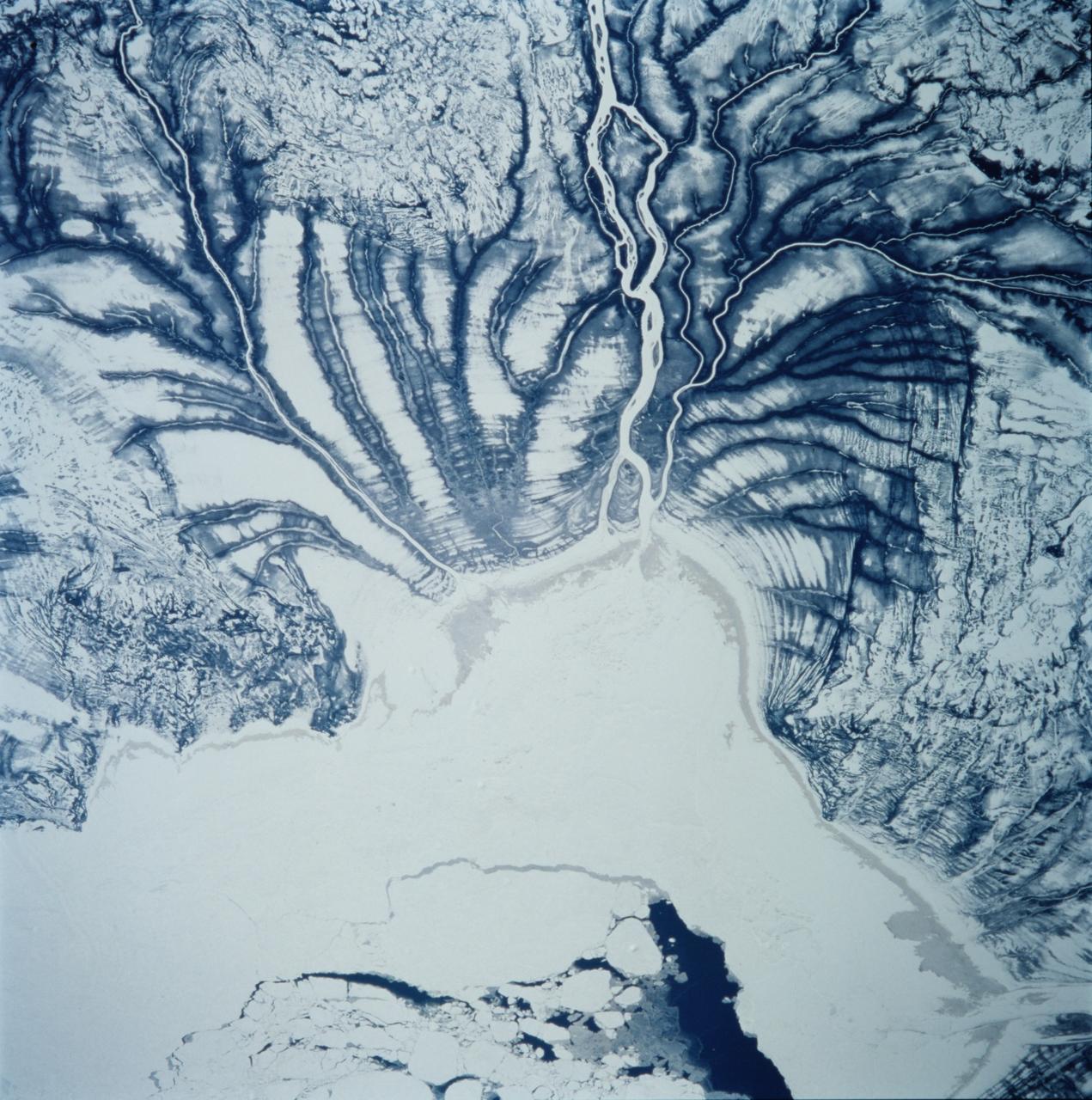
STS099-706-090 (11-22 February 2000) ---One of the astronauts aboard the Space Shuttle Endeavour for the STS-99 mission recorded this 70mm image of Hannah Bay, in the southern part of St. James Bay. The river is the Harricanaw River. Numerous shorelines around Hudson and St. James Bays are distinctive in winter because of snow cover. According to NASA scientists, shorelines were created when the overlying glaciers retreated and the land underneath rebounded causing the Hudson and St. James Bay waters to retreat northward. These ridges are 100 to 200 meters in width and heights can reach up to 7 meters. The land along St. James Bay consists mainly of tidal flats and salt marshes.
NASA astronauts Mark Vande Hei, left, and Joe Acaba, center, listen as Sergeant Craig Hudson explains the tradition of the Honor Guard at the Tomb of the Unknowns, Friday, June 15, 2018 at the Arlington National Cemetery in Arlington, Va. Photo Credit: (NASA/Aubrey Gemignani)
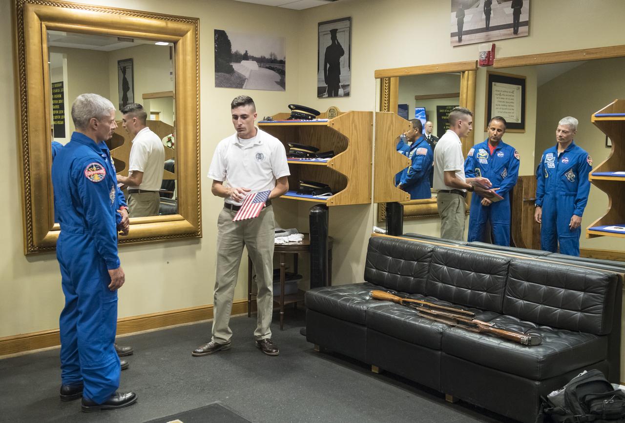
NASA astronauts Mark Vande Hei, left, and Joe Acaba, center, listen as Sergeant Craig Hudson explains the tradition of the Honor Guard at the Tomb of the Unknowns, Friday, June 15, 2018 at the Arlington National Cemetery in Arlington, Va. Photo Credit: (NASA/Aubrey Gemignani)
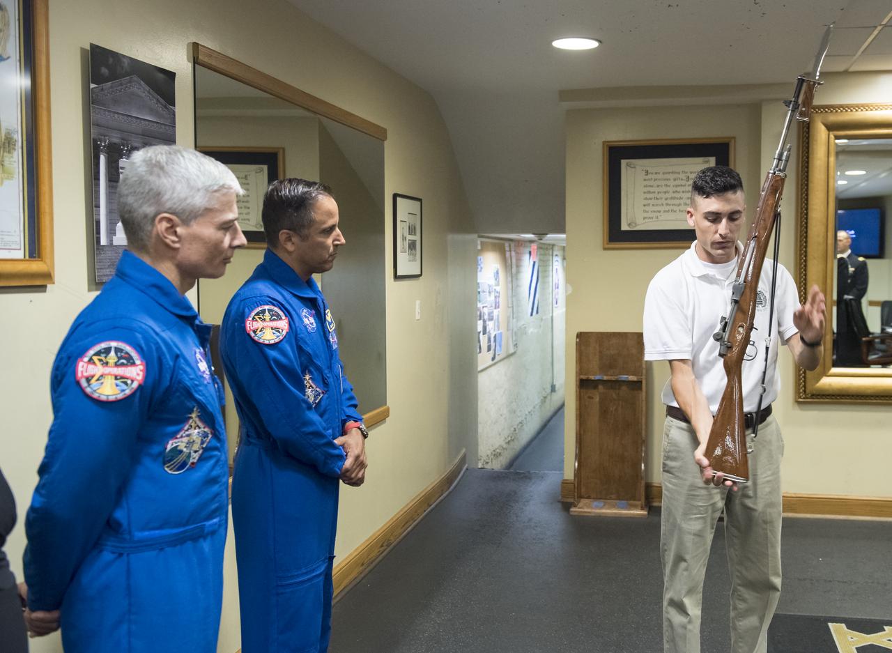
NASA astronauts Mark Vande Hei, left, and Joe Acaba, center, listen as Sergeant Craig Hudson explains the tradition of the Honor Guard at the Tomb of the Unknowns, Friday, June 15, 2018 at the Arlington National Cemetery in Arlington, Va. Photo Credit: (NASA/Aubrey Gemignani)

The New York-based artist team Geraluz, left, and WERC, right, and their son Amaru Alvarez, 5, pose for picture with the mural “To the Moon, and Back” by the artist team that was created as part of the reimagined NASA Art Program, Tuesday, September 24, 2024, at 350 Hudson Street in New York City. The murals use geometrical patterns to invite deeper reflection on the exploration, creativity, and connection with the cosmos. Photo Credit: (NASA/Joel Kowsky)

The New York-based artist team Geraluz, left, and WERC, right, and their son Amaru Alvarez, 5, pose for picture with the mural “To the Moon, and Back” by the artist team that was created as part of the reimagined NASA Art Program, Tuesday, September 24, 2024, at 350 Hudson Street in New York City. The murals use geometrical patterns to invite deeper reflection on the exploration, creativity, and connection with the cosmos. Photo Credit: (NASA/Joel Kowsky)
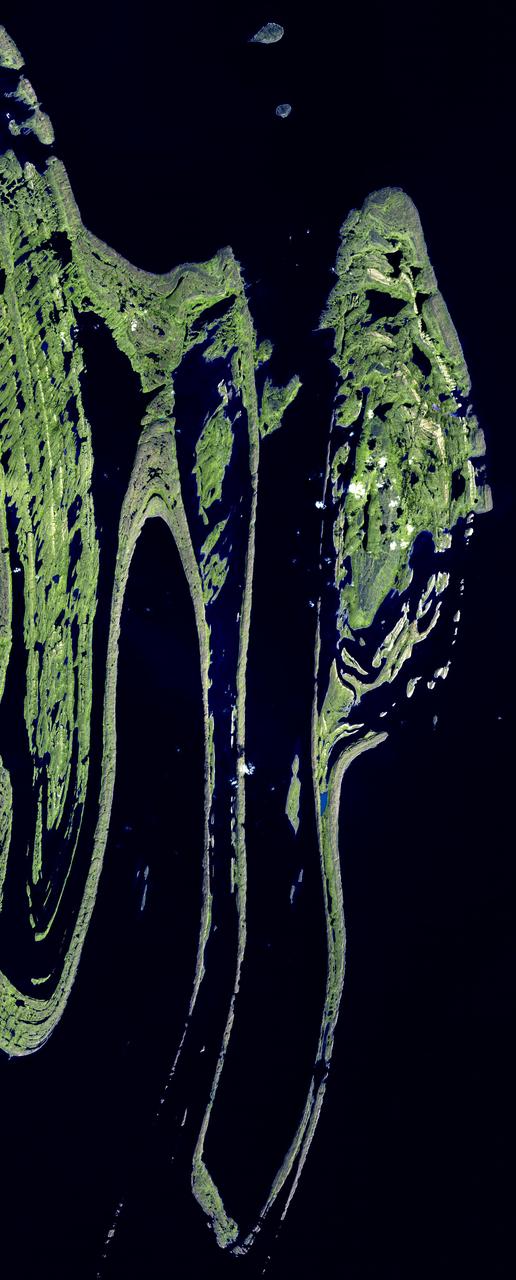
The Belcher Islands are an archipelago in Hudson Bay in Canada, belonging to the territory of Nunavit. The hamlet of Sanikiluaq is on the north coast of Flaherty Island. This image was acquired by NASA Terra satellite on 18 September 2006.

James Bay lies at the southern end of Hudson Bay. Visible in these images captured by NASA Terra satellite on Aug 9, 2000 and Jan. 15, 2001, are some of the many rivers that flow into the bay.
NASA engineer Larry Hudson and Ikhana ground crew member James Smith work on a ground validation test with new fiber optic sensors that led to validation flights on the Ikhana aircraft. NASA Dryden Flight Research Center is evaluating an advanced fiber optic-based sensing technology installed on the wings of NASA's Ikhana aircraft. The fiber optic system measures and displays the shape of the aircraft's wings in flight. There are other potential safety applications for the technology, such as vehicle structural health monitoring. If an aircraft structure can be monitored with sensors and a computer can manipulate flight control surfaces to compensate for stresses on the wings, structural control can be established to prevent situations that might otherwise result in a loss of control.
Art by Paul Hudson Pioneer Venus: Multiprobe Artwork
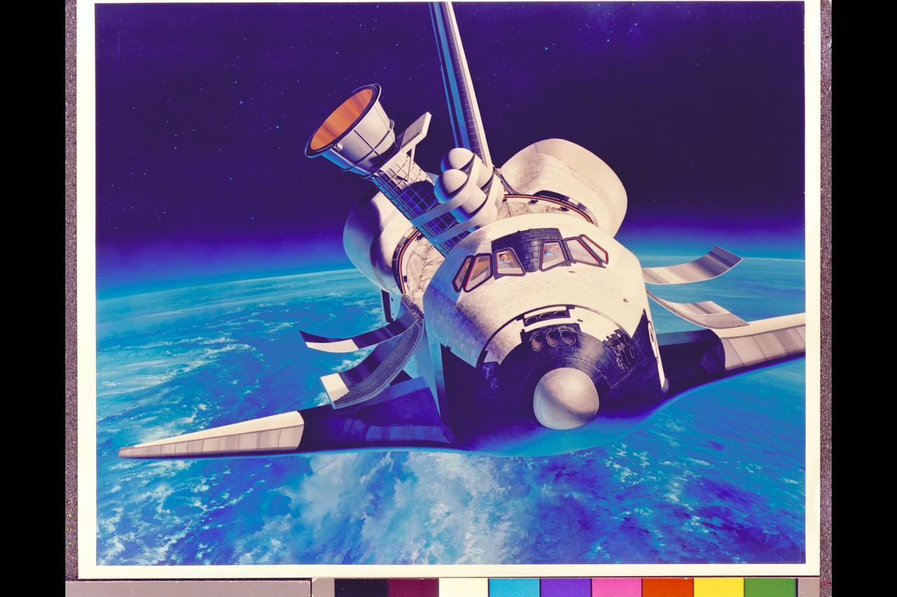
Space Shuttle Infrared Telescope Facility artwork by Paul Hudson. NASA Art
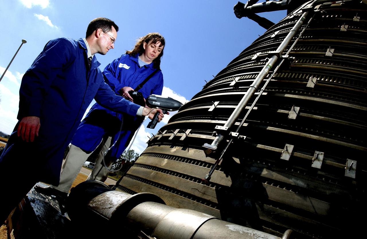
Teamed with KeyMaster Technologies, Kennewick, Washington, the Marshall Space Flight Center engineers have developed a portable vacuum analyzer that performs on-the-spot chemical analyses under field conditions— a task previously only possible in a chemical laboratory. The new capability is important not only to the aerospace industry, but holds potential for broad applications in any industry that depends on materials analysis, such as the automotive and pharmaceutical industries. Weighing in at a mere 4 pounds, the newly developed handheld vacuum X-ray fluorescent analyzer can identify and characterize a wide range of elements, and is capable of detecting chemical elements with low atomic numbers, such as sodium, aluminum and silicon. It is the only handheld product on the market with that capability. Aluminum alloy verification is of particular interest to NASA because vast amounts of high-strength aluminum alloys are used in the Space Shuttle propulsion system such as the External Tank, Main Engine, and Solid Rocket Boosters. This capability promises to be a boom to the aerospace community because of unique requirements, for instance, the need to analyze Space Shuttle propulsion systems on the launch pad. Those systems provide the awe-inspiring rocket power that propels the Space Shuttle from Earth into orbit in mere minutes. The scanner development also marks a major improvement in the quality assurance field, because screws, nuts, bolts, fasteners, and other items can now be evaluated upon receipt and rejected if found to be substandard. The same holds true for aluminum weld rods. The ability to validate the integrity of raw materials and partially finished products before adding value to them in the manufacturing process will be of benefit not only to businesses, but also to the consumer, who will have access to a higher value product at a cheaper price. Three vacuum X-ray scanners are already being used in the Space Shuttle Program. The External Tank Project Office is using one for aluminum alloy analysis, while a Marshall contractor is evaluating alloys with another unit purchased for the Space Shuttle Main Engine Office. The Reusable Solid Rocket Motor Project Office has obtained a scanner that is being used to test hardware and analyze materials. In this photograph, Richard Booth, Marshall Engineering Directorate, and Wanda Hudson, ATK Thiokol, use an enhanced vacuum X-ray fluorescent scanner to analyze materials in an F-1 engine, which was used to boost the Saturn V rocket from Earth’s orbit that carried astronauts to the moon in the 1960s.
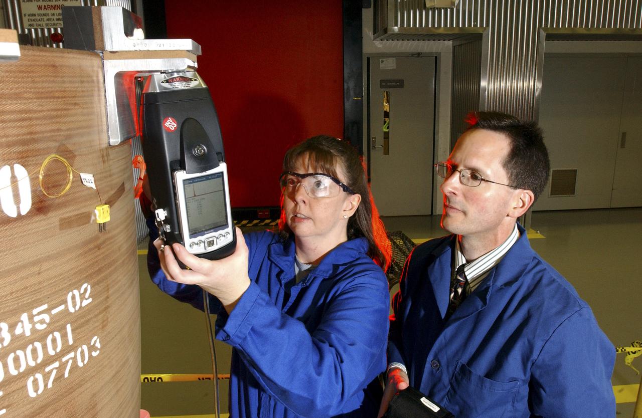
Teamed with KeyMaster Technologies, Kennewick, Washington, the Marshall Space Flight Center engineers have developed a portable vacuum analyzer that performs on-the-spot chemical analyses under field conditions— a task previously only possible in a chemical laboratory. The new capability is important not only to the aerospace industry, but holds potential for broad applications in any industry that depends on materials analysis, such as the automotive and pharmaceutical industries. Weighing in at a mere 4 pounds, the newly developed handheld vacuum X-ray fluorescent analyzer can identify and characterize a wide range of elements, and is capable of detecting chemical elements with low atomic numbers, such as sodium, aluminum and silicon. It is the only handheld product on the market with that capability. Aluminum alloy verification is of particular interest to NASA because vast amounts of high-strength aluminum alloys are used in the Space Shuttle propulsion system such as the External Tank, Main Engine, and Solid Rocket Boosters. This capability promises to be a boom to the aerospace community because of unique requirements, for instance, the need to analyze Space Shuttle propulsion systems on the launch pad. Those systems provide the awe-inspiring rocket power that propels the Space Shuttle from Earth into orbit in mere minutes. The scanner development also marks a major improvement in the quality assurance field, because screws, nuts, bolts, fasteners, and other items can now be evaluated upon receipt and rejected if found to be substandard. The same holds true for aluminum weld rods. The ability to validate the integrity of raw materials and partially finished products before adding value to them in the manufacturing process will be of benefit not only to businesses, but also to the consumer, who will have access to a higher value product at a cheaper price. Three vacuum X-ray scanners are already being used in the Space Shuttle Program. The External Tank Project Office is using one for aluminum alloy analysis, while a Marshall contractor is evaluating alloys with another unit purchased for the Space Shuttle Main Engine Office. The Reusable Solid Rocket Motor Project Office has obtained a scanner that is being used to test hardware and analyze materials. In this photograph, Wanda Hudson, left, ATK Thiokol, and Richard Booth, Marshall Engineering Directorate, use an enhanced vacuum X-ray fluorescent scanner to evaluate Reusable Solid Rocket Motor hardware.
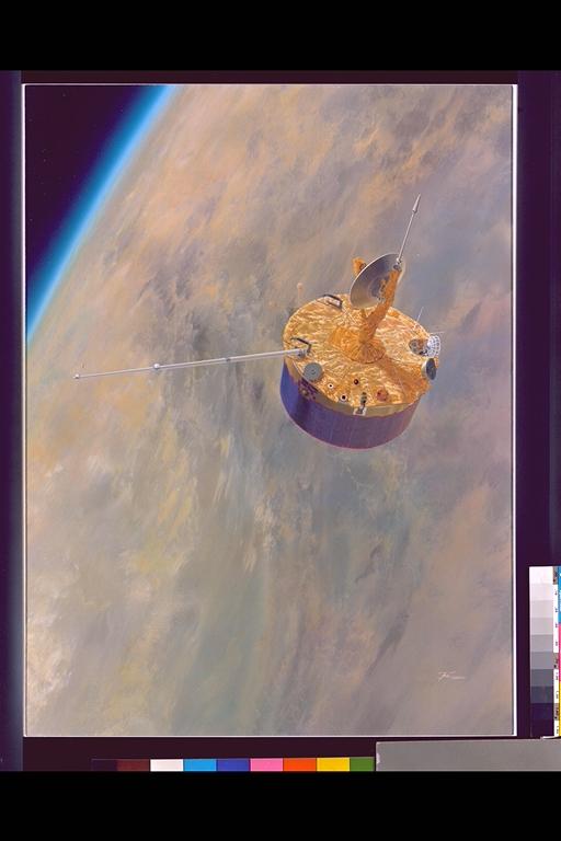
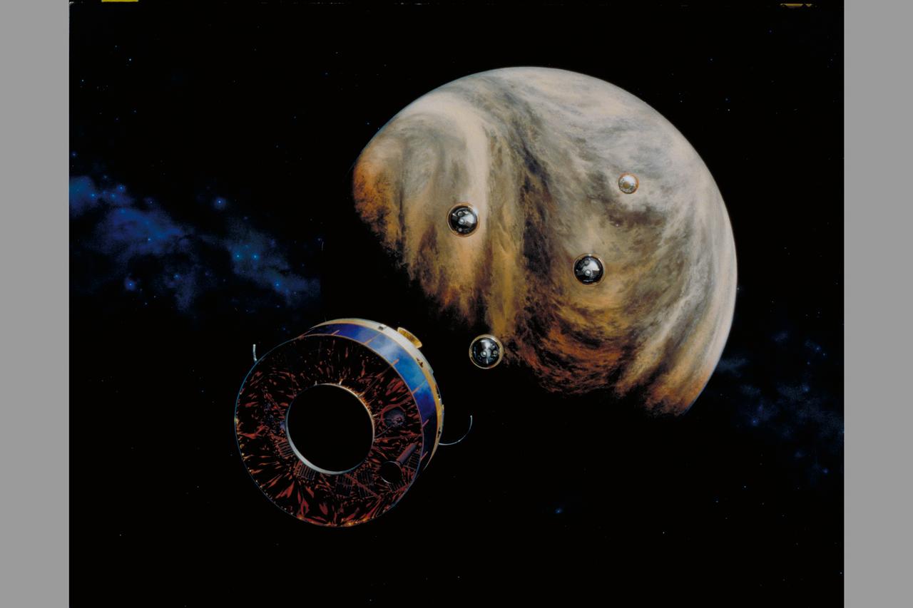
Artist: Paul Hudson Pioneer Venus Orbiter expected to orbit the planet from 1978 to 1992 when the spacecraft will enter and be destroyed in Venus' upper atmosphere
STS058-081-038 (18 Oct-1 Nov 1993) --- Fall colors in the northeast were captured by the STS-58 crew members. Long Island and the lower Hudson River dominate this scene, taken on a clear October day at the peak of the colorful fall foliage season. The maples and oaks of the Hudson Highlands are particularly striking, and contrast with the many lakes and reservoirs north of the city. The New York metropolitan area in New York and New Jersey (including Jersey City and Newark) is easily seen in the foreground. Manhattan Island sits near the middle of the scene, but Central Park foliage is still fairly green. West Point can be seen near the upper right, on the west-pointing bend of the Hudson, and the Catskills are in the far upper left.
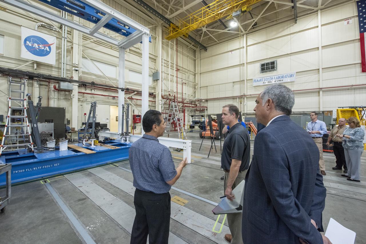
NASA Administrator Bridenstine talks with Armstrong's Larry Hudson about the capabilities of the Flight Loads Lab to conduct mechanical-load and thermal studies of structural components and complete flight vehicles.
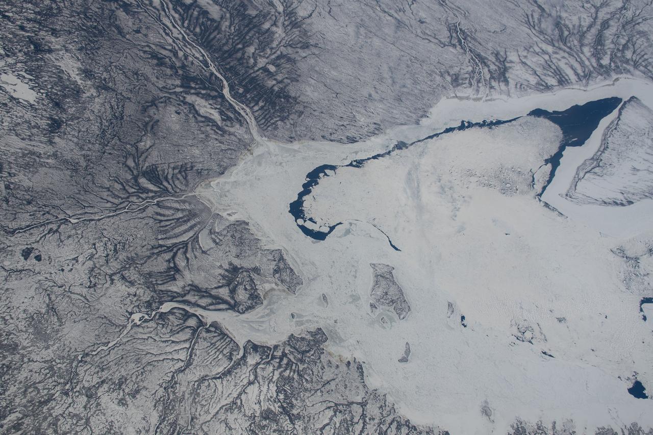
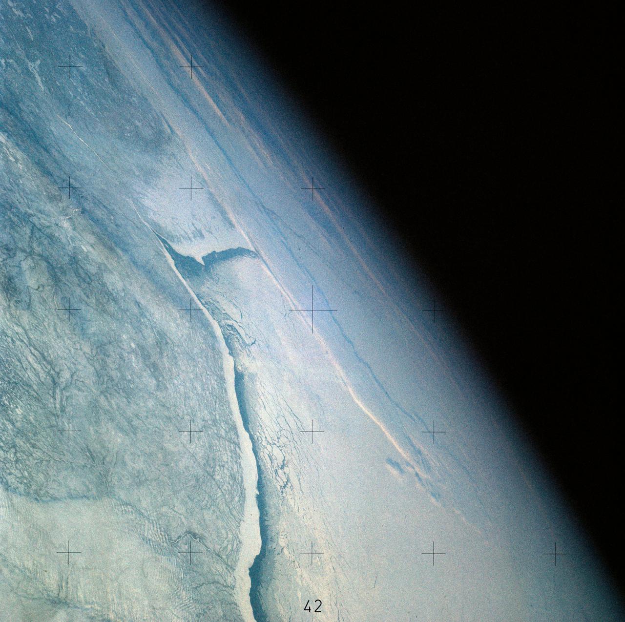
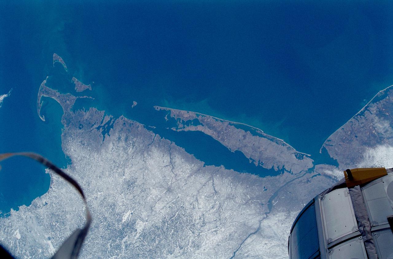
iss059e028115 (April 22, 2019) --- The frozen southern tip of Hudson Bay, which lies in between Ontario and Quebec, is pictured as the International Space Station orbited 258 miles above Canada.
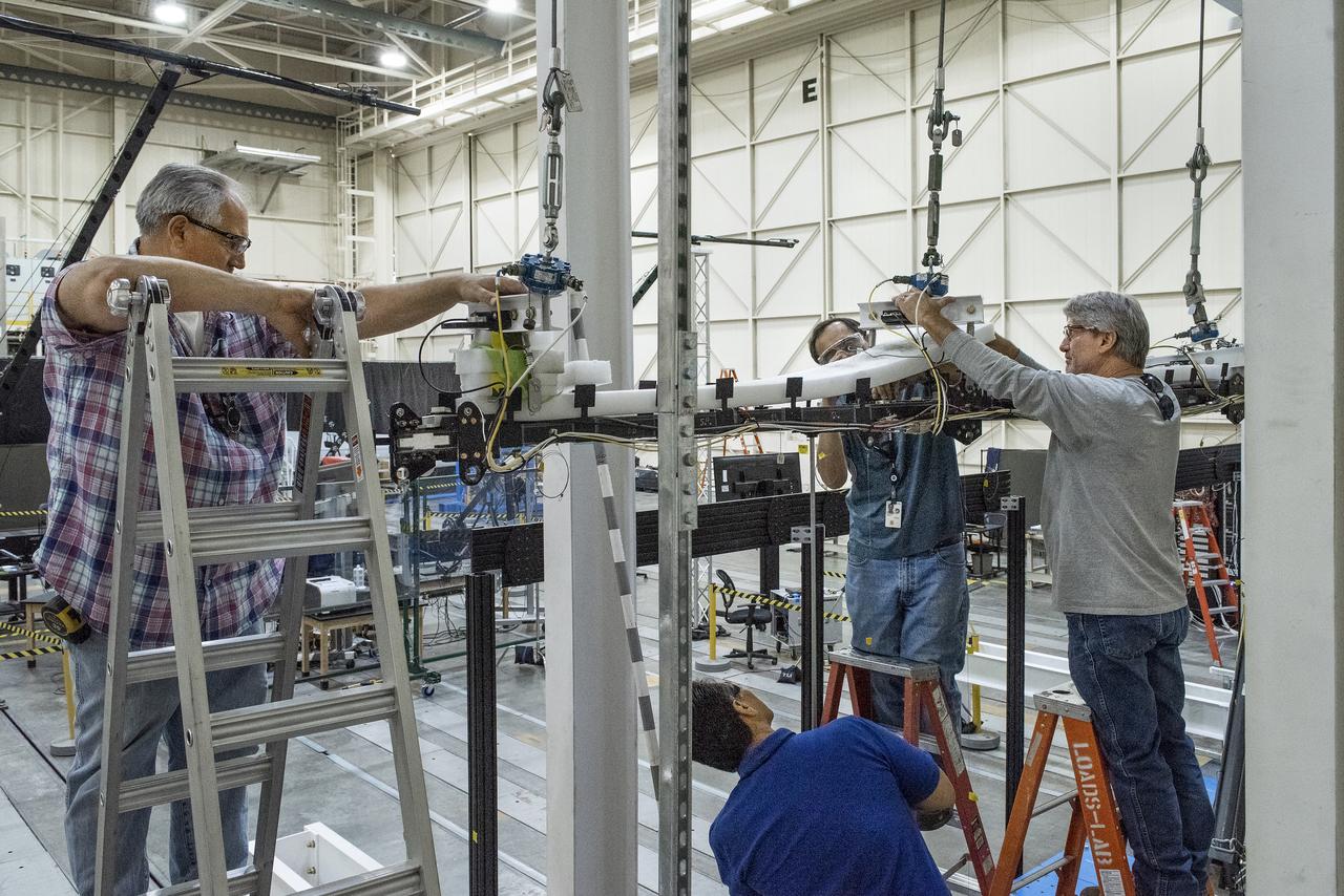
Ted Powers, from left, Larry Hudson, Ron Haraguchi and Walter Hargis make adjustments to the Passive Aeroelastic Tailored (PAT) wing testing apparatus at NASA’s Armstrong Flight Research Center in California.

Earth Observation taken during a day pass by the Expedition 40 crew aboard the International Space Station (ISS). Folder lists this as: Chappaquiddick Island also Niagra Falls Hudson etc.
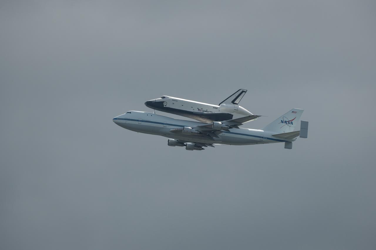
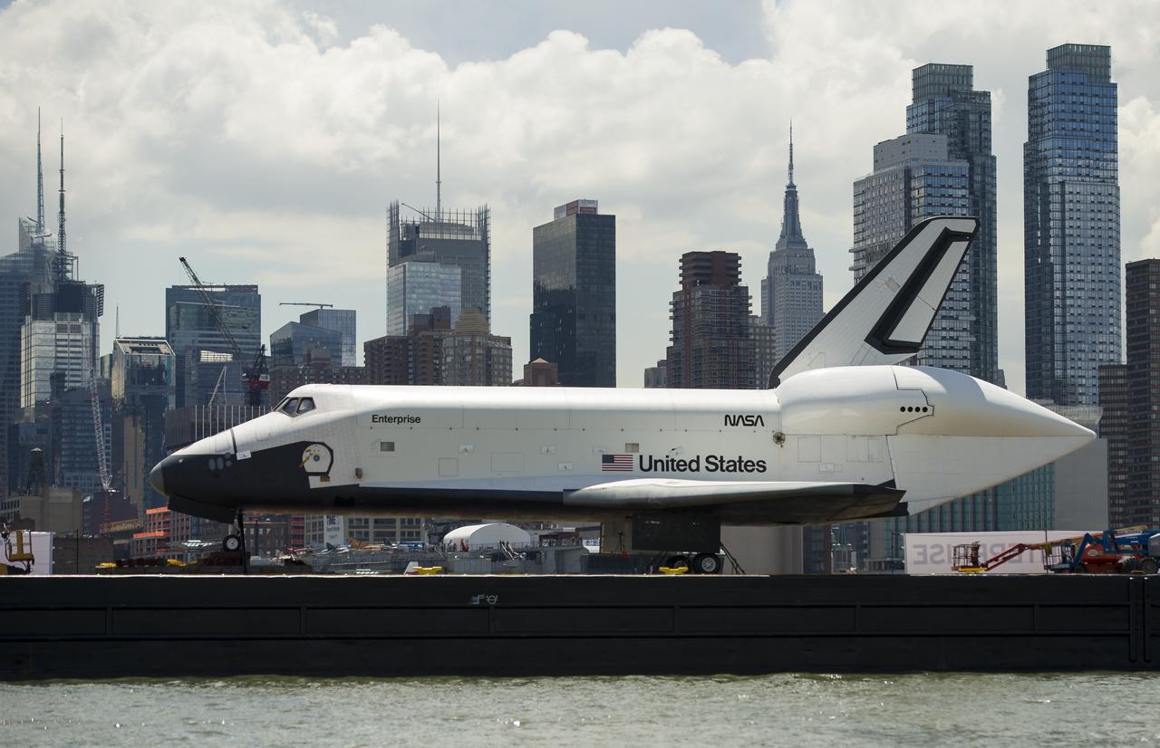
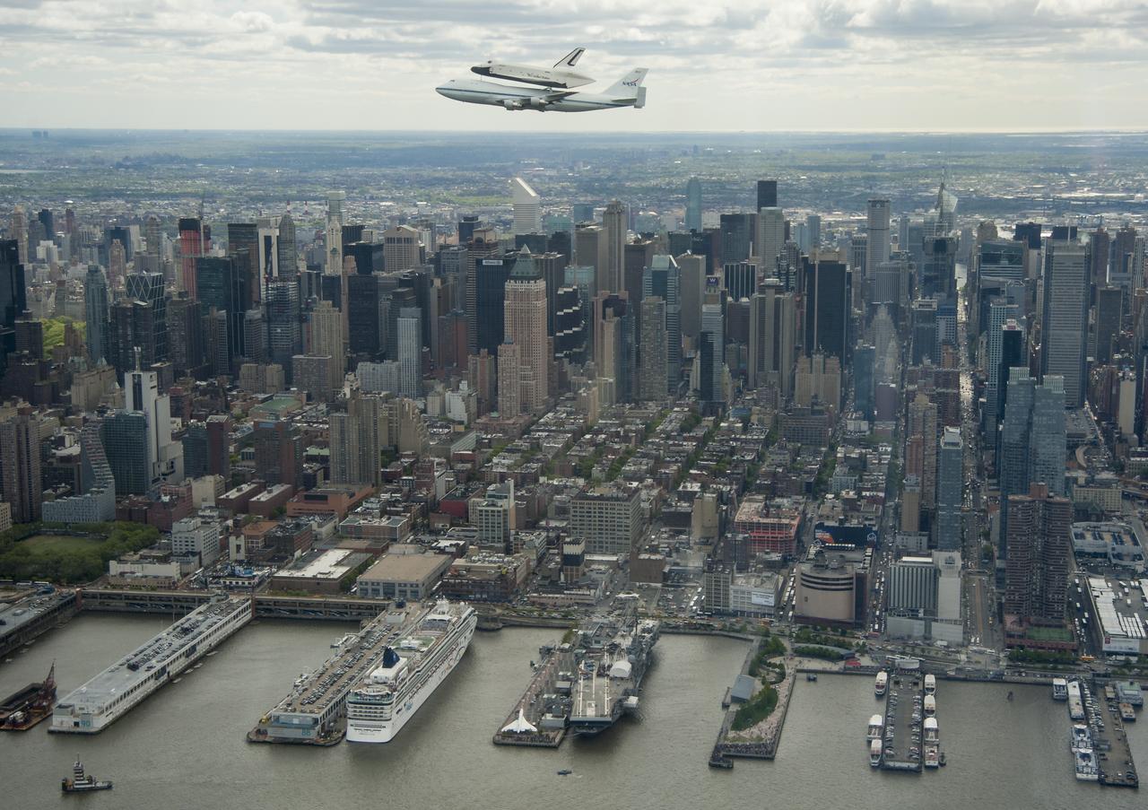
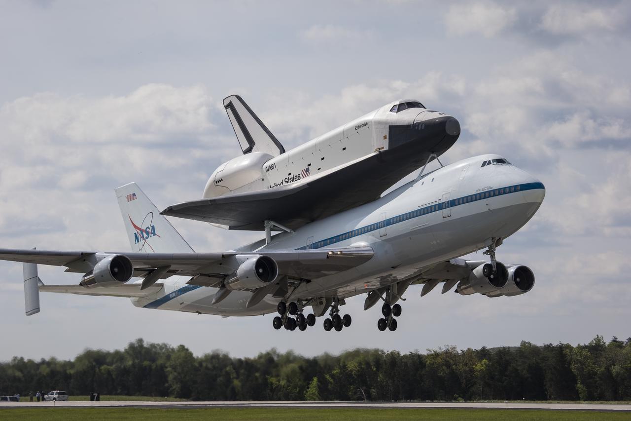
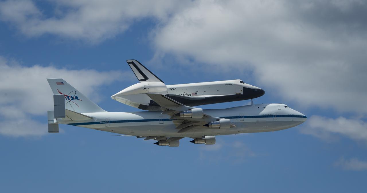
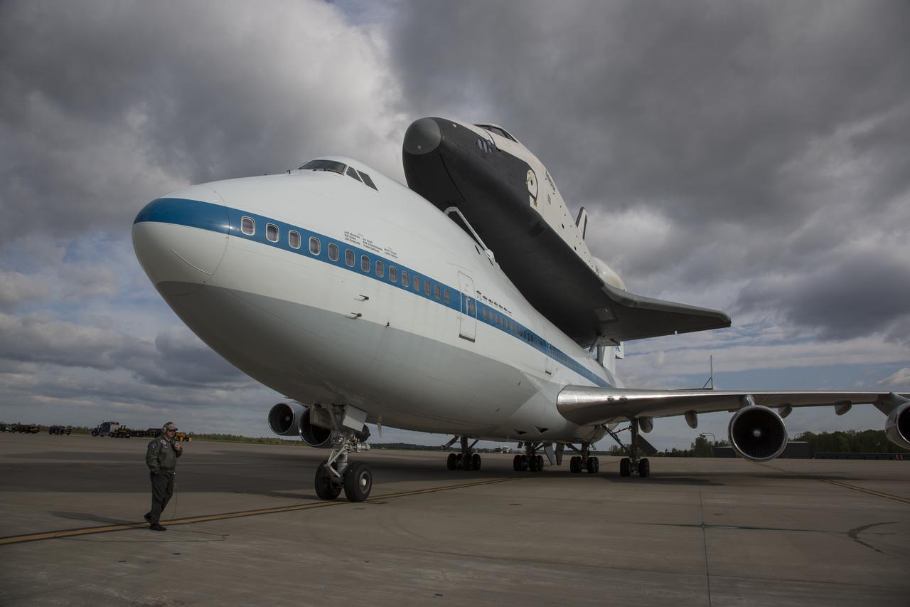
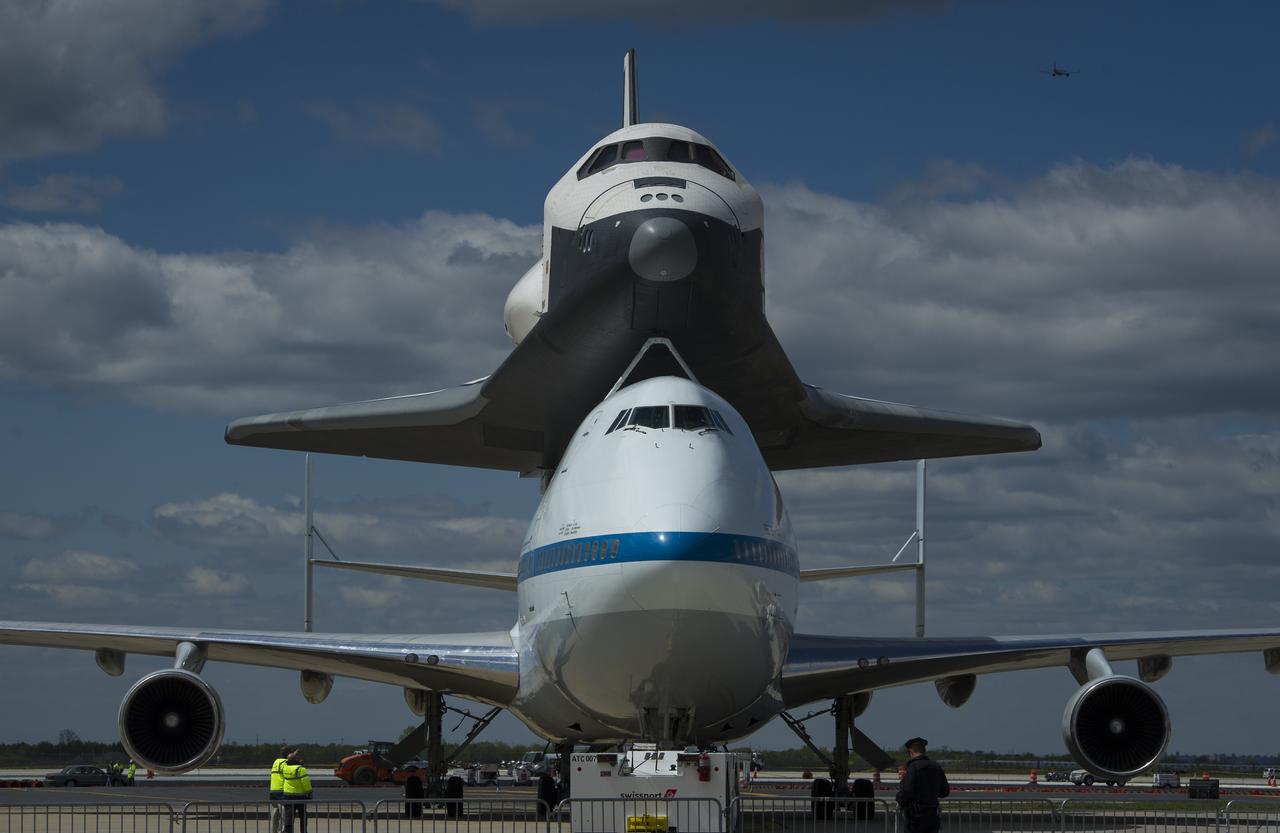
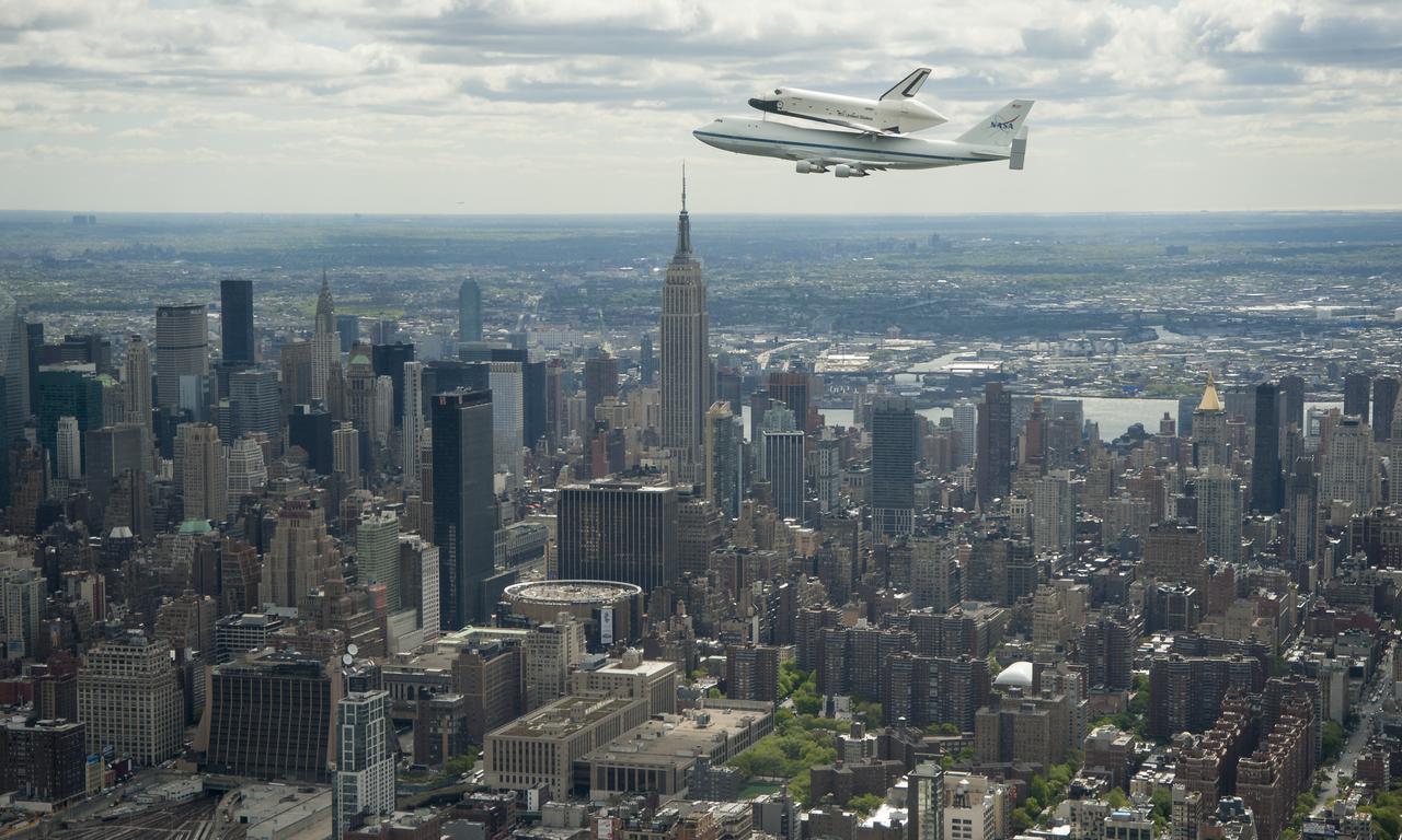
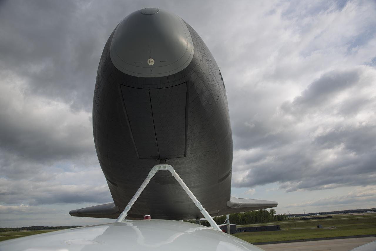
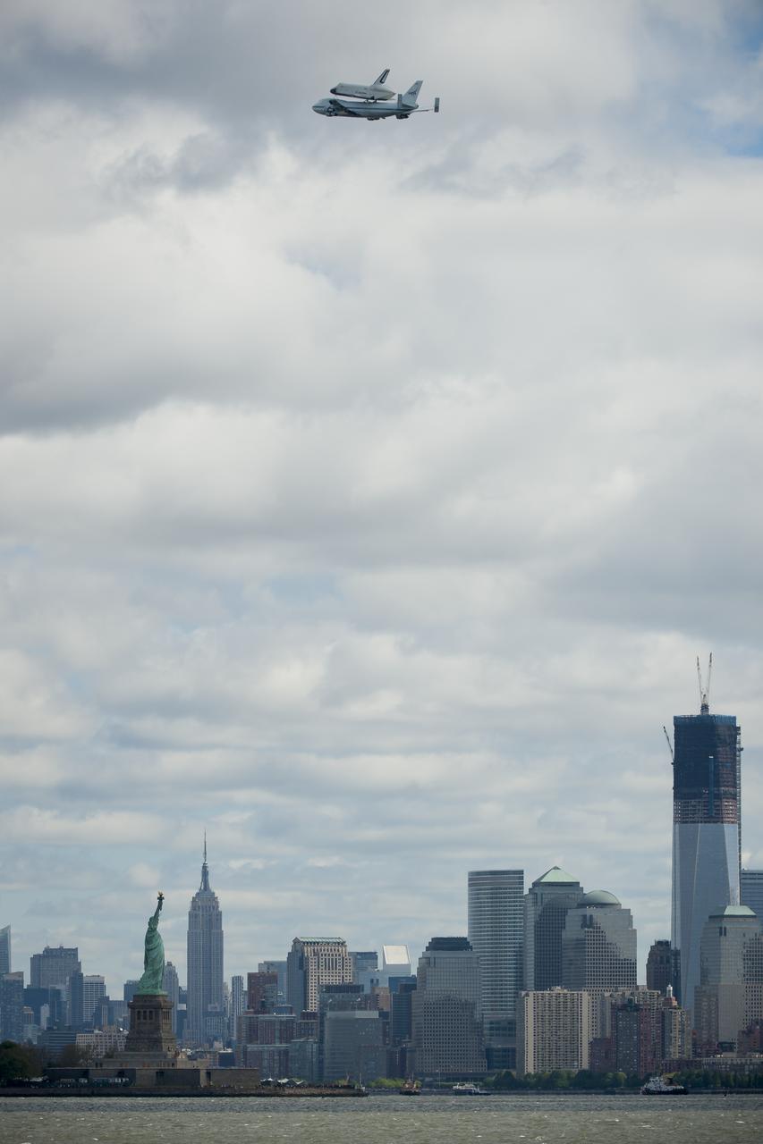
Space shuttle Enterprise, mounted atop a NASA 747 Shuttle Carrier Aircraft (SCA), is seen as it flies over the Hudson River, Friday, April 27, 2012, in New York. Enterprise was the first shuttle orbiter built for NASA performing test flights in the atmosphere and was incapable of spaceflight. Originally housed at the Smithsonian's Steven F. Udvar-Hazy Center, Enterprise will be demated from the SCA and placed on a barge that will eventually be moved by tugboat up the Hudson River to the Intrepid Sea, Air & Space Museum in June. Photo Credit: (NASA/Bill Ingalls)
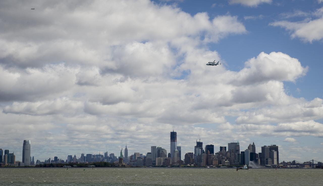
Space shuttle Enterprise, mounted atop a NASA 747 Shuttle Carrier Aircraft (SCA), is seen as it flies over the Hudson River, Friday, April 27, 2012, in New York. Enterprise was the first shuttle orbiter built for NASA performing test flights in the atmosphere and was incapable of spaceflight. Originally housed at the Smithsonian's Steven F. Udvar-Hazy Center, Enterprise will be demated from the SCA and placed on a barge that will eventually be moved by tugboat up the Hudson River to the Intrepid Sea, Air & Space Museum in June. Photo Credit: (NASA/Bill Ingalls)

Space shuttle Enterprise, mounted atop a NASA 747 Shuttle Carrier Aircraft (SCA), is seen as it flies over the Hudson River, Friday, April 27, 2012, in New York. Enterprise was the first shuttle orbiter built for NASA performing test flights in the atmosphere and was incapable of spaceflight. Originally housed at the Smithsonian's Steven F. Udvar-Hazy Center, Enterprise will be demated from the SCA and placed on a barge that will eventually be moved by tugboat up the Hudson River to the Intrepid Sea, Air & Space Museum in June. Photo Credit: (NASA/Matt Hedges)
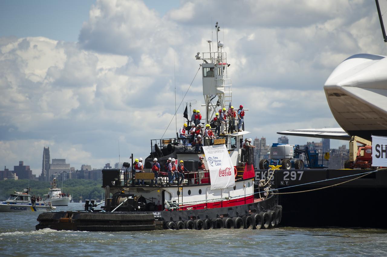
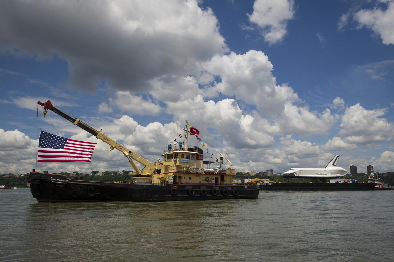
The tugboat Shelby helps tow the space shuttle Enterprise on a barge up the Hudson River to the Intrepid Sea, Air and Space Museum where it will be permanently displayed, Wednesday, June 6, 2012 in New York City. Photo Credit: (NASA/Bill Ingalls)
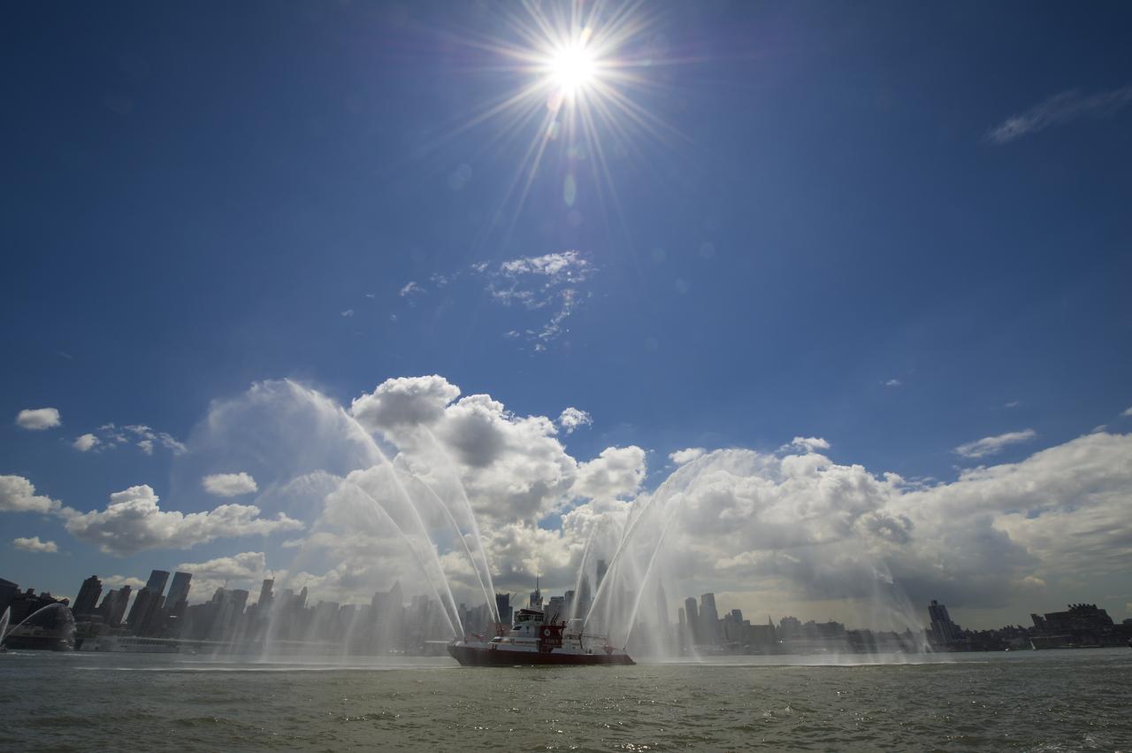
An FDNY fireboat is one of the lead boats for the space shuttle Enterprise as Enterprise is towed by barge up the Hudson River on it's way to the Intrepid Sea, Air and Space Museum where it will be permanently displayed, Wednesday, June 6, 2012 in New York City. Photo Credit: (NASA/Bill Ingalls)

iss061e100776 (Dec. 28, 2019) --- The bright city lights of Long Island, New York City and the New Jersey area contrast the dark waters of Sandy Hook Bay, the Upper and Lower Bays, the Hudson and East Rivers and Long Island Sound, that surround the major metropolitan area of the northeastern United States.
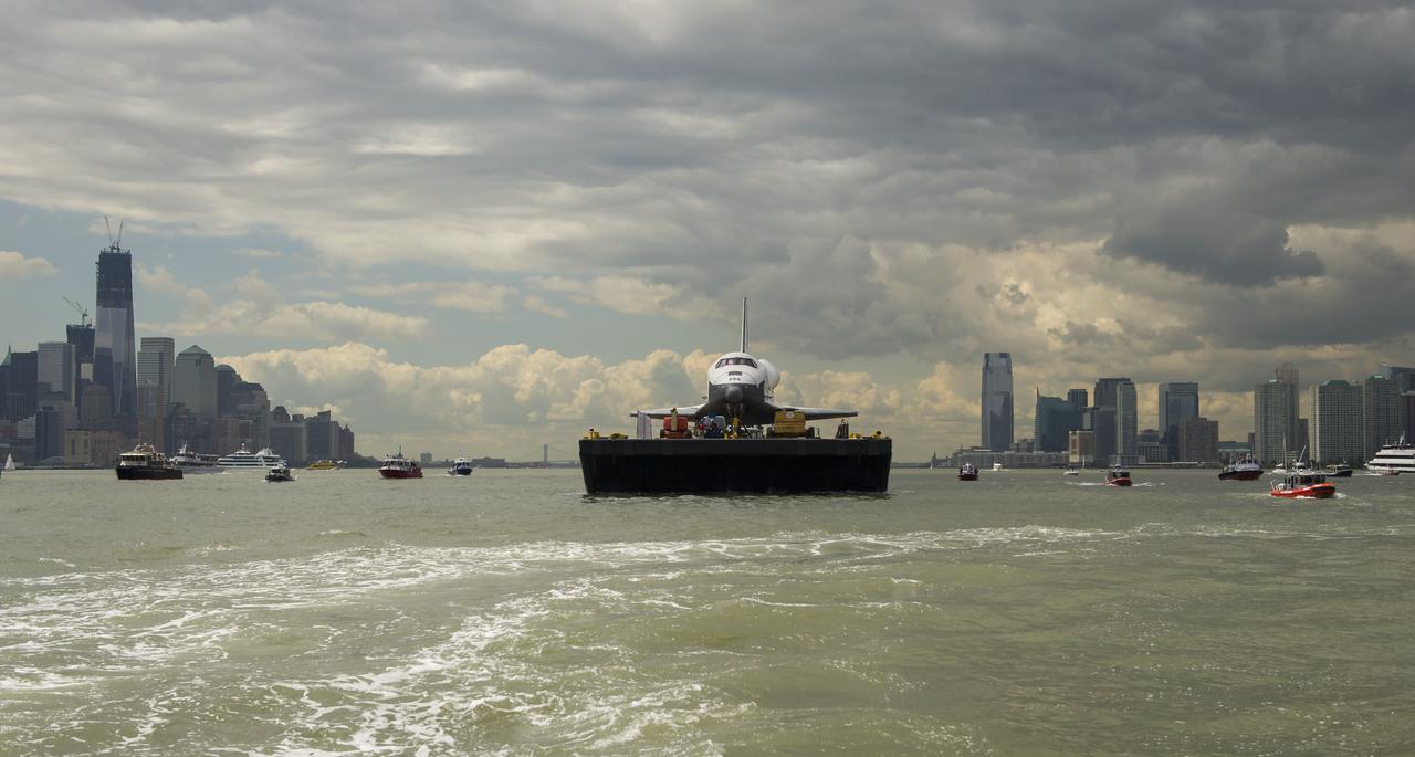
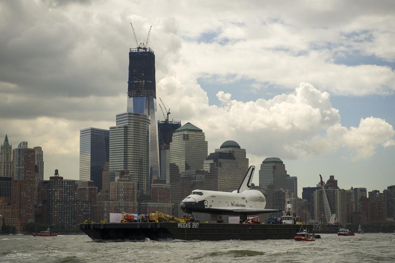
The space shuttle Enterprise is towed by barge up the Hudson River with the New York skyline seen on the left and the Jersey City skyline on the right while on it's way to the Intrepid Sea, Air and Space Museum where it will be permanently displayed, Wednesday, June 6, 2012. Photo Credit: (NASA/Bill Ingalls)
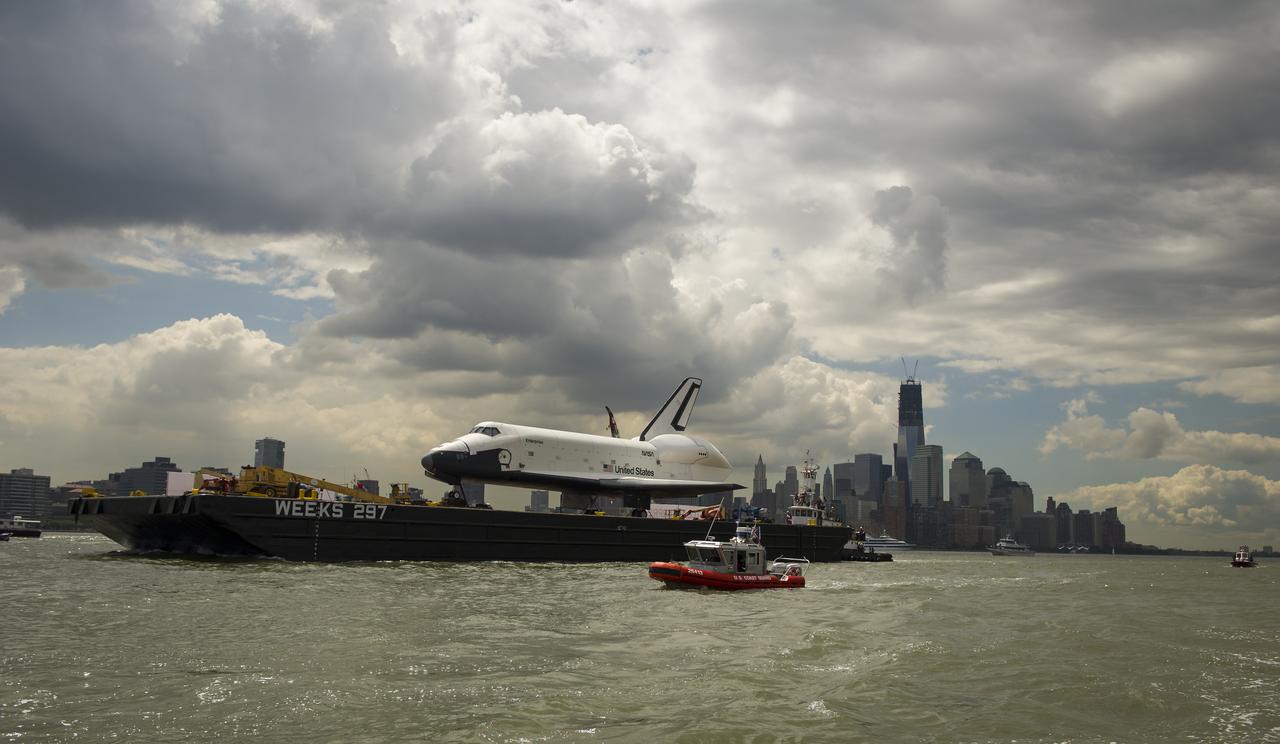
The space shuttle Enterprise is towed by barge up the Hudson River in New York with the World Trade Center's Freedom Tower in the background while on it's way to the Intrepid Sea, Air and Space Museum where it will be permanently displayed, Wednesday, June 6, 2012. Photo Credit: (NASA/Bill Ingalls)

iss072e402101 (Dec. 22, 2024) --- The city lghts of the New York/New Jersey metropolitan area at approximately 3:30 a.m. EST (local time) contrast with the Atlantic coast and the Hudson River in this photograph taken from the International Space Station as it orbited 259 miles above Newfoundland.
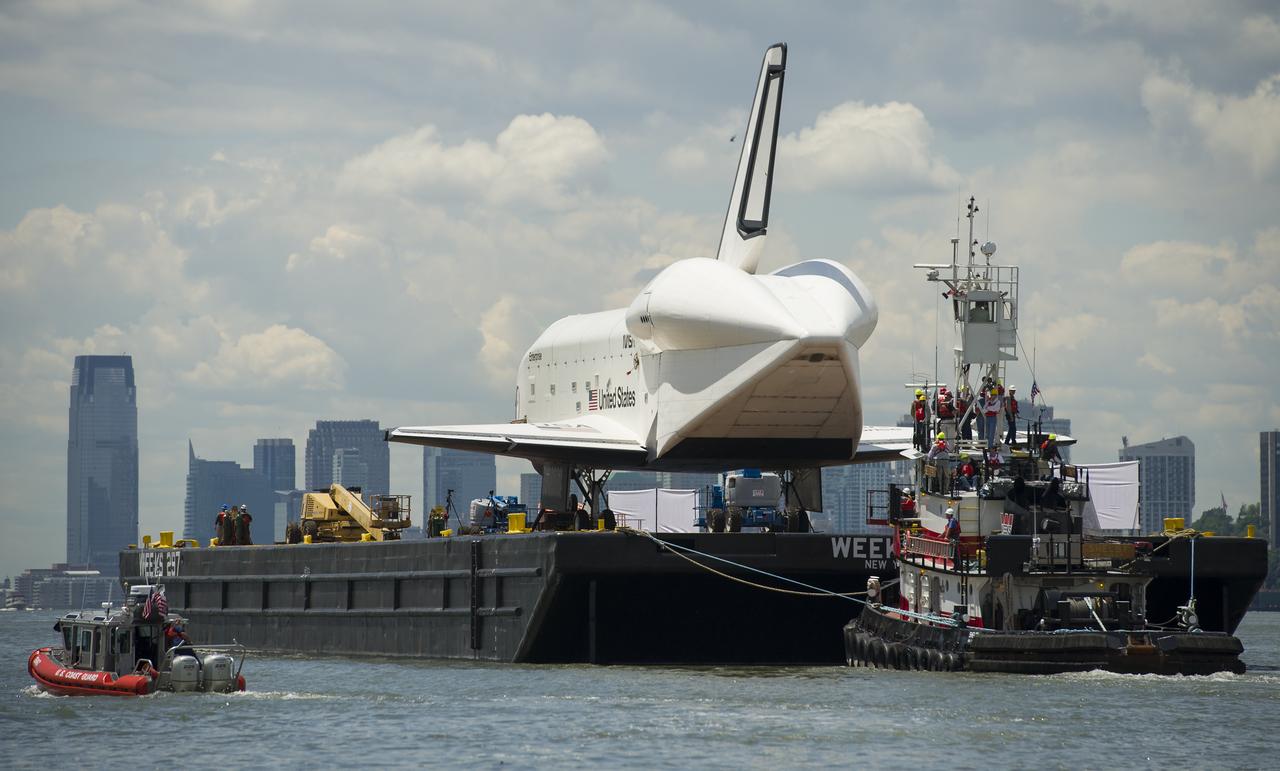
The tugboat Shelby tows the space shuttle Enterprise on a barge on the Hudson River to the Intrepid Sea, Air and Space Museum where it will be permanently displayed, Wednesday, June 6, 2012 in New York City. Photo Credit: (NASA/Bill Ingalls)
The space shuttle Enterprise is towed by barge up the Hudson River in New York with the New York City Skyline, including the Empire State Building, in the background while on it's way to the Intrepid Sea, Air and Space Museum where it will be permanently displayed, Wednesday, June 6, 2012. Photo Credit: (NASA/Bill Ingalls)
The space shuttle Enterprise is towed by barge up the Hudson River in New York with the World Trade Center's Freedom Tower in the background while on it's way to the Intrepid Sea, Air and Space Museum where it will be permanently displayed, Wednesday, June 6, 2012. Photo Credit: (NASA/Bill Ingalls)
The U.S. Army Corps of Engineers boat, Hayward, is seen in the foreground as the space shuttle Enterprise is towed by barge on the Hudson River to the Intrepid Sea, Air and Space Museum where it will be permanently displayed, Wednesday, June 6, 2012 in New York. Photo Credit: (NASA/Bill Ingalls)
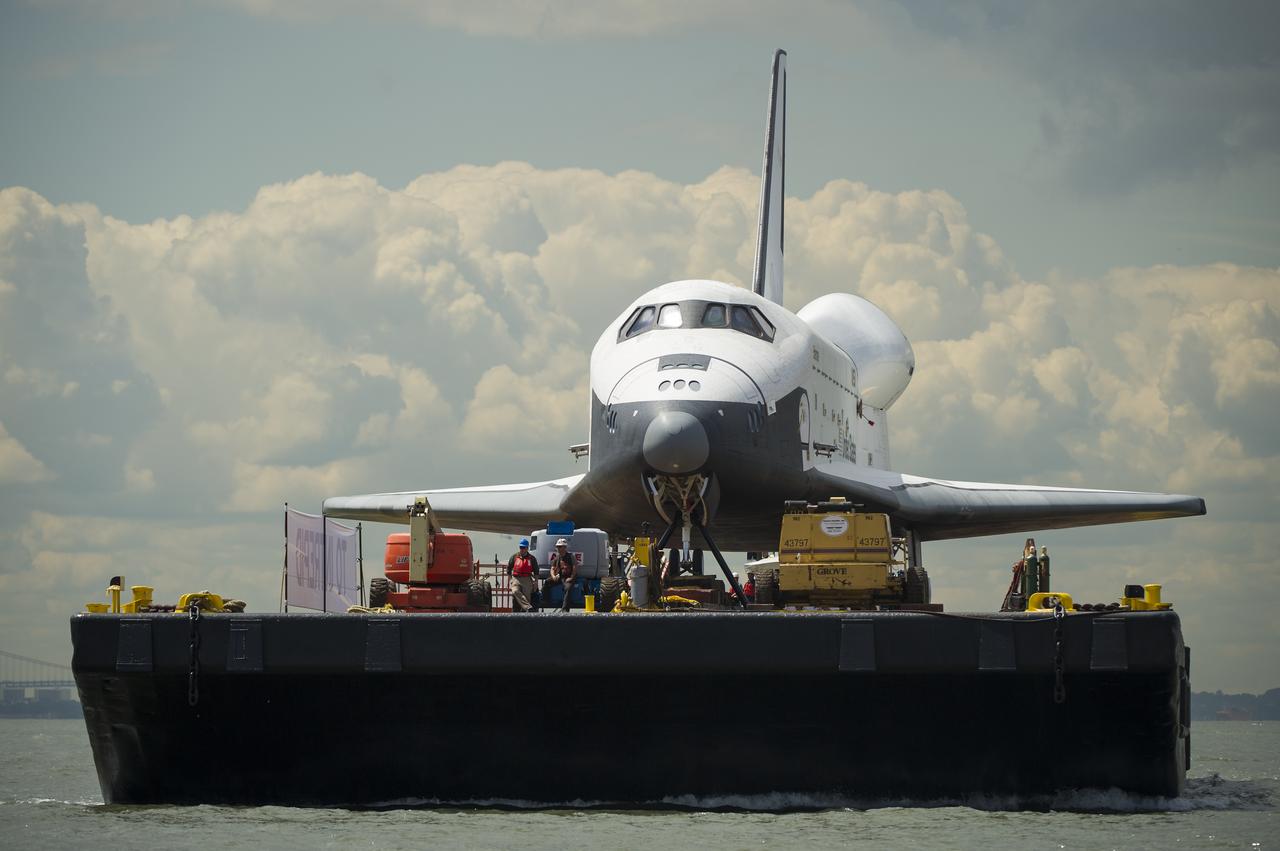
The space shuttle Enterprise is towed by barge up the Hudson River on it's way to the Intrepid Sea, Air and Space Museum where it will be permanently displayed, Wednesday, June 6, 2012 in New York City. Photo Credit: (NASA/Bill Ingalls)
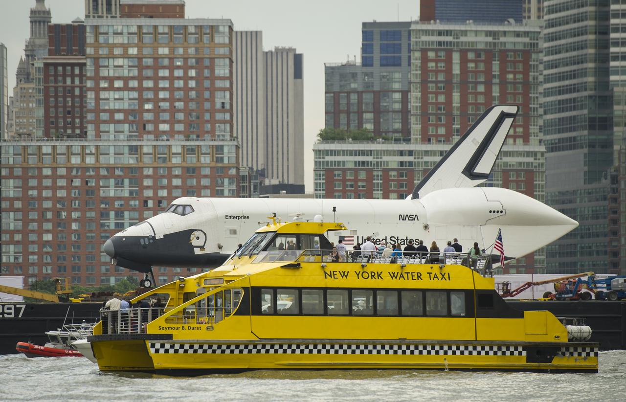
Riders onboard a New York Water Taxi get a close-up view of the space shuttle Enterprise as it is towed by barge up the Hudson River on it's way to the Intrepid Sea, Air and Space Museum where it will be permanently displayed, Wednesday, June 6, 2012 in New York City. Photo Credit: (NASA/Bill Ingalls)
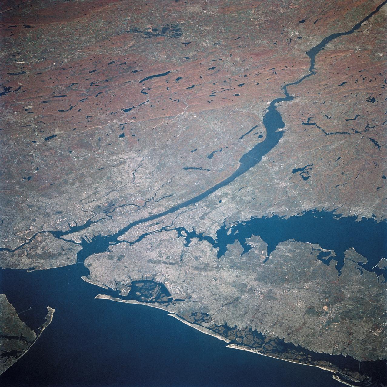
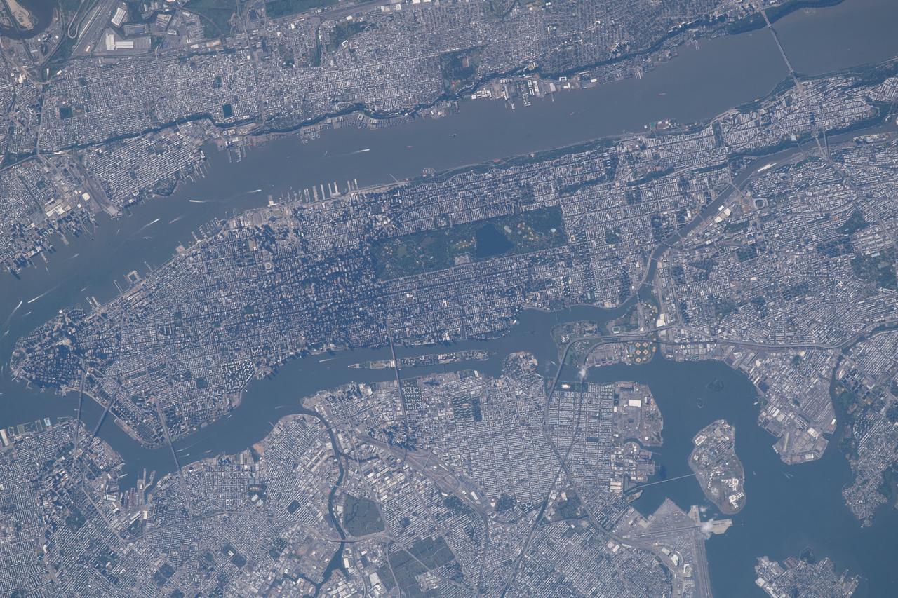
ISS032-E-027898 (12 Sept. 2012) --- This vertical view from the International Space Station features New York City. With a population in the metropolitan New York of 18.9 million (2011 figures from Census Bureau), and in the city of some 8.25 million, the New York City area is one of the leading commercial, financial, cultural, and communication centers in the world. The sediment-laden Hudson River enters the scene near the bottom left (north) of the image and can be seen flowing south emptying into Upper and Lower New York Bays (right of center). Much of Long Island is visible extending to the east at center and upper left of the image. Right (west) of the Hudson River, much of the state of New Jersey and the Newark metropolitan area are visible. Sandy Hook in New Jersey can be seen in the upper right quadrant of the image. Central Park on Manhattan can be seen below and just to the left of center as a dark rectangular patch.

STS100-716-108 (19 April-1 May 2001) --- This vertical view from the Space Shuttle Endeavour features New York City. With a population in the metropolitan New York of 11,685,650, and in the city of 8,008,278 (March 2001), the New York City area is one of the leading commercial, financial, cultural, and communication centers in the world. The sediment-laden Hudson River enters the scene near the bottom left (north) of the image and can be seen flowing south emptying into Upper and Lower New York Bays (right of center). Long Island is visible extending to the east at the upper left of the image. Right (west) of the Hudson River, the state of New Jersey and the Newark metropolitan area are visible. Sandy Hook in New Jersey can be seen in the upper right quadrant of the image.
STS073-E-5098 (30 Oct. 1995) --- Long Island, New York stretches across the scene. The New York City metropolitan complex is at the left; Central Park can be seen as a dark rectangle between the Hudson and East Rivers. Sandy beaches of the Long Island barrier islands mark the boundary between Atlantic Ocean and quiet lagoons and marshes. The frame was exposed with the Electronic Still Camera (ESC).
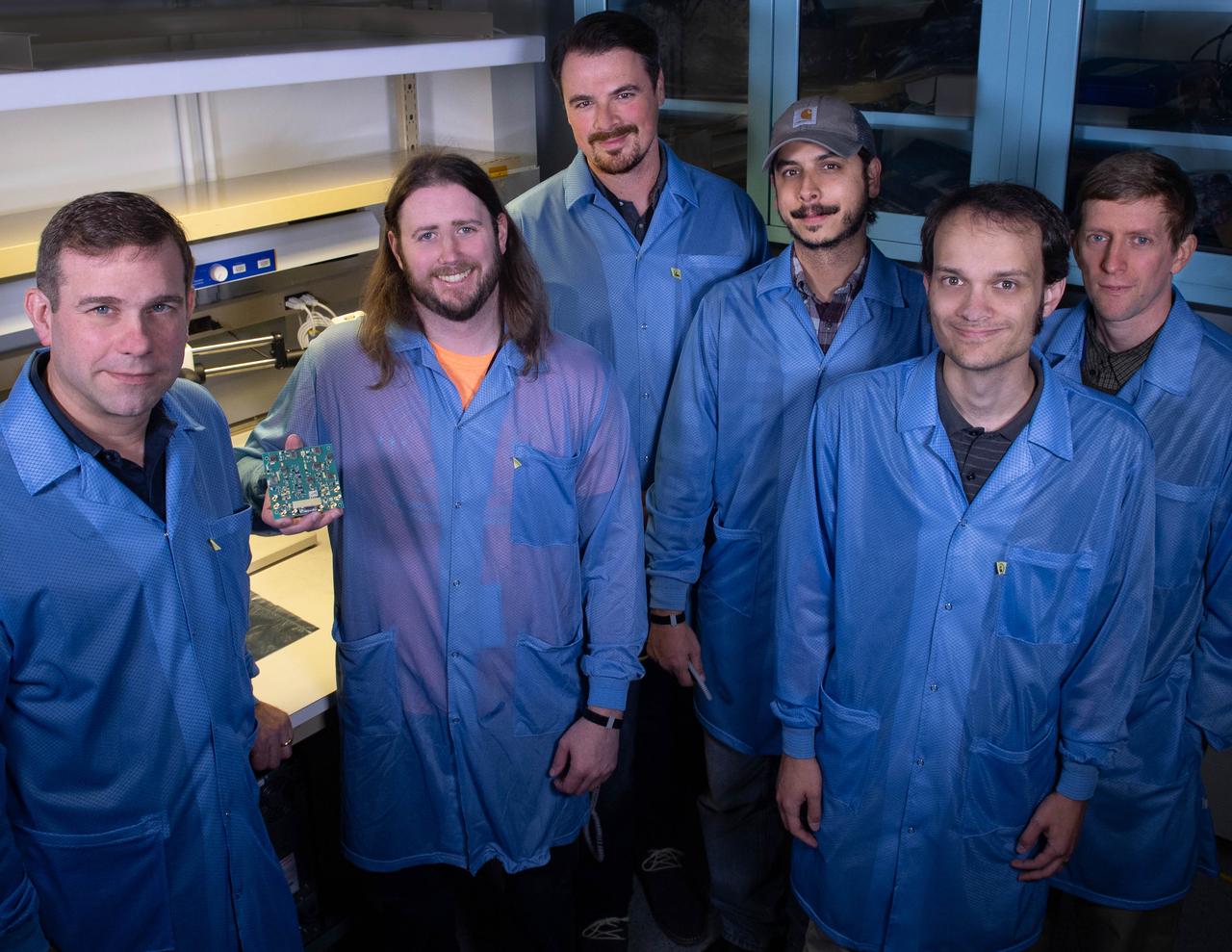
Several Goddard technologists are involved in a new CubeSat technology-demonstration mission called SNoOPI, which employs a novel remote-sensing technique for measuring soil-moisture levels. From left to right: Jeffrey Piepmeier, Chase Kielbasa, who is holding a first-generation prototype circuit board for the SNoOPI instrument, Joseph Knuble, Manuel Vega, Michael Coon, and Derek Hudson.
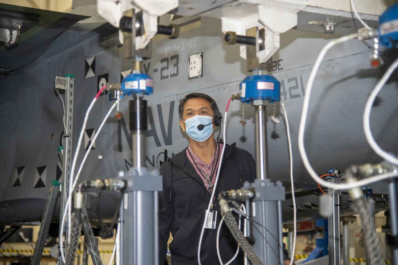
Larry Hudson does an inspection after the actuator on the F/A-18E from the Naval Air Systems Command (NAVAIR) in Patuxent River, Maryland, is pinned to the horizontal tail load test fixture. The aircraft is in NASA’s Armstrong Flight Research Center Flight Loads Laboratory in Edwards, California, for the center’s biggest load calibrations tests. This testing is needed before the aircraft can serve as a test vehicle for determining if it can safely manage maneuvers and proposed upgrades.
ISS010-E-21487 (26 March 2005) --- Manhattan Island and its easily recognizable Central Park are featured in this image photographed by an Expedition 10 crewmember on the International Space Station. Some of the other New York City boroughs (including parts of Queens and Brooklyn) are also shown, as are two small sections of the New Jersey side of the Hudson River.
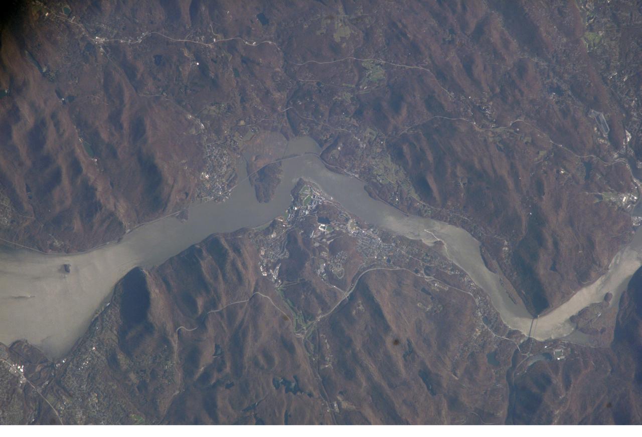
ISS012-E-08797 (20 Nov. 2005) --- West Point, NY, home of the United States Military Academy since 1802, is featured in this electronic still image recorded from the International Space Station during Expedition 12. West Point is located on the high west bank of the Hudson River north of New York City. North is at the top in this almost vertical view.

A set of cranes and wind restraints constructed to remove space shuttle Enterprise from atop NASA's 747 Shuttle Carrier Aircraft are being put into place at John F. Kennedy (JFK) International Airport in New York, Saturday, May 12, 2012. Enterprise will be placed on a barge that will move by tugboat up the Hudson River to Intrepid in June. The shuttle will be lifted by crane and placed on the flight deck of the Intrepid, where it will be on exhibit to the public starting this summer in a temporary climate-controlled pavilion. Photo Credit: (NASA/Kim Shiflet)
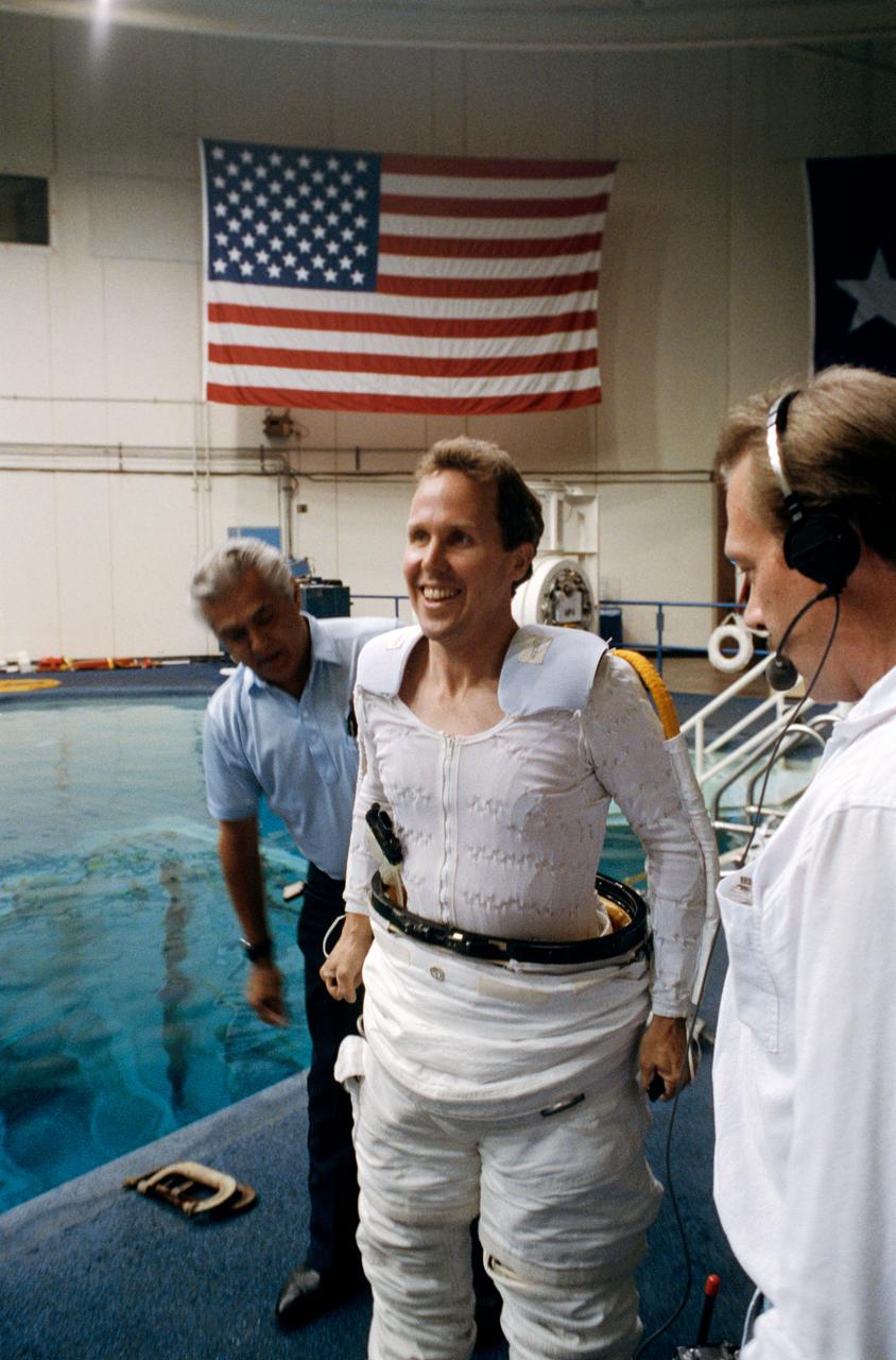
Astronaut Thomas D. Jones, mission specialist, dons a space suit prior to participating in contingency space walk simulations at the JSC Weightless Environment Training Facility (WETF). Jones is assisted by Frank Hernandez (left) and suit technician Charles Hudson of Hamilton Standard. Jones suit is weighted to that he can achieve a neutrally buoyant state once under water. Extravehicular tasks are not planned for the STS-59 mission, but a number of chores are rehearsed in case of failure of remote systems to perform those jobs.
Larry Hudson and Tony Chen inspect test data during horizontal tail testing on a F/A-18E from the Naval Air Systems Command (NAVAIR) in Patuxent River, Maryland. The aircraft is in NASA's Armstrong Flight Research Center Flight Loads Laboratory in Edwards, California, for the center's biggest load calibrations tests. This testing is needed before the aircraft can serve as a test vehicle for determining if it can safely manage maneuvers and proposed upgrades.

The space shuttle Enterprise hangs from a sling after being demated from the NASA 747 Shuttle Carrier Aircraft (SCA) at John F. Kennedy (JFK) International Airport in Jamica, New York, Sunday, May 13, 2012. The shuttle will be placed on a barge that will move by tugboat up the Hudson River to the Intrepid Sea, Air & Space Museum in June. The shuttle will be lifted by crane and placed on the flight deck of the Intrepid, where it will be on exhibit to the public starting this summer in a temporary climate-controlled pavilion. Photo Credit: (NASA/Kim Shiflet)
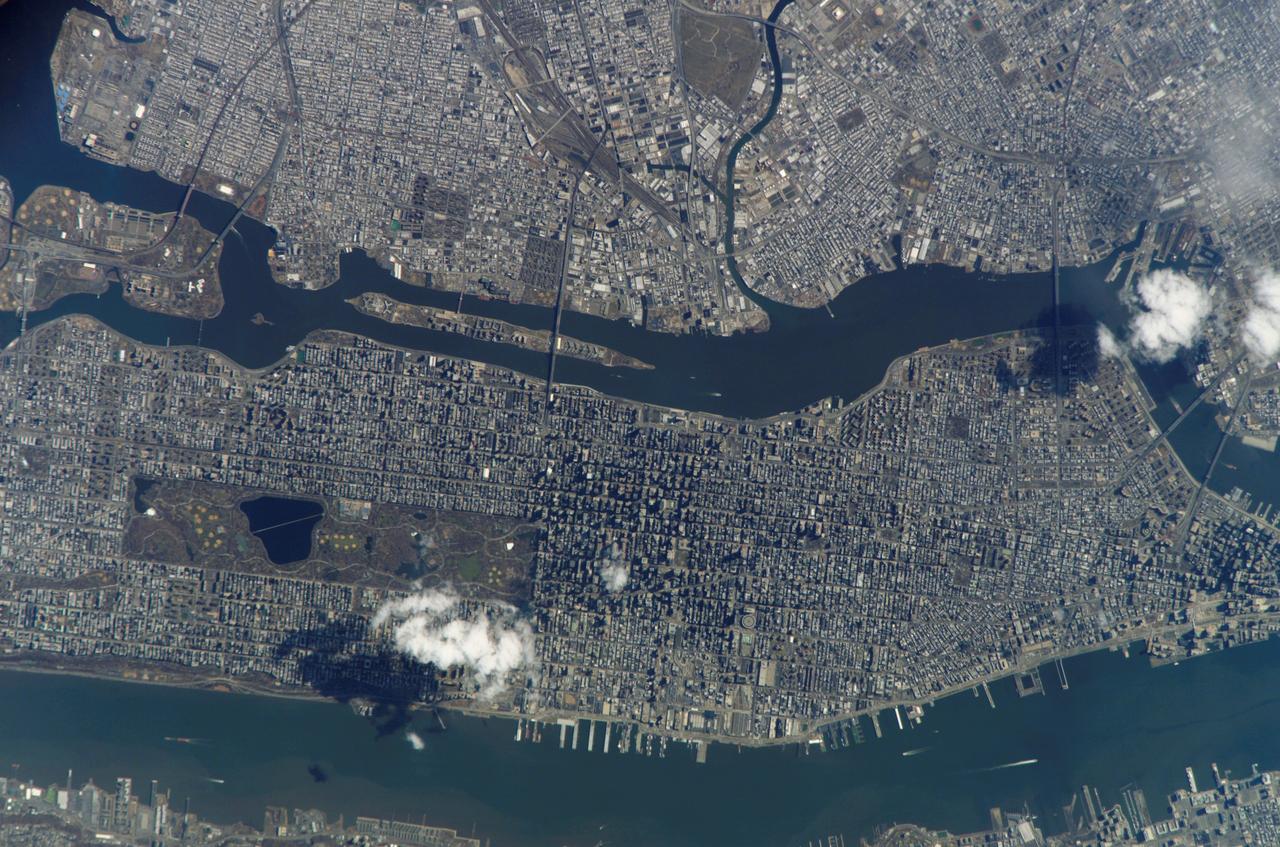
iss056e021682 (June 19, 2018) --- The commercial ports of the state of New Jersey and four out of five boroughs that make up New York City, including portions of Brooklyn, Queens, the Bronx and almost all of Manhattan, are pictured from the International Space Station. The Hudson River separates Manhattan from New Jersey. The East River separates Manhattan from Brooklyn and Queens while the Harlem River separates the Bronx from Manhattan.
Space shuttle Enterprise, mounted atop a NASA 747 Shuttle Carrier Aircraft (SCA), is seen as it flies over the Verrazano Bridge, Friday, April 27, 2012, in New York. Enterprise was the first shuttle orbiter built for NASA performing test flights in the atmosphere and was incapable of spaceflight. Originally housed at the Smithsonian's Steven F. Udvar-Hazy Center, Enterprise will be demated from the SCA and placed on a barge that will eventually be moved by tugboat up the Hudson River to the Intrepid Sea, Air & Space Museum in June. Photo Credit: (NASA/Bill Ingalls)

Space shuttle Enterprise, mounted atop a NASA 747 Shuttle Carrier Aircraft (SCA), is seen as it flies over the Manhattan Skyline with Freedom Tower in the background, Friday, April 27, 2012, in New York. Enterprise was the first shuttle orbiter built for NASA performing test flights in the atmosphere and was incapable of spaceflight. Originally housed at the Smithsonian's Steven F. Udvar-Hazy Center, Enterprise will be demated from the SCA and placed on a barge that will eventually be moved by tugboat up the Hudson River to the Intrepid Sea, Air & Space Museum in June. Photo Credit: (NASA/Robert Markowitz)

The space shuttle Enterprise, mounted on transport vehicle, is backed into a temporary hangar after being demated from the NASA 747 Shuttle Carrier Aircraft (SCA) at John F. Kennedy (JFK) International Airport in Jamica, New York, Sunday, May 13, 2012. Enterprise will be placed on a barge that will move by tugboat up the Hudson River to the Intrepid Sea, Air & Space Museum in June. The shuttle will be lifted by crane and placed on the flight deck of the Intrepid, where it will be on exhibit to the public starting this summer in a temporary climate-controlled pavilion. Photo Credit: (NASA/Kim Shiflet)

Space shuttle Enterprise, mounted atop a NASA 747 Shuttle Carrier Aircraft (SCA), is seen as it takes off for New York from Washington Dulles International Airport, Friday, April 27, 2012, in Sterling, VA. Enterprise was the first shuttle orbiter built for NASA performing test flights in the atmosphere and was incapable of spaceflight. Originally housed at the Smithsonian's Steven F. Udvar-Hazy Center, Enterprise will be demated from the SCA and placed on a barge that will eventually be moved by tugboat up the Hudson River to the Intrepid Sea, Air & Space Museum in June. Photo Credit: (NASA/Smithsonian Institution/Mark Avino)

The space shuttle Enterprise, mounted on transport vehicle, is backed into a temporary hangar after being demated from the NASA 747 Shuttle Carrier Aircraft (SCA) at John F. Kennedy (JFK) International Airport in Jamica, New York, Sunday, May 13, 2012. Enterprise will be placed on a barge that will move by tugboat up the Hudson River to the Intrepid Sea, Air & Space Museum in June. The shuttle will be lifted by crane and placed on the flight deck of the Intrepid, where it will be on exhibit to the public starting this summer in a temporary climate-controlled pavilion. Photo Credit: (NASA/Kim Shiflet)
CAPTION: ---------------------------- Space shuttle Enterprise, mounted atop a NASA 747 Shuttle Carrier Aircraft (SCA), is seen as it flies near the Intrepid Sea, Air and Space Museum, Friday, April 27, 2012, in New York. Enterprise was the first shuttle orbiter built for NASA performing test flights in the atmosphere and was incapable of spaceflight. Originally housed at the Smithsonian's Steven F. Udvar-Hazy Center, Enterprise will be demated from the SCA and placed on a barge that will eventually be moved by tugboat up the Hudson River to the Intrepid Sea, Air & Space Museum in June. Photo Credit: (NASA/Robert Markowitz)

iss073e0982136 (Oct. 25, 2025) --- Upper Bay (center) leads to New York City's Statue of Liberty, then splits into the Hudson River and East River, which shape the island borough of Manhattan. Surrounding this iconic borough are New York City's four other boroughs—Staten Island, Brooklyn, Queens, and the Bronx—as well as the neighboring state of New Jersey. The New York City metropolitan area has a population of approximately 19.9 million, making it the 10th most populous region in the world. This photograph was taken from the International Space Station as it orbited 262 miles above the Empire State at approximately 2:23 a.m. local time.

NASA's 747 Shuttle Carrier Aircraft (SCA), with space shuttle Enterprise latched on its back, is towed from the hangar at John F. Kennedy (JFK) International Airport in New York late in the night on Saturday, May 12, 2012. Early Sunday morning, Enterprise was removed from the SCA. The shuttle will be placed on a barge that will move by tugboat up the Hudson River to Intrepid in June. The shuttle will be lifted by crane and placed on the flight deck of the Intrepid, where it will be on exhibit to the public starting this summer in a temporary climate-controlled pavilion. Photo Credit: (NASA/Kim Shiflet)

Space shuttle Enterprise, mounted atop a NASA 747 Shuttle Carrier Aircraft (SCA), is seen as it flies near the Statue of Liberty and the Manhattan skyline, Friday, April 27, 2012, in New York. Enterprise was the first shuttle orbiter built for NASA performing test flights in the atmosphere and was incapable of spaceflight. Originally housed at the Smithsonian's Steven F. Udvar-Hazy Center, Enterprise will be demated from the SCA and placed on a barge that will eventually be moved by tugboat up the Hudson River to the Intrepid Sea, Air & Space Museum in June. Photo Credit: (NASA/Robert Markowitz)

NASA Deputy Administrator Lori Garver speaks Friday, April 27, 2012, during the transfer ceremony for space shuttle Enterprise at John F. Kennedy Airport in New York. Enterprise was the first shuttle orbiter built for NASA performing test flights in the atmosphere and was incapable of spaceflight. Originally housed at the Smithsonian's Steven F. Udvar-Hazy Center, Enterprise will be demated from the SCA and placed on a barge that will eventually be moved by tugboat up the Hudson River to the Intrepid Sea, Air & Space Museum in June. Photo Credit: (NASA/Paul E. Alers)
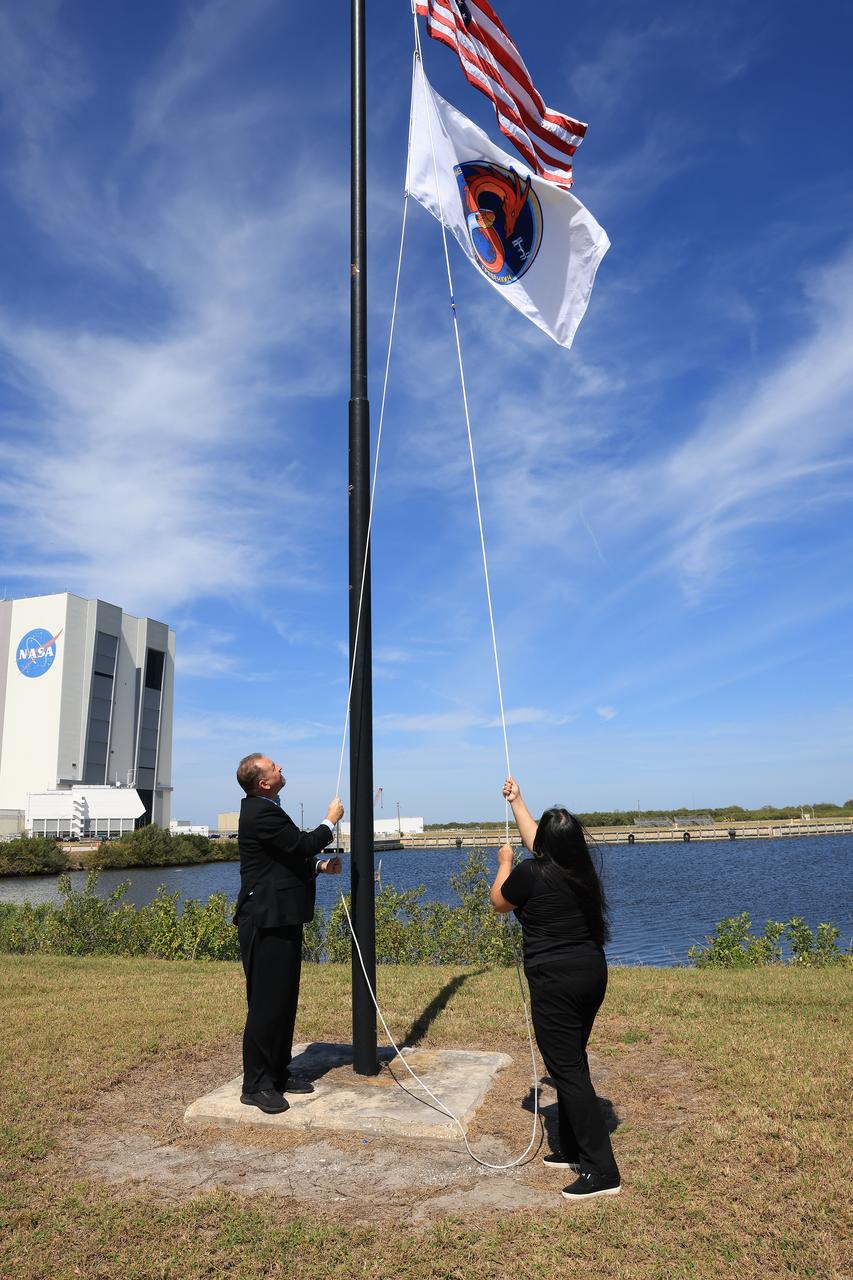
Dave Hudson, Commercial Crew Program flight operations integrator, and Asia Quince, former Commercial Crew Program spacecraft avionics, software, pyros system lead, raise the SpaceX Crew-8 flag, Wednesday, Feb. 28, 2024, near the countdown clock at the NASA News Center at the agency’s Kennedy Space Center in Florida. The Crew-8 mission will send NASA astronauts Matthew Dominick, Michael Barratt, and Jeanette Epps, and Roscosmos cosmonaut Alexander Grebenkin, to the International Space Station aboard SpaceX’s Dragon spacecraft on the company’s Falcon 9 rocket from Kennedy’s Launch Complex 39A no earlier than 11:16 p.m. EDT Saturday, March 2.
Space shuttle Enterprise, mounted atop a NASA 747 Shuttle Carrier Aircraft (SCA), is seen as it takes off for New York from Washington Dulles International Airport, Friday, April 27, 2012, in Sterling, VA. Enterprise was the first shuttle orbiter built for NASA performing test flights in the atmosphere and was incapable of spaceflight. Originally housed at the Smithsonian's Steven F. Udvar-Hazy Center, Enterprise will be demated from the SCA and placed on a barge that will eventually be moved by tugboat up the Hudson River to the Intrepid Sea, Air & Space Museum in June. Photo Credit: (NASA/Scott Andrews)

The space shuttle Enterprise is lowered onto a transport vehicle after being demated from the NASA 747 Shuttle Carrier Aircraft (SCA) at John F. Kennedy (JFK) International Airport in Jamica, New York, Sunday, May 13, 2012. The shuttle will be placed on a barge that will move by tugboat up the Hudson River to the Intrepid Sea, Air & Space Museum in June. The shuttle will be lifted by crane and placed on the flight deck of the Intrepid, where it will be on exhibit to the public starting this summer in a temporary climate-controlled pavilion. Photo Credit: (NASA/Kim Shiflet)
Space shuttle Enterprise, mounted atop a NASA 747 Shuttle Carrier Aircraft (SCA), is seen as it flies over John F. Kennedy Airport, Friday, April 27, 2012, in New York. Enterprise was the first shuttle orbiter built for NASA performing test flights in the atmosphere and was incapable of spaceflight. Originally housed at the Smithsonian's Steven F. Udvar-Hazy Center, Enterprise will be demated from the SCA and placed on a barge that will eventually be moved by tugboat up the Hudson River to the Intrepid Sea, Air & Space Museum in June. Photo Credit: (NASA/Paul E. Alers)
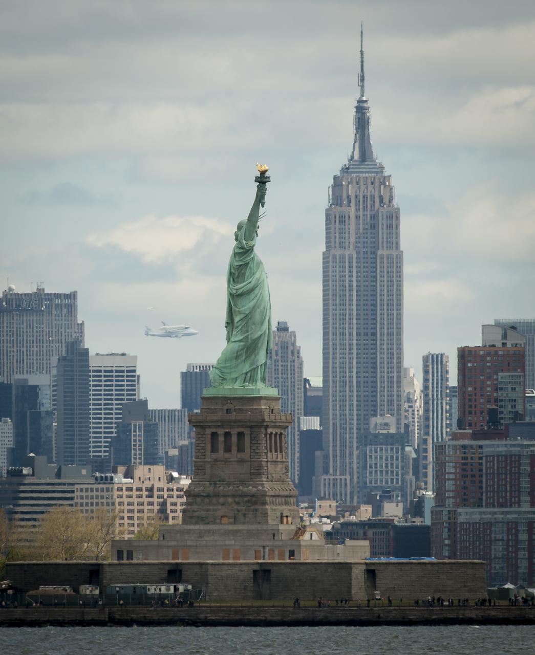
Space shuttle Enterprise, mounted atop a NASA 747 Shuttle Carrier Aircraft (SCA), is seen off in the distance behind the Statue of Liberty, Friday, April 27, 2012, in New York. Enterprise was the first shuttle orbiter built for NASA performing test flights in the atmosphere and was incapable of spaceflight. Originally housed at the Smithsonian's Steven F. Udvar-Hazy Center, Enterprise will be demated from the SCA and placed on a barge that will eventually be moved by tugboat up the Hudson River to the Intrepid Sea, Air & Space Museum in June. Photo Credit: (NASA/Bill Ingalls)

Space shuttle Enterprise is held aloft by a yellow sling and a set of cranes after it was removed from the top of NASA's 747 Shuttle Carrier Aircraft early Sunday morning at John F. Kennedy (JFK) International Airport in New York, Sunday, May 13, 2012 .The 747 was towed backwards so that Enterprise could be lowered. The shuttle will be placed on a barge that will move by tugboat up the Hudson River to the Intrepid Sea, Air & Space Museum in June. The shuttle will be lifted by crane and placed on the flight deck of the Intrepid, where it will be on exhibit to the public starting this summer in a temporary climate-controlled pavilion. Photo Credit: (NASA/Kim Shiflet)

A yellow sling is lowered onto space shuttle Enterprise, which sits atop NASA's 747 Shuttle Carrier Aircraft (SCA) prior to it being demated a few hours later at John F. Kennedy (JFK) International Airport in New York, Saturday, May 12, 2012. The shuttle will be placed on a barge that will move by tugboat up the Hudson River to Intrepid in June. The shuttle will be lifted by crane and placed on the flight deck of the Intrepid, where it will be on exhibit to the public starting this summer in a temporary climate-controlled pavilion. Photo Credit: (NASA/Kim Shiflet)
Space shuttle Enterprise, mounted atop a NASA 747 Shuttle Carrier Aircraft (SCA), is seen prior to taking off for New York from Washington Dulles International Airport, Friday, April 27, 2012, in Sterling, VA. Enterprise was the first shuttle orbiter built for NASA performing test flights in the atmosphere and was incapable of spaceflight. Originally housed at the Smithsonian's Steven F. Udvar-Hazy Center, Enterprise will be demated from the SCA and placed on a barge that will eventually be moved by tugboat up the Hudson River to the Intrepid Sea, Air & Space Museum in June. Photo Credit: (NASA/Scott Andrews)
Space shuttle Enterprise, mounted atop a NASA 747 Shuttle Carrier Aircraft (SCA), is seen as it taxis at John F. Kennedy Airport, Friday, April 27, 2012, in New York. Enterprise was the first shuttle orbiter built for NASA performing test flights in the atmosphere and was incapable of spaceflight. Originally housed at the Smithsonian's Steven F. Udvar-Hazy Center, Enterprise will be demated from the SCA and placed on a barge that will eventually be moved by tugboat up the Hudson River to the Intrepid Sea, Air & Space Museum in June. Photo Credit: (NASA/Paul E. Alers)

iss073e0982169 (Oct. 25, 2025) --- Long Island, New York—the most populous island in the United States—stretches 118 miles from west to east, extending from Brooklyn to Montauk Point. It lies between Long Island Sound to the north and the New York/New Jersey Bight to the south. Toward the upper left, New York City's island borough of Manhattan is visible, with the Hudson River and East River flowing on either side. The city's bright lights contrast with the elongated, darkened area of Central Park. This image was captured at approximately 2:24 a.m. local time from the International Space Station as it orbited 263 miles above the Empire State.
Space shuttle Enterprise, mounted atop a NASA 747 Shuttle Carrier Aircraft (SCA), is seen as it flies near the Empire State Building, Friday, April 27, 2012, in New York. Enterprise was the first shuttle orbiter built for NASA performing test flights in the atmosphere and was incapable of spaceflight. Originally housed at the Smithsonian's Steven F. Udvar-Hazy Center, Enterprise will be demated from the SCA and placed on a barge that will eventually be moved by tugboat up the Hudson River to the Intrepid Sea, Air & Space Museum in June. Photo Credit: (NASA/Robert Markowitz)
Space shuttle Enterprise, mounted atop a NASA 747 Shuttle Carrier Aircraft (SCA), is seen prior to taking off for New York from Washington Dulles International Airport, Friday, April 27, 2012, in Sterling, VA. Enterprise was the first shuttle orbiter built for NASA performing test flights in the atmosphere and was incapable of spaceflight. Originally housed at the Smithsonian's Steven F. Udvar-Hazy Center, Enterprise will be demated from the SCA and placed on a barge that will eventually be moved by tugboat up the Hudson River to the Intrepid Sea, Air & Space Museum in June. Photo Credit: (NASA/Scott Andrews)

NASA and United Space Alliance workers lower a yellow sling onto space shuttle Enterprise, which sits atop NASA's 747 Shuttle Carrier Aircraft (SCA) prior to it being demated a few hours later at John F. Kennedy (JFK) International Airport in New York, Saturday, May 12, 2012. Once the sling was firmly attached early Sunday morning, Enterprise was lifted from the SCA. The shuttle will be placed on a barge that will move by tugboat up the Hudson River to Intrepid in June. The shuttle will be lifted by crane and placed on the flight deck of the Intrepid, where it will be on exhibit to the public starting this summer in a temporary climate-controlled pavilion. Photo Credit: (NASA/Kim Shiflet)
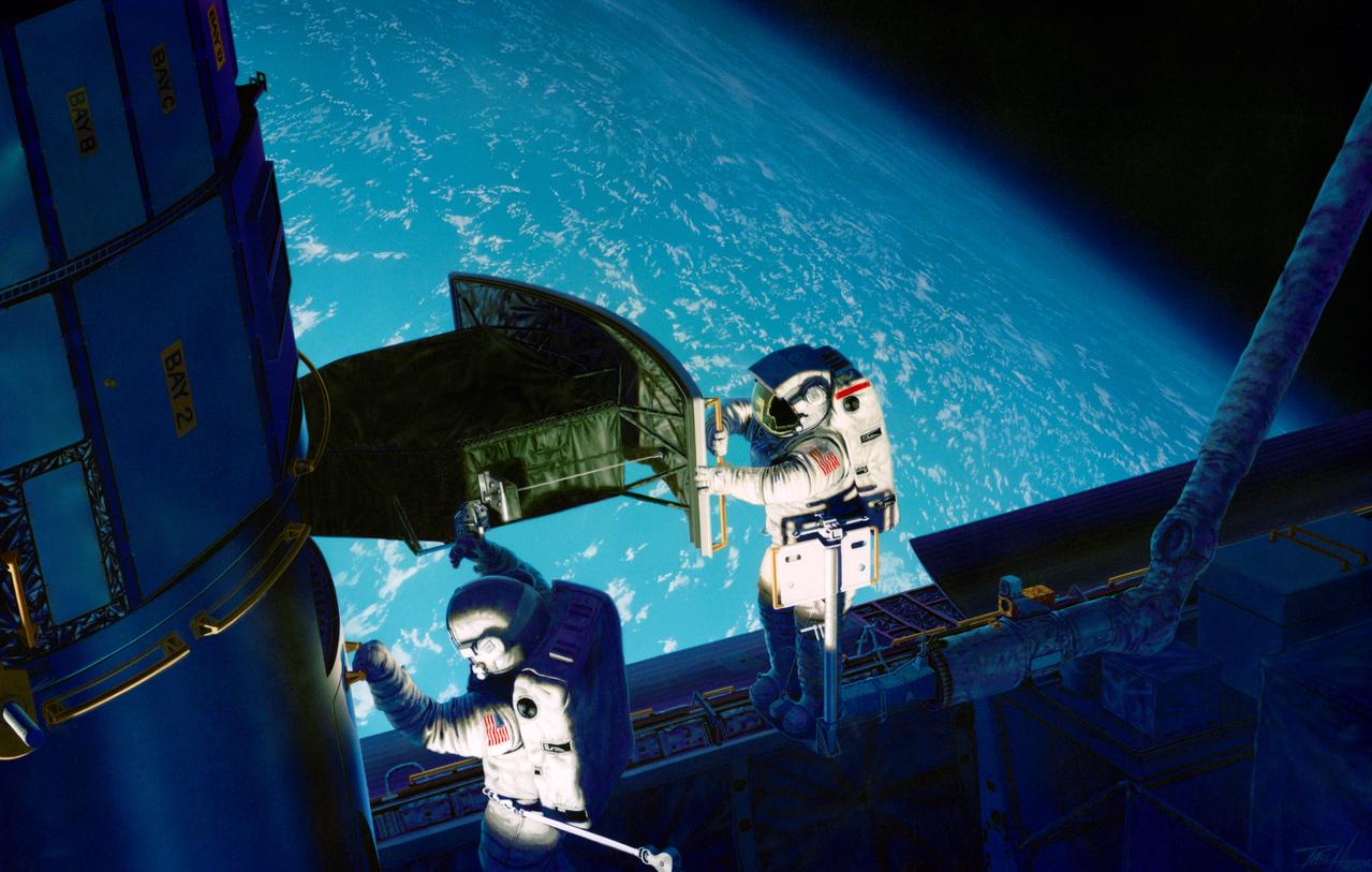
S93-48826 (November 1993) --- This artist's rendition of the 1993 Hubble Space Telescope (HST) servicing mission shows astronauts installing the new Wide Field/Planetary Camera (WF/PC 2). The instruments to replace the original camera and contains corrective optics that compensate for the telescope's flawed primary mirror. During the 11-plus day mission, astronauts are also scheduled to install the Corrective Optics Space Telescope Axial Replacement (COSTAR) -- an optics package that focuses and routes light to the other three instruments aboard the observatory -- a new set of solar array panels, and other hardware and components. The artwork was done for JPL by Paul Hudson.
Space shuttle Enterprise, mounted atop a NASA 747 Shuttle Carrier Aircraft (SCA), is seen as it flies near the Statue of Liberty, Friday, April 27, 2012, in New York. Enterprise was the first shuttle orbiter built for NASA performing test flights in the atmosphere and was incapable of spaceflight. Originally housed at the Smithsonian's Steven F. Udvar-Hazy Center, Enterprise will be demated from the SCA and placed on a barge that will eventually be moved by tugboat up the Hudson River to the Intrepid Sea, Air & Space Museum in June. Photo Credit: (NASA/Bill Ingalls)
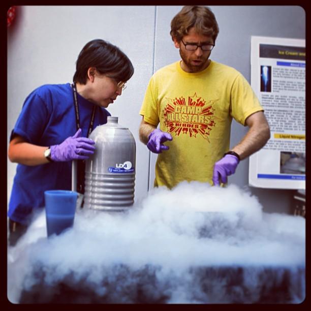
Pictured above, Goddard's astrobiology lab makes cookies and cream ice cream using liquid nitrogen at the Science Jamboree. The NASA Goddard Science Jamboree took place on July 16, 2013. The event allowed the different departments at Goddard a chance to showcase their research and projects to other employees and summer interns. #nasa #nasagoddard #icecream Credit: NASA/Goddard Sawyer Rosenstein

ISS006-E-18382 (January 2003) --- Bright city lights along the coastline and interior of the eastern coast of the United States were captured with a digital still camera by one of the Expedition Six crewmembers on board the International Space Station (ISS). This nighttime view shows New York City, the largest and brightest metropolitan area along the coast. The metropolitan area straddles the Hudson River and spreads eastward over western Long Island. The second largest city in this image is Philadelphia. The crew of the station took this image from a vantage point well to the northwest with the camera pointed back towards New York City and the coast. The result is that the perspective is highly distorted but still recognizable. Low clouds have formed over the waters of the Atlantic and have settled into some of the valleys of the Appalachian Mountains to the northwest.
STS102-336-035 (8-21 March 2001) --- One of the STS-102 astronauts aimed a 35mm camera through windows on the aft flight deck of the Space Shuttle Discovery to capture this synoptic southeast view of several New England states. The moderating influence of the Atlantic Ocean is visible along the coastline. The southern limit of the snow-covered landscape can be traced from southeast Massachusetts (left center) westward along the northern shore of Long Island Sound and includes the northern end of New Jersey (right center). In addition to Long Island (center), other prominent features on this image include: Cape Cod, Martha's Vineyard, Nantucket, and Block Islands; as well as the Hudson River (bottom center). Several southerly-draining river systems are discernible in Connecticut and extensive wetlands are observed along New York and New Jersey coastal areas.
STS113-347-034 (23 November - 7 December 2002) --- The STS-113 crewmembers used a 35mm still camera to record this image of New York City. Manhattan Island appears just left of center, flanked by the lower Hudson River (left), and the East River (right). The lake in Central Park on Manhattan is particularly clear. The Verrazano Narrows Bridge appears center on the bottom margin of the view, dividing upper New York Bay from Lower New York Bay. Newark Bay is the body of water lower left. Three well known islands appear at the north (top) end of Upper New York Bay, the smallest being Liberty Island (with the Statue of Liberty not visible at this resolution), Ellis Island, the middle-sized island, and Governor's Island, the largest. Queens appears top right, and Brooklyn, lower right, with the Naval Air Station on Jamaica Bay on the right margin.
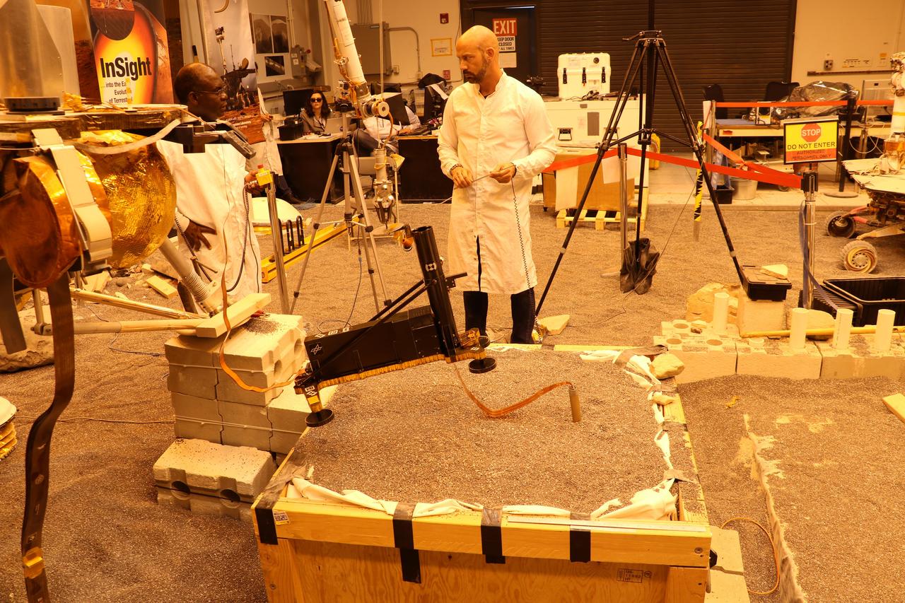
Engineers in a Mars-like test area at NASA's Jet Propulsion Laboratory try possible strategies to aid the Heat Flow and Physical Properties Package (HP3) on NASA's InSight lander, using engineering models of the lander, robotic arm and instrument. In this image, the model's robotic arm is lifting up part of HP3 to expose the self-hammering mole that is partially embedded in the testbed soil. Standing mid-ground are engineers Ashitey Trebi-Ollennu (left) and Troy Lee Hudson (right). Lights in the testbed intended to simulate Mars' lighting conditions give the image an orange tint. Engineers at the German Aerospace Center (DLR), which provided HP3, have also been working on strategies to help the probe. https://photojournal.jpl.nasa.gov/catalog/PIA23272

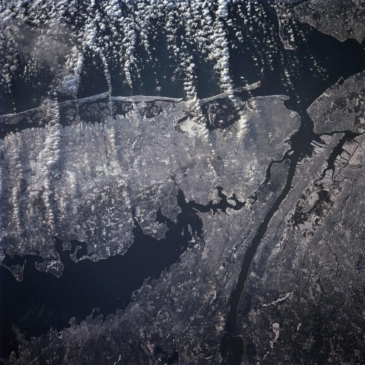
ISS028-E-045516 (9 Sept. 2011) --- Hurricane Katia off the northeastern USA coastline is featured in this image photographed by an Expedition 28 crew member on the International Space Station. Hurricane Katia had diminished to Category 1 strength on the Saffir-Simpson scale at the time this photograph was taken, but it still presented an impressive cloud circulation as its center passed by the northeastern USA coastline on Sept. 9, 2011. The storm had reached Category 4 strength earlier on Sept. 5, making it the second major hurricane of the 2011 Atlantic hurricane season. Katia remained over open waters of the Atlantic Ocean during its lifetime, unlike two preceding storms of the season ? Hurricane Irene and Tropical Storm Lee ? both of which made landfall on the continental USA. The approximate center of Hurricane Katia is visible at lower right, with its outer cloud bands extending across the center of the view. A small part of the State of New York ? including Long Island and the Hudson River ? is visible through a gap in the cloud cover at lower left. The Hudson River has a chocolate brown coloration due to heavy loading with sediment, a consequence of flooding and erosion of the upstream watershed from the heavy precipitation of Hurricane Irene and Tropical Storm Lee. A plume of sediment is just visible entering the Atlantic Ocean on the southern coastline of Long Island, directly to the south of the New York City metropolitan area (partially obscured by clouds). Crew members on the International Space Station have the opportunity to take images like this one by looking outwards at an angle through space station windows, much like taking photographs of the ground from a commercial airliner window ? albeit from an average altitude of approximately 400 kilometers.
STS-42 Earth observation taken aboard Discovery, Orbiter Vehicle (OV) 103, is of New York City (NYC), New York (41.0N, 74.0W). Snow cover highlights the large areas of development and the many reservoirs in this wintertime scene of the metropolitan NYC area. Features such as Central Park in Manhattan, the George Washington Bridge connecting Manhattan with New Jersey, street patterns in most of the boroughs, La Guardia and JFK airports in Queens, and the extensive harbor system are easily identified.
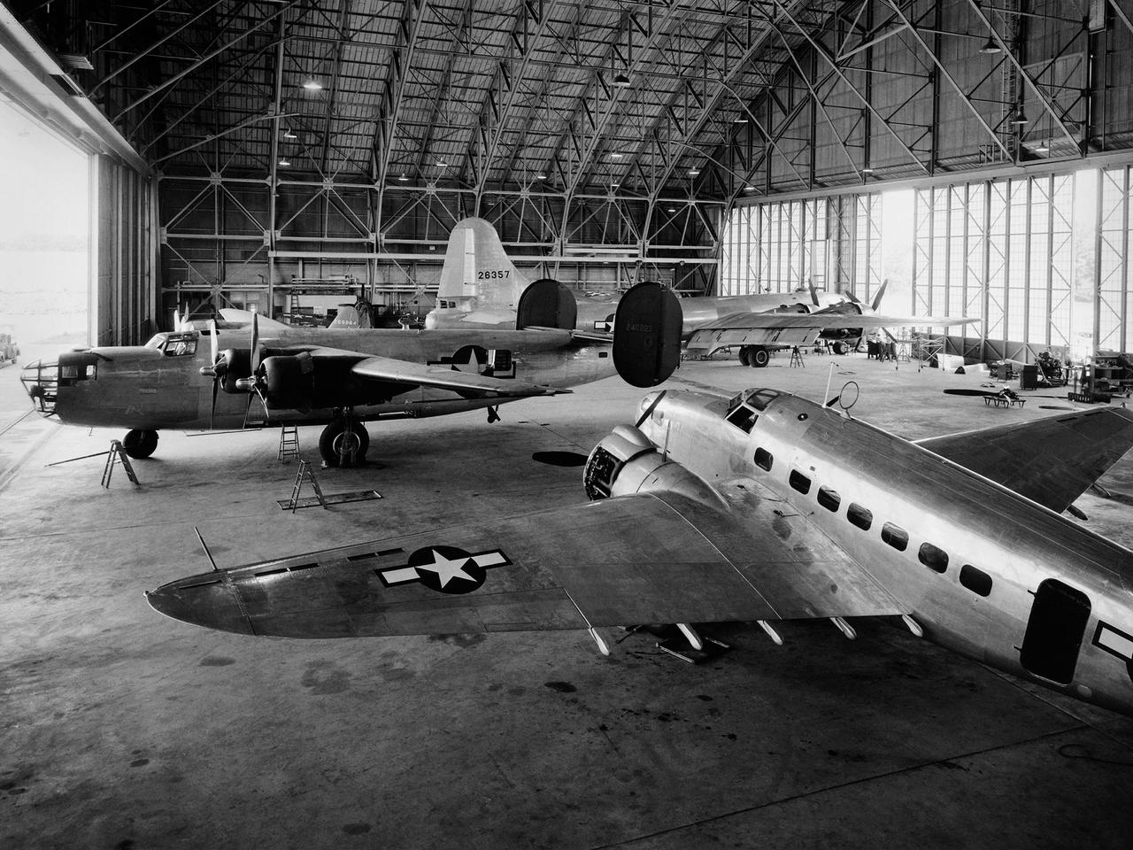
A Consolidated B–24D Liberator (left), Boeing B–29 Superfortress (background), and Lockheed RA–29 Hudson (foreground) parked inside the Flight Research Building at the National Advisory Committee for Aeronautics (NACA) Aircraft Engine Research Laboratory in Cleveland, Ohio. A P–47G Thunderbolt and P–63A King Cobra are visible in the background. The laboratory utilized 15 different aircraft during the final 2.5 years of World War II. This starkly contrasts with the limited-quantity, but long-duration aircraft of the NASA’s modern fleet. The Flight Research Building is a 272- by 150-foot hangar with an internal height ranging from 40 feet at the sides to 90 feet at its apex. The steel support trusses were pin-connected at the top with tension members extending along the corrugated transite walls down to the floor. The 37.5-foot-tall and 250-foot-long doors on either side can be opened in sections. The hangar included a shop area and stock room along the far wall, and a single-story office wing with nine offices, behind the camera. The offices were later expanded. The hangar has been in continual use since its completion in December 1942. Nearly 70 different aircraft have been sheltered here over the years. Temporary offices were twice constructed over half of the floor area when office space was at a premium.

SL3-87-299 (July-September 1973) --- A vertical view of southeastern New York State is seen in this Skylab 3 Earth Resources Experiments Package S190-B (five-inch Earth terrain camera) infrared photograph taken from the Skylab space station in Earth orbit. An 18-inch, 450mm lens and type 2443 infrared Ektachrome film was used. This picture covers the northern part of New Jersey, a part of northwestern Pennsylvania, and the western tip of Connecticut. The body of water is Long Island Sound. The wide Hudson River flows southward across a corner of the photograph. The New York City metropolitan area occupies part of the picture. Federal agencies participating with NASA on the EREP project are the Departments of Agriculture, Commerce, Interior, the Environmental Protection Agency and the Corps of Engineers. All EREP photography is available to the public through the Department of Interior?s Earth Resources Observations Systems Data Center, Sioux Falls, South Dakota, 57198. Photo credit: NASA

Belcher Islands - September 21st, 2001 Description: Like sweeping brushstrokes of pink and green, the Belcher Islands meander across the deep blue of Canada's Hudson Bay. The islands' only inhabitants live in the small town of Sanikiluaq, near the upper end of the middle island. Despite the green hues in this image, these rocky islands are too cold to sustain more than a smattering of low-growing vegetation. Credit: USGS/NASA/Landsat 5 To learn more about the Landsat satellite go to: <a href="http://landsat.gsfc.nasa.gov/" rel="nofollow">landsat.gsfc.nasa.gov/</a> <b><a href="http://www.nasa.gov/centers/goddard/home/index.html" rel="nofollow">NASA Goddard Space Flight Center</a></b> enables NASA’s mission through four scientific endeavors: Earth Science, Heliophysics, Solar System Exploration, and Astrophysics. Goddard plays a leading role in NASA’s accomplishments by contributing compelling scientific knowledge to advance the Agency’s mission. <b>Follow us on <a href="http://twitter.com/NASA_GoddardPix" rel="nofollow">Twitter</a></b> <b>Join us on <a href="http://www.facebook.com/pages/Greenbelt-MD/NASA-Goddard/395013845897?ref=tsd" rel="nofollow">Facebook</a></b>
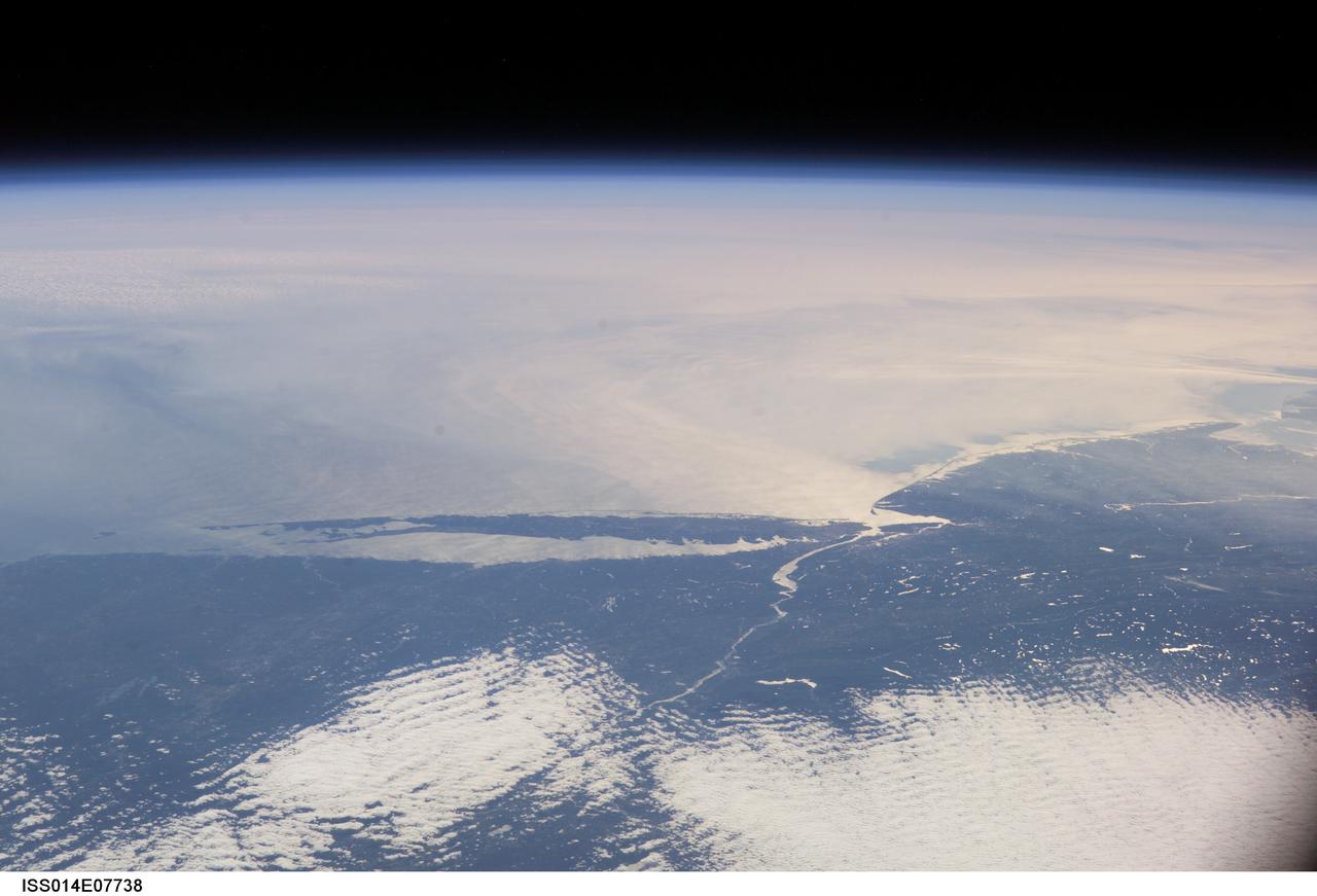
ISS014-E-07738 (10 Nov. 2006) --- This image featuring a southeast-looking view of the Long Island Sound and New Jersey coast, with the lower Hudson River and New York Bay in the area of brightest sunglint was photographed by an Expedition 14 crewmember on the International Space Station. On the far right a gray haze can be seen streaming out to sea offshore of New Jersey, where it becomes harder to see. In fact haze covers most of the visible area offshore, partly obscuring the sea surface. By contrast, clouds look quite different from haze according to scientists. Clouds usually have sharp margins and are pure white, as clouds at the bottom show. Industrial haze is grayer and more diffuse, and is typical of the air over the Northeast. Flow lines show that winds are transporting the haze in clockwise fashion--i.e. bending south--which in turn signifies that a high pressure system was operating on that day, centered roughly over the coast. High pressure systems are notorious for promoting smog events because they bring clear skies, and sunlight promotes smog formation. Highs also concentrate polluted surface layers near the ground.
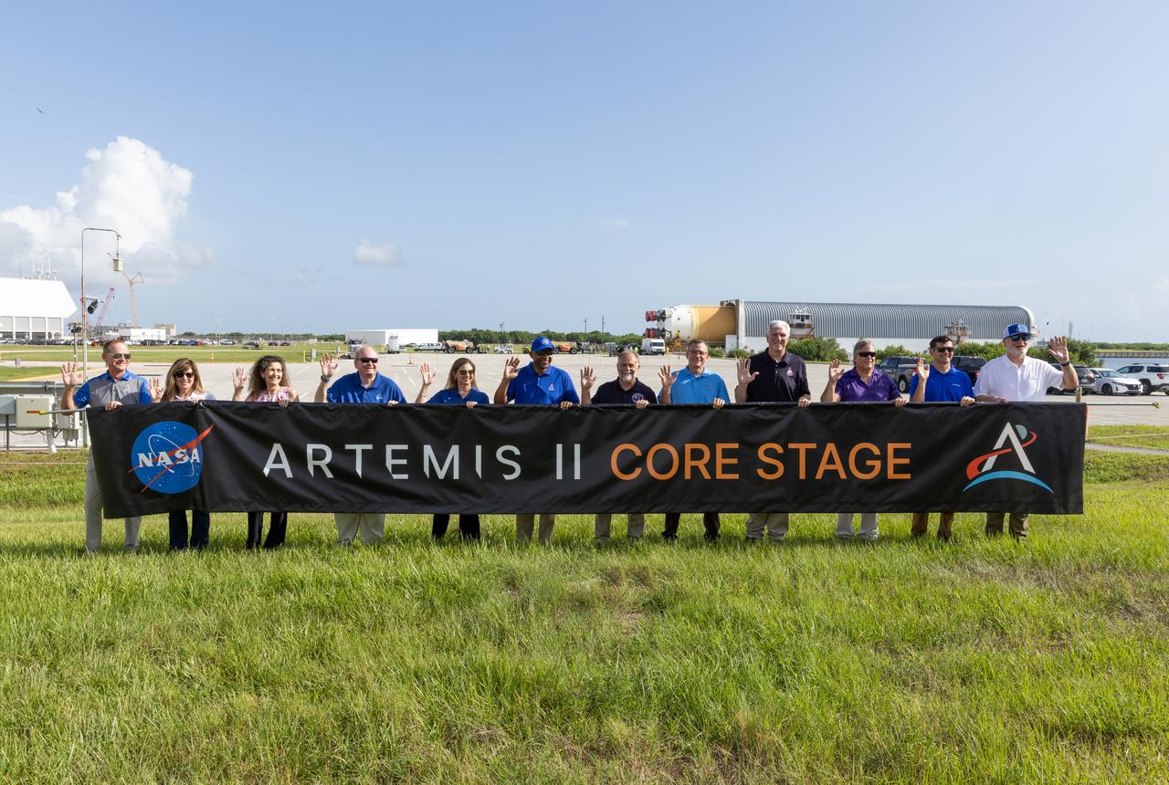
From left, John Ramsey, chief transformation officer for Jacobs; Jennifer Kunz, associate director, technical, NASA’s Kennedy Space Center; Lorna Kenna, vice president and general manager, Jacobs; Burt Summerfield, associate director, management, NASA Kennedy; Catherine Koerner, associate administrator for NASA’s Exploration Systems Development Mission Directorate; Kelvin Manning, deputy director, NASA Kennedy; Shawn Quinn, manager, NASA’s Exploration Ground Systems; Cliff Lanham, senior vehicle operations manager, NASA’s Exploration Ground Systems; Matthew Ramsey, Artemis II mission manager; Paul Hudson, Jacobs senior vehicle engineer; Jay Grow, Boeing’s associate chief engineer for Space Launch System Launch Operations; and Bill Muddle, lead RS-25 field engineer at Aerojet Rocketdyne, hold a banner to celebrate the arrival of the Artemis II SLS (Space Launch System) core stage at NASA’s Kennedy Space Center on Wednesday, July 24, 2024. Journeying from NASA’s Michoud Assembly Facility in New Orleans aboard the Pegasus barge, the core stage arrived at the Florida spaceport on July 23, 2024, to be processed for flight by NASA’s Exploration Ground Systems Program.