
NASA image acquired August 29, 2012 1:57 a.m EDT Hurricane Isaac lit up by moonlight as it spins over the city of New Orleans, La. at 1:57 am central daylight savings time the morning of August 29, 2012. The Suomi National Polar-orbiting Partnership (NPP) satellite captured these images with its Visible Infrared Imaging Radiometer Suite (VIIRS). The "day-night band" of VIIRS detects light in a range of wavelengths from green to near-infrared and uses light intensification to enable the detection of dim signals. Suomi NPP is the result of a partnership between NASA, the National Oceanic and Atmospheric Administration and the Department of Defense. Image Credit: NASA/NOAA, Earth Observatory NASA Earth Observatory image by Jesse Allen and Robert Simmon, using VIIRS Day Night Band data. Credit: <b><a href="http://www.earthobservatory.nasa.gov/" rel="nofollow"> NASA Earth Observatory</a></b> <b><a href="http://www.nasa.gov/audience/formedia/features/MP_Photo_Guidelines.html" rel="nofollow">NASA image use policy.</a></b> <b><a href="http://www.nasa.gov/centers/goddard/home/index.html" rel="nofollow">NASA Goddard Space Flight Center</a></b> enables NASA’s mission through four scientific endeavors: Earth Science, Heliophysics, Solar System Exploration, and Astrophysics. Goddard plays a leading role in NASA’s accomplishments by contributing compelling scientific knowledge to advance the Agency’s mission. <b>Follow us on <a href="http://twitter.com/NASA_GoddardPix" rel="nofollow">Twitter</a></b> <b>Like us on <a href="http://www.facebook.com/pages/Greenbelt-MD/NASA-Goddard/395013845897?ref=tsd" rel="nofollow">Facebook</a></b> <b>Find us on <a href="http://instagrid.me/nasagoddard/?vm=grid" rel="nofollow">Instagram</a></b>
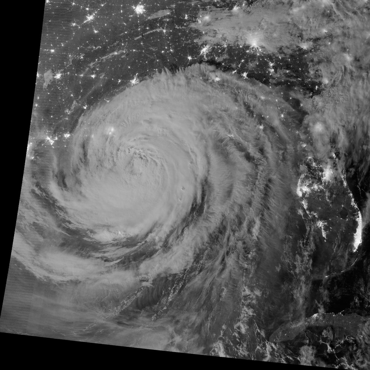
NASA image acquired August 29, 2012 1:57 a.m EDT Annotated view here: <a href="http://bit.ly/RsFT9Y" rel="nofollow">bit.ly/RsFT9Y</a> Hurricane Isaac lit up by moonlight as it spins over the city of New Orleans, La. at 1:57 am central daylight savings time the morning of August 29, 2012. The Suomi National Polar-orbiting Partnership (NPP) satellite captured these images with its Visible Infrared Imaging Radiometer Suite (VIIRS). The "day-night band" of VIIRS detects light in a range of wavelengths from green to near-infrared and uses light intensification to enable the detection of dim signals. Suomi NPP is the result of a partnership between NASA, the National Oceanic and Atmospheric Administration and the Department of Defense. Image Credit: NASA/NOAA, Earth Observatory NASA Earth Observatory image by Jesse Allen and Robert Simmon, using VIIRS Day Night Band data. Credit: <b><a href="http://www.earthobservatory.nasa.gov/" rel="nofollow"> NASA Earth Observatory</a></b> <b><a href="http://www.nasa.gov/audience/formedia/features/MP_Photo_Guidelines.html" rel="nofollow">NASA image use policy.</a></b> <b><a href="http://www.nasa.gov/centers/goddard/home/index.html" rel="nofollow">NASA Goddard Space Flight Center</a></b> enables NASA’s mission through four scientific endeavors: Earth Science, Heliophysics, Solar System Exploration, and Astrophysics. Goddard plays a leading role in NASA’s accomplishments by contributing compelling scientific knowledge to advance the Agency’s mission. <b>Follow us on <a href="http://twitter.com/NASA_GoddardPix" rel="nofollow">Twitter</a></b> <b>Like us on <a href="http://www.facebook.com/pages/Greenbelt-MD/NASA-Goddard/395013845897?ref=tsd" rel="nofollow">Facebook</a></b> <b>Find us on <a href="http://instagrid.me/nasagoddard/?vm=grid" rel="nofollow">Instagram</a></b>