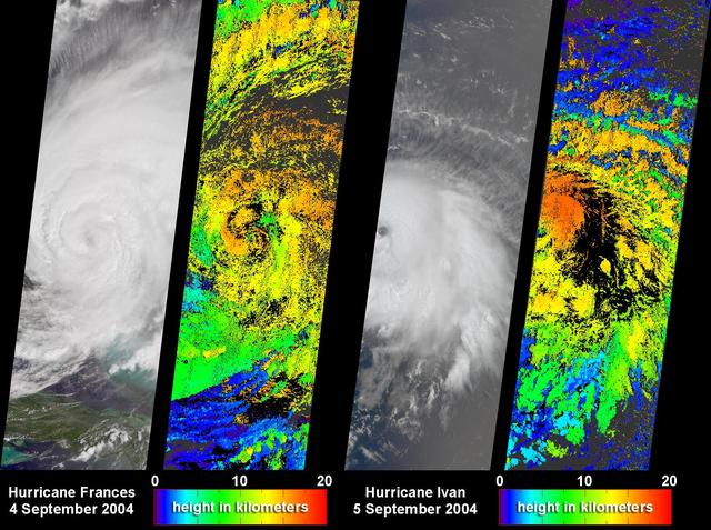
NASA Terra spacecraft captured these images and cloud-top height retrievals of Hurricane Frances on September 4, 2004, when the eye sat just off the coast of eastern Florida, and Hurricane Ivan on September 5th.

Interstate 10 across Pensacola Bay, Florida was severely damaged by Hurricane Ivan. This image was acquired by NASA Terra satellite on September 21, 2004.
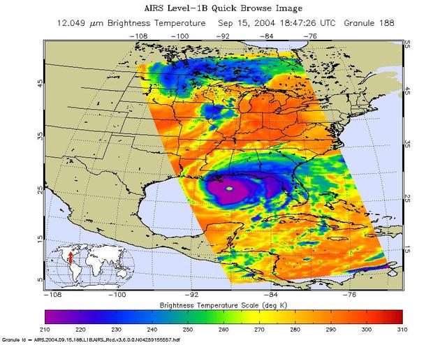
Hurricane Ivan is the most powerful hurricane to hit the Caribbean in 10 years. On September 7 and 8 it damaged 90 percent of the homes in Grenada and killed at least 16 people as it swept over Grenada, Barbados and the other islands in the area. By Thursday morning on September 9, Ivan's sustained winds reached 160 mph making it a rare category 5 hurricane on the Saffir-Simpson scale. By Monday September 13, Ivan is blamed for 67 deaths and skirts western Cuba with winds clocked at 156 mph. The National Hurricane Center predicted the eye of Ivan will make landfall across Mobile Bay in Alabama late Wednesday or early Thursday. These images of Hurricane Ivan were acquired by the AIRS infrared, microwave, and visible sensors on September 15 at 1:30 pm local time as the storm moves in to Alabama. Ivan at category 4 strength is about 150 miles south of Mobile, Alabama and is moving north at 14 mph. Maximum sustained winds are reported to be at 135 mph and extend 105 miles from the center, while tropical storm-force winds extend 290 miles from the center. Ivan pounded the Gulf coast all day Wednesday, and is expected to make landfall between midnight and 3am in Mobile Bay, Alabama. This image shows how the storm looks through an AIRS Infrared window channel, and reveals a very large eye - about 75 km (50 miles) across. Window channels measure the temperature of the cloud tops or the surface of the Earth in cloud-free regions. The lowest temperatures are associated with high, cold cloud tops that make up the top of the hurricane. The infrared signal does not penetrate through clouds, so the purple color indicates the cool cloud tops of the storm. In cloud-free areas, the infrared signal is retrieved at the Earth's surface, revealing warmer temperatures. Cooler areas are pushing to purple and warmer areas are pushing to red. http://photojournal.jpl.nasa.gov/catalog/PIA00431
This image hosts a look into the eye of Hurricane Ivan, one of the strongest hurricanes on record, as the storm approached landfall on the central Gulf coast Wednesday afternoon on September 15, 2004. The hurricane was photographed by astronaut Edward M. (Mike) Fincke from aboard the International Space Station (ISS) at an altitude of approximately 230 miles. At the time, sustained winds in the eye of the wall were reported at about 135 mph as the downgraded category 4 storm approached the Alabama coast. Crew Earth Observations record Earth surface changes over time, as well as more fleeting events such as storms, floods, fires, and volcanic eruptions.
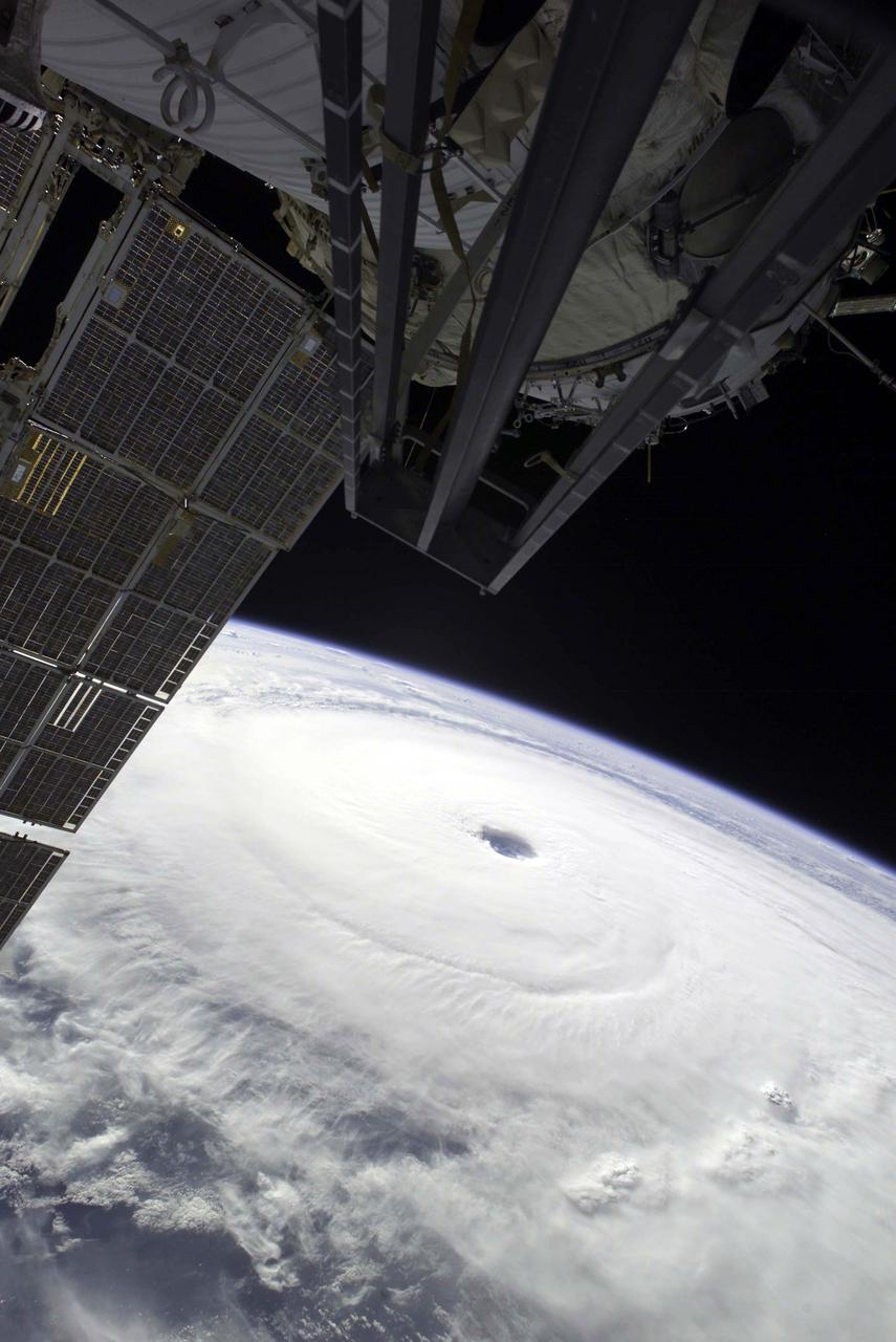
Except for a small portion of the International Space Station (ISS) in the foreground, Hurricane Ivan, one of the strongest hurricanes on record, fills this image over the northern Gulf of Mexico. As the downgraded category 4 storm approached landfall on the Alabama coast Wednesday afternoon on September 15, 2004, sustained winds in the eye of the wall were reported at about 135 mph. The hurricane was photographed by astronaut Edward M. (Mike) Fincke from aboard the ISS at an altitude of approximately 230 miles. Crew Earth Observations record Earth surface changes over time, as well as more fleeting events such as storms, floods, fires, and volcanic eruptions.
This image hosts a look at the eye of Hurricane Ivan, one of the strongest hurricanes on record, as the storm topped the western Caribbean Sea on Saturday, September 11, 2004. The hurricane was photographed by astronaut Edward M. (Mike) Fincke from aboard the International Space Station (ISS) at an altitude of approximately 230 miles. At the time, the category 5 storm sustained winds in the eye of the wall that were reported at about 160 mph. Crew Earth Observations record Earth surface changes over time, as well as more fleeting events such as storms, floods, fires, and volcanic eruptions.
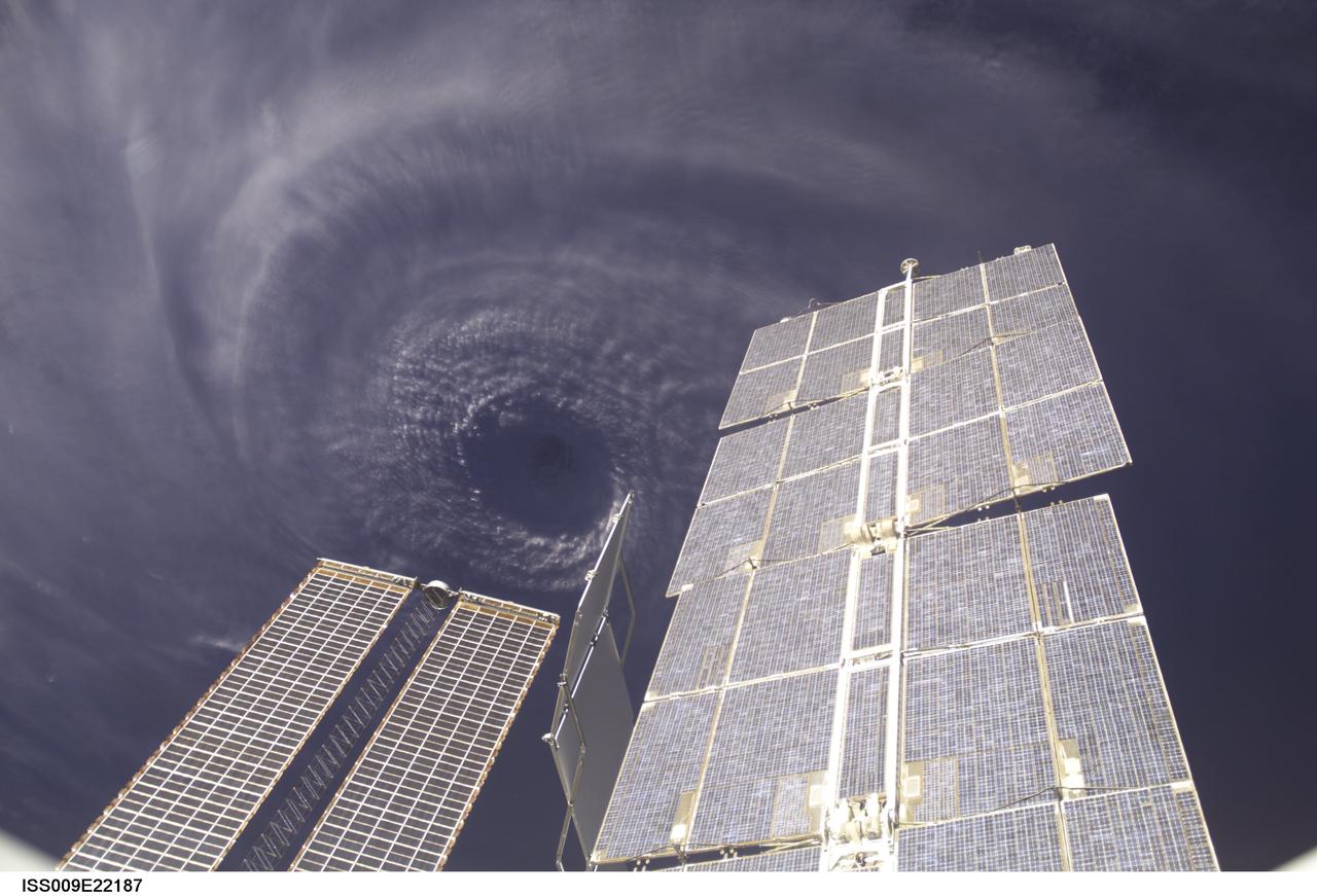
ISS009-E-22187 (11 September 2004) --- This image features the eye of Hurricane Ivan at center, partially framed by solar array panels on the International Space Station. One of the strongest hurricanes on record, Ivan was photographed Saturday from an altitude of about 230 miles by Astronaut Edward M. (Mike) Fincke, NASA ISS science officer and flight engineer, aboard the orbital outpost. At the time, Ivan was in the western Caribbean Sea and reported to have winds of 160 mph.
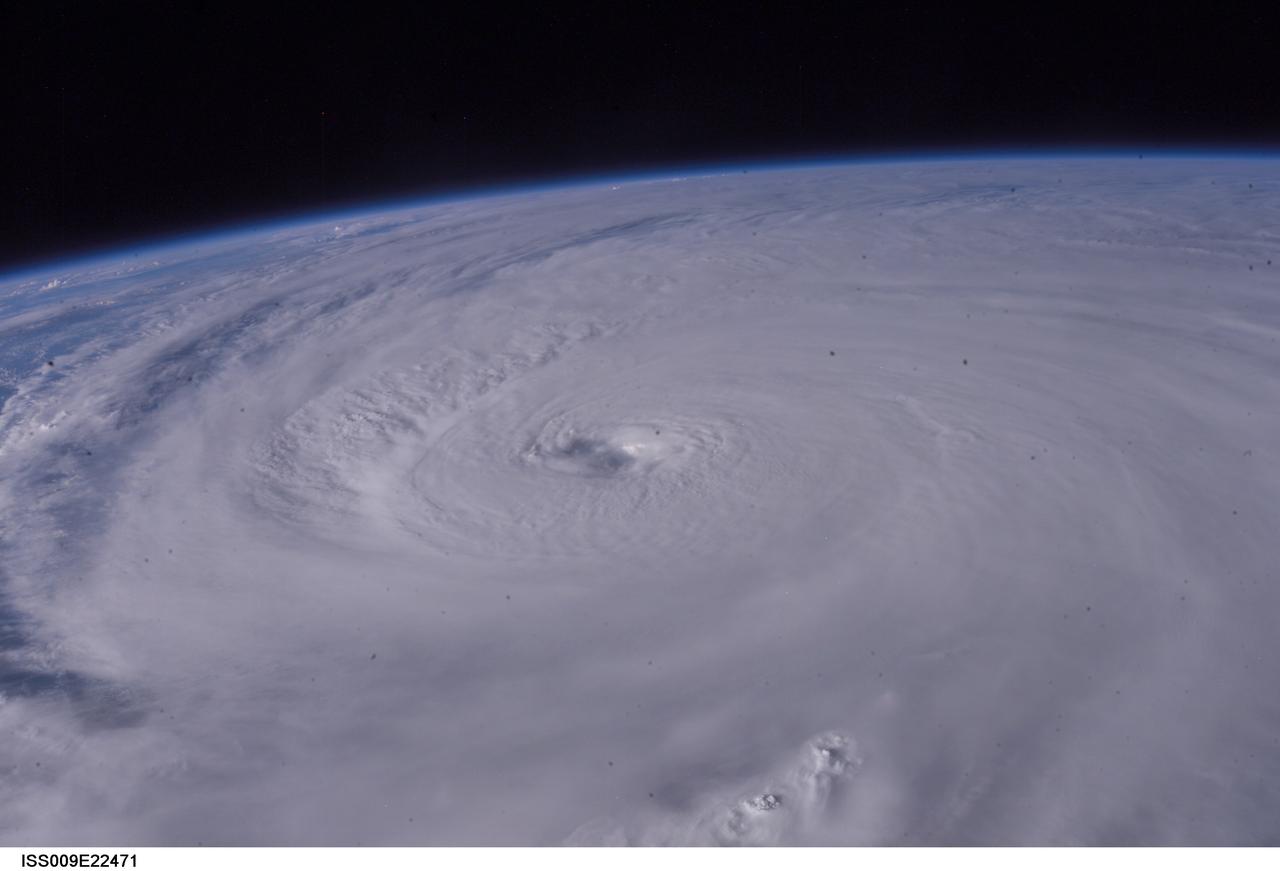
ISS009-E-22471 (13 September 2004) --- Hurricane Ivan was photographed as it entered the Gulf of Mexico late Monday (22:36:49 GMT, Sept. 13) by astronaut Edward M. (Mike) Fincke aboard the International Space Station, 230 miles above Earth. At the time, Ivan was a category 5 hurricane with winds of 160 mph. Fincke, the NASA Station Science Officer, and Station Commander Gennady Padalka are in the final month of a six-month mission aboard the research platform.
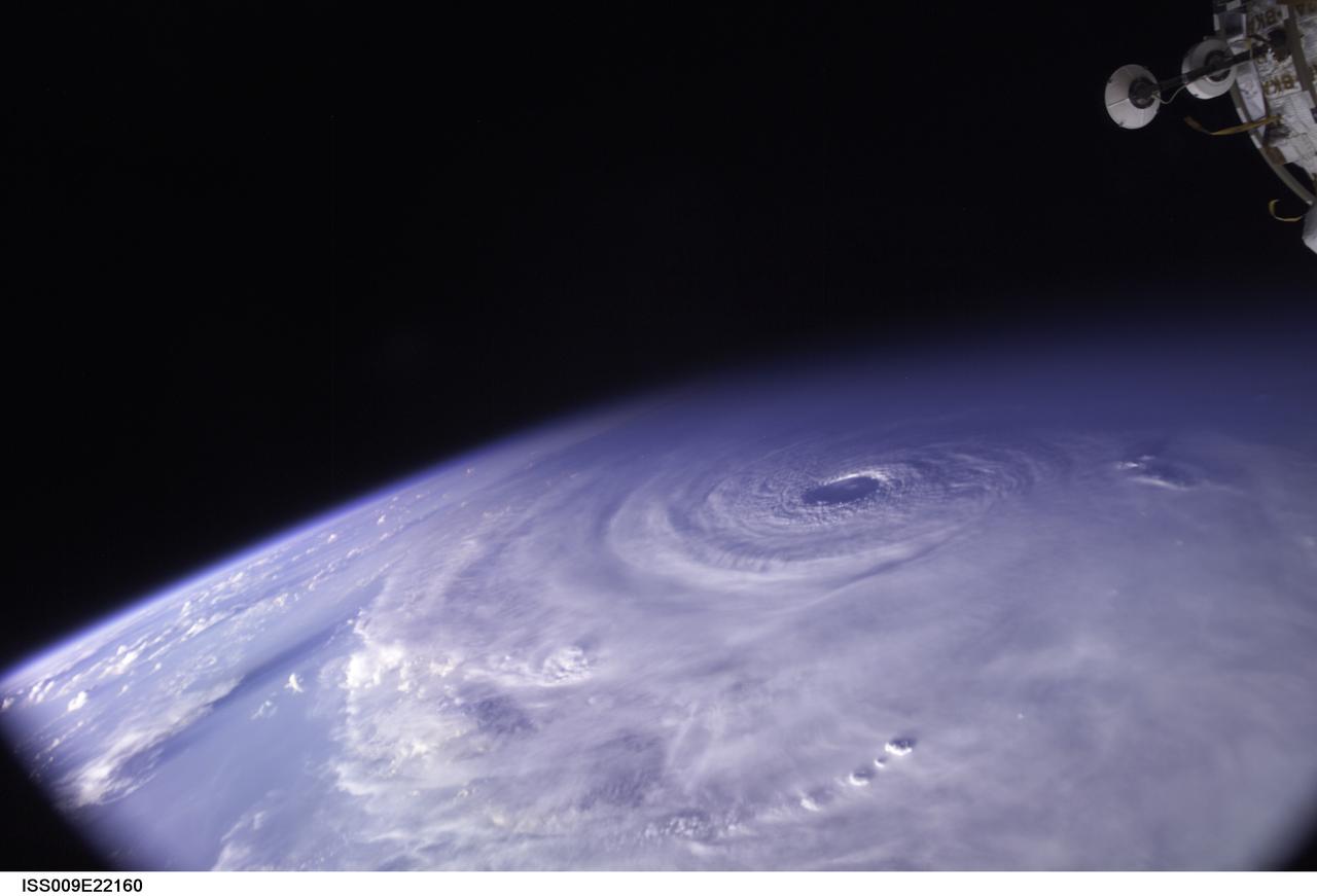
ISS009-E-22160 (11 September 2004) ---- This image of Hurricane Ivan, one of the strongest hurricanes on record, was taken Saturday from an altitude of about 230 miles by Astronaut Edward M. (Mike) Fincke, NASA ISS science officer and flight engineer, looking out the window of the International Space Station. At the time, Ivan was in the western Caribbean Sea and reported to have winds of 160 mph
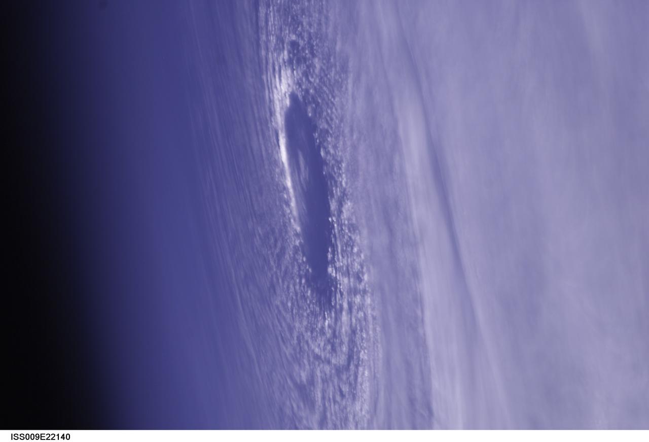
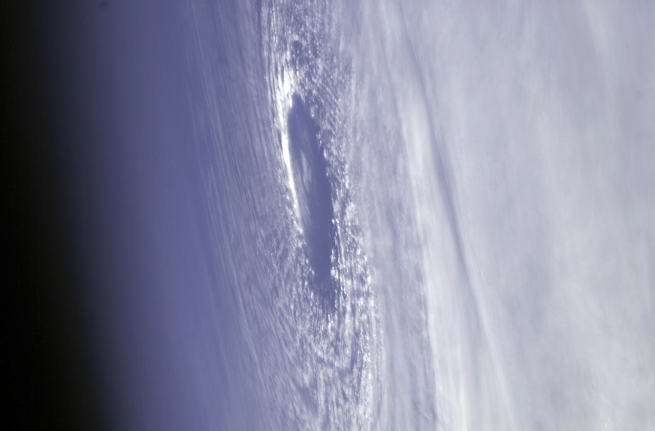
ISS009-E-22140 (11 September 2004) --- This image of the eye of Hurricane Ivan, one of the strongest hurricanes on record, was taken Saturday from an altitude of about 230 miles by Astronaut Edward M. (Mike) Fincke, NASA ISS science officer and flight engineer, aboard the International Space Station. At the time, Ivan was in the western Carribean Sea and reported to have winds of 160 mph.
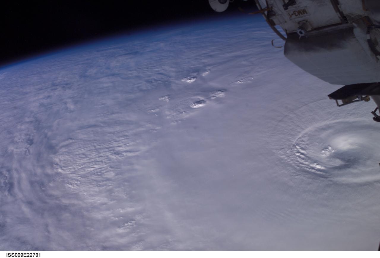
ISS009-E-22701 (14 September 2004) --- Hurricane Ivan was photographed as it churned in the Gulf of Mexico late Tuesday (23:06:56 GMT, Sept. 14) by astronaut Edward M. (Mike) Fincke aboard the International Space Station, 230 miles above Earth. At the time, Ivan was a category 4 hurricane with winds of 140 mph. Fincke, the NASA Station Science Officer, and Station Commander Gennady Padalka are in the final month of a six-month mission aboard the research platform.
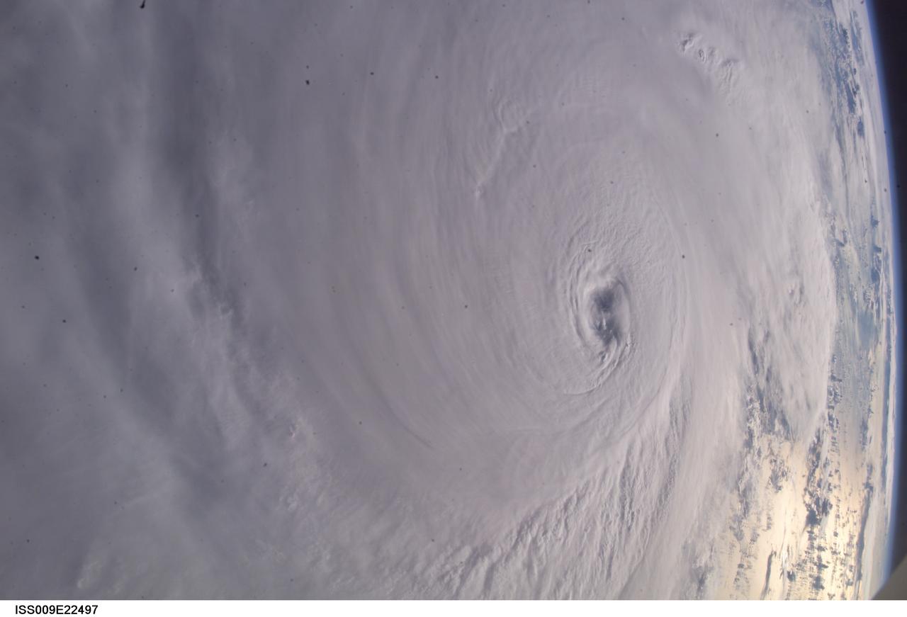
ISS009-E-22497 (13 September 2004) --- Hurricane Ivan was photographed as it entered the Gulf of Mexico late Monday (22:39:23 GMT, Sept. 13) by astronaut Edward M. (Mike) Fincke aboard the International Space Station, 230 miles above Earth. At the time, Ivan was a category 5 hurricane with winds of 160 mph. Fincke, the NASA Station Science Officer, and Station Commander Gennady Padalka are in the final month of a six-month mission aboard the research platform.
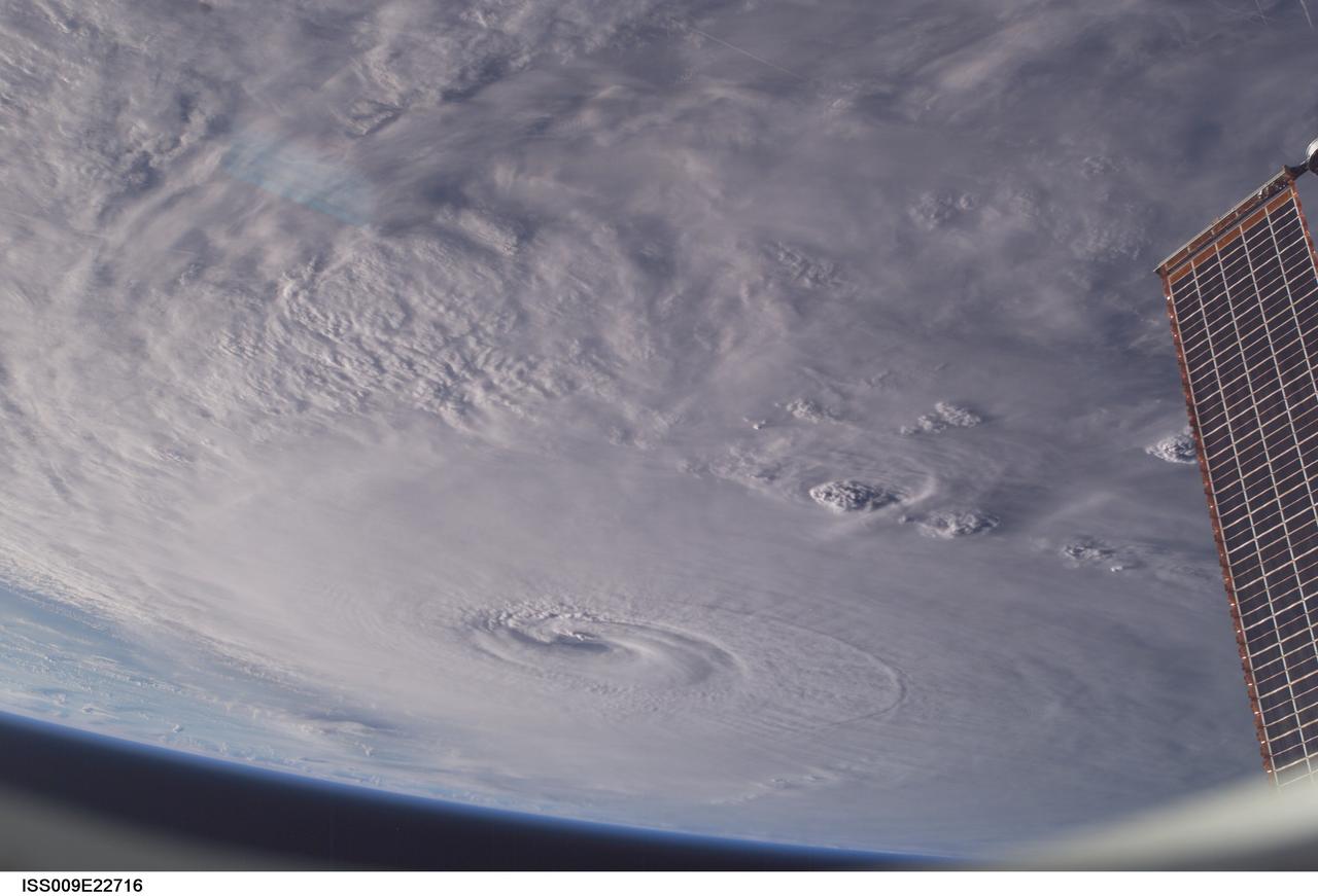
ISS009-E-22716 (14 September 2004) --- Hurricane Ivan was photographed as it churned in the Gulf of Mexico late Tuesday (23:09:41 GMT, Sept. 14) by astronaut Edward M. (Mike) Fincke aboard the International Space Station, 230 miles above Earth. At the time, Ivan was a category 4 hurricane with winds of 140 mph. Fincke, the NASA Station Science Officer, and Station Commander Gennady Padalka are in the final month of a six-month mission aboard the research platform.
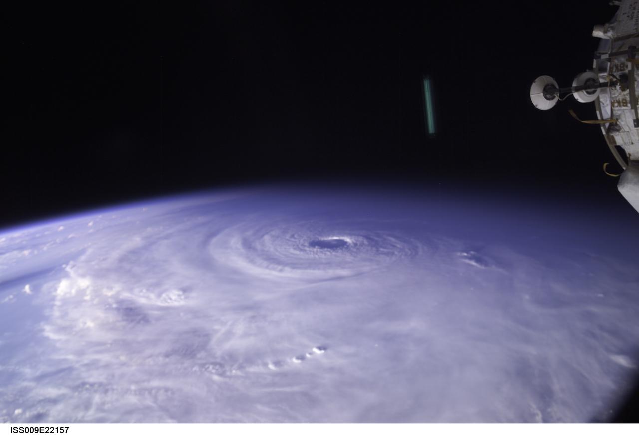
ISS009-E-22157 (11 September 2004) ---- This image of Hurricane Ivan, one of the strongest hurricanes on record, was taken Saturday from an altitude of about 230 miles by Astronaut Edward M. (Mike) Fincke, NASA ISS science officer and flight engineer, looking out the window of the International Space Station. At the time, Ivan was in the western Caribbean Sea and reported to have winds of 160 mph
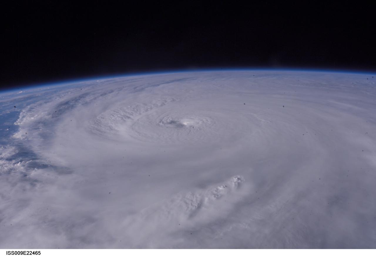
ISS009-E-22465 (13 September 2004) --- Hurricane Ivan was photographed as it entered the Gulf of Mexico late Monday (22:36:24 GMT, Sept. 13) by astronaut Edward M. (Mike) Fincke aboard the International Space Station, 230 miles above Earth. At the time, Ivan was a category 5 hurricane with winds of 160 mph. Fincke, the NASA Station Science Officer, and Station Commander Gennady Padalka are in the final month of a six-month mission aboard the research platform.
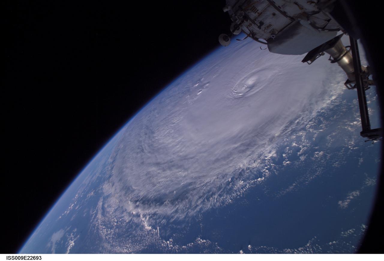
ISS009-E-22693 (14 September 2004) --- Hurricane Ivan was photographed as it churned in the Gulf of Mexico late Tuesday (23:06:23 GMT, Sept. 14) by astronaut Edward M. (Mike) Fincke aboard the International Space Station, 230 miles above Earth. At the time, Ivan was a category 4 hurricane with winds of 140 mph. Fincke, the NASA Station Science Officer, and Station Commander Gennady Padalka are in the final month of a six-month mission aboard the research platform.
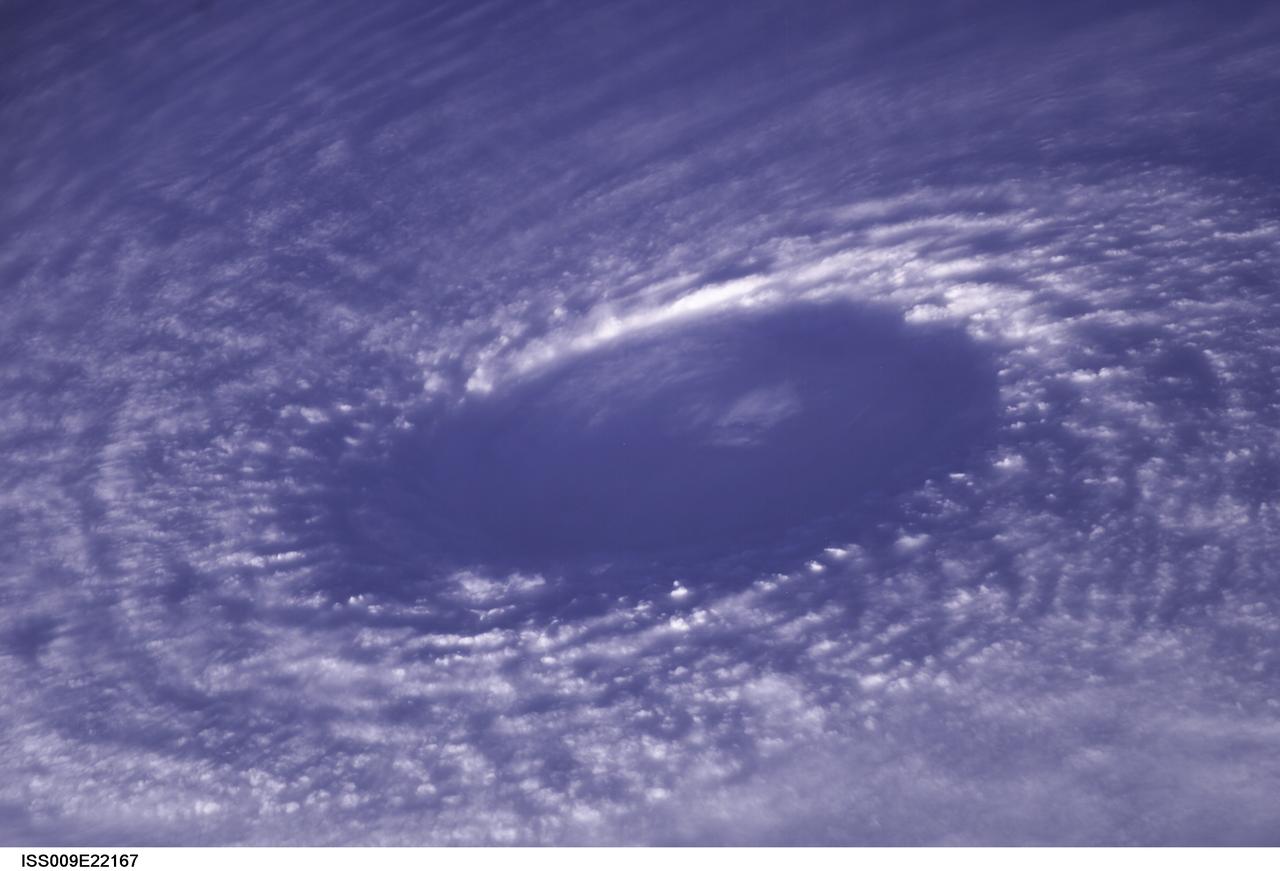
ISS009-E-22167 (11 September 2004) --- This image of the eye of Hurricane Ivan, one of the strongest hurricanes on record, was taken Saturday from an altitude of about 230 miles by Astronaut Edward M. (Mike) Fincke, NASA ISS science officer and flight engineer, aboard the International Space Station. At the time, Ivan was in the western Carribean Sea and reported to have winds of 160 mph.
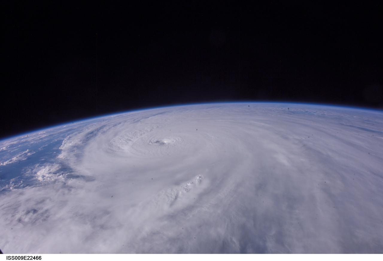
ISS009-E-22466 (13 September 2004) --- Hurricane Ivan was photographed as it entered the Gulf of Mexico late Monday (22:36:31 GMT, Sept. 13) by astronaut Edward M. (Mike) Fincke aboard the International Space Station, 230 miles above Earth. At the time, Ivan was a category 5 hurricane with winds of 160 mph. Fincke, the NASA Station Science Officer, and Station Commander Gennady Padalka are in the final month of a six-month mission aboard the research platform.
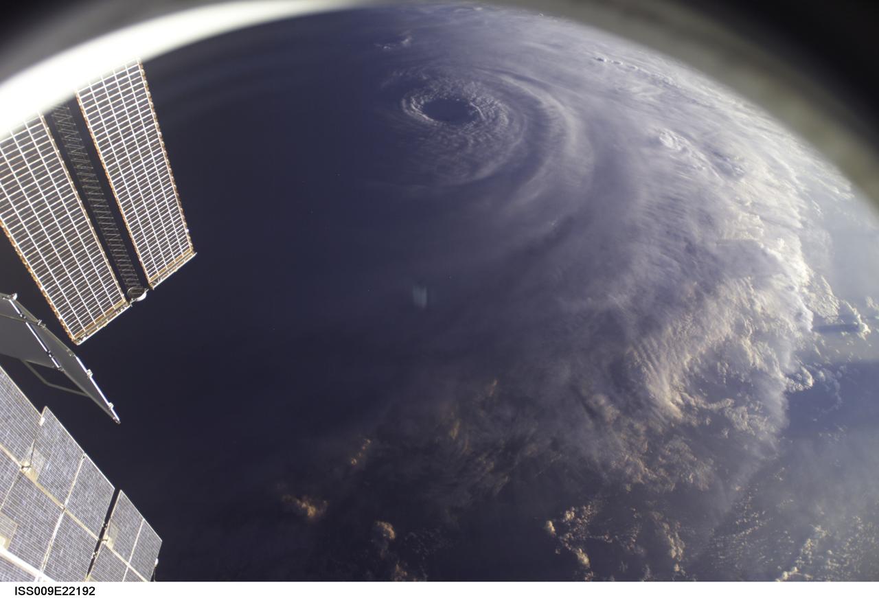
ISS009-E-22192 (11 September 2004) ---- This image of Hurricane Ivan, one of the strongest hurricanes on record, was taken Saturday from an altitude of about 230 miles by Astronaut Edward M. (Mike) Fincke, NASA ISS science officer and flight engineer, looking out the window of the International Space Station. At the time, Ivan was in the western Caribbean Sea and reported to have winds of 160 mph
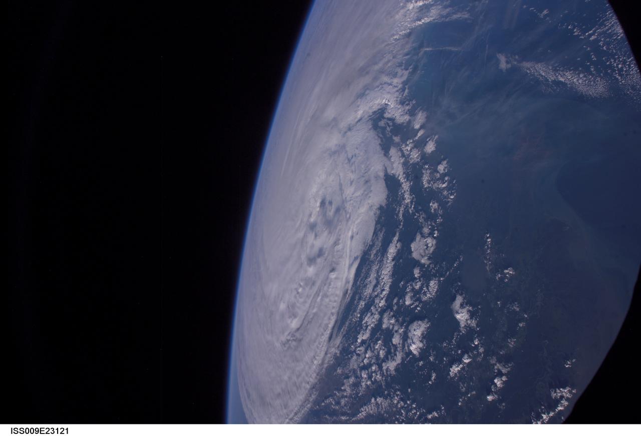
ISS009-E-23121 (16 September 2004) --- Hurricane Ivan moves inland as photographed by astronaut Edward M. (Mike) Fincke aboard the International Space Station on Thursday afternoon (22:21:34 GMT, Sept. 16). Ivan made landfall early Thursday near Pensacola, Fla. and the Florida-Alabama border.
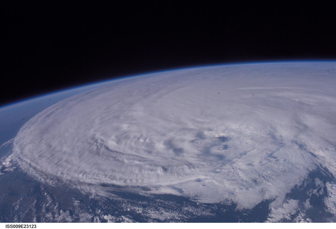
ISS009-E-23123 (16 September 2004) --- Hurricane Ivan moves inland as photographed by astronaut Edward M. (Mike) Fincke aboard the International Space Station on Thursday afternoon (22:29:50 GMT, Sept. 16). Ivan made landfall early Thursday near Pensacola, Fla. and the Florida-Alabama border.
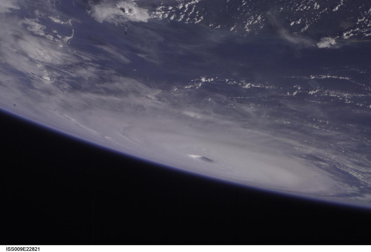
ISS009-E-22821 (15 September 2004) -- Hurricane Ivan fills the northern Gulf of Mexico in this photo taken by astronaut Edward M. (Mike) Fincke as the storm approached landfall on the Alabama coast Wednesday afternoon (21:59:25 GMT, Sept. 15). Ivan was reported to have sustained winds of 135 mph. This photo was taken from an altitude of about 230 miles. Fincke, the NASA ISS Science Officer, and Commander Gennady Padalka are nearing the end of a six-month mission aboard the research outpost.
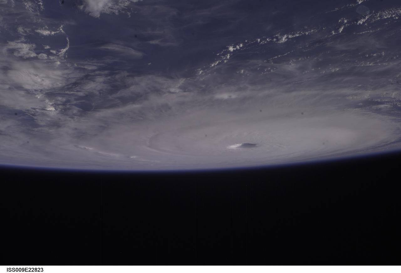
ISS009-E-22823 (15 September 2004) -- Hurricane Ivan fills the northern Gulf of Mexico in this photo taken by astronaut Edward M. (Mike) Fincke as the storm approached landfall on the Alabama coast Wednesday afternoon (21:59:36 GMT, Sept. 15). Ivan was reported to have sustained winds of 135 mph. This photo was taken from an altitude of about 230 miles. Fincke, the NASA ISS Science Officer, and Commander Gennady Padalka are nearing the end of a six-month mission aboard the research outpost.
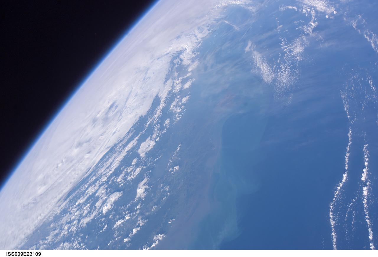
ISS009-E-23109 (16 September 2004) --- Hurricane Ivan moves inland as photographed by astronaut Edward M. (Mike) Fincke aboard the International Space Station on Thursday afternoon (22:28:48 GMT, Sept. 16). Ivan made landfall early Thursday near Pensacola, Fla. and the Florida-Alabama border. The Gulf Coast is visible in bottom of the photo.

ISS009-E-22680 (14 September 2004) --- The eye of Ivan was photographed as the category 4 hurricane churned in the Gulf of Mexico late Tuesday (23:05:13 GMT, Sept. 14) by astronaut Edward M. (Mike) Fincke aboard the International Space Station, 230 miles above Earth. At the time, Ivan produced winds of 140 mph. Fincke, the NASA Station Science Officer, and Station Commander Gennady Padalka are in the final month of a six-month mission aboard the research platform.
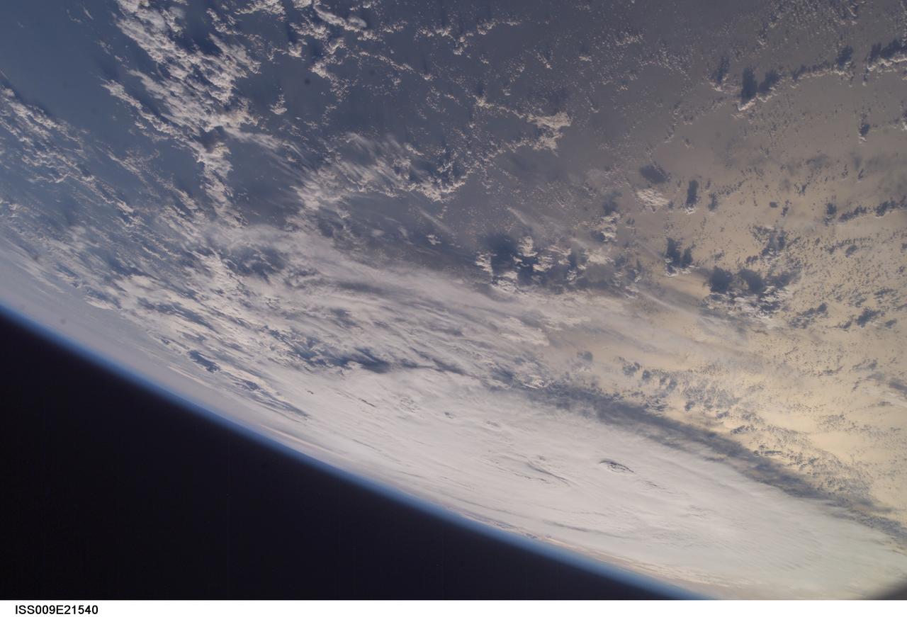
ISS009-E-21540 (5 September 2004) --- While Frances was moving destructively through Florida, another hurricane formed Sunday, September 5, in the central Atlantic. Quickly strengthening, Ivan was photographed at 10:27:46 (GMT) from the International Space Station, flying above Earth at an altitude of 235 miles.
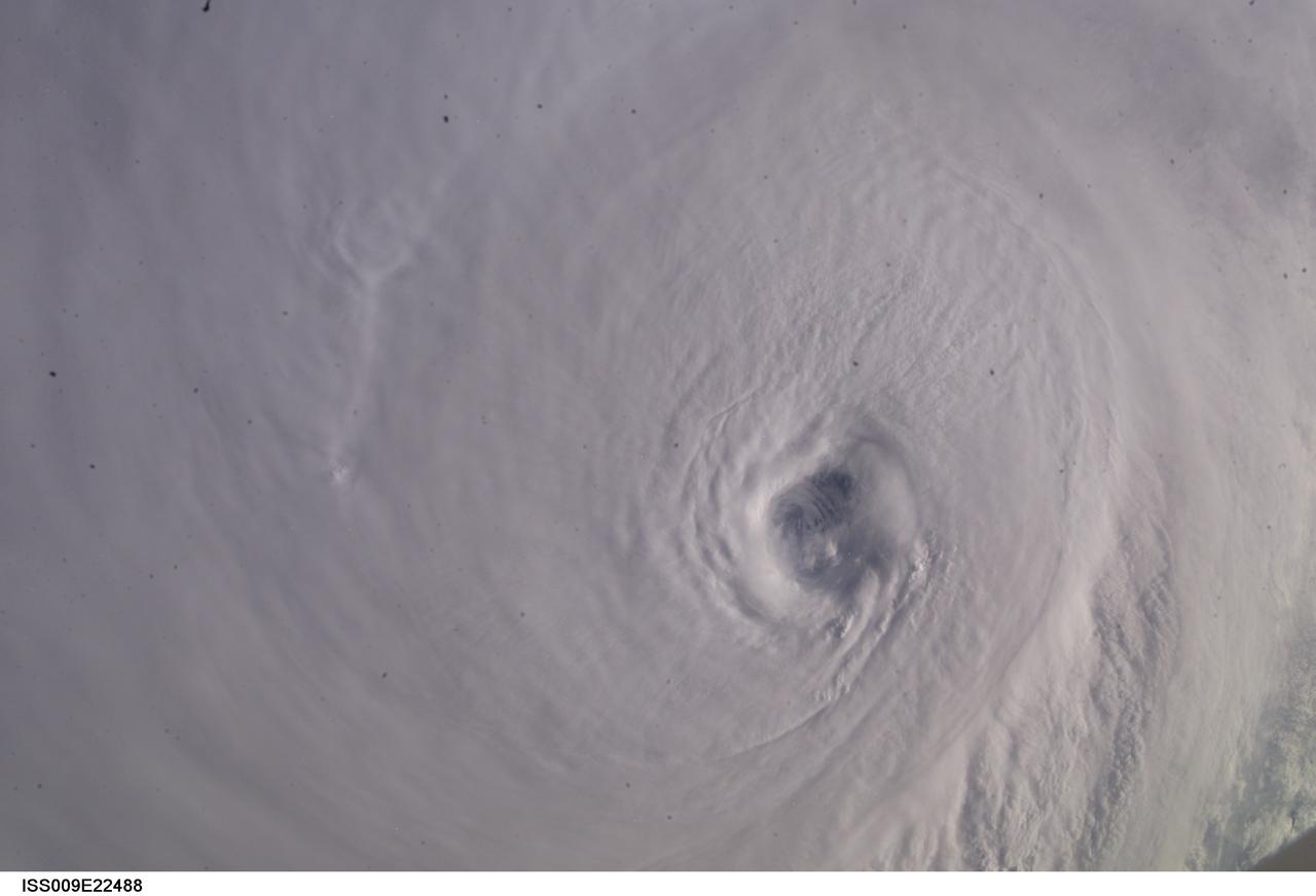
ISS009-E-22488 (13 September 2004) ---- The eye of Hurricane Ivan, swirling with sustained winds of 160 mph at the time, was photographed as the storm entered the Gulf of Mexico late Monday (22:38:37 GMT, Sept. 13) by astronaut Edward M. (Mike) Fincke, 230 miles above the Earth aboard the International Space Station. Fincke and Station Commander Gennady Padalka are in the final month of a six-month stay aboard the research complex.
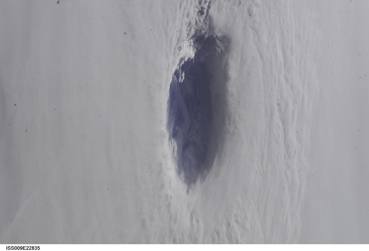
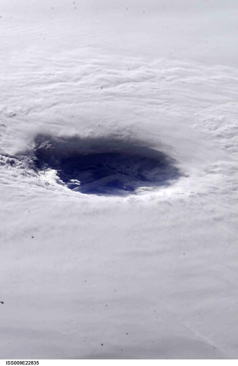
ISS009-E-22835 (15 September 2004) --- A look into the eye of the storm from space was provided by astronaut Edward M. (Mike) Fincke as Hurricane Ivan approached landfall on the central Gulf coast Wednesday afternoon (22:02:35 GMT, Sept. 15). At the time, sustained winds in the eye wall were reported at about 135 mph as the storm approached the Alabama coast. Fincke, the NASA ISS Science Officer, is nearing the end of a six-month stay on the orbiting complex with Commander Gennady Padalka. This photo was taken from an altitude of about 230 miles.
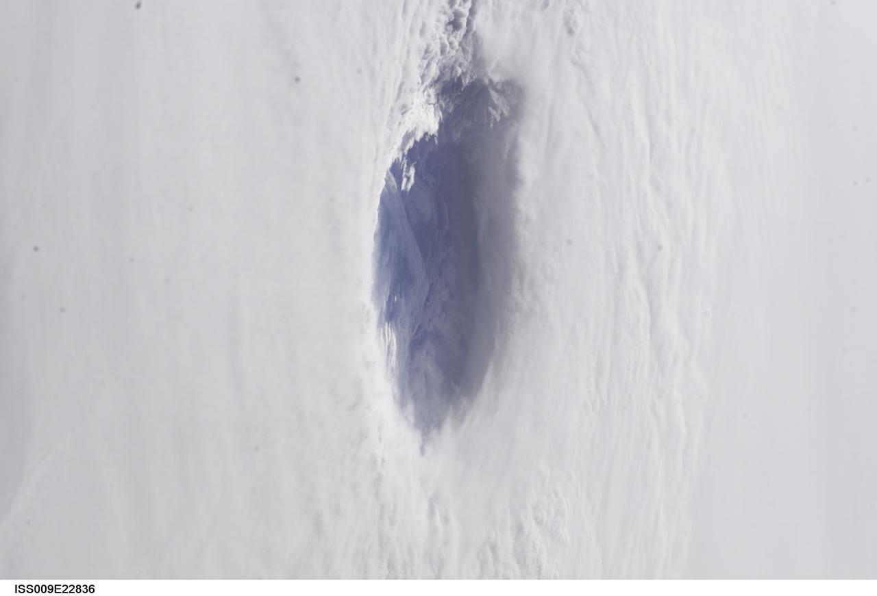
ISS009-E-22836 (15 September 2004) --- A look into the eye of the storm from space was provided by astronaut Edward M. (Mike) Fincke as Hurricane Ivan approached landfall on the central Gulf coast Wednesday afternoon (22:02:35 GMT, Sept. 15). At the time, sustained winds in the eye wall were reported at about 135 mph as the storm approached the Alabama coast. Fincke, the NASA ISS Science Officer, is nearing the end of a six-month stay on the orbiting complex with Commander Gennady Padalka. This photo was taken from an altitude of about 230 miles.
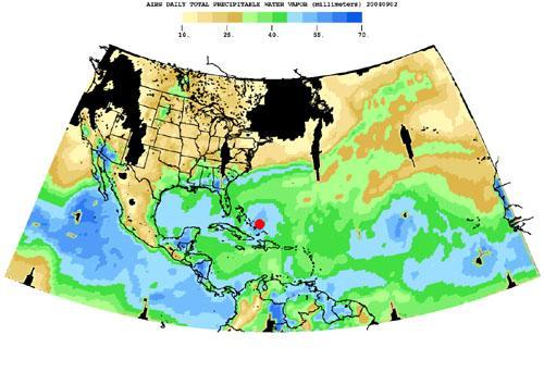
Born in the Atlantic, Hurricane Frances became a category 4 hurricane on August 31, 2004, as seen by the Atmospheric Infrared Sounding System AIRS on NASA Aqua. Expectations are the hurricane will hit the Space Coast of Florida in Brevard County early Sunday morning. This frame from a movie is a time-series of maps that show AIRS observations of the total amount of water vapor present in the atmospheric column above each point of the Earth's surface. If all the water vapor in the column were forced to fall as rain, the depth of the resulting puddle on the surface at that point is equal to the value shown on the map. Fifty millimeters (mm) is about 2 inches. The large band of maximum water vapor in the neighborhood of the equator is the Intertropical Convergence Zone (ITCZ), a region of strong convection and powerful thunderstorms. The movie (see PIA00433) shows the total precipitable water vapor from August 23 through September 2, 2004. You can see Hurricane Frances as it moves through the Caribbean toward Florida, and the changes in intensity are visible. The eye has been marked with a red spot. The water vapor encompassed by the hurricane is also the result of the very strong convection which is an integral part of the formation and intensification of tropical storms. If you look at the last frame of the movie in the lower right corner, you can see the emergence of a new tropical storm. Ivan makes its debut in the Atlantic. http://photojournal.jpl.nasa.gov/catalog/PIA00433