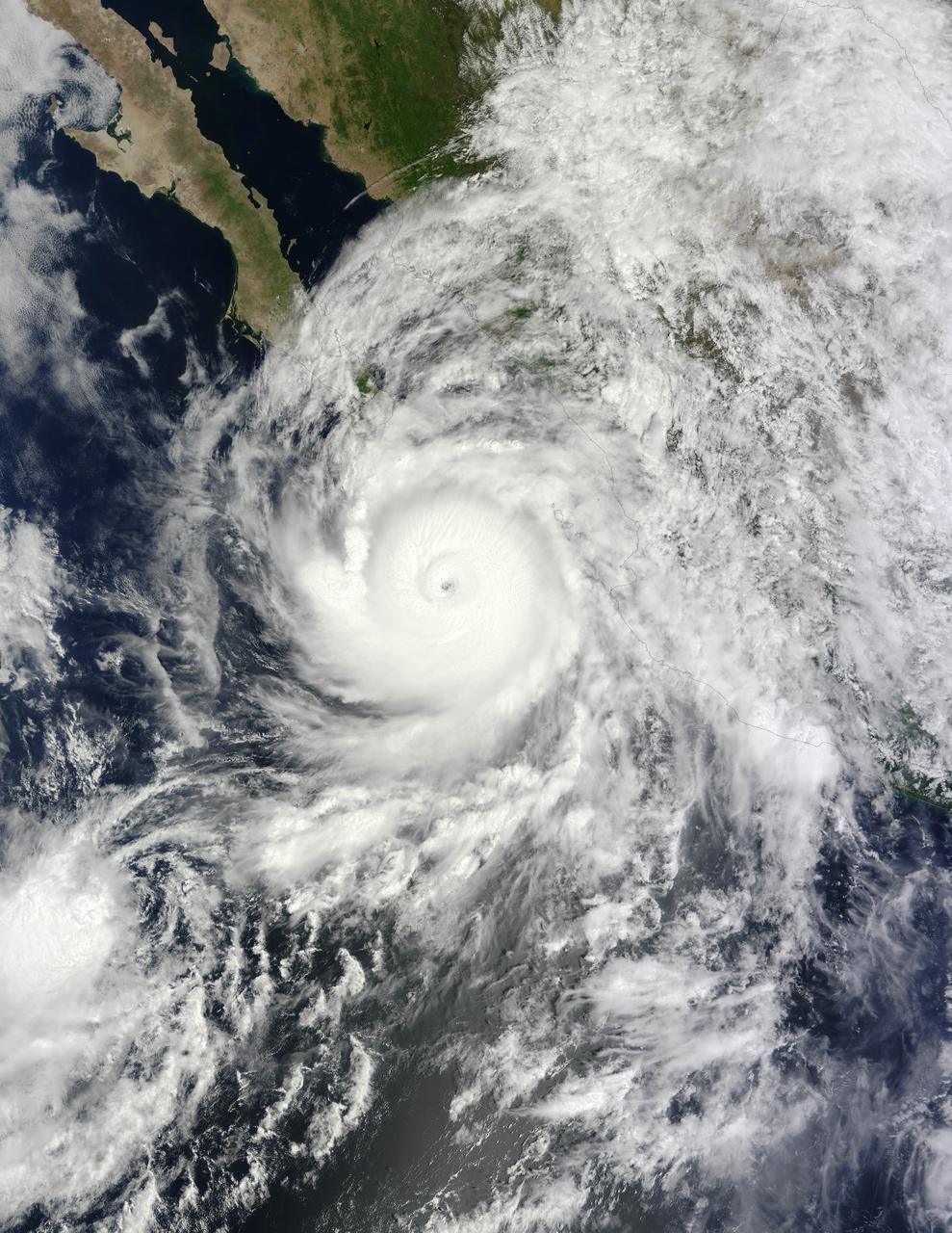
At about 10:45 p.m. Mountain Daylight Time (MDT) on September 14, 2014, Hurricane Odile made landfall as a Category 3 storm near Cabo San Lucas, Mexico. According to the U.S. National Hurricane Center, Odile arrived with wind speeds of 110 knots (204 kilometers or 127 miles per hour). The storm tied Olivia (1967) as the strongest hurricane to make landfall in the state of Baja California Sur in the satellite era. The Moderate Resolution Imaging Spectroradiometer (MODIS) on NASA’s Terra satellite acquired this natural-color view of the storm at about noon MDT on September 14, when it was still southeast of the Baja California peninsula. Unisys Weather reported that the Category 4 storm had maximum sustained wind speeds of 115 knots (213 kilometers per hour) at the time. Odile had weakened to a Category 2 hurricane by 6 a.m. MDT on September 15. The storm was expected to continue weakening as it moved up the peninsula and over the area’s rough terrain, according to weather blogger Jeff Masters. Meteorologists noted that while damaging winds posed the biggest threat in the short term, inland areas of the U.S. Southwest could face heavy rainfall by September 16. The rain expected from Odile came one week after the U.S. Southwest experienced flash floods from the remnants of Hurricane Norbert. According to weather and climate blogger Eric Holthaus, those floods did little to relieve the area’s ongoing drought. NASA image by Jeff Schmaltz, LANCE/EOSDIS Rapid Response. Caption by Kathryn Hansen. Instrument(s): Terra - MODIS Read more: <a href="http://earthobservatory.nasa.gov/IOTD/view.php?id=84378&eocn=home&eoci=iotd_title" rel="nofollow">earthobservatory.nasa.gov/IOTD/view.php?id=84378&eocn...</a> <b><a href="http://www.nasa.gov/audience/formedia/features/MP_Photo_Guidelines.html" rel="nofollow">NASA image use policy.</a></b> <b><a href="http://www.nasa.gov/centers/goddard/home/index.html" rel="nofollow">NASA Goddard Space Flight Center</a></b> enables NASA’s mission through four scientific endeavors: Earth Science, Heliophysics, Solar System Exploration, and Astrophysics. Goddard plays a leading role in NASA’s accomplishments by contributing compelling scientific knowledge to advance the Agency’s mission. <b>Follow us on <a href="http://twitter.com/NASAGoddardPix" rel="nofollow">Twitter</a></b> <b>Like us on <a href="http://www.facebook.com/pages/Greenbelt-MD/NASA-Goddard/395013845897?ref=tsd" rel="nofollow">Facebook</a></b> <b>Find us on <a href="http://instagram.com/nasagoddard?vm=grid" rel="nofollow">Instagram</a></b>
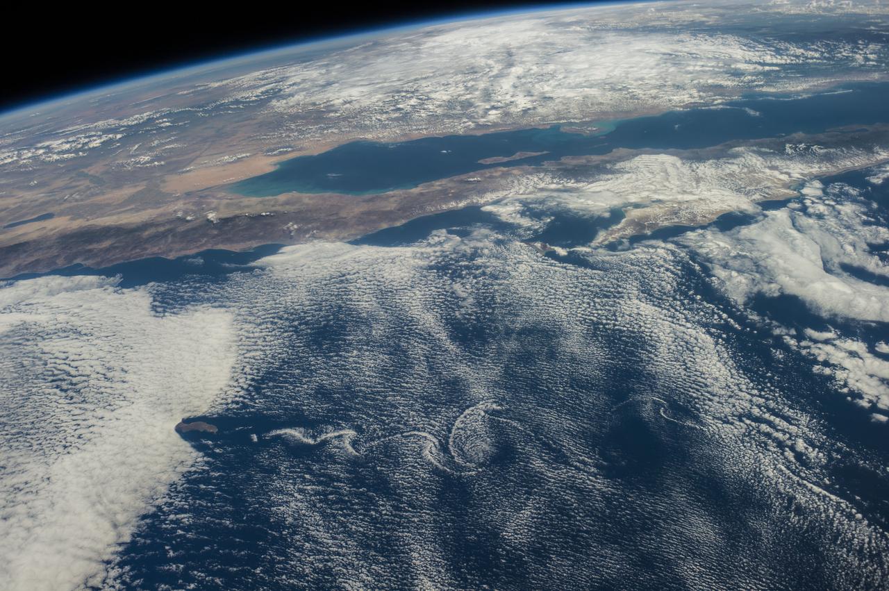
ISS041-E-016962 (18 Sept. 2014) --- Although land and waters of Mexico's Pacific area pictured here are influenced by masses of clouds, for Baja California and other parts of Mexico in this photograph made from the International Space Station, things are quite calmer than a few days ago when Hurricane Odile unleashed its power on the peninsula, especially Baja's south end (right side of frame) and Cabo San Lucas (just out of frame right). The Sea of Cortez (Gulf of California) experiences rather calm weather in this view. California's Salton Sea is visible at left center; and Guadalupe Island is visible at lower left, surrounded by von Karman vortices.