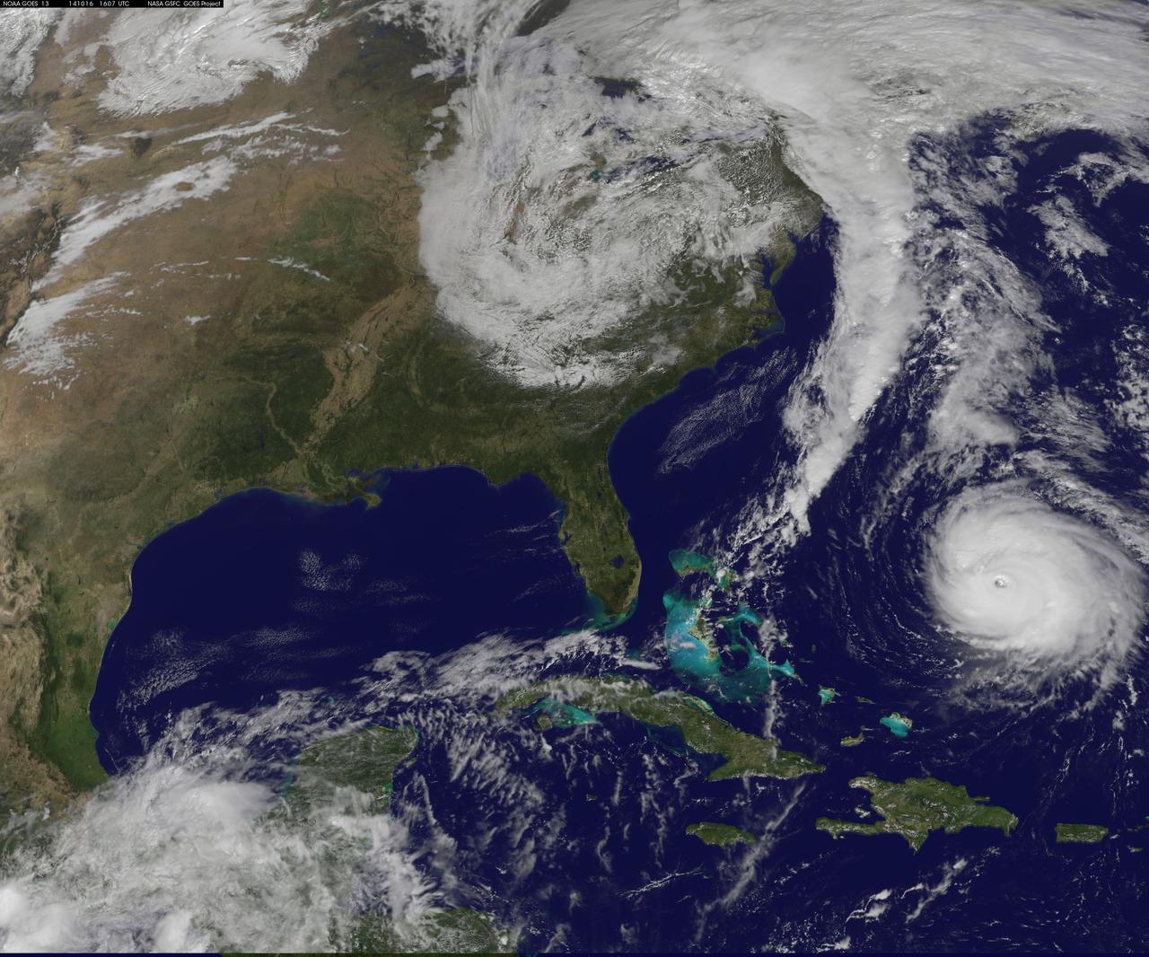
Hurricane Gonzalo is moving toward the northwest near 12 mph. A turn toward the north-northwest and then north is expected during the next day or so, followed by a north northeastward acceleration by late Thursday. Maximum sustained winds are near 130 mph making Gonzalo a Category 4 hurricane on the Saffir-Simpson Hurricane Wind Scale. Tropical storm conditions are possible on Bermuda by late Thursday night, with hurricane conditions possible on Friday. Large swells generated by Gonzalo will reach much of the U.S. east coast and Bermuda on Thursday. These swells are likely to cause life-threatening surf and rip current conditions. This image was taken by GOES 13 at 1607 UTC on October 16, 2014. Caption: NOAA Image Credit: NOAA/NASA GOES Project <b><a href="http://www.nasa.gov/audience/formedia/features/MP_Photo_Guidelines.html" rel="nofollow">NASA image use policy.</a></b> <b><a href="http://www.nasa.gov/centers/goddard/home/index.html" rel="nofollow">NASA Goddard Space Flight Center</a></b> enables NASA’s mission through four scientific endeavors: Earth Science, Heliophysics, Solar System Exploration, and Astrophysics. Goddard plays a leading role in NASA’s accomplishments by contributing compelling scientific knowledge to advance the Agency’s mission. <b>Follow us on <a href="http://twitter.com/NASAGoddardPix" rel="nofollow">Twitter</a></b> <b>Like us on <a href="http://www.facebook.com/pages/Greenbelt-MD/NASA-Goddard/395013845897?ref=tsd" rel="nofollow">Facebook</a></b> <b>Find us on <a href="http://instagram.com/nasagoddard?vm=grid" rel="nofollow">Instagram</a></b>
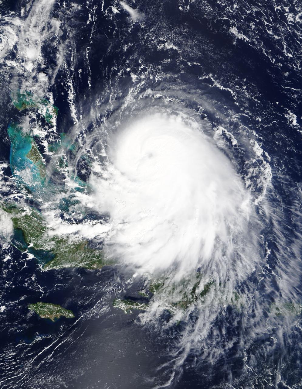
The MODIS instrument on NASA's Terra satellite captured Hurricane Joaquin off the Bahamas at 15:45 UTC (11:45 a.m. EDT) on September 30, 2015. Credit: NASA/GSFC/Jeff Schmaltz/MODIS Land Rapid Response Team At 11 a.m. EDT (1500 UTC) on Wednesday, September 30, 2015 the center of Hurricane Joaquin was located near latitude 24.7 North, longitude 72.6 West. That puts the center of Joaquin about 215 miles (345 km) east-northeast of the Central Bahamas. Joaquin became a tropical storm Monday evening (EDT), September 29 when it was midway between the Bahamas and Bermuda. By 8 a.m. EDT on September 30, it strengthened into a hurricane and has become the third hurricane of the Atlantic Hurricane season. On September 30, the National Hurricane Center issued a Hurricane Warning for the central Bahamas including Cat Island, the Exumas, Long Island, Rum Cay, and San Salvador. A Hurricane Watch is in effect for the northwestern Bahamas including the Abacos, Berry Islands, Bimini, Eleuthera, Grand Bahama Island, and New Providence, but excluding Andros Island. <b><a href="http://www.nasa.gov/audience/formedia/features/MP_Photo_Guidelines.html" rel="nofollow">NASA image use policy.</a></b> <b><a href="http://www.nasa.gov/centers/goddard/home/index.html" rel="nofollow">NASA Goddard Space Flight Center</a></b> enables NASA’s mission through four scientific endeavors: Earth Science, Heliophysics, Solar System Exploration, and Astrophysics. Goddard plays a leading role in NASA’s accomplishments by contributing compelling scientific knowledge to advance the Agency’s mission. <b>Follow us on <a href="http://twitter.com/NASAGoddardPix" rel="nofollow">Twitter</a></b> <b>Like us on <a href="http://www.facebook.com/pages/Greenbelt-MD/NASA-Goddard/395013845897?ref=tsd" rel="nofollow">Facebook</a></b> <b>Find us on <a href="http://instagrid.me/nasagoddard/?vm=grid" rel="nofollow">Instagram</a></b>
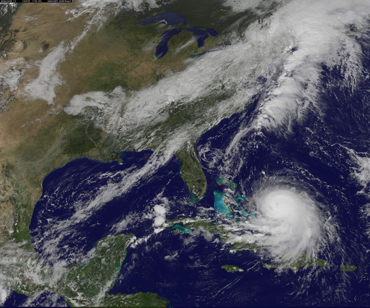
NOAA's GOES-East satellite captured this visible image of Hurricane Joaquin east of the Bahamas on Sept. 30 at 1745 UTC (1:45 p.m. EDT). Credit: NASA/NOAA GOES Project At 11 a.m. EDT (1500 UTC) on Wednesday, September 30, 2015 the center of Hurricane Joaquin was located near latitude 24.7 North, longitude 72.6 West. That puts the center of Joaquin about 215 miles (345 km) east-northeast of the Central Bahamas. Joaquin became a tropical storm Monday evening (EDT), September 29 when it was midway between the Bahamas and Bermuda. By 8 a.m. EDT on September 30, it strengthened into a hurricane and has become the third hurricane of the Atlantic Hurricane season. On September 30, the National Hurricane Center issued a Hurricane Warning for the central Bahamas including Cat Island, the Exumas, Long Island, Rum Cay, and San Salvador. A Hurricane Watch is in effect for the northwestern Bahamas including the Abacos, Berry Islands, Bimini, Eleuthera, Grand Bahama Island, and New Providence, but excluding Andros Island. <b><a href="http://www.nasa.gov/audience/formedia/features/MP_Photo_Guidelines.html" rel="nofollow">NASA image use policy.</a></b> <b><a href="http://www.nasa.gov/centers/goddard/home/index.html" rel="nofollow">NASA Goddard Space Flight Center</a></b> enables NASA’s mission through four scientific endeavors: Earth Science, Heliophysics, Solar System Exploration, and Astrophysics. Goddard plays a leading role in NASA’s accomplishments by contributing compelling scientific knowledge to advance the Agency’s mission. <b>Follow us on <a href="http://twitter.com/NASAGoddardPix" rel="nofollow">Twitter</a></b> <b>Like us on <a href="http://www.facebook.com/pages/Greenbelt-MD/NASA-Goddard/395013845897?ref=tsd" rel="nofollow">Facebook</a></b> <b>Find us on <a href="http://instagrid.me/nasagoddard/?vm=grid" rel="nofollow">Instagram</a></b>
NOAA's GOES-East satellite captured this visible image of Hurricane Joaquin east of the Bahamas on Sept. 30 at 1745 UTC (1:45 p.m. EDT). Credit: NASA/NOAA GOES Project At 11 a.m. EDT (1500 UTC) on Wednesday, September 30, 2015 the center of Hurricane Joaquin was located near latitude 24.7 North, longitude 72.6 West. That puts the center of Joaquin about 215 miles (345 km) east-northeast of the Central Bahamas. Joaquin became a tropical storm Monday evening (EDT), September 29 when it was midway between the Bahamas and Bermuda. By 8 a.m. EDT on September 30, it strengthened into a hurricane and has become the third hurricane of the Atlantic Hurricane season. On September 30, the National Hurricane Center issued a Hurricane Warning for the central Bahamas including Cat Island, the Exumas, Long Island, Rum Cay, and San Salvador. A Hurricane Watch is in effect for the northwestern Bahamas including the Abacos, Berry Islands, Bimini, Eleuthera, Grand Bahama Island, and New Providence, but excluding Andros Island. <b><a href="http://www.nasa.gov/audience/formedia/features/MP_Photo_Guidelines.html" rel="nofollow">NASA image use policy.</a></b> <b><a href="http://www.nasa.gov/centers/goddard/home/index.html" rel="nofollow">NASA Goddard Space Flight Center</a></b> enables NASA’s mission through four scientific endeavors: Earth Science, Heliophysics, Solar System Exploration, and Astrophysics. Goddard plays a leading role in NASA’s accomplishments by contributing compelling scientific knowledge to advance the Agency’s mission. <b>Follow us on <a href="http://twitter.com/NASAGoddardPix" rel="nofollow">Twitter</a></b> <b>Like us on <a href="http://www.facebook.com/pages/Greenbelt-MD/NASA-Goddard/395013845897?ref=tsd" rel="nofollow">Facebook</a></b> <b>Find us on <a href="http://instagrid.me/nasagoddard/?vm=grid" rel="nofollow">Instagram</a></b>
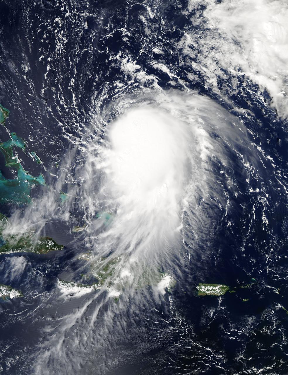
NASA's Aqua satellite captured this image of Joaquin near the Bahamas on Sept. 29 at 18:10 UTC (2:10 p.m. EDT). Credit: NASA Goddard MODIS Rapid Response Team At 11 a.m. EDT (1500 UTC) on Wednesday, September 30, 2015 the center of Hurricane Joaquin was located near latitude 24.7 North, longitude 72.6 West. That puts the center of Joaquin about 215 miles (345 km) east-northeast of the Central Bahamas. Joaquin became a tropical storm Monday evening (EDT), September 29 when it was midway between the Bahamas and Bermuda. By 8 a.m. EDT on September 30, it strengthened into a hurricane and has become the third hurricane of the Atlantic Hurricane season. On September 30, the National Hurricane Center issued a Hurricane Warning for the central Bahamas including Cat Island, the Exumas, Long Island, Rum Cay, and San Salvador. A Hurricane Watch is in effect for the northwestern Bahamas including the Abacos, Berry Islands, Bimini, Eleuthera, Grand Bahama Island, and New Providence, but excluding Andros Island. <b><a href="http://www.nasa.gov/audience/formedia/features/MP_Photo_Guidelines.html" rel="nofollow">NASA image use policy.</a></b> <b><a href="http://www.nasa.gov/centers/goddard/home/index.html" rel="nofollow">NASA Goddard Space Flight Center</a></b> enables NASA’s mission through four scientific endeavors: Earth Science, Heliophysics, Solar System Exploration, and Astrophysics. Goddard plays a leading role in NASA’s accomplishments by contributing compelling scientific knowledge to advance the Agency’s mission. <b>Follow us on <a href="http://twitter.com/NASAGoddardPix" rel="nofollow">Twitter</a></b> <b>Like us on <a href="http://www.facebook.com/pages/Greenbelt-MD/NASA-Goddard/395013845897?ref=tsd" rel="nofollow">Facebook</a></b> <b>Find us on <a href="http://instagrid.me/nasagoddard/?vm=grid" rel="nofollow">Instagram</a></b>