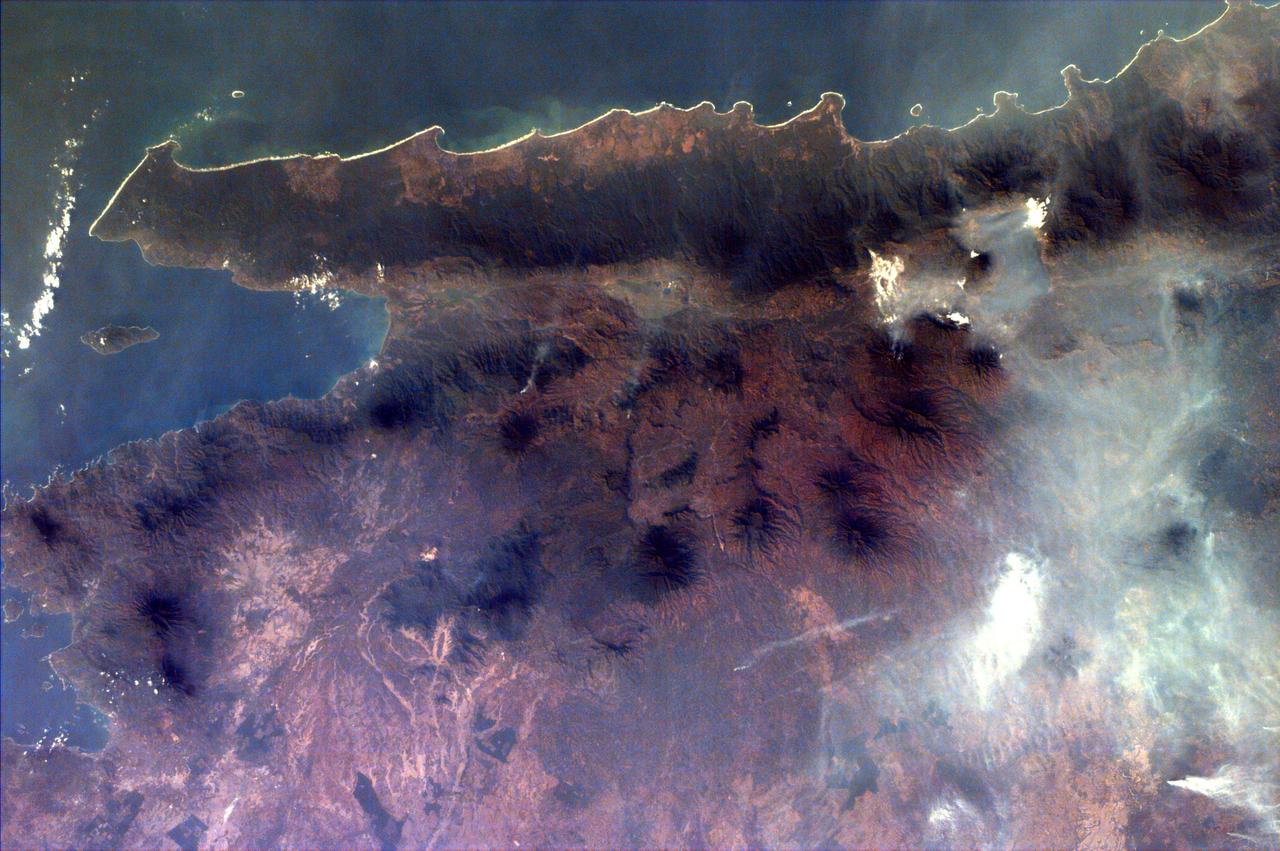
This almost totally cloud free, photo of the island of Timor, Indonesia (9.0S, 125.0E) illustrates the volcanic origin of the over 1500 islands of Indonesia. Close examination of the photo reveals several eroded volcanoes on the Island of Timor and several of the adjacent islands. The linear alignment of the volcanoes, as seen from space, indicates the edges of the tectonic plates of the Earth's crust where volcanic activity is most common.
This view shows the area around Northeastern Sumatra, Indonesia (1.0N, 104.0E). The city of Singapore and the Singapore Strait is in the center at the southern tip of the Malay Peninsula. The Singapore Strait is the eastern extension of the Strait of Malacca and separates the Malay Peninsula from Sumatra. Large sediment plumes from the rivers attest to the local soil erosion and industrial dumping ofd wastes.
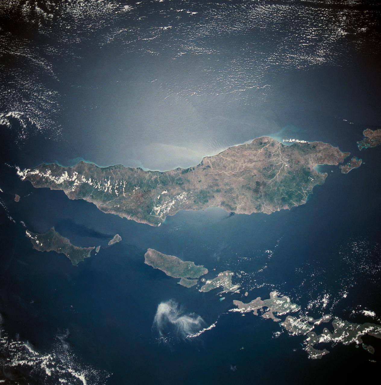
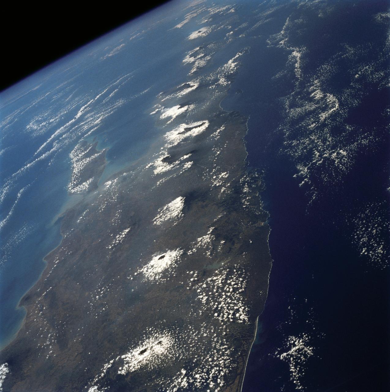
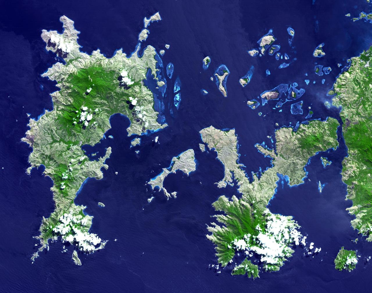
This is a striking, oblique view to the south of the Indonesian islands of Java (right), Bali and Lombok (upper left). The linear array of dark regions across the photo is a chain of volcanoes which make up the back bone of this part of the Indonesian Islands. This chain has been quite active over the past six months. Plumes of steam can be seen rising from the summits of Arjuno (west-central Java) and Merapi (central Java, near the right side of this photo). The region appears hazy due to an extended drought over Indonesia and Australia. Because of drought conditions, huge fires continue to burn over other regions of Indonesia, New Guinea and norther Australia, producing a regional smoke pall.
NASA Terra spacecraft flew over Jakarta, the capital and largest city of Indonesia. The population of the Jakarta conurbation is over 28 million, making it perhaps the largest metropolitan area in the world in terms of inhabitants.
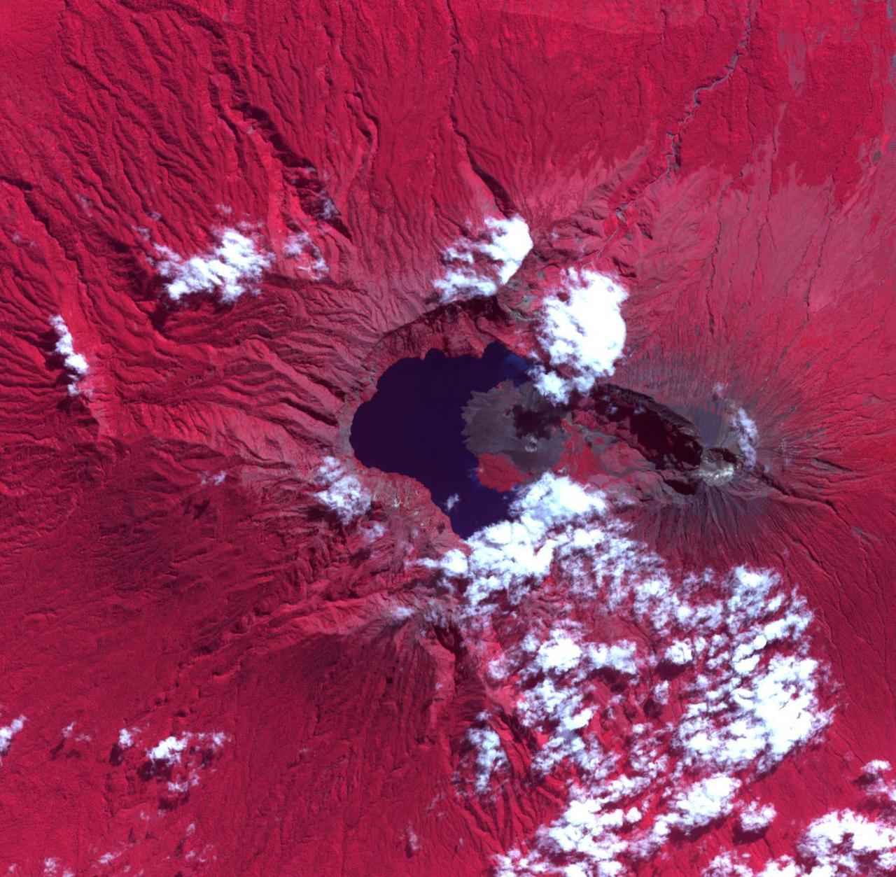
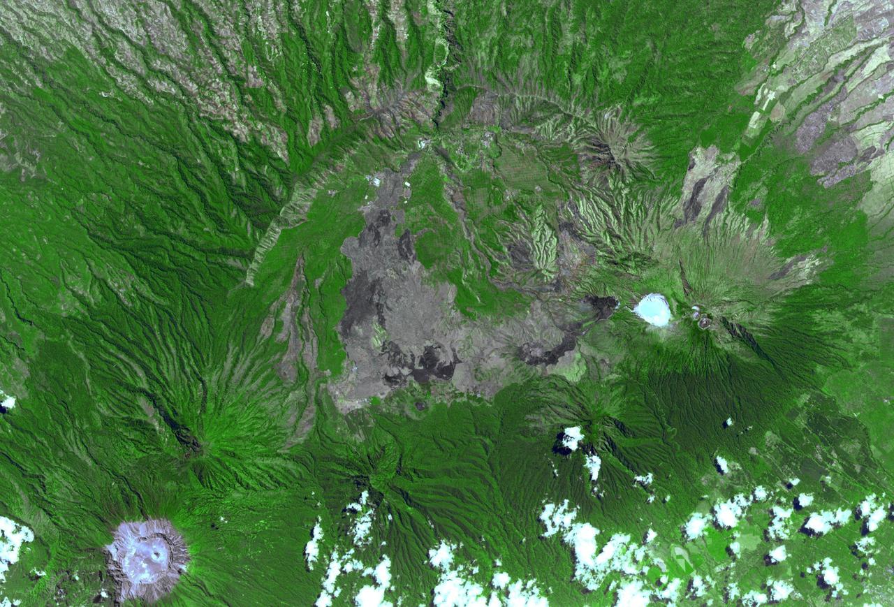
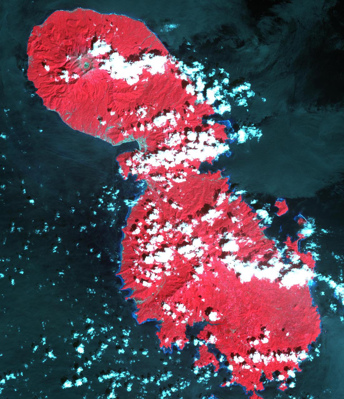
The Rinjani, Indonesia caldera-forming eruption is thought to have occurred in the 13th century. This 1257 Samalas eruption is now considered the likely source of high concentrations of sulfur found in widely dispersed ice core samples and may have been the most powerful volcanic blast since humans learned to write. The massive eruption may have triggered an episode of global cooling and failed harvests. Before this eruption, the Segara Anak caldera was a volcanic mountain named Samalas, which was higher than Rinjani. The image was acquired June 22, 2022, covers an area of 19.8 by 20.2 km, and is located at 8.4 degrees south, 116.4 degrees east. https://photojournal.jpl.nasa.gov/catalog/PIA26281
The ASTER instrument onboard NASA Terra spacecraft imaged the hot volcanic flow that resulted from collapse of the summit lava dome from the Merapi volcano in Indonesia that erupted on Oct. 26, 2010.
STS026-038-056 (29 Sept. - 3 Oct. 1988) --- Tambora Caldera, Sumbawa Island, Indonesia as photographed with a 70mm handheld Hasselblad camera. Tambora is a 6-kilometer-wide and 650-meter-deep Caldera formed in 1815 as a result of a huge volcanic eruption. Gases from the eruption were ejected high into Earth's atmosphere and transported around the globe. The atmospheric gases trapped part of the incoming sunglint, resulting in extremely cold weather. In New England, snow fell in June, and freezes occurred throughout the summer of 1816, which became known as "the year without a summer." This photo was shown by the STS-26 astronaut crew during its Oct. 11, l988 post-flight press conference.
Indonesia produces two thirds of the world's nickel from open pit mines. In southeast Sulawesi, about 50 nickel mining companies currently operate. In order to mine nickel, large areas of trees are cut down to create open pits. The areas of deforestation appear as reddish where the iron-rich soil is exposed; surrounded by bright green areas of tropical vegetation. The image was acquired 12 September 2019, covers an area of 38.3 by 65.2 km, and is located at 3.3 degrees south, 122.3 degrees east. https://photojournal.jpl.nasa.gov/catalog/PIA26007
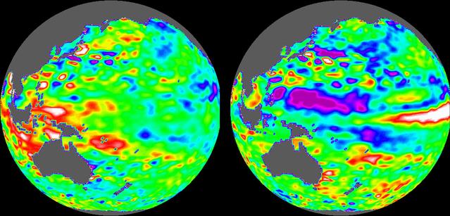
These images of the Pacific Ocean near Indonesia were produced using sea surface height measurements taken by NASA U.S.-French TOPEX/Poseidon satellite.

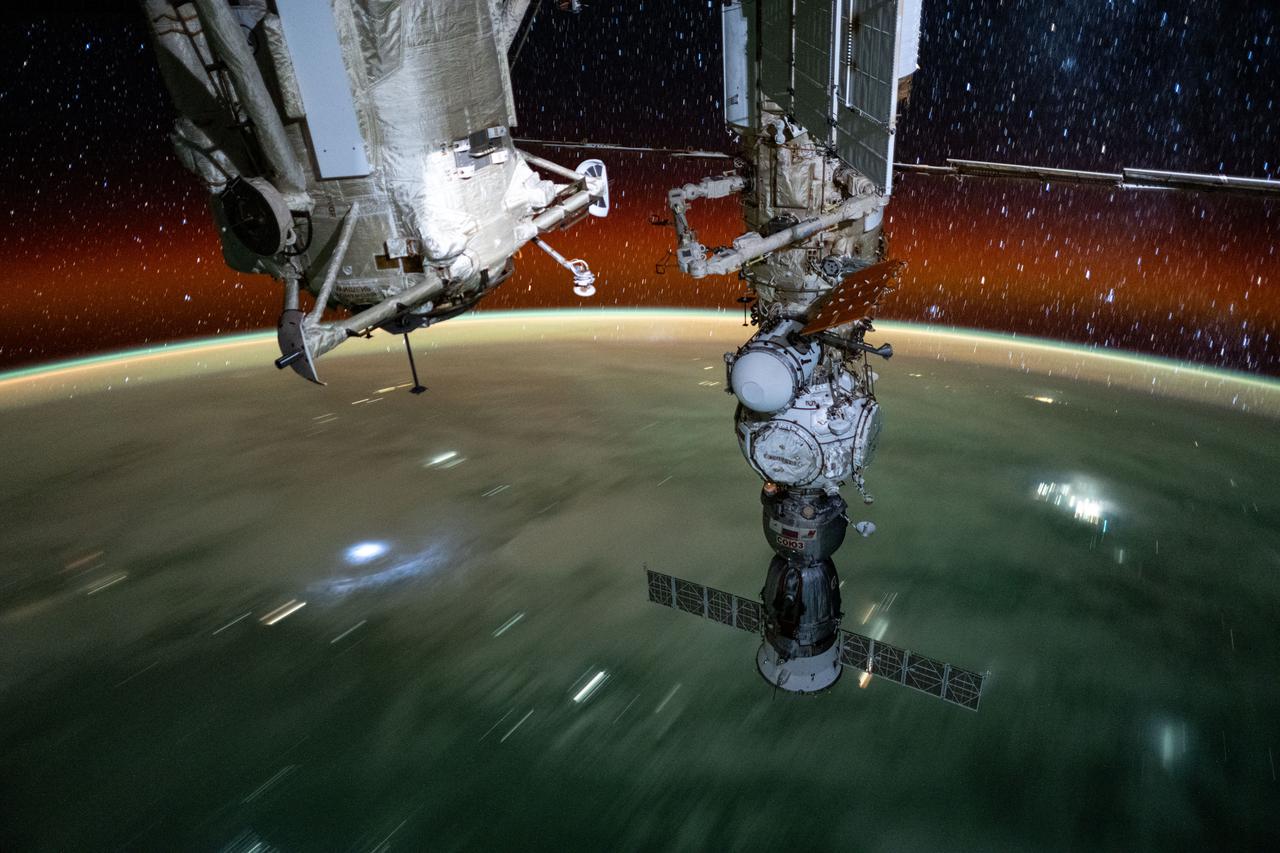
iss071e373018 (July 18, 2024) --- Silhouetted against the backdrop of the Earth below, is the Soyuz MS-25 crew ship docked to the Prichal docking module during an orbital nighttime pass. The International Space Station was soaring 261 miles above Jakarta on Indonesia's island of Java at the time of this photograph.
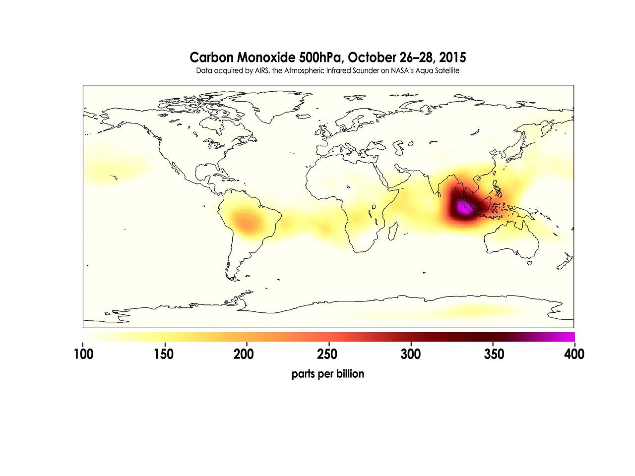
Widespread forest fires across Indonesia have burned tens of thousands of acres over three months, causing high levels of pollution, loss of life, and billions of dollars to the Indonesian government. It is estimated that more than 43 million people have been inhaling toxic fumes, and large parts of Indonesia have been placed in a state of emergency. Most of the fires are believed to have been set to clear farmland during the dry season, but a long term drought enhanced by El Niño conditions have contributed to the fires remaining unchecked due to lack of rain. These images made with data acquired by AIRS, the Atmospheric Infrared Sounder on NASA's Aqua Satellite, show the global concentration of carbon monoxide at the 500hPa pressure level, or approximately 18,000 feet (5,500 meters) altitude. The data are an average of measurements taken over three days, from October 14 through 16, and October 26 through 28, and the high concentration and large extent of the fires over Indonesia are quite apparent. While the scale for this image extends to 400 parts per billion, local values of carbon monoxide can be significantly higher. http://photojournal.jpl.nasa.gov/catalog/PIA20042
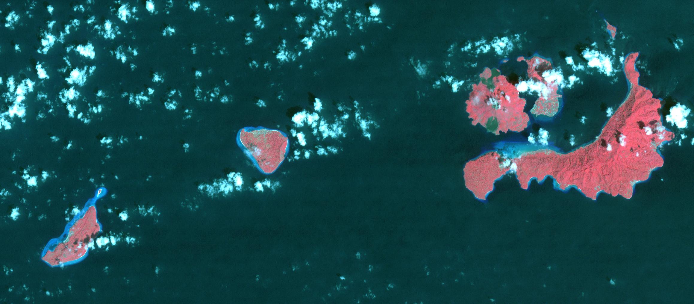
In 1667, the Dutch exchanged Run Island (left-most in the image) with the British for Manhattan (renamed from New Amsterdam to New York). Run Island is one of the smallest, and western-most, of the Banda Islands, part of the Malukus, Indonesia. At the time it was the only source of the incredibly valuable spices nutmeg and mace. The image was acquired January 5, 2016, covers an area of 15.7 by 34.8 kilometers, and is located at 4.5 degrees south, 129.7 degrees east. https://photojournal.jpl.nasa.gov/catalog/PIA22133
STS072-737-012 (11-20 Jan. 1996) --- The astronauts photographed this view of Java, an Indonesian island. Java lies between the Java Sea at top and the Indian Ocean at bottom (north is located at top center). A line of volcanoes on the southern edge of the island, trending from central to eastern areas, is highlighted by a ring of clouds. Off the southern coast of Java is the Java Trench where the Australian plate, to the south, is diving under the Eurasia plate to the north. According to anthropologists, Java has one of the highest populations in Indonesia because the soil is enriched by volcanic ash. Merapi volcano, at left edge, second volcano to the right, rises to 9,550 feet and erupts frequently. Madura Island, partially obscured by clouds, can be seen on the upper eastern end of Java.

iss073e0222649 (May 26, 2025) --- Jakarta, Indonesia, with a metropolitan population of about 32.6 million including its suburbs, and fishing boats illuminated on the Java Sea are pictured at approximately 11:47 p.m. local time from the International Space Station as it orbited 261 miles above the Indian Ocean.
West of Gunung Merapi, East Java, Indonesia, is the Ijen volcano, which has a one-kilometer-wide turquoise-colored acidic crater lake. The lake is the site of a labor-intensive sulfur mining operation, in which sulfur-laden baskets are carried by hand from the crater floor. The lake is recognized as the largest highly acidic crater lake in the world, with a pH of 0.5. The image was acquired 17 September 2008, covers an area of 24 by 39 kilometers, and is located at 8 degrees south, 114.2 degrees east. https://photojournal.jpl.nasa.gov/catalog/PIA21787
The island of Java (8.0S, 112.0E), perhaps better than any other, illustrates the volcanic origin of Pacific Island groups. Seen in this single view are at least a dozen once active volcano craters. Alignment of the craters even defines the linear fault line of Java as well as the other some 1500 islands of the Indonesian Archipelago. Deep blue water of the Indian Ocean to the south contrasts to the sediment laden waters of the Java Sea to the north.
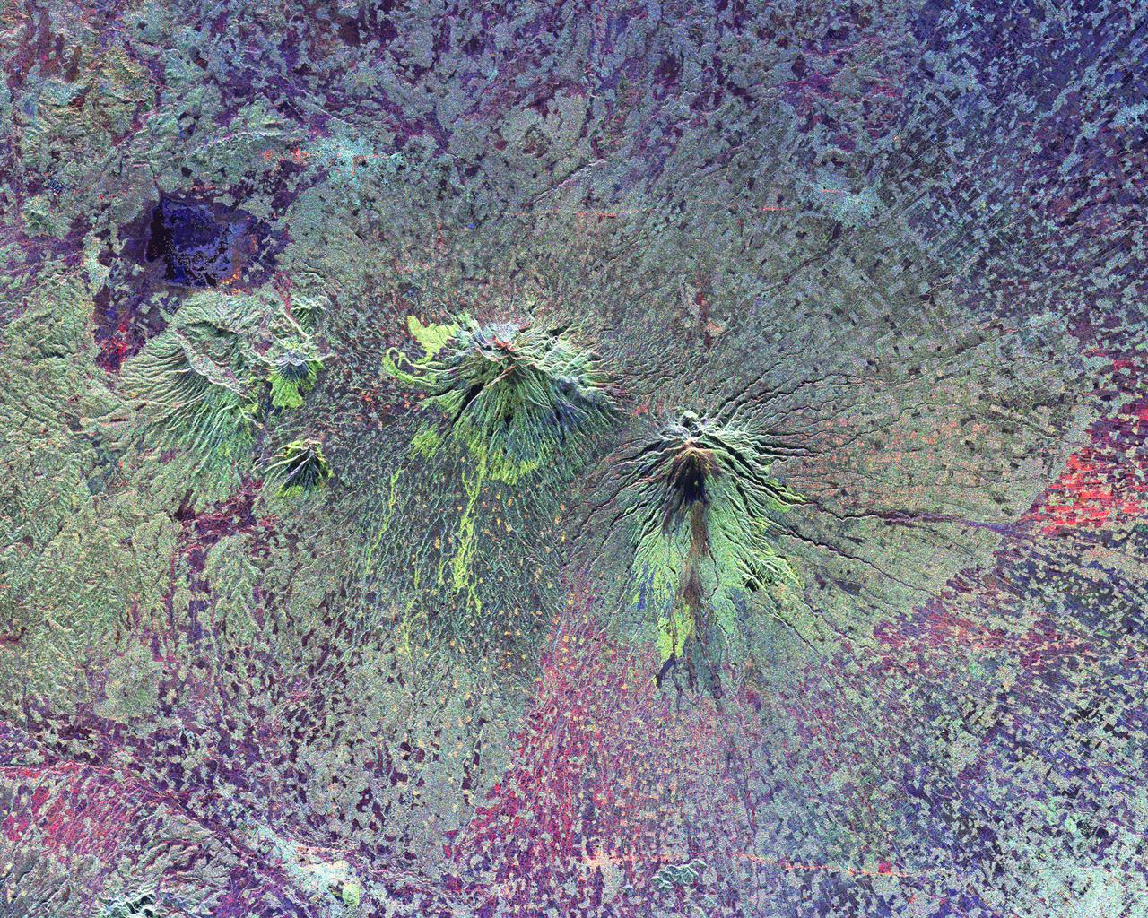
The summits of two large volcanoes in Central Java, Indonesia are shown in the center of this radar image. Lava flows of different ages and surface roughness appear in shades of green and yellow surrounding the summit of Mt. Merbabu (mid-center) and Mt. Merapi (lower center). Mt. Merapi erupted on November 28, 1994 about six weeks after this image was taken. The eruption killed more than 60 people and forced the evacuation of more than 6,000 others. Thousands of other residents were put on alert due to the possibility of volcanic debris mudflows, called lahars, that threatened nearby towns. Mt. Merapi is located approximately 40 kilometers (25 miles) north of Yogyakarta, the capital of Central Java. The older volcano at the top of the image is unnamed. Lake Rawapening is the dark blue feature in the upper right. The light blue area southeast of the lake is the city of Salatiga. Directly south of Salatiga and southeast of Mt. Merapi is the city of Boyolali. Scientists are studying Mt. Merapi as part of the international "Decade Volcanoes" project, because of its recent activity and potential threat to local populations. The radar data are being used to identify and distinguish a variety of volcanic features. http://photojournal.jpl.nasa.gov/catalog/PIA01782
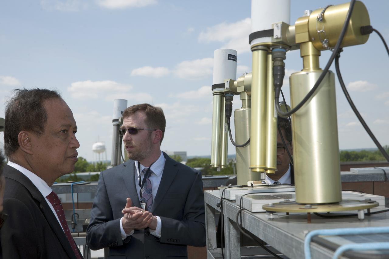
Indonesian delegation visited Goddard on May 21, 2018 they toured Hyperwall and Bldg 33 Aeronet
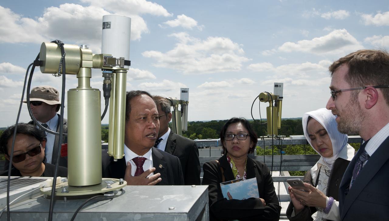
Indonesian delegation visited Goddard on May 21, 2018 they toured Hyperwall and Bldg 33 Aeronet
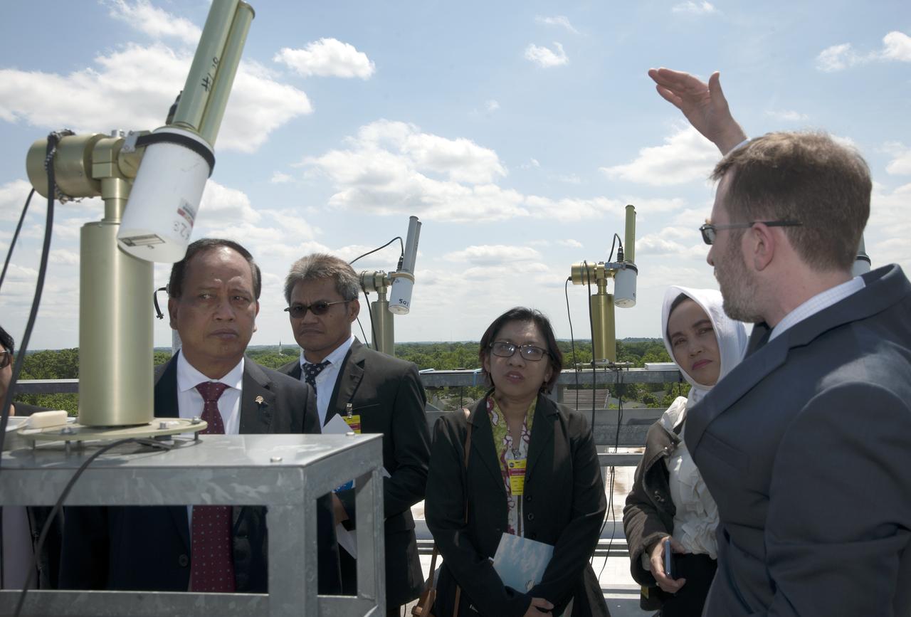
Indonesian delegation visited Goddard on May 21, 2018 they toured Hyperwall and Bldg 33 Aeronet
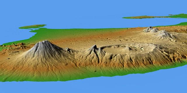
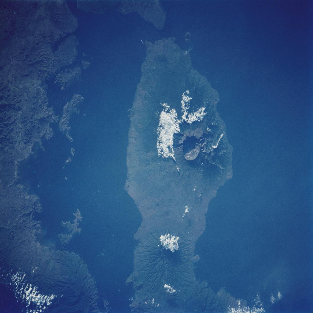
This perspective view shows the major volcanic group of Bali, one 13,000 islands comprising the nation of Indonesia.

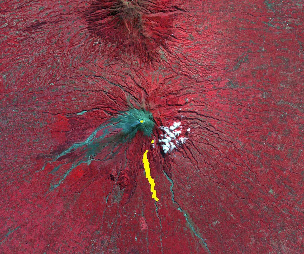
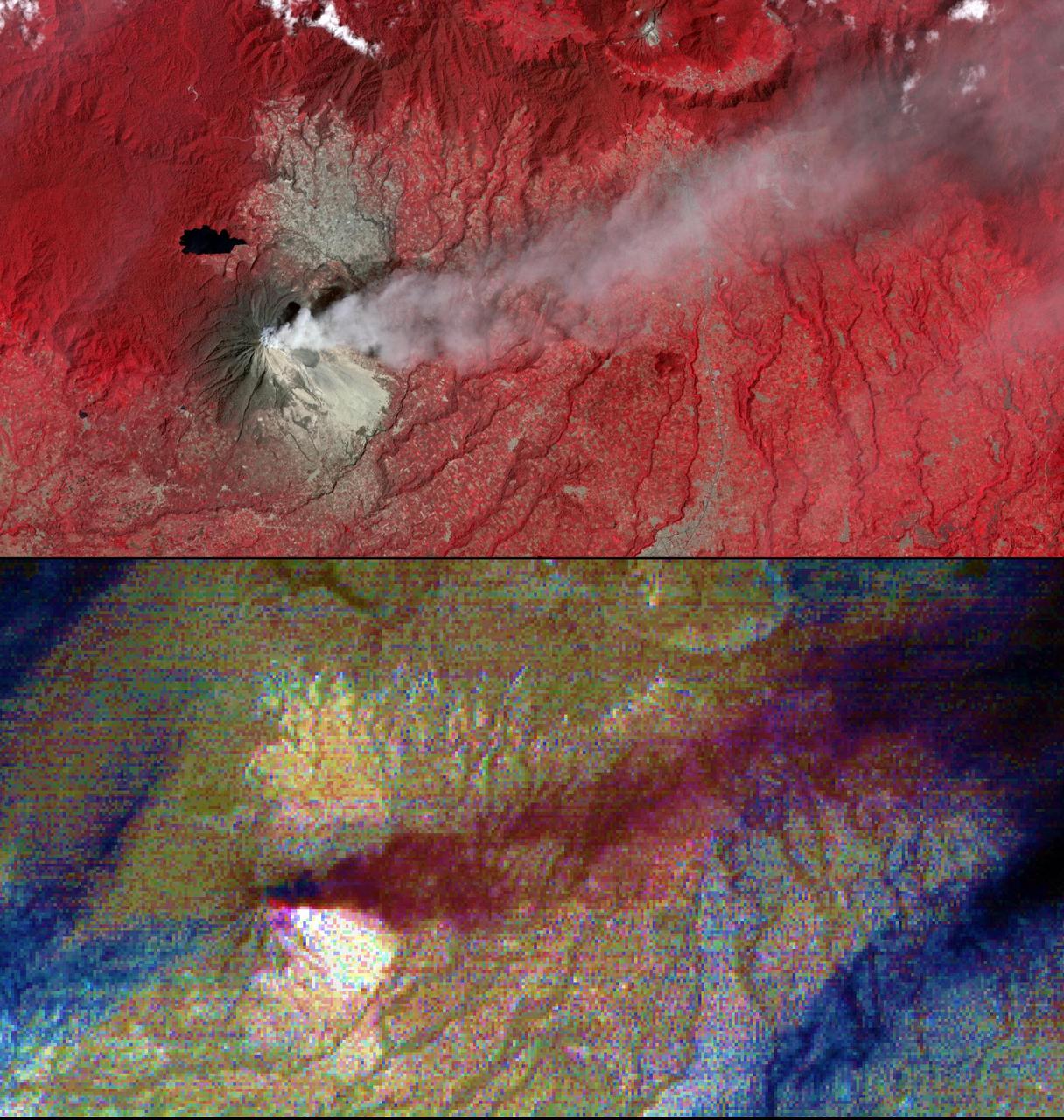
After a new small eruption sent an ash cloud 1.24 miles (2 kilometers) into the sky on Dec. 7, 2017, Indonesia's Mount Agung volcano quieted down. This image was acquired Dec. 8 after the latest activity by the Advanced Spaceborne Thermal Emission and Reflection Radiometer (ASTER) instrument on NASA's Terra satellite. The image shows vegetation in red colors. The summit crater has a hot spot (yellow) as detected by ASTER's thermal infrared channels. More than 65,00 residents continue to be evacuated from the volcano's danger zone in case of a major eruption. The image covers an area of 11 by 12.3 miles (17.8 by 19.8 kilometers), and is located at 8.3 degrees south, 115.5 degrees east. https://photojournal.jpl.nasa.gov/catalog/PIA22121
On 26 December 2004, a magnitude 9.0 earthquake occurred off the west coast of Sumatra, Indonesia. These views were acquired by NASA Terra spacecraft.
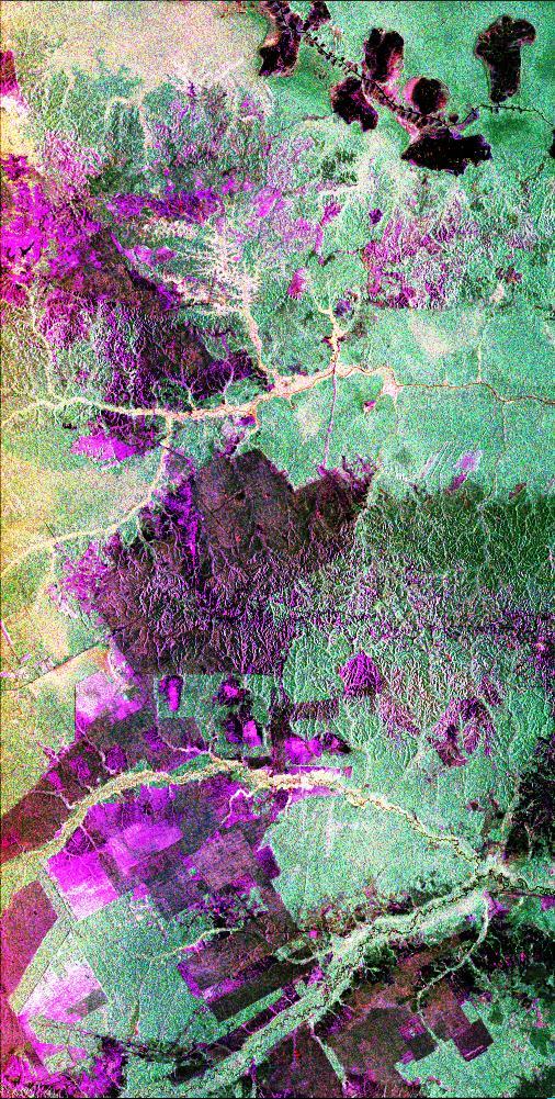
This is a radar image of the central part of the island of Sumatra in Indonesia that shows how the tropical rainforest typical of this country is being impacted by human activity. Native forest appears in green in this image, while prominent pink areas represent places where the native forest has been cleared. The large rectangular areas have been cleared for palm oil plantations. The bright pink zones are areas that have been cleared since 1989, while the dark pink zones are areas that were cleared before 1989. These radar data were processed as part of an effort to assist oil and gas companies working in the area to assess the environmental impact of both their drilling operations and the activities of the local population. Radar images are useful in these areas because heavy cloud cover and the persistent smoke and haze associated with deforestation have prevented usable visible-light imagery from being acquired since 1989. The dark shapes in the upper right (northeast) corner of the image are a chain of lakes in flat coastal marshes. This image was acquired in October 1994 by the Spaceborne Imaging Radar C/X-Band Synthetic Aperture Radar (SIR-C/X-SAR) onboard the space shuttle Endeavour. Environmental changes can be easily documented by comparing this image with visible-light data that were acquired in previous years by the Landsat satellite. The image is centered at 0.9 degrees north latitude and 101.3 degrees east longitude. The area shown is 50 kilometers by 100 kilometers (31 miles by 62 miles). The colors in the image are assigned to different frequencies and polarizations of the radar as follows: red is L-band horizontally transmitted, horizontally received; green is L-band horizontally transmitted, vertically received; blue is L-band vertically transmitted, vertically received. SIR-C/X-SAR, a joint mission of the German, Italian and United States space agencies, is part of NASA's Mission to Planet Earth program. http://photojournal.jpl.nasa.gov/catalog/PIA01797
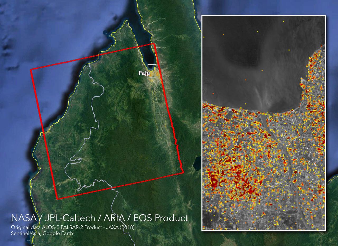
The Advanced Rapid Imaging and Analysis (ARIA) team at NASA's Jet Propulsion Laboratory in Pasadena, California, and Caltech, also in Pasadena, created this Damage Proxy Map (DPM) depicting areas in Central Sulawesi, Indonesia, including the city of Palu, that are likely damaged (shown by red and yellow pixels) as a result of the magnitude 7.5 September 28, 2018 earthquake. The map is derived from synthetic aperture radar (SAR) images from the ALOS-2 satellite, operated by Japan Aerospace Exploration Agency (JAXA). The images were taken before (Aug. 8, 2018) and after (Oct. 3, 2018) the earthquake. The map covers an area of 42 by 44 miles (67 by 70 kilometers), shown by the large red polygon. Each pixel measures about 33 yards (30 meters) across. The color variation from yellow to red indicates increasingly more significant ground surface change. Preliminary validation was done in collaboration with the Earth Observatory of Singapore by comparing with local media information and photos. This damage proxy map should be used as guidance to identify damaged areas, and may be less reliable over vegetated areas. For example, the scattered single colored pixels over vegetated areas may be false positives, and the lack of colored pixels over vegetated areas does not necessarily mean no damage. The DPM was created by the NASA-JPL/Caltech ARIA team, and the ALOS-2 data were provided by JAXA. The Earth Observatory of Singapore coordinated with the Sentinel Asia to timely task the ALOS-2 satellite. The algorithm development was carried out at JPL under a contract with NASA. https://photojournal.jpl.nasa.gov/catalog/PIA22746

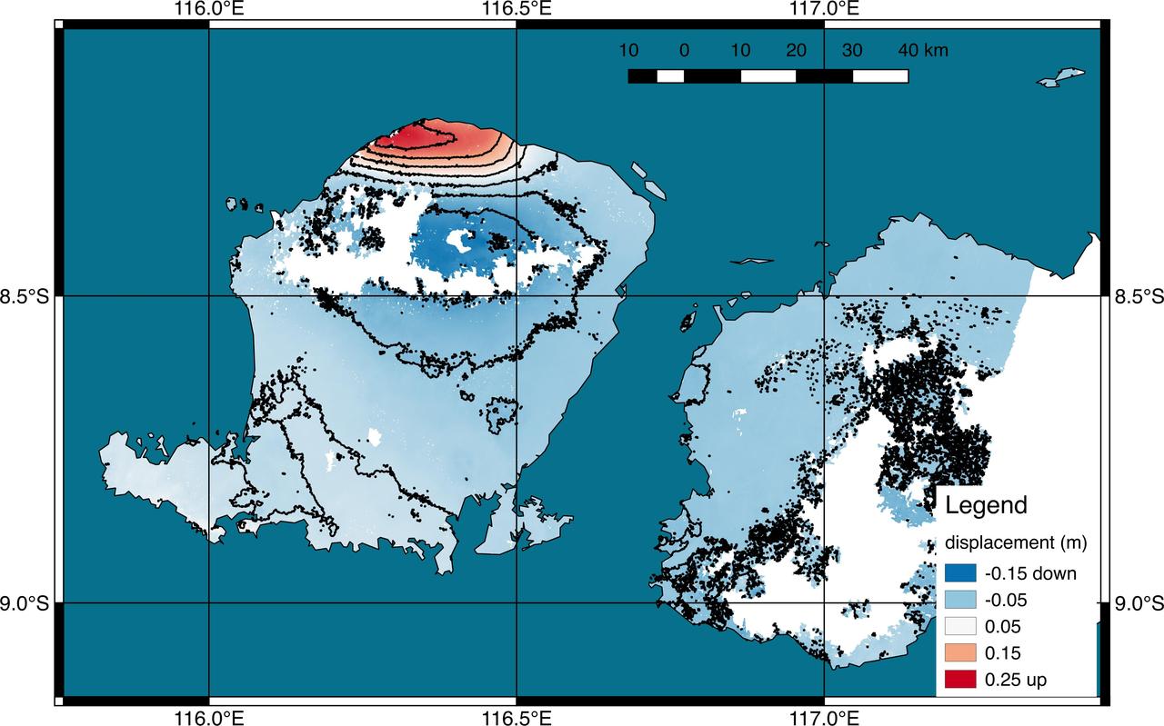
The Advanced Rapid Imaging and Analysis (ARIA) team at NASA's Jet Propulsion Laboratory in Pasadena, California, and Caltech, also in Pasadena, created this Damage Proxy Map (DPM) depicting areas in the northeastern part of Lombok Island, Indonesia, that are likely damaged (shown by red and yellow pixels) as a result of the major earthquake sequence (including the M6.4 July 29, the M6.9 August 5, the M5.9 August 9, and the M6.4 August 18 earthquakes) in 2018. The map is derived from synthetic aperture radar (SAR) images from the ALOS-2 satellites, operated by Japan Aerospace Exploration Agency (JAXA). The images were taken before the (May 13, 2018 00:30) and after the (August 19, 2018 00:30, both local time) earthquakes. The map covers an area of 73 by 70 kilometers, shown by the large red polygon. Each pixel measures about 30 meters across. The color variation from yellow to red indicates increasingly more significant ground surface change. Preliminary validation was done by comparing with the DigitalGlobe's high-resolution optical satellite imagery. This damage proxy map should be used as guidance to identify damaged areas, and may be less reliable over vegetated areas. For example, the scattered single colored pixels over vegetated areas may be false positives, and the lack of colored pixels over vegetated areas does not necessarily mean no damage. The DPM was created by the NASA-JPL/Caltech ARIA team, and the ALOS-2 data were provided by JAXA. The Earth Observatory of Singapore coordinated with the Sentinel Asia to timely task the ALOS-2 satellite. The algorithm development was carried out at JPL under a contract with NASA. https://photojournal.jpl.nasa.gov/catalog/PIA22495
iss073e0828980 (Sept. 14, 2025) --- A dim, yellow-green airglow crowns Earth’s horizon between northwestern Australia and Indonesia’s Lesser Sunda Islands. In the foreground, a set of the orbital outpost’s main solar arrays, partially overlapped by a smaller set of roll-out solar arrays, stretches across the frame. The International Space Station was soaring 262 miles above the tranquil Indian Ocean at approximately 4:07 a.m. local time when this photograph was taken.
On Feb. 13, 2014, violent eruption of Kelud stratovolcano in Java, Indonesia sent volcanic ash covering an area of 70,000 square miles, prompting the evacuation of tens of thousands of people. This image is from NASA Terra spacecraft.
This image acquired by NASA Terra spacecraft is of Mount Sinabung, a stratovolcano located in Indonesia. In late 2013, a lava dome formed on the summit. In early January 2014, the volcano erupted, and it erupted again in early February.
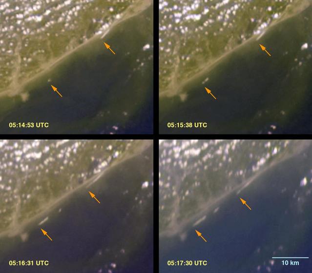
The initial tsunami waves resulting from the undersea earthquake that occurred at 00:58:53 UTC Coordinated Universal Time on 26 December 2004 off the island of Sumatra, Indonesia, as seen by NASA Terra spacecraft.
On Dec. 22, 2018, Indonesia's Anak Krakatau volcano erupted and partially collapsed. NASA's Advanced Spaceborne Thermal Emission and Reflection (ASTER) instrument imaged the volcano on Jan. 13 -- several weeks after the eruption. This image shows that the crater area has closed to become a lake and the forest on the island has been destroyed by ash falls. The reddish area in the water southwest of the island is likely due to either iron-rich ash in the water or the interaction of seawater with underwater volcanic eruption products. The image covers an area of 7.5 by 8.4 miles (12.2 by 13.5 kilometers), and is located at 6.1 degrees south, 105.4 degrees east. The tsunami that followed the eruption killed more than 400 people in western Indonesia. https://photojournal.jpl.nasa.gov/catalog/PIA22821
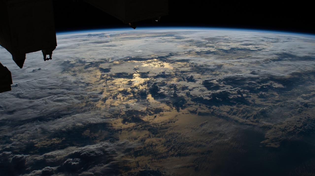
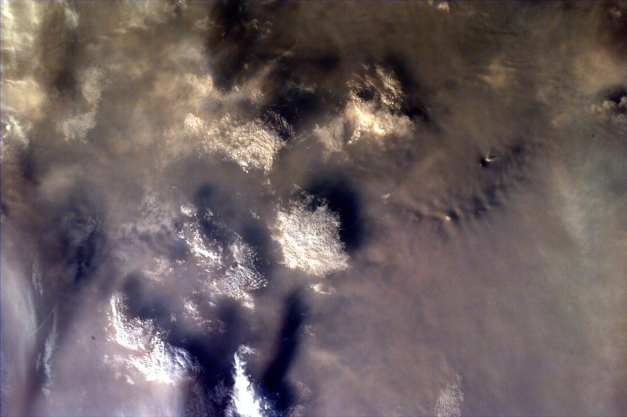
Earth observation taken by the Expedition 40 crew aboard the International Space Station (ISS). Folder lists this as: Cloud shadows over Indonesia.
iss063e027862 (June 13, 2020) --- The sun's glint on the Timor Sea between Indonesia and Australia is mellowed by cloud cover in this photograph from the International Space Station.
iss059e067877 (May 19, 2019) --- The International Space Station flies 255 miles above Indonesia as the sun's glint beams off the Celebes Sea in southeast Asia.
Middle school students across the country photographed the fires and smoke over southern Sumatra from a camera aboard the Space Shuttle Atlantis September 27, 1997.

NASA astronaut and Boeing Crew Flight Test Pilot Suni Williams Suni Williams uses a HAM radio and talks to students from Banda Aceh, Indonesia, answering their questions about life in space and other space related subjects aboard the International Space Station.
iss065e001270 (April 21, 2021) --- The north coast of West Nusa Tenggara, a province of Indonesia, on the Flores Sea is pictured from the International Space Station as it orbited 262 miles above.
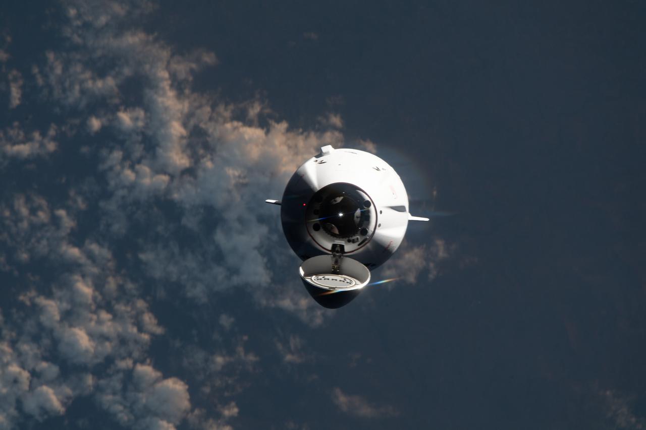
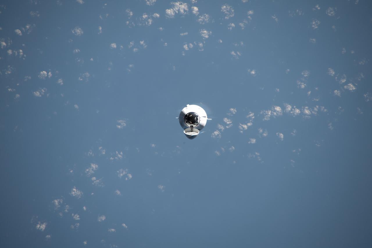
iss070e022160 (Nov. 11, 2023) --- The SpaceX Dragon cargo craft, on the company's 29th commercial resupply mission for NASA, approaches the International Space Station while orbiting 261 miles above Indonesia's Savu Sea.

iss071e000013 (April 7, 2024) --- The Soyuz MS-25 spacecraft is pictured docked to the Prichal docking module as the International Space Station soared into an orbital sunset 260 miles above the Indian Ocean off the coast on Indonesia.

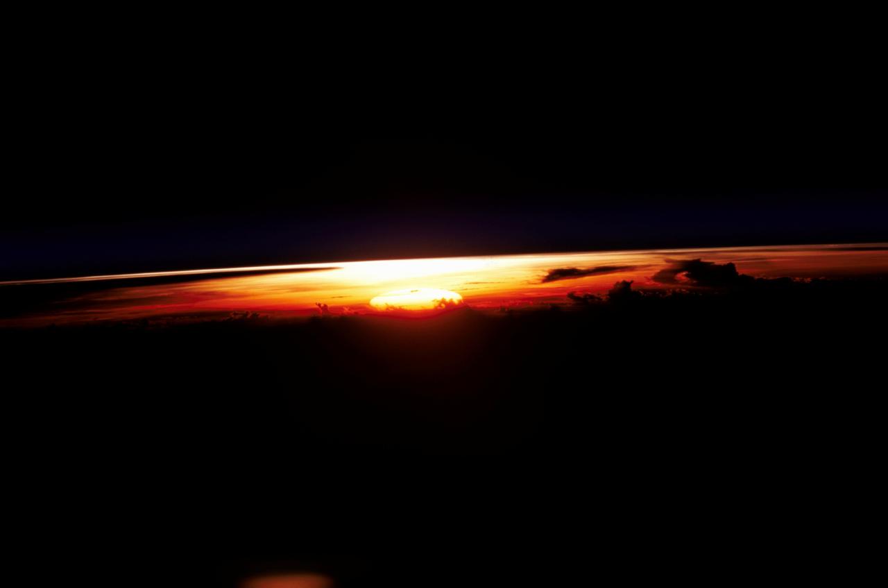
iss059e027932 (April 21, 2019) --- The sun's first rays peek above Earth's limb highlighting the thin blue atmosphere during an orbital sunrise as the International Space Station orbited 255 miles above Indonesia.
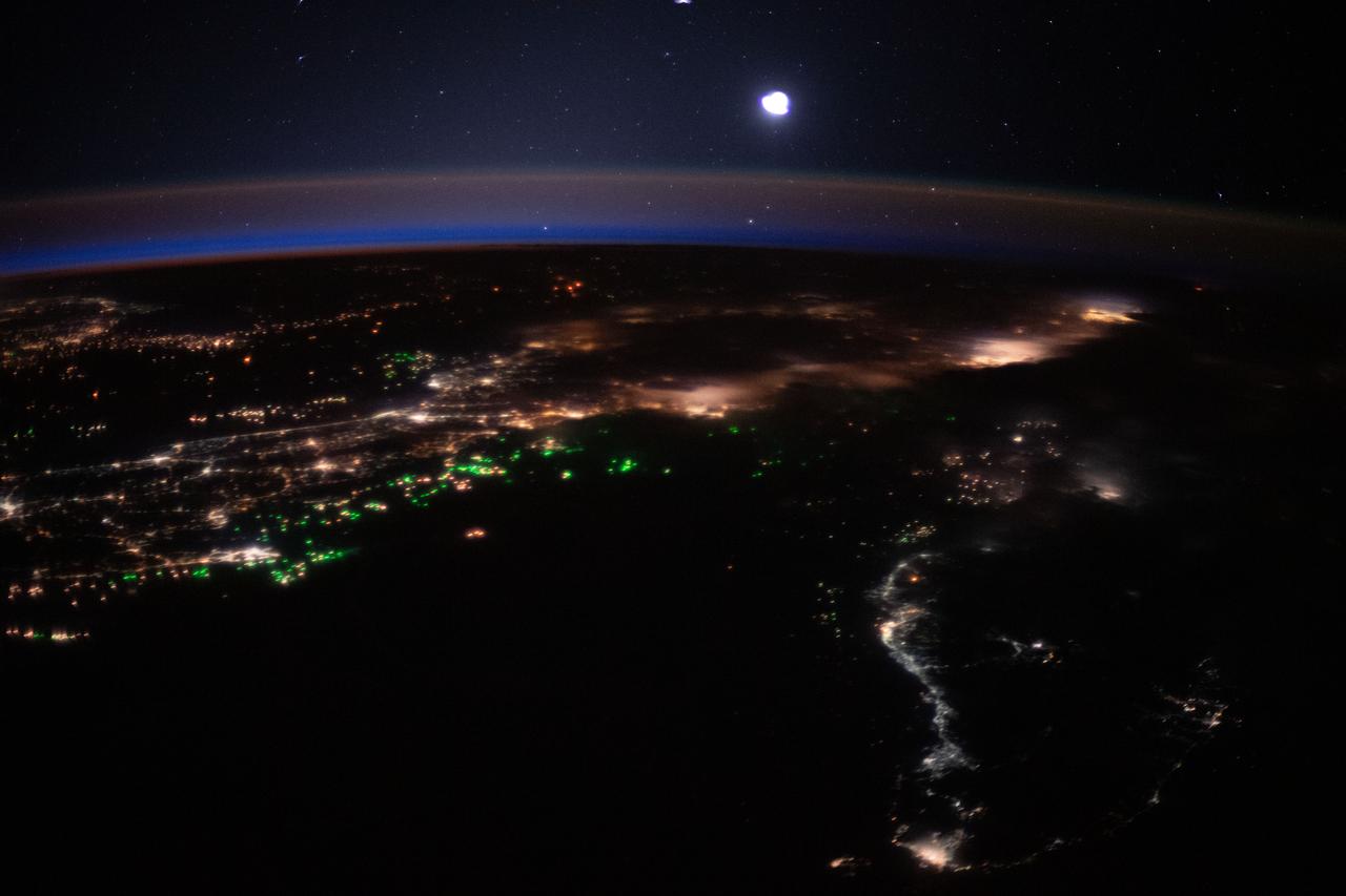
iss062e104685 (March 21, 2020) --- The International Space Station was orbiting 262 miles above the Bay of Bengal when an Expedition 62 captured this photograph of city lights and boat lights in Malaysia and Indonesia
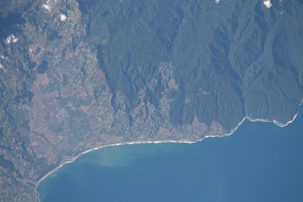
iss065e001304 (April 21, 2021) --- The south coast of West Nusa Tenggara, a province of Indonesia, is pictured from the International Space Station as it orbited 262 miles above the Indian Ocean.
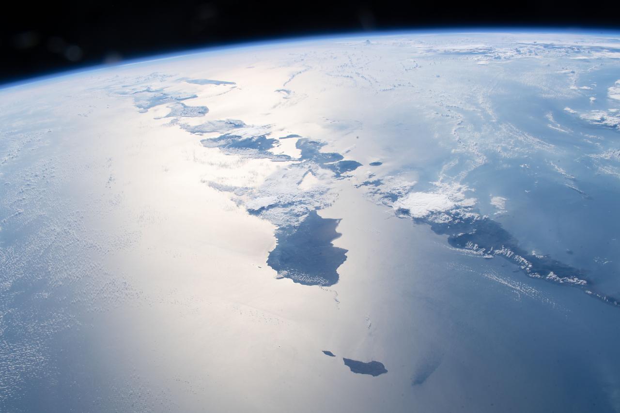
iss056e098152 (July 23, 2018) --- Just a few of the thousands of volcanic islands that make up the nation of Indonesia are pictured as the International begins an orbital pass over the Timor Sea after crossing western Australia.
iss070e023576 (Nov. 11, 2023) --- The SpaceX Dragon cargo craft, on the company's 29th commercial resupply mission for NASA, approaches the International Space Station while orbiting 261 miles above the Indian Ocean in between Australia and Indonesia.
Scientists with the Advanced Rapid Imaging and Analysis project (ARIA), a collaboration between NASA's Jet Propulsion Laboratory in Pasadena, California, and Caltech, also in Pasadena, used synthetic aperture radar (SAR) data from the European Union's Copernicus Sentinel-1A and -1B satellites, operated by the European Space Agency. They generated a map of the deformation of Earth's surface caused by the Aug. 5, 2018 magnitude 6.9 earthquake under Lombok island, Indonesia. The deformation map is produced from automated interferometric processing of the SAR data using the JPL-Caltech ARIA data system in response to a signal received from the U.S. Geological Survey. The false-color map shows the amount of permanent surface movement that occurred almost entirely due to the quake, as viewed by the satellite, during a 6-day interval between two Sentinel-1 images acquired on July 30 and Aug. 5, 2018. The map shows that the earthquake fault was under the northwest corner of Lombok island, probably extending offshore to the west. Through these maps, NASA and its partners are contributing observations and expertise that can assist with response to earthquakes and other natural or human-produced hazards. From the pattern of deformation in the map, scientists have determined that the earthquake fault slip was on a fault beneath the northwestern part of Lombok Island and caused as much as 10 inches (25 centimeters) of uplift of the ground surface. The map depicts motion towards the satellite (up and west) in the direction of the radar's line-of-sight, with contours every 2 inches (5 centimeters). White areas are places where the radar measurement was not possible, largely due to dense forests in the middle of the islands. https://photojournal.jpl.nasa.gov/catalog/PIA22491
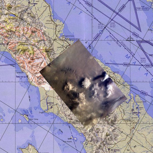
This map corresponds to NASA KidSat image MET 00215424 of the northern regions of Sumatra that was captured on Sept., 1997 during the Shuttle flight STS-86.
Middle school students across the country photographed the fires and smoke over southern Sumatra from a camera aboard the Space Shuttle Atlantis September 27, 1997.
NASA Terra spacecraft imaged the Indonesian islands of Komodo, Rintja, Padar, and Flores in the Komodo National Park. The Komodo dragon is the world largest lizard species.

Middle school students across the country photographed the fires and smoke over southern Sumatra from a camera aboard the Space Shuttle Atlantis September 27, 1997.
Canadian-based Baru Gold is hoping to start gold mining on the Indonesian island of Sangihe this year. The company's concession covers the southern half of the volcanic island. Opposition to the mining activity cites threats to endemic bird populations and the residents themselves, due to inadequate tailings handling technology. The company projects reserves of nearly 115,000 ounces of gold and 2 million ounces of silver. The image was acquired December 4, 2020, covers an area of 36.3 by 42.1 km, and is located at 3.5 degrees north, 125.5 degrees east. https://photojournal.jpl.nasa.gov/catalog/PIA24942
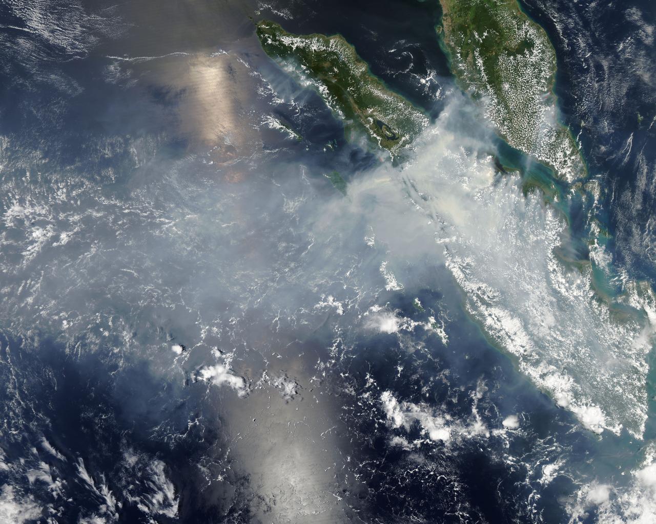
These data products from NASA Terra satellite document the presence of airborne particulates on March 13, 2002, during Terra orbit 11880. At least once a year for a period lasting from a week to several months, northern Sumatra is obscured by smoke and

iss047e001114 (March 2, 2016) --- An Expedition 47 crewmember photographed the Earth’s limb during a starry night pass. One of the International Space Station’s solar arrays is seen in the right foreground as the orbital complex flew 258 miles above the Indian Ocean in between Indonesia and Australia.

iss071e077638 (May 14, 2024) --- The first rays of an orbital sunrise break through Earth's atmosphere highlighting the cloud tops in this photograph from the International Space Station as it soared 256 miles above the Indian Ocean off the coast of Sumatra, Indonesia.
iss071e662620 (Sept. 2, 2024) --- This long exposure photograph taken by NASA astronaut Matthew Dominick with a camera programmed for low sensitivity shows star trails and streaks of city lights as the International Space Station orbited 257 miles above the Molucca Sea in Indonesia.
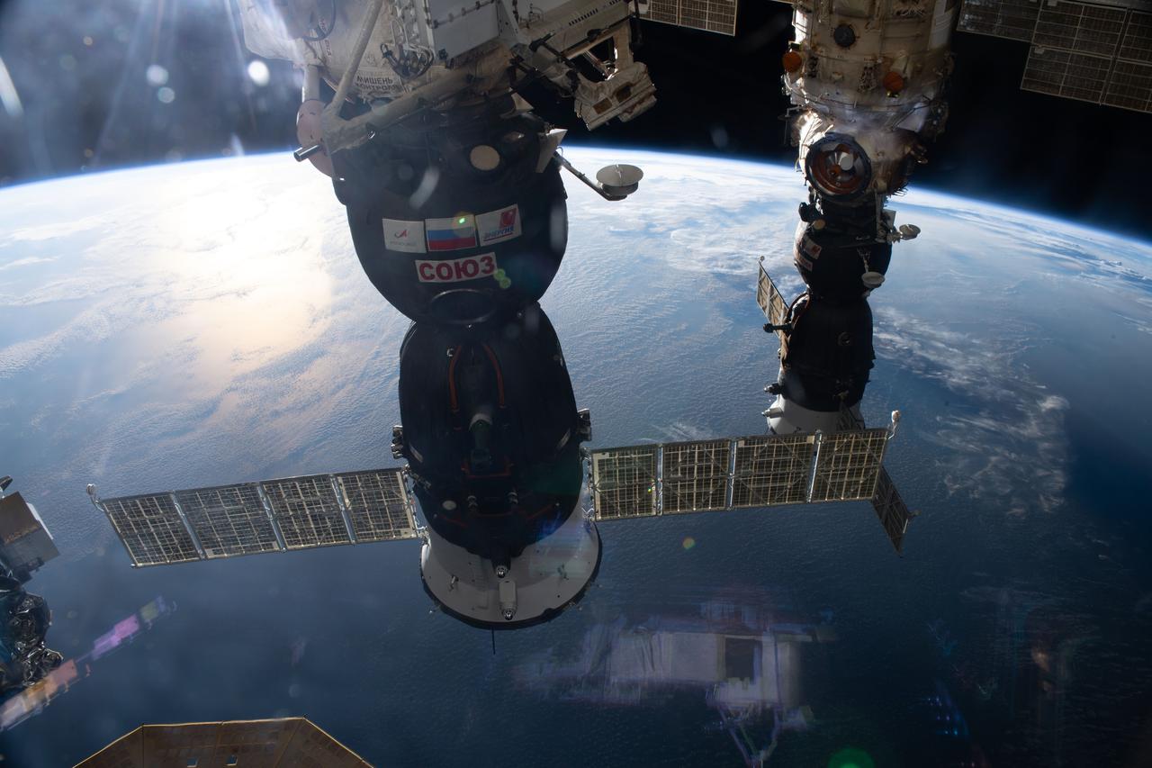
iss065e483092 (Oct. 16. 2021) --- Two Soyuz crew ships are pictured docked at the International Space Station as it orbited 264 miles above the Indian Ocean in between Australia and Indonesia. From front to back, the Soyuz MS-19 is docked to the Rassvet module and the Soyuz MS-18 is docked to the Nauka multipurpose laboratory module.
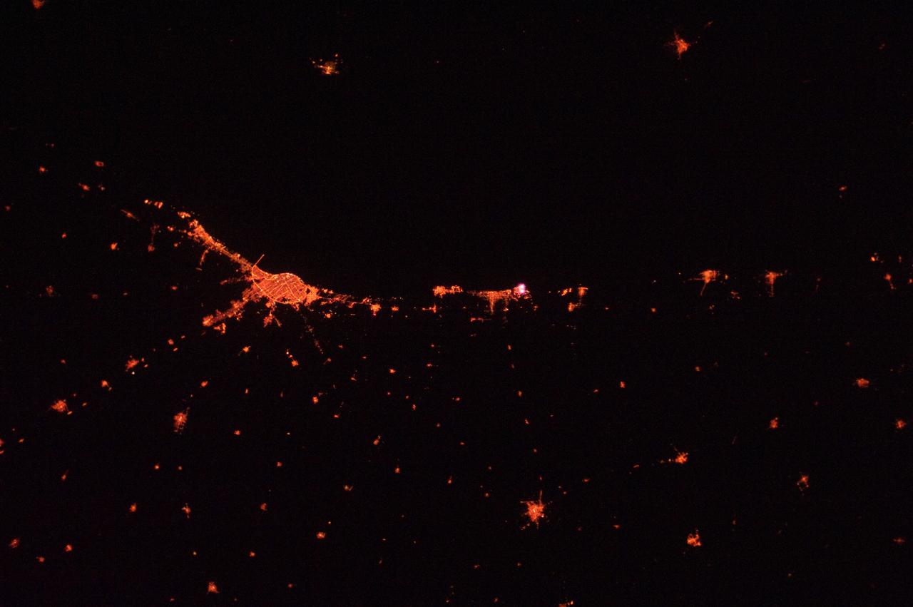
ISS030-E-015896 (25 Dec. 2011) --- This is an infrared image of Jakarta, Indonesia at night recorded by an Expedition 30 crew member aboard the Earth-orbiting International Space Station on Dec. 25, 2011. A 58-mm focal length was used.
ISS010-E-13088 (15 January 2005) --- Tsunami damage, northwestern Sumatra (Indonesia) is featured in this image photographed by an Expedition 10 crewmember on the International Space Station. On December 26, 2004 a large (magnitude 9.0) earthquake occurred off the western coast of Sumatra in the Indian Ocean. Scientists believe the earthquake was caused by the release of stresses accumulated as the India tectonic plate is overridden by the Burma tectonic plate. Movement of the seafloor due to the earthquake generated a tsunami, or seismic sea wave, that affected coastal regions around the Indian Ocean. The northwestern Sumatra coastline in particular suffered extensive damage and loss of life. This photo, along with image ISS010-E-13079, illustrates damage along the southwestern coast of Aceh Province in the vicinity of the city of Lho’ Kruet, Indonesia. The image captures the sunglint illuminating the Indian Ocean and standing water inland (light gray). Distortion and scale differences are caused by increased obliquity of the view from the Station.
Middle school students across the country photographed the fires and smoke over southern Sumatra from a camera aboard the Space Shuttle Atlantis September 27, 1997.
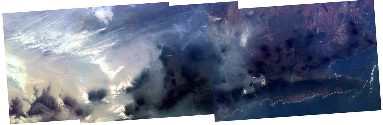
As the Space Shuttle Atlantis flew over the Indonesian archipelago on Saturday, Sept. 27, 1997, middle school students across the country used NASA Kidsat camera to photograph the fires and smoke that blanket the island of Sumatra.
STS109-345-032 (1-12 March 2002) --- One of the astronauts aboard the Space Shuttle Columbia photographed this west-looking view featuring the profile of the atmosphere and the setting sun. The shuttle was located over the Java Sea to the south of Kalimantan (Borneo) in Indonesia when this image was acquired. Visible to the right of the setting sun are cloud tops from some thunderstorms. The sun's reflection (bright spot over the setting sun) can be seen off the upper layers of the earth's atmosphere.
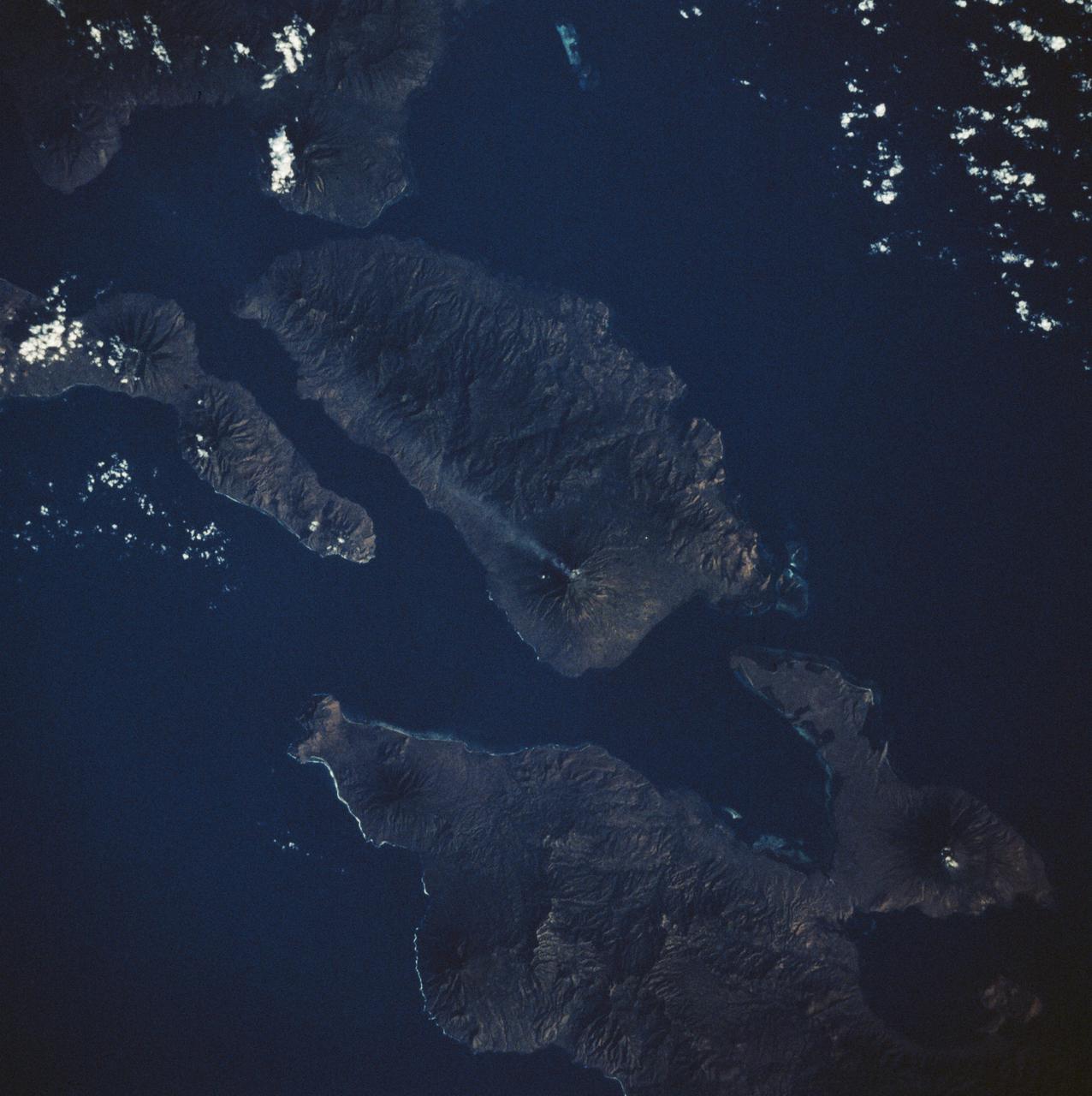
STS008-50-1840 (30 Aug-5 Sept 1983) --- An active 5,500 foot high volcano on Adonara Island in Indonesia leaves a 30 mile long visible trail of smoke. The surrounding islands are Flores (lower right) Solor (right edge) and Lomblen (upper center). This photograph was made from the Earth orbiting Space Shuttle Challenger on its third mission.
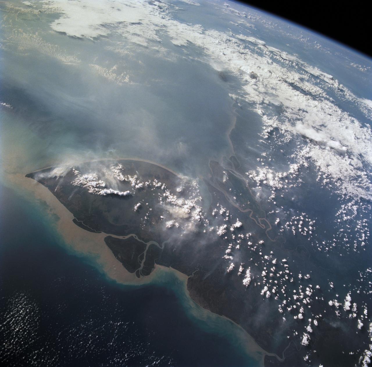
STS068-261-062 (30 September-11 October 1994) --- Vals Cape (left) is the prominent point of the island of New Guinea (Indonesia's Irian Jaya) that juts southwest into the Arafura Sea, pointing towards Australia. The part of New Guinea in this northwest-looking view is entirely low-lying swampland with very low population density. The Digul River, snaking across the middle of the view, drains the high mountain chain, which runs along the spine of the island.
iss071e256931 (July 1, 2024) --- The long duration photograph from the International Space Station highlights the Rassvet module (left) and the Soyuz MS-25 spacecraft (right) docked to the Prichal module which is itself attached to the Nauka science module. 255 miles below the orbital outpost is a cloudy Pacific Ocean blanketing islands northeast of Indonesia's province of Papua. Above Earth's horzon is the planet's atmospheric glow and star trails glittering in the vastness of space.
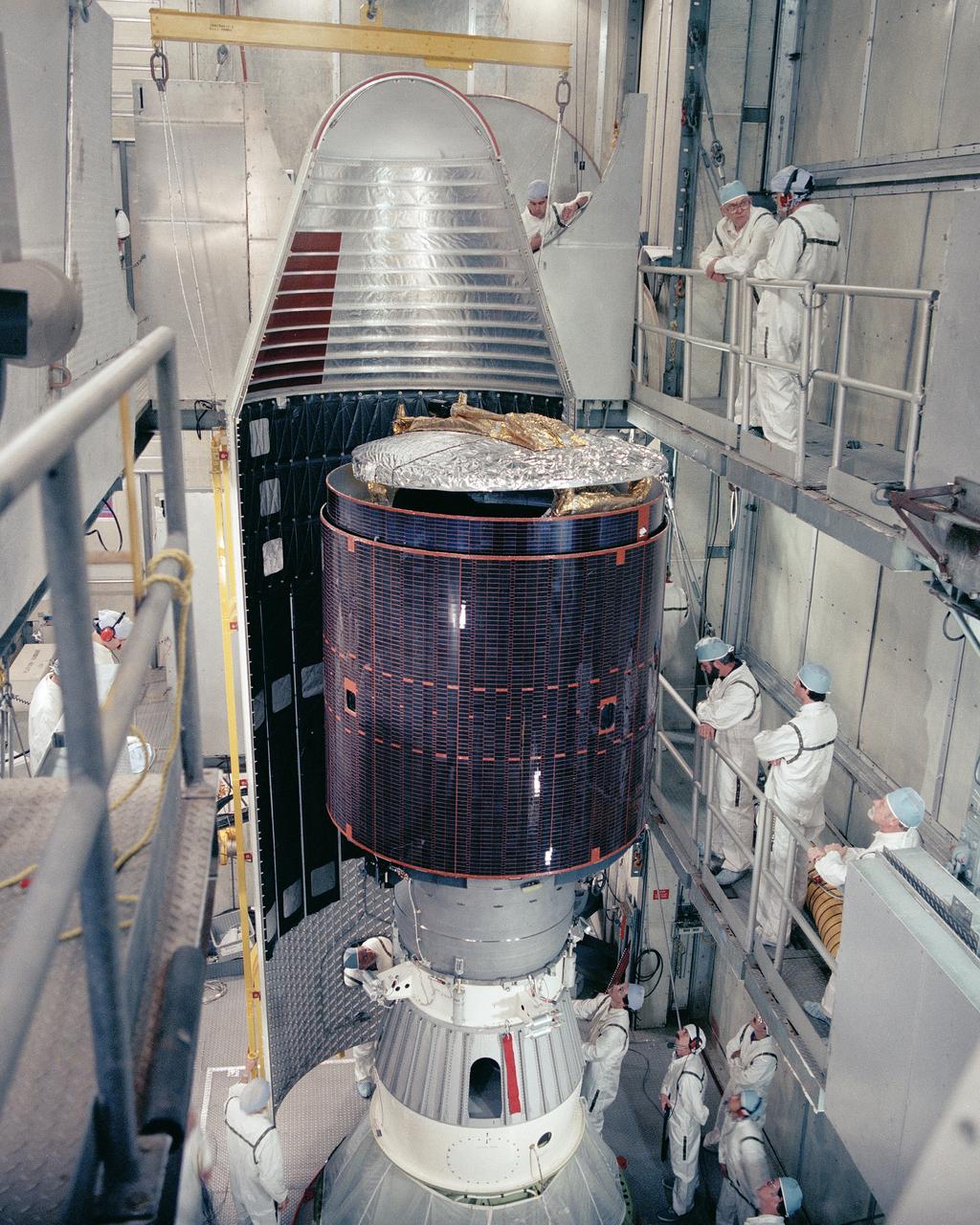
CAPE CANAVERAL, Fla. -- At Cape Canaveral Air Force Station in Florida, the paylaod fairing of the Delta 182 launch vehicle is carefully moved into place as encapsulation procedures continue on the Palapa B2-P communications satellite at Launch Complex 17, Pad B. Palapa is scheduled for launch from Cape Canaveral for the government of Indonesia. Liftoff of Delta 182 and Palapa is scheduled for March 20. Photo Credit: NASA

iss065e238807 (Aug. 12, 2021) --- The Northrop Grumman Cygnus space freighter is in the grips of the Canadarm2 robotic arm as it is installed on the International Space Station's Unity module. At left is a portion of one of the orbiting lab's main solar arrays. At right is the Soyuz MS-18 crew ship docked to the Rassvet module. The space station was orbiting into a sunset above far eastern Indonesia at the time of this photograph.

iss073e0379986 (July 16, 2025) --- In this long duration photograph taken from the International Space Station clouds streak across the Indian Ocean, a dim atmospheric glow crowns Earth's horizon, and stars trail above the planet's horizon. The orbital outpost was soaring 261 miles above the Indian Ocean southwest of Indonesia at approximately 3:14 a.m. local time.

iss074e0043595 (Dec. 29, 2025) --- This long-duration photograph of Earth’s horizon was taken at approximately 8:30 p.m. local time from the International Space Station as it orbited 260 miles above the Indian Ocean, south of Jakarta, Indonesia. A yellow-green airglow crowns the horizon beneath a starry sky and a faint Milky Way. Credit: JAXA/Kimiya Yui
ISS011-E-09620 (26 June 2005) --- Grasberg Mine, Indonesia is featured in this image photographed by an Expedition 11 crewmember on the International Space Station. Located in the Sudirman Mountains of the Irian Jaya province of Indonesia, the Grasberg complex (also known as the Freeport Mine) is one of the largest gold and copper mining operations in the world. The Sudirman Mountains form the western portion of the Maoke Range that extend across Irian Jaya from west to the east-southeast. According to scientists, these ranges were formed by ongoing collision of the northward-moving Australian and westward-moving Pacific tectonic plates. Intrusion of hot magma into sedimentary rock layers during uplift of the mountains resulted in the formation of copper- and gold-bearing ore bodies. Rich copper ore bodies were discovered in the area in 1936, and the Grasberg gold-bearing ore bodies were discovered in 1988. This image illustrates the approximately 4 kilometers-wide open-pit portion of the mine complex; there are also extensive underground mine workings. Access roads for trucks hauling ore and waste rock are visible along the sides of the pit.
ISS010-E-13079 (15 January 2005) --- Tsunami damage, northwestern Sumatra (Indonesia) is featured in this image photographed by an Expedition 10 crewmember on the International Space Station (ISS). On December 26, 2004 a large (magnitude 9.0) earthquake occurred off the western coast of Sumatra in the Indian Ocean. Scientists believe the earthquake was caused by the release of stresses accumulated as the India tectonic plate is overridden by the Burma tectonic plate. Movement of the seafloor due to the earthquake generated a tsunami, or seismic sea wave, that affected coastal regions around the Indian Ocean. The northwestern Sumatra coastline in particular suffered extensive damage and loss of life. This photo, along with image ISS010-E-13088, illustrates damage along the southwestern coast of Aceh Province in the vicinity of the city of Lho’ Kruet, Indonesia. Large areas of bare and disturbed soil (brownish gray) previously covered with vegetation are visible along the coastline. Embayments in the coastline were particularly hard hit, while adjacent headlands were less affected.
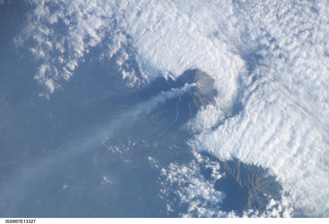
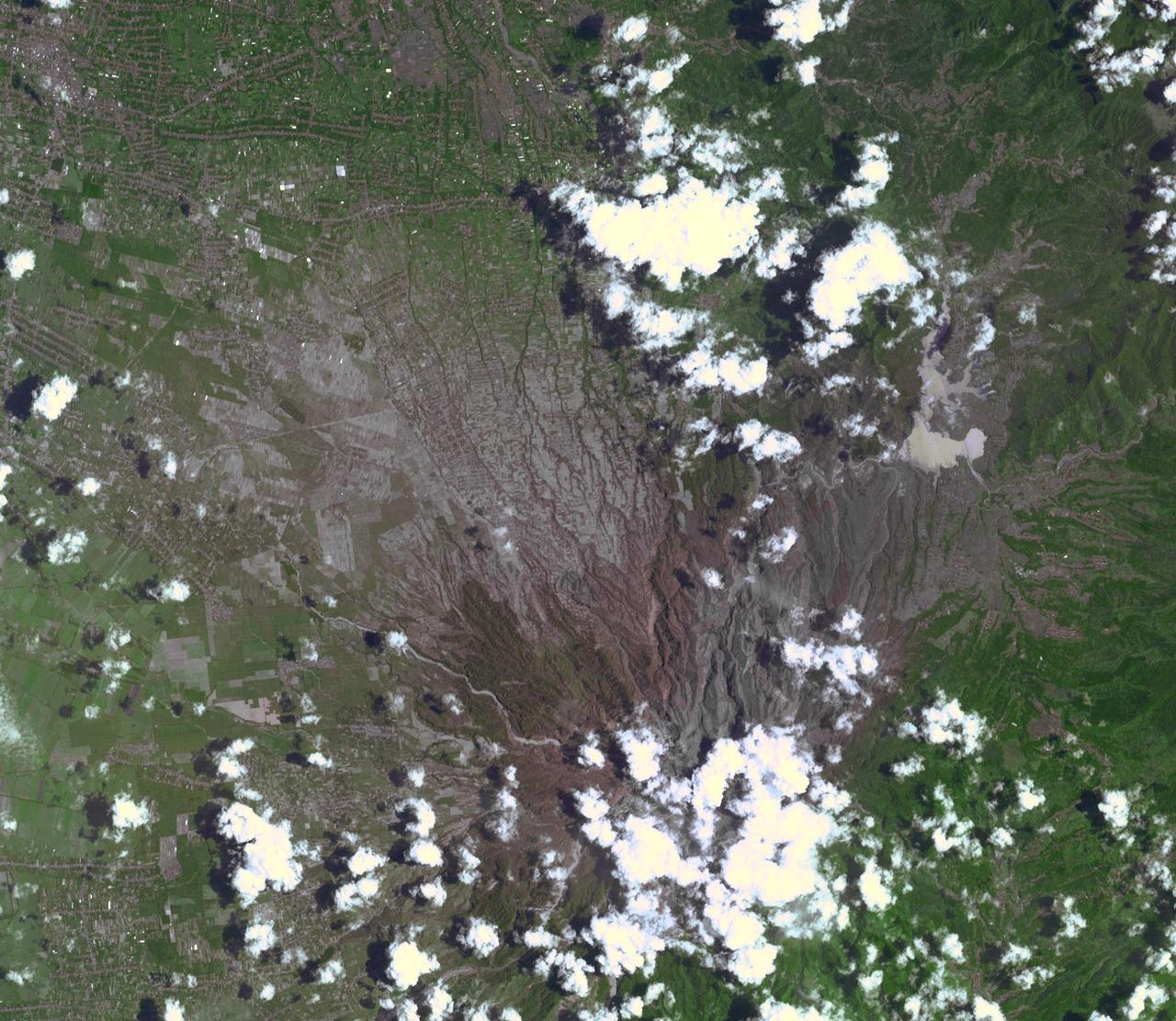
ISS007-E-13327 (24 August 2003) --- This view featuring Java’s Merapi volcano was photographed by one of the Expedition 7 crewmembers onboard the International Space Station (ISS). At 2,911 meters, the summit of Merapi and its vigorous steam plume rises above a bank of stratus clouds. One of Indonesia’s most active volcanoes, it has been almost continuously active for nearly ten years, including periodic pyroclastic flows and avalanches. The volcano is located less than 25 miles north of the city of Yogykarta in central Java.
STS093-708-062 (23-27 July 1999) --- The STS-93 astronauts took this picture of the Island of Borneo, which is divided among Indonesia, Malaysia and Brunei. The Rajang River meets the South China Sea in the northwestern portion of the Malaysian state of Sarawak. Smoke from both large and small fires is blowing north by the prevailing summer winds. Notice the contrast of dark colored rainforest with the lighter clearings where the largest fires are burning. According to NASA scientists studying the STS-93 photo collection, the sediment plumes along the coast are mostly shoreline erosional materials caught up in longshore currents. The Saribas River can be seen at the bottom.
S66-54692 (14 Sept. 1966) --- Indonesian Islands (partial cloud cover): Sumatra, Java, Bali, Borneo, and Sumbawa, as photographed from the Gemini-11 spacecraft during its 26th revolution of Earth, at an altitude of 570 nautical miles. Photo credit: NASA
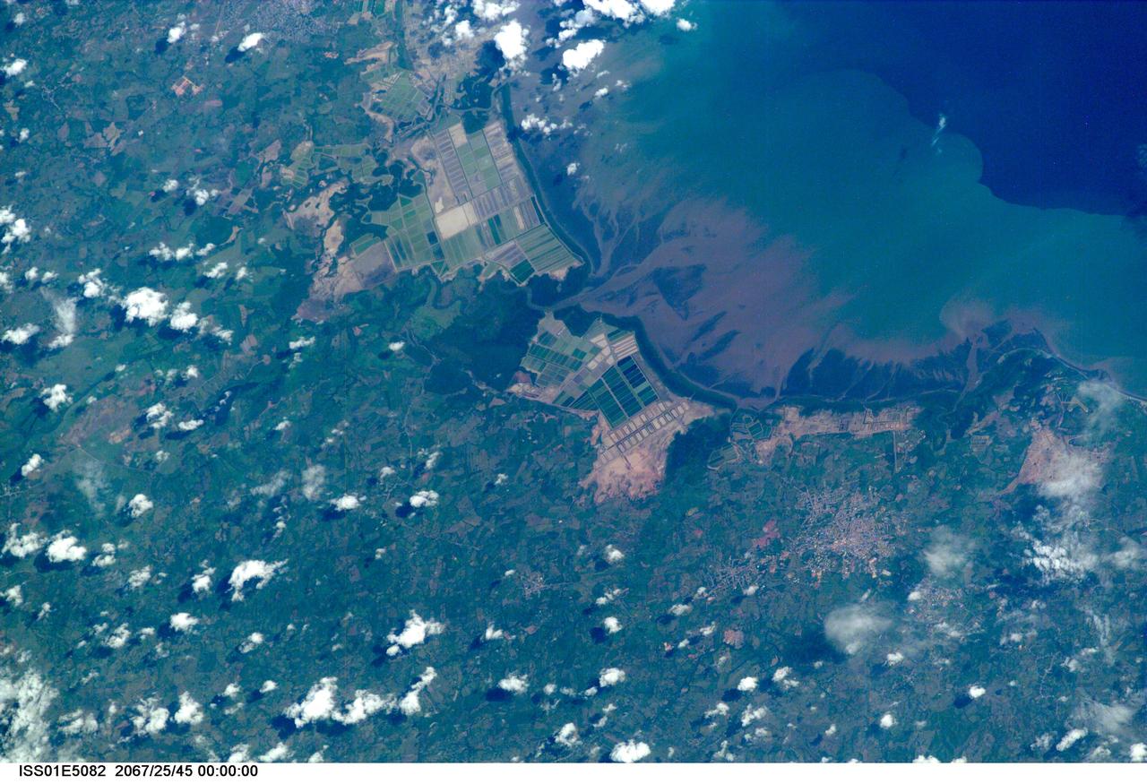
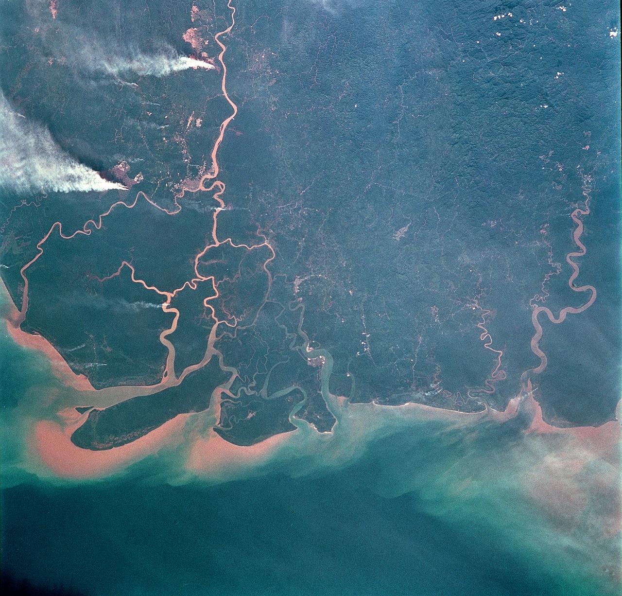
ISS01-E-5082 (December 2000) --- This image of coastal Asia was taken from the International Space Station with a digital still camera and a 400mm lens with a very narrow field of view. Early in the Space Station Program, communications with the crew are less direct, and the exact time that this image was taken could not be determined. Because there are relatively few photograph of Earth taken with this long lens, and because the times are not available to calculate the exact position of the Station over the Earth when the photograph was taken, the exact location of the photograph cannot be determined. Many of these logistical problems will be resolved as camera equipment is replaced and communications with the crew improve. Catalogers believe the coast most resembles Indonesia, and this determination will be maintained until future images allow correction and refinement of the location. The photograph is a striking example of the degree to which humans modify coastal environments. The large green squares in the image probably represent a combination of rice cultivation and aquaculture.

STS058-76-041 (18 Oct-1 Nov 1993) --- Backdropped against the Peru-Bolivia border and part of the Amazon basin, the Spacelab Life Sciences (SLS-2) laboratory module was captured with a 70mm camera, by one of the seven crew members inside the Space Shuttle Columbia's cabin. Part of the tunnel-like passageway is visible in the foreground. Six NASA astronauts and a veterinarian from the private sector spent two weeks devoted to medical research in Earth-orbit. Lake Titicaca, the largest high-altitude lake in the world lies in the Altiplano of Bolivia and Peru. Space Shuttle photography has been used to document fluctuations of several meters of the level of Lake Titicaca during the past decade, as well as to document the eutrophication of the north end of the lake, which is primarily due to increased population in the Peruvian shoreline areas. This view shows the effect of abnormally heavy precipitation of the region for the third successive year. Meteorologists feel this precipitation increase, which may portend another increase of the lake level, is due to the third successive El Nino - Southern Oscillation phenomenon in the 1993 - 94 southern hemisphere summertime. This global phenomenon is now resulting in major weather disturbances in Indonesia, California, Texas and elsewhere.

ISS040-E-088891 (5 Aug. 2014) --- Thunderheads near Borneo, Indonesia are featured in this image photographed by an Expedition 40 crew member on the International Space Station. Late afternoon sun casts long shadows from high thunderhead anvils over southern Borneo. Crews aboard the space station have recently concentrated on panoramic views of clouds?taken with lenses similar to the focal length of the human eye. These images reveal the kinds of views crews see -- huge areas of the planet, with a strong three-dimensional sense of what it is like to fly 350 kilometers above Earth. Winds usually blow in different directions at different altitudes. High-altitude winds are clearly sweeping the tops off the many tallest thunderclouds, generating long anvils of diffuse cirrus plumes that trail south. At low levels, ?streets? of white dots -- fair-weather cumulus clouds -- are aligned with west-moving winds (lower left). Small smoke plumes from forest fires onshore are also aligned west. Storm formation near the horizon -- more than 1,000 kilometers away (center) -- is assisted by air currents rising over the central mountains of Borneo.

STS032-80-036 (9-20 Jan. 1990) --- This oblique view of Tropical Storm Sam in the eastern Indian Ocean off the western coast of Australia was photographed with a 70mm camera by the astronauts. Tropical Storm Sam (known as Willy-Willy in Australia) was born in the eastern Indian Ocean near the islands of Timor and Sumba in Indonesia. The storm tracked southwestward attaining sustained winds in excess of 60 knots (70 miles per hour). Other than on Christmas Island and the Cocos (Keeling) Islands south of Java, and for strong swells along the western Australia coast, the storm had little impact on land areas. At the time this photograph was taken, the storm was beginning to dissipate in the south Indian Ocean. The eye of the storm is still visible near center, with the swirling bands of the storm propagating in a clockwise direction toward the center. Winds aloft have begun to shear the tops of thunderstorms associated with the storm, forming a high cirrus cloud cover over the center portions of the storm. This picture was used by the crew at their January 30, 1990 Post-Flight Press Conference (PFPC).
Fires burning in Sumatra continued to pour smoke over the region in mid-March, 2014, bringing air quality to dangerous levels. The Moderate Resolution Imaging Spectroradiometer (MODIS) aboard NASA’s Aqua satellite captured this true-color image of the smoke and haze across the region on March 12. According to the Jakarta Post, on March 12 the Sumatra Environmental Laboratory reported that 10 of 12 spots in Riau had an air quality of index above 300 on the Pollutant Standards Index (PSI), which is considered hazardous. Hazardous air quality had been recorded in some of the locations for 11 consecutive days. The province of Riau is located in the central eastern coast of Sumatra and, in this image, is hidden under thick bands of light gray smoke. Intense fires, reported as deliberately set to clear land, were burning in the Giam Siak Kecil-Bukit Batu biosphere reserve. This reserve contains over 700,000 hectares of sensitive peat forest that sustains a wide range of plant and animal species, including the Sumatra tiger, elephant, tapir and sun bear. With visibility as low as 500 m (1640 ft), 58 flights were cancelled in Pekanbaru, the capital of Riau province, on March 11. Schools were closed across the region, with 43,000 students affected in Payakumbuh, West Sumatra. On March 14, Selangor, Malaysia closed 203 schools, affecting 211,700 pupils, until the air quality improved. On that same day, according to Riau Health Agency, more than 55,000 residents in the province were suffering from haze-related illnesses, including acute respiratory infections, pneumonia and skin and eye irritation. Poor air quality not only affected transportation, human health and the ecosystem, but has had significant economic impacts. On March 17, Reuters reported that the poor air quality had forced Chevron, the country’s biggest oil producer, to close hundreds of its wells. As a result, Indonesia’s crude oil output dropped to 790,000 barrels per day (bpd) – significantly lower than the 870,000 bpd target. Although slash-and-burn techniques, which use fire to clear land, is illegal in Indonesia, the practice is still widespread, with approximately 99% of fires in Sumatra considered to be intentionally set. This year’s early agricultural fires began in February in Riau Province, home to palm-oil and pulpwood plantations. The emergency has prompted strong government response, including a shoot-on-sight order for any suspects involved in land burning activities that resisted arrest. According to the Jakarta Post, police have named as many as 60 suspected-fire starters in Riau. Credit: NASA/GSFC/Jeff Schmaltz/MODIS Land Rapid Response Team <b><a href="http://www.nasa.gov/audience/formedia/features/MP_Photo_Guidelines.html" rel="nofollow">NASA image use policy.</a></b> <b><a href="http://www.nasa.gov/centers/goddard/home/index.html" rel="nofollow">NASA Goddard Space Flight Center</a></b> enables NASA’s mission through four scientific endeavors: Earth Science, Heliophysics, Solar System Exploration, and Astrophysics. Goddard plays a leading role in NASA’s accomplishments by contributing compelling scientific knowledge to advance the Agency’s mission. <b>Follow us on <a href="http://twitter.com/NASAGoddardPix" rel="nofollow">Twitter</a></b> <b>Like us on <a href="http://www.facebook.com/pages/Greenbelt-MD/NASA-Goddard/395013845897?ref=tsd" rel="nofollow">Facebook</a></b> <b>Find us on <a href="http://instagram.com/nasagoddard?vm=grid" rel="nofollow">Instagram</a></b>
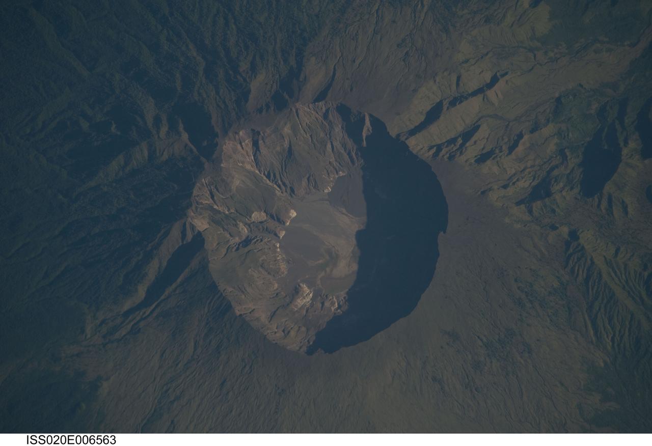
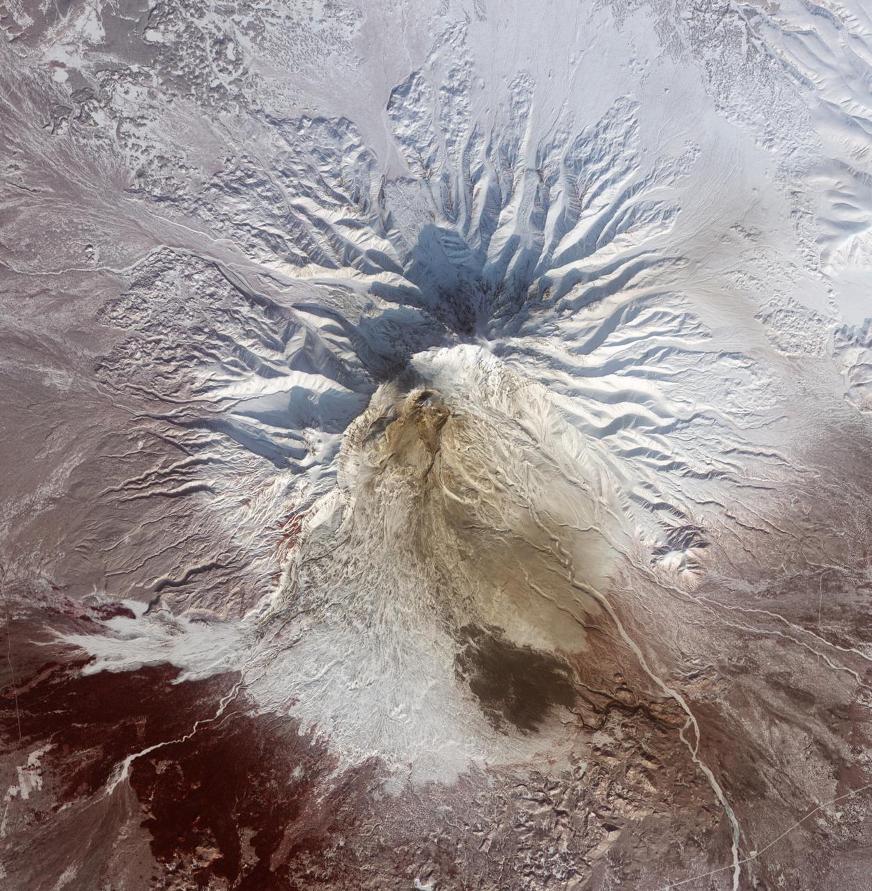
ISS020-E-006563 (3 June 2009) --- Mount Tambora Volcano, Sumbawa Island in Indonesia is featured in this image photographed by an Expedition 20 crew member on the International Space Station. On April 10, 1815 the Tambora volcano produced the largest eruption in history. An estimated 150 cubic kilometers of tephra ? exploded rock and ash ? was produced, with ash from the eruption recognized at least 1,300 kilometers away to the northwest. While the April 10 eruption was catastrophic, historical records and geological analysis of eruption deposits indicate that the volcano had been active between 1812 and 1815. Enough ash was input into the atmosphere from the April 10 eruption to reduce incident sunlight on Earth?s surface and cause global cooling, resulting in the 1816 ?year without a summer?. This detailed photograph depicts the summit caldera of the volcano. The huge caldera ? six kilometers in diameter and 1,100 meters deep ? formed when Tambora?s estimated 4,000 meter-high peak was removed, and the magma chamber below emptied, during the April 10 eruption. Today the crater floor is occupied by an ephemeral fresh-water lake, recent sedimentary deposits, and minor lava flows and domes emplaced during the 19th and 20th centuries. Layered tephra deposits are visible along the northwestern crater rim. Active fumaroles, or steam vents, are still present within the caldera. In 2004 scientists discovered the remains of a village and two adults buried under approximately three meters of ash in a gully on Tambora?s flank - remnants of the former Kingdom of Tambora preserved by the 1815 eruption that destroyed it. The similarity of the Tambora remains to those associated with the 79 AD eruption of Mount Vesuvius has led to the site being called ?the Pompeii of the East.?
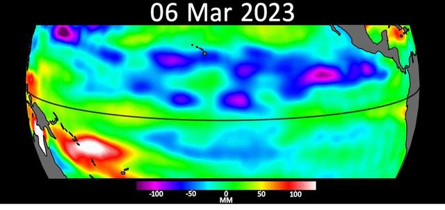
Sea level data from the U.S.-European satellite Sentinel-6 Michael Freilich shows early signs of a developing El Niño along the equatorial Pacific Ocean. The measurements show Kelvin waves, low waves that can be tens of miles (hundreds of kilometers) wide, moving from west to east at the equator towards the west coast of Ecuador. When they form at the equator, Kelvin waves can move warm water – associated with higher sea levels – from the western Pacific to the eastern Pacific. El Niño is a periodic climate phenomenon that can affect weather patterns around the world. The condition can bring cooler, wetter conditions to the U.S. Southwest and drought to countries in the western Pacific such as Indonesia and Australia. El Niño is characterized by higher sea levels and warmer-than-average ocean temperatures along the western coasts of North and South America. Water expands as it warms, so sea levels tend to be higher in places with warmer water. The climate phenomenon is also associated with a weakening of the trade winds. The Sentinel-6 Michael Freilich satellite data shown here covers a seven-week period between the beginning of March and the end of April 2023. By April 24, Figure A, Kelvin waves had piled up warmer water and higher sea levels (shown in red and white) off the coasts of Peru, Ecuador, and Columbia. A series of Kelvin waves starting in spring is a well-known precursor to an El Niño. The waves seen during March and April 2023 are similar to the ones that preceded the 1997-1998 El Niño, one of the most powerful in recorded history. Satellites like Sentinel-6 Michael Freilich can detect Kelvin waves with an instrument called an altimeter that uses radar signals to measure the height of the ocean's surface. Warmer areas show up as higher sea levels. The satellite, named after former NASA Earth Science Division Director Michael Freilich, is one of two that compose the Copernicus Sentinel-6/Jason-CS (Continuity of Service) mission. Animation available at https://photojournal.jpl.nasa.gov/catalog/PIA25776
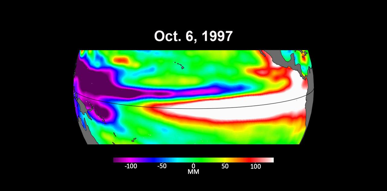
These three maps based on satellite data show sea levels in the Pacific Ocean during developing El Niño events in early October of 1997, 2015, and 2023. Higher-than-average ocean heights are shown in red and white, while lower-than-average heights are blue and purple. The two earlier maps represent the two extreme El Niño events from the past 30 years – the first from 1997 to 1998 and the second from 2015 to 2016. Both caused shifts in global air and ocean temperatures, atmospheric wind and rainfall patterns, and sea level. El Niños are characterized by higher-than-normal sea levels and warmer-than-average ocean temperatures along the equatorial Pacific. Water expands as it warms, so sea levels tend to be higher in places with warmer water. These temperature and sea level conditions can then propagate poleward along the western coasts of the Americas. El Niños can bring wetter conditions to the U.S. Southwest and drought to regions in the western Pacific, including Indonesia. Not all El Niño events are created equal, however, and their impacts vary widely. Satellites like the U.S.-European Sentinel-6 Michael Freilich, which captured the 2023 data, help anticipate those impacts on a global scale by tracking changes in sea surface height in the Pacific Ocean. The TOPEX/Poseidon satellite collected the 1997 data while Jason-2 collected data for the 2015 event. This year's El Niño is still developing, but researchers are looking to the recent past for clues as to how it is shaping up. By October 1997 and 2015, large areas of the central and eastern Pacific had sea levels more than 7 inches (18 centimeters) higher than normal. This year, sea levels are about 2 or 3 inches (5 to 8 centimeters) higher than normal and are elevated over a smaller area compared to the 1997 and 2015 events. Both of the past El Niños reached peak strength in late November or early December, so this year's event may still intensify. Launched in November 2020, Sentinel-6 Michael Freilich is named after former NASA Earth Science Division Director Michael Freilich. The satellite is one of two that compose the Copernicus Sentinel-6/Jason-CS (Continuity of Service) mission. Animation available at https://photojournal.jpl.nasa.gov/catalog/PIA26099
NASA image acquired February 25, 2011 Pyroclastic flows are some of the most fearsome hazards posed by erupting volcanoes. These avalanches of superheated ash, gas, and rock are responsible for some of the most famous volcanic disasters in history, including the burial of the ancient Roman city of Pompei and the destruction of Saint-Pierre in 1902. More recently, pyroclastic flows from Mount Merapi in Indonesia caused most of the casualties during the volcano’s 2010 eruption. The intense heat—over 1,000° Celsius (1800° Fahrenheit)—the terrific speed—up to 720 kilometers (450 miles) per hour—and the mixture of toxic gases all contribute to the deadly potential. Pyroclastic flows can incinerate, burn, or asphyxiate people who cannot get out of the flow path. This false-color satellite image from the Advanced Spaceborne Thermal Emission and Reflection Radiometer (ASTER) on the Terra satellite shows the remnants of a large pyroclastic flow on the slopes of Shiveluch Volcano. Fortunately, no one was hurt during the eruption and flow in the sparsely-populated area. ASTER detected heat from the flow during or shortly after an event on January 25, 2011. Note how the heat signatures from January line up with the dark surface deposits visible on February 25; those deposits cover more than 10 square kilometers (4 square miles). Light brown ash covers the snow above the flow deposits, and a tiny plume rises from Shiveluch’s growing lava dome. Vegetation surrounding the volcano is colored dark red. NASA Earth Observatory image by Robert Simmon, using data from the NASA/GSFC/METI/ERSDAC/JAROS, and U.S./Japan ASTER Science Team. Caption by Robert Simmon. Instrument: Terra - ASTER Credit: <b><a href="http://www.earthobservatory.nasa.gov/" rel="nofollow"> NASA Earth Observatory</a></b> <b><a href="http://www.nasa.gov/centers/goddard/home/index.html" rel="nofollow">NASA Goddard Space Flight Center</a></b> enables NASA’s mission through four scientific endeavors: Earth Science, Heliophysics, Solar System Exploration, and Astrophysics. Goddard plays a leading role in NASA’s accomplishments by contributing compelling scientific knowledge to advance the Agency’s mission. <b>Follow us on <a href="http://twitter.com/NASA_GoddardPix" rel="nofollow">Twitter</a></b> <b>Join us on <a href="http://www.facebook.com/pages/Greenbelt-MD/NASA-Goddard/395013845897?ref=tsd" rel="nofollow">Facebook</a></b>