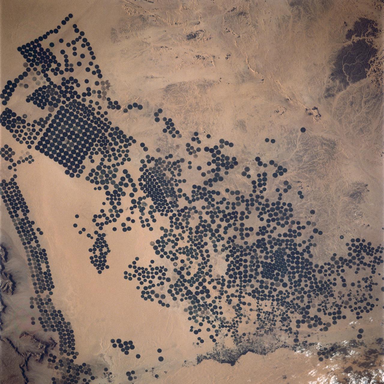
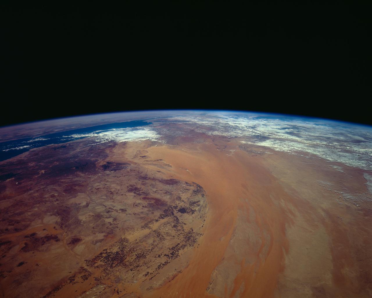
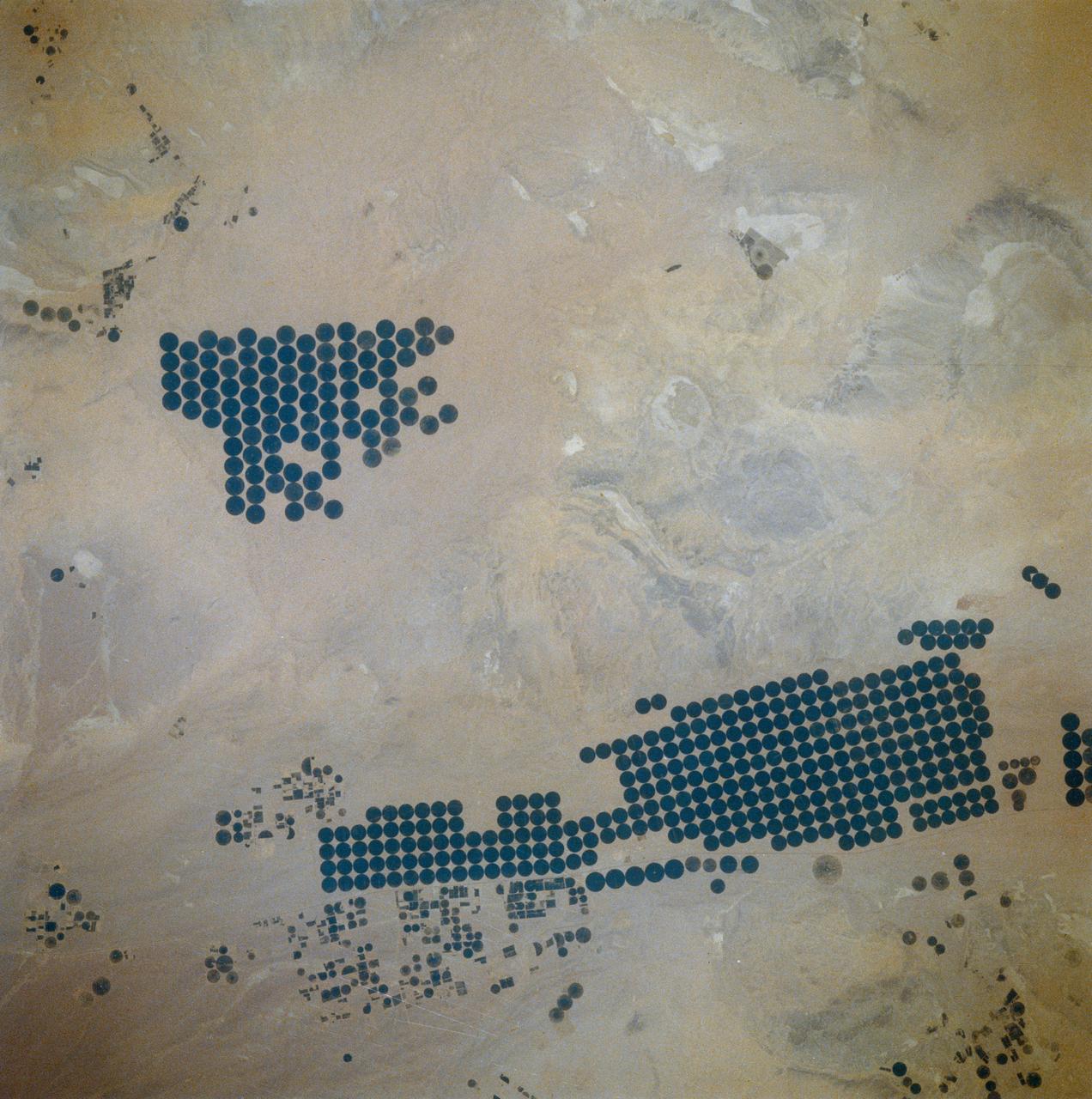
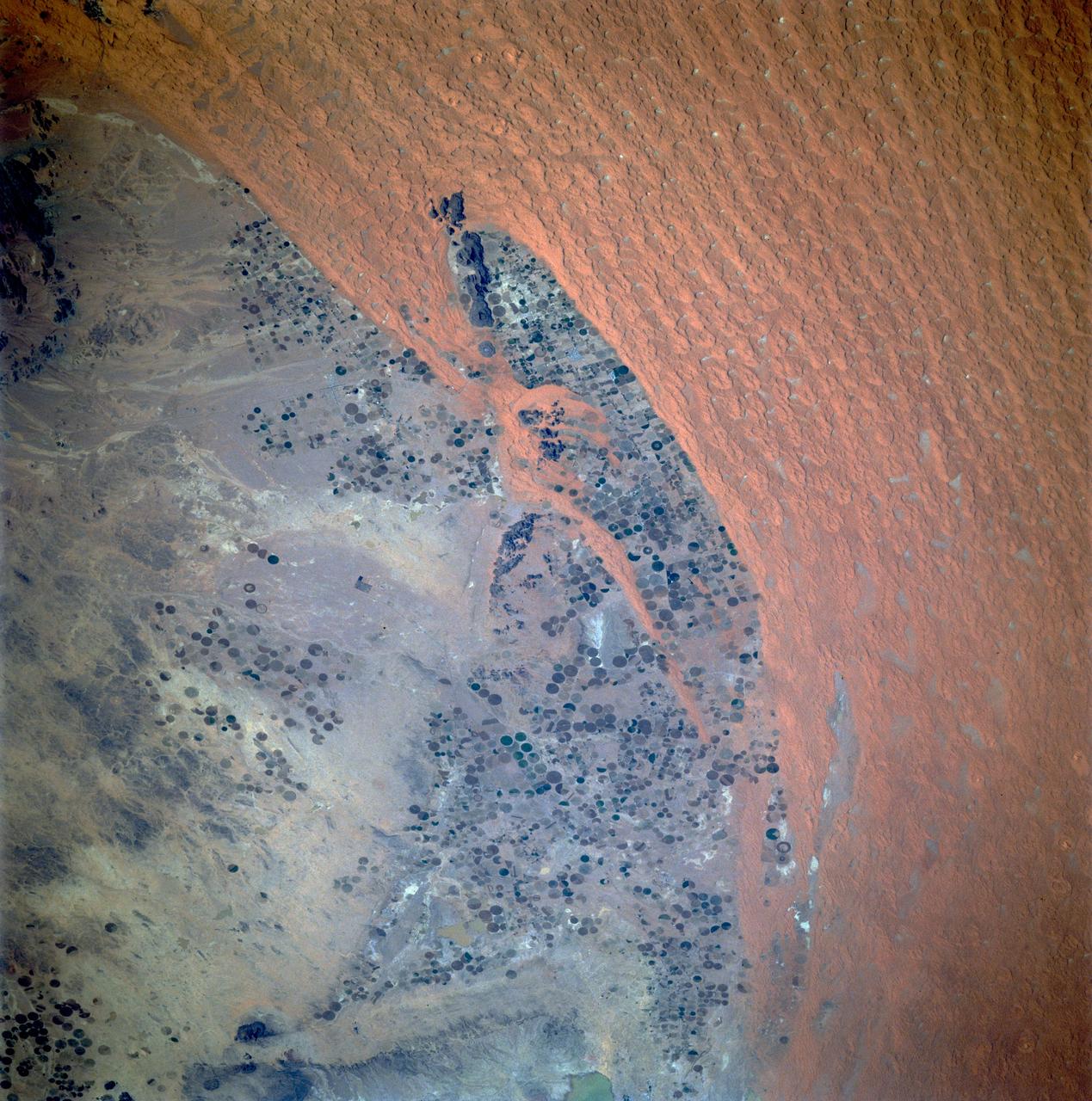
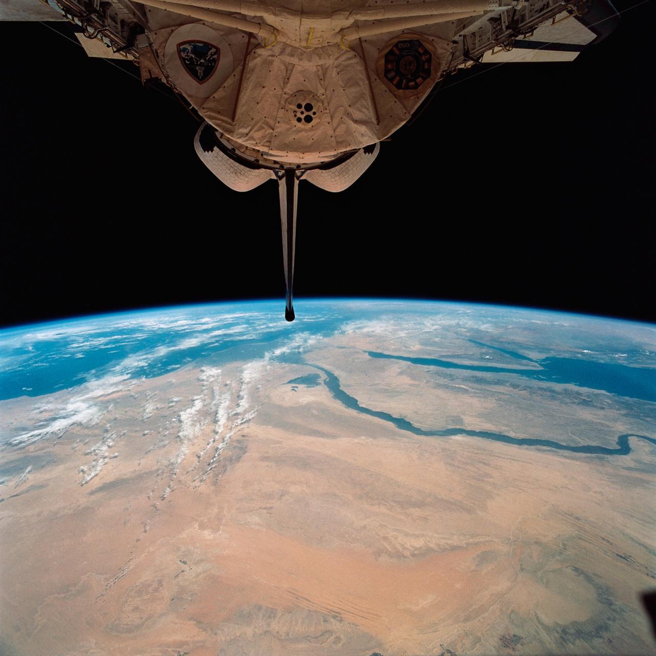
In Saudi Arabia, center-pivot, swing-arm irrigated agriculture complexes such as the one imaged at Jabal Tuwayq (20.5N, 45.0 E) extract deep fossil water reserves to achieve food crop production self sufficiency in this desert environment. The significance of the Saudi expanded irrigated agriculture is that the depletion of this finite water resource is a short term solution to a long term need that will still exist when the water has been extracted.
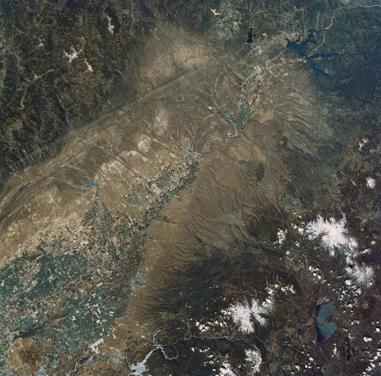
This image from NASA EarthKAM shows pivot irrigation near the city of As Sulayyil Sulayel, Saudi Arabia. The edge of the Rub al-Khali or Empty Quarter is visible in the southeast.
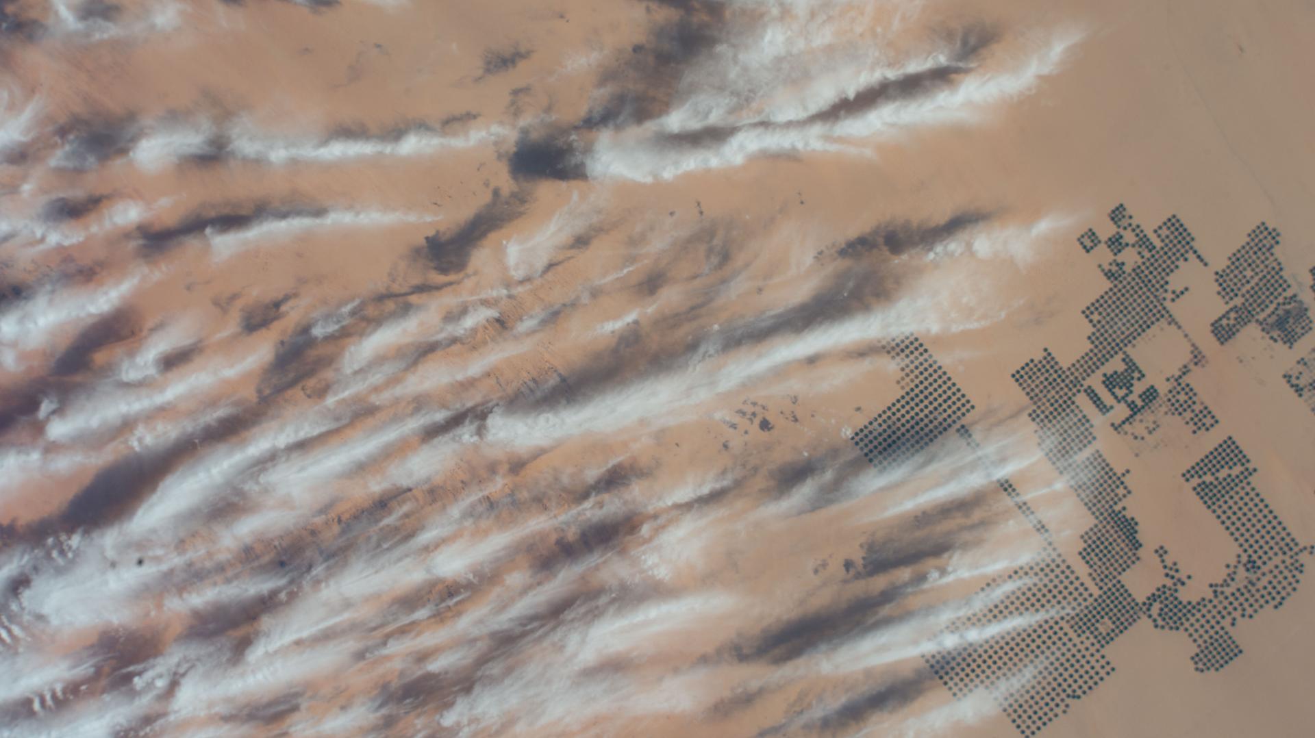
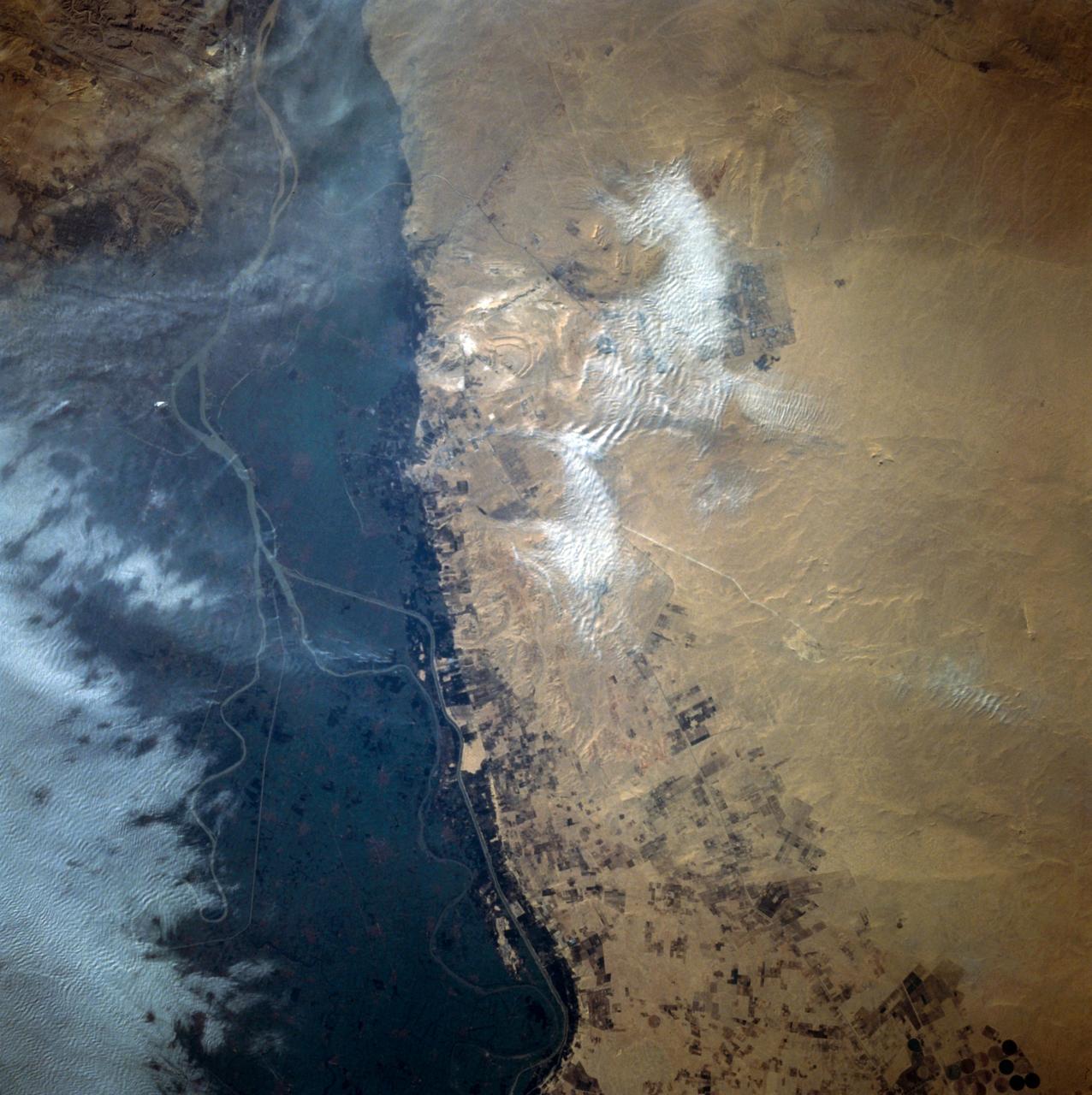
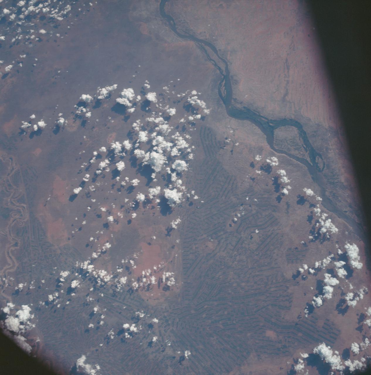
iss074e0247459 (Feb. 1, 2026) --- Large-scale agricultural projects (right) in southern Egypt near the Sudan border—known as center-pivot irrigation systems because they use an irrigation arm that rotates 360°, forming a perfect circle of crops such as potatoes and wheat—are pictured from the International Space Station as it orbited 258 miles above the African nation. Wispy cirrus clouds partly cover the cultivated land in the barren, extremely arid Western Desert.
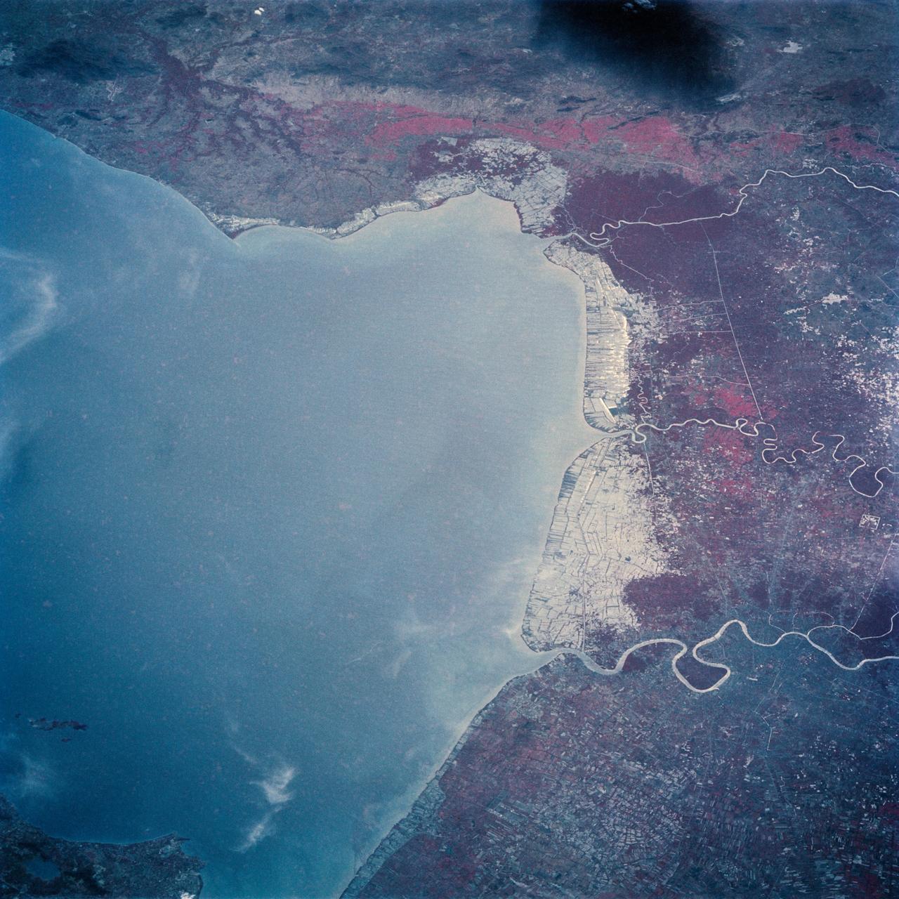
The Bight of Bangkok and the city of Bangkok, Thailand are visible in this west looking view. The city of Bangkok, with an estimated population in excess of 3.7 million people, can be seen in the lower right-hand corner of the view. The city, famous as a jewelry trading center, dealing in precious stones and silver and bronze ware, is situated in a vast lowland. This lowland is a major rice growing area interspersed with canals used for irrigation and drainage. Rice is a major export commodity of Thailand. The deforested hills of the Bilauktaung Range can be seen at the top of the view.
STS054-152-189 (13-19 Jan. 1993) --- This near-vertical color photograph shows the very diverse landscape that is part of the great Sahara Desert of north Africa. Specifically, the vast expanse of sand dunes, located in the extreme southwestern corner of Libya, is known as the Murzuk Sand Sea. Close inspection of this photograph shows the agricultural village of Murzuk as evidenced by the numerous center pivot irrigation patterns at the edge of the Murzuk Sand Sea. The very rugged, dissected terrain to the west of this sand sea is the eastern tip of the Tassili N'ajjer Mountains and the Tadrart Plateau that are in neighboring Algeria. Several smaller areas of sand dunes are interspersed between the major areas of rock outcrops. The photograph was taken with a Linhof camera.
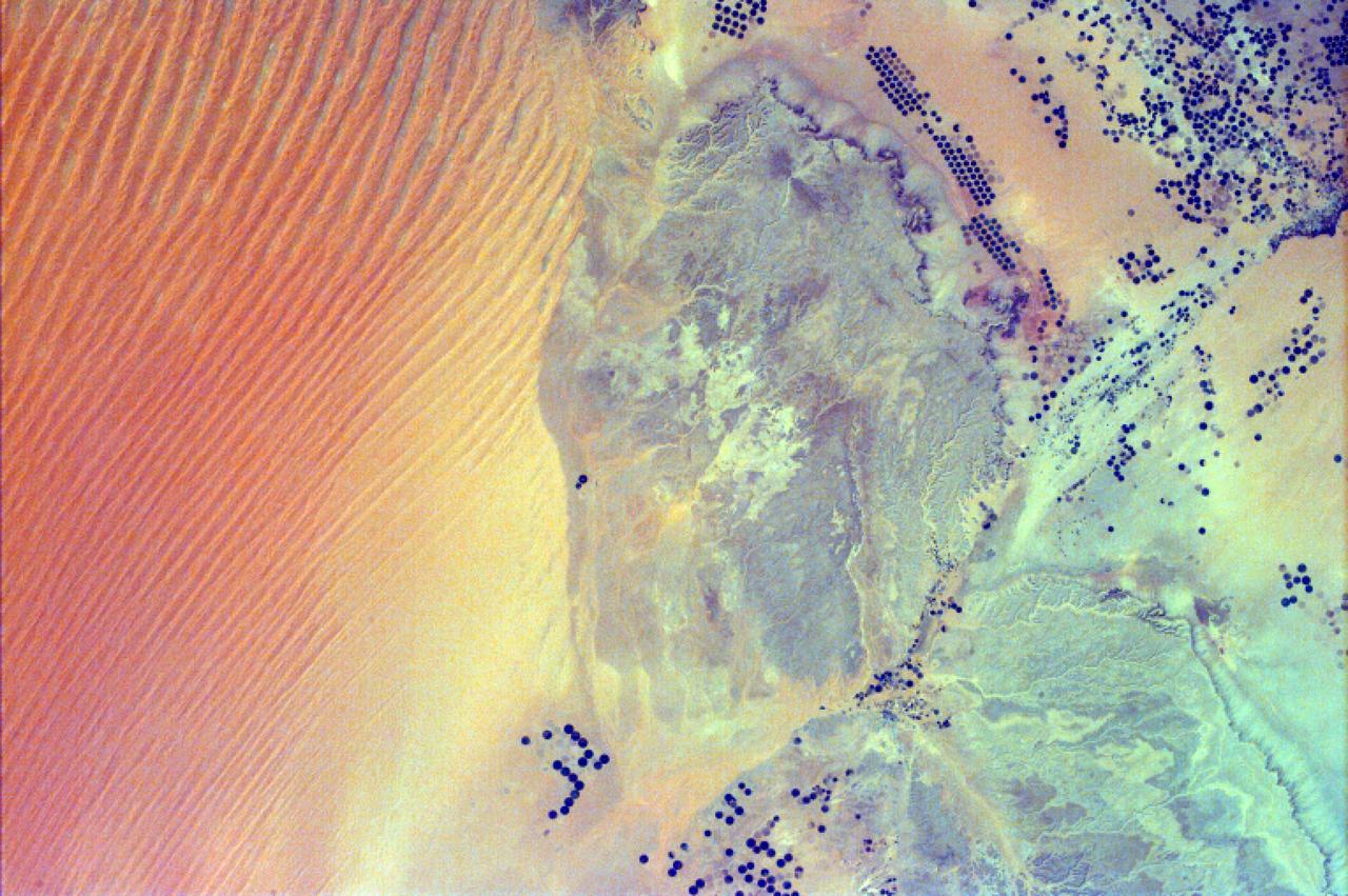
Acquired by NASA Terra spacecraft on in 2011, this image shows the Wadi As-Sirhan Basin in northwest Saudi Arabia, which has been steadily developing agricultural fields using center pivot irrigation by tapping into fossil ground water.
The lowlands of Lombardy and Piedmont in northwest Italy are some of the most highly developed irrigation areas in the world. These views of the region were acquired on May 8, 2005, by NASA Terra spacecraft.
This perspective view includes the city of Salalah, the second largest city in Oman. The city is located on the broad, generally bright coastal plain and includes areas of green irrigated crops.
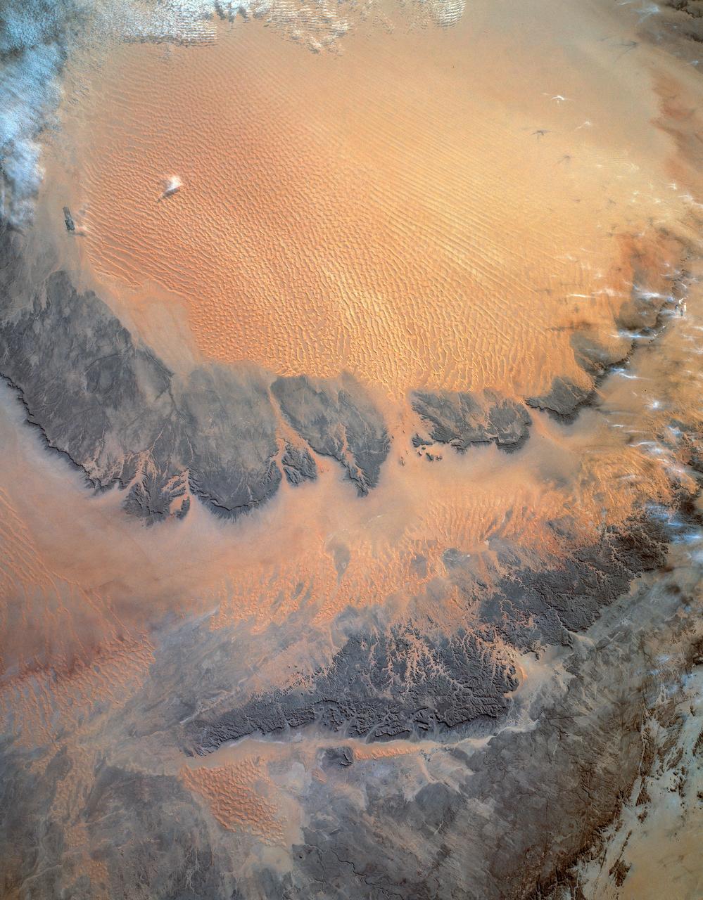
STS062-151-220 (4-18 March 1994) --- Great numbers of circular, center-pivot irrigation plots appear in this west-looking view of the northern Saudi Arabia (center to lower left). So many plots now exist that the face of Saudi Arabia as seen from low earth orbit has changed. Until a few years ago, there were only a few scattered center-pivots. Now the entire swath of country between the shifting sands of the Ad Dahna Sand Sea (light colors center and right) and the almost soilless Nejd Plateau (left) has been darkened by thousands of these agricultural fields. The Nejd Plateau is a mass of dark rocks, some volcanic, in NW Saudi Arabia. Water from this higher country flows east towards the agricultural region where it is pumped up from underground aquifers. The weep of the Ad Dahna Sand Sea is one of the major features of Saudi Arabia (center and right) as seen from the orbiter. The dunes follow the trend of regional winds (northwesterly in the center of the view) which circulate around the Nejd plateau. The north end of the Red Sea can be seen top left with the Sinai Peninsula and Mediterranean are just visible center top. Iraq is under cloud top right.
STS059-L22-140 (9-20 April 1994) --- View northeastward across Uzbekastan to the partly-ice-covered Aral Sea and Kazakhstan. The irrigated fan-delta of the Amu Darya extends from the right side of the photograph to end in extensive salt flats at the south end of the sea. The Aral was the fourth-largest inland sea or lake in the world, until diversion and over-use of the river water for irrigation led, in this arid climate, to the sea's decline. Linhof camera.
STS087-717-088 (19 November – 5 December 1997) --- Featured in this view are Sudan’s agricultural projects dependent on irrigation. Just southeast of the confluence of the Blue and White Nile rivers (and the city of Khartoum) is one of the largest irrigation projects in the world, known as the Gezira Scheme. The economy of Sudan is largely based on agriculture. The Gezira Scheme was begun by the British in 1925 and distributes water from the Blue Nile through canals and ditches to tenant farms lying between the Blue and White Nile rivers. Farmers cooperate with the Sudanese government and the Gezira Board. This network of canals and ditches is 2,700 miles (4,300 kilometers) long, and the irrigated area covers 2.5 million acres (1 million hectares). The main crop grown in this region is cotton. This picture is one of the 70mm Earth observations visuals used by the crew at its post flight presentation events.
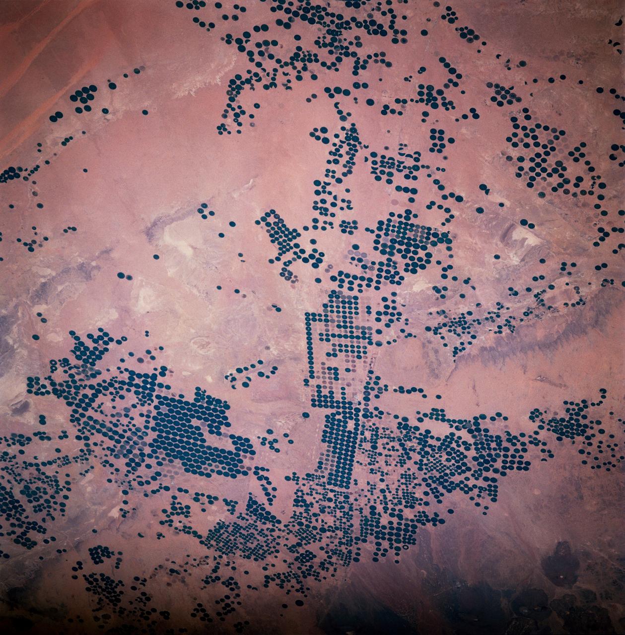
STS083-747-033 (4-8 April 1997) --- Center Pivot Irrigation, in Saudi Arabia. This irrigation project in Saudi Arabia is typical of many isolated irrigation projects scattered throughout the arid and hyper-arid regions of the Earth. Fossil water is mined from depths as great as 3,000 feet, pumped to the surface, and distributed via large center pivot irrigation feeds. The circles of green irrigated vegetation may comprise a variety of agricultural commodities from alfalfa to wheat. Diameters of the normally circular fields range from a few hundred meters to as much as 2 miles. The projects often trace out a narrow, sinuous, and seemingly random path. Actually, engineers generally seek ancient river channels now buried by the sand seas. The fossil waters mined in these projects accumulated during periods of wetter climate in the Pleistocene glacial epochs, between 10,000 to 2 million years ago, and are not being replenished under current climatic conditions. The projects, therefore, will have limited production as the reservoirs are drained. Water, of course, is the key to agriculture in Saudi Arabia. The Kingdom has implemented a multifaceted program to provide the vast supplies of water necessary to achieve the spectacular growth of the agricultural sector. A network of dams has been built to trap and utilize precious seasonal floods. Vast underground water reservoirs have been tapped through deep wells. Desalination plants have been built to produce fresh water from the sea for urban and industrial use, thereby freeing other sources for agriculture. Facilities have also been put into place to treat urban and industrial run-off for agricultural irrigation. These efforts collectively have helped transform vast tracts of the desert into fertile farmland. Land under cultivation has grown from under 400,000 acres in 1976 to more than 8 million acres in 1993.
41C-31-1002 (6-13 April 1984) --- Though previous photographs of this area have been taken prior to 41-C, that mission?s photography represents the best ever of ground water irrigation in Near East deserts. The system here is located in northeast Saudi Arabia, in the vicinity of Al Hufuf. Designed for use in the American west, the center pivot irrigation method pumps water from the ground and broadcasts it in a half-mile diameter circle from a mobile sprinkler system. This frame was one of the visuals used by the 41-C astronauts at their post-flight press conference.
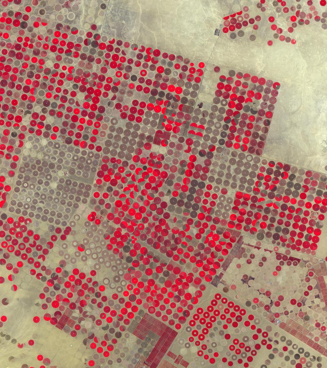
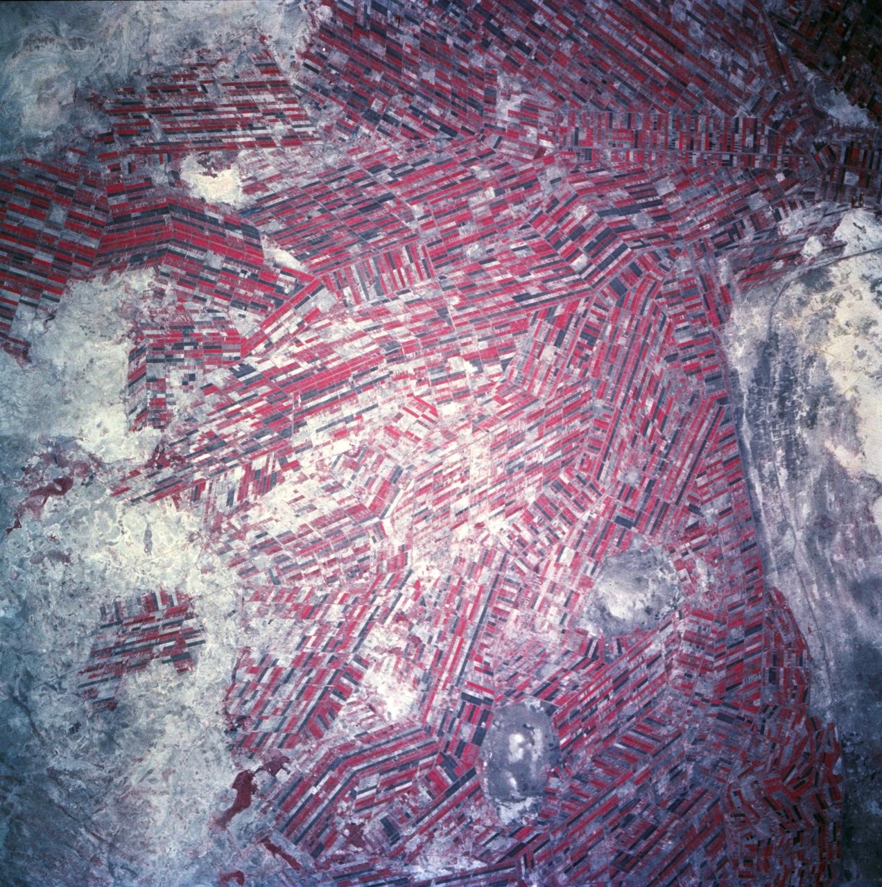
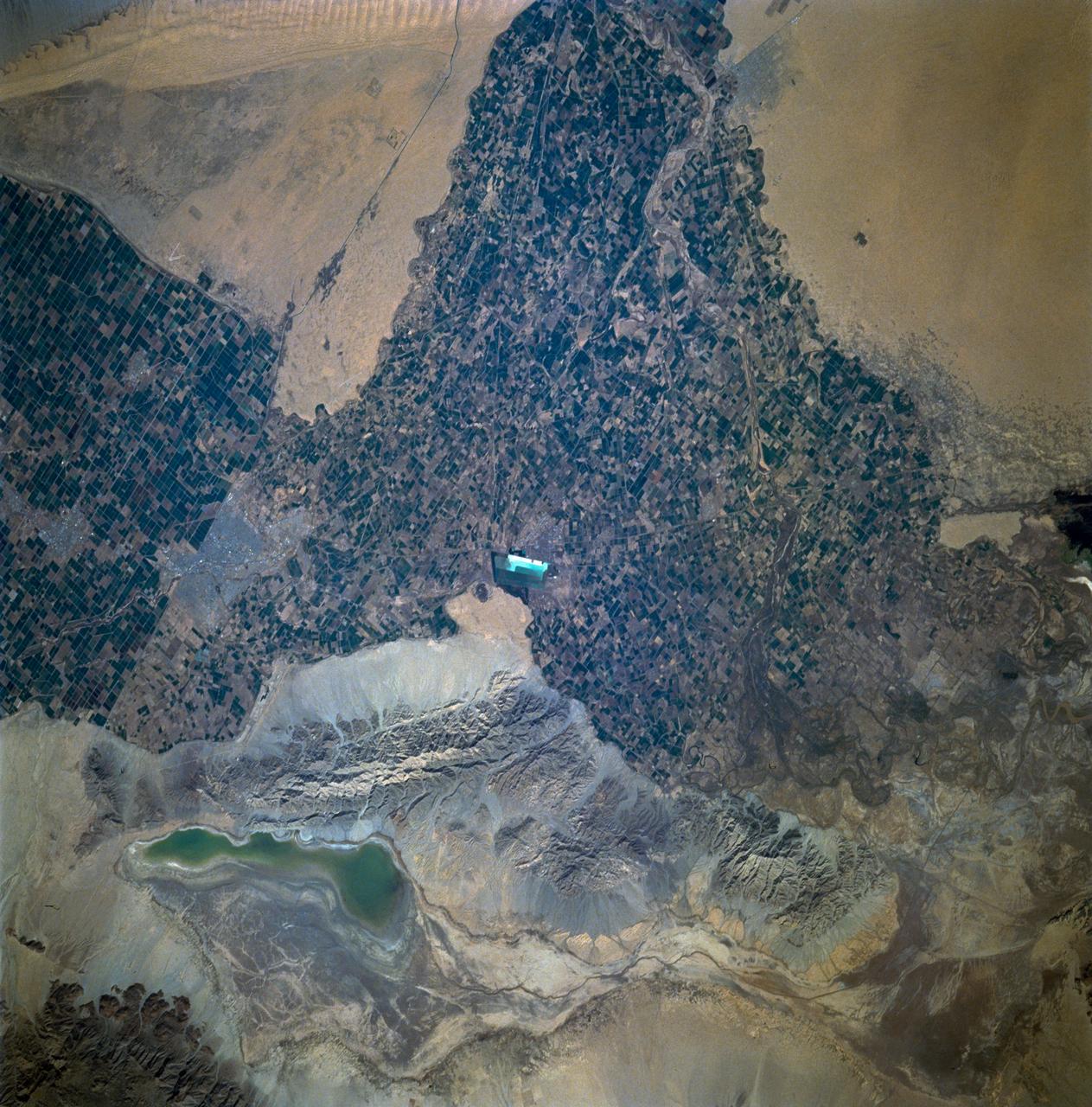
In the Al Jowf Province in northwestern Saudi Arabia, mining of fossil ground water has created an enormous agricultural enterprise, where tens of thousands of date palms and olive trees thrive in a hyper-arid environment. In a short 30-year period, the area has grown from 22 center-pivot irrigated fields to thousands. The Landsat TM image (Figure 1) was acquired March 30, 1989; the ASTER image on February 17, 2020. The images cover an area of 33.2 by 49 km, and are located at 30.1 degrees north, 38.3 degrees east. https://photojournal.jpl.nasa.gov/catalog/PIA23955
ISS010-E-05266 (28 October 2004) --- The Al Khufrah Oasis is featured in this image photographed by an Expedition 10 crewmember on the International Space Station (ISS). Green circles in the desert frequently indicate tracts of agriculture supported by center-pivot irrigation. The Al Khufrah Oasis in southeastern Libya (near the Egyptian border) is one of Libya’s largest agricultural projects, and is an easy-to-recognize landmark for orbiting crewmembers aboard the Station. The center-pivot irrigation system pumps water under pressure into a gantry or tubular arm from a central source. Anchored by a central pivot, the gantry slowly rotates over the area to be irrigated, thereby producing the circular patterns. Although the field diameters vary, these fields are approximately 0.6 mile (1 kilometer) in diameter. Darker colors indicate fields where such crops as wheat and alfalfa are grown. Lighter colors can indicate a variety of agricultural processes: fields that have been harvested recently; fields that are lying fallow; fields that have just been planted; or fields that have been taken out of production.
iss072e007017 (Oct. 1, 2024) --- The Aral Sea, once the third largest lake in the world that began shrinking in the 1960's after rivers that replenished it were diverted for irrigation projects, is pictured from the International Space Station as it orbited 260 miles above Kazakhstan.
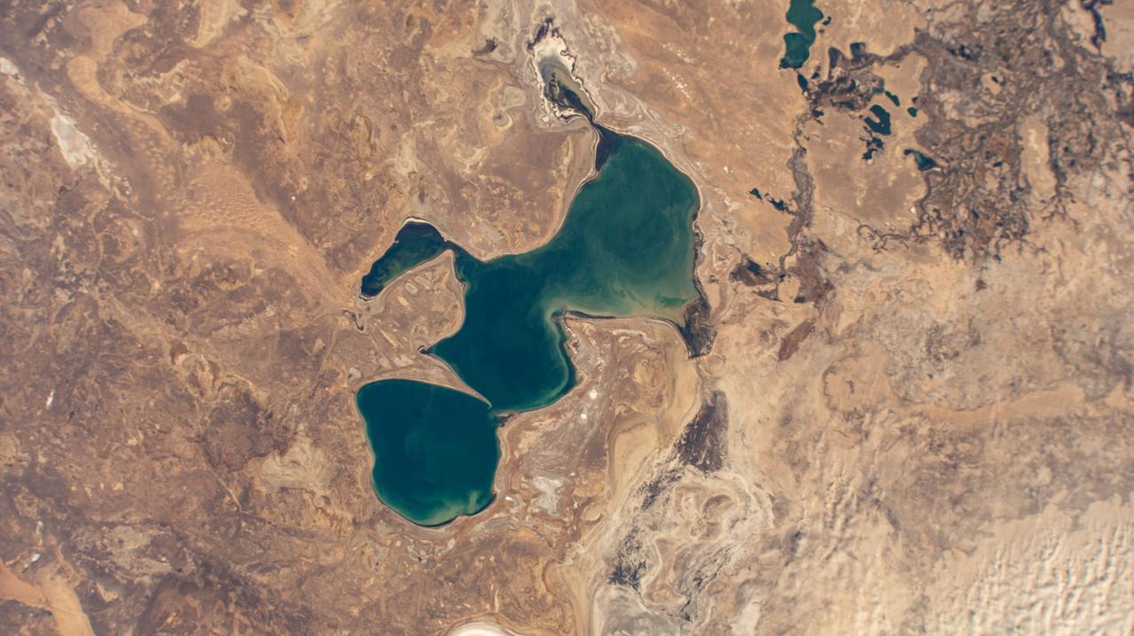
iss072e007018 (Oct. 1, 2024) --- Kazakhstan's North Aral Sea, once a part of the South Aral Sea before agricultural and irrigation activities depleted the lake, is pictured from the International Space Station as it orbited 260 miles above the Central Asian nation.
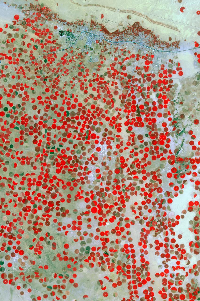
Al Basrah, Iraq Sensor: L7 ETM+ Acquisition Date: April 4, 2003 Path/Row: 166/39 Lat/Long: 30.486/47.811 Smoke drifts south in this image of Al Basrah, located in southeastern Iraq. The green circles from the center to the left of the image represent irrigated crops.
iss071e041651 (April 25, 2024) --- The snow-capped Caucasus Mountains run through Azerbaijan and Russia in this photograph from the International Space Station as it orbited 258 miles above. At top, is the Mingachevir Reservoir, the largest reservoir in the Caucasus and used for fishing, water supplies, and irrigation.
Agricultural patterns are distinctly visible in this near-vertical false color infrared photography taken in November 1994. The area depicted on the photograph is south of Khartoum between the White and Blue Nile Rivers. By far the most important irrigation project in sub-Saharan Africa, both large and small scale agricultural enterprises have been developed using water transported from the perennial Nile Rivers. Hundreds of small rectangular fields and water-filled canals can be seen in this photograph.
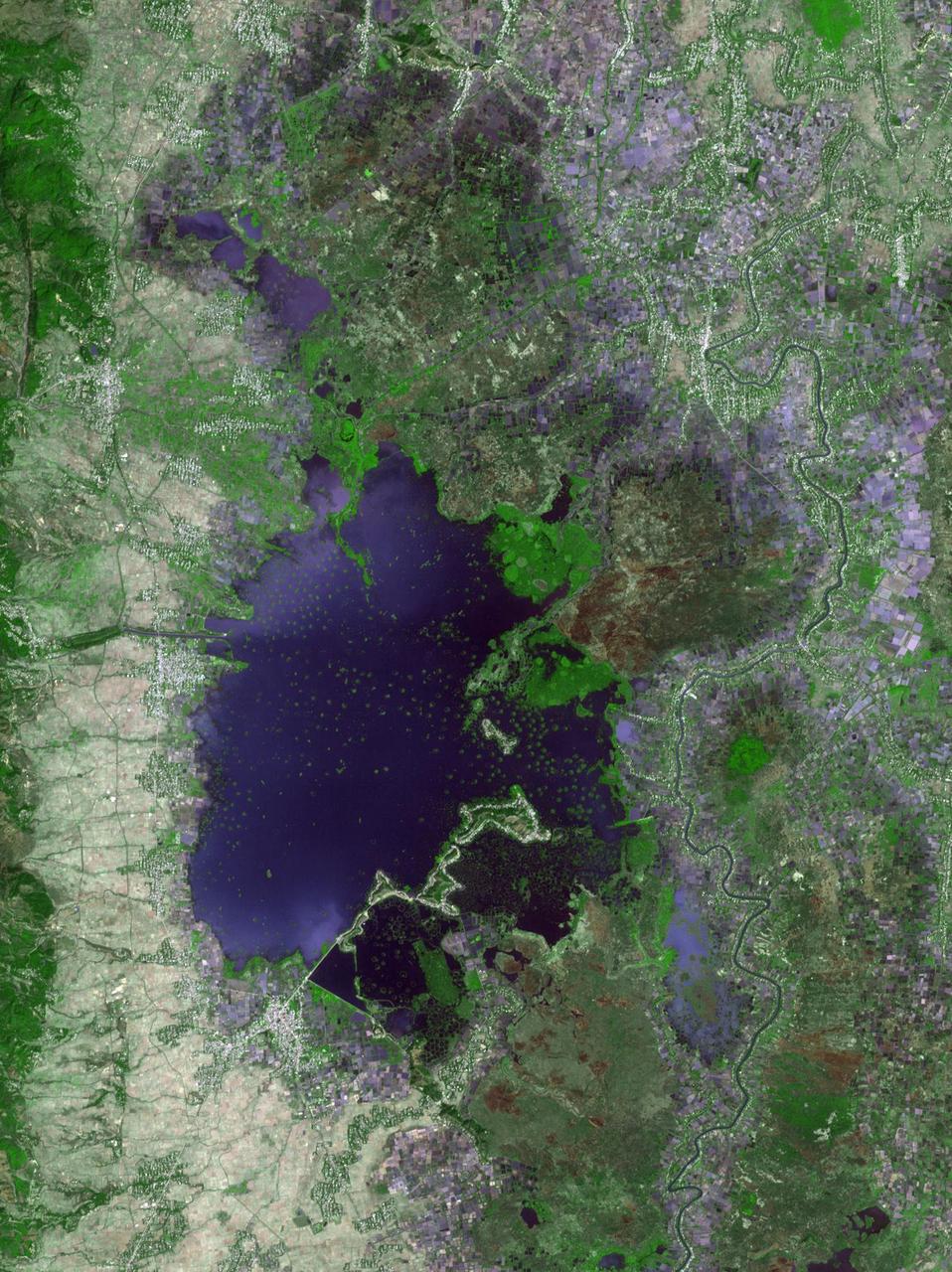
Loktak Lake is the largest freshwater lake in northeast India, and is famous for the floating "phudmis," masses of vegetation, soil and organic material. The lake is a source of water for hydropower, irrigation, drinking water, and livelihood for fish farmers. The image was acquired March 19, 2018, covers an area of 20.5 by 27.3 kilometers, and is located at 24.5 degrees north, 93.8 degrees east. https://photojournal.jpl.nasa.gov/catalog/PIA22369
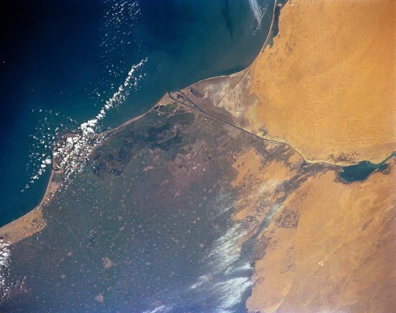
The Nile River Delta of Egypt (30.0N, 31.0E) irrigated by the Nile River and its many distributaries, is some of the richest farm land in the world and home to some 45 million people, over half of Egypt's population. The capital city of Cairo is at the apex of the delta. Just across the river from Cairo can be seen the ancient three big pyramids and sphinx at Giza and the Suez Canal is just to the right of the delta.
Evidence of a recent flash flood can be seen in the form of light brown sediment that flowed down gullies and mountain sides forming ponds of debris over agricultural areas in the broad valley near the town of Parras (26.5N, 102.5W). This part of Mexico has extensive vineyards, orchards and both dry land and irrigated agriculture. Based on the photo, it appears that flash flood waters damaged some 300 square miles of property in this area alone.
STS035-73-082 (2-10 Dec 1990) --- This agricultural and ranching area, Rio Sao Francisco, Brazil (13.0S, 43.5W) has been under study for several years. See scene STS-31-92-045 for comparison. This area has many small single family subsistence farms, large square and rectangular commercial farms and pastures for livestock grazing. Over the several years of observation, the number and size of farms has increased and center-pivot, swing-arm irrigation systems have been installed.
SL2-04-179 (22 June 1973) --- The Sacramento Valley (40.5N, 121.5W) of California is the northern extension of the Central Valley, main agriculture region of the state. Hundreds of truck farms, vineyards and orchards can be seen throughout the length and breadth of the valley which was reclaimed from the desert by means of intensive and extensive irrigation projects. Photo credit: NASA
This close-up view of the intensively cultivated Nile River flood plain near Cairo presents a sharp color contrast to the virtually non-vegetated, sandy desert, located to the west of the vegetated area. Some rectangular cultivated field patterns, as well as circular center pivot irrigation patterns, can be observed northwest of the Nile River flood plain. The world famous Giza Pyramids are located near the center of this photography (see highly reflective sand surfaces).
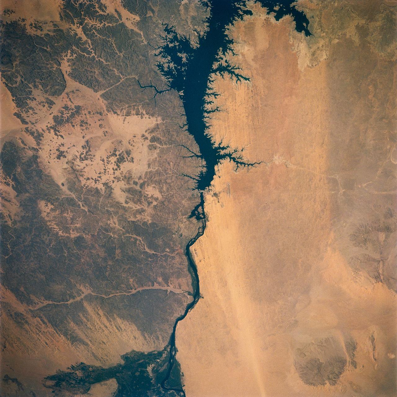
iss074e0315952 (Feb. 16, 2026) --- Egypt’s Nile River turns into Lake Nasser (upper left) at the Aswan High Dam, where the water spreads into a vast artificial reservoir that controls the river’s flow, prevents flooding, and generates hydroelectric power. Center‑pivot irrigation systems appear near the center bottom, forming perfect circles of crops such as potatoes and wheat. The International Space Station was orbiting 258 miles above the African nation at the time of this photograph. Credit: NASA
Egypt's High Aswan Dam on the Nile River at the first cataracts, Nile River, (24.0N, 33.0E) was completed in 1971 to provide cheap hydroelectric power and to regulate the historically uneven flow of the Nile River. The contrast between the largely base rock desert east of the Nile versus the sand covered desert west of the river and the ancient irrigated floodplain downstream from the damsite is clearly shown.
AS7-06-1718 (14 Oct. 1968) --- Sudan, showing White Nile and Blue Nile rivers below Khartoum, as seen from the Apollo 7 spacecraft during its 44th revolution of Earth. Photographed from an altitude of approximately 130 nautical miles, at ground elapsed time of 69 hours and 10 minutes. Note quilted-patchwork effect created by irrigated cultivated land.
iss074e0603632 (May 16, 2026) --- Industrial-scale farming and oil production exist side-by-side and compete for land and water resources in western Texas. The crop circles are center-pivot irrigation systems used to cultivate cotton, sorghum, wheat, hay, and corn. The grid set against the circular farms is a dense network of well sites, pipelines, and roads that support the petroleum infrastructure. The International Space Station was orbiting 259 miles above the Texas–Oklahoma border at the time of this photograph. Credit: NASA
ISS018-E-024949 (31 Jan. 2009) --- The All-American Canal, the largest irrigation canal in the world and a key landmark along the California-Mexico border, is featured in this image photographed by an Expedition 18 crewmember on the International Space Station. This image captures about 15 kilometers of the important infrastructure corridor just west of Yuma, AZ. The prominent dark line crossing the image is the Canal which is crossed, in this view, by Interstate Highway 8. The canal carries 740.6 cubic meters (26,155 cubic feet) of water per second from the Colorado River westward to support the intensive agriculture of California?s Imperial Valley to the northwest, and to nine cities including San Diego, CA. The canal system is the Imperial Valley?s only source of water, and allows irrigation of more than 2,000 square kilometers (500,000 acres) of agricultural fields. The Coachella Canal, one of four main branch canals, leads water north to Imperial Valley. This section of the canal requires constant maintenance. Approximately 68,000 acre-feet of water per year are lost by seepage from the All-American Canal - especially where the canal crosses the great Algodones Dune Field, a portion of which is visible extending from top to bottom in the center of the image. Additionally, dune sand is constantly blown to the southeast, and into the canal. As part of California?s Colorado River Water Use Plan, 37 kilometers (23 miles) of the canal is being lined to prevent water loss by seepage. A recently opened sector parallels the old canal (right) and new lined sectors are under construction (bright lines, center). Engineers have sited new sections of the canal to avoid the worst areas of dune-sand invasion, so that the new configuration will be significantly cheaper to maintain and operate. A new road crosses the dunes and marks the US?Mexico border as part of border fence construction efforts. The margin of the Colorado River floodplain in Mexico is just visible two kilometers south of the border (lower left corner). This floodplain is Mexico?s equivalent of the Imperial Valley in terms of its enormous irrigated agricultural production.
STS060-93-081 (3-11 Feb 1994)--- The Imperial Valley was documented using three films - color visible (seen here), the American infrared film (Kodak Aerochrome 2443), and the Russian panchromatic infrared film (SN-10). Results of this test still await detailed science analysis. However it does appear that good data was acquired of the region, and this data will be complemented by photography acquired by the Mir cosmonauts. In this frame, the U.S.-Mexico border goes from the upper left to the middle right. It is discernible as a vegetation line between Calexico, California and Mexicali, Mexico. The darker vegetation north of that line is due to different agricultural practices, heavier uses of fertilizers and pesticides, and lined (tiled) agricultural fields allowing subterraneean runoff of saline irrigation runoff. South of the line, the more polluted water draining out of the U.S. agricultural areas into the Mexican area has resulted in higher soil salinities and a consequent reduction in agricultural productivity. At the center of the frame, a large settling and desalinization plant has been built to attempt to purify, to some degree, the polluted irrigation waters draining south out of California. The All-American Canal, which brings in water from the Colorado River (off the frame, to the right), is located in the middle right hand portion of the frame. To the upper left is the normally dry Laguna Salada.
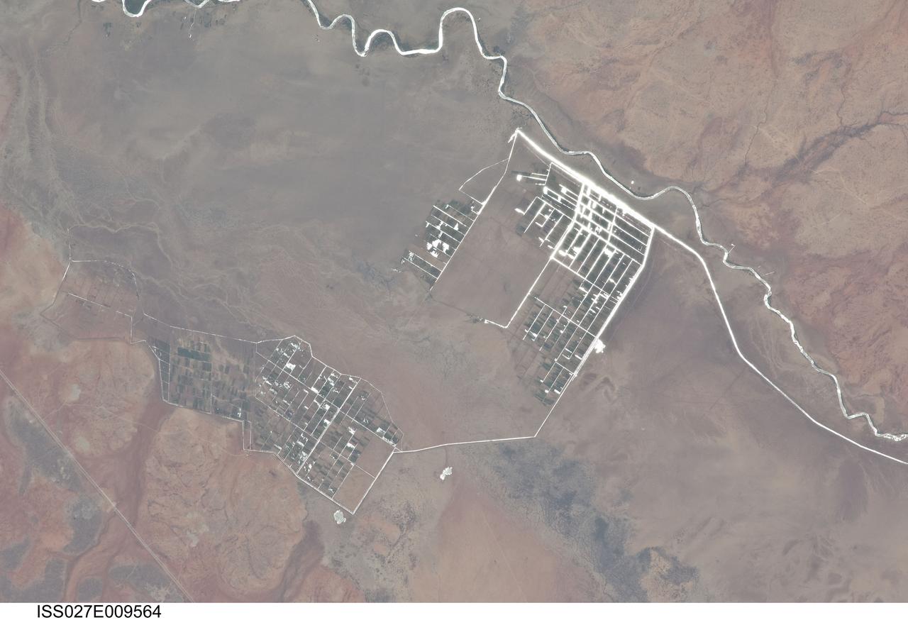
ISS027-E-009564 (31 March 2011) --- Agricultural fields along the Shebelle River in Ethiopia are featured in this image photographed by an Expedition 27 crew member on the International Space Station. The Shebelle River supports limited agricultural development within the arid to semi-arid Ogaden Plateau region of southeastern Ethiopia. This detailed photograph illustrates a network of irrigation canals and fields located approximately 42 kilometers to the west-northwest of the city of Gode, Ethiopia. Floodplain sediments and soils are dark brown to gray (center), and contrast with reddish rocks and soils of the adjacent plateau. Water in the Shebelle River, and the irrigation canals, has a bright, mirror-like appearance due to sunglint, or light reflecting off the water surface back towards the observer on the space station. Vegetation in the floodplain (bottom center) and agricultural fields is dark green. The river water supports a variety of crops?the most common being sorghum and maize?as well as grazing for livestock (cattle, sheep, goats, and camels). The Shebelle River has its headwaters in the Ethiopian Highlands, and transports water and sediment 1,000 kilometers to the southeast across Ethiopia, continuing an additional 130 kilometers into neighboring Somalia. The Shebelle River does not reach the Indian Ocean during most years, but disappears into the sands near the coast in Somalia. During periods of heavy rainfall and flooding however, the Shebelle can reach the Indian Ocean.
STS073-708-089 (26 October 1995) --- As evidenced by this 70mm photograph from the Earth-orbiting Space Shuttle Columbia, international borders have become easier to see from space in recent decades. This, according to NASA scientists studying the STS-73 photo collection, is particularly true in arid and semi-arid environments. The scientists go on to cite this example of the razor-sharp vegetation boundary between southern Israel and Gaza and the Sinai. The nomadic grazing practices to the south (the lighter areas of the Sinai and Gaza, top left) have removed most of the vegetation from the desert surface. On the north side of the border, Israel uses advanced irrigation techniques in Israel, mainly "trickle irrigation" by which small amounts of water are delivered directly to plant roots. These water-saving techniques have allowed precious supplies from the Jordan River to be used on farms throughout the country. Numerous fields of dark green can be seen in this detailed view. Scientists say this redistribution of the Jordan River waters has increased the Israeli vegetation cover to densities that approach those that may have been common throughout the Mid-East in wetter early Biblical times. A small portion of the Mediterranean Sea appears top right.
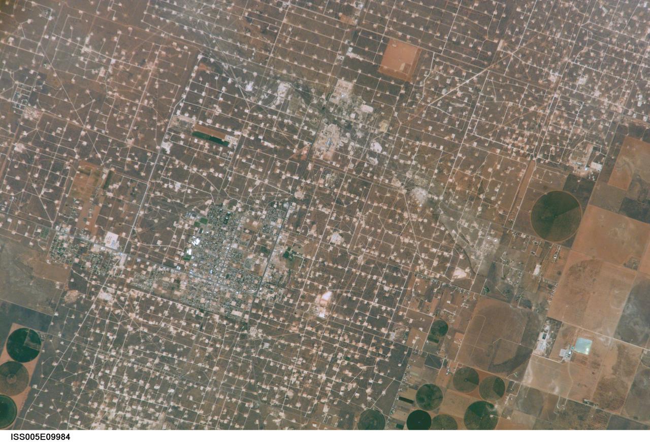
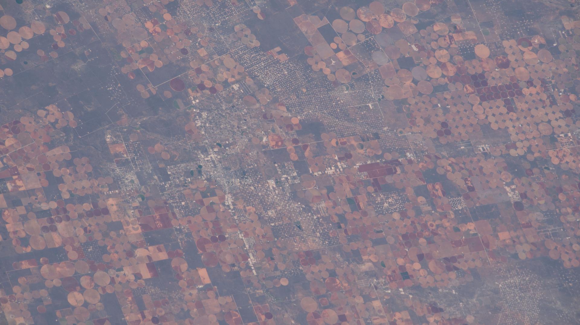
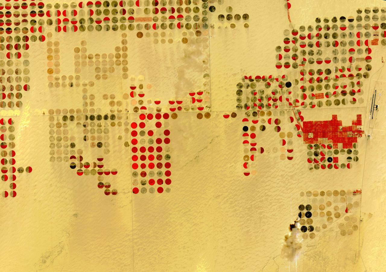
ISS005-E-9984 (17 August 2002) --- This digital still photograph, taken from the International Space Station (ISS) during its fifth staffing, depicts both agriculture and the petroleum industry, which compete for land use near Denver City, Texas. The photo was recently released by the Earth Sciences and Image Analysis Laboratory at Johnson Space Center. The area is southwest of Lubbock near the New Mexico border. According to analysts studying the station imagery, the economy of this region is almost completely dependent on its underground resources of petroleum and water. Both resources result in distinctive land use patterns visible from space. Historically this area has produced vast quantities of oil and gas since development began in the 1930s. A fine, light-colored grid of roads and pipelines connect well sites over this portion of the Wasson Oil Field, one of the state’s most productive. Since the 1940s, agricultural land use has shifted from grazing to irrigated cultivation of cotton, sorghum, wheat, hay, and corn. The water supply is drawn from wells tapping the vast Ogallala Aquifer. Note the large, circular center-pivot irrigation systems in the lower corners of the image. The largest is nearly a mile in diameter.
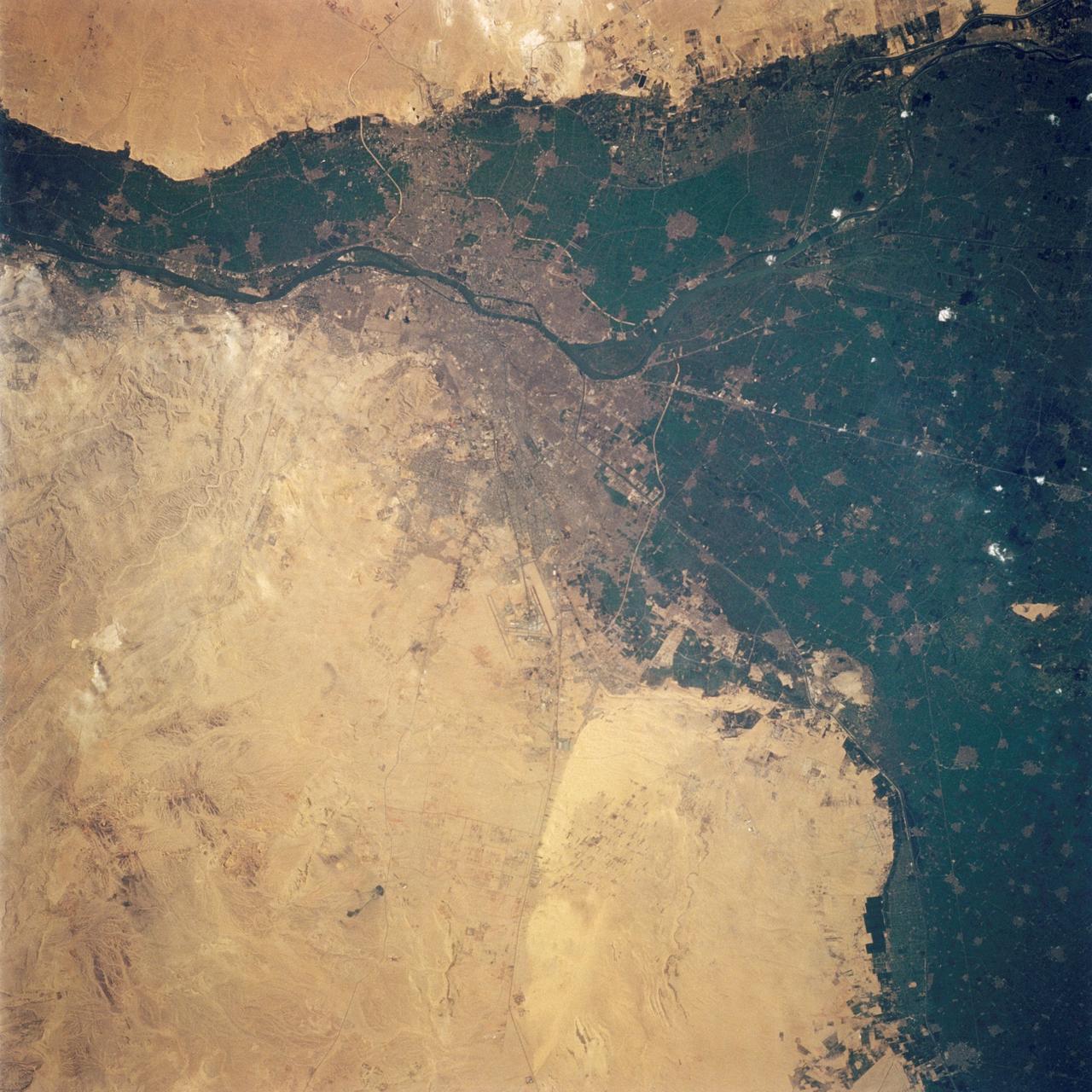
STS062-108-058 (4-18 March 1994) --- Cairo lies at the apex of the great delta of the Nile: the delta is marked by the strong greens of cultivated lands, Cairo by the gray sprawl along the river and the eastern delta apex as it develops in the direction of the airports and Suez. The city of El Giza lies on the west side of the Nile with the Giza pyramids in the desert just beyond the cultivated lands. Several major canals lead water to parts of the delta more distant from the Nile; generally these can be recognized as straighter, more engineered waterways. Towards the top left, the bifurcation of the Rosetta and Damietta branches of the Nile can be seen. These are the two major present-day veins of the Nile as it approaches the Mediterranean.

The Falcon International Reservoir is on the Rio Grande, 65 km southeast of Laredo, Texas, USA and Nuevo Laredo, Tamaulipas, Mexico. The Falcon Dam was constructed in 1953 to provide water conservation, irrigation, and hydroelectricity. Its maximum surface area, seen in the 2010 image, was 34,000 hectares. As a result of the 2010s-20s drought, the reservoir holds only a small fraction of its capacity. In 2010, vegetation in the area was healthy (dark red); in 2022, the area is parched. The images were acquired 14 July 2010 and 31 July 2022, cover an area of 29.8 by 46.9 km, and are located at 26.6 degrees north, 99.2 degrees west. https://photojournal.jpl.nasa.gov/catalog/PIA25446
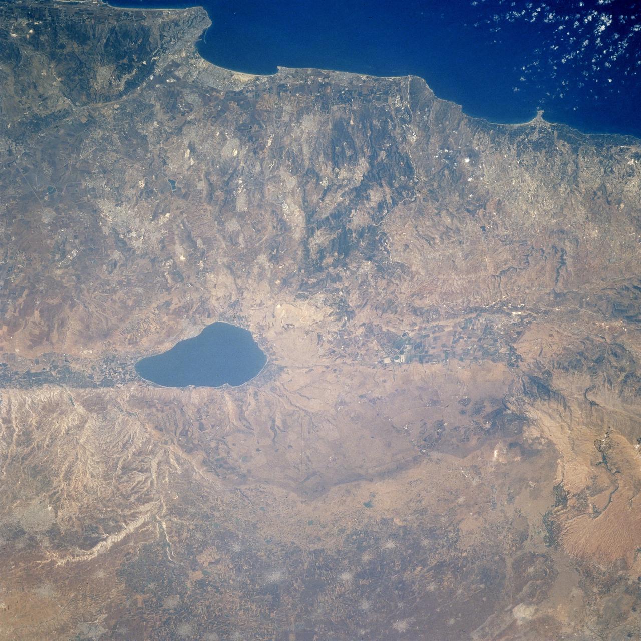
STS106-713-002 (19 September 2000) --- One of the STS-106 crew members on board the Space Shuttle Atlantis, 204 nautical miles above Earth, used a handheld 70mm camera to photograph this image featuring the Sea of Galilee and part of the Mediterranean coast. Also known as Lake Tiberius and other names, the body of water is the only natural fresh-water lake in Israel. It borders on the Golan Heights on its east side. The port of Haifa is visible on the Mediterranean coast. The large agriculture projects on the Israeli side of Galilee are irrigated by the lake and the Jordan River.
In the middle of the Arabian desert the city Green Oasis Wadi Al Dawasir is being developed as a new urban center for the Wadi Al Dawasir region of Saudi Arabia, as shown in this image from NASA Terra spacecraft. Huge solar fields supply the entire city and the surrounding region with energy. Hundreds of circular agricultural fields are fed by center pivot irrigation apparatus, drawing water from subterranean aquifers. The image was acquired March 30, 2013, covers an area of 30 x 45 km, and is located at 20.2 degrees north, 44.8 degrees east. http://photojournal.jpl.nasa.gov/catalog/PIA20077
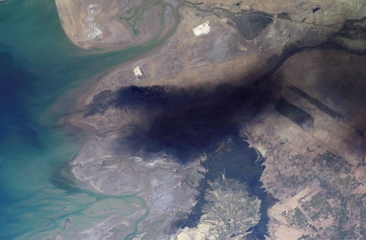
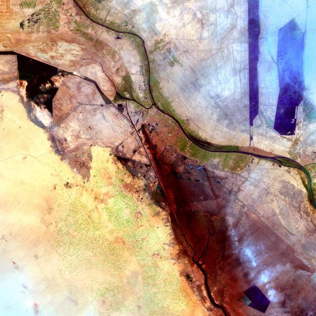
ISS008-E-18938 (24 March 2004) --- This photo of a large black smoke plume over southeastern Iraq was taken by an Expedition 8 crewmember on the International Space Station. The oil that is burning spilled from a ruptured pipeline on March 23, 2004. This photo was taken the next afternoon and shows details of land use near the fire. The delta of the Shatt al Arab has numerous channels, estuaries, and tidal flats. Near the top of the photo (southwest) are two large white salt evaporator operations while to the lower right are wetlands and irrigated agricultural fields. Iraq’s only oil terminal on the Persian Gulf is near the left edge of the plume.
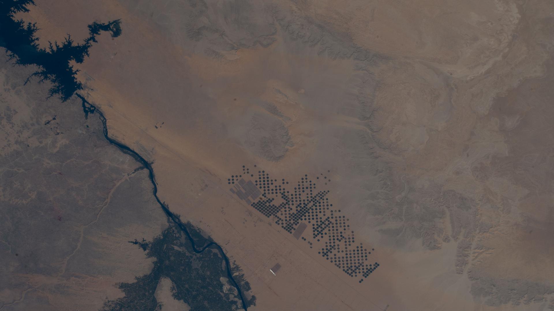
The Nubian Sandstone Aquifer System is the world's largest fossil water aquifer system. It covers an estimated area of 2.6 million square kilometers, including parts of Sudan, Chad, Libya, and most of Egypt. In the southwestern part of Egypt, the East Oweinat development project uses central pivot irrigation to mine the fossil water for extensive agricultural development. Crops include wheat and potatoes; they are transported via the airport on the eastern side. The image was acquired October 12, 2015, covers an area of 33.3 by 47.2 km, and is located near 22.6 degrees north, 28.5 degrees east. https://photojournal.jpl.nasa.gov/catalog/PIA24616
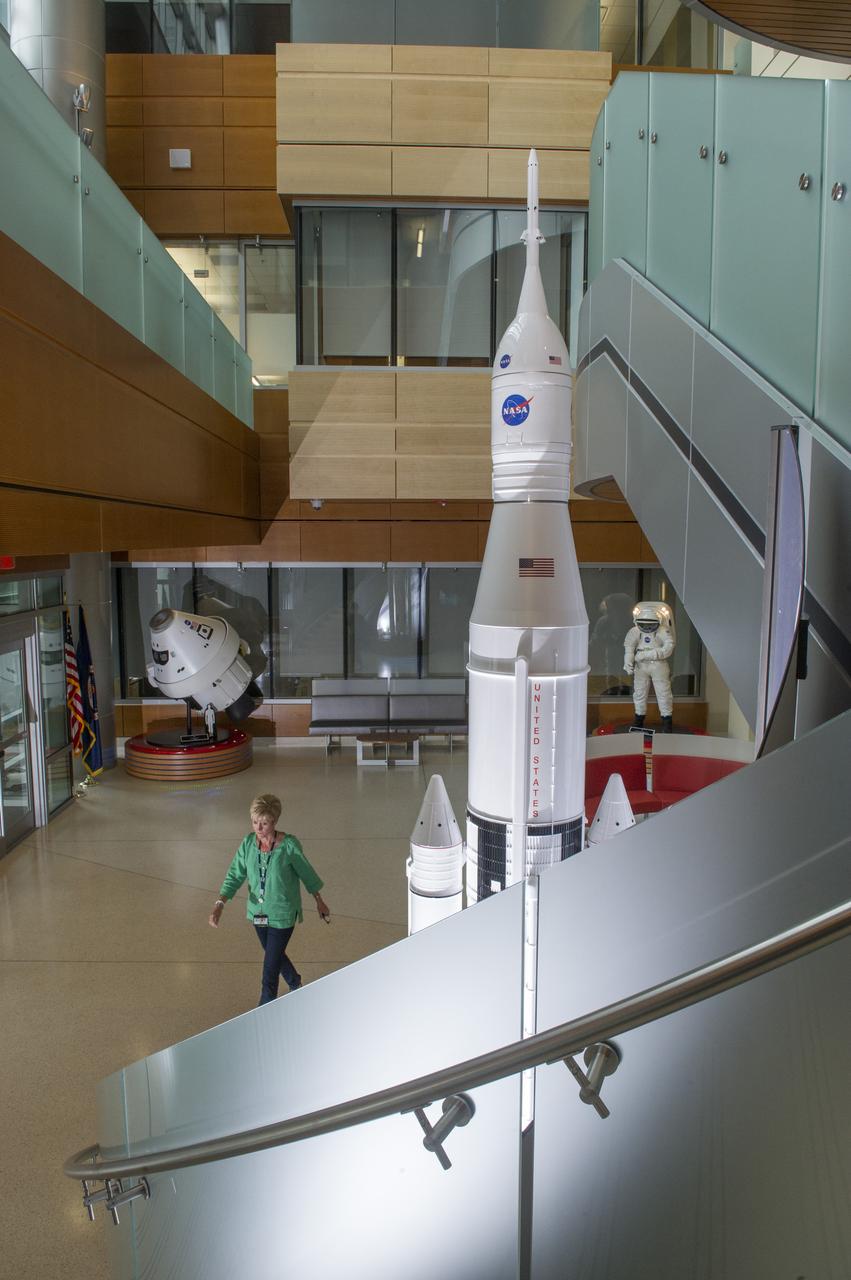
THE INTERIOR OF THE MARSHALL SPACE FLIGHT CENTER’S NEWLY OPENED BUILDING 4220, PRIMARILY HOME TO THE SPACE LAUNCH SYSTEM PROGRAM, REFLECTS A BLEND OF AESTHETICS, PRACTICALITY AND HIGH EFFICIENCY. THE COST-CONSCIOUS NEW FACILITY IS ENVIRONMENTALLY FRIENDLY ON ALL FRONTS, FEATURING STATE-OF-THE-ART GREEN TECHNOLOGIES AND ENERGY-CONSERVATION SYSTEMS THROUGHOUT THE BUILDING. THE ENTIRE STRUCTURE IS SPECIALLY INSULATED, WITH MUCH OF THE EXTERIOR COVERED IN LOW-EMISSIVITY GLASS THAT DEFLECTS HEAT TO REDUCE COOLING COSTS WITHIN. ROOFTOP SOLAR-POWER UNITS ABSORB ENERGY TO AUGMENT ELECTRICAL POWER, AND A 10,000-GALLON CISTERN COLLECTS STORMWATER TO IRRIGATE THE SURROUNDING GREENERY. EVEN THE FACILITY'S NEW PARKING LOT HAS A GREEN ELEMENT: RATHER THAN GUTTERS, IT INCLUDES A "BIOSWALE," A NATURAL, SOIL-AND-VEGETATION-BASED MEANS OF CAPTURING AND FILTERING STORMWATER RUNOFF, WHICH IS DIRECTED INTO A NEARBY COLLECTING POND. ONCE CERTIFICATION IS COMPLETE, BUILDING 4220 WILL BECOME THE SEVENTH LEED CERTIFIED MARSHALL STRUCTURE ON CAMPUS
STS087-703-089 (19 November – 5 December 1997) --- Featured in this view is center pivot irrigation in central Saudi Arabia. Abundant petroleum has provided the energy source for deep-well pumps that tap groundwater stored in bedrock many thousands of years ago when the climate was much wetter. The fields are carved out of ancient alluvial fan deposits, also formed when rainfall was much greater; the fields are pushed right to the edge of the Nafud al Mazhur (sand sea), representative of the present climate. The mining of petroleum and groundwater has enabled Saudi Arabia to become an exporter of wheat and other commodities, in addition to the oil for which it is famous. This picture is one of the 70mm Earth observation visuals used by the crew at its post flight presentation events.
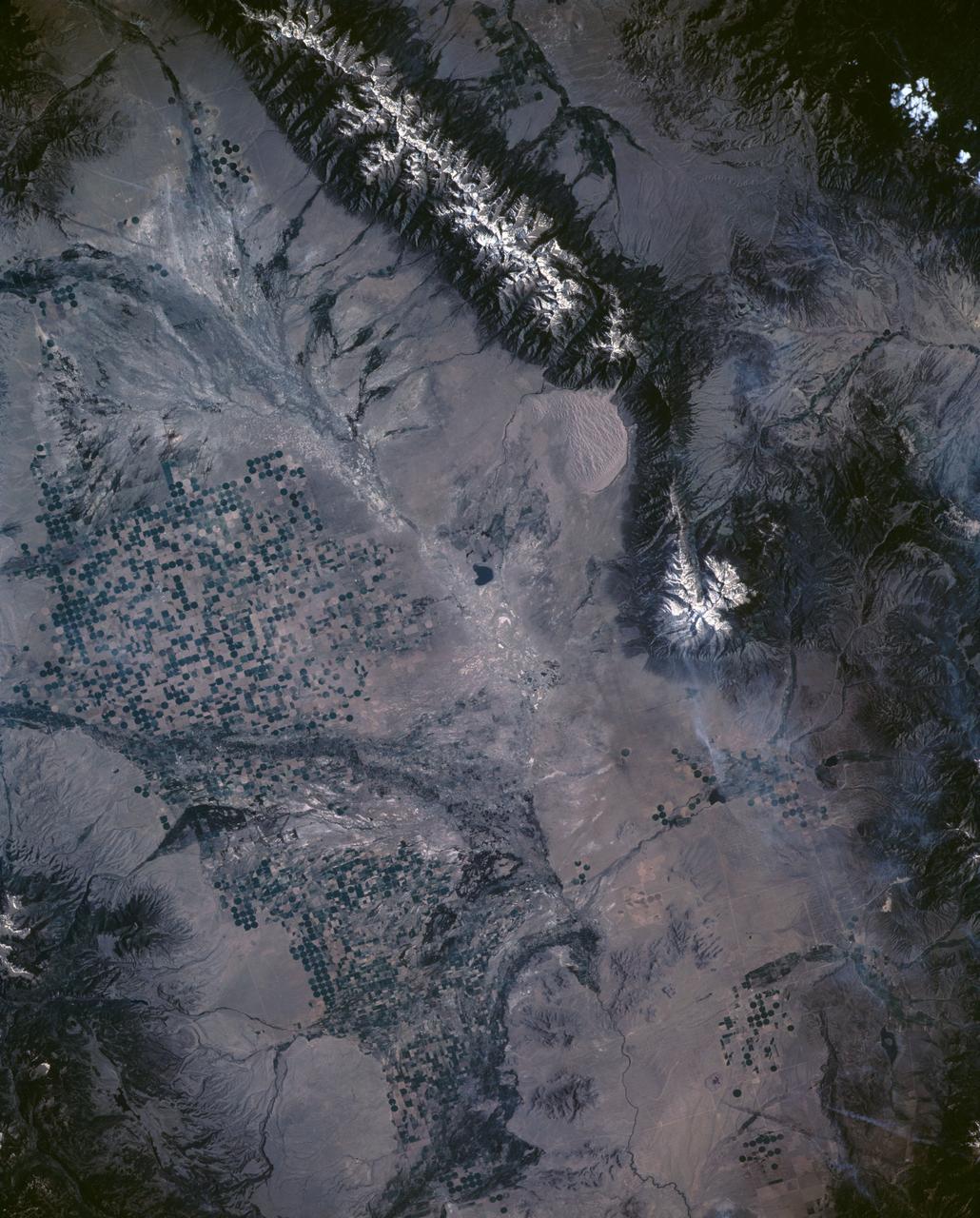
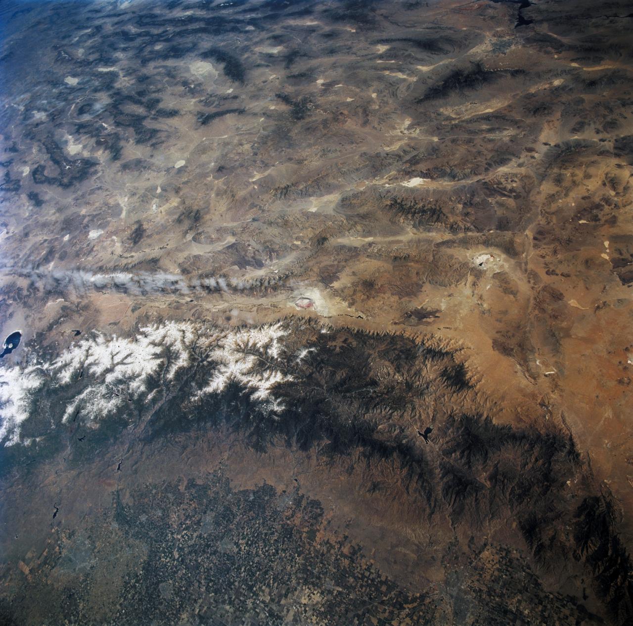
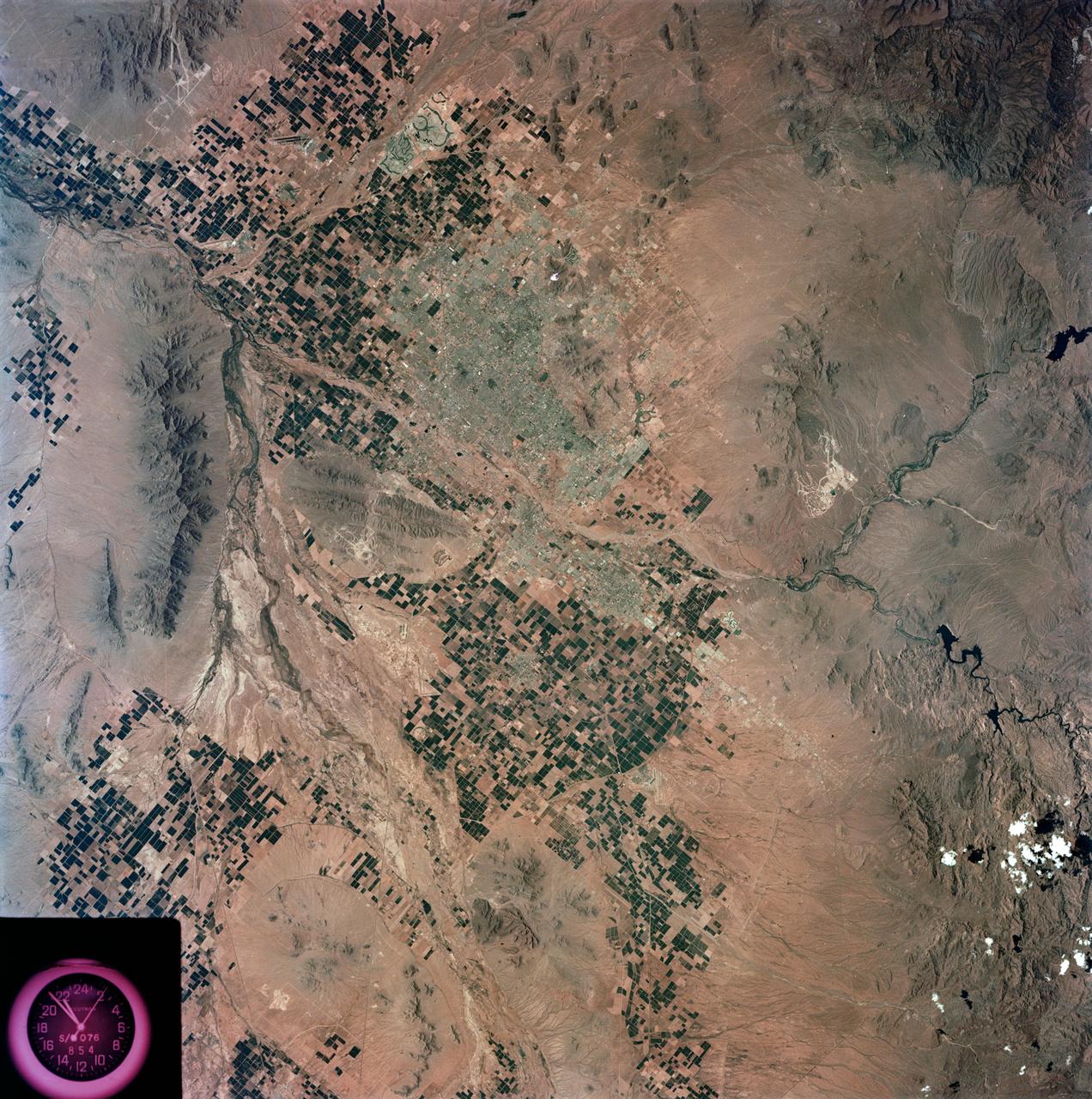
STS040-151-126 (5-14 June 1991) --- Croplands of the San Luis Valley stand out exceptionally clearly from low Earth orbit. The Rio Grande flows through the valley. Circular center pivot irrigation patterns have almost completely replaced the earlier rectangular grid pattern. Pinto beans are the specialty of the area. The Great Sand Dunes National Monument appears in fine detail near the center of the picture. The sands of these dunes have been blown from the valley floor by westerly winds in the course of the last few tens of thousands of years, now banked up against the foot of the Sangre de Christo Mountains (snowcapped peaks reach over 14000 feet). The town of Alamosa lies on the Rio Grande. The San Juan Mountains appear at the bottom left.
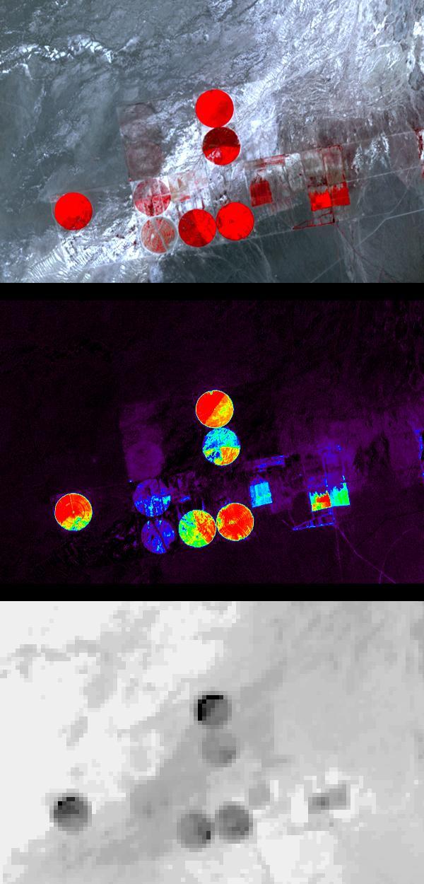
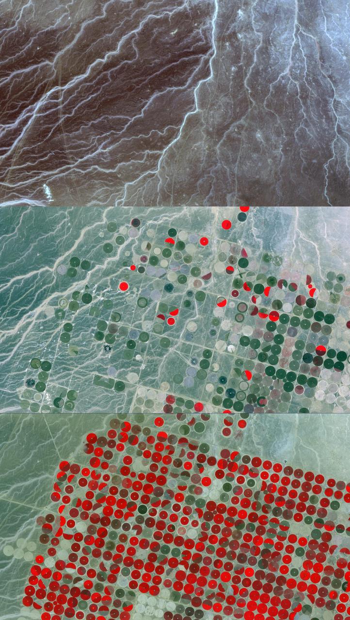
Information from images of Railroad Valley, Nevada captured on August 17, 2001 by the Advanced Spaceborne Thermal Emission and Reflection Radiometer (ASTER) may provide a powerful tool for monitoring crop health and maintenance procedures. These images cover an area of north central Nevada. The top image shows irrigated fields, with healthy vegetation in red. The middle image highlights the amount of vegetation. The color code shows highest vegetation content in red, orange, yellow, green, blue, and purple and the lowest in black. The final image is a thermal infrared channel, with warmer temperatures in white and colder in black. In the thermal image, the northernmost and westernmost fields are markedly colder on their northwest areas, even though no differences are seen in the visible image or the second, Vegetation Index image. This can be attributed to the presence of excess water, which can lead to crop damage. http://photojournal.jpl.nasa.gov/catalog/PIA03463
STS058-92-064 (18 Oct-1 Nov 1993) --- This oblique view, looking northeast from central Egypt, shows great expanses of the sand covered and rocky Western Desert in the foreground (bottom). The dark patches bottom right are the Dakhla Oases on the south side of an escarpment. For centuries camel trains have moved from here to the Nile Valley, seen here as a broad green line winding through the desert. The northern half of Egypt's Nile appears here, from about the latitude of Luxor to the delta. Green colors indicate the small area of crops which feed Egypt's population of 55 million. The Nile Delta is partly obscured by a band of clouds, but can be discerned at the coast as a flattened triangle of green. The smaller triangle close by is the Faiyum Basin, a depression irrigated by water from the Nile. The coast of the Mediterranean Sea appears left.
STS068-267-097 (30 September-11 October 1994) --- An extensive view eastward from the irrigated San Joaquin Valley in the foreground, across the Sierra Nevada (living up to its name in early October), into the desert of eastern California and Nevada (which has no snow, despite the name). Mono Lake is just visible at the left edge of the frame; Owens Valley extends southward to Owens Lake, the next valley is Panamint Valley, and then Death Valley. Las Vegas and Lake Mead are visible at the upper right of the frame. The Space Radar Laboratory 2 (SRL-2) obtained extensive, multiple-pass data from many test sites within the region displayed, including Mammoth Mountain ski area south of Mono Lake, and in Death Valley.

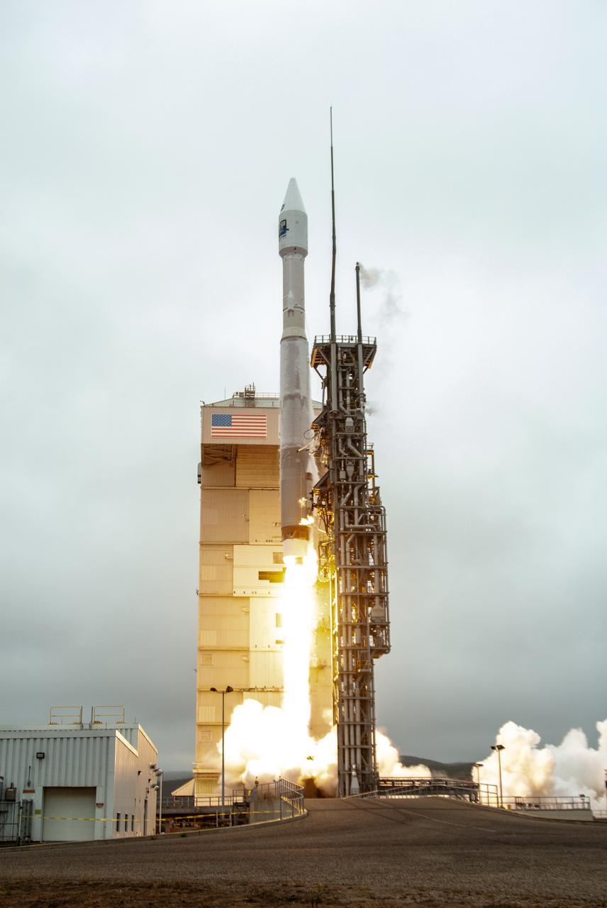
From left, Marie Lewis, NASA Communications; and Thomas Zurbuchen, associate administrator, NASA’s Science Mission Directorate, speak to members of the news media during a prelaunch news conference for NASA’s Landsat 9 mission at Vandenberg Space Force Station in California on Sept. 25, 2021. Landsat 9 is scheduled to launch at 2:12 p.m. EDT (11:12 a.m. PDT) on Monday, Sept. 27, on a United Launch Alliance Atlas V 401 rocket from Space Launch Complex 3 at Vandenberg. The launch is managed by NASA’s Launch Services Program, based at the agency’s Kennedy Space Center in Florida. Landsat 9 will join its sister satellite, Landsat 8, in orbit in collecting images from across the planet every eight days. This calibrated data will continue the Landsat program’s critical role in monitoring the health of Earth and helping people manage essential resources, including crops, irrigation water, and forests.

AS09-26A-3781A (11 March 1969) --- Colored infrared photograph of the mouth of the Colorado River in northern Baja California and Sonora, Mexico, as seen from Apollo 9 spacecraft during its 121st revolution of Earth. Photographed from an altitude of 130 nautical miles, at 16:14 GMT, on March 11, 1969. Color infrared film is designed to render healthy green foliage as tones of red, such as the red checker-board patterns in the irrigated farm lands along the Colorado River. Red hues of vegetation can be seen in the valleys and on the slopes of the San Pedro Martia and Juarez Mountains, at left. White ribbon-like salt lakes near the river mouth and the wide expanse of sand dunes in the Great Desert, at right, are evidence of the arid climate. Light colors of silt bands in the waters of the Gulf of California reflect currents and water depths. The town of San Felipe is on the Gulf coast at lower left.

Thomas Zurbuchen, associate administrator, NASA’s Science Mission Directorate, answers questions during a prelaunch news conference for NASA’s Landsat 9 mission at Vandenberg Space Force Station in California on Sept. 25, 2021. Landsat 9 is scheduled to launch at 2:11 p.m. EDT (11:11 a.m. PDT) on Monday, Sept. 27, on a United Launch Alliance Atlas V 401 rocket from Space Launch Complex 3 at Vandenberg. The launch is managed by NASA’s Launch Services Program, based at the agency’s Kennedy Space Center in Florida. Landsat 9 will join its sister satellite, Landsat 8, in orbit in collecting images from across the planet every eight days. This calibrated data will continue the Landsat program’s critical role in monitoring the health of Earth and helping people manage essential resources, including crops, irrigation water, and forests.
THE INTERIOR OF THE MARSHALL SPACE FLIGHT CENTER’S NEWLY OPENED BUILDING 4220, PRIMARILY HOME TO THE SPACE LAUNCH SYSTEM PROGRAM, REFLECTS A BLEND OF AESTHETICS, PRACTICALITY AND HIGH EFFICIENCY. THE COST-CONSCIOUS NEW FACILITY IS ENVIRONMENTALLY FRIENDLY ON ALL FRONTS, FEATURING STATE-OF-THE-ART GREEN TECHNOLOGIES AND ENERGY-CONSERVATION SYSTEMS THROUGHOUT THE BUILDING. THE ENTIRE STRUCTURE IS SPECIALLY INSULATED, WITH MUCH OF THE EXTERIOR COVERED IN LOW-EMISSIVITY GLASS THAT DEFLECTS HEAT TO REDUCE COOLING COSTS WITHIN. ROOFTOP SOLAR-POWER UNITS ABSORB ENERGY TO AUGMENT ELECTRICAL POWER, AND A 10,000-GALLON CISTERN COLLECTS STORMWATER TO IRRIGATE THE SURROUNDING GREENERY. EVEN THE FACILITY'S NEW PARKING LOT HAS A GREEN ELEMENT: RATHER THAN GUTTERS, IT INCLUDES A "BIOSWALE," A NATURAL, SOIL-AND-VEGETATION-BASED MEANS OF CAPTURING AND FILTERING STORMWATER RUNOFF, WHICH IS DIRECTED INTO A NEARBY COLLECTING POND. ONCE CERTIFICATION IS COMPLETE, BUILDING 4220 WILL BECOME THE SEVENTH LEED CERTIFIED MARSHALL STRUCTURE ON CAMPUS
ISS036-E-011034 (21 June 2013) --- The Salton Trough is featured in this image photographed by an Expedition 36 crew member on the International Space Station. The Imperial and Coachella Valleys of southern California – and the corresponding Mexicali Valley and Colorado River Delta in Mexico – are part of the Salton Trough, a large geologic structure known to geologists as a graben or rift valley that extends into the Gulf of California. The trough is a geologically complex zone formed by interaction of the San Andreas transform fault system that is, broadly speaking, moving southern California towards Alaska; and the northward motion of the Gulf of California segment of the East Pacific Rise that continues to widen the Gulf of California by sea-floor spreading. According to scientists, sediments deposited by the Colorado River have been filling the northern rift valley (the Salton Trough) for the past several million years, excluding the waters of the Gulf of California and providing a fertile environment – together with irrigation—for the development of extensive agriculture in the region (visible as green and yellow-brown fields at center). The Salton Sea, a favorite landmark of astronauts in low Earth orbit, was formed by an irrigation canal rupture in 1905, and today is sustained by agricultural runoff water. A wide array of varying landforms and land uses in the Salton Trough are visible from space. In addition to the agricultural fields and Salton Sea, easily visible metropolitan areas include Yuma, AZ (lower left); Mexicali, Baja California, Mexico (center); and the San Diego-Tijuana conurbation on the Pacific Coast (right). The approximately 72-kilometer-long Algodones Dunefield is visible at lower left.
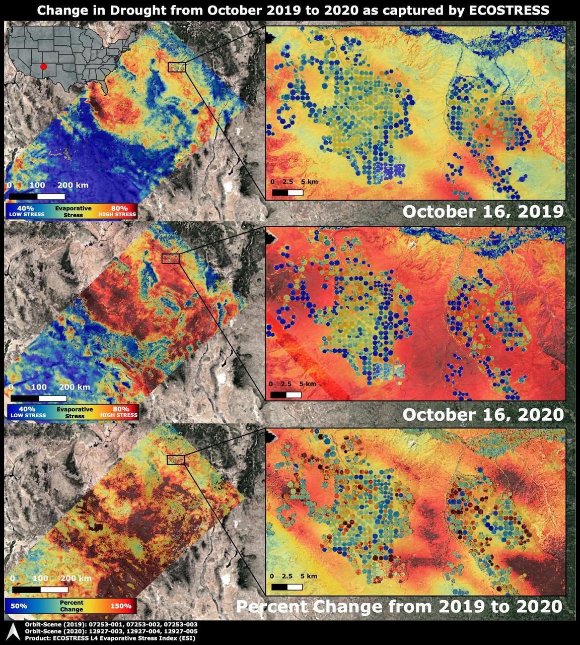
The Western United States has been entrenched in an Extreme and Exceptional drought that has extended from the summer and into the fall of 2020. NASA's ECOsystem Spaceborne Thermal Radiometer Experiment on Space Station (ECOSTRESS) imaged the drought on Oct. 16, 2020, and compared the same area to an image from ECOSTRESS taken a year earlier on Oct. 16, 2019. The bottom image shows the percentage change in plant water stress from 2019 to 2020. The images at left zoom into the Arizona and New Mexico border and Navajo Nation Territory area, featuring the ECOSTRESS Evaporative Stress Index (ESI), which shows plant water stress. The inset images on the right zoom further into the region, showing circular agricultural fields that have been irrigated. Blue colors represent low stress and high water use, whereas red colors represent high stress and low water use. Irrigation is able to alleviate plant water stress in many of the fields while the surrounding landscape suffers from the drought, though numerous agricultural fields are shut down in the drought image. The primary mission of ECOSTRESS, which launched to the International Space Station in June 2018, is to provide insight into plants' health, especially in a drought, by taking their temperature. Plants regulate their temperature by releasing water through tiny pores on their leaves. With sufficient water, they can maintain their temperature. When they lack water, their temperatures rise; ECOSTRESS can measure this change. https://photojournal.jpl.nasa.gov/catalog/PIA24132
ISS030-E-009186 (3 Dec. 2011) --- The Menindee Lakes, New South Wales, Australia are featured in this image photographed by an Expedition 30 crew member on the International Space Station. The Menindee Lakes comprise a system of ephemeral, freshwater lakes fed by the Darling River when it floods. The lakes lie in the far west of New South Wales, Australia, near the town of Menindee. The longest is Lake Tandou (18.6 kilometers north?south dimension), visible at the upper right of this photograph. The lakes appear to have a small amount of water flooding them. The Darling River itself was flowing, as indicated by the dark water and blackened mud along its course (left). The Darling River flows southwest in tortuous fashion (bottom left to upper right). In the flat landscapes of this part of Australia, the river has created several inland deltas in its course to the sea, with characteristic diverging channel patterns, marked by younger sediments, which appear grayer than the surrounding ancient red soils and rocks. One such inland delta appears at right where minor channels wind across the countryside. The apex of another inland delta appears at upper right. Some of the Menindee Lakes have been incorporated in an artificially regulated overflow system providing for flood control, water storage for domestic use and livestock, as well as downstream irrigation. The lakes are also important as wetlands supporting a rich diversity of birds. The floor of one lake, Lake Tandou, is also used as prime agricultural land, as can be seen by its patchwork of irrigated fields, and is protected from flooding.
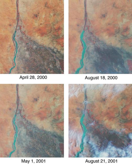
Throughout history, the rising and falling waters of the mighty Nile River have directly impacted the lives of the people who live along its banks. These images of the area around Sudan's capital city of Khartoum capture the river's dynamic nature. Acquired by the Multi-angle Imaging SpectroRadiometer's nadir (vertical-viewing) camera, they display the extent of the Nile waters before and after the onset of the rainy seasons of 2000 (top pair) and 2001 (bottom pair). The images are displayed in "false color," using the camera's near-infrared, green, and blue bands. With this particular spectral combination, water appears in shades of blue and turquoise, and highly vegetated areas show up as bright red. Originating in Uganda and Ethiopia, respectively, the waters of the White Nile (western branch) and Blue Nile (eastern branch) converge at Khartoum (about half-way between image center and the left-hand side), and continue to flow northward as the Great Nile. Although the most obvious feature in these images is the increased width of the White Nile between spring and summer, careful inspection shows that the Great Nile is at its widest in August 2001 (note in particular the area between the clouds near the top of this panel). Heavy rains in the Blue Nile catchment area of the Ethiopian highlands led to a rapid overflow of the river's floodwaters into the main stream of the Great Nile, leading to extensive flooding, the worst effects of which occurred north of Khartoum. According to the Food and Agriculture Organization of the United Nations, tens of thousands of people have fled their homes, and the number of people in need of urgent food assistance in Sudan, estimated at three million earlier in the year, was likely to increase with the onset of these floods. South of the confluence of the White Nile and the Blue Nile, the area of a cross-hatched appearance is the irrigated plain of El Gezira. The Gezira irrigation scheme uses water from the Makwar Dam (now called the Sennar Dam), located across the Blue Nile south of Khartoum. Among the main agricultural products of this region are cotton, millet, peanuts and fodder crops. Overall prospects for Sudan's 2001 grain crop were already poor prior to the flooding due to a late start of the rainy season in parts of the country. Following two consecutive years of serious drought, precipitation arrived too late to save the grain harvest that normally begins in late August. Lower harvests for the past two years coupled with depletion of stocks have led to a rise in cereal prices, reducing access to food for the Sudan's poorer citizens, already suffering from the effects of Africa's longest running civil war. Each of these images represents an area of about 130 kilometers x 150 kilometers. The data were obtained during Terra orbits 1922, 3553, 7281, and 8912. http://photojournal.jpl.nasa.gov/catalog/PIA03420
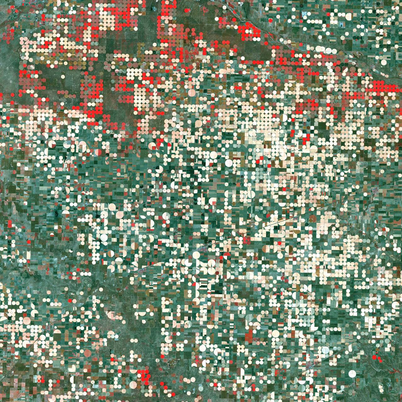
Center pivot irrigation systems create red circles of healthy vegetation in this image of croplands near Garden City, Kansas. This image was acquired by Landsat 7’s Enhanced Thematic Mapper plus (ETM+) sensor on September 25, 2000. This is a false-color composite image made using near infrared, red, and green wavelengths. The image has also been sharpened using the sensor’s panchromatic band. Credit: NASA/GSFC/Landsat <b><a href="http://www.nasa.gov/centers/goddard/home/index.html" rel="nofollow">NASA Goddard Space Flight Center</a></b> enables NASA’s mission through four scientific endeavors: Earth Science, Heliophysics, Solar System Exploration, and Astrophysics. Goddard plays a leading role in NASA’s accomplishments by contributing compelling scientific knowledge to advance the Agency’s mission. <b>Follow us on <a href="http://twitter.com/NASA_GoddardPix" rel="nofollow">Twitter</a></b> <b>Join us on <a href="http://www.facebook.com/pages/Greenbelt-MD/NASA-Goddard/395013845897?ref=tsd" rel="nofollow">Facebook</a></b>

STS098-714A-020 (7-20 February 2001) ---One of the STS-98 astronauts aboard the Earth-orbiting Space Shuttle Atlantis used a 70mm handheld camera to record this image of Southern California. Snow blanketing the higher elevations in the Los Padres National Forest (center of the image) and that covering the Angeles National Forest (right middle) help to accentuate and separate three major landform regions in southern California. The northern Los Angeles Basin that includes the San Fernando Valley and the Santa Monica Mountains is visible in the lower right quadrant of the image. The western end of the Mojave Desert (upper right) shows the two distinctive mountain boundaries along the southwest and northwest edge of the desert. The San Andreas Fault and the Garlock Fault converge (snow covered in this scene) at the western end of the desert. The intensively irrigated and cultivated southern end of the San Joaquin Valley that includes Bakersfield is visible (upper left) north of the snow-covered, northeast-southwest trending Tehachapi Mountains. The island off of the California coast (bottom left) is Santa Cruz Island.
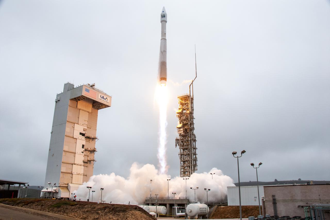
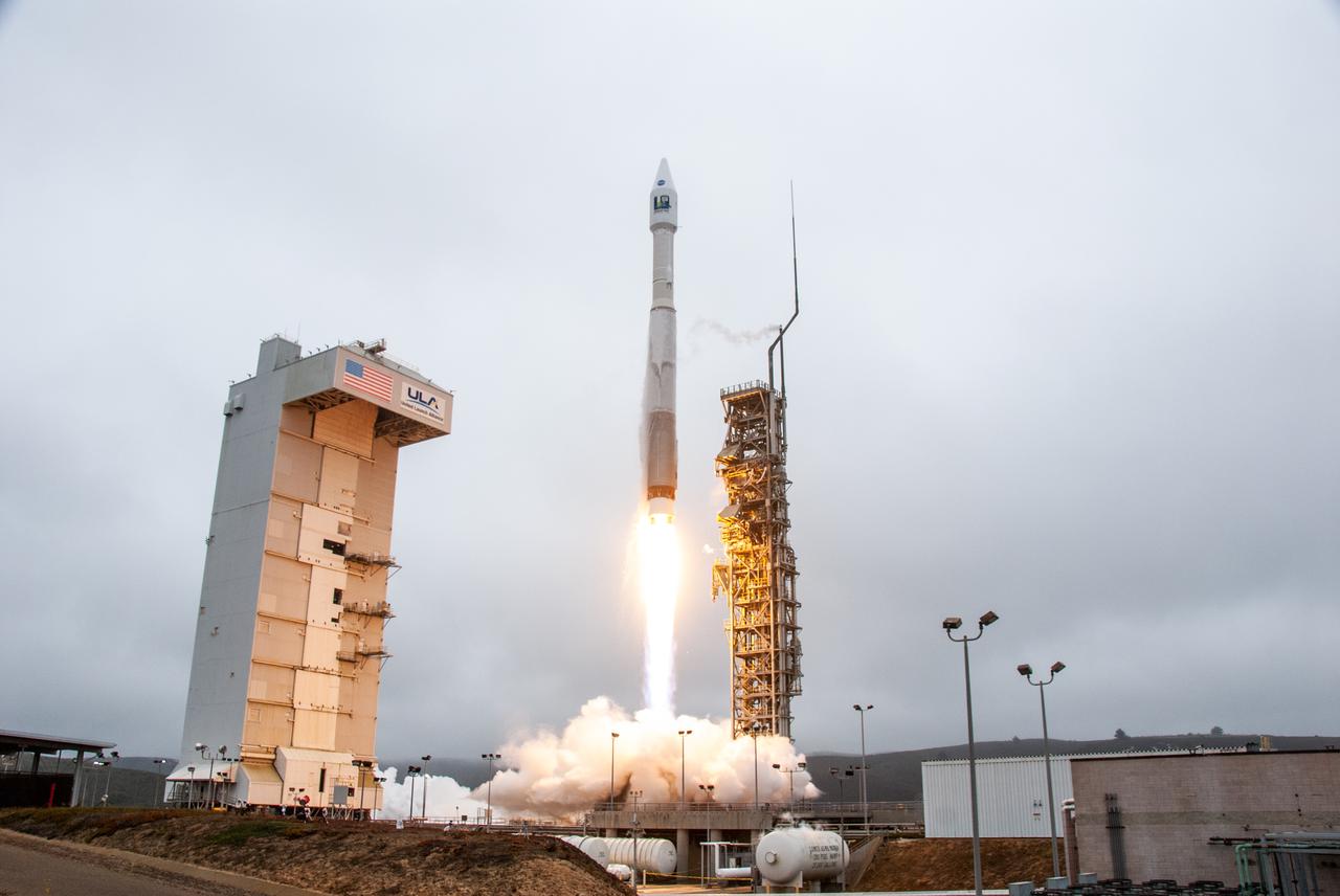
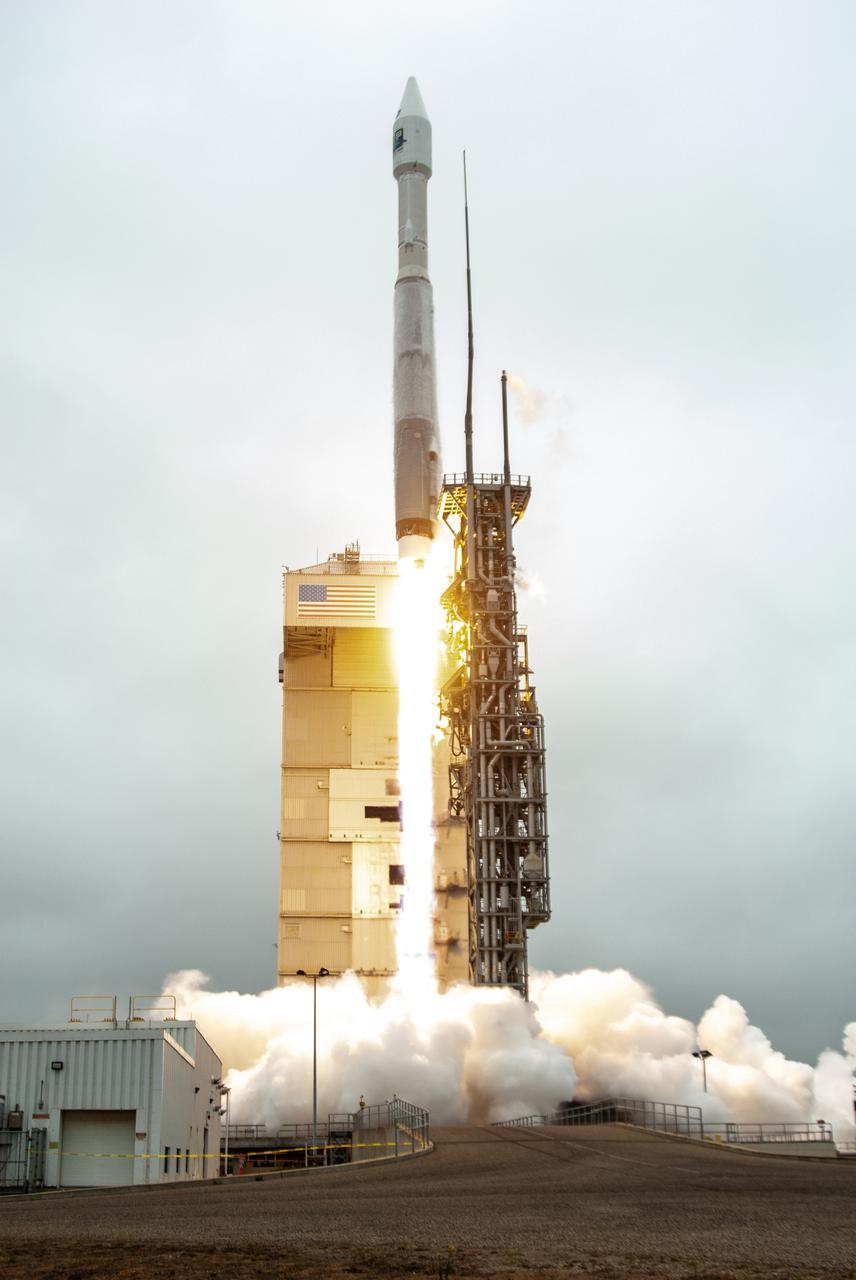
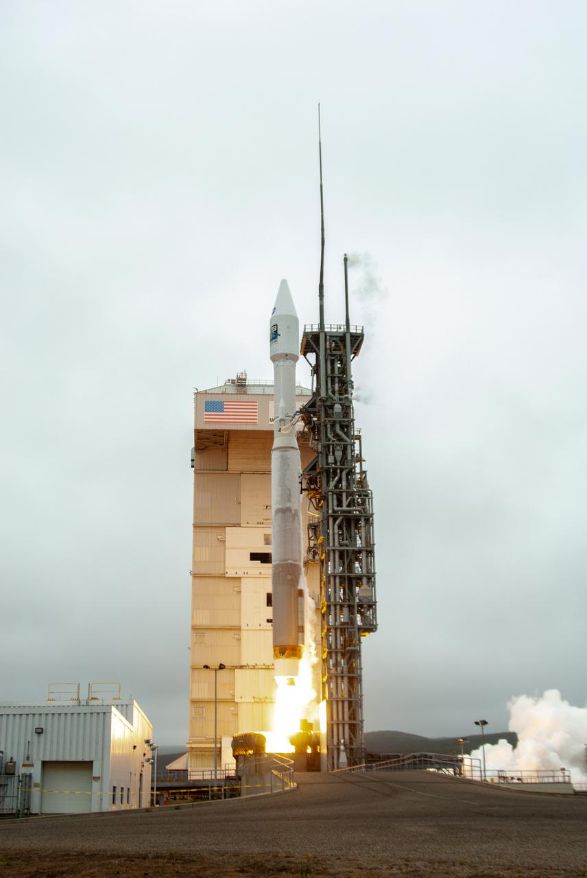
NASA’s Landsat 9 satellite launches on a United Launch Alliance Atlas V 401 rocket from Space Launch Complex 3 at Vandenberg Space Force Station in California on Sept. 27, 2021. Launch time was 2:11 p.m. EDT (11:11 a.m. PDT). The launch is managed by NASA’s Launch Services Program, based at the agency’s Kennedy Space Center in Florida. Landsat 9 will join its sister satellite, Landsat 8, in orbit in collecting images from across the planet every eight days. This calibrated data will continue the Landsat program’s critical role in monitoring the health of Earth and helping people manage essential resources, including crops, irrigation water, and forests. NASA Goddard manages the Landsat 9 mission. Goddard teams also built and tested one of the two instruments on Landsat 9, the Thermal Infrared Sensor 2 (TIRS-2) instrument. TIRS-2 will use thermal imaging to make measurements that can be used to estimate soil moisture and detect the health of plants.
STS-56 Earth observation of the northeastern Nile Delta was photographed from the Earth-orbiting Discovery, Orbiter Vehicle (OV) 103. The branch of the Nile featured in the frame is Daimietta. The Suez Canal marks the boundary of the Nile Delta agriculture and the Sinai Desert to the right. Lake Masada, the dark waterlogged area to the west (left) of Port Said is becoming more saline as the Aswan Dam has reduced sediment downstream. This sediment reduction, according to NASA scientists studying the STS-56 photography, has resulted in increased coastal erosion and the intrusion of a salt-water lens to the ground water, particularly in the northeastern portions of the delta. Center pivot irrigation fields are located along either side of the Ramses Canal, which connects the Daimietta Nile with Great Bitter Lake. This canal has been re-dug three or four times in the past 3,000 years. Historians note that the canal's most famous use was as the departure point of the fleet of Pharaoh Necho. The fleet circumnavigated Africa clockwise from the head of the Red Sea to the Mediterranean coast of the Nile (probably the Rosetta Nile) in a three-year voyage circa 660 BC.

Marie Lewis, NASA Communications, moderates a prelaunch news conference for NASA’s Landsat 9 mission at Vandenberg Space Force Base in California on Saturday, Sept. 25, 2021. Participants include Thomas Zurbuchen, associate administrator, NASA’s Science Mission Directorate; Karen St. Germain, director, NASA’s Earth Science Division; Tanya Trujillo, assistant secretary for water and science, U.S. Department of the Interior; Michael Egan, Landsat program executive, NASA’s Earth Science Division; Tim Dunn, launch director, NASA’s Launch Services Program; Scott Messer, United Launch Alliance program manager, NASA Launch Services Program; and Capt. Addison Nichols, weather officer, Space Launch Delta 30. Landsat 9 is scheduled to launch at 2:12 p.m. EDT (11:12 a.m. PDT) on Monday, Sept. 27, on a United Launch Alliance Atlas V 401 rocket from Space Launch Complex 3 at Vandenberg. The launch is managed by NASA’s Launch Services Program, based at the agency’s Kennedy Space Center in Florida. Landsat 9 will join its sister satellite, Landsat 8, in orbit in collecting images from across the planet every eight days. This calibrated data will continue the Landsat program’s critical role in monitoring the health of Earth and helping people manage essential resources, including crops, irrigation water, and forests.

ISS029-E-037471 (3 Nov. 2011) --- Egypt?Israel borderlands, northern Sinai Peninsula and northern Negev Desert are featured in this image photographed by an Expedition 29 crew member on the International Space Station. A clearly visible line that marks approximately 50 kilometers of the international border between Egypt and Israel?10-60 kilometers from the Mediterranean Sea to the northwest (not shown)?crosses the center of this photograph from left to right. The reason for the color difference is likely the slightly higher level of grazing by the animal herds of Bedouin herdsmen on the Egyptian side of the border. A major highway also follows the border, making the demarcation more prominent in this recent image taken from the space station. A patch of the Gaza Strip appears under scattered cloud at far right. In the arid to semiarid climate of the region illustrated in the image the natural grass vegetation is sparse at best. Irrigated commercial agriculture in Israel nearest the Mediterranean coast appears as a series of large angular patterns and circular center pivot fields, with darker greens indicating growing crops (right). Smaller plot sizes appear on the Egyptian side of the border at upper right. The image shows how the active sand dunes, which dominate most of the landscape in this view, mark the southern limit of the agriculture.
S73-35078 (July-Sept. 1973) --- A nearly vertical view of the Phoenix, Arizona metropolitan area is seen in this Skylab 3 (second manning) Earth Resources Experiments Package S190-B (five-inch Earth terrain camera) photograph taken from the Skylab space station in Earth orbit. Also in the picture are Scottsdale, Paradise Valley, Tempe, Mesa, Komatke, Salt River Indian Reservation and part of the Gila River Indian Reservation. Features which can be delineated from the photograph include: cultural patterns defined by commercial, industrial, agricultural and residential areas; transportation networks consisting of major corridors, primary, secondary and feeder streets; major urban developments in the area such as airports, Squaw Peak City Park, Turf Paradise Race Track and the State Fairgrounds. Phoenix is one of the 27 census cities of interest under study by the U.S. Geological Survey and is the center of the Arizona Regional Ecological Test Site. A large number of investigators will be using the Skylab data. This photo will be compared to earlier ones to document changes in the urban area with time. The landscape is well defined in terms of mountains, alluvial fans and river flood plains. Several different types of natural vegetation and irrigated crop lands can be mapped. Geological features are not well displayed but mining activities are readily identified. Photo credit: NASA
NASA’s Landsat 9 satellite launches on a United Launch Alliance Atlas V 401 rocket from Space Launch Complex 3 at Vandenberg Space Force Station in California on Sept. 27, 2021. Launch time was 2:12 p.m. EDT (11:12 a.m. PDT). The launch is managed by NASA’s Launch Services Program, based at the agency’s Kennedy Space Center in Florida. Landsat 9 will join its sister satellite, Landsat 8, in orbit in collecting images from across the planet every eight days. This calibrated data will continue the Landsat program’s critical role in monitoring the health of Earth and helping people manage essential resources, including crops, irrigation water, and forests. NASA Goddard manages the Landsat 9 mission. Goddard teams also built and tested one of the two instruments on Landsat 9, the Thermal Infrared Sensor 2 (TIRS-2) instrument. TIRS-2 will use thermal imaging to make measurements that can be used to estimate soil moisture and detect the health of plants.
NASA’s Landsat 9 satellite launches on a United Launch Alliance Atlas V 401 rocket from Space Launch Complex 3 at Vandenberg Space Force Station in California on Sept. 27, 2021. Launch time was 2:11 p.m. EDT (11:11 a.m. PDT). The launch is managed by NASA’s Launch Services Program, based at the agency’s Kennedy Space Center in Florida. Landsat 9 will join its sister satellite, Landsat 8, in orbit in collecting images from across the planet every eight days. This calibrated data will continue the Landsat program’s critical role in monitoring the health of Earth and helping people manage essential resources, including crops, irrigation water, and forests. NASA Goddard manages the Landsat 9 mission. Goddard teams also built and tested one of the two instruments on Landsat 9, the Thermal Infrared Sensor 2 (TIRS-2) instrument. TIRS-2 will use thermal imaging to make measurements that can be used to estimate soil moisture and detect the health of plants.
STS072-727-059 (11-20 Jan. 1996) --- Plains of the Orange Free State, South Africa are featured in this 70mm frame exposed from the Space Shuttle Endeavour. If the photograph is oriented with the largest clouds at the top edge, so that the cloud shadows fall to the upper right of each cloud, then north is to the top. The Vaal River flows along the top and through the upper left of the photograph; the reservoir of the Bloemhofdam on the Sand River can be seen between clouds at the upper right of the photograph. Kimberley can be seen as a gray smudge southeast of a contorted set of bends in the Vaal river (upper left center). With high magnification four dark dots, large open-pit mine shafts, can be seen within the gray smudge of the city. Kimberley, the capital of Northern Cape Province, was founded in 1878 after the discovery of diamonds in 1969 - 71, and reached by railway in 1885. Diamond mining and gem cutting remain prominent in the economy. The reddish soil and scattered salt pans (playa lakes) across the plateau suggest the semi-arid climate, suitable for cattle ranching. Reservoirs on most streams now provide water for the towns as well as irrigation for agriculture.

Tylar Greene, NASA Communications, moderates a mission and science briefing for NASA’s Landsat 9 mission at Vandenberg Space Force Base in California on Sept. 24, 2021. Virtual participants (not shown) are Jeff Masek, Landsat 9 project scientist at NASA’s Goddard Space Flight Center; Chris Crawford, Landsat 9 project scientist at USGS; Inbal Becker-Reshef, director of NASA’s Harvest food security and agriculture program; Del Jenstrom, Landsat 9 project manager at Goddard; Brian Sauer, Landsat 9 project manager at USGS; Sabrina Chapman, manager, system engineering, Northrop Grumman Space Systems; and Sarah Lipscy, OLI-2 senior engineer, Ball Aerospace & Technologies. Landsat 9 is scheduled to launch at 2:11 p.m. EDT (11:11 a.m. PDT) on Monday, Sept. 27, on a United Launch Alliance Atlas V 401 rocket from Space Launch Complex 3 at Vandenberg. The launch is managed by NASA’s Launch Services Program, based at the agency’s Kennedy Space Center in Florida. Landsat 9 will join its sister satellite, Landsat 8, in orbit in collecting images from across the planet every eight days. This calibrated data will continue the Landsat program’s critical role in monitoring the health of Earth and helping people manage essential resources, including crops, irrigation water, and forests.
NASA’s Landsat 9 satellite launches on a United Launch Alliance Atlas V 401 rocket from Space Launch Complex 3 at Vandenberg Space Force Station in California on Sept. 27, 2021. Launch time was 2:11 p.m. EDT (11:11 a.m. PDT). The launch is managed by NASA’s Launch Services Program, based at the agency’s Kennedy Space Center in Florida. Landsat 9 will join its sister satellite, Landsat 8, in orbit in collecting images from across the planet every eight days. This calibrated data will continue the Landsat program’s critical role in monitoring the health of Earth and helping people manage essential resources, including crops, irrigation water, and forests. NASA Goddard manages the Landsat 9 mission. Goddard teams also built and tested one of the two instruments on Landsat 9, the Thermal Infrared Sensor 2 (TIRS-2) instrument. TIRS-2 will use thermal imaging to make measurements that can be used to estimate soil moisture and detect the health of plants.
STS060-83-041 (3-11 Feb 1994) --- The large city of Monterrey, in northeastern Mexico, was founded at the edge between the Sierra Madre Oriental and the Rio Grande Embayment portion of the Gulf Coastal Plain. This location is analogous to the Fall Line along the United States eastern seaboard, but instead of lying along a stream at the head of navigation, Monterrey lies at the boundary between a well-watered mountain range and a semi-arid plain where irrigation is often necessary for successful agriculture. The mountains themselves are formed from folded limestone and shale beds; to the south of the city, beds are crumpled into tight folds. Around and north of the city, more open folds gradually give way to nearly flat-lying beds of the coastal plain. Because of the water and other resources such as shale and limestone to quarry and burn for cement, Monterrey early became a thriving industrial center. It is now one of Mexico's largest cities with a population of approximately 5 million. According to NASA geologists, the STS-60 photography of this area is the best that has been acquired during the past 32 years of space photography by the United States. Monterrey remains an area of high interest for future photography in order to assess the impact of urbanization in this area.
NASA’s Landsat 9 satellite launches on a United Launch Alliance Atlas V 401 rocket from Space Launch Complex 3 at Vandenberg Space Force Station in California on Sept. 27, 2021. Launch time was 2:11 p.m. EDT (11:11 a.m. PDT). The launch is managed by NASA’s Launch Services Program, based at the agency’s Kennedy Space Center in Florida. Landsat 9 will join its sister satellite, Landsat 8, in orbit in collecting images from across the planet every eight days. This calibrated data will continue the Landsat program’s critical role in monitoring the health of Earth and helping people manage essential resources, including crops, irrigation water, and forests. NASA Goddard manages the Landsat 9 mission. Goddard teams also built and tested one of the two instruments on Landsat 9, the Thermal Infrared Sensor 2 (TIRS-2) instrument. TIRS-2 will use thermal imaging to make measurements that can be used to estimate soil moisture and detect the health of plants.

Dr. Thomas Zurbuchen, associate administrator, NASA’s Science Mission Directorate, participates in the launch broadcast for the Landsat 9 mission on Sept. 27, 2021, at Vandenberg Space Force Base in California. NASA’s Landsat 9 satellite launched on a United Launch Alliance Atlas V 401 rocket from Vandenberg's Space Launch Complex 3 at 2:12 p.m. EDT (11:12 a.m. PDT). The launch is managed by NASA’s Launch Services Program, based at the agency’s Kennedy Space Center in Florida. Landsat 9 will join its sister satellite, Landsat 8, in orbit in collecting images from across the planet every eight days. This calibrated data will continue the Landsat program’s critical role in monitoring the health of Earth and helping people manage essential resources, including crops, irrigation water, and forests. NASA Goddard manages the Landsat 9 mission. Goddard teams also built and tested one of the two instruments on Landsat 9, the Thermal Infrared Sensor 2 (TIRS-2) instrument. TIRS-2 will use thermal imaging to make measurements that can be used to estimate soil moisture and detect the health of plants.

Dr. Pete Doucette, acting director, USGS Earth Resources, participates in the launch broadcast for the Landsat 9 mission on Sept. 27, 2021, at Vandenberg Space Force Base in California. NASA’s Landsat 9 satellite launched on a United Launch Alliance Atlas V 401 rocket from Vandenberg's Space Launch Complex 3 at 2:12 p.m. EDT (11:12 a.m. PDT). The launch is managed by NASA’s Launch Services Program, based at the agency’s Kennedy Space Center in Florida. Landsat 9 will join its sister satellite, Landsat 8, in orbit in collecting images from across the planet every eight days. This calibrated data will continue the Landsat program’s critical role in monitoring the health of Earth and helping people manage essential resources, including crops, irrigation water, and forests. NASA Goddard manages the Landsat 9 mission. Goddard teams also built and tested one of the two instruments on Landsat 9, the Thermal Infrared Sensor 2 (TIRS-2) instrument. TIRS-2 will use thermal imaging to make measurements that can be used to estimate soil moisture and detect the health of plants.

Tylar Greene, NASA Communications, moderates a mission and science briefing for NASA’s Landsat 9 mission at Vandenberg Space Force Base in California on Sept. 24, 2021. Virtual participants (not shown) are Jeff Masek, Landsat 9 project scientist at NASA’s Goddard Space Flight Center; Chris Crawford, Landsat 9 project scientist at USGS; Inbal Becker-Reshef, director of NASA’s Harvest food security and agriculture program; Del Jenstrom, Landsat 9 project manager at Goddard; Brian Sauer, Landsat 9 project manager at USGS; Sabrina Chapman, manager, system engineering, Northrop Grumman Space Systems; and Sarah Lipscy, OLI-2 senior engineer, Ball Aerospace & Technologies. Landsat 9 is scheduled to launch at 2:11 p.m. EDT (11:11 a.m. PDT) on Monday, Sept. 27, on a United Launch Alliance Atlas V 401 rocket from Space Launch Complex 3 at Vandenberg. The launch is managed by NASA’s Launch Services Program, based at the agency’s Kennedy Space Center in Florida. Landsat 9 will join its sister satellite, Landsat 8, in orbit in collecting images from across the planet every eight days. This calibrated data will continue the Landsat program’s critical role in monitoring the health of Earth and helping people manage essential resources, including crops, irrigation water, and forests.

Jeff Masek, Landsat 9 project scientist at NASA’s Goddard Space Flight Center, participates in the launch broadcast for the Landsat 9 mission on Sept. 27, 2021, at Vandenberg Space Force Base in California. NASA’s Landsat 9 satellite launched on a United Launch Alliance Atlas V 401 rocket from Vandenberg's Space Launch Complex 3 at 2:12 p.m. EDT (11:12 a.m. PDT). The launch is managed by NASA’s Launch Services Program, based at the agency’s Kennedy Space Center in Florida. Landsat 9 will join its sister satellite, Landsat 8, in orbit in collecting images from across the planet every eight days. This calibrated data will continue the Landsat program’s critical role in monitoring the health of Earth and helping people manage essential resources, including crops, irrigation water, and forests. NASA Goddard manages the Landsat 9 mission. Goddard teams also built and tested one of the two instruments on Landsat 9, the Thermal Infrared Sensor 2 (TIRS-2) instrument. TIRS-2 will use thermal imaging to make measurements that can be used to estimate soil moisture and detect the health of plants.
Marie Lewis, NASA Communications, moderates the launch broadcast for the Landsat 9 mission on Sept. 27, 2021, at Vandenberg Space Force Base in California. NASA’s Landsat 9 satellite launched on a United Launch Alliance Atlas V 401 rocket from Vandenberg's Space Launch Complex 3 at 2:12 p.m. EDT (11:12 a.m. PDT). The launch is managed by NASA’s Launch Services Program, based at the agency’s Kennedy Space Center in Florida. Landsat 9 will join its sister satellite, Landsat 8, in orbit in collecting images from across the planet every eight days. This calibrated data will continue the Landsat program’s critical role in monitoring the health of Earth and helping people manage essential resources, including crops, irrigation water, and forests. NASA Goddard manages the Landsat 9 mission. Goddard teams also built and tested one of the two instruments on Landsat 9, the Thermal Infrared Sensor 2 (TIRS-2) instrument. TIRS-2 will use thermal imaging to make measurements that can be used to estimate soil moisture and detect the health of plants.
STS077-707-097 (19-29 May 1996) --- This 70mm photograph shows the contrasts between the Chihuahua Desert and the irrigated bottomlands of the Rio Grande. The twin cities of Juarez, Mexico, and El Paso, Texas, on opposite sides of the border are in the center of the frame. The area was first colonized in 1598 making it one of the oldest settlements of Europeans on the North American continent. The name of El Paso derives from the Spanish ?El Paso del Norte.? The City of El Paso became a United States city in 1873. The pass allows passage through the Rocky Mountains in this region. The extension of the Rockies to the northwest of El Paso is known as the Franklin Mountains. Juarez now has over a million people and El Paso has around 400,000. The economy is driven by the maquiladora industries. Fort Bliss on the United States side is a major employer also. Fort Bliss is the wedge shaped feature in El Paso. The post was first established in 1849 for protection from the Comanches and the last horse Calvary unit was disbanded in 1943.

Dr. Kate Frickas, cofounder of "Ladies of Landsat", participates in the launch broadcast for the Landsat 9 mission on Sept. 27, 2021, at Vandenberg Space Force Base in California. NASA’s Landsat 9 satellite launched on a United Launch Alliance Atlas V 401 rocket from Vandenberg's Space Launch Complex 3 at 2:12 p.m. EDT (11:12 a.m. PDT). The launch is managed by NASA’s Launch Services Program, based at the agency’s Kennedy Space Center in Florida. Landsat 9 will join its sister satellite, Landsat 8, in orbit in collecting images from across the planet every eight days. This calibrated data will continue the Landsat program’s critical role in monitoring the health of Earth and helping people manage essential resources, including crops, irrigation water, and forests. NASA Goddard manages the Landsat 9 mission. Goddard teams also built and tested one of the two instruments on Landsat 9, the Thermal Infrared Sensor 2 (TIRS-2) instrument. TIRS-2 will use thermal imaging to make measurements that can be used to estimate soil moisture and detect the health of plants.

Frank DeMauro, vice president, Northrop Grumman Tactical Space Systems, participates in the launch broadcast for the Landsat 9 mission on Sept. 27, 2021, at Vandenberg Space Force Base in California. NASA’s Landsat 9 satellite launched on a United Launch Alliance Atlas V 401 rocket from Vandenberg's Space Launch Complex 3 at 2:12 p.m. EDT (11:12 a.m. PDT). The launch is managed by NASA’s Launch Services Program, based at the agency’s Kennedy Space Center in Florida. Landsat 9 will join its sister satellite, Landsat 8, in orbit in collecting images from across the planet every eight days. This calibrated data will continue the Landsat program’s critical role in monitoring the health of Earth and helping people manage essential resources, including crops, irrigation water, and forests. NASA Goddard manages the Landsat 9 mission. Goddard teams also built and tested one of the two instruments on Landsat 9, the Thermal Infrared Sensor 2 (TIRS-2) instrument. TIRS-2 will use thermal imaging to make measurements that can be used to estimate soil moisture and detect the health of plants.
NASA’s Landsat 9 satellite launches on a United Launch Alliance Atlas V 401 rocket from Space Launch Complex 3 at Vandenberg Space Force Station in California on Sept. 27, 2021. Launch time was 2:11 p.m. EDT (11:11 a.m. PDT). The launch is managed by NASA’s Launch Services Program, based at the agency’s Kennedy Space Center in Florida. Landsat 9 will join its sister satellite, Landsat 8, in orbit in collecting images from across the planet every eight days. This calibrated data will continue the Landsat program’s critical role in monitoring the health of Earth and helping people manage essential resources, including crops, irrigation water, and forests. NASA Goddard manages the Landsat 9 mission. Goddard teams also built and tested one of the two instruments on Landsat 9, the Thermal Infrared Sensor 2 (TIRS-2) instrument. TIRS-2 will use thermal imaging to make measurements that can be used to estimate soil moisture and detect the health of plants.

Marc Evan Jackson, actor, "Landsat Steve" in Kong: Skull Island, participates in the launch broadcast for the Landsat 9 mission on Sept. 27, 2021, at Vandenberg Space Force Base in California. NASA’s Landsat 9 satellite launched on a United Launch Alliance Atlas V 401 rocket from Vandenberg's Space Launch Complex 3 at 2:12 p.m. EDT (11:12 a.m. PDT). The launch is managed by NASA’s Launch Services Program, based at the agency’s Kennedy Space Center in Florida. Landsat 9 will join its sister satellite, Landsat 8, in orbit in collecting images from across the planet every eight days. This calibrated data will continue the Landsat program’s critical role in monitoring the health of Earth and helping people manage essential resources, including crops, irrigation water, and forests. NASA Goddard manages the Landsat 9 mission. Goddard teams also built and tested one of the two instruments on Landsat 9, the Thermal Infrared Sensor 2 (TIRS-2) instrument. TIRS-2 will use thermal imaging to make measurements that can be used to estimate soil moisture and detect the health of plants.
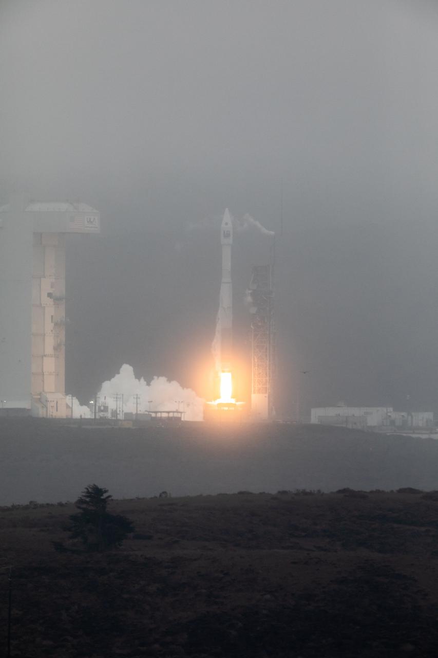
NASA’s Landsat 9 satellite launches on a United Launch Alliance Atlas V 401 rocket from Space Launch Complex 3 at Vandenberg Space Force Station in California on Sept. 27, 2021. Launch time was 2:12 p.m. EDT (11:12 a.m. PDT). The launch is managed by NASA’s Launch Services Program, based at the agency’s Kennedy Space Center in Florida. Landsat 9 will join its sister satellite, Landsat 8, in orbit in collecting images from across the planet every eight days. This calibrated data will continue the Landsat program’s critical role in monitoring the health of Earth and helping people manage essential resources, including crops, irrigation water, and forests. NASA Goddard manages the Landsat 9 mission. Goddard teams also built and tested one of the two instruments on Landsat 9, the Thermal Infrared Sensor 2 (TIRS-2) instrument. TIRS-2 will use thermal imaging to make measurements that can be used to estimate soil moisture and detect the health of plants.

Omar Baez, NASA senior launch director, participates in the launch broadcast for the Landsat 9 mission on Sept. 27, 2021, at Vandenberg Space Force Base in California. NASA’s Landsat 9 satellite launched on a United Launch Alliance Atlas V 401 rocket from Vandenberg's Space Launch Complex 3 at 2:12 p.m. EDT (11:12 a.m. PDT). The launch is managed by NASA’s Launch Services Program, based at the agency’s Kennedy Space Center in Florida. Landsat 9 will join its sister satellite, Landsat 8, in orbit in collecting images from across the planet every eight days. This calibrated data will continue the Landsat program’s critical role in monitoring the health of Earth and helping people manage essential resources, including crops, irrigation water, and forests. NASA Goddard manages the Landsat 9 mission. Goddard teams also built and tested one of the two instruments on Landsat 9, the Thermal Infrared Sensor 2 (TIRS-2) instrument. TIRS-2 will use thermal imaging to make measurements that can be used to estimate soil moisture and detect the health of plants.
STS083-747-052 (4-8 April 1997) --- Sunglint on the Indus River, Sukkar, and Rohri, Pakistan. Sukkar city (27.42 north 68.52 east), Sindh province, southeastern Pakistan lies on the west bank of the Indus River, connected with Rohri on the opposite bank by a cantilever bridge. Midstream between the two cities is the strategic island fortress of Bukkur. The old town contains many historic tombs and mosques, including the Mir Ma'sum Shah Minaret (c. AD 1607). An industrial and trade center, it has biscuit, cigarette, oil, lime, and cement factories, and cotton, silk, thread, and flour mills; boat building is also significant. The surrounding region is a vast alluvial plain broken only occasionally by low limestone hills. A portion of the Thar Desert is reaching from the south to Rohri. The Sukkur Barrage, highlighted by the sunglint, was completed in 1932. Nearly 1 mile (1.6 kilometers) long it crosses the Indus River 3 miles (4.8 kilometers) below Sukkur Gorge and feeds irrigation canals. The canals originating from it serve a cultivable area of about five million acres of land producing both food and cash crops, such as wheat, cotton, rice, oilseed, and fruit cultivation.
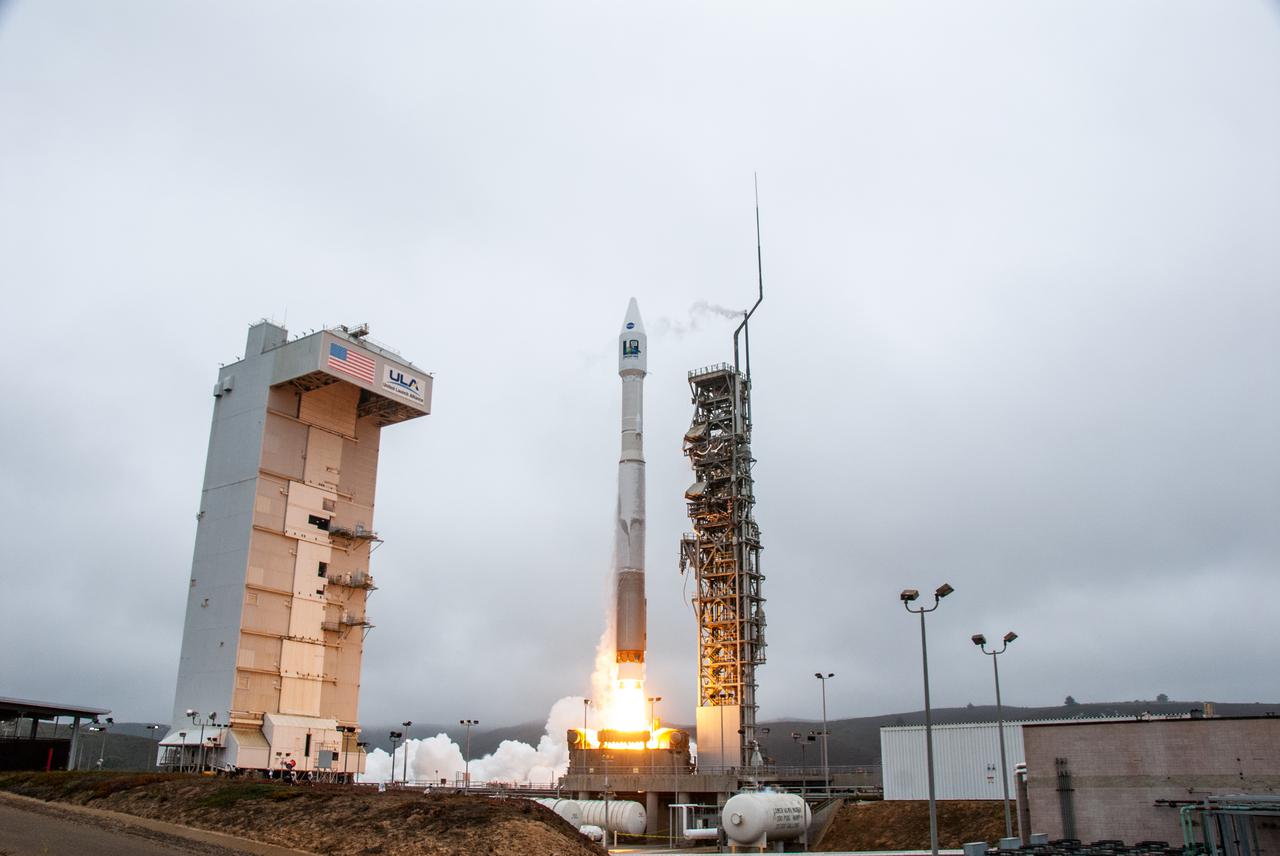
NASA’s Landsat 9 satellite launches on a United Launch Alliance Atlas V 401 rocket from Space Launch Complex 3 at Vandenberg Space Force Station in California on Sept. 27, 2021. Launch time was 2:11 p.m. EDT (11:11 a.m. PDT). The launch is managed by NASA’s Launch Services Program, based at the agency’s Kennedy Space Center in Florida. Landsat 9 will join its sister satellite, Landsat 8, in orbit in collecting images from across the planet every eight days. This calibrated data will continue the Landsat program’s critical role in monitoring the health of Earth and helping people manage essential resources, including crops, irrigation water, and forests. NASA Goddard manages the Landsat 9 mission. Goddard teams also built and tested one of the two instruments on Landsat 9, the Thermal Infrared Sensor 2 (TIRS-2) instrument. TIRS-2 will use thermal imaging to make measurements that can be used to estimate soil moisture and detect the health of plants.
STS083-748-066 (4-8 April 1997) --- Luxor, Qus, and Qina, Egypt on the Nile. The Nile, which is about 4,132 miles long, is the longest river in the world. This photo demonstrates the dependency of the local agriculture on the River. This area is the historic area of ancient Thebes. Luxor, also called EL-AKSUR, or AL-UQSUR, a market town along the southern part of the Nile's curve, is located on the southern half of the ruins of Thebes. Ancient Thebes was about six miles square; the main part of the city was situated along the Nile's east bank; along the west bank was "the city of the dead" -- an area containing the Egyptian kings' mortuary temples and the houses of those priests, soldiers, craftsmen, and laborers who were devoted to their service. Qina, extending 3 - 4 miles (5 - 6 kilometers) on each side of the Nile River between the Arabian and Libyan deserts, is seen on the northeast part of the rivers curve. Occupying the great bend in the Nile Valley, it has an area of 715 square miles (1,851 square kilometers) and contains the celebrated ruins of Thebes and the Valley of the Tombs of the Kings. Qina has a dense agricultural population (more than 3,000 persons per square mile), and most of its land is under basin irrigation, yielding only one crop annually. Main crops are sugar (about three-fifths of the nation's production), lentils, and grains.
![This radar image is of an area thought to contain the ruins of the ancient settlement of Niya. It is located in the southwestern corner of the Taklamakan Desert in China Sinjiang Province. This oasis was part of the famous Silk Road, an ancient trade route from one of China's earliest capitols, Xian, to the West. The image shows a white linear feature trending diagonally from the upper left to the lower right. Scientists believe this newly [sic] discovered feature is a man-made canal which presumably diverted river waters toward the settlement of Niya for irrigation purposes. The image was acquired by the Spaceborne Imaging Radar-C and X-band Synthetic Aperture Radar (SIR-C/X-SAR) aboard the space shuttle Endeavour on its 106th orbit on April 16, 1994, and is centered at 37.78 degrees north latitude and 82.41 degrees east longitude. The false-color radar image was created by displaying the C-band (horizontally transmitted and received) return in red, the L-band (horizontally transmitted and received) return in green, and the L-band (horizontally transmitted and vertically received) return in blue. Areas in mottled white and purple are low-lying floodplains of the Niya River. Dark green and black areas between river courses are higher ridges or dunes confining the water flow. http://photojournal.jpl.nasa.gov/catalog/PIA01725](https://images-assets.nasa.gov/image/PIA01725/PIA01725~thumb.jpg)
This radar image is of an area thought to contain the ruins of the ancient settlement of Niya. It is located in the southwestern corner of the Taklamakan Desert in China Sinjiang Province. This oasis was part of the famous Silk Road, an ancient trade route from one of China's earliest capitols, Xian, to the West. The image shows a white linear feature trending diagonally from the upper left to the lower right. Scientists believe this newly [sic] discovered feature is a man-made canal which presumably diverted river waters toward the settlement of Niya for irrigation purposes. The image was acquired by the Spaceborne Imaging Radar-C and X-band Synthetic Aperture Radar (SIR-C/X-SAR) aboard the space shuttle Endeavour on its 106th orbit on April 16, 1994, and is centered at 37.78 degrees north latitude and 82.41 degrees east longitude. The false-color radar image was created by displaying the C-band (horizontally transmitted and received) return in red, the L-band (horizontally transmitted and received) return in green, and the L-band (horizontally transmitted and vertically received) return in blue. Areas in mottled white and purple are low-lying floodplains of the Niya River. Dark green and black areas between river courses are higher ridges or dunes confining the water flow. http://photojournal.jpl.nasa.gov/catalog/PIA01725
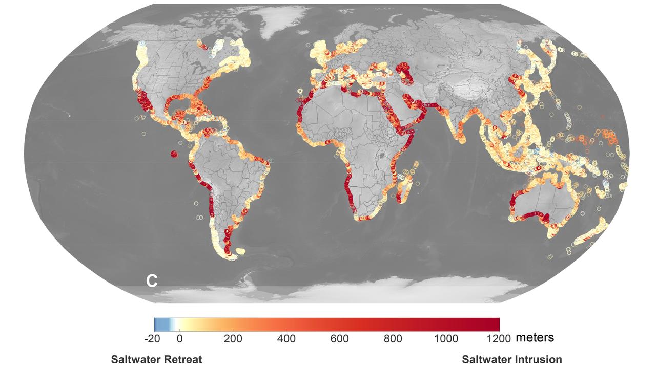
A recent study led by researchers at NASA's Jet Propulsion Laboratory in Southern California that seawater will infiltrate underground fresh water supplies in about 77% of coastal watersheds around the world by the year 2100, as illustrated in this graphic. Called saltwater intrusion, the phenomenon will result from the combined effects of sea level rise and slower replenishment of groundwater supplies due to warmer, drier regional climates, according to the study, which was funded by NASA and the U.S. Department of Defense and published in Geophysical Research Letters in November 2024. In the graphic, areas that the study projected will experience the most severe saltwater intrusion are marked with red, while the few areas that will experience the opposite phenomenon, called saltwater retreat, are marked with blue. Saltwater intrusion happens deep below coastlines, where two masses of water naturally run up against each other. Rainfall on land replenishes, or recharges, fresh water in coastal aquifers (essentially, underground rock and dirt that hold water), which tends to flow underground toward the ocean. Meanwhile, seawater, backed by the pressure of the ocean, tends to push inland. Although there's some mixing in the transition zone where the two meet, the balance of opposing forces typically keeps the water fresh on one side and salty on the other. Spurred by melting ice sheets and glaciers, sea level rise is causing coastlines to migrate inland and increasing the force pushing underground salt water landward. At the same time, slower groundwater recharge resulting from reduced rainfall and warmer weather patterns is weakening the force behind the fresh water in some areas. Saltwater intrusion can render water in coastal aquifers undrinkable and useless for irrigation. It can also harm ecosystems and damage infrastructure. https://photojournal.jpl.nasa.gov/catalog/PIA26491
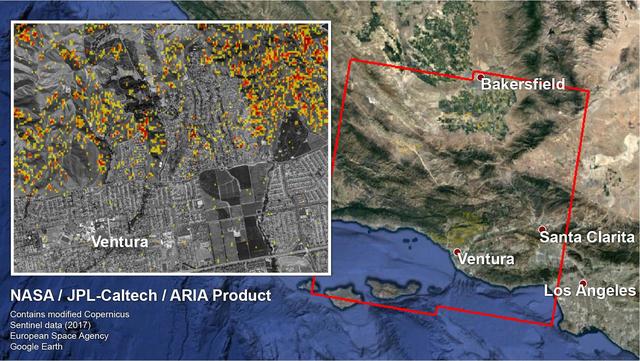
The Advanced Rapid Imaging and Analysis (ARIA) team at NASA's Jet Propulsion Laboratory in Pasadena, California, and Caltech, also in Pasadena, created a Damage Proxy Map (DPM) depicting areas in Southern California that are likely damaged (shown by red and yellow pixels) as a result of recent wildfires, including the Thomas Fire in Ventura and Santa Barbara Counties, highlighted in the attached image taken from the DPM. The map is derived from synthetic aperture radar (SAR) images from the Copernicus Sentinel-1 satellites, operated by the European Space Agency (ESA). The images were taken before (Nov. 28, 2017, 6 a.m. PST) and after (Dec. 10, 2017, 6 a.m. PST) the onset of the fires. The map covers an area of 107 by 107 miles (172 by 172 kilometers), shown by the large red polygon. Each pixel measures about 33 yards (30 meters) across. The color variation from yellow to red indicates increasingly more significant ground surface change. Preliminary validation was done by comparing the map to optical satellite imagery from DigitalGlobe. This damage proxy map should be used as guidance to identify damaged areas, and may be less reliable over vegetated areas. For example, the colored pixels seen over mountainous areas may seem a little scattered even though the reality could be that the contiguous areas were burned. Patches of farmland can also appear as signals due to plowing or irrigation. The full map is available to download from https://aria-share.jpl.nasa.gov/events/20171210-SoCal_Fire/. https://photojournal.jpl.nasa.gov/catalog/PIA22191
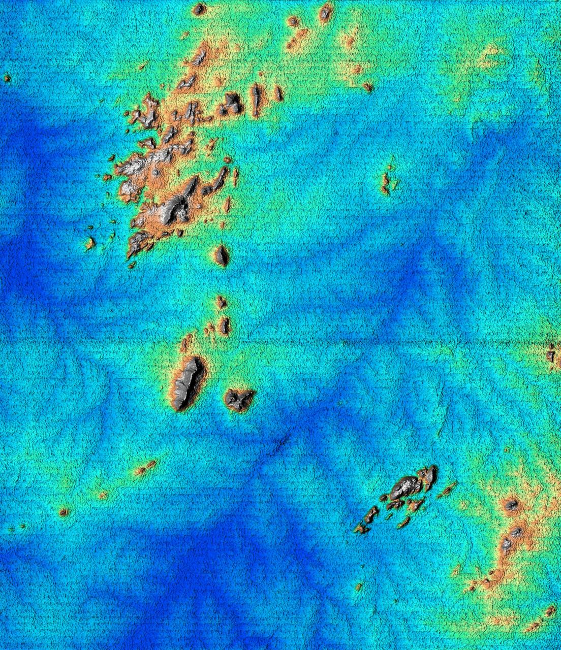
This topographic image acquired by SRTM shows an area south of the Sao Francisco River in Brazil. The scrub forest terrain shows relief of about 400 meters (1300 feet). Areas such as these are difficult to map by traditional methods because of frequent cloud cover and local inaccessibility. This region has little topographic relief, but even subtle changes in topography have far-reaching effects on regional ecosystems. The image covers an area of 57 km x 79 km and represents one quarter of the 225 km SRTM swath. Colors range from dark blue at water level to white and brown at hill tops. The terrain features that are clearly visible in this image include tributaries of the Sao Francisco, the dark-blue branch-like features visible from top right to bottom left, and on the left edge of the image, and hills rising up from the valley floor. The San Francisco River is a major source of water for irrigation and hydroelectric power. Mapping such regions will allow scientists to better understand the relationships between flooding cycles, forestation and human influences on ecosystems. This shaded relief image was generated using topographic data from the Shuttle Radar Topography Mission. A computer-generated artificial light source illuminates the elevation data to produce a pattern of light and shadows. Slopes facing the light appear bright, while those facing away are shaded. On flatter surfaces, the pattern of light and shadows can reveal subtle features in the terrain. Shaded relief maps are commonly used in applications such as geologic mapping and land use planning. http://photojournal.jpl.nasa.gov/catalog/PIA02700

ISS038-E-023651 (26 Dec. 2013) --- Lake Sharpe near Lower Brule, South Dakota is featured in this image photographed by an Expedition 38 crew member on the International Space Station. The Missouri River rises in the Rocky Mountains of western Montana, and flows generally to the southeast for approximately 3,767 kilometers (2,341 miles) to its confluence with the Mississippi River north of St. Louis, Missouri -- making it the longest river in North America. The river does not follow a straight southeasterly course along this distance, but includes may meander bends such as illustrated in this photograph. This particular bend is occupied by Lake Sharpe, an approximately 130-kilometer (80 miles) long reservoir formed behind the Big Bend Dam on the Missouri River. The lake surface is frozen and covered with snow, presenting a uniform white appearance in the image. As meander bends develop, they tend to assume a distinctive U-shape when viewed from above. Over time, the river channel can continue to cut into the ends of the "U", eventually bringing them so close together that the river then cuts across the gap to achieve a shorter flow path, essentially short-circuiting or cutting off the meander bend. When this happens and the meander ceases to be part of the active river channel, it may become an oxbow lake. The distance across the narrow neck of land (lower right) associated with this meander near Lower Brule, South Dakota is approximately one kilometer (0.62 miles); however, as the river flow is controlled by the Big Bend Dam downstream, the natural process of meander cutoff has been significantly slowed. The snow cover also highlights circular agricultural fields on the small peninsula within the meander bend. This type of field indicates center-pivot irrigation, where water is distributed from a central point radially outwards using sprinklers to cover the field area. Crops grown here include corn and soybeans according to data from the US Department of Agriculture's CropScape database.
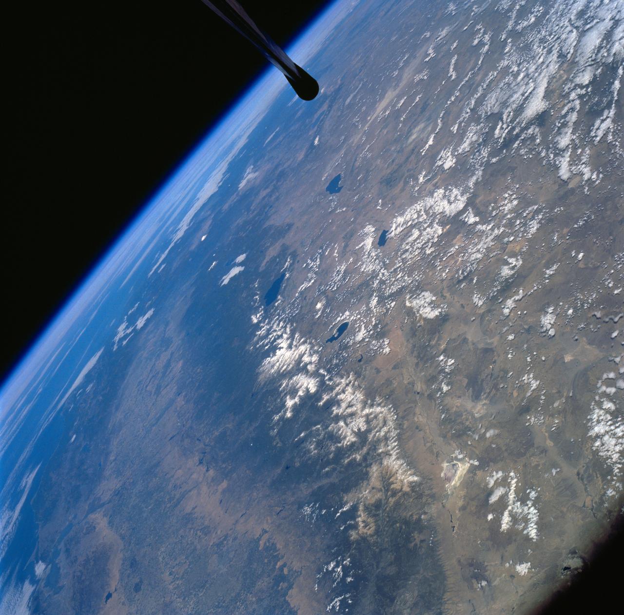
STS058-72-004 (18 Oct-1 Nov 1993) --- The Sierra Nevada Mountain Range can be seen in this north-looking high oblique view taken in October, 1993, by the STS-58 crew. Visible in the view to the west of the Sierra Nevada are the San Joaquin and Sacramento Valleys of central California. The San Francisco/Oakland Bay Area can be seen to the west of the valley at the extreme left of the photograph. To the east or right of the Sierra Nevada, the basin and Range Region of central and northern Nevada is visible. Mono Lake, Lake Tahoe and Pyramid Lake are also visible in this scene. The long northwest/southeast trending Walker Lane Shear Zone, which lies just to the east (right) of the Sierra Nevada is also visible. Near the top of the view (near the horizon), the snow covered volcanic peak Mount Shasta can be seen. Over 645 kilometers (400 miles) long and from 65 to 130 kilometers (40 to 80 miles) wide, the Sierra Nevada have many peaks in excess of 3,300 meters (11,000 feet) above sea level. A titled fault block in structure (the largest in the United States) and shaped by glaciers during the last ice age over 12,000 years ago, the Sierra Nevada eastern front rises sharply from the Great Basin of Nevada, while its western slope descends gradually to the hills bordering the Central Valley of California. Snow-fed streams supply much of the irrigation water to the Central Valley and to western Nevada and also generate hydroelectricity. Recent above normal precipitation (snowfall) of the last two years has helped in alleviating the drought conditions that had prevailed throughout most of California in the mid and late 1980's and early 1990's.
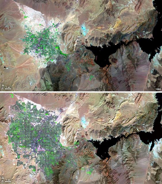
Over the years of the Landsat program, the desert city of Las Vegas has gone through a massive growth spurt. The outward expansion of the city over the last quarter of a century is shown here with two false-color Landsat 5 images (August 3, 1984, and November 2, 2011). The dark purple grid of city streets and the green of irrigated vegetation grow out in every direction into the surrounding desert. These images were created using reflected light from the shortwave infrared, near-infrared, and green portions of the electromagnetic spectrum (Landsat 5 TM bands 7,4,2). ---- NASA and the U.S. Department of the Interior through the U.S. Geological Survey (USGS) jointly manage Landsat, and the USGS preserves a 40-year archive of Landsat images that is freely available over the Internet. The next Landsat satellite, now known as the Landsat Data Continuity Mission (LDCM) and later to be called Landsat 8, is scheduled for launch in 2013. In honor of Landsat’s 40th anniversary in July 2012, the USGS released the LandsatLook viewer – a quick, simple way to go forward and backward in time, pulling images of anywhere in the world out of the Landsat archive. <b><a href="http://www.nasa.gov/audience/formedia/features/MP_Photo_Guidelines.html" rel="nofollow">NASA image use policy.</a></b> <b><a href="http://www.nasa.gov/centers/goddard/home/index.html" rel="nofollow">NASA Goddard Space Flight Center</a></b> enables NASA’s mission through four scientific endeavors: Earth Science, Heliophysics, Solar System Exploration, and Astrophysics. Goddard plays a leading role in NASA’s accomplishments by contributing compelling scientific knowledge to advance the Agency’s mission. <b>Follow us on <a href="http://twitter.com/NASA_GoddardPix" rel="nofollow">Twitter</a></b> <b>Like us on <a href="http://www.facebook.com/pages/Greenbelt-MD/NASA-Goddard/395013845897?ref=tsd" rel="nofollow">Facebook</a></b> <b>Find us on <a href="http://instagrid.me/nasagoddard/?vm=grid" rel="nofollow">Instagram</a></b>
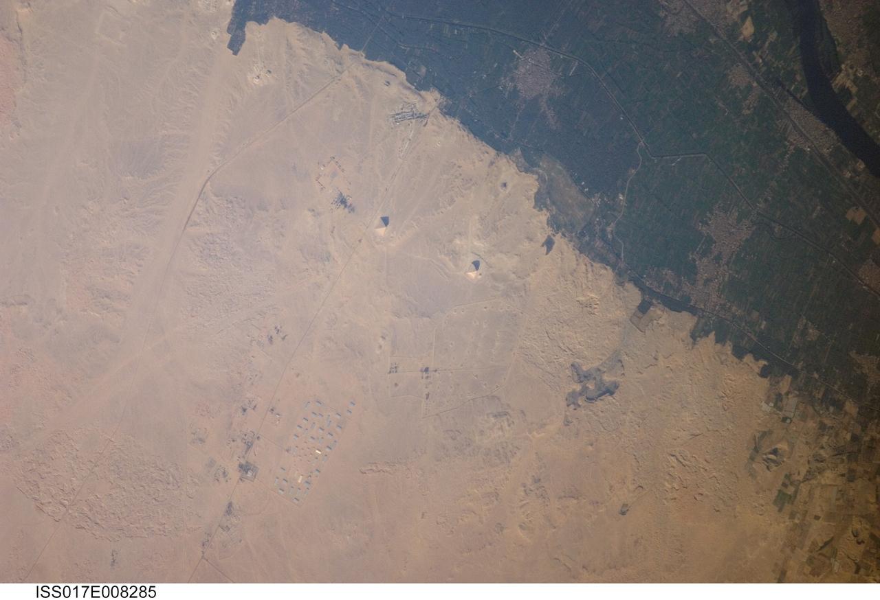
ISS017-E-008285 (30 May 2008) --- Pyramids of Dashur, Egypt are featured in this image photographed by an Expedition 17 crewmember on the International Space Station. While the pyramids of Giza are perhaps the most famous, there are several other ancient Egyptian royal necropolis ("city of the dead") sites situated along the Nile River and its delta. One of these sites is located near the village of Dashur (upper right). The gray-brown built area of Dashur is surrounded by green agricultural land of the Nile Delta, which forms a distinct boundary with the tan desert to the west. It is in the desert that the monuments of the ancient rulers of Egypt are found. Several monuments are visible in this image, including the large Red and Bent Pyramids built by Snofru, first king of the 4th Dynasty that lasted from 2575-2465 BC. Other visible monuments include the pyramid complexes of Amenemhat III and Sesostris III, both kings of the 12th Dynasty (1991-1783 BC). Both of these complexes are poorly preserved, due both to unstable ground conditions, and dismantling of the limestone blocks forming the outer pyramid casings during later historical periods. The Bent Pyramid (lower right) is so called as the slope of the outer face was lessened halfway through construction, leading to a distinctive "bent" profile -- explanations for why this was done include decreasing the mass of the pyramid to prevent collapse, or to reduce the work necessary to complete it. The Red Pyramid to the north (center) was built after the Bent Pyramid, and is named for the coloration of the building stone at the structure's core. An irregular dark feature to the southeast of the Bent Pyramid is not a shadow cast by a monument; it is an irrigation feature extending into the desert.
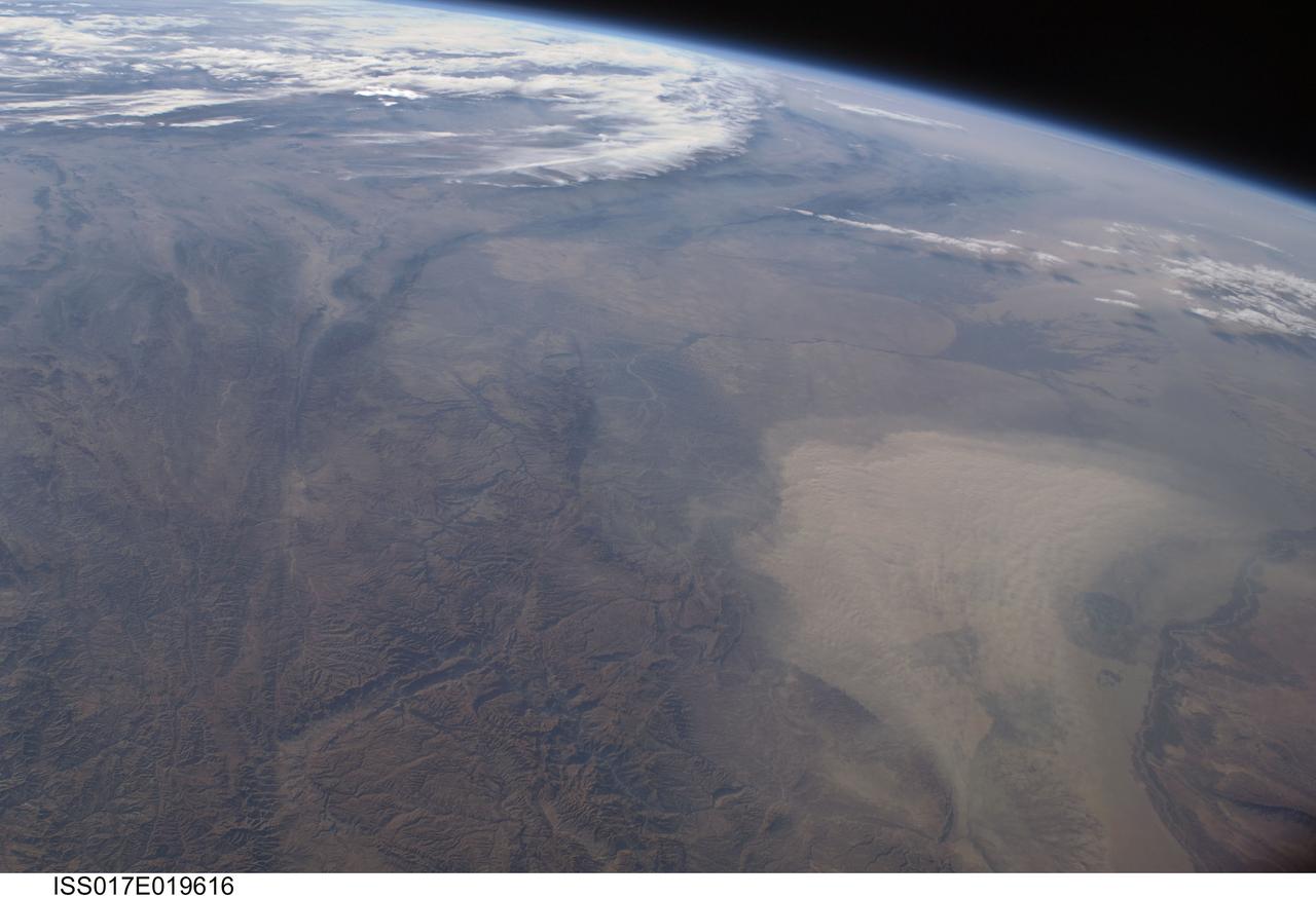
ISS017-E-019616 (16 Oct. 2008) --- A dust storm in Turkmenistan, Central Asia is featured in this image photographed by an Expedition 17 crewmember on the International Space Station. This west-looking view, taken with a short focal length lens from the station, shows a wide swath of central Asia--from Afghanistan, along the length of Turkmenistan to the Caspian Sea. Winds blowing down the largest river valley in the region, the Amudarya, were strong enough to raise a large dust storm. Dust appears as a light brown mass extending into the center of the image from the lower right. Diffuse dust from prior windy weather appears over much of the area making a regional haze that clouds much of the landscape detail. The haze partly obscures the irrigated agriculture in Turkmenistan and entirely obscures the Caspian Sea. Numerous rivers rise in the Hindu Kush mountain complex (lower left). The Band-i Amir River is a major tributary of the main regional river, the Amudarya, which it reaches via a deep canyon. The Amudarya River was the major historical contributor of water to the Aral Sea, but today extensive diversion of river water for agricultural purposes has lead to extensive exposure and desiccation of the sea bed. The exposed sea bed is a major source of saline dusts contaminated with agricultural chemicals that pose a significant environmental hazard to central Asia. To a lesser extent, dusts are also mobilized from sediments along the Amudarya river channel. The Paropamisus Range and the Amudarya (also known as the Oxus River) are mentioned in histories of Alexander the Great's famous military expedition from Greece to India. His horsemen made a fast side excursion from near the Caspian Sea (top right) as far as the Amudarya (lower right).
ISS009-E-09985 (3 June 2004) --- The Ebro River Delta, located along the eastern coast of Spain, is featured in this image photographed by an Expedition 9 crewmember on the International Space Station (ISS). Taken in partial sun glint, this view defines the Ebro’s fresh water lens— the water density boundary between the upper layer of fresh water issuing from the Ebro River mouth and the saltier, denser Mediterranean Sea water. According to NASA geologists studying the ISS imagery, diversion and impoundment of the Ebro River upstream has led to a decrease in water and sediment delivery to the delta. This decrease has led to increased erosion in some areas to the northeast of El Fangar Bay and along the southwestern shoreline of the delta. The Ebro River Delta is one of the largest wetland areas in the western Mediterranean region. The Ebro delta has grown rapidly—the historical rate of growth of the delta is demonstrated by the city of Amposta. This city was a seaport in the 4th Century, and is now located well inland from the current Ebro river mouth. The rounded form of the delta attests to the balance between sediment deposition by the Ebro River and removal of this material by wave erosion. The modern delta is in intensive agricultural use for rice, fruit, and vegetables. White polygonal areas to the north and south of the Ebro River are paddy fields. The Ebro delta also hosts numerous beaches, marshes, and saltpans that provide habitat for over 300 species of birds. A large part of the delta was designated as Parc Natural del Delta de l'Ebre (Ebre Delta National Park) in 1983. A network of canals and irrigation ditches constructed by both agricultural and conservation groups are helping to maintain the ecologic and economic resources of the Ebro Delta.
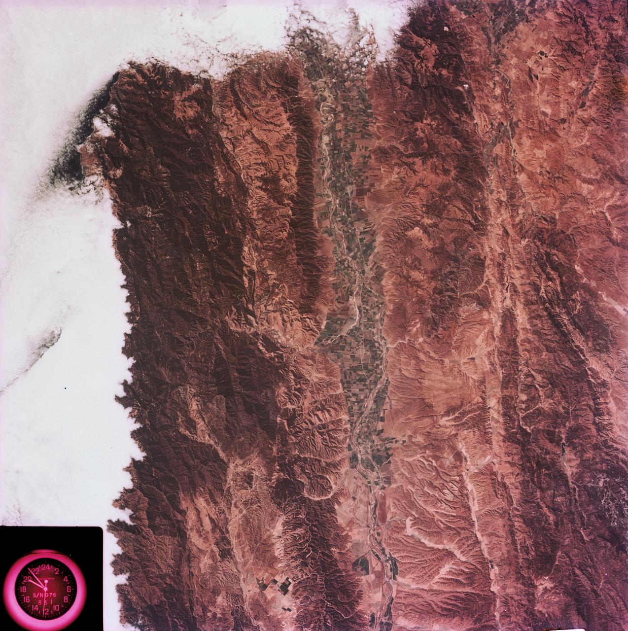
SL3-88-004 (July-September 1973) --- A vertical view of the Salinas River Valley area south of Monterey Bay, California area is seen in this Skylab 3 Earth Resources Experiments Package S190-B (five-inch Earth terrain camera) photograph taken from the Skylab space station in Earth orbit. The valley is an irrigated agricultural area, and is indicated by the dark-green and light-gray rectangular patterns in the centre of the picture. The city of Salinas is barely visible under the cloud cover at the top (north) end of the valley. The dark mass on the left (west) side of the valley is the Santa Lucia mountain range. The Big Sur area is on the left and partly covered by clouds. The Diablo Range forms the dark mass in the lower right (southeast) corner of the photograph. The town of Hollister is the gray area in the dark-green rectangular farm tracts which occupy the floor of the San Benito Valley in the upper right (northeast) corner of the photograph. The Salinas River flows northwestward toward Monterey Bay. The towns of Soledad, Greenfield and King City appear as gray areas along U.S. 101 in the Salinas Valley. The geology of the area is complex, and has been racked by several earthquakes resulting from movement along the San Andreas and subsidiary faults. Here, the surface expression of the San Andreas Fault can be traced from a point just west of Hollister at the contrast of dark brown and tan to a point about one inch left of the lower right (southeast) corner of the picture. Subsidiary faults are indicated by the curving trend of the rocks along the right side. The photograph will provide detailed information on land use patterns (Dr. R. Colwell, University of California, Berkeley) and fault tectonics (Dr. P. Merifield, Earth Science Res., Inc. and Dr. M. Abdel-Gawad, Rockwell International). Federal agencies participating with NASA on the EREP project are the Departments of Agriculture, Commerce, Interior, the Environmental Protection Agency and the Corps of Engineers. All EREP photography is available to the public through the Department of Interior’s Earth Resources Observations Systems Data Center, Sioux Falls, South Dakota, 57198. Photo credit: NASA
This is an X-band image showing seasonal changes at the hydrological test site of Bebedouro in Brazil. The image is centered at 9 degrees south latitude and 40.2 degrees west longitude. This image was acquired by the Spaceborne Imaging Radar-C and X-band Synthetic Aperture Radar (SIR-C/X-SAR) aboard the space shuttle Endeavour on April 10, 1994, during the first flight of the radar system, and on October 1, 1994, during the second mission. The swath width is approximately 16.5 kilometers (10.5 miles) wide. The image channels have the following color assignments: red represents data acquired on April 10; green represents data acquired on October 1; blue corresponds to the ratio of the two data sets. Agriculture plays an important economic and social role in Brazil. One of the major problems related to Brazilian agriculture is estimating the size of planting areas and their productivity. Due to cloud cover and the rainy season, which occurs from November through April, optical and infrared Earth observations are seldom used to survey the region. An additional goal of monitoring this region is to watch the floodplains of rivers like Rio Sao Francisco in order to determine suitable locations for additional agricultural fields. This area belongs to the semi-arid northeastern region of Brazil, where estimates have suggested that about 10 times more land could be used for agriculture, including some locations which could be used for irrigation projects. Monitoring of soil moisture during the important summer crop season is of high priority for the future development and productivity of this region. In April the area was covered with vegetation because of the moisture of the soil and only small differences could be seen in X-band data. In October the run-off channels of this hilly region stand out quite clearly because the greenish areas indicated much less soil moisture and water content in plants. http://photojournal.jpl.nasa.gov/catalog/PIA01733

ISS032-E-010487 (29 July 2012) --- Walker Lake, Nevada is featured in this image photographed by an Expedition 32 crew member on the International Space Station. According to scientists, the Pleistocene landscape of western Nevada approximately 15,000 years ago was one of narrow mountain ranges and numerous interconnected lakes that together formed the extensive glacial Lake Lahontan. Scientists believe drying and warming of the regional climate since the last Ice Age led to the disappearance of the glaciers feeding meltwater to Lake Lahontan, and eventual disappearance of the lake itself. Today, few remnants of Lahontan remain; most of its arms have become dry enclosed basins known as playas. This photograph highlights Walker Lake, one of only two remnant lakes that contain water throughout the year (Pyramid Lake in Nevada is the other). The lake is located in an enclosed basin bounded by the Wassuk Range to the west and the Gillis Range to the east. It is fed by the Walker River flowing from the north. The current dimensions of the lake are approximately 21 kilometers north-south by 9 kilometers east-west. Shoreline deposits at higher elevations than the current lake level form concentric bands that are just visible in the image (bottom center) ? these record varying lake levels in the geologic past. The nearest town is Hawthorne, Nevada to the southeast. To the southwest the highest peak of the Wassuk Range, Mount Grant (elevation 3,496 meters above sea level), dominates the skyline. Green agricultural fields, primarily alfalfa, located to the west of the Wassuk Range (lower right) provide a striking contrast to the surrounding Great Basin desert. These fields are irrigated using water from the nearby East Fork of the Walker River (right, just visible alongside the fields).
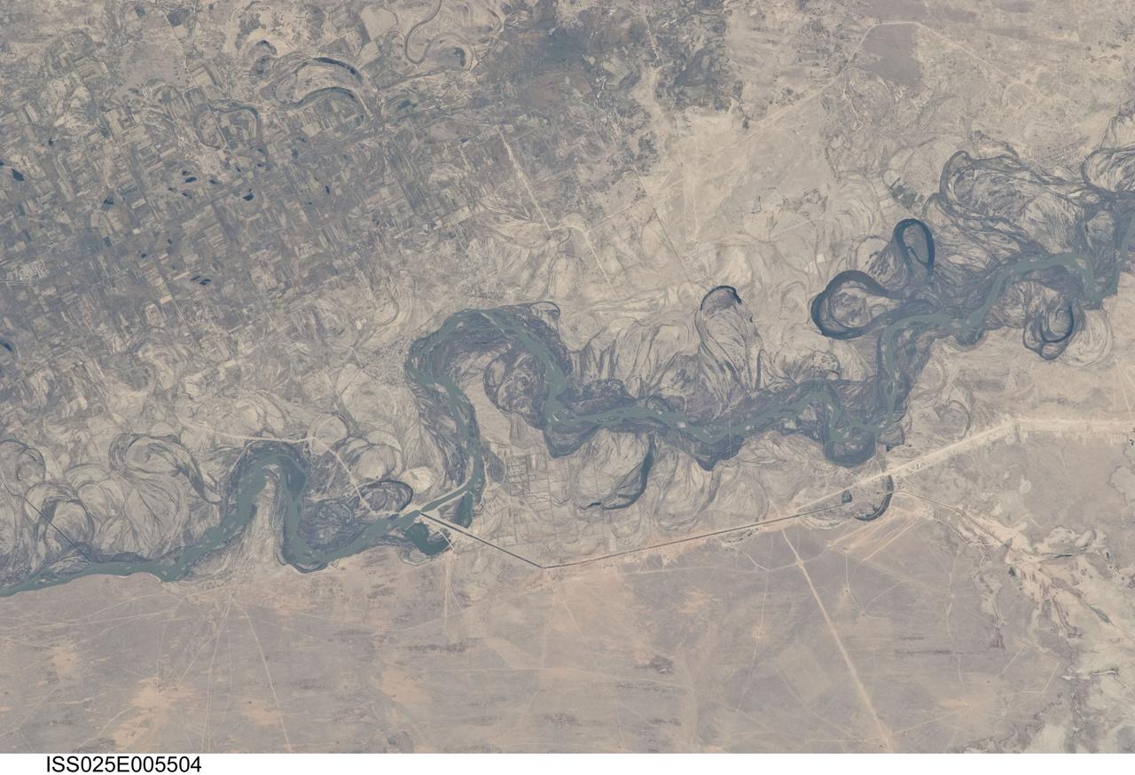
ISS025-E-005504 (30 Sept. 2010) --- Syr Dar’ya River floodplain in Kazakhstan, central Asia is featured in this image photographed by an Expedition 25 crew member on the International Space Station. Central Asia’s most important cotton-growing region is concentrated in the floodplain of the Syr Dar’ya, and is irrigated by water from the river. The floodplain is shown here as a tangle of twisting meanders and loops (center). The darkest areas are brushy vegetation along the present course (filled with blue-green water); wisps of vegetation are also visible along flanking swampy depressions, or sloughs. An older floodplain appears as an area of more diffuse dark vegetation (upper left), where a pattern of relict meander bends is overlain by a rectangular pattern of cotton fields. The straight channel of a new diversion canal—one of sixteen from this point downstream—can be seen along the east bank of the river. The older floodplain area is fed from the Chardara Reservoir immediately upstream (not shown). Half the river flow is controlled from reservoirs, and half from direct water take-off from canals. By contrast with the intensive agricultural use of water shown here, upstream water control in the mountain valleys is oriented more toward power generation. The river flows for a total distance of 2,200 kilometers from the Tien Shan Mountains westward and northwestward to the Aral Sea—the dying waterbody at the low point of the basin far to the northwest. Withdrawals of water from the river for agriculture have continued for many decades. Although the Syr Dar’ya is the second largest river flowing into the sea, its discharge is not very large. As such, it has been easily depleted, with none of its water today reaching the Aral Sea. Control of the river is vested in the Syr Dar’ya Basin Water Organization run by nations with territory in the Syr Dar’ya basin. Some of the organization’s main efforts are accurate gauging of water use along the river course, and repair of canals to reduce widespread water loss by leakage.

ISS030-E-090918 (21 Feb. 2012) --- Agricultural fields in the Wadi As-Sirhan Basin in Saudi Arabia are featured in this image photographed by an Expedition 30 crew member on the International Space Station. Northern Saudi Arabia hosts some of the most extensive sand and gravel deserts in the world, but modern agricultural technology has changed the face of some of them. This photograph presents the almost surreal image of abundant green fields in the midst of a barren desert ? specifically the Wadi As-Sirhan Basin of northwestern Saudi Arabia. As recently as 1986 there was little to no agricultural activity in the area, but over the subsequent 26 years agricultural fields have been steadily developed, largely as a result of investment of oil industry revenues by the Saudi government. The fields use water pumped from subsurface aquifers and is distributed in rotation about a center point within a circular field ? a technique known as center-pivot agriculture. This technique affords certain benefits relative to more traditional surface irrigation such as better control of water use and application of fertilizers. The use of this so-called ?precision agriculture? is particularly important in regions subject to high evaporative water loss; by better controlling the amount and timing of water application, evaporative losses can be minimized. Crops grown in the area include fruits, vegetables, and wheat. For a sense of scale, agricultural fields in active use (dark green) and fallow (brown to tan), are approximately one kilometer in diameter. While much of the Wadi As-Sirhan Basin shown here is sandy (light tan to brown surfaces) and relatively flat, low hills and rocky outcrops (dark gray) of underlying sedimentary rocks are visible at left and right.
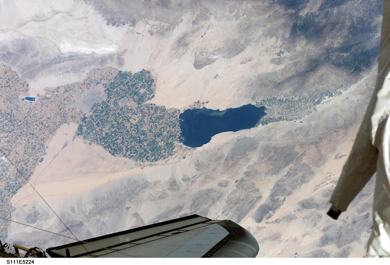
STS111-E-5224 (12 June 2002) --- Southern California’s Salton Sea is routinely a prominent visual for astronauts passing overhead on the shuttle or International Space Station (ISS). This large lake, photographed from the station while docked to the Space Shuttle Endeavour by one of the STS-111 crew members, supports the rich agricultural fields of the Imperial, Coachella and Mexicali Valleys in the California and Mexico desert. According to geologists, the Salton Sea formed by accident in 1905 when an irrigation canal ruptured, allowing the Colorado River to flood the Salton Basin. Today the Sea performs an important function as the sink for agricultural runoff. Water levels are maintained by the runoff from the surrounding agricultural valleys. The Salton Sea salinity is high -- nearly 1/4 saltier than ocean water --but it remains an important stopover point for migratory water birds, including several endangered species. Scientists also noted that the region experiences several environmental problems. The recent increased demands for the limited Colorado River water, the scientists point out, threatens the amount of water allowed to flow into the Salton Sea, and increased salinity with decreased water levels could trigger several regional environmental crises. The agricultural flow into the Sea includes nutrients and agricultural by-products, increasing the productivity and likelihood of algae blooms. This image shows either a bloom, or suspended sediment (usually highly organic) in the water that has been stirred up by winds.