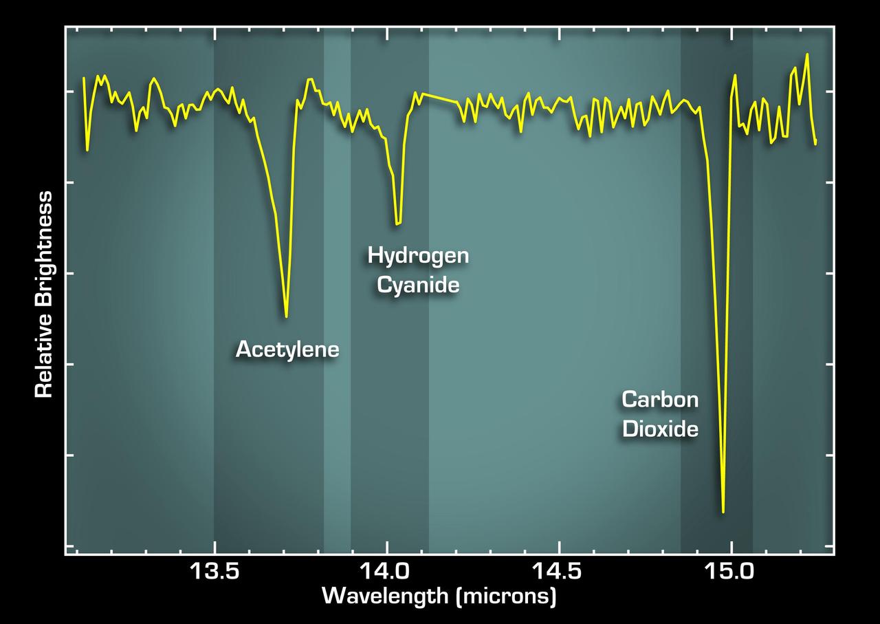
This graph, or spectrum, from NASA Spitzer Space Telescope tells astronomers that some of the most basic ingredients of DNA and protein are concentrated in a dusty planet-forming disk circling a young sun-like star called IRS 46.

This artist concept illustrates a solar system that is a much younger version of our own. Dusty disks, like the one shown here circling the star, are thought to be the breeding grounds of planets, including rocky ones like Earth.
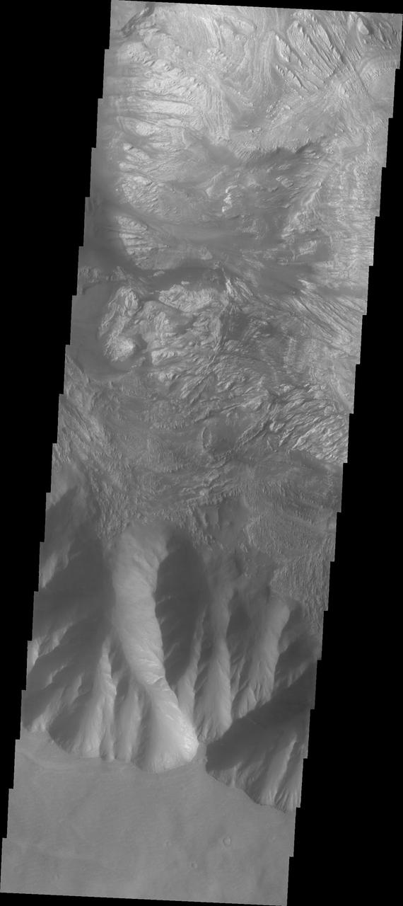
This image shows the part of the southern cliff face of Hebes Chasma at the bottom of the image. The materials seen in the majority of this image are part of the erosion of the central mesa, perhaps created by a massive landslide. Hebes Chasma is an enclosed basin not connected to Valles Marineris. The Odyssey spacecraft has spent over 15 years in orbit around Mars, circling the planet more than 69000 times. It holds the record for longest working spacecraft at Mars. THEMIS, the IR/VIS camera system, has collected data for the entire mission and provides images covering all seasons and lighting conditions. Over the years many features of interest have received repeated imaging, building up a suite of images covering the entire feature. From the deepest chasma to the tallest volcano, individual dunes inside craters and dune fields that encircle the north pole, channels carved by water and lava, and a variety of other feature, THEMIS has imaged them all. For the next several months the image of the day will focus on the Tharsis volcanoes, the various chasmata of Valles Marineris, and the major dunes fields. We hope you enjoy these images! Orbit Number: 10701 Latitude: -1.17496 Longitude: 282.347 Instrument: VIS Captured: 2004-05-13 10:46 https://photojournal.jpl.nasa.gov/catalog/PIA21810
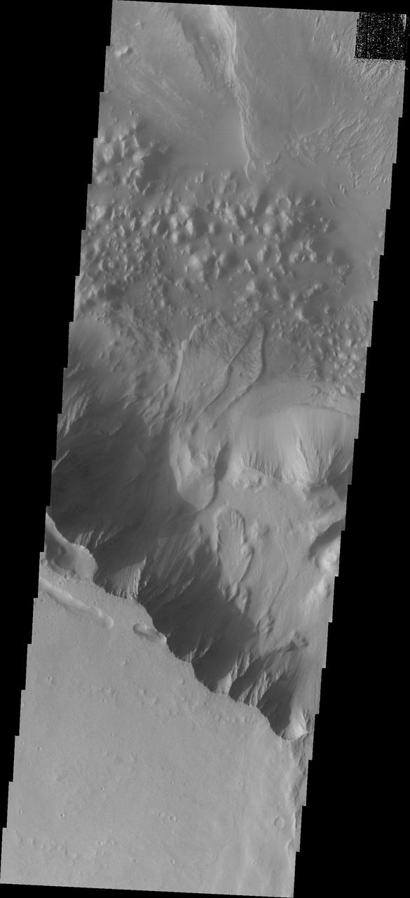
Melas Chasma is part of the largest canyon system on Mars, Valles Marineris. At only 563 km long (349 miles) it is not the longest canyon, but it is the widest. Located in the center of Valles Marineris, it has depths up to 9 km below the surrounding plains, and is the location of many large landslide deposits, as will as layered materials and sand dunes. There is evidence of both water and wind action as modes of formation for many of the interior deposits. This VIS image is located right at the edge of the canyon with the surrounding plains - the flat area at the bottom of the image. Some small landslide deposits are visible originating at the cliff side. The Odyssey spacecraft has spent over 15 years in orbit around Mars, circling the planet more than 69000 times. It holds the record for longest working spacecraft at Mars. THEMIS, the IR/VIS camera system, has collected data for the entire mission and provides images covering all seasons and lighting conditions. Over the years many features of interest have received repeated imaging, building up a suite of images covering the entire feature. From the deepest chasma to the tallest volcano, individual dunes inside craters and dune fields that encircle the north pole, channels carved by water and lava, and a variety of other feature, THEMIS has imaged them all. For the next several months the image of the day will focus on the Tharsis volcanoes, the various chasmata of Valles Marineris, and the major dunes fields. We hope you enjoy these images! Orbit Number: 26762 Latitude: -13.4233 Longitude: 287.973 Instrument: VIS Captured: 2007-12-26 19:46 https://photojournal.jpl.nasa.gov/catalog/PIA22136
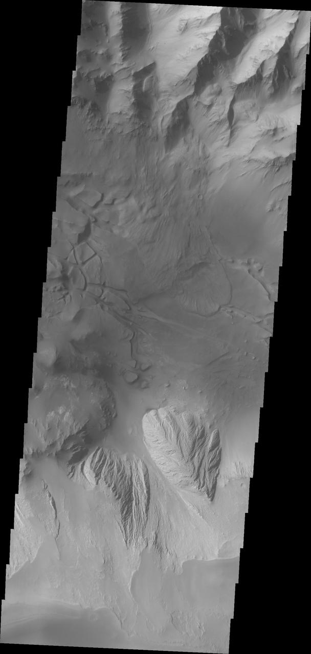
This image shows part of eastern Candor Chasma. At the top of the image is the steep cliff between the upper surface elevation and the depths of Candor Chasma. The bottom of the image is the cliff side of a large mesa. The two cliff faces have very different appearances. The cliff face between the top of the canyon and the bottom is likely layers of volcanic flows from the nearby Tharsis volcanoes. The mesa, however, is probably layers of sediments deposited in the canyon from wind, water and gravity driven erosion and deposition. These layered materials are much more easily eroded than the solid rock of the canyon sides. There is a landslide that originate from the northern cliff face and ran out into the canyon floor, visible as the lobate "tongue" at the right near the center of the image. Candor Chasma is one of the largest canyons that make up Valles Marineris. It is approximately 810 km long (503 miles) and has is divided into two regions - eastern and western Candor. Candor is located south of Ophir Chasma and north of Melas Chasma. The border with Melas Chasma contains many large landslide deposits. The floor of Candor Chasma includes a variety of landforms, including layered deposits, dunes, landslide deposits and steep sided cliffs and mesas. Many forms of erosion have shaped Chandor Chasma. There is evidence of wind and water erosion, as well as significant gravity driven mass wasting (landslides). The Odyssey spacecraft has spent over 15 years in orbit around Mars, circling the planet more than 69000 times. It holds the record for longest working spacecraft at Mars. THEMIS, the IR/VIS camera system, has collected data for the entire mission and provides images covering all seasons and lighting conditions. Over the years many features of interest have received repeated imaging, building up a suite of images covering the entire feature. From the deepest chasma to the tallest volcano, individual dunes inside craters and dune fields that encircle the north pole, channels carved by water and lava, and a variety of other feature, THEMIS has imaged them all. For the next several months the image of the day will focus on the Tharsis volcanoes, the various chasmata of Valles Marineris, and the major dunes fields. We hope you enjoy these images! Orbit Number: 36232 Latitude: -6.78692 Longitude: 292.732 Instrument: VIS Captured: 2010-02-13 14:46 https://photojournal.jpl.nasa.gov/catalog/PIA22170