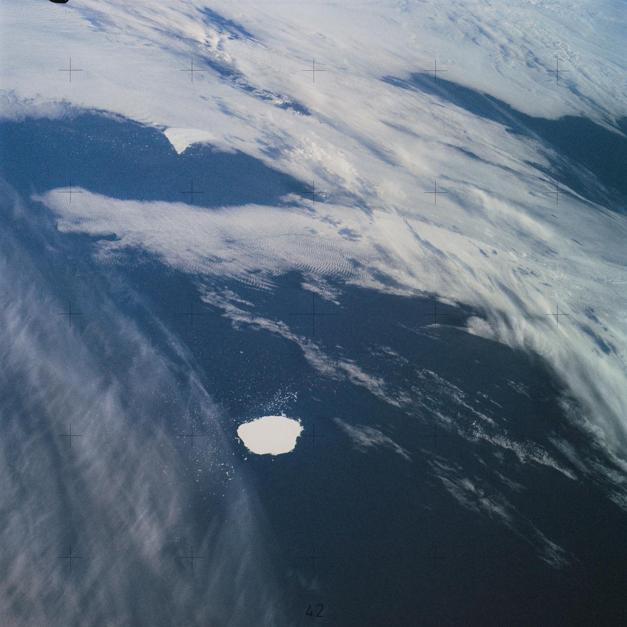
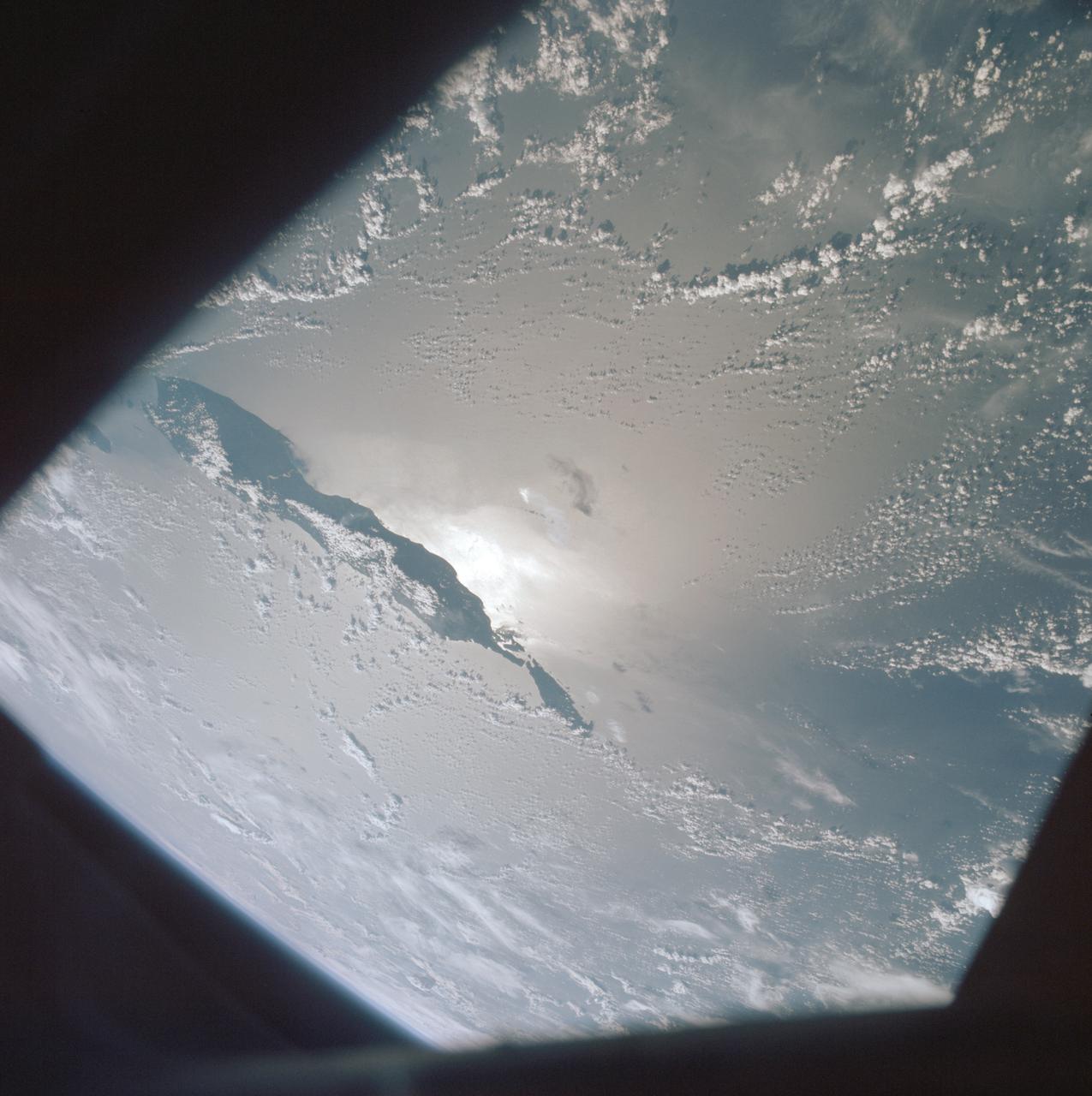
SL4-142-4577 (28 Jan. 1974) --- Two large ice islands in the vicinity of South Georgia Island in the South Atlantic Ocean, as photographed from the Skylab space station in Earth orbit by one of the Skylab 4 crewmen. The camera used was a hand-held 70mm Hasselblad, with SO-368 medium-speed Ektachrome. One of the ice islands is partially obscured by clouds. Ice islands were observed as large as 45 by 60 kilometers (27 x 37 miles) and as far north as 45 degrees south latitude. The size and distribution of the "small" icebergs (to a ship they would look very large) can be used to study the local winds and currents. Recent research has suggested the possibility of towing such Antarctic icebergs to selected areas and using them as water supplies. One such iceberg would contain many times the water as in Lake Powell. Photo credit: NASA
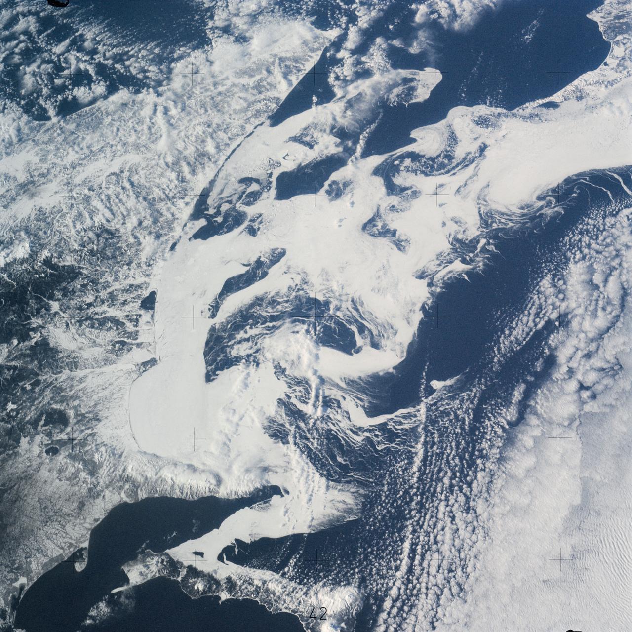
SL4-141-4340 (20 Jan. 1974) --- An oblique view of the southern part of the Sea of Okhotsk, north of Japan, as photographed from the Skylab space station in Earth orbit by one of the Skylab 4 crewmen. The camera used was a hand-held 70mm Hasselblad, and SO-368 medium-speed Ektachrome. NORTH IS AT THE TOP WHEN THE PICTURE IS HELD WITH THE LARGEST LAND MASS AT THE BOTTOM. Most of the land area is Hokkaido Island, Japan. The southern tip of Sakhalin Island (Soviet Union) is in the northwest corner. This photograph was taken to aid in the study of the formation of sea ice. Comparison of these photographs will be made with observations made during a joint USSR-U.S. experiment in the Bering Sea a year earlier. Observations in the Sea of Okhotsk are of interest because the ice has a morphology similar to that of the Bering Sea. Photo credit: NASA
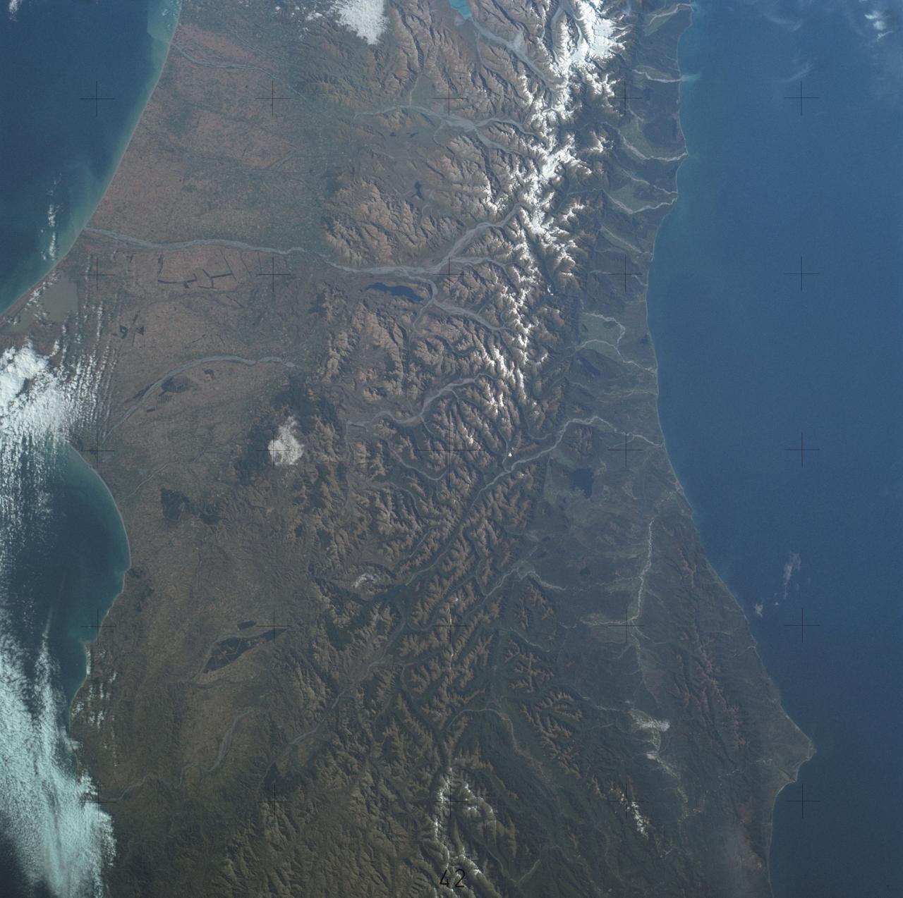
SL4-137-3700 (22 Dec. 1973) --- A near vertical view of a portion of South Island, New Zealand, as see from the Skylab space station in Earth orbit. This picture was taken by one of the Skylab 4 crew members with a handheld 70mm Hasselblad camera using a 100mm lens. The picture should be held with the largest body of water (Tasman Sea) on the left. Cape Foulwind is at the upper left. The City of Christchurch is under clouds at the center right margin. Note the movement of sediment by alongshore currents, especially on the east (right) side of the island. The Alpine Fault, which is part of the circum-Pacific volcanic-tectonic belt, is clearly visible on the left (west) side of the island. The fault line is marked by a scarp, which appears very distinct from orbital altitude. Differences in topography and vegetation on either side of the fault are also sharp. Streams change direction at the fault line, and the change in slope at the fault line is evident in the widening of stream channels. The left side of the fault has moved northeast (upward) relative to the right side; some stream offsets indicate the direction of relative movement, but others are controlled by local topography. The Alpine Fault, which also transects New Zealand's North Island, was photographed and described more than a dozen times by the Skylab 4 crewmen. The circum-Pacific volcanic-tectonic belt is a feature of the Earth's crust which is related to sea floor spreading and continental drift. Though the Alpine Fault is sharply delineated in this photograph, other major crustal features are subtle that their existence was unknown before their observation from orbit. The distance from top to bottom is about 290 kilometers (175 miles). Photo credit: NASA
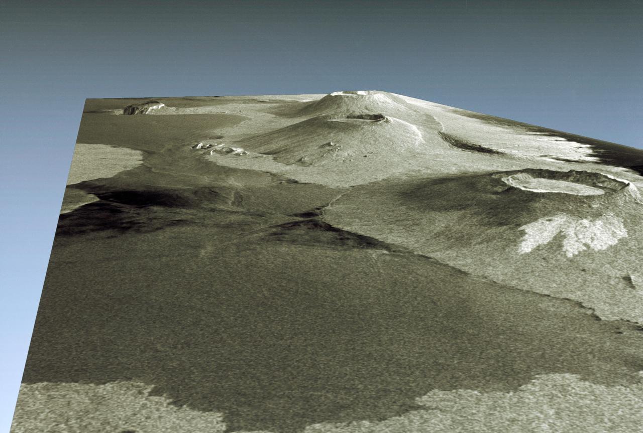
STS059-S-085 (18 April 1994) --- This is a three-dimensional perspective view of part of Isla Isabela in the western Galapagos Islands. It was taken by the L-Band radar in HH polarization from the Spaceborne Imaging Radar-C and X-Band Synthetic Aperture Radar (SIR-C/X-SAR) on the 40th orbit of the Space Shuttle Endeavour. This view was constructed by overlaying a SIR-C radar image on a U.S. Geological Survey digital elevation map. The image is centered at about .5 degrees south latitude and 91 degrees west longitude, and covers an area of 75 by 60 kilometers. The radar incidence angle at the center of the image is about 20 degrees. The western Galapagos Islands, which lie about 1200 kilometers west of Ecuador in the eastern Pacific, have six active volcanoes similar to the volcanoes found in Hawaii. Since the time of Charles Darwin's visit to the area in 1835, there have been over 60 recorded eruptions on these volcanoes. This SIR-C/X-SAR image of Alcedo and Sierra Negra volcanoes shows the rougher lava flows as bright features, while ash deposits and smooth pahoehoe lava flows appear dark. The Galapagos Islands are one of the SIR-C/X-SAR supersites and data of this area will be taken several times during the flight to allow scientists to conduct topographic change studies and to search for different lava flow types, ash deposits and fault lines. SIR-C/X-SAR is part of NASA's Mission to Planet Earth (MTPE). SIR-C/X-SAR radars illuminate Earth with microwaves allowing detailed observations at any time, regardless of weather or sunlight conditions. SIR-C/X-SAR uses three microwave wavelengths: L-Band (24 cm), C-Band (6 cm), and X-Band (3 cm). The multi-frequency data will be used by the international scientific community to better understand the global environment and how it is changing. The SIR-C/X-SAR data, complemented by aircraft and ground studies, will give scientists clearer insights into those environmental changes which are caused by nature and those changes which are induced by human activity. SIR-C was developed by NASA's Jet Propulsion Laboratory (JPL). X-SAR was developed by the Dornire and Alenia Spazio Companies for the German Space Agency, Deutsche Agentur fuer Raumfahrtangelegenheiten (DARA), and the Italian Space Agency, Agenzia Spaziale Italiana (ASI). JPL Photo ID: P-43938
This high oblique view shows the majority of the island of Madagascar (19.0S, 47.5E). This Texas sized island is now largely deforested and is suffering from severe soil erosion as well as a declining biological species diversity and productivity. At the turn of the century, the island was almost totally forested but now, forests cover only about 10 percent of the surface. Evidence of soil erosion can be seen in the offshore sediment plumes.
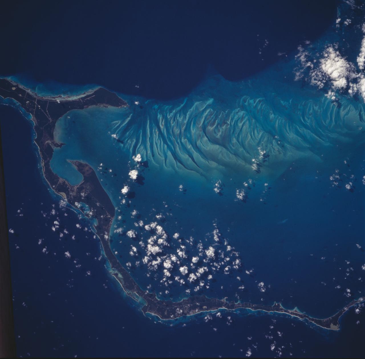
The striking views provided by the Bahama Islands lend insights into the important problems of limestone (CaCO3) production and transport. This photograph includes the southern part of Eleuthera Island in the northern Bahamas. The hook-shaped island encloses a relatively shallow platform (light blue) which is surrounded by deep water (dark blue). The feathery pattern along the western edge of Eleuthera's platform are sand bars and sand channels created by tidal currents sweeping on and off the platform. The channels serve to funnel large amounts of CaCO3 off the platform and into the deeper water.
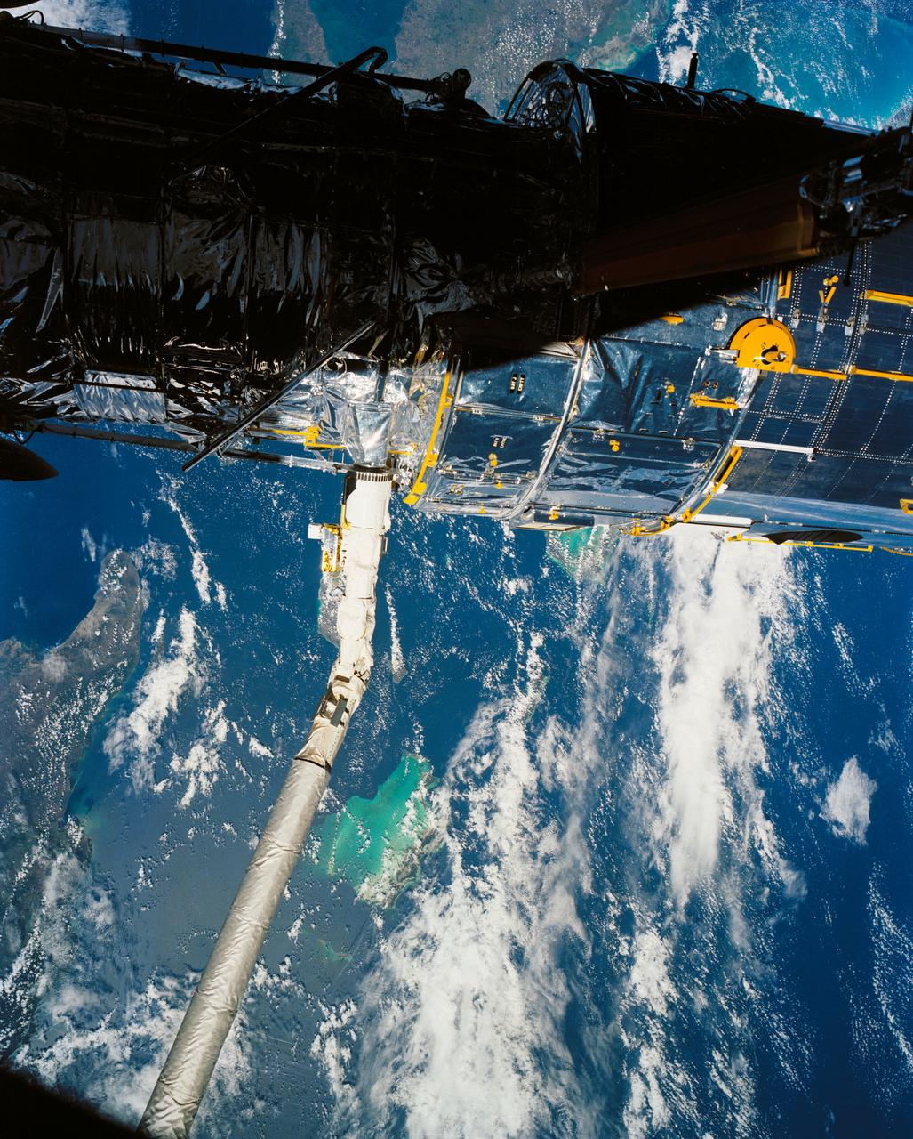
A close up deploy view of the Hubble Space Telescope on the end of the space shuttle remote manipulator system (RMS) with Eastern Cuba, (20.0N, 74.0W) seen on the left side of the telescope and northern Haiti seen on the right side of the telescope. The light colored blue feature in the water north of Haiti is the shallow waters of the Caicos Bank.
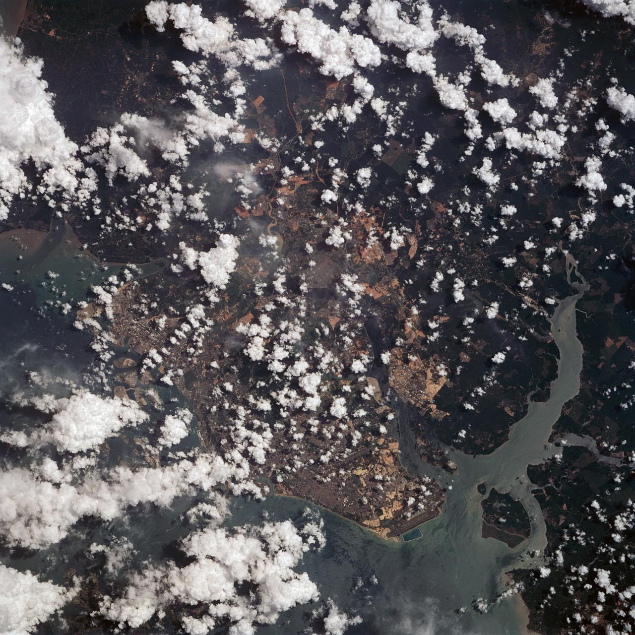
This view shows the area around Northeastern Sumatra, Indonesia (1.0N, 104.0E). The city of Singapore and the Singapore Strait is in the center at the southern tip of the Malay Peninsula. The Singapore Strait is the eastern extension of the Strait of Malacca and separates the Malay Peninsula from Sumatra. Large sediment plumes from the rivers attest to the local soil erosion and industrial dumping ofd wastes.
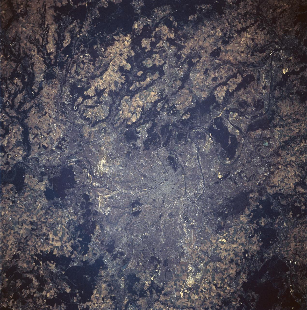
STS047-94-010 (12 - 20 Sept 1992) --- This 250mm Hasselblad color photo of Paris, France recorded during this mission, shows urban land uses in great detail. Several airports are clear, including the two major international airports of Orly and Le Bourget. Paris was founded in pre-Roman times on an island in the Seine River and continued as a Roman outpost. The easily defensible location was one of the keys to the growth of this island city. The city expanded from its island state to become a major urban center in Europe because of its location, its easy access by river traffic, and its productive hinterland.

SL2-05-390 (22 June 1973) --- Greater Detroit (42.0N, 82.5W) is located at the southeastern border of Michigan on the Detroit River across from Windsor, Ontario, Canada and Lake Huron to the north. The river connecting Lake Erie is a channel left over from the Ice Age Glaciers. The land use pattern in this scene is typical of this part of the upper Midwest. The once extensive forests have been cleared for farmland and pasture, but narrow rows of trees still line farm boundaries. Photo credit: NASA
The island of Java (8.0S, 112.0E), perhaps better than any other, illustrates the volcanic origin of Pacific Island groups. Seen in this single view are at least a dozen once active volcano craters. Alignment of the craters even defines the linear fault line of Java as well as the other some 1500 islands of the Indonesian Archipelago. Deep blue water of the Indian Ocean to the south contrasts to the sediment laden waters of the Java Sea to the north.
This distant view of Mt. Fuji, on the main home island of Honshu, Japan (34.0N, 139.0E) was taken from about 450 miles to the south. Evan at that great distance, the majestic and inspiring Mt. Fuji is still plainly visible and easily recognized as a world renowned symbol of Japan. The snow capped extinct volcano lies just a few miles south of Tokyo.
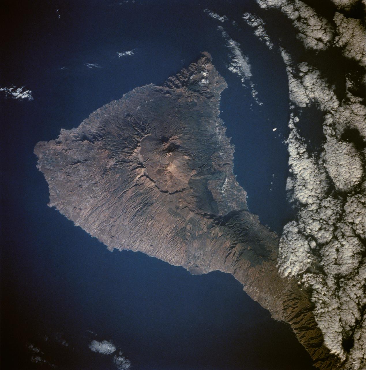
Tenarife Island is one of the most volcanically active of the Canary Island archipelago, Atlantic Ocean, just off the NW coast of Africa, (28.5N, 16.5W). The old central caldera, nearly filled in by successive volcanic activity culminating in two stratocones. From those two peaks, a line of smaller cinder cones extend to the point of the island. Extensive gullies dissect the west side of the island and some forests still remain on the east side.
This view of the Malay Peninsula shows the city state of Singapore, Malaysia (1.5N, 104.0E) with all its urban, industrial and commercial land use areas. Singapore is located at the south tip of the Malay peninsula separated by the Johor Strait. The prosporous island state, once Asia's major trade center, is now highly industrialized despite its small size and its ideal location has made this island a hub of trade, shipping and service industries.
The southern half of the island of Okinawa, Japan (26.5N, 128.0E) can be seen in this nearly cloud free view. Okinawa is part of the Ryuku Islands which extend from Taiwan northeastward to Kyushu, southernmost of the Japanese Home Islands. The large military base at Kadena, with large runways, is visible near the center of the scene. Kadena is one of several emergency landing sites around the world for the space shuttle.
STS026-43-082 (29 Sept. - 3 Oct. 1988) --- This 70mm northerly oriented frame over the Pacific Ocean features the Hawaiian Islands chain. The islands perturb the prevailing northeasterly winds producing extensive cloud wakes in the lee of the islands. Photo experts feel that atmospheric haze in the Hawaii wake is probably a result of the continuing eruptions of Kilauea volcano on the southeast coast. From the lower right corner in a diagonal directed upward to the north are the islands of Nihau, Kauai, Oahu, Molokai, Lanai, Maui, Kahoolawe, and Hawaii. This photo was shown during the post-flight press conference on October 11, 1988 by the STS-26 astronauts, who at one time during the flight wore Hawaiian attire to pay tribute to the working staff of the Hawaii tracking station.
This almost totally cloud free, photo of the island of Timor, Indonesia (9.0S, 125.0E) illustrates the volcanic origin of the over 1500 islands of Indonesia. Close examination of the photo reveals several eroded volcanoes on the Island of Timor and several of the adjacent islands. The linear alignment of the volcanoes, as seen from space, indicates the edges of the tectonic plates of the Earth's crust where volcanic activity is most common.
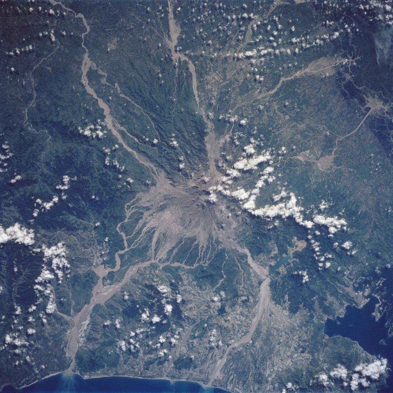
Mt. Pinatubo on the island of Luzon (15.0N, 120.0E) erupted catastrophically in June 1991 after over 600 years of inactivity. In this vertical view, the full extent of the eruption is obvious. Thick layers of ash completely surrounds the crater and the effect of mudflows in this previously heavily forested and agricultural region can be traced as ribbons flowing downhill. Clark AFB, once the crossroads of the SW Pacific can only partially be seen.
STS026-038-056 (29 Sept. - 3 Oct. 1988) --- Tambora Caldera, Sumbawa Island, Indonesia as photographed with a 70mm handheld Hasselblad camera. Tambora is a 6-kilometer-wide and 650-meter-deep Caldera formed in 1815 as a result of a huge volcanic eruption. Gases from the eruption were ejected high into Earth's atmosphere and transported around the globe. The atmospheric gases trapped part of the incoming sunglint, resulting in extremely cold weather. In New England, snow fell in June, and freezes occurred throughout the summer of 1816, which became known as "the year without a summer." This photo was shown by the STS-26 astronaut crew during its Oct. 11, l988 post-flight press conference.
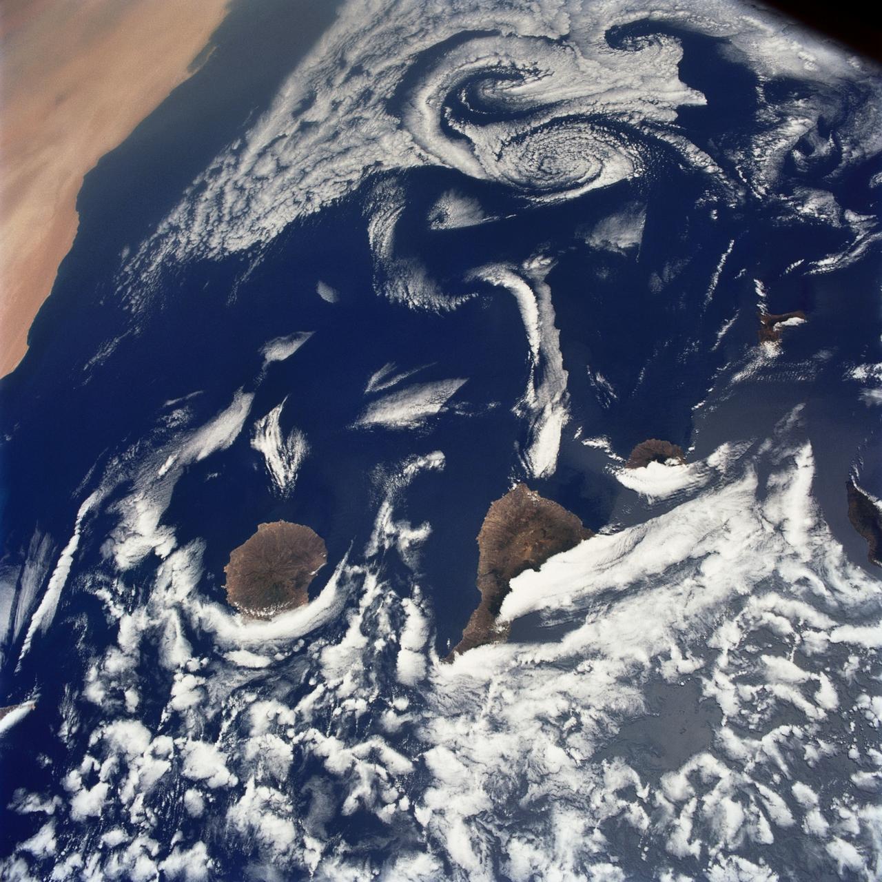
STS040-75-003 (5-14 June 1991) --- This image shows several of the Canary Islands, located in the North Atlantic Ocean just west of Africa. Low level stratus clouds often form here (and along the west coast of continents at these latitudes) are trapped in vertical movement due to an overlying atmospheric temperature inversion. The islands are generating disturbances in the low-level wind flow which is generally from the north-northeast or from top to bottom in the image. These disturbances travel downstream from the islands and manifest themselves as cloud swirls which are called von Karman vortices. The northern extent of a large dust storm moving off the coast of Africa is apparent at the lower right of the image. The dust, extended across the Atlantic Ocean as far west as the Dominican Republic later in the mission.
STS054-74-049 (13-19 Jan. 1993) --- St. Croix is the largest, and most industrial of the U.S. Virgin Islands. This photograph captures St. Croix's features in great detail. The large industrial complex in the middle of the southern shore is the world's largest petroleum refinery. The main city, Christiansted, can be seen across the island on the north shore. The reefs around the eastern end of St. Croix are preserved as a submarine national park -- Buck Island Reef National Park -- around the small island off the north shore of the eastern end of St. Croix.
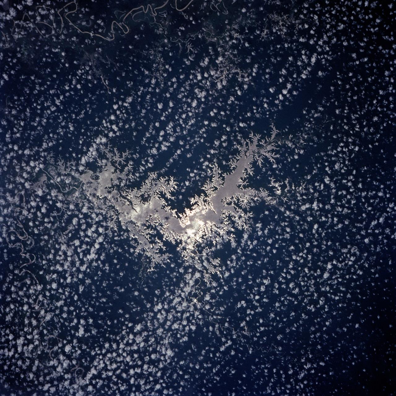
Lake Murray, a manmade reservoir, lies between the Fly and Strickland River Basins, Papua, New Guinea (7.0S, 141.5E). The region, photographed in sunglint, shows the water level in the reservoir and the full extent of the drainage basins of both river systems as the rivers meander through wide alluvial floodplains. Some forest clearing can be seen in places throughout the region, but most of the area remains in closed canopy forest.
The entire Hawaiian Island Archipelago (21.5N, 158.0W) is seen in this single view. The islands are a favorite international resort and tourist attraction drawing visitors from all over the world to enjoy the tropical climate, year round beaches and lush island flora. Being volcanic in origin, the islands' offer a rugged landscape and on the big island of Hawaii, there is still an occasional volcanic eruption of lava flows and steam vents.
The light blue shallow water platforms of the Bahamas, (24.0N, 77.0W) which are separated by very deep dark blue channels make for a striking scene. In the foreground is Andros Island and in the background are the Tongue of the Ocean, the Exuma Islands, Exuma Sound and the Atlantic Ocean. The Bahamas are one of the few regions where calcium carbonate precipitates directly out of the water, as the mineral aragonite, to form the coral reef islands.
STS059-213-019 (9-20 April 1994) --- SRL scientists will use these photographs with the radar imagery to discriminate among different ages of basalt flows, and different ecosystems of shrub communities, on these equatorial volcanic islands. Aims are twofold: to understand the history of physical and biological systems on the islands themselves, and to extend what is learned to other, less-well-known areas globally. Hasselblad photograph.
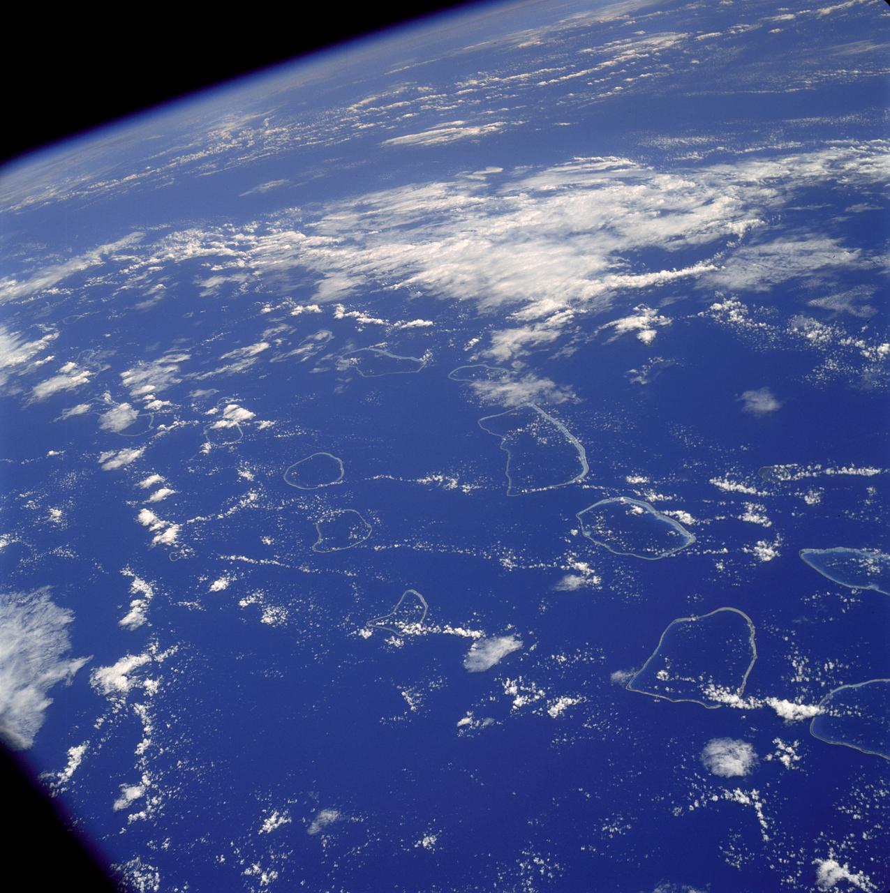
AS07-04-1590 (20 Oct. 1968) --- Tuamotu Archipelago in the South Pacific Ocean, looking southwest, as photographed from the Apollo 7 spacecraft during its 141st revolution of Earth. The photograph was taken from an altitude of 110 nautical miles, at a ground elapsed time of 224 hours and 18 minutes.
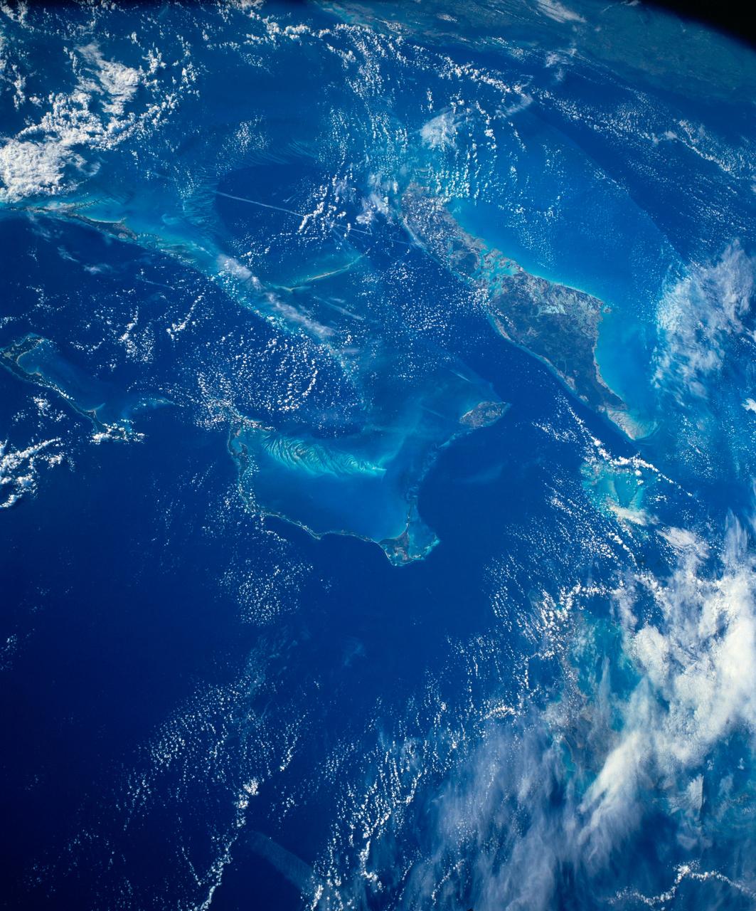
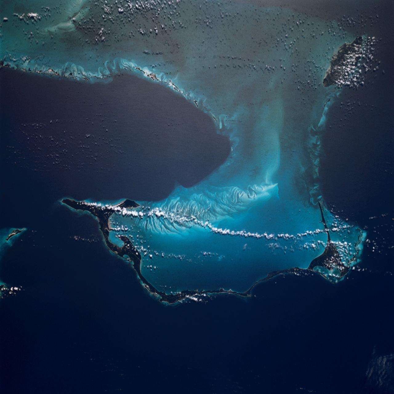
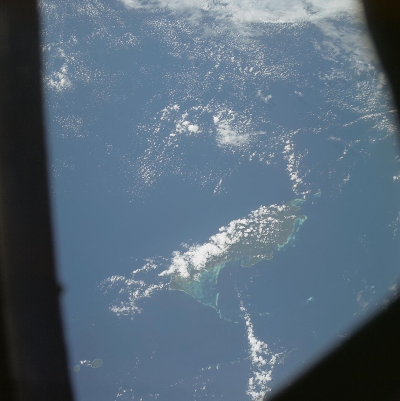
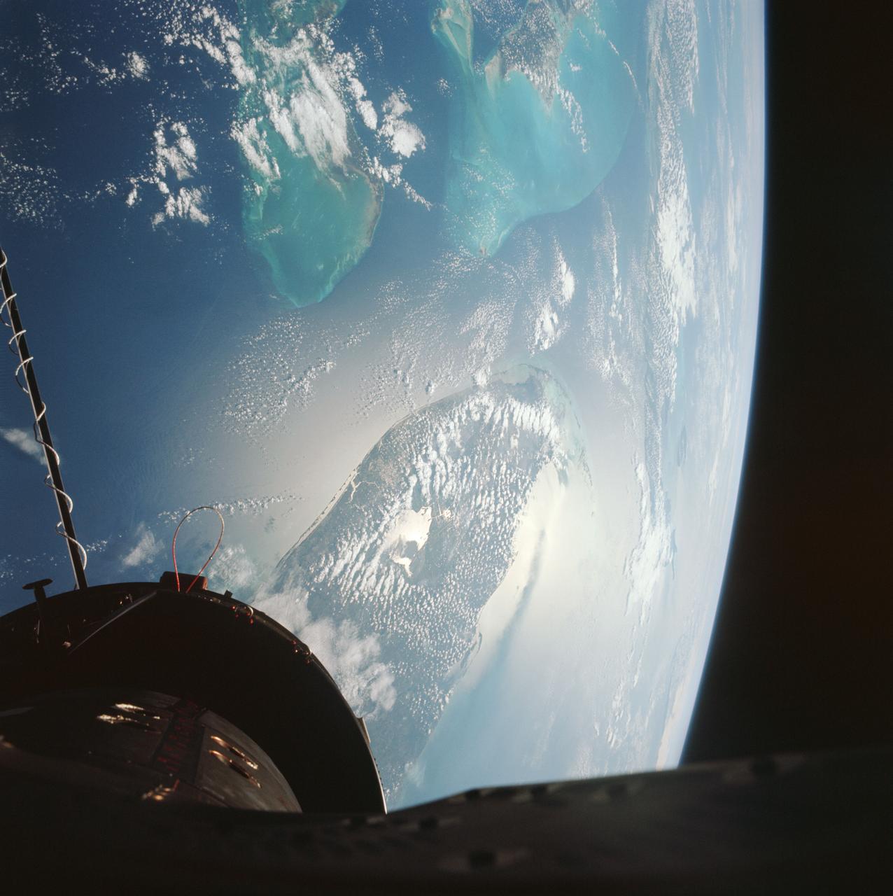
STS054-152-102 (13-19 Jan. 1993) --- This is a south-looking, wide angle view of the northern Bahamas, featuring the islands (from mid-foreground toward background) of Eleuthera, New Providence, and Andros. The northern shore of Cuba can be seen in the background. The resort city of Nassau occupies much of eastern New Providence. The Bahamas host some very distinctive features -- the deep blue channels and the shallow, light blue platforms, feathery sand bars at the edges of the deep water sounds, and colorful lakes and tidal channels like seen on Andros Island.
AST-17-1378 (20 July 1975) --- A near vertical view of the most southerly portion of the Island of Sicily in the Mediterranean Sea, as photographed from the Apollo spacecraft in Earth orbit during the joint U.S.-USSR Apollo-Soyuz Test Project mission. This view includes the towns of Gala, Pachino, Avela and Pozzalo. The photograph was taken at an altitude of 228 kilometers (141 statute miles) with a 70mm Hasselblad camera using high-definition aerial Ektachrome SO-242 type film.
In this view of Houston/Galveston, Texas, USA (29.5N, 95.5W), heavy spring rains emphasize the several bodies of water in the area. Even though partially cloud covered, the progressive nature of the Houston highway and freeway system can easily be observed in this highly detailed view. To the south, the NASA, Clear Lake area just off of Galveston Bay can easily be seen. In the center, is the downtown business district.
This color infrared view of Houston (29.5N, 95.0W) was taken with a dual camera mount. Compare this scene with STS048-78-034 for an analysis of the unique properties of each film type. Comparative tests such as this aids in determining the kinds of information unique to each film system and evaluates and compares photography taken through hazy atmospheres. Infrared film is best at penetrating haze, vegetation detection and producing a sharp image.
The northeast coast of Hokkaido and Kunashir Island, Japan (44.0N, 143.0E) are seen bordered by drifting sea ice. The sea ice has formed a complex pattern of eddies in response to surface water currents and winds. Photos of this kind aid researchers in describing local ocean current patterns and the effects of wind speed and direction on the drift of surface material, such as ice floes or oil. Kunashir is the southernmost of the Kuril Islands.
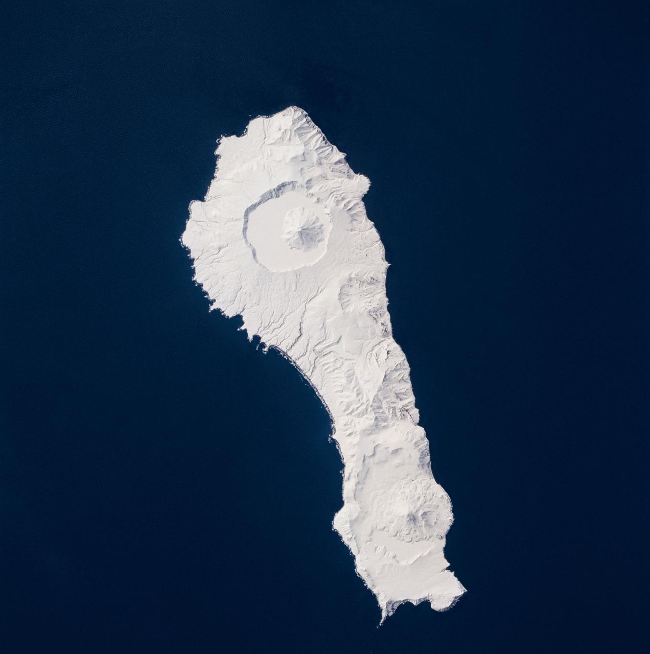
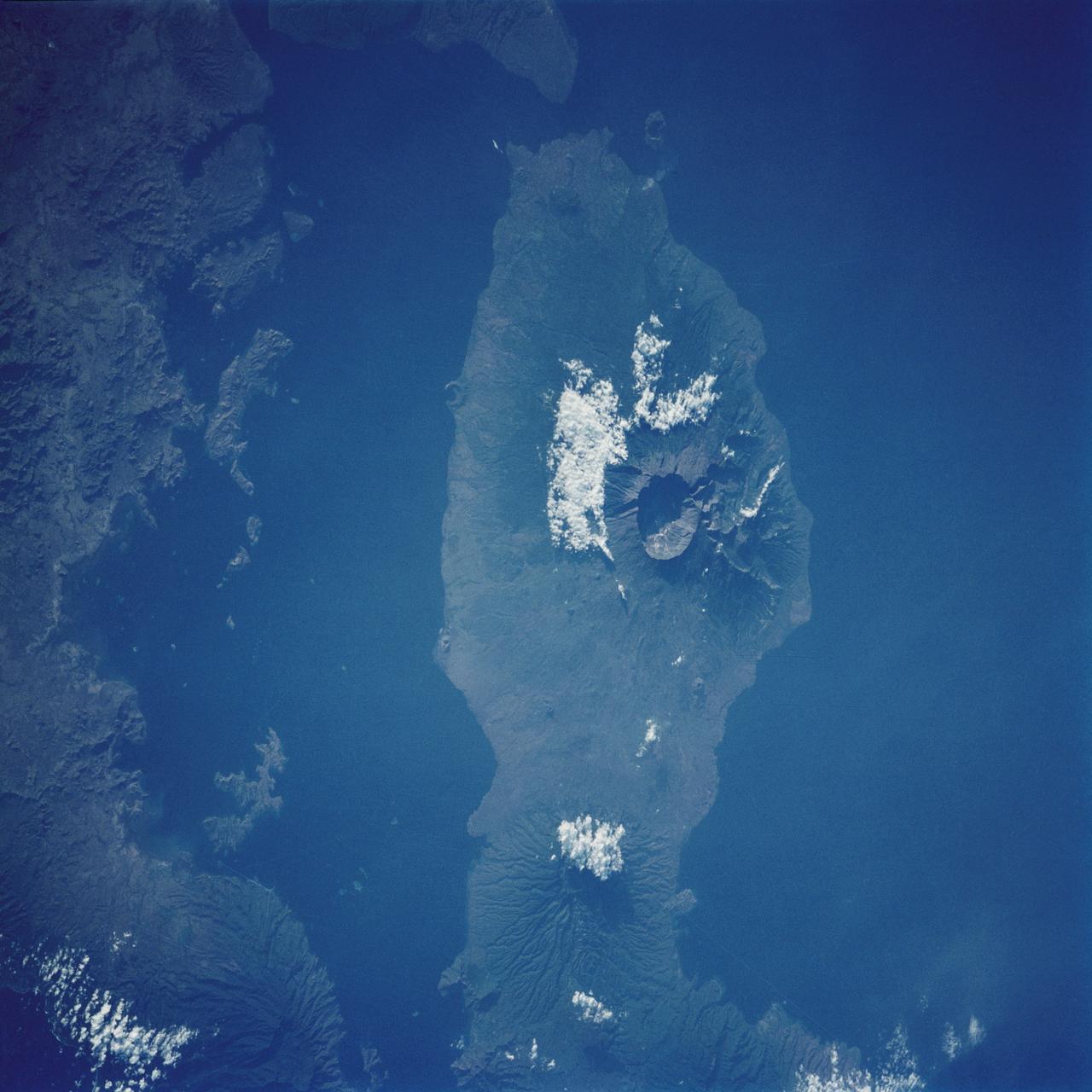
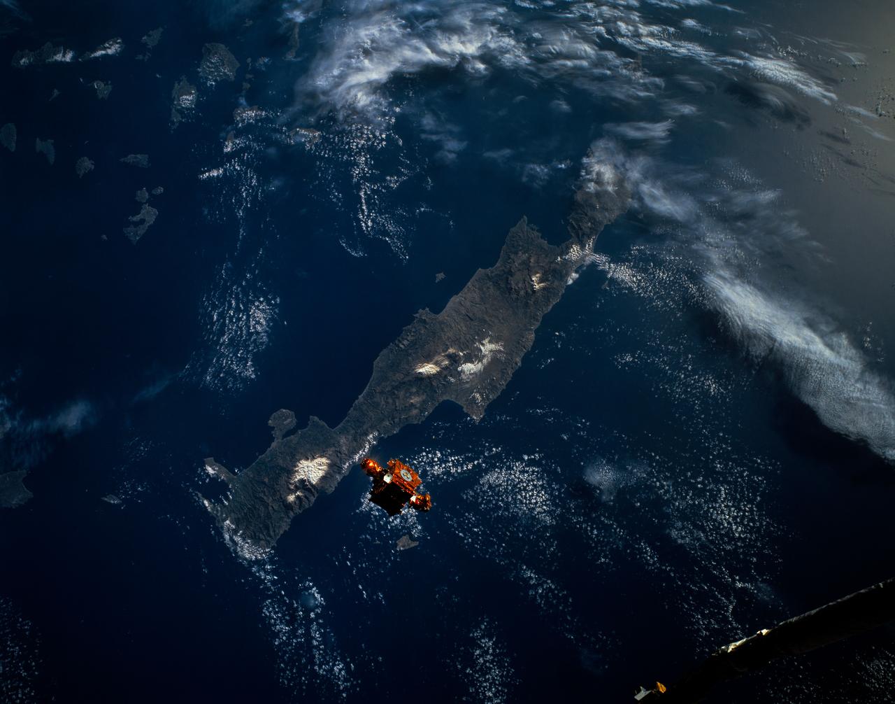
STS059-219-065 (9-20 April 1994) --- The narrow end of the island is to the north by northeast. This is one of several volcanic islands extending south by southwest between the southern tip of Kamchatka and Japan. The exposure was stopped down to provide extremely fine detail in the totally snow-covered landscape, at the same time making the dark sea look completely black. Compare to STS047-90-087, taken in September, which shows a green ground cover. Hasselblad photograph.
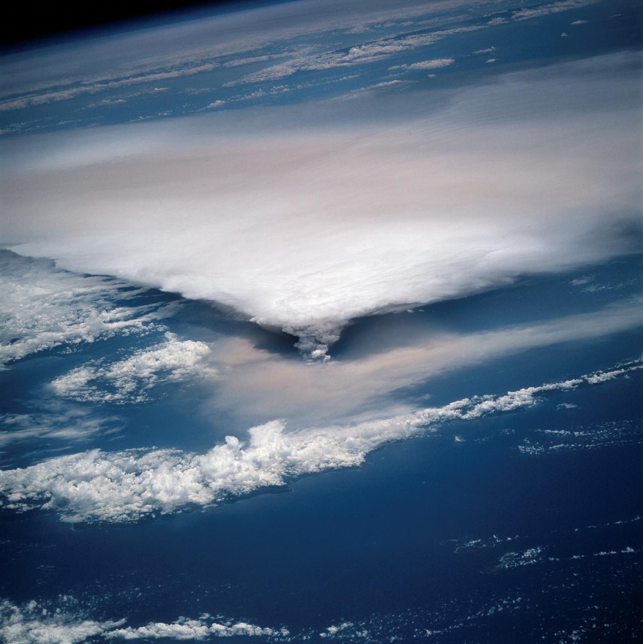
STS064-116-064 (20 Sept. 1994) --- Near the end of the mission, the crew aboard space shuttle Discovery was able to document the beginning of the second day of activity of the Rabaul volcano, on the east end of New Britain. On the morning of Sept. 19, 1994, two volcanic cones on the opposite sides of the 6-kilometer sea crater had begun to erupt with very little warning. Discovery flew just east of the eruption roughly 24 hours after it started and near the peak of its activity. New Ireland, the cloud-covered area in the foreground, lies just east of Rabaul harbor. The eruption, which sent a plume up to over 60,000 feet into the atmosphere, caused over 50,000 people to evacuate the area. Because winds were light at the time of the eruption, most of the ash was deposited in a region within 20 kilometers of the eruption zone. This photo shows the large white billowing eruption plume is carried in a westerly direction by the weak prevailing winds. At the base of the eruption column is a layer of yellow-brown ash being distributed by lower level winds. A sharp boundary moving outward from the center of the eruption in the lower cloud is a pulse of laterally-moving ash which results from a volcanic explosion. Geologists theorize that the large white column and the lower gray cloud are likely from the two main vents on each side of the harbor. The bay and harbor of Rabaul are covered with a layer of ash, possibly partly infilled with volcanic material. Matupit Island and the airport runway have disappeared into the bay. More than a meter of ash has fallen upon the city of Rabaul. Up to five vents were reported to have erupted at once, including the two cones Vulcan and Tavurvur, which are opposites of the harbor as well as new vents below the bay. Half of the Vulcan cone has collapsed into the sea. The extra day in space due to bad weather at the landing site afforded the crew the opportunity for both still and video coverage of the event. Photo credit: NASA or National Aeronautics and Space Administration
AST-19-1555 (24 July 1975) --- A sunglint in the South Western Pacific Ocean, as photographed from the Apollo spacecraft in Earth orbit during the joint U.S.-USSR Apollo-Soyuz Test Project mission. The island is Bougainville of the Solomon Islands group. The horizon of Earth is in the background. The picture was taken at an altitude of 231 kilometers (143 statute miles), with a 70mm Hasselblad camera using medium-speed Ektachrome QX-807 type film.
STS006-45-097 (4-9 April 1983) --- This photograph was taken with a handheld 70mm camera aimed through the “ceiling” windows of the Earth-orbiting space shuttle Challenger during its five-day STS-6 mission. A beautiful photo shows the contrast between the islands, clouds, shallow water and deep water. Islands of the Bahamas seen are New Providence (upper left) and Eleuthera (right). Northeast Providence Channel is at the upper edge and Exuma Sound is at the lower left with the open Atlantic along the right edge. The wind, from the south, causes a long cloud to develop downwind from Eleuthera Point. Photo credit: NASA
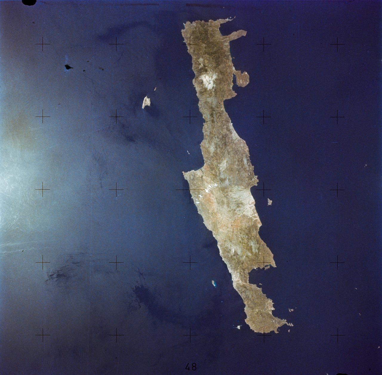
SL2-05-364 (22 June 1973) --- Lying in the eastern Mediterranean Sea, the entire Island of Crete (35.0N, 25.0E) can be seen in great detail in this cloud free view. The volcanic origins of this island can also be observed in the many sharp and angular ridgelines and rugged coastal features. Photo credit: NASA
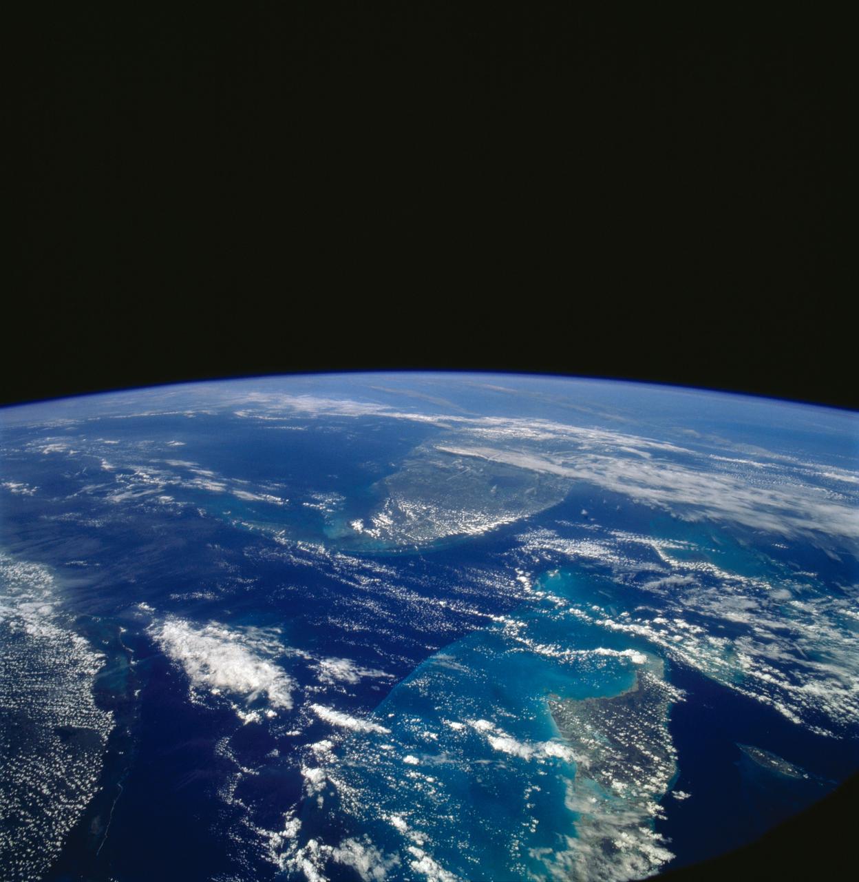
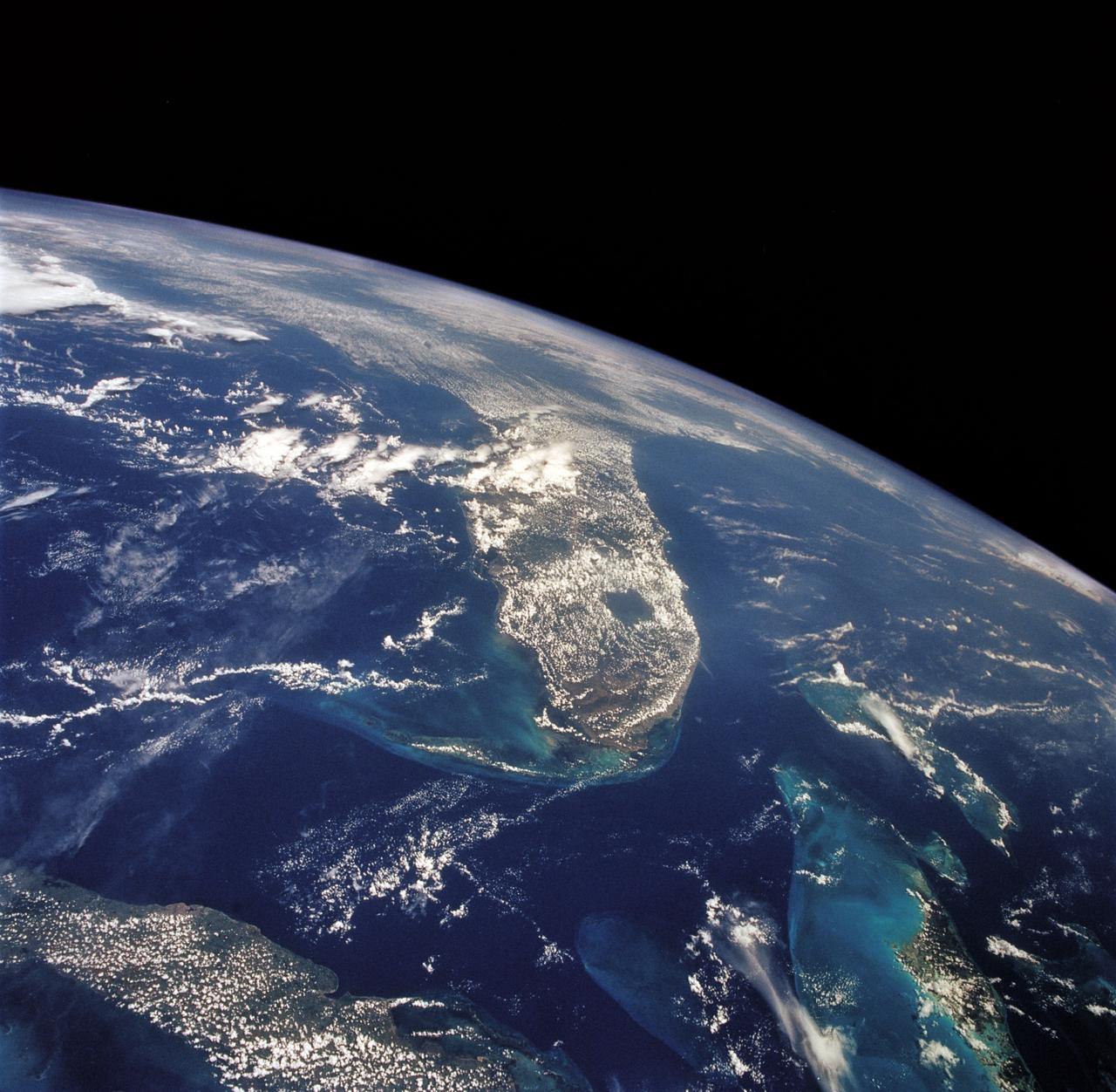
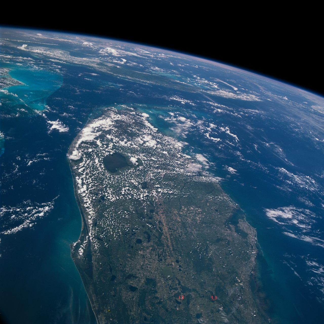
STS058-107-046 (18 Oct-1 Nov 1993) --- Clouds streak across central Florida in this striking photograph which includes the Florida Peninsula, Andros Island of the northern Bahamas and Cuba (lower left). The light blue, shallow bank of the Bahamas contrast with the deeper blue waters of the Florida strait. The city of Miami is obscured by clouds, but one can see the Florida Keys stretching off to the left. Much of the rest of the southeast coast is barely visible under haze.
S65-63926 (16 Dec. 1965) --- Island of Hispaniola, Dominican Republic end, as seen from the National Aeronautics and Space Administration's Gemini-7 spacecraft during its 179th revolution of Earth. North is toward the left of the picture. This photograph was taken with a modified 70mm Hasselblad camera, using Eastman Kodak, Ektachrome MS (S.O. 217) color film. Photo credit: NASA
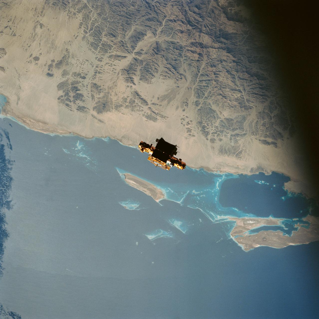
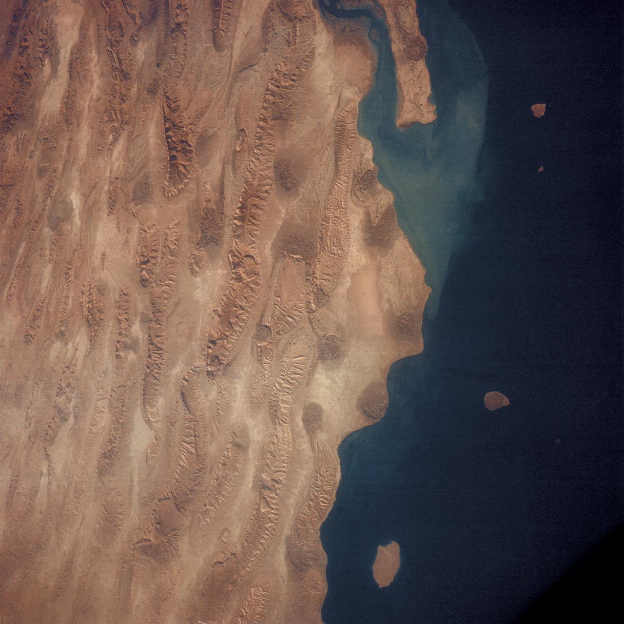
During STS-56, the Shuttle Pointed Autonomous Research Tool for Astronomy 201 (SPARTAN-201), a freeflying payload, was captured on 70mm film as it drifts over the Red Sea coast of Sudan. SPARTAN-201 was photographed by the crewmembers aboard Discovery, Orbiter Vehicle (OV) 103. On the mission's third day, crewmembers used the remote manipulator system (RMS) to lift the satellite from its support structure in OV-103's payload bay (PLB) and release it into space. SPARTAN-201 was later recaptured by OV-103's RMS and returned to Earth with the astronaut crew. The cape structure in the background is Ras abu Shagara, north of Port Sudan.
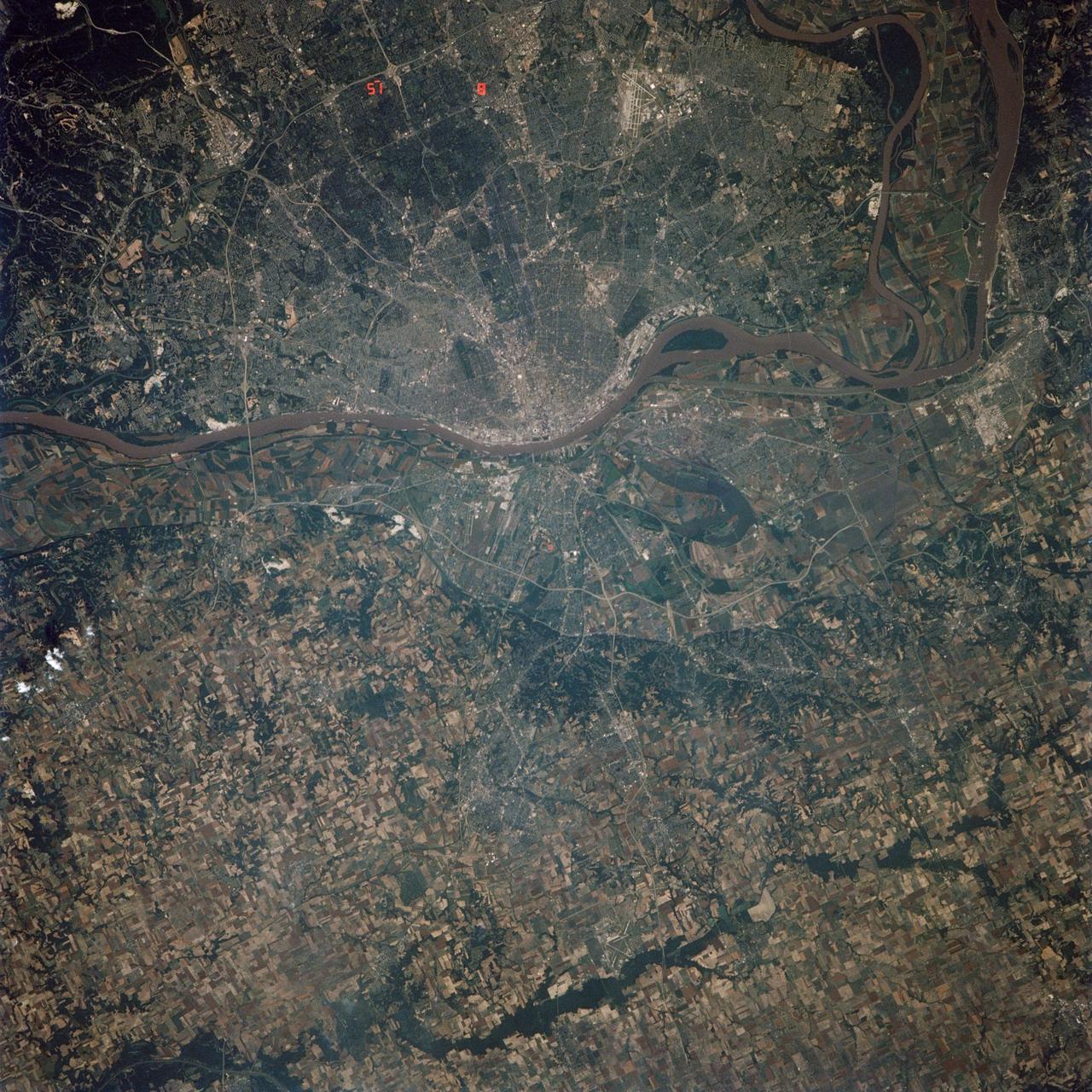
STS040-614-066 (5-14 June 1991) --- St. Louis, Missouri-East St. Louis, Illinois and surrounding area were photographed by the STS 40 crewmembers aboard the Space Shuttle Columbia. The winding Mississippi River serves as a reference point for finding features of the area. Busch Stadium is clearly seen. NASA photo experts studying the STS 40 imagery claim photographs of this type aid in following demographic changes and in planning for development. The ground track of STS-40 and the existence of exceptionally clear skies during much of the nine-day flight permitted photographic acquisition of several cities not generally seen from the space flights flying at 28-degree inclinations to the Equator.
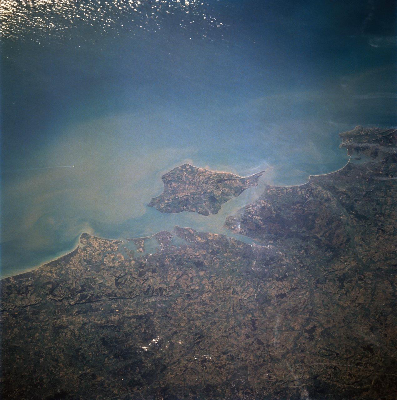
STS060-94-007 (3-11 Feb 1994) --- The Isle of Wight, over 380 square kilometers, is a diamond-shaped island located off the south coast of England. Separated from the mainland by The Solent, a narrow channel of water, the island is a popular resort area due to its scenery and mild climate. Sediment from English Lowland drainage systems, most notably the River Test, is visible entering The Solent and spilling into the English Channel. At the tip of the linear, northwestward inlet is the mouth of the Test and the city of Southampton, discernible as a small patch of lighter gray. Further east is a series of protected bays which are, from west to east: Portsmouth Harbour, Langstone Harbour, and Chichester Harbour. The city of Portsmouth is the location of Great Britain's chief naval station and arsenal. Portsmouth houses numerous ships of past and present glory. Two of the most notable vessels in Portsmouth are the 104-gun Victory, and the remains of the Mary Rose. The renowned HMS Victory, still carried on active duty rolls of the Royal Navy, and the acting Post Ship of the Royal Navy Base Commander, was built in 1765. The HMS Victory was severely damaged and dismasted in battle. A careful inspection of the original film will show the 175-foot long HMS Victory in this frame. According to NASA geologists it is extremely unusual for Portsmouth to be this cloud-free. It has been a site of some interest for many Space Shuttle missions during the past 10 years.
During STS-56, the Shuttle Pointed Autonomous Research Tool for Astronomy 201 (SPARTAN-201), a freeflying payload, was photographed by Discovery's, Orbiter Vehicle (OV) 103's, crewmembers as it drifted above the Mediterranean Sea near the island of Crete. On the mission's third day, the remote manipulator system (RMS) arm was used to lift SPARTAN-201 from its support structure in OV-103's payload bay and release it in space. SPARTAN-201 was later recaptured by OV-103's RMS and returned to Earth with the astronaut crew.
STS049-79-024 (13 May 1992) --- Florida's Atlantic Coast and the Cape Canaveral area form the backdrop for this 70mm scene of Intelsat VI's approach to the Space Shuttle Endeavour. Later, the seven-member crew was successful in capturing the satellite and adding a perigee phase. The new motor allowed the needed boost for Intelsat, once the crew members had released it into space.
S66-54692 (14 Sept. 1966) --- Indonesian Islands (partial cloud cover): Sumatra, Java, Bali, Borneo, and Sumbawa, as photographed from the Gemini-11 spacecraft during its 26th revolution of Earth, at an altitude of 570 nautical miles. Photo credit: NASA
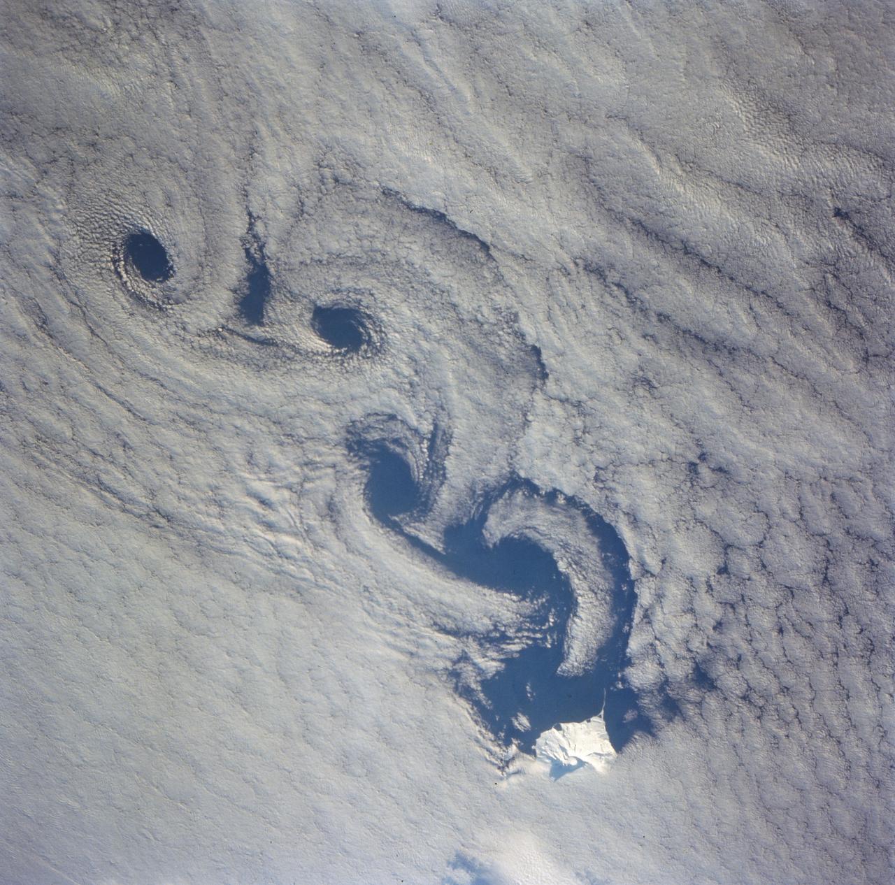
As the air blows over the tops of the mountain peaks, seen here in the clear region, the direction of the air flow is disturbed. These disturbances in the flow pattern are generally small circular eddies with one circulating in a clockwise direction and the next in the reverse direction. The wind here has caused the shallow cloud cover to change accordingly. These eddies are commonly called von Karmen Vortices.
AS07-04-1609 (21 Oct. 1968) --- Woodlark Island in the Solomon Sea, east of New Guinea and northeast of Australia, as seen from the Apollo 7 spacecraft during its 158th revolution of Earth. Photographed from an altitude of 140 nautical miles, at ground elapsed time of 251 hours and 21 minutes.
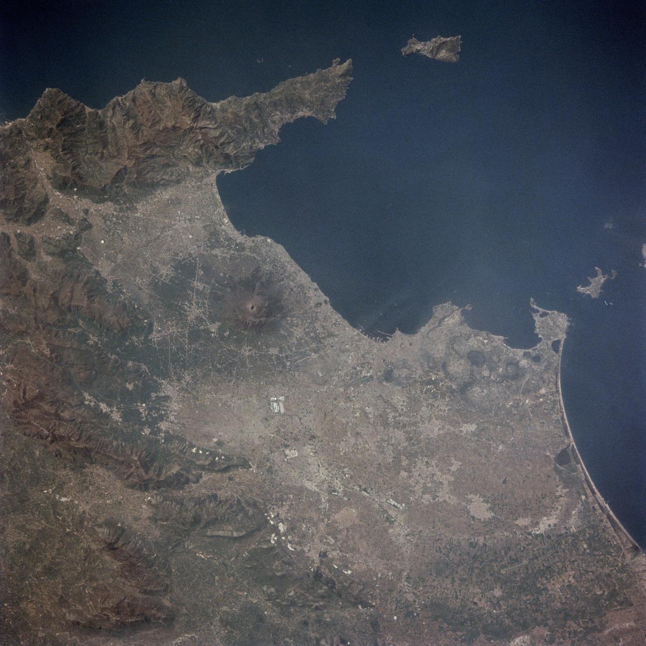
STS001-13-442 (14 April 1981) --- This photograph showing much of Italy was taken with a handheld 70mm camera from 276 kilometers above Earth as the NASA space shuttle Columbia and its crew were marking their last few hours in space on the historic first space mission utilizing a reusable vehicle. Included in the area of the frame are Golfo de Napoli, Napoli (Naples), Castellammare, Amalfi, Capri, Sorrento, Mt. Vesuvius and the ruins of Pompei. Astronauts John W. Young and Robert L. Crippen exposed eight magazines of color 70mm film during their two and one-third days in Earth orbit. Photo credit: NASA
STS062-153-226 (4-18 March 1994) --- Though it did not reproduce well, this photo gives scientific information to aid in studying all types of earth's processes. It documents ocean features in the sunglint in the Gulf of California, off the Isla Cerralvo, souther Baja, California. Biological oils collect on the surface and shows current patterns, eddies and ship wakes. The small bright spot on the edge of the eddy is a ship dumping oily water from its bilges. The line in the brighter area is a light wind gust roughening the surface.
This is a striking, oblique view to the south of the Indonesian islands of Java (right), Bali and Lombok (upper left). The linear array of dark regions across the photo is a chain of volcanoes which make up the back bone of this part of the Indonesian Islands. This chain has been quite active over the past six months. Plumes of steam can be seen rising from the summits of Arjuno (west-central Java) and Merapi (central Java, near the right side of this photo). The region appears hazy due to an extended drought over Indonesia and Australia. Because of drought conditions, huge fires continue to burn over other regions of Indonesia, New Guinea and norther Australia, producing a regional smoke pall.
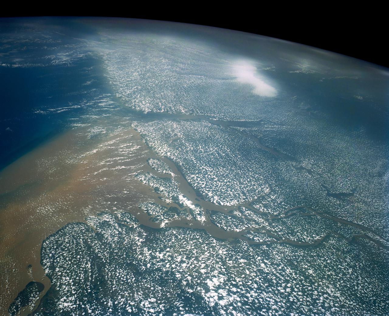
Huge sediment loads from the interior of the country flow through the Mouths of the Amazon River, Brazil (0.5S, 50.0W). The river current carries hundreds of tons of sediment through the multiple outlets of the great river over 100 miles from shore before it is carried northward by oceanic currents. The characteristic "fair weather cumulus" pattern of low clouds over the land but not over water may be observed in this scene.
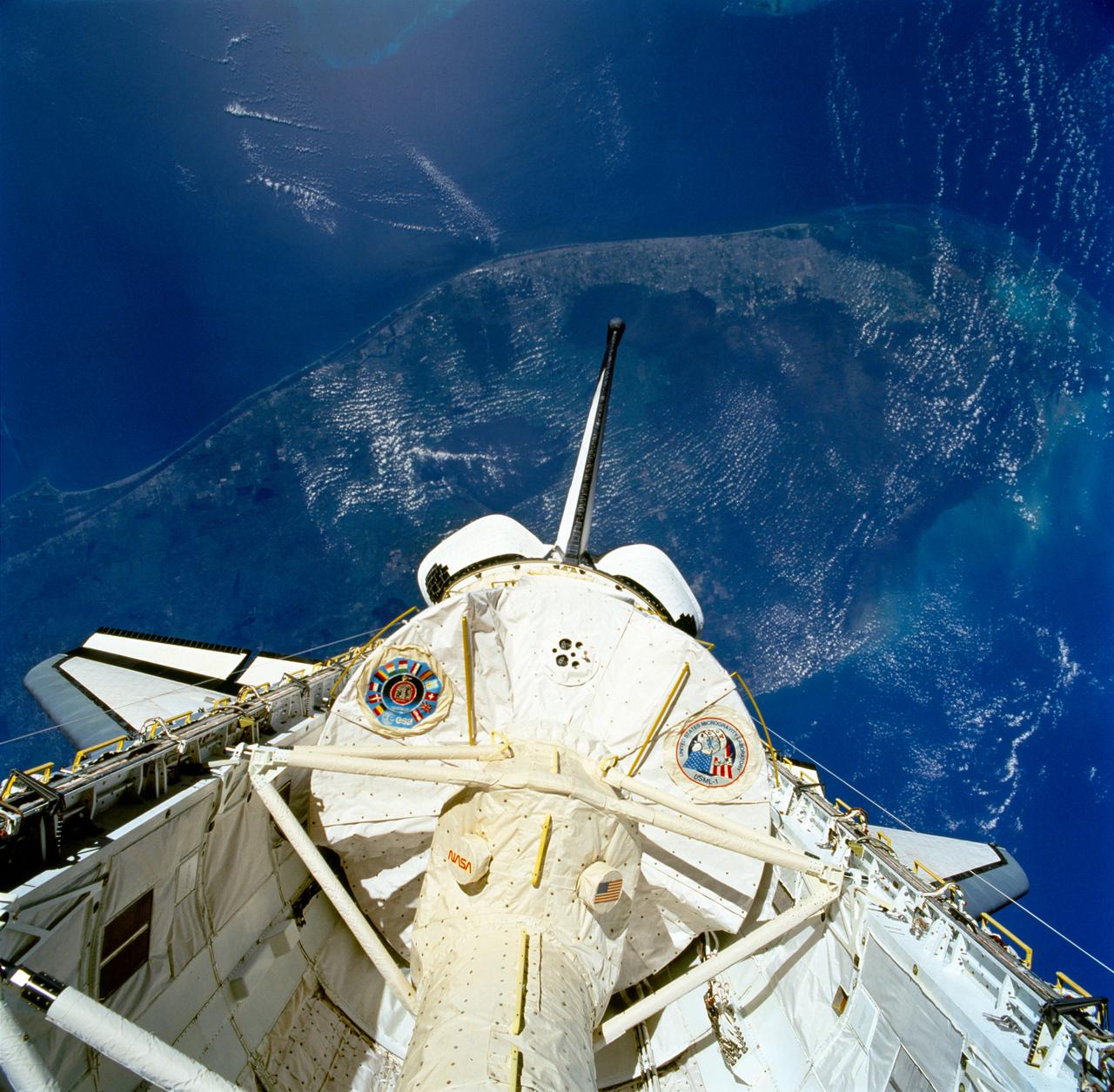
STS050-81-027 (25 June-9 July 1992) --- The first United States Microgravity Laboratory 1 (USML-1) module is pictured in the payload bay of the Earth-orbiting Space Shuttle Columbia in this scene over the southern two-thirds of the Florida peninsula. The Kennedy Space Center (KSC), where the mission began, can be seen just above Columbia's starboard wing. (Hold photo with number at left.)
SL4-142-4542 (November 1973-February 1974) --- An oblique view of the Pacific Coast of Southern California, including the Los Angeles and San Diego areas, as seen from the Skylab space station in Earth orbit. This picture was taken by one of the Skylab 4 crewmen using a hand-held 70mm Hasselblad camera with a 100mm lens and SO-368 medium-speed Ektachrome film. The visible coastline extends from San Diego northwesterly to Santa Barbara. The Mojave Desert occupies much of the photograph. This view also includes the Channel Islands off the coast. Note that the higher elevations of the mountains are covered with snow. Photo credit: NASA
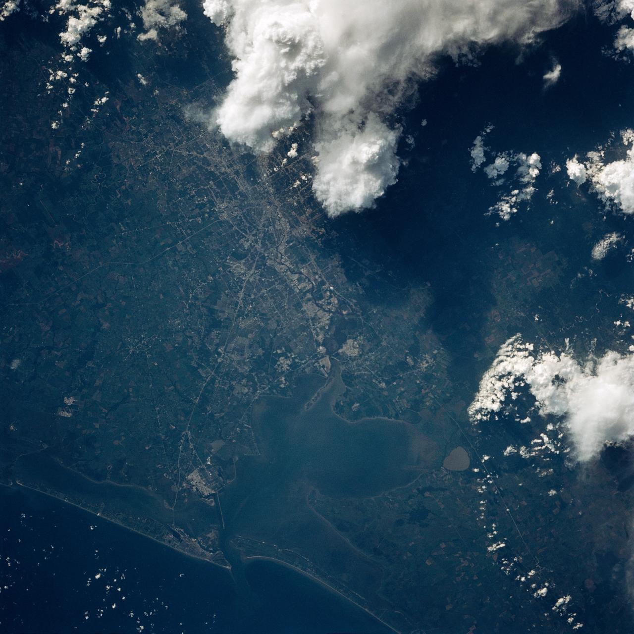
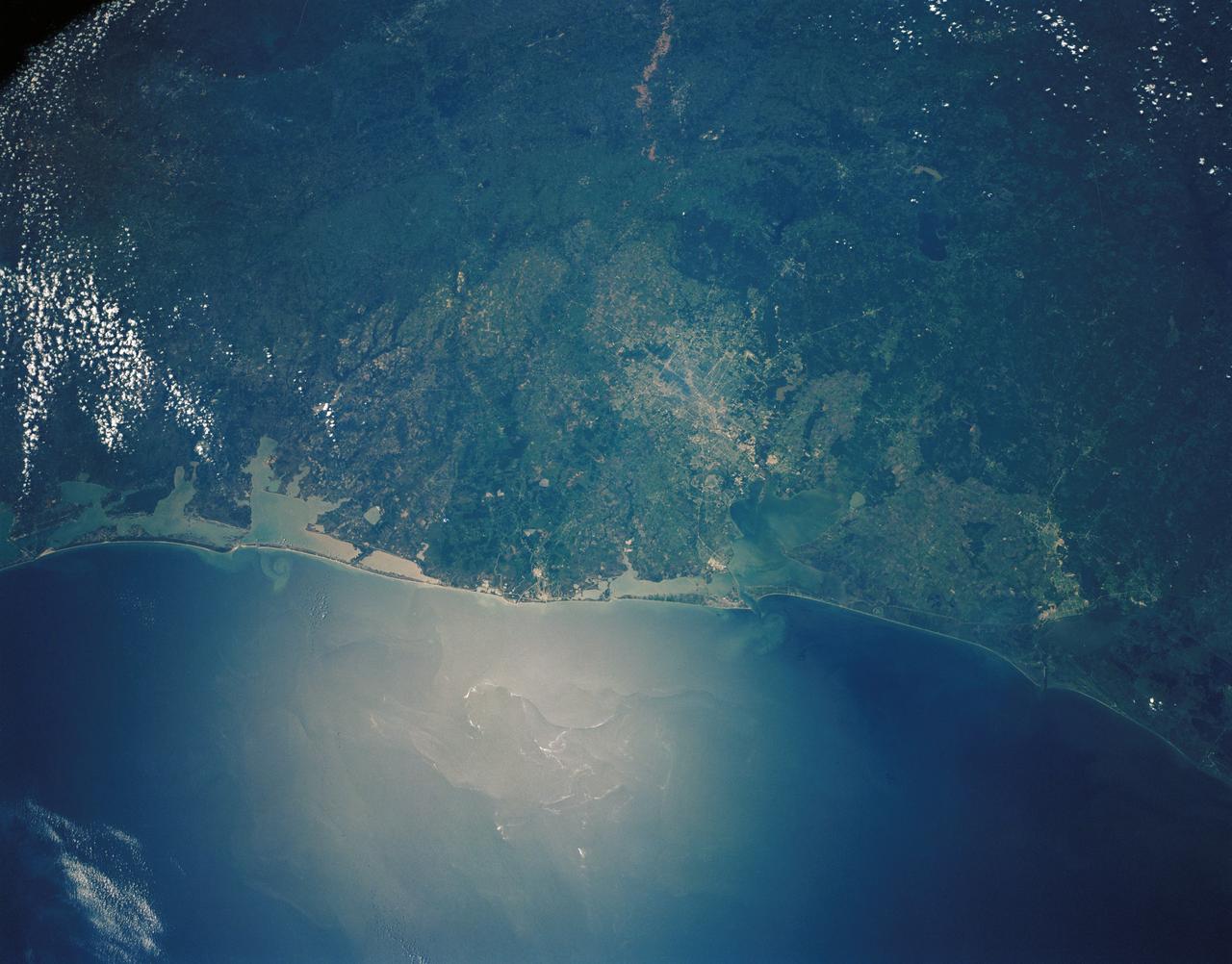
STS043-151-043 (8 August 1991) --- The Rio Grande extends across the center of this photograph from Falcon Reservoir to its bulging delta, joining the Gulf of Mexico. Sediment brought down by the river is spread northward and southward by alongshore currents to form the barrier chain of Padre Island and its protected Laguna Madre Speckled agricultural land use patterns in the river valley contrast with range land northward from the white cloud, and with closed canopy forest on hills in Mexico. A Linhof camera with a 90mm lens, was used to expose the frame at 14:43 GMT, Aug. 8, 1991.

STS003-10-606 (30 March 1982) --- The entire state of New Jersey (39.5N, 74.5W) is seen in great detail in this photograph. Philadelphia, PA on the west bank of the Delaware River and Camden, NJ on the east bank of this natural boundary, are easily seen as well as the coastal resort of Atlantic City. Further north, New York City and most of Long Island can be seen in fair detail while further inland, the northern Appalachian Mountains can be seen going diagonal across the scene. Photo credit: NASA
AS7-05-1615 (12 Oct. 1968) --- Persian Gulf coastal area of Iran, Qeshm Island, as seen from the Apollo 7 spacecraft during its 24th revolution of Earth. Photographed from an altitude of approximately 130 nautical miles, at ground elapsed time of 37 hours and 23 minutes.
STS007-05-245 (18-24 June 1983) --- A rare view of internal waves in the South China Sea. Several different series of internal waves are represented in the 70mm frame, exposed with a handheld camera by members of the STS-7 astronaut crew aboard the Earth-orbiting Challenger. The land area visible in the lower left is part of the large island of Hainan, China.
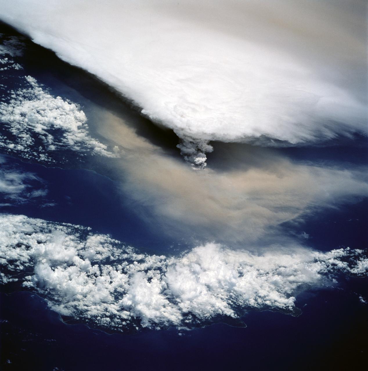
STS064-116-055 (20 Sept. 1994) --- Near the end of its mission, the crew aboard space shuttle Discovery was able to document the beginning of the second day of activity of the Rabaul volcano, on the east end of New Britain. On the morning of Sept. 19, 1994, two volcanic cones on the opposite sides of the 6-kilometer sea crater had begun to erupt with very little warning. Discovery flew just east of the eruption roughly 24 hours after it started and near the peak of its activity. The eruption, which sent a plume up to over 60,000 feet into the atmosphere, caused over 50,000 people to evacuate the area. Because winds were light at the time of the eruption, most of the ash was deposited in a region within 20 kilometers of the eruption zone. This photo shows the large white billowing eruption plume is carried in a westerly direction by the weak prevailing winds. At the base of the eruption column is a layer of yellow-brown ash being distributed by lower level winds. A sharp boundary moving outward from the center of the eruption in the lower cloud is a pulse of laterally-moving ash which results from a volcanic explosion. Geologists theorize that the large white column and the lower gray cloud are likely from the two main vents on each side of the harbor. The cloud-covered island in the foreground is New Ireland. The bay and harbor of Rabaul are covered with a layer of ash, possibly partly infilled with volcanic material. Matupit Island and the airport runway have disappeared into the bay. More than a meter of ash has fallen upon the city of Rabaul. Up to five vents were reported to have erupted at once, including the cones Vulcan and Tavurvur, which are opposites of the harbor as well as new vents below the bay. Half of the Vulcan cone has collapsed into the sea. The extra day in space due to bad weather at the landing site afforded the crew the opportunity for both still and video coverage of the event. Photo credit: NASA or National Aeronautics and Space Administration
STS039-151-175 (28 April-6 May 1991) --- Large format (five-inch) frame of part of the greater Houston metropolitan area photographed from the Earth-orbiting Space Shuttle Discovery. (Hold photo vertically with Galveston at bottom so that north will be at top.) Heavier than normal spring rains emphasize the several bodies of water in the area. Thanks to Sun angle, the interstate highways, Houston's belt and loop systems and even city streets, farm-to-market roads and airport runways are easily observed in the frame. NASA and Clear Lake City, work and home areas of the seven Discovery astronaut crew members, are easily spotted near upper Galveston Bay in bottom (south portion) of the frame. Houston's central business district and the Harris County Domed Stadium are seen in the upper left quadrant.
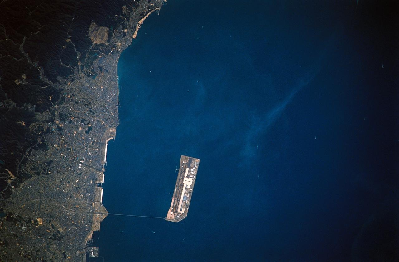
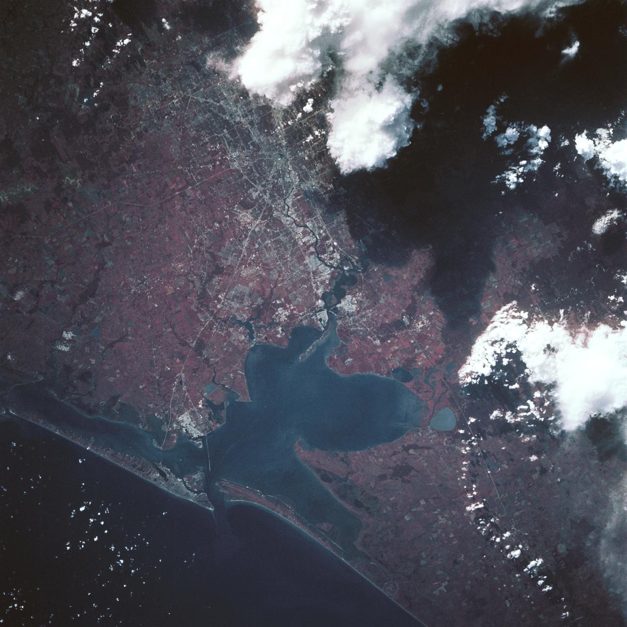
STS059-305-021 (9-20 April 1994) --- The floating airport at Osaka, Honshu, Japan. Nikon photograph, 300mm lens.
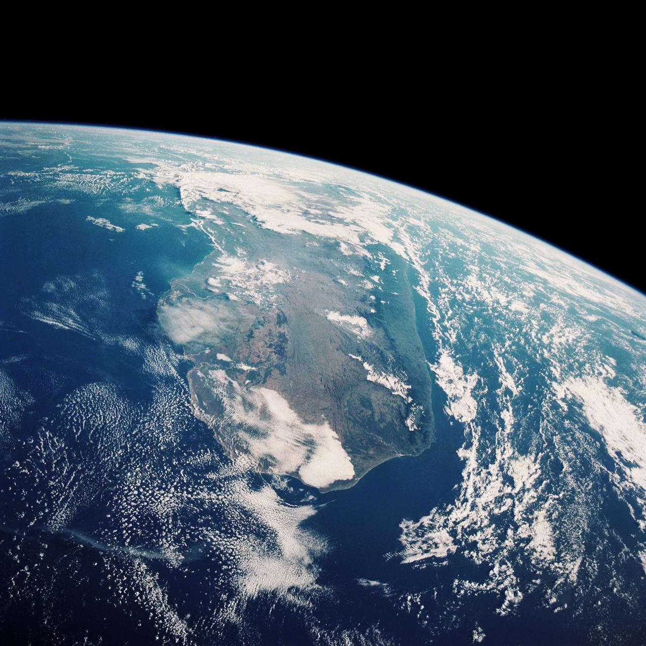
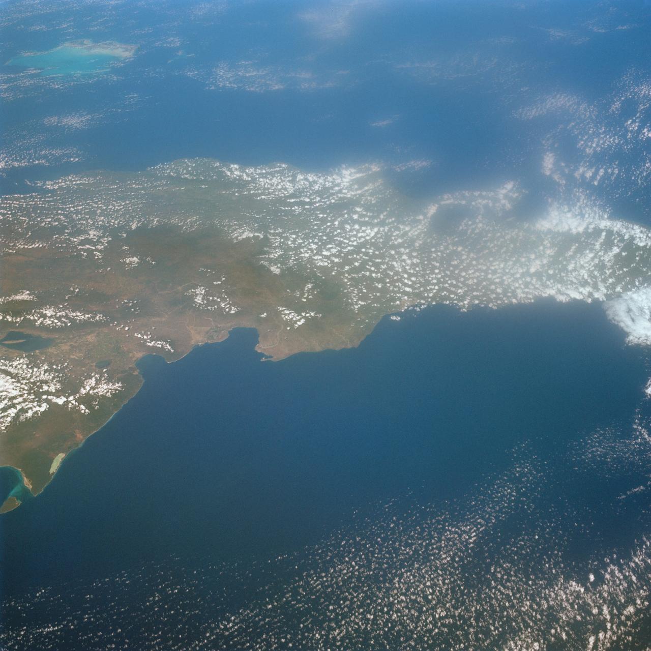
STS033-82-103 (22-27 Nov. 1989) --- This oblique view of the southern half of Madagascar was taken by the crew members of the Space Shuttle Discovery as they orbited Earth at an altitude of 289 nautical miles.
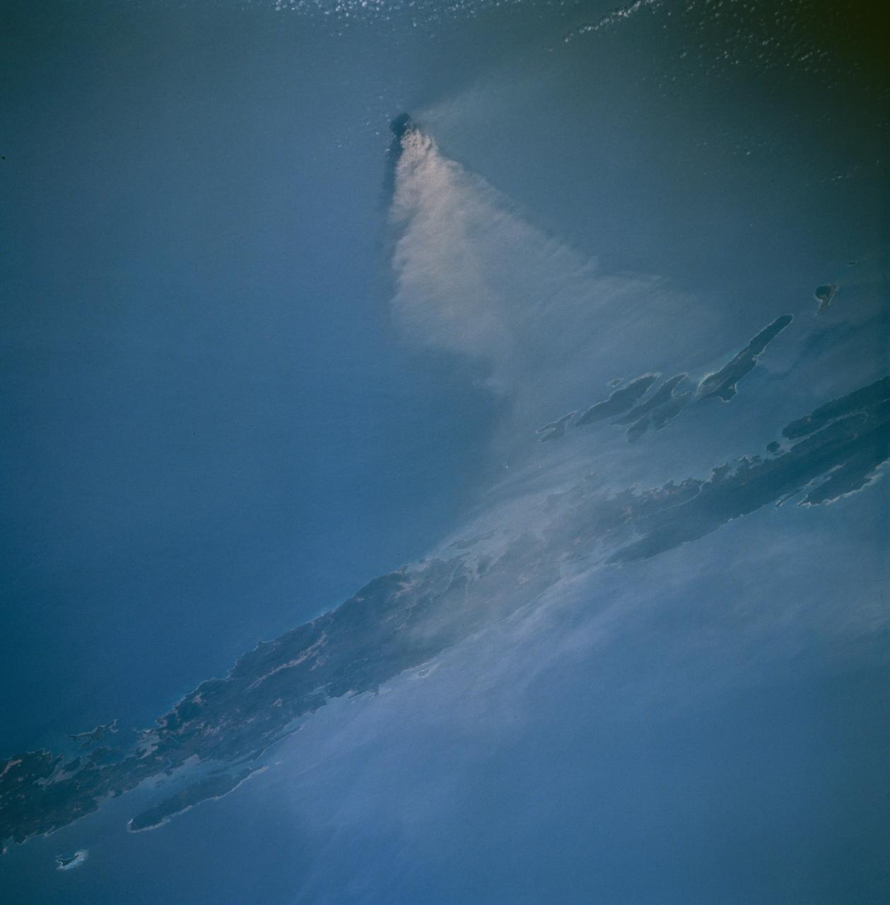
Barren Island, a small volcanic island which is part of the Andaman Island group in the Andaman Sea west of Malaysia, began a new eruptive phase late in 1994. The STS-67 crew noticed the volcanic plume early in their flight, and had several opportunities to document the on-going eruption. This view, taken March 14, 1995, shows a healthy volcanic plume rising several thousand feet into the atmosphere. The main plume drifts westward over Andaman Island, although a smaller plume close to the ground is being dispersed to the south.
This color photo view of Houston (29.5N, 95.0W) was taken with a dual camera mount for comparitive film type testing. Compare this scene with STS048-106- 034 for an analysis of the unique properties of each type. Comparitive tests such as this aids in determining the kinds of information unique to each film system and evaluates and compares photography taken through hazy atmospheres. Color film is best at presenting the image as it appears to the human eye.
STS030-152-066 (4-8 May 1989) --- The upper Texas and Louisiana Gulf Coast area was clearly represented in this large format frame photographed by the astronaut crew of the Earth-orbiting Space Shuttle Atlantis. The area covered stretches almost 300 miles from Aransas Pass, Texas to Cameron, Louisiana. The sharp detail of both the natural and cultural features noted throughout the scene is especially evident in the Houston area, where highways, major streets, airport runways and even some neighborhood lanes are easily seen. Other major areas seen are Austin, San Antonio and the Golden Triangle. An Aero Linhof camera was used to expose the frame.
AS7-07-1741 (14 Oct. 1968) --- Island of Oahu, State of Hawaii, as seen from the Apollo 7 spacecraft during its 51st revolution of Earth. Photographed from an altitude of 122 nautical miles, at ground elapsed time of 81 hours. Diamond Head and Pearl Harbor are clearly visible.
This unique photo offers a view of the Florida peninsula, western Bahamas, north central Cuba and the deep blue waters of the Gulf Stream, that hugs the east coast of Florida (27.0N, 82.0W). In addition to being an excellent photograph for showing the geographical relationships between the variety of landforms in this scene, the typical effect of the land-sea breeze is very much in evidence as few clouds over water, cumulus build up over landmass.
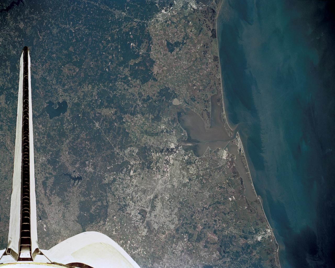
51J-143-126 (5 Oct. 1985) --- The vertical stabilizer of the Earth-orbiting Space Shuttle Atlantis serves to partially frame this scene of Metropolitan Houston. Hold photo with vertical tail at top so that north will be at top. America's fourth largest city, with its radiating highway network, lies at the junction between the East Texas piney woods, containing lakes Conroe and Livingston (near top center and top right, respectively), and the coastal prairie, now largely farmland (left side of frame). The coast stretches from the left at Freeport and the mouth of the Brazos River, past Galveston and Texas City, and the circle of the High Island Salt Dome (clearly seen at lower right near the Bolivar Peninsula), to Port Arthur on the Neches River (far right). Patterns of muddy and clear water are particularly well-displayed in Galveston and Trinity Bays, as well as in the Gulf of Mexico. With a close look, the Harris County Domed Stadium (Astrodome) can be recognized on Houston's south side. The NASA Johnson Space Center (JSC) and the Clear Lake City area are easily delineated some 25 miles southeast of downtown Houston. The scene was recorded on film by one of the STS-51J crewmembers using a handheld Hasselblad camera and 70mm film.
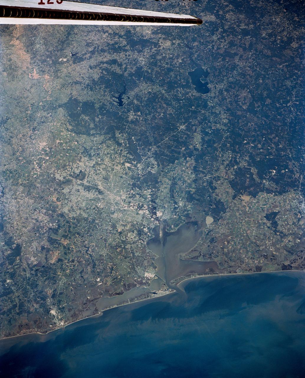
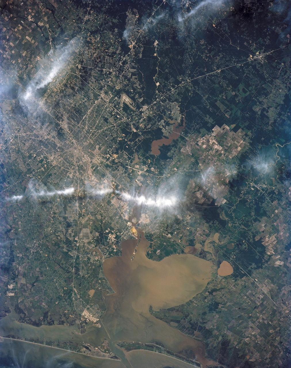
Long regarded as one of the best photo of Houston, Texas (29.5N, 95.0W), this view from space shows the entire greater Houston/Galveston region in remarkable detail and clarity. The dark north/south line in the water between Houston and Galveston is the Houston Ship Channel. NASA's Johnson Space Center and Mission Control is located on the north shore of Clear Lake west of the channel. The extensive road and highway network can be seen in great detail.
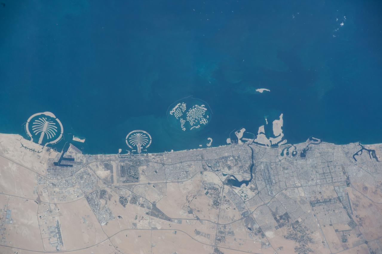
ISS042E006751 (11/08/2014) --- Earth observation taken from the International Space Station of the coastline of the United Arab Emirates. The large wheel along the coast center left is "Jumeirah" Palm Island, with a conference center, hotels, recreation areas and a large marine zoo.

SL4-140-4111 (14 Jan. 1974) --- The Aleutian Islands area of Alaska, as photographed from the Skylab space station in Earth orbit by one of the Skylab 4 crewmen. The camera used was a hand-held Hasselblad, with SO-368 medium-speed Ektachrome. Here is another macro scale phenomenon which is difficult to observe except from a space platform. The Aleutian Islands and clouds with very elaborate van Karman vortices was photographed on Jan. 14, 1974. In addition to the vortices the waves in the clouds due to the mountains on the islands are very evident. In fact, the easiest way to find the mountains is to start with their atmospheric disturbance and work back to the mountain. Photo credit: NASA
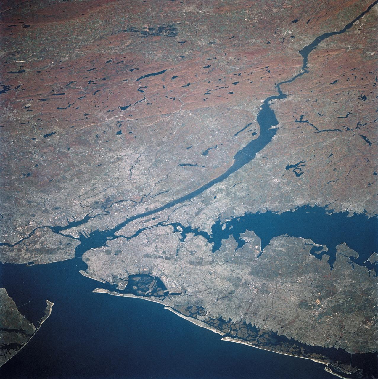
STS058-081-038 (18 Oct-1 Nov 1993) --- Fall colors in the northeast were captured by the STS-58 crew members. Long Island and the lower Hudson River dominate this scene, taken on a clear October day at the peak of the colorful fall foliage season. The maples and oaks of the Hudson Highlands are particularly striking, and contrast with the many lakes and reservoirs north of the city. The New York metropolitan area in New York and New Jersey (including Jersey City and Newark) is easily seen in the foreground. Manhattan Island sits near the middle of the scene, but Central Park foliage is still fairly green. West Point can be seen near the upper right, on the west-pointing bend of the Hudson, and the Catskills are in the far upper left.
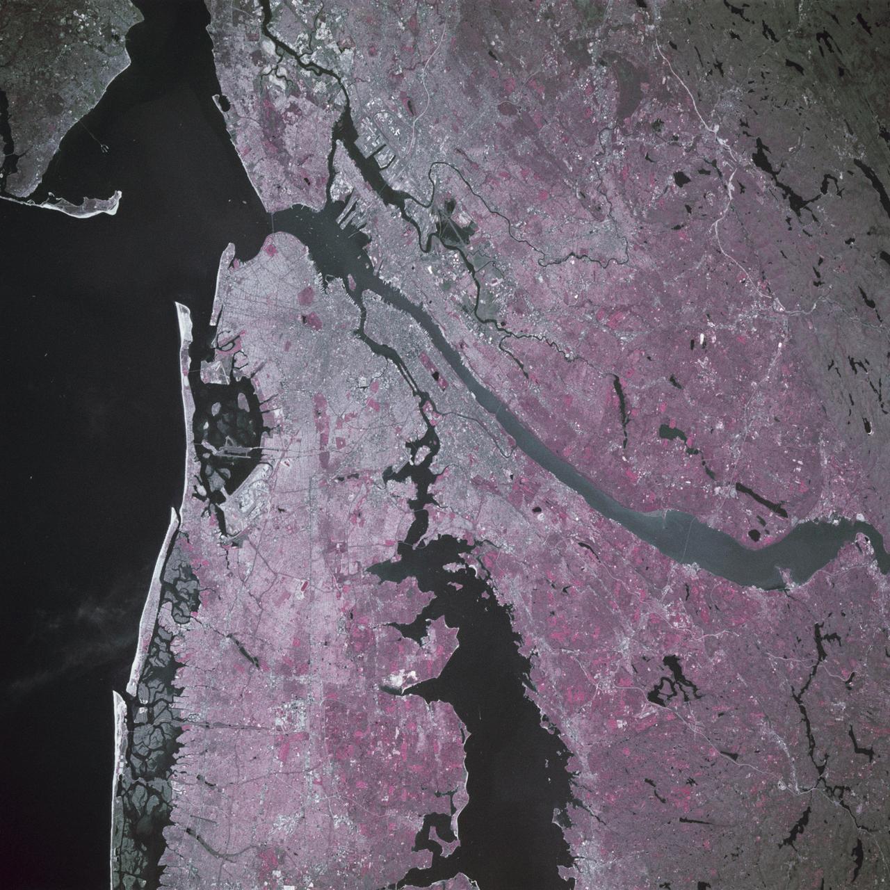
STS039-88-054 (28 April-6 May 1991) --- The dense urban development of the New York City metropolitan area in downstate New York, Long Island and New Jersey shows up as gray and white on this color Infrared photograph. The scene was taken on a remarkably clear spring day. Almost all the major man-made structures of the area are obvious, including ship traffic in and out of New York Harbor, the piers, all of the bridges spanning the area rivers and connecting Manhattan Island with New Jersey, the Bronx, Brooklyn and Queens, the three major airports (Newark, La Guardia and JFK), the New York State thruway, as well as Shea Stadium and Yankee Stadium. The reds and pinks are vegetated areas. Central Park clearly shows up on Manhattan, as do the string of parks along the cliffs (formed by the Palisades sill) along the west side of the Hudson north of the George Washington Bridge.
STS040-613-049 (5-14 June 1991) --- This oblique scene from the Earth-orbiting Space Shuttle Columbia shows southern Florida, several of the Bahama Islands and parts of the Atlantic Ocean, the Gulf of Mexico and the Caribbean Sea. The nine-day STS-40/Spacelab Life Sciences (SLS-1) mission started with launch from Kennedy Space Center (KSC), visible in lower left. Cuba can be seen at top center. The picture was photographed with a handheld Rolleiflex camera, aimed through Columbia's aft flight deck windows.
S66-63418 (13 Nov. 1966) --- Florida (south half), Bahamas Islands (Andros-Grand Bahamas-Bimini), and Cuba, looking south as seen from Gemini-12 spacecraft on its 15th revolution of Earth. Photo credit: NASA
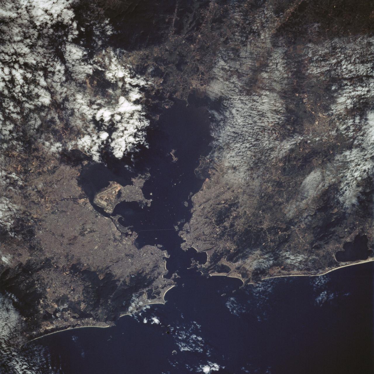
STS065-88-001 (8-23 July 1994) --- Rio de Janeiro, a port city in Brazil with a population of 11.6 million people, can be seen to the left of Governador Island in the Bay of Guanabara. Aeroporto Galeao is visible on the left, or western half of Governador Island. Below Governador Island is the Ponte Rio Niteroi bridge which connects the cities of Rio de Janeiro and Niteroi. Several ships can be seen in the Bay of Guanabara.
AS08-16-2581 (21-27 Dec. 1968) --- This photograph of Earth was taken from the Apollo 8 spacecraft while it was in Earth orbit. Most of the southeastern United States and the Caribbean Sea area, the U.S. coastline from Chesapeake Bay to the Florida Peninsula can be seen. The Bahamas and the islands of Cuba, Jamaica, Hispaniola and Puerto Rico extend across the Caribbean, the light blue of the shallow Bahama banks contrasting sharply with the darker hue of the deeper water, especially in the Tongue of the Ocean area.
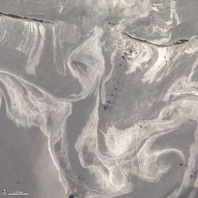
NASA image acquired June 26, 2010 As of June 27, 2010, the entire gulf-facing beachfront of several barrier islands in eastern Mississippi (offshore of Pascagoula) had received a designation of at least “lightly oiled” by the interagency Shoreline Cleanup Assessment Team that is responding to the disaster in the Gulf of Mexico. A few small stretches of Petit Bois Island had been labeled heavily or moderately oiled. (To view this image without a description go to: This high-resolution image shows Petit Bois Island (top right) and the eastern end of Horn Island (top left) on June 26. In general, oil-covered waters are silvery and cleaner waters are blue-gray. This pattern is especially consistent farther from the islands. The intensely bright patches of water directly offshore of the barrier islands, however, may be from a combination of factors, including sediment and organic material, coastal currents and surf, and oil. The islands provide a sense of scale for the ribbons of oil swirling into the area from the south. Petit Bois Island is about 10 kilometers (6 miles) long. It is one of seven barrier islands that, along with some mainland areas of Mississippi and Florida, make up the Gulf Islands National Seashore. According to the National Park Service Gulf Islands National Seashore Website, all the islands remained open to the public as of June 28, 2010, and clean-up crews were on hand to respond to any oil coming ashore. The large version of this image, which was captured by the Advanced Land Imager on NASA’s Earth Observing-1 (EO-1) satellite, shows a larger area, including the Mississippi Sound and parts of mainland Mississippi. Although oil has been observed in the Sound, it is unlikely that all the bright patches of water in that area are thickly oil-covered. Differences in brightness in coastal area waters may be due to other factors, including freshwater runoff, strong currents, and water depth and clarity. NASA Earth Observatory image created by Jesse Allen and Robert Simmon, using EO-1 ALI data provided courtesy of the NASA EO-1 team. Caption by Rebecca Lindsey. Instrument: EO-1 - ALI To see more images go to: <a href="http://earthobservatory.nasa.gov/" rel="nofollow">earthobservatory.nasa.gov/</a> <b><a href="http://www.nasa.gov/centers/goddard/home/index.html" rel="nofollow">NASA Goddard Space Flight Center</a></b> is home to the nation's largest organization of combined scientists, engineers and technologists that build spacecraft, instruments and new technology to study the Earth, the sun, our solar system, and the universe.
ISS043E185040 (05/10/2015) --- Earth observation taken by the Expedition 43 crew of the International Space Station. These islands have often been referred to as the "jewel of the Atlantic" and are only 2 two hours by commercial plane from the USA. NASA astronaut Scott Kelly tweeted this image on May 10, 2015 with this comment: "Bermuda, your clouds and remoteness have shielded you for a long time, but I finally got my eye on you.#YearInSpace".
ISS034-E-48455 (14 Feb. 2013) --- Looking out at Earth?s surface from the International Space Station (ISS), astronauts and cosmonauts frequently observe sunglint highlighting both ocean and inland water surfaces. The Atlantic Ocean, including Cape Cod Bay and Buzzards Bay, along the coastlines of Massachusetts and Rhode Island, has a burnished, mirror-like appearance in this image. This is due to sunlight reflected off the water surface back towards the station crew member who took the photo. The peak reflection point is towards the right side of the image, lending the waters of Long Island Sound and the upper Massachusetts coastline an even brighter appearance. Sunglint also illuminates the surface waters of Chesapeake Bay, located over 400 kilometers (250 miles) to the southwest of the tip of Long Island. This suggests that the Sun was low on the horizon due to the observed extent of the sunglint effect. The time of image acquisition, approximately 4:26 p.m. Eastern Standard Time, was about one hour before local sunset. There is little in this image to indicate that the region was still recovering from a major winter storm that dropped almost one meter (three feet) of snow over much of the northeastern USA less than a week earlier. The high viewing angle from the space station also allows Earth?s curvature, or limb, to be seen; blue atmospheric layers gradually fade into the darkness of space across the top part of the image. Low clouds near Cape Cod, Long Island, and further down the Atlantic coastline cast shadows over the water surfaces, reducing the sunglint in some areas.
STS046-80-009 (31 July-8 Aug. 1992) --- A view of the mouth of the Amazon River and the Amazon Delta shows a large sediment plume expanding outward into the Atlantic Ocean. The sediment plume can be seen hugging the coast north of the Delta. This is caused by the west-northwest flowing Guyana Current. The large island of Marajo is partially visible through the clouds.
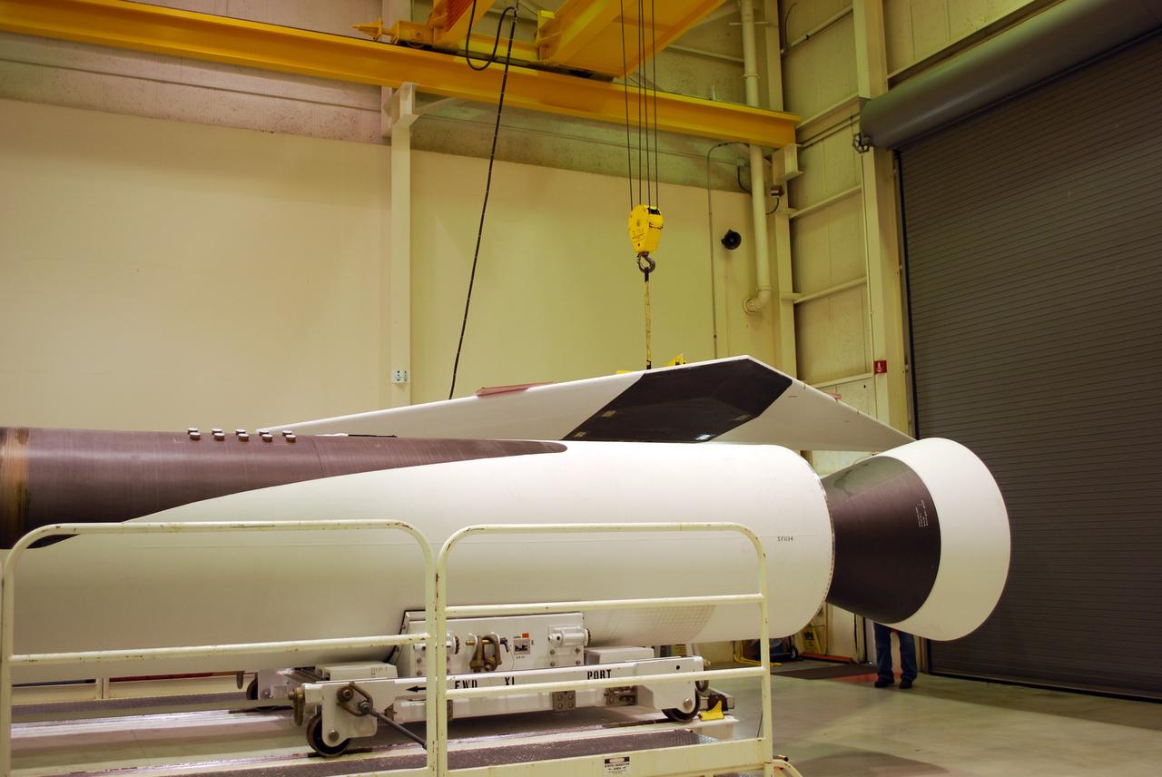
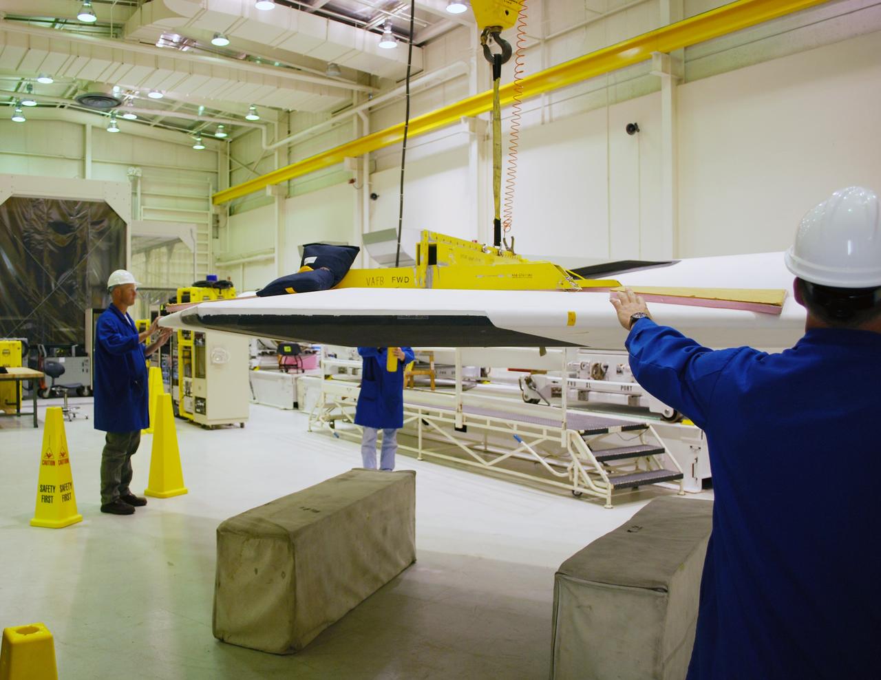
VANDENBERG AIR FORCE BASE, Calif. -- Avionics shelf flatness and fillet gap measurements are conducted on the wing of a Pegasus rocket in Building 1555 at Vandenberg AFB. The testing was performed by workers from Advanced Digital Measuring Works using an API laser tracker. The Pegasus will launch NASA's Interstellar Boundary Explorer Mission, or IBEX, satellite from Kwajalein Island in the Marshall Islands, South Pacific. IBEX will make the first map of the boundary between the solar system and interstellar space. IBEX is the first mission designed to detect the edge of the solar system. As the solar wind from the sun flows out beyond Pluto, it collides with the material between the stars, forming a shock front. IBEX contains two neutral atom imagers designed to detect particles from the termination shock at the boundary between the solar system and interstellar space. IBEX also will study galactic cosmic rays, energetic particles from beyond the solar system that pose a health and safety hazard for humans exploring beyond Earth orbit. IBEX will make these observations from a highly elliptical orbit that takes it beyond the interference of the Earth's magnetosphere. IBEX is targeted for launch in October 2008. Photo credit: NASA/Randy Beaudoin
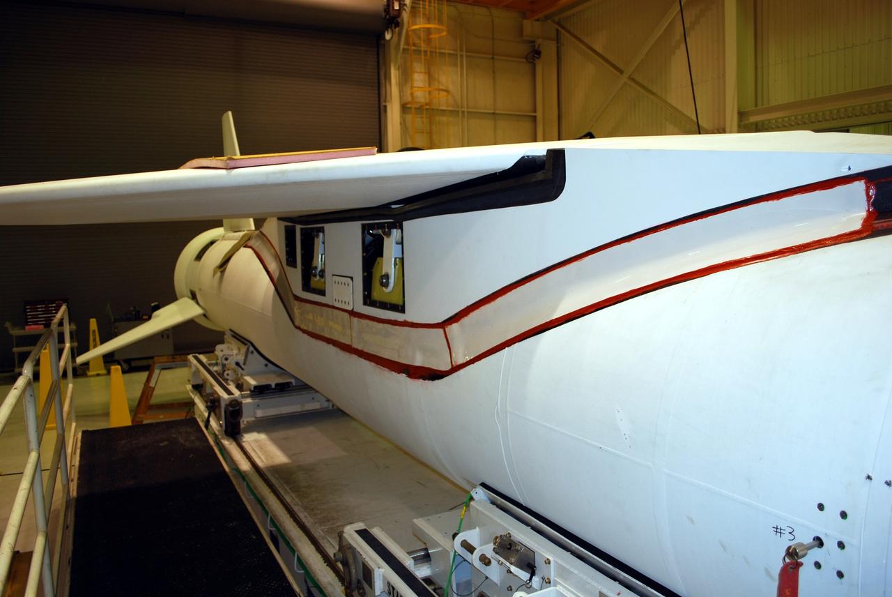
VANDENBERG AIR FORCE BASE, Calif. -- Avionics shelf flatness and fillet gap measurements are conducted on the wing of a Pegasus rocket in Building 1555 at Vandenberg AFB. The testing was performed by workers from Advanced Digital Measuring Works using an API laser tracker. The Pegasus will launch NASA's Interstellar Boundary Explorer Mission, or IBEX, satellite from Kwajalein Island in the Marshall Islands, South Pacific. IBEX will make the first map of the boundary between the solar system and interstellar space. IBEX is the first mission designed to detect the edge of the solar system. As the solar wind from the sun flows out beyond Pluto, it collides with the material between the stars, forming a shock front. IBEX contains two neutral atom imagers designed to detect particles from the termination shock at the boundary between the solar system and interstellar space. IBEX also will study galactic cosmic rays, energetic particles from beyond the solar system that pose a health and safety hazard for humans exploring beyond Earth orbit. IBEX will make these observations from a highly elliptical orbit that takes it beyond the interference of the Earth's magnetosphere. IBEX is targeted for launch in October 2008. Photo credit: NASA/Randy Beaudoin
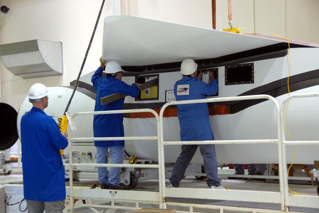
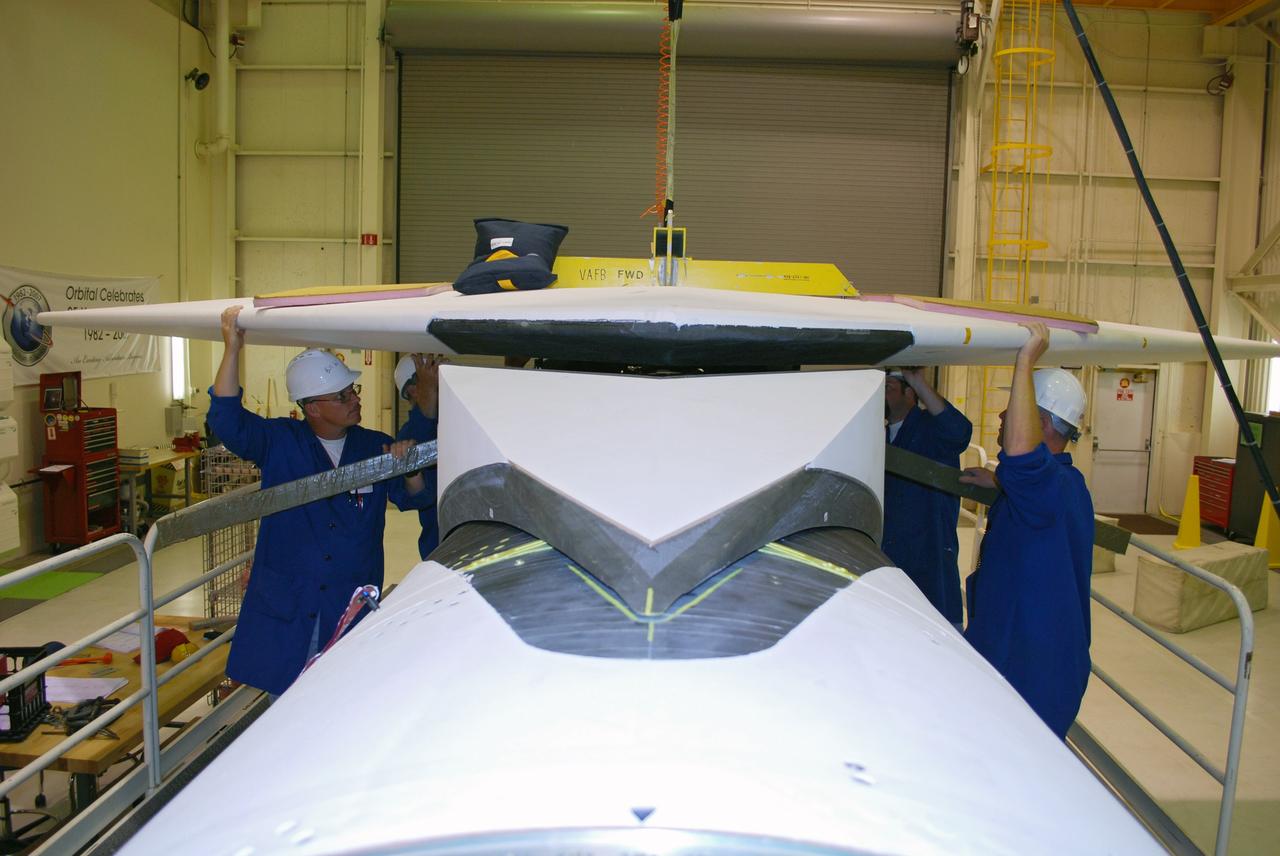
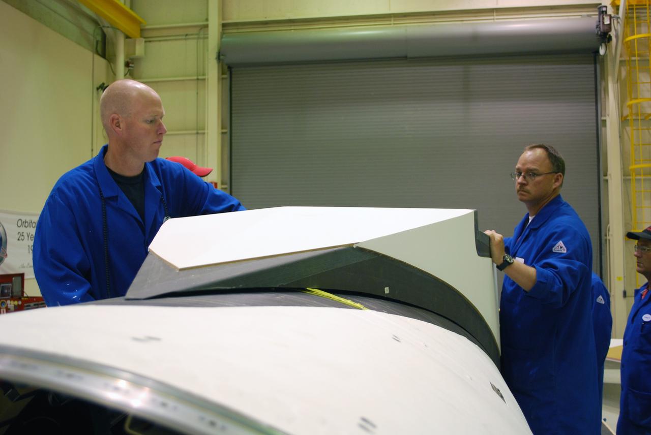
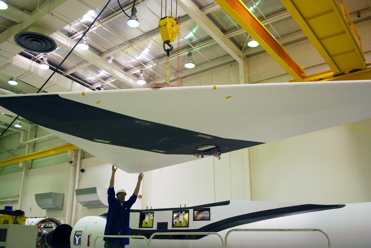
VANDENBERG AIR FORCE BASE, Calif. -- Workers in Building 1555 at Vandenberg AFB check the installation of the wing on the Pegasus rocket. The Pegasus will launch NASA's Interstellar Boundary Explorer Mission, or IBEX, satellite from Kwajalein Island in the Marshall Islands, South Pacific. IBEX will make the first map of the boundary between the solar system and interstellar space. IBEX is the first mission designed to detect the edge of the solar system. As the solar wind from the sun flows out beyond Pluto, it collides with the material between the stars, forming a shock front. IBEX contains two neutral atom imagers designed to detect particles from the termination shock at the boundary between the solar system and interstellar space. IBEX also will study galactic cosmic rays, energetic particles from beyond the solar system that pose a health and safety hazard for humans exploring beyond Earth orbit. IBEX will make these observations from a highly elliptical orbit that takes it beyond the interference of the Earth's magnetosphere. IBEX is targeted for launch in September 2008. Photo credit: NASA/ Randy Beaudoin
VANDENBERG AIR FORCE BASE, Calif. -- Workers in Building 1555 at Vandenberg AFB maneuver the wing into place on the Pegasus rocket for installation. The Pegasus will launch NASA's Interstellar Boundary Explorer Mission, or IBEX, satellite from Kwajalein Island in the Marshall Islands, South Pacific. IBEX will make the first map of the boundary between the solar system and interstellar space. IBEX is the first mission designed to detect the edge of the solar system. As the solar wind from the sun flows out beyond Pluto, it collides with the material between the stars, forming a shock front. IBEX contains two neutral atom imagers designed to detect particles from the termination shock at the boundary between the solar system and interstellar space. IBEX also will study galactic cosmic rays, energetic particles from beyond the solar system that pose a health and safety hazard for humans exploring beyond Earth orbit. IBEX will make these observations from a highly elliptical orbit that takes it beyond the interference of the Earth's magnetosphere. IBEX is targeted for launch in September 2008. Photo credit: NASA/ Randy Beaudoin
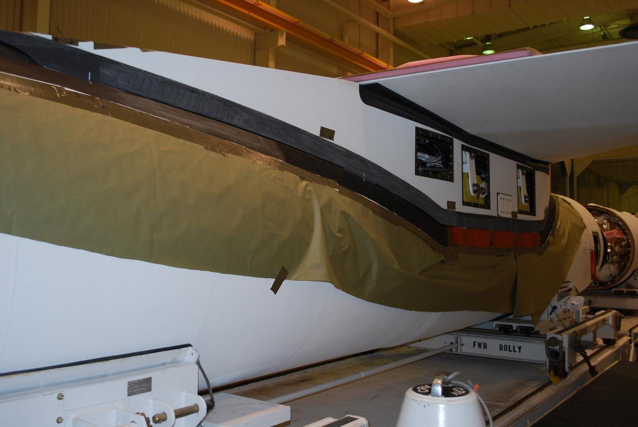
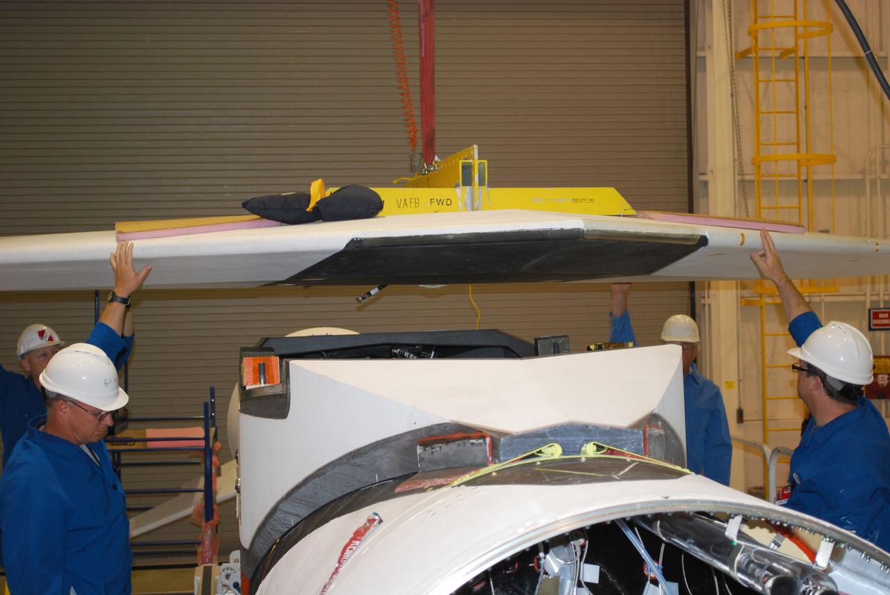
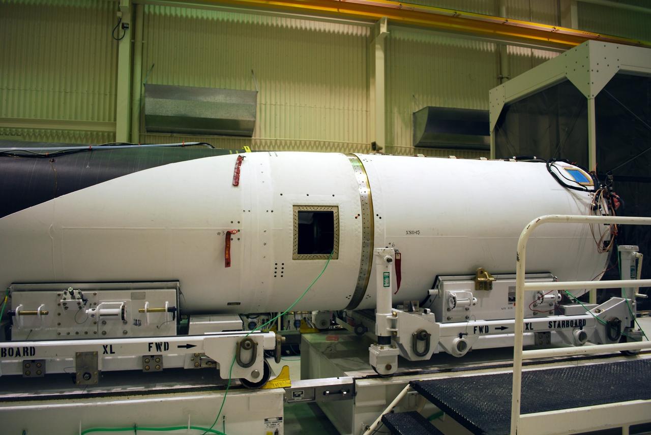
VANDENBERG AIR FORCE BASE, Calif. – In Building 1555, workers check the fit of the wing on the Pegasus XL launch vehicle. The Pegasus will launch NASA's Interstellar Boundary Explorer Mission, or IBEX, satellite from Kwajalein Island in the Marshall Islands, South Pacific. IBEX will make the first map of the boundary between the solar system and interstellar space. IBEX is the first mission designed to detect the edge of the solar system. As the solar wind from the sun flows out beyond Pluto, it collides with the material between the stars, forming a shock front. IBEX contains two neutral atom imagers designed to detect particles from the termination shock at the boundary between the solar system and interstellar space. IBEX also will study galactic cosmic rays, energetic particles from beyond the solar system that pose a health and safety hazard for humans exploring beyond Earth orbit. IBEX will make these observations from a highly elliptical orbit that takes it beyond the interference of the Earth's magnetosphere. Photo credit: NASA/Randy Beaudoin
VANDENBERG AIR FORCE BASE, Calif. – In Building 1555, the wings of the Pegasus XL launch vehicle are checked for fit. The Pegasus will launch NASA's Interstellar Boundary Explorer Mission, or IBEX, satellite from Kwajalein Island in the Marshall Islands, South Pacific. IBEX will make the first map of the boundary between the solar system and interstellar space. IBEX is the first mission designed to detect the edge of the solar system. As the solar wind from the sun flows out beyond Pluto, it collides with the material between the stars, forming a shock front. IBEX contains two neutral atom imagers designed to detect particles from the termination shock at the boundary between the solar system and interstellar space. IBEX also will study galactic cosmic rays, energetic particles from beyond the solar system that pose a health and safety hazard for humans exploring beyond Earth orbit. IBEX will make these observations from a highly elliptical orbit that takes it beyond the interference of the Earth's magnetosphere. Photo credit: NASA/Randy Beaudoin
VANDENBERG AIR FORCE BASE, Calif. -- Workers in Building 1555 at Vandenberg AFB maneuver the wing into place on the Pegasus rocket for installation. The Pegasus will launch NASA's Interstellar Boundary Explorer Mission, or IBEX, satellite from Kwajalein Island in the Marshall Islands, South Pacific. IBEX will make the first map of the boundary between the solar system and interstellar space. IBEX is the first mission designed to detect the edge of the solar system. As the solar wind from the sun flows out beyond Pluto, it collides with the material between the stars, forming a shock front. IBEX contains two neutral atom imagers designed to detect particles from the termination shock at the boundary between the solar system and interstellar space. IBEX also will study galactic cosmic rays, energetic particles from beyond the solar system that pose a health and safety hazard for humans exploring beyond Earth orbit. IBEX will make these observations from a highly elliptical orbit that takes it beyond the interference of the Earth's magnetosphere. IBEX is targeted for launch in September 2008. Photo credit: NASA/ Randy Beaudoin
VANDENBERG AIR FORCE BASE, Calif. – In Building 1555, workers check equipment on the Pegasus XL launch vehicle. The Pegasus will launch NASA's Interstellar Boundary Explorer Mission, or IBEX, satellite from Kwajalein Island in the Marshall Islands, South Pacific. IBEX will make the first map of the boundary between the solar system and interstellar space. IBEX is the first mission designed to detect the edge of the solar system. As the solar wind from the sun flows out beyond Pluto, it collides with the material between the stars, forming a shock front. IBEX contains two neutral atom imagers designed to detect particles from the termination shock at the boundary between the solar system and interstellar space. IBEX also will study galactic cosmic rays, energetic particles from beyond the solar system that pose a health and safety hazard for humans exploring beyond Earth orbit. IBEX will make these observations from a highly elliptical orbit that takes it beyond the interference of the Earth's magnetosphere. Photo credit: NASA/Randy Beaudoin
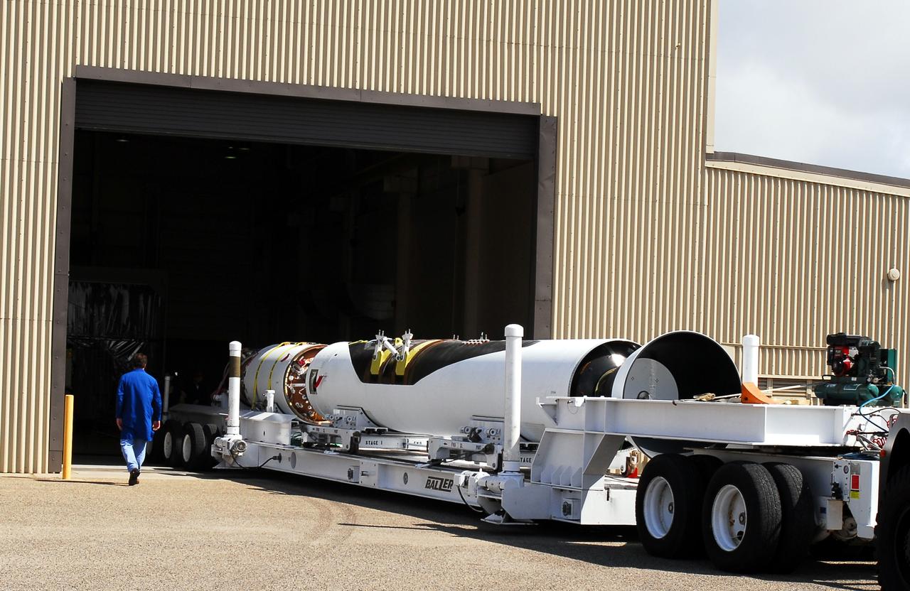
VANDENBERG AIR FORCE BASE, Calif. – Segments of the Pegasus XL launch vehicle are moved into Building 1555. The Pegasus will launch NASA's Interstellar Boundary Explorer Mission, or IBEX, satellite from Kwajalein Island in the Marshall Islands, South Pacific. IBEX will make the first map of the boundary between the solar system and interstellar space. IBEX is the first mission designed to detect the edge of the solar system. As the solar wind from the sun flows out beyond Pluto, it collides with the material between the stars, forming a shock front. IBEX contains two neutral atom imagers designed to detect particles from the termination shock at the boundary between the solar system and interstellar space. IBEX also will study galactic cosmic rays, energetic particles from beyond the solar system that pose a health and safety hazard for humans exploring beyond Earth orbit. IBEX will make these observations from a highly elliptical orbit that takes it beyond the interference of the Earth's magnetosphere. Photo credit: NASA/Moran
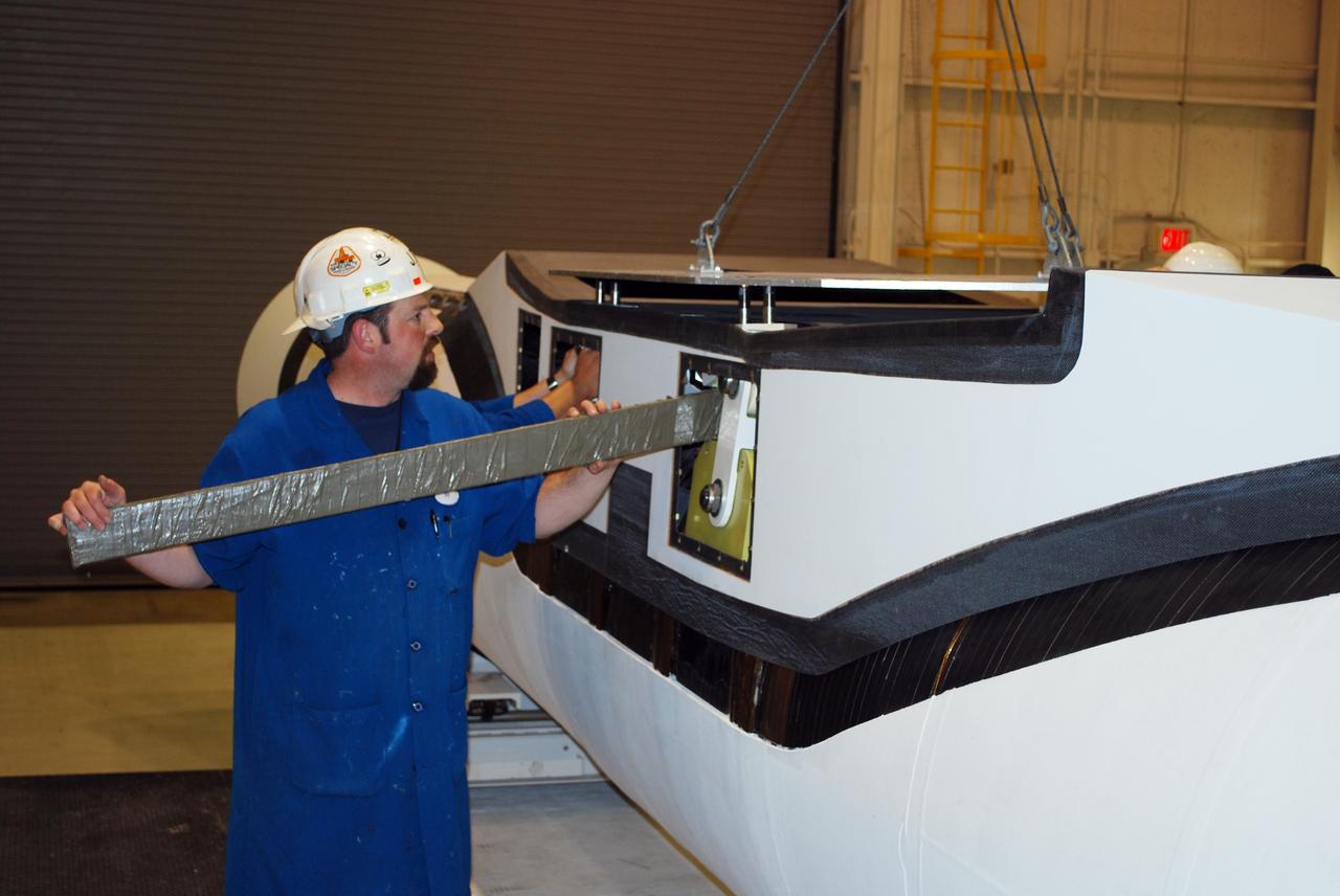
VANDENBERG AIR FORCE BASE, Calif. – In Building 1555, workers secure the fillet into place on the Pegasus XL launch vehicle. The Pegasus will launch NASA's Interstellar Boundary Explorer Mission, or IBEX, satellite from Kwajalein Island in the Marshall Islands, South Pacific. IBEX will make the first map of the boundary between the solar system and interstellar space. IBEX is the first mission designed to detect the edge of the solar system. As the solar wind from the sun flows out beyond Pluto, it collides with the material between the stars, forming a shock front. IBEX contains two neutral atom imagers designed to detect particles from the termination shock at the boundary between the solar system and interstellar space. IBEX also will study galactic cosmic rays, energetic particles from beyond the solar system that pose a health and safety hazard for humans exploring beyond Earth orbit. IBEX will make these observations from a highly elliptical orbit that takes it beyond the interference of the Earth's magnetosphere. Photo credit: NASA/Randy Beaudoin
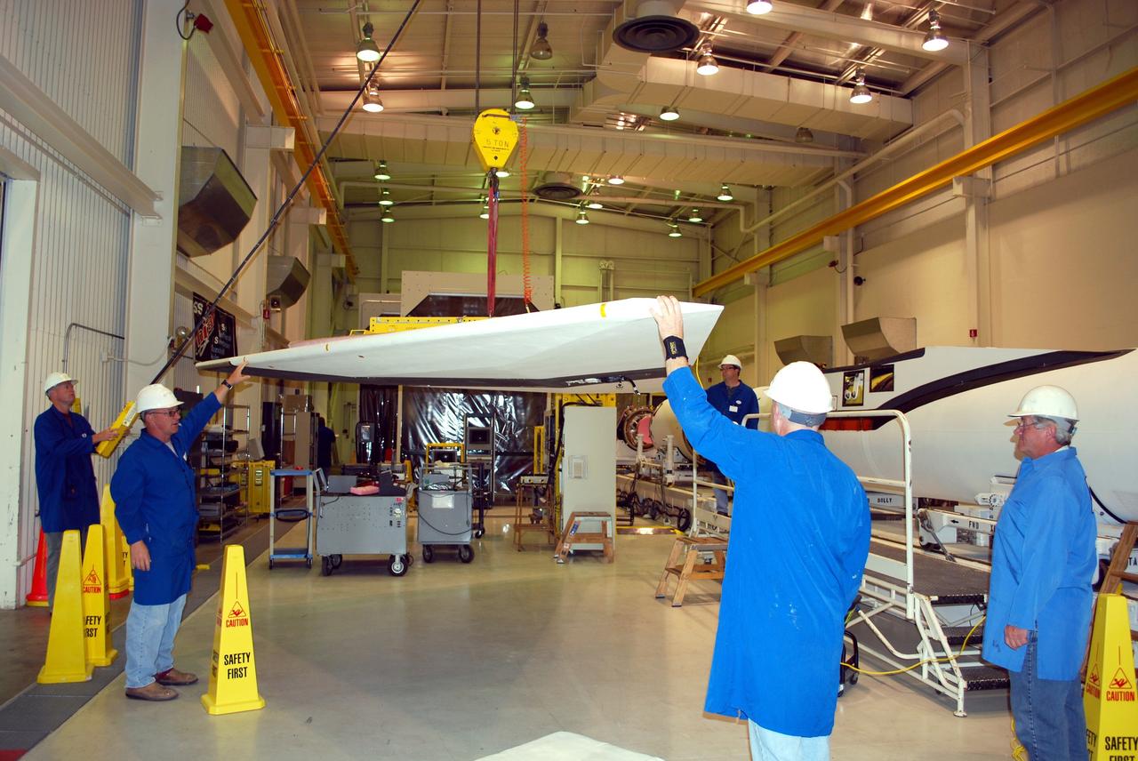
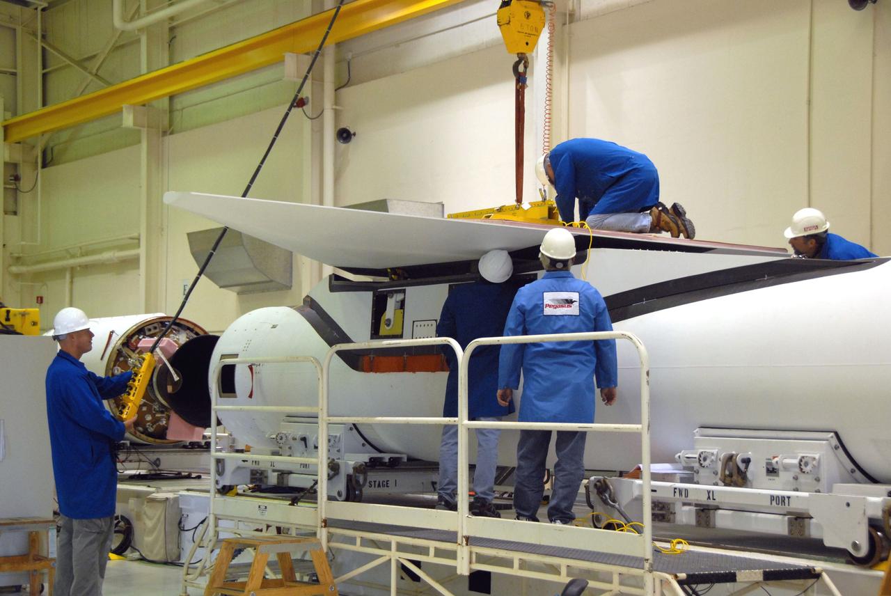
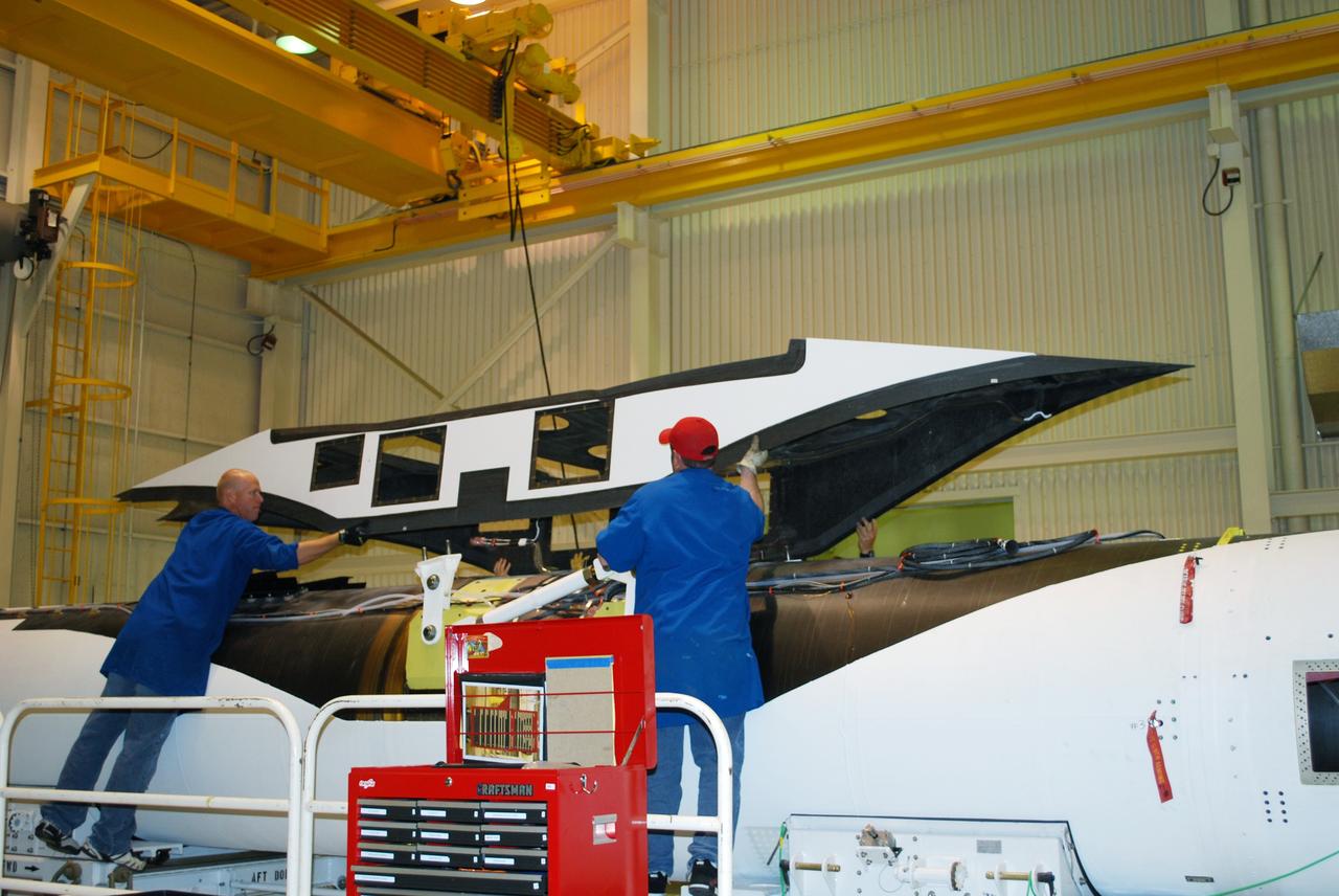
VANDENBERG AIR FORCE BASE, Calif. -- Workers in Building 1555 at Vandenberg AFB help guide the wing toward the Pegasus rocket for installation. The Pegasus will launch NASA's Interstellar Boundary Explorer Mission, or IBEX, satellite from Kwajalein Island in the Marshall Islands, South Pacific. IBEX will make the first map of the boundary between the solar system and interstellar space. IBEX is the first mission designed to detect the edge of the solar system. As the solar wind from the sun flows out beyond Pluto, it collides with the material between the stars, forming a shock front. IBEX contains two neutral atom imagers designed to detect particles from the termination shock at the boundary between the solar system and interstellar space. IBEX also will study galactic cosmic rays, energetic particles from beyond the solar system that pose a health and safety hazard for humans exploring beyond Earth orbit. IBEX will make these observations from a highly elliptical orbit that takes it beyond the interference of the Earth's magnetosphere. IBEX is targeted for launch in September 2008. Photo credit: NASA/ Randy Beaudoin
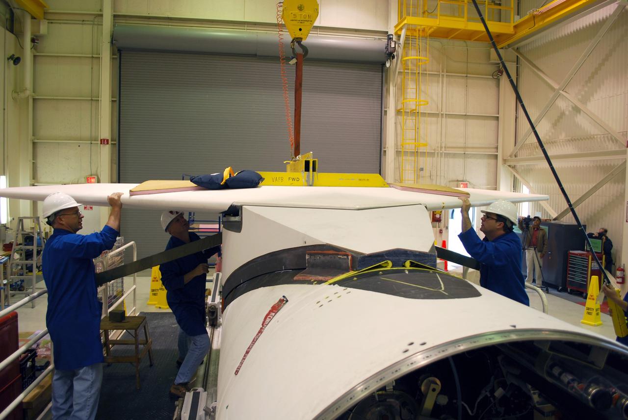
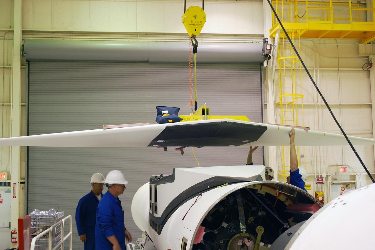
VANDENBERG AIR FORCE BASE, Calif. -- Preparations are underway in Building 1555 at Vandenberg AFB for installation of the final wing onto the Pegasus rocket. The Pegasus will launch NASA's Interstellar Boundary Explorer Mission, or IBEX, satellite from Kwajalein Island in the Marshall Islands, South Pacific. IBEX will make the first map of the boundary between the solar system and interstellar space. IBEX is the first mission designed to detect the edge of the solar system. As the solar wind from the sun flows out beyond Pluto, it collides with the material between the stars, forming a shock front. IBEX contains two neutral atom imagers designed to detect particles from the termination shock at the boundary between the solar system and interstellar space. IBEX also will study galactic cosmic rays, energetic particles from beyond the solar system that pose a health and safety hazard for humans exploring beyond Earth orbit. IBEX will make these observations from a highly elliptical orbit that takes it beyond the interference of the Earth's magnetosphere. IBEX is targeted for launch in September 2008. Photo credit: NASA/ Randy Beaudoin
VANDENBERG AIR FORCE BASE, Calif. -- Workers in Building 1555 at Vandenberg AFB secure the wing into place on the Pegasus rocket. The Pegasus will launch NASA's Interstellar Boundary Explorer Mission, or IBEX, satellite from Kwajalein Island in the Marshall Islands, South Pacific. IBEX will make the first map of the boundary between the solar system and interstellar space. IBEX is the first mission designed to detect the edge of the solar system. As the solar wind from the sun flows out beyond Pluto, it collides with the material between the stars, forming a shock front. IBEX contains two neutral atom imagers designed to detect particles from the termination shock at the boundary between the solar system and interstellar space. IBEX also will study galactic cosmic rays, energetic particles from beyond the solar system that pose a health and safety hazard for humans exploring beyond Earth orbit. IBEX will make these observations from a highly elliptical orbit that takes it beyond the interference of the Earth's magnetosphere. IBEX is targeted for launch in September 2008. Photo credit: NASA/ Randy Beaudoin
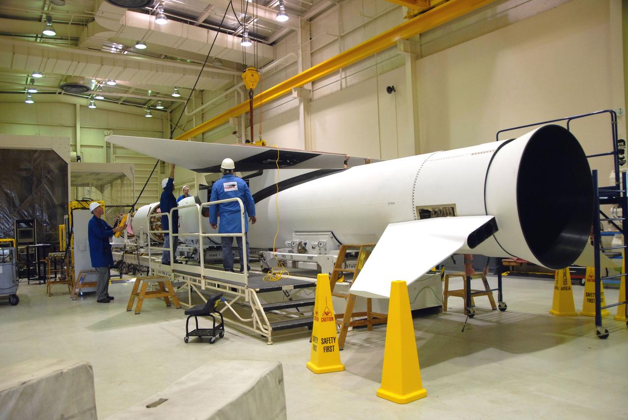
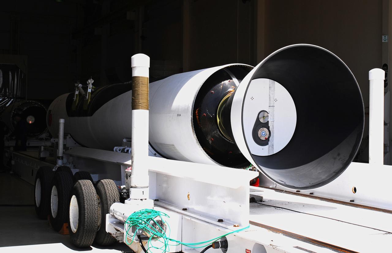
VANDENBERG AIR FORCE BASE, Calif. – In Building 1555, stage 1 and stage 2 of the Pegasus XL launch vehicle are temporarily mated. The Pegasus will launch NASA's Interstellar Boundary Explorer Mission, or IBEX, satellite from Kwajalein Island in the Marshall Islands, South Pacific. IBEX will make the first map of the boundary between the solar system and interstellar space. IBEX is the first mission designed to detect the edge of the solar system. As the solar wind from the sun flows out beyond Pluto, it collides with the material between the stars, forming a shock front. IBEX contains two neutral atom imagers designed to detect particles from the termination shock at the boundary between the solar system and interstellar space. IBEX also will study galactic cosmic rays, energetic particles from beyond the solar system that pose a health and safety hazard for humans exploring beyond Earth orbit. IBEX will make these observations from a highly elliptical orbit that takes it beyond the interference of the Earth's magnetosphere. Photo credit: NASA/Moran
VANDENBERG AIR FORCE BASE, Calif. -- Workers in Building 1555 at Vandenberg AFB help maneuver the wing for installation onto the Pegasus rocket. The Pegasus will launch NASA's Interstellar Boundary Explorer Mission, or IBEX, satellite from Kwajalein Island in the Marshall Islands, South Pacific. IBEX will make the first map of the boundary between the solar system and interstellar space. IBEX is the first mission designed to detect the edge of the solar system. As the solar wind from the sun flows out beyond Pluto, it collides with the material between the stars, forming a shock front. IBEX contains two neutral atom imagers designed to detect particles from the termination shock at the boundary between the solar system and interstellar space. IBEX also will study galactic cosmic rays, energetic particles from beyond the solar system that pose a health and safety hazard for humans exploring beyond Earth orbit. IBEX will make these observations from a highly elliptical orbit that takes it beyond the interference of the Earth's magnetosphere. IBEX is targeted for launch in September 2008. Photo credit: NASA/ Randy Beaudoin
VANDENBERG AIR FORCE BASE, Calif. – In Building 1555, workers help guide a wing toward the Pegasus XL launch vehicle in the background for a fit check. The Pegasus will launch NASA's Interstellar Boundary Explorer Mission, or IBEX, satellite from Kwajalein Island in the Marshall Islands, South Pacific. IBEX will make the first map of the boundary between the solar system and interstellar space. IBEX is the first mission designed to detect the edge of the solar system. As the solar wind from the sun flows out beyond Pluto, it collides with the material between the stars, forming a shock front. IBEX contains two neutral atom imagers designed to detect particles from the termination shock at the boundary between the solar system and interstellar space. IBEX also will study galactic cosmic rays, energetic particles from beyond the solar system that pose a health and safety hazard for humans exploring beyond Earth orbit. IBEX will make these observations from a highly elliptical orbit that takes it beyond the interference of the Earth's magnetosphere. Photo credit: NASA/Randy Beaudoin
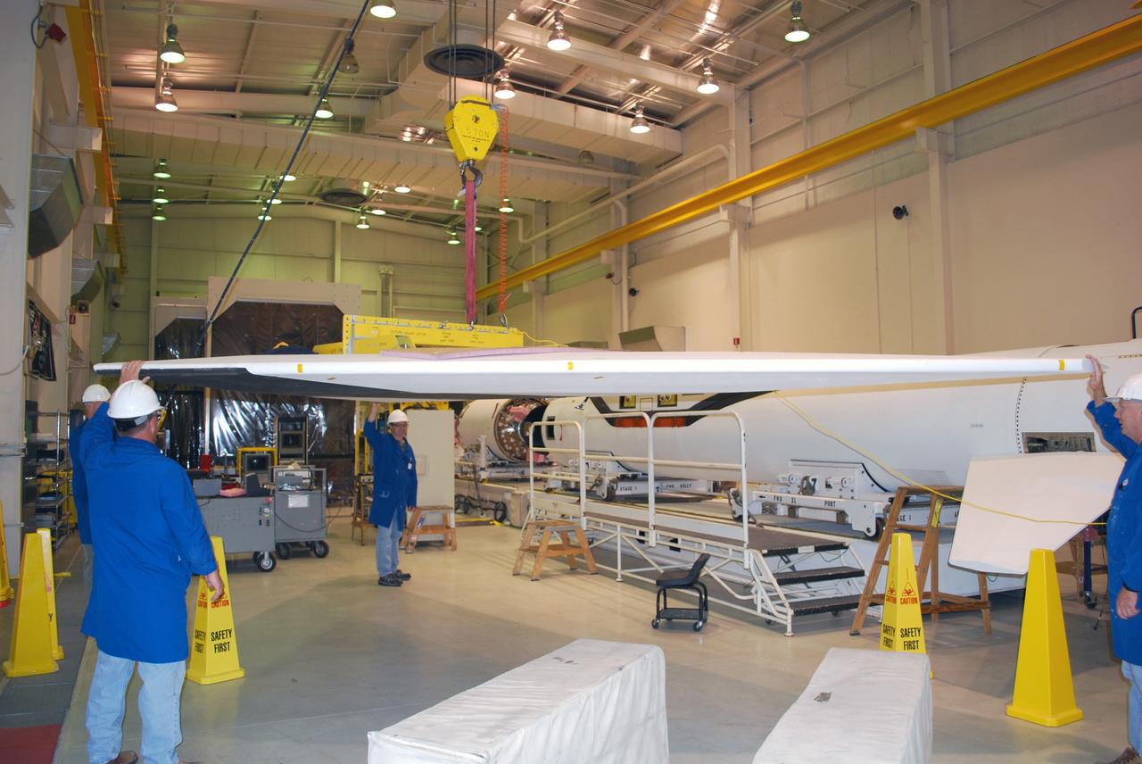
VANDENBERG AIR FORCE BASE, Calif. -- Workers in Building 1555 at Vandenberg AFB help guide the wing toward the Pegasus rocket for installation. The Pegasus will launch NASA's Interstellar Boundary Explorer Mission, or IBEX, satellite from Kwajalein Island in the Marshall Islands, South Pacific. IBEX will make the first map of the boundary between the solar system and interstellar space. IBEX is the first mission designed to detect the edge of the solar system. As the solar wind from the sun flows out beyond Pluto, it collides with the material between the stars, forming a shock front. IBEX contains two neutral atom imagers designed to detect particles from the termination shock at the boundary between the solar system and interstellar space. IBEX also will study galactic cosmic rays, energetic particles from beyond the solar system that pose a health and safety hazard for humans exploring beyond Earth orbit. IBEX will make these observations from a highly elliptical orbit that takes it beyond the interference of the Earth's magnetosphere. IBEX is targeted for launch in September 2008. Photo credit: NASA/ Randy Beaudoin
VANDENBERG AIR FORCE BASE, Calif. – Segments of the Pegasus XL launch vehicle are moved into Building 1555. The Pegasus will launch NASA's Interstellar Boundary Explorer Mission, or IBEX, satellite from Kwajalein Island in the Marshall Islands, South Pacific. IBEX will make the first map of the boundary between the solar system and interstellar space. IBEX is the first mission designed to detect the edge of the solar system. As the solar wind from the sun flows out beyond Pluto, it collides with the material between the stars, forming a shock front. IBEX contains two neutral atom imagers designed to detect particles from the termination shock at the boundary between the solar system and interstellar space. IBEX also will study galactic cosmic rays, energetic particles from beyond the solar system that pose a health and safety hazard for humans exploring beyond Earth orbit. IBEX will make these observations from a highly elliptical orbit that takes it beyond the interference of the Earth's magnetosphere. Photo credit: NASA/Moran
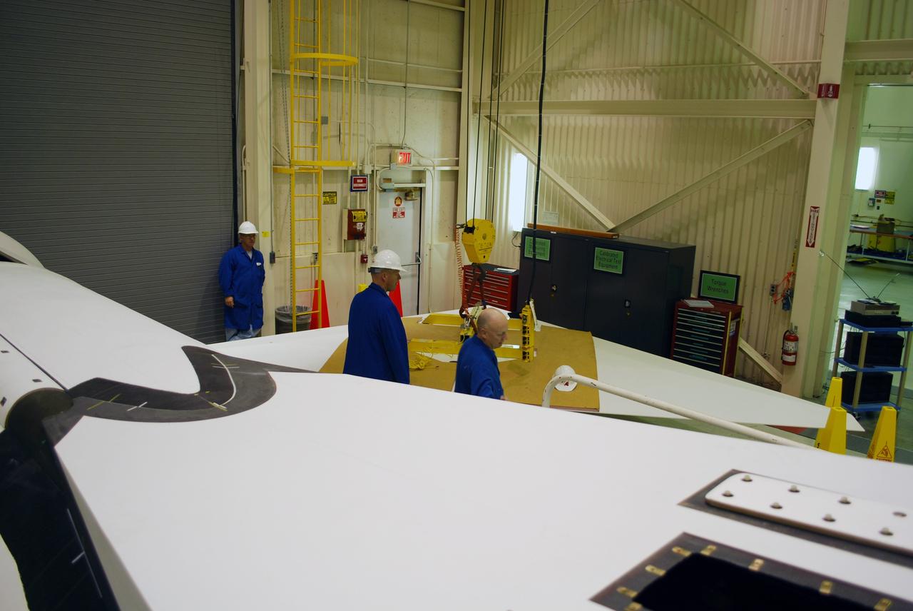
VANDENBERG AIR FORCE BASE, Calif. – In Building 1555, workers check the movement of the wing toward the Pegasus XL launch vehicle. The Pegasus will launch NASA's Interstellar Boundary Explorer Mission, or IBEX, satellite from Kwajalein Island in the Marshall Islands, South Pacific. IBEX will make the first map of the boundary between the solar system and interstellar space. IBEX is the first mission designed to detect the edge of the solar system. As the solar wind from the sun flows out beyond Pluto, it collides with the material between the stars, forming a shock front. IBEX contains two neutral atom imagers designed to detect particles from the termination shock at the boundary between the solar system and interstellar space. IBEX also will study galactic cosmic rays, energetic particles from beyond the solar system that pose a health and safety hazard for humans exploring beyond Earth orbit. IBEX will make these observations from a highly elliptical orbit that takes it beyond the interference of the Earth's magnetosphere. Photo credit: NASA/Randy Beaudoin
VANDENBERG AIR FORCE BASE, Calif. – In Building 1555, workers help guide a wing toward the Pegasus XL launch vehicle for a fit check. The Pegasus will launch NASA's Interstellar Boundary Explorer Mission, or IBEX, satellite from Kwajalein Island in the Marshall Islands, South Pacific. IBEX will make the first map of the boundary between the solar system and interstellar space. IBEX is the first mission designed to detect the edge of the solar system. As the solar wind from the sun flows out beyond Pluto, it collides with the material between the stars, forming a shock front. IBEX contains two neutral atom imagers designed to detect particles from the termination shock at the boundary between the solar system and interstellar space. IBEX also will study galactic cosmic rays, energetic particles from beyond the solar system that pose a health and safety hazard for humans exploring beyond Earth orbit. IBEX will make these observations from a highly elliptical orbit that takes it beyond the interference of the Earth's magnetosphere. Photo credit: NASA/Randy Beaudoin
VANDENBERG AIR FORCE BASE, Calif. – In Building 1555, workers help guide the fillet on top of the Pegasus XL launch vehicle. The Pegasus will launch NASA's Interstellar Boundary Explorer Mission, or IBEX, satellite from Kwajalein Island in the Marshall Islands, South Pacific. IBEX will make the first map of the boundary between the solar system and interstellar space. IBEX is the first mission designed to detect the edge of the solar system. As the solar wind from the sun flows out beyond Pluto, it collides with the material between the stars, forming a shock front. IBEX contains two neutral atom imagers designed to detect particles from the termination shock at the boundary between the solar system and interstellar space. IBEX also will study galactic cosmic rays, energetic particles from beyond the solar system that pose a health and safety hazard for humans exploring beyond Earth orbit. IBEX will make these observations from a highly elliptical orbit that takes it beyond the interference of the Earth's magnetosphere. Photo credit: NASA/Randy Beaudoin