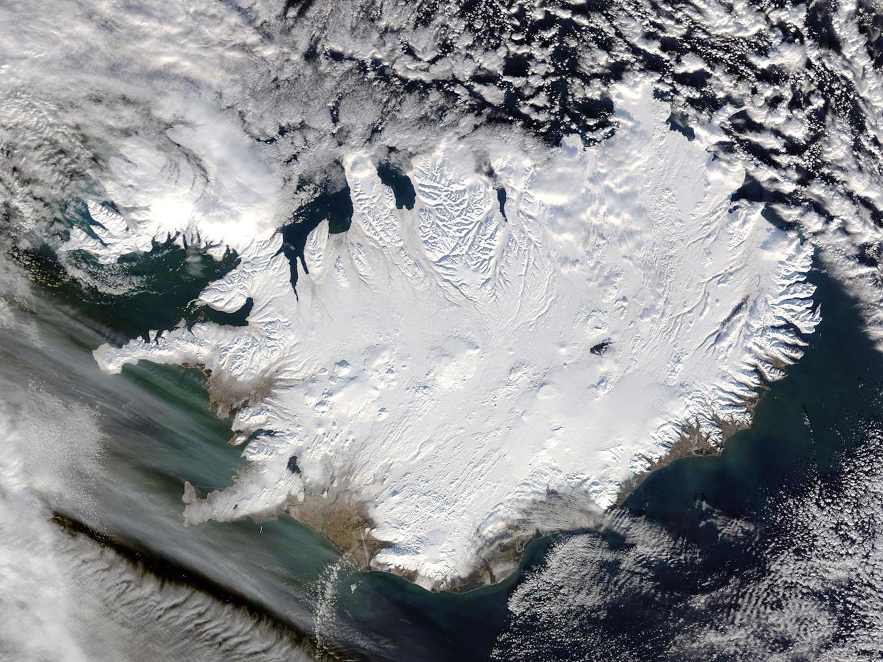
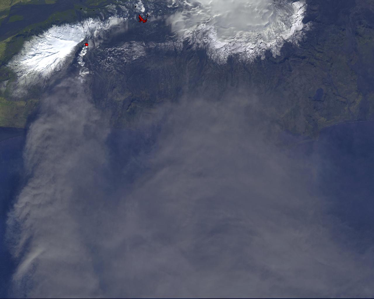
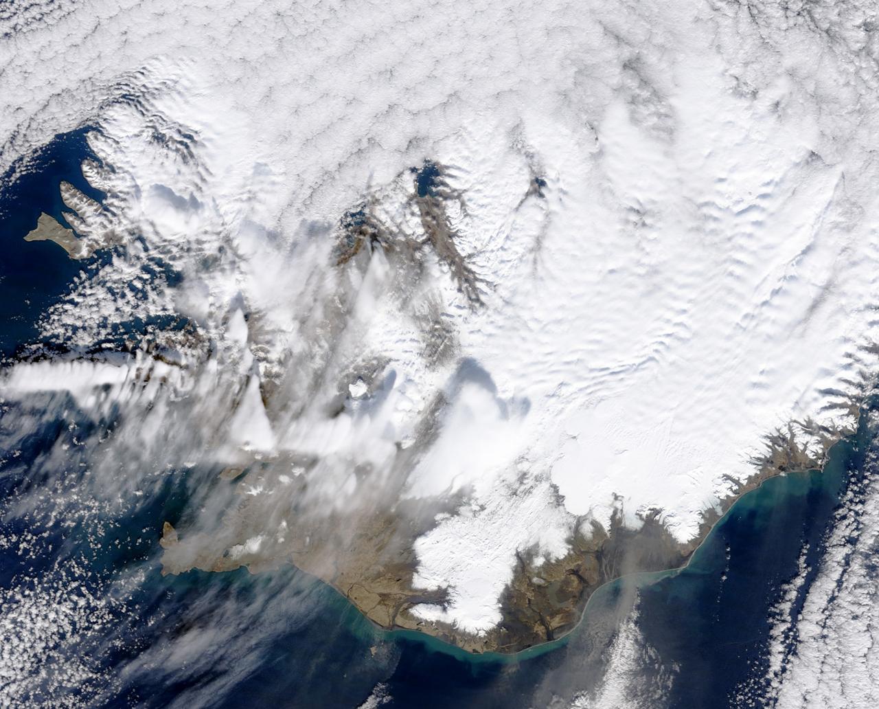
Iceland, dressed in winter white, peaked through a hole in a complex system of clouds in late February, 2015. The Moderate Resolution Imaging Spectroradiometer (MODIS) aboard NASA’s Terra satellite captured this true-color image on February 21 as it passed over the region. Ice and snow covers Iceland almost entirely, except for coastal regions in the southwest and southeast. The extensive, roughly H-shaped area in the southeast section of the island is Vatnajökull, Iceland’s largest glacier. Hidden underneath the ice lies Bardarbunga, a large subglacial stratovolcano. On August 31, 2014 the volcano began an eruption at two fissures to the north of the glacier and deposited a lava field that measured about 131 feet (40 meters) at its thickest points, and covered an area about 33 sq. mi (85 sq. km) by the time the eruption ended on February 27, 2015. The massive lava flow left its mark on Iceland – the cooled lava can be seen as the roughly oval black area to the north of the Vatnajökull glacier. Credit: NASA/GSFC/Jeff Schmaltz/MODIS Land Rapid Response Team <b><a href="http://www.nasa.gov/audience/formedia/features/MP_Photo_Guidelines.html" rel="nofollow">NASA image use policy.</a></b> <b><a href="http://www.nasa.gov/centers/goddard/home/index.html" rel="nofollow">NASA Goddard Space Flight Center</a></b> enables NASA’s mission through four scientific endeavors: Earth Science, Heliophysics, Solar System Exploration, and Astrophysics. Goddard plays a leading role in NASA’s accomplishments by contributing compelling scientific knowledge to advance the Agency’s mission. <b>Follow us on <a href="http://twitter.com/NASAGoddardPix" rel="nofollow">Twitter</a></b> <b>Like us on <a href="http://www.facebook.com/pages/Greenbelt-MD/NASA-Goddard/395013845897?ref=tsd" rel="nofollow">Facebook</a></b> <b>Find us on <a href="http://instagram.com/nasagoddard?vm=grid" rel="nofollow">Instagram</a></b>
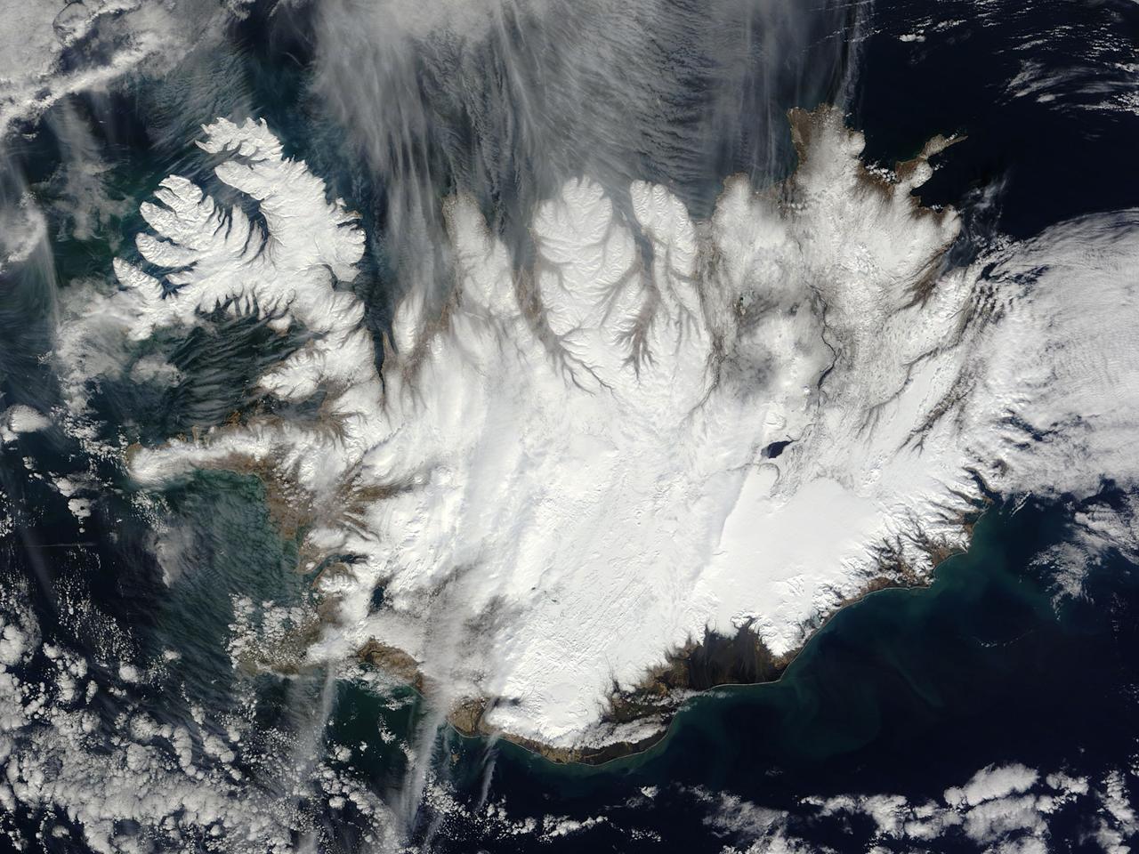
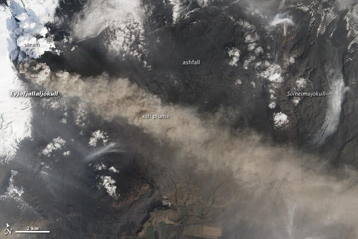
This nearly cloud-free image of Iceland was captured by the MODIS instrument on board the Terra spacecraft on 04/15/2015 at 13:00 UTC.
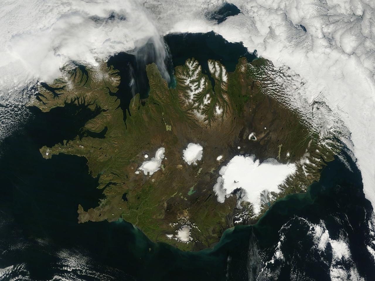
On August 22, 2014 the Moderate Resolution Imaging Spectroradiometer (MODIS) aboard NASA’s Terra satellite captured a true-color image of a sunny summer day in Iceland. While most of the winter snow has melted to reveal green vegetation, the rugged northern peaks retain a snow cap. Further south bright white marks the location of glaciers. Situated in the southeast is Vatnajökull – the largest glacier in Europe and the site of Iceland’s highest mountain, Hvannadalshnjúkur. On August 20, scientists from the Icelandic Met Office closed all roads into the north of Vatnajökull Glacier due to increase seismic activity from the Bardarbunga volcano which lies under the ice cap in this area. On August 23, a small eruption was detected in Bardarbunga and the airspace near the activity was closed as a precautionary measure. Further study of the data suggested that no eruption had in fact occurred and airspace was opened under a code orange alert. Seismic activity remained high. On August 29, an eruption occurred north of Vatnajökull Glacier when a fissure, close to 1 km in length, opened up, and emitted lava at a slow pace. The eruption was short-lived, but on August 31 an eruption was confirmed in the same remote, uninhabited area. The Icelandic Meteorological Office reported that as of September 11 that eruption continued unabated. There has been no significant explosive activity, but lava flow has been the primary feature. High concentrations of sulfuric gases from the volcanic activity accompany the eruption, and are the primary health concern. Credit: NASA/GSFC/Jeff Schmaltz/MODIS Land Rapid Response Team <b><a href="http://www.nasa.gov/audience/formedia/features/MP_Photo_Guidelines.html" rel="nofollow">NASA image use policy.</a></b> <b><a href="http://www.nasa.gov/centers/goddard/home/index.html" rel="nofollow">NASA Goddard Space Flight Center</a></b> enables NASA’s mission through four scientific endeavors: Earth Science, Heliophysics, Solar System Exploration, and Astrophysics. Goddard plays a leading role in NASA’s accomplishments by contributing compelling scientific knowledge to advance the Agency’s mission. <b>Follow us on <a href="http://twitter.com/NASAGoddardPix" rel="nofollow">Twitter</a></b> <b>Like us on <a href="http://www.facebook.com/pages/Greenbelt-MD/NASA-Goddard/395013845897?ref=tsd" rel="nofollow">Facebook</a></b> <b>Find us on <a href="http://instagram.com/nasagoddard?vm=grid" rel="nofollow">Instagram</a></b>
Artemis II Crew Geology Training in Iceland. Nautagil / Holohraun Science Activity. Photo Date: August 1, 2024. Location: Drekagil, Iceland. Photo Credit: NASA/Robert Markowitz
Artemis II Crew Geology Training in Iceland. Nautagil / Holohraun Science Activity. Photo Date: August 1, 2024. Location: Drekagil, Iceland. Photo Credit: NASA/Robert Markowitz
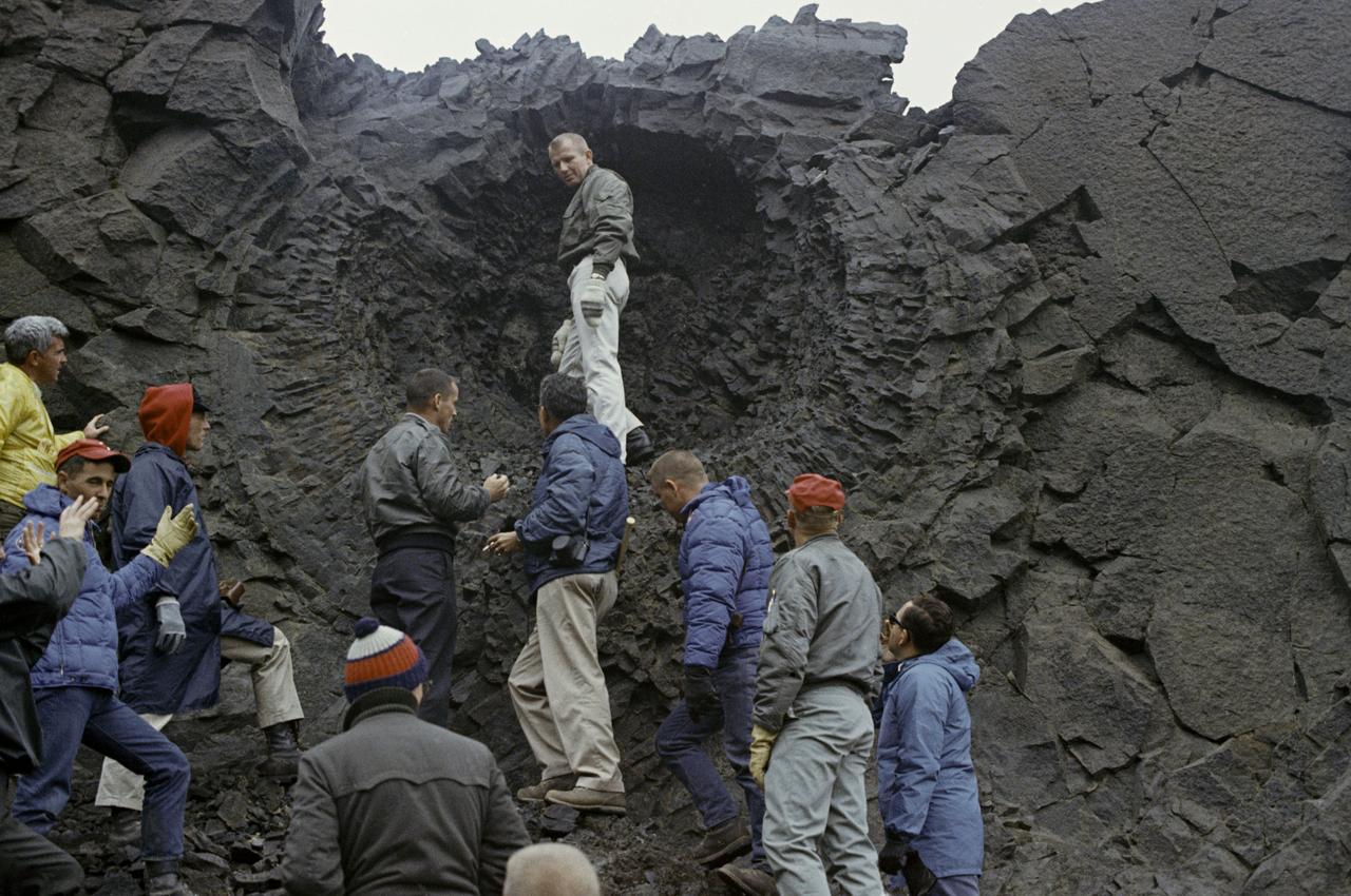
Apollo astronauts study rock formations during a geology field training in Iceland in 1967.
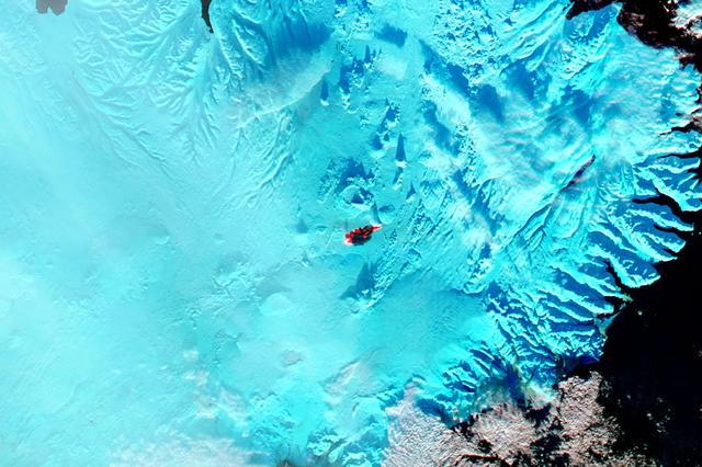
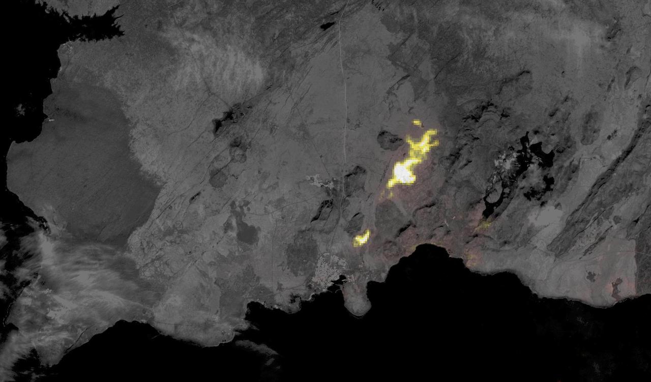
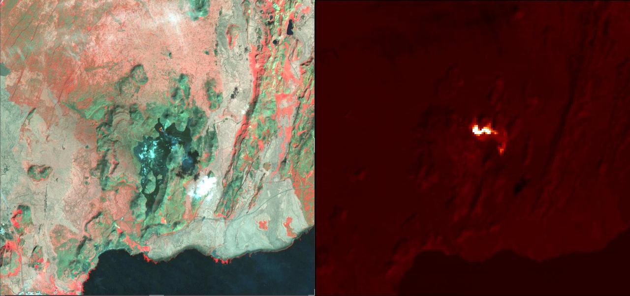
The main caldera of Bardarbunga volcano is tucked beneath Iceland’s largest glacier, Vatnajökull. Beginning in August, 2014, red-hot basaltic lava originating from Bardarbunga has been pouring from fissures just north of Vatnajökull, creating the massive Holuhraun lava field. As of January 6, 2015, the Holuhraun lava field had spread across more than 84 square kilometers (32 square miles), making it larger than the island of Manhattan. Holuhraun is Iceland’s largest basaltic lava flow since the Laki eruption in 1783–84, an event that killed 20 percent of the island’s population. Scientists from the University of Iceland’s Institute of Earth Sciences have estimated the thickness of the lava field based on data from surveillance flights. On average, the eastern part was about 10 meters (33 feet) thick, the center was 12 meters, and the western part was 14 meters. Their preliminary analysis put the volume of lava at 1.1 cubic kilometers, enough for the eruption to be considered a flood basalt. While Holuhraun continues to spew copious amounts of lava and sulfur dioxide, some observations suggest the eruption may be slowing down. As Edinburgh University volcanologist John Stevenson noted on his blog, Icelandic scientists have shown that the sinking (subsidence) of the caldera has declined from 80 centimeters (31 inches) to 25 centimeters per day—a sign that less magma is moving toward the surface. In addition, magnitude 5 or higher earthquakes that used to occur daily are now happening about once a week. Meanwhile, satellite observations of heat flux show a decline from more than 20 gigawatts in early September to fewer than 5 gigawatts by the end of November. As reported by Volcano Discovery, one bold scientist has even suggested that it is reasonable to forecast that the eruption may be over by March, 2015. The Moderate Resolution Imaging Spectrometer (MODIS) aboard NASA’s Aqua satellite flew over Iceland on January 18, 2015 and captured a false-color image of the lava field. In this image, clouds are bright white, cold snow is electric blue, and the North Atlantic Ocean is inky blue-black. Fresh lava appears bright red, while newly formed basaltic rock in the lava field, cooler than the fresh lava, appears black. Credit: NASA/GSFC/Jeff Schmaltz/MODIS Land Rapid Response Team <b><a href="http://www.nasa.gov/audience/formedia/features/MP_Photo_Guidelines.html" rel="nofollow">NASA image use policy.</a></b> <b><a href="http://www.nasa.gov/centers/goddard/home/index.html" rel="nofollow">NASA Goddard Space Flight Center</a></b> enables NASA’s mission through four scientific endeavors: Earth Science, Heliophysics, Solar System Exploration, and Astrophysics. Goddard plays a leading role in NASA’s accomplishments by contributing compelling scientific knowledge to advance the Agency’s mission. <b>Follow us on <a href="http://twitter.com/NASAGoddardPix" rel="nofollow">Twitter</a></b> <b>Like us on <a href="http://www.facebook.com/pages/Greenbelt-MD/NASA-Goddard/395013845897?ref=tsd" rel="nofollow">Facebook</a></b> <b>Find us on <a href="http://instagram.com/nasagoddard?vm=grid" rel="nofollow">Instagram</a></b>
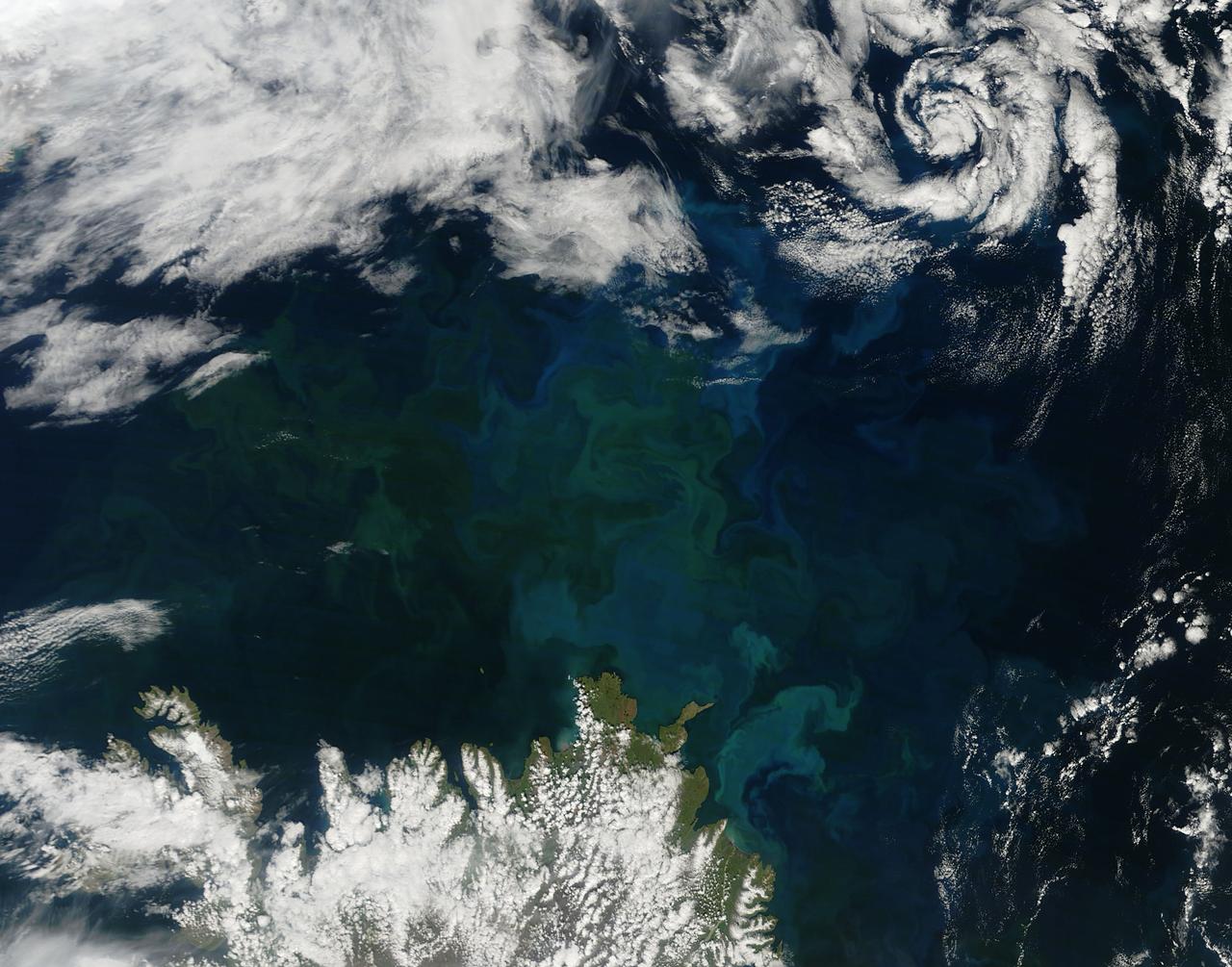
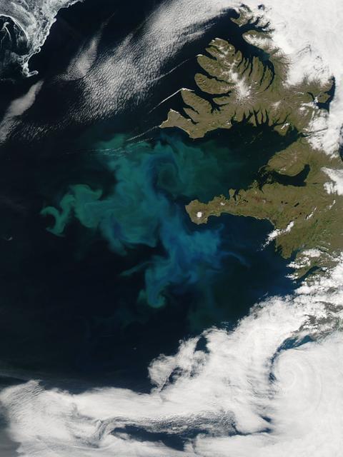
A massive phytoplankton bloom stained the waters of the Atlantic Ocean north of Iceland with brilliant jewel tones in late summer, 2014. The Moderate Resolution Imaging Spectroradiometer (MODIS) aboard NASA’s Aqua satellite captured this true-color image on August 2. Huge colonies of the floating, plant-like organisms create swirls of green, teal and turquoise and cover over 80% of the visible ocean off the northeast coast of Iceland. Marine phytoplankton require just the right amount of sunlight, dissolved nutrients and water temperatures which are not too hot, nor too cold to spark explosive reproduction and result in blooms which can cover hundreds of square kilometers. Phytoplankton form the base of the marine food chain, and are a rich food source for zooplankton, fish and other marine species. Some species, however, can deplete the water of oxygen and may become toxic to marine life. Credit: NASA/GSFC/Jeff Schmaltz/MODIS Land Rapid Response Team <b><a href="http://www.nasa.gov/audience/formedia/features/MP_Photo_Guidelines.html" rel="nofollow">NASA image use policy.</a></b> <b><a href="http://www.nasa.gov/centers/goddard/home/index.html" rel="nofollow">NASA Goddard Space Flight Center</a></b> enables NASA’s mission through four scientific endeavors: Earth Science, Heliophysics, Solar System Exploration, and Astrophysics. Goddard plays a leading role in NASA’s accomplishments by contributing compelling scientific knowledge to advance the Agency’s mission. <b>Follow us on <a href="http://twitter.com/NASAGoddardPix" rel="nofollow">Twitter</a></b> <b>Like us on <a href="http://www.facebook.com/pages/Greenbelt-MD/NASA-Goddard/395013845897?ref=tsd" rel="nofollow">Facebook</a></b> <b>Find us on <a href="http://instagram.com/nasagoddard?vm=grid" rel="nofollow">Instagram</a></b>
CSA (Canadian Space Agency) astronaut and Artemis II backup crew member, Jenni Gibbons, participates in geology field training in Iceland.
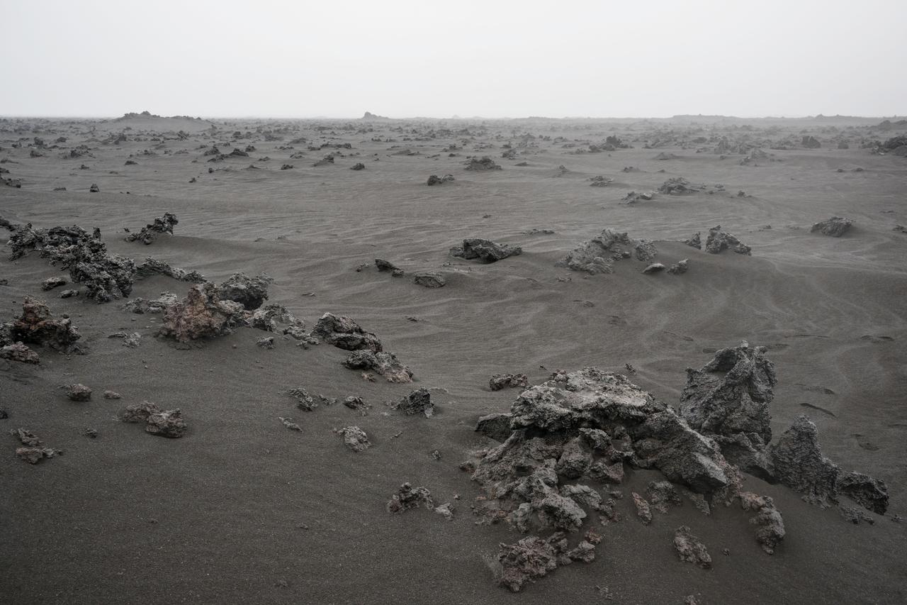
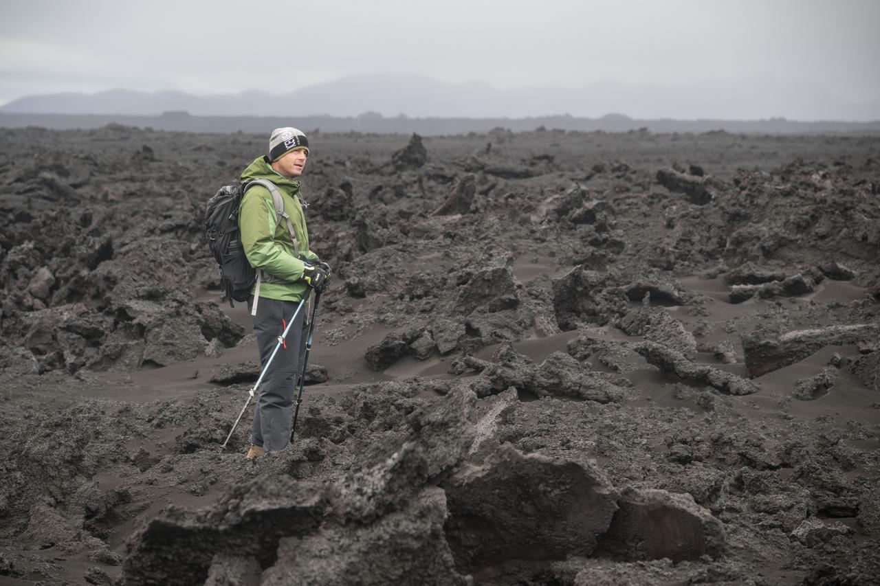
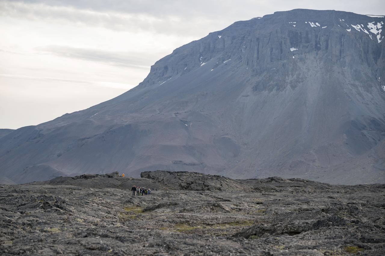
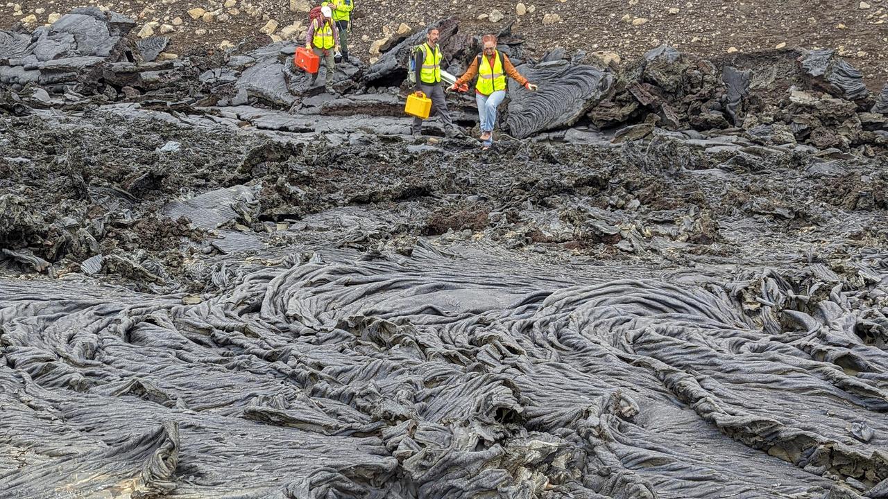
A view of the Holuhraun lava field from the Bárðarbunga volcano, located in Vatnajökull National Park in Iceland. The image shows the rubbly textured basaltic lava flow that has been partially buried by wind-blown sediment. Iceland has been used as a planetary analog for geology training for astronauts since the Apollo missions because of the geologic similarities to the Moon.

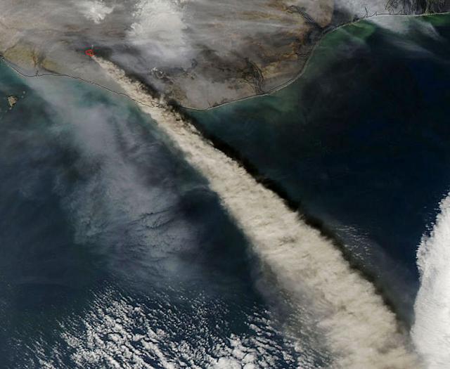
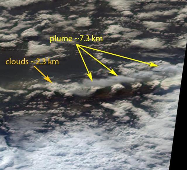
NASA satellite image acquired May 6, 2010 at 11 :55 UTC To view a detail of this image go to: <a href="http://www.flickr.com/photos/gsfc/4583711511/">www.flickr.com/photos/gsfc/4583711511/</a> NASA Satellite Sees a Darker Ash Plume From Iceland Volcano NASA's Terra satellite flew over the Eyjafjallajokull Volcano, Iceland, on May 6 at 11:55 UTC (7:55 a.m. EDT). The Moderate Resolution Imaging Spectroradiometer instrument known as MODIS that flies onboard Terra, captured a visible image of the ash plume. The plume was blowing east then southeast over the Northern Atlantic. The satellite image shows that the plume is at a lower level in the atmosphere than the clouds that lie to its east, as the brown plume appears to slide underneath the white clouds. Satellite: Terra NASA/GSFC/Jeff Schmaltz/MODIS Land Rapid Response Team To learn more about MODIS go to: <a href="http://www.nasa.gov/topics/earth/features/iceland-volcano-plume.html" rel="nofollow">www.nasa.gov/topics/earth/features/iceland-volcano-plume....</a> <b><a href="http://www.nasa.gov/centers/goddard/home/index.html" rel="nofollow">NASA Goddard Space Flight Center</a></b> is home to the nation's largest organization of combined scientists, engineers and technologists that build spacecraft, instruments and new technology to study the Earth, the sun, our solar system, and the universe.
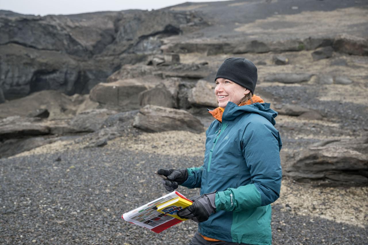
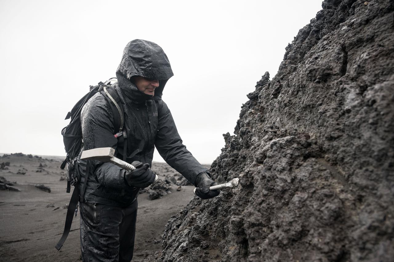
Angela Garcia, Artemis II science officer and exploration geologist, demonstrates how to use a rock hammer and chisel to dislodge a rock sample from a large boulder during the Artemis II field geology training in Iceland.

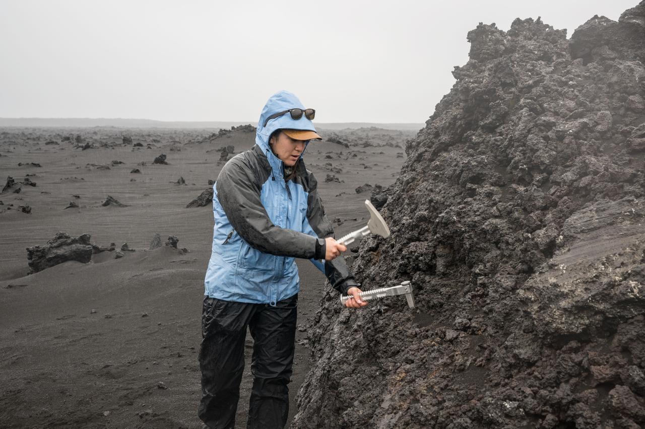
NASA astronaut and Artemis II backup crew member Andre Douglas uses a rock hammer and chisel to break a sample off a large boulder during a geology field training exercise in Iceland.

This nearly cloud-free image of Iceland was captured by the MODIS instrument on board the Terra spacecraft on 04/15/2015 at 13:00 UTC. <b><a href="http://www.nasa.gov/audience/formedia/features/MP_Photo_Guidelines.html" rel="nofollow">NASA image use policy.</a></b> <b><a href="http://www.nasa.gov/centers/goddard/home/index.html" rel="nofollow">NASA Goddard Space Flight Center</a></b> enables NASA’s mission through four scientific endeavors: Earth Science, Heliophysics, Solar System Exploration, and Astrophysics. Goddard plays a leading role in NASA’s accomplishments by contributing compelling scientific knowledge to advance the Agency’s mission. <b>Follow us on <a href="http://twitter.com/NASAGoddardPix" rel="nofollow">Twitter</a></b> <b>Like us on <a href="http://www.facebook.com/pages/Greenbelt-MD/NASA-Goddard/395013845897?ref=tsd" rel="nofollow">Facebook</a></b> <b>Find us on <a href="http://instagrid.me/nasagoddard/?vm=grid" rel="nofollow">Instagram</a></b>
NASA image captured 06/24/2010 at 14 :30 UTC Phytoplankton bloom off western Iceland Satellite: Aqua NASA/GSFC/Jeff Schmaltz/MODIS Land Rapid Response Team To learn more about MODIS go to: <a href="http://rapidfire.sci.gsfc.nasa.gov/gallery/?latest" rel="nofollow">rapidfire.sci.gsfc.nasa.gov/gallery/?latest</a> <b><a href="http://www.nasa.gov/centers/goddard/home/index.html" rel="nofollow">NASA Goddard Space Flight Center</a></b> is home to the nation's largest organization of combined scientists, engineers and technologists that build spacecraft, instruments and new technology to study the Earth, the sun, our solar system, and the universe.
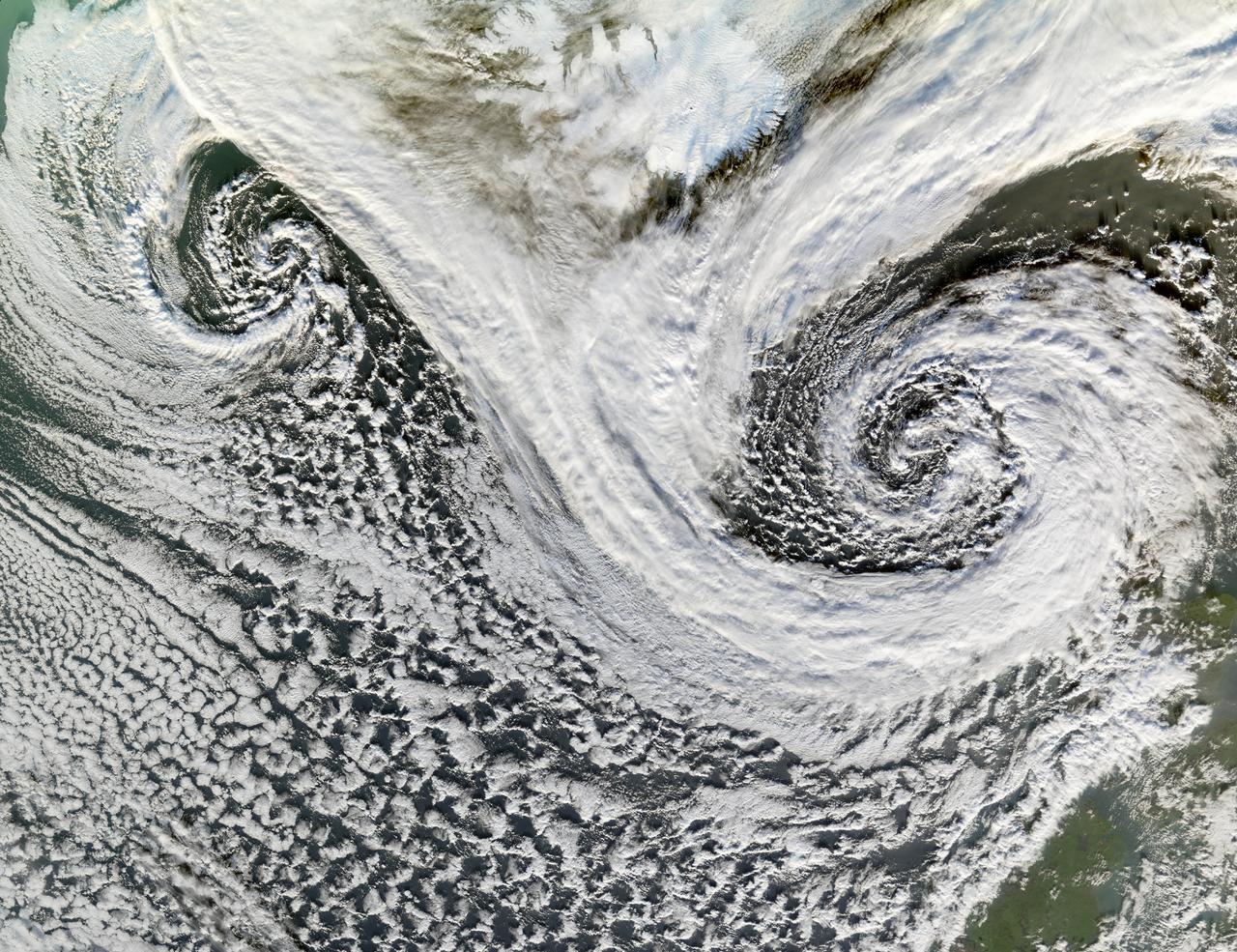
A cyclone is a low-pressure area of winds that spiral inwards. Although tropical storms most often come to mind, these spiraling storms can also form at mid- and high latitudes. Two such cyclones formed in tandem in November 2006. The Moderate Resolution Imaging Spectroradiometer (MODIS) flying onboard NASA’s Terra satellite took this picture on November 20. This image shows the cyclones south of Iceland. Scotland appears in the lower right. The larger and perhaps stronger cyclone appears in the east, close to Scotland. Cyclones at high and mid-latitudes are actually fairly common, and they drive much of the Earth’s weather. In the Northern Hemisphere, cyclones move in a counter-clockwise direction, and both of the spiraling storms in this image curl upwards toward the northeast then the west. The eastern storm is fed by thick clouds from the north that swoop down toward the storm in a giant “V” shape on either side of Iceland. Skies over Iceland are relatively clear, allowing some of the island to show through. South of the storms, more diffuse cloud cover swirls toward the southeast. Credit: NASA <b><a href="http://www.nasa.gov/centers/goddard/home/index.html" rel="nofollow">NASA Goddard Space Flight Center</a></b> is home to the nation's largest organization of combined scientists, engineers and technologists that build spacecraft, instruments and new technology to study the Earth, the sun, our solar system, and the universe. <b>Follow us on <a href="http://twitter.com/NASA_GoddardPix" rel="nofollow">Twitter</a></b> <b>Join us on <a href="http://www.facebook.com/pages/Greenbelt-MD/NASA-Goddard/395013845897?ref=tsd" rel="nofollow">Facebook</a></b>
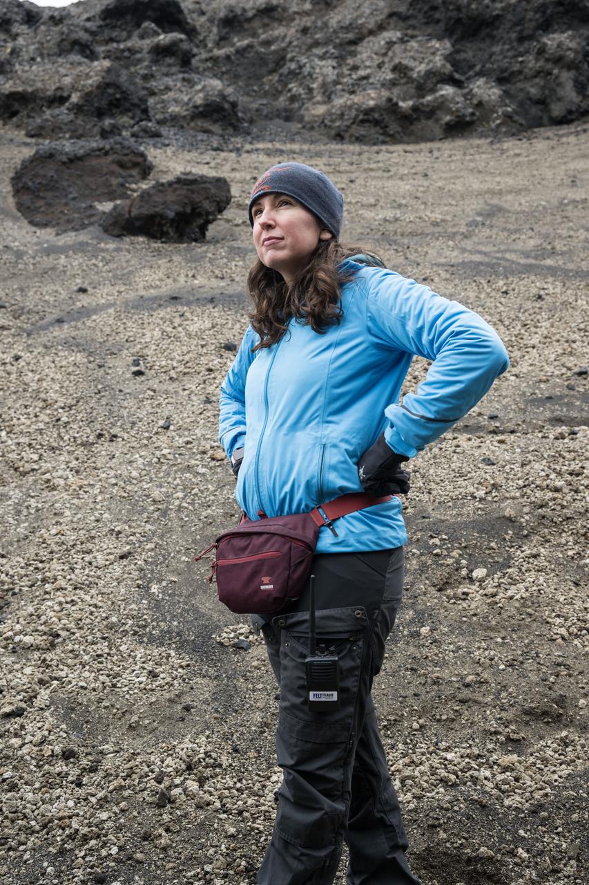
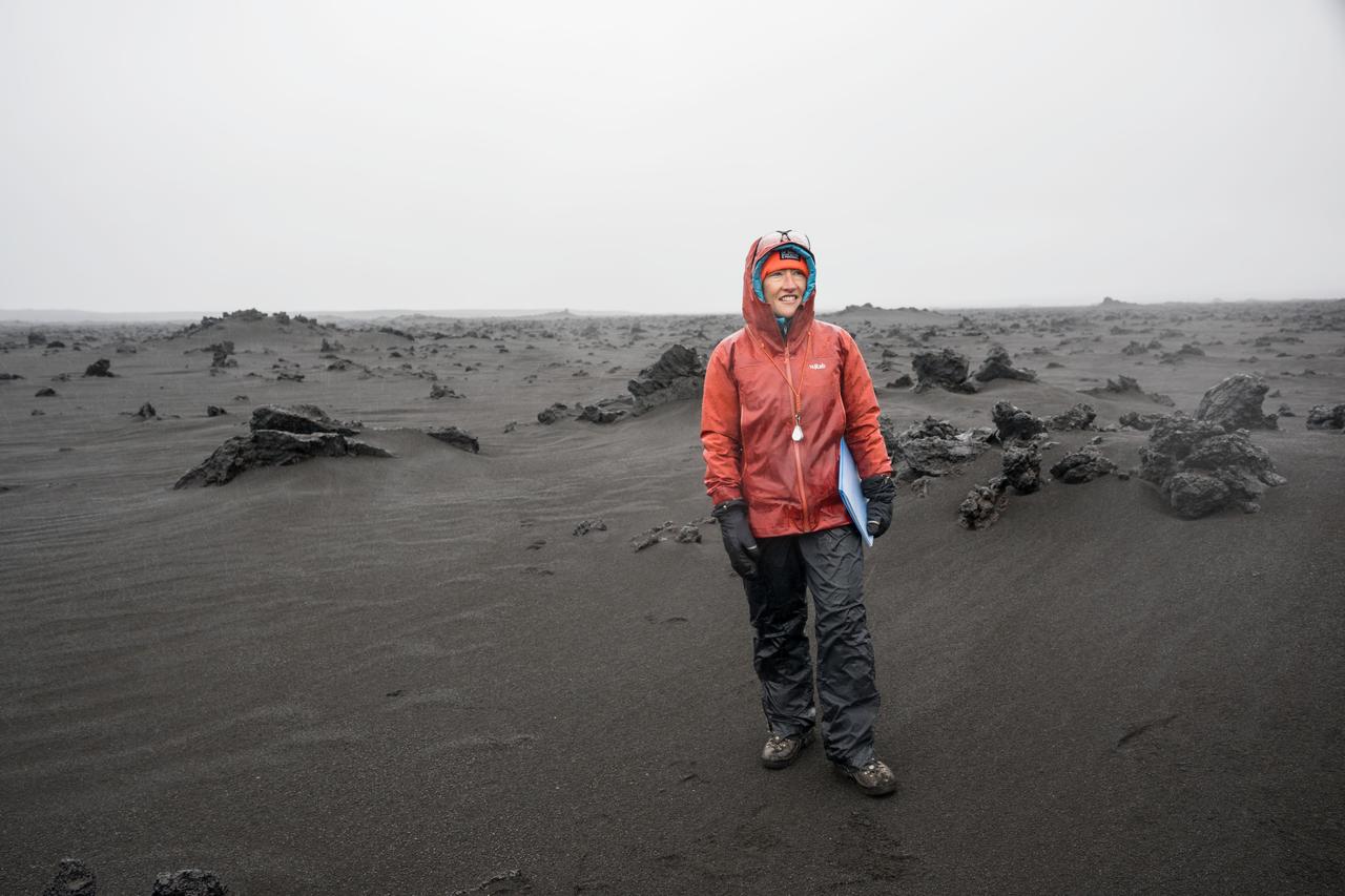
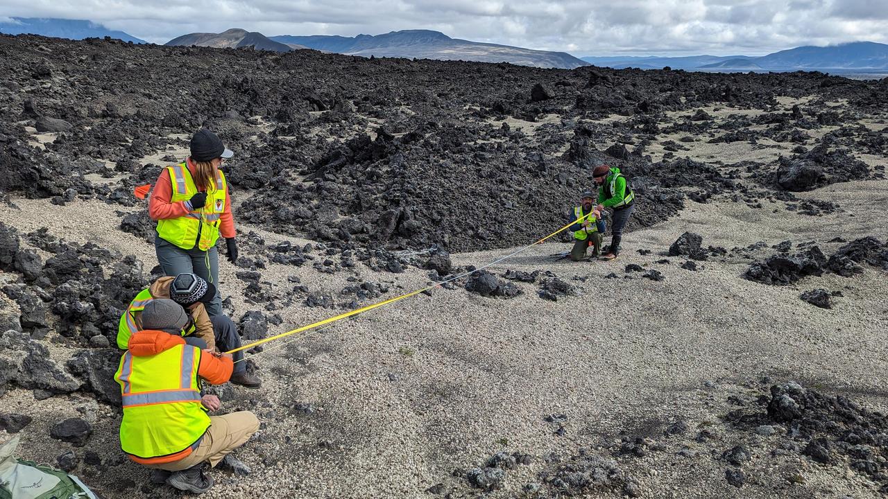
Lunar science lead for Artemis II and Artemis II science officer at NASA’s Goddard Space Flight Center in Greenbelt, Maryland, Kelsey Young, stands in the lunar-like landscape of Iceland during an Artemis II crew geology field training.
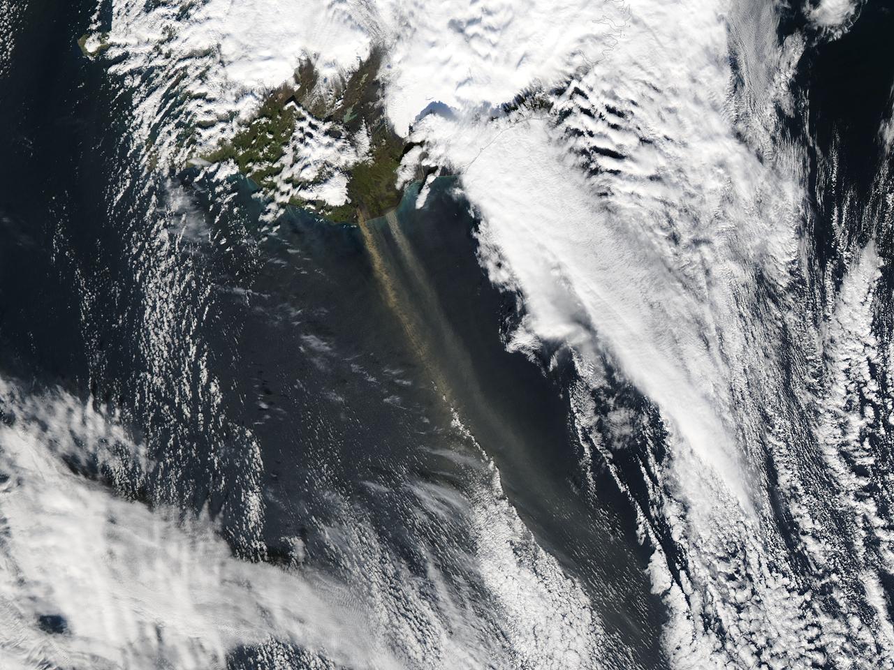
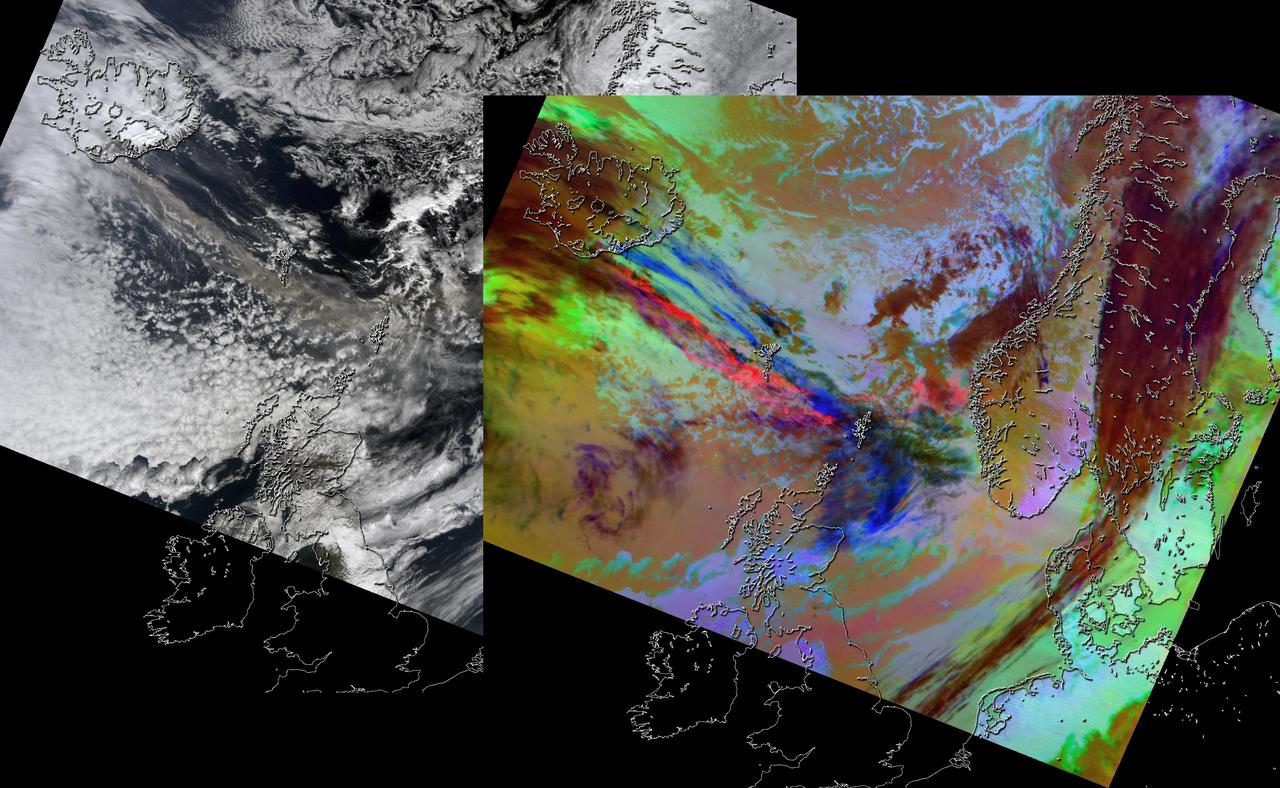
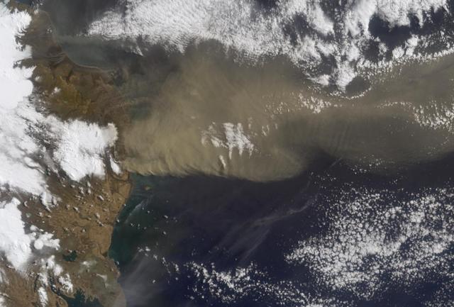
On September 16, 2013 the Moderate Resolution Imaging Spectroradiometer (MODIS) aboard NASA’s Aqua satellite passed over the southern tip of Iceland and captured a remarkable image dust plumes blowing hundreds of kilometers over the Atlantic Ocean. The westernmost plume is dark tan in color and so thick that the blue ocean waters are obscured from view near Iceland's coast. The eastern plume appears broader, thinner and light gray in color. According to the Icelandic Met Office, near the Mýrdalsjökull and Vatnajökull ice-caps there are vast glacial outwash plains which stretch from the glacial margins to the sea. These plains, formed by melt water from glaciers, are known as sandur. Strong northerly winds frequently blow dust from the sandur plains far from the shore. This particular dust plume originates to the east of the Mýrdalsjökull ice cap. The Katla volcano, one of the largest in Iceland, lies under the Mýrdalsjökull glacier and in the general region of the westernmost plume. Katla has a history of large, violent eruptions occurring on an average of every 50-100 years. The volcano has been increasingly restless since 1999, with increased seismicity in recent years. In 2011 a very small eruption was reported, with minimal damage. Because of the increasing restlessness and the dangerous nature of historic eruptions, the volcano is currently carefully monitored. None of the monitoring agencies reported eruption at Katla in mid-September of this year. Credit: NASA/GSFC/Jeff Schmaltz/MODIS Land Rapid Response Team <b><a href="http://www.nasa.gov/audience/formedia/features/MP_Photo_Guidelines.html" rel="nofollow">NASA image use policy.</a></b> <b><a href="http://www.nasa.gov/centers/goddard/home/index.html" rel="nofollow">NASA Goddard Space Flight Center</a></b> enables NASA’s mission through four scientific endeavors: Earth Science, Heliophysics, Solar System Exploration, and Astrophysics. Goddard plays a leading role in NASA’s accomplishments by contributing compelling scientific knowledge to advance the Agency’s mission. <b>Follow us on <a href="http://twitter.com/NASA_GoddardPix" rel="nofollow">Twitter</a></b> <b>Like us on <a href="http://www.facebook.com/pages/Greenbelt-MD/NASA-Goddard/395013845897?ref=tsd" rel="nofollow">Facebook</a></b> <b>Find us on <a href="http://instagram.com/nasagoddard?vm=grid" rel="nofollow">Instagram</a></b>
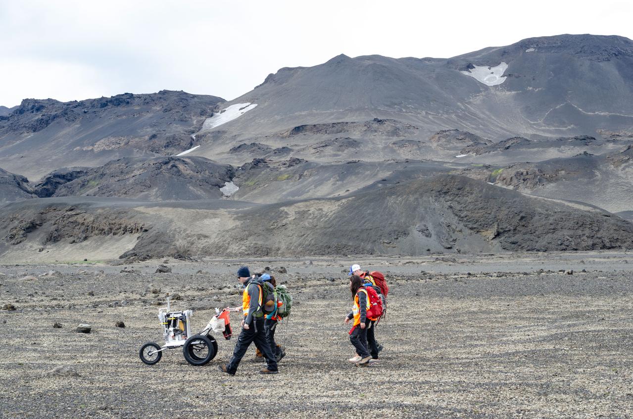
jsc2023e041422 --- Artemis II science trainers push a lunar tool cart across the lunar-like landscape of Iceland during an Artemis II crew geology field training.
The Artemis II crew, NASA astronauts Reid Wiseman, Victor Glover, Christina Koch, and Canadian Space Agency (CSA) astronaut Jeremy Hansen, and backup crew members NASA astronaut Andre Douglas and CSA astronaut Jenni Gibbons trek across the Icelandic landscape during their field geology training. Credits: NASA/Robert Markowitz
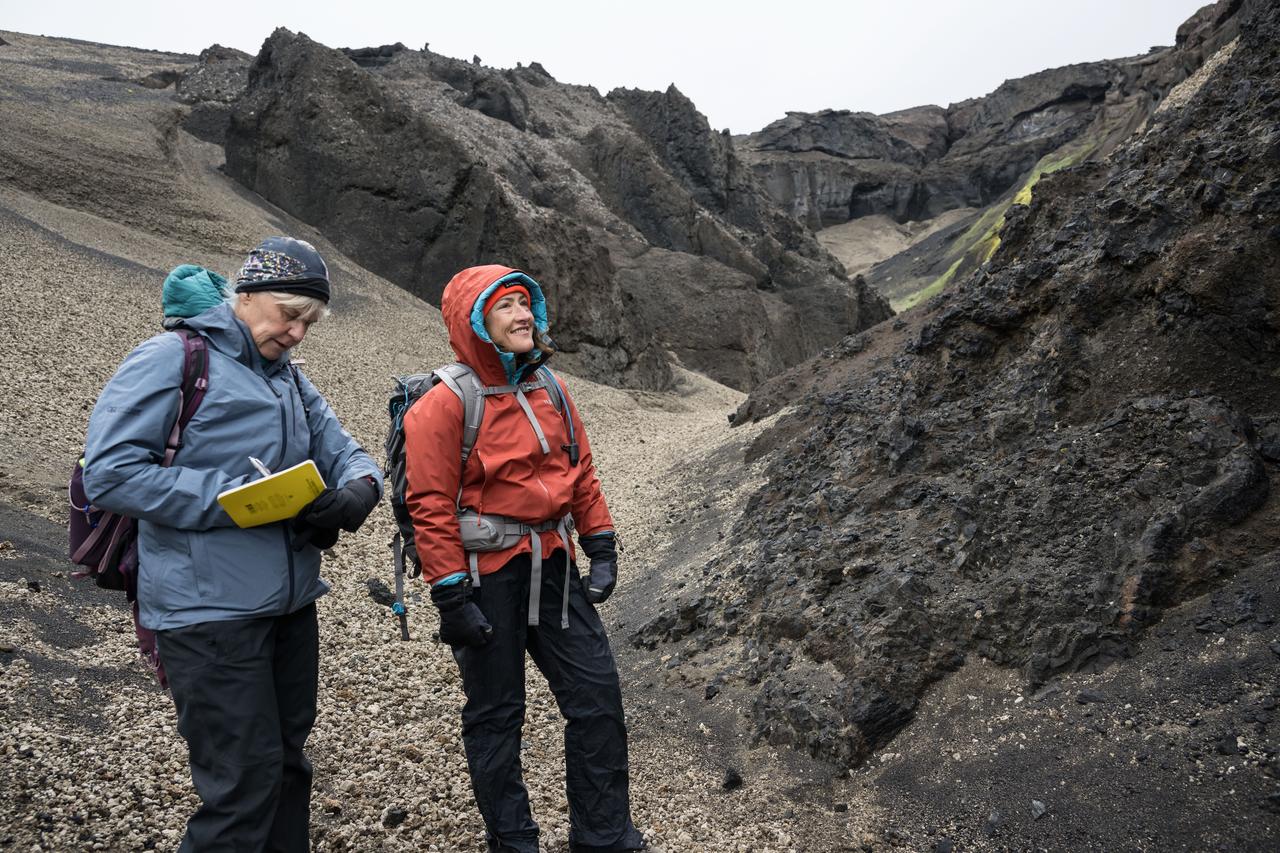
Artemis geology training lead at NASA's Johnson Space Center in Houston, Cindy Evans (left) and NASA astronaut and Artemis II mission specialist Christina Koch study geologic features in Iceland during Artemis II crew geology training in August 2024.

NASA satellite image acquired May 6, 2010 at 11 :55 UTC To view the full view go to: <a href="http://www.nasa.gov/topics/earth/features/iceland-volcano-plume.html" rel="nofollow">www.nasa.gov/topics/earth/features/iceland-volcano-plume....</a> NASA Satellite Sees a Darker Ash Plume From Iceland Volcano NASA's Terra satellite flew over the Eyjafjallajokull Volcano, Iceland, on May 6 at 11:55 UTC (7:55 a.m. EDT). The Moderate Resolution Imaging Spectroradiometer instrument known as MODIS that flies onboard Terra, captured a visible image of the ash plume. The plume was blowing east then southeast over the Northern Atlantic. The satellite image shows that the plume is at a lower level in the atmosphere than the clouds that lie to its east, as the brown plume appears to slide underneath the white clouds. Satellite: Terra NASA/GSFC/Jeff Schmaltz/MODIS Land Rapid Response Team To learn more about MODIS go to: <a href="http://rapidfire.sci.gsfc.nasa.gov/gallery/?latest" rel="nofollow">rapidfire.sci.gsfc.nasa.gov/gallery/?latest</a> <b><a href="http://www.nasa.gov/centers/goddard/home/index.html" rel="nofollow">NASA Goddard Space Flight Center</a></b> is home to the nation's largest organization of combined scientists, engineers and technologists that build spacecraft, instruments and new technology to study the Earth, the sun, our solar system, and the universe.

NASA Image acquired March 24, 2010 To learn more and to download a high res version of this image go here: <a href="http://earthobservatory.nasa.gov/IOTD/view.php?id=43252" rel="nofollow">earthobservatory.nasa.gov/IOTD/view.php?id=43252</a> Iceland’s Eyjafjallajökull Volcano burst into life for the first time in 190 years on March 20, 2010. A 500-meter- (2,000-foot) long fissure opened in the Fimmvörduháls pass to the west of the ice-covered summit of Eyjafjallajökull. Lava fountains erupted fluid magma, which quickly built several hills of bubble-filled lava rocks (scoria) along the vent. A lava flow spread northeast, spilling into Hrunagil Gully. This natural-color satellite image shows lava fountains, lava flows, a volcanic plume, and steam from vaporized snow. The image was acquired on March 24, 2010, by the Advanced Land Imager (ALI) aboard NASA’s Earth Observing-1 (EO-1) satellite. The lava fountains are orange-red, barely visible at the 10-meter (33-foot) resolution of the satellite. The scoria cones surrounding the fissure are black, as is the lava flow extending to the northeast. White volcanic gases escape from the vent and erupting lava, while a steam plume rises where the hot lava meets snow. (The bright green color along the edge of the lava flow is an artifact of the sensor.) The eruption of Eyjafjallajökull was presaged by a series of earthquakes starting in early March. Over time, the earthquakes rose towards the surface, and land near the volcano rose at least 40 millimeters (2 inches)—both indications that magma was moving underneath the volcano. The eruption continued through at least March 26th, and may continue for several more months. Previous eruptions in the area have caused flooding due to the melting of glacial ice (a Jökulhlaup), but the current eruption is in an area covered by winter snow, not permanent ice. Although some past eruptions of Eyjafjallajökull were followed by larger, explosive eruptions at nearby Katla Volcano, there is currently no sign of activity at Katla. NASA image by Robert Simmon, using ALI data from the EO-1 team. Caption by Robert Simmon. Instrument: EO-1 - ALI <b><a href="http://www.nasa.gov/centers/goddard/home/index.html" rel="nofollow">NASA Goddard Space Flight Center</a></b> is home to the nation's largest organization of combined scientists, engineers and technologists that build spacecraft, instruments and new technology to study the Earth, the sun, our solar system, and the universe.
NASA Terra spacecraft captured this pair of images of Iceland Eyjafyallajökull volcano on May 3, 2010. On this day, Ireland closed its airspace for several hours due to presence of ash over the country.
The March 16 volcanic eruption in Iceland's Reykjanes Peninsula was the fourth in many months. On March 22, ASTER's thermal infrared scanner detected the hot lava flow, through a thick cloud cover. The image matched the most recent official map, released March 20. The image covers an area of 7.5 by 10 km, and is located at 63.9 degrees north, 22.3 degrees west. https://photojournal.jpl.nasa.gov/catalog/PIA26288
Volcanic activity resumed near the town of Grindavik, Iceland on January 14. A fissure eruption began several kilometers southwest of the 2023 fissure eruptions. This time, several houses were engulfed by lava. When this nighttime thermal image was captured by ASTER on January 24, the eruption had stopped. The background image is an earlier ASTER daytime scene acquired on August 15, 2022. The images cover an area of 17.8 by 30.2 km, and are located at 63.9 degrees north, 22 degrees west. https://photojournal.jpl.nasa.gov/catalog/PIA26283
NASA satellite image acquired May 2, 2010 To view a detail of this image go to: <a href="http://www.flickr.com/photos/gsfc/4584266734/">www.flickr.com/photos/gsfc/4584266734/</a> Ash and steam continued billowing from Eyjafjallajökull Volcano in early May 2010. The Advanced Land Imager (ALI) on NASA’s Earth Observing-1 (EO-1) satellite captured this natural-color image on May 2, 2010. The volcano’s summit is near the left edge of this image, capped by a dark plume. The plume is dull gray-brown, indicating that its principal visible component is volcanic ash. Ash from the plume blows toward the east-southeast, passing over a charcoal-colored ash field on the land surface. Just to the north of Eyjafjallajökull’s summit are white puffs of steam, likely from surface lava flows vaporizing snow and glacial ice. On May 4, 2010, the Icelandic Meteorological Office warned that Eyjafjallajökull showed no signs of ending its eruptive activity in the near future. The Met Office reported that ash from the volcano had reached a height of 5.8 to 6.0 kilometers (19,000 to 20,000 feet) above sea level, and had spread 65 to 80 kilometers (40 to 50 miles) east-southeast of the volcano, where it impeded visibility for local residents. The Met Office also reported that lava continued flowing down a steep hill north of the crater. NASA image by Robert Simmon, using ALI data from the EO-1 team. Caption by Michon Scott. Instrument: EO-1 – ALI To view other images from the Earth Observatory go to: <a href="http://earthobservatory.nasa.gov/" rel="nofollow">earthobservatory.nasa.gov/</a> <b><a href="http://www.nasa.gov/centers/goddard/home/index.html" rel="nofollow">NASA Goddard Space Flight Center</a></b> is home to the nation's largest organization of combined scientists, engineers and technologists that build spacecraft, instruments and new technology to study the Earth, the sun, our solar system, and the universe.
NASA image acquired May 8, 2010 at 13 :35 UTC Ash plume from Eyjafjallajokull Volcano, Iceland Satellite: Aqua NASA/GSFC/Jeff Schmaltz/MODIS Land Rapid Response Team <b><a href="http://www.nasa.gov/centers/goddard/home/index.html" rel="nofollow">NASA Goddard Space Flight Center</a></b> is home to the nation's largest organization of combined scientists, engineers and technologists that build spacecraft, instruments and new technology to study the Earth, the sun, our solar system, and the universe.
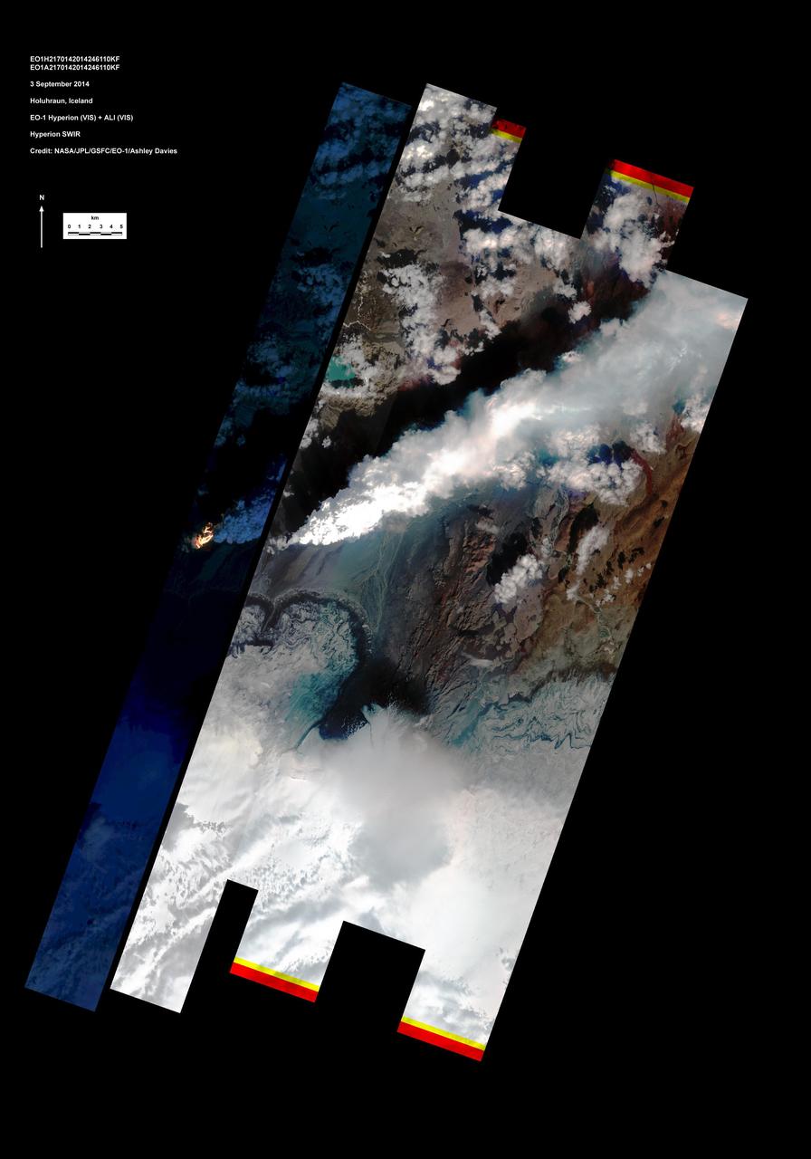
This image shows Iceland volcanic eruption monitored by NASA EO-1 spacecraft. To the south is the edge of Dyngjujökull and to the north is the volcano called Askja.
On Monday, April 19, 2010, the Advanced Spaceborne Thermal Emission and Reflection Radiometer ASTER instrument onboard NASA Terra spacecraft obtained this image of the continuing eruption of Iceland Eyjafjallajökull volcano.
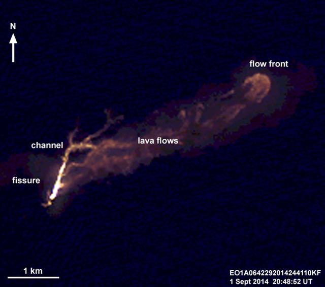
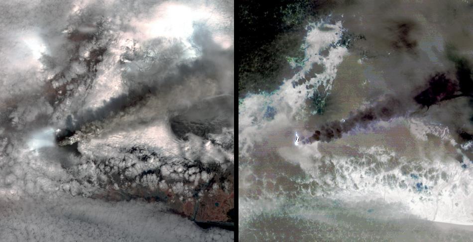
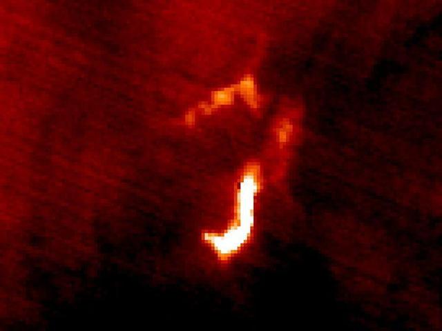
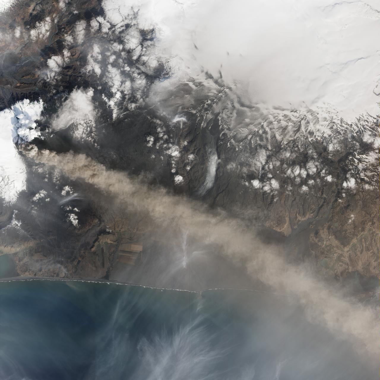
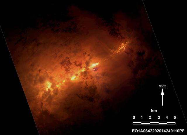
On the night of Sept. 1, 2014, NASA Earth Observing 1 EO-1 spacecraft observed the ongoing eruption at Holuhraun, Iceland. This false-color image that emphasizes the hottest areas of the vent and resulting lava flows.
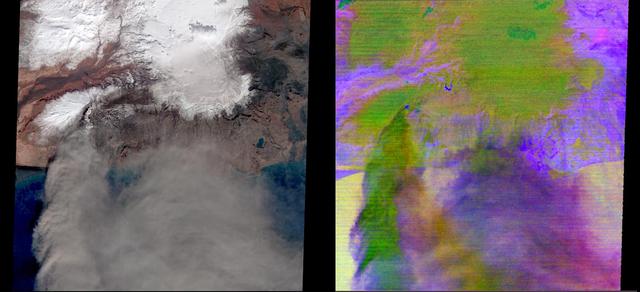
This image shows a small part of the Hofsjökull ice cap in Iceland, which encompasses several glaciers. The fan at upper left is part of a glacier called Mûlajökul.

Since the end of August 2014, Iceland Bardarbunga volcano has been pouring out lava from a growing fissure. NASA Terra spacecraft shows the flows have been accompanied by spectacular lava fountains.
On Saturday, April 17, 2010, NASA Earth Observing-1 EO-1 spacecraft obtained this pair of images of the continuing eruption of Iceland Eyjafjallajökull volcano. On the left, new black ash deposits are visible on the ground.
The eruption of the Fagradalsfjall volcano in southwest Iceland continued two weeks after it started, along a fissure spewing lava fountains and producing flows. The ASTER visible-near infrared image (left) shows the black fresh lava, and a small bright red area of incandescent lava. A thin gray eruption plume streams to the southeast. The color-coded thermal infrared image (right) highlights the hottest areas of activity in red, and then in bright shades of red. The image was acquired August 15, 2022, covers an area of 14.6 by 15.7 km, and is located at 64.2 degrees north, 21.1 degrees west. https://photojournal.jpl.nasa.gov/catalog/PIA25501
NASA image acquired May 8, 2010 at 13 :35 UTC Ash plume from Eyjafjallajokull Volcano, Iceland Satellite: Aqua NASA/GSFC/Jeff Schmaltz/MODIS Land Rapid Response Team <b><a href="http://www.nasa.gov/centers/goddard/home/index.html" rel="nofollow">NASA Goddard Space Flight Center</a></b> is home to the nation's largest organization of combined scientists, engineers and technologists that build spacecraft, instruments and new technology to study the Earth, the sun, our solar system, and the universe.
NASA satellite image acquired May 2, 2010 To see the full view of this image go to: <a href="http://www.flickr.com/photos/gsfc/4584266582/">www.flickr.com/photos/gsfc/4584266582/</a> Ash and steam continued billowing from Eyjafjallajökull Volcano in early May 2010. The Advanced Land Imager (ALI) on NASA’s Earth Observing-1 (EO-1) satellite captured this natural-color image on May 2, 2010. The volcano’s summit is near the left edge of this image, capped by a dark plume. The plume is dull gray-brown, indicating that its principal visible component is volcanic ash. Ash from the plume blows toward the east-southeast, passing over a charcoal-colored ash field on the land surface. Just to the north of Eyjafjallajökull’s summit are white puffs of steam, likely from surface lava flows vaporizing snow and glacial ice. On May 4, 2010, the Icelandic Meteorological Office warned that Eyjafjallajökull showed no signs of ending its eruptive activity in the near future. The Met Office reported that ash from the volcano had reached a height of 5.8 to 6.0 kilometers (19,000 to 20,000 feet) above sea level, and had spread 65 to 80 kilometers (40 to 50 miles) east-southeast of the volcano, where it impeded visibility for local residents. The Met Office also reported that lava continued flowing down a steep hill north of the crater. NASA image by Robert Simmon, using ALI data from the EO-1 team. Caption by Michon Scott. Instrument: EO-1 – ALI To view other images from the Earth Observatory go to: <a href="http://earthobservatory.nasa.gov/" rel="nofollow">earthobservatory.nasa.gov/</a> <b><a href="http://www.nasa.gov/centers/goddard/home/index.html" rel="nofollow">NASA Goddard Space Flight Center</a></b> is home to the nation's largest organization of combined scientists, engineers and technologists that build spacecraft, instruments and new technology to study the Earth, the sun, our solar system, and the universe.
March 31, 2010..The volcanic eruption near Eyjafjallajökull persists into its second week, with continued lava fountaining and lava flows spilling into nearby canyons. The eruption is located at the Fimmvörduháls Pass between the Eyjafjallajökull ice field to the west (left) and the Mýrdalsjökull ice field to the east (right). This natural-color satellite image was acquired on March 26, 2010, by the MODIS aboard NASA’s Terra satellite. Dark ash and scoria cover the northern half of the Fimmvörduháls Pass. White snow covers the rest of the pass, sandwiched between white glaciers. Snow-free land is tan, brown, or dark gray, devoid of vegetation in early spring. To download a high res version of this image go to: <a href="http://modis.gsfc.nasa.gov/gallery/individual.php?db_date=2010-03-31" rel="nofollow">modis.gsfc.nasa.gov/gallery/individual.php?db_date=2010-0...</a> <b><a href="http://www.nasa.gov/centers/goddard/home/index.html" rel="nofollow">NASA Goddard Space Flight Center</a></b> is home to the nation's largest organization of combined scientists, engineers and technologists that build spacecraft, instruments and new technology to study the Earth, the sun, our solar system, and the universe.
On April 15, 2010, NASA Terra spacecraft captured these images of the ongoing eruption of Iceland Eyjafjallajökull Volcano, which continues to spew ash into the atmosphere and impact air travel worldwide.
This image from NASA Terra spacecraft shows ash plumes from Eyjafjallajökull Volcano, Iceland stretching over the North Atlantic; the volcano erupted on April 14, 2010 bringing closure to major airports in Europe.
On the night of Sept. 6, 2014 NASA Earth Observing 1 EO-1 spacecraft observed the ongoing eruption at Holuhraun, Iceland. Partially covered by clouds, this scene shows the extent of the lava flows that have been erupting.
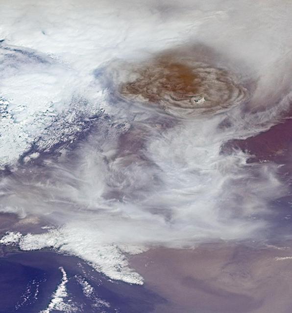
This image from NASA Terra spacecraft shows the ash plume of Iceland Eyjafyallajökull Volcano on April 19, 2010. The eruption plume and drifting veil of ash appear to be homogeneous.
The Advanced Land Imager onboard NASA Earth Observing-1 EO-1 spacecraft obtained this false-color infrared image of Iceland Eyjafjallajökull volcano on April 17, 2010. A strong thermal source is visible at the base of the Eyjafjallajökull plume.
CSA (Canadian Space Agency) astronaut and Artemis II crew member Jeremy Hansen uses a rock hammer and chisel to break a sample off a large boulder during a geology field training exercise in Iceland.
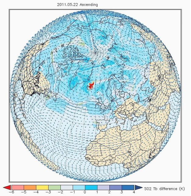
The Atmospheric Infrared Sounder AIRS on NASA Aqua satellite sees sulfur dioxide plume from Iceland Grímsvötn Volcano when it erupted May, 2011.
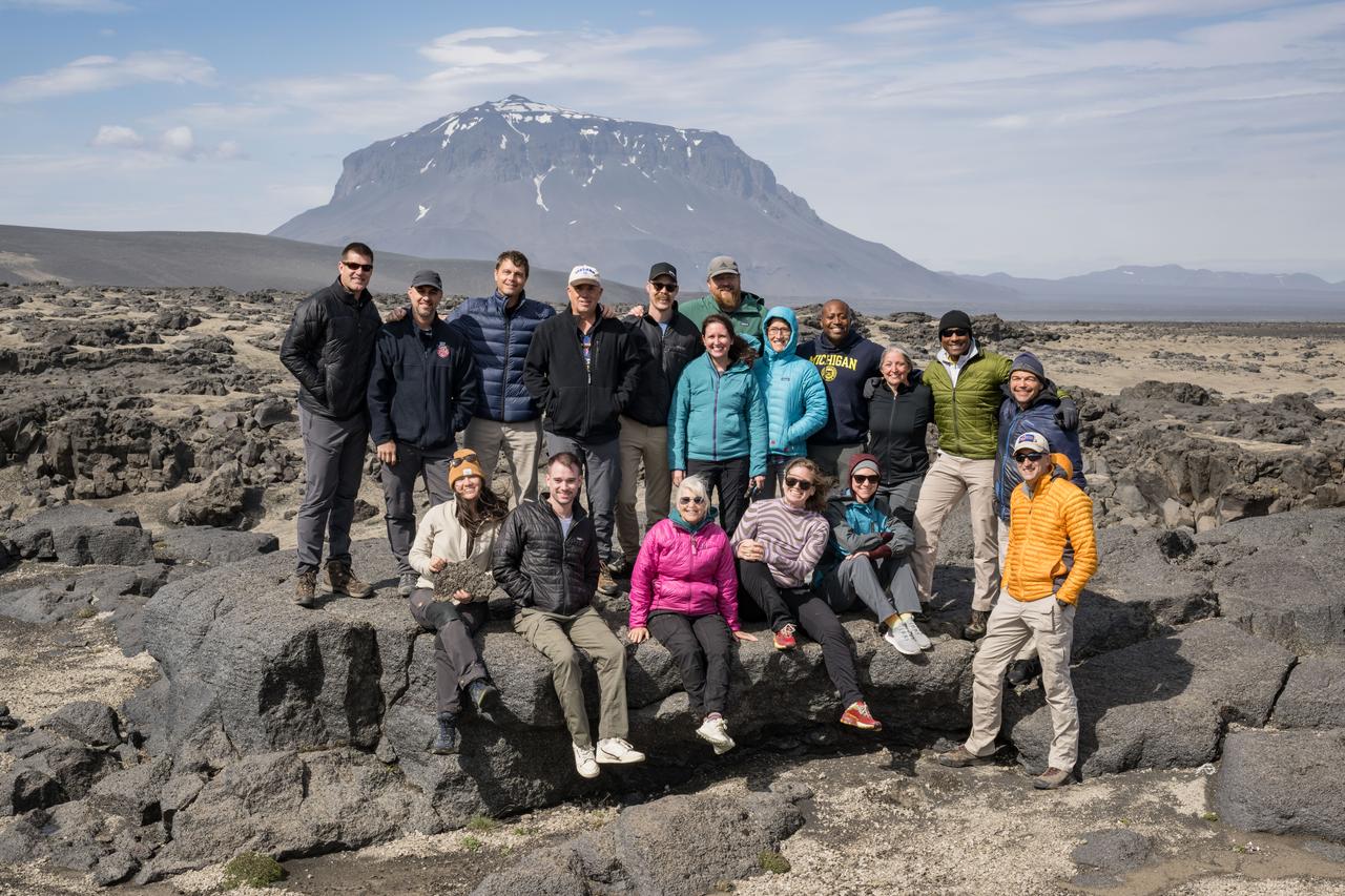
The Artemis II crew astronauts, their backups, and the geology training field team pose in a valley in Iceland’s Vatnajökull national park. From front left: Angela Garcia, Jacob Richardson, Cindy Evans, Jenni Gibbons, Jacki Mahaffey, back row from left: Jeremy Hansen, John Ramsey, Reid Wiseman, Ron Spencer, Scott Wray, Kelsey Young, Patrick Whelley, Christina Koch, Andre Douglas, Jacki Kagey, Victor Glover, Rick Rochelle (NOLS), Trevor Graff.

Members of the VERITAS science team pause for a photograph on July 31, 2023, after arriving in Iceland to begin a two-week campaign to study the volcanic island's geology to help the team prepare for NASA's VERITAS (short for Venus Emissivity, Radio science, InSAR, Topography, And Spectroscopy) mission to Venus. From July 30 to Aug. 14, 2023, the international science team, including local participation from the University of Iceland, worked to lay the groundwork for the science that will ultimately be done from Venus orbit. At center, holding the VERITAS mission identifier is the mission's principal investigator and the science team lead, Sue Smrekar, of NASA's Jet Propulsion Laboratory in Southern California. Flanking her are science team members from multiple U.S., Italian, and German institutions, including members of the German Aerospace Center (DLR) Flugzeug Synthetic Aperture Radar (F-SAR) airplane team. The DLR F-SAR team was tasked with collecting synthetic-aperture radar data of the regions studied by the field team. A key objective of the campaign is to refine change detection algorithms that will be used to look for global surface change (such as volcanic activity) between NASA's Magellan radar mission from the 1990s and VERITAS, as well as between VERITAS and the ESA (European Space Agency) EnVision mission to Venus, both of which are targeting the early 2030s for launch. NASA's VERITAS is an orbiter designed to peer through Venus' thick atmosphere with a suite of powerful instruments to create global maps of the planet's surface, including topography, radar images, rock type, and gravity, as well as detect surface changes. VERITAS is designed to understand what processes are currently active, search for evidence of past and current interior water, and understand the geologic evolution of the planet, illuminating how rocky planets throughout the galaxy evolve. VERITAS and NASA's Deep Atmosphere Venus Investigation of Noble gases, Chemistry, and Imaging (DAVINCI) mission were selected in 2021 under NASA's Discovery Program as the agency's next missions to Venus. The Discovery Program is managed by the Planetary Missions Program Office at NASA's Marshall Space Flight Center in Huntsville, Alabama, for the Planetary Science Division of NASA's Science Mission Directorate in Washington. https://photojournal.jpl.nasa.gov/catalog/PIA25835
To lay the groundwork for NASA's VERITAS mission (Venus Emissivity, Radio science, InSAR, Topography, And Spectroscopy), members of the mission's international science team traveled in August 2023 to Iceland, using the island as a stand-in, or analog, for Venus. Using several techniques, the team studied a variety of rocky terrain, including this lava field featuring new rock from a recent flow, to better understand what the VERITAS mission will "see" when it studies Venus' surface. The VERITAS orbiter will peer through the planet's thick atmosphere with a suite of powerful science instruments to create global maps of the planet's surface – including topography, radar images, rock type, and gravity measurements – as well as detect surface changes. VERITAS is designed to understand what processes are currently active, search for evidence of past and current interior water, and understand the geologic evolution of the planet, illuminating how rocky planets throughout the galaxy evolve. https://photojournal.jpl.nasa.gov/catalog/PIA25838
During their August 2023 Iceland field campaign, international science team members of NASA's VERITAS (Venus Emissivity, Radio science, InSAR, Topography, And Spectroscopy) mission prepare for lidar (Light Detection and Ranging) imaging of rocks at a study area. Lidar measurements of rocky terrain can provide information about the material, such as surface roughness. While the science team led by NASA's Jet Propulsion Laboratory gathered lidar data on the ground, their partners from the German Aerospace Center (Deutsches Zentrum für Luft- und Raumfahrt, or DLR) carried out overflights to gather radar observations of the same study areas. By doing this, the team was able to ground-truth the radar data that will be used to help inform the science that VERITAS will do at Venus. VERITAS will peer through the planet's thick atmosphere with a suite of powerful science instruments to create global maps of Venus' surface – including topography, radar images, rock type, and gravity measurements – as well as detect surface changes. VERITAS is designed to understand what processes are currently active, search for evidence of past and current interior water, and understand the geologic evolution of the planet, illuminating how rocky planets throughout the galaxy evolve. https://photojournal.jpl.nasa.gov/catalog/PIA25839
Iceland Eyjafjallajökull volcano produced its second major ash plume beginning on May 7, 2010. NASA Terra satellite passed just east of the volcano mid-morning and captured this image the same day.
Ash from Iceland Eyjafjallajökull volcano, viewed here in imagery from NASA Terra spacecraft on May 16, 2010, once again disrupted air traffic over Europe with the closure of major airports in the United Kingdom and the Netherlands.
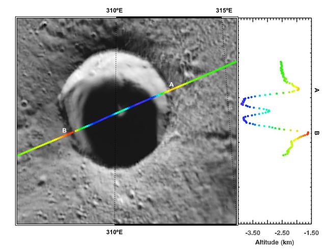
Peaking into the Shadows. This image from NASA MESSENGER spacecraft features Laxness, a crater on Mercury northern plains named for Halldör Laxness, a twentieth-century Icelandic writer.
NASA Terra satellite flew directly over Iceland on April 19, 2010 and captured this image of the Eyjafjallajökull volcano and its erupting ash plume. 3D glasses are necessary to view this image.
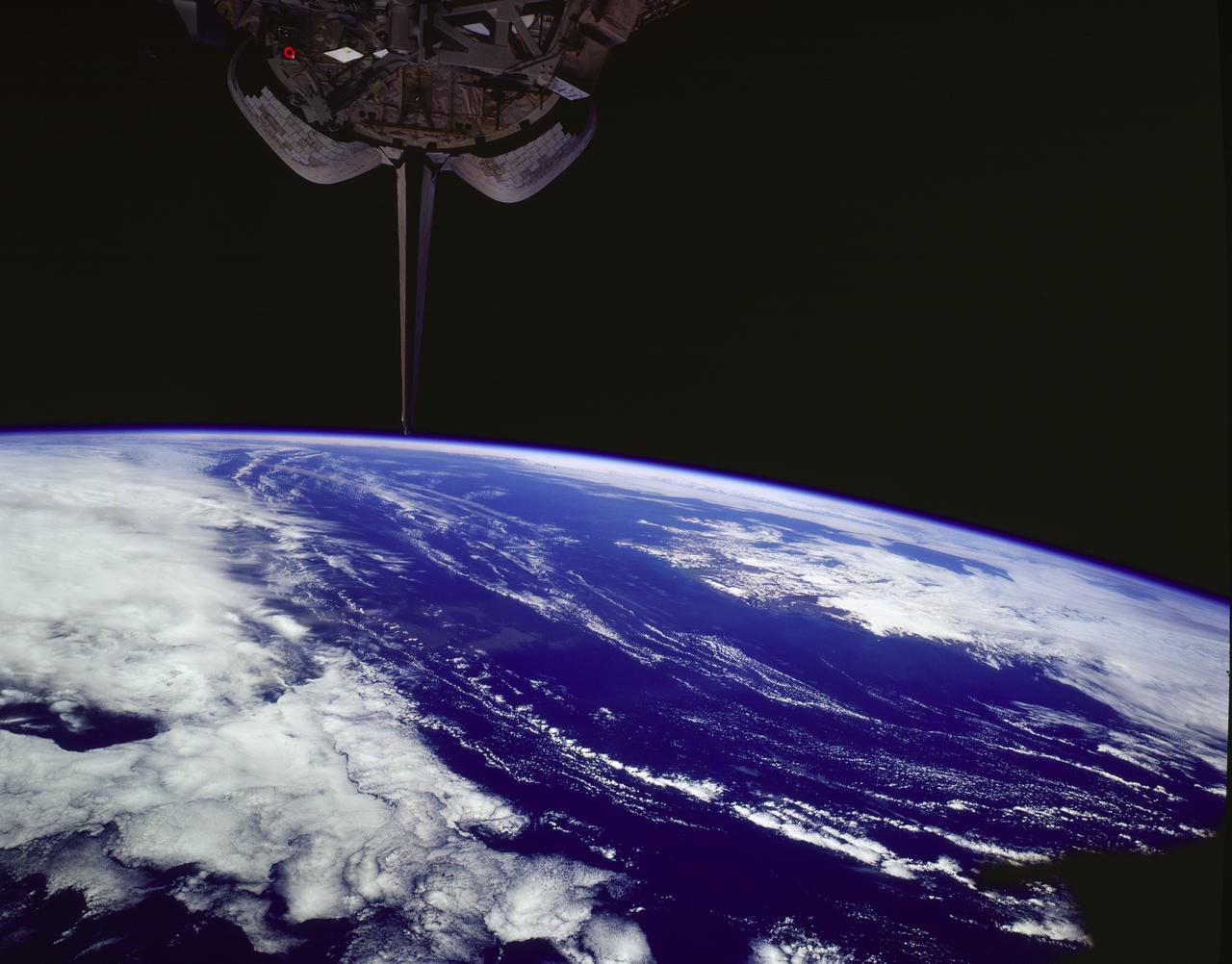
STS085-502-078 (7 - 19 August 1997) --- The southern coastline of seldom-seen Iceland can be detected under cloud, top right in this dramatic west-looking view. Iceland's capital city, Reykjavik, lies on the cape that projects furthest left (i.e. southwest) in this view. Along the southeast margin (nearest to the viewer), Iceland's largest icecap, Vatnajškull, appears as a white mass with a texture different to the spotty cumulus cloud. At the closest point, Greenland only lies 170 miles to the northwest of Iceland -- and under a hand lens, hundreds of miles of the east coast of Greenland can be seen stretching across the top of this view. Taken with the large format Linhof camera, the enormous clarity of the air on this day allowed the crew to photograph Iceland which lies 400 miles and more north of the northernmost point which the Space Shuttle Discovery attained (57.5 degrees north latitude). Greenland lies more than 700 miles from the orbiter. The nature of the light brown feature in the ocean (middle of the view under the tailfin) is unclear. Part is a reflection off the window, but part shows details characteristic of a plankton bloom.

KENNEDY SPACE CENTER, FLA. -- Kennedy Space Center Director Roy Bridges with the president of Iceland.
NASA Terra satellite flew directly over Iceland on April 19, 2010, to capture this stereo anaglyph generated from the nadir and 46-degree forward-viewing cameras of the Eyjafjallajökull volcano and its erupting ash plume. 3D glasses are necessary to vie
NASA Terra spacecraft captured this image of Grímsvötn, the most active of Iceland volcanoes, which began erupting around 5:30 p.m. local time 1730 UTC on Saturday, May 21, 2011, east of the capital city of Reykjavik.
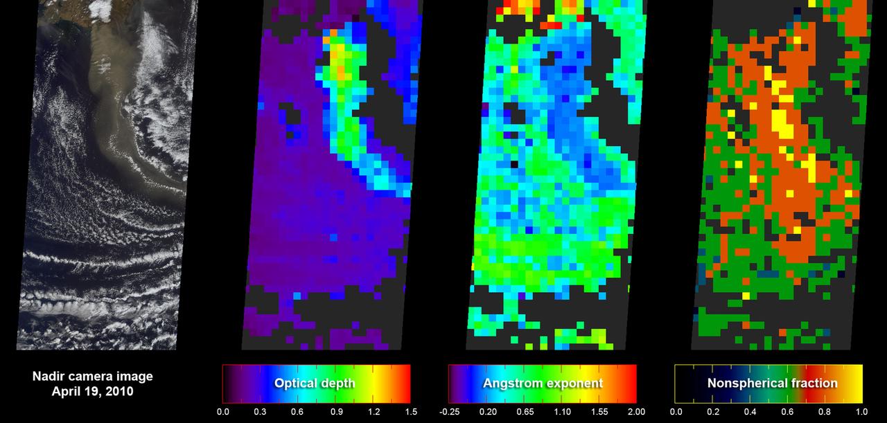
As NASA Terra satellite flew over Iceland erupting Eyjafjallajökull volcano, its Multi-angle Imaging SpectroRadiometer instrument acquired 36 near-simultaneous images of the ash plume, covering nine view angles in each of four wavelengths.
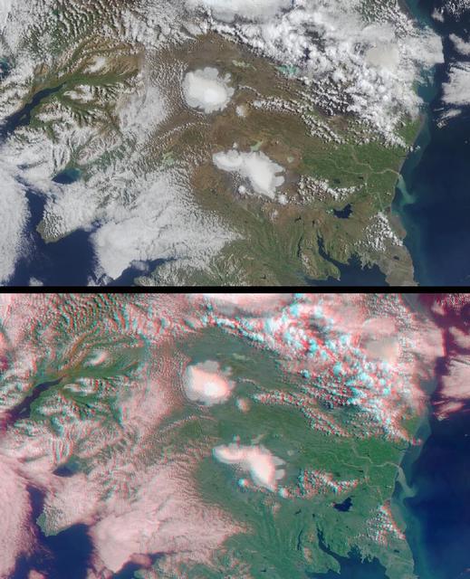
Two of Iceland larger icecaps, Langjökull located just below image center and Hofsjökull just above center can be clearly seen in this anaglyph from the MISR instrument aboard NASA Terra spacecraft. 3D glasses are necessary to view this image.
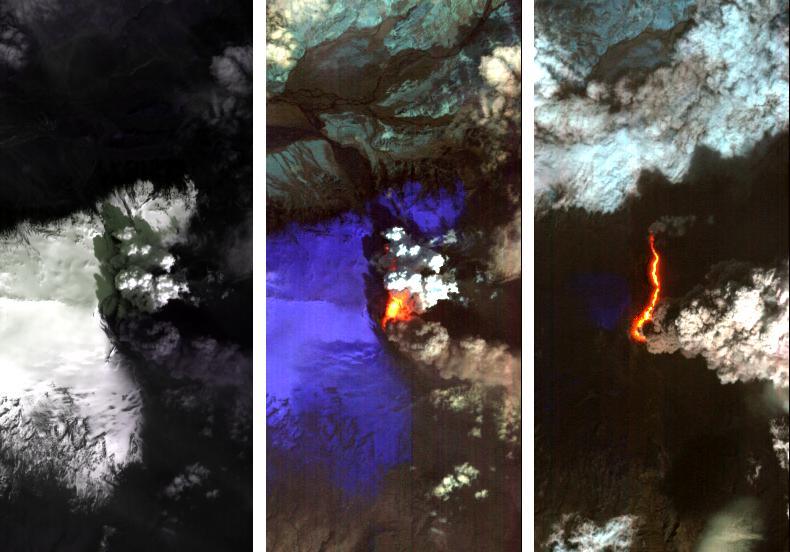
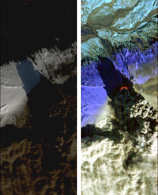
Dramatic changes have been observed at the Eyjafjallajökull volcano in Iceland by NASA's Earth Observing 1 (EO-1) spacecraft. On May 2, 2010, the Hyperion hyperspectral imager on EO-1 imaged Eyjafjallajökull and identified the extent of a lava flow extending northwards from the main eruption vent. This lava flow had been previously reported by volcanologists in Iceland, and is slowly carving its way north through the ice cap. The image on the left (Figure 1) is at visible wavelengths, and shows the persistent dark volcanic plume emanating from the main vent. This plume is still rich in ash, hence its brown coloration. This ash is still causing problems, threatening new airspace closures over parts of Europe. Large cracks at the edge of the crater are an indication of the extent of ice removal from the icecap during the eruption. To the north of this vent is another plume that is very white. This second plume is the result of ice being boiled off, generally non-explosively, by the heat from the silicate lava flow. As a result this plume is probably comprised mostly of water vapour. The black lava shows up clearly against the ice in the left-hand image. The image in the center (Figure 2) is a false-color image in the short-wavelength infrared. In this image, ice appears as blue and hot pixels appear as red. Very hot pixels appear as yellow and white. Red pixels, visible though the plume chart the extent of the lava flow, which has extended some 1.8 kilometers (1.1 miles) northwards from the area of the vent that is emitting the most energy. Total heat loss on May 2 was estimated to be at least 300 megawatts. The image on the right (Figure 3) shows the lava flow on May 4, 2010. The entire lava channel is now exposed, most of the overlying ice having been removed and the white plume has mostly disappeared. Without the plume obscuring heat loss from the lava flow, a better estimate of heat loss can be made. On May 4, the volcano was emitting at least 1,600 megawatts of energy. Each image covers an area measuring 7.7 kilometers (4.8 miles) wide, and has a resolution of 30 meters (98 feet) per pixel. The vertical direction is north-northeast. http://photojournal.jpl.nasa.gov/catalog/PIA13098
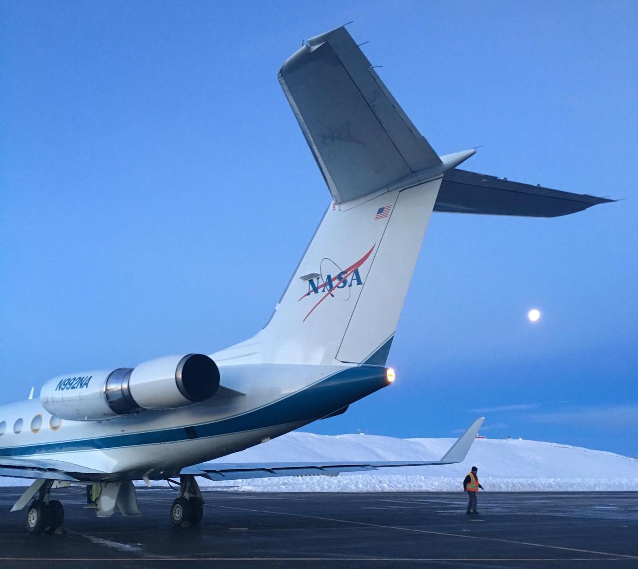
NASA's Gulfstream III was one of several research aircraft that NASA's Oceans Melting Greenland mission used during its six-year field campaign to record the temperature, salinity, and depth of the ocean around the entire island. OMG used airports in Greenland, Iceland, and Norway as bases for research flights. This image was taken at Thule Air Base, Greenland, on Sept. 18, 2016. https://photojournal.jpl.nasa.gov/catalog/PIA24984

jsc2024e040808 --- Artemis II crew members, from left, NASA astronauts Christina Koch and Victor Glover, CSA (Canadian Space Agency) astronauts Jeremy Hansen and Jenni Gibbons, study rocks during classroom preparation ahead of their fieldwork training in Iceland.
Airborne Arctic Stratospheric (Ozone) Expedition Stavanger Norway Jan-Feb 1989: The clouds seen from the NASA DC-8 aircraft at nearly 39,000 feet in the polar regions north of Stravanger, Norway, are representative of what are called 'Type II' polar stratospheric clouds. This type consists mostly of water molecules frozen as ice. These particular clouds are also exhibiting what is called orographic effects - the clouds have taken on a wave-like form because of motion associated with underlying topographic features of the earth's surface; in this case, some mountains in Iceland.

STS-85 Payload Specialist Bjarni V. Tryggvason gives a thumbs up as he is assisted with his ascent/reentry flight suit in the Operations and Checkout (O&C) Building. He is a Canadian Space Agency astronaut and was born in Iceland. Tryggvason has also been a flight instructor for the Canadian Air Force. Tryggvason is the principal investigator of the Microgravity Vibration Isolation Mount now flying on the Russian Mir space station. During STS-85, Tryggvason will conduct vibration isolation mount and fluid physics investigations. His work to study how Shuttle vibrations affect the results of experiments will be valuable to the International Space Station program, since this experiment is planned for use on that space platform. Tryggvason will also conduct Bioreactor experiments and assist Mission Specialist Stephen K. Robinson with photography
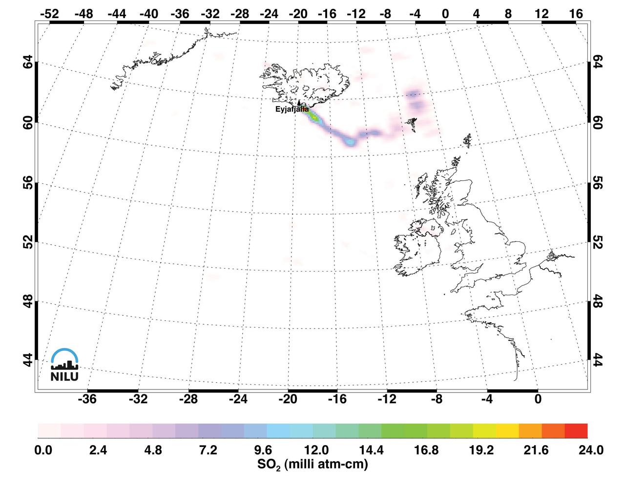
Images made with data from the Atmospheric Infrared Sounder on NASA Aqua satellite, show sulfur dioxide released from the volcanic eruption of Eyjafjallajökull.
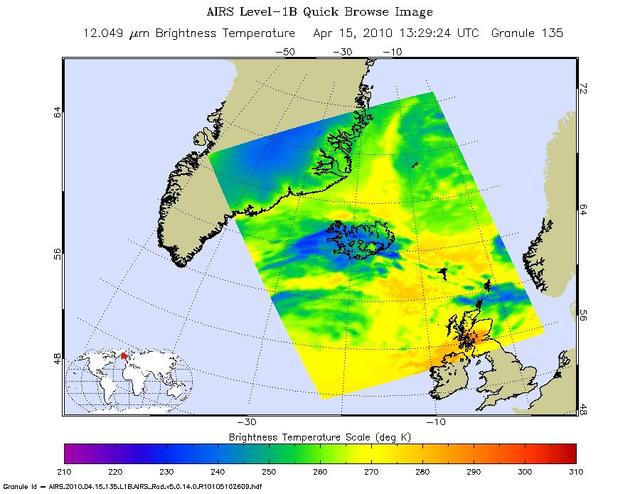
NASA Aqua satellite flew over the volcano on April 15, capturing this image of the ash plume. The image shows the ash cloud being carried over the Shetland Islands and onward to Europe.
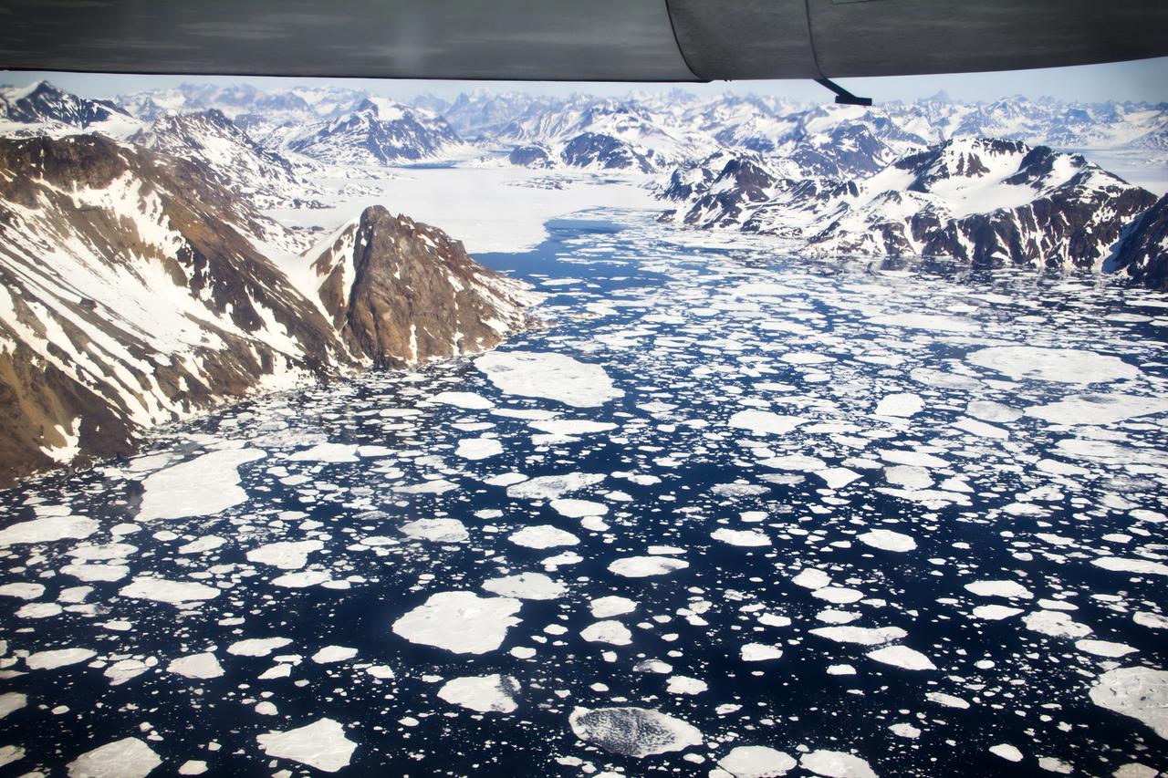
GPM "Let it Snow" Photo Contest Winners The Global Precipitation Measurement mission is happy to announce the top ten winners of the "Let It Snow" photo competition. Thank you to everyone who submitted their best pictures of winter. From January 7th through February 4th 2013, over 1,000 photos were submitted via Flickr and Instagram (see the Flickr submissions here: <a href="http://bit.ly/VVEubh" rel="nofollow">bit.ly/VVEubh</a>). We loved all of your entries and thoroughly appreciate your participation. About this image: Kulusuk Icebergs, by Andrew Bossi Location: On approach to the airstrip at Kulusuk, Greenland, located on the east coast. The flight departed out of Reykjavík, Iceland. How this Photo Was Taken: "My write-up of the day covers things in decent detail. Basically my vacation was focused on Scandinavia and hadn't even considered Greenland, but while traveling around Iceland I'd become aware that day trips were offered and I leapt at the opportunity. This approach was my first sight of Greenland. While I've seen plenty of glaciers and mountains, I'd never seen anything like this - it started with endless fields of ice amid the deep blue sea, and some minutes later a wall of frozen rock rose up from the horizon. I'd never seen anything so beautiful. I think my camera's shutter was snapping almost endlessly right up until we landed. The landing itself was an experience, as our tiny plane descended between the mountains -- rockfaces just outside each window -- and set down on a gravel runway." About Photographer Steven Sandner: More info about this photo: <a href="http://intentionallylost.blogspot.com/2011/06/gl-kulusuk.htm" rel="nofollow">intentionallylost.blogspot.com/2011/06/gl-kulusuk.htm</a> <a href="http://www.flickr.com/photos/thisisbossi/">www.flickr.com/photos/thisisbossi/</a> <a href="http://twitter.com/thisisbossi" rel="nofollow">twitter.com/thisisbossi</a> <b><a href="http://www.nasa.gov/audience/formedia/features/MP_Photo_Guidelines.html" rel="nofollow">NASA image use policy.</a></b> <b><a href="http://www.nasa.gov/centers/goddard/home/index.html" rel="nofollow">NASA Goddard Space Flight Center</a></b> enables NASA’s mission through four scientific endeavors: Earth Science, Heliophysics, Solar System Exploration, and Astrophysics. Goddard plays a leading role in NASA’s accomplishments by contributing compelling scientific knowledge to advance the Agency’s mission. <b>Follow us on <a href="http://twitter.com/NASA_GoddardPix" rel="nofollow">Twitter</a></b> <b>Like us on <a href="http://www.facebook.com/pages/Greenbelt-MD/NASA-Goddard/395013845897?ref=tsd" rel="nofollow">Facebook</a></b> <b>Find us on <a href="http://instagram.com/nasagoddard?vm=grid" rel="nofollow">Instagram</a></b>
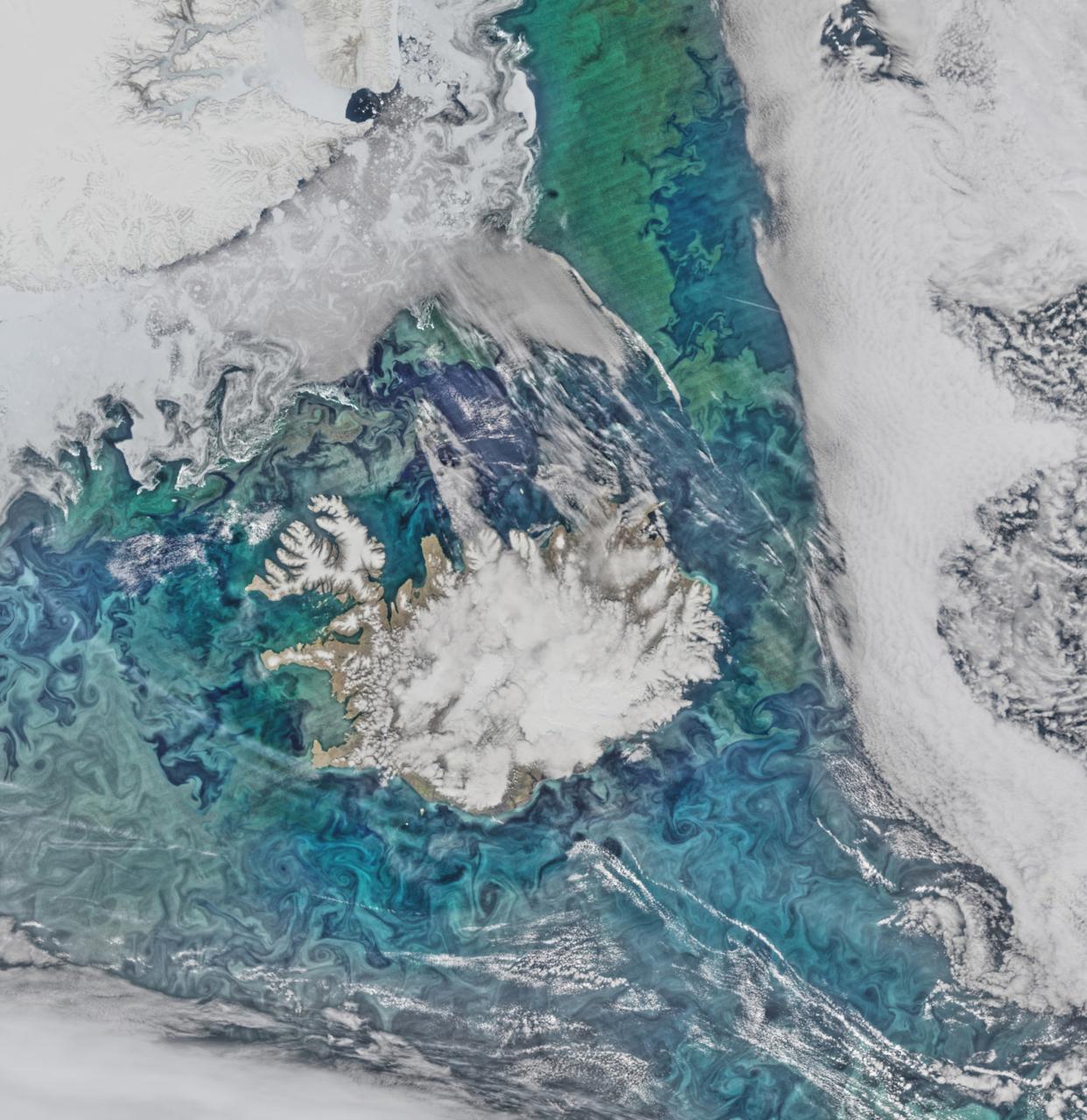
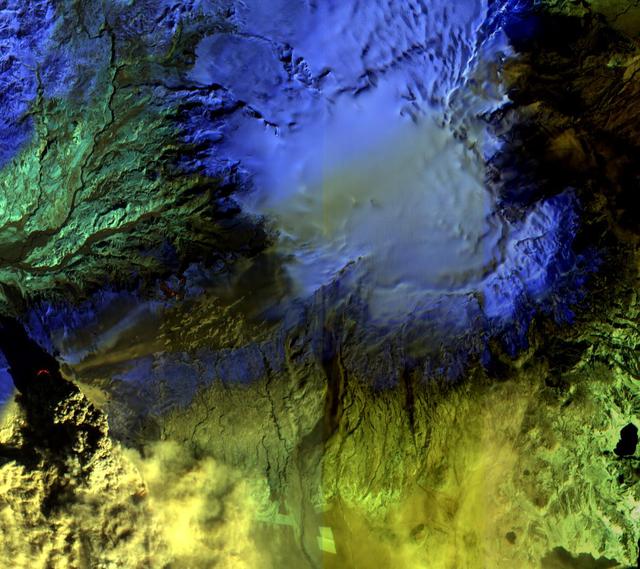
Phytoplankton communities and sea ice limn the turbulent flow field around Iceland in this Suomi-NPP/VIIRS scene collected on June 14, 2015. Credit: NASA/Goddard/Suomi NPP/VIIRS <b><a href="http://www.nasa.gov/audience/formedia/features/MP_Photo_Guidelines.html" rel="nofollow">NASA image use policy.</a></b> <b><a href="http://www.nasa.gov/centers/goddard/home/index.html" rel="nofollow">NASA Goddard Space Flight Center</a></b> enables NASA’s mission through four scientific endeavors: Earth Science, Heliophysics, Solar System Exploration, and Astrophysics. Goddard plays a leading role in NASA’s accomplishments by contributing compelling scientific knowledge to advance the Agency’s mission. <b>Follow us on <a href="http://twitter.com/NASAGoddardPix" rel="nofollow">Twitter</a></b> <b>Like us on <a href="http://www.facebook.com/pages/Greenbelt-MD/NASA-Goddard/395013845897?ref=tsd" rel="nofollow">Facebook</a></b> <b>Find us on <a href="http://instagrid.me/nasagoddard/?vm=grid" rel="nofollow">Instagram</a></b>
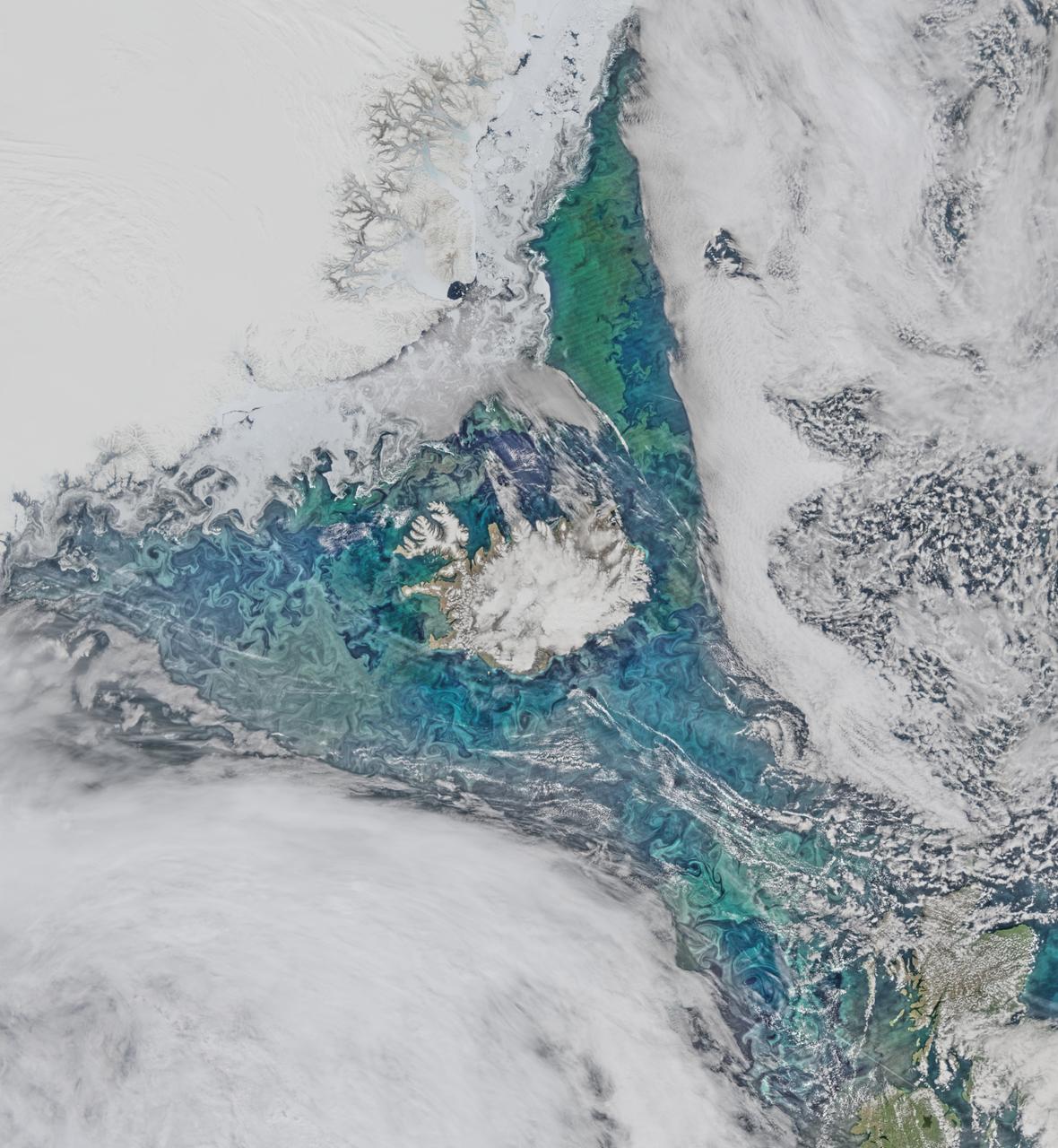
Phytoplankton communities and sea ice limn the turbulent flow field around Iceland in this Suomi-NPP/VIIRS scene collected on June 14, 2015. Credit: NASA/Goddard/Suomi NPP/VIIRS <b><a href="http://www.nasa.gov/audience/formedia/features/MP_Photo_Guidelines.html" rel="nofollow">NASA image use policy.</a></b> <b><a href="http://www.nasa.gov/centers/goddard/home/index.html" rel="nofollow">NASA Goddard Space Flight Center</a></b> enables NASA’s mission through four scientific endeavors: Earth Science, Heliophysics, Solar System Exploration, and Astrophysics. Goddard plays a leading role in NASA’s accomplishments by contributing compelling scientific knowledge to advance the Agency’s mission. <b>Follow us on <a href="http://twitter.com/NASAGoddardPix" rel="nofollow">Twitter</a></b> <b>Like us on <a href="http://www.facebook.com/pages/Greenbelt-MD/NASA-Goddard/395013845897?ref=tsd" rel="nofollow">Facebook</a></b> <b>Find us on <a href="http://instagrid.me/nasagoddard/?vm=grid" rel="nofollow">Instagram</a></b>