Ida and Gaspra http://photojournal.jpl.nasa.gov/catalog/PIA00332
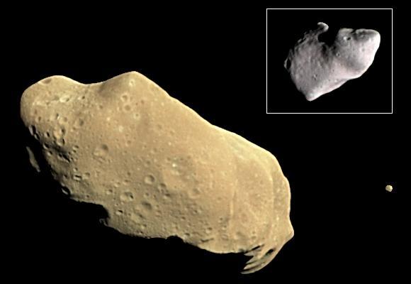
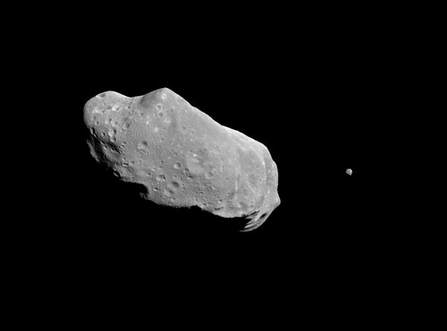
During its examination of the asteroid Ida, NASA Galileo spacecraft returned images of a second object, Dactyl--the first confirmed satellite or moon of an asteroid; the much smaller moon is visible to the right of Ida. http://photojournal.jpl.nasa.gov/catalog/PIA00333
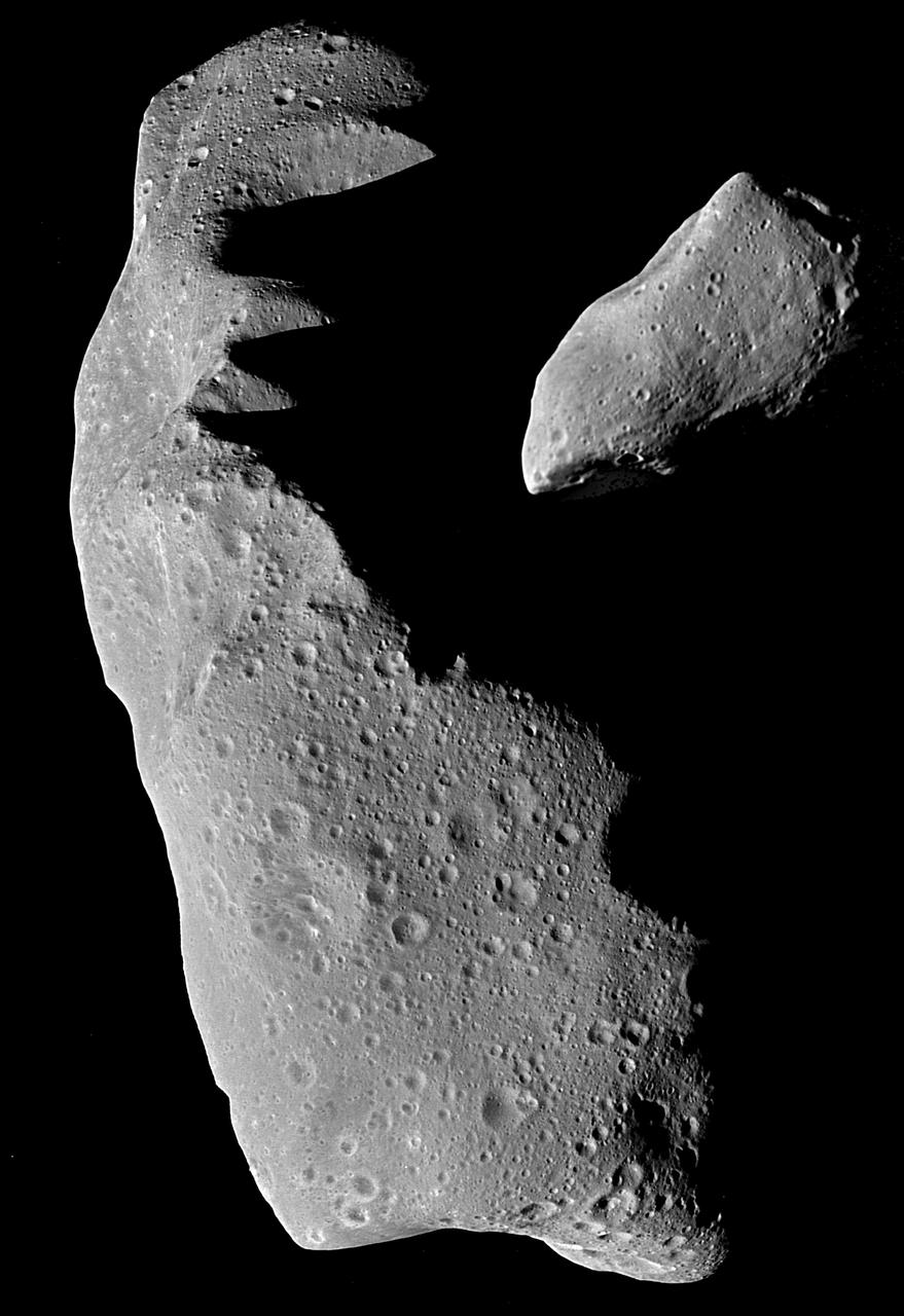
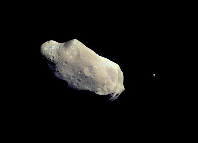
This is the first full picture showing both asteroid 243 Ida and its newly discovered moon to be transmitted to Earth from the National Aeronautics and Space Administration's (NASA's) Galileo spacecraft--the first conclusive evidence that natural satellites of asteroids exist. Ida, the large object, is about 56 kilometers (35 miles) long. Ida's natural satellite is the small object to the right. This portrait was taken by Galileo's charge-coupled device (CCD) camera on August 28, 1993, about 14 minutes before the Jupiter-bound spacecraft's closest approach to the asteroid, from a range of 10,870 kilometers (6,755 miles). Ida is a heavily cratered, irregularly shaped asteroid in the main asteroid belt between Mars and Jupiter -- the 243rd asteroid to be discovered since the first was found at the beginning of the 19th century. Ida is a member of a group of asteroids called the Koronis family. The small satellite, which is about 1.5 kilometers (1 mile) across in this view, has yet to be given a name by astronomers. It has been provisionally designated '1993 (243) 1' by the International Astronomical Union. ('1993' denotes the year the picture was taken, '243' the asteroid number and '1' the fact that it is the first moon of Ida to be found.) Although appearing to be 'next' to Ida, the satellite is actually in the foreground, slightly closer to the spacecraft than Ida is. Combining this image with data from Galileo's near-infrared mapping spectrometer, the science team estimates that the satellite is about 100 kilometers (60 miles) away from the center of Ida. This image, which was taken through a green filter, is one of a six-frame series using different color filters. The spatial resolution in this image is about 100 meters (330 feet) per pixel. http://photojournal.jpl.nasa.gov/catalog/PIA00136

Nine Galileo Views in Exaggerated Color of Main-Belt Asteroid Ida http://photojournal.jpl.nasa.gov/catalog/PIA00331

Nine Galileo Views in Natural Color of Main-Belt Asteroid Ida http://photojournal.jpl.nasa.gov/catalog/PIA00330
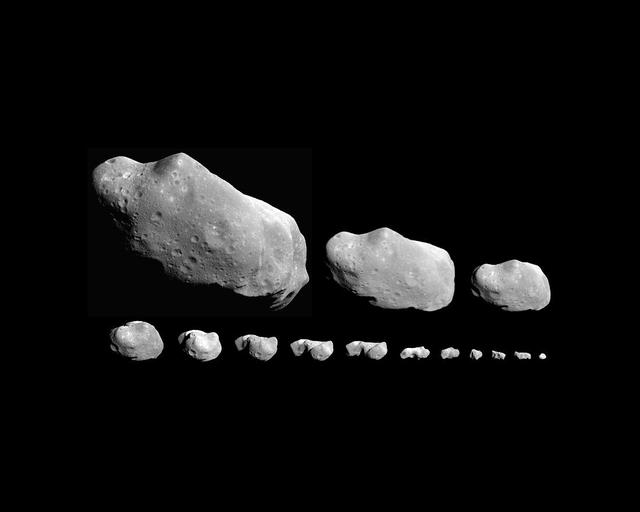
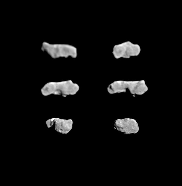
This montage of 14 images the time order is right to left, bottom to top shows asterpod Ida as it appeared in the field of view of NASA Galileo camera on August 28, 1993. http://photojournal.jpl.nasa.gov/catalog/PIA00070
This color picture is made from images taken by the imaging system on NASA Galileo spacecraft about 14 minutes before its closest approach to asteroid 243 Ida on August 28, 1993. http://photojournal.jpl.nasa.gov/catalog/PIA00069
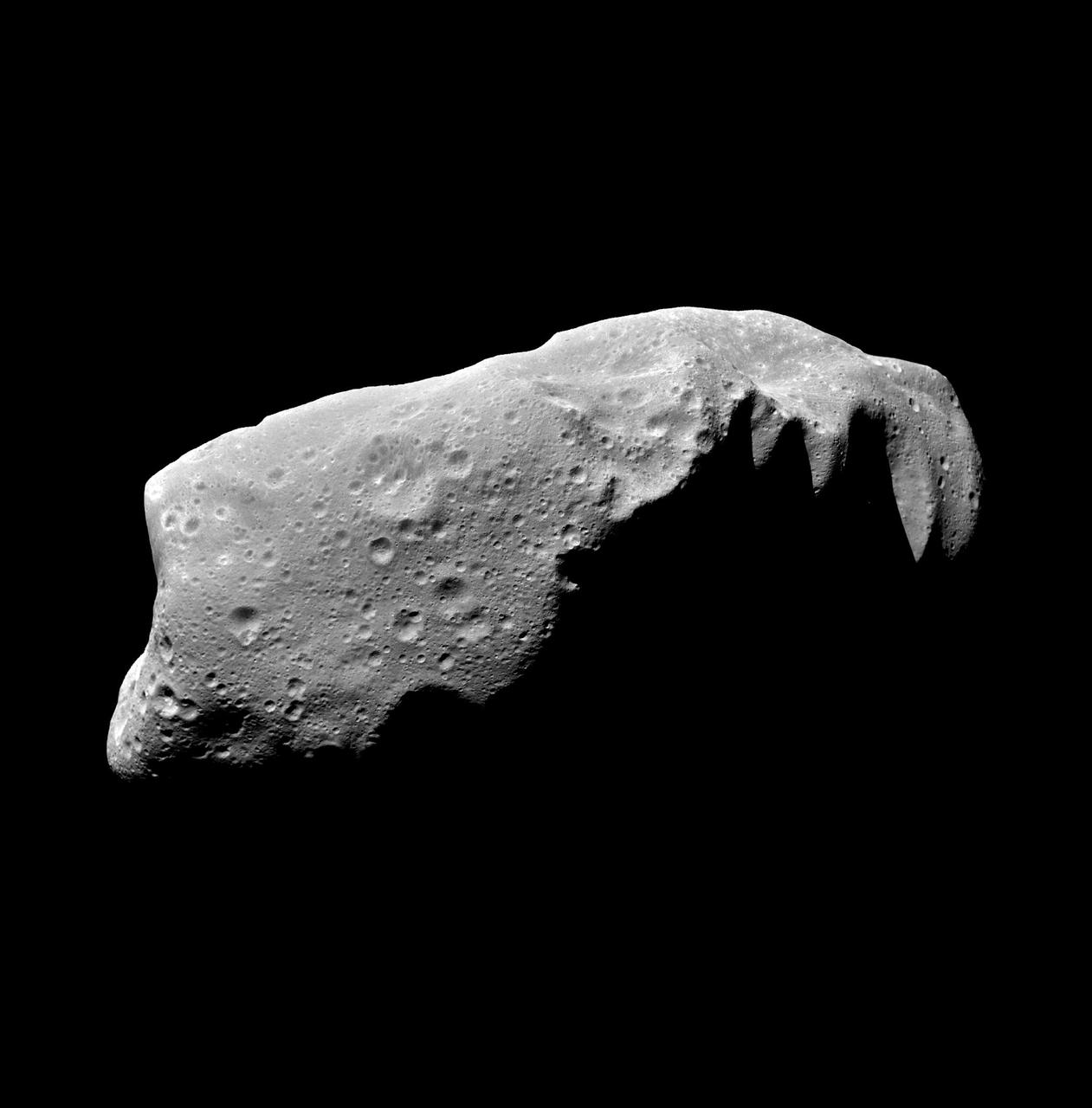
This composite image shows the asteroid 243 Ida as seen from NASA's Galileo spacecraft during its approach on August 28, 1993. http://photojournal.jpl.nasa.gov/catalog/PIA00137
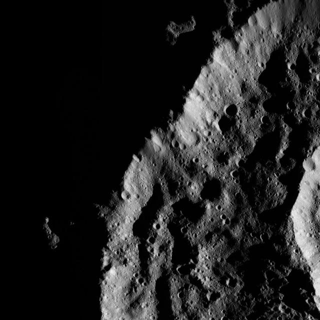
This view of the asteroid 243 Ida is a mosaic of five image frames acquired by NASA's Galileo spacecraft solid-state imaging system at ranges of 3,057 to 3,821 kilometers 1,900 to 2,375 miles on August 28, 1993. http://photojournal.jpl.nasa.gov/catalog/PIA00135
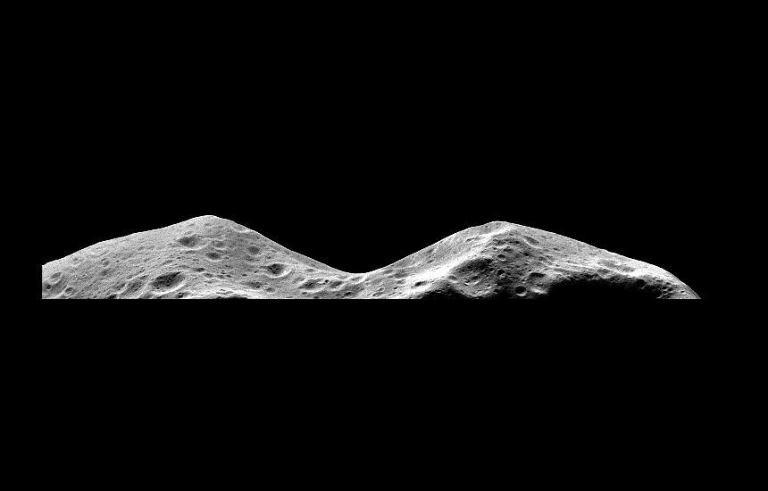
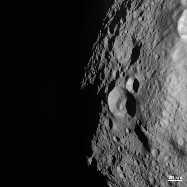
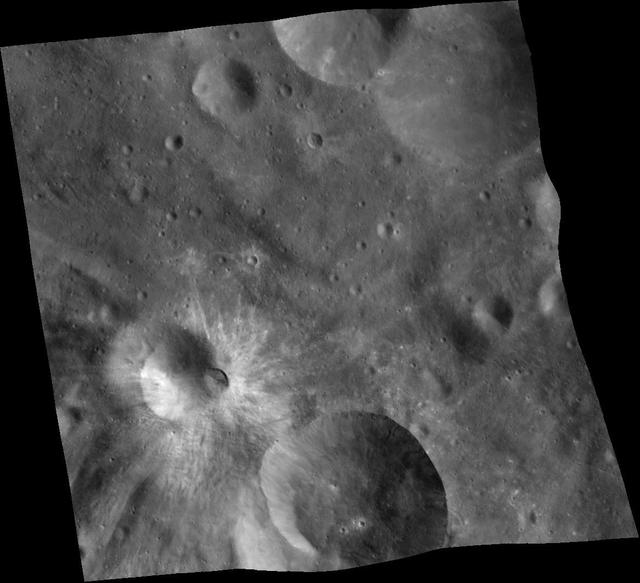
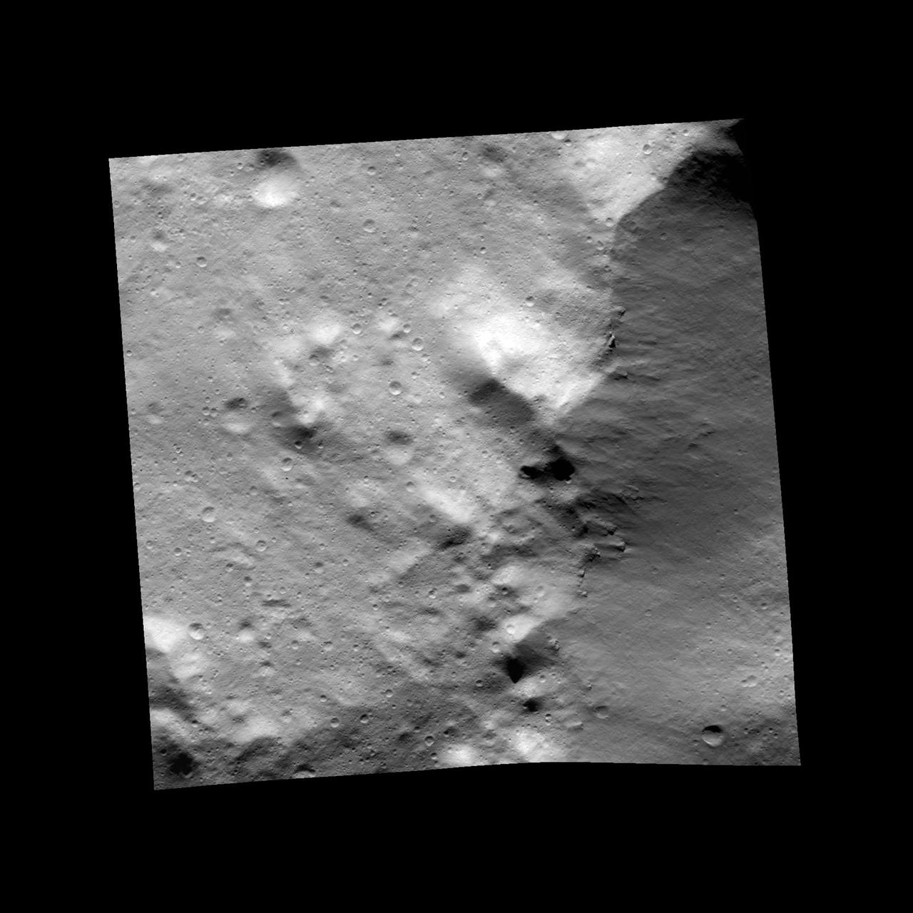
NASA's Galileo imaging system captured this picture of the limb of the asteroid 243 Ida about 46 seconds after its closest approach on August 28, 1993, from a range of only 2480 kilometers. http://photojournal.jpl.nasa.gov/catalog/PIA00138

Information, Data, & Analytics Services, IDAS Face to Face Meeting
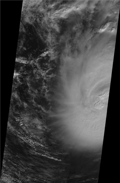
This image shows JPL Multi-angle Imaging SpectroRadiometer instrument onboard NASA Terra satellite on Sunday, Nov. 8, 2009 as it passed over Hurricane Ida while situated between western Cuba and the Yucatan Peninsula.
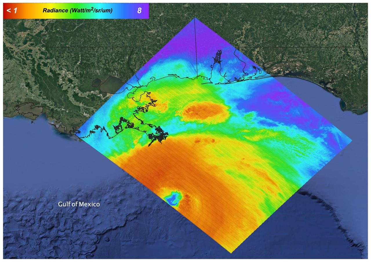
On August 27, 2021 Ida crossed over Cuba as a Category 1 Storm. 48 hours later the storm intensified to a Category 4 before making landfall on the coast of Louisiana. The storm was the second most destructive storm to ever make landfall on the Louisiana coast with sustained winds over 150 mph (240 km/h). The rapid intensification process that the storm system underwent is not well understood. Satellite images such as this are helpful as scientists attempt to understand new weather patterns that are emerging with Global Climate Change. Tasked with detecting plant water use and stress, ECOSTRESS's primary mission is to measure the temperature of plants heating up as they run out of water. But it can also measure and track heat-related phenomena like wildfires, heat waves, and volcanoes. ECOSTRESS observations have a spatial resolution of about 77 by 77 yards (70 by 70 meters), which enables researchers to study surface-temperature conditions down to the size of a football field. Due to the space station's unique orbit, the mission can acquire images of the same regions at different times of the day, as opposed to crossing over each area at the same time of day like satellites in other orbits do. This is advantageous when monitoring plant stress in the same area throughout the day, for example. https://photojournal.jpl.nasa.gov/catalog/PIA24210
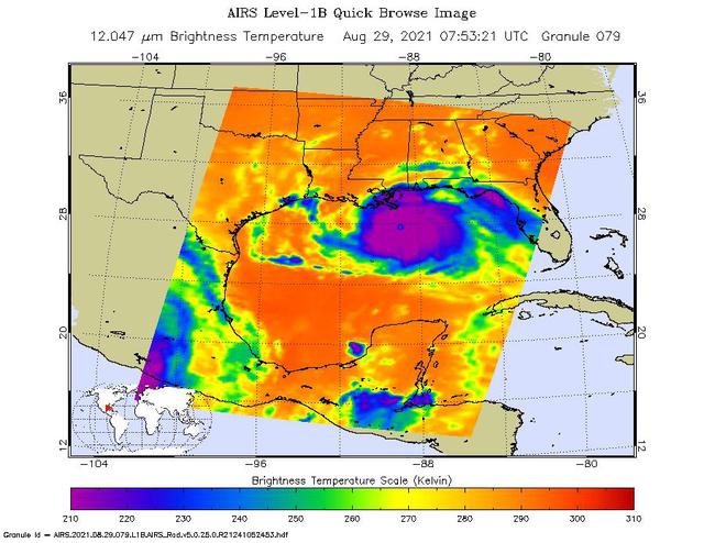
NASA's Atmospheric Infrared Sounder (AIRS), aboard the Aqua satellite, caught views of Hurricane Ida as the high-end Category 4 storm swept ashore around noon local time on Aug. 29, 2021, near Port Fourchon, Louisiana. One snapshot showed the hurricane around 3 a.m. that day while it was still over the Gulf of Mexico. The second view (Figure 1) caught the storm around 1:45 p.m. local time. In the infrared AIRS imagery, purple areas indicate very cold clouds carried high into the atmosphere by towering thunderstorms. These regions are also associated with heavy rainfall. Blue and green indicate warmer areas with shallower rain clouds. The orange and red areas represent mostly cloud-free air. The eye of the hurricane is seen just over the Louisiana coast as a small blue-green area in the middle of the large patch of purple in the after-landfall image. AIRS, in conjunction with the Advanced Microwave Sounding Unit (AMSU), senses emitted infrared and microwave radiation from Earth to provide a three-dimensional look at the planet's weather and climate. Working in tandem, the two instruments make simultaneous observations down to Earth's surface. With more than 2,000 channels sensing different regions of the atmosphere, the system creates a global, three-dimensional map of atmospheric temperature and humidity, cloud amounts and heights, greenhouse gas concentrations, and many other atmospheric phenomena. Launched into Earth orbit in 2002 aboard NASA's Aqua spacecraft, the AIRS and AMSU instruments are managed by NASA's Jet Propulsion Laboratory in Southern California, under contract to NASA. JPL is a division of Caltech. https://photojournal.jpl.nasa.gov/catalog/PIA24538

This image was the most detailed picture of then recently discovered natural satellite of asteroid 243 Ida taken by the Galileo Solid-State Imaging camera during its encounter with the asteroid on August 28, 1993. http://photojournal.jpl.nasa.gov/catalog/PIA00297
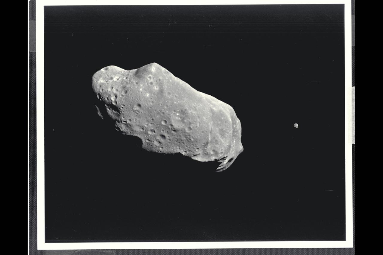
This image is the first full picture showing both asteroid 243 Ida and its newly discovered moon to be transmitted to Earth from NASA's Galileo spacecraft--the first conclusive evidence that natural satellites of asteroids exist. Ida is the large object to the left, about 56 kilometers (35 miles long). Ida's natural satellite is the small object to the right. This portrait was taken by Galileo's charge-coupled device (CCD) camera on August 28, 1993, about 14 minutes before the spacecraft's closest approach to the asteriod, from a range of 10,870 kilometers (6,755 miles). Ida is a heavily cratered, irregularly shaped asteroid in the main asteroid belt between Mars and Jupiter-- the 243rd asteroid to be discovered since the first one was found at the beginning of the 19th century. It is a member of a group of asteroids called the Koronis family. The small satellite, which is about 1.5 kilometers (1 mile) across in this view, has yet to be given a name by astronomers. It has been provisionally designated '1993 (243) 1' by the International Astronomical Union. (The numbers denote the year the picture was taken, the asteroid number and the fact that it is the first moon of Ida to be found.) ALthough the satellite appears to be 'next' to Ida it is actually slightly in the foreground, closer to the spacecraft than Ida. Combining this image with data from Galileo's near-infrared mapping spectrometer, the science team estimates that the object is about 100 kilometers (60 miles) away from the center of Ida. This image is one of a six-frame series taken through different color filters, this one in green. The spatial resolution in this image is about 100 meters (330 feet) per pixel. The Galileo spacecraft flew past Ida en route to its final destination, Jupiter, where it will go into orbit in December 1995. The Jet Propulsion Laboratory manages the galileo Project for NASA's Office of Space Science. (JPL ref. No. P-43731)

iss065e319865 (Aug. 28, 2021) --- Hurricane Ida is pictured as a category 2 storm from the International Space Station as it orbited 263 miles above the Gulf of Mexico.

iss060e043181 (Aug. 21, 2019) --- NASA astronaut Andrew Morgan is pictured working outside the International Space Station during a six-hour and 32-minute spacewalk to install the orbiting lab’s second commercial crew vehicle docking port, the International Docking Adapter-3 (IDA-3). The IDA-3 will accommodate the future arrivals of Boeing CST-100 Starliner and SpaceX Crew Dragon commercial crew spacecraft.

iss060e038222 (Aug. 21, 2019) --- NASA astronaut Andrew Morgan is pictured in his U.S. spacesuit inside the International Space Station's Quest airlock preparing to begin a six-hour and 32-minute spacewalk to install the orbiting lab’s second commercial crew vehicle docking port, the International Docking Adapter-3 (IDA-3). The IDA-3 will accommodate the future arrivals of Boeing CST-100 Starliner and SpaceX Crew Dragon commercial crew spacecraft.

iss060e038215 (Aug. 21, 2019) --- NASA astronaut Christina Koch poses for a portrait with Andrew Morgan and Nick Hague in their U.S. spacesuits before beginning a six-hour and 32-minute spacewalk to install the orbiting lab’s second commercial crew vehicle docking port, the International Docking Adapter-3 (IDA-3). The IDA-3 will accommodate the future arrivals of Boeing CST-100 Starliner and SpaceX Crew Dragon commercial crew spacecraft.

iss060e038228 (Aug. 21, 2019) --- NASA astronaut Nick Hague is pictured in his U.S. spacesuit inside the International Space Station's Quest airlock preparing to begin a six-hour and 32-minute spacewalk to install the orbiting lab’s second commercial crew vehicle docking port, the International Docking Adapter-3 (IDA-3). The IDA-3 will accommodate the future arrivals of Boeing CST-100 Starliner and SpaceX Crew Dragon commercial crew spacecraft.
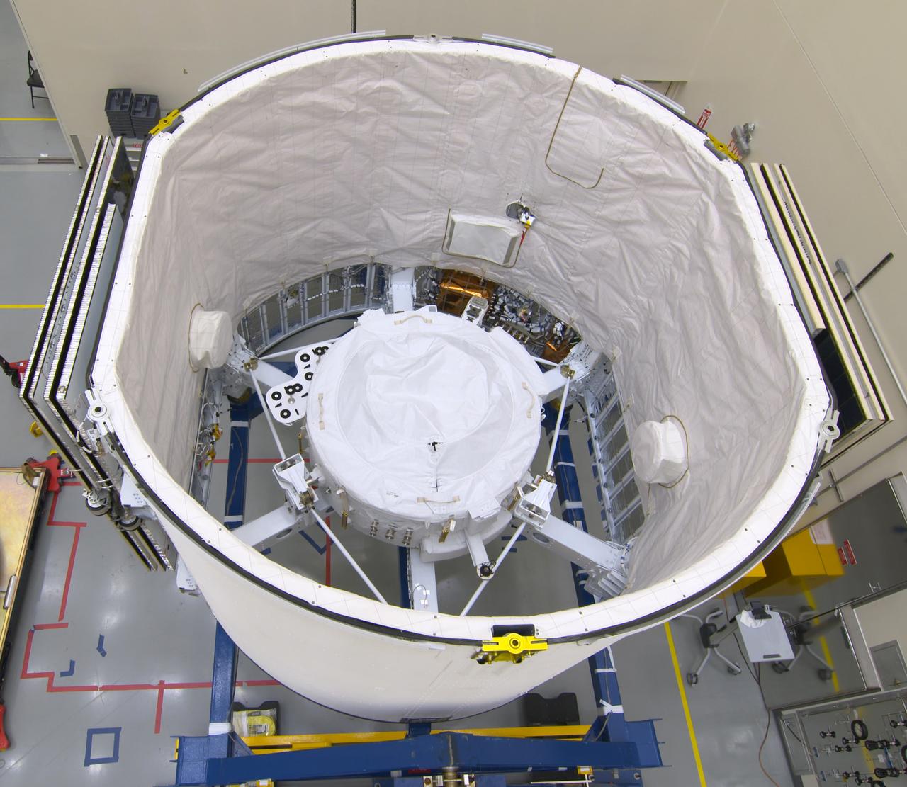
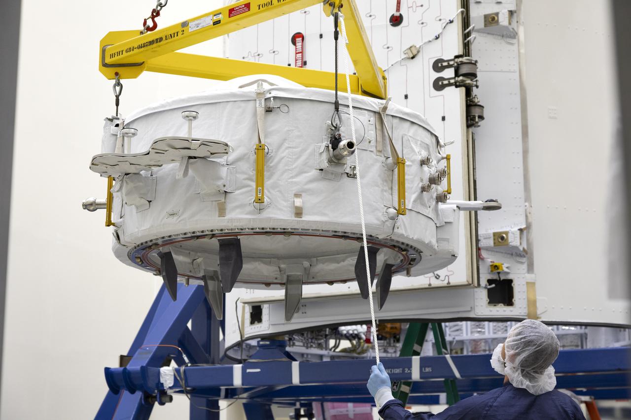
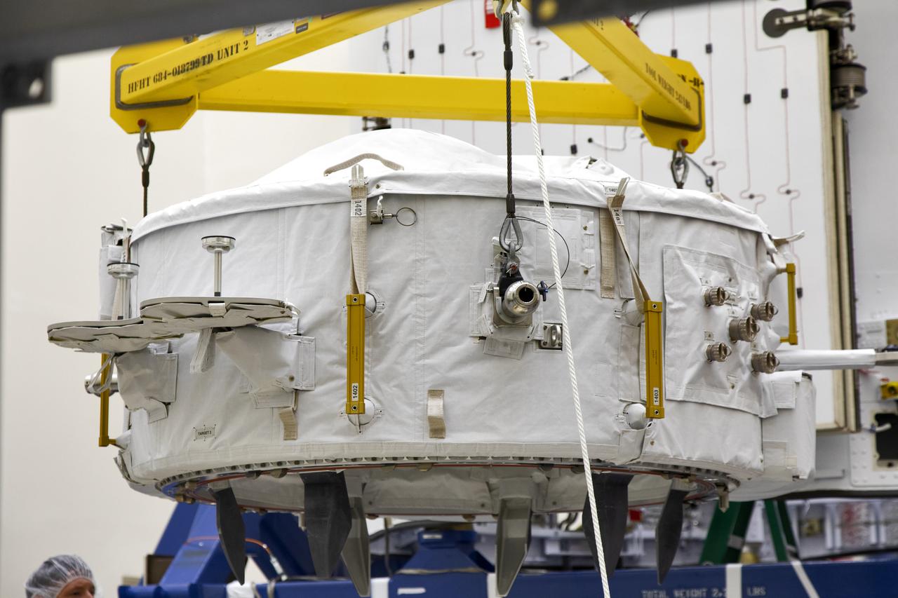
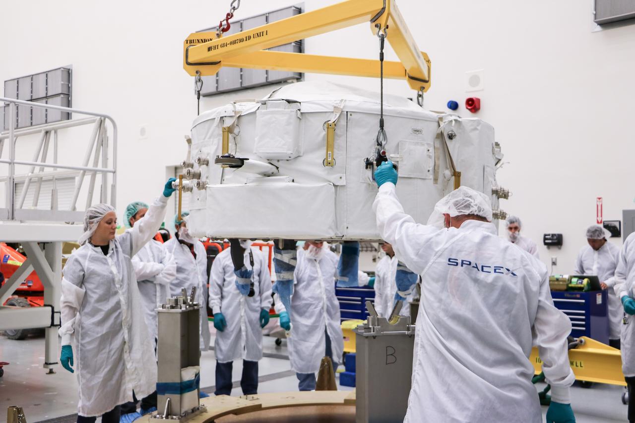
The International Docking Adapter 3, a critical component for future crewed missions to the International Space Station, is carefully packed away in the unpressurized “trunk” section of the SpaceX Dragon spacecraft at the SpaceX facility on Cape Canaveral Air Force Station in Florida on June 19. It will launch to the orbiting laboratory in July on the company’s 18th commercial resupply mission. The adapter will support future U.S. crewed vehicles visiting the station.
The International Docking Adapter 3, a critical component for future crewed missions to the International Space Station, is carefully packed away in the unpressurized “trunk” section of the SpaceX Dragon spacecraft at the SpaceX facility on Cape Canaveral Air Force Station in Florida on June 19. It will launch to the orbiting laboratory in July on the company’s 18th commercial resupply mission. The adapter will support future U.S. crewed vehicles visiting the station.
The International Docking Adapter 3, a critical component for future crewed missions to the International Space Station, is carefully packed away in the unpressurized “trunk” section of the SpaceX Dragon spacecraft at the SpaceX facility on Cape Canaveral Air Force Station in Florida on June 19. It will launch to the orbiting laboratory in July on the company’s 18th commercial resupply mission. The adapter will support future U.S. crewed vehicles visiting the station.
The International Docking Adapter 3, a critical component for future crewed missions to the International Space Station, is carefully packed away in the unpressurized “trunk” section of the SpaceX Dragon spacecraft at the SpaceX facility on Cape Canaveral Air Force Station in Florida on June 19. It will launch to the orbiting laboratory in July on the company’s 18th commercial resupply mission. The adapter will support future U.S. crewed vehicles visiting the station.
The International Docking Adapter 3, a critical component for future crewed missions to the International Space Station, is carefully packed away in the unpressurized “trunk” section of the SpaceX Dragon spacecraft at the SpaceX facility on Cape Canaveral Air Force Station in Florida on June 19. It will launch to the orbiting laboratory in July on the company’s 18th commercial resupply mission. The adapter will support future U.S. crewed vehicles visiting the station.
The International Docking Adapter 3, a critical component for future crewed missions to the International Space Station, is carefully packed away in the unpressurized “trunk” section of the SpaceX Dragon spacecraft at the SpaceX facility on Cape Canaveral Air Force Station in Florida on June 19. It will launch to the orbiting laboratory in July on the company’s 18th commercial resupply mission. The adapter will support future U.S. crewed vehicles visiting the station.
The International Docking Adapter 3, a critical component for future crewed missions to the International Space Station, is carefully packed away in the unpressurized “trunk” section of the SpaceX Dragon spacecraft at the SpaceX facility on Cape Canaveral Air Force Station in Florida on June 19. It will launch to the orbiting laboratory in July on the company’s 18th commercial resupply mission. The adapter will support future U.S. crewed vehicles visiting the station.
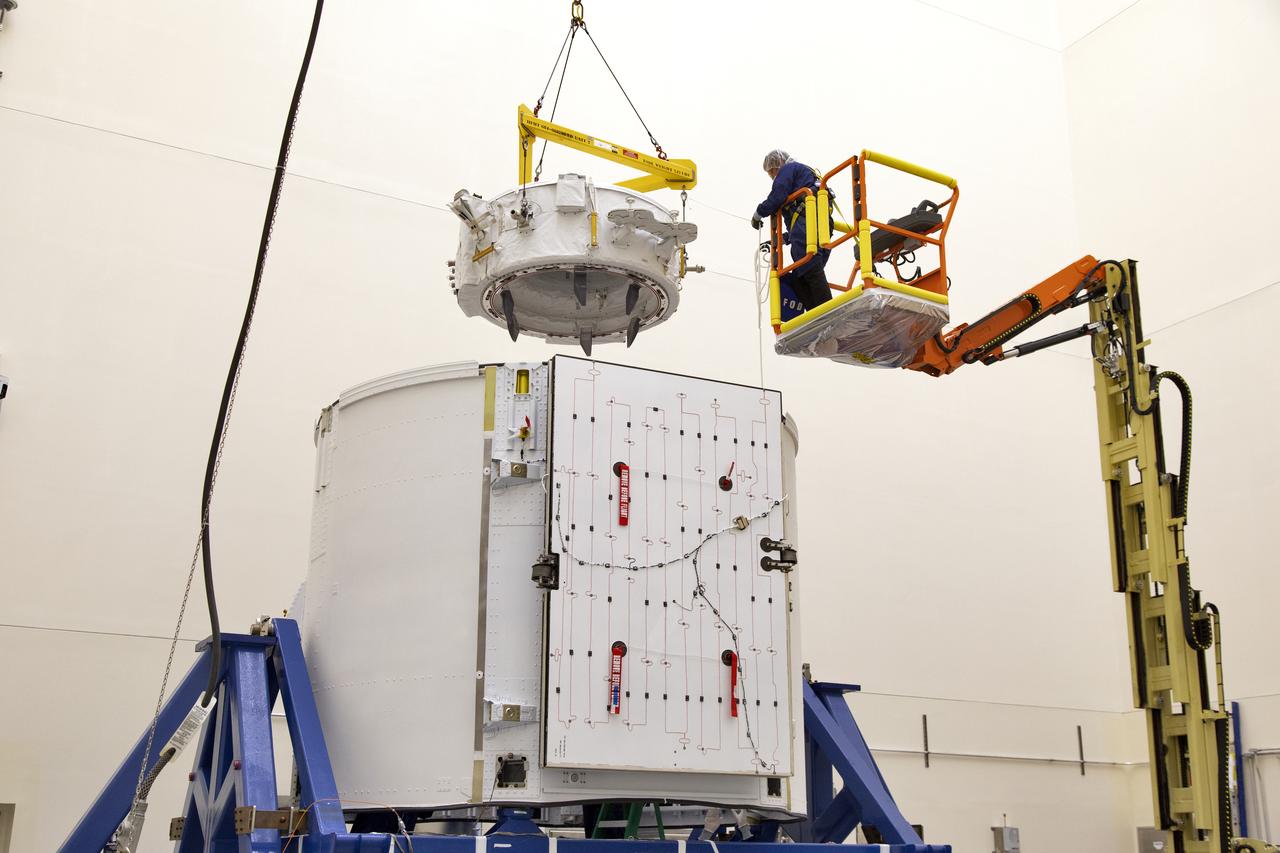
International Docking Adapter #2 installation for SpaceX's CRS-9 mission.
International Docking Adapter #2 installation for SpaceX's CRS-9 mission.

International Docking Adapter #2 installation for SpaceX's CRS-9 mission.
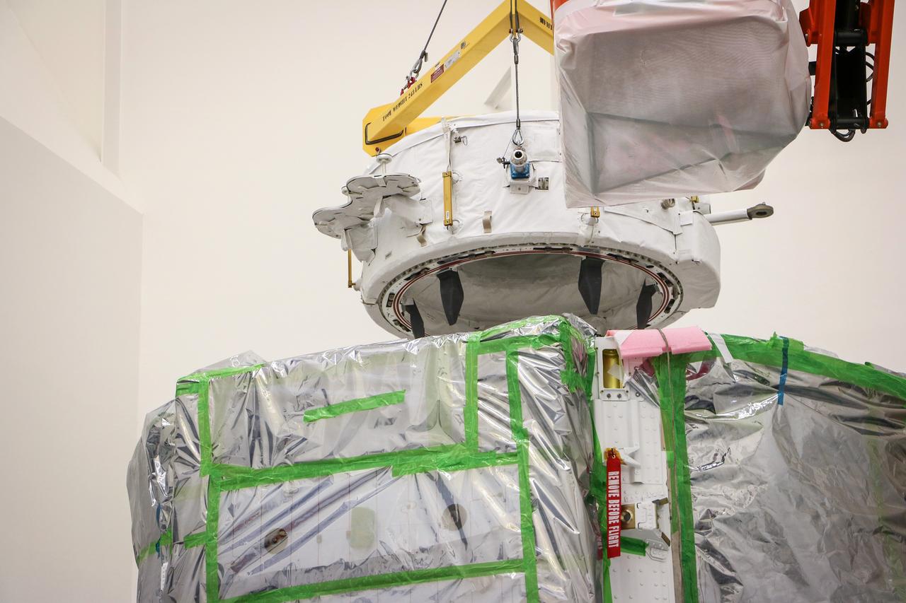
International Docking Adapter #2 installation for SpaceX's CRS-9 mission.

iss065e327057 (Aug. 29, 2021) --- Hurricane Ida is pictured as a category 4 storm nearing the southeast Louisiana coast from the International Space Station. In the foreground, is the Northrop Grumman Cygnus space freighter attached to the Unity module.

iss065e319500 (Aug. 28, 2021) --- Hurricane Ida is pictured as a category 2 storm in this near bird's-eye view from the International Space Station as it orbited 263 miles above the Gulf of Mexico.
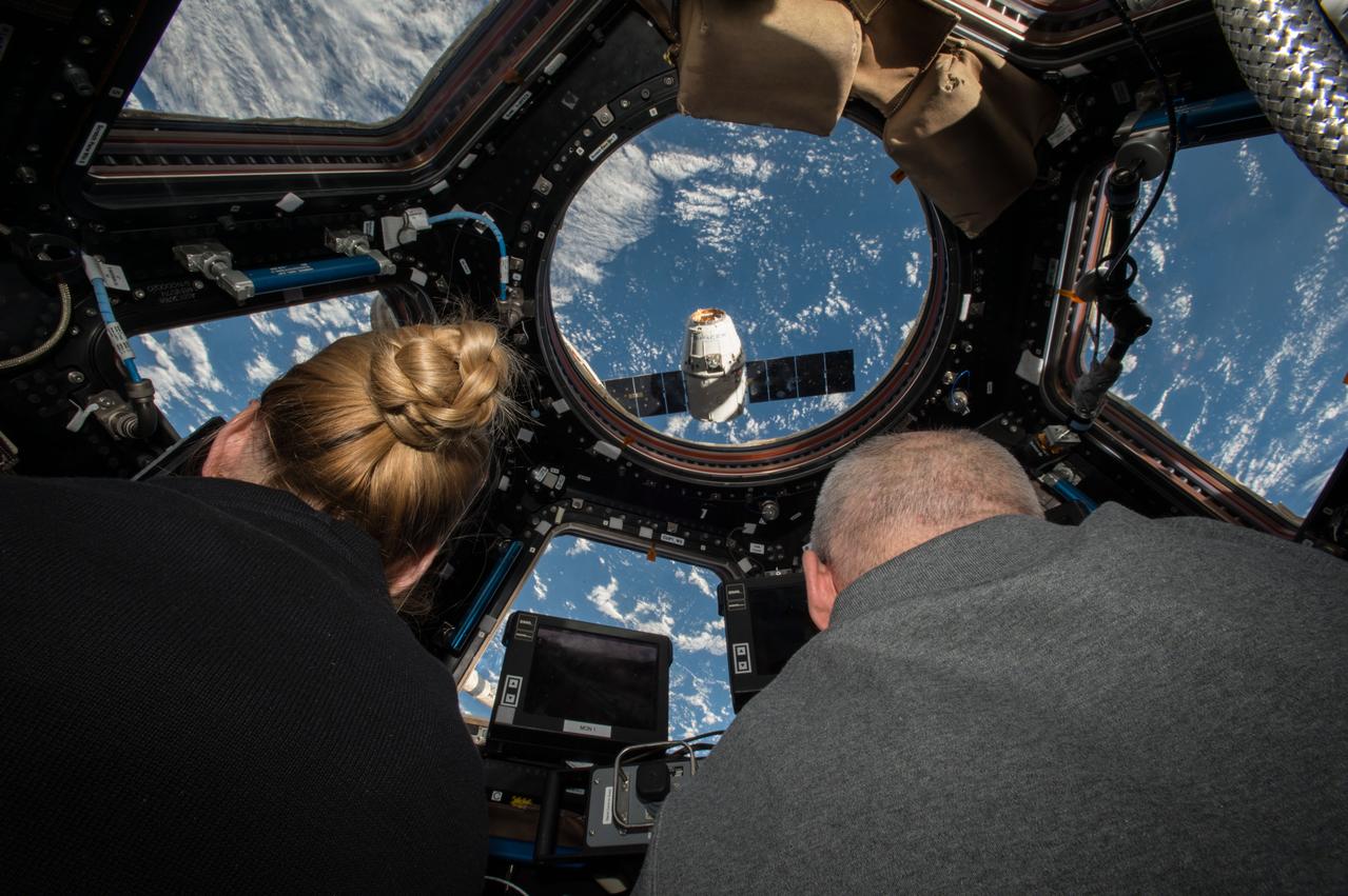
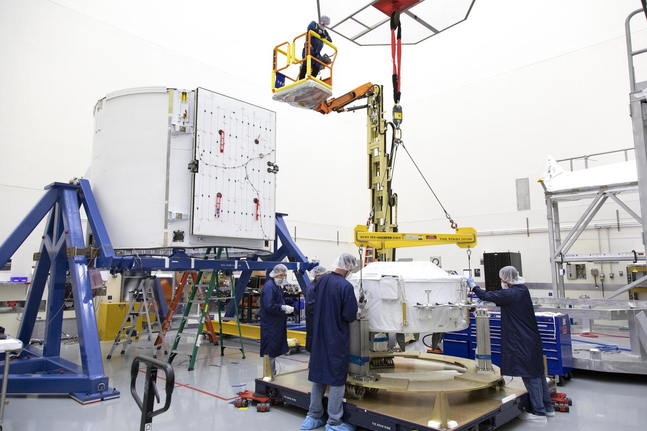
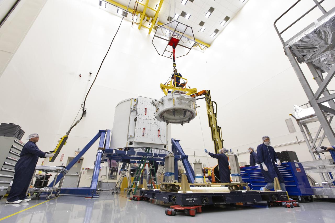
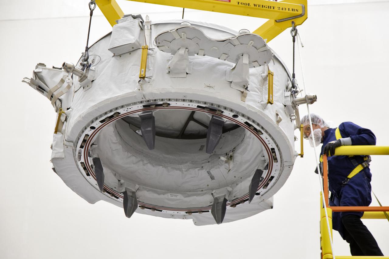
ISS048e041836 (07/20/2016) --- NASA astronauts Kate Rubins (left) and Jeff Williams (right) prepare to grapple the SpaceX Dragon supply spacecraft from aboard the International Space Station. The nearly 5,000 pounds of supplies and equipment includes science supplies and hardware, including instruments to perform the first-ever DNA sequencing in space, and the first of two identical international docking adapters (IDA.) The IDAs will provide a means for commercial crew spacecraft to dock to the station in the near future as part of NASA’s Commercial Crew Program. Dragon is scheduled to depart the space station Aug. 29 when it will return critical science research back to Earth.

iss065e319494 (Aug. 28, 2021) --- Hurricane Ida is pictured as a category 2 storm from the International Space Station as it orbited 264 miles above the Gulf of Mexico. In the foreground, is the Canadarm2 robotic arm with Dextre, the fine-tuned robotic hand, attached.

iss060e043180 (Aug. 21, 2019) --- NASA astronaut Nick Hague takes an out-of-this-world "space-selfie" during a spacewalk to install the International Space Station’s second commercial crew vehicle docking port, the International Docking Adapter-3 (IDA-3).

iss060e043194 (Aug. 21, 2019) --- NASA astronaut Andrew Morgan waves as he is photographed during a spacewalk to install the International Space Station’s second commercial crew vehicle docking port, the International Docking Adapter-3 (IDA-3).

iss065e319503 (Aug. 28, 2021) --- Hurricane Ida is pictured as a category 2 storm from the International Space Station as it orbited 263 miles above the Gulf of Mexico. At left, from top to bottom, are the Nauka multipurpose laboratory module, the Soyuz MS-18 crew ship and the Northrop Grumman Cygnus space freighter.

iss065e319769 (Aug. 28, 2021) --- Hurricane Ida is pictured as a category 2 storm from the International Space Station as it orbited 263 miles above the Gulf of Mexico. At upper left, is the Nauka multipurpose laboratory module docked to the Earth-facing port of the Zvezda service module.

iss060e043273 (Aug. 21, 2019) --- NASA astronaut Nick Hague is pictured tethered to the forward end of the International Space Station during a spacewalk to install the orbiting lab's second commercial crew vehicle docking port, the International Docking Adapter-3 (IDA-3).
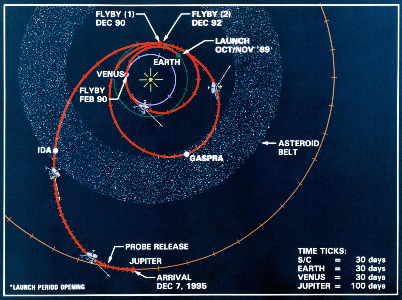
Line drawing charts the Galileo spacecraft's launch from low Earth orbit and its three planetary and two asteroid encounters in the course of its gravity-assisted flight to Jupiter. These encounters include Venus (February 1990), two Earth passes (December 1990 and December 1992), and the asteroids Gaspra and Ida in the asteroid belt. Galileo will release a probe and will arrive at Jupiter, 12-07-95.
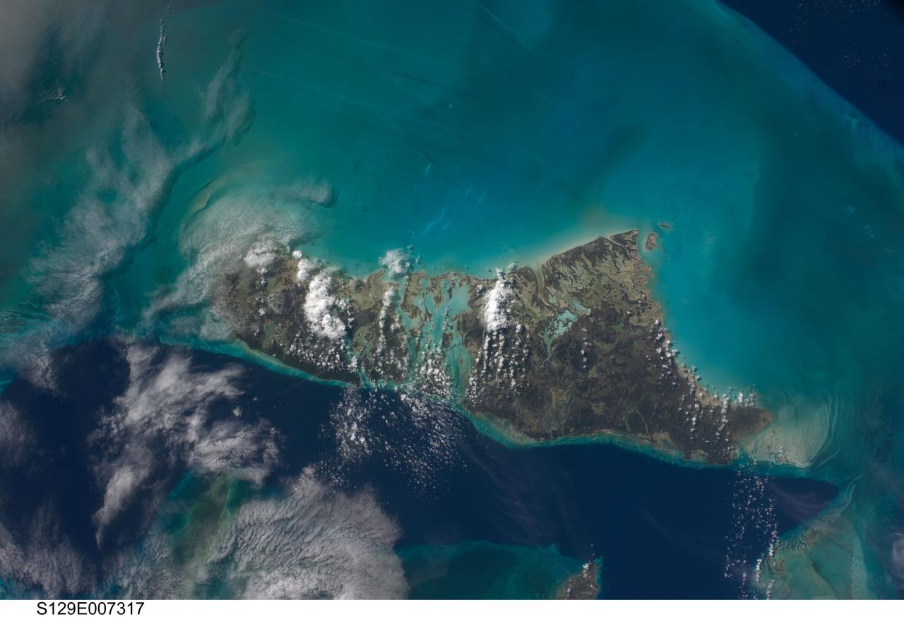
S129-E-007317 (21 Nov. 2009) --- This scene of the Bahamas’ Andros Island and the Tongue of the Ocean was captured by one of the STS-129 crewmembers aboard the space shuttle Atlantis during flight day six activities. This scene from Earth orbit appears much more peaceful than earlier in the month, when Hurricane/Tropical Storm Ida was not only threatening but seriously affecting several areas in several oceans. The dark blue area, aptly named "Tongue of the Ocean", is characterized by water depths as great as 3000 meters (almost two miles). The Atlantic Ocean just east of Eleuthra Island is nearly 5000 meters deep. By comparison, the waters of the Bahama Platform are less than 15 meters deep.
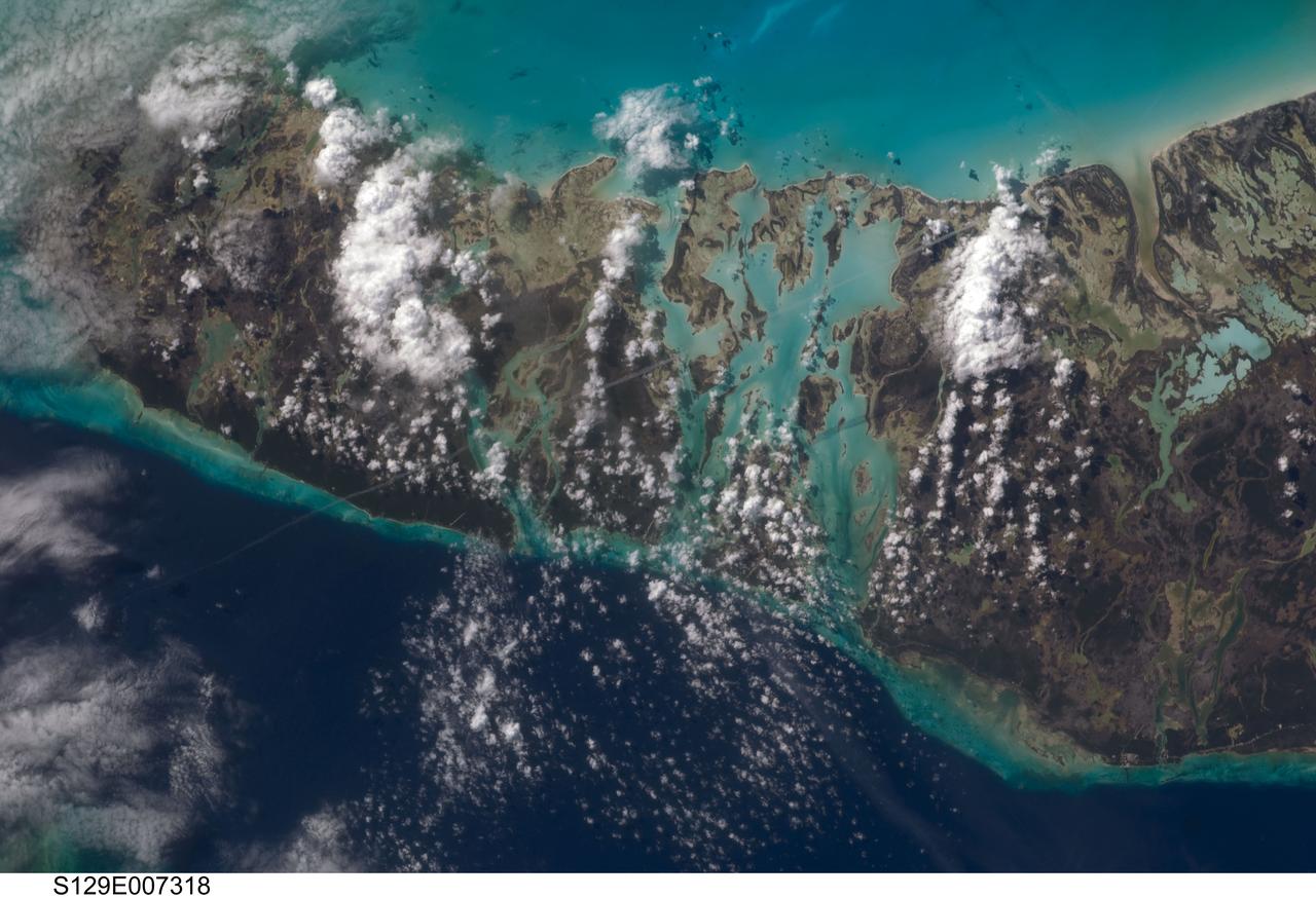
S129-E-007318 (21 Nov. 2009) --- This scene of the Bahamas’ Andros Island and the Tongue of the Ocean was captured by one of the STS-129 crew members aboard the space shuttle Atlantis during flight day six activities. This scene from Earth orbit appears much more peaceful than earlier in the month, when Hurricane/Tropical Storm Ida was not only threatening but seriously affecting several areas in several oceans. The dark blue area, aptly named "Tongue of the Ocean", is characterized by water depths as great as 3000 meters (almost two miles). The Atlantic Ocean just east of Eleuthra Island is nearly 5000 meters deep. By comparison, the waters of the Bahama Platform are less than 15 meters deep.

An oil slick in the Gulf of Mexico following Hurricane Ida – a high-end Category 4 when it made landfall near Port Fourchon, Louisiana, on Aug. 29, 2021 – appears as a green trail in the inset false-color graphic provided by NASA's Delta-X project, while the surrounding seawater appears orange. The National Oceanic and Atmospheric Administration (NOAA) regularly monitors U.S. coastal waters for potential spills and noticed slicks that appeared just off the coast after the hurricane. They were able to use this information from Delta-X to corroborate other data they had about oil slicks in the area (satellite image in the second inset picture). The blue-green swath crossing from the Gulf of Mexico over the Louisiana coast denotes the flight path of the Delta-X radar instrument on Sept. 1, just before 11:30 a.m. CDT. Charged with studying the Mississippi River Delta, Delta-X was gearing up to collect data on Louisiana's coastal wetlands when Hurricane Ida barreled ashore in late August. The storm damaged buildings and infrastructure alike, resulting in power outages, flooding, and oil slicks in the Gulf of Mexico. Oil tends to smooth out the bumps on the ocean's surface, which results in a distinct radar signal that the Delta-X mission was able to pick out of their data. Delta-X added flight paths to their planned schedule – with the support of NASA's Applied Science Disaster Program – in order to collect information over the gulf in areas of interest to NOAA. Delta-X is studying two wetlands – the Atchafalaya and Terrebonne Basins – by land, boat, and air to quantify water and sediment flow as well as vegetation growth. While the Atchafalaya Basin has been gaining land through sediment accumulation, Terrebonne Basin, which is right next to the Atchafalaya, has been rapidly losing land. The data collected by the project will be applied to models used to forecast which areas of the delta are likely to gain or lose land under various sea level rise, river flow, and watershed management scenarios. The mission uses several instruments to collect its data. Affixed to the bottom of a Gulfstream-III airplane, one of those instruments, the all-weather Uninhabited Aerial Vehicle Synthetic Aperture Radar (UAVSAR), bounces radar signals off of Earth's surface, forming a kind of image of a particular area. Repeated images of the same regions, captured at different times, enable researchers to detect changes in those areas, such as fluctuating water levels beneath the vegetation as the tides move in and out of these wetlands. In addition to radar measurements, teams from Caltech, Louisiana State University, Florida International University, and other collaborating institutions gather water and vegetation samples – among other data – by boat, other airborne sensors, and from instruments on the ground. Funded by NASA's Earth Venture Suborbital (EVS-3) program, Delta-X is managed by the agency's Jet Propulsion Laboratory. Caltech in Pasadena, California, manages JPL for NASA. Fall 2021 was Delta-X's last scheduled field campaign, although the five-year mission will run through the end of 2023. https://photojournal.jpl.nasa.gov/catalog/PIA24540
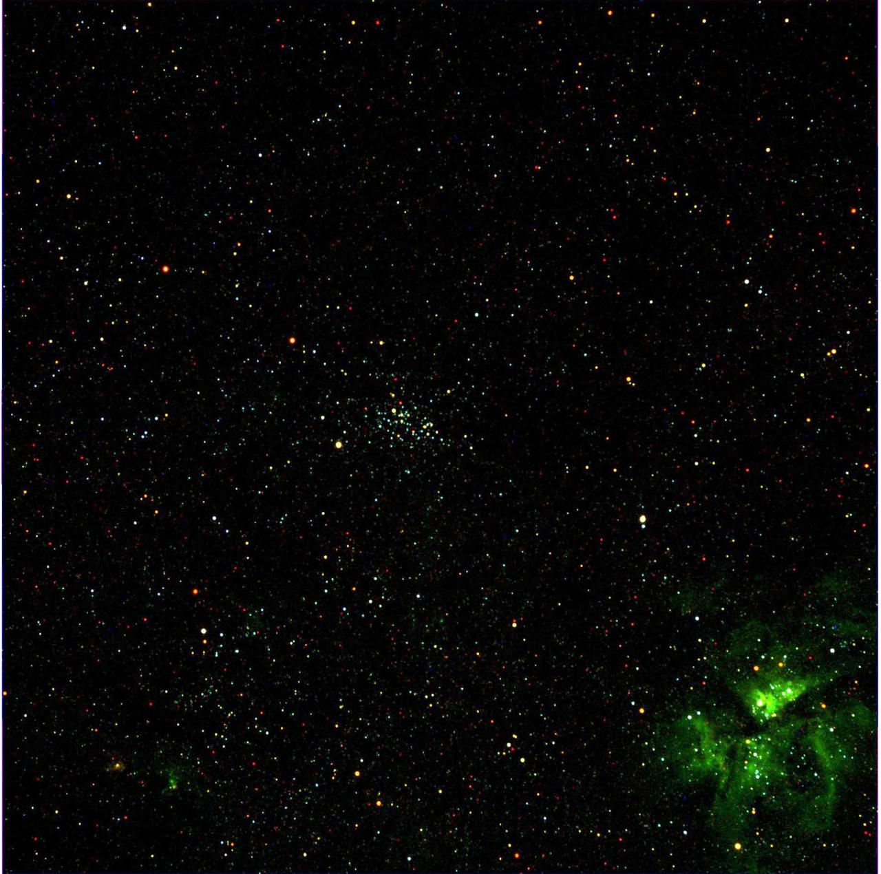
This view in the southern constellation Carina was acquired on December 13, 2007 as part of the characterization tests of the Framing Camera. The cluster of stars in the center is NGC 3532, and the nebula in the lower right is the Eta Carina Nebula.
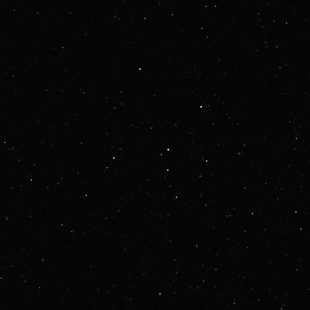
A star field in the constellation Cepheus is a composite of two 600-second exposures by the Framing Camera acquired during tests on December 3, 2007.
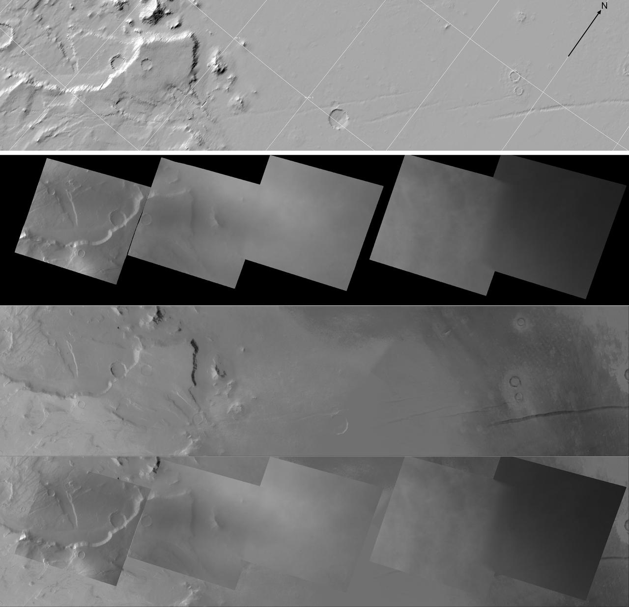
Each image on this High Resolution Stereo Camera Image Composite HRSC mosaic is of the same location observed by Dawn Framing Camera when it flew by Mars to complete the spacecraft gravity assist maneuver on February 17, 2009.
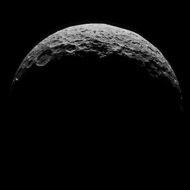
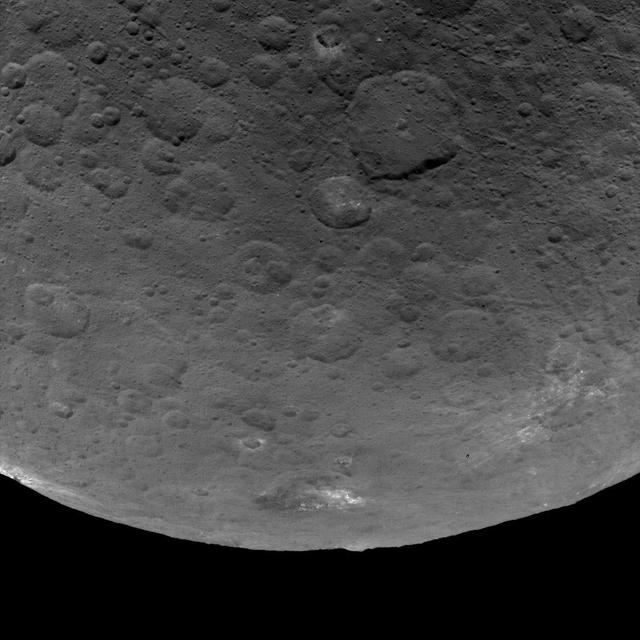
This image of Ceres is part of a sequence taken by NASA Dawn spacecraft on April 29, 2015, from a distance of 8,400 miles 13,600 kilometers. http://photojournal.jpl.nasa.gov/catalog/PIA19550

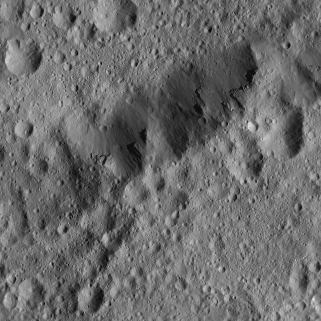
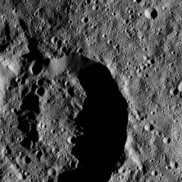
Patches of bright material can be seen on the walls of a relatively fresh crater on Ceres in this view from NASA Dawn spacecraft.
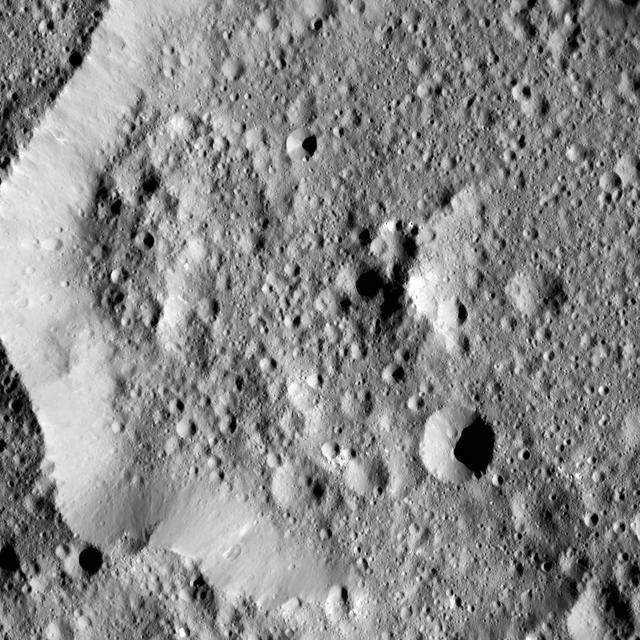
The rim of Ezinu Crater is seen in this view from NASA Dawn spacecraft.
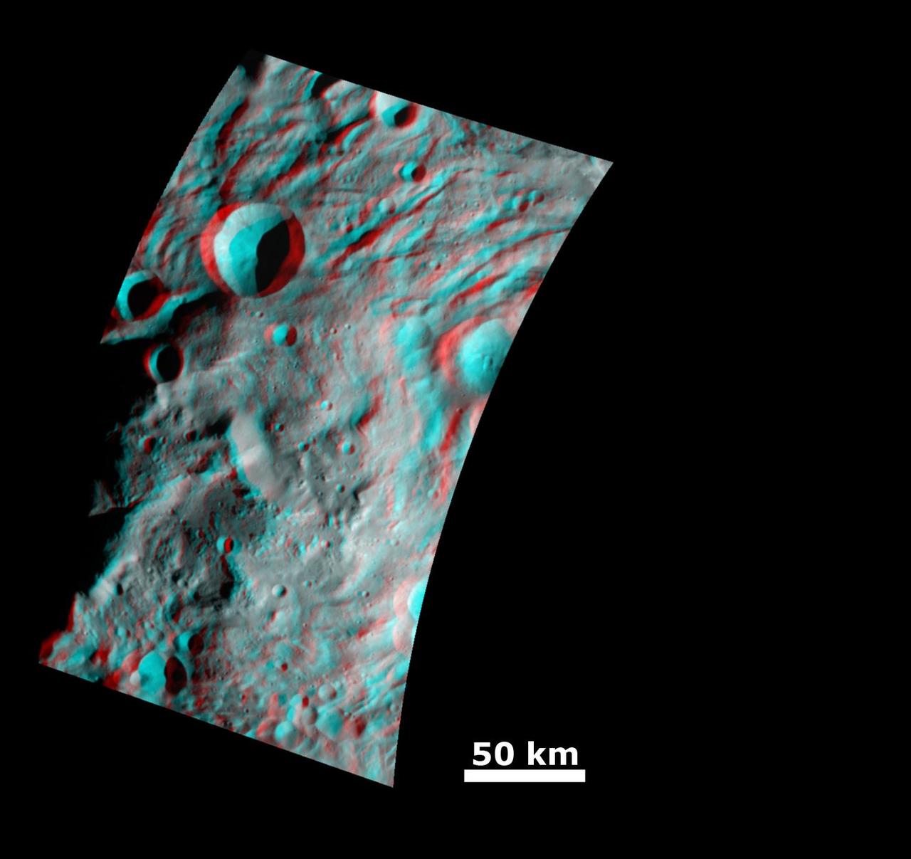
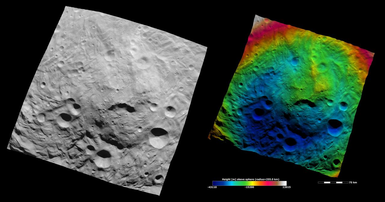
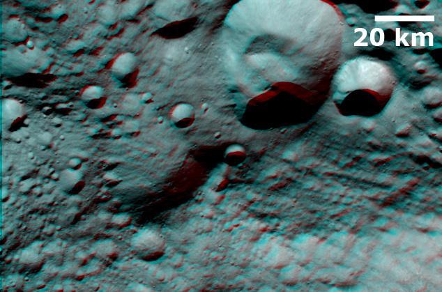
This anaglyph image from NASA Dawn spacecraft shows the topography of the mountain-central complex in asteroid Vesta south polar region. You need 3D glasses to view this image.

This image of Ceres is part of a sequence taken by NASA Dawn spacecraft on April 29, 2015, from a distance of 8,400 miles 13,600 kilometers.
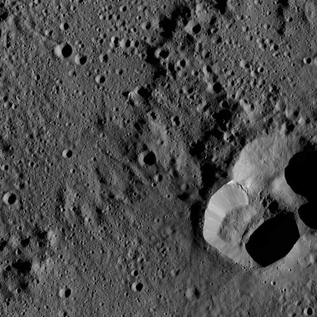
Ernutet Crater is featured in this image from Ceres, taken by NASA Dawn spacecraft. Ernutet was named for the Egyptian cobra-headed goddess of the harvest. The crater measures about 32 miles 52 kilometers in diameter and is located in the northern hem

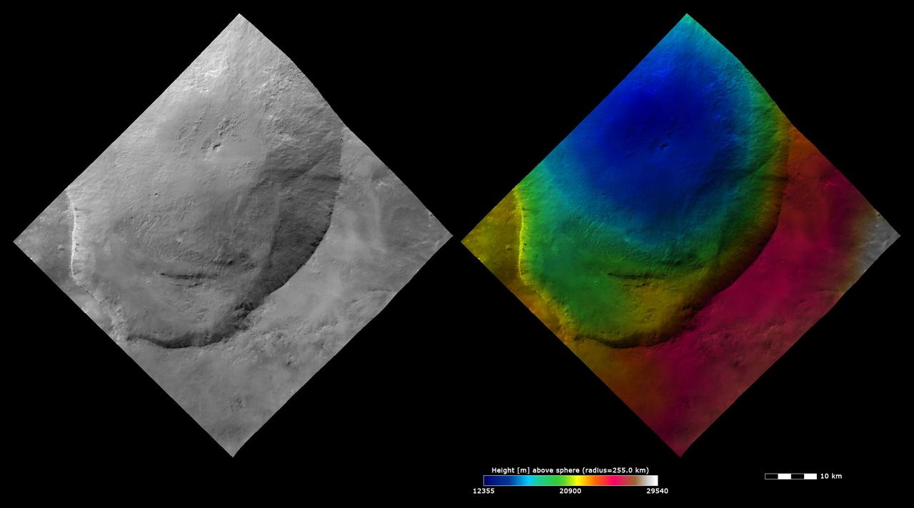
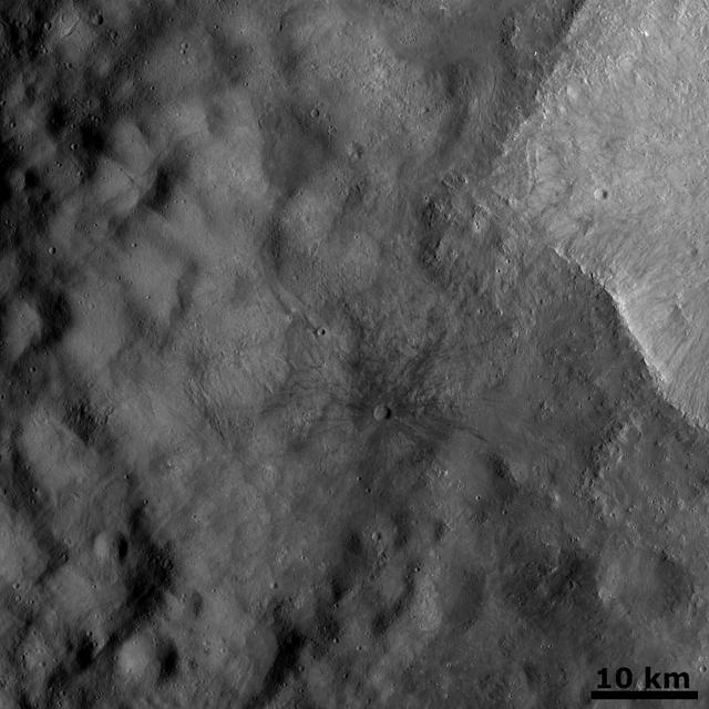
NASA's Dawn spacecraft captured this view on May 28, 2016, showing a relatively young crater with smooth walls and a sharp rim. The crater has a prominent central ridge, imprinted upon the rim of the larger Datan Crater, lying toward the lower right. The image is centered at approximately 64 degrees north latitude, 249 degrees east longitude. Dawn took this image on May 28, 2016, from its low-altitude mapping orbit, at a distance of about 240 miles (385 kilometers) above the surface. The image resolution is 120 feet (35 meters) per pixel. http://photojournal.jpl.nasa.gov/catalog/PIA20876

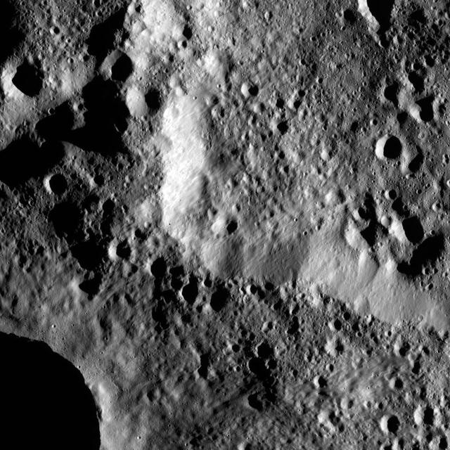
This image from NASA Dawn spacecraft shows two overlapping impact craters on asteroid Vesta. The rims of the craters are both reasonably fresh but the larger crater must be older because the smaller crater cuts across the larger crater rim.
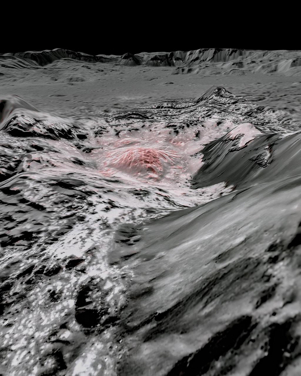
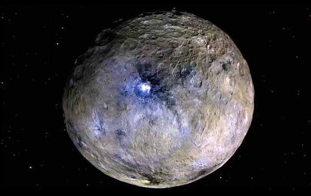
NASA's Dawn spacecraft captured pictures in visible and infrared wavelengths, which were combined to create this false-color view of a region in 57-mile-wide (92-kilometer-wide) Occator Crater on the dwarf planet Ceres (in the main asteroid belt between Mars and Jupiter). Here, recently exposed brine, or salty liquids, in the center of the crater were pushed up from a deep reservoir below Ceres' crust. In this view, they appear reddish. In the foreground, is Cerealia Facula ("facula" means bright area), a 9-mile-wide (15-kilometer-wide) region with a composition dominated by salts. The central dome, Cerealia Tholus, is about 1.9 miles (3 kilometers) across at its base and 1,100 feet (340 meters) tall. The dome is inside a central depression about 3,000 feet (900 meters) deep. The area depicted in this scene is about 1.3 miles (2.1 kilometers) wide in the foreground, about 7 miles (11 kilometers) wide across the dome, and 35 miles (56 kilometers) wide in the background, where the crater rim rises against the black sky. The distance from the near point (at the bottom) to the far point (at the top) is about 32 miles (52 kilometers). This mosaic is made from multiple images Dawn captured during its second extended mission in 2018 from an altitude of about 22 miles (35 kilometers). Those were combined with a topographic map based on images obtained during Dawn's prime mission and first extended mission in 2016, from an altitude of about 240 miles (385 kilometers). The resolution varies from about 11 feet (3.5 meters) per pixel in the bright regions to about 115 feet (35 meters) per pixel in the background. The color data that is overlain on the topographic data was obtained during the prime mission in 2015 when the spacecraft was at an altitude of 915 miles (1470 kilometers). It has a resolution of 450 feet (140 meters) per pixel. https://photojournal.jpl.nasa.gov/catalog/PIA24021
This image of the giant asteroid Vesta was obtained by NASA Dawn spacecraft in the evening Nov. 27 PST early morning Nov. 28, UTC, as it was spiraling down from its high altitude mapping orbit to low altitude mapping orbit.
NASA's Dawn spacecraft took this picture as it reached its new orbit to observe Ceres in opposition, when Dawn is directly between the sun and the Occator Crater bright spots. Entering the very tight opposition geometry (explained here) is a major feat that requires extra checks for increased delivery accuracy. Hence, this picture was part of a series of images intended to help the navigation of the spacecraft relative to Ceres. This vantage point highlights the southern hemisphere of Ceres. Abundant polygonal craters can be seen, starting with Kerwan, Ceres' largest crater at 174 miles (280 kilometers) in diameter, in the upper right of Ceres' circular disc. Kerwan's rims appear subdued and its floor is relatively relaxed. The crater found almost in the "bullseye" of the crater is called Insitor (16 miles or 26 kilometers in diameter). The Inamahari and Homshuk craters featured here can be found at the top of the disc. Another large polygonal crater called Chaminuka (76 miles, 122 kilometers in diameter) is found toward the center. This map can be used to locate these and more features. The name "Kerwan" refers to the Hopi spirit of sprouting maize and "Chaminuka" to the Shona (Zimbabwe) spirit who provides rains in times of droughts. "Insitor" is named for the Roman agricultural deity in charge of the sowing. This picture was taken on April 17, 2017, from an altitude of about 28,000 miles (45,000 kilometers). https://photojournal.jpl.nasa.gov/catalog/PIA21403
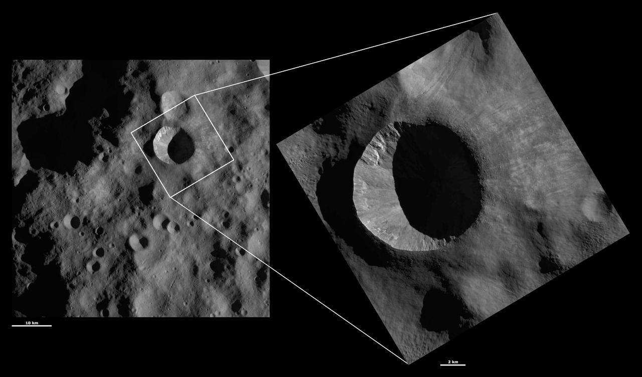
The rim of Hamori Crater on Ceres is seen in the upper right portion of this image, which was taken by NASA Dawn spacecraft. Hamori is located in the southern hemisphere of Ceres and measures 37 miles 60 kilometers wide.
This view of Ceres from NASA's Dawn spacecraft shows Tupo Crater (22 miles, 36 kilometers wide), at upper left, with its sharp rim and prominent central peak. The image was taken from a spacecraft altitude of 915 miles (1,470 kilometers) during Dawn's High Altitude Mapping Orbit (HAMO) phase on Oct. 21, 2015. Image resolution is 450 feet (140 meters) per pixel. The view is centered at approximately 41 degrees south latitude, 96 degrees east latitude. http://photojournal.jpl.nasa.gov/catalog/PIA20189
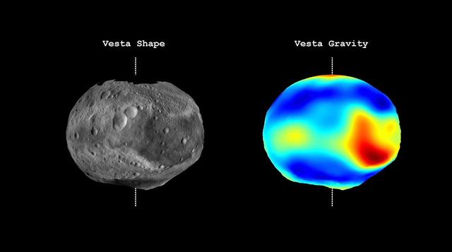
This frame from a video from NASA Dawn mission shows that the gravity field of Vesta closely matches the surface topography of the giant asteroid Vesta.
This image from NASA's Dawn spacecraft shows an area within the large crater Mondamin (78 miles, 126 kilometers wide) on Ceres. The image is centered at 67 degrees south latitude, 348 degrees east longitude. Dawn took this image on June 6, 2016, from its low-altitude mapping orbit, at a distance of about 240 miles (385 kilometers) above the surface. The image resolution is 120 feet (35 meters) per pixel. http://photojournal.jpl.nasa.gov/catalog/PIA20953
NASA Dawn spacecraft shows the central area of the south polar basin. This view is rotated by approximately 60°.
This image of asteroid Vesta from NASA Dawn spacecraft shows an old, very degraded crater that is almost completely filled with regolith. Regolith is the fine-grained material that covers most of Vesta surface.

This view from NASA's Dawn spacecraft captures the central complex of mountain peaks within Dantu Crater on Ceres. A patch of bright material is visible near lower right. The image is centered at approximately 23 degrees north latitude, 139 degrees east longitude. Dawn captured the scene on Dec. 21, 2015 from its low-altitude mapping orbit (LAMO), at an approximate altitude of 240 miles (385 kilometers) above Ceres. The image resolution is 120 feet (35 meters) per pixel. http://photojournal.jpl.nasa.gov/catalog/PIA20303

These images from NASA Dawn spacecraft show many craters, which have different states of preservation, in Vesta Bellicia quadrangle in the northern hemisphere.
NASA Dawn spacecraft obtained this image with its framing camera on Aug. 20, 2011. This image was taken through the camera clear filter. The image has a resolution of about 260 meters per pixel.
The view from NASA Dawn spacecraft shows an unnamed crater that lies in the northeast part of the larger impact feature Gaue. The area is dominated by small craters and is relatively smooth in general.
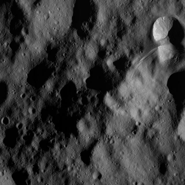
This image of Ceres, taken by NASA's Dawn spacecraft, features several craters with bright material within and around them. The image is centered on terrain near the equator of Ceres and faces southeast. The large crater at top, just right of center, is named Nawish for the guardian of the field of the Acoma people. The 50-mile- (80-kilometer-) wide crater's southern rim is thrown into sharp relief by shadows. The view was acquired from an altitude of 2,700 miles (4,400 kilometers). The image, with a resolution of 1,400 feet (410 meters) per pixel, was taken on June 9, 2015. http://photojournal.jpl.nasa.gov/catalog/PIA19627
This frame from a video from NASA's Dawn mission shows dwarf planet Ceres in false-color renderings, which highlight differences in surface materials. Images were used to create a movie of Ceres rotating, followed by a flyover view of Occator Crater, home of Ceres' brightest area. A video is available at http://photojournal.jpl.nasa.gov/catalog/PIA20182
This view from NASA's Dawn spacecraft features Liber Crater (14 miles, 23 kilometers wide) in Ceres' northern hemisphere, at right. Dawn took this image on June 17, 2016, from its low-altitude mapping orbit, at a distance of about 240 miles (385 kilometers) above the surface. The image resolution is 120 feet (35 meters) per pixel. http://photojournal.jpl.nasa.gov/catalog/PIA20863

This image from the atlas of the giant asteroid Vesta was created from images taken as NASA's Dawn mission flew around the object, also known as a protoplanet. The set of maps was created from mosaics of10,000 images from Dawn¹s framing camera instrument, taken at a low altitude of about 130 miles (210 kilometers). This map is mostly at a scale about that of regional road touring maps, where every inch of map is equivalent to a little more than 3 miles of asteroid (one centimeter equals 2 kilometers). http://photojournal.jpl.nasa.gov/catalog/PIA19506
This image of Vibidia AV-L-20, from the atlas of the giant asteroid Vesta, was created from images taken as NASA Dawn mission flew around the object, also known as a protoplanet. The set of maps was created from mosaics of10,000 images from Dawn's framing camera instrument, taken at a low altitude of about 130 miles (210 kilometers). This map is mostly at a scale about that of regional road touring maps, where every inch of map is equivalent to a little more than 3 miles of asteroid (one centimeter equals 2 kilometers). http://photojournal.jpl.nasa.gov/catalog/PIA19524
NASA Dawn spacecraft obtained this image of a young and old crater at the night and day boundary on asteroid Vesta. The image has a resolution of about 260 meters per pixel.
The low angle of sunlight creates stark shadows in this Cerean scene. The image is centered at approximately 74 degrees south latitude, 159 degrees east longitude. NASA's Dawn spacecraft took this image on June 17, 2016, from its low-altitude mapping orbit, at a distance of about 240 miles (385 kilometers) above the surface. The image resolution is 120 feet (35 meters) per pixel. http://photojournal.jpl.nasa.gov/catalog/PIA20861
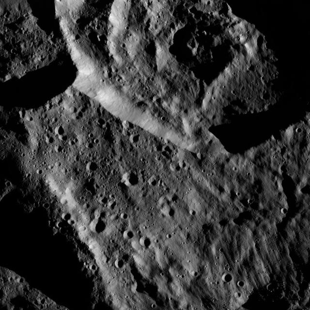
This image from NASA Dawn spacecraft is of the south pole region of the asteroid Vesta, a mountain is rising approximately 9 miles 15 kilometers above the floor of a crater.
This image from NASA Dawn spacecraft shows an ejecta blanket mantling the surface and obscuring older caters. The bright crater rim, seen in the middle right edge, is one of a group of craters which are the source of this ejecta blanket.

This image of Ceres, taken by NASA's Dawn spacecraft, features a large, steep-sided mountain and several intriguing bright spots. The mountain's height is estimated to be about 4 miles (6 kilometers), which is a revision of the previous estimate of 3 miles (5 kilometers). It is the highest point seen on Ceres so far. The image was obtained on June 25, 2015 from an altitude of 2,700 miles (4,400 kilometers) above Ceres and has a resolution of 1,400 feet (410 meters) per pixel. http://photojournal.jpl.nasa.gov/catalog/PIA19615

In this image of Ceres from NASA Dawn spacecraft, a younger, fresher crater lies to next to the older, larger crater named Messor. Messor, which is named for the Roman god of the harvesting and cutting of grain.
This mosaic of three images was taken by NASA Dawn framing camera during the high-altitude mapping orbit over the giant asteroid Vesta. The eastern rim is higher than the western rim, and the overall topography is downhill from east to west.

This image of asteroid Vesta from NASA Dawn spacecraft is dominated by a chain of secondary craters located in Vesta Floronia quadrangle, in Vesta northern hemisphere.
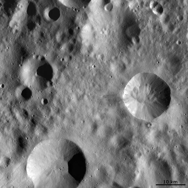
Tupo Crater on Ceres is seen in this view from NASA Dawn spacecraft. This crater, located in the southern hemisphere of Ceres, was named for the Polynesian god of turmeric. Dawn captured the scene on Dec. 24, 2015.
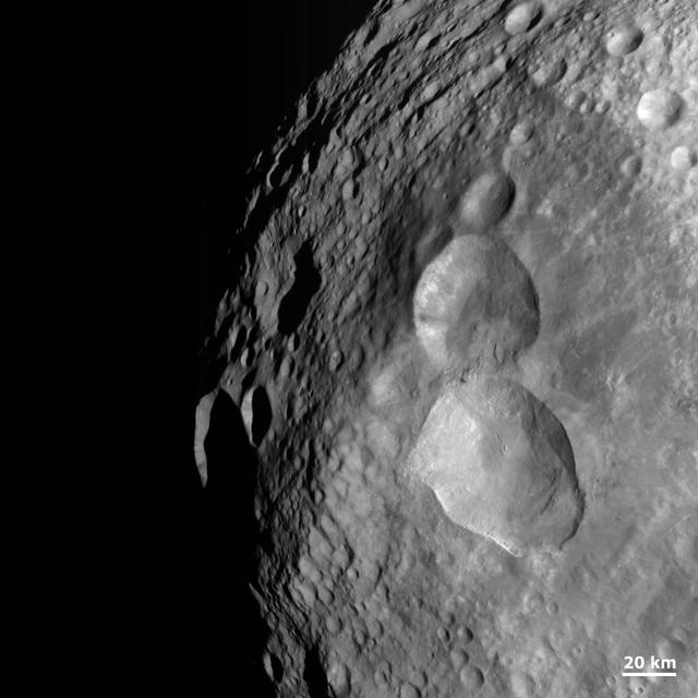
These images from NASA Dawn spacecraft show Marcia crater, after which Marcia quadrangle is named. Marcia crater is the largest and southernmost of the three Vestan craters nicknamed the Snowman.
This image of Paulina AV-L-15, from the atlas of the giant asteroid Vesta, was created from images taken as NASA Dawn mission flew around the object, also known as a protoplanet. The set of maps was created from mosaics of10,000 images from Dawn's framing camera instrument, taken at a low altitude of about 130 miles (210 kilometers). This map is mostly at a scale about that of regional road touring maps, where every inch of map is equivalent to a little more than 3 miles of asteroid (one centimeter equals 2 kilometers). http://photojournal.jpl.nasa.gov/catalog/PIA19519
These images from NASA Dawn spacecraft are located in asteroid Vesta Bellicia quadrangle, in Vesta northern hemisphere.

This image from NASA's Dawn spacecraft shows Dantu Crater, which is 78 miles (126 kilometers) across. Its shape is reminiscent of Occator Crater -- in particular, they both have shallow floors and central pits. This suggests melting and possibly some hydrothermal activity occurred following impact that formed Dantu. Part of the energy generated by the impact would have been turned into heat. The relatively warm temperatures found at the low latitudes of Dantu and Occator make it easier for Ceres' ice-rich material to melt as a consequence of impact-generated heat. The unnamed crater seen below Dantu in this image is smaller and has a much rougher floor. This is because the smaller impact event would not have generated as much heat. The numerous bright spots found across the crater suggest bright material may be just below the surface, exposed through small impacts and landslides. Ejected material from Dantu extends up to Kerwan crater, with a dark color reminiscent of material that came from Occator. Dantu was named for the Ghanaian god associated with the planting of the corn. This picture was taken by the Dawn framing camera on September 25, 2015, from 915 miles (1,470 kilometers) altitude. The center coordinates of this picture are 22 degrees north latitude, 133 degrees east longitude. https://photojournal.jpl.nasa.gov/catalog/PIA21412
This image from NASA Dawn spacecraft shows four large impact craters close to one another on Vesta surface. Interestingly, each of these four has a distinct preservation state.
This anaglyph shows the topography of Vesta Snowman craters on asteroid Vesta. The bottom crater is named Marcia, the middle crater, Calpurnia, and the top crater, Minucia. You need 3-D glasses to view this image.
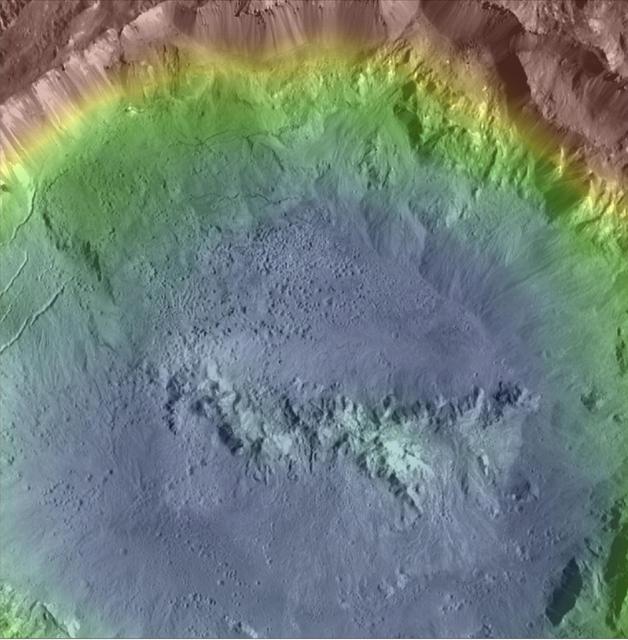
Haulani Crater (21 miles, 34 kilometers in diameter) is one of the youngest craters on Ceres, as evidenced by its sharp rims and bright, bluish material in enhanced color composite images from the framing camera on NASA's Dawn spacecraft. Haulani is also a good example of a polygonal crater. This high-resolution topography map of the crater's floor and northern rim displays a prime example of pitted terrains. Those features were likely formed through the rapid vaporization of subsurface water upon impact, and suggest that there is abundant water in Ceres' crust. Pitted terrains have also been found on Mars and Vesta. This topographic map was produced from the combination of images acquired under multiple illumination angles while the Dawn spacecraft was in its low-altitude mapping orbit, at a distance of about 240 miles (385 kilometers) above the surface. The colors represent elevations ranging from 1.3 miles (2.1 kilometers) below the surface to 0.75 miles (1.2 kilometers) above the surface. The center coordinates of the crater are 5.8 degree north latitude and 10.77 east longitude. An unannotated version of this image is also available. Haulani is named after the Hawaiian plant goddess. https://photojournal.jpl.nasa.gov/catalog/PIA21748
This image, one of the first obtained by NASA Dawn spacecraft in its low altitude mapping orbit, shows an area within the Rheasilvia basin in the south polar area of the giant asteroid Vesta.
This image, taken by NASA's Dawn spacecraft, shows a portion of the southern hemisphere of dwarf planet Ceres from an altitude of 2,700 miles (4,400 kilometers). The image, with a resolution of 1,400 feet (410 meters) per pixel, was taken on June 10, 2015, and shows roughly the same territory as PIA19588. http://photojournal.jpl.nasa.gov/catalog/PIA19626
This view from NASA Dawn spacecraft shows high northern latitudes on Ceres. Dawn acquired the image on Oct. 17, 2015, from an altitude of 915 miles 1,470 kilometers. It has a resolution of 450 feet 140 meters per pixel. http://photojournal.jpl.nasa.gov/catalog/PIA20138
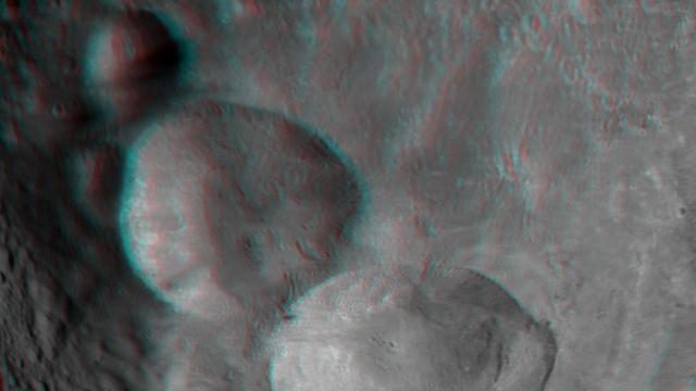
This anaglpyh from NASA Dawn spacecraft shows Caparronia crater on asteroid Vesta. The 3-D effect of the anaglyph highlights the large ridge running across the base of Caparronia crater. You will need 3-D glasses to view this image.
This view from NASA's Dawn spacecraft shows an area in the interior of Yalode Crater on Ceres. Yalode is one of the largest impact basins on Ceres, with a diameter of 160 miles (260 kilometers). Dawn took this image on June 3, 2016, from its low-altitude mapping orbit, at a distance of about 240 miles (385 kilometers) above the surface. The image resolution is 120 feet (35 meters) per pixel. http://photojournal.jpl.nasa.gov/catalog/PIA20945

This image of asteroid Vesta from NASA Dawn spacecraft shows part of a large crater with a relatively fresh rim located in Vesta Numisia quadrangle, near the equator.
This map shows the distribution of dark materials throughout the southern hemisphere of the giant asteroid Vesta. The circles, diamonds, and stars show where the dark material appears in craters, spots and topographic highs.

NASA's Dawn spacecraft views Kupalo Crater in this view of Ceres. Kupalo, which measures 16 miles (26 kilometers) across and is located at southern mid-latitudes, is named for the Slavic god of vegetation and harvest. Dawn took this image on June 2, 2016, from its low-altitude mapping orbit, at a distance of about 240 miles (385 kilometers) above the surface. The image resolution is 120 feet (35 meters) per pixel. http://photojournal.jpl.nasa.gov/catalog/PIA20944
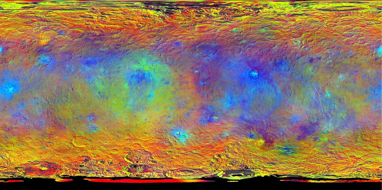
This map-projected view of Ceres was created from images taken by NASA's Dawn spacecraft during its high-altitude mapping orbit, in August and September, 2015. Images taken using infrared (920 nanometers), red (750 nanometers) and blue (440 nanometers) spectral filters were combined to create this false-color view. Redder colors indicate places on Ceres' surface that reflect light strongly in the infrared, while bluish colors indicate enhanced reflectivity at short (bluer) wavelengths; green indicates places where albedo, or overall brightness, is strongly enhanced. Scientists use this technique in order to highlight subtle color differences across Ceres, which would appear fairly uniform in natural color. This can provide valuable insights into the mineral composition of the surface, as well as the relative ages of surface features. http://photojournal.jpl.nasa.gov/catalog/PIA19977
The crater on asteroid Vesta shown in this image from NASA Dawn spacecraft was emplaced onto the ejecta blanket of two large twin craters. Commonly, rays from impact craters are brighter than the surrounding surface.