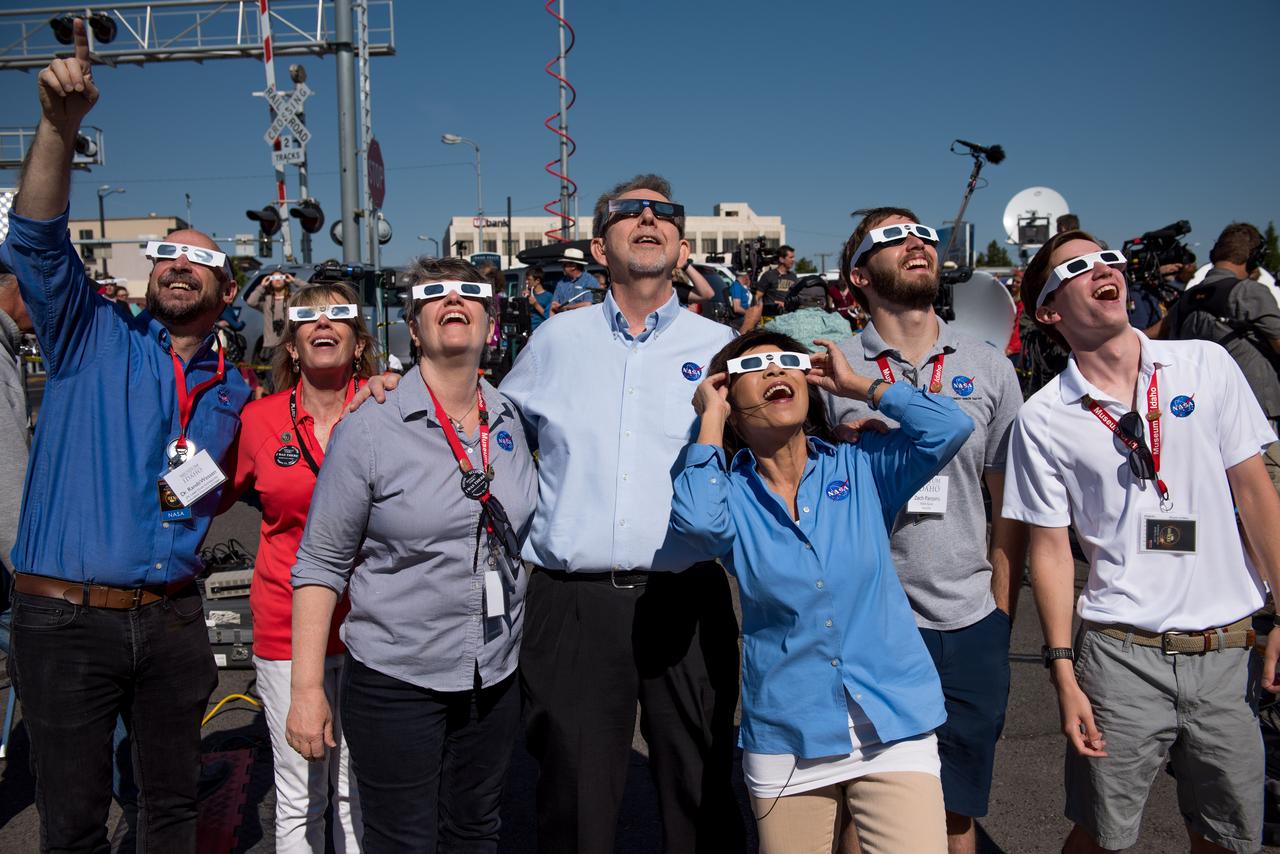
NASA employees enjoy the 2017 total solar eclipse in Idaho Falls, Idaho.

The crowd at a NASA event during the 2017 total solar eclipse in Idaho Falls, Idaho

Juniper Doucette with her mother Chloe Doucette, head of education at the museum of Idaho Falls, celebrate the 2017 total solar eclipse.

Juniper Doucette and her mother Chloe Doucette, head of education at the museum of Idaho Falls, enjoying the 2017 total solar eclipse.

Logging operations have left a striking checkerboard pattern in the landscape along the Idaho-Montana border, sandwiched between Clearwater and Bitterroot National Forests as seen in this image acquired by NASA Terra spacecraft.
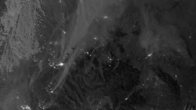
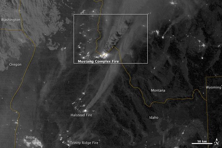
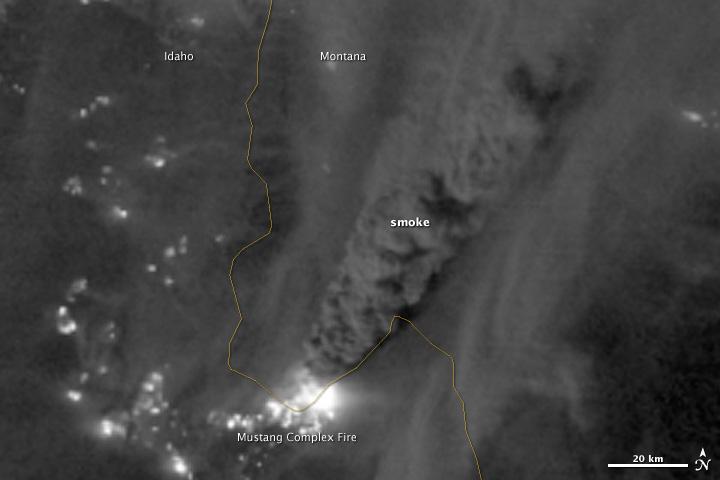
On August 29, 2012, the Visible Infrared Imaging Radiometer Suite (VIIRS) on the Suomi NPP satellite captured this nighttime view of wildfires burning in Idaho and Montana. The image was captured by the VIIRS “day-night band,” which detects light in a range of wavelengths from green to near-infrared and uses filtering techniques to observe signals such as gas flares, auroras, wildfires, city lights, and reflected moonlight. When the image was acquired, the moon was in its waxing gibbous phase, meaning it was more than half-lit, but less than full. Numerous hot spots from the Mustang Complex Fire are visible in northern Idaho. A plume of thick, billowing smoke streams west from the brightest fires near the Idaho-Montana border. The Halstead and Trinity Ridge fires are visible to the south. In addition to the fires, city lights from Boise and other smaller cities appear throughout the image. A bank of clouds is located west of the Mustang Complex, over southeastern Washington and northeastern Oregon. The Operational Line System (OLS)—an earlier generation of night-viewing sensors on the U.S. Defense Meteorological Satellite Program (DMSP) satellites—was also capable of detecting fires at night. But the VIIRS “day-night band” is far better than OLS at resolving them. Each pixel of an VIIRS image shows roughly 740 meters (0.46 miles), compared to the 3-kilometer footprint (1.86 miles) on the OLS system. NASA Earth Observatory image by Jesse Allen and Robert Simmon, using VIIRS Day-Night Band data from the Suomi National Polar-orbiting Partnership. Suomi NPP is the result of a partnership between NASA, the National Oceanic and Atmospheric Administration, and the Department of Defense. Caption by Adam Voiland. Instrument: Suomi NPP - VIIRS Credit: <b><a href="http://www.earthobservatory.nasa.gov/" rel="nofollow"> NASA Earth Observatory</a></b> <b>Click here to view all of the <a href="http://earthobservatory.nasa.gov/Features/NightLights/" rel="nofollow"> Earth at Night 2012 images </a></b> <b>Click here to <a href="http://earthobservatory.nasa.gov/NaturalHazards/view.php?id=79754" rel="nofollow"> read more </a> about this image </b> <b><a href="http://www.nasa.gov/audience/formedia/features/MP_Photo_Guidelines.html" rel="nofollow">NASA image use policy.</a></b> <b><a href="http://www.nasa.gov/centers/goddard/home/index.html" rel="nofollow">NASA Goddard Space Flight Center</a></b> enables NASA’s mission through four scientific endeavors: Earth Science, Heliophysics, Solar System Exploration, and Astrophysics. Goddard plays a leading role in NASA’s accomplishments by contributing compelling scientific knowledge to advance the Agency’s mission. <b>Follow us on <a href="http://twitter.com/NASA_GoddardPix" rel="nofollow">Twitter</a></b> <b>Like us on <a href="http://www.facebook.com/pages/Greenbelt-MD/NASA-Goddard/395013845897?ref=tsd" rel="nofollow">Facebook</a></b> <b>Find us on <a href="http://instagram.com/nasagoddard?vm=grid" rel="nofollow">Instagram</a></b>
On August 29, 2012, the Visible Infrared Imaging Radiometer Suite (VIIRS) on the Suomi NPP satellite captured this nighttime view of wildfires burning in Idaho and Montana. The image was captured by the VIIRS “day-night band,” which detects light in a range of wavelengths from green to near-infrared and uses filtering techniques to observe signals such as gas flares, auroras, wildfires, city lights, and reflected moonlight. When the image was acquired, the moon was in its waxing gibbous phase, meaning it was more than half-lit, but less than full. Numerous hot spots from the Mustang Complex Fire are visible in northern Idaho. A plume of thick, billowing smoke streams west from the brightest fires near the Idaho-Montana border. The Halstead and Trinity Ridge fires are visible to the south. In addition to the fires, city lights from Boise and other smaller cities appear throughout the image. A bank of clouds is located west of the Mustang Complex, over southeastern Washington and northeastern Oregon. The Operational Line System (OLS)—an earlier generation of night-viewing sensors on the U.S. Defense Meteorological Satellite Program (DMSP) satellites—was also capable of detecting fires at night. But the VIIRS “day-night band” is far better than OLS at resolving them. Each pixel of an VIIRS image shows roughly 740 meters (0.46 miles), compared to the 3-kilometer footprint (1.86 miles) on the OLS system. NASA Earth Observatory image by Jesse Allen and Robert Simmon, using VIIRS Day-Night Band data from the Suomi National Polar-orbiting Partnership. Suomi NPP is the result of a partnership between NASA, the National Oceanic and Atmospheric Administration, and the Department of Defense. Caption by Adam Voiland. Instrument: Suomi NPP - VIIRS Credit: <b><a href="http://www.earthobservatory.nasa.gov/" rel="nofollow"> NASA Earth Observatory</a></b> <b>Click here to view all of the <a href="http://earthobservatory.nasa.gov/Features/NightLights/" rel="nofollow"> Earth at Night 2012 images </a></b> <b>Click here to <a href="http://earthobservatory.nasa.gov/NaturalHazards/view.php?id=79754" rel="nofollow"> read more </a> about this image </b> <b><a href="http://www.nasa.gov/audience/formedia/features/MP_Photo_Guidelines.html" rel="nofollow">NASA image use policy.</a></b> <b><a href="http://www.nasa.gov/centers/goddard/home/index.html" rel="nofollow">NASA Goddard Space Flight Center</a></b> enables NASA’s mission through four scientific endeavors: Earth Science, Heliophysics, Solar System Exploration, and Astrophysics. Goddard plays a leading role in NASA’s accomplishments by contributing compelling scientific knowledge to advance the Agency’s mission. <b>Follow us on <a href="http://twitter.com/NASA_GoddardPix" rel="nofollow">Twitter</a></b> <b>Like us on <a href="http://www.facebook.com/pages/Greenbelt-MD/NASA-Goddard/395013845897?ref=tsd" rel="nofollow">Facebook</a></b> <b>Find us on <a href="http://instagram.com/nasagoddard?vm=grid" rel="nofollow">Instagram</a></b>
On August 29, 2012, the Visible Infrared Imaging Radiometer Suite (VIIRS) on the Suomi NPP satellite captured this nighttime view of wildfires burning in Idaho and Montana. The image was captured by the VIIRS “day-night band,” which detects light in a range of wavelengths from green to near-infrared and uses filtering techniques to observe signals such as gas flares, auroras, wildfires, city lights, and reflected moonlight. When the image was acquired, the moon was in its waxing gibbous phase, meaning it was more than half-lit, but less than full. Numerous hot spots from the Mustang Complex Fire are visible in northern Idaho. A plume of thick, billowing smoke streams west from the brightest fires near the Idaho-Montana border. The Halstead and Trinity Ridge fires are visible to the south. In addition to the fires, city lights from Boise and other smaller cities appear throughout the image. A bank of clouds is located west of the Mustang Complex, over southeastern Washington and northeastern Oregon. The Operational Line System (OLS)—an earlier generation of night-viewing sensors on the U.S. Defense Meteorological Satellite Program (DMSP) satellites—was also capable of detecting fires at night. But the VIIRS “day-night band” is far better than OLS at resolving them. Each pixel of an VIIRS image shows roughly 740 meters (0.46 miles), compared to the 3-kilometer footprint (1.86 miles) on the OLS system. NASA Earth Observatory image by Jesse Allen and Robert Simmon, using VIIRS Day-Night Band data from the Suomi National Polar-orbiting Partnership. Suomi NPP is the result of a partnership between NASA, the National Oceanic and Atmospheric Administration, and the Department of Defense. Caption by Adam Voiland. Instrument: Suomi NPP - VIIRS Credit: <b><a href="http://www.earthobservatory.nasa.gov/" rel="nofollow"> NASA Earth Observatory</a></b> <b>Click here to view all of the <a href="http://earthobservatory.nasa.gov/Features/NightLights/" rel="nofollow"> Earth at Night 2012 images </a></b> <b>Click here to <a href="http://earthobservatory.nasa.gov/NaturalHazards/view.php?id=79754" rel="nofollow"> read more </a> about this image </b> <b><a href="http://www.nasa.gov/audience/formedia/features/MP_Photo_Guidelines.html" rel="nofollow">NASA image use policy.</a></b> <b><a href="http://www.nasa.gov/centers/goddard/home/index.html" rel="nofollow">NASA Goddard Space Flight Center</a></b> enables NASA’s mission through four scientific endeavors: Earth Science, Heliophysics, Solar System Exploration, and Astrophysics. Goddard plays a leading role in NASA’s accomplishments by contributing compelling scientific knowledge to advance the Agency’s mission. <b>Follow us on <a href="http://twitter.com/NASA_GoddardPix" rel="nofollow">Twitter</a></b> <b>Like us on <a href="http://www.facebook.com/pages/Greenbelt-MD/NASA-Goddard/395013845897?ref=tsd" rel="nofollow">Facebook</a></b> <b>Find us on <a href="http://instagram.com/nasagoddard?vm=grid" rel="nofollow">Instagram</a></b>
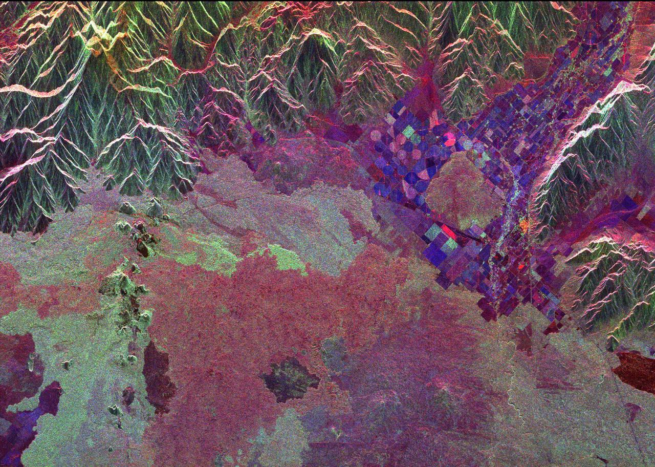
Ancient lava flows dating back 2,000 to 15,000 years are shown in light green and red on the left side of this space radar image of the Craters of the Moon National Monument area in Idaho.

NASA Phoenix Mars Lander parachuted for nearly three minutes as it descended through the Martian atmosphere on May 25, 2008. Extensive preparations for that crucial period included this drop test near Boise, Idaho, in October 2006.
Craters of the Moon National Monument is located in southern Idaho in the Snake River Plain. The Snake River Plain was formed by a series of giant eruptions which started 16 million years ago. The COM flows were erupted between 15,000 and 2,100 years ago. The hotspot that created the eruptions is now under Yellowstone. The COM has some of the best examples of open rift cracks in the world. There are excellent examples of almost every variety of basaltic, as well as tree molds, lava tubes, and many other volcanic features. The image was acquired July 14, 2006, covers an area of 65.2 by 75.4 km, and is located at 43.5 degrees north, 113.5 degrees west. https://photojournal.jpl.nasa.gov/catalog/PIA26501
This full-frame ASTER image, acquired August 30, 2000, covers an area of 60 by 60 km in the Salmon River Mountains, Idaho. In this color infrared composite, vegetation is red, clouds are white, and smoke from forest fires is blue. An enlargement (Figure 1) covers an area of 12 x 15 km. A thermal infrared band is displayed in red, a short wave infrared band is displayed in green, and a visible band is displayed in blue. In this combination, fires larger than about 50 m appear yellow because they are bright in both infrared bands. Smaller fires appear green because they are too small to be seen by the 90 m thermal pixels, but large enough to be detected in the 30 m short wave infrared pixels. We are able to see through the smoke in the infrared bands, whereas in the visible bands, the smoke obscures detection of the active fires. This image is located at 44.8 degrees north latitude and 114.8 degrees west longitude. http://photojournal.jpl.nasa.gov/catalog/PIA11088
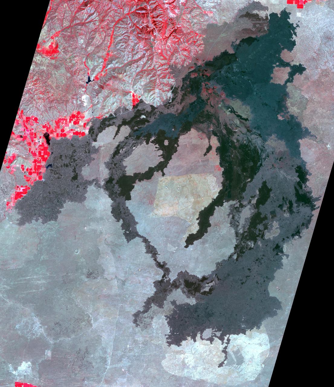
A wildfire burned 46,000 acres southwest of Pocatello, Idaho, threatening homes and filling the area with smoke. The human-caused fire was 85 percent contained by Aug. 10, 2017. The extent of the burned area is evident in this image as the dark gray area. The image was acquired Aug. 13, 2017, covers an area of 22 by 28 miles (36 by 45 kilometers), and is located at 42.7 degrees north, 112.6 degrees west. https://photojournal.jpl.nasa.gov/catalog/PIA21875
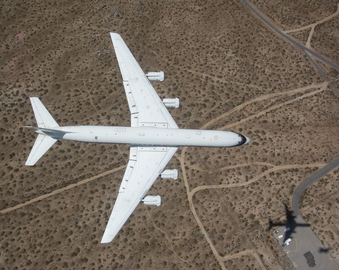
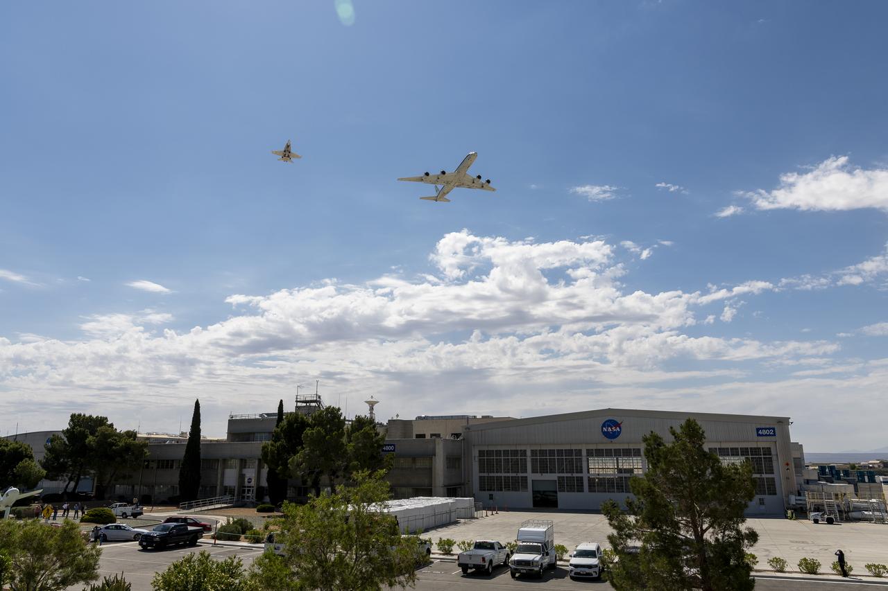
The DC-8 ascents during its final flight before it is retired from NASA’s Armstrong Flight Research Center Building 703 in Palmdale, California, to Idaho State University in Pocatello, Idaho. The DC-8 will provide real-world experience to train future aircraft technicians at the college’s Aircraft Maintenance Technology Program.
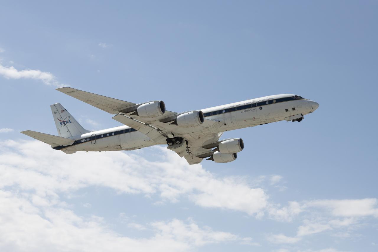
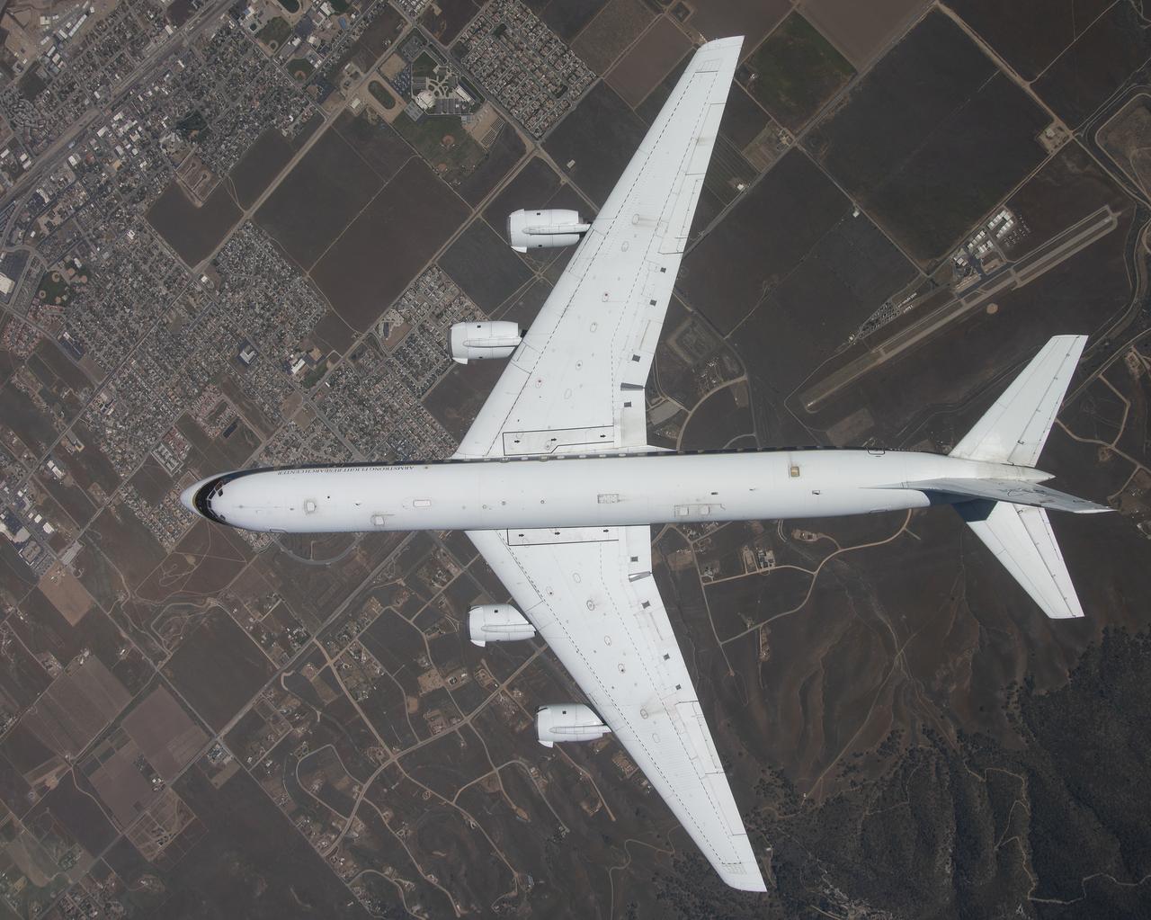
The DC-8 flies for the last time from NASA’s Armstrong Flight Research Center Building 703 in Palmdale, California, to Idaho State University in Pocatello, Idaho. The DC-8 will provide real-world experience to train future aircraft technicians at the college’s Aircraft Maintenance Technology Program.

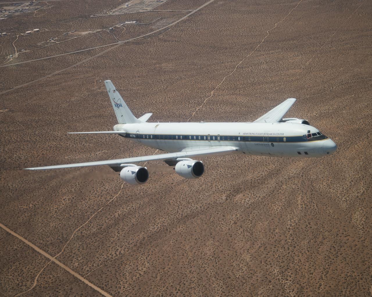
The DC-8 flies low for the last time over NASA’s Armstrong Flight Research Center in Edwards, California, before it retires to Idaho State University in Pocatello, Idaho. The DC-8 will provide real-world experience to train future aircraft technicians at the college’s Aircraft Maintenance Technology Program.
The DC-8 is shown overhead during its final flight from NASA’s Armstrong Flight Research Center Building 703 in Palmdale, California, before it retires to Idaho State University in Pocatello, Idaho. The DC-8 will provide real-world experience to train future aircraft technicians at the college’s Aircraft Maintenance Technology Program.
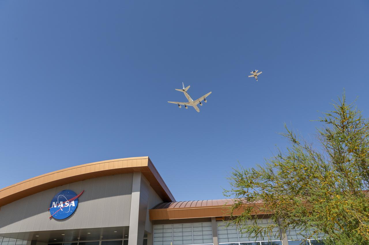
The DC-8 flies low for the last time over NASA’s Armstrong Flight Research Center in Edwards, California, before it retires to Idaho State University in Pocatello, Idaho. The DC-8 will provide real-world experience to train future aircraft technicians at the college’s Aircraft Maintenance Technology Program.
The DC-8 flies for the last time from NASA’s Armstrong Flight Research Center Building 703 in Palmdale, California, before it retires to Idaho State University in Pocatello, Idaho. The DC-8 will provide real-world experience to train future aircraft technicians at the college’s Aircraft Maintenance Technology Program.
The DC-8 flies for the last time from NASA’s Armstrong Flight Research Center Building 703 in Palmdale, California, before it retires to Idaho State University in Pocatello, Idaho. The DC-8 will provide real-world experience to train future aircraft technicians at the college’s Aircraft Maintenance Technology Program.
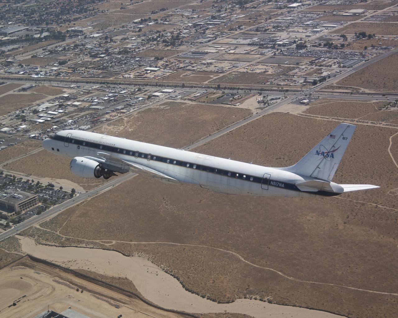
The DC-8 flies low over the Antelope Valley during its final flight before it is retired from NASA’s Armstrong Flight Research Center Building 703 in Palmdale, California, to Idaho State University in Pocatello, Idaho. The DC-8 will provide real-world experience to train future aircraft technicians at the college’s Aircraft Maintenance Technology Program.
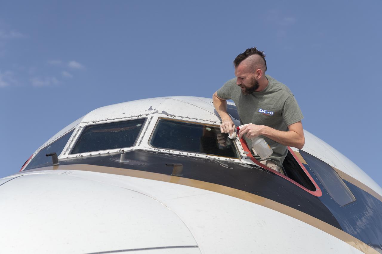
Avionics lead Kelly Jellison wipes the windshield of the DC-8 aircraft prior to its final flight before it is retired from NASA’s Armstrong Flight Research Center Building 703 in Palmdale, California, to Idaho State University in Pocatello, Idaho. The DC-8 will provide real-world experience to train future aircraft technicians at the college’s Aircraft Maintenance Technology Program.
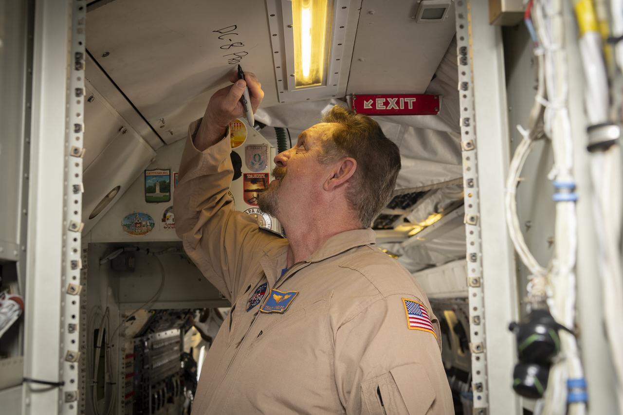
Aerospace engineer and research pilot Tracy Phelps signs the ceiling inside the DC-8 aircraft. Phelps piloted the aircraft’s final flight before it is retired from NASA’s Armstrong Flight Research Center Building 703 in Palmdale, California, to Idaho State University in Pocatello, Idaho. The DC-8 will provide real-world experience to train future aircraft technicians at the college’s Aircraft Maintenance Technology Program.
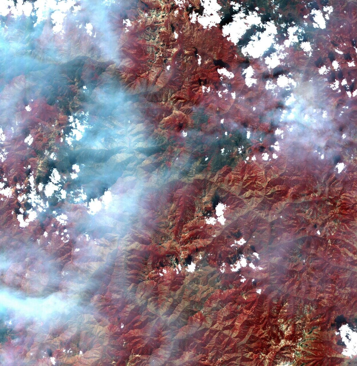
These images from NASA Terra satellite are of smoke plumes from devastating wildfires in the northwestern U.S. This view of the Clearwater and Salmon River Mountains in Idaho was acquired on August 5, 2000 Terra orbit 3370.

jsc2021e064552 (12/14/2021) --- Preflight image of the apparatus for the Determining the Efficacy of Bacteria Resistant Polymers in Microgravity (Bacteria Resistant Polymers in Space) investigation. The University of Idaho’s Vandal Voyagers Student Payload Opportunity with Citizen Science (SPOCS) investigation focuses on bacteria-resistant materials in microgravity. Image courtesy of University of Idaho SPOCS Team.
This frame from a movie was produced with data from NASA Aqua spacecraft showing the spread of carbon monoxide pollution across North America from fires in the Western U.S., including the Beaver Creek Fire in Idaho and the Rim Fire in California.

ISS015-E-22276 (13 Aug. 2007) --- Smoke plumes from wide-spread fires across Idaho, Utah and Montana are featured in this image photographed by an Expedition 15 crewmember on the International Space Station while Space Shuttle Endeavour (STS-118) was docked with the station. Looking westward toward the horizon, this image covers an expanse from northern Utah to central Idaho with southwest Montana in the foreground.
iss057e055559 (Oct. 22, 2018) --- The rural community of Grand View, Idaho is just south of the Ted Trueblood Wildlife Area which can host a variety of thousands of birds during migration periods. Snake River flows through the area and also forms portions of the Idaho, Oregon and Washington borders. The International Space Station was orbiting 256 miles above North America when this photograph was taken.
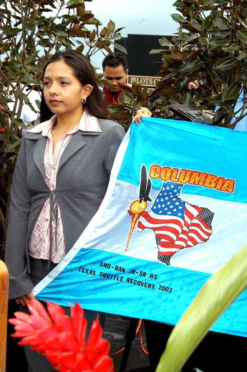
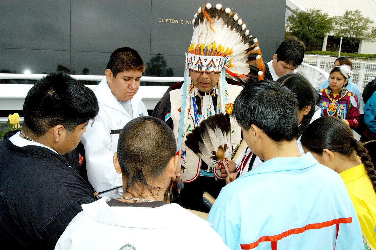
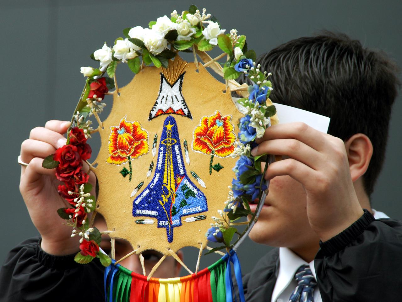
KENNEDY SPACE CENTER, FLA. - A student from Shoshone-Bannock Junior-Senior High School, Fort Hall, Idaho, holds part of a flag presented by dancers from the Shoshone-Bannock Native American community, Fort Hall, Idaho, commemorating the orbiter Columbia and her crew. The dancers performed a healing ceremony during the memorial service held at the Space Memorial Mirror for the crew of Columbia. Feb. 1 is the one-year anniversary of the loss of the crew and orbiter Columbia in a tragic accident as the ship returned to Earth following mission STS-107. Students and staff of the Shoshone-Bannock Nation had an experiment on board Columbia. The public was invited to the memorial service, held in the KSC Visitor Complex, which included comments by Center Director Jim Kennedy and Executive Director of Florida Space Authority Winston Scott. Scott is a former astronaut who flew on Columbia in 1997.
Project DaVinci is a student-led team at North Idaho STEM Charter Academy. Their spacecraft, the DaVinci satellite, has been constructed with the intent to connect with students worldwide to help reignite a passion for space. When launched, the DaVinci satellite will begin broadcasting messages across the globe using amateur radio uplink and downlink frequencies. Students in nearly every country will be able to receive these messages using a USB receiver dongle, open source software, and a yagi antenna in locations where the signal may be weaker. All messages will be education-related, and messages received will be in Morse Code requiring students to download a translating app or to translate it themselves. The DaVinci satellite will use the internet as a redundancy communication channel while in orbit. It is one of the few CubeSat to have a GlobalStar modem onboard, and will allow team members to upload digital messages to internet through the satellite. DaVinci satellite has an onboard Arducam as well, and will provide photos of Earth from its position in orbit. These pictures can be retrieved by the team using the GlobalStar modem and its corresponding server. To Learn more about the DaVinci satellite, visit www.projectdavincicubesat.org/
Project DaVinci is a student-led team at North Idaho STEM Charter Academy. Their spacecraft, the DaVinci satellite, has been constructed with the intent to connect with students worldwide to help reignite a passion for space. When launched, the DaVinci satellite will begin broadcasting messages across the globe using amateur radio uplink and downlink frequencies. Students in nearly every country will be able to receive these messages using a USB receiver dongle, open source software, and a yagi antenna in locations where the signal may be weaker. All messages will be education-related, and messages received will be in Morse Code requiring students to download a translating app or to translate it themselves. The DaVinci satellite will use the internet as a redundancy communication channel while in orbit. It is one of the few CubeSat to have a GlobalStar modem onboard, and will allow team members to upload digital messages to internet through the satellite. DaVinci satellite has an onboard Arducam as well, and will provide photos of Earth from its position in orbit. These pictures can be retrieved by the team using the GlobalStar modem and its corresponding server. To Learn more about the DaVinci satellite, visit www.projectdavincicubesat.org/
Project DaVinci is a student-led team at North Idaho STEM Charter Academy. Their spacecraft, the DaVinci satellite, has been constructed with the intent to connect with students worldwide to help reignite a passion for space. When launched, the DaVinci satellite will begin broadcasting messages across the globe using amateur radio uplink and downlink frequencies. Students in nearly every country will be able to receive these messages using a USB receiver dongle, open source software, and a yagi antenna in locations where the signal may be weaker. All messages will be education-related, and messages received will be in Morse Code requiring students to download a translating app or to translate it themselves. The DaVinci satellite will use the internet as a redundancy communication channel while in orbit. It is one of the few CubeSat to have a GlobalStar modem onboard, and will allow team members to upload digital messages to internet through the satellite. DaVinci satellite has an onboard Arducam as well, and will provide photos of Earth from its position in orbit. These pictures can be retrieved by the team using the GlobalStar modem and its corresponding server. To Learn more about the DaVinci satellite, visit www.projectdavincicubesat.org/

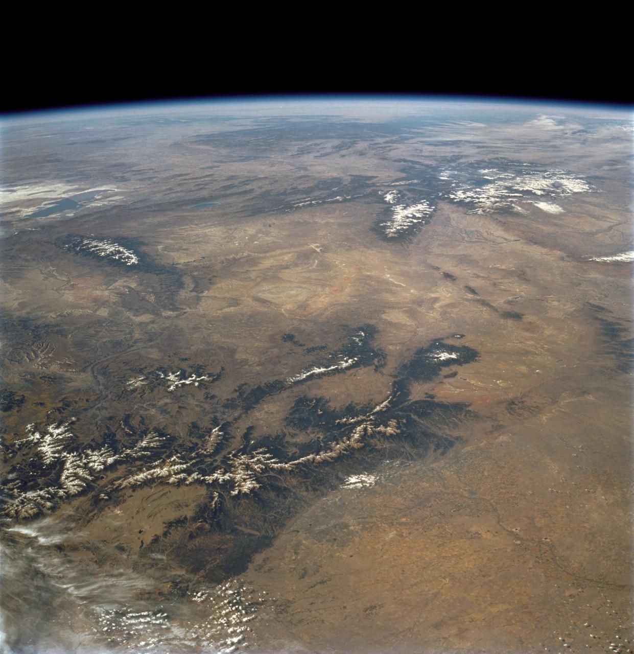
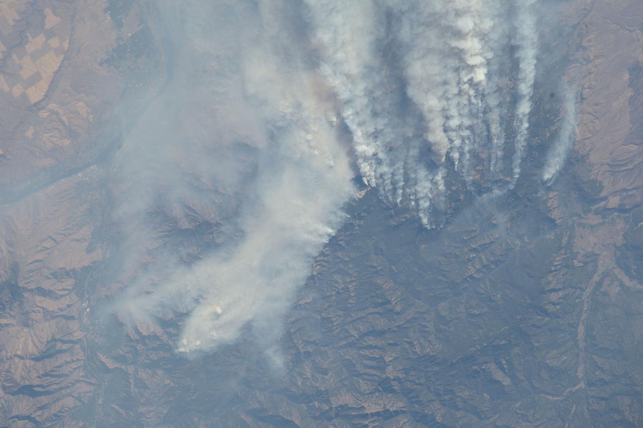
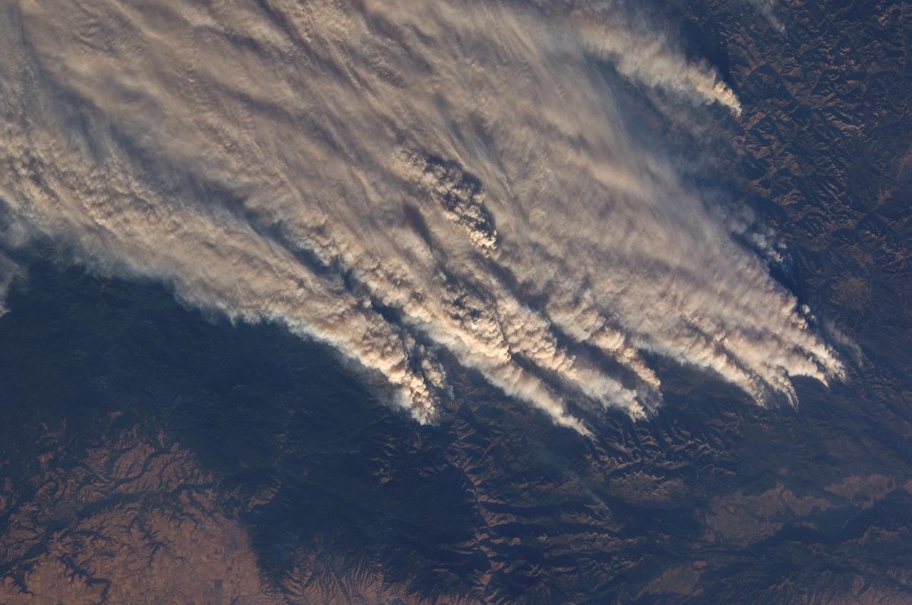
ISS032-E-024687 (3 Sept. 2012) --- Idaho fires are featured in this image photographed by an Expedition 32 crew member on the International Space Station. Taken with a short lens (45 mm), this west-looking photograph has a field of view covering much of the forested region of central Idaho. The dark areas are all wooded mountains—the Salmon River Mountains (left), Bitterroot Mountains (lower right) and Clearwater Mountains (right). All three areas experienced wildfires in September 2012—this image illustrates the situation early in the month. Smaller fire ‘complexes” appear as tendrils of smoke near the sources (e.g. Halstead complex at left), and as major white smoke plumes from the Mustang fire complex in the densest forests (darkest green, center) of the Clearwater Mountains. This was the largest plume noted in the region with thick smoke blowing eastward over the Beaverhead Mountains at bottom. The linear shape of the smoke plumes gives a sense of the generally eastward smoke transport on this day in early September. The smoke distribution shows another kind of transport: at night, when winds are weak, cooling of the atmosphere near the ground causes drainage of cooled (denser) air down into the major valleys. Here the smoke can be seen flowing west down into the narrow Salmon and Lochsa River valleys (at a local time of 12:18:50 p.m.) – in the opposite direction to the higher winds and the thick smoke masses. The bright yellow-tan areas at top left and top right contrasting with the mountains are grasslands of the Snake River in southern Idaho around Boise, and the Palouse region in western Idaho–SE Washington state. This latter area is known to ecologists as the Palouse Grasslands Ecoregion. Light green areas visible in the center of many of the valleys are agricultural crops including barley, alfalfa, and wheat. The image also shows several firsts of which Idaho can boast. The Snake River between Boise and the Palouse region has cut Hells Canyon (top), the deepest gorge in the U.S. at almost 2,436 meters (8,000 feet). The largest single wilderness area in the contiguous U.S., the Frank Church-River of No Return Wilderness occupies the wooded zones of the Salmon River Mountains and the Clearwater Mountains, i.e. most of the area shown in the middle of the image. Idaho’s highest peak is Borah Peak (lower left) at 3,860 meters above sea level (12,662 feet ASL). The Continental Divide cuts through the bottom of the image—rivers on the eastern slopes of the Beaverhead Mountains drain to the Atlantic Ocean, whereas rivers in the rest of the area drain to the Pacific Ocean.
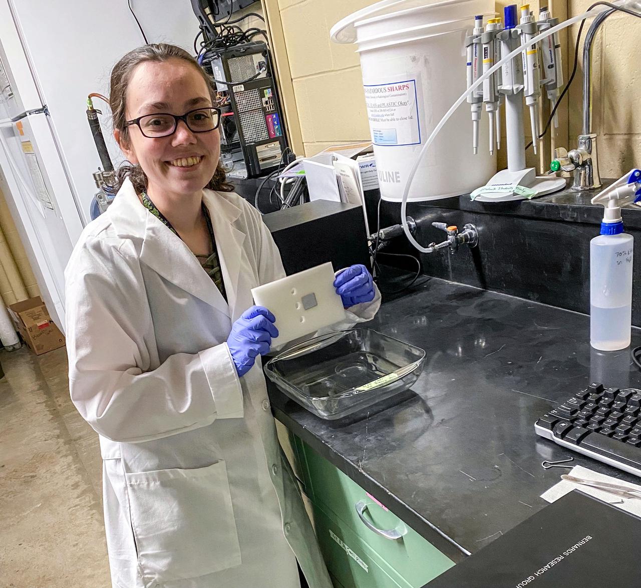
jsc2021e064550 (12/14/2021) --- Ashley Keeley tests the long-term performance of the adhesive binding the aluminum substrates to the housing material under wet conditions for the Determining the Efficacy of Bacteria Resistant Polymers in Microgravity (Bacteria Resistant Polymers in Space) investigation. Image courtesy of University of Idaho SPOCS Team.
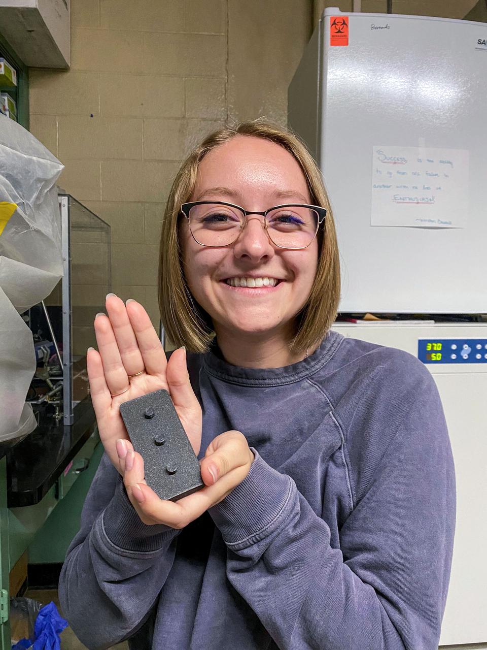
jsc2021e064551 (12/14/2021) --- Kaitlyn Harvey presents a 3D printed stand used to load and seal the bacteria introduction devices during assembly of the final experimental apparatus for the Determining the Efficacy of Bacteria Resistant Polymers in Microgravity (Bacteria Resistant Polymers in Space) investigation. Image courtesy of University of Idaho SPOCS Team.
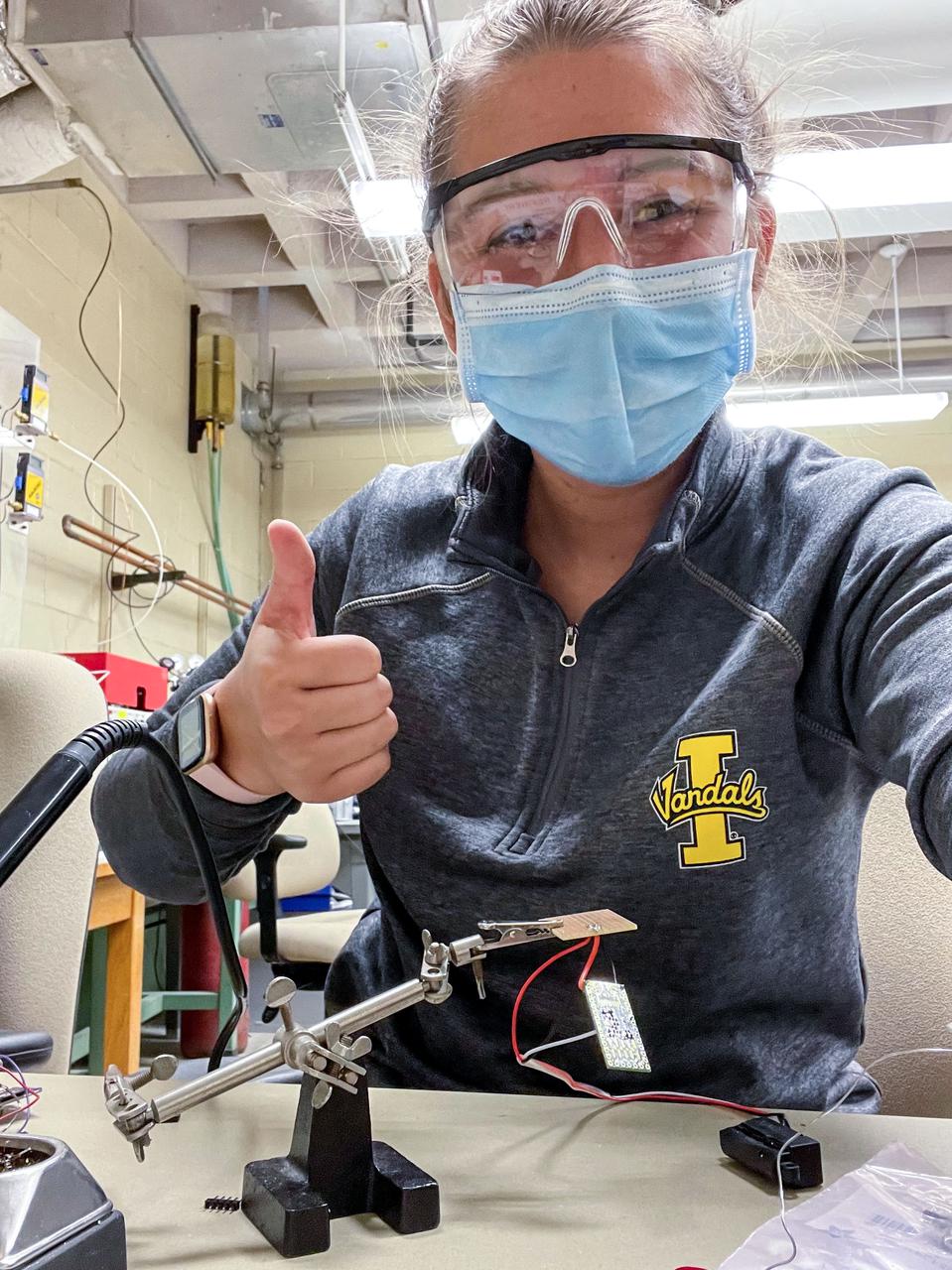
jsc2021e064549 (12/14/2021) --- Hannah Johnson solders the electrical circuitry that runs the Determining the Efficacy of Bacteria Resistant Polymers in Microgravity (Bacteria Resistant Polymers in Space) investigation autonomously aboard the International Space Station. Image courtesy of University of Idaho SPOCS Team.
iss054e037647 (Feb. 8, 2018) --- NASA astronauts (from left) Joe Acaba, Mark Vande Hei and Scott Tingle talk to high school students and teachers who linked up to the International Space Station during a STEM (Science, Technology, Engineering and Mathematics) event from the Boise State University in Boise, Idaho.
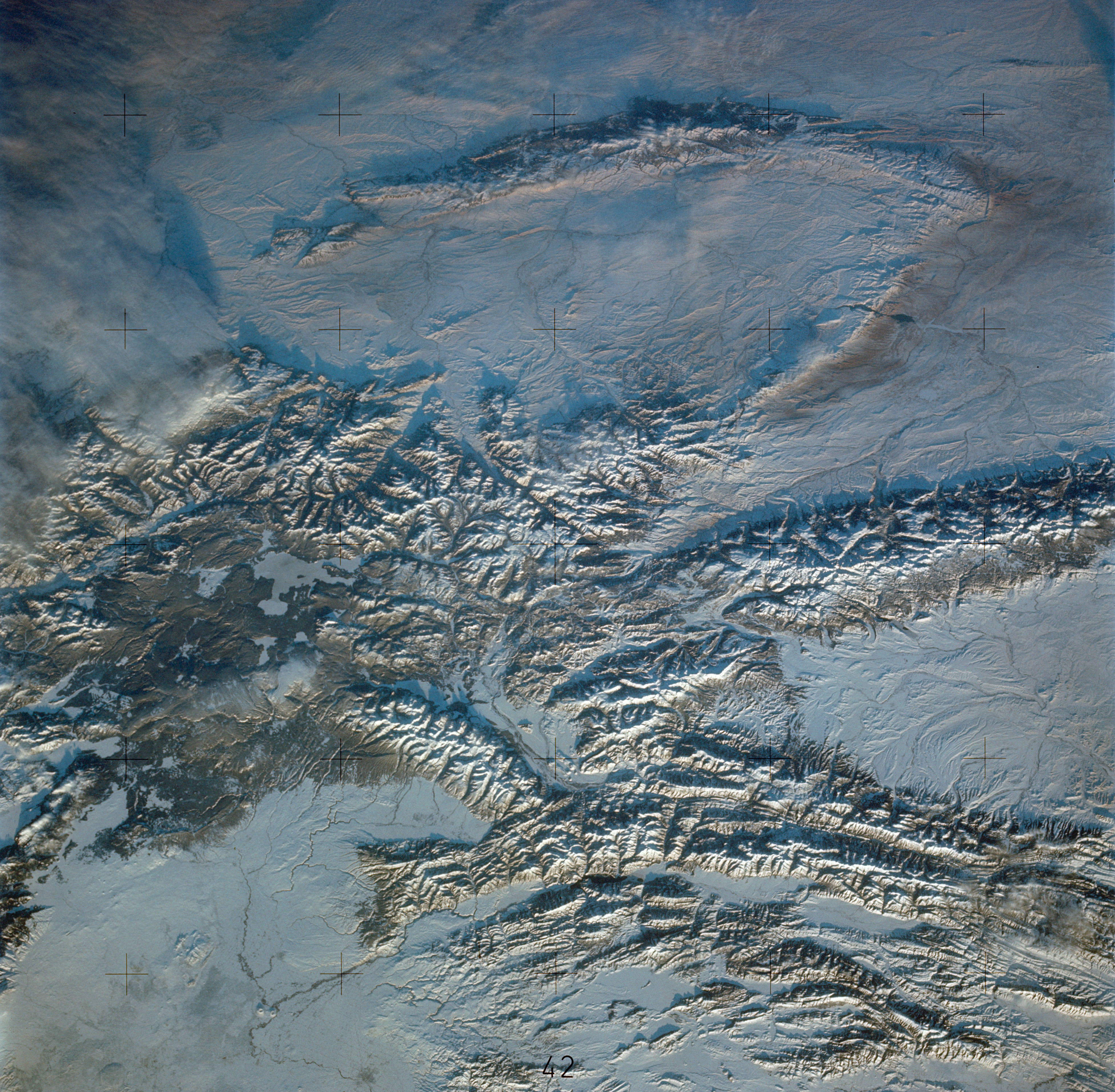
STS112-708-002 (7-18 October 2002) --- This image, photographed from the Earth-orbiting Space Shuttle Atlantis, covers parts of Utah, Colorado, Wyoming and Idaho. The Front Range of the Rockies is the dark range crossing the bottom of the view, with Denver and neighboring cities (grays) situated in the gentle embayment of the mountains (bottom center of the view). Great Salt Lake in Utah appears as two colors of blue top left, with the snow-covered Uinta Mountains just below, in this northwesterly view. Most of the view encompasses the brown plains of western Wyoming (center) and the cluster of mountains around Yellowstone (top center, top right, with snow). Beyond the brown Snake River Plain, black rocks of the Sawtooth Mountains and neighboring ranges of central Idaho appear top center.
S85-38312 (September 1985) --- Logo designed for use by the 10 finalists in NASA’s Teacher in Space Project, who were at JSC for training and orientation the week of July 8–12, 1985. They are David M. Marquart, Boise High, Boise, Idaho; Michael W. Metcalf, Hazen Union School, Hardwick, Vermont; Judith Marie Garcia, Thomas Jefferson School for Science and Technology, Alexandria, Virginia; Peggy J. Lathlaen, Westwood Elementary, Friendswood, Texas; Niki Mason Wenger, Vandevender Junior High, Parkersburg, West Virginia; Barbara R. Morgan, McCall-Donnelly Elementary, McCall, Idaho; Kathleen Anne Beres, Kenwood High, Baltimore, Maryland; Richard A. Methia, New Bedford High, New Bedford, Mass.; Sharon Christa McAuliffe, Concord High, Concord, New Hampshire; and Robert S. Foerster, Cumberland Elementary School, West Lafayette, Indiana. Photo credit: NASA
The electricity for NASA's Mars 2020 rover is provided by a power system called a Multi-Mission Radioisotope Thermoelectric Generator, or MMRTG. Essentially a nuclear battery, an MMRTG uses the heat from the natural radioactive decay of plutonium-238 to generate about 110 watts of electricity at the start of a mission. Besides generating electrical power, the MMRTG produces heat. Some of this heat can be used to maintain the rover's systems at the proper operating temperatures in the frigid cold of space and on the surface of Mars. This device, seen here before fueling and testing at the U.S. Department of Energy's Idaho National Laboratory, has "fins" that radiate excess heat. MMRTGs are provided to NASA for civil space applications by the U.S. Department of Energy (DOE). The radioisotope fuel is inserted into the MMRTG at the DOE's Idaho National Laboratory before the MMRTG is shipped to the launch site. Electrically heated versions of the MMRTG are used at JPL to verify and practice integration of the power system with the rover. https://photojournal.jpl.nasa.gov/catalog/PIA23306
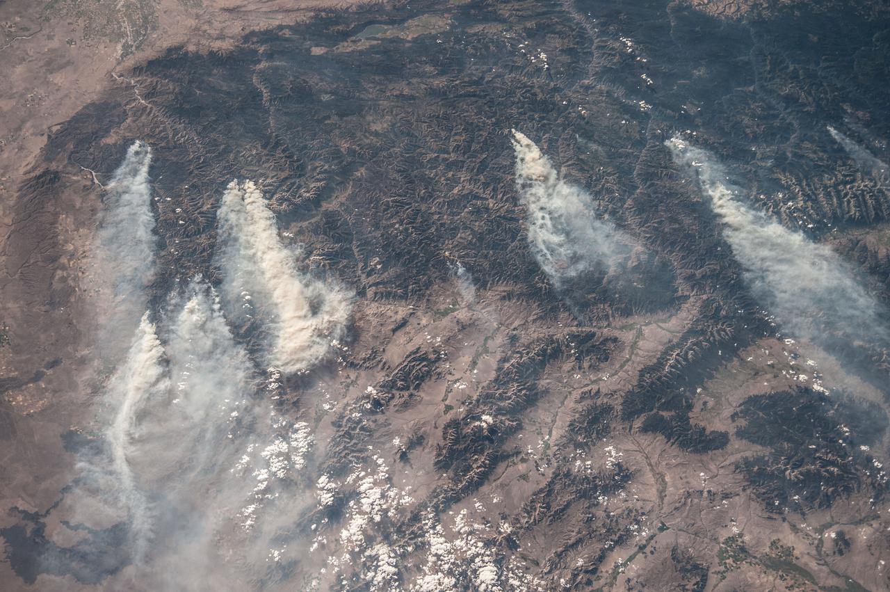
ISS036-E-032853 (18 Aug. 2013) --- Central Idaho wildfires are featured in this image photographed by an Expedition 36 crew member on the International Space Station. Taken with a short lens (50 mm), this west-looking image covers much of forested central Idaho?the dark areas are all wooded mountains. The image highlights part of the largest single wilderness area in the contiguous United States (the Frank Church-River of No Return Wilderness). Within this mountainous region, several fires can be seen producing extensive smoke plumes. Some fires had been named by Aug. 20, 2013, two days after the image was taken. The densest smoke on that day appears to be generated by a combination of the Little Queens and Leggit fires (left, within the Salmon River Mountains). The named fires were mostly set by lightning, and on Aug. 20 totaled 53,000 acres of burned forest south of the Salmon River, and many more if the unnamed fires are included. The Gold Pan fire north of the Salmon River had burned 27,000 acres. For a sense of scale in this oblique view, the Gold Pan fire lies about 125 miles north of the Little Queens fire. This image shows the common pattern of westerly winds transporting smoke in an easterly direction, as seen during the wildfire season of one year ago. Ten days before this image was taken, fires in central Idaho near Boise were aggravated by southerly winds. Some of the fires began to burn in July but were quelled and remain under observation for new flare-ups. Smoke from fires in the south partly obscures the black lava flows of the Craters of the Moon National Monument (lower left). The Beaverhead Mountains mark the eastern boundary of Idaho with Montana.

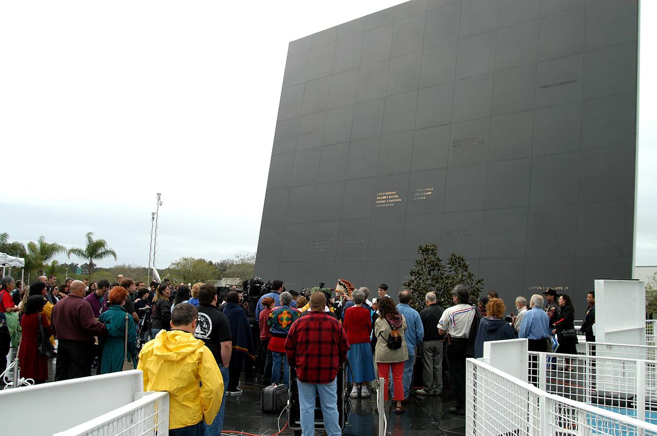
KENNEDY SPACE CENTER, FLA. - Friends, co-workers and families gather at the Space Memorial Mirror for KSC’s special service remembering and honoring the crew of Columbia. Feb. 1 is the one-year anniversary of the loss of the crew and orbiter Columbia in a tragic accident as the ship returned to Earth following mission STS-107. The public was invited to the memorial service held at the KSC Visitor Complex. Participants included Center Director Jim Kennedy, Deputy Director Woodrow Whitlow Jr., Executive Director of Florida Space Authority Winston Scott, Dr. Stephen Feldman, president of the Astronaut Memorial Foundation, and dancers from the Shoshone-Bannock Native American community in Fort Hall, Idaho.
KENNEDY SPACE CENTER, FLA. - Dancers from the Shoshone-Bannock Junior-Senior High School, Fort Hall, Idaho, perform a healing ceremony during the memorial service held at the Space Memorial Mirror for the crew of Columbia. Feb. 1 is the one-year anniversary of the loss of the crew and orbiter Columbia in a tragic accident as the ship returned to Earth following mission STS-107. Students and staff of the Shoshone-Bannock Nation had an experiment on board Columbia. The public was invited to the memorial service, held in the KSC Visitor Complex, which included comments by Center Director Jim Kennedy and Executive Director of Florida Space Authority Winston Scott. Scott is a former astronaut who flew on Columbia in 1997.
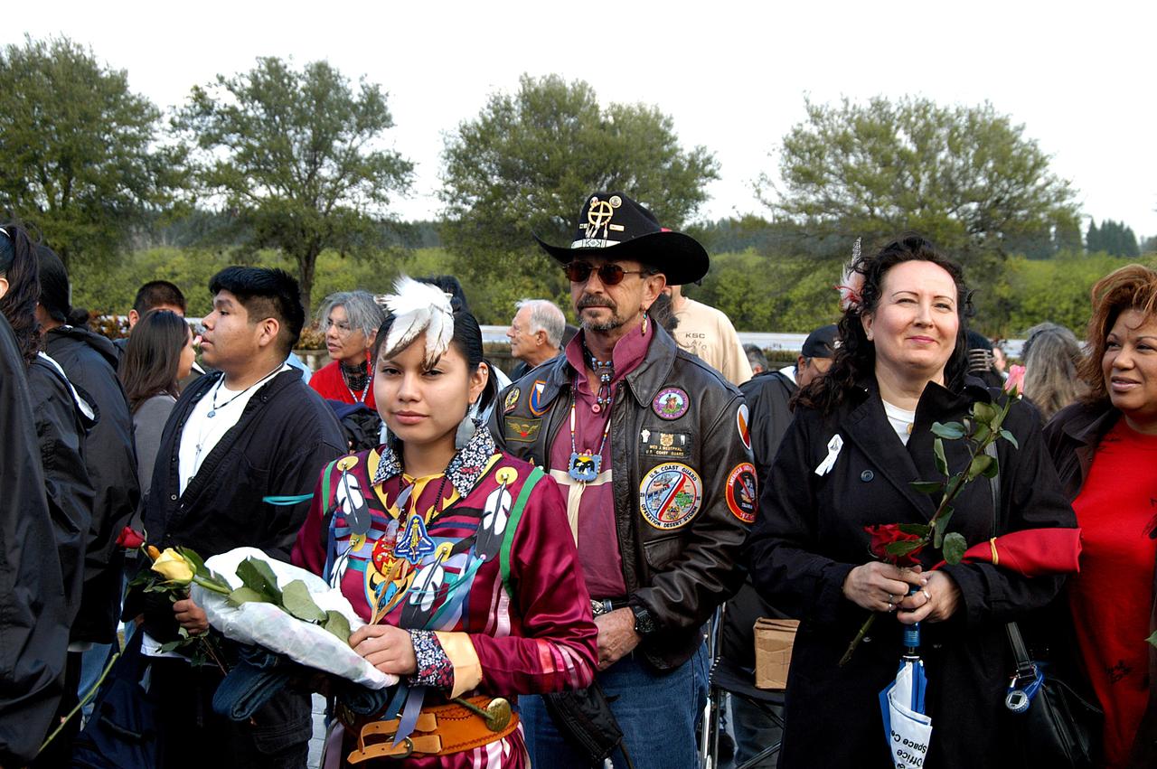
KENNEDY SPACE CENTER, FLA. - Friends, co-workers and families gather at the Space Memorial Mirror for KSC’s special service remembering and honoring the crew of Columbia. Feb. 1 is the one-year anniversary of the loss of the crew and orbiter Columbia in a tragic accident as the ship returned to Earth following mission STS-107. The public was invited to the memorial service held at the KSC Visitor Complex. Participants included Center Director Jim Kennedy, Deputy Director Woodrow Whitlow Jr., Executive Director of Florida Space Authority Winston Scott, Dr. Stephen Feldman, president of the Astronaut Memorial Foundation, and dancers from the Shoshone-Bannock Native American community in Fort Hall, Idaho.
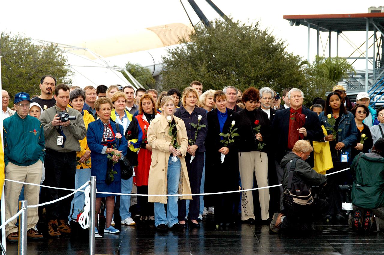
KENNEDY SPACE CENTER, FLA. - Friends, co-workers and families gather at the Space Memorial Mirror for KSC’s special service remembering and honoring the crew of Columbia. Feb. 1 is the one-year anniversary of the loss of the crew and orbiter Columbia in a tragic accident as the ship returned to Earth following mission STS-107. The public was invited to the memorial service held at the KSC Visitor Complex. Participants included Center Director Jim Kennedy, Deputy Director Woodrow Whitlow Jr., Executive Director of Florida Space Authority Winston Scott, Dr. Stephen Feldman, president of the Astronaut Memorial Foundation, and dancers from the Shoshone-Bannock Native American community in Fort Hall, Idaho.
KENNEDY SPACE CENTER, FLA. - Dancers from the Shoshone-Bannock Junior-Senior High School, Fort Hall, Idaho, perform a healing ceremony during the memorial service held at the Space Memorial Mirror for the crew of Columbia. Feb. 1 is the one-year anniversary of the loss of the crew and orbiter Columbia in a tragic accident as the ship returned to Earth following mission STS-107. Students and staff of the Shoshone-Bannock Nation had an experiment on board Columbia. The public was invited to the memorial service, held in the KSC Visitor Complex, which included comments by Center Director Jim Kennedy and Executive Director of Florida Space Authority Winston Scott. Scott is a former astronaut who flew on Columbia in 1997.
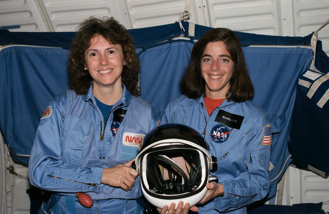
S85-46205 (December 1985) --- Sharon Christa McAuliffe (left), from Concord, New Hampshire, and Barbara R. Morgan of McCall, Idaho, have been named NASA Teacher-in-Space Project prime and backup payload specialists, respectively, for the first citizen observer position of the STS program, scheduled for a Challenger flight in January 1986. Photo credit: NASA
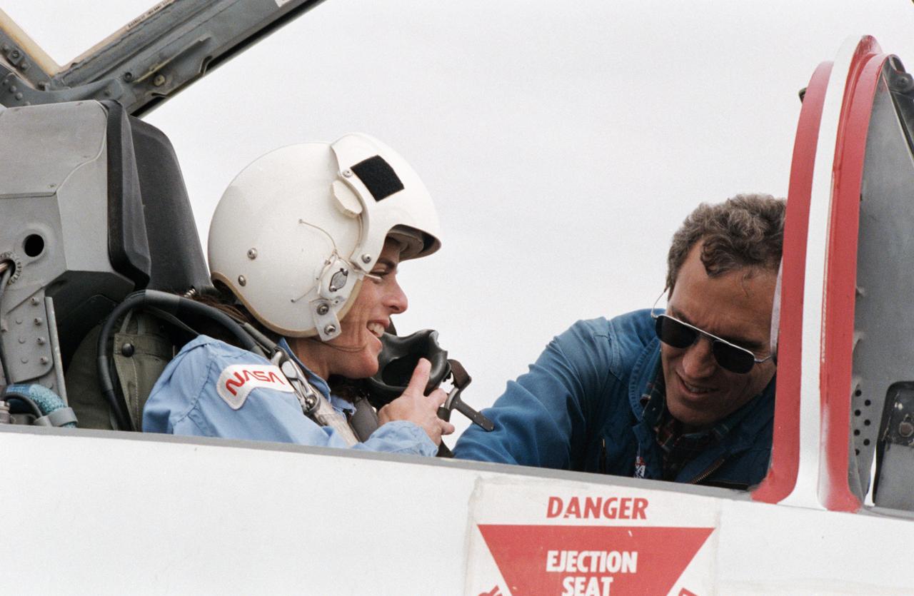
S85-41451 (3 Oct. 1985) --- Barbara Morgan, backup to the Teacher-in-Space participant Christa McAuliffe, prepares for a ride in the rear station of one of NASA's T-38 jet trainers at Ellington Field, near the Johnson Space Center (JSC). The McCall, Idaho teacher is briefed by astronaut Michael J. Smith, 51-L pilot, before departing Ellington Field. Photo credit: NASA
STS058-085-091 (18 Oct-1 Nov 1993) --- Yellowstone Lake and the surrounding Plateau are centered in this scene of northwestern Wyoming, and adjacent Idaho and Montana. The view extends across the Absaroka Range to Billings, on the Yellowstone River at the upper right edge of the photograph. Jackson Lake, Jackson Hole (valley) and the Grand Tetons extend from the Yellowstone Plateau toward the camera.
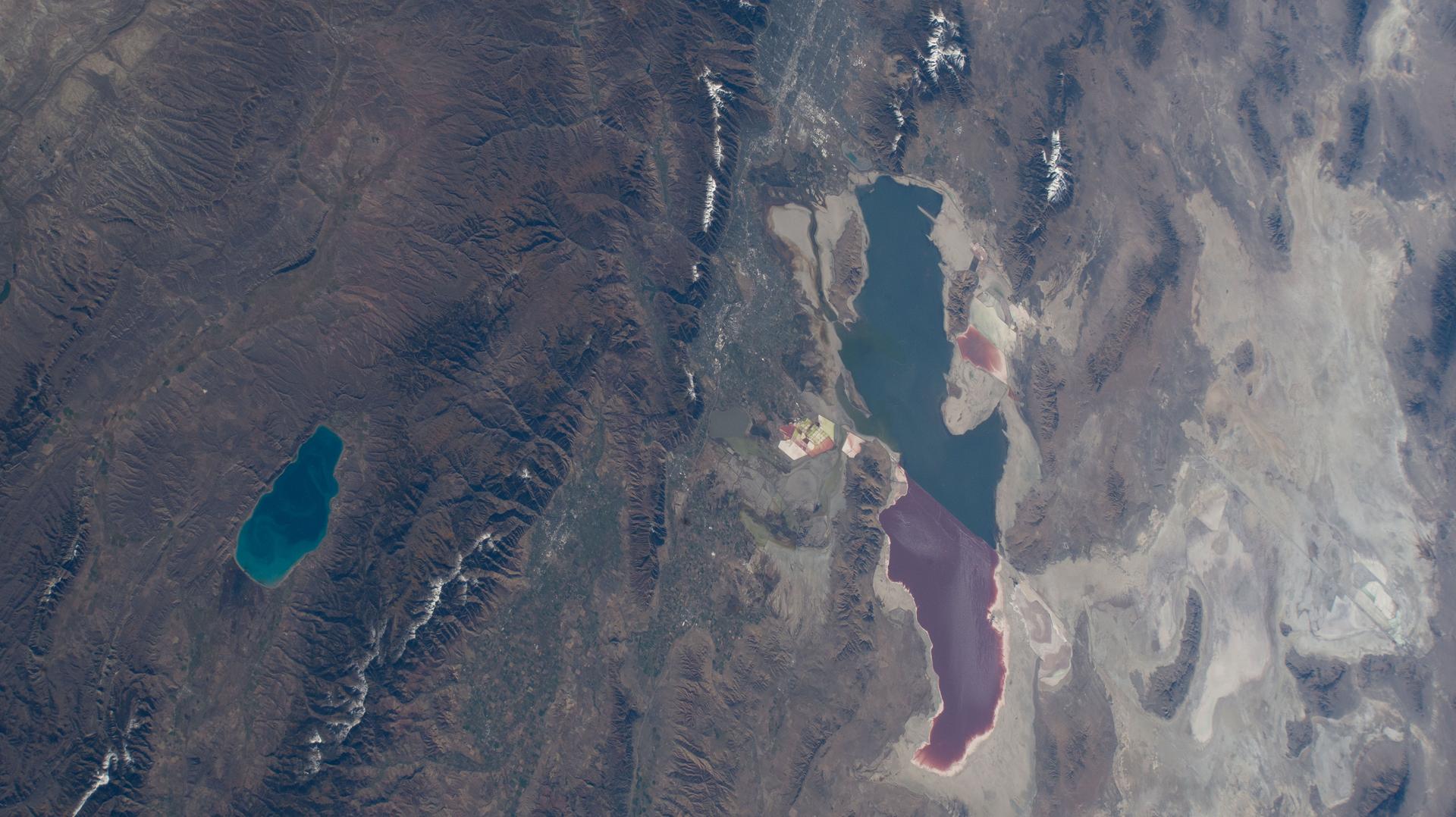
iss073e0865636 (Oct. 7, 2025) --- Bear Lake (left) is a freshwater lake spanning Idaho and Utah, and is smaller and much deeper than Utah's Great Salt Lake—averaging 208 feet compared to just 14 feet. The distinct color differences in the Great Salt Lake are caused by a railroad causeway: the red portion has much higher salinity than the blue, less saline section.
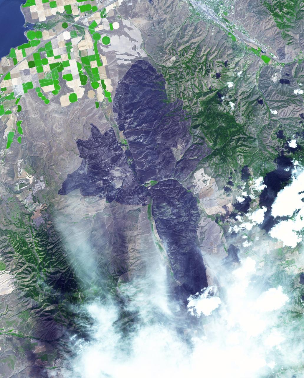
ISS033-E-005644 (19 Sept. 2012) --- One of the Expedition 33 crew members aboard the International Space Station, flying at an altitude of approximately 260 statute miles, recorded this nadir scene of the Mustang Complex wildland fires in Idaho. Close to 300,000 acres have been burned by the Mustang fires and hundreds of people have been forced to flee the area.
ISS015-E-22269 (13 Aug. 2007) --- The crew aboard the International Space Station provided this image of the wide-spread forest fires in the Payette National Forest, Central Idaho within the Salmon River Mountains. North is toward the left of the image. The Salmon River is the feature in the bottom central part of the frame. Lake Cascade is seen at the lower right.

ISS007-E-17557 (17 October 2003) --- This sweeping view of the Rocky Mountains and the western US was taken when the International Space Station (ISS) traveled over eastern Washington on October 17, 2003. The POV of the Station was looking southeast over the mountains of Idaho (foreground) and Wyoming (Yellowstone, the Tetons and the Wind River Range are just right and above the center of the image). Great Salt Lake is in the lower right of the image.

Steve Howe, former director of the Center for Space Nuclear Research at the Idaho National Laboratory, left, NASA Deputy Administrator Pam Melroy, center, and Stefanie Tompkins, director of the Defense Advance Research Projects Agency (DARPA), right, are seen during a fireside chat announcing a new collaboration on nuclear thermal propulsion at the American Institute of Aeronautics and Astronautics SciTech Forum, Tuesday, Jan. 24, 2023, at the Gaylord National Resort and Convention Center in National Harbor, Md. NASA and the Defense Advanced Research Projects Agency (DARPA) will partner on the Demonstration Rocket for Agile Cislunar Operations, or DRACO, project to develop and demonstrate in-space a nuclear thermal engine. Photo Credit: (NASA/Joel Kowsky)

Steve Howe, former director of the Center for Space Nuclear Research at the Idaho National Laboratory, left, NASA Deputy Administrator Pam Melroy, center, and Stefanie Tompkins, director of the Defense Advance Research Projects Agency (DARPA), right, are seen during a fireside chat announcing a new collaboration on nuclear thermal propulsion at the American Institute of Aeronautics and Astronautics SciTech Forum, Tuesday, Jan. 24, 2023, at the Gaylord National Resort and Convention Center in National Harbor, Md. NASA and the Defense Advanced Research Projects Agency (DARPA) will partner on the Demonstration Rocket for Agile Cislunar Operations, or DRACO, project to develop and demonstrate in-space a nuclear thermal engine. Photo Credit: (NASA/Joel Kowsky)

Steve Howe, former director of the Center for Space Nuclear Research at the Idaho National Laboratory, left, NASA Deputy Administrator Pam Melroy, center, and Stefanie Tompkins, director of the Defense Advance Research Projects Agency (DARPA), right, are seen during a fireside chat announcing a new collaboration on nuclear thermal propulsion at the American Institute of Aeronautics and Astronautics SciTech Forum, Tuesday, Jan. 24, 2023, at the Gaylord National Resort and Convention Center in National Harbor, Md. NASA and the Defense Advanced Research Projects Agency (DARPA) will partner on the Demonstration Rocket for Agile Cislunar Operations, or DRACO, project to develop and demonstrate in-space a nuclear thermal engine. Photo Credit: (NASA/Joel Kowsky)
![Today's VIS image shows the region where the northward flow of Kasei Valles turns to the east having split into two large channels. This image is located in the southern branch of Kasei Valles, called the Kasei Valles Canyon. Arising from Vallis Marineris and ending in Chryse Planitia, the valles is over 1,580 km long (982 miles), making Kasei Valles one of the largest outflow channels on Mars. [The US/Canadian border from eastern Montana to western Idaho is ~ 972 miles in length.] Orbit Number: 79041 Latitude: 21.9093 Longitude: 288.446 Instrument: VIS Captured: 2019-10-09 13:24 https://photojournal.jpl.nasa.gov/catalog/PIA23562](https://images-assets.nasa.gov/image/PIA23562/PIA23562~medium.jpg)
Today's VIS image shows the region where the northward flow of Kasei Valles turns to the east having split into two large channels. This image is located in the southern branch of Kasei Valles, called the Kasei Valles Canyon. Arising from Vallis Marineris and ending in Chryse Planitia, the valles is over 1,580 km long (982 miles), making Kasei Valles one of the largest outflow channels on Mars. [The US/Canadian border from eastern Montana to western Idaho is ~ 972 miles in length.] Orbit Number: 79041 Latitude: 21.9093 Longitude: 288.446 Instrument: VIS Captured: 2019-10-09 13:24 https://photojournal.jpl.nasa.gov/catalog/PIA23562

KENNEDY SPACE CENTER, FLA. - Some of the dancers from the Shoshone-Bannock Junior-Senior High School, Fort Hall, Idaho, hold a flag commemorating the orbiter Columbia and her crew. The dancers performed a healing ceremony during the memorial service held at the Space Memorial Mirror for the crew of Columbia. Students and staff of the Shoshone-Bannock Nation had an experiment on board Columbia. Feb. 1 is the one-year anniversary of the loss of the crew and orbiter Columbia in a tragic accident as the ship returned to Earth following mission STS-107. The public was invited to the memorial service, held in the KSC Visitor Complex, which included comments by Center Director Jim Kennedy and Executive Director of Florida Space Authority Winston Scott. Scott is a former astronaut who flew on Columbia in 1997.
KENNEDY SPACE CENTER, FLA. - At the Space Memorial Mirror in the KSC Visitor Complex, visitors gather around dancers from the Shoshone-Bannock Native American community, Fort Hall, Idaho, who are performing a healing ceremony during the memorial service held for the crew of Columbia. Feb. 1 is the one-year anniversary of the loss of the crew and orbiter Columbia in a tragic accident as the ship returned to Earth following mission STS-107. Students and staff of the Shoshone-Bannock Nation had an experiment on board Columbia. The public was invited to the memorial service, held in the KSC Visitor Complex, which included comments by Center Director Jim Kennedy and Executive Director of Florida Space Authority Winston Scott. Scott is a former astronaut who flew on Columbia in 1997.
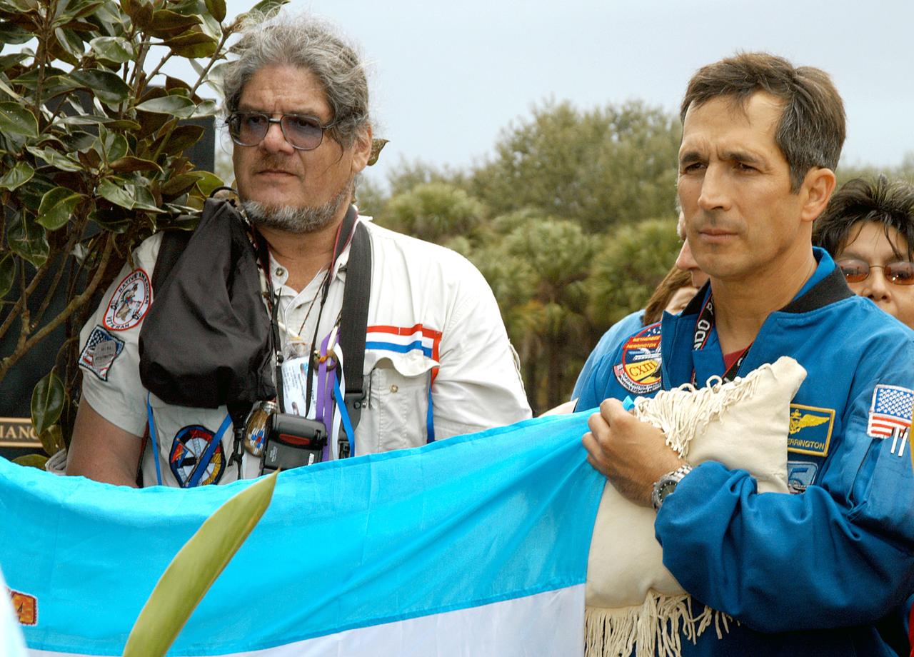
KENNEDY SPACE CENTER, FLA. - Astronaut John Herrington (right) holds part of a flag presented by dancers from the Shoshone-Bannock Junior-Senior High School, Fort Hall, Idaho, commemorating the orbiter Columbia and her crew. The dancers performed a healing ceremony during the memorial service held at the Space Memorial Mirror for the crew of Columbia. Feb. 1 is the one-year anniversary of the loss of the crew and orbiter Columbia in a tragic accident as the ship returned to Earth following mission STS-107. Students and staff of the Shoshone-Bannock Nation had an experiment on board Columbia. The public was invited to the memorial service, held in the KSC Visitor Complex, which included comments by Center Director Jim Kennedy and Executive Director of Florida Space Authority Winston Scott. Scott is a former astronaut who flew on Columbia in 1997.
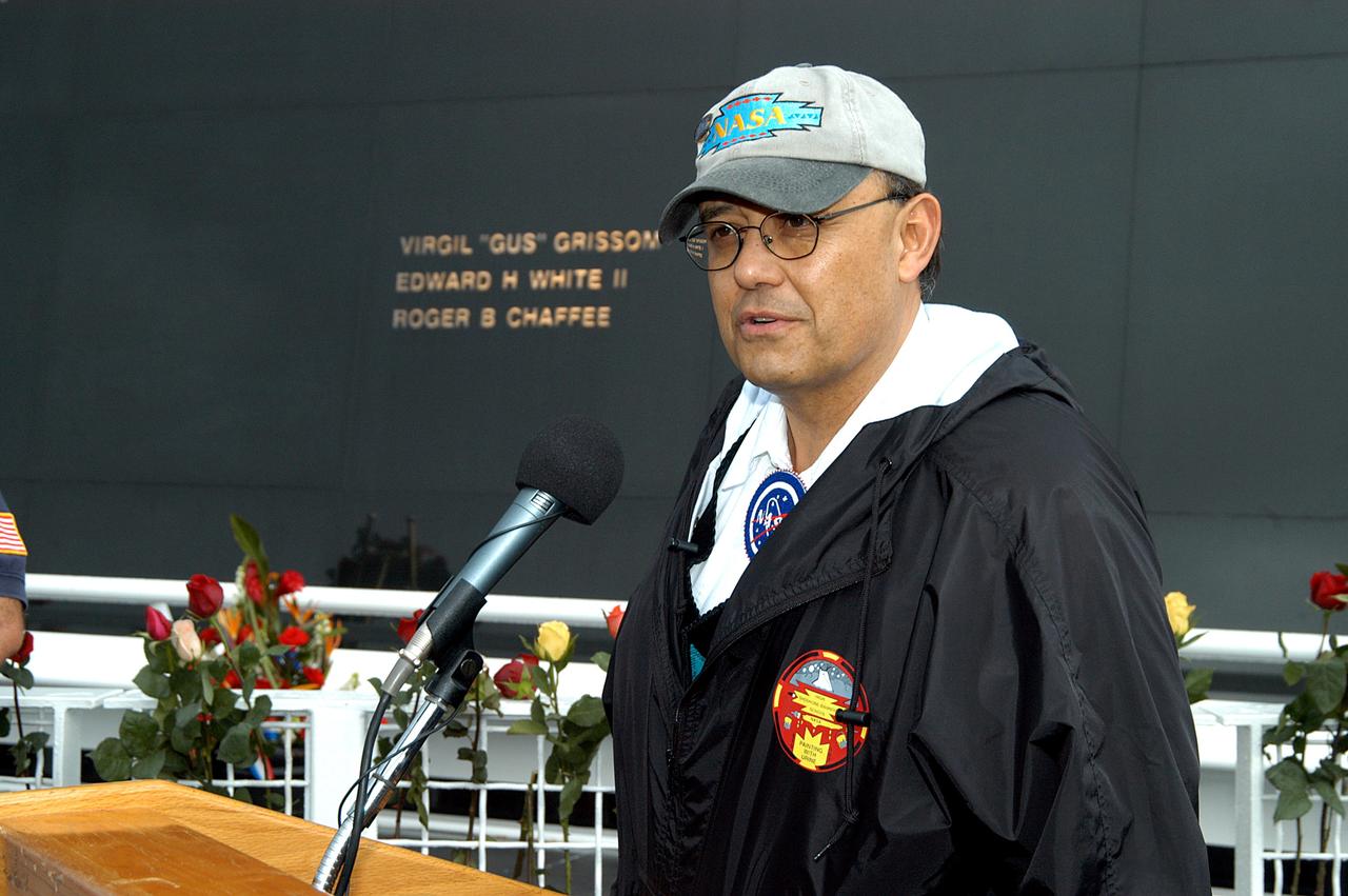
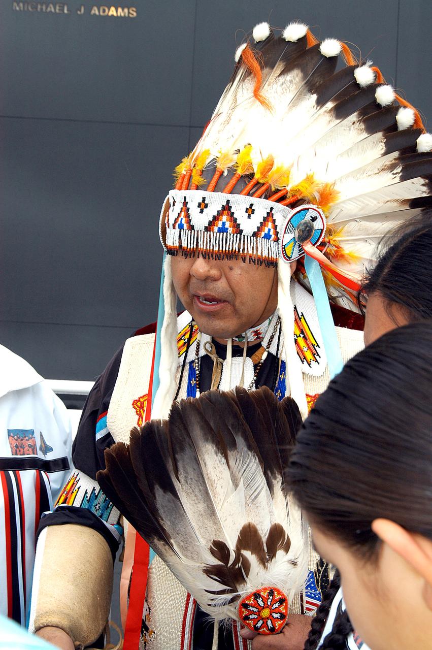
KENNEDY SPACE CENTER, FLA. - Dr. Ed Galindo speaks to the visitors at the memorial service held at the Space Memorial Mirror for the crew of Columbia. Galindo is science educator of Shoshone-Bannock High School and introduced the dancers from the Shoshone-Bannock Native American community in Fort Hall, Idaho. The dancers performed a healing ceremony during the memorial. Students and staff of the Shoshone-Bannock Nation had an experiment on board Columbia. Feb. 1 is the one-year anniversary of the loss of the crew and orbiter Columbia in a tragic accident as the ship returned to Earth following mission STS-107. The public was invited to the memorial service, held in the KSC Visitor Complex, which included comments by Center Director Jim Kennedy and Executive Director of Florida Space Authority Winston Scott. Scott is a former astronaut who flew on Columbia in 1997.
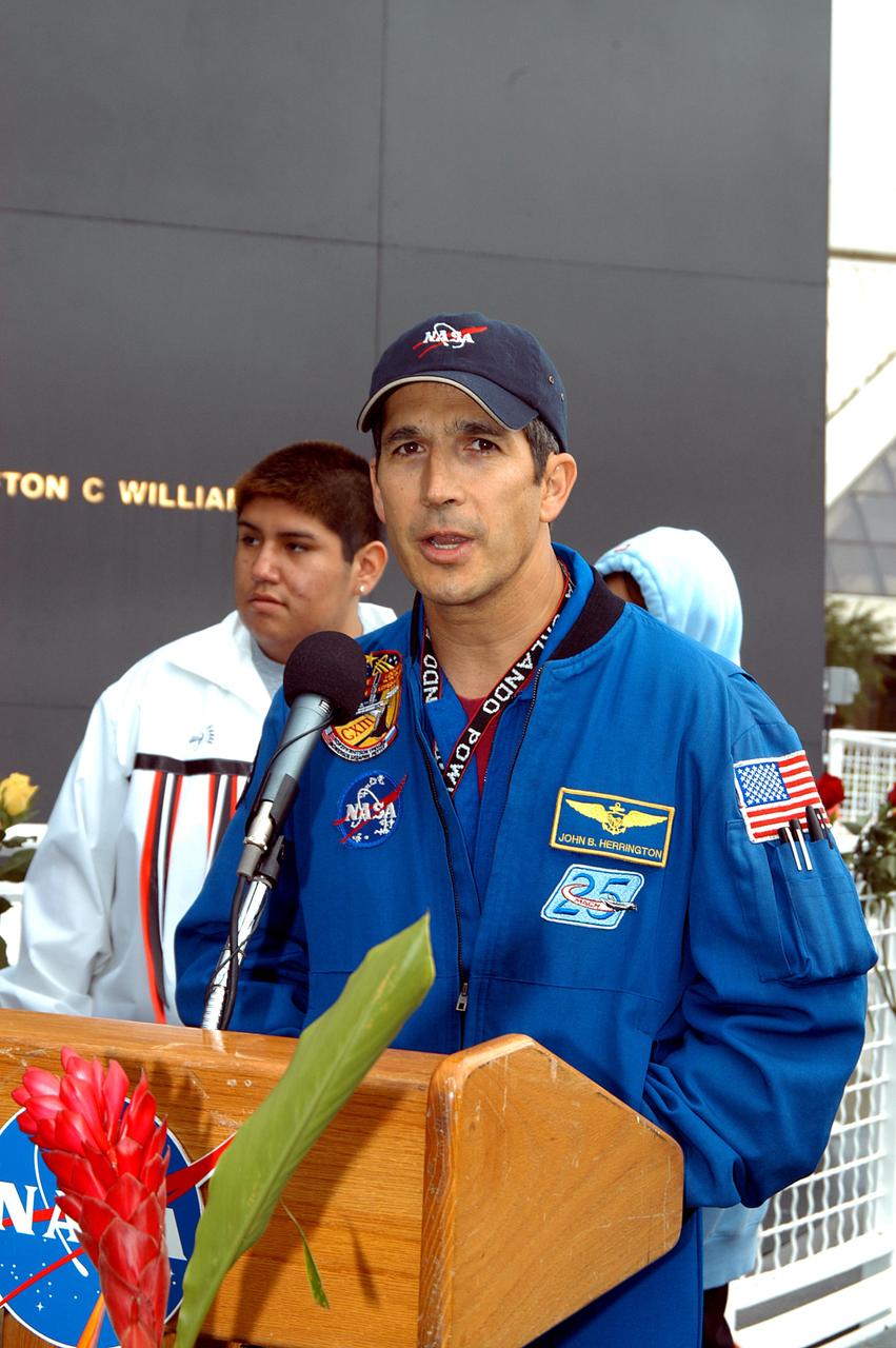
KENNEDY SPACE CENTER, FLA. - Astronaut John Herrington speaks to the visitors at the memorial service held at the Space Memorial Mirror for the crew of Columbia. Herrington, who is a Chickasaw from Oklahoma, introduced the Shoshone-Bannock Junior-Senior High School dancers, from the Native American community at Fort Hall, Idaho, who performed a healing ceremony. Students and staff of the Shoshone-Bannock Nation had an experiment on board Columbia. Feb. 1 is the one-year anniversary of the loss of the crew and orbiter Columbia in a tragic accident as the ship returned to Earth following mission STS-107. The public was invited to the memorial service, held in the KSC Visitor Complex, which included comments by Center Director Jim Kennedy and Executive Director of Florida Space Authority Winston Scott. Scott is a former astronaut who flew on Columbia in 1997.
KENNEDY SPACE CENTER, FLA. - A member of the Shoshone-Bannock Native American community from Fort Hall, Idaho, displays a handmade item with the STS-107 logo. Dancers from Shoshone-Bannock Junior-Senior High School performed a healing ceremony during the memorial held at the Space Memorial Mirror, in the KSC Visitor Complex. Feb. 1 is the one-year anniversary of the loss of the crew and orbiter Columbia in a tragic accident as the ship returned to Earth following mission STS-107. Students and staff of the Shoshone-Bannock Nation had an experiment on board Columbia. The public was invited to the memorial service, held in the KSC Visitor Complex, which included comments by Center Director Jim Kennedy and Executive Director of Florida Space Authority Winston Scott. Scott is a former astronaut who flew on Columbia in 1997.
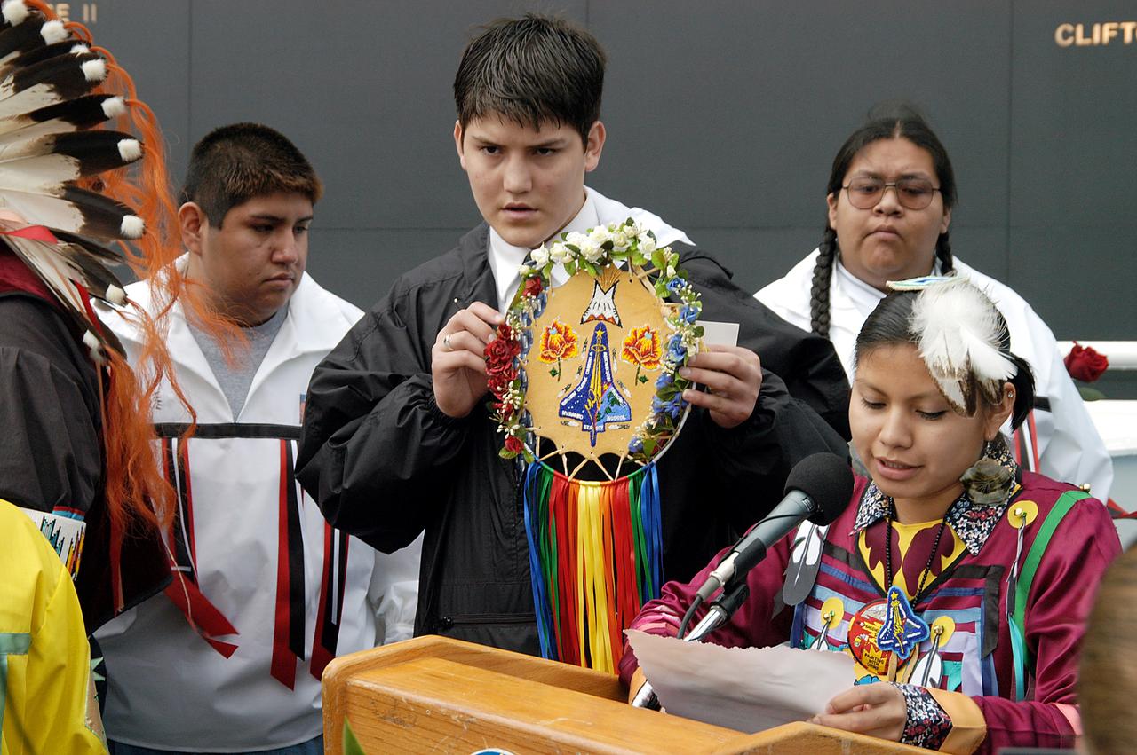
KENNEDY SPACE CENTER, FLA. - A member of the Shoshone-Bannock Native American community from Fort Hall, Idaho, reads a tribute to the crew of Columbia while another displays a handmade item with the STS-107 logo. Dancers from Shoshone-Bannock Junior-Senior High School performed a healing ceremony during the memorial held at the Space Memorial Mirror, in the KSC Visitor Complex. Feb. 1 is the one-year anniversary of the loss of the crew and orbiter Columbia in a tragic accident as the ship returned to Earth following mission STS-107. Students and staff of the Shoshone-Bannock Nation had an experiment on board Columbia. The public was invited to the memorial service, held in the KSC Visitor Complex, which included comments by Center Director Jim Kennedy and Executive Director of Florida Space Authority Winston Scott. Scott is a former astronaut who flew on Columbia in 1997.

Stefanie Tompkins, director of the Defense Advance Research Projects Agency (DARPA), right, answers a question alongside Steve Howe, former director of the Center for Space Nuclear Research at the Idaho National Laboratory, left, NASA Deputy Administrator Pam Melroy, center, during a fireside chat announcing a new collaboration on nuclear thermal propulsion at the American Institute of Aeronautics and Astronautics SciTech Forum, Tuesday, Jan. 24, 2023, at the Gaylord National Resort and Convention Center in National Harbor, Md. NASA and the Defense Advanced Research Projects Agency (DARPA) will partner on the Demonstration Rocket for Agile Cislunar Operations, or DRACO, project to develop and demonstrate in-space a nuclear thermal engine. Photo Credit: (NASA/Joel Kowsky)
SL4-138-3846 (February 1974) --- A near vertical view of the snow-covered northwest corner of Wyoming as seen from the Skylab space station in Earth orbit. A Skylab 4 crewman used a hand-held 70mm Hasselblad camera to take this picture. A small portion of Montana and Idaho is seen in this photograph also. The dark area is Yellowstone National Park. The largest body of water is Yellowstone Lake. The Absaroka Range is immediately east and northeast of Yellowstone Lake. The elongated range in the eastern part of the picture is the Big Horn Mountain range. The Wind River Range is at bottom center. The Grand Teton National Park area is almost straight south of Yellowstone Lake. Approximately 30 per cent of the state of Wyoming can be seen in this photograph. Photo credit: NASA
ISS036-E-029522 (7 Aug. 2013) --- In the International Space Station’s Kibo laboratory, NASA astronaut Karen Nyberg, Expedition 36 flight engineer, conducts a session with a pair of bowling-ball-sized free-flying satellites known as Synchronized Position Hold, Engage, Reorient, Experimental Satellites, or SPHERES. Nyberg and NASA astronaut Chris Cassidy (not pictured) put the miniature satellites through their paces for a dry run of the SPHERES Zero Robotics tournament scheduled for Aug. 13. Teams of middle school students from Florida, Georgia, Idaho and Massachusetts will gather at the Massachusetts Institute of Technology in Cambridge to see which teams’ algorithms do the best job of commanding the free-flying robots through a series of maneuvers and objectives.
ISS036-E-029539 (7 Aug. 2013) --- In the International Space Station’s Kibo laboratory, NASA astronaut Karen Nyberg, Expedition 36 flight engineer, conducts a session with a pair of bowling-ball-sized free-flying satellites known as Synchronized Position Hold, Engage, Reorient, Experimental Satellites, or SPHERES. Nyberg and NASA astronaut Chris Cassidy (not pictured) put the miniature satellites through their paces for a dry run of the SPHERES Zero Robotics tournament scheduled for Aug. 13. Teams of middle school students from Florida, Georgia, Idaho and Massachusetts will gather at the Massachusetts Institute of Technology in Cambridge to see which teams’ algorithms do the best job of commanding the free-flying robots through a series of maneuvers and objectives.
ISS036-E-029521 (7 Aug. 2013) --- In the International Space Station’s Kibo laboratory, NASA astronaut Karen Nyberg, Expedition 36 flight engineer, conducts a session with a pair of bowling-ball-sized free-flying satellites known as Synchronized Position Hold, Engage, Reorient, Experimental Satellites, or SPHERES. Nyberg and NASA astronaut Chris Cassidy (not pictured) put the miniature satellites through their paces for a dry run of the SPHERES Zero Robotics tournament scheduled for Aug. 13. Teams of middle school students from Florida, Georgia, Idaho and Massachusetts will gather at the Massachusetts Institute of Technology in Cambridge to see which teams’ algorithms do the best job of commanding the free-flying robots through a series of maneuvers and objectives.
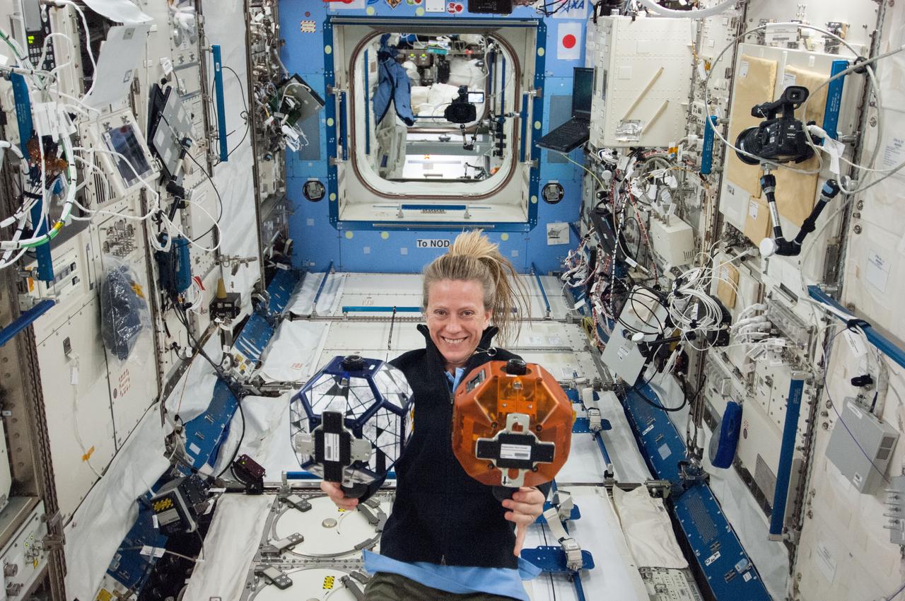
ISS036-E-029545 (7 Aug. 2013) --- In the International Space Station’s Kibo laboratory, NASA astronaut Karen Nyberg, Expedition 36 flight engineer, conducts a session with a pair of bowling-ball-sized free-flying satellites known as Synchronized Position Hold, Engage, Reorient, Experimental Satellites, or SPHERES. Nyberg and NASA astronaut Chris Cassidy (not pictured) put the miniature satellites through their paces for a dry run of the SPHERES Zero Robotics tournament scheduled for Aug. 13. Teams of middle school students from Florida, Georgia, Idaho and Massachusetts will gather at the Massachusetts Institute of Technology in Cambridge to see which teams’ algorithms do the best job of commanding the free-flying robots through a series of maneuvers and objectives.
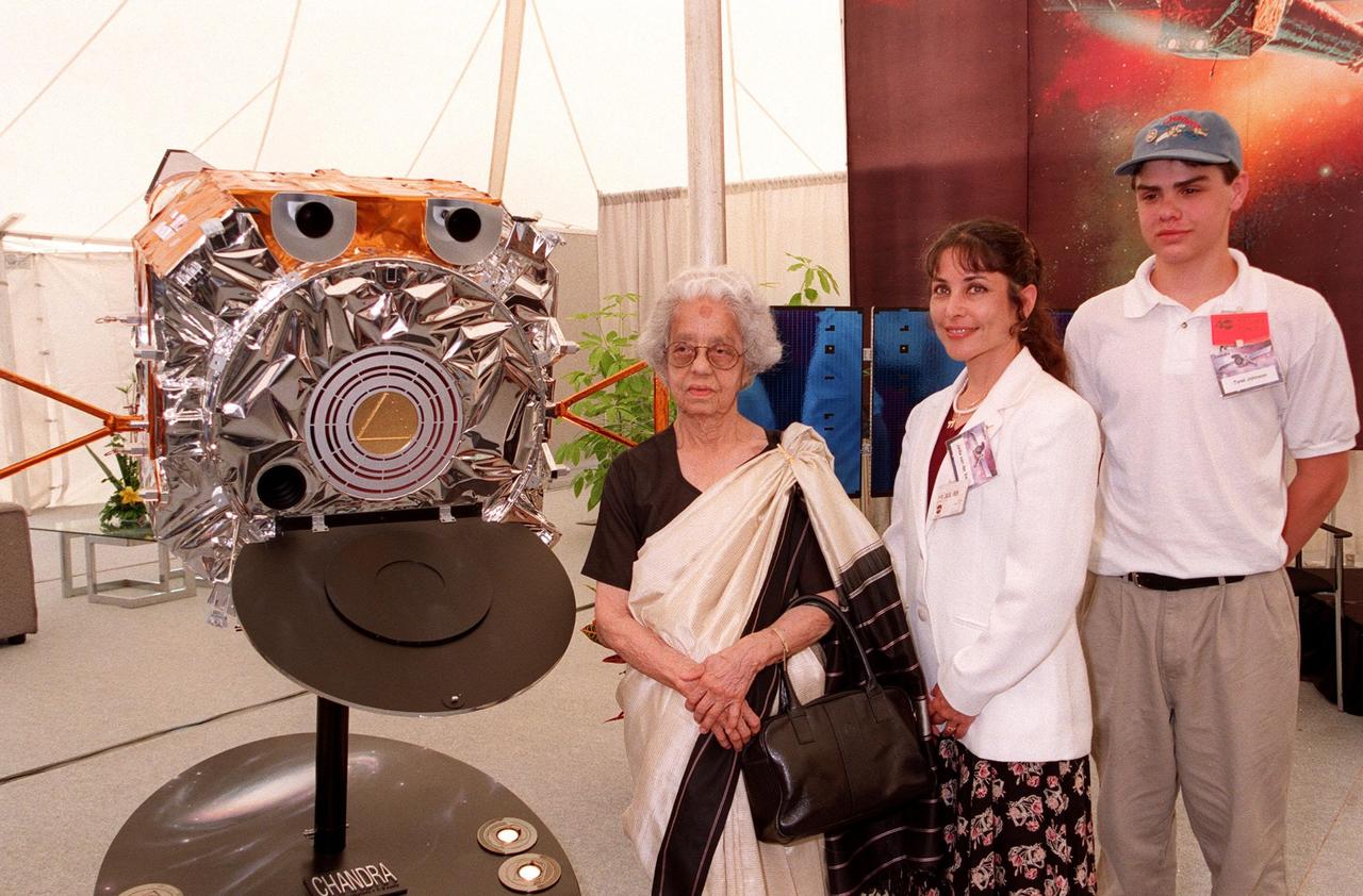
KENNEDY SPACE CENTER, FLA. -- Mrs. Lalitha Chandrasekhar (left), wife of the late Indian-American Nobel Laureate Subrahmanyan Chandrasekhar, poses with a model of the Chandra X-ray Observatory and the winners of the contest to rename the telescope in the TRW Media Hospitality Tent at the NASA Press Site at KSC. The winners of the contest are Jatila van der Veen (center), academic coordinator and lecturer, Physics Dept., University of Santa Barbara, Calif., and Tyrel Johnson (right), high school student, Laclede, Idaho. The name "Chandra," a shortened version of Chandrasekhar's name which he preferred among friends and colleagues, was chosen to honor the Nobel Laureate. "Chandra" also means "Moon" or "luminous" in Sanskrit. The observatory is scheduled to be launched aboard Columbia on Space Shuttle mission STS-93
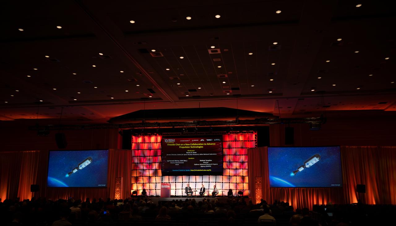
An artists concept of the Demonstration Rocket for Agile Cislunar Operations, or DRACO, spacecraft is seen on a screen as Steve Howe, former director of the Center for Space Nuclear Research at the Idaho National Laboratory, left, NASA Deputy Administrator Pam Melroy, center, and Stefanie Tompkins, director of the Defense Advance Research Projects Agency (DARPA), right, participate in a fireside chat announcing a new collaboration on nuclear thermal propulsion at the American Institute of Aeronautics and Astronautics SciTech Forum, Tuesday, Jan. 24, 2023, at the Gaylord National Resort and Convention Center in National Harbor, Md. NASA and the Defense Advanced Research Projects Agency (DARPA) will partner on the Demonstration Rocket for Agile Cislunar Operations, or DRACO, project to develop and demonstrate in-space a nuclear thermal engine. Photo Credit: (NASA/Joel Kowsky)
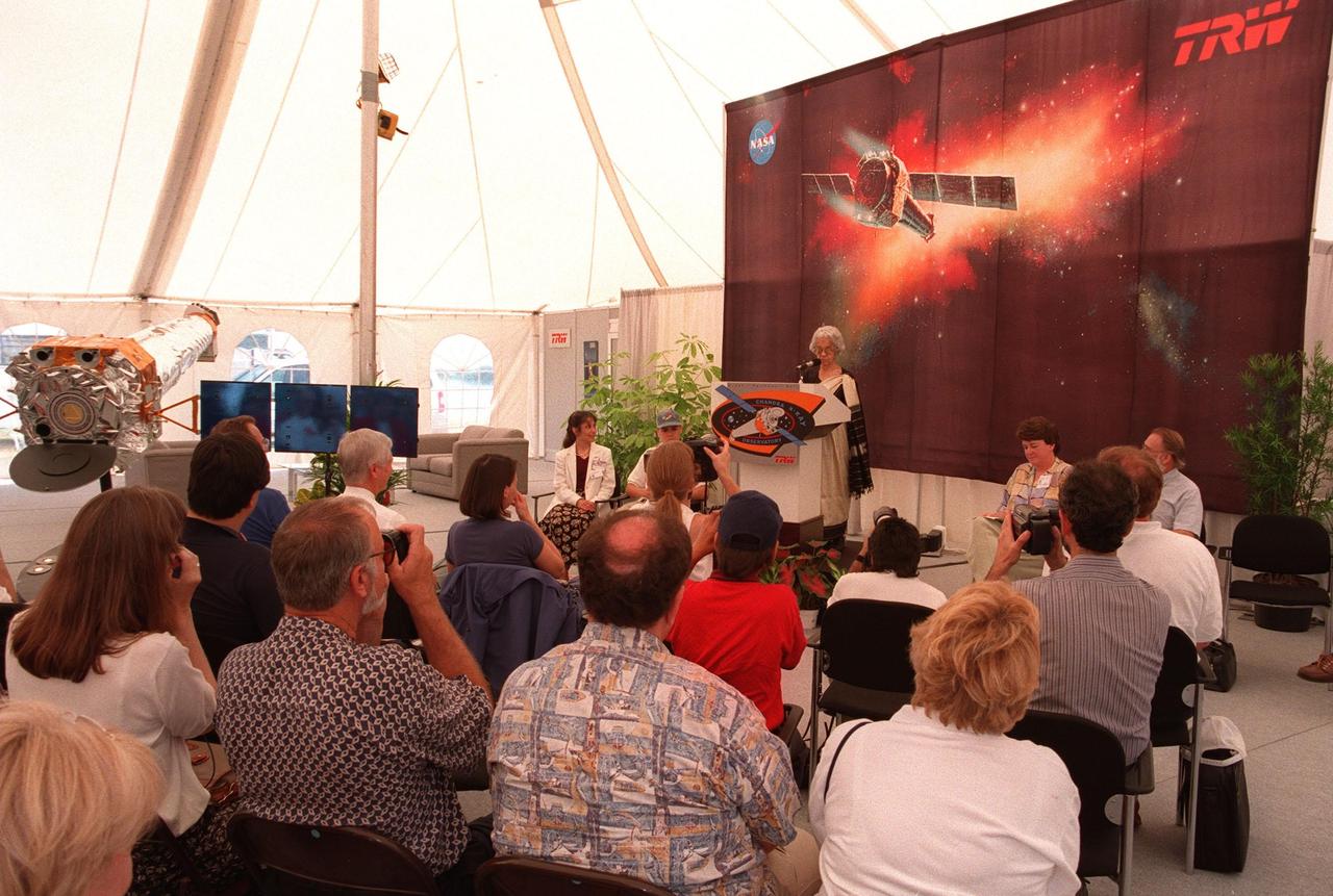
Mrs. Lalitha Chandrasekhar (at podium), wife of the late Indian-American Nobel Laureate Subrahmanyan Chandrasekhar, addresses the media and other invited guests in the TRW Media Hospitality Tent at the NASA Press Site at KSC. Other participants in the program (seated facing the audience, left to right) are the winners of the contest to rename the telescope, Jatila van der Veen, academic coordinator and lecturer, Physics Dept., University of Santa Barbara, Calif., and Tyrel Johnson, high school student, Laclede, Idaho; Joanne Maguire, vice-president and general manager, TRW Space & Laser Programs Division; and Dr. Alan Bunner, Science Program Director, Structure and Evolution of the Universe, Office of Space Science, NASA Headquarters, Washington, D.C. The name "Chandra," a shortened version of Chandrasekhar, was the name the Nobel Laureate preferred among friends and colleagues. "Chandra" also means "Moon" or "luminous" in Sanskrit. The observatory is scheduled to be launched aboard Columbia on Space Shuttle mission STS-93
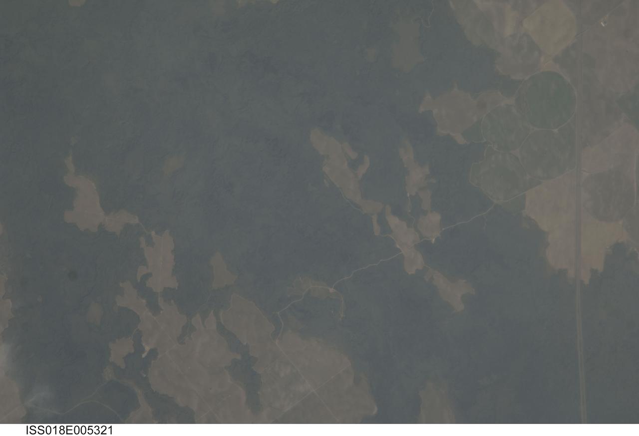
ISS018-E-005321 (24 Oct. 2008) --- The Hell's Half Acre Lava Field in Idaho is featured in this image photographed by an Expedition 18 crewmember on the International Space Station. Located in eastern Idaho, the Hell's Half Acre Lava Field is the easternmost large field associated with the Snake River Plain that arcs across the center of the state. The abundant lava flows and other volcanic rocks of the Snake River Plain are thought to be the result of southwest passage of the North American tectonic plate over a fixed mantle plume or "hotspot". According to scientists, Volcanism attributed to the hotspot began approximately 15 million years ago in the western portion of the Plain, with lava fields becoming younger to the east -- with lavas erupted approximately 4,100 years ago, Hell's Half Acre is one of the youngest lava fields. Today, the center of hotspot volcanism is located in Yellowstone National Park and feeds the extensive geyser system there. Portions of the Hell's Half Acre Lava Field are designated as a National Natural Landmark and Wilderness Study Area. This detailed photograph illustrates the forbidding landscape of the basaltic lava field -- the complex ridge patterns of the black to grey-green flow surfaces, comprised of ropy pahoehoe and blocky A a lava, are clearly visible. Regions of tan soil surrounded by lava are known as kipukas -- these "islands" are windows onto the older underlaying soil surface as they were never covered by lava. The kipukas are used for agriculture (both crops and grazing) -- several green fields are visible to the northwest of Interstate Highway 15 (right). Light to dark mottling visible in the kipukas is most likely due to variations in moisture and disturbance by agricultural activities.

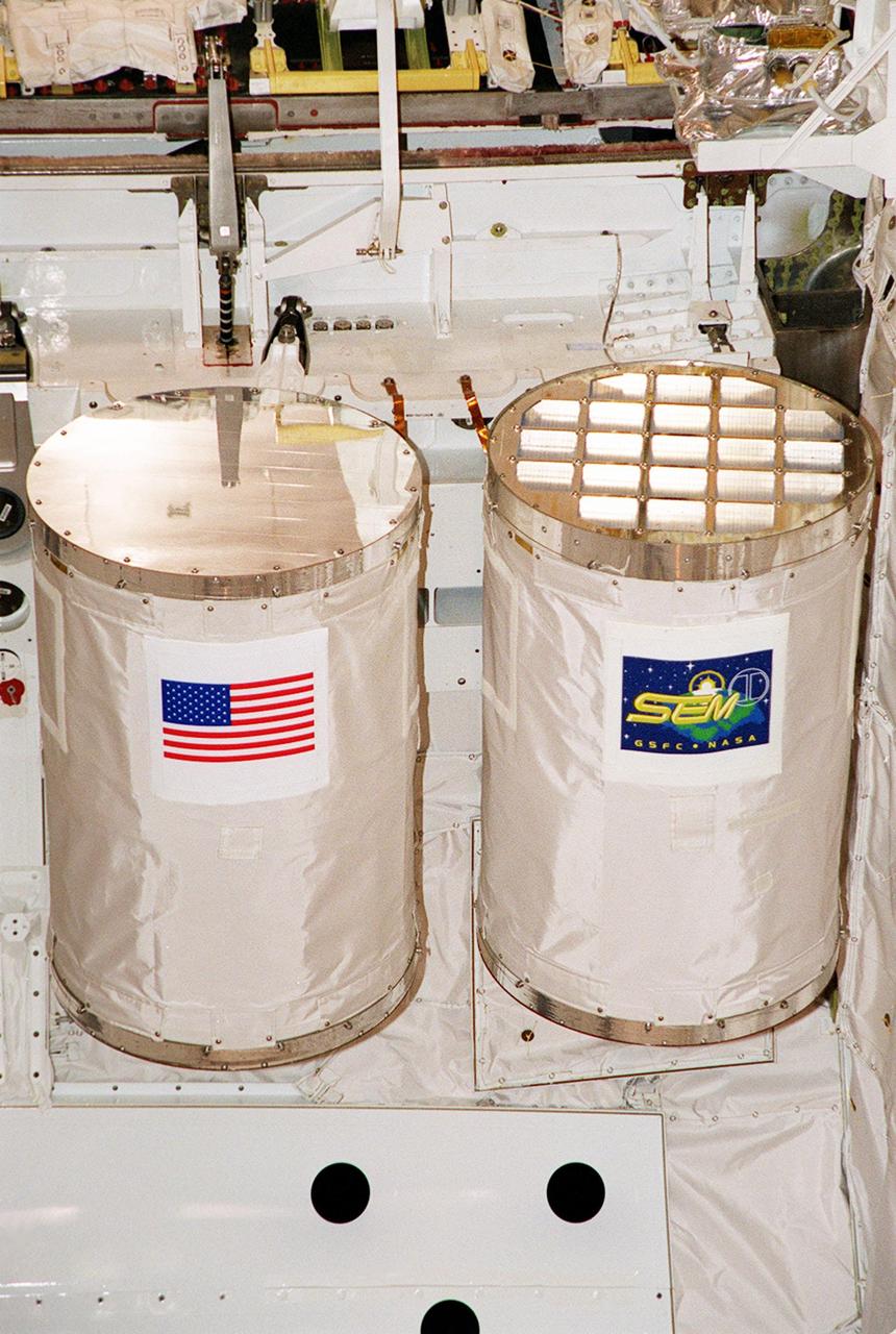
KENNEDY SPACE CENTER, FLA. -- Seen here in a closeup is a GetAway Special (GAS) known as SEM, part of the payload on mission STS-101, in the payload bay on Space Shuttle Atlantis prior to door closure. The SEM program is student-developed, focusing on the science of zero-gravity and microgravity. Selected student experiments on this sixth venture are testing the effects of space on Idaho tubers, seeds, paint, yeast, film, liquids, electronics and magnetic chips. SEM-06 is one of two GAS experiments. The other is MARS, part of the KSC Space Life Sciences Outreach Program. It includes 20 participating schools (ranging from elementary to high school) from all over the nation and one in Canada who have been involved in KSC Space Life Sciences projects over the past seven years. The MARS payload has 20 tubes filled with materials for various classroom investigations designed by the MARS schools. The primary mission of STS-101 is to deliver logistics and supplies to the International Space Station, plus prepare the Station for the arrival of the Zvezda Service Module, expected to be launched by Russia in July 2000. The crew will conduct one space walk to perform maintenance on the Space Station. This will be the third assembly flight for the Space Station. STS-101 is scheduled to launch April 24 at 4:15 p.m. from Launch Pad 39A
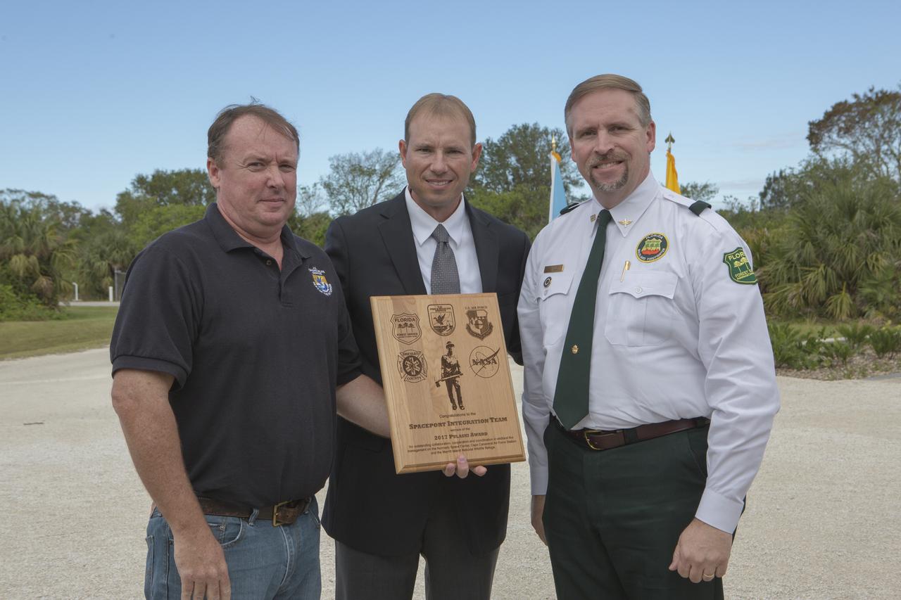
From left, Jon Wallace, deputy fire coordinator, U.S. Fish and Wildlife Service Southeast Region, Atlanta, Georgia; Chris Wilcox, U.S. Fish and Wildlife chief, Fire Management, National Interagency Fire Center, Boise, Idaho; and John Fish, chief, Florida Forest Service, pose for a portrait following a ceremony Nov. 1 on the Merritt Island National Wildlife Refuge in Florida. During the joint ceremony, the Spaceport Integration Team and its partners were presented with the prestigious 2017 Pulaski Award and a new memorial marker was dedicated. The multi-agency team includes representatives from NASA's Kennedy Space Center, Cape Canaveral Air Force Station's 45th Space Wing, the Merritt Island National Wildlife Refuge, as well as the Florida Forest Service and Brevard County Fire Rescue. The memorial marker honors two fallen firefighters, Scott Maness and Beau Sauselein, who died fighting a wildfire on space center property in 1981. Held outdoors, the ceremony was attended by 140 guests.
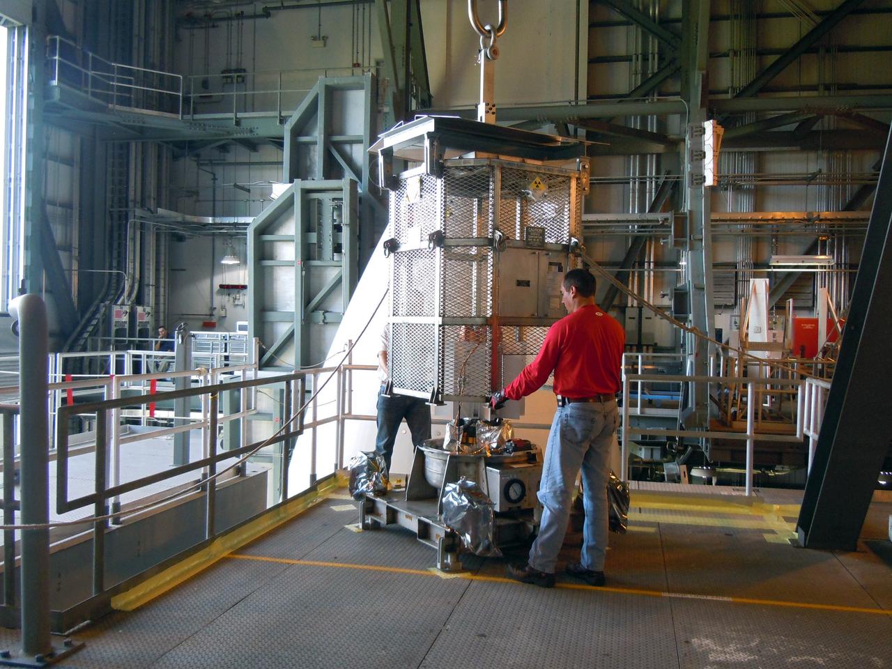
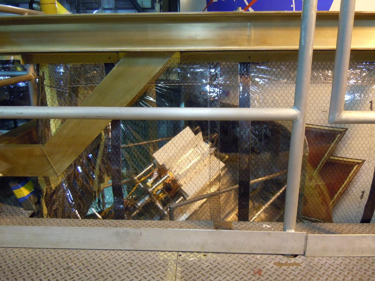
CAPE CANAVERAL, Fla. -- In the Vertical Integration Facility at Space Launch Complex-41 on Cape Canaveral Air Force Station, spacecraft technicians guide the mesh container protecting the multi-mission radioisotope thermoelectric generator (MMRTG) for NASA's Mars Science Laboratory (MSL) mission as a crane lifts it from around the generator. The container, known as the "gorilla cage," protects the MMRTG during transport and allows any excess heat generated to dissipate into the air. Next, the MMRTG will be installed on MSL's Curiosity rover. The MMRTG will generate the power needed for the mission from the natural decay of plutonium-238, a non-weapons-grade form of the radioisotope. Heat given off by this natural decay will provide constant power through the day and night during all seasons. Curiosity, MSL's car-sized rover, has 10 science instruments designed to search for signs of life, including methane, and help determine if the gas is from a biological or geological source. Waste heat from the MMRTG will be circulated throughout the rover system to keep instruments, computers, mechanical devices and communications systems within their operating temperature ranges. Launch of MSL aboard a United Launch Alliance Atlas V rocket is scheduled for Nov. 25. For more information, visit http://www.nasa.gov/msl. Photo credit: Department of Energy/Idaho National Laboratory
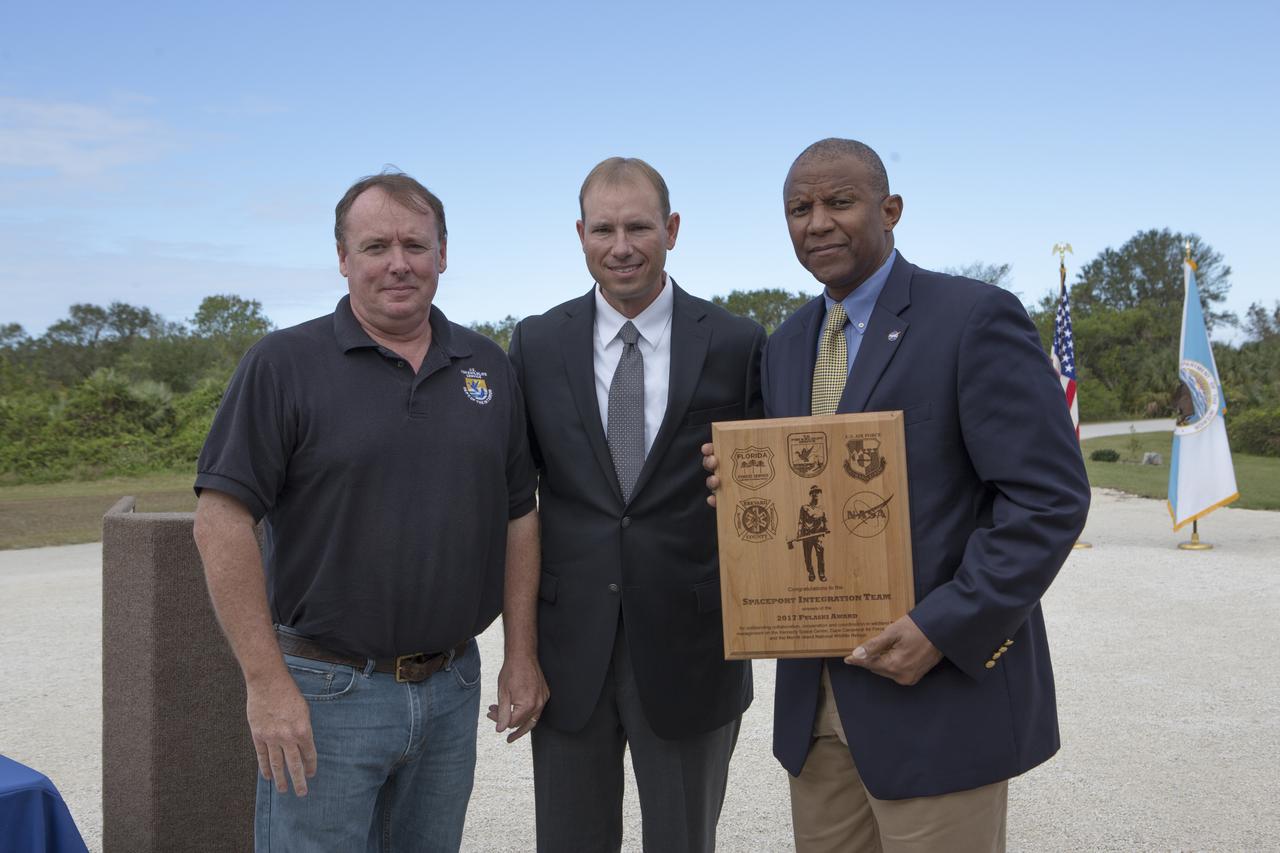
From left, Jon Wallace, deputy fire coordinator, U.S. Fish and Wildlife Service Southeast Region, Atlanta, Georgia; Chris Wilcox, U.S. Fish and Wildlife chief, Fire Management, National Interagency Fire Center, Boise, Idaho; and Kelvin Manning, associate director, NASA's Kennedy Space Center, pose for a portrait following a ceremony Nov. 1 on the Merritt Island National Wildlife Refuge in Florida. During the joint ceremony, the Spaceport Integration Team and its partners were presented with the prestigious 2017 Pulaski Award and a new memorial marker was dedicated. The multi-agency team includes representatives from NASA's Kennedy Space Center, Cape Canaveral Air Force Station's 45th Space Wing, the Merritt Island National Wildlife Refuge, as well as the Florida Forest Service and Brevard County Fire Rescue. The memorial marker honors two fallen firefighters, Scott Maness and Beau Sauselein, who died fighting a wildfire on space center property in 1981. Held outdoors, the ceremony was attended by 140 guests.
CAPE CANAVERAL, Fla. -- In the Vertical Integration Facility at Space Launch Complex-41 on Cape Canaveral Air Force Station, the multi-mission radioisotope thermoelectric generator (MMRTG) for NASA's Mars Science Laboratory (MSL) mission, secured to a turning fixture, is positioned on the radioisotope power system integration cart (RIC). The MMRTG will be installed on the Curiosity rover with the aid of the RIC. The MMRTG will generate the power needed for the mission from the natural decay of plutonium-238, a non-weapons-grade form of the radioisotope. Heat given off by this natural decay will provide constant power through the day and night during all seasons. Curiosity, MSL's car-sized rover, has 10 science instruments designed to search for signs of life, including methane, and help determine if the gas is from a biological or geological source. Waste heat from the MMRTG will be circulated throughout the rover system to keep instruments, computers, mechanical devices and communications systems within their operating temperature ranges. Launch of MSL aboard a United Launch Alliance Atlas V rocket is scheduled for Nov. 25. For more information, visit http://www.nasa.gov/msl. Photo credit: Department of Energy/Idaho National Laboratory

KENNEDY SPACE CENTER, FLA. -- Two GetAway Special (GAS) experiments SEM-06 (left) and MARS (right), part of the payload on mission STS-101, are seen here in the payload bay of Space Shuttle Atlantis prior to door closure. The SEM program is student-developed, focusing on the science of zero-gravity and microgravity. Selected student experiments on this sixth venture are testing the effects of space on Idaho tubers, seeds, paint, yeast, film, liquids, electronics and magnetic chips. MARS is the name for part of the KSC Space Life Sciences Outreach Program. It includes 20 participating schools (ranging from elementary to high school) from all over the nation and one in Canada who have been involved in KSC Space Life Sciences projects over the past seven years. The MARS payload has 20 tubes filled with materials for various classroom investigations designed by the MARS schools. The primary mission of STS-101 is to deliver logistics and supplies to the International Space Station, plus prepare the Station for the arrival of the Zvezda Service Module, expected to be launched by Russia in July 2000. The crew will conduct one space walk to perform maintenance on the Space Station. This will be the third assembly flight for the Space Station. STS-101 is scheduled to launch April 24 at 4:15 p.m. from Launch Pad 39A
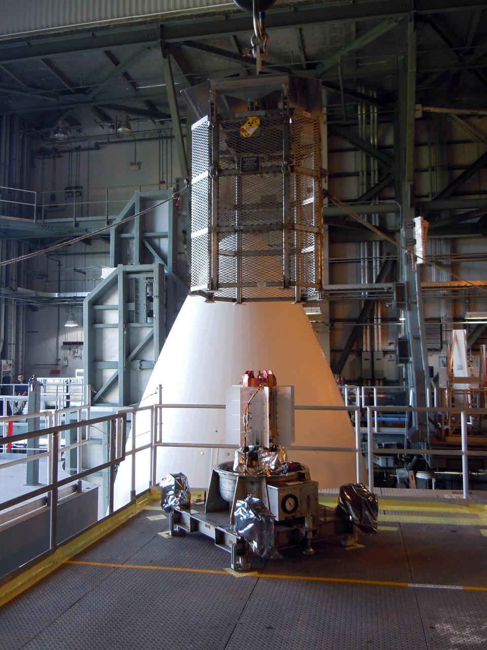
CAPE CANAVERAL, Fla. -- In the Vertical Integration Facility at Space Launch Complex-41 on Cape Canaveral Air Force Station, the multi-mission radioisotope thermoelectric generator (MMRTG) for NASA's Mars Science Laboratory (MSL) mission is uncovered during preparations to install it on MSL's Curiosity rover. The mesh container, known as the "gorilla cage," is suspended above the generator as it is lifted off the MMRTG's support base. The cage protects the MMRTG during transport and allows any excess heat generated to dissipate into the air. The MMRTG will generate the power needed for the mission from the natural decay of plutonium-238, a non-weapons-grade form of the radioisotope. Heat given off by this natural decay will provide constant power through the day and night during all seasons. Curiosity, MSL's car-sized rover, has 10 science instruments designed to search for signs of life, including methane, and help determine if the gas is from a biological or geological source. Waste heat from the MMRTG will be circulated throughout the rover system to keep instruments, computers, mechanical devices and communications systems within their operating temperature ranges. Launch of MSL aboard a United Launch Alliance Atlas V rocket is scheduled for Nov. 25. For more information, visit http://www.nasa.gov/msl. Photo credit: Department of Energy/Idaho National Laboratory
CAPE CANAVERAL, Fla. -- In the Vertical Integration Facility at Space Launch Complex-41 on Cape Canaveral Air Force Station, spacecraft technicians install the multi-mission radioisotope thermoelectric generator (MMRTG) for NASA's Mars Science Laboratory (MSL) mission on the Curiosity rover. The MMRTG will generate the power needed for the mission from the natural decay of plutonium-238, a non-weapons-grade form of the radioisotope. Heat given off by this natural decay will provide constant power through the day and night during all seasons. Curiosity, MSL's car-sized rover, has 10 science instruments designed to search for signs of life, including methane, and help determine if the gas is from a biological or geological source. Waste heat from the MMRTG will be circulated throughout the rover system to keep instruments, computers, mechanical devices and communications systems within their operating temperature ranges. Launch of MSL aboard a United Launch Alliance Atlas V rocket is scheduled for Nov. 25. For more information, visit http://www.nasa.gov/msl. Photo credit: Department of Energy/Idaho National Laboratory
The electricity needed to operate NASA's Mars 2020 rover is provided by a power system called a Multi-Mission Radioisotope Thermoelectric Generator, or MMRTG. The MMRTG will be inserted into the aft end of the rover between the panels with gold tubing visible at the rear, which are called heat exchangers. Essentially a nuclear battery, an MMRTG uses the heat from the natural radioactive decay of plutonium-238 to generate about 110 watts of electricity at the start of a mission. Besides generating useful electrical power, the MMRTG produces heat. Some of this heat can be used to maintain the rover's systems at the proper operating temperatures in the frigid cold of space and on the surface of Mars. Some of it is rejected into space via the rover's Heat Rejection System. The gold-colored tubing on the heat exchangers form part of the cooling loops of that system. The tubes carry a fluid coolant called Trichlorofluoromethane (CFC-11) that helps dissipate the excess heat. The same tubes are used to pipe some of the heat back into the belly of the rover. MMRTGs are provided to NASA for civil space applications by the U.S. Department of Energy (DOE). The radioisotope fuel is inserted into the MMRTG at the DOE's Idaho National Laboratory before the MMRTG is shipped to the launch site. Electrically heated versions of the MMRTG are used at JPL to verify and practice integration of the power system with the rover. https://photojournal.jpl.nasa.gov/catalog/PIA23305
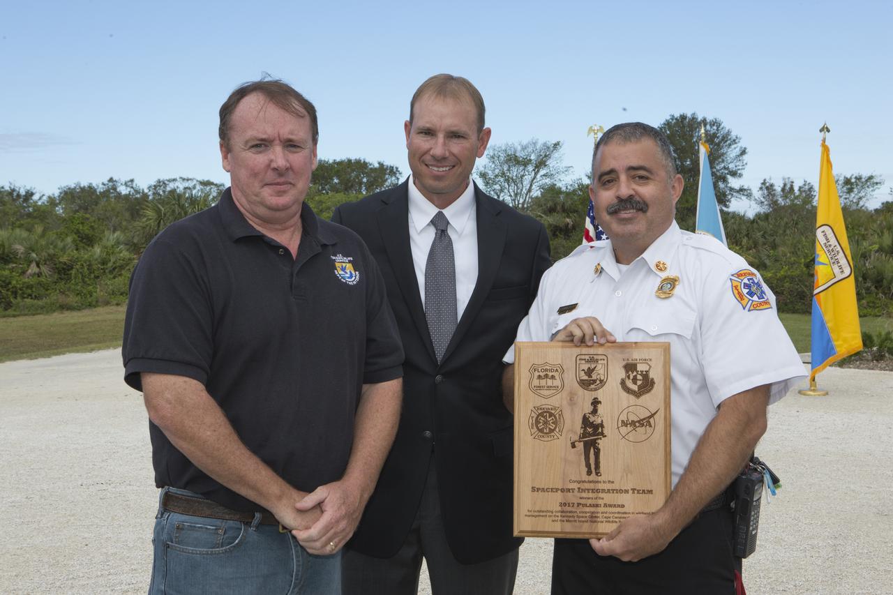
From left, Jon Wallace, deputy fire coordinator, U.S. Fish and Wildlife Service Southeast Region, Atlanta, Georgia; Chris Wilcox, U.S. Fish and Wildlife chief, Fire Management, National Interagency Fire Center, Boise, Idaho; and Mark Schollmeyer, chief, Brevard County Fire Rescue, pose for a portrait following a ceremony Nov. 1 on the Merritt Island National Wildlife Refuge in Florida. During the joint ceremony, the Spaceport Integration Team and its partners were presented with the prestigious 2017 Pulaski Award and a new memorial marker was dedicated. The multi-agency team includes representatives from NASA's Kennedy Space Center, Cape Canaveral Air Force Station's 45th Space Wing, the Merritt Island National Wildlife Refuge, as well as the Florida Forest Service and Brevard County Fire Rescue. The memorial marker honors two fallen firefighters, Scott Maness and Beau Sauselein, who died fighting a wildfire on space center property in 1981. Held outdoors, the ceremony was attended by 140 guests.
KENNEDY SPACE CENTER, FLA. -- Seen here in a closeup is a GetAway Special (GAS) known as SEM, part of the payload on mission STS-101, in the payload bay on Space Shuttle Atlantis prior to door closure. The SEM program is student-developed, focusing on the science of zero-gravity and microgravity. Selected student experiments on this sixth venture are testing the effects of space on Idaho tubers, seeds, paint, yeast, film, liquids, electronics and magnetic chips. SEM-06 is one of two GAS experiments. The other is MARS, part of the KSC Space Life Sciences Outreach Program. It includes 20 participating schools (ranging from elementary to high school) from all over the nation and one in Canada who have been involved in KSC Space Life Sciences projects over the past seven years. The MARS payload has 20 tubes filled with materials for various classroom investigations designed by the MARS schools. The primary mission of STS-101 is to deliver logistics and supplies to the International Space Station, plus prepare the Station for the arrival of the Zvezda Service Module, expected to be launched by Russia in July 2000. The crew will conduct one space walk to perform maintenance on the Space Station. This will be the third assembly flight for the Space Station. STS-101 is scheduled to launch April 24 at 4:15 p.m. from Launch Pad 39A

KENNEDY SPACE CENTER, FLA. -- Placed at the end of Space Shuttle Atlantis' payload bay are two GetAway Special (GAS) experiments, MARS (left) and SEM-06 (right). MARS is the name for part of the KSC Space Life Sciences Outreach Program. It includes 20 participating schools (ranging from elementary to high school) from all over the nation and one in Canada who have been involved in KSC Space Life Sciences projects over the past seven years. The MARS payload has 20 tubes filled with materials for various classroom investigations designed by the MARS schools. The SEM program is student-developed, focusing on the science of zero-gravity and microgravity. Selected student experiments on this sixth venture are testing the effects of space on Idaho tubers, seeds, paint, yeast, film, liquids, electronics and magnetic chips. The primary mission of STS-101 is to deliver logistics and supplies to the International Space Station, plus prepare the Station for the arrival of the Zvezda Service Module, expected to be launched by Russia in July 2000. The crew will conduct one space walk to perform maintenance on the Space Station. This will be the third assembly flight for the Space Station. STS-101 is scheduled to launch April 24 at 4:15 p.m. from Launch Pad 39A
CAPE CANAVERAL, Fla. -- At Space Launch Complex-41 on Cape Canaveral Air Force Station, spacecraft technicians in the Vertical Integration Facility prepare to install the multi-mission radioisotope thermoelectric generator (MMRTG) for NASA's Mars Science Laboratory (MSL) mission on the Curiosity rover. The MMRTG is enclosed in a protective mesh container, known as the "gorilla cage," which protects it during transport and allows any excess heat generated to dissipate into the air. The MMRTG will generate the power needed for the mission from the natural decay of plutonium-238, a non-weapons-grade form of the radioisotope. Heat given off by this natural decay will provide constant power through the day and night during all seasons. Curiosity, MSL's car-sized rover, has 10 science instruments designed to search for signs of life, including methane, and help determine if the gas is from a biological or geological source. Waste heat from the MMRTG will be circulated throughout the rover system to keep instruments, computers, mechanical devices and communications systems within their operating temperature ranges. Launch of MSL aboard a United Launch Alliance Atlas V rocket is scheduled for Nov. 25. For more information, visit http://www.nasa.gov/msl. Photo credit: Department of Energy/Idaho National Laboratory
KENNEDY SPACE CENTER, FLA. -- Two GetAway Special (GAS) experiments SEM-06 (left) and MARS (right), part of the payload on mission STS-101, are seen here in the payload bay of Space Shuttle Atlantis prior to door closure. The SEM program is student-developed, focusing on the science of zero-gravity and microgravity. Selected student experiments on this sixth venture are testing the effects of space on Idaho tubers, seeds, paint, yeast, film, liquids, electronics and magnetic chips. MARS is the name for part of the KSC Space Life Sciences Outreach Program. It includes 20 participating schools (ranging from elementary to high school) from all over the nation and one in Canada who have been involved in KSC Space Life Sciences projects over the past seven years. The MARS payload has 20 tubes filled with materials for various classroom investigations designed by the MARS schools. The primary mission of STS-101 is to deliver logistics and supplies to the International Space Station, plus prepare the Station for the arrival of the Zvezda Service Module, expected to be launched by Russia in July 2000. The crew will conduct one space walk to perform maintenance on the Space Station. This will be the third assembly flight for the Space Station. STS-101 is scheduled to launch April 24 at 4:15 p.m. from Launch Pad 39A
KENNEDY SPACE CENTER, FLA. -- Placed at the end of Space Shuttle Atlantis' payload bay are two GetAway Special (GAS) experiments, MARS (left) and SEM-06 (right). MARS is the name for part of the KSC Space Life Sciences Outreach Program. It includes 20 participating schools (ranging from elementary to high school) from all over the nation and one in Canada who have been involved in KSC Space Life Sciences projects over the past seven years. The MARS payload has 20 tubes filled with materials for various classroom investigations designed by the MARS schools. The SEM program is student-developed, focusing on the science of zero-gravity and microgravity. Selected student experiments on this sixth venture are testing the effects of space on Idaho tubers, seeds, paint, yeast, film, liquids, electronics and magnetic chips. The primary mission of STS-101 is to deliver logistics and supplies to the International Space Station, plus prepare the Station for the arrival of the Zvezda Service Module, expected to be launched by Russia in July 2000. The crew will conduct one space walk to perform maintenance on the Space Station. This will be the third assembly flight for the Space Station. STS-101 is scheduled to launch April 24 at 4:15 p.m. from Launch Pad 39A
CAPE CANAVERAL, Fla. -- In the Vertical Integration Facility at Space Launch Complex-41 on Cape Canaveral Air Force Station, a turning fixture lowers the multi-mission radioisotope thermoelectric generator (MMRTG) for NASA's Mars Science Laboratory (MSL) mission toward the radioisotope power system integration cart (RIC). Once the MMRTG is secured on the cart, it will be installed on the Curiosity rover. The MMRTG will generate the power needed for the mission from the natural decay of plutonium-238, a non-weapons-grade form of the radioisotope. Heat given off by this natural decay will provide constant power through the day and night during all seasons. Curiosity, MSL's car-sized rover, has 10 science instruments designed to search for signs of life, including methane, and help determine if the gas is from a biological or geological source. Waste heat from the MMRTG will be circulated throughout the rover system to keep instruments, computers, mechanical devices and communications systems within their operating temperature ranges. Launch of MSL aboard a United Launch Alliance Atlas V rocket is scheduled for Nov. 25. For more information, visit http://www.nasa.gov/msl. Photo credit: Department of Energy/Idaho National Laboratory
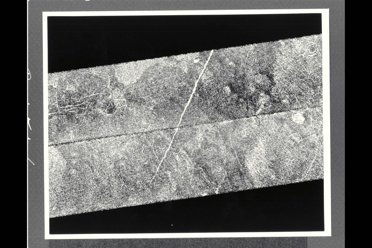
After traveling more than 1.5 billion km (948 million mi.), the Magellan spacecraft was inserted into orbit around Venus on Aug. 10, 1990. This mosaic consists of adjacent pieces of two magellan image strips obtained in the first radar test. The radar test was part of a planned In-Orbit Checkout sequence designed to prepare the magellan spacecraft and radar to begin mapping after Aug. 31. The strip on the left was returned to the Goldstone Deep Space Network station in California; the strip to the right was received at the DSN in Canberra, Australia. A third station that will be receiving Magellan data is locaterd near Madrid, Spain. Each image strip is 20 km (12 mi.) wide and 16,000 km (10,000 mi.) long. This mosaic is a small portion 80 km (50 mi.) long. This image is centered at 21 degrees north latitude and 286.8 degrees east longitude, southeast of a volcanic highland region called Beta Regio. The resolution of the image is about 120 meters (400 feet), 10 times better than revious images of the same area of Venus, revealing many new geologic features. The bright line trending northwest-southeast across the center of the image is a fracture or fault zone cutting the volcanic plains. In the upper lest corner of the image, a multiple-ring circular feature of probable volcanic origin can be seen, approx. 4.27 km (2.65 mi.) across. The bright and dark variations seen in the plains surrounding these features correspond to volcanic lava flows of varying ages. The volcanic lava flows in the southern half of the image have been cut by north-south trending faults. This area is similar geologically to volcanic deposits seen on Earth at Hawaii and the Snake River Plains in Idaho.
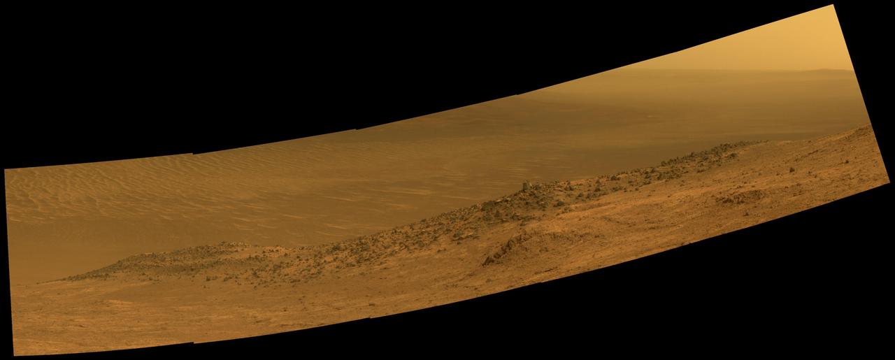
This scene from NASA's Mars Exploration Rover Opportunity shows "Wharton Ridge," which forms part of the southern wall of "Marathon Valley" on the western rim of Endeavour Crater. The full extent of Wharton Ridge is visible, with the floor of Endeavour Crater beyond it and the far wall of the crater in the distant background. Near the right edge of the scene is "Lewis and Clark Gap," through which Opportunity crossed from Marathon Valley to "Bitterroot Valley" in September 2016. Before the rover departed Marathon Valley, its panoramic camera (Pancam) acquired the component images for this scene on Aug. 30, 2016, during the 4,480th Martian day, or sol, of Opportunity's work on Mars. Opportunity's science team chose the ridge's name to honor the memory of Robert A. Wharton (1951-2012), an astrobiologist who was a pioneer in the use of terrestrial analog environments, particularly in Antarctica, to study scientific problems connected to the habitability of Mars. Over the course of his career, he was a visiting senior scientist at NASA Headquarters, vice president for research at the Desert Research Institute, provost at Idaho State University, and president of the South Dakota School of Mines and Technology. The view spans from east-northeast at left to southeast at right. It merges exposures taken through three of the Pancam's color filters, centered on wavelengths of 753 nanometers (near-infrared), 535 nanometers (green) and 432 nanometers (violet). It is presented in approximately true color. http://photojournal.jpl.nasa.gov/catalog/PIA20849
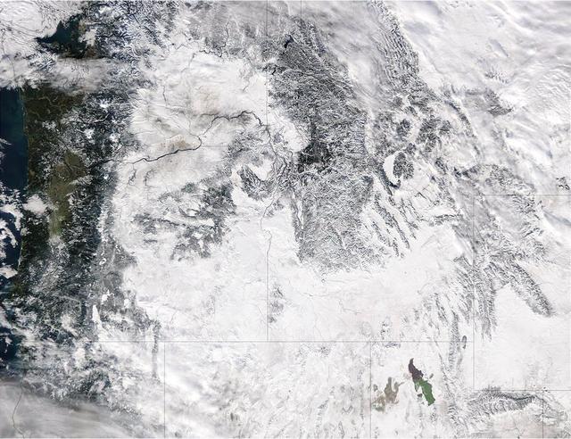
Extreme rain events have been affecting California and snow has blanketed the Pacific Northwest. This visible image from NASA's Aqua satellite on Jan. 6, 2017, at 3:35 p.m. EST (20:35 UTC) shows snow cover in the U.S. Pacific Northwest in Washington, Idaho, Oregon, northern California and Nevada. On Jan. 9, another area of low pressure moved over Oregon, where the National Weather Service is forecasting heavy snows. It was the same week last year that the West Coast endured a similar bout of very wet weather. Heavy rain affected the Pacific coast in 2016 during the same week from Jan. 5 through Jan. 7, as a progression of storm systems in the Eastern Pacific Ocean hit southern California and generated flooding and mudslides. For updated forecasts, visit the National Weather Service website at: <a href="http://www.weather.gov" rel="nofollow">www.weather.gov</a> Learn more about NASA's view of the storm: <a href="http://go.nasa.gov/2j0xpvW" rel="nofollow">go.nasa.gov/2j0xpvW</a> Credits: NASA Goddard MODIS Rapid Response <b><a href="http://www.nasa.gov/audience/formedia/features/MP_Photo_Guidelines.html" rel="nofollow">NASA image use policy.</a></b> <b><a href="http://www.nasa.gov/centers/goddard/home/index.html" rel="nofollow">NASA Goddard Space Flight Center</a></b> enables NASA’s mission through four scientific endeavors: Earth Science, Heliophysics, Solar System Exploration, and Astrophysics. Goddard plays a leading role in NASA’s accomplishments by contributing compelling scientific knowledge to advance the Agency’s mission. <b>Follow us on <a href="http://twitter.com/NASAGoddardPix" rel="nofollow">Twitter</a></b> <b>Like us on <a href="http://www.facebook.com/pages/Greenbelt-MD/NASA-Goddard/395013845897?ref=tsd" rel="nofollow">Facebook</a></b> <b>Find us on <a href="http://instagrid.me/nasagoddard/?vm=grid" rel="nofollow">Instagram</a></b>
The Multi-Mission Radioisotope Thermoelectric Generator for NASA'S Mars 2020 Perseverance rover is shown during a fit check with the rover in a payload processing facility at NASA's Kennedy Space Center in Florida on April 16-17, 2020. The Multi-Mission Radioisotope Thermoelectric Generator is designed and built by the U.S. Department of Energy, and provided to NASA as part of the space agency's Radioisotope Power Systems Program. It arrived at NASA KSC in April 2020 following its final assembly and transport from the Department of Energy's Idaho National Laboratory. The fit check is the first time that the fueled flight generator is connected to the rover. After the successful fit check, the Multi-Mission Radioisotope Thermoelectric Generator was disconnected; it will be connected to the rover for the final time on the launch pad atop the mission's Atlas V launch vehicle in July, before the planned launch of the Mars 2020 mission. The Multi-Mission Radioisotope Thermoelectric Generator is a space nuclear power system that produces about 110 watts of electrical power to run the rover's systems and science instruments, and extra heat to keep them warm during the frigid Martian nights and winter seasons. It converts the heat from the natural radioactive decay of plutonium dioxide into electricity using thermocouples with no moving parts. The choice of a Multi-Mission Radioisotope Thermoelectric Generator as the rover's power system gave mission planners significantly more flexibility in selecting the rover's landing site and in planning its surface operations. https://photojournal.jpl.nasa.gov/catalog/PIA23981
Technicians in the payload processing facility at NASA's Kennedy Space Center in Florida perform a fit check between NASA'S Mars 2020 Perseverance rover and its Multi-Mission Radioisotope Thermoelectric Generator on April 16-17, 2020. The Multi-Mission Radioisotope Thermoelectric Generator is designed and built by the U.S. Department of Energy, and provided to NASA as part of the space agency's Radioisotope Power Systems Program. It arrived at NASA KSC in April 2020 following its final assembly and transport from the Department of Energy's Idaho National Laboratory. The fit check is the first time that the fueled flight generator is connected to the rover. After the successful fit check, the Multi-Mission Radioisotope Thermoelectric Generator was disconnected; it will be connected to the rover for the final time on the launch pad atop the mission's Atlas V launch vehicle in July, before the planned launch of the Mars 2020 mission. The Multi-Mission Radioisotope Thermoelectric Generator is a space nuclear power system that produces about 110 watts of electrical power to run the rover's systems and science instruments, and extra heat to keep them warm during the frigid Martian nights and winter seasons. It converts the heat from the natural radioactive decay of plutonium dioxide into electricity using thermocouples with no moving parts. The choice of a Multi-Mission Radioisotope Thermoelectric Generator as the rover's power system gave mission planners significantly more flexibility in selecting the rover's landing site and in planning its surface operations. https://photojournal.jpl.nasa.gov/catalog/PIA23827

The Rocky, Cascade, and Coast Mountain Ranges dominate the landscape of the Pacific Northwest in this image created June 11-17, 2012 from the Visible-Infrared Imager/Radiometer Suite (VIIRS) instrument aboard the Suomi National Polar-orbiting Partnership or Suomi NPP satellite, a partnership between NASA and the National Oceanic and Atmospheric Administration, or NOAA. Potato and other agriculture can be seen in the bottom center of the image, as the Rockies transition to the plains of Idaho. High values of Normalized Difference Vegetation Index, or NDVI, represent dense green functioning vegetation and low NDVI values represent sparse green vegetation or vegetation under stress from limiting conditions, such as drought. Credit: NASA/NOAA To read more go to: <a href="http://www.nasa.gov/mission_pages/NPP/news/vegetation.html" rel="nofollow">www.nasa.gov/mission_pages/NPP/news/vegetation.html</a> <b><a href="http://www.nasa.gov/audience/formedia/features/MP_Photo_Guidelines.html" rel="nofollow">NASA image use policy.</a></b> <b><a href="http://www.nasa.gov/centers/goddard/home/index.html" rel="nofollow">NASA Goddard Space Flight Center</a></b> enables NASA’s mission through four scientific endeavors: Earth Science, Heliophysics, Solar System Exploration, and Astrophysics. Goddard plays a leading role in NASA’s accomplishments by contributing compelling scientific knowledge to advance the Agency’s mission. <b>Follow us on <a href="http://twitter.com/NASA_GoddardPix" rel="nofollow">Twitter</a></b> <b>Like us on <a href="http://www.facebook.com/pages/Greenbelt-MD/NASA-Goddard/395013845897?ref=tsd" rel="nofollow">Facebook</a></b> <b>Find us on <a href="http://instagram.com/nasagoddard?vm=grid" rel="nofollow">Instagram</a></b>
This image shows the Multi-Mission Radioisotope Thermoelectric Generator for NASA'S Mars 2020 Perseverance rover during a fit check with the rover in the payload processing facility at NASA's Kennedy Space Center in Florida on April 16-17, 2020. The Multi-Mission Radioisotope Thermoelectric Generator is designed and built by the U.S. Department of Energy, and provided to NASA as part of the space agency's Radioisotope Power Systems Program. It arrived at NASA KSC in April 2020 following its final assembly and transport from the Department of Energy's Idaho National Laboratory. The fit check is the first time that the fueled flight generator is connected to the rover. After the successful fit check, the Multi-Mission Radioisotope Thermoelectric Generator was disconnected; it will be connected to the rover for the final time on the launch pad atop the mission's Atlas V launch vehicle in July, before the planned launch of the Mars 2020 mission. The Multi-Mission Radioisotope Thermoelectric Generator is a space nuclear power system that produces about 110 watts of electrical power to run the rover's systems and science instruments, and extra heat to keep them warm during the frigid Martian nights and winter seasons. It converts the heat from the natural radioactive decay of plutonium dioxide into electricity using thermocouples with no moving parts. The choice of a Multi-Mission Radioisotope Thermoelectric Generator as the rover's power system gave mission planners significantly more flexibility in selecting the rover's landing site and in planning its surface operations. https://photojournal.jpl.nasa.gov/catalog/PIA23982
NASA launched a Terrier-Improved Malemute suborbital sounding rocket carrying the RockSat-X payload with university and community college student experiments at 6:04 a.m. EDT Wednesday, Aug. 12, from NASA’s Wallops Flight Facilityin Virginia. More than 60 students and instructors from across the continental United States, Hawaii and Puerto Rico were on hand to witness the launch of their experiments. The payload flew to an altitude of about 97 miles and descended via parachute into the Atlantic Ocean off the coast of Wallops. Payload recovery operations began after lift-off. Developed by students from seven higher education programs, the experiments flew through the RockSat-X program in conjunction with the Colorado Space Grant Consortium. Participating institutions in this flight are the University of Colorado, Boulder; Northwest Nazarene University, Nampa, Idaho; the University of Puerto Rico; the University of Nebraska, Lincoln; Virginia Tech University, Blacksburg; Capitol Technology University, Laurel, Maryland; and University of Hawai'i Community Colleges at the Honolulu, Kapi'olani, Kaua'i, and Windward campuses. The next launch scheduled from Wallops is a NASA Black Brant IX suborbital sounding rocket carrying several technology development instruments. The launch is scheduled between 7 and 7:41 p.m. Sept. 29. The backup launch days are Sept. 30 through Oct. 12. <b><a href="http://www.nasa.gov/audience/formedia/features/MP_Photo_Guidelines.html" rel="nofollow">NASA image use policy.</a></b> <b><a href="http://www.nasa.gov/centers/goddard/home/index.html" rel="nofollow">NASA Goddard Space Flight Center</a></b> enables NASA’s mission through four scientific endeavors: Earth Science, Heliophysics, Solar System Exploration, and Astrophysics. Goddard plays a leading role in NASA’s accomplishments by contributing compelling scientific knowledge to advance the Agency’s mission. <b>Follow us on <a href="http://twitter.com/NASAGoddardPix" rel="nofollow">Twitter</a></b> <b>Like us on <a href="http://www.facebook.com/pages/Greenbelt-MD/NASA-Goddard/395013845897?ref=tsd" rel="nofollow">Facebook</a></b> <b>Find us on <a href="http://instagrid.me/nasagoddard/?vm=grid" rel="nofollow">Instagram</a></b>
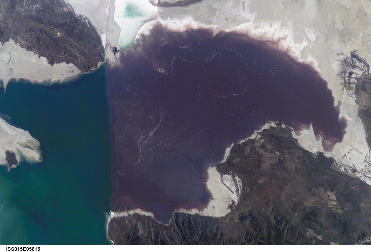
ISS015-E-05815 (30 April 2007) --- Algae in Great Salt Lake, Utah is featured in this image photographed by an Expedition 15 crewmember on the International Space Station. According to scientists, the Great Salt Lake of northern Utah is a remnant of glacial Lake Bonneville that extended over much of present-day western Utah, and into the neighboring states of Nevada and Idaho, approximately 32,000 to 14,000 years ago. During this time, the peaks of adjacent ranges such as the Promontory and Lakeside Mountains were most likely islands. As climate warmed and precipitation decreased in the region, glaciers that fed melt-water to Lake Bonneville disappeared, and the lake began to dry up. The present-day Great Salt Lake is a terminal lake in that water does not flow out of the lake basin. Water loss through the year is due primarily to evaporation, and when this loss exceeds input of water from rivers, streams, precipitation, and groundwater the lake level decreases. This is particularly evident during droughts. This process of evaporation, together with the relatively shallow water levels (maximum lake depth is around 33 feet), has led to increased salinity (dissolved salt content) of the lake waters. The north arm of the Lake, displayed in this image, typically has twice the salinity of the rest of the lake due to impoundment of water by a railroad causeway that crosses the lake from east to west. This restriction of water flow has led to a striking division in the types of algae and bacteria found in the north and south arms of the lake. In the northern arm (north of the causeway), the red algae Dunaliella Salina and the bacterial species Halo bacterium produce a pronounced reddish cast to the water, whereas the south arm (south of the causeway) is dominated by green algae such as Dunaliella viridis. The Great Salt Lake also supports brine shrimp and brine flies; and is a major stopover point for migratory birds including avocets, stilts, and plovers.
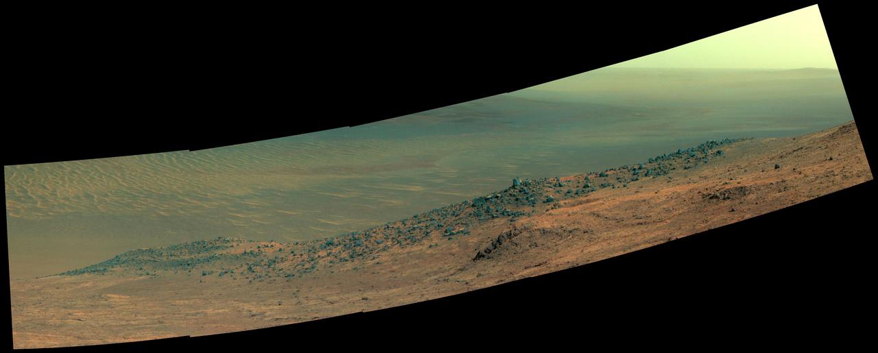
This scene from NASA's Mars Exploration Rover Opportunity shows "Wharton Ridge," which forms part of the southern wall of "Marathon Valley" on the western rim of Endeavour Crater. In this version of the scene the landscape is presented in enhanced color to make differences in surface materials more easily visible The full extent of Wharton Ridge is visible, with the floor of Endeavour Crater beyond it and the far wall of the crater in the distant background. Near the right edge of the scene is "Lewis and Clark Gap," through which Opportunity crossed from Marathon Valley to "Bitterroot Valley" in September 2016. Before the rover departed Marathon Valley, its panoramic camera (Pancam) acquired the component images for this scene on Aug. 30, 2016, during the 4,480th Martian day, or sol, of Opportunity's work on Mars. Opportunity's science team chose the ridge's name to honor the memory of Robert A. Wharton (1951-2012), an astrobiologist who was a pioneer in the use of terrestrial analog environments, particularly in Antarctica, to study scientific problems connected to the habitability of Mars. Over the course of his career, he was a visiting senior scientist at NASA Headquarters, vice president for research at the Desert Research Institute, provost at Idaho State University, and president of the South Dakota School of Mines and Technology. The view spans from east-northeast at left to southeast at right. Color in the scene comes from component images taken through three of the Pancam's color filters, centered on wavelengths of 753 nanometers (near-infrared), 535 nanometers (green) and 432 nanometers (violet). http://photojournal.jpl.nasa.gov/catalog/PIA20850