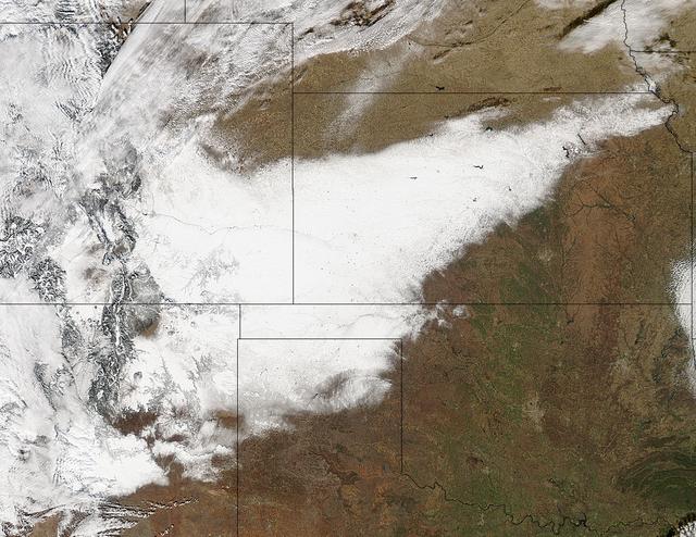
Winter arrived officially on Dec. 22 at 12:35 a.m. EST, but the U.S. Plains states received an early and cool welcome on Dec. 19 from heavy snowfall that was seen by a NASA satellite. NASA's Aqua satellite passed overhead on Dec. 21 at 20:05 UTC (3:05 p.m. EST) and the Moderate Resolution Imaging Spectroradiometer (MODIS) instrument aboard NASA's Aqua satellite captured a visible image of snow blanketing the ground through west and central Kansas, eastern and central Colorado, much of New Mexico, northern Texas and the panhandle of Oklahoma. According to CBS News, blizzard conditions were reported in northern New Mexico, the Texas Panhandle, Oklahoma and northwestern Kansas. The Associated Press reported snow drifts as high as 10 feet in southeast Colorado. Six people lost their lives in traffic accidents from this storm. Heavy snow is expected again today, Dec. 22 in New Mexico and Colorado. Snow is also expected to stretch across the plains into the upper Midwest today, according to the National Weather Service. Portions of many states are expecting some snow today, including the four corners states, north Texas, Kansas, southern Nebraska, western Oklahoma, northern Missouri, Iowa, northern Illinois and southern Wisconsin stretching east into northern New England. The first day of the winter season occurs when the sun is farthest south, either Dec. 21 or 22. The day is also known as the winter solstice. By the second day of winter, NASA's Aqua satellite is going to have a lot more snowfall to observe. Image Credit: NASA Goddard MODIS Rapid Response Team Caption: NASA, Rob Gutro <b><a href="http://www.nasa.gov/audience/formedia/features/MP_Photo_Guidelines.html" rel="nofollow">NASA image use policy.</a></b> <b><a href="http://www.nasa.gov/centers/goddard/home/index.html" rel="nofollow">NASA Goddard Space Flight Center</a></b> enables NASA’s mission through four scientific endeavors: Earth Science, Heliophysics, Solar System Exploration, and Astrophysics. Goddard plays a leading role in NASA’s accomplishments by contributing compelling scientific knowledge to advance the Agency’s mission. <b>Follow us on <a href="http://twitter.com/NASA_GoddardPix" rel="nofollow">Twitter</a></b> <b>Like us on <a href="http://www.facebook.com/pages/Greenbelt-MD/NASA-Goddard/395013845897?ref=tsd" rel="nofollow">Facebook</a></b> <b>Find us on <a href="http://instagrid.me/nasagoddard/?vm=grid" rel="nofollow">Instagram</a></b>
With just two days until NASA MESSENGER spacecraft closest pass by Mercury, the Mercury Dual Imaging System MDIS is acquiring sets of images twice a day.

This pair of images, acquired 16 days apart by NASA Terra satellite in 2002 and 2007, covers the Liaoning region of China and parts of northern and western Korea, comparing a relatively clear day and an extremely dusty day.
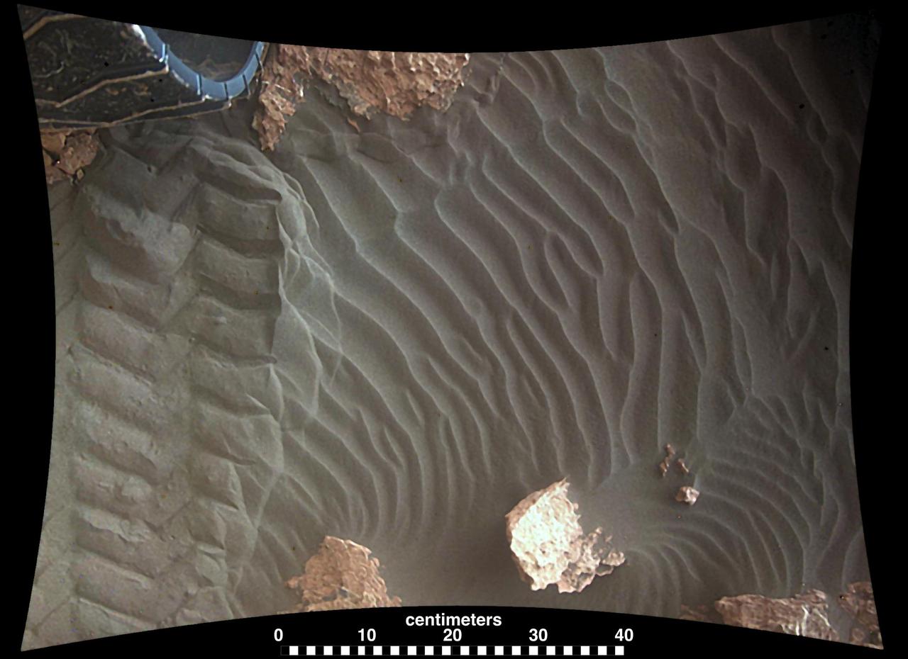
This image from an animation shows wind blowing sand underneath NASA Curiosity Mars rover on a non-driving day for the rover. Each image was taken just after sundown by the rover's downward-looking Mars Descent Imager (MARDI). The area of ground shown in the images spans about 3 feet (about 1 meter) left-to-right. The first image was taken on Jan. 23, 2017, during the 1,587th Martian day, or sol, of Curiosity's work on Mars. Figure 1 above is the image with a scale bar in centimeters. The second was taken on Jan. 24, 2017 (Sol 1588). The day-apart images by MARDI were taken as a part of investigation of wind's effects during Martian summer, the windiest time of year in Gale Crater. An animation is available at http://photojournal.jpl.nasa.gov/catalog/PIA21143
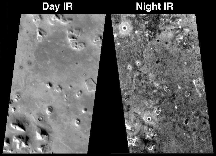
This image is a mosaic of day and night infrared images of Melas Chasma taken by NASA Mars Odyssey spacecraft. The daytime temperature images are shown in black and white, superimposed on the Martian topography.
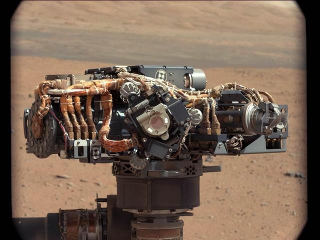
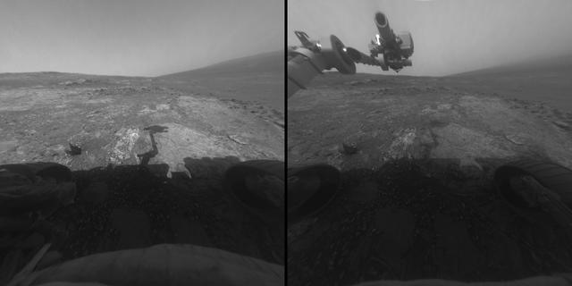
This image shows the Mars Hand Lens Imager MAHLI on NASA Curiosity rover, with the Martian landscape in the background. The image was taken by Curiosity Mast Camera on the 32nd Martian day, or sol, of operations on the surface.
This daytime infrared image shows the large sand sheet on the floor of Charlier Crater. The brightness is due to the warmth of the sand during the day.
This image, acquired by NASA Terra spacecraft, is of the ancient city of Uruk is located in present-day Iraq, on an abandoned channel of the Euphrates River.
NASA Terra spacecraft acquired this image of the Day fire in Ventura County in Southern California in 2006.
![This isolated mesa [lower left center of the image] has an almost heart-shaped margin. Happy Valentine Day from Mars](https://images-assets.nasa.gov/image/PIA02174/PIA02174~medium.jpg)
This isolated mesa [lower left center of the image] has an almost heart-shaped margin. Happy Valentine Day from Mars
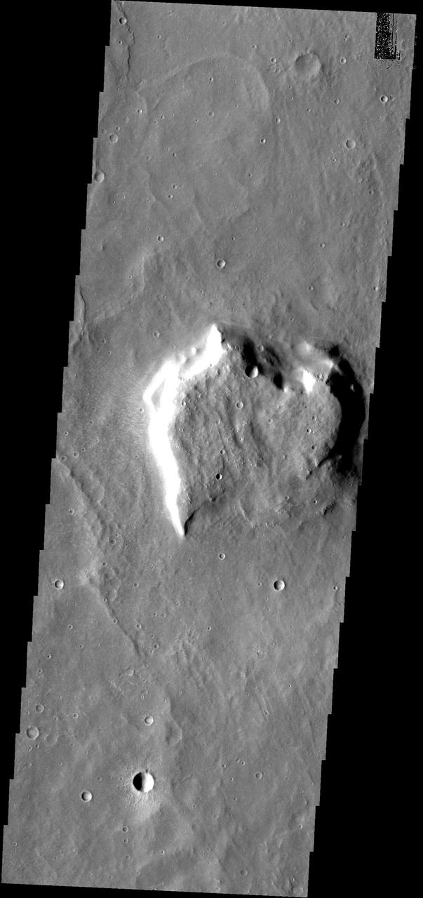
Back by popular demand: THEMIS ART IMAGE #65 Valentines Day is past, but this martian mesa reminds us of a heart
This image of the Martian surface was taken in the afternoon of Mars Pathfinder's first day on Mars. Taken by the Imager for Mars Pathfinder (IMP camera), the image shows a diversity of rocks strewn in the foreground. A hill is visible in the distance (the notch within the hill is an image artifact). Airbags are seen at the lower right. http://photojournal.jpl.nasa.gov/catalog/PIA00612
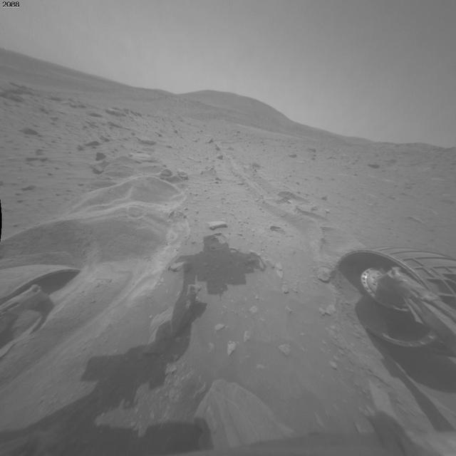
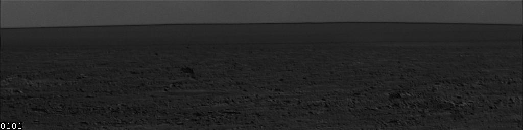
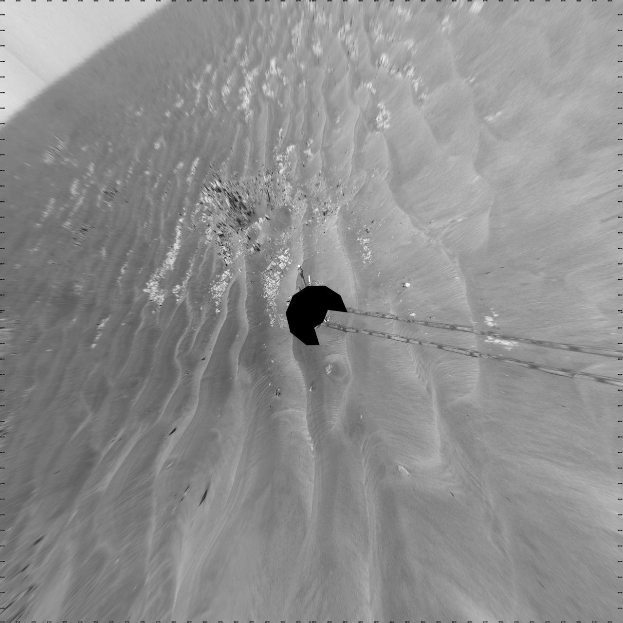
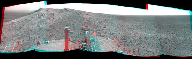
This image from the navigation camera on NASA Mars Exploration Rover Opportunity shows the view ahead on the day before the rover reached the rim of Endeavour crater. It was taken during the 2,680th Martian day, or sol, of the rover work on Mars.
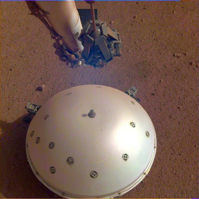
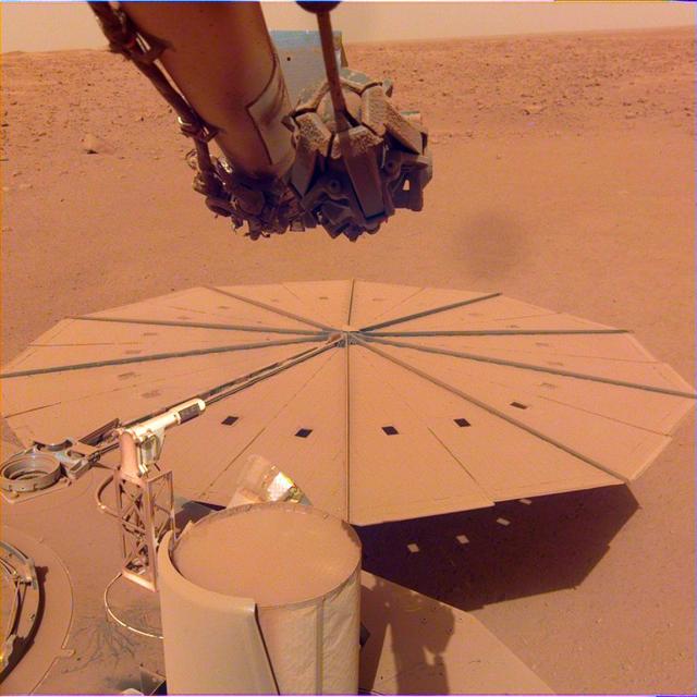
This image shows InSight's domed Wind and Thermal Shield, which covers its seismometer. The image was taken on the 110th Martian day, or sol, of the mission. The seismometer is called Seismic Experiment for Interior Structure, or SEIS. https://photojournal.jpl.nasa.gov/catalog/PIA23177

Three days after the Mars Reconnaissance Orbiter Aug. 12, 2005, launch, the NASA spacecraft was pointed toward Earth and the Mars Color Imager camera was powered up to acquire a suite of color and ultraviolet images of Earth and the Moon.
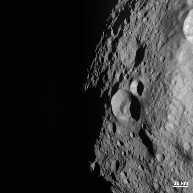
NASA Dawn spacecraft obtained this image of a young and old crater at the night and day boundary on asteroid Vesta. The image has a resolution of about 260 meters per pixel.
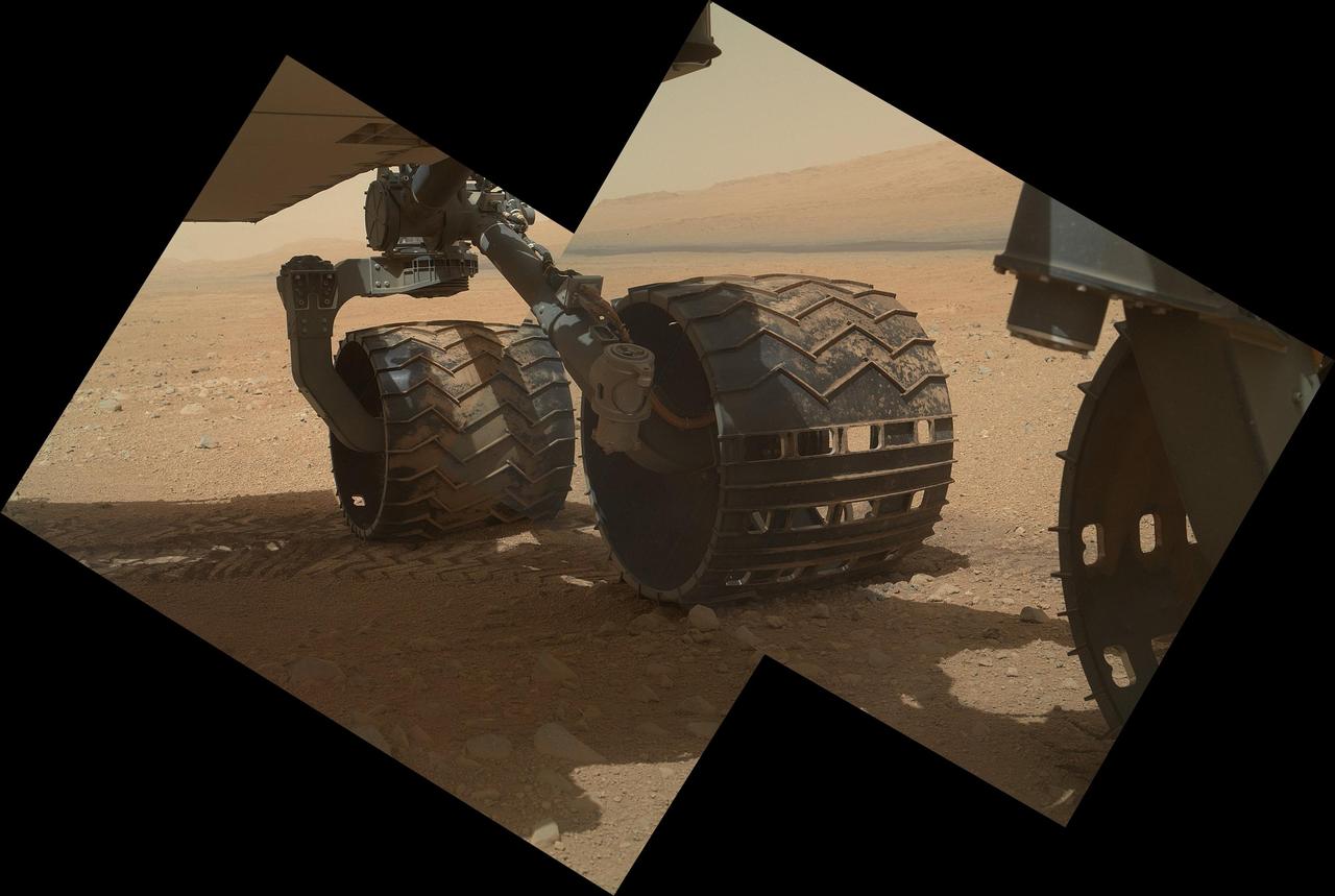
This view of the three left wheels of NASA Mars rover Curiosity combines two images that were taken by the rover Mars Hand Lens Imager MAHLI during the 34th Martian day, or sol, on Mars Sept. 9, 2012.
This view of the landscape to the north of NASA Mars rover Curiosity acquired by the Mars Hand Lens Imager on the afternoon of the first day of landing. In the distance, the image shows the north wall and rim of Gale Crater.
NASA Mars Odyssey spacecraft captured this image on Feb. 19, 2012, 10 years to the day after the camera recorded its first view of Mars. This image covers an area in the Nepenthes Mensae region north of the Martian equator.
This image was acquired by NASA Phoenix Mars Lander Surface Stereo Imager and shows sublimation of ice in the trench informally called Dodo-Goldilocks over the course of four days.

Three days after the Mars Reconnaissance Orbiter Aug. 12, 2005, launch, the spacecraft was pointed toward Earth and the Mars Color Imager camera was powered up to acquire a suite of images of Earth and the Moon.
This image from an animated flyover of the workspace of NASA’s Phoenix Mars Lander’s was taken by the Surface Stereo Imager on Sol 14 June 8, 2008, or the 14th Martian day after landing.
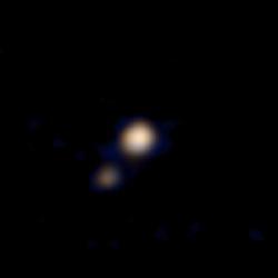
This image of Pluto and its largest moon, Charon, was taken by the Ralph color imager aboard NASA New Horizons spacecraft on April 9 and downlinked to Earth the following day.
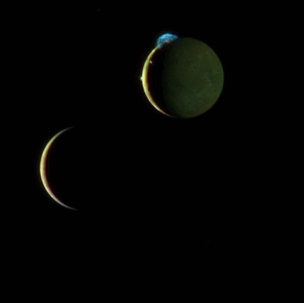
This beautiful image of the crescents of volcanic Io and more sedate Europa is a combination of two New Horizons images taken March 2, 2007, about two days after New Horizons made its closest approach to Jupiter.
These two images taken one day apart by the MARCI weather camera on NASA Mars Reconnaissance Orbiter reveal when an asteroid impact made the scar seen in the right-hand image.
This image was acquired by NASA Phoenix Mars Lander Surface Stereo Imager SSI in the late afternoon of the 30th Martian day of the mission, or Sol 30 June 25, 2008. This is hours after the beginning of Martian northern summer.
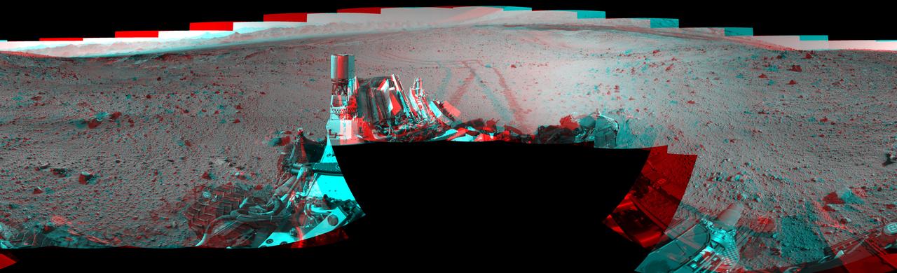
This stereo mosaic of images from NASA Mars rover Curiosity shows the terrain surrounding the rover position on the 524th Martian day. You need 3-D glasses to view this image.
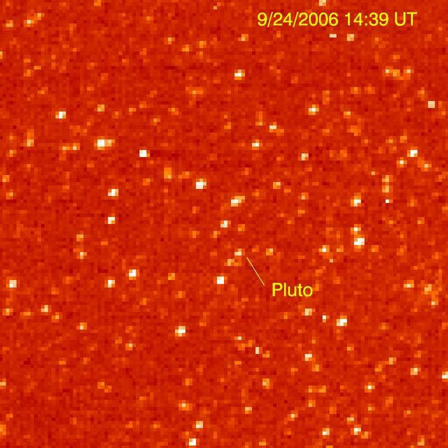
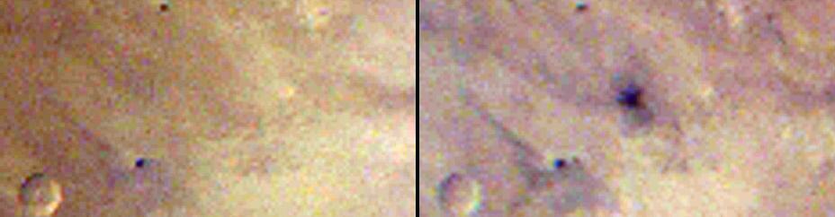
The Long Range Reconnaissance Imager on NASA New Horizons acquired images of the Pluto field three days apart in late September 2006, in order to see Pluto motion against a dense background of stars.
Clouds of dust and ice swirl past the Surface Stereo Imager SSI camera on NASA Phoenix Mars Lander in this frame from a series of images taken on the 132nd Martian day of the mission Oct. 7, 2008.
This color image was acquired by the Surface Stereo Imager on NASA Phoenix Mars Lander on the 21st day of the mission, or Sol 20 June 15, 2008. It shows lumps of ice in the lower left corner of a trench nicknamed Dodo-Goldilocks.

This image shows Phobos, the larger of Mars two moons, as it transits in front of the sun. This image was taken by NASA Mars Exploration Rover Opportunity during the afternoon of the rover 3,078th Martian day, or sol.
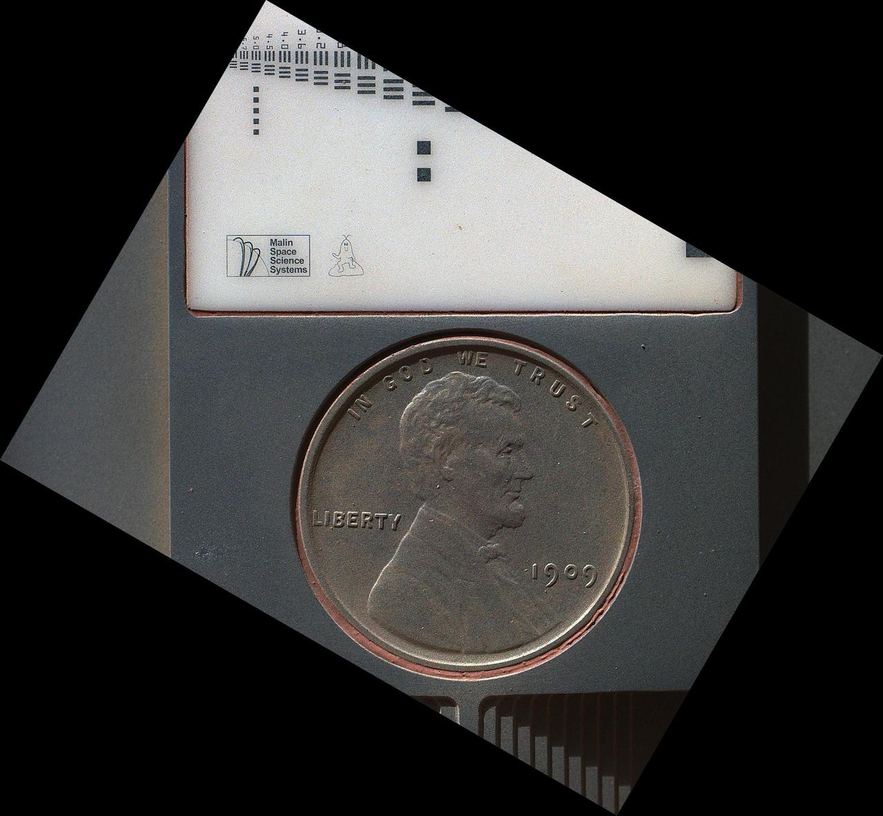
The penny in this image is part of a camera calibration target on NASA Mars rover Curiosity. The MAHLI camera on the rover took this image of the MAHLI calibration target during the 34th Martian day of Curiosity work on Mars, Sept. 9, 2012.
This image is one of two images which documents very slight forward movement of NASA Mars Exploration Rover Spirit during a drive on the rover 2,090th Martian day, or sol Nov. 19, 2009.
This frame from a sequence of nine images taken by the Surface Stereo Imager on NASA Phoenix Mars Lander shows the sun rising on the morning of the lander 101st Martian day after landing.
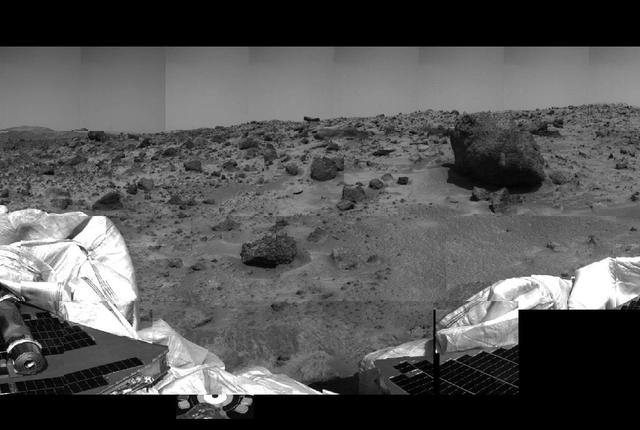
This image of the Martian surface was taken by the Imager for Mars Pathfinder (IMP) before sunset on July 4, 1997 (Sol 1), the spacecraft's first day on Mars. The airbags have been partially retracted, and portions the petal holding the undeployed rover Sojourner can be seen at lower left. The rock in the center of the image may be a future target for chemical analysis. The soil in the foreground has been disturbed by the movement of the airbags as they retracted. http://photojournal.jpl.nasa.gov/catalog/PIA00619
NASA MARCI acquires a global view of the red planet and its weather patterns every day. This image was taken on Nov. 3, 2008 by the Mars Reconnaissance Orbiter.
This first image of comet 103P/Hartley 2 was taken from NASA Deep Impact spacecraft 60 days prior to the spacecraft flyby of the comet.
This pair of infrared images from NASA Mars Odyssey spacecraft shows the so-called face on Mars landform viewed during both the day and night.

These July 11, 2006 images from NASA Terra Satellite show then Tropical Storm Bud as it was intensifying into a hurricane, which it became later that day.

This image pair from NASA Terra spacecraft includes the area around the damaged Fukushima Dai-ichi nuclear power facility and extends northward along the coast.

An instrument on NASA Terra spacecraft captured a simulated natural color image of the Port-au-Prince, Haiti, area, two days after a devastating earthquake.
This image from the Navigation Camera (Navcam) on NASA's Curiosity Mars rover shows the position in which the rover held its arm for several days after a transient short circuit triggered onboard fault-protection programming to halt arm activities on Feb. 27, 2015, the 911th Martian day, or sol, of the rover's work on Mars. The rover team chose to hold the arm in the same position for several days of tests to diagnose the underlying cause of the Sol 911 event. Observations with instruments on the rover's mast continued during this period. The Navcam took this image on March 4, 2015, during Sol 915. http://photojournal.jpl.nasa.gov/catalog/PIA19147
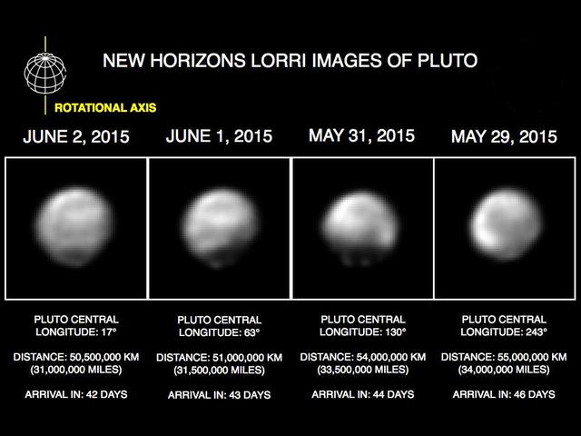
These images, taken by NASA's New Horizons' Long Range Reconnaissance Imager (LORRI), show four different "faces" of Pluto as it rotates about its axis with a period of 6.4 days. All the images have been rotated to align Pluto's rotational axis with the vertical direction (up-down) on the figure, as depicted schematically in the upper left. From left to right, the images were taken when Pluto's central longitude was 17, 63, 130, and 243 degrees, respectively. The date of each image, the distance of the New Horizons spacecraft from Pluto, and the number of days until Pluto closest approach are all indicated in the figure.These images show dramatic variations in Pluto's surface features as it rotates. When a very large, dark region near Pluto's equator appears near the limb, it gives Pluto a distinctly, but false, non-spherical appearance. Pluto is known to be almost perfectly spherical from previous data. These images are displayed at four times the native LORRI image size, and have been processed using a method called deconvolution, which sharpens the original images to enhance features on Pluto. Deconvolution can occasionally introduce "false" details, so the finest details in these pictures will need to be confirmed by images taken from closer range in the next few weeks. All of the images are displayed using the same brightness scale. http://photojournal.jpl.nasa.gov/catalog/PIA19686
This stereo view combines a pair of images taken by the microscopic imager on NASA Mars Exploration Rover Spirit during the 1,925th Martian day sol of Spirit mission on Mars June 2, 2009. 3D glasses are necessary to view this image.

This image, taken by NASA's Dawn spacecraft, shows cratered terrain near the day-night line, called the terminator, on dwarf planet Ceres. The image, with a resolution of 1,400 feet (410 meters) per pixel, was taken at an altitude of 2,700 miles (4,400 kilometers) on June 24, 2015. http://photojournal.jpl.nasa.gov/catalog/PIA19611

This image of clouds in Neptune atmosphere is the first that tests the accuracy of the weather forecast that was made eight days earlier to select targets for NASA Voyager narrow angle camera. http://photojournal.jpl.nasa.gov/catalog/PIA00048
NASA's InSight Mars lander captured this image of one of its dust-covered solar panels on April 24, 2022, the 1,211th Martian day, or sol, of the mission. https://photojournal.jpl.nasa.gov/catalog/PIA25286
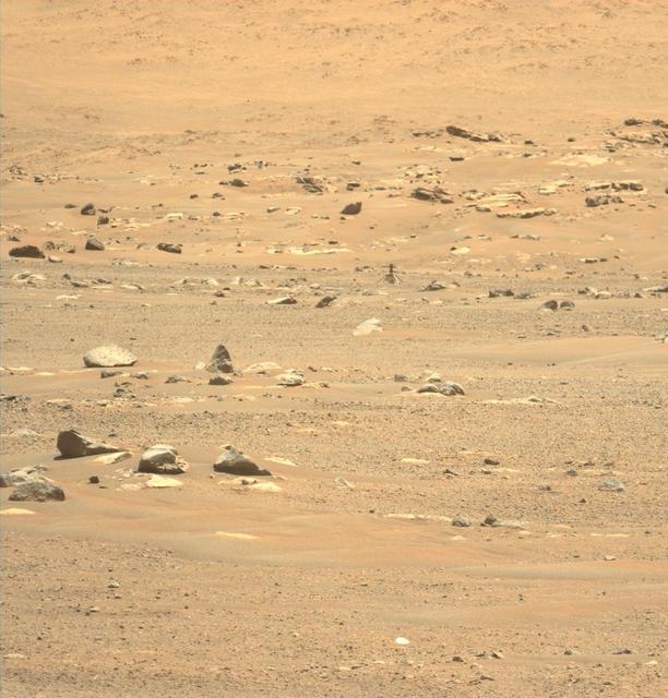
This image of Ingenuity was taken on May 23, 2021 – the day after its sixth flight – by the Mastcam-Z instrument aboard the Perseverance Mars rover. https://photojournal.jpl.nasa.gov/catalog/PIA24599

Bob Balaram, Teddy Tzanetos and Havard Grip from the NASA Mars Helicopter project discuss the sequence of events for the day's flight testing. The image was taken Jan. 18, 2019. https://photojournal.jpl.nasa.gov/catalog/PIA23162

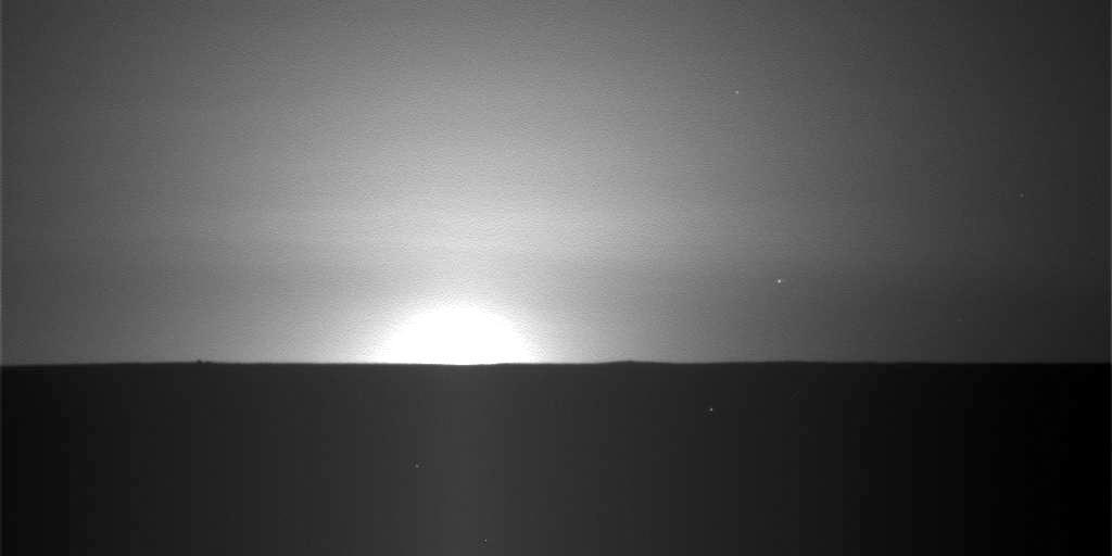
This is the first image ever taken of Earth from the surface of a planet beyond the Moon. It was taken by the Mars Exploration Rover Spirit one hour before sunrise on the 63rd martian day, or sol, of its mission. Earth is the tiny white dot in the center. The image is a mosaic of images taken by the rover's navigation camera showing a broad view of the sky, and an image taken by the rover's panoramic camera of Earth. The contrast in the panoramic camera image was increased two times to make Earth easier to see. http://photojournal.jpl.nasa.gov/catalog/PIA05560

This is the first image ever taken of Earth from the surface of a planet beyond the Moon. It was taken by the Mars Exploration Rover Spirit one hour before sunrise on the 63rd martian day, or sol, of its mission. The image is a mosaic of images taken by the rover's navigation camera showing a broad view of the sky, and an image taken by the rover's panoramic camera of Earth. The contrast in the panoramic camera image was increased two times to make Earth easier to see. The inset shows a combination of four panoramic camera images zoomed in on Earth. The arrow points to Earth. Earth was too faint to be detected in images taken with the panoramic camera's color filters. http://photojournal.jpl.nasa.gov/catalog/PIA05547
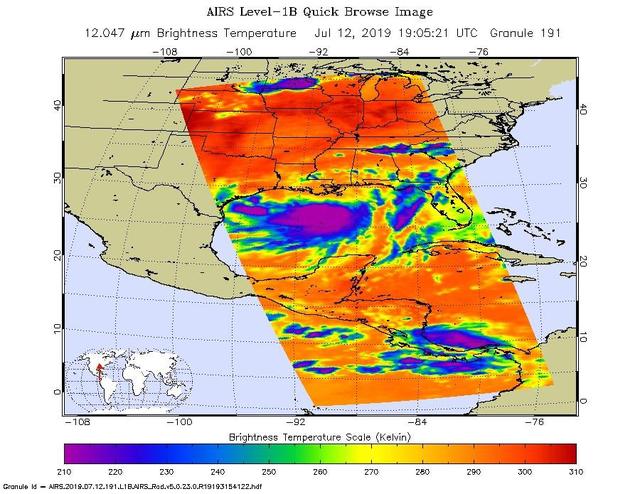
NASA's AIRS instrument imaged Tropical Storm Barry on the afternoon of July 12, 2019, a day before the storm is expected to make landfall on the Louisiana Coast. The infrared image shows very cold clouds that have been carried high into the atmosphere by deep thunderstorms in purple. These clouds are associated with heavy rainfall. Warmer areas with shallower rain clouds are shown in blue and green. And the orange and red areas represent mostly cloud-free air. https://photojournal.jpl.nasa.gov/catalog/PIA23355
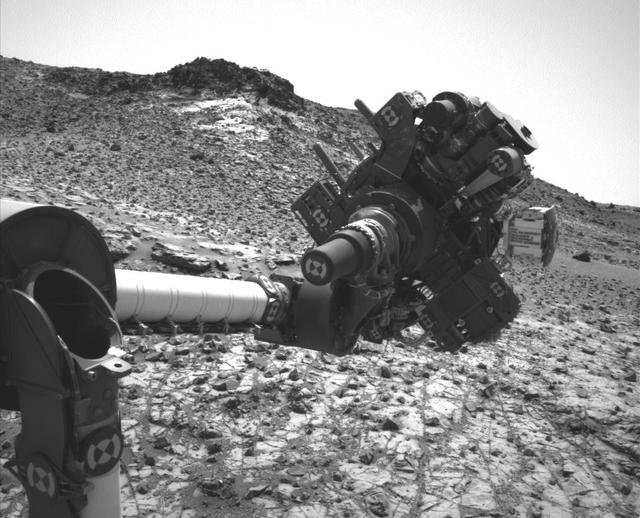
The left eye of the Mast Camera Mastcam on NASA Mars rover Curiosity took this image of the camera on the rover arm, the Mars Hand Lens Imager MAHLI, during the 30th Martian day, or sol, of the rover mission on Mars Sept. 5, 2012.

With just one day until NASA MESSENGER spacecraft historic flyby of Mercury, MESSENGER has Mercury clearly in its sights. The Narrow Angle Camera, part of the Mercury Dual Imaging System MDIS, took this image on January 12, 2008.
These images taken by NASA Voyager 2 show changes in the clouds around Neptune Great Dark Spot GDS over a four and one-half-day period. From top to bottom the images show successive rotations of the planet an interval of about 18 hours. http://photojournal.jpl.nasa.gov/catalog/PIA00045
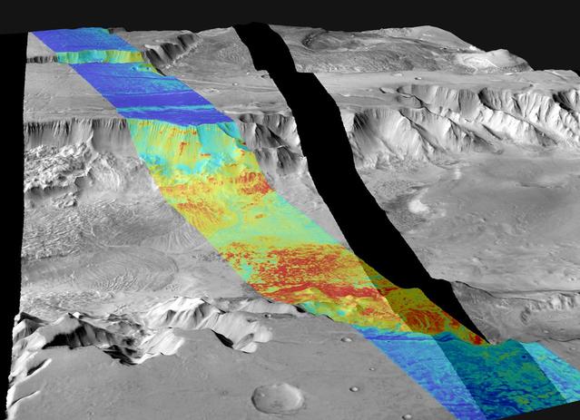
This image is a mosaic of day and night infrared images of Melas Chasma taken by NASA Mars Odyssey spacecraft. The daytime temperatures range from approximately -35 degrees Celsius -31 degrees Fahrenheit to -5 degrees Celsius 23 degrees Fahrenheit.
A laser beam from the Canadian-built lidar instrument on NASA Phoenix Mars Lander can be seen in this contrast-enhanced image taken by Phoenix Surface Stereo Imager on July 26, 2008, during early Martian morning hours of the 61st Martian day.
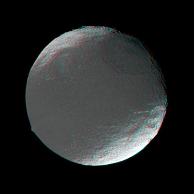
This stereo view of Iapetus was created by combining two NASA Cassini images, which were taken one day apart. The view serves mainly to show the spherical shape of Iapetus and some of the moon’s topography. 3D glasses are necessary to view this image.
This frame from an animation shows the movement of several dust storms near NASA Phoenix Mars Lander. These images were taken by the lander Surface Stereo Imager SSI on the 137th Martian day, or sol, of the mission Oct. 13, 2008.
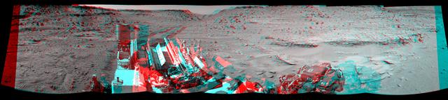
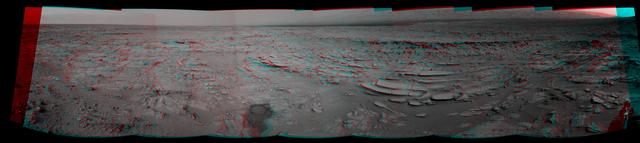
This stereo view combining images taken on Feb. 10, 2014, by the Navigation Camera Navcam on NASA Curiosity Mars rover looks back to where the rover crossed a dune at Dingo Gap four days earlier. You need 3D glasses to view this image.
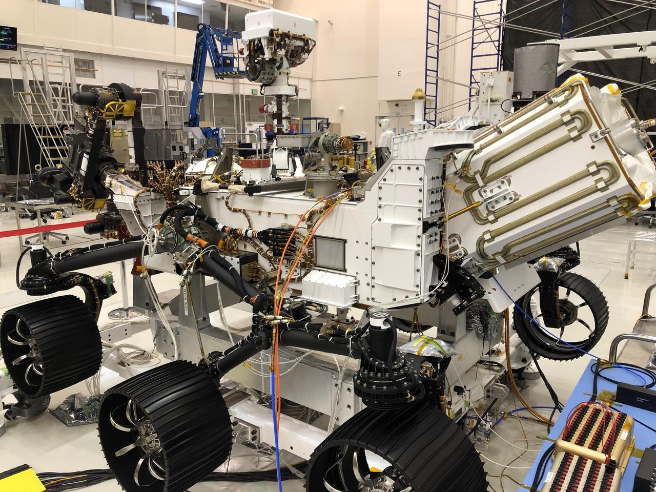
In this image taken on Nov. 16, 2019, the Perseverance rover is undergoing a 10-day test in the Spacecraft Assembly Facility's High Bay 1 at NASA's Jet Propulsion Laboratory in Southern California. During the test, all aspects of the upcoming mission were investigated (launch, cruise, landing and surface operations). https://photojournal.jpl.nasa.gov/catalog/PIA24044
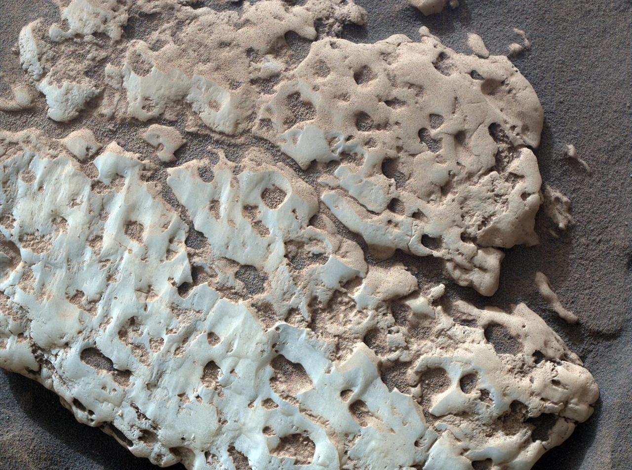
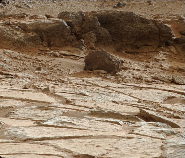
NASA's Curiosity Mars rover captured this close-up image of a rock nicknamed "Snow Lake" on June 8, 2024, the 4,209th Martian day, or sol, of the mission. The image was captured by Curiosity's Mars Hand Lens Imager (MAHLI), a camera on the end of the rover's robotic arm. Nine days before this image was captured, Curiosity crushed a similar-looking rock and revealed crystalline textures inside. Curiosity's Alpha Particle X-Ray Spectrometer (APXS) found that the rock was made of elemental sulfur. An entire field of similar-looking rocks were found in this area; all are expected to have sulfur inside them. https://photojournal.jpl.nasa.gov/catalog/PIA26308
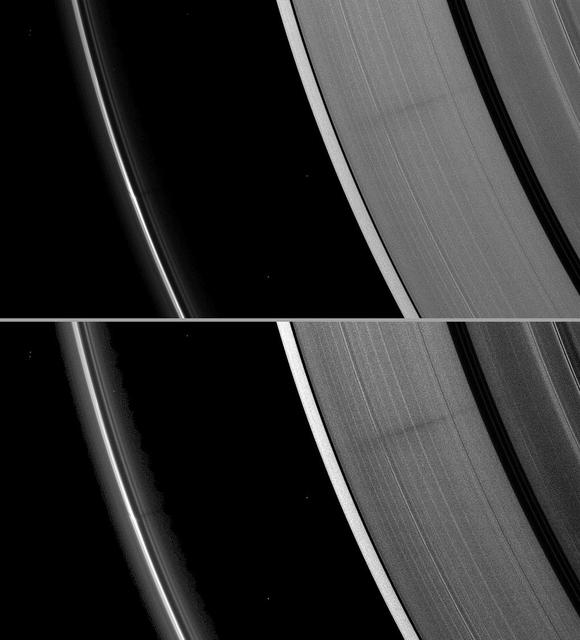
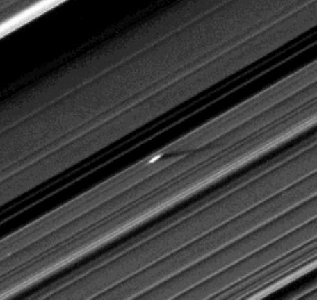
A vertically extended structure or object in Saturn F ring casts a shadow long enough to reach the A ring in this Cassini image taken just days before planet August 2009 equinox.
NASA Mars Exploration Rover Opportunity used its navigation camera to take the images combined into this stereo view of the rover surroundings on sol or Martian day 959 of its surface mission
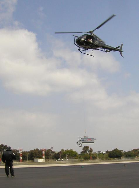
This image taken March 25, 2010 shows preparations for radar testing for NASA Mars Science Laboratory. This day work evaluated a setup for suspending a rover mock-up beneath a helicopter at Hawthorne Municipal Airport, Hawthorne, Calif.

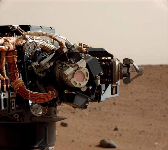
This is one of the last images ever taken by NASA's InSight Mars lander. Captured on Dec. 11, 2022, the 1,436th Martian day, or sol, of the mission, it shows InSight's seismometer on the Red Planet's surface. https://photojournal.jpl.nasa.gov/catalog/PIA25680

Seventeen days after Hurricane Katrina flooded New Orleans, much of the city was still under water. In this pair of images from NASA Terra satellite, the affected areas can clearly be seen.
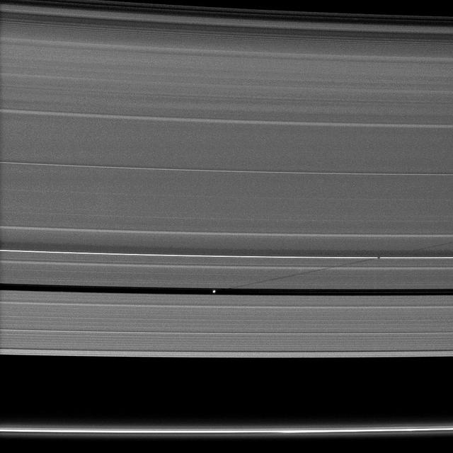
An unusually large propeller feature is detected just beyond the Encke Gap in this Cassini image of Saturn’s outer A ring taken a couple days after the planet’s August 2009 equinox.
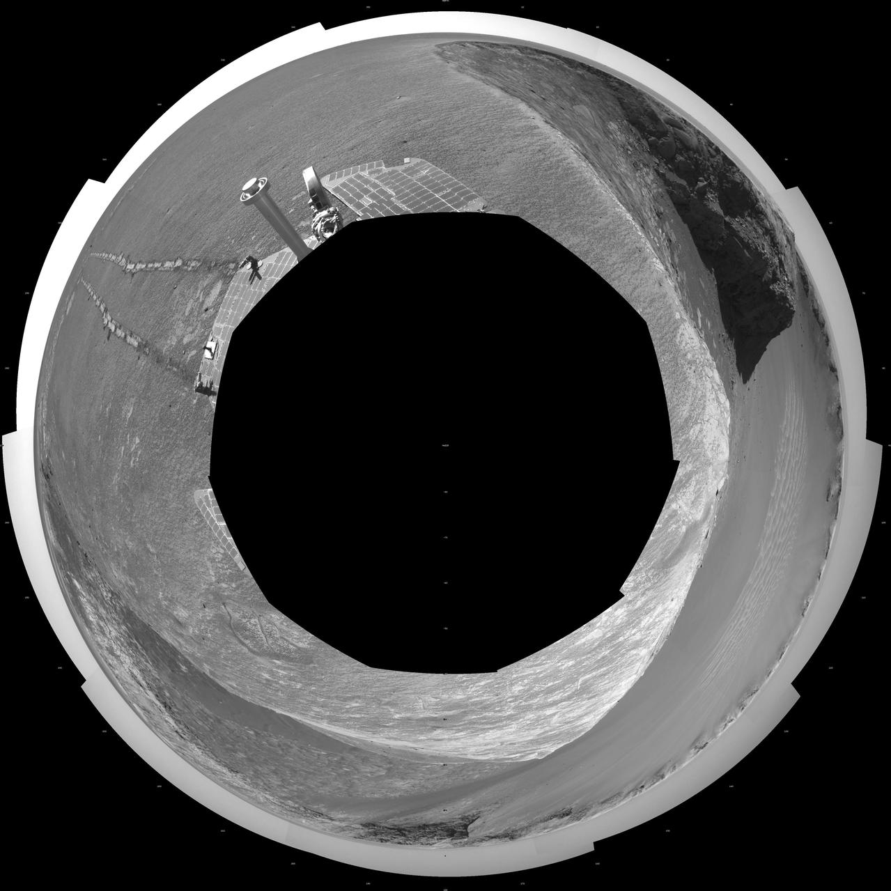
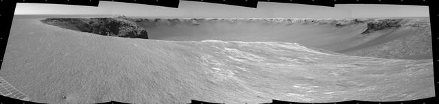
NASA Mars Exploration Rover Opportunity used its navigation camera to take the images combined into this 360-degree vertical view of the rover surroundings on the 1,950th Martian day, or sol, of its surface mission July 19, 2009.
NASA Mars Exploration Rover Opportunity used its navigation camera to take the images combined into this stereo view of the rover surroundings on the 958th sol, or Martian day, of its surface mission Oct. 4, 2006
NASA Mars Exploration Rover Opportunity used its navigation camera to take the images combined into this stereo view of the rover surroundings on the 958th sol, or Martian day, of its surface mission Oct. 4, 2006
NASA Mars Exploration Rover Opportunity used its navigation camera to take the images combined into this 360-degree polar view of the rover surroundings on the 1,950th Martian day, or sol, of its surface mission July 19, 2009.
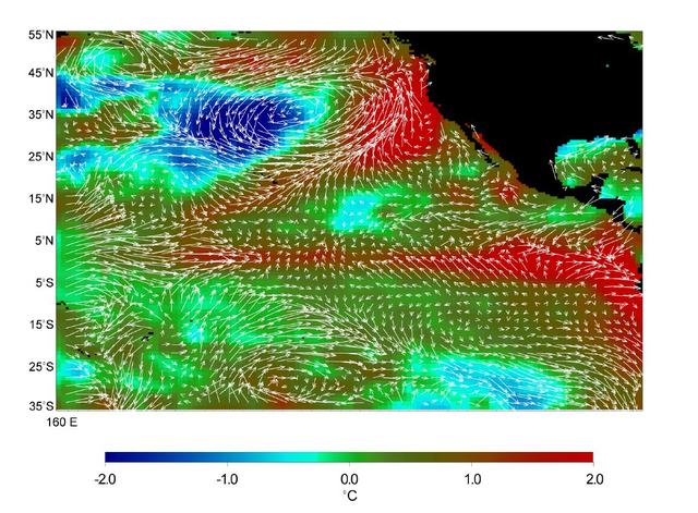
This image displays wind measurements taken by the satellite-borne NASA Scatterometer NSCAT during the last 10 days of May 1997, showing the relationship between the ocean and the atmosphere at the onset of the 1997-98 El Niño condition.
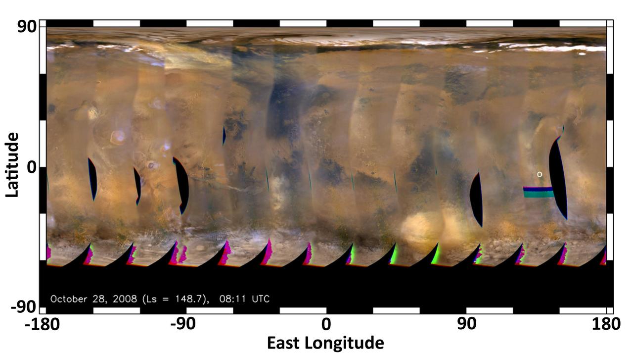
This global map of Mars was acquired on Oct. 28, 2008, by the Mars Color Imager instrument on NASA MRO. One global map is generated each day to forecast weather conditions for the entry, descent and landing of NASA Curiosity rover.

Iceland Eyjafjallajökull volcano produced its second major ash plume beginning on May 7, 2010. NASA Terra satellite passed just east of the volcano mid-morning and captured this image the same day.
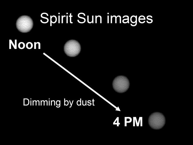
This image shows the Sun as it appears on Mars throughout the day. Scientists monitor the dimming of the setting Sun to assess how much dust is in the martian atmosphere. The pictures were taken by the Mars Exploration Rover Spirit panoramic camera.

Comet NEOWISE was first observed by NASA NEOWISE spacecraft on Valentine Day, 2014. This heat-sensitive infrared image was made by combining six exposures taken by the NEOWISE mission of the newly discovered comet.
This 360-degree vertical projection was assembled from images taken by the navigation camera on NASA Mars Exporation Rover Opportunity shows terrain surrounding the position where the rover spent its 3,000th Martian day.
NASA Mars Exploration Rover Opportunity used its navigation camera to take the images combined into this stereo view of the rover surroundings on sol or Martian day 959 of its surface mission
This stereo panoramic view combines 14 images taken by NASA Mars rover Curiosity during the mission 120th Martian day, or sol Dec. 7, 2012. You need 3D glasses.
The relatively flat floor and terrace walls of this impact crater imaged by NASA Mars Odyssey spacecraft suggest the crater was partly infilled with sediment and subsequently eroded to its present day form.
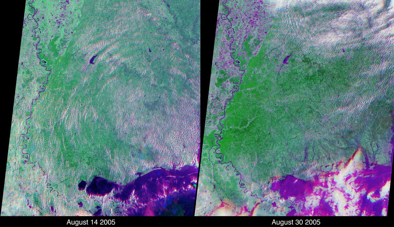
These views of the Louisiana and Mississippi regions were acquired before and one day after Katrina made landfall along the Gulf of Mexico coast. The images were acquired by NASA Terra spacecraft on August 14 and August 30, 2005.

This artist image illustrates the Kepler-16 system from an overhead view, showing the eccentric orbits of the two stars as they twirl around each other every 41 days like figure skaters.
This image from NASA Curiosity was taken by the right telephoto-lens camera of the Mast Camera Mastcam on the rover during the 193rd Martian day, or sol, of Curiosity work on Mars Feb. 20, 2013 in the Glenelg area.
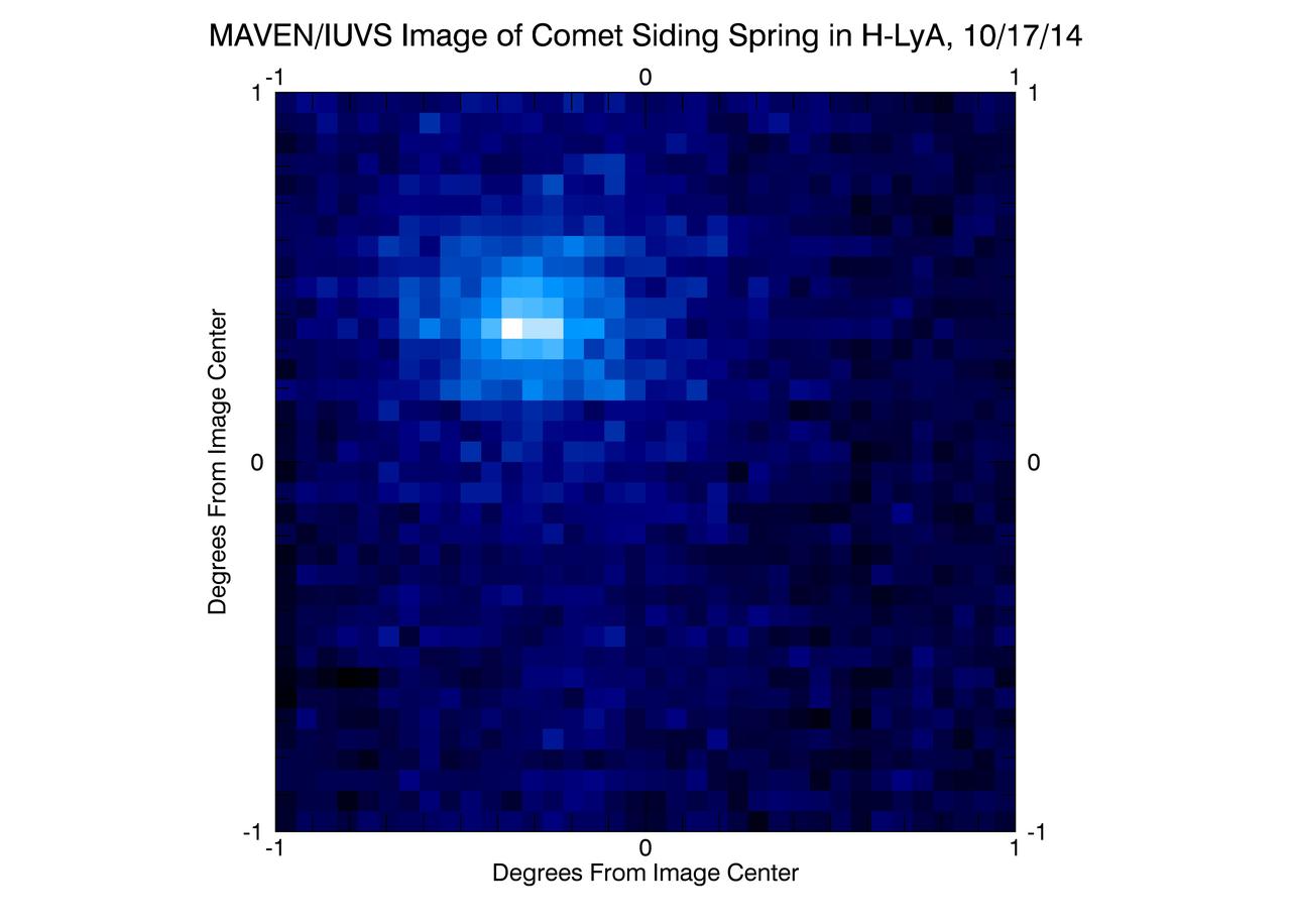
NASA MAVEN spacecraft obtained this ultraviolet image of hydrogen surrounding comet Siding Spring on Oct. 17, 2014, two days before the comet closest approach to Mars.
These two images, taken five Martian days sols apart by the front hazard-avoidance camera on NASA Mars Exploration Rover Opportunity, document the Martian sky above the rover Endeavour Crater location becoming dustier.
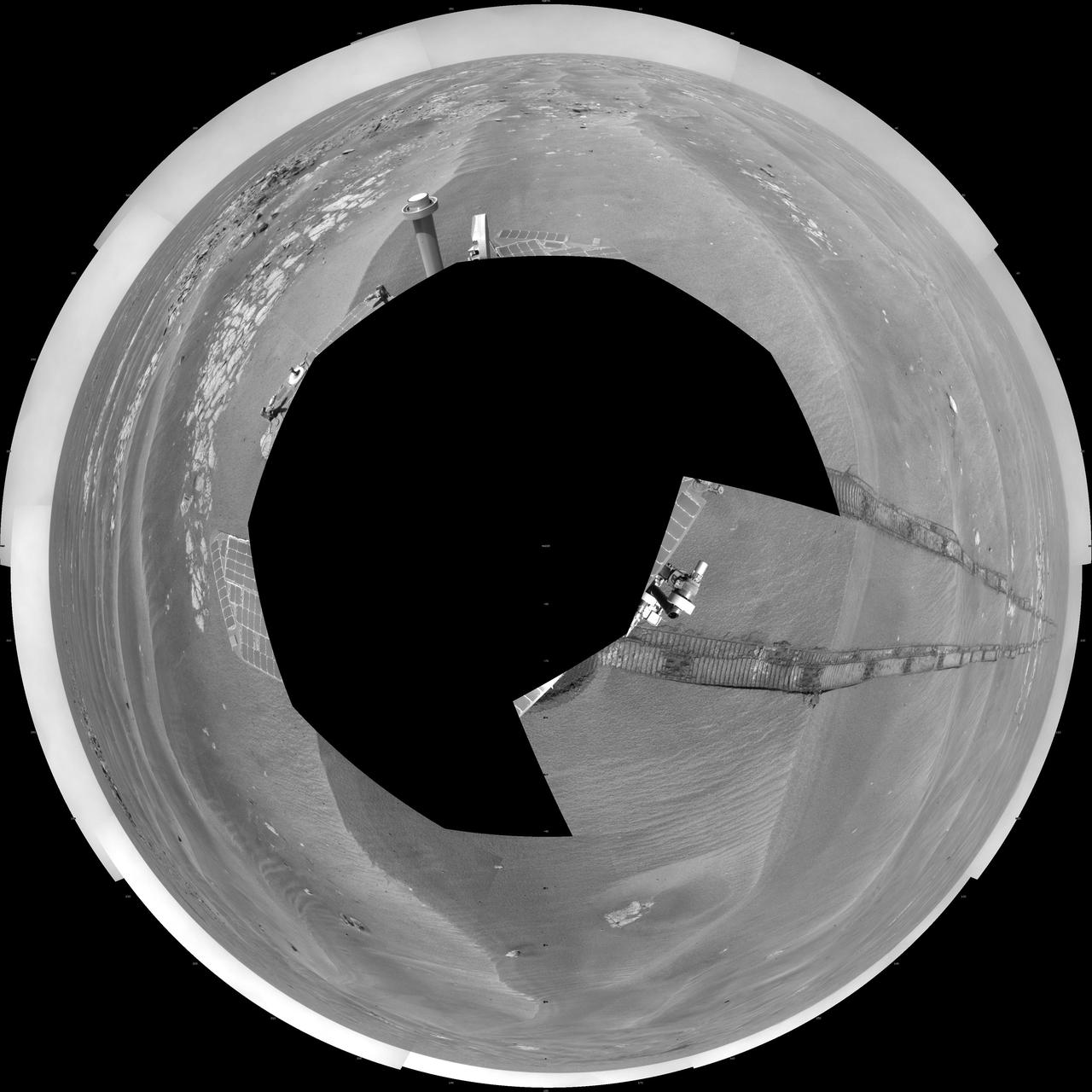
NASA rover Opportunity used its navigation camera to take the images combined into this full 360-degree view of the rover surroundings after a drive on the 2,220th Martian day, or sol, of Opportunity mission on Mars April 22, 2010.

These computer-generated images from NASA Spitzer Space Telescope chart the development of severe weather patterns on the highly eccentric exoplanet HD 80606b during the days after its closest approach to its parent star.

The South Pole is receiving sun every day now as spring progresses. The surface texture visible in this image captured by NASA Mars Odyssey was created by the effect of solar warming on the ice.
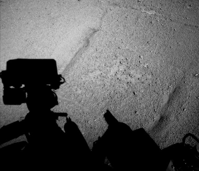
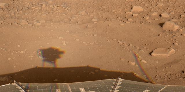
NASA Curiosity Mars rover caught its own shadow in this image taken just after completing a drive of 329 feet 100.3 meters on the 547th Martian day, or sol, of the rover work on Mars Feb. 18, 2014.

Acquired by NASA Terra spacecraft, this image shows ExxonMobil Baytown refinery in Texas. With a refining capacity of over 560,000 barrels per day, it is the largest refinery in the United States.
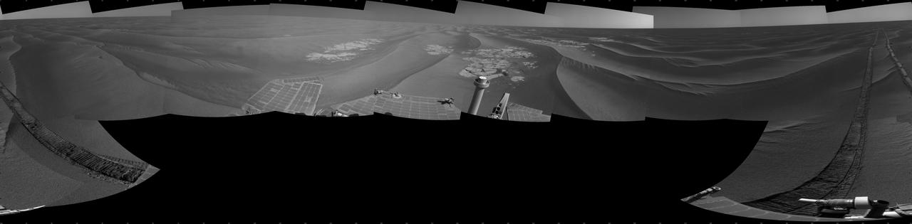
NASA Mars Exploration Rover Opportunity used its navigation camera to take the images combined into this 360-degree cylindrical view of the rover surroundings on the 1,950th Martian day, or sol, of its surface mission July 19, 2009.
This mosaic of images from the Navigation Camera Navcam on NASA Mars rover Curiosity shows the scene from the rover position on the 376th Martian day, or sol, of the mission Aug. 27, 2013.
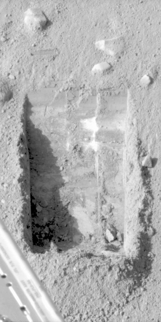
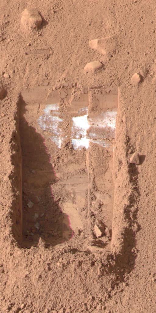
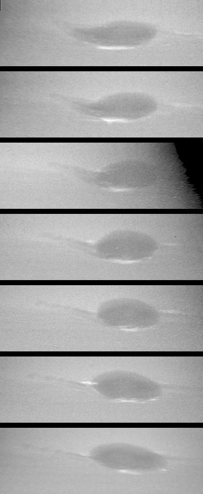
This image shows the evolution of the trench called Snow White that NASA Phoenix Mars Lander began digging on the 22nd Martian day of the mission after the May 25, 2008, landing.
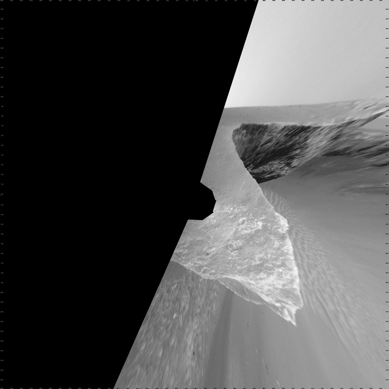
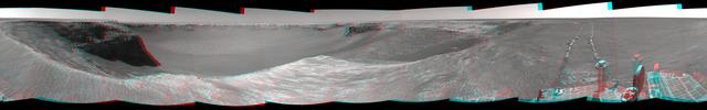
NASA Mars Exploration Rover Opportunity recorded this view of the summit of Cape Tribulation, on the western rim of Endeavour Crater on the day before the rover drove to the top. You need 3D glasses to view this image.

Images from the Ozone Monitoring Instrument onboard NASA Aura spacecraft shows the average total column ozone during the months of January and March, and the total column ozone on the single day of 11 March, 2005.

This 360-degree view combines frames taken by the navigation camera on NASA Mars Exploration Rover Spirit during the rover 271st martian day, or sol, on Oct. 7, 2004. 3D glasses are necessary to view this image.
NASA Mars Exploration Rover Opportunity used its microscopic imager to get this view of the surface of a rock called Block Island during the 1,963rd Martian day, or sol, of the rover mission on Mars Aug. 1, 2009.
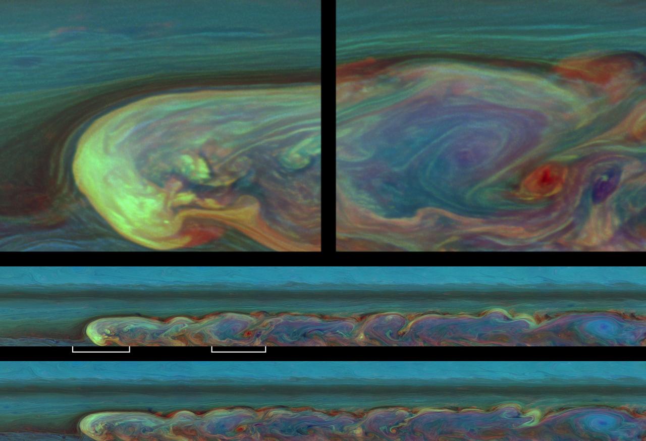
These false-color images from NASA Cassini spacecraft chronicle a day in the life of a huge storm that developed from a small spot that appeared 12 weeks earlier in Saturn northern mid-latitudes.
Saturn small moon Pan casts a long shadow across the A ring in this image captured by NASA Cassini spacecraft a few days after the planet August 2009 equinox.