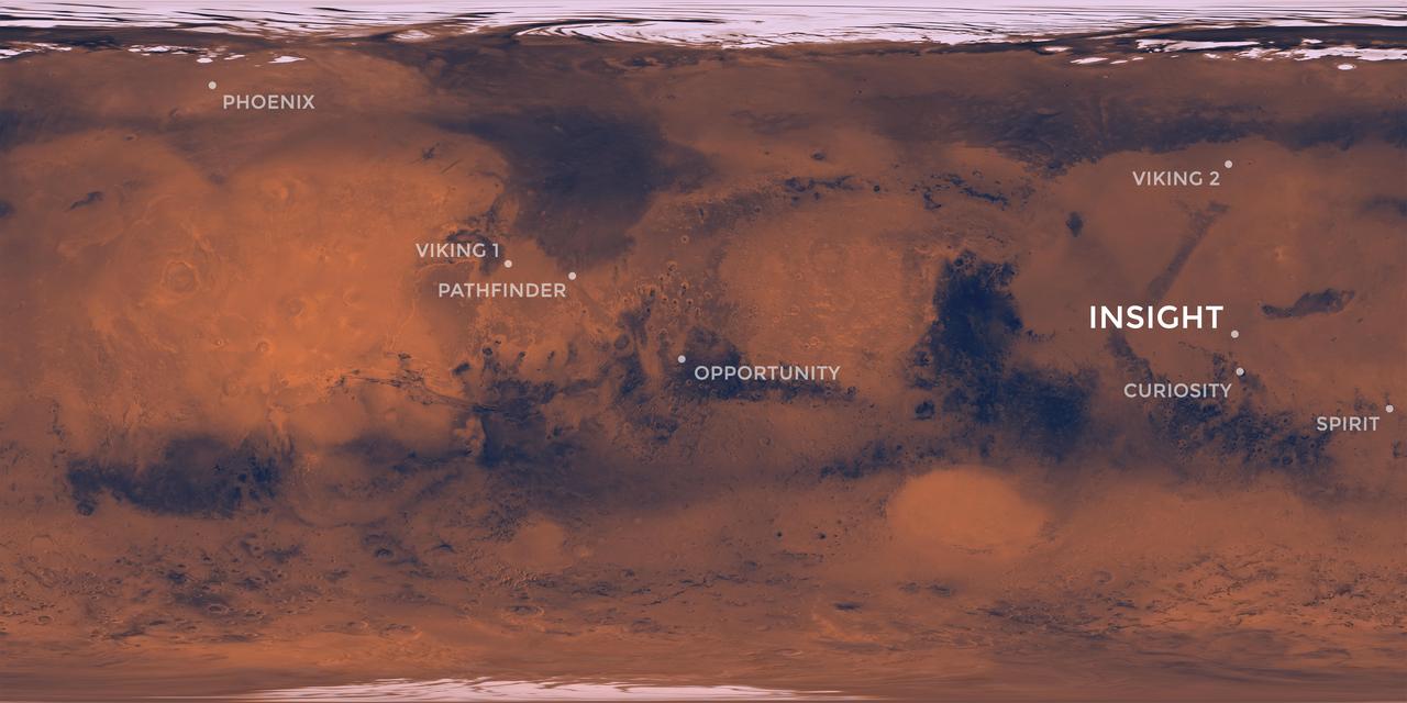
Elysium Planitia, a flat-smooth plain just north of the equator makes for the perfect location from which to study the deep Martian interior. Interior Exploration using Seismic Investigations, Geodesy and Heat Transport, or InSight, is designed to study the deep interior of Mars. The mission seeks the fingerprints of the processes that formed the rocky planets of the solar system. Its landing site, Elysium Planitia, was picked from 22 candidates, and is centered at about 4.5 degrees north latitude and 135.9 degrees east longitude; about 373 miles (600 kilometers) from Curiosity's landing site, Gale Crater. The locations of other Mars landers and rovers are labeled. InSight's scientific success and safe landing depends on landing in a relatively flat area, with an elevation low enough to have sufficient atmosphere above the site for a safe landing. It also depends on landing in an area where rocks are few in number. Elysium Planitia has just the right surface for the instruments to be able to probe the deep interior, and its proximity to the equator ensures that the solar-powered lander is exposed to plenty of sunlight. https://photojournal.jpl.nasa.gov/catalog/PIA22232
NASA's InSight spacecraft captured this panorama of its landing site on Dec. 9, 2018, the 14th Martian day, or sol, of its mission. The 290-degree perspective surveys the rim of the degraded crater InSight landed in, nicknamed "Homestead Hollow." The panorama is made of 30 individual images that were taken by the spacecraft's Instrument Deployment Camera, located on its robotic arm. https://photojournal.jpl.nasa.gov/catalog/PIA23140
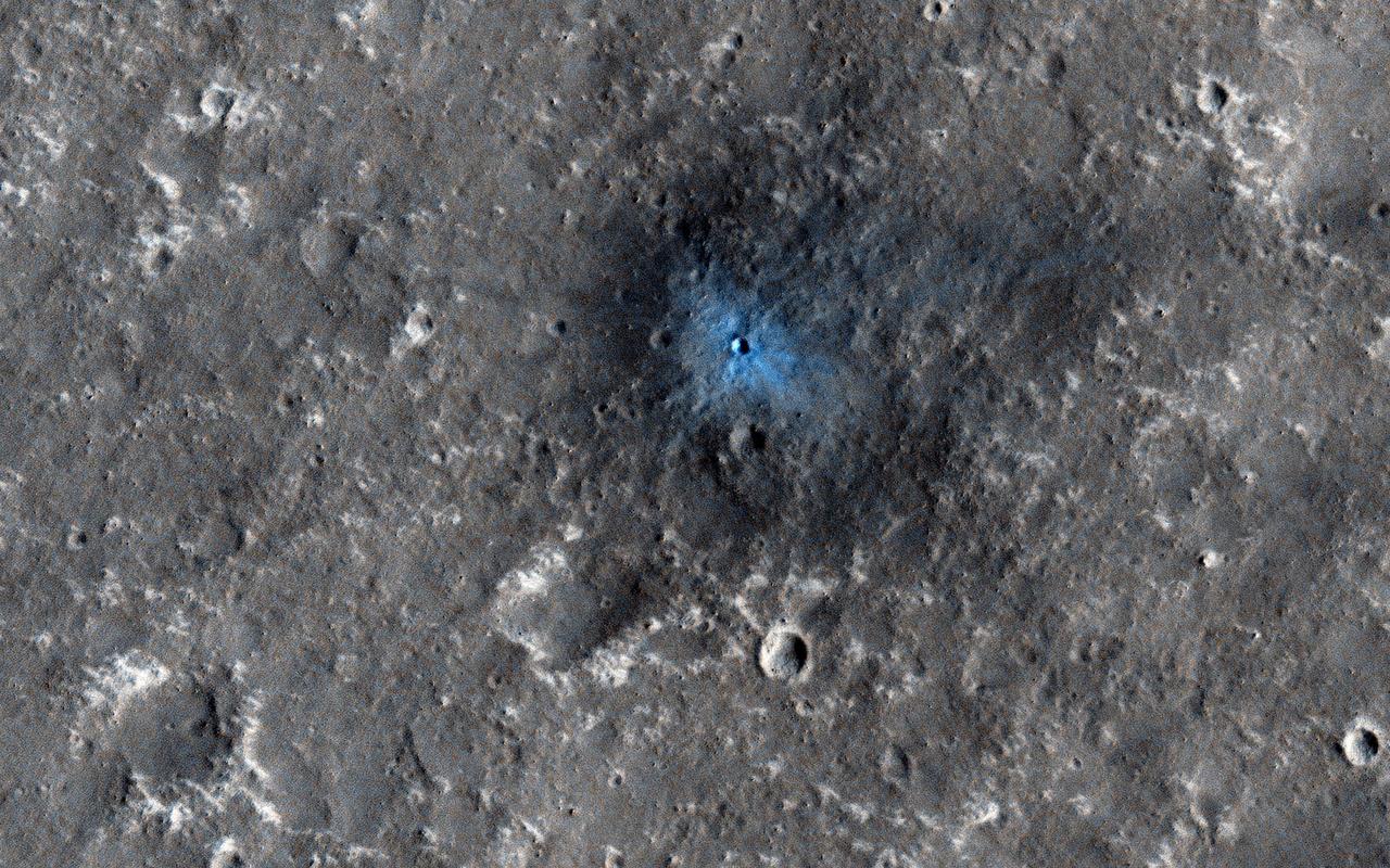
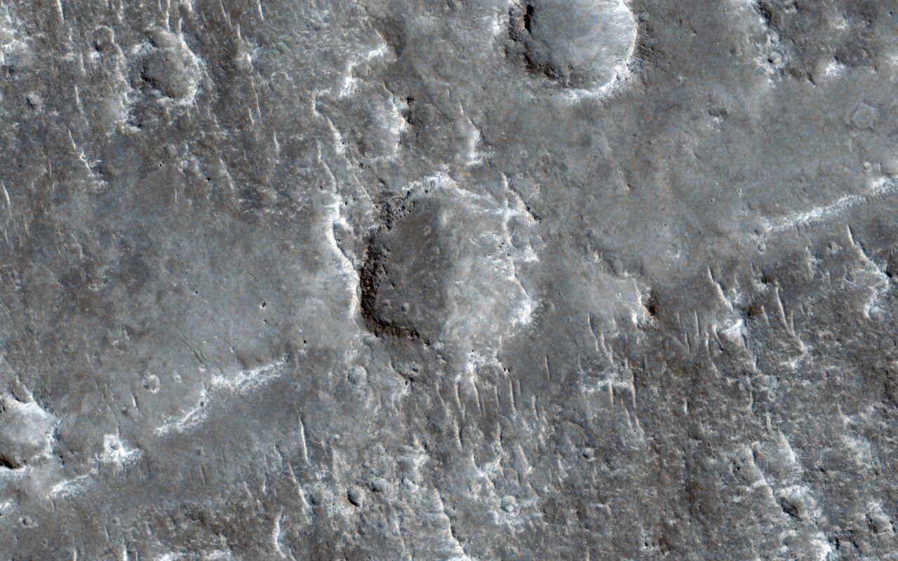
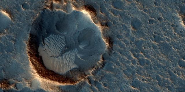
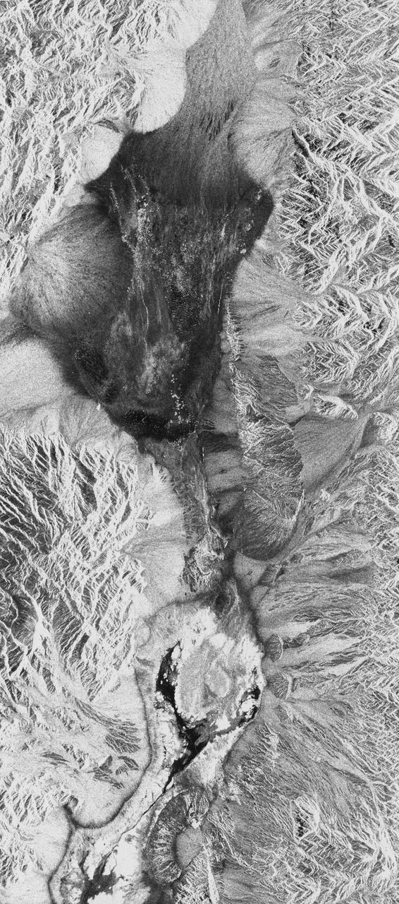
This recent image from NASA Mars Reconnaissance Orbiter, acquired to certify a landing site for NASAa InSight mission, shows a distinctive crater with a very sharp rim and ejecta.
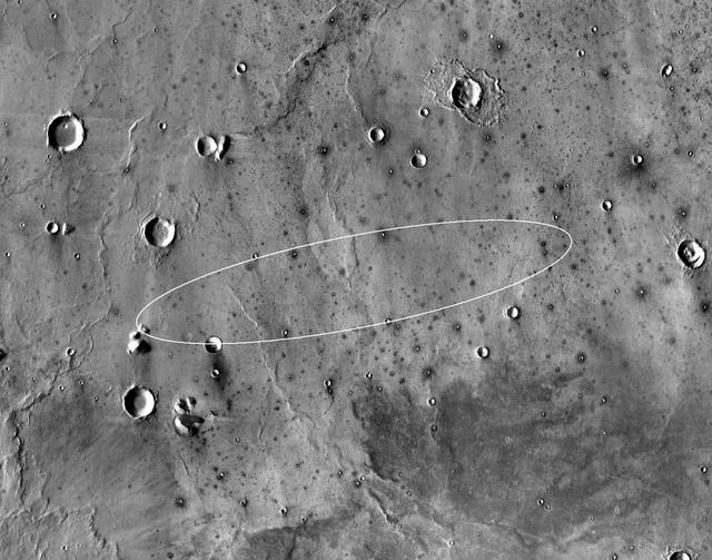
This map shows the single area under continuing evaluation as the InSight mission's Mars landing site, as of a year before the mission's May 2016 launch. The finalist ellipse marked within the northern portion of flat-lying Elysium Planitia is centered at about 4.5 degrees north latitude and 136 degrees east longitude. InSight -- an acronym for Interior Exploration using Seismic Investigations, Geodesy and Heat Transport -- will study the interior of Mars to improve understanding of the processes that formed and shaped rocky planets, including Earth. The mission's launch period begins March 4, 2016, and lasts until late March. Whichever day during that period the launch occurs, landing is scheduled for Sept. 28, 2016. The landing ellipse on this map covers an area within which the spacecraft has about 99 percent chance of landing when targeted for the center of the ellipse. It is about 81 miles (130 kilometers) long, generally west to east, and about 17 miles (27 kilometers) wide. This ellipse covers the case of a launch at the start of the launch period. If the launch occurs later in the period, orientation of the landing ellipse would shift slightly clockwise. Four semifinalist sites in Elysium Planitia were evaluated as safe for InSight landing. This one was selected as having the largest proportion of its area classified as smooth terrain. If continuing analysis identifies unexpected problems with this site, another of the semifinalists could be reconsidered before final selection later this year. The InSight lander will deploy two instruments directly onto the ground using a robotic arm. One is a seismometer contributed by France's space agency (CNES) with components from Germany, Switzerland, the United Kingdom and the United States. The seismometer will measure microscopic ground motions, providing detailed information about the interior structure of Mars. The other instrument to be deployed by the arm is a heat-flow probe contributed by the German Aerospace Center (DLR), designed to hammer itself three to five meters (about 10 to 16 feet) deep. It will monitor heat coming from the planet's interior. The mission will also track the lander's radio to measure wobbles in the planet's rotation that relate to the size of its core. A suite of environmental sensors will monitor the weather and variations in the magnetic field. The base map is a mosaic of daytime thermal images from the Thermal Emission Imaging System (THEMIS) on NASA's Mars Odyssey orbiter. THEMIS was developed and is operated by Arizona State University, Tempe. Note: After thorough examination, NASA managers have decided to suspend the planned March 2016 launch of the Interior Exploration using Seismic Investigations Geodesy and Heat Transport (InSight) mission. The decision follows unsuccessful attempts to repair a leak in a section of the prime instrument in the science payload. http://photojournal.jpl.nasa.gov/catalog/PIA19143
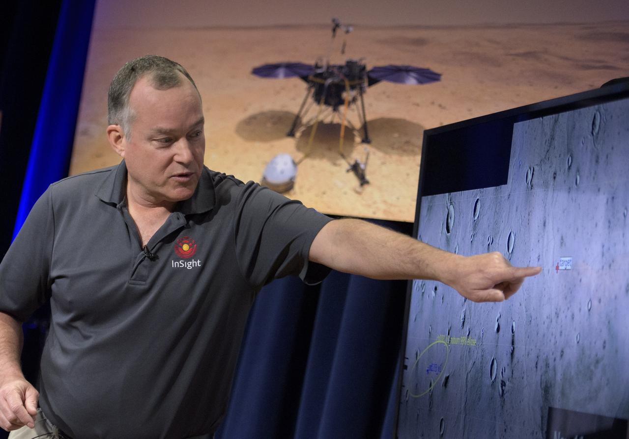
Tom Hoffman, InSight Project Manager, NASA JPL talks about the Mars InSight landing site during a pre-landing briefing, Sunday, Nov. 25, 2018 at NASA's Jet Propulsion Laboratory in Pasadena, California. InSight, short for Interior Exploration using Seismic Investigations, Geodesy and Heat Transport, is a Mars lander designed to study the "inner space" of Mars: its crust, mantle, and core. InSight is scheduled to touch down on the Red Planet at approximately noon PST (3 p.m. EST) on Nov. 26. Photo Credit: (NASA/Bill Ingalls)
With NASA Mars Reconnaissance Orbiter HiRISE camera and its powerful resolution, other mission teams can request images of potential future landing sites on Mars.
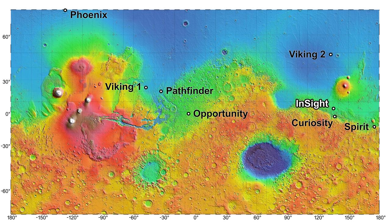
The process of selecting a site for NASA's next landing on Mars, planned for September 2016, has narrowed to four semifinalist sites located close together in the Elysium Planitia region of Mars. The mission known by the acronym InSight will study the Red Planet's interior, rather than surface features, to advance understanding of the processes that formed and shaped the rocky planets of the inner solar system, including Earth. The location of the cluster of semifinalist landing sites for InSight is indicated on this near-global topographic map of Mars, which also indicates landing sites of current and past NASA missions to the surface of Mars. The mission's full name is Interior Exploration Using Seismic Investigations, Geodesy and Heat Transport. The location of Elysium Planitia close to the Martian equator meets an engineering requirement for the stationary InSight lander to receive adequate solar irradiation year-round on its photovoltaic array. The location also meets an engineering constraint for low elevation, optimizing the amount of atmosphere the spacecraft can use for deceleration during its descent to the surface. The number of candidate landing sites for InSight was trimmed from 22 down to four in August 2013. This down-selection facilitates focusing the efforts to further evaluate the four sites. Cameras on NASA's Mars Reconnaissance Orbiter will be used to gather more information about them before the final selection. The topographic map uses data from the Mars Orbiter Laser Altimeter on NASA's Mars Global Surveyor spacecraft. The color coding on this map indicates elevation relative to a reference datum, since Mars has no "sea level." The lowest elevations are presented as dark blue; the highest as white. The difference between green and orange in the color coding is about 2.5 miles (4 kilometers) vertically. Note: After thorough examination, NASA managers have decided to suspend the planned March 2016 launch of the Interior Exploration using Seismic Investigations Geodesy and Heat Transport (InSight) mission. The decision follows unsuccessful attempts to repair a leak in a section of the prime instrument in the science payload. http://photojournal.jpl.nasa.gov/catalog/PIA17357
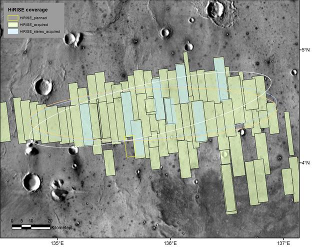
This map shows footprints of images taken from Mars orbit by the High Resolution Imaging Science Experiment (HiRISE) camera as part of advance analysis of the area where NASA's InSight mission will land in 2018. The final planned image of the set is targeted to fill in the yellow-outlined rectangle on March 30, 2017. HiRISE is one of six science instruments on NASA's Mars Reconnaissance Orbiter, which reached Mars in 2006 and surpassed 50,000 orbits on March 27, 2017. The map covers an area about 100 miles (160 kilometers) across. HiRISE has been used since 2006 to inspect dozens of candidate landing sites on Mars, including the sites where the Phoenix and Curiosity missions landed in 2008 and 2012. The site selected for InSight's Nov. 26, 2018, landing is on a flat plain in the Elysium Planitia region of Mars, between 4 and 5 degrees north of the equator. HiRISE images are detailed enough to reveal individual boulders big enough to be a landing hazard. The March 30 observation that completes the planned advance imaging of this landing area brings the number of HiRISE images of the area to 73. Some are pairs covering the same ground. Overlapping observations provide stereoscopic, 3-D information for evaluating characteristics such as slopes. On this map, coverage by stereo pairs is coded in pale blue, compared to the gray-green of single HiRISE image footprints. The ellipses on the map are about 81 miles (130 kilometers) west-to-east by about 17 miles (27 kilometers) north-to-south. InSight has about 99 percent odds of landing within the ellipse for which it is targeted. The three ellipses indicate landing expectations for three of the possible InSight launch dates: white outline for launch at the start of the launch period, on May 5, 2018; blue for launch on May 26, 2018; orange for launch on June 8, 2018. InSight -- an acronym for "Interior Exploration using Seismic Investigations, Geodesy and Heat Transport" -- will study the deep interior of Mars to improve understanding about how rocky planets like Earth formed and evolved. http://photojournal.jpl.nasa.gov/catalog/PIA21489
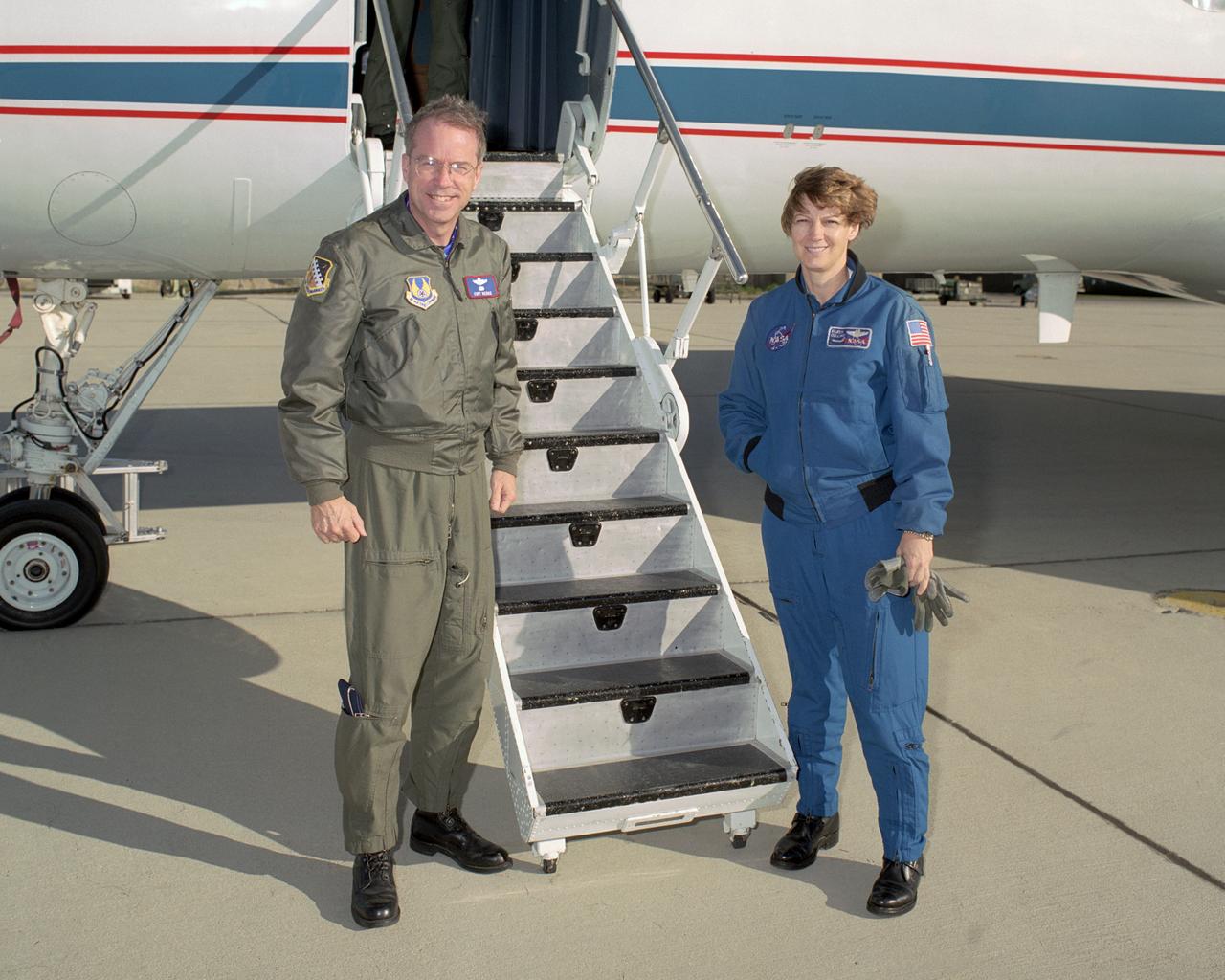
Brig. Gen. Curtis Bedke, commander of the Air Force Flight Test Center at Edwards Air Force Base, received some first-hand insight on how to fly a Space Shuttle approach and landing, courtesy of NASA astronaut and STS-114 mission commander Eileen Collins. The series of proficiency flights in NASA's modified Grumman Gulfstream-II Shuttle Training Aircraft were in preparation for the STS-114 mission with the shuttle Discovery. Although NASA's Kennedy Space Center in Florida is the primary landing site for Space Shuttle missions, flight crews also practice the shuttle's steep approach and landing at Edwards in case weather or other situations preclude a landing at the Florida site and force a diversion to Edwards AFB.
This image from the High Resolution Imaging Science Experiment (HiRISE) camera on NASA's Mars Reconnaissance Orbiter shows a location on Mars associated with the best-selling novel and Hollywood movie, "The Martian." This area is in the Acidalia Planitia region. In the novel and the movie, it is the landing site of a crewed mission named Ares 3. For the story's central character, Acidalia Planitia is within driving distance from where NASA's Mars Pathfinder, with its Sojourner rover, landed in 1997. An initial HiRISE image of the site was taken in April 2015 and is online at http://hirise.lpl.arizona.edu/ESP_040776_2115. A second one was taken May 17, 2015, and is shown here. Figure 1 is a stereo combination of the two, appearing three-dimensional when viewed through blue-red glasses with the red lens on the left One of the main objectives of the HiRISE camera is to carry out "monitoring science", which involves taking images of certain areas of high scientific interest on regular intervals. The team usually does so to monitor a seasonal or recurring process such as seasonal changes in carbon-dioxide ice near the poles, dune movement or recurring flow-like features on some slopes. HiRISE also takes repeated images of areas with active rovers, such as Curiosity, to help plan safe routes toward areas of high scientific interest. Another key responsibility for the HiRISE camera is to provide information for use in selection of landing sites for future missions. One technique is to image a site of interest at least twice when the weather conditions are similar, but with a small difference in viewing angle, much like what you would experience if you looked at something with only your right eye, then looked at it again with the left. By doing this, we are able to build a stereo view of the site, providing a chance to identify high and low points in the site more effectively. This resulting 3-D information can combined with elevation data from laser altimeters to create a highly accurate "digital terrain model" or DTM for short. DTMs allow researchers to view the locations in 3-D and to analyze them by measuring the exact height of features that could be hazardous to the future mission, such as large boulders or small impact craters. DTMs from HiRISE were a key factor in choosing the landing site for NASA's Curiosity Mars rover in Gale Crater and are being used to evaluate sites under consideration for the NASA's 2016 InSight Mars lander and Mars 2020 rover missions. The location of the site in this image is 31.3 degrees north latitude, 331.3 degrees east latitude. The image is an excerpt from HiRISE observation ESP_041277_2115. http://photojournal.jpl.nasa.gov/catalog/PIA19913
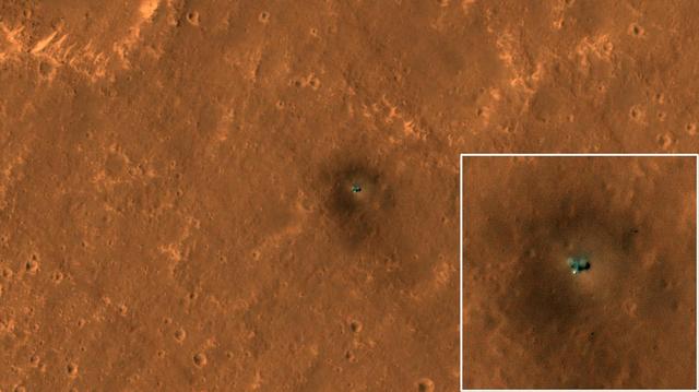
The HiRISE camera on NASA's Mars Reconnaissance Orbiter got its best view yet of the agency's InSight lander on Sept. 23, 2019. HiRISE has been monitoring InSight's landing site on the Red Planet for changes such as dust-devil tracks (the slightly dark diagonals streaks crisscrossing the surface). This new image clearly shows the two circular solar panels on either side of the lander body. From end to end, the panels span 20 feet (6 meters); the image was taken from an elevation of 169 miles (272 kilometers) above the surface. The bright spot on the lower side of the spacecraft is the dome-shaped protective cover over InSight's seismometer. Surrounding the spacecraft is a dark halo created by retrorocket thrusters scouring the surface during landing. Dark streaks seen crossing diagonally across the surface are dust-devil tracks. Several factors make this image crisper than past images. For one thing, there's less dust in the air this time of year compared to before. And shadows are offset from the lander because this is an oblique view looking west. Moreover, the lighting was better for avoiding the bright reflections from the lander or its solar panels that have obscured surrounding pixels in other images. The seismometer cover to the south of the lander is still bright because its dome shape always produces a mirror-like reflection over some small area. https://photojournal.jpl.nasa.gov/catalog/PIA23376
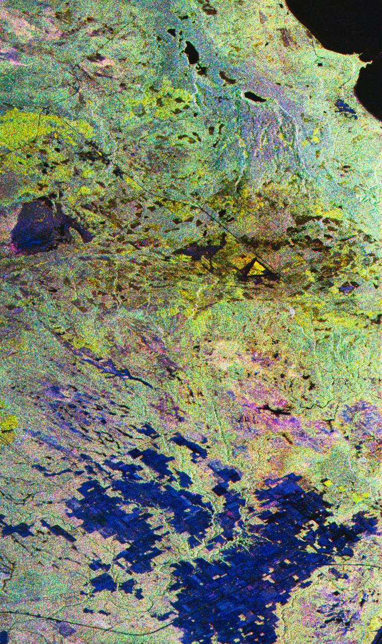
STS059-S-027 (10 April 1994) --- This image is a false-color composite of Raco, Michigan, centered at 46.39 degrees north latitude, 84.88 degrees east longitude. This image was acquired by the Spaceborne Imaging Radar-C and X-Band Synthetic Aperture Radar (SIR-C/X-SAR) aboard the Space Shuttle Endeavour on its 6th orbit and during the first full-capacity test of the instrument. This image was produced using both L-Band and C-Band data. The area shown is approximately 20 kilometers by 50 kilometers. Raco is located at the eastern end of Michigan's upper peninsula, west of Sault Ste. Marie and south of Whitefish Bay on Lake Superior. The site is located at the boundary between the boreal forests and the northern temperate forests, a transitional zone that is expected to be ecologically sensitive to anticipated global changes resulting from climatic warming. On any given day, there is a 60 percent chance that this area will be obscured to some extent by cloud cover which makes it difficult to image using optical sensors. In this color representation (Red=LHH, Green=LHV, Blue=CHH), darker areas in the image are smooth surfaces such as frozen lakes and other non-forested areas. The colors are related to the types of trees and the brightness is related to the amount of plant material covering the surface, called forest biomass. Accurate information about land-cover is important to area resource managers and for use in regional- to global-scale scientific models used to understand global change. SIR-C/X-SAR radars illuminate Earth with microwaves allowing detailed observations at any time, regardless of weather or sunlight conditions. SIR-C/X-SAR uses three microwave wavelengths: L-Band (24 cm), C-Band (6 cm), and X-Band (3 cm). The multi-frequency data will be used by the international scientific community to better understand the global environment and how it is changing. The SIR-C/X-SAR data, complemented by aircraft and ground studies, will give scientists clearer insights into those environmental changes which are caused by nature and those changes which are induced by human activity. SIR-C was developed by NASA's Jet Propulsion Laboratory (JPL). X-SAR was developed by the Dornire and Alenia Spazio Companies for the German Space Agency, Deutsche Agentur fuer Raumfahrtangelegenheiten (DARA), and the Italian Space Agency, Agenzia Spaziale Italiana (ASI). JPL Photo ID: P-43882
STS059-S-026 (11 April 1994) --- This is an image of Death Valley, California, centered at 36.629 degrees north latitude, 117.069 degrees west longitude. The image shows Furnace Creek alluvial fan and Furnace Creek Ranch at the far right, and the sand dunes near Stove Pipe Wells at the center. The dark fork-shaped feature between Furnace Creek fan and the dunes is a smooth flood-plain which encloses Cottonball Basin. The SIR-C/X-SAR supersite is an area of extensive field investigations and has been visited by both Space Radar Lab astronaut crews. Elevations in the Valley range from 70 meters below sea level, the lowest in the United States, to more than 3300 meters above sea level. Scientists are using SIR-C/X-SAR data from Death Valley to help answer a number of different questions about the Earth's geology. One question concerns how alluvial fans are formed and change through time under the influence of climatic changes and earthquakes. Alluvial fans are gravel deposits that wash down from the mountains over time. They are visible in the image as circular, fan-shaped bright areas extending into the darker valley floor from the mountains. Information about the alluvial fans help scientists study Earth's ancient climate. Scientists know the fans are bulit up through climatic and tectonic processes and they will use the SIR-C/X-SAR data to understand the nature and rates of weathering processes on the fans, soil formation, and the transport of sand and dust by the wind. SIR-C/X-SAR's sensitivity to centimeter-scale (or inch-scale) roughness provides detailed maps of surface texture. Such information can be used to study the occurrence and movement of dust storms and sand dunes. the goal of these studies is to gain a better understanding of the record of past climatic changes and the effects of those changes on a sensitive environment. This may lead to a better ability to predict future response of the land to different potential global cimate-change scenarios. Death Valley is also one of the primary calibration sites for SIR-C/X-SAR. The bright dots near the center of the image are corner reflectors that have been set-up to calibrate the radar as the Shuttle passes overhead. Thirty triangular-shaped reflectors (they look like aluminum pyramids) have been deployed by the calibration team from JPL over a 40 kilometer by 40 kilometer area in and around Death Valley. The calibration team will also deploy transponders (electronic reflectors) and recievers to measure the radar signals from SIR-C/X-SAR on the ground. Spaceborne Imaging Radar-C and X-Synthetic Aperture Radar (SIR-C/X-SAR) is part of NASA's Mission to Planet Earth (MTPE). The radars illuminate Earth with microwaves allowing detailed observations at any time, regardless of weather or sunlight conditions. SIR-C/X-SAR uses three microwave wavelengths: L-Band (24 cm), C-Band (6 cm), and X-Band (3 cm). The multi-frequency data will be used by the international scientific community to better understand the global environment and how it is changing. The SIR-C/X-SAR data, complemented by aircraft and ground studies, will give scientists clearer insights into those environmental changes which are caused by nature and those changes which are induced by human activity. SIR-C was develpoed by NASA's Jet Propulsion Laboratory (JPL). X-SAR was developed by the Dornire and Alenia Spazio Companies for the German Space Agency, Deutsche Agentur fuer Raumfahrtangelegenheiten (DARA), and the Italian Space Agency, Agenzia Spaziale Italiana (ASI). JPL Photo ID: P-43883