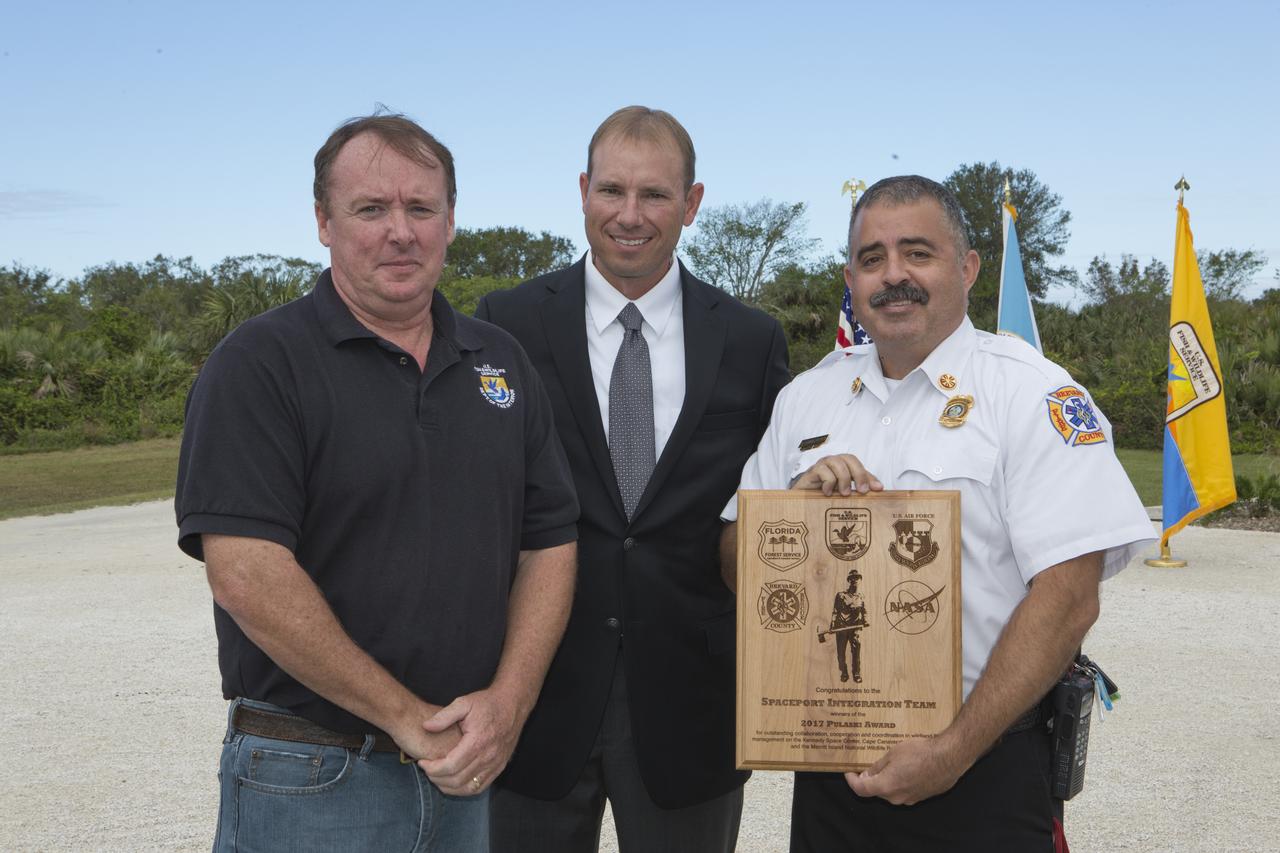
From left, Jon Wallace, deputy fire coordinator, U.S. Fish and Wildlife Service Southeast Region, Atlanta, Georgia; Chris Wilcox, U.S. Fish and Wildlife chief, Fire Management, National Interagency Fire Center, Boise, Idaho; and Mark Schollmeyer, chief, Brevard County Fire Rescue, pose for a portrait following a ceremony Nov. 1 on the Merritt Island National Wildlife Refuge in Florida. During the joint ceremony, the Spaceport Integration Team and its partners were presented with the prestigious 2017 Pulaski Award and a new memorial marker was dedicated. The multi-agency team includes representatives from NASA's Kennedy Space Center, Cape Canaveral Air Force Station's 45th Space Wing, the Merritt Island National Wildlife Refuge, as well as the Florida Forest Service and Brevard County Fire Rescue. The memorial marker honors two fallen firefighters, Scott Maness and Beau Sauselein, who died fighting a wildfire on space center property in 1981. Held outdoors, the ceremony was attended by 140 guests.
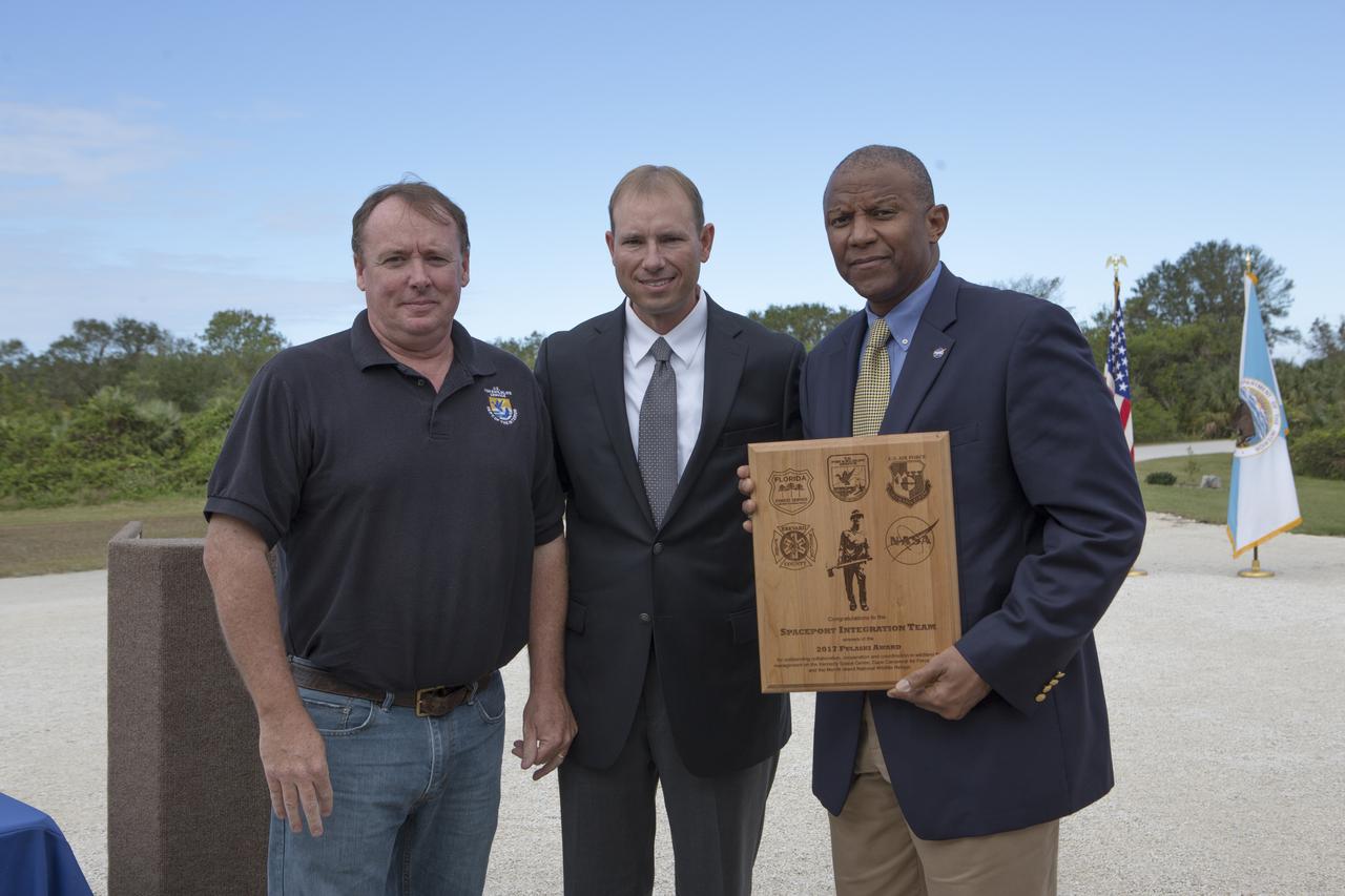
From left, Jon Wallace, deputy fire coordinator, U.S. Fish and Wildlife Service Southeast Region, Atlanta, Georgia; Chris Wilcox, U.S. Fish and Wildlife chief, Fire Management, National Interagency Fire Center, Boise, Idaho; and Kelvin Manning, associate director, NASA's Kennedy Space Center, pose for a portrait following a ceremony Nov. 1 on the Merritt Island National Wildlife Refuge in Florida. During the joint ceremony, the Spaceport Integration Team and its partners were presented with the prestigious 2017 Pulaski Award and a new memorial marker was dedicated. The multi-agency team includes representatives from NASA's Kennedy Space Center, Cape Canaveral Air Force Station's 45th Space Wing, the Merritt Island National Wildlife Refuge, as well as the Florida Forest Service and Brevard County Fire Rescue. The memorial marker honors two fallen firefighters, Scott Maness and Beau Sauselein, who died fighting a wildfire on space center property in 1981. Held outdoors, the ceremony was attended by 140 guests.
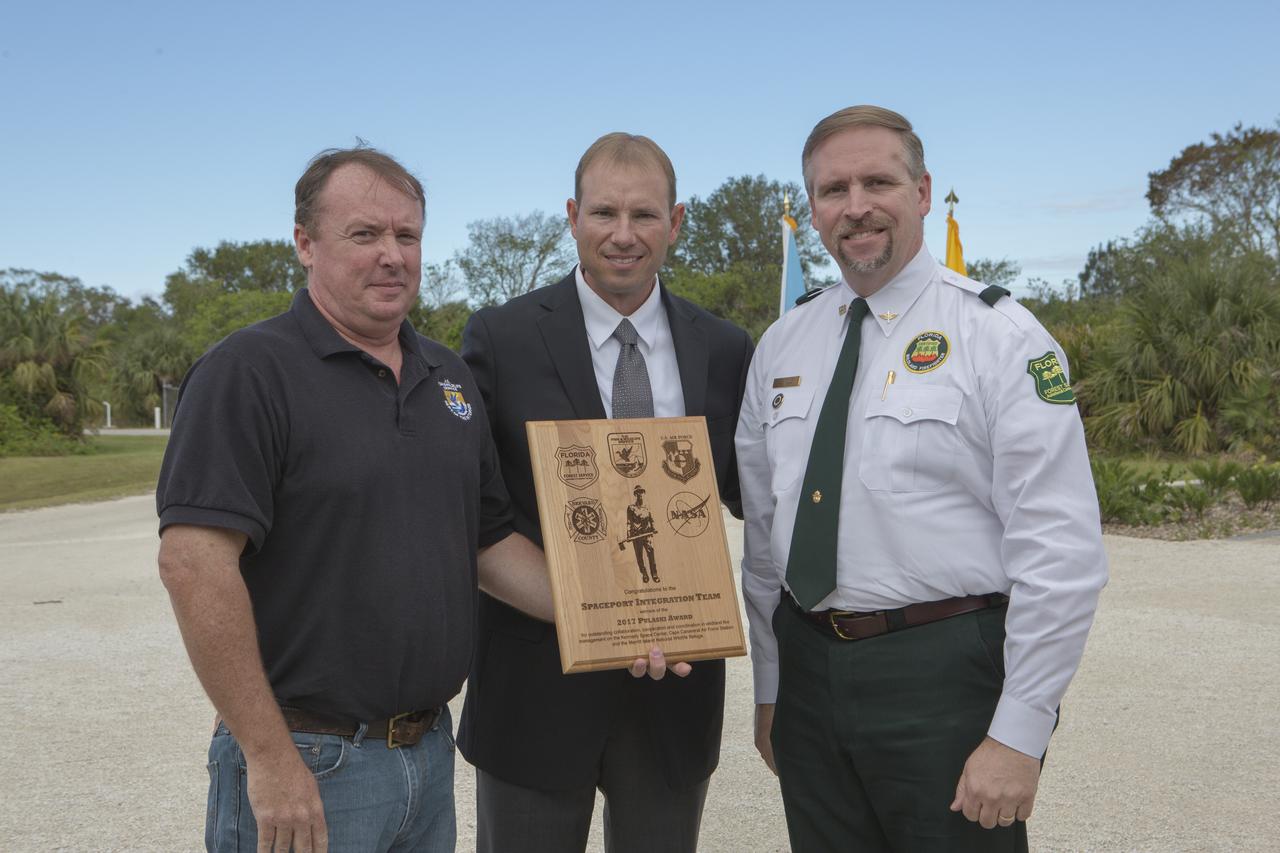
From left, Jon Wallace, deputy fire coordinator, U.S. Fish and Wildlife Service Southeast Region, Atlanta, Georgia; Chris Wilcox, U.S. Fish and Wildlife chief, Fire Management, National Interagency Fire Center, Boise, Idaho; and John Fish, chief, Florida Forest Service, pose for a portrait following a ceremony Nov. 1 on the Merritt Island National Wildlife Refuge in Florida. During the joint ceremony, the Spaceport Integration Team and its partners were presented with the prestigious 2017 Pulaski Award and a new memorial marker was dedicated. The multi-agency team includes representatives from NASA's Kennedy Space Center, Cape Canaveral Air Force Station's 45th Space Wing, the Merritt Island National Wildlife Refuge, as well as the Florida Forest Service and Brevard County Fire Rescue. The memorial marker honors two fallen firefighters, Scott Maness and Beau Sauselein, who died fighting a wildfire on space center property in 1981. Held outdoors, the ceremony was attended by 140 guests.
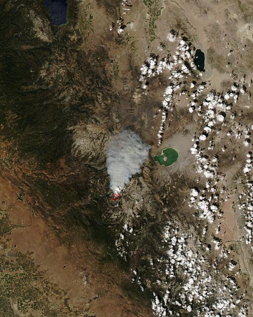
The Meadow Fire in Yosemite National Park is a remote, hold-over lightning caused fire which began on September 4 and is located five miles east of Yosemite Valley, CA. The fuel burning is timber and brush. There is active fire behavior with long range spotting. The National Park Service reports that a fire, that may be a spot fire, from the Meadow lightning-caused fire, was discovered at approximately 12:30 PM, Sunday September 7. The fire is approximately 2,582 acres. It is burning within the Little Yosemite Valley on both sides of the Merced River. All trails in the area are closed. Approximately 100 hikers and backpackers were evacuated from the fire area in Little Yosemite Valley. Half-Dome, a popular tourist destination, has been closed. The fire is burning in Yosemite Wilderness. Eighty-five hikers and climbers were also evacuated from the summit of Half Dome by helicopters from the California Highway Patrol, US Department of Agriculture Forest Service, Sequoia Kings Canyon National Park, and CAL Fire. This natural-color satellite image was collected by the Moderate Resolution Imaging Spectroradiometer (MODIS) aboard the Aqua satellite on Sept. 07, 2014. Actively burning areas, detected by MODIS’s thermal bands, are outlined in red. NASA image courtesy Jeff Schmaltz, MODIS Rapid Response Team. Caption: NASA/Goddard, Lynn Jenner with information from the National Park Service and the National Interagency Coordination Center. <b><a href="http://www.nasa.gov/audience/formedia/features/MP_Photo_Guidelines.html" rel="nofollow">NASA image use policy.</a></b> <b><a href="http://www.nasa.gov/centers/goddard/home/index.html" rel="nofollow">NASA Goddard Space Flight Center</a></b> enables NASA’s mission through four scientific endeavors: Earth Science, Heliophysics, Solar System Exploration, and Astrophysics. Goddard plays a leading role in NASA’s accomplishments by contributing compelling scientific knowledge to advance the Agency’s mission. <b>Follow us on <a href="http://twitter.com/NASAGoddardPix" rel="nofollow">Twitter</a></b> <b>Like us on <a href="http://www.facebook.com/pages/Greenbelt-MD/NASA-Goddard/395013845897?ref=tsd" rel="nofollow">Facebook</a></b> <b>Find us on <a href="http://instagram.com/nasagoddard?vm=grid" rel="nofollow">Instagram</a></b>
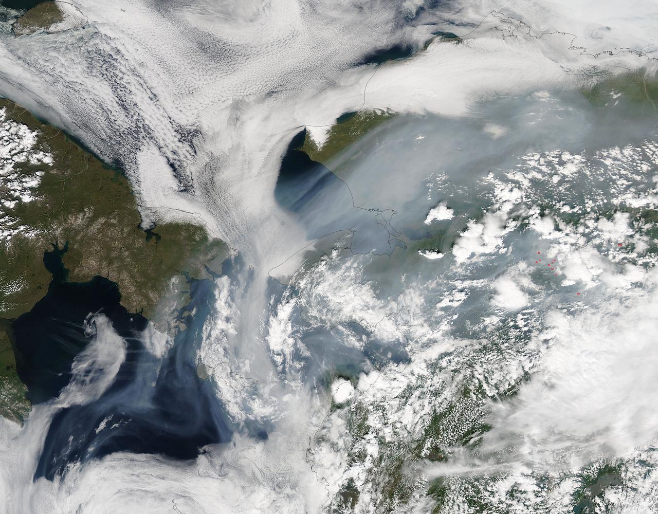
Fires have raged throughout Alaska in 2015. The Moderate Resolution Imaging Spectroradiometer (MODIS) on NASA’s Aqua satellite acquired this image on July 14, 2015. Actively burning areas, detected by the thermal bands on MODIS, are outlined in red. According to the most recent update (July 16, 2015) from the Alaska Interagency Coordination Center, about 304 fires were actively burning when MODIS imaged the area. To date, fires have charred a total of 4,854,924 acres in Alaska. The worst fire season in Alaska's history was in 2004. At this point in time, 2015 is a month ahead of the totals in 2004 putting it on track surpass the fire totals in 2004. The amount of acreage burned in Alaska during June 2015 shattered the previous acreage record set in June 2004 by more than 700,000 acres delivering a sobering piece of news for Alaskan residents. Credit: NASA/GSFC/Jeff Schmaltz/MODIS Land Rapid Response Team <b><a href="http://www.nasa.gov/audience/formedia/features/MP_Photo_Guidelines.html" rel="nofollow">NASA image use policy.</a></b> <b><a href="http://www.nasa.gov/centers/goddard/home/index.html" rel="nofollow">NASA Goddard Space Flight Center</a></b> enables NASA’s mission through four scientific endeavors: Earth Science, Heliophysics, Solar System Exploration, and Astrophysics. Goddard plays a leading role in NASA’s accomplishments by contributing compelling scientific knowledge to advance the Agency’s mission. <b>Follow us on <a href="http://twitter.com/NASAGoddardPix" rel="nofollow">Twitter</a></b> <b>Like us on <a href="http://www.facebook.com/pages/Greenbelt-MD/NASA-Goddard/395013845897?ref=tsd" rel="nofollow">Facebook</a></b> <b>Find us on <a href="http://instagrid.me/nasagoddard/?vm=grid" rel="nofollow">Instagram</a></b>
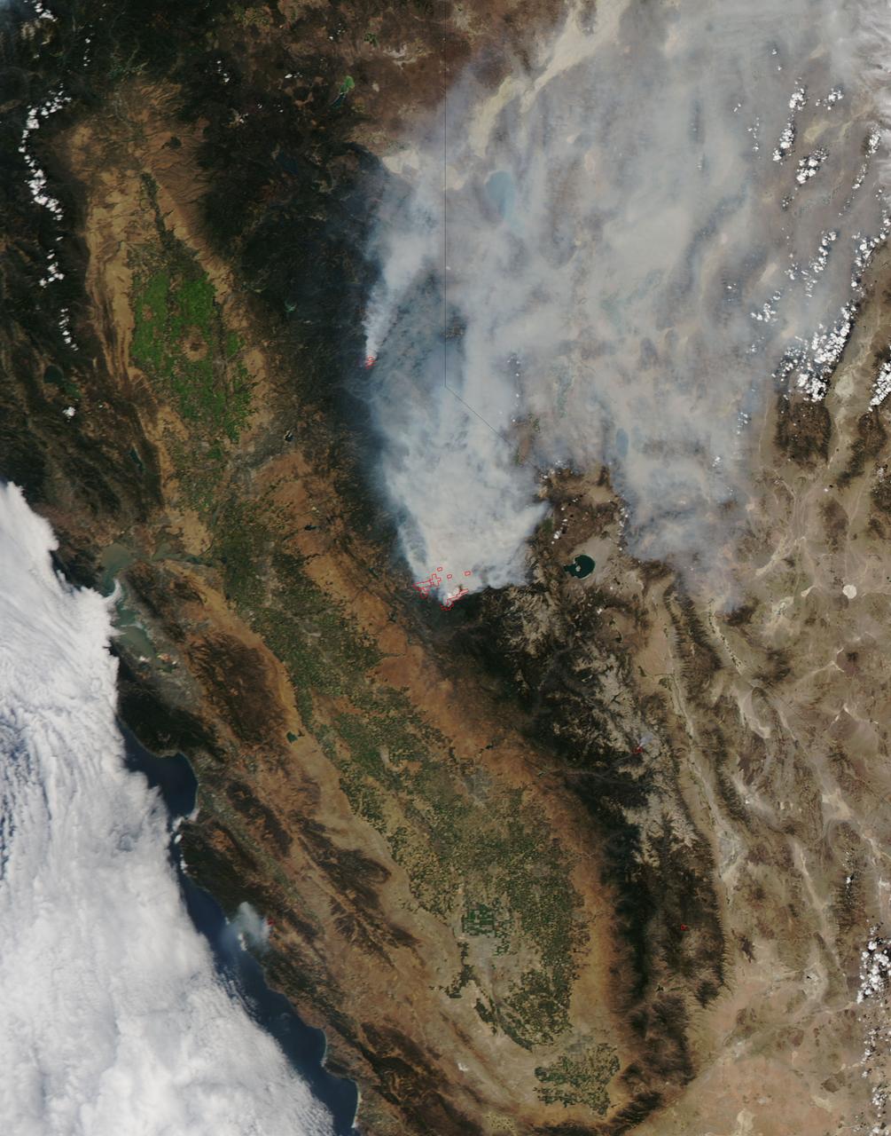
On August 23, 2013, the Moderate Resolution Imaging Spectroradiometer (MODIS) on NASA’s Aqua satellite acquired this image of the drought-fueled Rim fire burning in central California, near Yosemite National Park. Red outlines indicate hot spots where MODIS detected unusually warm surface temperatures associated with fires. Winds blew a thick smoke plume toward the northeast. A smaller fire—American fire—burned to the north. The lower image is a photograph that shows the fire burning at night on August 21. Started on August 17, 2013, the fast-moving fire had already charred more than 100,000 acres (40,000 hectares) by August 23, despite the efforts of more than 2,000 firefighters. Hundreds of people were forced to evacuate their homes, and roads in the area were closed. As of August 23, no structures had been reported destroyed, but the fire threatened the towns of Groveland and Pine Mountain Lake. By late August, wildfires had burned 3.4 million acres in the United States, making 2013 somewhat less active than other recent years. Over the last decade, fires charred 5.7 million acres on average by August 22, according to statistics published the National Interagency Fire Center. NASA image by Jeff Schmaltz, LANCE/EOSDIS Rapid Response. Caption by Adam Voiland. Instrument: Aqua - MODIS Credit: <b><a href="http://www.earthobservatory.nasa.gov/" rel="nofollow"> NASA Earth Observatory</a></b> <b><a href="http://www.nasa.gov/audience/formedia/features/MP_Photo_Guidelines.html" rel="nofollow">NASA image use policy.</a></b> <b><a href="http://www.nasa.gov/centers/goddard/home/index.html" rel="nofollow">NASA Goddard Space Flight Center</a></b> enables NASA’s mission through four scientific endeavors: Earth Science, Heliophysics, Solar System Exploration, and Astrophysics. Goddard plays a leading role in NASA’s accomplishments by contributing compelling scientific knowledge to advance the Agency’s mission. <b>Follow us on <a href="http://twitter.com/NASA_GoddardPix" rel="nofollow">Twitter</a></b> <b>Like us on <a href="http://www.facebook.com/pages/Greenbelt-MD/NASA-Goddard/395013845897?ref=tsd" rel="nofollow">Facebook</a></b> <b>Find us on <a href="http://instagram.com/nasagoddard?vm=grid" rel="nofollow">Instagram</a></b>
On August 25, 2013, the Moderate Resolution Imaging Spectroradiometer (MODIS) on NASA’s Terra satellite acquired this image of the drought-fueled Rim fire burning in central California, near Yosemite National Park. Red outlines indicate hot spots where MODIS detected unusually warm surface temperatures associated with fires. Winds blew a thick smoke plume toward the northeast. A smaller fire—American fire—burned to the north. Started on August 17, 2013, the fast-moving fire had already charred more than 100,000 acres (40,000 hectares) by August 23, despite the efforts of more than 2,000 firefighters. Hundreds of people were forced to evacuate their homes, and roads in the area were closed. As of August 23, no structures had been reported destroyed, but the fire threatened the towns of Groveland and Pine Mountain Lake. By late August, wildfires had burned 3.4 million acres in the United States, making 2013 somewhat less active than other recent years. Over the last decade, fires charred 5.7 million acres on average by August 22, according to statistics published the National Interagency Fire Center. NASA image by Jeff Schmaltz, LANCE/EOSDIS Rapid Response. Caption by Adam Voiland. Instrument: Terra - MODIS Credit: <b><a href="http://www.earthobservatory.nasa.gov/" rel="nofollow"> NASA Earth Observatory</a></b> <b><a href="http://www.nasa.gov/audience/formedia/features/MP_Photo_Guidelines.html" rel="nofollow">NASA image use policy.</a></b> <b><a href="http://www.nasa.gov/centers/goddard/home/index.html" rel="nofollow">NASA Goddard Space Flight Center</a></b> enables NASA’s mission through four scientific endeavors: Earth Science, Heliophysics, Solar System Exploration, and Astrophysics. Goddard plays a leading role in NASA’s accomplishments by contributing compelling scientific knowledge to advance the Agency’s mission. <b>Follow us on <a href="http://twitter.com/NASA_GoddardPix" rel="nofollow">Twitter</a></b> <b>Like us on <a href="http://www.facebook.com/pages/Greenbelt-MD/NASA-Goddard/395013845897?ref=tsd" rel="nofollow">Facebook</a></b> <b>Find us on <a href="http://instagram.com/nasagoddard?vm=grid" rel="nofollow">Instagram</a></b>
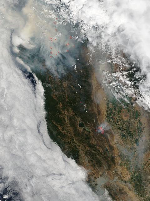
This satellite image shows smoke from several fires in Oregon and California on Aug. 2, 2015. The Moderate Resolution Imaging Spectroradiometer (MODIS) instrument that flies aboard NASA's Aqua satellite captured an image of smoke from these fires Aug. 2 at 21:05 UTC (5:05 p.m. EDT). The multiple red pixels are heat signatures detected by MODIS. The smoke appears to be a light brown color. InciWeb is an interagency all-risk incident information management system that coordinates with federal, state and local agencies to manage wildfires. In Oregon smoke from the Cable Crossing Fire, the Stouts Fire and the Potter Mountain Complex Fire commingle. The Cable Crossing Fire was reported burning on forestlands protected by the Douglas Forest Protective Association (DFPA) at approximately 3:25 p.m. on Tuesday, July 28, 2015, near Oregon Highway 138 East, near Mile Post 23, east of Glide. South of the Cable Crossing Fire is the Stouts Fire also in forestlands of the DFPA. This fire was reported on Thursday, July 30, 2015, burning approximately 11 miles east of Canyonville near the community of Milo. East of the other fires is the Potter Mountain Complex Fire. These fires are located in the Deschutes Forest consists of eight fires. According to Inciweb they were started by dry lightning on Saturday, Aug. 2, at approximately 5:30 p.m. about five miles north of Toketee Lake. In northern California, smoke from the River Complex Fire, the Fork Complex Fire and the Shf July Lightning Fire was visible in the MODIS image. The River Complex currently consists of seven reported and observed fires on the Six Rivers and Shasta Trinity National Forests. Originally identified as 18 fires, some have burned together. Inciweb noted that in the Six Rivers National Forest there are fires in the Trinity Alps Wilderness. Those fires include the Groves Fire and the Elk Fire. In the Shasta-Trinity National Forest the fires include the Happy Fire at 2,256 acres, Daily Fire at 16 acres, the Look Fire at 7 acres, Onion Fire at 136 acres and Smokey Fire at 1 acre. In the same forest, south of the River Complex is the Fork Complex fire. Inciweb reported that the Fork Complex consists of (at current count) over 40 fires, all of which were ignited by lightning between July 29 and 31, 2015. To the southwest of this complex is the Mad River Complex. This is a series of seven lightning fires that started on July 30, 2015 after a lightning storm moved through Northern California. To the east of this and the other fires, burns another near Redding, California, called the Shf July Lightning Fire. This is also under the Shasta-Trinity National Forest management. At 8 p.m. PDT on Aug. 2, Inciweb reported that approximately 15 lightning strikes occurred within 24 hours throughout the Shasta Trinity National Forest and resulted in two new fires. The Caves fire, east of Mt. Shasta, is approximately one-tenth of an acre. The Bluejay fire, east of Shasta Lake, is approximately four acres. Image credit: NASA Goddard's MODIS Rapid Response Team, Jeff Schmaltz <b><a href="http://www.nasa.gov/audience/formedia/features/MP_Photo_Guidelines.html" rel="nofollow">NASA image use policy.</a></b> <b><a href="http://www.nasa.gov/centers/goddard/home/index.html" rel="nofollow">NASA Goddard Space Flight Center</a></b> enables NASA’s mission through four scientific endeavors: Earth Science, Heliophysics, Solar System Exploration, and Astrophysics. Goddard plays a leading role in NASA’s accomplishments by contributing compelling scientific knowledge to advance the Agency’s mission. <b>Follow us on <a href="http://twitter.com/NASAGoddardPix" rel="nofollow">Twitter</a></b> <b>Like us on <a href="http://www.facebook.com/pages/Greenbelt-MD/NASA-Goddard/395013845897?ref=tsd" rel="nofollow">Facebook</a></b> <b>Find us on <a href="http://instagrid.me/nasagoddard/?vm=grid" rel="nofollow">Instagram</a></b>
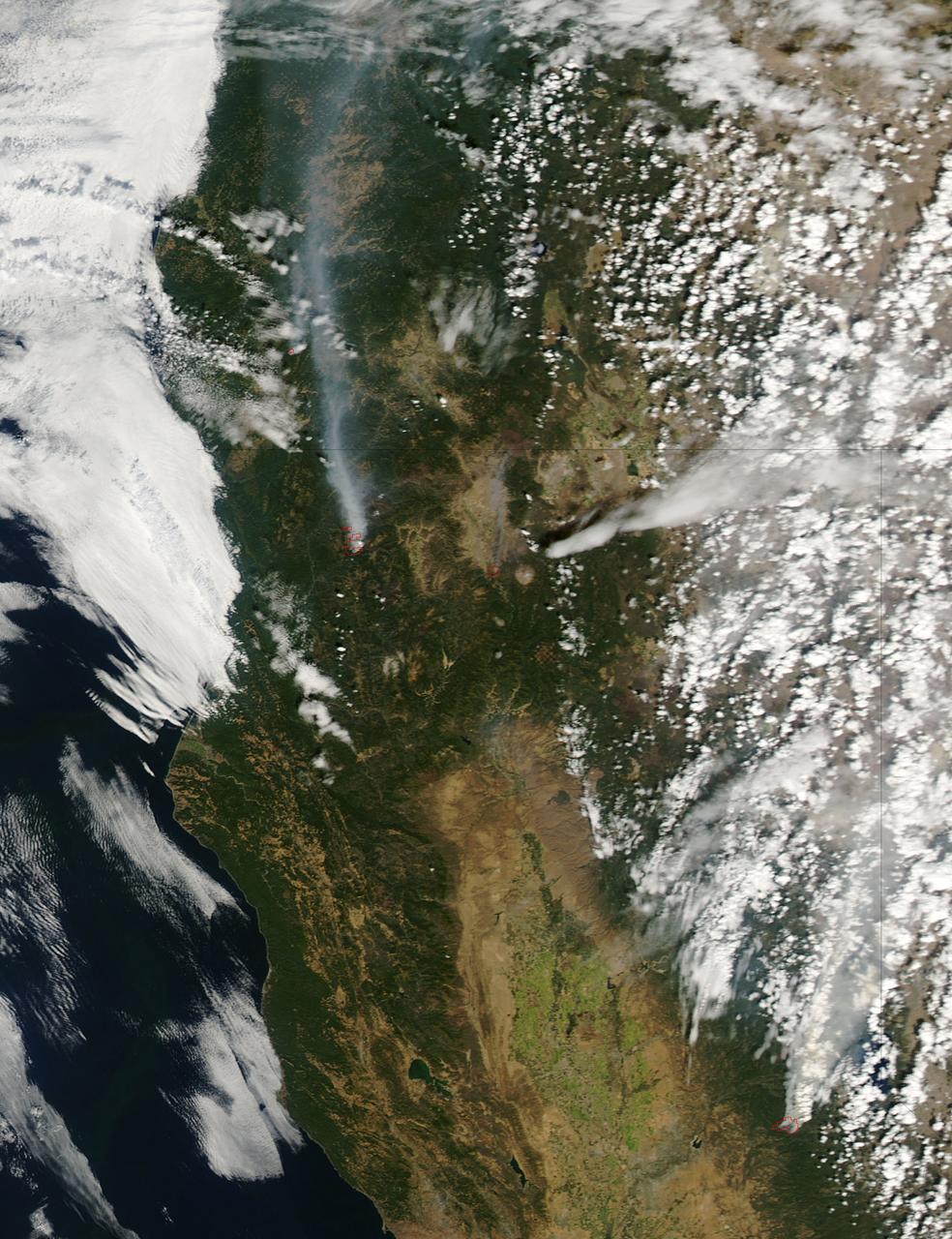
The fire season in California has been anything but cooperative this year. Hot conditions combined with a state-wide drought and dry lightning makes for unpleasant conditions and leads to an abundance of forest fires. On August 12, lightning struck and started the fire that grew into the Happy Camp Complex. Currently over 113,000 acres have been affected and the fire is only 55% contained as of today. Strong winds tested fire lines yesterday (8/15), and are expected to do so again today. Despite the high winds, existing fire lines held with no spotting or expansion outside current containment lines. The south end of the fire continued backing slowly toward Elk Creek in the Marble Mountain Wilderness. The Man Fire joined with the Happy Camp Complex yesterday and will be managed by California Interagency Incident Management Team 4 as of 6:00am on Wednesday, September 17, 2014. Nearby the Happy Camp Complex, near Mt. Shasta and the town of Weed, another fire erupted that fire officials said quickly damaged or destroyed 100 structures Monday (8/15). Hundreds of firefighters were trying to contain that fire. A California Fire spokesman said more than 300 acres were scorched and more than 100 structures damaged or destroyed in just a few hours. The blaze, dubbed the Boles Fire, also led to the closure of Interstate 5 and U.S. 97. Weed is in Siskiyou County, about 50 miles south of the California-Oregon border. With strong winds, the fire was able to rage into the community before firefighters could get equipment to the blaze. About 1,500 to 2,000 residents were being evacuated to the Siskiyou County fairgrounds. An evacuation center was set up at the county fairgrounds in Yreka. NASA's Aqua satellite collected this natural-color image with the Moderate Resolution Imaging Spectroradiometer, MODIS, instrument on September 15, 2014. Actively burning areas, detected by MODIS’s thermal bands, are outlined in red. NASA image courtesy Jeff Schmaltz LANCE/EOSDIS MODIS Rapid Response Team, GSFC. Caption by Lynn Jenner with information from Inciweb and California Department of Forestry and Fire Protection. <b><a href="http://www.nasa.gov/audience/formedia/features/MP_Photo_Guidelines.html" rel="nofollow">NASA image use policy.</a></b> <b><a href="http://www.nasa.gov/centers/goddard/home/index.html" rel="nofollow">NASA Goddard Space Flight Center</a></b> enables NASA’s mission through four scientific endeavors: Earth Science, Heliophysics, Solar System Exploration, and Astrophysics. Goddard plays a leading role in NASA’s accomplishments by contributing compelling scientific knowledge to advance the Agency’s mission. <b>Follow us on <a href="http://twitter.com/NASAGoddardPix" rel="nofollow">Twitter</a></b> <b>Like us on <a href="http://www.facebook.com/pages/Greenbelt-MD/NASA-Goddard/395013845897?ref=tsd" rel="nofollow">Facebook</a></b> <b>Find us on <a href="http://instagram.com/nasagoddard?vm=grid" rel="nofollow">Instagram</a></b>

With its sensor pod under its left wing, NASA's remotely piloted Ikhana unmanned aircraft cruises over California during the Western States Fire Mission.

With its thermal-infared sensor pod under its left wing, NASA's Ikhana unmanned aircraft cruises over California during the Western States Fire Mission.

NASA's Ikhana remotely piloted aircraft soars over smoky terrain during a wildfire imaging demonstration mission in the late summer of 2007.

Carrying its sensor pod, NASA's remotely piloted Ikhana unmanned aircraft banks away during a checkout flight in the Western States Fire Mission.
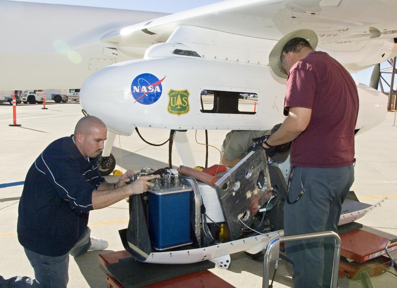
NASA Dryden's Ikhana ground crewmen Gus Carreno and James Smith load the thermal-infrared imaging scanner pallet into the Ikhana's underwing payload pod.

With smoke from the Lake Arrowhead area fires streaming in the background, NASA's Ikhana unmanned aircraft heads out on a Southern California wildfires imaging mission.

With smoke from the Lake Arrowhead area fires streaming in the background, NASA's Ikhana unmanned aircraft heads out on a Southern California wildfires imaging mission.
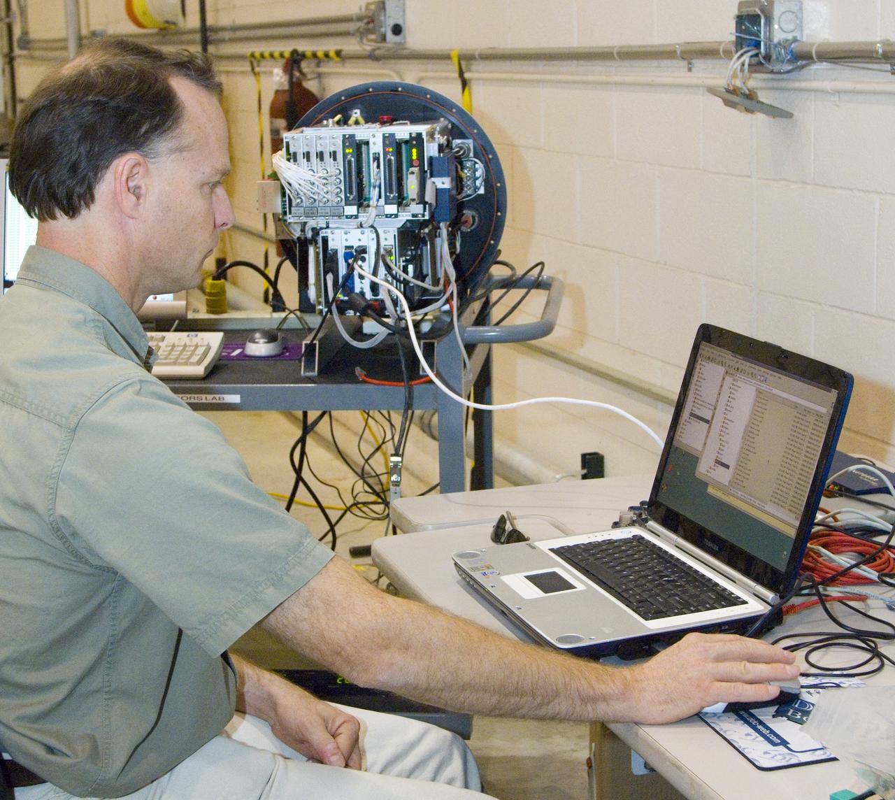
NASA Ames engineer Ted Hildum checks out the thermal-infrared scanner computer before it is loaded on NASA's Ikhana unmanned aircraft.

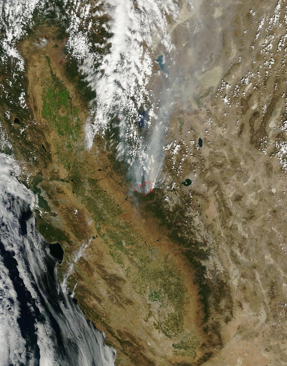
NASA’s Aqua satellite captured a large area of smoke from the Long Valley Wildfire that was affecting Yosemite National Park. This natural-color satellite image was collected by the Moderate Resolution Imaging Spectroradiometer instrument that flies aboard the Aqua satellite. The image, taken July 20, showed actively burning areas in red, as detected by MODIS’s thermal bands. According to Inciweb, an interagency all-risk incident information management system that coordinates with federal, state and local agencies to manage wildfires, the fire started on Tuesday July 11, 2017. It is located about two miles north of Doyle, California and about 50 miles north of Reno, Nevada. As of July 21 the fire covered 83,733 acres and was 91 percent contained. NASA image courtesy NASA MODIS Rapid Response Team <b><a href="http://www.nasa.gov/audience/formedia/features/MP_Photo_Guidelines.html" rel="nofollow">NASA image use policy.</a></b> <b><a href="http://www.nasa.gov/centers/goddard/home/index.html" rel="nofollow">NASA Goddard Space Flight Center</a></b> enables NASA’s mission through four scientific endeavors: Earth Science, Heliophysics, Solar System Exploration, and Astrophysics. Goddard plays a leading role in NASA’s accomplishments by contributing compelling scientific knowledge to advance the Agency’s mission. <b>Follow us on <a href="http://twitter.com/NASAGoddardPix" rel="nofollow">Twitter</a></b> <b>Like us on <a href="http://www.facebook.com/pages/Greenbelt-MD/NASA-Goddard/395013845897?ref=tsd" rel="nofollow">Facebook</a></b> <b>Find us on <a href="http://instagrid.me/nasagoddard/?vm=grid" rel="nofollow">Instagram</a></b>
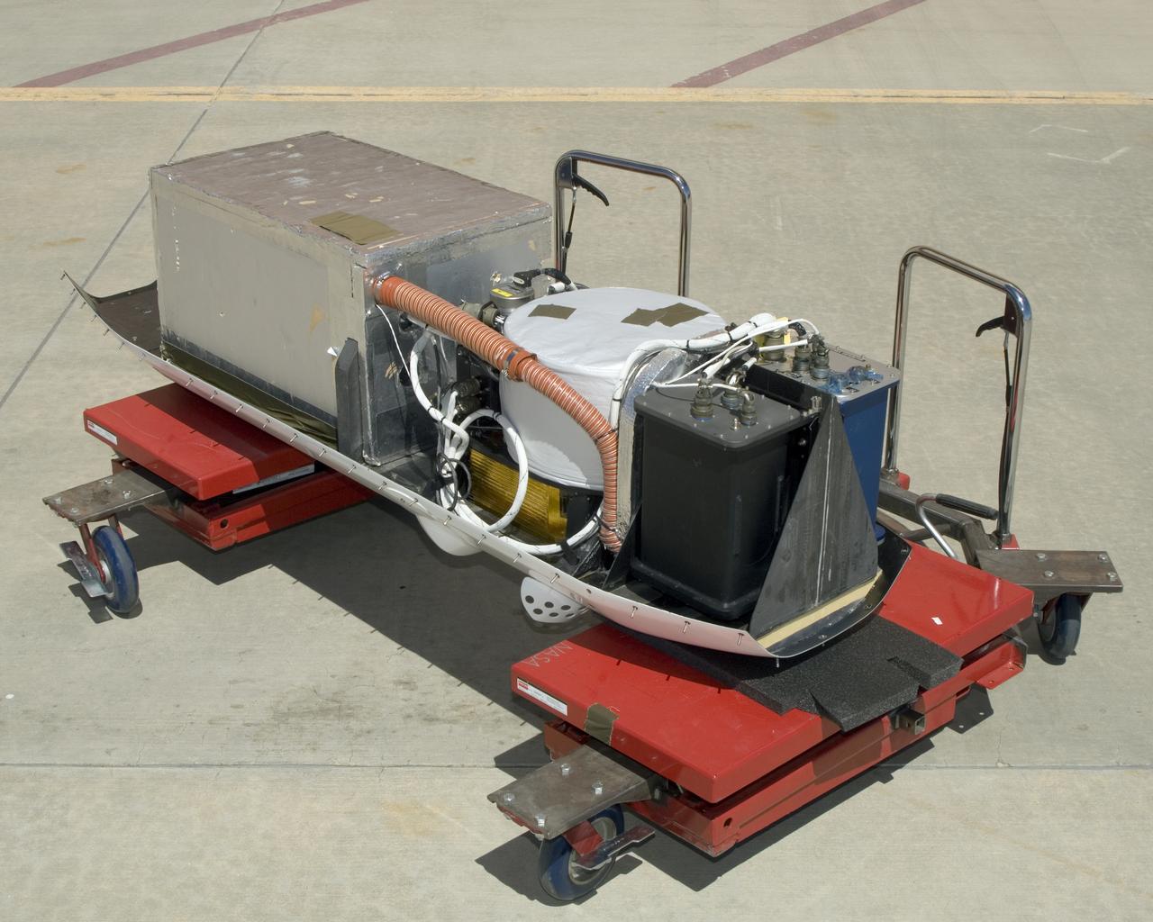
The instruments that make up the Ames Autonomous Module Scanner (AMS) that provided precise thermal-infrared imaging during the Western States Fire Mission in 2007 are detailed in this photo of the AMS as mounted on Ikhana's pod tray. The large foil-covered foam-insulated box at left covers the pressure vessel containing the data system computers and other electronics. The round white-topped assembly is the scan head, including the scan mirror, folded telescope, blackbody references, spectrometer and detectors. Two pressure boxes visible at the forward end of the tray contain the Applanix POS/AV precision navigation subsystem (black) and the power distributor including circuit breakers and ancillary wiring, scan motor controller and the blackbody reference temperature controller (blue).