ISS017-E-011603 (22 July 2008) --- Layers of Earth's atmosphere, brightly colored as the sun rises over central Asia, and Polar Mesospheric Clouds (also known as noctilucent clouds) are featured in this image photographed by an Expedition 17 crewmember on the International Space Station. The image was acquired in support of International Polar Year research.
Earth Limb taken by the Expedition 17 Crew
VANDENBERG AIR FORCE BASE, CALIF. - At Vandenberg Air Force Base, Calif., the Pegasus launch vehicle is moved toward its hangar. The Pegasus will carry the SciSat-1 spacecraft in a 400-mile-high polar orbit to investigate processes that control the distribution of ozone in the upper atmosphere. The data from the satellite will provide Canadian and international scientists with improved measurements relating to global ozone processes and help policymakers assess existing environmental policy and develop protective measures for improving the health of our atmosphere, preventing further ozone depletion. The mission is designed to last two years.
VANDENBERG AIR FORCE BASE, CALIF. -  The SciSat-1 payload and Pegasus launch vehicle are lifted and mated to the L-1011 carrier aircraft.  The SciSat-1 weighs approximately 330 pounds and after launch will be placed in a 400-mile-high polar orbit to investigate processes that control the distribution of ozone in the upper atmosphere. The data from the satellite will provide Canadian and international scientists with improved measurements relating to global ozone processes and help policymakers assess existing environmental policy and develop protective measures for improving the health of our atmosphere, preventing further ozone depletion. The mission is designed to last two years.
VANDENBERG AIR FORCE BASE, CALIF. - The SciSat-1 payload and Pegasus launch vehicle are lifted and mated to the L-1011 carrier aircraft. The SciSat-1 weighs approximately 330 pounds and after launch will be placed in a 400-mile-high polar orbit to investigate processes that control the distribution of ozone in the upper atmosphere. The data from the satellite will provide Canadian and international scientists with improved measurements relating to global ozone processes and help policymakers assess existing environmental policy and develop protective measures for improving the health of our atmosphere, preventing further ozone depletion. The mission is designed to last two years.
VANDENBERG AIR FORCE BASE, CALIF.- At Vandenberg Air Force Base, Calif., spacecraft functional testing is underway on the SciSat-1. The solar arrays are being attached and the communications systems are also being checked out.   The SciSat-1 weighs approximately 330 pounds and after launch will be placed in a 400-mile-high polar orbit to investigate processes that control the distribution of ozone in the upper atmosphere. The data from the satellite will provide Canadian and international scientists with improved measurements relating to global ozone processes and help policymakers assess existing environmental policy and develop protective measures for improving the health of our atmosphere, preventing further ozone depletion. The mission is designed to last two years.
VANDENBERG AIR FORCE BASE, CALIF.- At Vandenberg Air Force Base, Calif., spacecraft functional testing is underway on the SciSat-1. The solar arrays are being attached and the communications systems are also being checked out. The SciSat-1 weighs approximately 330 pounds and after launch will be placed in a 400-mile-high polar orbit to investigate processes that control the distribution of ozone in the upper atmosphere. The data from the satellite will provide Canadian and international scientists with improved measurements relating to global ozone processes and help policymakers assess existing environmental policy and develop protective measures for improving the health of our atmosphere, preventing further ozone depletion. The mission is designed to last two years.
KENNEDY SPACE CENTER, FLA. - At Vandenberg Air Force Base, Calif., the Pegasus launch vehicle is moved into its hangar.  The Pegasus will carry the SciSat-1 spacecraft in a 400-mile-high polar orbit to investigate processes that control the distribution of ozone in the upper atmosphere.  The scientific mission of SciSat-1 is to measure and understand the chemical processes that control the distribution of ozone in the Earth’s atmosphere, particularly at high altitudes.  The data from the satellite will provide Canadian and international scientists with improved measurements relating to global ozone processes and help policymakers assess existing environmental policy and develop protective measures for improving the health of our atmosphere, preventing further ozone depletion.  The mission is designed to last two years.
KENNEDY SPACE CENTER, FLA. - At Vandenberg Air Force Base, Calif., the Pegasus launch vehicle is moved into its hangar. The Pegasus will carry the SciSat-1 spacecraft in a 400-mile-high polar orbit to investigate processes that control the distribution of ozone in the upper atmosphere. The scientific mission of SciSat-1 is to measure and understand the chemical processes that control the distribution of ozone in the Earth’s atmosphere, particularly at high altitudes. The data from the satellite will provide Canadian and international scientists with improved measurements relating to global ozone processes and help policymakers assess existing environmental policy and develop protective measures for improving the health of our atmosphere, preventing further ozone depletion. The mission is designed to last two years.
VANDENBERG AIR FORCE BASE, CALIF. -  The L-1011 carrier aircraft is in flight with its cargo of the Pegasus launch vehicle and SciSat-1 spacecraft underneath. The SciSat-1 weighs approximately 330 pounds and after launch will be placed in a 400-mile-high polar orbit to investigate processes that control the distribution of ozone in the upper atmosphere. The data from the satellite will provide Canadian and international scientists with improved measurements relating to global ozone processes and help policymakers assess existing environmental policy and develop protective measures for improving the health of our atmosphere, preventing further ozone depletion. The mission is designed to last two years.
VANDENBERG AIR FORCE BASE, CALIF. - The L-1011 carrier aircraft is in flight with its cargo of the Pegasus launch vehicle and SciSat-1 spacecraft underneath. The SciSat-1 weighs approximately 330 pounds and after launch will be placed in a 400-mile-high polar orbit to investigate processes that control the distribution of ozone in the upper atmosphere. The data from the satellite will provide Canadian and international scientists with improved measurements relating to global ozone processes and help policymakers assess existing environmental policy and develop protective measures for improving the health of our atmosphere, preventing further ozone depletion. The mission is designed to last two years.
VANDENBERG AIR FORCE BASE, CALIF. -  At Vandenberg AFB, Calif., a solar array is installed on the SciSat-1 spacecraft.  The SciSat-1 weighs approximately 330 pounds and after launch will be placed in a 400-mile-high polar orbit to investigate processes that control the distribution of ozone in the upper atmosphere. The data from the satellite will provide Canadian and international scientists with improved measurements relating to global ozone processes and help policymakers assess existing environmental policy and develop protective measures for improving the health of our atmosphere, preventing further ozone depletion. The mission is designed to last two years.
VANDENBERG AIR FORCE BASE, CALIF. - At Vandenberg AFB, Calif., a solar array is installed on the SciSat-1 spacecraft. The SciSat-1 weighs approximately 330 pounds and after launch will be placed in a 400-mile-high polar orbit to investigate processes that control the distribution of ozone in the upper atmosphere. The data from the satellite will provide Canadian and international scientists with improved measurements relating to global ozone processes and help policymakers assess existing environmental policy and develop protective measures for improving the health of our atmosphere, preventing further ozone depletion. The mission is designed to last two years.
VANDENBERG AIR FORCE BASE, CALIF. -  The L-1011 carrier aircraft is in flight with its cargo of the Pegasus launch vehicle and SciSat-1 spacecraft underneath.  The SciSat-1 weighs approximately 330 pounds and after launch will be placed in a 400-mile-high polar orbit to investigate processes that control the distribution of ozone in the upper atmosphere. The data from the satellite will provide Canadian and international scientists with improved measurements relating to global ozone processes and help policymakers assess existing environmental policy and develop protective measures for improving the health of our atmosphere, preventing further ozone depletion. The mission is designed to last two years.
VANDENBERG AIR FORCE BASE, CALIF. - The L-1011 carrier aircraft is in flight with its cargo of the Pegasus launch vehicle and SciSat-1 spacecraft underneath. The SciSat-1 weighs approximately 330 pounds and after launch will be placed in a 400-mile-high polar orbit to investigate processes that control the distribution of ozone in the upper atmosphere. The data from the satellite will provide Canadian and international scientists with improved measurements relating to global ozone processes and help policymakers assess existing environmental policy and develop protective measures for improving the health of our atmosphere, preventing further ozone depletion. The mission is designed to last two years.
VANDENBERG AIR FORCE BASE, CALIF. -  At Vandenberg AFB, Calif., a solar array is tested before installing on the SciSat-1 spacecraft.  The SciSat-1 weighs approximately 330 pounds and after launch will be placed in a 400-mile-high polar orbit to investigate processes that control the distribution of ozone in the upper atmosphere. The data from the satellite will provide Canadian and international scientists with improved measurements relating to global ozone processes and help policymakers assess existing environmental policy and develop protective measures for improving the health of our atmosphere, preventing further ozone depletion. The mission is designed to last two years.
VANDENBERG AIR FORCE BASE, CALIF. - At Vandenberg AFB, Calif., a solar array is tested before installing on the SciSat-1 spacecraft. The SciSat-1 weighs approximately 330 pounds and after launch will be placed in a 400-mile-high polar orbit to investigate processes that control the distribution of ozone in the upper atmosphere. The data from the satellite will provide Canadian and international scientists with improved measurements relating to global ozone processes and help policymakers assess existing environmental policy and develop protective measures for improving the health of our atmosphere, preventing further ozone depletion. The mission is designed to last two years.
VANDENBERG AIR FORCE BASE, CALIF. -  The SciSat-1 payload and Pegasus launch vehicle are lifted and mated to the L-1011 carrier aircraft.  The SciSat-1 weighs approximately 330 pounds and after launch will be placed in a 400-mile-high polar orbit to investigate processes that control the distribution of ozone in the upper atmosphere. The data from the satellite will provide Canadian and international scientists with improved measurements relating to global ozone processes and help policymakers assess existing environmental policy and develop protective measures for improving the health of our atmosphere, preventing further ozone depletion. The mission is designed to last two years.
VANDENBERG AIR FORCE BASE, CALIF. - The SciSat-1 payload and Pegasus launch vehicle are lifted and mated to the L-1011 carrier aircraft. The SciSat-1 weighs approximately 330 pounds and after launch will be placed in a 400-mile-high polar orbit to investigate processes that control the distribution of ozone in the upper atmosphere. The data from the satellite will provide Canadian and international scientists with improved measurements relating to global ozone processes and help policymakers assess existing environmental policy and develop protective measures for improving the health of our atmosphere, preventing further ozone depletion. The mission is designed to last two years.
VANDENBERG AIR FORCE BASE, CALIF. -    Workers mate the Pegasus , with its cargo of the SciSat-1 payload to the L-1011 carrier aircraft.  The SciSat-1 weighs approximately 330 pounds and after launch will be placed in a 400-mile-high polar orbit to investigate processes that control the distribution of ozone in the upper atmosphere. The data from the satellite will provide Canadian and international scientists with improved measurements relating to global ozone processes and help policymakers assess existing environmental policy and develop protective measures for improving the health of our atmosphere, preventing further ozone depletion. The mission is designed to last two years.
VANDENBERG AIR FORCE BASE, CALIF. - Workers mate the Pegasus , with its cargo of the SciSat-1 payload to the L-1011 carrier aircraft. The SciSat-1 weighs approximately 330 pounds and after launch will be placed in a 400-mile-high polar orbit to investigate processes that control the distribution of ozone in the upper atmosphere. The data from the satellite will provide Canadian and international scientists with improved measurements relating to global ozone processes and help policymakers assess existing environmental policy and develop protective measures for improving the health of our atmosphere, preventing further ozone depletion. The mission is designed to last two years.
VANDENBERG AIR FORCE BASE, CALIF. - At Vandenberg Air Force Base, Calif., the Pegasus launch vehicle is moved toward its hangar. The Pegasus will carry the SciSat-1 spacecraft in a 400-mile-high polar orbit to investigate processes that control the distribution of ozone in the upper atmosphere. The data from the satellite will provide Canadian and international scientists with improved measurements relating to global ozone processes and help policymakers assess existing environmental policy and develop protective measures for improving the health of our atmosphere, preventing further ozone depletion. The mission is designed to last two years.
VANDENBERG AIR FORCE BASE, CALIF.- At Vandenberg Air Force Base, Calif., spacecraft functional testing is underway on the SciSat-1. The solar arrays are being attached and the communications systems are also being checked out.   The SciSat-1 weighs approximately 330 pounds and after launch will be placed in a 400-mile-high polar orbit to investigate processes that control the distribution of ozone in the upper atmosphere. The data from the satellite will provide Canadian and international scientists with improved measurements relating to global ozone processes and help policymakers assess existing environmental policy and develop protective measures for improving the health of our atmosphere, preventing further ozone depletion. The mission is designed to last two years.
VANDENBERG AIR FORCE BASE, CALIF.- At Vandenberg Air Force Base, Calif., spacecraft functional testing is underway on the SciSat-1. The solar arrays are being attached and the communications systems are also being checked out. The SciSat-1 weighs approximately 330 pounds and after launch will be placed in a 400-mile-high polar orbit to investigate processes that control the distribution of ozone in the upper atmosphere. The data from the satellite will provide Canadian and international scientists with improved measurements relating to global ozone processes and help policymakers assess existing environmental policy and develop protective measures for improving the health of our atmosphere, preventing further ozone depletion. The mission is designed to last two years.
VANDENBERG AIR FORCE BASE, CALIF. -  With its cover removed, the SciSat-1 spacecraft is rotated.  The solar arrays will be attached and the communications systems checked out.   The SciSat-1 weighs approximately 330 pounds and after launch will be placed in a 400-mile-high polar orbit to investigate processes that control the distribution of ozone in the upper atmosphere. The data from the satellite will provide Canadian and international scientists with improved measurements relating to global ozone processes and help policymakers assess existing environmental policy and develop protective measures for improving the health of our atmosphere, preventing further ozone depletion. The mission is designed to last two years.
VANDENBERG AIR FORCE BASE, CALIF. - With its cover removed, the SciSat-1 spacecraft is rotated. The solar arrays will be attached and the communications systems checked out. The SciSat-1 weighs approximately 330 pounds and after launch will be placed in a 400-mile-high polar orbit to investigate processes that control the distribution of ozone in the upper atmosphere. The data from the satellite will provide Canadian and international scientists with improved measurements relating to global ozone processes and help policymakers assess existing environmental policy and develop protective measures for improving the health of our atmosphere, preventing further ozone depletion. The mission is designed to last two years.
VANDENBERG AIR FORCE BASE, CALIF.- At Vandenberg Air Force Base, Calif., spacecraft functional testing is underway on the SciSat-1. The solar arrays are being attached and the communications systems are also being checked out.   The SciSat-1 weighs approximately 330 pounds and after launch will be placed in a 400-mile-high polar orbit to investigate processes that control the distribution of ozone in the upper atmosphere. The data from the satellite will provide Canadian and international scientists with improved measurements relating to global ozone processes and help policymakers assess existing environmental policy and develop protective measures for improving the health of our atmosphere, preventing further ozone depletion. The mission is designed to last two years.
VANDENBERG AIR FORCE BASE, CALIF.- At Vandenberg Air Force Base, Calif., spacecraft functional testing is underway on the SciSat-1. The solar arrays are being attached and the communications systems are also being checked out. The SciSat-1 weighs approximately 330 pounds and after launch will be placed in a 400-mile-high polar orbit to investigate processes that control the distribution of ozone in the upper atmosphere. The data from the satellite will provide Canadian and international scientists with improved measurements relating to global ozone processes and help policymakers assess existing environmental policy and develop protective measures for improving the health of our atmosphere, preventing further ozone depletion. The mission is designed to last two years.
VANDENBERG AIR FORCE BASE, CALIF. -  The SciSat-1 payload, with fairing installed and attached to its Pegasus launch vehicle, begins rollout to the hot pad and mating to the L-1011 carrier aircraft.  The SciSat-1 weighs approximately 330 pounds and after launch will be placed in a 400-mile-high polar orbit to investigate processes that control the distribution of ozone in the upper atmosphere. The data from the satellite will provide Canadian and international scientists with improved measurements relating to global ozone processes and help policymakers assess existing environmental policy and develop protective measures for improving the health of our atmosphere, preventing further ozone depletion. The mission is designed to last two years.
VANDENBERG AIR FORCE BASE, CALIF. - The SciSat-1 payload, with fairing installed and attached to its Pegasus launch vehicle, begins rollout to the hot pad and mating to the L-1011 carrier aircraft. The SciSat-1 weighs approximately 330 pounds and after launch will be placed in a 400-mile-high polar orbit to investigate processes that control the distribution of ozone in the upper atmosphere. The data from the satellite will provide Canadian and international scientists with improved measurements relating to global ozone processes and help policymakers assess existing environmental policy and develop protective measures for improving the health of our atmosphere, preventing further ozone depletion. The mission is designed to last two years.
VANDENBERG AIR FORCE BASE, CALIF. -  The L-1011 carrier aircraft is in flight with its cargo underneath of the Pegasus launch vehicle and SciSat-1 spacecraft.  The SciSat-1 weighs approximately 330 pounds and after launch will be placed in a 400-mile-high polar orbit to investigate processes that control the distribution of ozone in the upper atmosphere. The data from the satellite will provide Canadian and international scientists with improved measurements relating to global ozone processes and help policymakers assess existing environmental policy and develop protective measures for improving the health of our atmosphere, preventing further ozone depletion. The mission is designed to last two years.
VANDENBERG AIR FORCE BASE, CALIF. - The L-1011 carrier aircraft is in flight with its cargo underneath of the Pegasus launch vehicle and SciSat-1 spacecraft. The SciSat-1 weighs approximately 330 pounds and after launch will be placed in a 400-mile-high polar orbit to investigate processes that control the distribution of ozone in the upper atmosphere. The data from the satellite will provide Canadian and international scientists with improved measurements relating to global ozone processes and help policymakers assess existing environmental policy and develop protective measures for improving the health of our atmosphere, preventing further ozone depletion. The mission is designed to last two years.
VANDENBERG AIR FORCE BASE, CALIF. -   The SciSat-1 payload, with fairing installed and attached to its Pegasus launch vehicle, begins rollout to the hot pad and mating to the L-1011 carrier aircraft.  The SciSat-1 weighs approximately 330 pounds and after launch will be placed in a 400-mile-high polar orbit to investigate processes that control the distribution of ozone in the upper atmosphere. The data from the satellite will provide Canadian and international scientists with improved measurements relating to global ozone processes and help policymakers assess existing environmental policy and develop protective measures for improving the health of our atmosphere, preventing further ozone depletion. The mission is designed to last two years.
VANDENBERG AIR FORCE BASE, CALIF. - The SciSat-1 payload, with fairing installed and attached to its Pegasus launch vehicle, begins rollout to the hot pad and mating to the L-1011 carrier aircraft. The SciSat-1 weighs approximately 330 pounds and after launch will be placed in a 400-mile-high polar orbit to investigate processes that control the distribution of ozone in the upper atmosphere. The data from the satellite will provide Canadian and international scientists with improved measurements relating to global ozone processes and help policymakers assess existing environmental policy and develop protective measures for improving the health of our atmosphere, preventing further ozone depletion. The mission is designed to last two years.
VANDENBERG AIR FORCE BASE, CALIF.-  A covered SciSat-1 spacecraft sits on a test stand at Vandenberg Air Force Base, Calif.  The solar arrays will be attached and the communications systems checked out.   The SciSat-1 weighs approximately 330 pounds and after launch will be placed in a 400-mile-high polar orbit to investigate processes that control the distribution of ozone in the upper atmosphere. The data from the satellite will provide Canadian and international scientists with improved measurements relating to global ozone processes and help policymakers assess existing environmental policy and develop protective measures for improving the health of our atmosphere, preventing further ozone depletion. The mission is designed to last two years.
VANDENBERG AIR FORCE BASE, CALIF.- A covered SciSat-1 spacecraft sits on a test stand at Vandenberg Air Force Base, Calif. The solar arrays will be attached and the communications systems checked out. The SciSat-1 weighs approximately 330 pounds and after launch will be placed in a 400-mile-high polar orbit to investigate processes that control the distribution of ozone in the upper atmosphere. The data from the satellite will provide Canadian and international scientists with improved measurements relating to global ozone processes and help policymakers assess existing environmental policy and develop protective measures for improving the health of our atmosphere, preventing further ozone depletion. The mission is designed to last two years.
VANDENBERG AIR FORCE BASE, CALIF. -  At Vandenberg AFB, Calif., a solar array is tested before installing on the SciSat-1 spacecraft.  The SciSat-1 weighs approximately 330 pounds and after launch will be placed in a 400-mile-high polar orbit to investigate processes that control the distribution of ozone in the upper atmosphere. The data from the satellite will provide Canadian and international scientists with improved measurements relating to global ozone processes and help policymakers assess existing environmental policy and develop protective measures for improving the health of our atmosphere, preventing further ozone depletion. The mission is designed to last two years.
VANDENBERG AIR FORCE BASE, CALIF. - At Vandenberg AFB, Calif., a solar array is tested before installing on the SciSat-1 spacecraft. The SciSat-1 weighs approximately 330 pounds and after launch will be placed in a 400-mile-high polar orbit to investigate processes that control the distribution of ozone in the upper atmosphere. The data from the satellite will provide Canadian and international scientists with improved measurements relating to global ozone processes and help policymakers assess existing environmental policy and develop protective measures for improving the health of our atmosphere, preventing further ozone depletion. The mission is designed to last two years.
VANDENBERG AIR FORCE BASE, CALIF.- The cover is being lifted off SciSat-1 spacecraft at Vandenberg Air Force Base, Calif.   Sci-Sat, which will undergo instrument checkout and spacecraft functional testing, weighs approximately 330 pounds and after launch will be placed in a 400-mile-high polar orbit to investigate processes that control the distribution of ozone in the upper atmosphere. The data from the satellite will provide Canadian and international scientists with improved measurements relating to global ozone processes and help policymakers assess existing environmental policy and develop protective measures for improving the health of our atmosphere, preventing further ozone depletion. The mission is designed to last two years.
VANDENBERG AIR FORCE BASE, CALIF.- The cover is being lifted off SciSat-1 spacecraft at Vandenberg Air Force Base, Calif. Sci-Sat, which will undergo instrument checkout and spacecraft functional testing, weighs approximately 330 pounds and after launch will be placed in a 400-mile-high polar orbit to investigate processes that control the distribution of ozone in the upper atmosphere. The data from the satellite will provide Canadian and international scientists with improved measurements relating to global ozone processes and help policymakers assess existing environmental policy and develop protective measures for improving the health of our atmosphere, preventing further ozone depletion. The mission is designed to last two years.
VANDENBERG AIR FORCE BASE, CALIF.-  The covered SciSat-1 spacecraft is lowered onto a test stand at Vandenberg Air Force Base, Calif., for functional testing.  The solar arrays will be attached and the communications systems checked out.   The SciSat-1 weighs approximately 330 pounds and after launch will be placed in a 400-mile-high polar orbit to investigate processes that control the distribution of ozone in the upper atmosphere. The data from the satellite will provide Canadian and international scientists with improved measurements relating to global ozone processes and help policymakers assess existing environmental policy and develop protective measures for improving the health of our atmosphere, preventing further ozone depletion. The mission is designed to last two years.
VANDENBERG AIR FORCE BASE, CALIF.- The covered SciSat-1 spacecraft is lowered onto a test stand at Vandenberg Air Force Base, Calif., for functional testing. The solar arrays will be attached and the communications systems checked out. The SciSat-1 weighs approximately 330 pounds and after launch will be placed in a 400-mile-high polar orbit to investigate processes that control the distribution of ozone in the upper atmosphere. The data from the satellite will provide Canadian and international scientists with improved measurements relating to global ozone processes and help policymakers assess existing environmental policy and develop protective measures for improving the health of our atmosphere, preventing further ozone depletion. The mission is designed to last two years.
VANDENBERG AIR FORCE BASE, CALIF. -  The Pegasus transporter, with its cargo of  the SciSat-1 payload and Pegasus launch vehicle, moves under the L-1011 carrier aircraft for matting.  The SciSat-1 weighs approximately 330 pounds and after launch will be placed in a 400-mile-high polar orbit to investigate processes that control the distribution of ozone in the upper atmosphere. The data from the satellite will provide Canadian and international scientists with improved measurements relating to global ozone processes and help policymakers assess existing environmental policy and develop protective measures for improving the health of our atmosphere, preventing further ozone depletion. The mission is designed to last two years.
VANDENBERG AIR FORCE BASE, CALIF. - The Pegasus transporter, with its cargo of the SciSat-1 payload and Pegasus launch vehicle, moves under the L-1011 carrier aircraft for matting. The SciSat-1 weighs approximately 330 pounds and after launch will be placed in a 400-mile-high polar orbit to investigate processes that control the distribution of ozone in the upper atmosphere. The data from the satellite will provide Canadian and international scientists with improved measurements relating to global ozone processes and help policymakers assess existing environmental policy and develop protective measures for improving the health of our atmosphere, preventing further ozone depletion. The mission is designed to last two years.
VANDENBERG AIR FORCE BASE, CALIF.- At Vandenberg Air Force Base, Calif., spacecraft functional testing is underway on the SciSat-1. The solar arrays are being attached and the communications systems are also being checked out.   The SciSat-1 weighs approximately 330 pounds and after launch will be placed in a 400-mile-high polar orbit to investigate processes that control the distribution of ozone in the upper atmosphere. The data from the satellite will provide Canadian and international scientists with improved measurements relating to global ozone processes and help policymakers assess existing environmental policy and develop protective measures for improving the health of our atmosphere, preventing further ozone depletion. The mission is designed to last two years.
VANDENBERG AIR FORCE BASE, CALIF.- At Vandenberg Air Force Base, Calif., spacecraft functional testing is underway on the SciSat-1. The solar arrays are being attached and the communications systems are also being checked out. The SciSat-1 weighs approximately 330 pounds and after launch will be placed in a 400-mile-high polar orbit to investigate processes that control the distribution of ozone in the upper atmosphere. The data from the satellite will provide Canadian and international scientists with improved measurements relating to global ozone processes and help policymakers assess existing environmental policy and develop protective measures for improving the health of our atmosphere, preventing further ozone depletion. The mission is designed to last two years.
VANDENBERG AIR FORCE BASE, CALIF. - The SciSat-1 spacecraft is revealed at Vandenberg Air Force Base, Calif.   Sci-Sat, which will undergo instrument checkout and spacecraft functional testing, weighs approximately 330 pounds and after launch will be placed in a 400-mile-high polar orbit to investigate processes that control the distribution of ozone in the upper atmosphere. The data from the satellite will provide Canadian and international scientists with improved measurements relating to global ozone processes and help policymakers assess existing environmental policy and develop protective measures for improving the health of our atmosphere, preventing further ozone depletion. The mission is designed to last two years.
VANDENBERG AIR FORCE BASE, CALIF. - The SciSat-1 spacecraft is revealed at Vandenberg Air Force Base, Calif. Sci-Sat, which will undergo instrument checkout and spacecraft functional testing, weighs approximately 330 pounds and after launch will be placed in a 400-mile-high polar orbit to investigate processes that control the distribution of ozone in the upper atmosphere. The data from the satellite will provide Canadian and international scientists with improved measurements relating to global ozone processes and help policymakers assess existing environmental policy and develop protective measures for improving the health of our atmosphere, preventing further ozone depletion. The mission is designed to last two years.
KENNEDY SPACE CENTER, FLA. -  The SciSat-1 spacecraft is uncrated at Vandenberg Air Force Base, Calif.  SciSat-1 weighs approximately 330 pounds and will be placed in a 400-mile-high polar orbit to investigate processes that control the distribution of ozone in the upper atmosphere.  The scientific mission of SciSat-1 is to measure and understand the chemical processes that control the distribution of ozone in the Earth’s atmosphere, particularly at high altitudes.  The data from the satellite will provide Canadian and international scientists with improved measurements relating to global ozone processes and help policymakers assess existing environmental policy and develop protective measures for improving the health of our atmosphere, preventing further ozone depletion.  The mission is designed to last two years.
KENNEDY SPACE CENTER, FLA. - The SciSat-1 spacecraft is uncrated at Vandenberg Air Force Base, Calif. SciSat-1 weighs approximately 330 pounds and will be placed in a 400-mile-high polar orbit to investigate processes that control the distribution of ozone in the upper atmosphere. The scientific mission of SciSat-1 is to measure and understand the chemical processes that control the distribution of ozone in the Earth’s atmosphere, particularly at high altitudes. The data from the satellite will provide Canadian and international scientists with improved measurements relating to global ozone processes and help policymakers assess existing environmental policy and develop protective measures for improving the health of our atmosphere, preventing further ozone depletion. The mission is designed to last two years.
VANDENBERG AIR FORCE BASE, CALIF.- At Vandenberg Air Force Base, Calif., spacecraft functional testing is underway on the SciSat-1. The solar arrays are being attached and the communications systems are also being checked out.   The SciSat-1 weighs approximately 330 pounds and after launch will be placed in a 400-mile-high polar orbit to investigate processes that control the distribution of ozone in the upper atmosphere. The data from the satellite will provide Canadian and international scientists with improved measurements relating to global ozone processes and help policymakers assess existing environmental policy and develop protective measures for improving the health of our atmosphere, preventing further ozone depletion. The mission is designed to last two years.
VANDENBERG AIR FORCE BASE, CALIF.- At Vandenberg Air Force Base, Calif., spacecraft functional testing is underway on the SciSat-1. The solar arrays are being attached and the communications systems are also being checked out. The SciSat-1 weighs approximately 330 pounds and after launch will be placed in a 400-mile-high polar orbit to investigate processes that control the distribution of ozone in the upper atmosphere. The data from the satellite will provide Canadian and international scientists with improved measurements relating to global ozone processes and help policymakers assess existing environmental policy and develop protective measures for improving the health of our atmosphere, preventing further ozone depletion. The mission is designed to last two years.
VANDENBERG AIR FORCE BASE, CALIF. - The SciSat-1 payload, with fairing installed and attached to its Pegasus launch vehicle, arrives at the pad for mating to the L-1011 carrier aircraft.  The SciSat-1 weighs approximately 330 pounds and after launch will be placed in a 400-mile-high polar orbit to investigate processes that control the distribution of ozone in the upper atmosphere. The data from the satellite will provide Canadian and international scientists with improved measurements relating to global ozone processes and help policymakers assess existing environmental policy and develop protective measures for improving the health of our atmosphere, preventing further ozone depletion. The mission is designed to last two years.
VANDENBERG AIR FORCE BASE, CALIF. - The SciSat-1 payload, with fairing installed and attached to its Pegasus launch vehicle, arrives at the pad for mating to the L-1011 carrier aircraft. The SciSat-1 weighs approximately 330 pounds and after launch will be placed in a 400-mile-high polar orbit to investigate processes that control the distribution of ozone in the upper atmosphere. The data from the satellite will provide Canadian and international scientists with improved measurements relating to global ozone processes and help policymakers assess existing environmental policy and develop protective measures for improving the health of our atmosphere, preventing further ozone depletion. The mission is designed to last two years.
VANDENBERG AIR FORCE BASE, CALIF. -    Workers mate the Pegasus , with its cargo of the SciSat-1 payload to the L-1011 carrier aircraft.  The SciSat-1 weighs approximately 330 pounds and after launch will be placed in a 400-mile-high polar orbit to investigate processes that control the distribution of ozone in the upper atmosphere. The data from the satellite will provide Canadian and international scientists with improved measurements relating to global ozone processes and help policymakers assess existing environmental policy and develop protective measures for improving the health of our atmosphere, preventing further ozone depletion. The mission is designed to last two years.
VANDENBERG AIR FORCE BASE, CALIF. - Workers mate the Pegasus , with its cargo of the SciSat-1 payload to the L-1011 carrier aircraft. The SciSat-1 weighs approximately 330 pounds and after launch will be placed in a 400-mile-high polar orbit to investigate processes that control the distribution of ozone in the upper atmosphere. The data from the satellite will provide Canadian and international scientists with improved measurements relating to global ozone processes and help policymakers assess existing environmental policy and develop protective measures for improving the health of our atmosphere, preventing further ozone depletion. The mission is designed to last two years.
VANDENBERG AIR FORCE BASE, CALIF. - The Pegasus transporter, with its cargo of  the SciSat-1 payload and Pegasus launch vehicle, moves under the L-1011 carrier aircraft for matting.  The SciSat-1 weighs approximately 330 pounds and after launch will be placed in a 400-mile-high polar orbit to investigate processes that control the distribution of ozone in the upper atmosphere. The data from the satellite will provide Canadian and international scientists with improved measurements relating to global ozone processes and help policymakers assess existing environmental policy and develop protective measures for improving the health of our atmosphere, preventing further ozone depletion. The mission is designed to last two years.
VANDENBERG AIR FORCE BASE, CALIF. - The Pegasus transporter, with its cargo of the SciSat-1 payload and Pegasus launch vehicle, moves under the L-1011 carrier aircraft for matting. The SciSat-1 weighs approximately 330 pounds and after launch will be placed in a 400-mile-high polar orbit to investigate processes that control the distribution of ozone in the upper atmosphere. The data from the satellite will provide Canadian and international scientists with improved measurements relating to global ozone processes and help policymakers assess existing environmental policy and develop protective measures for improving the health of our atmosphere, preventing further ozone depletion. The mission is designed to last two years.
VANDENBERG AIR FORCE BASE, CALIF. -  At Vandenberg Air Force Base, Calif. a covered SciSat-1 spacecraft is lifted onto a rotation stand.   The solar arrays will be attached and the communications systems checked out.   The SciSat-1 weighs approximately 330 pounds and after launch will be placed in a 400-mile-high polar orbit to investigate processes that control the distribution of ozone in the upper atmosphere. The data from the satellite will provide Canadian and international scientists with improved measurements relating to global ozone processes and help policymakers assess existing environmental policy and develop protective measures for improving the health of our atmosphere, preventing further ozone depletion. The mission is designed to last two years.
VANDENBERG AIR FORCE BASE, CALIF. - At Vandenberg Air Force Base, Calif. a covered SciSat-1 spacecraft is lifted onto a rotation stand. The solar arrays will be attached and the communications systems checked out. The SciSat-1 weighs approximately 330 pounds and after launch will be placed in a 400-mile-high polar orbit to investigate processes that control the distribution of ozone in the upper atmosphere. The data from the satellite will provide Canadian and international scientists with improved measurements relating to global ozone processes and help policymakers assess existing environmental policy and develop protective measures for improving the health of our atmosphere, preventing further ozone depletion. The mission is designed to last two years.
VANDENBERG AIR FORCE BASE, CALIF.- At Vandenberg Air Force Base, Calif., spacecraft functional testing is underway on the SciSat-1. The solar arrays are being attached and the communications systems are also being checked out.   The SciSat-1 weighs approximately 330 pounds and after launch will be placed in a 400-mile-high polar orbit to investigate processes that control the distribution of ozone in the upper atmosphere. The data from the satellite will provide Canadian and international scientists with improved measurements relating to global ozone processes and help policymakers assess existing environmental policy and develop protective measures for improving the health of our atmosphere, preventing further ozone depletion. The mission is designed to last two years.
VANDENBERG AIR FORCE BASE, CALIF.- At Vandenberg Air Force Base, Calif., spacecraft functional testing is underway on the SciSat-1. The solar arrays are being attached and the communications systems are also being checked out. The SciSat-1 weighs approximately 330 pounds and after launch will be placed in a 400-mile-high polar orbit to investigate processes that control the distribution of ozone in the upper atmosphere. The data from the satellite will provide Canadian and international scientists with improved measurements relating to global ozone processes and help policymakers assess existing environmental policy and develop protective measures for improving the health of our atmosphere, preventing further ozone depletion. The mission is designed to last two years.
At the edge of Mars' permanent North Polar cap, we see an exposure of the internal layers, each with a different mix of water ice, dust and dirt. These layers are believed to correspond to different climate conditions over the past tens of thousands of years.  When we zoom in closer, we see that the distinct layers erode differently. Some are stronger and more resistant to erosion, others only weakly cemented. The strong layers form ledges.  http://photojournal.jpl.nasa.gov/catalog/PIA21022
North Polar Cap Layers and Ledges
KENNEDY SPACE CENTER, FLA. -  The Pegasus launch vehicle is moved back to its hangar at Vandenberg Air Force Base, Calif.  The Pegasus will carry the SciSat-1 spacecraft in a 400-mile-high polar orbit to investigate processes that control the distribution of ozone in the upper atmosphere.  The scientific mission of SciSat-1 is to measure and understand the chemical processes that control the distribution of ozone in the Earth’s atmosphere, particularly at high altitudes.  The data from the satellite will provide Canadian and international scientists with improved measurements relating to global ozone processes and help policymakers assess existing environmental policy and develop protective measures for improving the health of our atmosphere, preventing further ozone depletion.  The mission is designed to last two years.
KENNEDY SPACE CENTER, FLA. - The Pegasus launch vehicle is moved back to its hangar at Vandenberg Air Force Base, Calif. The Pegasus will carry the SciSat-1 spacecraft in a 400-mile-high polar orbit to investigate processes that control the distribution of ozone in the upper atmosphere. The scientific mission of SciSat-1 is to measure and understand the chemical processes that control the distribution of ozone in the Earth’s atmosphere, particularly at high altitudes. The data from the satellite will provide Canadian and international scientists with improved measurements relating to global ozone processes and help policymakers assess existing environmental policy and develop protective measures for improving the health of our atmosphere, preventing further ozone depletion. The mission is designed to last two years.
KENNEDY SPACE CENTER, FLA. -  Workers at Vandenberg Air Force Base, Calif., prepare to move the SciSat-1 spacecraft.  SciSat-1 weighs approximately 330 pounds and will be placed in a 400-mile-high polar orbit to investigate processes that control the distribution of ozone in the upper atmosphere.  The scientific mission of SciSat-1 is to measure and understand the chemical processes that control the distribution of ozone in the Earth’s atmosphere, particularly at high altitudes.  The data from the satellite will provide Canadian and international scientists with improved measurements relating to global ozone processes and help policymakers assess existing environmental policy and develop protective measures for improving the health of our atmosphere, preventing further ozone depletion.  The mission is designed to last two years.
KENNEDY SPACE CENTER, FLA. - Workers at Vandenberg Air Force Base, Calif., prepare to move the SciSat-1 spacecraft. SciSat-1 weighs approximately 330 pounds and will be placed in a 400-mile-high polar orbit to investigate processes that control the distribution of ozone in the upper atmosphere. The scientific mission of SciSat-1 is to measure and understand the chemical processes that control the distribution of ozone in the Earth’s atmosphere, particularly at high altitudes. The data from the satellite will provide Canadian and international scientists with improved measurements relating to global ozone processes and help policymakers assess existing environmental policy and develop protective measures for improving the health of our atmosphere, preventing further ozone depletion. The mission is designed to last two years.
KENNEDY SPACE CENTER, FLA. - The Pegasus launch vehicle is moved back to its hangar at Vandenberg Air Force Base, Calif.  The Pegasus will carry the SciSat-1 spacecraft in a 400-mile-high polar orbit to investigate processes that control the distribution of ozone in the upper atmosphere.  The scientific mission of SciSat-1 is to measure and understand the chemical processes that control the distribution of ozone in the Earth’s atmosphere, particularly at high altitudes.  The data from the satellite will provide Canadian and international scientists with improved measurements relating to global ozone processes and help policymakers assess existing environmental policy and develop protective measures for improving the health of our atmosphere, preventing further ozone depletion.  The mission is designed to last two years.
KENNEDY SPACE CENTER, FLA. - The Pegasus launch vehicle is moved back to its hangar at Vandenberg Air Force Base, Calif. The Pegasus will carry the SciSat-1 spacecraft in a 400-mile-high polar orbit to investigate processes that control the distribution of ozone in the upper atmosphere. The scientific mission of SciSat-1 is to measure and understand the chemical processes that control the distribution of ozone in the Earth’s atmosphere, particularly at high altitudes. The data from the satellite will provide Canadian and international scientists with improved measurements relating to global ozone processes and help policymakers assess existing environmental policy and develop protective measures for improving the health of our atmosphere, preventing further ozone depletion. The mission is designed to last two years.
VANDENBERG AIR FORCE BASE, CALIF.  -  Outside the clean room at Vandenberg Air Force Base, Calif., the SciSat-1 spacecraft (background) has been removed from the shipping container mounting base (lower left) and placed on the handling fixture. Sci-Sat, which will undergo instrument checkout and spacecraft functional testing, weighs approximately 330 pounds and after launch will be placed in a 400-mile-high polar orbit to investigate processes that control the distribution of ozone in the upper atmosphere. The data from the satellite will provide Canadian and international scientists with improved measurements relating to global ozone processes and help policymakers assess existing environmental policy and develop protective measures for improving the health of our atmosphere, preventing further ozone depletion. The mission is designed to last two years.
VANDENBERG AIR FORCE BASE, CALIF. - Outside the clean room at Vandenberg Air Force Base, Calif., the SciSat-1 spacecraft (background) has been removed from the shipping container mounting base (lower left) and placed on the handling fixture. Sci-Sat, which will undergo instrument checkout and spacecraft functional testing, weighs approximately 330 pounds and after launch will be placed in a 400-mile-high polar orbit to investigate processes that control the distribution of ozone in the upper atmosphere. The data from the satellite will provide Canadian and international scientists with improved measurements relating to global ozone processes and help policymakers assess existing environmental policy and develop protective measures for improving the health of our atmosphere, preventing further ozone depletion. The mission is designed to last two years.
VANDENBERG AIR FORCE BASE, CALIF. -  The L-1011 carrier aircraft is ready for flight after undergoing a Combined Systems Test, an integrated test involving the Pegasus launch vehicle, SciSat-1 spacecraft and L-1011 aircraft.  The SciSat-1 weighs approximately 330 pounds and after launch will be placed in a 400-mile-high polar orbit to investigate processes that control the distribution of ozone in the upper atmosphere. The data from the satellite will provide Canadian and international scientists with improved measurements relating to global ozone processes and help policymakers assess existing environmental policy and develop protective measures for improving the health of our atmosphere, preventing further ozone depletion. The mission is designed to last two years.
VANDENBERG AIR FORCE BASE, CALIF. - The L-1011 carrier aircraft is ready for flight after undergoing a Combined Systems Test, an integrated test involving the Pegasus launch vehicle, SciSat-1 spacecraft and L-1011 aircraft. The SciSat-1 weighs approximately 330 pounds and after launch will be placed in a 400-mile-high polar orbit to investigate processes that control the distribution of ozone in the upper atmosphere. The data from the satellite will provide Canadian and international scientists with improved measurements relating to global ozone processes and help policymakers assess existing environmental policy and develop protective measures for improving the health of our atmosphere, preventing further ozone depletion. The mission is designed to last two years.
KENNEDY SPACE CENTER, FLA. -   The SciSat-1 spacecraft is revealed after being uncrated at Vandenberg Air Force Base, Calif.  SciSat-1 weighs approximately 330 pounds and will be placed in a 400-mile-high polar orbit to investigate processes that control the distribution of ozone in the upper atmosphere.  The scientific mission of SciSat-1 is to measure and understand the chemical processes that control the distribution of ozone in the Earth’s atmosphere, particularly at high altitudes.  The data from the satellite will provide Canadian and international scientists with improved measurements relating to global ozone processes and help policymakers assess existing environmental policy and develop protective measures for improving the health of our atmosphere, preventing further ozone depletion.  The mission is designed to last two years.
KENNEDY SPACE CENTER, FLA. - The SciSat-1 spacecraft is revealed after being uncrated at Vandenberg Air Force Base, Calif. SciSat-1 weighs approximately 330 pounds and will be placed in a 400-mile-high polar orbit to investigate processes that control the distribution of ozone in the upper atmosphere. The scientific mission of SciSat-1 is to measure and understand the chemical processes that control the distribution of ozone in the Earth’s atmosphere, particularly at high altitudes. The data from the satellite will provide Canadian and international scientists with improved measurements relating to global ozone processes and help policymakers assess existing environmental policy and develop protective measures for improving the health of our atmosphere, preventing further ozone depletion. The mission is designed to last two years.
KENNEDY SPACE CENTER, FLA. -   Inside the hangar at Vandenberg Air Force Base, Calif., workers wait for the Pegasus launch vehicle to be moved inside.  The Pegasus will carry the SciSat-1 spacecraft in a 400-mile-high polar orbit to investigate processes that control the distribution of ozone in the upper atmosphere.  The scientific mission of SciSat-1 is to measure and understand the chemical processes that control the distribution of ozone in the Earth’s atmosphere, particularly at high altitudes.  The data from the satellite will provide Canadian and international scientists with improved measurements relating to global ozone processes and help policymakers assess existing environmental policy and develop protective measures for improving the health of our atmosphere, preventing further ozone depletion.  The mission is designed to last two years.
KENNEDY SPACE CENTER, FLA. - Inside the hangar at Vandenberg Air Force Base, Calif., workers wait for the Pegasus launch vehicle to be moved inside. The Pegasus will carry the SciSat-1 spacecraft in a 400-mile-high polar orbit to investigate processes that control the distribution of ozone in the upper atmosphere. The scientific mission of SciSat-1 is to measure and understand the chemical processes that control the distribution of ozone in the Earth’s atmosphere, particularly at high altitudes. The data from the satellite will provide Canadian and international scientists with improved measurements relating to global ozone processes and help policymakers assess existing environmental policy and develop protective measures for improving the health of our atmosphere, preventing further ozone depletion. The mission is designed to last two years.
KENNEDY SPACE CENTER, FLA. -   At Vandenberg Air Force Base, Calif., the Pegasus launch vehicle is moved toward its hangar.  The Pegasus will carry the SciSat-1 spacecraft in a 400-mile-high polar orbit to investigate processes that control the distribution of ozone in the upper atmosphere.  The scientific mission of SciSat-1 is to measure and understand the chemical processes that control the distribution of ozone in the Earth’s atmosphere, particularly at high altitudes.  The data from the satellite will provide Canadian and international scientists with improved measurements relating to global ozone processes and help policymakers assess existing environmental policy and develop protective measures for improving the health of our atmosphere, preventing further ozone depletion.  The mission is designed to last two years.
KENNEDY SPACE CENTER, FLA. - At Vandenberg Air Force Base, Calif., the Pegasus launch vehicle is moved toward its hangar. The Pegasus will carry the SciSat-1 spacecraft in a 400-mile-high polar orbit to investigate processes that control the distribution of ozone in the upper atmosphere. The scientific mission of SciSat-1 is to measure and understand the chemical processes that control the distribution of ozone in the Earth’s atmosphere, particularly at high altitudes. The data from the satellite will provide Canadian and international scientists with improved measurements relating to global ozone processes and help policymakers assess existing environmental policy and develop protective measures for improving the health of our atmosphere, preventing further ozone depletion. The mission is designed to last two years.
S117-E-06998 (10 June 2007) --- Polar Mesospheric Clouds are featured in this image photographed by a STS-117 crewmember onboard Space Shuttle Atlantis. Sometimes in the summertime in the far northern (or southern) latitudes, high in the Earth's atmosphere at the edge of space, thin silvery clouds form and are observed just after sunset.  These high clouds, occurring at altitudes of about 80 kilometers (50 miles), are called Polar Mesospheric Clouds (PMC) or noctilucent clouds, and are the subject of new studies to determine whether their occurrence is related to global climate change. Observations over the past few years suggest that PMC are now observed more frequently and at lower latitudes than historical observations. Several studies related to the International Polar Year (IPY), and the AIM (Aeronomy of Ice in the Mesosphere) spacecraft are underway to collect relevant data on the chemistry and physics of the mesosphere that might explain the occurrence of PMC.  Astronauts in orbiting spacecraft frequently observe PMC over Canada, northern Europe and Asia during June, July and August. While PMC also occur over the high latitudes in the southern hemisphere in December, January and February, astronaut observations of southern PMC are less frequent.  Earlier in June 2007, the shuttle crew visiting the International Space Station observed spectacular PMC over north-central Asia. This image was taken looking north while the shuttle and station were docking and flying over the border between western China, Mongolia and Kazakhstan. The red-to-dark region at the bottom of the image is the dense part of the Earth's atmosphere. Because this image was taken with a long lens (180mm), the entire profile of the Earth's limb is not captured. To support IPY research over the next 2 years, station crewmembers will be looking for and documenting PMC in both hemispheres.
Earth Observation taken by STS-117 crewmember on Space Shuttle Atlantis
ISS024-E-006136 (16 June 2010) --- Polar mesospheric clouds, illuminated by an orbital sunrise, are featured in this image photographed by an Expedition 24 crew member on the International Space Station. Polar mesospheric, or noctilucent (?night shining?), clouds are observed from both Earth?s surface and in orbit by crew members aboard the space station. They are called night-shining clouds as they are usually seen at twilight. Following the setting of the sun below the horizon and darkening of Earth?s surface, these high clouds are still briefly illuminated by sunlight. Occasionally the ISS orbital track becomes nearly parallel to Earth?s day/night terminator for a time, allowing polar mesospheric clouds to be visible to the crew at times other than the usual twilight due to the space station altitude. This unusual photograph shows polar mesospheric clouds illuminated by the rising, rather than setting, sun at center right. Low clouds on the horizon appear yellow and orange, while higher clouds and aerosols are illuminated a brilliant white. Polar mesospheric clouds appear as light blue ribbons extending across the top of the image. These clouds typically occur at high latitudes of both the Northern and Southern Hemispheres, and at fairly high altitudes of 76?85 kilometers (near the boundary between the mesosphere and thermosphere atmospheric layers). The ISS was located over the Greek island of Kos in the Aegean Sea (near the southwestern coastline of Turkey) when the image was taken at approximately midnight local time. The orbital complex was tracking northeastward, nearly parallel to the terminator, making it possible to observe an apparent ?sunrise? located almost due north.  A similar unusual alignment of the ISS orbit track, terminator position, and seasonal position of Earth?s orbit around the sun allowed for striking imagery of polar mesospheric clouds over the Southern Hemisphere earlier this year.
Earth Observations
ISS022-E-052281 (30 Jan. 2010) --- Polar mesospheric clouds over the Southern Hemisphere are featured in this image photographed by an Expedition 22 crew member on the International Space Station. This striking view shows polar mesospheric clouds (PMC) over the polar region of the Southern Hemisphere. These clouds occur over the high latitudes of both northern and southern hemispheres during their respective summer months at very high altitudes of approximately 76?85 kilometers. When present they are visible during twilight, when the clouds are illuminated by the sun while the ground surface below is in darkness. The International Space Station (ISS) orbit extends from latitude 52 North to latitude 52 South; combined with the highly oblique views through Earth?s atmosphere possible with hand-held imagery, the ISS is an ideal platform for documenting these transient, high altitude phenomena. Another NASA mission, the Aeronomy of Ice in the Mesosphere or AIM satellite, is dedicated to the study of PMC and is providing daily information about their formation, distribution, and variability. Polar mesospheric clouds are also known as noctilucent or night-shining clouds ? a property that is clearly visible in this photograph. The PMC exhibit thin, wispy light blue forms that contrast with the darkness of space above (upper right). Lower levels of cloud are strongly illuminated by the sun and appear light orange to white. Clouds closest to Earth?s surface are reddish-orange (center). The image was taken approximately 38 minutes after midnight Greenwich Mean Time (GMT) while the ISS was located over the southern Atlantic Ocean. At this time of year, the sun never sets over Antarctica but rather defines an arc across the local horizon, allowing PMC to be observed near local midnight.
Earth Observations taken by the Expedition 22 Crew
ISS017-E-011632 (22 July 2008) --- Polar Mesospheric Clouds (also known as noctilucent clouds) are transient, upper atmospheric phenomena observed usually in the summer months at high latitudes (greater than 50 degrees) of both the Northern and Southern Hemispheres. They are bright and cloudlike in appearance while in deep twilight. They are illuminated by sunlight when the lower layers of the atmosphere are in the darkness of the Earth's shadow. This image was acquired at an altitude of just over 200 miles in the pre-dawn hours of July 22, 2008 as the International Space Station was passing over western Mongolia in central Asia. The dark horizon of the Earth appears below with some layers of the lower atmosphere already illuminated.  The higher, bluish-colored clouds look much like wispy cirrus clouds which can be found in the troposphere as high as 60,000 feet. However noctilucent clouds, as seen here, are observed in the mesosphere at altitudes of 250,000 to 280,000 feet. Astronaut observations of Polar Mesospheric Clouds (PMC) over northern Asia in June and July are not uncommon.  The Expedition 17 crew of the International Space Station acquired this image, and more, in support of research for the International Polar Year. Some researchers link increased observations of PMC to changes in global climate; PMC have been the subject of extensive observation and research from space by the Swedish satellite Odin launched in 2001 and more recently by NASA's Aeronomy of Ice in the Mesosphere (AIM) satellite system beginning in 2007.
Earth Limb taken by the Expedition 17 Crew
The diagram – based on data used in a July 2024 NASA-funded study – shows polar motion, a phenomenon that results from the combined action of several physical processes that broadly shift the distribution of mass around the globe or create forces in its mantle and core that cause the planet to wobble as it rotates. These changes cause the spin axis to meander over time.  The blue line starts at the position of the spin axis near the North Pole in 1900, the first year polar motion data was collected, and tracks it until 2023. The spin axis now sits about 30 feet (10 meters) from where it was in 1900, in the direction of Canada's Baffin Bay. Around 2000, the axis took a sudden eastward turn, which researchers at NASA's Jet Propulsion Laboratory in Southern California in a 2016 study attributed to faster melting of the Greenland and Antarctic ice sheets and groundwater depletion in Eurasia.  Surendra Adhikari, a JPL geophysicist who co-authored that study, used measurements from the International Earth Rotation and Reference Systems Service to create the animation.  Adhikari and collaborators from Switzerland, Canada, and Germany found in a July 2024 paper in Nature Geoscience that about 90% of repeated oscillations in polar motion between 1900 and 2018 could be explained by large-scale mass redistribution at Earth's surface due to the melting of ice sheets and glaciers and the depletion of aquifers. It also found that nearly all of the long-term, non-repeating drift of the axis was due to dynamics in the mantle.  Animation available at https://photojournal.jpl.nasa.gov/catalog/PIA26120
Meandering Path of Earth's Spin Axis
NASA's DC-8 flying laboratory lifts off the runway at Air Force Plant 42 in Palmdale, Calif., on its first flight in the ARCTAS atmospheric science mission.
NASA's DC-8 flying laboratory lifts off the runway at Air Force Plant 42 in Palmdale, Calif., on its first flight in the ARCTAS atmospheric science mission
Climate researchers from the National Center for Atmospheric Research (NCAR) and several universities install and perform functional checkouts of a variety of sensitive atmospheric instruments on NASA's DC-8 airborne laboratory prior to beginning the ARCTAS mission.
Deedee Montzka of the National Center for Atmospheric Research checks out the NOxyO3 instrument on NASA's DC-8 flying laboratory before the ARCTAS mission
Climate researchers from the National Center for Atmospheric Research (NCAR) and several universities install and perform functional checkouts of a variety of sensitive atmospheric instruments on NASA's DC-8 airborne laboratory prior to beginning the ARCTAS mission.
Jingqiu Moa and Xinrong Ren check out Pennsylvania State University's Airborne Tropospheric Hydrogen Oxides Sensor instrument during the ARCTAS mission upload
Climate researchers from the National Center for Atmospheric Research (NCAR) and several universities install and perform functional checkouts of a variety of sensitive atmospheric instruments on NASA's DC-8 airborne laboratory prior to beginning the ARCTAS mission.
Eric Scheuer of the University of New Hampshire installs the Soluble Acidic Gases and Aerosol instrument in NASA's DC-8 for the ARCTAS mission
Climate researchers from the National Center for Atmospheric Research (NCAR) and several universities install and perform functional checkouts of a variety of sensitive atmospheric instruments on NASA's DC-8 airborne laboratory prior to beginning the ARCTAS mission.
Eric Apel and Alan Hills of the National Center for Atmospheric Research install the Trace Organic Gas Analyzer's sensor probe on the exterior of NASA's DC-8
Climate researchers from the National Center for Atmospheric Research (NCAR) and several universities install and perform functional checkouts of a variety of sensitive atmospheric instruments on NASA's DC-8 airborne laboratory prior to beginning the ARCTAS mission.
Lee Mauldin inspects the National Center for Atmospheric Research CIMS instrument probe on the exterior of NASA's DC-8 flying lab prior to the ARCTAS mission
Climate researchers from the National Center for Atmospheric Research (NCAR) and several universities install and perform functional checkouts of a variety of sensitive atmospheric instruments on NASA's DC-8 airborne laboratory prior to beginning the ARCTAS mission.
Chris Cantrell and Becky Anderson of the National Center for Atmospheric Research assess the CIMS instrument's operation during ARCTAS mission preparations
Remarkable new details of Pluto's largest moon Charon are revealed in this image from New Horizons' Long Range Reconnaissance Imager (LORRI), taken late on July 13, 2015 from a distance of 289,000 miles (466,000 kilometers).  A swath of cliffs and troughs stretches about 600 miles (1,000 kilometers) from left to right, suggesting widespread fracturing of Charon's crust, likely a result of internal processes. At upper right, along the moon's curving edge, is a canyon estimated to be 4 to 6 miles (7 to 9 kilometers) deep.  Mission scientists are surprised by the apparent lack of craters on Charon. South of the moon's equator, at the bottom of this image, terrain is lit by the slanting rays of the sun, creating shadows that make it easier to distinguish topography. Even here, however, relatively few craters are visible, indicating a relatively young surface that has been reshaped by geologic activity.  In Charon's north polar region, a dark marking prominent in New Horizons' approach images is now seen to have a diffuse boundary, suggesting it is a thin deposit of dark material. Underlying it is a distinct, sharply bounded, angular feature; higher resolution images still to come are expected to shed more light on this enigmatic region.  The image has been compressed to reduce its file size for transmission to Earth. In high-contrast areas of the image, features as small as 3 miles (5 kilometers) across can be seen. Some lower-contrast detail is obscured by the compression of the image, which may make some areas appear smoother than they really are. The uncompressed version still resides in New Horizons' computer memory and is scheduled to be transmitted at a later date.  The image has been combined with color information obtained by New Horizons' Ralph instrument on July 13.  New Horizons traveled more than three billion miles over nine-and-a-half years to reach the Pluto system.  http://photojournal.jpl.nasa.gov/catalog/PIA19709
Charon Surprising Youthful and Varied Terrain
STS089-743-004 (22-31 Jan. 1998) --- This picture showing Auckland Island, New Zealand was photographed with a 70mm handheld camera from the Earth-orbiting space shuttle Endeavour.  A spectacular occurrence of internal waves in the ocean is visible in the wake of the island.  These waves can be generated by currents or, in some cases, wind across the island.  In this case, the observation was that these waves were visible after the sunglint disappeared, suggesting current generated effects.  If so, the circum-polar current that moves west-east around Antarctica would generate the scalloped appearance in the water east of the island.  There is characteristically very little surface expression to these waves so they would not be noticed by a ship in this region.  Fundamental processes of oceanic circulation and interaction are poorly understood.  These shots help oceanographers model the dynamics of the open ocean and work out mixing models for ocean layer and ocean-air interaction (important for modeling CO2 budget, for example).  The long linear valleys and bays have been excavated by glaciers cutting into this long-extinct volcano.  This island is located on the submerged Campbell Plateau, which is an area almost as large as the exposed land of South Island, New Zealand.  Scientists report that the plateau was submerged when New Zealand, Antarctica and Australia separated "around 75 million years ago."  This could be viewed as one of the tallest mountains on the plateau.  Usually the weather in this area is bad so this photo opportunity was considered a "great catch." Photo credit: NASA
Earth observations during STS-89
STS059-S-086 (18 April 1994) --- This is a three-frequency false-color image of Flevoland, the Netherlands, centered at 52.4 degrees north latitude, and 5.4 degrees east longitude.  This image was acquired by the Spaceborne Imaging Radar-C and X-Band Synthetic Aperture Radar (SIR-C/X-SAR) aboard the Space Shuttle Endeavour on April 14, 1994.  It was produced by combining data from the X-Band, C-Band and L-Band radar's.  The area shown is approximately 25 by 28 kilometers (15 1/2 by 17 1/2 miles).  Flevoland, which fills the lower two-thirds of the image, is a very flat area that is made up of reclaimed land that is used for agriculture and forestry.  At the top of the image, across the canal from Flevoland, is an older forest shown in red; the city of Harderwijk is shown in white on the shore of the canal.  At this time of the year, the agricultural fields are bare soil, and they show up in this images in blue.  The changes in the brightness of the blue areas are equal to the changes in roughness.  The dark blue areas are water and the small dots in the canal are boats.  This SIR-C/X-SAR supersite is being used for both calibration and agricultural studies.  Several soil and crop ground-truth studies will be conducted during the Shuttle flight.  In addition, about 10 calibration devices and 10 corner reflectors have been deployed to calibrate and monitor the radar signal.  One of these transponders can be seen as a bright star in the lower right quadrant of the image.  This false-color image was made using L-Band total power in the red channel, C-Band total power in the green channel, and X-Band VV polarization in the blue channel.  SIR-C/X-SAR is part of NASA's Mission to Planet Earth (MTPE).  SIR-C/X-SAR radars illuminate Earth with microwaves allowing detailed observations at any time, regardless of weather or sunlight conditions.  SIR-C/X-SAR uses three microwave wavelengths: L-Band (24 cm), C-Band (6 cm), and X-Band (3 cm).  The multi-frequency data will be used by the international scientific community to better understand the global environment and how it is changing.  The SIR-C/X-SAR data, complemented by aircraft and ground studies, will give scientists clearer insights into those environmental changes which are caused by nature and those changes which are induced by human activity.  SIR-C was developed by NASA's Jet Propulsion Laboratory (JPL).  X-SAR was developed by the Dornire and Alenia Spazio Companies for the German Space Agency, Deutsche Agentur fuer Raumfahrtangelegenheiten (DARA), and the Italian Space Agency, Agenzia Spaziale Italiana (ASI).     JPL Photo ID: P-43941
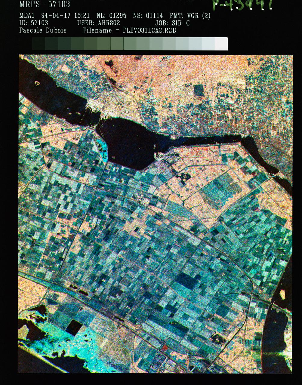
Three frequency false color image of Flevoland, the Netherlands
This is a color composite image of southern Bahia, Brazil, centered at 15.22 degree south latitude and 39.07 degrees west longitude. The image was acquired by the Spaceborne Imaging Radar-C/X-band Synthetic Aperture Radar aboard the space shuttle Endeavour on its 38th orbit of Earth on October 2, 1994.  The image covers an area centered over the Una Biological Reserve, one the largest protected areas in northeastern Brazil. The 7,000-hectare reserve is administered by the Brazilian Institute for the Environment and is part of the larger Atlantic coastal forest, a narrow band of rain forest extending along the eastern coast of Brazil. The Atlantic coastal forest of southern Bahia is one of the world's most threatened and diverse ecosystems. Due to widespread settlement, only 2 to 5 percent of the original forest cover remains. Yet the region still contains an astounding variety of plants and animals, including a large number of endemic species. More than half of the region's tree species and 80 percent of its animal species are indigenous and found nowhere else on Earth. The Una Reserve is also the only federally protected habitat for the golden-headed lion tamarin, the yellow-breasted capuchin monkey and many other endangered species. In the past few years, scientists from Brazilian and international conservation organizations have coordinated efforts to study the biological diversity of this region and to develop practical and economically viable options for preserving the remaining primary forests in southern Bahia.  The shuttle imaging radar is used in this study to identify various land uses and vegetation types, including remaining patches of primary forest, cabruca forest (cacao planted in the understory of the native forest), secondary forest, pasture and coastal mangrove. Standard remote-sensing technology that relies on light reflected from the forest canopy cannot accurately distinguish between cabruca and undisturbed forest. Optical remote sensing is also limited by the nearly continuous cloud cover in the region and heavy rainfall, which occurs more than 150 days each year. The ability of the shuttle radars to "see" through the forest canopy to the cultivated cacao below -- independent of weather or sunlight conditions --will allow researchers to distinguish forest from cabruca in unprecedented detail. This SIR-C/X-SAR image was produced by assigning red to the L-band, green to the C-band and blue to the X-band. The Una Reserve is located in the middle of the image west of the coastline and slightly northwest of Comandatuba River. The reserve's primary forests are easily detected by the pink areas in the image. The intensity of red in these areas is due to the high density of forest vegetation (biomass) detected by the radar's L-band (horizontally transmitted and vertically received) channel. Secondary forest is visible along the reserve's eastern border. The Serrado Mar mountain range is located in the top left portion of the image. Cabruca forest to the west of Una Reserve has a different texture and a yellow color. The removal of understory in cabruca forest reduces its biomass relative to primary forest, which changes the L-band and C-band penetration depth and returns, and produces a different texture and color in the image. The region along the Atlantic is mainly mangrove swamp, agricultural fields and urban areas. The high intensity of blue in this region is a result of increasing X-band return in areas covered with swamp and low vegetation. The image clearly separates the mangrove region (east of coastal Highway 001, shown in blue) from the taller and dryer forest west of the highway. The high resolution capability of SIR-C/X-SAR imaging and the sensitivity of its frequency and polarization channels to various land covers will be used for monitoring and mapping areas of importance for conservation.  http://photojournal.jpl.nasa.gov/catalog/PIA01764
Space Radar Image of Bahia
STS059-S-039 (11 April 1994) --- This is a false-color composite of Prince Albert, Canada, centered at 53.91 north latitude and 104.69 west longitude.  This image was acquired by the Spaceborne Imaging Radar-C and X-Band Synthetic Aperture Radar (SIR-C/X-SAR) aboard the Space Shuttle Endeavour on its 20th orbit.  The area is located 40 kilometers (25 miles) north and 30 kilometers (20 miles) east of the town of Prince Albert in the Saskatchewan province of Canada.  The image covers the area east of the Candle Lake, between gravel surface Highways 120 and 106 and west of 106.  The area in the middle of the image covers the entire Nipawin (Narrow Hills) provincial park.  The look angle of the radar is 30 degrees and the size of the image is approximately 20 kilometers by 50 kilometers (12 by 30 miles).  The image was produced by using only the L-Band.  The three polarization channels HH, HV and VV are illustrated by red, green and blue respectively.  The changes in the intensity of each color are related to various surface conditions such as variations in forest stands, frozen or thawed condition of the surface, disturbances (fire and deforestation), and areas of re-growth.  Most of the dark areas in the image are the ice-covered lakes in the region.  The dark area on the top right corner of the image is the White Gull Lake north of the intersection of Highway 120 and 913.  The right middle part of the image shows Lake Ispuchaw and Lower Fishing Lake.  The deforested areas are also shown by dark areas in the image.  Since most of the logging practice at the Prince Albert area is around the major highways, the deforested areas can be easily detected as small geometrically shaped dark regions along the roads.  At the time of the SIR-C/X-SAR overpass, a major part of the forest is either frozen or undergoing the spring thaw.  The L-Band HH shows a high return in the jack pine forest.  The reddish areas in the image are old jack pine forest, 12-17 meters (40-55 feet) in height and 60-75 years old.  The orange-greenish areas are young jack pine trees, 3-5 meters (10-16 feet) in height and 11-16 years old.  The green areas are due to the relative high intensity of the HV channel which is strongly correlated with the amount of biomass.  L-Band HV channel shows the biomass variations over the entire region.  Most of the green areas, when compared to the forest cover maps are identified as black spruce trees.  The dark blue and dark purple colors show recently harvested or re-growth areas respectively.  SIR-C/X-SAR is part of NASA's Mission to Planet Earth (MTPE).  SIR-C/X-SAR radars illuminate Earth with microwaves allowing detailed observations at any time, regardless of weather or sunlight conditions.  SIR-C/X-SAR uses three microwave wavelengths: L-Band (24 cm), C-Band (6 cm), and X-Band (3 cm).  The multi-frequency data will be used by the international scientific community to better understand the global environment and how it is changing.  The SIR-C/X-SAR data, complemented by aircraft and ground studies, will give scientists clearer insights into those environmental changes which are caused by nature and those changes which are induced by human activity.  SIR-C was developed by NASA's Jet Propulsion Laboratory (JPL).  X-SAR was developed by the Dornire and Alenia Spazio Companies for the German Space Agency, Deutsche Agentur fuer Raumfahrtangelegenheiten (DARA), and the Italian Space Agency, Agenzia Spaziale Italiana (ASI).    JPL Photo ID: P-43886
False-color composite image of Prince Albert, Canada