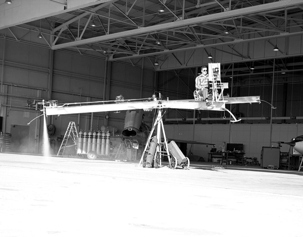
NACA High-Speed Flight Station test pilot Stan Butchart flying the Iron Cross, the mechanical reaction control simulator. High-pressure nitrogen gas expanded selectively, by the pilot, through the small reaction control thrusters maneuvered the Iron Cross through the three axes. The exhaust plume can be seen from the aft thruster. The tanks containing the gas can be seen on the cart at the base of the pivot point of the Iron Cross. NACA technicians built the iron-frame simulator, which matched the inertia ratios of the Bell X-1B airplane, installing six jet nozzles to control the movement about the three axes of pitch, roll, and yaw.

A photo of the control stick used on the Iron Cross Attitude Simulator. Although it resembled today's desktop computer flight sticks, its operation was different. As with a standard control stick, moving it back and forth raised and lowered the nose resulting in changes in pitch. Moving the stick to the right or left raised or lowered the wing, resulted in changes in roll. This control stick had a third axis, not found in standard control sticks. Twisting the stick to the right or left caused the airplane's nose to move horizontally in the same direction, resulting in changes in yaw.
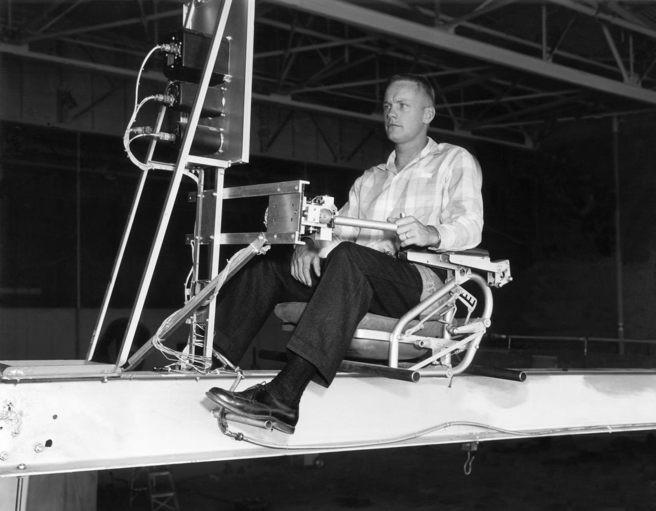
Famed astronaut Neil A. Armstrong, the first man to set foot on the moon during the historic Apollo 11 space mission in July 1969, served for seven years as a research pilot at the NACA-NASA High-Speed Flight Station, now the Dryden Flight Research Center, at Edwards, California, before he entered the space program. Armstrong joined the National Advisory Committee for Aeronautics (NACA) at the Lewis Flight Propulsion Laboratory (later NASA's Lewis Research Center, Cleveland, Ohio, and today the Glenn Research Center) in 1955. Later that year, he transferred to the High-Speed Flight Station at Edwards as an aeronautical research scientist and then as a pilot, a position he held until becoming an astronaut in 1962. He was one of nine NASA astronauts in the second class to be chosen. As a research pilot Armstrong served as project pilot on the F-100A and F-100C aircraft, F-101, and the F-104A. He also flew the X-1B, X-5, F-105, F-106, B-47, KC-135, and Paresev. He left Dryden with a total of over 2450 flying hours. He was a member of the USAF-NASA Dyna-Soar Pilot Consultant Group before the Dyna-Soar project was cancelled, and studied X-20 Dyna-Soar approaches and abort maneuvers through use of the F-102A and F5D jet aircraft. Armstrong was actively engaged in both piloting and engineering aspects of the X-15 program from its inception. He completed the first flight in the aircraft equipped with a new flow-direction sensor (ball nose) and the initial flight in an X-15 equipped with a self-adaptive flight control system. He worked closely with designers and engineers in development of the adaptive system, and made seven flights in the rocket plane from December 1960 until July 1962. During those fights he reached a peak altitude of 207,500 feet in the X-15-3, and a speed of 3,989 mph (Mach 5.74) in the X-15-1. Armstrong has a total of 8 days and 14 hours in space, including 2 hours and 48 minutes walking on the Moon. In March 1966 he was commander of the Gemini 8 or

The Transient Dentritic Solidification Experiment (TDSE) is being developed as a candidate for flight aboard the International Space Station. TDSE will study the growth of dentrites (treelike crystalline structures) in a transparent material (succinonitrile or SCN) that mimics the behavior of widely used iron-based metals. Basic work by three Space Shuttle flights (STS-62, STS-75, and STS-87) of the Isothermal Dendritic Growth Experiment (IDGE) is yielding new insights into virtually all industrially relevant metal and alloy forming operations. The TDSE is similar to IDGE, but will maintain a constant temperature while varying pressure on the dentrites. Shown here is a cutaway of the isothermal bath containing its growth cell at the heart of the TDSE. The principal investigator is Matthew Koss of College of the Holy Cross in Worcester, MA. Note: an Acrobat PDF version is available from http://microgravity.nasa.gov/gallery

The Transient Dendritic Solidification Experiment (TDSE) is being developed as a candidate for flight aboard the International Space Station. TDSE will study the growth of dendrites (treelike crystalline structures) in a transparent material (succinonitrile or SCN) that mimics the behavior or widely used iron-based metals. Basic work by three Space Shuttle missions of the Isothermal Dendritic Growth Experiment (IDGE) is yielding new insights into virtually all industrially relevant metal and alloy forming operations. The TDSE is similar to IDGE, but will maintain a constant temperature while varying pressure on the dendrites. Shown here is an exploded view of major elements of the TDSE. A similar view is availble without labels. The principal investigator is Matthew Koss of College of the Holy Cross in Worcester, MA. Photo credit: NASA/Marshall Space Flight Center (MSFC)

The Transient Dendritic Solidification Expepriment (TDSE) is being developed as a candidate for flight aboard the International Space Station. TDSE will study the growth of dendrites (treelike crystalline structures) in a transparent material (succinonitrile or SCN) that mimics the behavior of widely used iron-based metals. Basic work by three Space Shuttle missions of the Isothermal Dendritic Growth Expepriment (IDGE) is yielding new insights into virtually all industrially relevant metal and alloy forming operations. The TDSE is similar to IDGE, but will maintain a constant temperature while varying pressure on the dendrites. Shown here is an exploded view of major elements of TDSE. A similar view is available with labels. The principal investigator is Matthew Koss of College of the Holy Cross in Worcester, MA. Photo credit: NASA/Marshall Space Flight Center (MSFC)
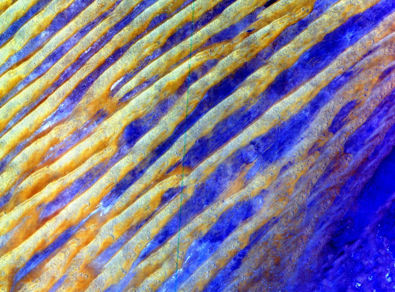
This image of Saudi Arabia shows a great sea of linear dunes in part of the Rub' al Khali, or the Empty Quarter. Acquired on June 25, 2000, the image covers an area 37 kilometers (23 miles) wide and 28 kilometers (17 miles) long in three bands of the reflected visible and infrared wavelength region. The dunes are yellow due to the presence of iron oxide minerals. The inter-dune area is made up of clays and silt and appears blue due to its high reflectance in band 1. The Rub' al Khali is the world's largest continuous sand desert. It covers about 650,000 square kilometers (250,966 square miles) and lies mainly in southern Saudi Arabia, though it does extend into the United Arab Emirates, Oman, and Yemen. One of the world's driest areas, it is uninhabited except for the Bedouin nomads who cross it. The first European to travel through the desert was Bertram Thomas in 1930. http://photojournal.jpl.nasa.gov/catalog/PIA02656
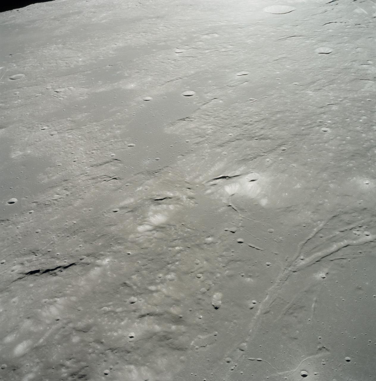
AS17-153-23572 (15 Dec. 1972) --- An oblique view of the Sulpicius Gallus region on the southwestern edge of the Sea of Serenity looking westward across the Haemus Mountains, as photographed from the Apollo 17 Command and Service Modules during its 65th revolution of the moon. This photograph shows the slight orange cast which was identified by astronaut Ronald E. Evans, command module pilot. The region shown in the picture is about 600 kilometers (360 statute miles) west across Mare Serentatis from the Taurus-Littrow landing site where scientist-astronaut Harrison H. "Jack" Schmitt, lunar module pilot, discovered an orange soil sample composed of fine glass particles rich in iron and titanium. North is toward the right. Rima Sulpicius Gallus is the lunar trench or valley (right foreground) that crosses the edge of the Mare and divides into three branches as it runs to the northwest. The crater Sulpicius Gallus is just off the photograph at the bottom right. Note that several small craters in the dark portion of the picture (east) show a more distinct orange cast. The coordinates of the center of this photograph are about 8.4 degrees east longitude and 19.8 degrees north latitude.

Researchers used the Mast Camera (Mastcam) on NASA's Curiosity Mars rover to gain this detailed view of layers in "Vera Rubin Ridge" from just below the ridge. The scene combines 70 images taken with the Mastcam's right-eye, telephoto-lens camera, on Aug. 13, 2017, during the 1,785th Martian day, or sol, of Curiosity's work on Mars. This and other Mastcam panoramas show details of the sedimentary rocks that make up the "Vera Rubin Ridge." This distinct topographic feature located on the lower slopes of Mount Sharp (Aeolis Mons) is characterized by the presence of hematite, an iron-oxide mineral, which has been detected from orbit. The Mastcam images show that the rocks making up the lower part of the ridge are characterized by distinct horizontal stratification with individual rock layers of the order of several inches (tens of centimeters) thick. Scientists on the mission are using such images to determine the ancient environment these rocks were deposited in. The repeated beds indicate progressive accumulation of sediments that now make up the lower part of Mount Sharp, although from this distance it is not possible to know if they were formed by aqueous or wind-blown processes. Close-up images collected as the rover climbs the ridge will help answer this question. The stratified rocks are cross cut by veins filled with a white mineral, likely calcium sulfate, that provide evidence of later episodes of fluid flow through the rocks. The panorama has been white-balanced so that the colors of the rock materials resemble how they would appear under daytime lighting conditions on Earth. It spans from southeast on the left to west on the right. The Sol 1785 location just north of the ridge is shown in a Sol 1782 traverse map. The ridge was informally named in early 2017 in memory of Vera Cooper Rubin (1928-2016), whose astronomical observations provided evidence for the existence of the universe's dark matter. An annotated figure is shown at https://photojournal.jpl.nasa.gov/catalog/PIA21850
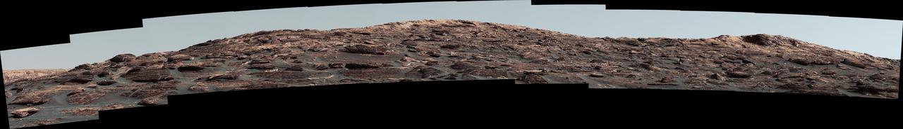
The Mast Camera (Mastcam) on NASA's Curiosity Mars rover captured this view of "Vera Rubin Ridge" about two weeks before the rover started ascending this steep ridge on lower Mount Sharp. The view combines 13 images taken with the Mastcam's right-eye, telephoto-lens camera, on Aug. 19, 2017, during the 1,790th Martian day, or sol, of Curiosity's work on Mars. This and other Mastcam panoramas show details of the sedimentary rocks that make up the "Vera Rubin Ridge." This distinct topographic feature located on the lower slopes of Mount Sharp (Aeolis Mons) is characterized by the presence of hematite, an iron-oxide mineral, which has been detected from orbit. The Mastcam images show that the rocks making up the lower part of the ridge are characterized by distinct horizontal stratification with individual rock layers of the order of several inches (tens of centimeters) thick. Scientists on the mission are using such images to determine the ancient environment these rocks were deposited in. The repeated beds indicate progressive accumulation of sediments that now make up the lower part of Mount Sharp, although from this distance it is not possible to know if they were formed by aqueous or wind-blown processes. Close-up images collected as the rover climbs the ridge will help answer this question. The stratified rocks are cross cut by veins filled with a white mineral, likely calcium sulfate, that provide evidence of later episodes of fluid flow through the rocks. The panorama has been white-balanced so that the colors of the rock materials resemble how they would appear under daytime lighting conditions on Earth. It spans about 55 compass degrees centered to the south-southeast. The Sol 1790 location just north of the ridge is shown in a Sol 1789 traverse map. The ridge was informally named in early 2017 in memory of Vera Cooper Rubin (1928-2016), whose astronomical observations provided evidence for the existence of the universe's dark matter. An annotated figure is shown at https://photojournal.jpl.nasa.gov/catalog/PIA21851
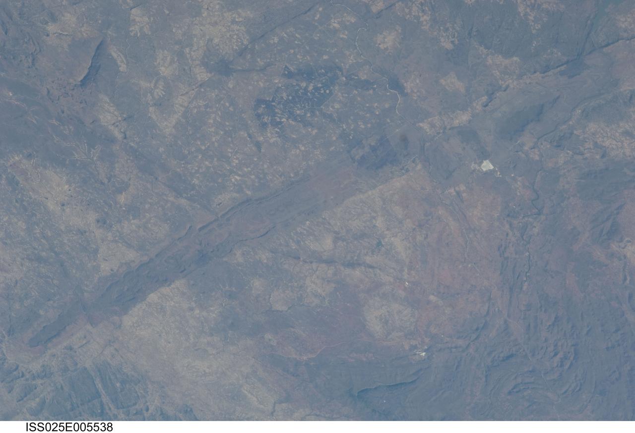
ISS025-E-005538 (30 Sept. 2010) --- The Great Dyke of Zimbabwe, Africa is featured in this image photographed by an Expedition 25 crew member on the International Space Station. The Great Dyke of Zimbabwe is a prominent geological feature that extends for over 550 kilometers, varying from 3-12 kilometers in width across the center of the country northeast – southwest; the southern end of the Dyke is illustrated in this view. The Dyke (or Dike in American English) is a layered mafic intrusion of igneous, metal-bearing rock that has been dated using uranium-lead isotopes to approximately 2.5 billion years in age, according to scientists. It intrudes even older rocks of the African craton, or core of oldest rocks forming the continent; in cross section, the Great Dyke looks somewhat triangular or keel-shaped suggesting to geologists that it rose along deep faults associated with extension of the African crust. Layered mafic intrusions are usually associated with economically important metals such as chromium, nickel, copper, platinum, titanium, iron, vanadium and tin. Chromium, in the form of the mineral chromite and platinum are particularly abundant in the Great Dyke and actively mined. Younger faults have offset sections of the Dyke along its length – two of the most obvious faults in the image are indicated, with arrows showing the relative directions of offset relative to the main trend of the intrusion. While the Great Dyke and its metal ores are products of geologic processes operating in the deep past, more recent events have also left their mark on the landscape as illustrated by two large fire burn scars which are visible at top center.
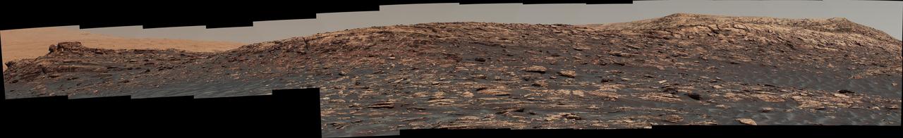
"Vera Rubin Ridge," a favored destination for NASA's Curiosity Mars rover even before the rover landed in 2012, rises near the rover nearly five years later in this panorama from Curiosity's Mast Camera (Mastcam). The scene combines 23 images taken with the Mastcam's right-eye, telephoto-lens camera, on June 22, 2017, during the 1,734th Martian day, or sol, of Curiosity's work on Mars. The rover began ascending the ridge in September 2017. This and other Mastcam panoramas show details of the sedimentary rocks that make up the "Vera Rubin Ridge." This distinct topographic feature located on the lower slopes of Mount Sharp (Aeolis Mons) is characterized by the presence of hematite, an iron-oxide mineral, which has been detected from orbit. The Mastcam images show that the rocks making up the lower part of the ridge are characterized by distinct horizontal stratification with individual rock layers of the order of several inches (tens of centimeters) thick. Scientists on the mission are using such images to determine the ancient environment these rocks were deposited in. The repeated beds indicate progressive accumulation of sediments that now make up the lower part of Mount Sharp, although from this distance it is not possible to know if they were formed by aqueous or wind-blown processes. Close-up images collected as the rover climbs the ridge will help answer this question. The stratified rocks are cross cut by veins filled with a white mineral, likely calcium sulfate, that provide evidence of later episodes of fluid flow through the rocks. The panorama has been white-balanced so that the colors of the rock materials resemble how they would appear under daytime lighting conditions on Earth. It spans about 65 compass degrees, centered toward the south-southeast. Higher portions of Mount Sharp are visible at upper left. The Sol 1734 location just north of the ridge is shown in a Sol 1732 traverse map. An annotated figure is shown at https://photojournal.jpl.nasa.gov/catalog/PIA21849