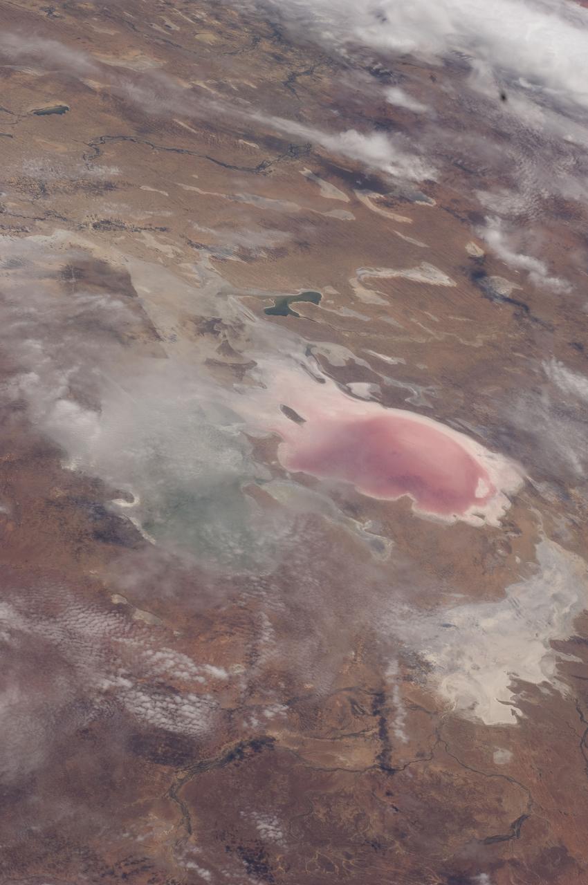
ISS030-E-009271 (5 Dec. 2011) --- Lake Eyre floods in South Australia are featured in this image photographed by an Expedition 30 crew member on the International Space Station. Heavy rain in early March 2011 produced the comparatively unusual event of water entering Lake Eyre. The southernmost and deepest lobes, Belt Bay and Lake Eyre South, were filled first. In this northeast-looking view from the space station, water can be seen in the southern basins of Lake Eyre, especially in Belt Bay where it appears green, and in Madigan Gulf where it appears in shades of pink and red. Despite some cloud, water is also apparent in narrow Jackboot Bay and at the estuary where Cooper Creek, one of the most important inflow rivers, fills a small, dark green lake. The varying water colors result from the effects of water depth and resident organisms. The green coloration of Belt Bay is likely related to its depth, which was reported in early December 2011 to be just less than one meter. The red color of Madigan Bay on the other hand, appears to be related to salt-loving bacteria. At half the depth of Belt Bay (0.4 meters), evaporation had apparently raised salt concentrations high enough to allow salt-loving bacteria to flourish when this image was taken. In Australian lake waters with salinities from about 30 percent upwards the majority of microbes are haloarchaea. The density of microbes that live in Australia?s salt lakes can reach 10⁷ ? 10⁸ cells/milliliters?so dense in fact, that the pink-red carotenoid pigments in the cell membranes appear to color the water. By August 2011 more than half the lake floor was covered by shallow water, with local creeks continuing to deliver water to the lake. Lake Eyre is an internal drainage basin, which means that all the water accumulates in the lake since it has no outlet to the sea. Any water that reaches the lake evaporates in the course of subsequent months. Water levels were reported to be falling everywhere in late 2011, when this image was acquired. The bright white salt of the floor of Lake Eyre South shows that this lake is entirely dry.
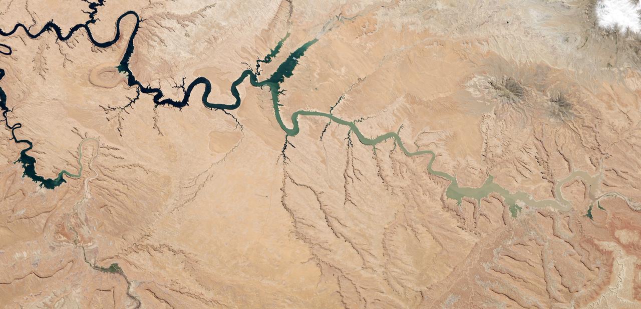
After 14 years of drought, Lake Powell was at 42 percent of its capacity as of May 20, 2014. The low water levels are evident in these images, which were acquired by the Landsat 8 satellite on May 13, 2014. White bleached rock show where Lake Powell’s shore is when the reservoir is at capacity. It is normal for water levels to fluctuate in the reservoir depending on how much water flows in from snow and rain and how much flows out to meet needs. However, it has been dry in all but three of the past 14 years. At the beginning of 2000, Lake Powell was at 94 percent of capacity. By October 2013 (the beginning of the 2014 water year), water levels had dropped to a low of 50 percent capacity, according to the Bureau of Reclamation, the agency that manages the reservoir. The Earth Observatory’s World of Change shows this annual fluctuation and overall decline. With slightly above average snowpack in the basin that feeds the lake, water levels are expected to rebound to about 51 percent of capacity by October 2014, the end of the water year. While the drop in water levels are worrying for those who generate electricity or use the water for agriculture, the lower water levels may be a draw for recreation. Boaters coming to Lake Powell in the spring of 2014 will find beaches and rock formations that are usually underwater. Bullfrog Bay is the starting point for many boat rentals. The popularity of the spot is evident in the lower image: boats dot the surface of the water, just tiny white flecks at this scale. NASA Earth Observatory image by Robert Simmon, using Landsat data from the U.S. Geological Survey. Caption by Holli Riebeek. Instrument(s): Landsat 8 - OLI Read more: <a href="http://1.usa.gov/1hck6NX" rel="nofollow">1.usa.gov/1hck6NX</a> Credit: <b><a href="http://www.earthobservatory.nasa.gov/" rel="nofollow"> NASA Earth Observatory</a></b> <b><a href="http://www.nasa.gov/audience/formedia/features/MP_Photo_Guidelines.html" rel="nofollow">NASA image use policy.</a></b> <b><a href="http://www.nasa.gov/centers/goddard/home/index.html" rel="nofollow">NASA Goddard Space Flight Center</a></b> enables NASA’s mission through four scientific endeavors: Earth Science, Heliophysics, Solar System Exploration, and Astrophysics. Goddard plays a leading role in NASA’s accomplishments by contributing compelling scientific knowledge to advance the Agency’s mission. <b>Follow us on <a href="http://twitter.com/NASAGoddardPix" rel="nofollow">Twitter</a></b> <b>Like us on <a href="http://www.facebook.com/pages/Greenbelt-MD/NASA-Goddard/395013845897?ref=tsd" rel="nofollow">Facebook</a></b> <b>Find us on <a href="http://instagram.com/nasagoddard?vm=grid" rel="nofollow">Instagram</a></b>