
Tithonium Chasma/Ius Chasma

Ius Chasma
Ius Chasma
Ius Chasma In False Color
Ius Chasma Ridge

Ius Chasma by Day and Night
Old Landslide In Ius Chasma
Ius Chasma at Night
Ius Chasma Debris

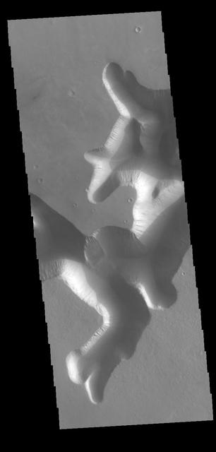
Ius Chasma Landslide
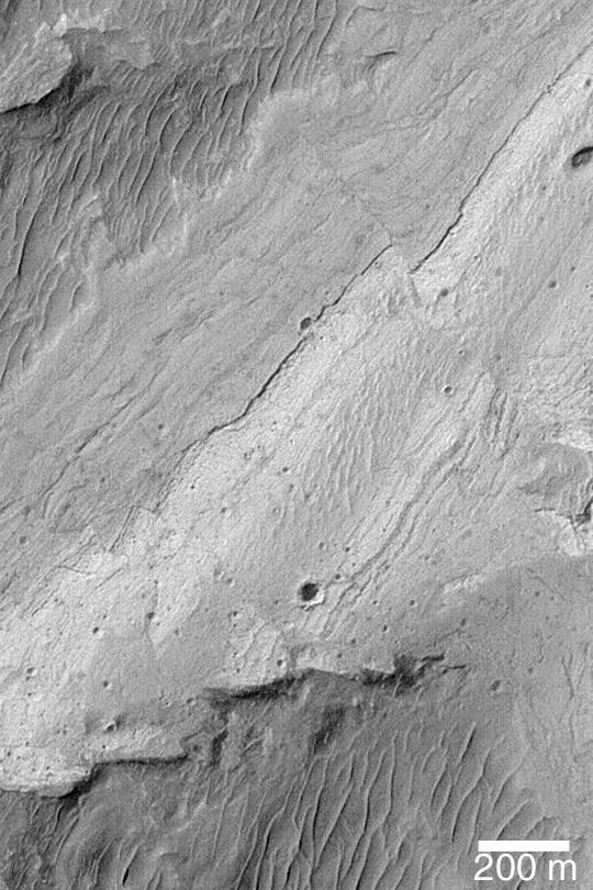
Ius Chasma Ridge
Ius Chasma Floor
Floor of Ius Chasma
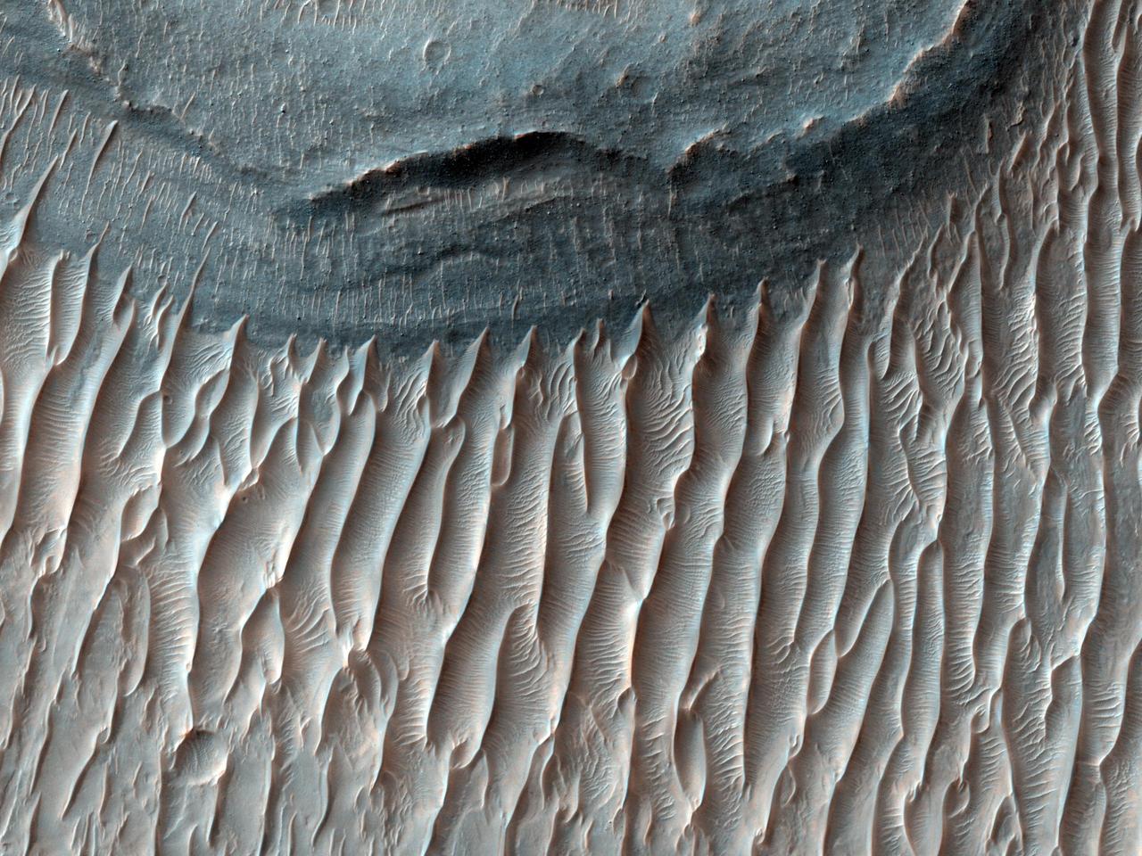
Ius Chasma Layers
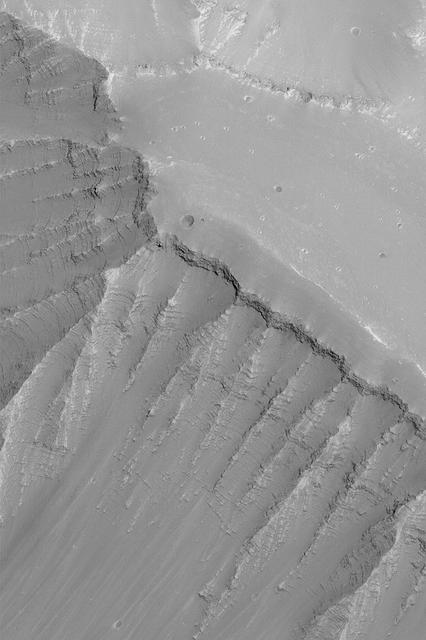
Ius Chasma Fault
Western Tithonium Chasma/Ius Chasma, Valles Marineris

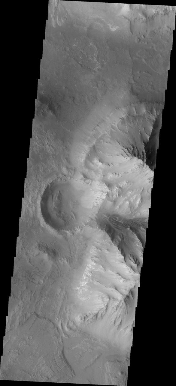
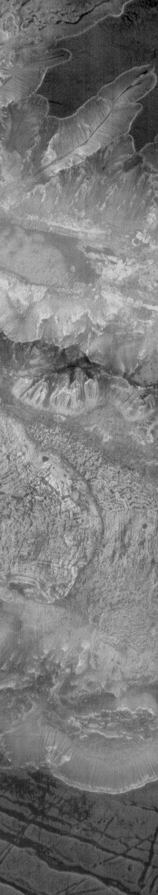
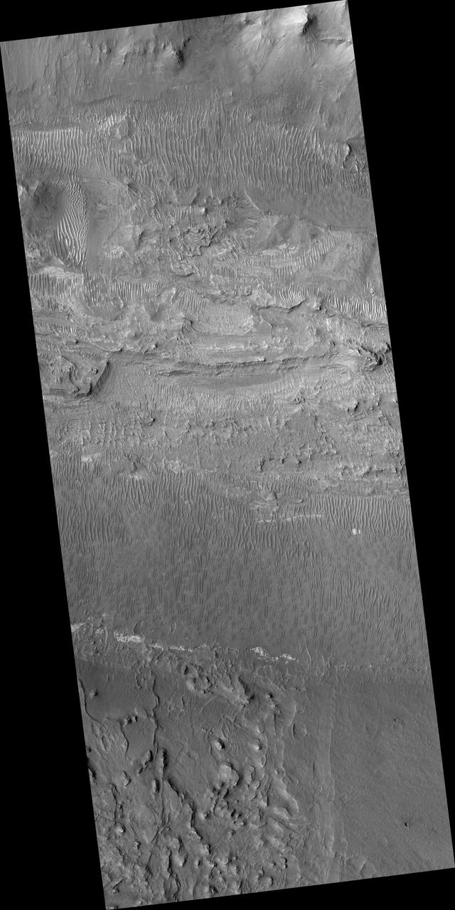
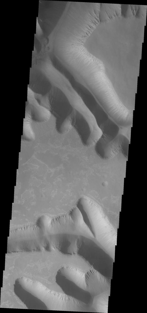
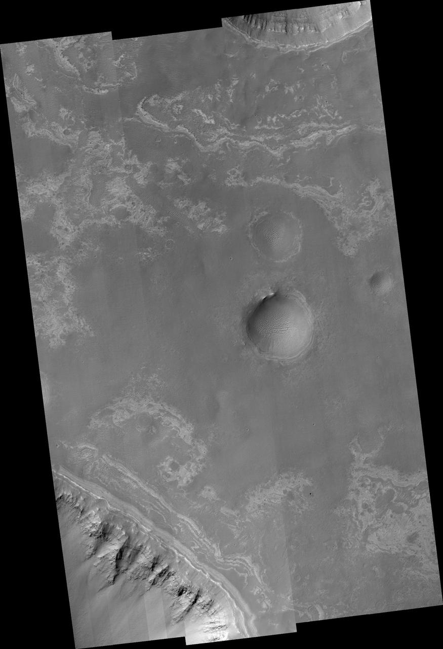
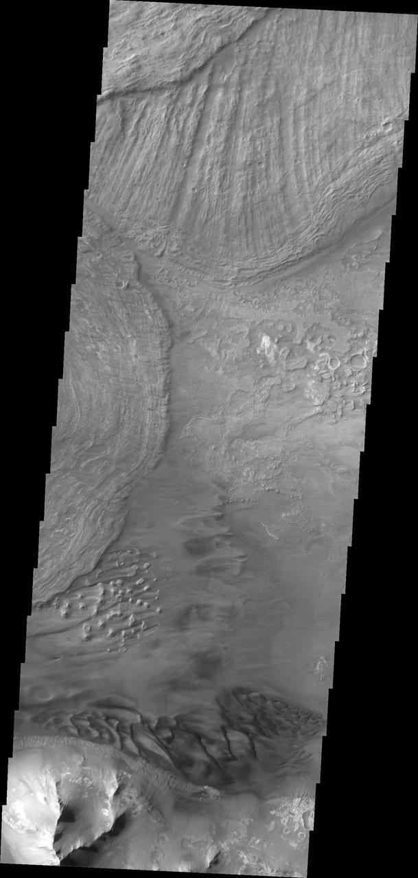
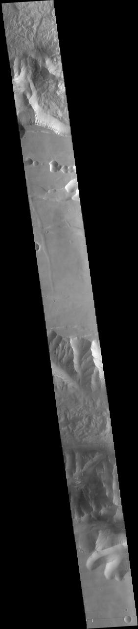
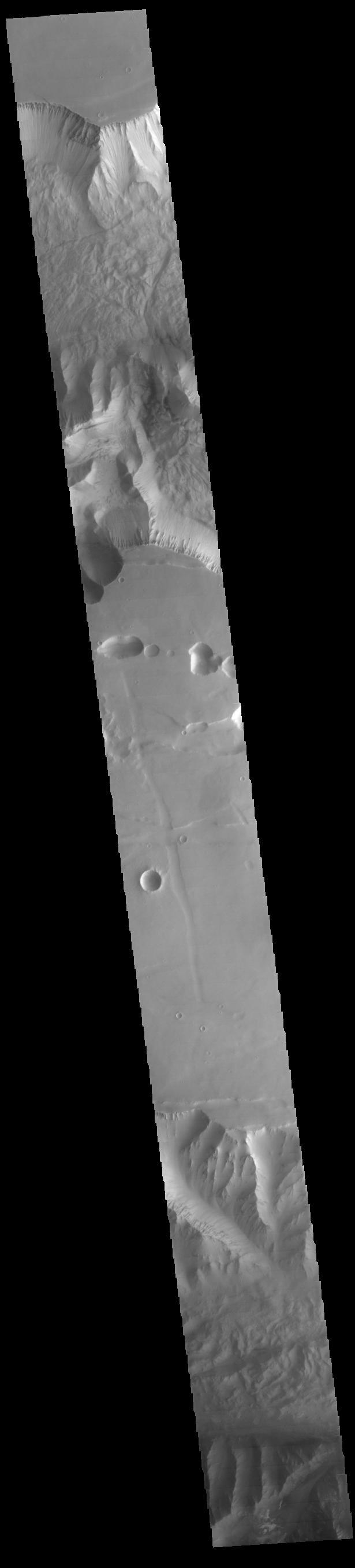
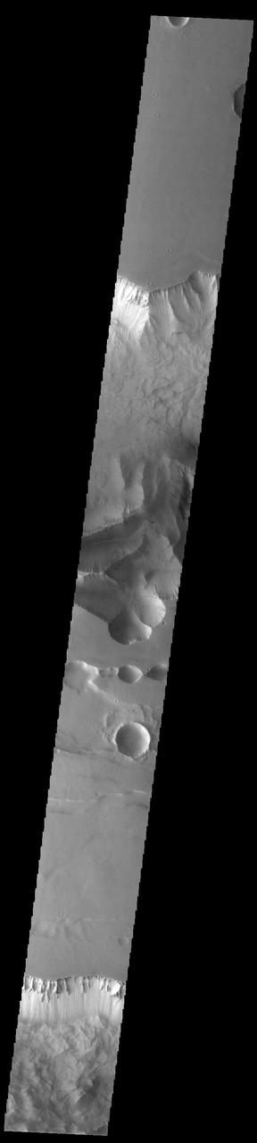
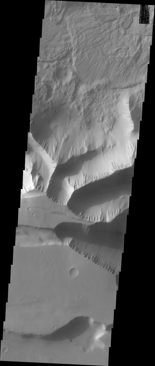
Today's VIS image shows the southern cliffside of Tithonium Chasma (top of image) and the complete cross section of Ius Chasma (center of image). Ius Chasma and Thithonium Chasma are at the western end of Valles Marineris. Valles Marineris is over 4000 kilometers long, wider than the United States. Tithonium Chasma is 803 kilometers long (499 miles) while Ius Chasma is almost 850 kilometers long (528 miles), 120 kilometers wide and over 8 kilometers deep. In comparison, the Grand Canyon in Arizona is about 175 kilometers long, 30 kilometers wide, and only 2 kilometers deep. The canyons of Valles Marineris were formed by extensive fracturing and pulling apart of the crust during the uplift of the vast Tharsis plateau. Landslides have enlarged the canyon walls and created deposits on the canyon floor. Weathering of the surface and influx of dust and sand have modified the canyon floor, both creating and modifying layered materials. There are many features that indicate flowing and standing water played a part in the chasma formation. The rugged floor of Ius Chasma in this image is the result of many large landslides. Orbit Number: 89711 Latitude: -6.50729 Longitude: 272.316 Instrument: VIS Captured: 2022-03-06 02:35 https://photojournal.jpl.nasa.gov/catalog/PIA25391

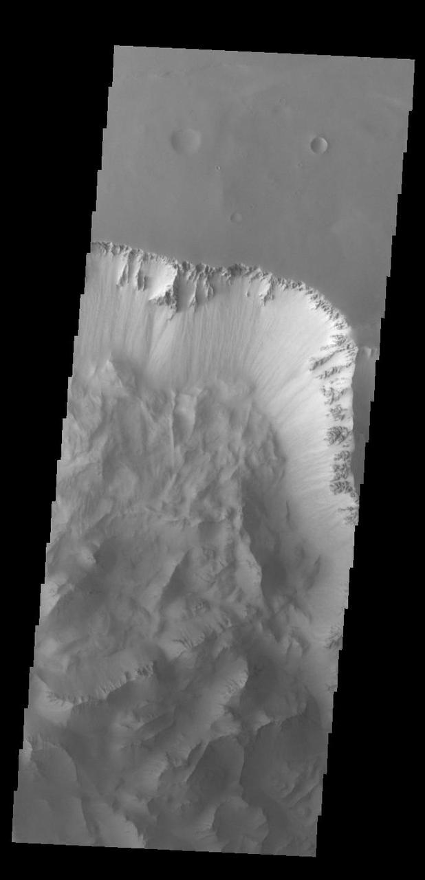
Today's VIS image shows a complete cross section of Ius Chasma. Ius Chasma is at the western end of Valles Marineris. Valles Marineris is over 4000 kilometers long, wider than the United States. Ius Chasma is almost 850 kilometers long (528 miles), 120 kilometers wide and over 8 kilometers deep. In comparison, the Grand Canyon in Arizona is about 175 kilometers long, 30 kilometers wide, and only 2 kilometers deep. The canyons of Valles Marineris were formed by extensive fracturing and pulling apart of the crust during the uplift of the vast Tharsis plateau. Landslides have enlarged the canyon walls and created deposits on the canyon floor. Weathering of the surface and influx of dust and sand have modified the canyon floor, both creating and modifying layered materials. There are many features that indicate flowing and standing water played a part in the chasma formation. The rugged floor of Ius Chasma in this image is the result of many large landslides. Orbit Number: 92413 Latitude: -6.89657 Longitude: 272.994 Instrument: VIS Captured: 2022-10-14 13:17 https://photojournal.jpl.nasa.gov/catalog/PIA25760
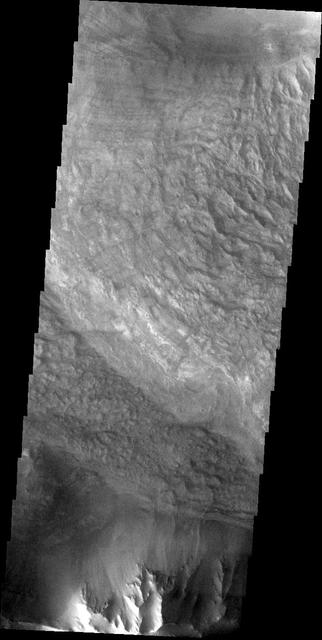
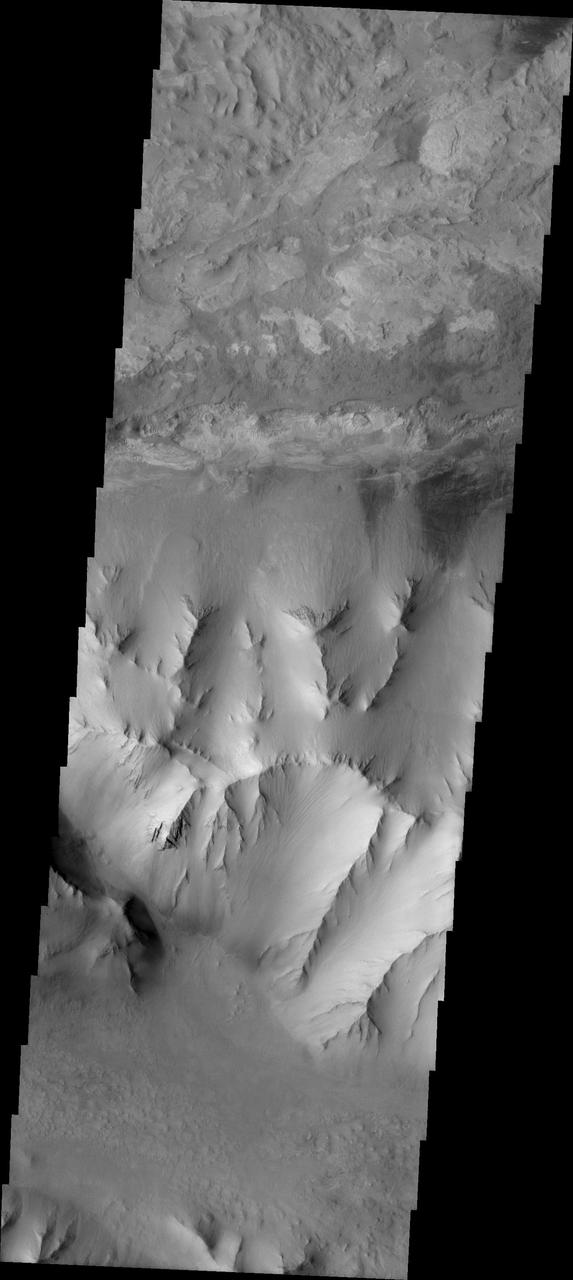
Western Tithonium Chasma/Ius Chasma, Valles Marineris - High Resolution Image
Western Tithonium Chasma/Ius Chasma, Valles Marineris - High Resolution Image
This image captured by NASA Mars Odyssey shows parts of two giant gully that are located on the southern side of Ius Chasma. Ius Chasma has the largest number of mega gullies of any of the chasmata that make up Valles Marineris.
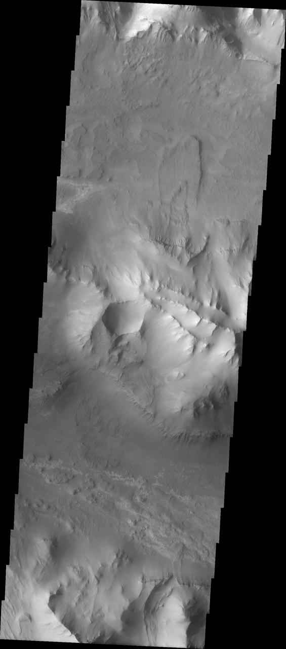
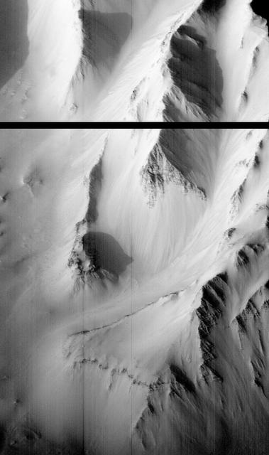
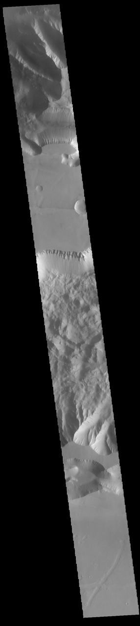
Today's VIS image shows part of Ius Chasma. Ius Chasma is at the western end of Valles Marineris. Valles Marineris is over 4000 kilometers long, wider than the United States. Ius Chasma is almost 850 kilometers long (528 miles), 120 kilometers wide and over 8 kilometers deep. In comparison, the Grand Canyon in Arizona is about 175 kilometers long, 30 kilometers wide, and only 2 kilometers deep. The canyons of Valles Marineris were formed by extensive fracturing and pulling apart of the crust during the uplift of the vast Tharsis plateau. Landslides have enlarged the canyon walls and created deposits on the canyon floor. Weathering of the surface and influx of dust and sand have modified the canyon floor, both creating and modifying layered materials. There are many features that indicate flowing and standing water played a part in the chasma formation. The rugged floor of Ius Chasma in this image is the result of many large landslides. Orbit Number: 92987 Latitude: -6.37421 Longitude: 273.45 Instrument: VIS Captured: 2022-11-30 19:36 https://photojournal.jpl.nasa.gov/catalog/PIA25808
Ius Chasma Tributary Valleys and Adjacent Plains

Large landslide deposits dominate this image of Ius Chasma captured by NASA 2001 Mars Odyssey. Dunes are visible at the bottom of the frame.
Dunes and the distal end of a landslide deposit are evident in this image from NASA 2001 Mars Odyssey of eastern Ius Chasma.
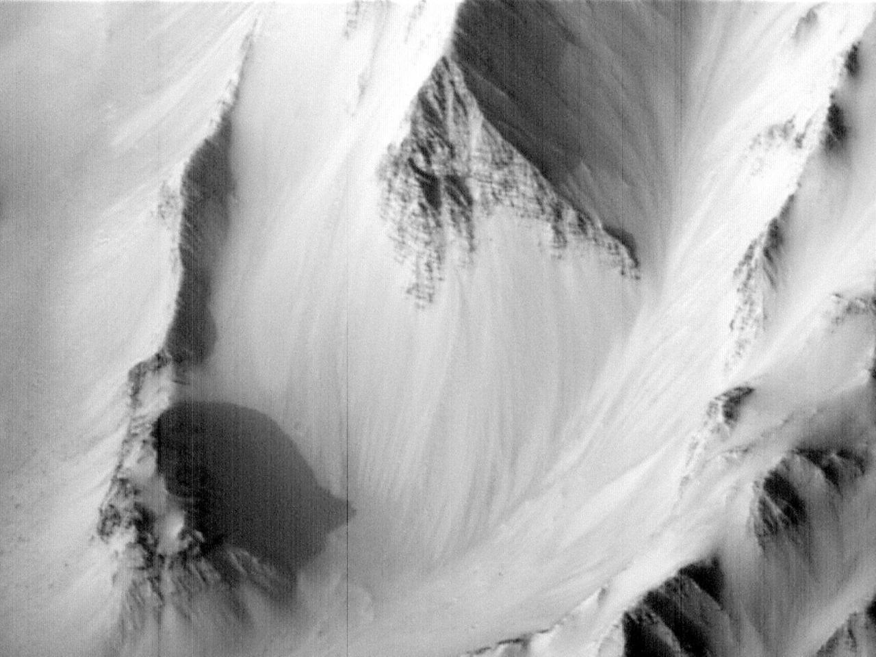
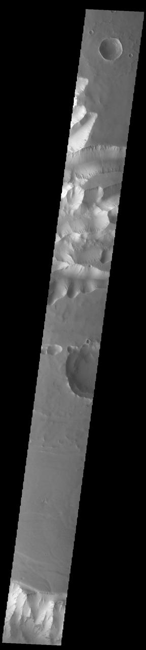
Today's VIS image shows part of Ius Chasma and one of its mega gullies (bottom of image). Ius Chasma is unique from the other chasmata of Valles Marineris in possessing mega gullies on both sides of the chasma. The largest mega gullies are located in Sinai Planum, dissecting those plains and emptying into the canyon. Mega gullies are thought to be sapping channels caused by groundwater flow and erosion. The Earth analog is springs – water that flows underground and then breaches the surface creating channels. The morphology of the Mars gullies mirrors terrestrial springs. The channel is fairly uniform in width and the "head" of the channel is rounded like an amphitheater. The channel lengthens by erosion at the "head" backwards as the surface where the spring emerges is undercut. For Mars it is theorized that subsurface water would stay liquid due to underground heating. Ius Chasma is at the western end of Valles Marineris, south of Tithonium Chasma. Valles Marineris is over 4000 kilometers long, almost as wide as the United States. Ius Chasma is almost 850 kilometers long (528 miles), 120 kilometers wide and over 8 kilometers deep. Orbit Number: 91408 Latitude: -6.95449 Longitude: 274.37 Instrument: VIS Captured: 2022-07-23 20:09 https://photojournal.jpl.nasa.gov/catalog/PIA25577

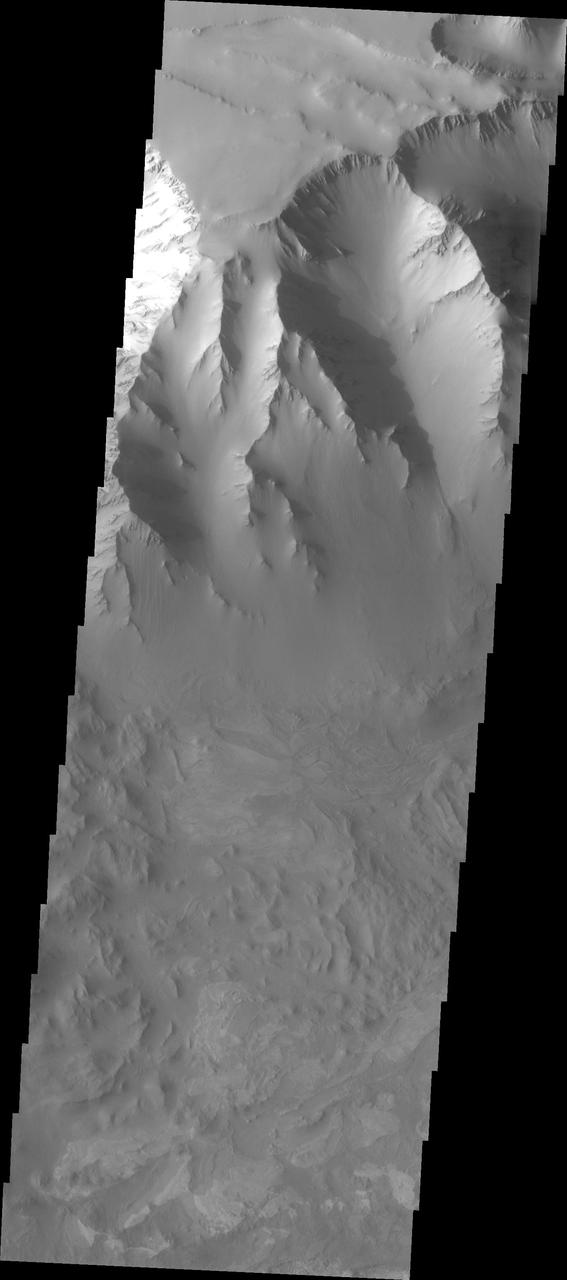
Ius Chasma is at the western end of Valles Marineris, south of Tithonium Chasma. Valles Marineris is over 4000 kilometers long, almost as wide as the United States. Ius Chasma is almost 850 kilometers long (528 miles), 120 kilometers wide and over 8 kilometers deep. In comparison, the Grand Canyon in Arizona is about 175 kilometers long, 30 kilometers wide, and only 2 kilometers deep. The canyons of Valles Marineris were formed by extensive fracturing and pulling apart of the crust during the uplift of the vast Tharsis plateau. Landslides have enlarged the canyon walls and created deposits on the canyon floor. Weathering of the surface and influx of dust and sand have modified the canyon floor, both creating and modifying layered materials. There are many features that indicate flowing and standing water played a part in the chasma formation. The rugged floor of Ius Chasma in this image is the result of many large landslides. Orbit Number: 91839 Latitude: -7.09251 Longitude: 272.604 Instrument: VIS Captured: 2022-08-28 06:58 https://photojournal.jpl.nasa.gov/catalog/PIA25712
Huge gullies, like these captured by NASA 2001 Mars Odyssey, line both rims of Ius Chasma.

This image from NASA Mars Odyssey shows a portion of a large landslide deposit in Ius Chasma.
Ius Chasma is one of several canyons that make up Valles Marineris, the largest canyon system in the Solar System as seen by NASA Mars Reconnaissance Orbiter.
This image captured by NASA 2001 Mars Odyssey spacecraft shows one of the mega sized gullies located on the plains just south of Ius Chasma. Orbit Number: 65907 Latitude: -8.73127 Longitude: 275.005 Instrument: VIS Captured: 2016-10-22 15:44 http://photojournal.jpl.nasa.gov/catalog/PIA21188
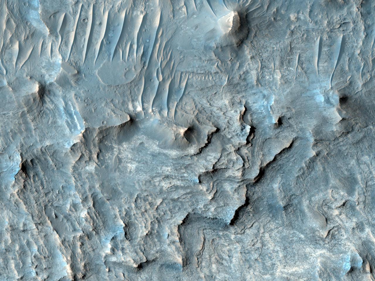
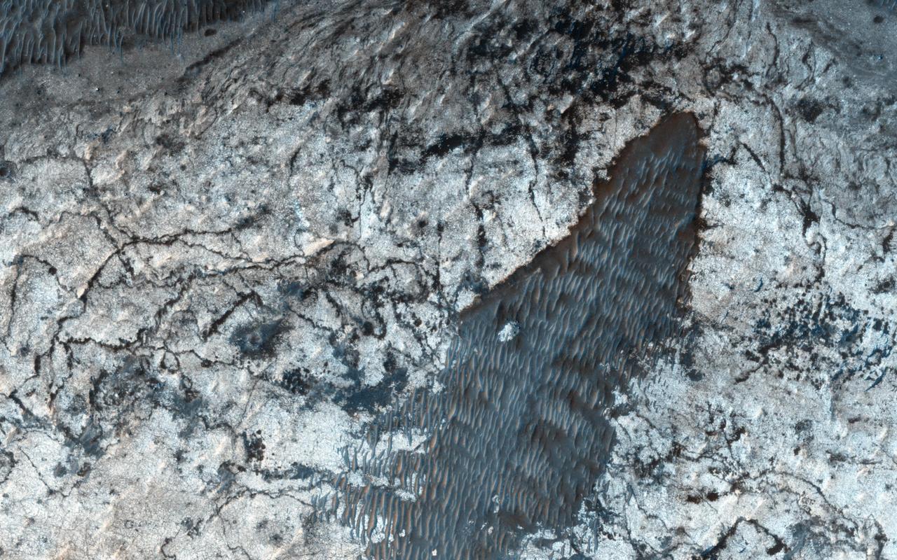
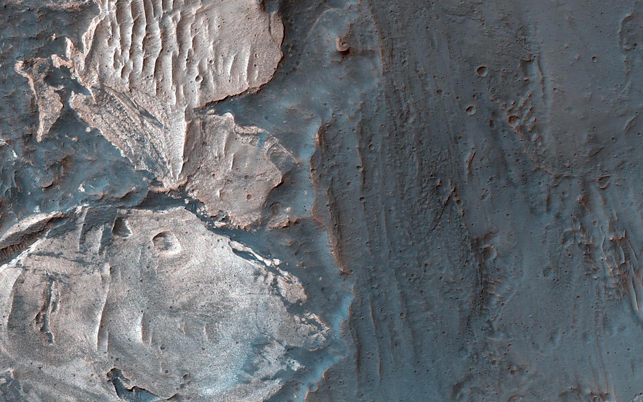
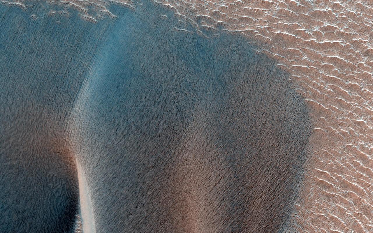
Sometimes Mars' surface is just beautiful as seen through the eyes of HiRISE. This is one example on the floor of Ius Chasma, part of Valles Marineris. The region has had a complex history of sediment deposition, deformation, erosion, and alteration. https://photojournal.jpl.nasa.gov/catalog/PIA23183
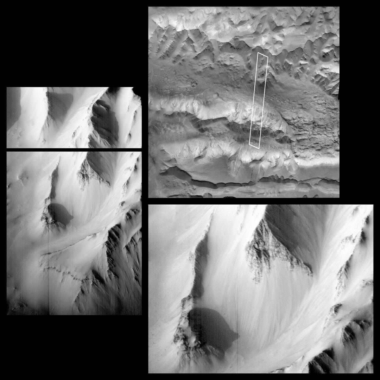
This image was acquired in Ius Chasma, a major section of the western portion of the giant Valles Marineris trough. We see a portion of a steep slope with gullies extending downhill (towards bottom of image). Many of the gully floors are dark, and in some places that dark material extends onto the fan-shaped deposits of the gullies. These dark features are candidates for recurring slope lineae (RSL), which are seasonal features that grow incrementally. The relation between RSL and gullies is not clear: does the RSL activity carve the gullies, or do they simply follow the gully topography created by other processes? Another closeup from this observation shows part of the floor of Ius Chasma, with layered bedrock draped by dunes. https://photojournal.jpl.nasa.gov/catalog/PIA23099
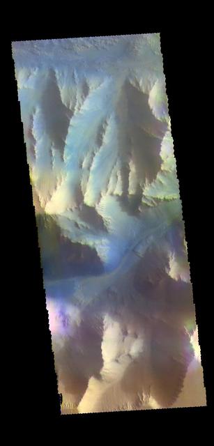
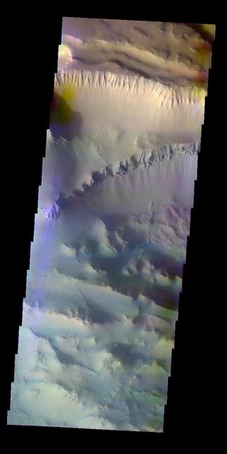
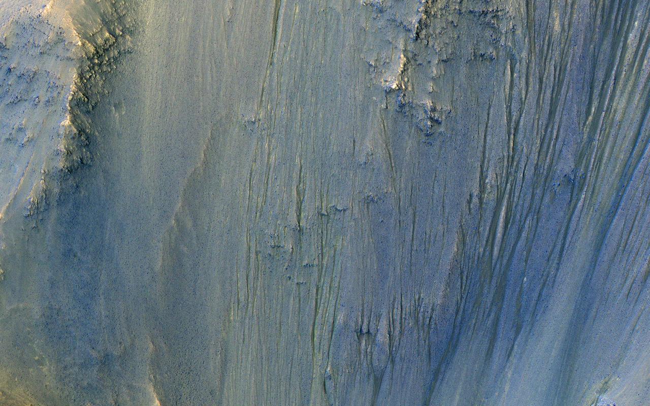
This VIS image shows part of the southern cliff face of Ius Chasma. The THEMIS VIS camera contains 5 filters. The data from different filters can be combined in multiple ways to create a false color image. These false color images may reveal subtle variations of the surface not easily identified in a single band image. Orbit Number: 61753 Latitude: -7.27471 Longitude: 274.245 Instrument: VIS Captured: 2015-11-15 12:03 https://photojournal.jpl.nasa.gov/catalog/PIA23070
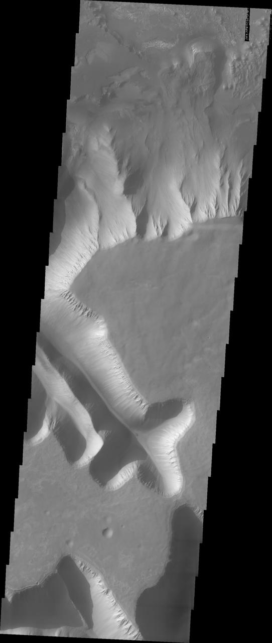
Ius Chasma is unique from the other chasmata of Valles Marineris in possessing mega gullies on both sides of the chasma. The largest mega gullies are located in Sinai Planum, dissecting those plains and emptying into the canyon. These mega gullies are called Louros Valles. Mega gullies are thought to be sapping channels caused by groundwater flow and erosion. The Earth analog is springs - water that flows underground and then breaches the surface creating channels. The morphology of the Mars gullies mirrors terrestrial springs. The channel is fairly uniform in width and the "head" of the channel is rounded like an amphiteater. The channel lengthens by erosion at the "head" backwards as the surface where the spring emerges is undercut. For Mars it is theorized that subsurface water would stay liquid due to underground heating. The "X" in the lower half of the image and the channel at the very bottom are parts of the two largest mega gullies. Ius Chasma is at the western end of Valles Marineris, south of Tithonium Chasma. Valles Marineris is over 4000 kilometers long, wider than the United States. Ius Chasma is almost 850 kilometers long (528 miles), 120 kilometers wide and over 8 kilometers deep. In comparison, the Grand Canyon in Arizona is about 175 kilometers long, 30 kilometers wide, and only 2 kilometers deep. The canyons of Valles Marineris were formed by extensive fracturing and pulling apart of the crust during the uplift of the vast Tharsis plateau. Landslides have enlarged the canyon walls and created deposits on the canyon floor. Weathering of the surface and influx of dust and sand have modified the canyon floor, both creating and modifying layered materials. There are many features that indicate flowing and standing water played a part in the chasma formation. The Odyssey spacecraft has spent over 15 years in orbit around Mars, circling the planet more than 71,000 times. It holds the record for longest working spacecraft at Mars. THEMIS, the IR/VIS camera system, has collected data for the entire mission and provides images covering all seasons and lighting conditions. Over the years many features of interest have received repeated imaging, building up a suite of images covering the entire feature. From the deepest chasma to the tallest volcano, individual dunes inside craters and dune fields that encircle the north pole, channels carved by water and lava, and a variety of other feature, THEMIS has imaged them all. For the next several months the image of the day will focus on the Tharsis volcanoes, the various chasmata of Valles Marineris, and the major dunes fields. We hope you enjoy these images! Orbit Number: 11138 Latitude: -7.92828 Longitude: 275.477 Instrument: VIS Captured: 2004-06-18 10:19 https://photojournal.jpl.nasa.gov/catalog/PIA22286

Ius Chasma is unique from the other chasmata of Valles Marineris in possessing mega gullies on both sides of the chasma. The largest mega gullies are located in Sinai Planum, dissecting those plains and emptying into the canyon. These mega gullies are called Louros Valles. Mega gullies are thought to be sapping channels caused by groundwater flow and erosion. The Earth analog is springs - water that flows underground and then breaches the surface creating channels. The morphology of the Mars gullies mirrors terrestrial springs. The channel is fairly uniform in width and the "head" of the channel is rounded like an amphitheater. The channel lengthens by erosion at the "head" backwards as the surface where the spring emerges is undercut. For Mars it is theorized that subsurface water would stay liquid due to underground heating. The channels in this image are parts of the two largest mega gullies. Note how every channel head is the amphitheater bowl shape. Ius Chasma is at the western end of Valles Marineris, south of Tithonium Chasma. Valles Marineris is over 4000 kilometers long, wider than the United States. Ius Chasma is almost 850 kilometers long (528 miles), 120 kilometers wide and over 8 kilometers deep. In comparison, the Grand Canyon in Arizona is about 175 kilometers long, 30 kilometers wide, and only 2 kilometers deep. The canyons of Valles Marineris were formed by extensive fracturing and pulling apart of the crust during the uplift of the vast Tharsis plateau. Landslides have enlarged the canyon walls and created deposits on the canyon floor. Weathering of the surface and influx of dust and sand have modified the canyon floor, both creating and modifying layered materials. There are many features that indicate flowing and standing water played a part in the chasma formation. The Odyssey spacecraft has spent over 15 years in orbit around Mars, circling the planet more than 71,000 times. It holds the record for longest working spacecraft at Mars. THEMIS, the IR/VIS camera system, has collected data for the entire mission and provides images covering all seasons and lighting conditions. Over the years many features of interest have received repeated imaging, building up a suite of images covering the entire feature. From the deepest chasma to the tallest volcano, individual dunes inside craters and dune fields that encircle the north pole, channels carved by water and lava, and a variety of other feature, THEMIS has imaged them all. For the next several months the image of the day will focus on the Tharsis volcanoes, the various chasmata of Valles Marineris, and the major dunes fields. We hope you enjoy these images! Orbit Number: 40700 Latitude: -8.16691 Longitude: 275.35 Instrument: VIS Captured: 2011-02-16 12:12 https://photojournal.jpl.nasa.gov/catalog/PIA22287
Sedimentary deposits are common within Valles Marineris. Most larger chasmata contain kilometer-thick light-toned layered deposits composed of sulfates. However, some of the chasmata, like Ius Chasma shown in this image from NASA Mars Reconnaissance Orbiter, lack these deposits or have much thinner deposits. The light-toned deposits in Ius Chasma are observed both along the floor and inner wallrock materials. Some of the light-toned deposits appear to post-date formation of the chasma floor, whereas other deposits appear to lie beneath wallrock materials, indicating they are older. By examining the stratigraphy using digital terrain models and 3D images, it should be possible to decipher the relative ages of the different geologic units. CRISM data may also provide insight into the mineralogy, which will tell scientists about the aqueous conditions that emplaced the light-toned deposits. http://photojournal.jpl.nasa.gov/catalog/PIA19855

Continuing eastward along Ius Chasma, this image shows the eastern section of the large landslide deposit seen in yesterday's post. A landslide is a failure of slope due to gravity. They initiate due to several reasons. A lower layer of poorly cemented/resistant material may have been eroded, undermining the wall above which then collapses; earth quake seismic waves can cause the slope to collapse; and even an impact event near the canyon wall can cause collapse. As millions of tons of material fall and slide down slope a scalloped cavity forms at the upper part where the slope failure occurred. At the material speeds downhill it will pick up more of the underlying slope, increasing the volume of material entrained into the landslide. Whereas some landslides spread across the canyon floor forming lobate deposits, very large volume slope failures will completely fill the canyon floor in a large complex region of chaotic blocks. Ius Chasma is at the western end of Valles Marineris, south of Tithonium Chasma. Valles Marineris is over 4000 kilometers long, wider than the United States. Ius Chasma is almost 850 kilometers long (528 miles), 120 kilometers wide and over 8 kilometers deep. In comparison, the Grand Canyon in Arizona is about 175 kilometers long, 30 kilometers wide, and only 2 kilometers deep. The canyons of Valles Marineris were formed by extensive fracturing and pulling apart of the crust during the uplift of the vast Tharsis plateau. Landslides have enlarged the canyon walls and created deposits on the canyon floor. Weathering of the surface and influx of dust and sand have modified the canyon floor, both creating and modifying layered materials. There are many features that indicate flowing and standing water played a part in the chasma formation. The Odyssey spacecraft has spent over 15 years in orbit around Mars, circling the planet more than 71,000 times. It holds the record for longest working spacecraft at Mars. THEMIS, the IR/VIS camera system, has collected data for the entire mission and provides images covering all seasons and lighting conditions. Over the years many features of interest have received repeated imaging, building up a suite of images covering the entire feature. From the deepest chasma to the tallest volcano, individual dunes inside craters and dune fields that encircle the north pole, channels carved by water and lava, and a variety of other feature, THEMIS has imaged them all. For the next several months the image of the day will focus on the Tharsis volcanoes, the various chasmata of Valles Marineris, and the major dunes fields. We hope you enjoy these images! Orbit Number: 17902 Latitude: -6.65656 Longitude: 274.872 Instrument: VIS Captured: 2005-12-27 08:01 https://photojournal.jpl.nasa.gov/catalog/PIA22279
Continuing eastward along Ius Chasma, this section of the canyon floor has been completely filled by blocky deposits from large volume landslides. A landslide is a failure of slope due to gravity. They initiate due to several reasons. A lower layer of poorly cemented/resistant material may have been eroded, undermining the wall above which then collapses; earth quake seismic waves can cause the slope to collapse; and even an impact event near the canyon wall can cause collapse. As millions of tons of material fall and slide down slope a scalloped cavity forms at the upper part where the slope failure occurred. At the material speeds downhill it will pick up more of the underlying slope, increasing the volume of material entrained into the landslide. Whereas some landslides spread across the canyon floor forming lobate deposits, very large volume slope failures will completely fill the canyon floor in a large complex region of chaotic blocks. Ius Chasma is at the western end of Valles Marineris, south of Tithonium Chasma. Valles Marineris is over 4000 kilometers long, wider than the United States. Ius Chasma is almost 850 kilometers long (528 miles), 120 kilometers wide and over 8 kilometers deep. In comparison, the Grand Canyon in Arizona is about 175 kilometers long, 30 kilometers wide, and only 2 kilometers deep. The canyons of Valles Marineris were formed by extensive fracturing and pulling apart of the crust during the uplift of the vast Tharsis plateau. Landslides have enlarged the canyon walls and created deposits on the canyon floor. Weathering of the surface and influx of dust and sand have modified the canyon floor, both creating and modifying layered materials. There are many features that indicate flowing and standing water played a part in the chasma formation. The Odyssey spacecraft has spent over 15 years in orbit around Mars, circling the planet more than 71,000 times. It holds the record for longest working spacecraft at Mars. THEMIS, the IR/VIS camera system, has collected data for the entire mission and provides images covering all seasons and lighting conditions. Over the years many features of interest have received repeated imaging, building up a suite of images covering the entire feature. From the deepest chasma to the tallest volcano, individual dunes inside craters and dune fields that encircle the north pole, channels carved by water and lava, and a variety of other feature, THEMIS has imaged them all. For the next several months the image of the day will focus on the Tharsis volcanoes, the various chasmata of Valles Marineris, and the major dunes fields. We hope you enjoy these images! Orbit Number: 17041 Latitude: -6.50422 Longitude: 272.124 Instrument: VIS Captured: 2005-10-17 10:40 https://photojournal.jpl.nasa.gov/catalog/PIA22278

This VIS image shows part of eastern Ius Chasma. The lower elevations of Geryon Montes are located at the top of the image. Between the montes and the southern wall face is a region of sand and sand dunes. The presence of mobile sand indicates that winds are eroding, depositing and changing the canyon floor. The texture of the canyon floor beneath the dunes and elsewhere in the image is an indication of water, in some form, was part of the process creating the surface. There is a tongue of material emerging from the canyon wall that has steep sides, this may be a delta formed by material washing down the valley and into a body of standing water, like a lake. It may also just be a landslide deposit that has undergone extensive weathering. A landslide is a failure of slope due to gravity. They initiate due to several reasons. A lower layer of poorly cemented/resistant material may have been eroded, undermining the wall above which then collapses; earthquake seismic waves can cause the slope to collapse; and even an impact event near the canyon wall can cause collapse. As millions of tons of material fall and slide down slope a scalloped cavity forms at the upper part where the slope failure occurred. At the material speeds downhill it will pick up more of the underlying slope, increasing the volume of material entrained into the landslide. Whereas some landslides spread across the canyon floor forming lobate deposits, very large volume slope failures will completely fill the canyon floor in a large complex region of chaotic blocks. Ius Chasma is at the western end of Valles Marineris, south of Tithonium Chasma. Valles Marineris is over 4000 kilometers long, wider than the United States. Ius Chasma is almost 850 kilometers long (528 miles), 120 kilometers wide and over 8 kilometers deep. In comparison, the Grand Canyon in Arizona is about 175 kilometers long, 30 kilometers wide, and only 2 kilometers deep. The canyons of Valles Marineris were formed by extensive fracturing and pulling apart of the crust during the uplift of the vast Tharsis plateau. Landslides have enlarged the canyon walls and created deposits on the canyon floor. Weathering of the surface and influx of dust and sand have modified the canyon floor, both creating and modifying layered materials. There are many features that indicate flowing and standing water played a part in the chasma formation. The Odyssey spacecraft has spent over 15 years in orbit around Mars, circling the planet more than 71,000 times. It holds the record for longest working spacecraft at Mars. THEMIS, the IR/VIS camera system, has collected data for the entire mission and provides images covering all seasons and lighting conditions. Over the years many features of interest have received repeated imaging, building up a suite of images covering the entire feature. From the deepest chasma to the tallest volcano, individual dunes inside craters and dune fields that encircle the north pole, channels carved by water and lava, and a variety of other feature, THEMIS has imaged them all. For the next several months the image of the day will focus on the Tharsis volcanoes, the various chasmata of Valles Marineris, and the major dunes fields. We hope you enjoy these images! Orbit Number: 10701 Latitude: -8.75442 Longitude: 281.333 Instrument: VIS Captured: 2004-05-13 10:49 https://photojournal.jpl.nasa.gov/catalog/PIA22282
This VIS image shows the eastern end of Ius Chasma. The southern canyon wall is at the bottom of the image, with dark sand and sand dunes. The presence of mobile sand indicates that winds are eroding, depositing and changing the canyon floor. The rest of the image is dominated by large landslide deposits. At the top of the image are two overlapping deposits from landslides originating on the northern chasma wall. The landslide deposit on the left side of the image originate from the southern chasma wall. A landslide is a failure of slope due to gravity. They initiate due to several reasons. A lower layer of poorly cemented/resistant material may have been eroded, undermining the wall above which then collapses; earthquake seismic waves can cause the slope to collapse; and even an impact event near the canyon wall can cause collapse. As millions of tons of material fall and slide down slope a scalloped cavity forms at the upper part where the slope failure occurred. At the material speeds downhill it will pick up more of the underlying slope, increasing the volume of material entrained into the landslide. Whereas some landslides spread across the canyon floor forming lobate deposits, very large volume slope failures will completely fill the canyon floor in a large complex region of chaotic blocks. Ius Chasma is at the western end of Valles Marineris, south of Tithonium Chasma. Valles Marineris is over 4000 kilometers long, wider than the United States. Ius Chasma is almost 850 kilometers long (528 miles), 120 kilometers wide and over 8 kilometers deep. In comparison, the Grand Canyon in Arizona is about 175 kilometers long, 30 kilometers wide, and only 2 kilometers deep. The canyons of Valles Marineris were formed by extensive fracturing and pulling apart of the crust during the uplift of the vast Tharsis plateau. Landslides have enlarged the canyon walls and created deposits on the canyon floor. Weathering of the surface and influx of dust and sand have modified the canyon floor, both creating and modifying layered materials. There are many features that indicate flowing and standing water played a part in the chasma formation. The Odyssey spacecraft has spent over 15 years in orbit around Mars, circling the planet more than 71,000 times. It holds the record for longest working spacecraft at Mars. THEMIS, the IR/VIS camera system, has collected data for the entire mission and provides images covering all seasons and lighting conditions. Over the years many features of interest have received repeated imaging, building up a suite of images covering the entire feature. From the deepest chasma to the tallest volcano, individual dunes inside craters and dune fields that encircle the north pole, channels carved by water and lava, and a variety of other feature, THEMIS has imaged them all. For the next several months the image of the day will focus on the Tharsis volcanoes, the various chasmata of Valles Marineris, and the major dunes fields. We hope you enjoy these images! Orbit Number: 36744 Latitude: -8.64709 Longitude: 282.235 Instrument: VIS Captured: 2010-03-27 18:32 https://photojournal.jpl.nasa.gov/catalog/PIA22285
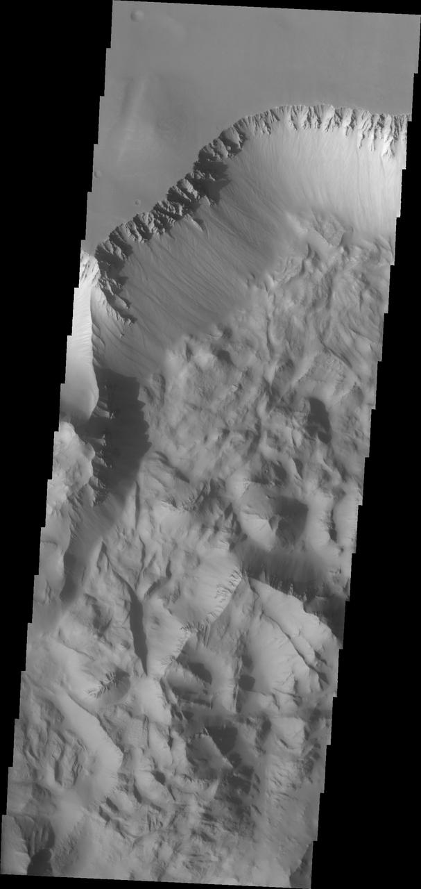
Continuing eastward thru central Ius Chasma, this image shows a section of chasma that is not dominated by landslide deposits. Geryon Montes, in the upper half of the image, has several visible faults, including a pair of faults that divide the uppermost ridge into two sections. Between the montes and the southern wall face is a region of sand and sand dunes. The presence of mobile sand indicates that winds are eroding, depositing and changing the canyon floor. A landslide is a failure of slope due to gravity. They initiate due to several reasons. A lower layer of poorly cemented/resistant material may have been eroded, undermining the wall above which then collapses; earthquake seismic waves can cause the slope to collapse; and even an impact event near the canyon wall can cause collapse. As millions of tons of material fall and slide down slope a scalloped cavity forms at the upper part where the slope failure occurred. At the material speeds downhill it will pick up more of the underlying slope, increasing the volume of material entrained into the landslide. Whereas some landslides spread across the canyon floor forming lobate deposits, very large volume slope failures will completely fill the canyon floor in a large complex region of chaotic blocks. Ius Chasma is at the western end of Valles Marineris, south of Tithonium Chasma. Valles Marineris is over 4000 kilometers long, wider than the United States. Ius Chasma is almost 850 kilometers long (528 miles), 120 kilometers wide and over 8 kilometers deep. In comparison, the Grand Canyon in Arizona is about 175 kilometers long, 30 kilometers wide, and only 2 kilometers deep. The canyons of Valles Marineris were formed by extensive fracturing and pulling apart of the crust during the uplift of the vast Tharsis plateau. Landslides have enlarged the canyon walls and created deposits on the canyon floor. Weathering of the surface and influx of dust and sand have modified the canyon floor, both creating and modifying layered materials. There are many features that indicate flowing and standing water played a part in the chasma formation. The Odyssey spacecraft has spent over 15 years in orbit around Mars, circling the planet more than 71,000 times. It holds the record for longest working spacecraft at Mars. THEMIS, the IR/VIS camera system, has collected data for the entire mission and provides images covering all seasons and lighting conditions. Over the years many features of interest have received repeated imaging, building up a suite of images covering the entire feature. From the deepest chasma to the tallest volcano, individual dunes inside craters and dune fields that encircle the north pole, channels carved by water and lava, and a variety of other feature, THEMIS has imaged them all. For the next several months the image of the day will focus on the Tharsis volcanoes, the various chasmata of Valles Marineris, and the major dunes fields. We hope you enjoy these images! Orbit Number: 27012 Latitude: -7.59048 Longitude: 276.328 Instrument: VIS Captured: 2008-01-16 09:47 https://photojournal.jpl.nasa.gov/catalog/PIA22281
Moving into the central part of Ius Chasma, the canyon profile changes. What started as a large graben south of the main chasma wall, has widened to create a central high ridge separating the chasm into two parallel sections. This interior ridge is called Geryon Montes. The northern canyon wall is at the top of the image, including several tongue shaped landslide deposits. The floor has been covered in deposits that may include landslide material and later materials such as air fall particles like dust and water lain layered deposits. The Geryon Montes are in the lower 1/3 of the image. Just to the top of the Montes are materials with different "colors". These are part of the layered materials inside the canyon. At the very bottom of the image a highly eroded landslide deposit exists. The materials on this side of Geryon Montes are at a higher elevation than the floor on the opposite side. The unusual texture of the canyon floor also points to layered materials that may have been laid down in standing water. A landslide is a failure of slope due to gravity. They initiate due to several reasons. A lower layer of poorly cemented/resistant material may have been eroded, undermining the wall above which then collapses; earth quake seismic waves can cause the slope to collapse; and even an impact event near the canyon wall can cause collapse. As millions of tons of material fall and slide down slope a scalloped cavity forms at the upper part where the slope failure occurred. At the material speeds downhill it will pick up more of the underlying slope, increasing the volume of material entrained into the landslide. Whereas some landslides spread across the canyon floor forming lobate deposits, very large volume slope failures will completely fill the canyon floor in a large complex region of chaotic blocks. Ius Chasma is at the western end of Valles Marineris, south of Tithonium Chasma. Valles Marineris is over 4000 kilometers long, wider than the United States. Ius Chasma is almost 850 kilometers long (528 miles), 120 kilometers wide and over 8 kilometers deep. In comparison, the Grand Canyon in Arizona is about 175 kilometers long, 30 kilometers wide, and only 2 kilometers deep. The canyons of Valles Marineris were formed by extensive fracturing and pulling apart of the crust during the uplift of the vast Tharsis plateau. Landslides have enlarged the canyon walls and created deposits on the canyon floor. Weathering of the surface and influx of dust and sand have modified the canyon floor, both creating and modifying layered materials. There are many features that indicate flowing and standing water played a part in the chasma formation. The Odyssey spacecraft has spent over 15 years in orbit around Mars, circling the planet more than 71,000 times. It holds the record for longest working spacecraft at Mars. THEMIS, the IR/VIS camera system, has collected data for the entire mission and provides images covering all seasons and lighting conditions. Over the years many features of interest have received repeated imaging, building up a suite of images covering the entire feature. From the deepest chasma to the tallest volcano, individual dunes inside craters and dune fields that encircle the north pole, channels carved by water and lava, and a variety of other feature, THEMIS has imaged them all. For the next several months the image of the day will focus on the Tharsis volcanoes, the various chasmata of Valles Marineris, and the major dunes fields. We hope you enjoy these images! Orbit Number: 26151 Latitude: -7.12079 Longitude: 275.703 Instrument: VIS Captured: 2007-11-06 12:17 https://photojournal.jpl.nasa.gov/catalog/PIA22280
The VIS image shows part of the western end of Ius Chasma. Both the north and south canyon walls are visible in this image. At the top of the frame paired faults have created a graben. On the southern face of the canyon, several linear faults parallel the graben. These faults are part of the tectonic formation of Valles Marineris. Landslides on both walls created deposits on the crater floor. The easiest to identify is the lobate margin at the right side of the images. Lobate margins and radial surface grooves are common features in low volume landslides. A landslide is a failure of slope due to gravity. They initiate due to several reasons. A lower layer of poorly cemented/resistant material may have been eroded, undermining the wall above which then collapses; earth quake seismic waves can cause the slope to collapse; and even an impact event near the canyon wall can cause collapse. As millions of tons of material fall and slide down slope a scalloped cavity forms at the upper part where the slope failure occurred. At the material speeds downhill it will pick up more of the underlying slope, increasing the volume of material entrained into the landslide. Whereas some landslides spread across the canyon floor forming lobate deposits, very large volume slope failures will completely fill the canyon floor in a large complex region of chaotic blocks. Ius Chasma is at the western end of Valles Marineris, south of Tithonium Chasma. Valles Marineris is over 4000 kilometers long, wider than the United States. Ius Chasma is almost 850 kilometers long (528 miles), 120 kilometers wide and over 8 kilometers deep. In comparison, the Grand Canyon in Arizona is about 175 kilometers long, 30 kilometers wide, and only 2 kilometers deep. The canyons of Valles Marineris were formed by extensive fracturing and pulling apart of the crust during the uplift of the vast Tharsis plateau. Landslides have enlarged the canyon walls and created deposits on the canyon floor. Weathering of the surface and influx of dust and sand have modified the canyon floor, both creating and modifying layered materials. There are many features that indicate flowing and standing water played a part in the chasma formation. The Odyssey spacecraft has spent over 15 years in orbit around Mars, circling the planet more than 71,000 times. It holds the record for longest working spacecraft at Mars. THEMIS, the IR/VIS camera system, has collected data for the entire mission and provides images covering all seasons and lighting conditions. Over the years many features of interest have received repeated imaging, building up a suite of images covering the entire feature. From the deepest chasma to the tallest volcano, individual dunes inside craters and dune fields that encircle the north pole, channels carved by water and lava, and a variety of other feature, THEMIS has imaged them all. For the next several months the image of the day will focus on the Tharsis volcanoes, the various chasmata of Valles Marineris, and the major dunes fields. We hope you enjoy these images! Orbit Number: 8792 Latitude: -6.69222 Longitude: 270.88 Instrument: VIS Captured: 2003-12-08 06:35 https://photojournal.jpl.nasa.gov/catalog/PIA22277

This VIS image shows part of the eastern end of Ius Chasma. Geryon Montes are located in the bottom half of the image. Between the montes and the southern wall face is a region of sand and sand dunes. The presence of mobile sand indicates that winds are eroding, depositing and changing the canyon floor. The top of the image is dominated by a large landslide deposit. The radial surface grooves are still visible, but the region as a whole as undergone significant erosion. A landslide is a failure of slope due to gravity. They initiate due to several reasons. A lower layer of poorly cemented/resistant material may have been eroded, undermining the wall above which then collapses; earthquake seismic waves can cause the slope to collapse; and even an impact event near the canyon wall can cause collapse. As millions of tons of material fall and slide down slope a scalloped cavity forms at the upper part where the slope failure occurred. At the material speeds downhill it will pick up more of the underlying slope, increasing the volume of material entrained into the landslide. Whereas some landslides spread across the canyon floor forming lobate deposits, very large volume slope failures will completely fill the canyon floor in a large complex region of chaotic blocks. Ius Chasma is at the western end of Valles Marineris, south of Tithonium Chasma. Valles Marineris is over 4000 kilometers long, wider than the United States. Ius Chasma is almost 850 kilometers long (528 miles), 120 kilometers wide and over 8 kilometers deep. In comparison, the Grand Canyon in Arizona is about 175 kilometers long, 30 kilometers wide, and only 2 kilometers deep. The canyons of Valles Marineris were formed by extensive fracturing and pulling apart of the crust during the uplift of the vast Tharsis plateau. Landslides have enlarged the canyon walls and created deposits on the canyon floor. Weathering of the surface and influx of dust and sand have modified the canyon floor, both creating and modifying layered materials. There are many features that indicate flowing and standing water played a part in the chasma formation. The Odyssey spacecraft has spent over 15 years in orbit around Mars, circling the planet more than 71,000 times. It holds the record for longest working spacecraft at Mars. THEMIS, the IR/VIS camera system, has collected data for the entire mission and provides images covering all seasons and lighting conditions. Over the years many features of interest have received repeated imaging, building up a suite of images covering the entire feature. From the deepest chasma to the tallest volcano, individual dunes inside craters and dune fields that encircle the north pole, channels carved by water and lava, and a variety of other feature, THEMIS has imaged them all. For the next several months the image of the day will focus on the Tharsis volcanoes, the various chasmata of Valles Marineris, and the major dunes fields. We hope you enjoy these images! Orbit Number: 17153 Latitude: -8.20738 Longitude: 281.009 Instrument: VIS Captured: 2005-10-26 16:00 https://photojournal.jpl.nasa.gov/catalog/PIA22284
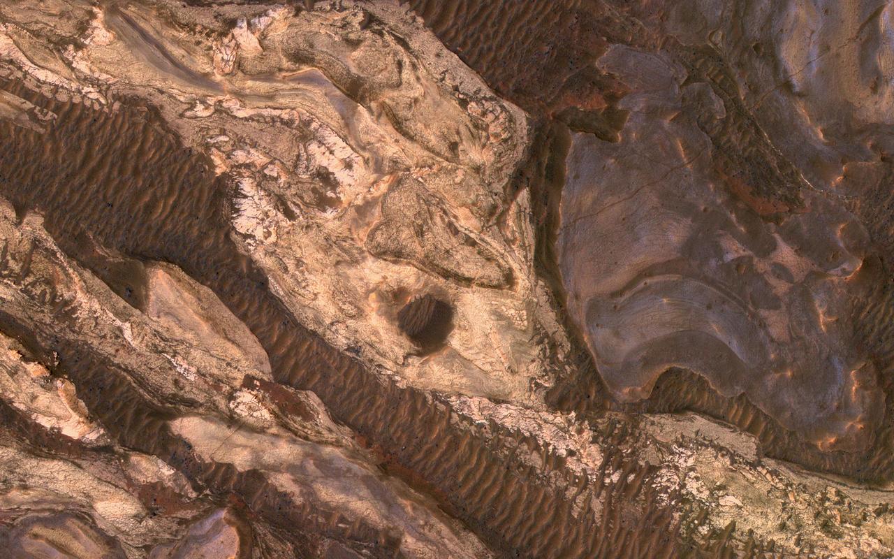
Many of the Valles Marineris canyons, called chasmata, have kilometer-high, light-toned layered mounds made up of sulfate materials. Ius Chasma, near the western end of Valles Marineris, is an exception. The light-toned deposits here are thinner and occur along both the floor and walls, as we see in this HiRISE image. Additionally, the sulfates are mixed with other minerals like clays and hydrated silica. Scientists are trying to use the combination of mineralogy, morphology, and stratigraphy to understand how the deposits formed in Ius Chasma and why they differ from those found elsewhere in Valles Marineris. https://photojournal.jpl.nasa.gov/catalog/PIA25982
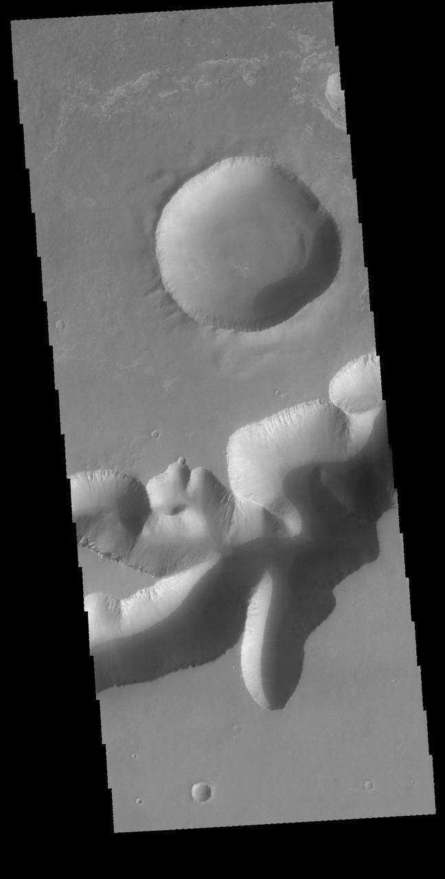
This image captured by NASA 2001 Mars Odyssey spacecraft spans from Tithonium Chasma top of image to Ius Chasma bottom of image.
This image captured by NASA 2001 Mars Odyssey spacecraft crosses both Tithonium and Ius Chasma.
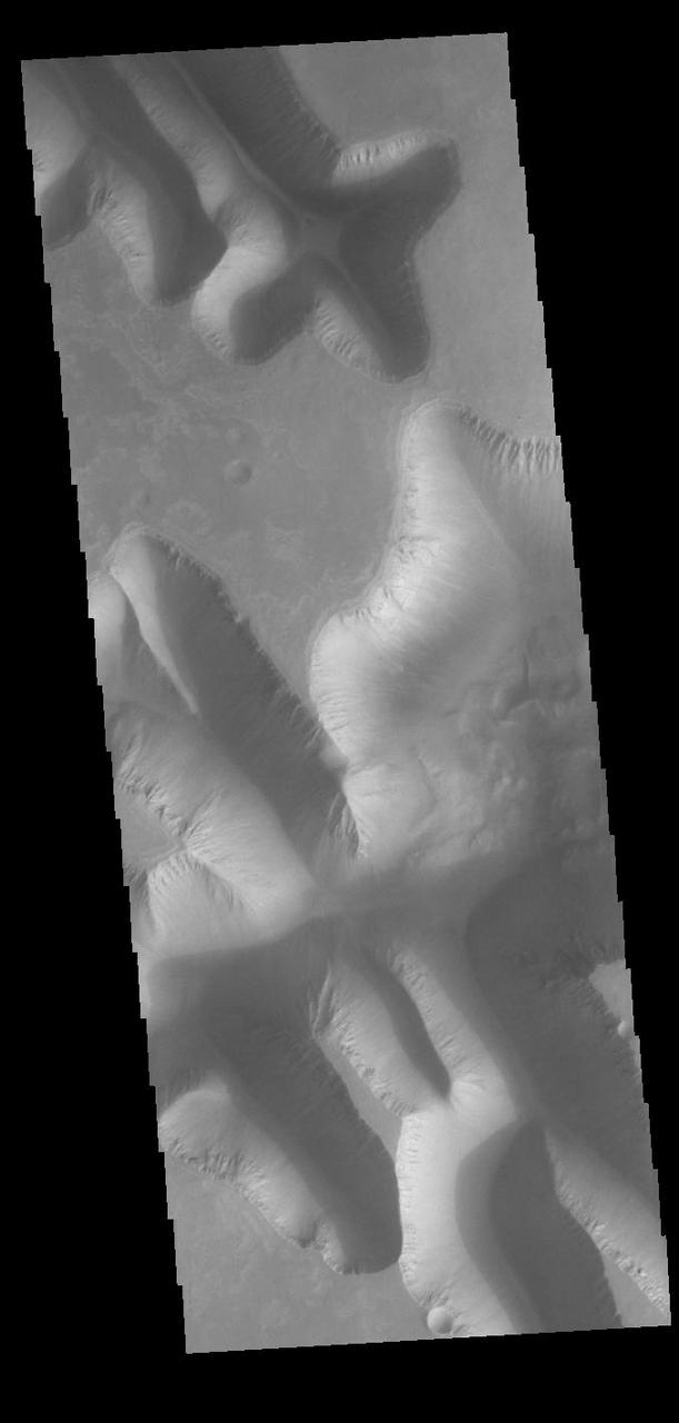
Today's VIS image shows part of Louros Valles on the southern part of Ius Chasma. Louros Valles is a region of mega gullies the empty into Ius Chasma. Ius Chasma is unique from the other chasmata of Valles Marineris in possessing mega gullies on both sides of the chasma. The largest mega gullies are located in Sinai Planum, dissecting those plains and emptying into the canyon. Mega gullies are thought to be sapping channels caused by groundwater flow and erosion. The Earth analog is springs – water that flows underground and then breaches the surface creating channels. The morphology of the Mars gullies mirrors terrestrial springs. The channel is fairly uniform in width and the "head" of the channel is rounded like an amphiteater. The channel lengthens by erosion at the "head" backwards as the surface where the spring emerges is undercut. For Mars it is theorized that subsurface water would stay liquid due to underground heating. Ius Chasma is at the western end of Valles Marineris, south of Tithonium Chasma. Valles Marineris is over 4000 kilometers long, wider than the United States. Ius Chasma is almost 850 kilometers long (528 miles), 120 kilometers wide and over 8 kilometers deep. In comparison, the Grand Canyon in Arizona is about 175 kilometers long, 30 kilometers wide, and only 2 kilometers deep. Orbit Number: 90809 Latitude: -8.38091 Longitude: 275.49 Instrument: VIS Captured: 2022-06-04 12:25 https://photojournal.jpl.nasa.gov/catalog/PIA25512
Today's VIS image shows part a section of a mega gully. Located on the plains of Sinai Planum, it is just one of a number of huge channels that line the cliff face of Ius Chasma. The linear sides of the channel indicate that the formation of these features included tectonic activity. Ius Chasma is on the western end of Valles Marineris. Orbit Number: 77719 Latitude: -8.12758 Longitude: 274.408 Instrument: VIS Captured: 2019-06-22 16:33 https://photojournal.jpl.nasa.gov/catalog/PIA23368
Ius and Tithonium Chasmata are located at the western end of Valles Marineris. Tithonium Chasma is north of Ius Chasma. Valles Marineris is over 4000 kilometers long (2495 miles), almost as wide as the United States. Ius Chasma is almost 840 kilometers long (522 miles), 120 kilometers wide and over 8 kilometers deep. Tithonium Chasma is 803 km (499 miles) long. In comparison, the Grand Canyon in Arizona is about 175 kilometers long (109 miles), 30 kilometers wide, and only 2 kilometers deep. The canyons of Valles Marineris were formed by extensive fracturing and pulling apart of the crust during the uplift of the vast Tharsis plateau. Landslides have enlarged the canyon walls and created deposits on the canyon floor. Weathering of the surface and influx of dust and sand have modified the canyon floor, both creating and modifying layered materials. There are many features that indicate flowing and standing water played a part in the chasma formation. The rugged floor of Ius Chasma (bottom of image) is comprised of large landslide deposits. Orbit Number: 92700 Latitude: -5.02133 Longitude: 273.439 Instrument: VIS Captured: 2022-11-07 04:26 https://photojournal.jpl.nasa.gov/catalog/PIA25769
Ius and Tithonium Chasmata are located at the western end of Valles Marineris. Tithonium Chasma is north of Ius Chasma. Valles Marineris is over 4000 kilometers long (2495 miles), almost as wide as the United States. Ius Chasma is almost 840 kilometers long (522 miles), 120 kilometers wide and over 8 kilometers deep. Tithonium Chasma is 803 km (499 miles) long. In comparison, the Grand Canyon in Arizona is about 175 kilometers long (109 miles), 30 kilometers wide, and only 2 kilometers deep. The canyons of Valles Marineris were formed by extensive fracturing and pulling apart of the crust during the uplift of the vast Tharsis plateau. Landslides have enlarged the canyon walls and created deposits on the canyon floor. Weathering of the surface and influx of dust and sand have modified the canyon floor, both creating and modifying layered materials. There are many features that indicate flowing and standing water played a part in the chasma formation. The rugged floor of Ius Chasma (lower half of image) is comprised of large landslide deposits. Orbit Number: 89711 Latitude: -6.50729 Longitude: 272.316 Instrument: VIS Captured: 2022-03-06 02:35 https://photojournal.jpl.nasa.gov/catalog/PIA25459

The THEMIS camera contains 5 filters. The data from different filters can be combined in multiple ways to create a false color image. These false color images may reveal subtle variations of the surface not easily identified in a single band image. Today's false color image shows the northern tip of Baetis Mensa. In false color images dark blue is often basaltic sands. In this image it is possible to trace the sands from the erosion of Beatis Mensa moving down the canyon gullies to the floor of Ophir Chasma. Orbit Number: 42247 Latitude: -4.17728 Longitude: 287.975 Instrument: VIS Captured: 2011-06-23 21:11 http://photojournal.jpl.nasa.gov/catalog/PIA20792
Today's VIS image shows the part of the eastern end of Tithonium Chasma. Tithonium Chasma is at the western end of Valles Marineris. Valles Marineris is over 4000 kilometers long, almost as wide as the United States. Tithonium Chasma is almost 810 kilometers long (499 miles), 50 kilometers wide and over 6 kilometers deep. In comparison, the Grand Canyon in Arizona is about 175 kilometers long, 30 kilometers wide, and only 2 kilometers deep. The canyons of Valles Marineris were formed by extensive fracturing and pulling apart of the crust during the uplift of the vast Tharsis plateau. In this image, the shallower regions of Tithonium are visible. The northern cliff of Ius Chasma is visible at the bottom of the image. Orbit Number: 92650 Latitude: -5.20867 Longitude: 275.913 Instrument: VIS Captured: 2022-11-03 01:37 https://photojournal.jpl.nasa.gov/catalog/PIA25767
Tithonium Chasma has numerous large landslide deposits. At the bottom of this VIS image is the high plateau between Tithonium Chasma and Ius Chasma (off the bottom of the frame). The resistant material of the plateau surface forms the linear ridges of the canyon wall. Erosion of the walls cover the lower slopes. Large landslides have changed the walls and floor of the canyon. A landslide is a failure of slope due to gravity. They initiate due to several reasons. A lower layer of poorly cemented/resistant material may have been eroded, undermining the wall above which then collapses; earth quake seismic waves can cause the slope to collapse; and even an impact event near the canyon wall can cause collapse. As millions of tons of material fall and slide down slope a scalloped cavity forms at the upper part where the slope failure occurred. At the material speeds downhill it will pick up more of the underlying slope, increasing the volume of material entrained into the landslide. As the landslide material reaches the canyon bottom it spreads out and eventually comes to rest. The edge of the deposit is lobate, and may be affected by running up against pre-existing features on the canyon floor. Most Martian landslide have radial grooves on the slide surface. Tithonium Chasma is at the western end of Valles Marineris. Valles Marineris is over 4000 kilometers long, wider than the United States. Tithonium Chasma is almost 810 kilometers long (499 miles), 50 kilometers wide and over 6 kilometers deep. In comparison, the Grand Canyon in Arizona is about 175 kilometers long, 30 kilometers wide, and only 2 kilometers deep. The canyons of Valles Marineris were formed by extensive fracturing and pulling apart of the crust during the uplift of the vast Tharsis plateau. Landslides have enlarged the canyon walls and created deposits on the canyon floor. Weathering of the surface and influx of dust and sand have modified the canyon floor, both creating and modifying layered materials. The Odyssey spacecraft has spent over 15 years in orbit around Mars, circling the planet more than 71,000 times. It holds the record for longest working spacecraft at Mars. THEMIS, the IR/VIS camera system, has collected data for the entire mission and provides images covering all seasons and lighting conditions. Over the years many features of interest have received repeated imaging, building up a suite of images covering the entire feature. From the deepest chasma to the tallest volcano, individual dunes inside craters and dune fields that encircle the north pole, channels carved by water and lava, and a variety of other feature, THEMIS has imaged them all. For the next several months the image of the day will focus on the Tharsis volcanoes, the various chasmata of Valles Marineris, and the major dunes fields. We hope you enjoy these images! Orbit Number: 11500 Latitude: -4.89712 Longitude: 273.275 Instrument: VIS Captured: 2004-07-18 05:36 https://photojournal.jpl.nasa.gov/catalog/PIA22270
Landslides in Valles Marineris are truly enormous, sometimes stretching from one wall to the base of another. This landslide, known as Ius Labes, would occupy the surface area of the state of Delaware, U.S., seen by NASA Mars Reconnaissance Orbiter.