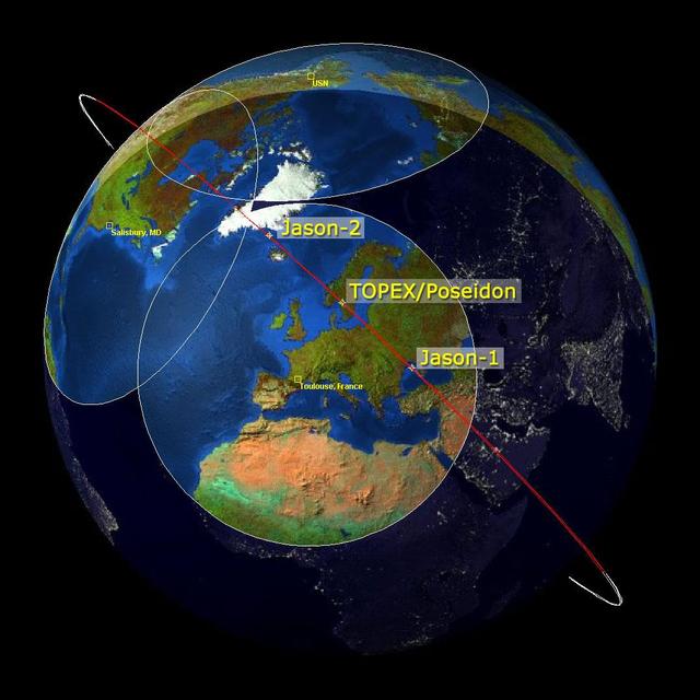
This image is a family portrait of Topex/Poseidon, Jason-1 and Ocean Surface Topography Mission/Jason-2 OSTM/Jason-2, NASA satellites that have measured global sea surface heights since 1992.
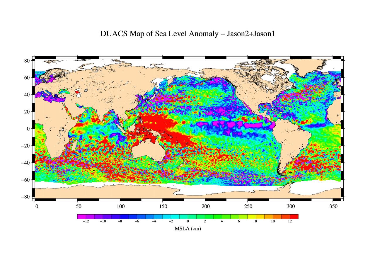
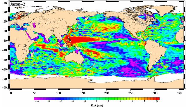
This is the first global map of ocean surface topography produced with data from the new interleaved tandem mission of NASA Jason-1 and Ocean Surface Topography Mission OSTM/Jason-2 satellites.
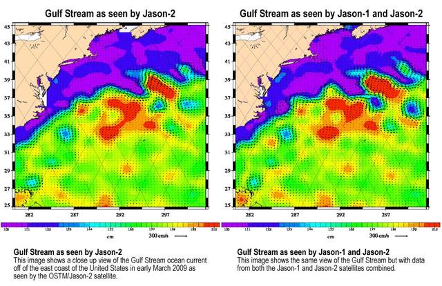
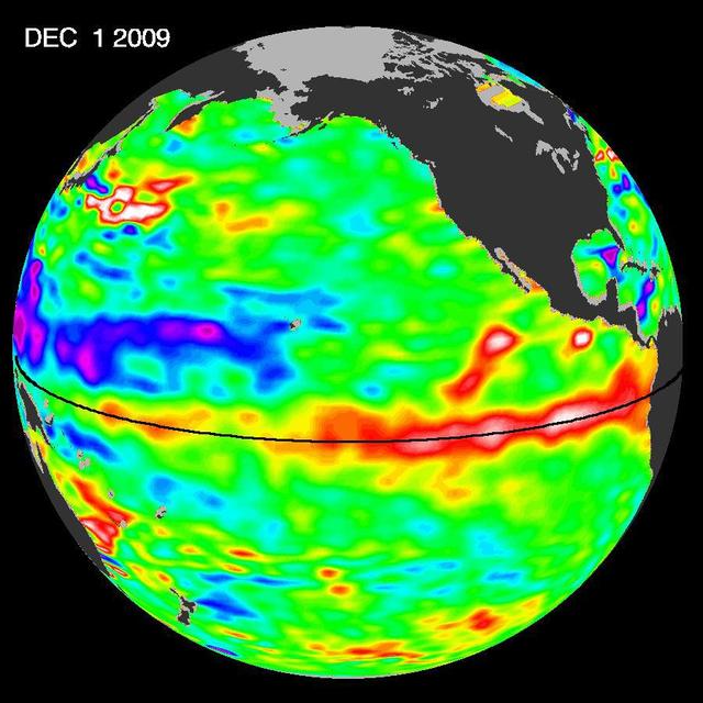
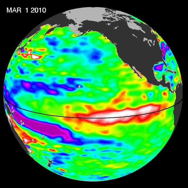
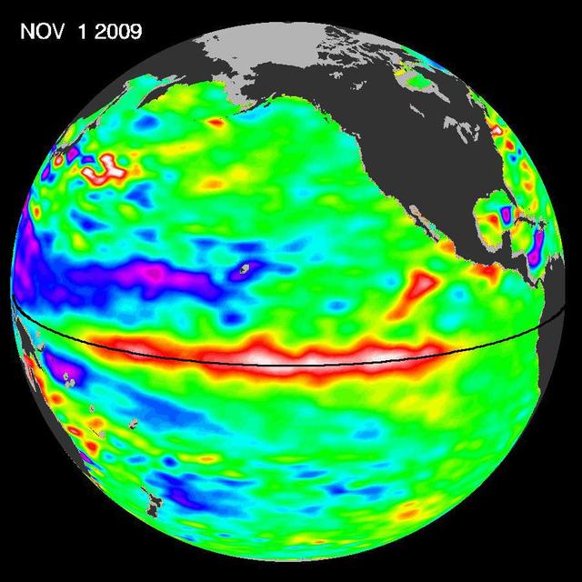
Created with altimeter data from NASA's Ocean Surface Topography Mission (OSTM)/Jason-2 satellite and the Jason-1 satellite, this image shows a portion of the Gulf Stream off the east coast of the United States. It demonstrates how much more detail is visible in the ocean surface when measured by two satellites than by one alone. The image on the left was created with data from OSTM/Jason-2. The image on the right is the same region but made with combined data from OSTM/Jason-2 and Jason-1.It shows the Gulf Stream's eddies and rings much more clearly. This image is a product of the new interleaved tandem mission of the Jason-1 and Ocean Surface Topography Mission (OSTM)/Jason-2 satellites. (The first global map from this tandem mission is available at PIA11859.) In January 2009, Jason-1 was maneuvered into orbit on the opposite side of Earth from its successor, OSTM/Jason-2 satellite. It takes 10 days for the satellites to cover the globe and return to any one place over the ocean. So, in this new tandem configuration, Jason-1 flies over the same region of the ocean that OSTM/Jason-2 flew over five days earlier. Its ground tracks fall mid-way between those of Jason-2, which are about 315 kilometers (195 miles) apart at the equator. Working together, the two spacecraft measure the surface topography of the ocean twice as often as would be possible with one satellite, and over a 10-day period, they return twice the amount of detailed measurements. Combining data from the two satellites makes it possible to map smaller, more rapidly changing features than one satellite could alone. These images show sea-level anomaly data from the first 14 days of the interleaved orbit of Jason-1 and OSTM/Jason-2, the period beginning on Feb. 20, 2009. An anomaly is a departure from a value averaged over a long period of time. Red and yellow are regions where sea levels are higher than normal. Purple and dark blue show where sea levels are lower. A higher-than-normal sea surface is usually a sign of warm waters below, while lower sea levels indicate cooler than normal temperatures. http://photojournal.jpl.nasa.gov/catalog/PIA11997
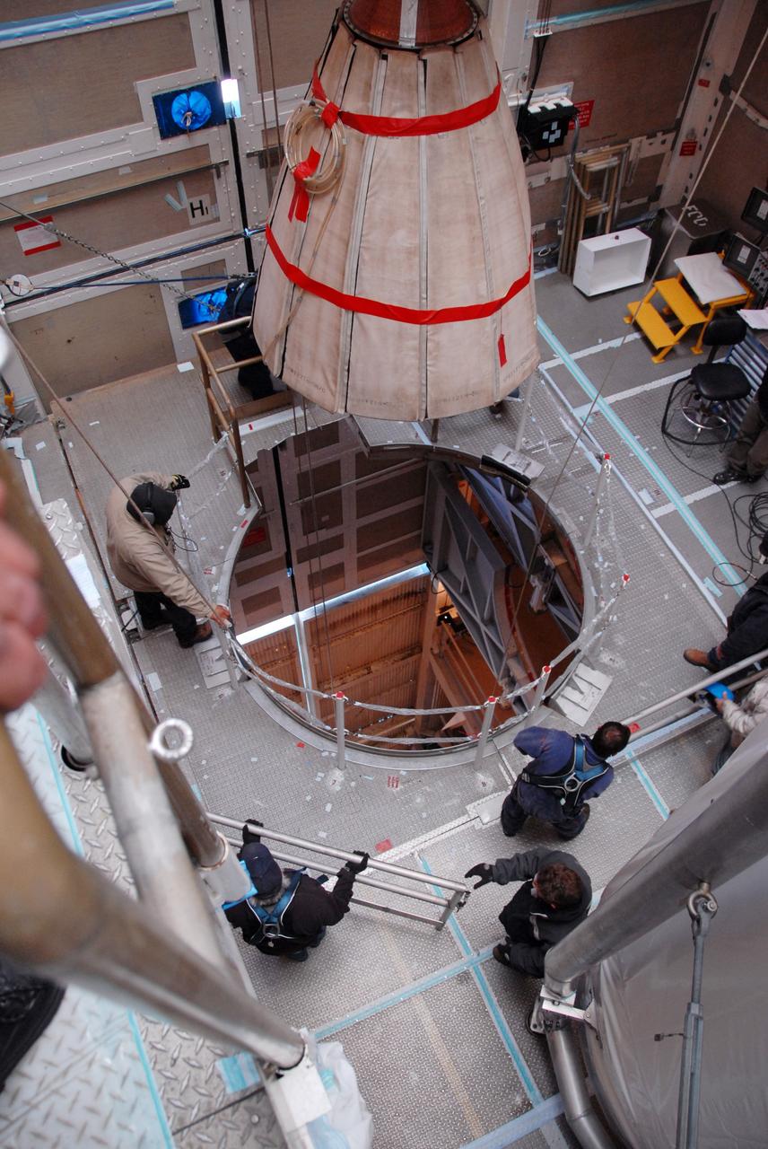
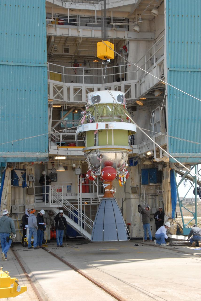
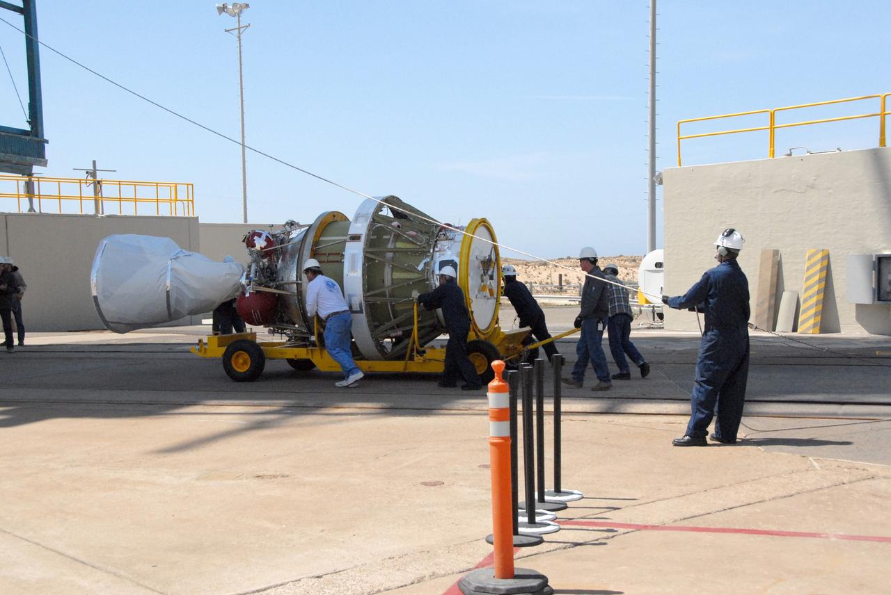
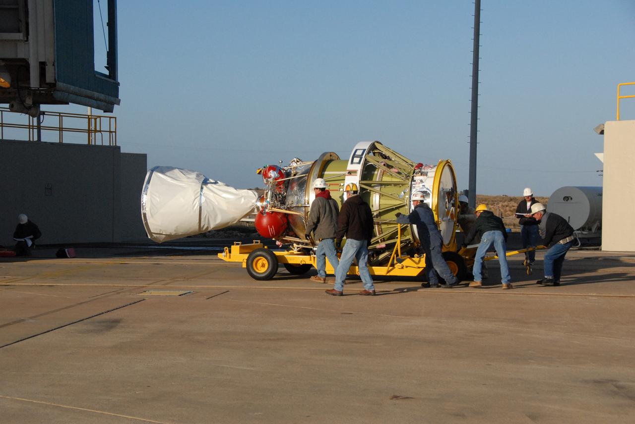
JPL technicians perform a practice run of the mechanical integration sequence that will be used to mate the Jason-3 spacecraft Advanced Microwave Radiometer instrument to the Jason-3 satellite.
Artist concept of NASA's Jason 1 spacecraft from December, 2002. http://photojournal.jpl.nasa.gov/catalog/PIA04237

Students participate in the JASON Project's 2004-05 expedition, `Disappearing Wetlands' at SSC, conducting field lab experiments and watching live broadcasts from JASON Expedition Louisiana research sites.
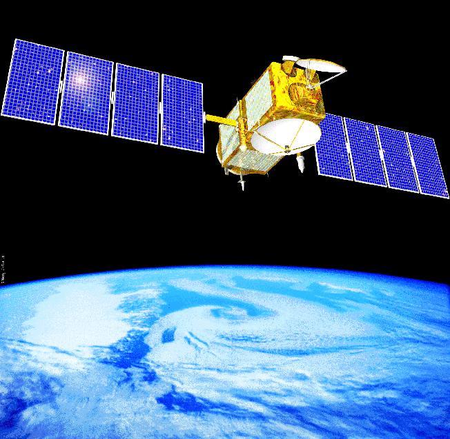
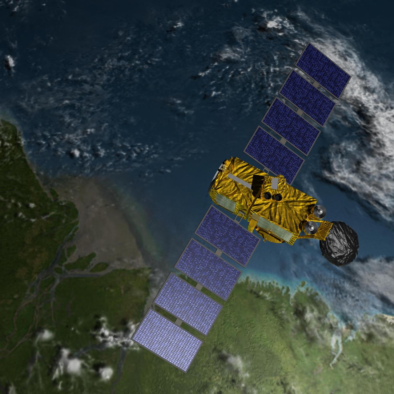
An artist concept of the Ocean Surface Topography Mission/Jason 2 Earth satellite. The Ocean Surface Topography Mission/Jason 2 is an Earth satellite designed to make observations of ocean topography for investigations into sea-level rise and the relationship between ocean circulation and climate change. The satellite also provides data on the forces behind such large-scale climate phenomena as El Niño and La Niña. The mission is a follow-on to the French-American Jason 1 mission, which began collecting data on sea-surface levels in 1992. http://photojournal.jpl.nasa.gov/catalog/PIA18158
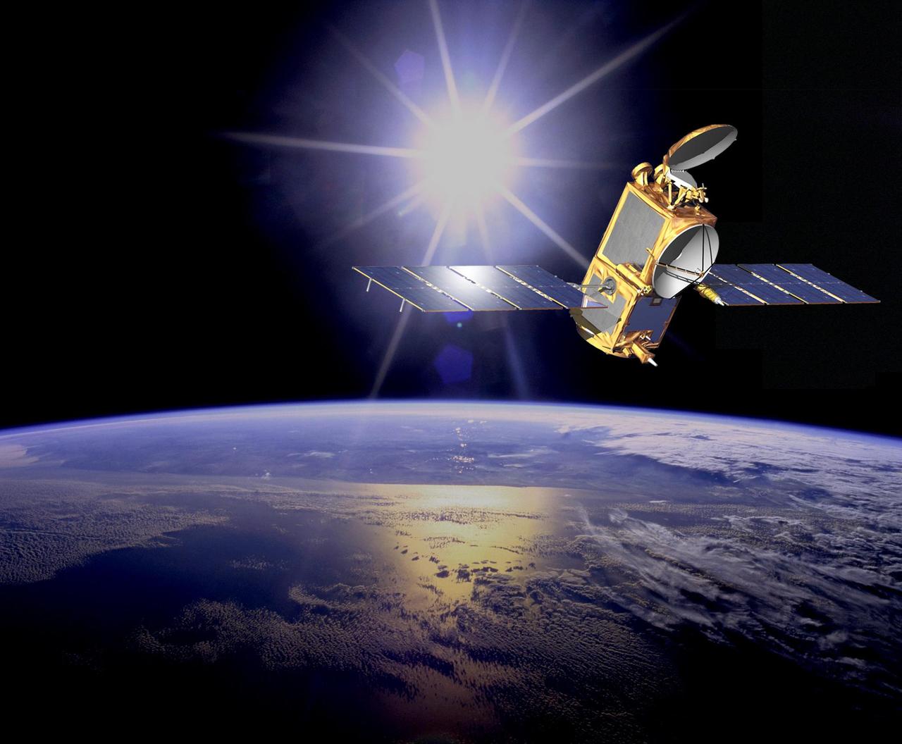
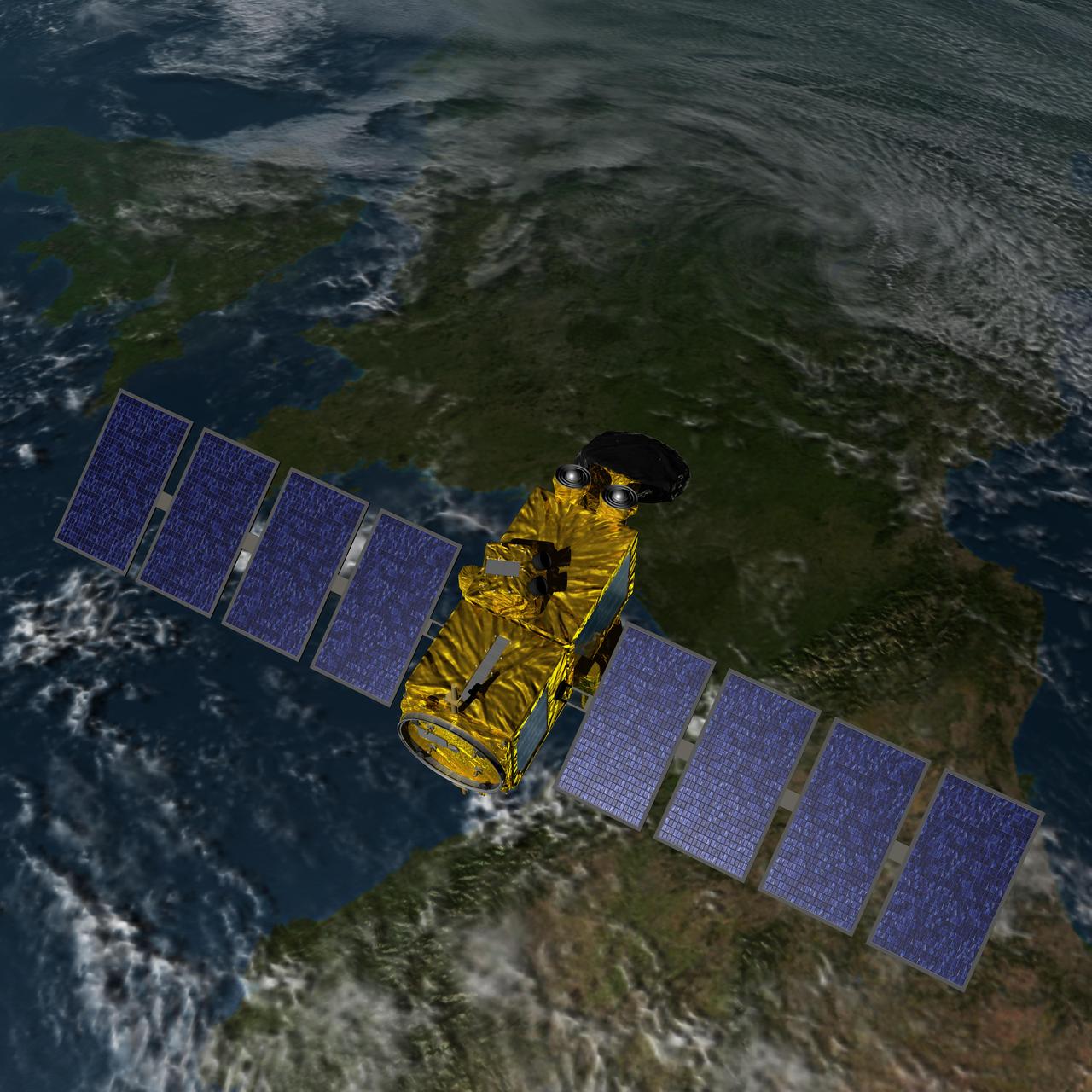
Artist concept of the U.S.-European Jason-3 spacecraft over the California coast. Jason-3 will precisely measure the height of the ocean surface, allowing scientists to monitor ocean circulation and sea level.
The U.S./European Jason-3 satellite has produced its first map of sea surface height, which corresponds well to data from its predecessor, Jason-2. Higher-than-normal sea levels are red; lower-than-normal sea levels are blue. El Niño is visible as the red blob in the eastern equatorial Pacific. Extending the timeline of ocean surface topography measurements begun by the Topex/Poseidon and Jason 1 and 2 satellites, Jason 3 will make highly detailed measurements of sea-level on Earth to gain insight into ocean circulation and climate change. http://photojournal.jpl.nasa.gov/catalog/PIA20532
Artist concept of U.S.-European Jason-3 Ocean Altimetry Satellite over the Amazon
Artist concept of U.S.-European Jason-3 Ocean Altimetry Satellite over France.
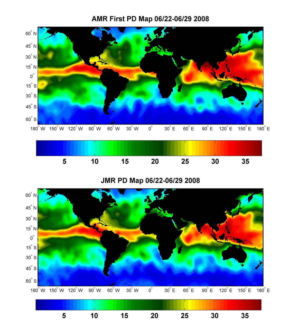
Global Views of Atmospheric Water Vapor:<br />First Data from OSTM/Jason-2 Advanced Microwave Radiometer
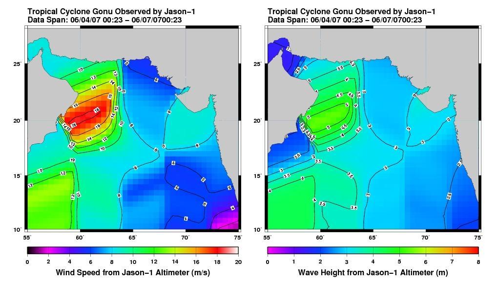
This pair of images from the radar altimeter instrument on NASA U.S./France Jason mission reveals information on wind speeds and wave heights of Tropical Cyclone Gonu, which reached Category 5 strength in the Arabian Sea prior to landfall in early June.
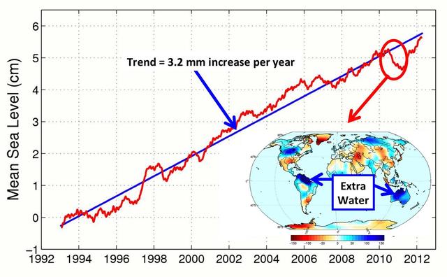
This figure shows changes in global mean sea level as measured by satellite altimetry NASA/CNES Topex/Poseidon and Jason-1; and NASA/CNES/NOAA/EUMETSAT Jason-2 between 1992 to 2012.
Recent sea-level height data from NASA Jason-1 altimetric satellite show that continuing weaker-than-normal trade winds in the western and central equatorial Pacific have triggered another strong, eastward moving, warm Kelvin wave.

Dr. Jason Dworkin, Project Scientist for NASA's OSIRIS-Rex mission is seen hear sealing a glass test tube with a sample of Allende meteorite dust which is 4.567 BILLION years old. Jason is the Chief of NASA Goddard's Astrochemistry Lab. Read more about the mission here: <a href="http://www.nasa.gov/mission_pages/osiris-rex" rel="nofollow">www.nasa.gov/mission_pages/osiris-rex</a> Credit: NASA/Goddard/Debbie Mccallum <b><a href="http://www.nasa.gov/audience/formedia/features/MP_Photo_Guidelines.html" rel="nofollow">NASA image use policy.</a></b> <b><a href="http://www.nasa.gov/centers/goddard/home/index.html" rel="nofollow">NASA Goddard Space Flight Center</a></b> enables NASA’s mission through four scientific endeavors: Earth Science, Heliophysics, Solar System Exploration, and Astrophysics. Goddard plays a leading role in NASA’s accomplishments by contributing compelling scientific knowledge to advance the Agency’s mission. <b>Follow us on <a href="http://twitter.com/NASAGoddardPix" rel="nofollow">Twitter</a></b> <b>Like us on <a href="http://www.facebook.com/pages/Greenbelt-MD/NASA-Goddard/395013845897?ref=tsd" rel="nofollow">Facebook</a></b> <b>Find us on <a href="http://instagram.com/nasagoddard?vm=grid" rel="nofollow">Instagram</a></b>
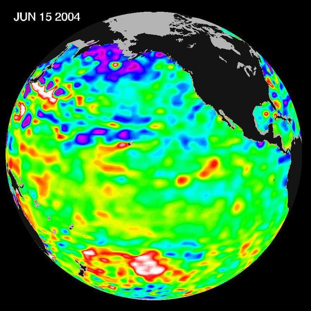
Recent sea level height data from NASA U.S./France Jason altimetric satellite during a 10-day cycle ending June 15, 2004.
New data from NASA Jason-2 satellite show near-normal sea surface heights in the equatorial Pacific Ocean persisting for a 16th straight month.
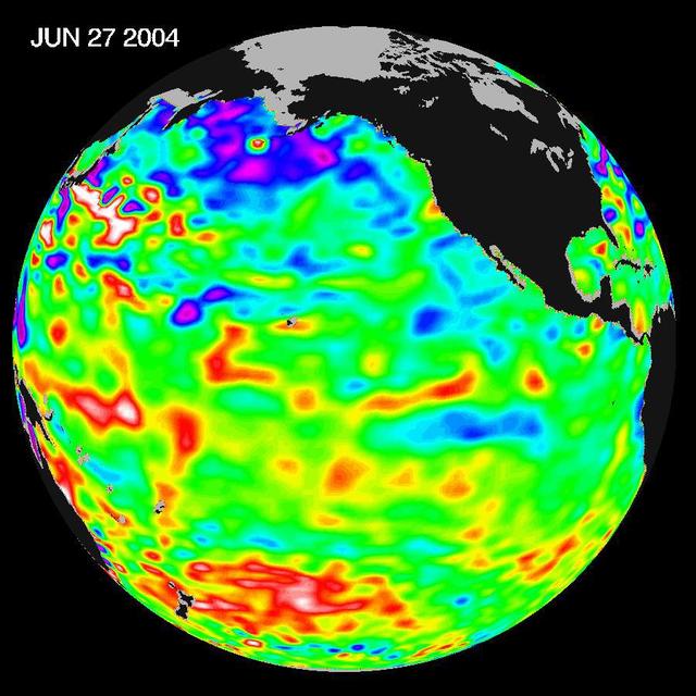
Recent sea level height data from NASA U.S./France Jason altimetric satellite during a 10-day cycle ending June 27, 2004.
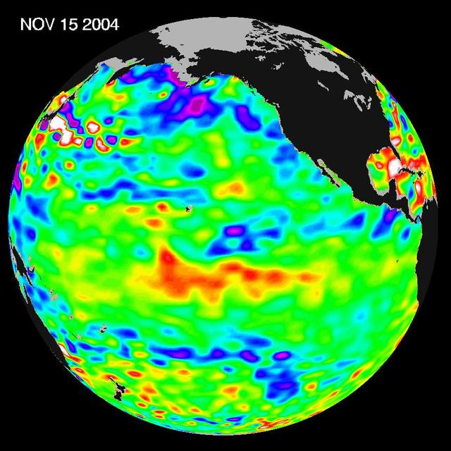
Recent sea-level height data from NASA U.S./France Jason altimetric satellite during a 10-day cycle ending November 15, 2004.

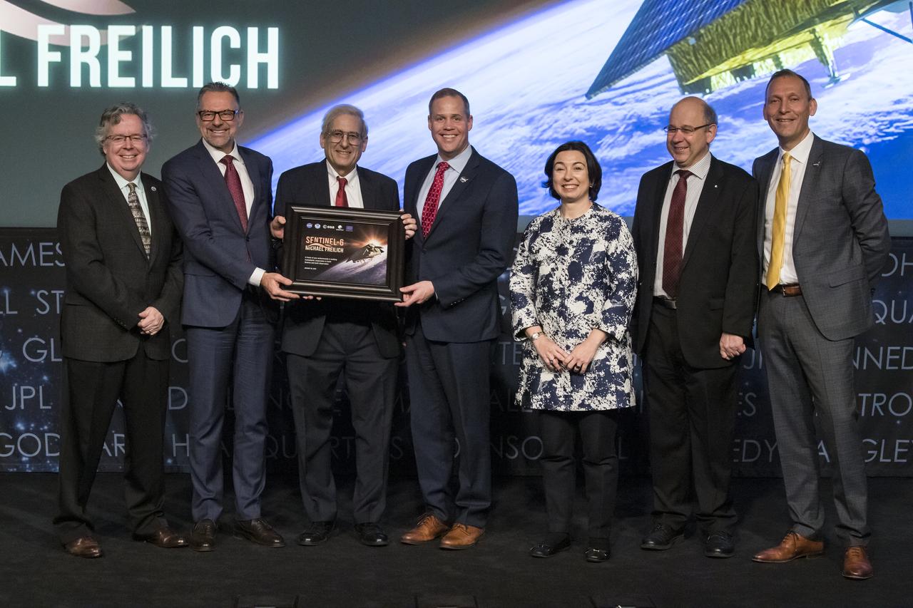
Former director of NASA’s Earth Science Division, Mike Freilich, speaks at a renaming ceremony for the international ocean science satellite previously known as Sentinel-6A/Jason-CS, Tuesday, January 28, 2020, at NASA Headquarters in Washington. NASA and its European partners renamed the satellite Sentinel-6 Michael Freilich after Dr. Freilich. Sentinel-6A Michael Freilich will observe and record global sea level changes and will be joined by an identical satellite slated to launch in 2025 for a total of ten years of targeted observations. Photo Credit: (NASA/Aubrey Gemignani)

NASA Administrator Jim Bridenstine applauds NASA’s former director of the Earth Science division, Dr. Michael Freilich, right, during a renaming ceremony for the international ocean science satellite previously known as Sentinel-6A/Jason-CS, Tuesday, January 28, 2020, at NASA Headquarters in Washington. NASA and its European partners renamed the satellite Sentinel-6 Michael Freilich after him. Sentinel-6A Michael Freilich will observe and record global sea level changes and will be joined by an identical satellite slated to launch in 2025 for a total of ten years of targeted observations.” Photo Credit: (NASA/Aubrey Gemignani)

Former director of NASA’s Earth Science Division, Mike Freilich, gestures at the conclusion of a renaming ceremony for the international ocean science satellite previously known as Sentinel-6A/Jason-CS, Tuesday, January 28, 2020, at NASA Headquarters in Washington. NASA and its European partners renamed the satellite Sentinel-6 Michael Freilich after him. Sentinel-6A Michael Freilich will observe and record global sea level changes and will be joined by an identical satellite slated to launch in 2025 for a total of ten years of targeted observations. Photo Credit: (NASA/Aubrey Gemignani)
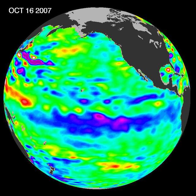
The tropical Pacific Ocean remains in the grips of a cool La Niña, as shown by new data of sea-level heights from mid-October of 2007, collected by NASA U.S-French Jason altimetric satellite.
This sea surface height map of the Gulf of Mexico, with the Florida peninsula on the right and the Texas-Mexico Gulf Coast on the left, is based on altimeter data from four satellites including NASA’s Topex/Poseidon and Jason.
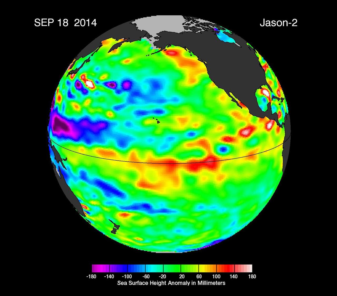
This image from NASA European Jason-2 satellite shows Kelvin waves of high sea level red/yellow crossing the Pacific Ocean at the equator. The waves can be related to El Niño events.
Pools of warm water known as Kelvin waves can be seen traveling eastward along the equator black line in this image from the NASA/French Space Agency Ocean Surface Topography Mission/Jason-2 satellite.
One of the strongest La Niñas in many years is slowly weakening but continues to blanket the Pacific Ocean near the equator, as shown by new sea-level height data collected by NASA U.S.-French Jason oceanographic satellite.
The latest image of sea-surface height measurements from NASA U.S./French Jason-1 oceanography satellite shows the Pacific Ocean remains locked in a strong, cool phase of the Pacific Decadal Oscillation.
This sea surface height map of the Gulf of Mexico and the northwestern Caribbean Sea, with the Florida peninsula on the upper right, is based on altimeter data from three satellites including NASA Jason-1.

EUMETSAT director-general, Alain Ratier, speaks at a renaming ceremony for the international ocean science satellite previously known as Sentinel-6A/Jason-CS, Tuesday, January 28, 2020, at NASA Headquarters in Washington. NASA and its European partners renamed the satellite Sentinel-6 Michael Freilich after NASA’s former director of the Earth Science division, Dr. Michael Freilich. Sentinel-6A Michael Freilich will observe and record global sea level changes and will be joined by an identical satellite slated to launch in 2025 for a total of ten years of targeted observations.” Photo Credit: (NASA/Aubrey Gemignani)

ESA (European Space Agency) director of Earth Observation Programmes, Josef Aschbacher, announces that the international ocean science satellite previously known as Sentinel-6A/Jason-CS has been renamed Sentinel-6 Michael Freilich after NASA’s former director of the Earth Science division, Dr. Michael Freilich, Tuesday, January 28, 2020, at NASA Headquarters in Washington. Sentinel-6A Michael Freilich will observe and record global sea level changes and will be joined by an identical satellite slated to launch in 2025 for a total of ten years of targeted observations. Photo Credit: (NASA/Aubrey Gemignani)

Former director of NASA’s Earth Science Division, Mike Freilich is seen onstage at the conclusion of a renaming ceremony for the international ocean science satellite previously known as Sentinel-6A/Jason-CS, Tuesday, January 28, 2020, at NASA Headquarters in Washington. NASA and its European partners renamed the satellite Sentinel-6 Michael Freilich after Dr. Freilich. Sentinel-6A Michael Freilich will observe and record global sea level changes and will be joined by an identical satellite slated to launch in 2025 for a total of ten years of targeted observations. Photo Credit: (NASA/Aubrey Gemignani)

Head of Global Issues and Innovation of the European Union delegation to the United States, Mercedes Garcia Pérez speaks at a renaming ceremony for the international ocean science satellite previously known as Sentinel-6A/Jason-CS, Tuesday, January 28, 2020, at NASA Headquarters in Washington. NASA and its European partners renamed the satellite Sentinel-6 Michael Freilich after NASA’s former director of the Earth Science division, Dr. Michael Freilich. Sentinel-6A Michael Freilich will observe and record global sea level changes and will be joined by an identical satellite slated to launch in 2025 for a total of ten years of targeted observations.” Photo Credit: (NASA/Aubrey Gemignani)

NASA associate administrator for Science, Thomas Zurbuchen, speaks at a renaming ceremony for the international ocean science satellite previously known as Sentinel-6A/Jason-CS, Tuesday, January 28, 2020, at NASA Headquarters in Washington. NASA and its European partners renamed the satellite Sentinel-6 Michael Freilich after NASA’s former director of the Earth Science division, Dr. Michael Freilich. Sentinel-6A Michael Freilich will observe and record global sea level changes and will be joined by an identical satellite slated to launch in 2025 for a total of ten years of targeted observations.” Photo Credit: (NASA/Aubrey Gemignani)

ESA (European Space Agency) director of Earth Observation Programmes, Josef Aschbacher, left, presents NASA’s former director of the Earth Science division, Dr. Michael Freilich with an award after announcing that the international ocean science satellite previously known as Sentinel-6A/Jason-CS has been renamed Sentinel-6 Michael Freilich after him, Tuesday, January 28, 2020, at NASA Headquarters in Washington. Sentinel-6A Michael Freilich will observe and record global sea level changes and will be joined by an identical satellite slated to launch in 2025 for a total of ten years of targeted observations. Photo Credit: (NASA/Aubrey Gemignani)

National Oceanic and Atmospheric Administration (NOAA) assistant administrator for Satellite and Information Services, Stephen Volz, speaks at a renaming ceremony for the international ocean science satellite previously known as Sentinel-6A/Jason-CS, Tuesday, January 28, 2020, at NASA Headquarters in Washington. NASA and its European partners renamed the satellite Sentinel-6 Michael Freilich after NASA’s former director of the Earth Science division, Dr. Michael Freilich. Sentinel-6A Michael Freilich will observe and record global sea level changes and will be joined by an identical satellite slated to launch in 2025 for a total of ten years of targeted observations.” Photo Credit: (NASA/Aubrey Gemignani)

ESA (European Space Agency) director of Earth Observation Programmes, Josef Aschbacher, left, presents NASA’s former director of the Earth Science division, Dr. Michael Freilich with an award after announcing that the international ocean science satellite previously known as Sentinel-6A/Jason-CS has been renamed Sentinel-6 Michael Freilich after him, Tuesday, January 28, 2020, at NASA Headquarters in Washington. Sentinel-6A Michael Freilich will observe and record global sea level changes and will be joined by an identical satellite slated to launch in 2025 for a total of ten years of targeted observations. Photo Credit: (NASA/Aubrey Gemignani)

NASA associate administrator for Science, Thomas Zurbuchen, left, makes closing remarks with Dr. Michael Freilich, right, at the conclusion of a renaming ceremony for the international ocean science satellite previously known as Sentinel-6A/Jason-CS, Tuesday, January 28, 2020, at NASA Headquarters in Washington. NASA and its European partners renamed the satellite Sentinel-6 Michael Freilich after NASA’s former director of the Earth Science division, Dr. Michael Freilich. Sentinel-6A Michael Freilich will observe and record global sea level changes and will be joined by an identical satellite slated to launch in 2025 for a total of ten years of targeted observations. Photo Credit: (NASA/Aubrey Gemignani)

NASA associate administrator for Science, Thomas Zurbuchen, speaks at a renaming ceremony for the international ocean science satellite previously known as Sentinel-6A/Jason-CS, Tuesday, January 28, 2020, at NASA Headquarters in Washington. NASA and its European partners renamed the satellite Sentinel-6 Michael Freilich after NASA’s former director of the Earth Science division, Dr. Michael Freilich. Sentinel-6A Michael Freilich will observe and record global sea level changes and will be joined by an identical satellite slated to launch in 2025 for a total of ten years of targeted observations.” Photo Credit: (NASA/Aubrey Gemignani)

The audience applauds NASA’s former director of the Earth Science division, Dr. Michael Freilich, right, at the conclusion of a renaming ceremony for the international ocean science satellite previously known as Sentinel-6A/Jason-CS, Tuesday, January 28, 2020, at NASA Headquarters in Washington. NASA and its European partners renamed the satellite Sentinel-6 Michael Freilich after him. Sentinel-6A Michael Freilich will observe and record global sea level changes and will be joined by an identical satellite slated to launch in 2025 for a total of ten years of targeted observations. Photo Credit: (NASA/Aubrey Gemignani)

VANDENBERG AIR FORCE BASE, Calif. -- Workers on Space Launch Complex 2 at Vandenberg Air Force Base in California prepare to attach a sling crane onto the Delta II second stage. The sling will lift the second stage into the mobile service tower for installation on the first stage for launch of the OSTM/Jason-2 spacecraft. The OSTM, or Ocean Topography Mission, on the Jason-2 satellite is a follow-on to Jason-1. It will take oceanographic studies of sea surface height into an operational mode for continued climate forecasting research and science and industrial applications. This satellite altimetry data will help determine ocean circulation, climate change and sea-level rise. OSTM is a joint effort by the National Oceanic and Atmospheric Administration, NASA, France’s Centre National d’Etudes Spatiales and the European Meteorological Satellite Organisation. OSTM/Jason-2 will be launched on June 20. Photo credit: NASA
VANDENBERG AIR FORCE BASE, Calif. -- Workers on Space Launch Complex 2 at Vandenberg Air Force Base in California place protective covers over the engine of the Delta II second stage. It will be lifted into the mobile service tower for installation on the first stage for launch of the OSTM/Jason-2 spacecraft. The OSTM, or Ocean Topography Mission, on the Jason-2 satellite is a follow-on to Jason-1. It will take oceanographic studies of sea surface height into an operational mode for continued climate forecasting research and science and industrial applications. This satellite altimetry data will help determine ocean circulation, climate change and sea-level rise. OSTM is a joint effort by the National Oceanic and Atmospheric Administration, NASA, France’s Centre National d’Etudes Spatiales and the European Meteorological Satellite Organisation. OSTM/Jason-2 will be launched on June 20. Photo credit: NASA

VANDENBERG AIR FORCE BASE, Calif. -- On Space Launch Complex 2 at Vandenberg Air Force Base in California, the Delta II second stage is lowered inside the mobile service tower toward the first stage. The second stage will be mated to the first stage for launch of the OSTM/Jason-2 spacecraft. The OSTM, or Ocean Topography Mission, on the Jason-2 satellite is a follow-on to Jason-1. It will take oceanographic studies of sea surface height into an operational mode for continued climate forecasting research and science and industrial applications. This satellite altimetry data will help determine ocean circulation, climate change and sea-level rise. OSTM is a joint effort by the National Oceanic and Atmospheric Administration, NASA, France’s Centre National d’Etudes Spatiales and the European Meteorological Satellite Organisation. OSTM/Jason-2 will be launched on June 20. Photo credit: NASA
VANDENBERG AIR FORCE BASE, Calif. -- On Space Launch Complex 2 at Vandenberg Air Force Base in California, the Delta II second stage is lowered inside the mobile service tower toward the first stage. The second stage will be mated to the first stage for launch of the OSTM/Jason-2 spacecraft. The OSTM, or Ocean Topography Mission, on the Jason-2 satellite is a follow-on to Jason-1. It will take oceanographic studies of sea surface height into an operational mode for continued climate forecasting research and science and industrial applications. This satellite altimetry data will help determine ocean circulation, climate change and sea-level rise. OSTM is a joint effort by the National Oceanic and Atmospheric Administration, NASA, France’s Centre National d’Etudes Spatiales and the European Meteorological Satellite Organisation. OSTM/Jason-2 will be launched on June 20. Photo credit: NASA
VANDENBERG AIR FORCE BASE, Calif. -- On Space Launch Complex 2 at Vandenberg Air Force Base in California, the Delta II second stage is ready to be lifted into the mobile service tower for installation on the first stage for launch of the OSTM/Jason-2 spacecraft. The OSTM, or Ocean Topography Mission, on the Jason-2 satellite is a follow-on to Jason-1. It will take oceanographic studies of sea surface height into an operational mode for continued climate forecasting research and science and industrial applications. This satellite altimetry data will help determine ocean circulation, climate change and sea-level rise. OSTM is a joint effort by the National Oceanic and Atmospheric Administration, NASA, France’s Centre National d’Etudes Spatiales and the European Meteorological Satellite Organisation. OSTM/Jason-2 will be launched on June 20. Photo credit: NASA
VANDENBERG AIR FORCE BASE, Calif. -- On Space Launch Complex 2 at Vandenberg Air Force Base in California, the Delta II second stage is lowered inside the mobile service tower toward the opening above the first stage. The second stage will be mated to the first stage for launch of the OSTM/Jason-2 spacecraft. The OSTM, or Ocean Topography Mission, on the Jason-2 satellite is a follow-on to Jason-1. It will take oceanographic studies of sea surface height into an operational mode for continued climate forecasting research and science and industrial applications. This satellite altimetry data will help determine ocean circulation, climate change and sea-level rise. OSTM is a joint effort by the National Oceanic and Atmospheric Administration, NASA, France’s Centre National d’Etudes Spatiales and the European Meteorological Satellite Organisation. OSTM/Jason-2 will be launched on June 20. Photo credit: NASA
VANDENBERG AIR FORCE BASE, Calif. -- Suspended vertically, the Delta II second stage is ready to be lifted into the mobile service tower on Space Launch Complex 2 at Vandenberg Air Force Base in California. The second stage will be installed on the first stage for launch of the OSTM/Jason-2 spacecraft. The OSTM, or Ocean Topography Mission, on the Jason-2 satellite is a follow-on to Jason-1. It will take oceanographic studies of sea surface height into an operational mode for continued climate forecasting research and science and industrial applications. This satellite altimetry data will help determine ocean circulation, climate change and sea-level rise. OSTM is a joint effort by the National Oceanic and Atmospheric Administration, NASA, France’s Centre National d’Etudes Spatiales and the European Meteorological Satellite Organisation. OSTM/Jason-2 will be launched on June 20. Photo credit: NASA
VANDENBERG AIR FORCE BASE, Calif. -- Workers on Space Launch Complex 2 at Vandenberg Air Force Base in California maneuver the transporter with the Delta II second stage into place. It will be lifted into the mobile service tower and installed on the first stage for launch of the OSTM/Jason-2 spacecraft. The OSTM, or Ocean Topography Mission, on the Jason-2 satellite is a follow-on to Jason-1. It will take oceanographic studies of sea surface height into an operational mode for continued climate forecasting research and science and industrial applications. This satellite altimetry data will help determine ocean circulation, climate change and sea-level rise. OSTM is a joint effort by the National Oceanic and Atmospheric Administration, NASA, France’s Centre National d’Etudes Spatiales and the European Meteorological Satellite Organisation. OSTM/Jason-2 will be launched on June 20. Photo credit: NASA
VANDENBERG AIR FORCE BASE, Calif. -- Workers on Space Launch Complex 2 at Vandenberg Air Force Base in California maneuver the transporter with the Delta II second stage into place. It will be lifted into the mobile service tower and installed on the first stage for launch of the OSTM/Jason-2 spacecraft. The OSTM, or Ocean Topography Mission, on the Jason-2 satellite is a follow-on to Jason-1. It will take oceanographic studies of sea surface height into an operational mode for continued climate forecasting research and science and industrial applications. This satellite altimetry data will help determine ocean circulation, climate change and sea-level rise. OSTM is a joint effort by the National Oceanic and Atmospheric Administration, NASA, France’s Centre National d’Etudes Spatiales and the European Meteorological Satellite Organisation. OSTM/Jason-2 will be launched on June 20. Photo credit: NASA
VANDENBERG AIR FORCE BASE, Calif. -- The Delta II second stage is transported onto Space Launch Complex 2 at Vandenberg Air Force Base in California. It will be lifted into the mobile service tower and installed on the first stage for launch of the OSTM/Jason-2 spacecraft. The OSTM, or Ocean Topography Mission, on the Jason-2 satellite is a follow-on to Jason-1. It will take oceanographic studies of sea surface height into an operational mode for continued climate forecasting research and science and industrial applications. This satellite altimetry data will help determine ocean circulation, climate change and sea-level rise. OSTM is a joint effort by the National Oceanic and Atmospheric Administration, NASA, France’s Centre National d’Etudes Spatiales and the European Meteorological Satellite Organisation. OSTM/Jason-2 will be launched on June 20. Photo credit: NASA
VANDENBERG AIR FORCE BASE, Calif. -- On Space Launch Complex 2 at Vandenberg Air Force Base in California, the mobile service tower moves toward the Delta II rocket for installation of the second stage. The Delta II will launch the OSTM/Jason-2 spacecraft. The OSTM, or Ocean Topography Mission, on the Jason-2 satellite is a follow-on to Jason-1. It will take oceanographic studies of sea surface height into an operational mode for continued climate forecasting research and science and industrial applications. This satellite altimetry data will help determine ocean circulation, climate change and sea-level rise. OSTM is a joint effort by the National Oceanic and Atmospheric Administration, NASA, France’s Centre National d’Etudes Spatiales and the European Meteorological Satellite Organisation. OSTM/Jason-2 will be launched on June 20. Photo credit: NASA

BLDG 4605, LUNAR ENVIRONMENTS TEST SYSTEM. JASON VAUGHN
The most recent sea-level height data from the NASA/European Ocean Surface Topography Mission/Jason-2 oceanography satellite show the continued eastward progression of a strong wave of warm water, known as a Kelvin wave, now approaching South America.
Recent sea-level height data from NASA Jason-2 oceanography satellite show a weakening of trade winds in western and central equatorial Pacific during late-January through February has triggered yet another strong, eastward-moving Kelvin wave.
This image from NASA European Ocean Surface Topography Mission/Jason-2 shows that the moderate El Niño of the past year has officially bowed out, leaving his cool sibling, La Niña, poised to potentially take the equatorial stage.
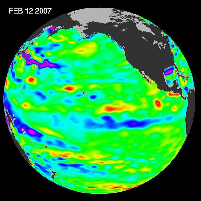
New data of sea-level heights from early February, 2007, by the Jason altimetric satellite show that the tropical Pacific Ocean has transitioned from a warm El Niño to a cool La Niña condition during the prior two months
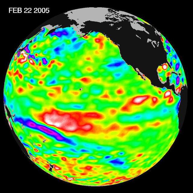
Recent sea-level height data from NASA U.S./France Jason altimetric satellite during a 10-day cycle ending February 22, 2005, show that the central equatorial Pacific continues to exhibit an area of higher-than-normal sea surface heights.
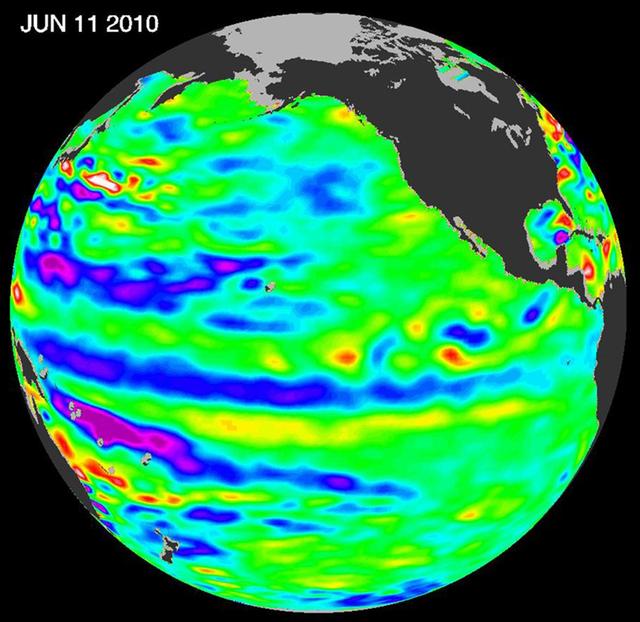
The latest image of Pacific Ocean sea surface heights from the NASA OSTIM/Jason-2 oceanography satellite, on June 11, 2010, shows that Pacific has switched from warm red to cold blue during the last few months.
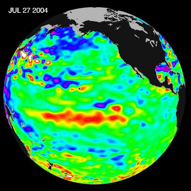
Sea-level height data from NASA U.S./France Jason altimetric satellite during a 10-day cycle ending July 27, 2004, show weaker than normal trade winds in the western and central equatorial Pacific have triggered an eastward moving, warm Kelvin wave.
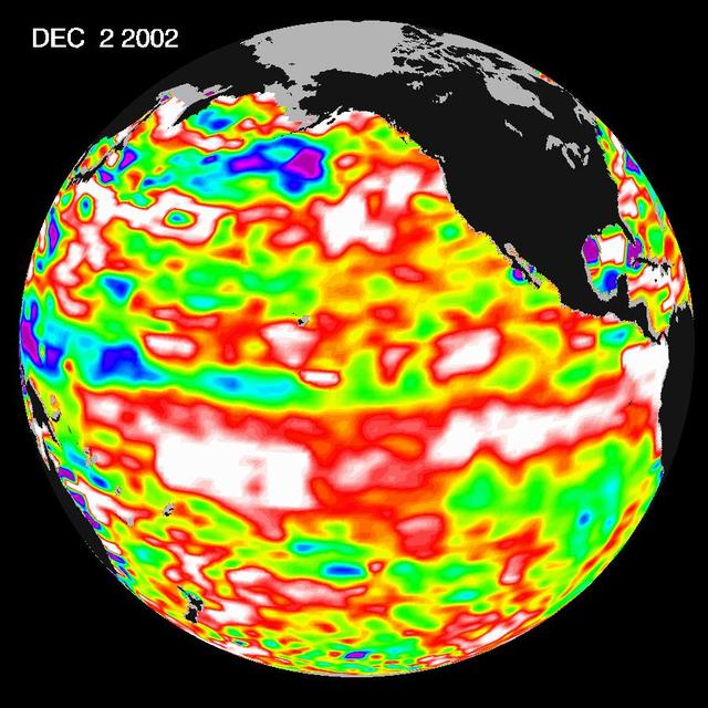
The latest image from NASA Jason oceanography satellite, taken during a 10-day collection cycle ending December 2, 2002, shows the Pacific dominated by two significant areas of higher-than-normal sealevel warmer ocean temperatures.
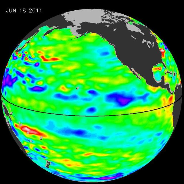
The latest image of sea surface heights in the Pacific Ocean from NASA Jason-2 satellite shows that the equatorial Pacific Ocean is now in its 10th month of being locked in what some call a neutral, or La Nada state.
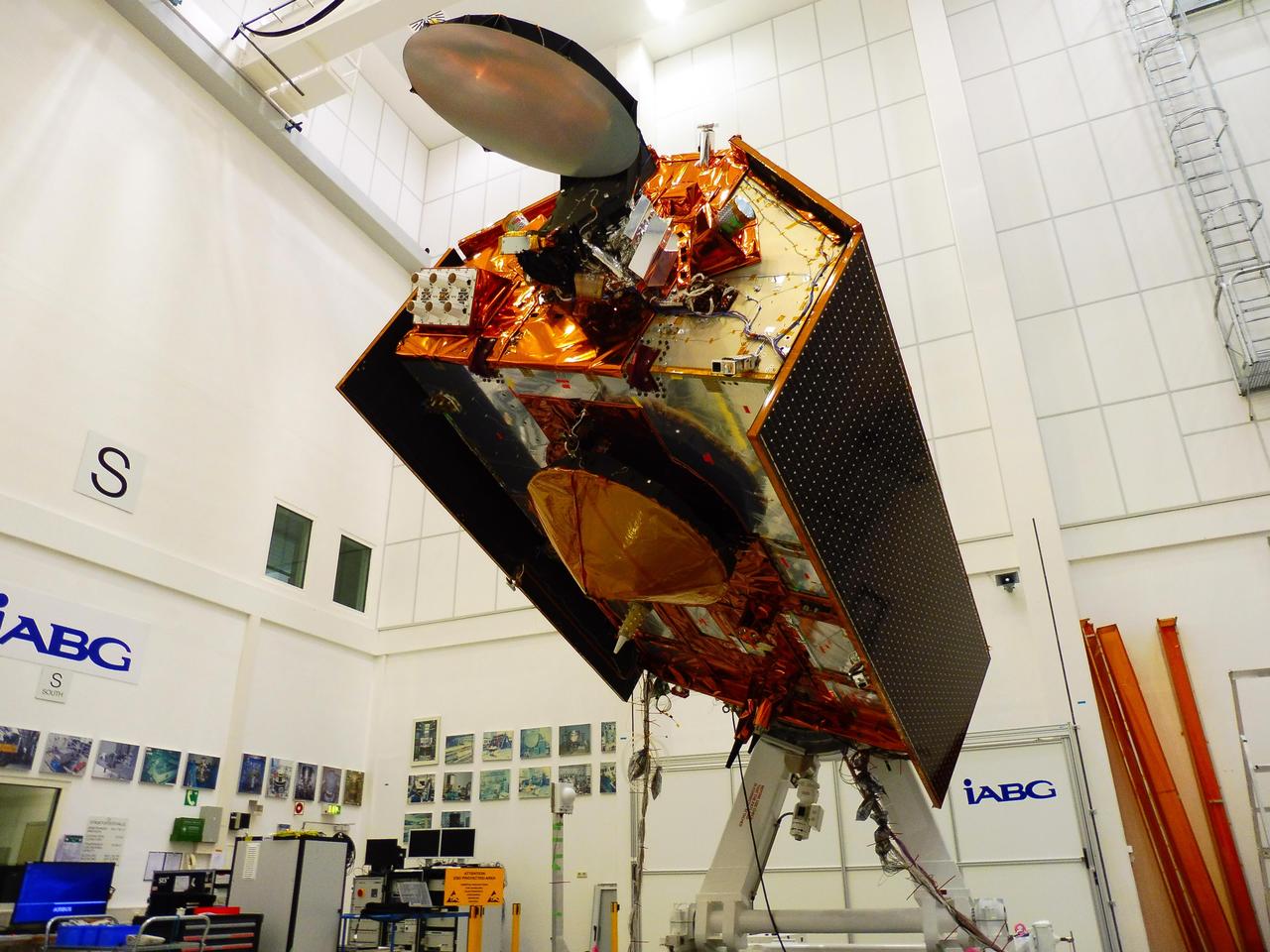
The Sentinel-6A spacecraft sits in its clean room in Germany's IABG space test center. The satellite is being prepared for a scheduled launch in November 2020 from Vandenberg Air Force Base in California. The spacecraft is part of Sentinel-6/Jason-CS, a 10-year mission by U.S and European agencies that will continue to study rising sea levels. The mission consists of two identical satellites, Sentinel-6A and Sentinel-6B, launching five years apart and follows in the footsteps of four other joint U.S.-European satellite missions — TOPEX/Poseidon and Jason-1, Ocean Surface Topography/Jason-2, and Jason-3 — that over the past three decades have documented Earth's oceans rising by an average of 0.1 inches (3 millimeters) per year. Sentinel-6/Jason-CS will study not just sea level change but also changes in ocean circulation, climate variability such as El Niño and La Niña, and weather patterns, including hurricanes and storms. It is being jointly developed by the European Space Agency (ESA), the European Organisation for the Exploitation of Meteorological Satellite (EUMETSAT), NASA and the National Oceanic and Atmospheric Administration (NOAA) with funding support from the European Commission and support from France's National Centre for Space Studies (CNES). NASA's contributions to the Sentinel-6 mission are science instrument payloads for the two Sentinel-6 satellites, launch services for those satellites, ground systems supporting the science instruments operations and support for the international Ocean Surface Topography Science Team. https://photojournal.jpl.nasa.gov/catalog/PIA23549
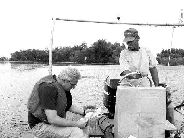
Dr. Marco Giardino, chief of the Applications Integration Division for NASA Stennis Space Center's Earth Science Applications Directorate, has been chosen by the JASON Project to be one of six host researchers for Disappearing Wetlands, which will run through the 2004-05 school year. In the photo, Giardino (left) interprets satellite imagery on the way to an archeological site near Lake Salvador, La., in November 2002. With him is his local guide, Michael Comardelle.
BLDG 4605, VACUUM UV/UV TESTER, JASON VAUGHN
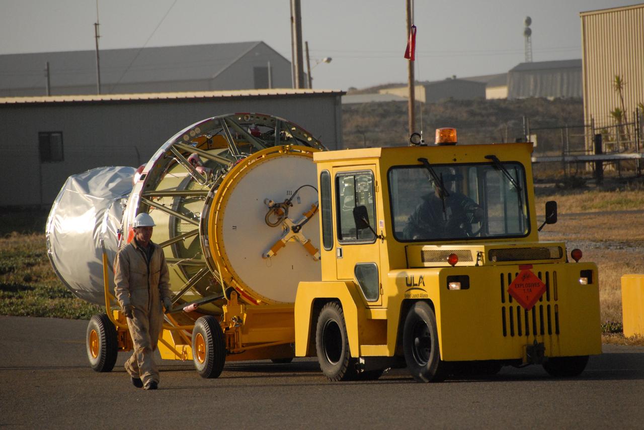
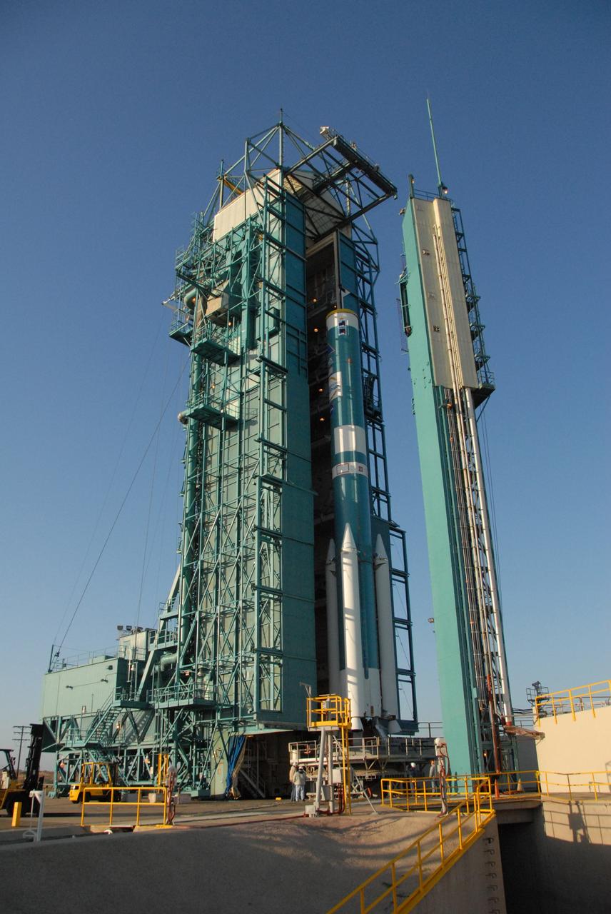
PASADENA, Calif. – A Delta II rocket carrying the Ocean Surface Topography Mission/Jason 2 satellite, is prepared for launch at Space Launch Complex 2 at Vandenberg Air Force Base, Calif. The OSTM/Jason 2 satellite will embark on a globe-circling voyage to continue charting sea level, a vital indicator of global climate change. The mission will return a vast amount of new data that will improve weather, climate and ocean forecasts. OSTM/Jason 2's expected lifetime of at least three years will extend into the next decade the continuous record of these data started in 1992 by NASA and the French space agency Centre National d'Etudes Spatiales, or CNES, with the TOPEX/Poseidon mission. The data collection was continued by the two agencies on Jason 1 in 2001. Photo credit: Carleton Bailie photograph for United Launch Alliance
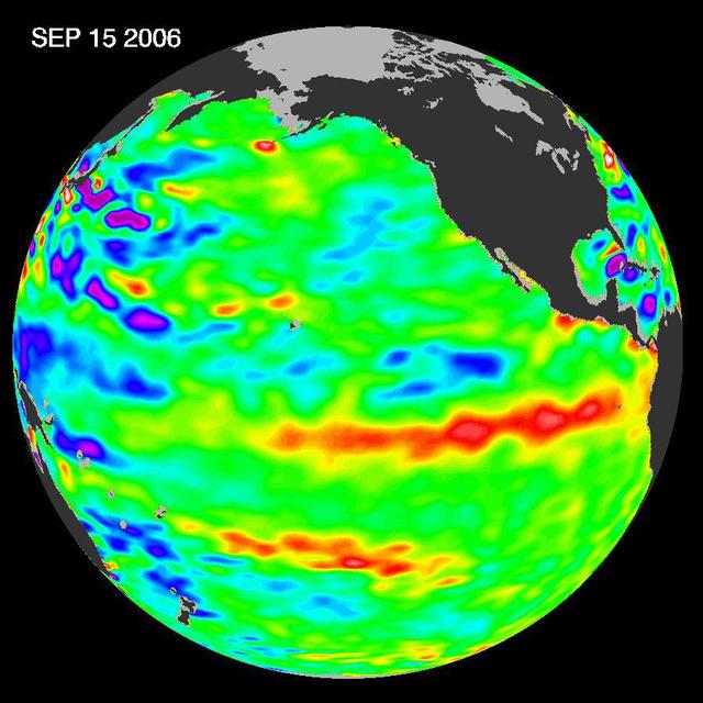
In September 2006, NASA satellite data indicated that El Niño had returned to the tropical Pacific Ocean, although it was relatively weak.
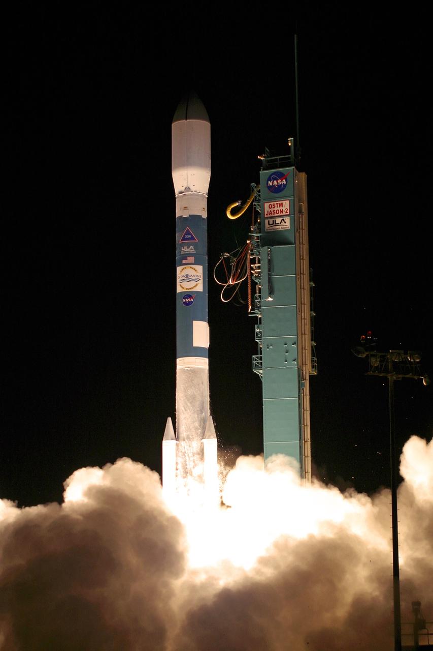
PASADENA, Calif. – The NASA-French space agency Ocean Surface Topography Mission/Jason 2 satellite launched aboard a Delta II rocket from Space Launch Complex 2 at Vandenberg Air Force Base, Calif., at 12:46 a.m. PDT. Fifty-five minutes later, OSTM/Jason 2 separated from the rocket’s second stage, and then, unfurled its twin sets of solar arrays. The OSTM/Jason 2 satellite will embark on a globe-circling voyage to continue charting sea level, a vital indicator of global climate change. The mission will return a vast amount of new data that will improve weather, climate and ocean forecasts. OSTM/Jason 2's expected lifetime of at least three years will extend into the next decade the continuous record of these data started in 1992 by NASA and the French space agency Centre National d'Etudes Spatiales, or CNES, with the TOPEX/Poseidon mission. The data collection was continued by the two agencies on Jason 1 in 2001. Photo credit: Carleton Bailie photograph for United Launch Alliance
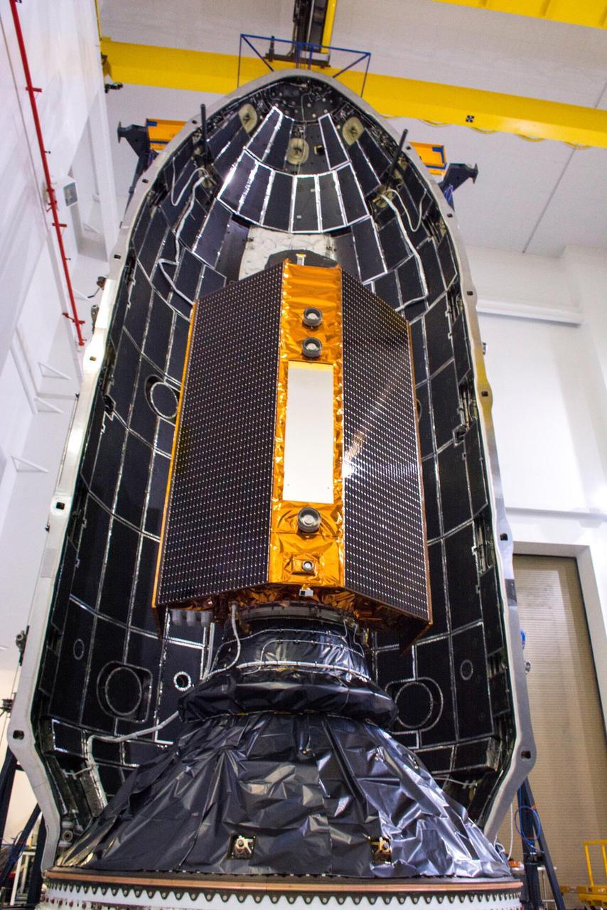
The Sentinel-6 Michael Freilich satellite is encapsulated in a protective nosecone, or payload fairing, in the SpaceX Payload Processing Facility at Vandenberg Air Force Base in California. The fairing will sit atop a SpaceX Falcon 9 rocket during the late-November 2020 launch that will place the satellite in Earth orbit. Sentinel-6 Michael Freilich is one of two identical satellites that are a part of the Sentinel-6/Jason-CS (Continuity of Service) mission, a U.S.-European collaboration. The mission is part of Copernicus, the European Union's Earth observation program managed by the European Commission. Continuing the legacy of the Jason series missions, Sentinel-6/Jason-CS will extend the records of sea level into their fourth decade, collecting accurate measurements of sea surface height for more than 90% of the world's oceans, and providing crucial information for operational oceanography, marine meteorology, and climate studies. Sentinel-6 Michael Freilich's twin, Sentinel-6B, is scheduled to launch in 2025. https://photojournal.jpl.nasa.gov/catalog/PIA24133
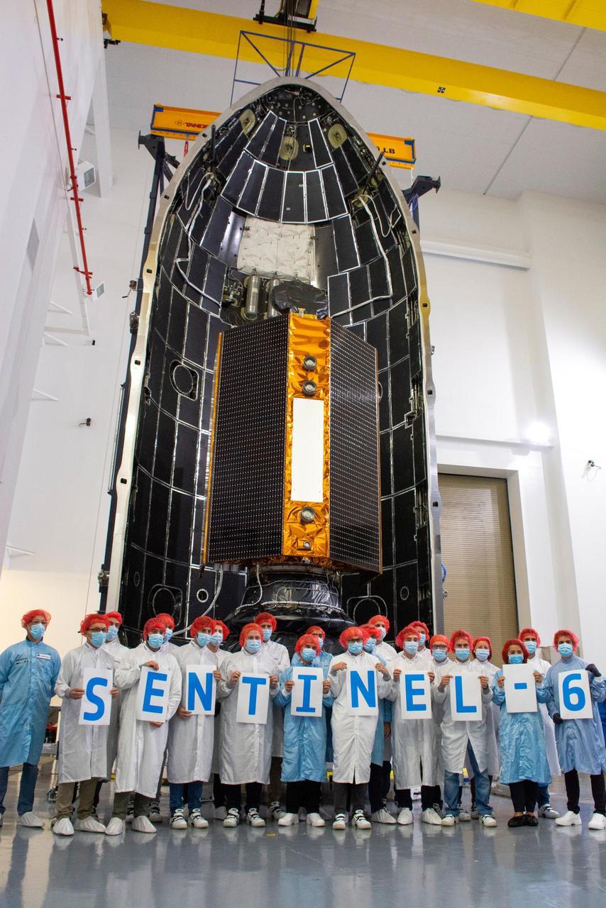
Technicians and engineers working on the Sentinel-6 Michael Freilich satellite pose in front of the spacecraft as it sits in a protective nosecone, or payload fairing, in the SpaceX Payload Processing Facility at Vandenberg Air Force Base in California. Once it's closed up, the fairing will sit atop a SpaceX Falcon 9 rocket when it launches from Vandenburg Air Force Base in central California in late November 2020. Sentinel-6 Michael Freilich is one of two identical satellites that are a part of the Sentinel-6/Jason-CS (Continuity of Service) mission, a U.S.-European collaboration. The mission is part of Copernicus, the European Union's Earth observation program managed by the European Commission. Continuing the legacy of the Jason series missions, Sentinel-6/Jason-CS will extend the records of sea level into their fourth decade, collecting accurate measurements of sea surface height for more than 90% of the world's oceans, and providing crucial information for operational oceanography, marine meteorology, and climate studies. Sentinel-6 Michael Freilich's twin, Sentinel-6B, is scheduled to launch in 2025. https://photojournal.jpl.nasa.gov/catalog/PIA24134
ElNi?o is experiencing a late-fall resurgence. Sea-level height data from the NASA/European Ocean Surface Topography Mission/Jason-2 oceanography satellite show the equatorial Pacific has triggered a wave of warm water, known as a Kelvin wave.
NASA Ocean Surface Topography Mission OSTM/Jason-2, launched on June 20, 2008, wasted no time getting to work. The satellite radar altimeter collected its first data a little more than 48 hours after launch.

Front row, from left to right, EUMETSAT director-general, Alain Ratier; National Oceanic and Atmospheric Administration (NOAA) assistant administrator for Satellite and Information Services, Stephen Volz; ESA (European Space Agency) director of Earth Observation Programmes, Josef Aschbacher; NASA associate administrator for Science, Thomas Zurbuchen; NASA Administrator Jim Bridenstine; and Former director of NASA’s Earth Science Division, Mike Freilich and his wife are seen in the audience at a renaming ceremony for the international ocean science satellite previously known as Sentinel-6A/Jason-CS, Tuesday, January 28, 2020, at NASA Headquarters in Washington. NASA and its European partners renamed the satellite Sentinel-6 Michael Freilich after NASA’s former director of the Earth Science division, Dr. Michael Freilich. Sentinel-6A Michael Freilich will observe and record global sea level changes and will be joined by an identical satellite slated to launch in 2025 for a total of ten years of targeted observations. Photo Credit: (NASA/Aubrey Gemignani)
From left to right, National Oceanic and Atmospheric Administration (NOAA) assistant administrator for Satellite and Information Services, Stephen Volz; ESA (European Space Agency) director of Earth Observation Programmes, Josef Aschbacher; Former director of NASA’s Earth Science Division, Mike Freilich; NASA Administrator Jim Bridenstine; Head of Global Issues and Innovation of the European Union delegation to the United States, Mercedes Garcia Pérez; EUMETSAT director-general, Alain Ratier; and NASA associate administrator for Science, Thomas Zurbuchen pose for a group photo at the conclusion of a renaming ceremony for the international ocean science satellite previously known as Sentinel-6A/Jason-CS, Tuesday, January 28, 2020, at NASA Headquarters in Washington. NASA and its European partners renamed the satellite Sentinel-6 Michael Freilich after Dr. Freilich. Sentinel-6A Michael Freilich will observe and record global sea level changes and will be joined by an identical satellite slated to launch in 2025 for a total of ten years of targeted observations. Photo Credit: (NASA/Aubrey Gemignani)
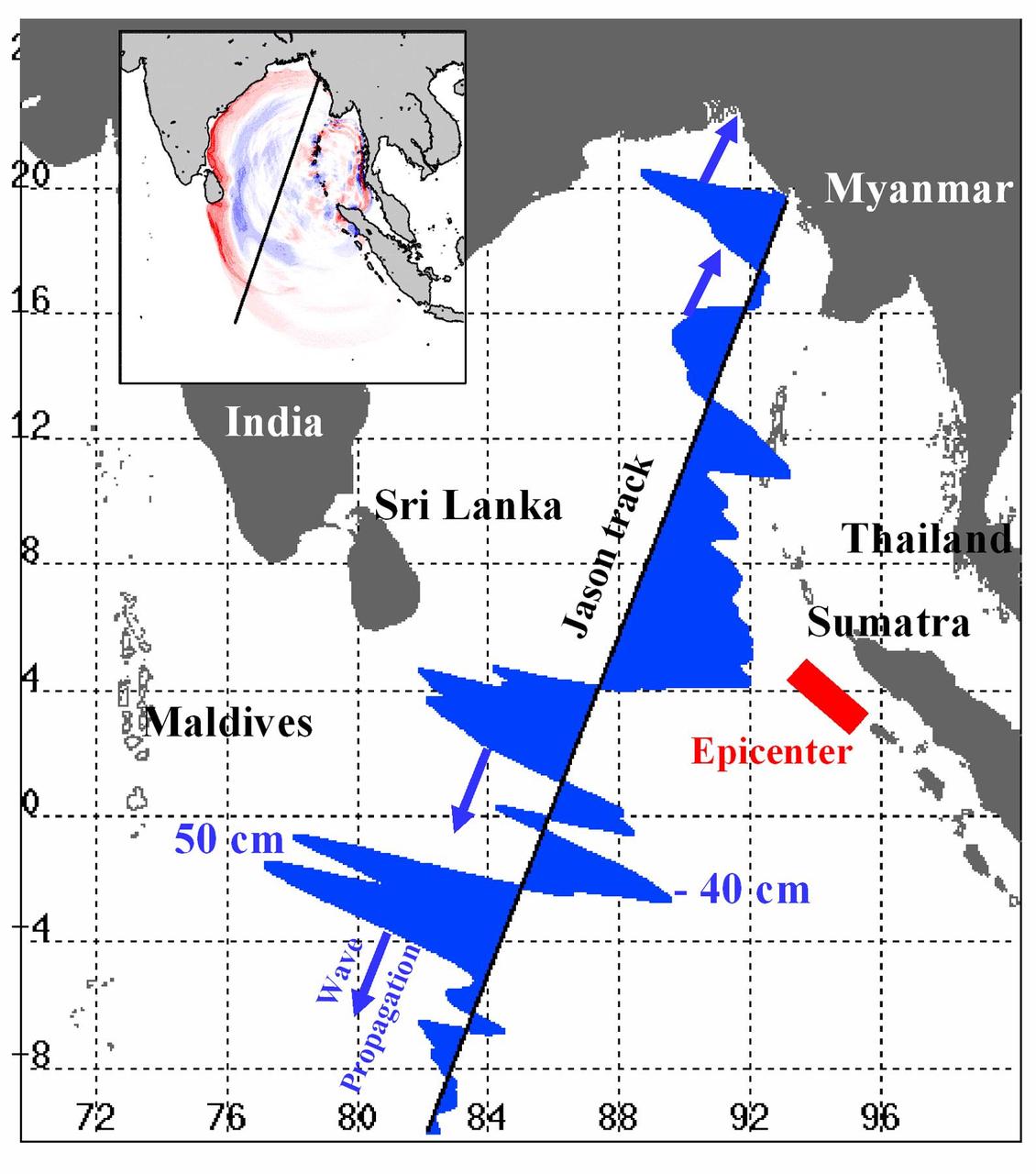
Displayed in blue color is the height of sea surface (shown in blue) measured by the Jason satellite two hours after the initial magnitude 9 earthquake hit the region (shown in red) southwest of Sumatra on December 26, 2004. The data were taken by a radar altimeter onboard the satellite along a track traversing the Indian Ocean when the tsunami waves had just filled the entire Bay of Bengal (see the model simulation inset image). The data shown are the changes of sea surface height from previous observations made along the same track 20-30 days before the earthquake, reflecting the signals of the tsunami waves. The maximum height of the leading wave crest was about 50 cm (or 1.6 ft), followed by a trough of sea surface depression of 40 cm. The directions of wave propagation along the satellite track are shown by the blue arrows. http://photojournal.jpl.nasa.gov/catalog/PIA07219
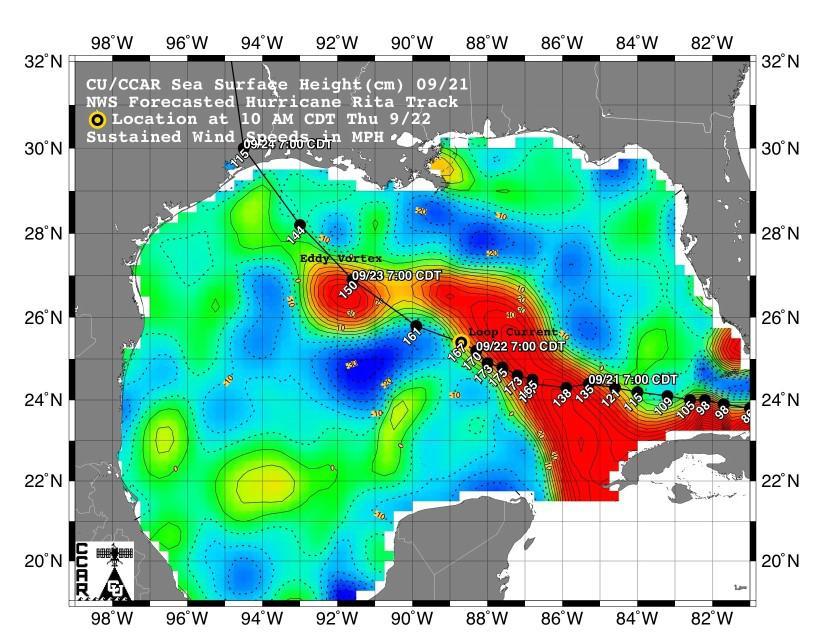
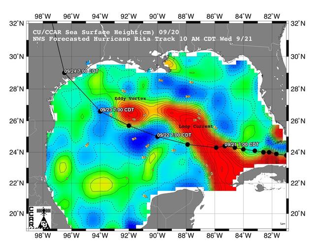
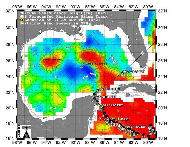
This sea surface height map of the Gulf of Mexico, with the Florida peninsula on the right and the Texas-Mexico Gulf Coast on the left, is based on altimeter data from four satellites including NASA’s Topex/Poseidon and Jason. Red indicates a strong circulation of much warmer waters, which can feed energy to a hurricane. This area stands 35 to 60 centimeters (about 13 to 23 inches) higher than the surrounding waters of the Gulf. The actual track of a hurricane is primarily dependent upon steering winds, which are forecasted through the use of atmospheric models. However, the interaction of the hurricane with the upper ocean is the primary source of energy for the storm. Hurricane intensity is therefore greatly affected by the upper ocean temperature structure and can exhibit explosive growth over warm ocean currents and eddies. Eddies are currents of water that run contrary to the direction of the main current. According to the forecasted track through the Gulf of Mexico, Hurricane Rita will continue crossing the warm waters of a Gulf of Mexico circulation feature called the Loop Current and then pass near a warm-water eddy called the Eddy Vortex, located in the north central Gulf, south of Louisiana. http://photojournal.jpl.nasa.gov/catalog/PIA06427
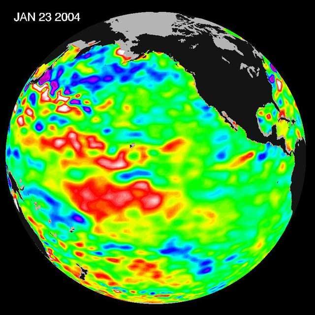
The latest remote sensing data from NASA's Jason satellite show that the equatorial Pacific sea surface levels are higher, indicating warmer sea surface temperatures in the central and west Pacific Ocean. This pattern has the appearance of La Niña rather than El Niño. This contrasts with the Bering Sea, Gulf of Alaska and U.S. West Coast where lower-than-normal sea surface levels and cool ocean temperatures continue (indicated by blue and purple areas). The image above is a global map of sea surface height, accurate to within 30 millimeters. The image represents data collected and composited over a 10-day period, ending on Jan 23, 2004. The height of the water relates to the temperature of the water. As the ocean warms, its level rises; and as it cools, its level falls. Yellow and red areas indicate where the waters are relatively warmer and have expanded above sea level, green indicates near normal sea level, and blue and purple areas show where the waters are relatively colder and the surface is lower than sea level. The blue areas are between 5 and 13 centimeters (2 and 5 inches) below normal, whereas the purple areas range from 14 to 18 centimeters (6 to 7 inches) below normal. http://photojournal.jpl.nasa.gov/catalog/PIA05071

Jason Dworkin, project scientist for NASA's OSIRIS-REx (Origins, Spectral Interpretation, Resource Identification, and Security – Regolith Explorer) mission, examines a portion of the asteroid Bennu sample delivered to Earth in a laboratory at the agency's Goddard Space Flight Center in Greenbelt, Maryland.
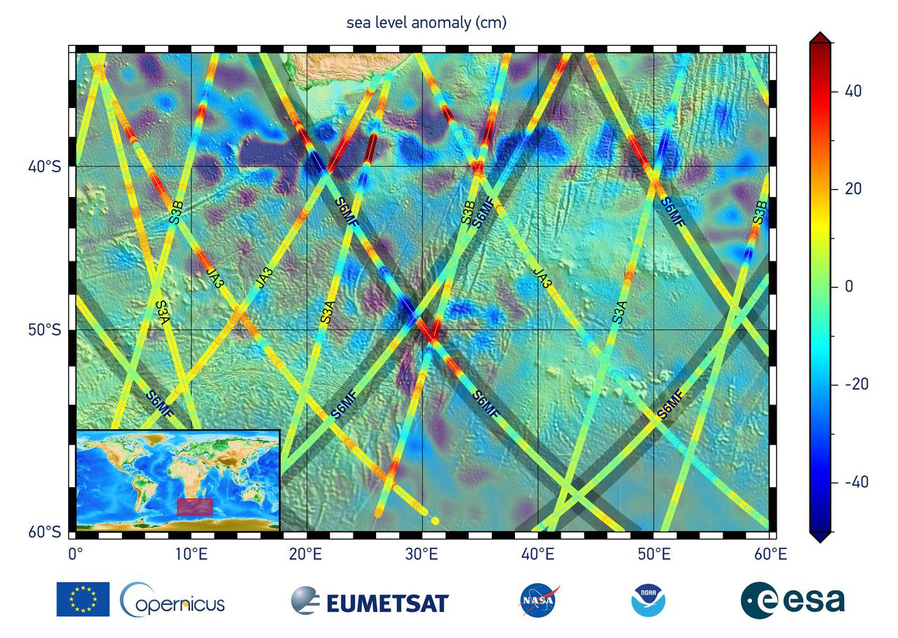
This graphic, released on Dec. 10, 2020, shows the first sea level measurements taken by Sentinel-6 Michael Freilich (S6MF), which launched Nov. 21, 2020. It focuses on the ocean off the southern tip of Africa, where red colors indicate higher sea level relative to blue areas, which are lower. Also included are sea surface height measurements from three other satellites for comparison: Jason-3 (JA3), Sentinel-3A (S3A), and Sentinel-3B (S3B). https://photojournal.jpl.nasa.gov/catalog/PIA24135
This map shows sea level measured by the Sentinel-6 Michael Freilich satellite from June 5 to15. Red areas are regions where sea level is higher than normal, and blue areas indicate areas where it's lower than normal. The measurements are part of a set of data streams that become available to the public hours to a couple of days after the satellite collects them. The difference in when the products become available balances accuracy with delivery timeliness for tasks like forecasting the weather or helping to monitor the formation of hurricanes. The satellite, named after former NASA Earth Science Division Director Michael Freilich, collects its measurements for about 90% of the world's oceans. The spacecraft is one of two satellites that compose the Copernicus Sentinel-6/Jason-CS (Continuity of Service) mission. The second satellite, Sentinel-6B, is slated for launch in 2025. Together, they are the latest in a series of spacecraft starting with TOPEX/Poseidon in 1992 and continuing with the Jason series of satellites that have been gathering precise ocean height measurements for nearly 30 years. Shortly after launch in Nov. 2020, Sentinel-6 Michael Freilich moved into position, trailing the current reference sea level satellite Jason-3 by 30 seconds. Scientists and engineers then spent time cross-calibrating the data collected by both satellites to ensure the continuity of measurements between the two. Once assured of the data quality, Sentinel-6 Michael Freilich will then become the primary sea level satellite. https://photojournal.jpl.nasa.gov/catalog/PIA24533
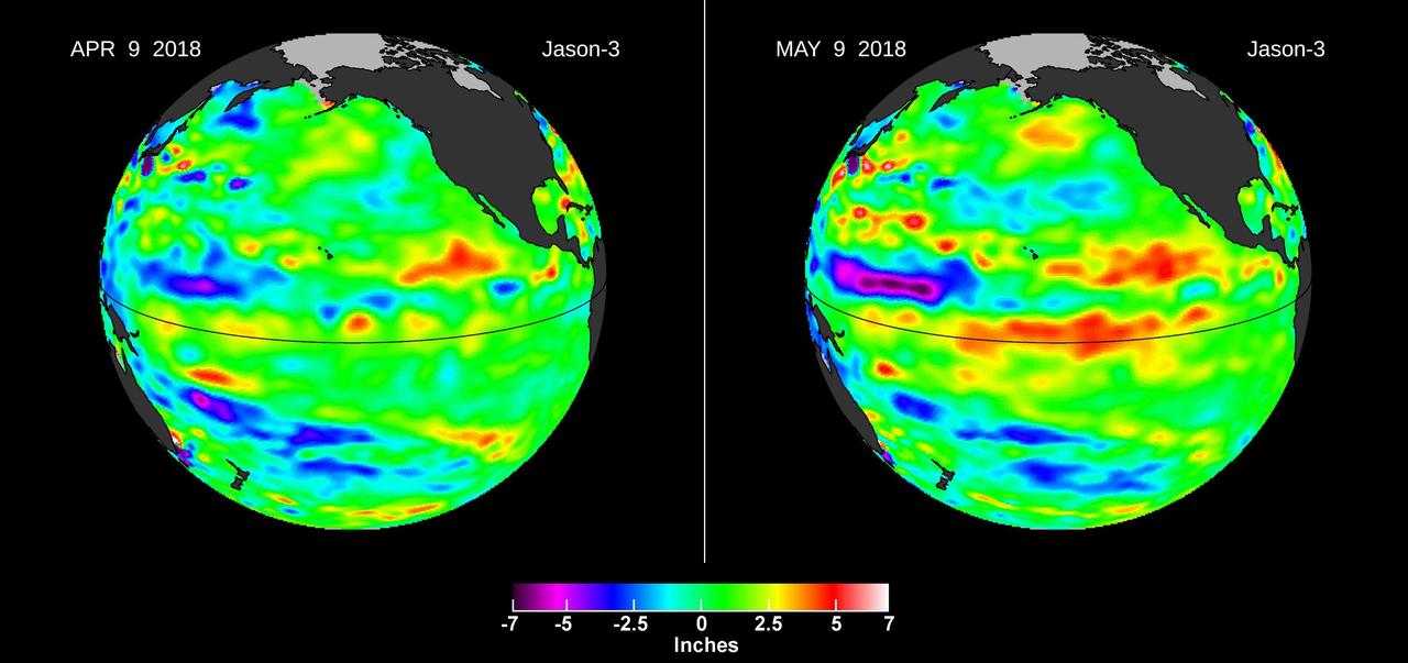
Images from the U.S./European Jason-3 satellite show sea surface height with respect to the seasonal cycle and the long-term trend. Blue/magenta colors indicate lower-than-normal sea levels, while yellow/red colors indicate higher-than-normal sea levels. The April 9, 2018 image (left panel) shows most of the ocean at neutral heights (green). A month later (right panel), a red patch is visible along the equator in the Central Pacific. The red area is a downwelling Kelvin wave, traveling eastward along the equator. https://photojournal.jpl.nasa.gov/catalog/PIA22473
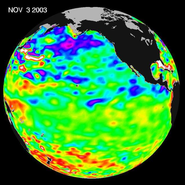
Some climate forecast models indicate there is an above average chance that there could be a weak to borderline El Niño by the end of November 2003. However, the trade winds, blowing from east to west across the equatorial Pacific Ocean, remain strong. Thus, there remains some uncertainty among climate scientists as to whether the warm temperature anomaly will form again this year. The latest remote sensing data from NASA's Jason satellite show near normal conditions across the equatorial Pacific. There are currently no visible signs in sea surface height of an impending El Niño. This equatorial quiet contrasts with the Bering Sea, Gulf of Alaska and U.S. West Coast where lower-than-normal sea surface levels and cool ocean temperatures continue (indicated by blue and purple areas). The image above is a global map of sea surface height, accurate to within 30 millimeters. The image represents data collected and composited over a 10-day period, ending on Nov. 3, 2003. The height of the water relates to the temperature of the water. As the ocean warms, its level rises; and as it cools, its level falls. Yellow and red areas indicate where the waters are relatively warmer and have expanded above sea level, green indicates near normal sea level, and blue and purple areas show where the waters are relatively colder and the surface is lower than sea level. The blue areas are between 5 and 13 centimeters (2 and 5 inches) below normal, whereas the purple areas range from 14 to 18 centimeters (6 to 7 inches) below normal. http://photojournal.jpl.nasa.gov/catalog/PIA04878
The Sentinel-6 Michael Freilich satellite undergoes final preparations in a clean room at Vandenberg Air Force Base in California for an early November launch. The satellite is named after Dr. Michael Freilich, the former director of NASA's Earth Science Division and an instrumental figure in advancing ocean observations from space. Sentinel-6 Michael Freilich is one of two identical spacecraft that compose the Sentinel-6/Jason-CS (Continuity of Service) mission developed in partnership with ESA (the European Space Agency). Other partners include the National Oceanic and Atmospheric Administration (NOAA), the intergovernmental European Organisation for the Exploitation of Meteorological Satellites (EUMETSAT), and France's National Centre for Space Studies (CNES). ESA is developing the new Sentinel family of missions to support the operational needs of the European Union's Copernicus program, the EU's Earth observation program managed by the European Commission. The spacecraft's twin, Sentinel-6B, will launch in 2025. https://photojournal.jpl.nasa.gov/catalog/PIA24131

A shipping container containing the Sentinel-6 Michael Freilich satellite is transported on a truck to the SpaceX payload processing facility at Vandenberg Air Force Base after arriving in California on Sept. 24, 2020. An Antonov aircraft carrying the spacecraft arrived at around 10:40 a.m. PDT (1:40 p.m. EDT) after a two-day journey from an IABG engineering facility near Munich, Germany. The ocean-monitoring satellite will undergo prelaunch tests before its scheduled launch on Nov. 10, 2020. Sentinel-6 Michael Freilich will begin a five-and-a-half-year mission to collect sea surface height measurements down to the centimeter for 90% of the world's oceans. The satellite is named after Dr. Michael Freilich, the former director of NASA's Earth Science Division and an instrumental figure in advancing ocean observations from space. Sentinel-6 Michael Freilich is one of two identical spacecraft that compose the Sentinel-6/Jason-CS (Continuity of Service) mission developed in partnership with ESA (the European Space Agency). ESA is developing the new Sentinel family of missions to support the operational needs of the European Union's Copernicus program, the EU's Earth observation program managed by the European Commission. The spacecraft's twin, Sentinel-6B, will launch in 2025. Sentinel-6/Jason-CS is being jointly developed by ESA, the European Organisation for the Exploitation of Meteorological Satellites (EUMETSAT), NASA, and the National Oceanic and Atmospheric Administration, with funding support from the European Commission and technical support from France's National Centre for Space Studies (CNES). JPL, a division of Caltech in Pasadena, is contributing three science instruments for each Sentinel-6 satellite: the Advanced Microwave Radiometer, the Global Navigation Satellite System - Radio Occultation, and the Laser Retroreflector Array. NASA is also contributing launch services, ground systems supporting operation of the NASA science instruments, the science data processors for two of these instruments, and support for the international Ocean Surface Topography Science Team. https://photojournal.jpl.nasa.gov/catalog/PIA24104
A shipping container containing the Sentinel-6 Michael Freilich satellite is removed from an Antonov 124 aircraft at Vandenberg Air Force Base in California on Sept. 24, 2020. The flight arrived at around 10:40 a.m. PDT (1:40 p.m. EDT) after a two-day journey from an IABG engineering facility near Munich, Germany. The ocean-monitoring satellite will undergo prelaunch tests before its scheduled launch on Nov. 10, 2020. Sentinel-6 Michael Freilich will begin a five-and-a-half-year mission to collect sea surface height measurements down to the centimeter for 90% of the world's oceans. The satellite is named after Dr. Michael Freilich, the former director of NASA's Earth Science Division and an instrumental figure in advancing ocean observations from space. Sentinel-6 Michael Freilich is one of two identical spacecraft that compose the Sentinel-6/Jason-CS (Continuity of Service) mission developed in partnership with ESA (the European Space Agency). ESA is developing the new Sentinel family of missions specifically to support the operational needs of the European Union's Copernicus program, the EU's Earth observation program managed by the European Commission. The spacecraft's twin, Sentinel-6B, will launch in 2025. Sentinel-6/Jason-CS is being jointly developed by ESA, the European Organisation for the Exploitation of Meteorological Satellites (EUMETSAT), NASA, and the National Oceanic and Atmospheric Administration, with funding support from the European Commission and technical support from France's National Centre for Space Studies (CNES). NASA JPL is contributing three science instruments for each Sentinel-6 satellite: the Advanced Microwave Radiometer, the Global Navigation Satellite System - Radio Occultation, and the Laser Retroreflector Array. NASA is also contributing launch services, ground systems supporting operation of the NASA science instruments, the science data processors for two of these instruments, and support for the international Ocean Surface Topography Science Team. https://photojournal.jpl.nasa.gov/catalog/PIA24103
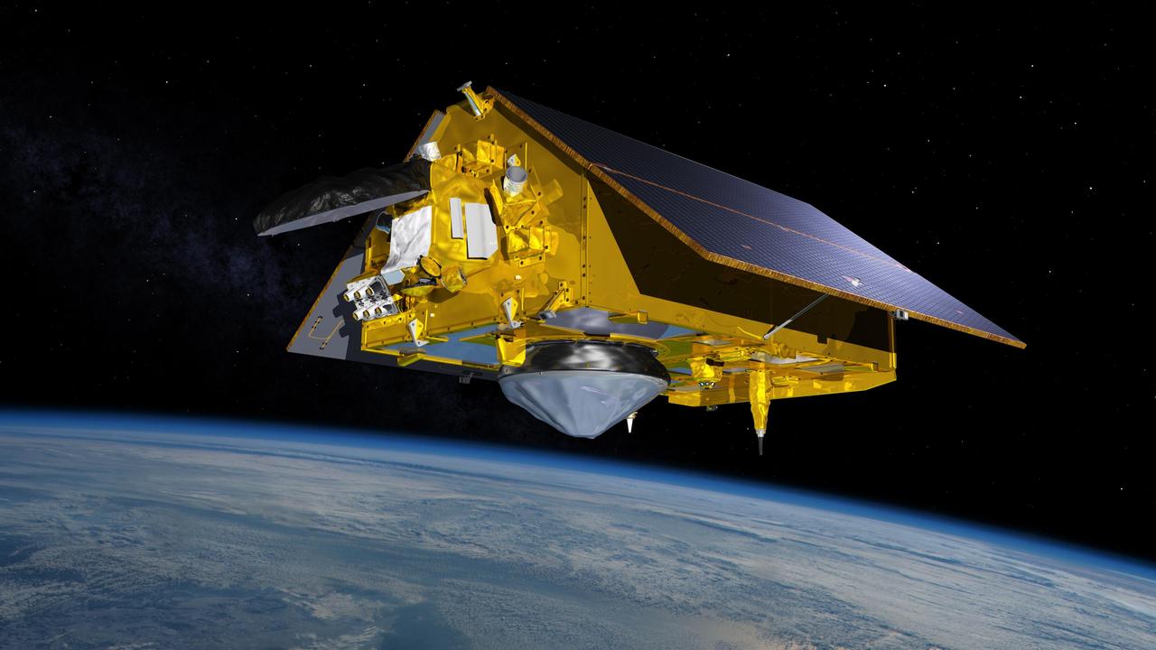
This illustration shows the Sentinel-6 Michael Freilich spacecraft in orbit above Earth with its deployable solar panels extended. As the world's latest ocean-monitoring satellite, it will collect the most accurate data yet on global sea level and how our oceans are rising in response to climate change. The mission will also collect precise data of atmospheric temperature and humidity that will help improve weather forecasts and climate models. Sentinel-6 Michael Freilich extends the near-30-year record of satellite measurements of sea level that was initiated by the U.S.-European TOPEX/Poseidon mission in 1992 and continued with the Jason-1, 2, and 3 series of sea level observation satellites. Launched in 2016, Jason-3 is currently providing data. The satellite is named after Dr. Michael Freilich, the former director of NASA's Earth Science Division and an instrumental figure in advancing ocean observations from space. Sentinel-6 Michael Freilich is one of two identical spacecraft that compose the Sentinel-6/Jason-CS (Continuity of Service) mission developed in partnership with ESA (the European Space Agency). Other partners include the National Oceanic and Atmospheric Administration (NOAA), the intergovernmental European Organisation for the Exploitation of Meteorological Satellites (EUMETSAT), and France's National Centre for Space Studies (CNES). ESA is developing the new Sentinel family of missions to support the operational needs of the European Union's Copernicus program, the EU's Earth observation program managed by the European Commission. The spacecraft's twin, Sentinel-6B, will launch in 2025. https://photojournal.jpl.nasa.gov/catalog/PIA24105
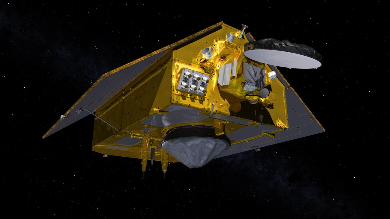
This illustration shows the front of the Sentinel-6 Michael Freilich spacecraft in orbit above Earth with its deployable solar panels extended. As the world's latest ocean-monitoring satellite, it is launching on Nov. 10, 2020, to collect the most accurate data yet on global sea level and how our oceans are rising in response to climate change. The mission will also collect precise data of atmospheric temperature and humidity that will help improve weather forecasts and climate models. The conelike instrument on the bottom (Earth-facing side) of the spacecraft is the satellite's Poseidon-4 radar altimeter. The disklike instrument at the front of the spacecraft is the Advanced Microwave Radiometer (AMR-C). Both instruments will be used together to measure ocean surface height. The gray rectangle with six cones attached at the front-left of the spacecraft is part of the Global Navigation Satellite System - Radio Occultation (GNSS-RO) instrument. Sentinel-6 Michael Freilich extends the near-30-year record of satellite measurements of sea level initiated by the U.S.-European TOPEX/Poseidon mission in 1992 and that continued with the Jason-1, 2, and 3 series of sea level observation satellites. Launched in 2016, Jason-3 is currently providing data. The satellite is named after Dr. Michael Freilich, the former director of NASA's Earth Science Division and an instrumental figure in advancing ocean observations from space. Sentinel-6 Michael Freilich is one of two identical spacecraft that compose the Sentinel-6/Jason-CS (Continuity of Service) mission developed in partnership with ESA (the European Space Agency). Other partners include the National Oceanic and Atmospheric Administration (NOAA), the intergovernmental European Organisation for the Exploitation of Meteorological Satellites (EUMETSAT), and France's National Centre for Space Studies (CNES). ESA is developing the new Sentinel family of missions to support the operational needs of the European Union's Copernicus program, the EU's Earth observation program managed by the European Commission. The spacecraft's twin, Sentinel-6B, will launch in 2025. https://photojournal.jpl.nasa.gov/catalog/PIA24106
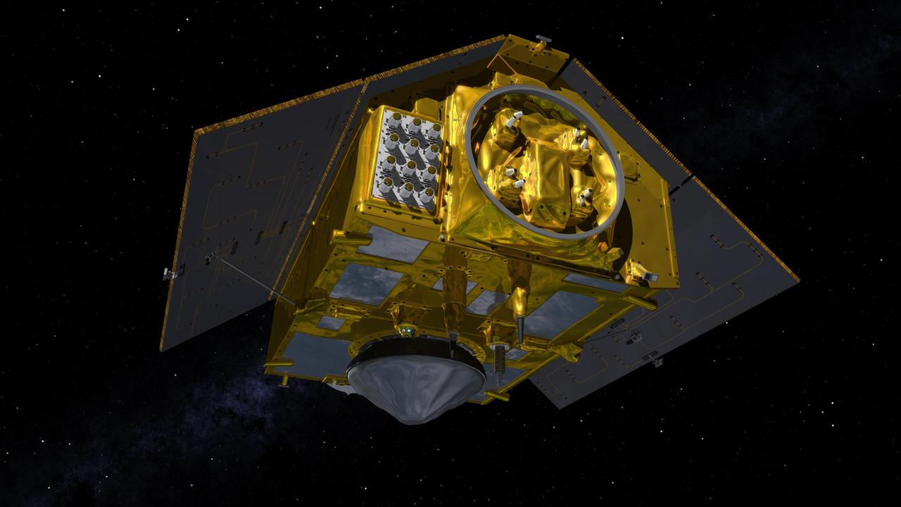
This illustration shows the rear of the Sentinel-6 Michael Freilich spacecraft in orbit above Earth with its deployable solar panels extended. As the world's latest ocean-monitoring satellite, it is launching on Nov. 10, 2020, to collect the most accurate data yet on global sea level and how our oceans are rising in response to climate change. The mission will also collect precise data of atmospheric temperature and humidity that will help improve weather forecasts and climate models. The conelike instrument on the bottom (Earth-facing side) of the spacecraft is the satellite's Poseidon-4 radar altimeter. When used with the Advanced Microwave Radiometer (AMR-C) attached to the front of the spacecraft, both instruments will be used to make precise measurements of sea surface height. The gray rectangle with 12 cones attached at the rear-left of the spacecraft is part of the Global Navigation Satellite System - Radio Occultation (GNSS-RO) instrument. Sentinel-6 Michael Freilich extends the near-30-year record of satellite measurements of sea level initiated by the U.S.-European TOPEX/Poseidon mission in 1992 and that continued with the Jason-1, 2, and 3 series of sea level observation satellites. Launched in 2016, Jason-3 is currently providing data. The satellite is named after Dr. Michael Freilich, the former director of NASA's Earth Science Division and an instrumental figure in advancing ocean observations from space. Sentinel-6 Michael Freilich is one of two identical spacecraft that compose the Sentinel-6/Jason-CS (Continuity of Service) mission developed in partnership with ESA (the European Space Agency). Other partners include the National Oceanic and Atmospheric Administration (NOAA), the intergovernmental European Organisation for the Exploitation of Meteorological Satellites (EUMETSAT), and France's National Centre for Space Studies (CNES). ESA is developing the new Sentinel family of missions to support the operational needs of the European Union's Copernicus program, the EU's Earth observation program managed by the European Commission. The spacecraft's twin, Sentinel-6B, will launch in 2025. https://photojournal.jpl.nasa.gov/catalog/PIA24107

Jason Crusan, director, NASA Advanced Exploration Systems (AES) Division, speaks with the STEM in 30 team Wednesday, June 27, 2018 at Smithsonian's National Air and Space Museum in Washington. Photo Credit: (NASA/Aubrey Gemignani)
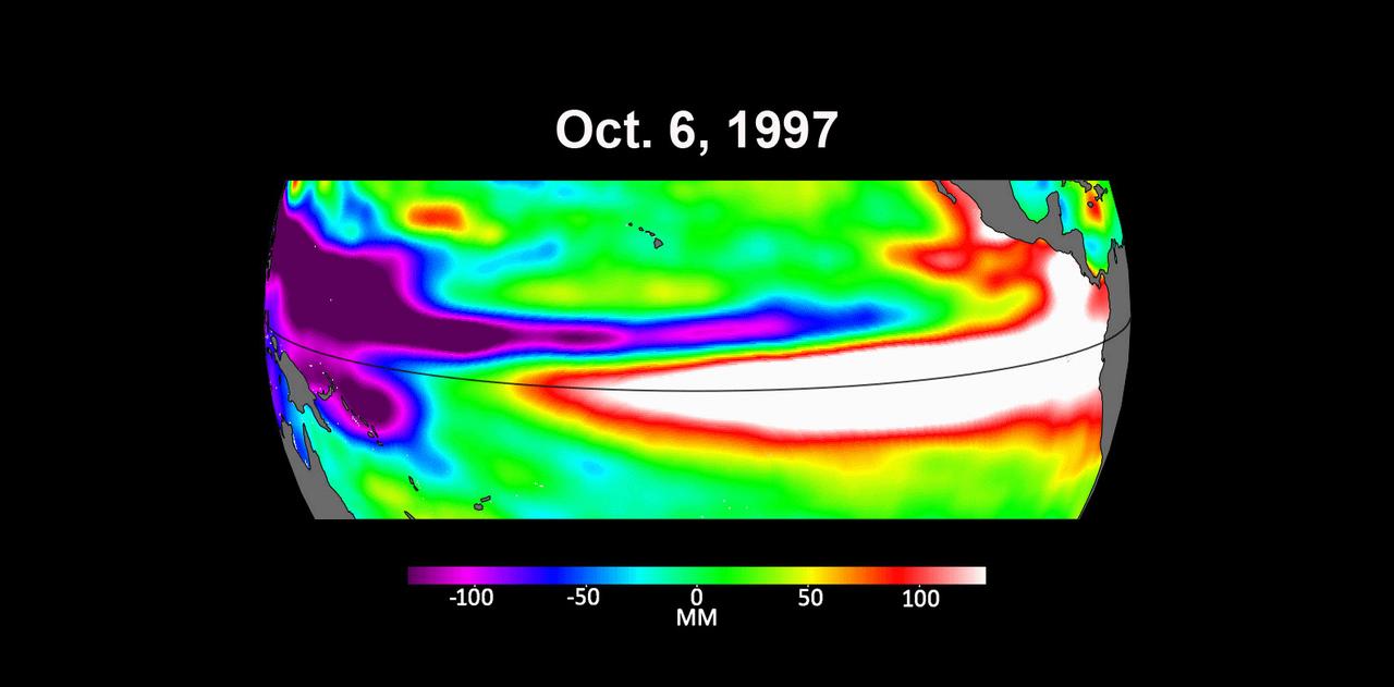
These three maps based on satellite data show sea levels in the Pacific Ocean during developing El Niño events in early October of 1997, 2015, and 2023. Higher-than-average ocean heights are shown in red and white, while lower-than-average heights are blue and purple. The two earlier maps represent the two extreme El Niño events from the past 30 years – the first from 1997 to 1998 and the second from 2015 to 2016. Both caused shifts in global air and ocean temperatures, atmospheric wind and rainfall patterns, and sea level. El Niños are characterized by higher-than-normal sea levels and warmer-than-average ocean temperatures along the equatorial Pacific. Water expands as it warms, so sea levels tend to be higher in places with warmer water. These temperature and sea level conditions can then propagate poleward along the western coasts of the Americas. El Niños can bring wetter conditions to the U.S. Southwest and drought to regions in the western Pacific, including Indonesia. Not all El Niño events are created equal, however, and their impacts vary widely. Satellites like the U.S.-European Sentinel-6 Michael Freilich, which captured the 2023 data, help anticipate those impacts on a global scale by tracking changes in sea surface height in the Pacific Ocean. The TOPEX/Poseidon satellite collected the 1997 data while Jason-2 collected data for the 2015 event. This year's El Niño is still developing, but researchers are looking to the recent past for clues as to how it is shaping up. By October 1997 and 2015, large areas of the central and eastern Pacific had sea levels more than 7 inches (18 centimeters) higher than normal. This year, sea levels are about 2 or 3 inches (5 to 8 centimeters) higher than normal and are elevated over a smaller area compared to the 1997 and 2015 events. Both of the past El Niños reached peak strength in late November or early December, so this year's event may still intensify. Launched in November 2020, Sentinel-6 Michael Freilich is named after former NASA Earth Science Division Director Michael Freilich. The satellite is one of two that compose the Copernicus Sentinel-6/Jason-CS (Continuity of Service) mission. Animation available at https://photojournal.jpl.nasa.gov/catalog/PIA26099

Future Engineers "Two for the Crew" competition winner, Jason Qin, speaks about his Two Pliers + 1 Handle, during a STEM in 30 event, Wednesday, June 27, 2018 at Smithsonian's National Air and Space Museum in Washington. Photo Credit: (NASA/Aubrey Gemignani)
Jason Crusan, Director of NASA's Advanced Exploration Systems Division, speaks during an Exploration Forum showcasing NASA's human exploration path to Mars in the James E. Webb Auditorium at NASA Headquarters on Tuesday, April 29, 2014. Photo Credit: (NASA/Joel Kowsky)
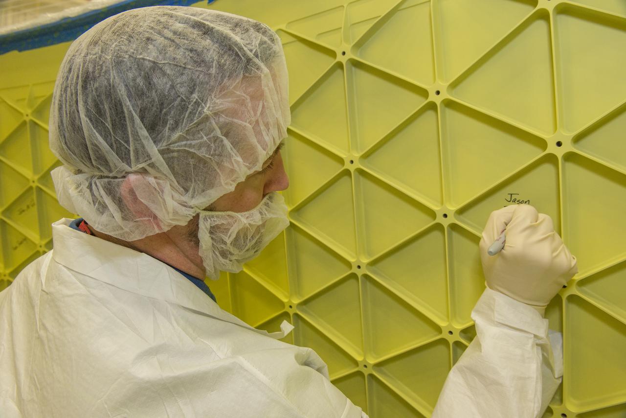
JASON ELDRIDGE, AN ERC INCORPORATED EMPLOYEE SUPPORTING THE MATERIALS & PROCESSES LABORATORY AT NASA'S MARSHALL SPACE FLIGHT CENTER, SIGNS HIS NAME ON THE INTERIOR OF THE ADAPTER THAT WILL CONNECT THE ORION SPACECRAFT TO A UNITED LAUNCH ALLIANCE DELTA IV ROCKET FOR EXPLORATION FLIGHT TEST (EFT)-1. MARSHALL CENTER TEAM MEMBERS WHO WERE INVOLVED IN THE DESIGN, CONSTRUCTION AND TESTING OF THE ADAPTER HAD THE OPPORTUNITY TO AUTOGRAPH IT BEFORE THE HARDWARE IS SHIPPED TO NASA'S KENNEDY SPACE CENTER IN FEBRUARY. ELDRIDGE WAS ON A TEAM THAT PERFORMED ULTRASONIC INSPECTIONS ON THE ADAPTER'S WELDS -- ENSURING THEY ARE STRUCTURALLY SOUND. EFT-1, SCHEDULED FOR 2014, WILL PROVIDE EARLY EXPERIENCE FOR NASA SPACE LAUNCH SYSTEM (SLS) HARDWARE AHEAD OF THE ROCKET'S FIRST FLIGHT IN 2017.
Future Engineers "Two for the Crew" competition winners, Ansel Austin, left, Austin Suder, center, and Jason Qin, right, are seen onstage during a STEM in 30 event, Wednesday, June 27, 2018 at Smithsonian's National Air and Space Museum in Washington. Photo Credit: (NASA/Aubrey Gemignani)

Future Engineers "Two for the Crew" competition winners, Ansel Austin, left, Austin Suder, center, and Jason Qin, right, are seen onstage during a STEM in 30 event, Wednesday, June 27, 2018 at Smithsonian's National Air and Space Museum in Washington. Photo Credit: (NASA/Aubrey Gemignani)
International Space Station (ISS) Remote Power Control Module (RPCM) Hot-mate/De-mate Assessment Dr. Erin Hayward , Mr. Todd Schneider, Mr. Jason Vaughn
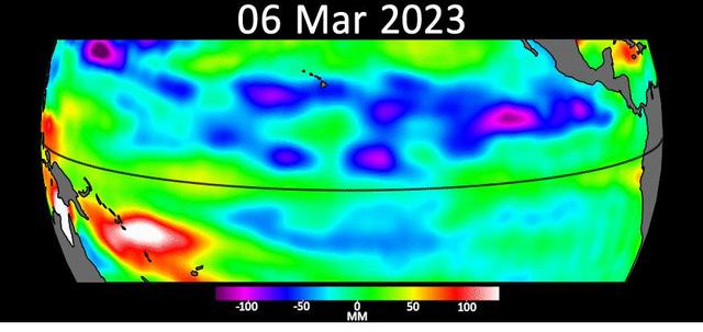
Sea level data from the U.S.-European satellite Sentinel-6 Michael Freilich shows early signs of a developing El Niño along the equatorial Pacific Ocean. The measurements show Kelvin waves, low waves that can be tens of miles (hundreds of kilometers) wide, moving from west to east at the equator towards the west coast of Ecuador. When they form at the equator, Kelvin waves can move warm water – associated with higher sea levels – from the western Pacific to the eastern Pacific. El Niño is a periodic climate phenomenon that can affect weather patterns around the world. The condition can bring cooler, wetter conditions to the U.S. Southwest and drought to countries in the western Pacific such as Indonesia and Australia. El Niño is characterized by higher sea levels and warmer-than-average ocean temperatures along the western coasts of North and South America. Water expands as it warms, so sea levels tend to be higher in places with warmer water. The climate phenomenon is also associated with a weakening of the trade winds. The Sentinel-6 Michael Freilich satellite data shown here covers a seven-week period between the beginning of March and the end of April 2023. By April 24, Figure A, Kelvin waves had piled up warmer water and higher sea levels (shown in red and white) off the coasts of Peru, Ecuador, and Columbia. A series of Kelvin waves starting in spring is a well-known precursor to an El Niño. The waves seen during March and April 2023 are similar to the ones that preceded the 1997-1998 El Niño, one of the most powerful in recorded history. Satellites like Sentinel-6 Michael Freilich can detect Kelvin waves with an instrument called an altimeter that uses radar signals to measure the height of the ocean's surface. Warmer areas show up as higher sea levels. The satellite, named after former NASA Earth Science Division Director Michael Freilich, is one of two that compose the Copernicus Sentinel-6/Jason-CS (Continuity of Service) mission. Animation available at https://photojournal.jpl.nasa.gov/catalog/PIA25776

Thalia Patrinos, and Jason Townsend from NASA's Social Media Teamm monitor questions coming in from social media during an event where nine U.S. companies where named as eligible to bid on NASA delivery services to the lunar surface through Commercial Lunar Payload Services (CLPS) contracts, Thursday, Nov. 29, 2018 at NASA Headquarters in Washington. The companies will be able to bid on delivering science and technology payloads for NASA, including payload integration and operations, launching from Earth and landing on the surface of the Moon. NASA expects to be one of many customers that will use these commercial landing services. Photo Credit: (NASA/Bill Ingalls)

Jason Townsend, NASA's Deputy Social Media Manager, kicks off the Lunar Atmosphere and Dust Environment Explorer (LADEE) NASA Social at Wallops Flight Facility, Thursday, Sept. 5, 2013 on Wallops Island, VA. Fifty of NASA's social media followers are attending a two-day event in support of the LADEE launch. Data from LADEE will provide unprecedented information about the environment around the moon and give scientists a better understanding of other planetary bodies in our solar system and beyond. LADEE is scheduled to launch at 11:27 p.m. Friday, Sept. 6, from NASA's Wallops Flight Facility. Photo Credit: (NASA/Carla Cioffi)

Jason Kessler, Special Projects Program Executive, NASA Office of the Chief Technologist, talks during the Asteroid Initiative Industry and Partner Day at NASA Headquarters on Tuesday, June 18, 2013 in Washington. During the event NASA Deputy Administrator Lori Garver and other senior NASA officials discussed the progress being made on NASA's mission to capture, redirect, and explore an asteroid. NASA also announced an Asteroid Grand Challenge focused on finding all asteroid threats to human populations and knowing what to do about them. Photo Credit: (NASA/Bill Ingalls)