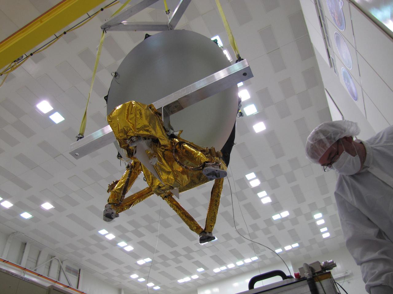
JPL technicians perform a practice run of the mechanical integration sequence that will be used to mate the Jason-3 spacecraft Advanced Microwave Radiometer instrument to the Jason-3 satellite.
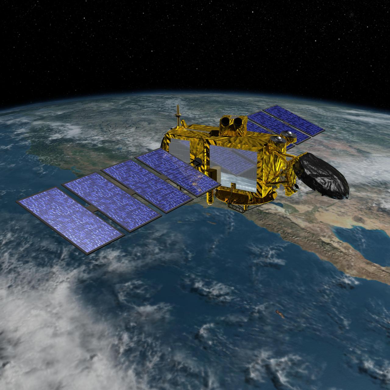
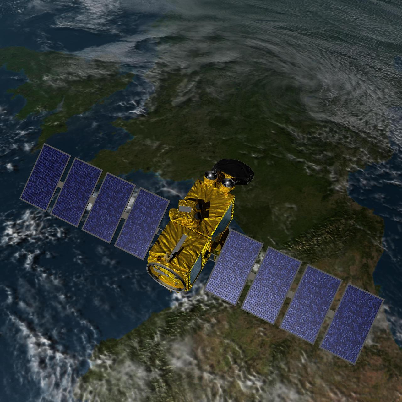
Artist concept of the U.S.-European Jason-3 spacecraft over the California coast. Jason-3 will precisely measure the height of the ocean surface, allowing scientists to monitor ocean circulation and sea level.
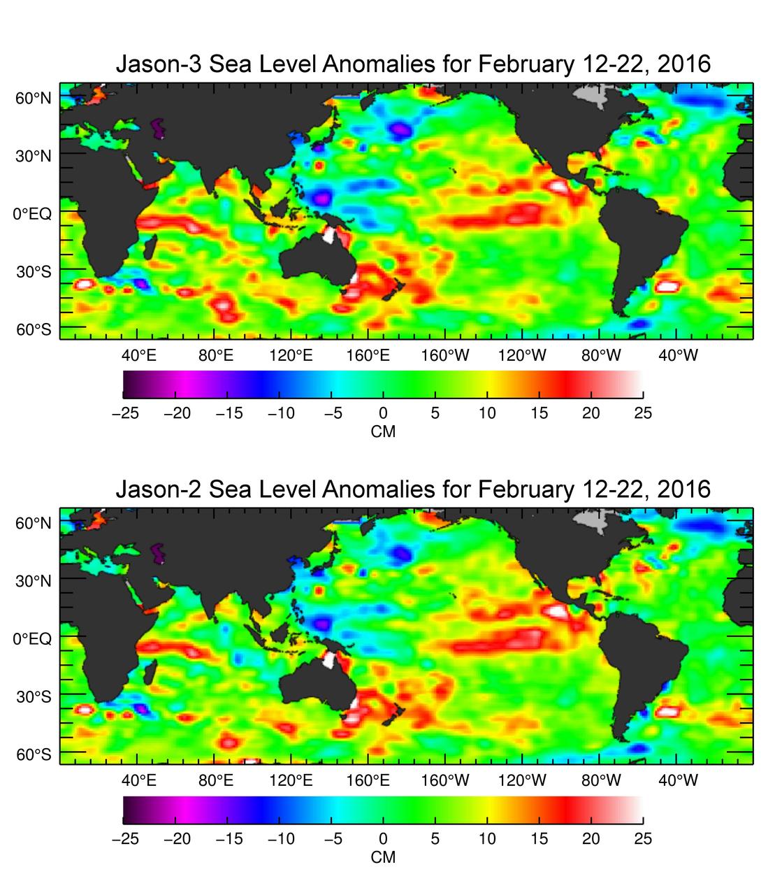
The U.S./European Jason-3 satellite has produced its first map of sea surface height, which corresponds well to data from its predecessor, Jason-2. Higher-than-normal sea levels are red; lower-than-normal sea levels are blue. El Niño is visible as the red blob in the eastern equatorial Pacific. Extending the timeline of ocean surface topography measurements begun by the Topex/Poseidon and Jason 1 and 2 satellites, Jason 3 will make highly detailed measurements of sea-level on Earth to gain insight into ocean circulation and climate change. http://photojournal.jpl.nasa.gov/catalog/PIA20532
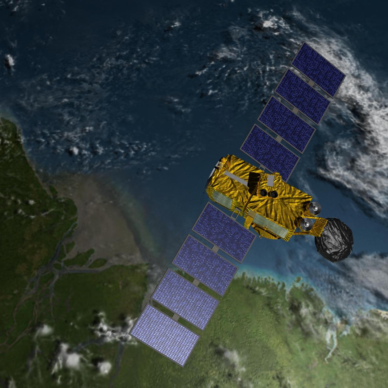
Artist concept of U.S.-European Jason-3 Ocean Altimetry Satellite over the Amazon
Artist concept of U.S.-European Jason-3 Ocean Altimetry Satellite over France.
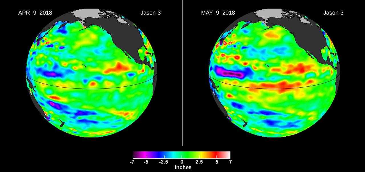
Images from the U.S./European Jason-3 satellite show sea surface height with respect to the seasonal cycle and the long-term trend. Blue/magenta colors indicate lower-than-normal sea levels, while yellow/red colors indicate higher-than-normal sea levels. The April 9, 2018 image (left panel) shows most of the ocean at neutral heights (green). A month later (right panel), a red patch is visible along the equator in the Central Pacific. The red area is a downwelling Kelvin wave, traveling eastward along the equator. https://photojournal.jpl.nasa.gov/catalog/PIA22473
The Sentinel-6A spacecraft sits in its clean room in Germany's IABG space test center. The satellite is being prepared for a scheduled launch in November 2020 from Vandenberg Air Force Base in California. The spacecraft is part of Sentinel-6/Jason-CS, a 10-year mission by U.S and European agencies that will continue to study rising sea levels. The mission consists of two identical satellites, Sentinel-6A and Sentinel-6B, launching five years apart and follows in the footsteps of four other joint U.S.-European satellite missions — TOPEX/Poseidon and Jason-1, Ocean Surface Topography/Jason-2, and Jason-3 — that over the past three decades have documented Earth's oceans rising by an average of 0.1 inches (3 millimeters) per year. Sentinel-6/Jason-CS will study not just sea level change but also changes in ocean circulation, climate variability such as El Niño and La Niña, and weather patterns, including hurricanes and storms. It is being jointly developed by the European Space Agency (ESA), the European Organisation for the Exploitation of Meteorological Satellite (EUMETSAT), NASA and the National Oceanic and Atmospheric Administration (NOAA) with funding support from the European Commission and support from France's National Centre for Space Studies (CNES). NASA's contributions to the Sentinel-6 mission are science instrument payloads for the two Sentinel-6 satellites, launch services for those satellites, ground systems supporting the science instruments operations and support for the international Ocean Surface Topography Science Team. https://photojournal.jpl.nasa.gov/catalog/PIA23549
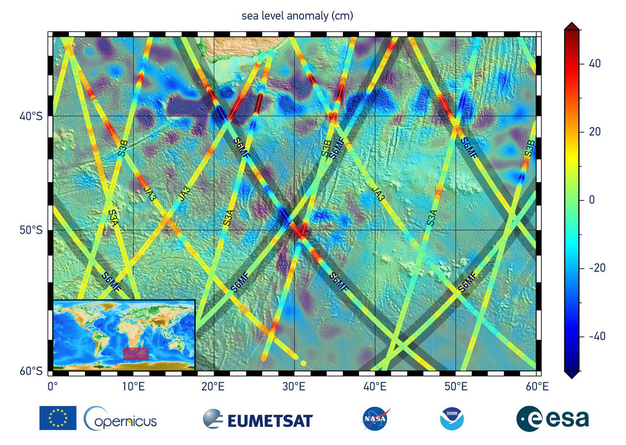
This graphic, released on Dec. 10, 2020, shows the first sea level measurements taken by Sentinel-6 Michael Freilich (S6MF), which launched Nov. 21, 2020. It focuses on the ocean off the southern tip of Africa, where red colors indicate higher sea level relative to blue areas, which are lower. Also included are sea surface height measurements from three other satellites for comparison: Jason-3 (JA3), Sentinel-3A (S3A), and Sentinel-3B (S3B). https://photojournal.jpl.nasa.gov/catalog/PIA24135

Jason Townsend, NASA's Deputy Social Media Manager, reads questions submitted by online social media followers during a prelaunch media briefing for NASA's InSight mission, Thursday, May 3, 2018, at Vandenberg Air Force Base in California. InSight, short for Interior Exploration using Seismic Investigations, Geodesy and Heat Transport, is a Mars lander designed to study the "inner space" of Mars: its crust, mantle, and core. Photo Credit: (NASA/Bill Ingalls)
Jason Hopper of NASA (front row), Jody Ladner of Lockheed Martin (back row, left) and Chris Mulkey of NASA prepare to test the Blue Origin BE-3 engine thrust chamber in the E-1 Test Stand Control Center at John C. Stennis Space Center on Nov. 8. The test was one of 27 conducted in Stennis' E Test Complex the week of Nov. 5.
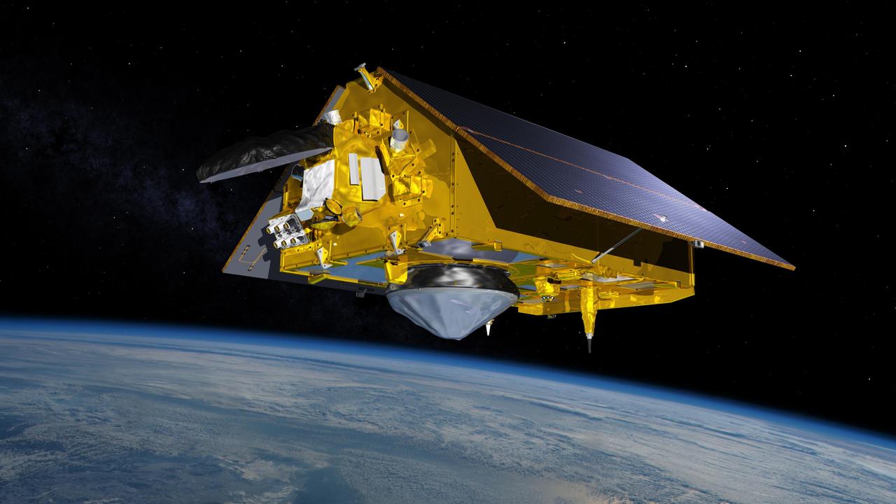
This illustration shows the Sentinel-6 Michael Freilich spacecraft in orbit above Earth with its deployable solar panels extended. As the world's latest ocean-monitoring satellite, it will collect the most accurate data yet on global sea level and how our oceans are rising in response to climate change. The mission will also collect precise data of atmospheric temperature and humidity that will help improve weather forecasts and climate models. Sentinel-6 Michael Freilich extends the near-30-year record of satellite measurements of sea level that was initiated by the U.S.-European TOPEX/Poseidon mission in 1992 and continued with the Jason-1, 2, and 3 series of sea level observation satellites. Launched in 2016, Jason-3 is currently providing data. The satellite is named after Dr. Michael Freilich, the former director of NASA's Earth Science Division and an instrumental figure in advancing ocean observations from space. Sentinel-6 Michael Freilich is one of two identical spacecraft that compose the Sentinel-6/Jason-CS (Continuity of Service) mission developed in partnership with ESA (the European Space Agency). Other partners include the National Oceanic and Atmospheric Administration (NOAA), the intergovernmental European Organisation for the Exploitation of Meteorological Satellites (EUMETSAT), and France's National Centre for Space Studies (CNES). ESA is developing the new Sentinel family of missions to support the operational needs of the European Union's Copernicus program, the EU's Earth observation program managed by the European Commission. The spacecraft's twin, Sentinel-6B, will launch in 2025. https://photojournal.jpl.nasa.gov/catalog/PIA24105
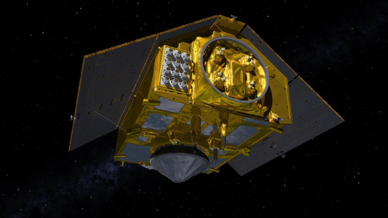
This illustration shows the front of the Sentinel-6 Michael Freilich spacecraft in orbit above Earth with its deployable solar panels extended. As the world's latest ocean-monitoring satellite, it is launching on Nov. 10, 2020, to collect the most accurate data yet on global sea level and how our oceans are rising in response to climate change. The mission will also collect precise data of atmospheric temperature and humidity that will help improve weather forecasts and climate models. The conelike instrument on the bottom (Earth-facing side) of the spacecraft is the satellite's Poseidon-4 radar altimeter. The disklike instrument at the front of the spacecraft is the Advanced Microwave Radiometer (AMR-C). Both instruments will be used together to measure ocean surface height. The gray rectangle with six cones attached at the front-left of the spacecraft is part of the Global Navigation Satellite System - Radio Occultation (GNSS-RO) instrument. Sentinel-6 Michael Freilich extends the near-30-year record of satellite measurements of sea level initiated by the U.S.-European TOPEX/Poseidon mission in 1992 and that continued with the Jason-1, 2, and 3 series of sea level observation satellites. Launched in 2016, Jason-3 is currently providing data. The satellite is named after Dr. Michael Freilich, the former director of NASA's Earth Science Division and an instrumental figure in advancing ocean observations from space. Sentinel-6 Michael Freilich is one of two identical spacecraft that compose the Sentinel-6/Jason-CS (Continuity of Service) mission developed in partnership with ESA (the European Space Agency). Other partners include the National Oceanic and Atmospheric Administration (NOAA), the intergovernmental European Organisation for the Exploitation of Meteorological Satellites (EUMETSAT), and France's National Centre for Space Studies (CNES). ESA is developing the new Sentinel family of missions to support the operational needs of the European Union's Copernicus program, the EU's Earth observation program managed by the European Commission. The spacecraft's twin, Sentinel-6B, will launch in 2025. https://photojournal.jpl.nasa.gov/catalog/PIA24106
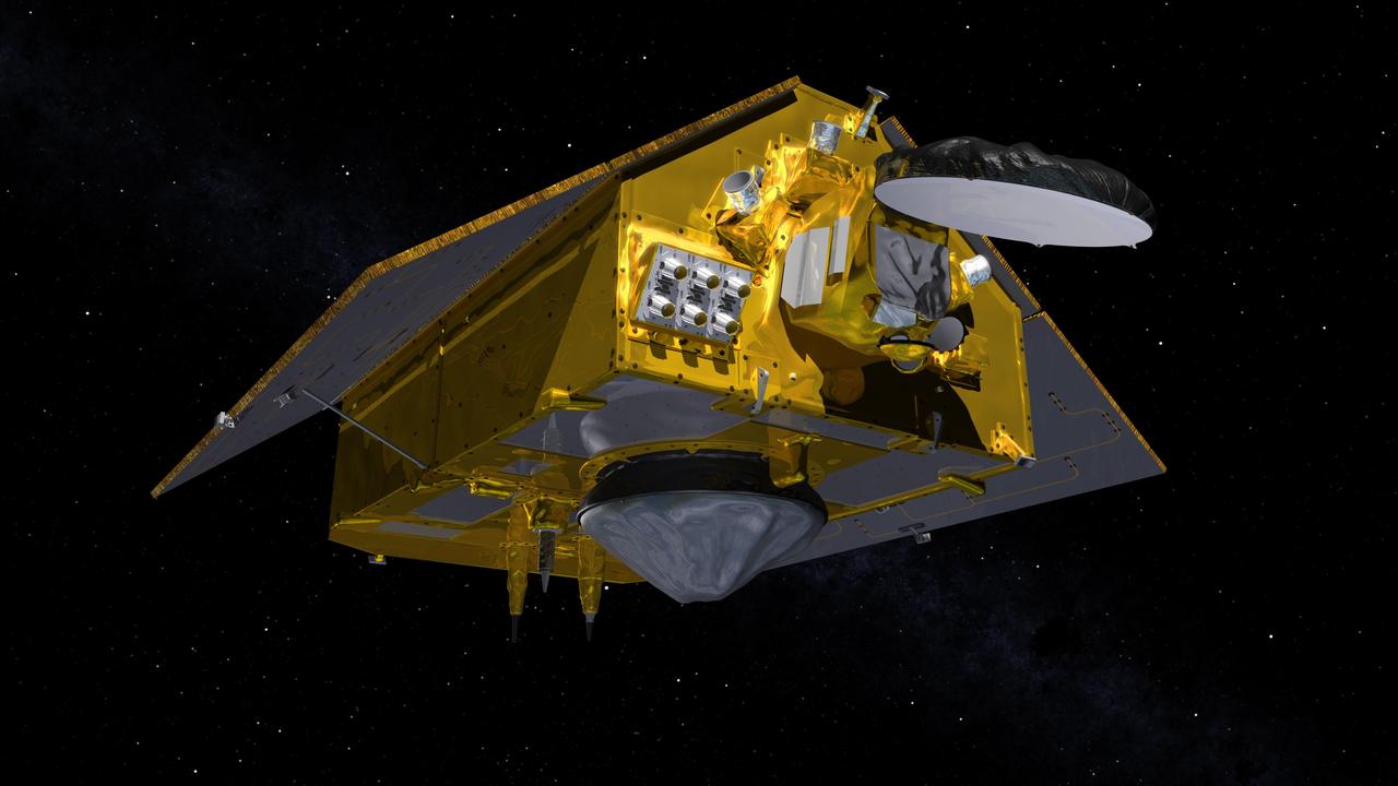
This illustration shows the rear of the Sentinel-6 Michael Freilich spacecraft in orbit above Earth with its deployable solar panels extended. As the world's latest ocean-monitoring satellite, it is launching on Nov. 10, 2020, to collect the most accurate data yet on global sea level and how our oceans are rising in response to climate change. The mission will also collect precise data of atmospheric temperature and humidity that will help improve weather forecasts and climate models. The conelike instrument on the bottom (Earth-facing side) of the spacecraft is the satellite's Poseidon-4 radar altimeter. When used with the Advanced Microwave Radiometer (AMR-C) attached to the front of the spacecraft, both instruments will be used to make precise measurements of sea surface height. The gray rectangle with 12 cones attached at the rear-left of the spacecraft is part of the Global Navigation Satellite System - Radio Occultation (GNSS-RO) instrument. Sentinel-6 Michael Freilich extends the near-30-year record of satellite measurements of sea level initiated by the U.S.-European TOPEX/Poseidon mission in 1992 and that continued with the Jason-1, 2, and 3 series of sea level observation satellites. Launched in 2016, Jason-3 is currently providing data. The satellite is named after Dr. Michael Freilich, the former director of NASA's Earth Science Division and an instrumental figure in advancing ocean observations from space. Sentinel-6 Michael Freilich is one of two identical spacecraft that compose the Sentinel-6/Jason-CS (Continuity of Service) mission developed in partnership with ESA (the European Space Agency). Other partners include the National Oceanic and Atmospheric Administration (NOAA), the intergovernmental European Organisation for the Exploitation of Meteorological Satellites (EUMETSAT), and France's National Centre for Space Studies (CNES). ESA is developing the new Sentinel family of missions to support the operational needs of the European Union's Copernicus program, the EU's Earth observation program managed by the European Commission. The spacecraft's twin, Sentinel-6B, will launch in 2025. https://photojournal.jpl.nasa.gov/catalog/PIA24107
Jason August, International Space Station Mission Evaluation Room manager, talks to NASA Social participants about the International Docking Adapter-3 payload during a What’s On Board science briefing at the agency’s Kennedy Space Center in Florida on July 23, 2019. The briefing was held for SpaceX’s 18th Commercial Resupply Services (CRS-18) mission to the station. The SpaceX Falcon 9 rocket and uncrewed Dragon spacecraft are scheduled to launch July 24, 2019, from Space Launch Complex 40 at Florida’s Cape Canaveral Air Force Station.
Jason August, International Space Station Mission Evaluation Room manager, talks to NASA Social participants about the International Docking Adapter-3 payload during a What’s On Board science briefing at the agency’s Kennedy Space Center in Florida on July 23, 2019. The briefing was held for SpaceX’s 18th Commercial Resupply Services (CRS-18) mission to the station. The SpaceX Falcon 9 rocket and uncrewed Dragon spacecraft are scheduled to launch July 24, 2019, from Space Launch Complex 40 at Florida’s Cape Canaveral Air Force Station.

Jason Craig, Visualization Manager, NASA JPL, talks about Mars InSight online visualization tools during a social media briefing, Sunday, Nov. 25, 2018 at NASA's Jet Propulsion Laboratory in Pasadena, California. InSight, short for Interior Exploration using Seismic Investigations, Geodesy and Heat Transport, is a Mars lander designed to study the "inner space" of Mars: its crust, mantle, and core. InSight is scheduled to touch down on the Red Planet at approximately noon PST (3 p.m. EST) on Nov. 26. Photo Credit: (NASA/Bill Ingalls)
Jason August, International Space Station Mission Evaluation Room manager, talks to NASA Social participants about the International Docking Adapter-3 payload during a What’s On Board science briefing at the agency’s Kennedy Space Center in Florida on July 23, 2019. The briefing was held for SpaceX’s 18th Commercial Resupply Services (CRS-18) mission to the station. The SpaceX Falcon 9 rocket and uncrewed Dragon spacecraft are scheduled to launch July 24, 2019, from Space Launch Complex 40 at Florida’s Cape Canaveral Air Force Station.
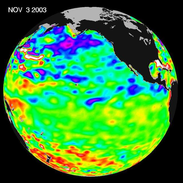
Some climate forecast models indicate there is an above average chance that there could be a weak to borderline El Niño by the end of November 2003. However, the trade winds, blowing from east to west across the equatorial Pacific Ocean, remain strong. Thus, there remains some uncertainty among climate scientists as to whether the warm temperature anomaly will form again this year. The latest remote sensing data from NASA's Jason satellite show near normal conditions across the equatorial Pacific. There are currently no visible signs in sea surface height of an impending El Niño. This equatorial quiet contrasts with the Bering Sea, Gulf of Alaska and U.S. West Coast where lower-than-normal sea surface levels and cool ocean temperatures continue (indicated by blue and purple areas). The image above is a global map of sea surface height, accurate to within 30 millimeters. The image represents data collected and composited over a 10-day period, ending on Nov. 3, 2003. The height of the water relates to the temperature of the water. As the ocean warms, its level rises; and as it cools, its level falls. Yellow and red areas indicate where the waters are relatively warmer and have expanded above sea level, green indicates near normal sea level, and blue and purple areas show where the waters are relatively colder and the surface is lower than sea level. The blue areas are between 5 and 13 centimeters (2 and 5 inches) below normal, whereas the purple areas range from 14 to 18 centimeters (6 to 7 inches) below normal. http://photojournal.jpl.nasa.gov/catalog/PIA04878
This map shows sea level measured by the Sentinel-6 Michael Freilich satellite from June 5 to15. Red areas are regions where sea level is higher than normal, and blue areas indicate areas where it's lower than normal. The measurements are part of a set of data streams that become available to the public hours to a couple of days after the satellite collects them. The difference in when the products become available balances accuracy with delivery timeliness for tasks like forecasting the weather or helping to monitor the formation of hurricanes. The satellite, named after former NASA Earth Science Division Director Michael Freilich, collects its measurements for about 90% of the world's oceans. The spacecraft is one of two satellites that compose the Copernicus Sentinel-6/Jason-CS (Continuity of Service) mission. The second satellite, Sentinel-6B, is slated for launch in 2025. Together, they are the latest in a series of spacecraft starting with TOPEX/Poseidon in 1992 and continuing with the Jason series of satellites that have been gathering precise ocean height measurements for nearly 30 years. Shortly after launch in Nov. 2020, Sentinel-6 Michael Freilich moved into position, trailing the current reference sea level satellite Jason-3 by 30 seconds. Scientists and engineers then spent time cross-calibrating the data collected by both satellites to ensure the continuity of measurements between the two. Once assured of the data quality, Sentinel-6 Michael Freilich will then become the primary sea level satellite. https://photojournal.jpl.nasa.gov/catalog/PIA24533
University of Washington Applied Physics Laboratory Senior Oceanographer Andrey Shcherbina, left, and University of Washington Applied Physics Laboratory Senior Principal Oceanographer Jason Gobat work one of their instruments onboard the Woods Hole Oceanographic Institution's research vessel Knorr on Tuesday, Sept. 4, 2012, in Woods Hole, Mass. Knorr is scheduled to depart on Sept. 6 to take part in the Salinity Processes in the Upper Ocean Regional Study (SPURS). The NASA-sponsored expedition will sail to the North Atlantic's saltiest spot to get a detailed, 3-D picture of how salt content fluctuates in the ocean's upper layers and how these variations are related to shifts in rainfall patterns around the planet. Photo Credit: (NASA/Bill Ingalls)
University of Washington Applied Physics Laboratory Senior Oceanographer Andrey Shcherbina, left, and University of Washington Applied Physics Laboratory Senior Principal Oceanographer Jason Gobat carry one of their instruments onboard the Woods Hole Oceanographic Institution's research vessel Knorr on Tuesday, Sept. 4, 2012, in Woods Hole, Mass. Knorr is scheduled to depart on Sept. 6 to take part in the Salinity Processes in the Upper Ocean Regional Study (SPURS). The NASA-sponsored expedition will sail to the North Atlantic's saltiest spot to get a detailed, 3-D picture of how salt content fluctuates in the ocean's upper layers and how these variations are related to shifts in rainfall patterns around the planet. Photo Credit: (NASA/Bill Ingalls)
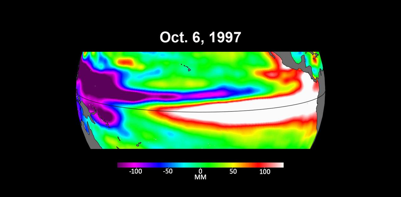
These three maps based on satellite data show sea levels in the Pacific Ocean during developing El Niño events in early October of 1997, 2015, and 2023. Higher-than-average ocean heights are shown in red and white, while lower-than-average heights are blue and purple. The two earlier maps represent the two extreme El Niño events from the past 30 years – the first from 1997 to 1998 and the second from 2015 to 2016. Both caused shifts in global air and ocean temperatures, atmospheric wind and rainfall patterns, and sea level. El Niños are characterized by higher-than-normal sea levels and warmer-than-average ocean temperatures along the equatorial Pacific. Water expands as it warms, so sea levels tend to be higher in places with warmer water. These temperature and sea level conditions can then propagate poleward along the western coasts of the Americas. El Niños can bring wetter conditions to the U.S. Southwest and drought to regions in the western Pacific, including Indonesia. Not all El Niño events are created equal, however, and their impacts vary widely. Satellites like the U.S.-European Sentinel-6 Michael Freilich, which captured the 2023 data, help anticipate those impacts on a global scale by tracking changes in sea surface height in the Pacific Ocean. The TOPEX/Poseidon satellite collected the 1997 data while Jason-2 collected data for the 2015 event. This year's El Niño is still developing, but researchers are looking to the recent past for clues as to how it is shaping up. By October 1997 and 2015, large areas of the central and eastern Pacific had sea levels more than 7 inches (18 centimeters) higher than normal. This year, sea levels are about 2 or 3 inches (5 to 8 centimeters) higher than normal and are elevated over a smaller area compared to the 1997 and 2015 events. Both of the past El Niños reached peak strength in late November or early December, so this year's event may still intensify. Launched in November 2020, Sentinel-6 Michael Freilich is named after former NASA Earth Science Division Director Michael Freilich. The satellite is one of two that compose the Copernicus Sentinel-6/Jason-CS (Continuity of Service) mission. Animation available at https://photojournal.jpl.nasa.gov/catalog/PIA26099