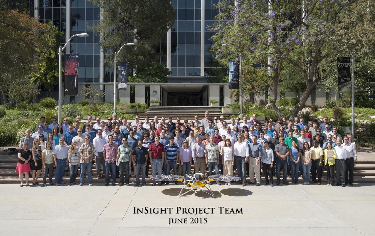
The InSight Team at NASA's Jet Propulsion Laboratory, JPL, in June 2015. The InSight team is comprised of scientists and engineers from multiple disciplines and is a unique collaboration between countries and organizations around the world. The science team includes co-investigators from the U.S., France, Germany, Austria, Belgium, Canada, Japan, Switzerland and the United Kingdom. https://photojournal.jpl.nasa.gov/catalog/PIA22234

Bruce Banerdt, InSight Principal Investigator, NASA JPL, left, Hallie Gengl, Data Visualization Developer, NASA JPL, right, and other NASA InSight team members celebrate after the first image of Mars from the Mars InSight lander, Monday, Nov. 26, 2018 inside the Mission Support Area at NASA's Jet Propulsion Laboratory in Pasadena, California. InSight, short for Interior Exploration using Seismic Investigations, Geodesy and Heat Transport, is a Mars lander designed to study the "inner space" of Mars: its crust, mantle, and core. Photo Credit: (NASA/Bill Ingalls)

Tom Hoffman, InSight Project Manager, NASA JPL, center, talks with other Mars InSight team members during a post-landing press conference, Monday, Nov. 26, 2018 at NASA's Jet Propulsion Laboratory in Pasadena, California. InSight, short for Interior Exploration using Seismic Investigations, Geodesy and Heat Transport, is a Mars lander designed to study the "inner space" of Mars: its crust, mantle, and core. Photo Credit: (NASA/Bill Ingalls)

Bruce Banerdt, InSight Principal Investigator, NASA JPL, center, listens as other Mars InSight team members give remarks during a post-landing press conference, Monday, Nov. 26, 2018 at NASA's Jet Propulsion Laboratory in Pasadena, California. InSight, short for Interior Exploration using Seismic Investigations, Geodesy and Heat Transport, is a Mars lander designed to study the "inner space" of Mars: its crust, mantle, and core. Photo Credit: (NASA/Bill Ingalls)

Sue Smrekar, InSight deputy principal investigator, NASA JPL, and other Mars InSight team members monitor the status of the lander prior to it touching down on Mars, Monday, Nov. 26, 2018 inside the Mission Support Area at NASA's Jet Propulsion Laboratory in Pasadena, California. InSight, short for Interior Exploration using Seismic Investigations, Geodesy and Heat Transport, is a Mars lander designed to study the "inner space" of Mars: its crust, mantle, and core. Photo Credit: (NASA/Bill Ingalls)
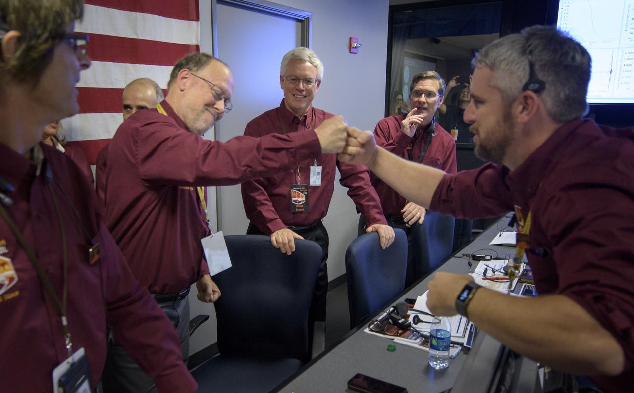
Bruce Banerdt, InSight Principal Investigator, NASA JPL, gives a fist-pump to another Mars InSight team member after receiving confirmation that the Mars InSight lander successfully touched down on the surface of Mars, Monday, Nov. 26, 2018 inside the Mission Support Area at NASA's Jet Propulsion Laboratory in Pasadena, California. InSight, short for Interior Exploration using Seismic Investigations, Geodesy and Heat Transport, is a Mars lander designed to study the "inner space" of Mars: its crust, mantle, and core. Photo Credit: (NASA/Bill Ingalls)
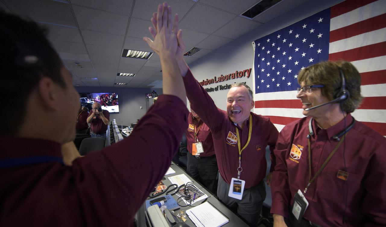
Tom Hoffman, InSight Project Manager, NASA JPL, gives a high-five to other Mars InSight team members after receiving confirmation that the Mars InSight lander successfully touched down on the surface of Mars, Monday, Nov. 26, 2018 inside the Mission Support Area at NASA's Jet Propulsion Laboratory in Pasadena, California. InSight, short for Interior Exploration using Seismic Investigations, Geodesy and Heat Transport, is a Mars lander designed to study the "inner space" of Mars: its crust, mantle, and core. Photo Credit: (NASA/Bill Ingalls)

Bruce Banerdt, InSight Principal Investigator, NASA JPL, left, Hallie Gengl, Data Visualization Developer, seated, and other Mars InSight team members, anxiously watch for the first image to be received from the Mars InSight lander after it touched down on the surface of Mars, Monday, Nov. 26, 2018 inside the Mission Support Area at NASA's Jet Propulsion Laboratory in Pasadena, California. InSight, short for Interior Exploration using Seismic Investigations, Geodesy and Heat Transport, is a Mars lander designed to study the "inner space" of Mars: its crust, mantle, and core. Photo Credit: (NASA/Bill Ingalls)

NASA Headquarters acting director of the Planetary Science Division Lori Glaze, left, talks with Sue Smrekar, InSight deputy principal investigator, NASA JPL, as they and other Mars InSight team members monitor the status of the lander prior to it touching down on Mars, Monday, Nov. 26, 2018 inside the Mission Support Area at NASA's Jet Propulsion Laboratory in Pasadena, California. InSight, short for Interior Exploration using Seismic Investigations, Geodesy and Heat Transport, is a Mars lander designed to study the "inner space" of Mars: its crust, mantle, and core. Photo Credit: (NASA/Bill Ingalls)

Rob Grover, EDL Phase Lead, NASA JPL, holds a jar of good-luck peanuts as he and other Mars InSight team members monitor the status of the lander prior to it touching down on Mars, Monday, Nov. 26, 2018 inside the Mission Support Area at NASA's Jet Propulsion Laboratory in Pasadena, California. InSight, short for Interior Exploration using Seismic Investigations, Geodesy and Heat Transport, is a Mars lander designed to study the "inner space" of Mars: its crust, mantle, and core. Photo Credit: (NASA/Bill Ingalls)
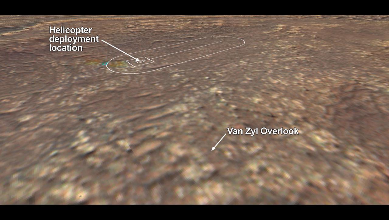
The location where NASA's Mars 2020 Perseverance rover will observe the Ingenuity Mars Helicopter's attempt at powered controlled flight at Mars is called "Van Zyl Overlook," after Jakob van Zyl. Van Zyl was the team's longtime colleague, mentor, and leader at NASA's Jet Propulsion Laboratory in Southern California. He passed away unexpectedly in August 2020, about a month after the launch of Perseverance. Van Zyl joined JPL in 1986 and served in crucial roles at the Lab over a 33-year career, including as director for the Astronomy and Physics Directorate, associate director for project formulation and strategy, and finally director for the Solar System Exploration Directorate. As leader of solar system exploration at JPL, he oversaw successful operations of such NASA missions as Juno, Dawn, and Cassini, the implementation of the Mars InSight lander and MarCO CubeSats, as well as ongoing development of Europa Clipper, Psyche, and all of JPL's instruments and Ingenuity. https://photojournal.jpl.nasa.gov/catalog/PIA24435
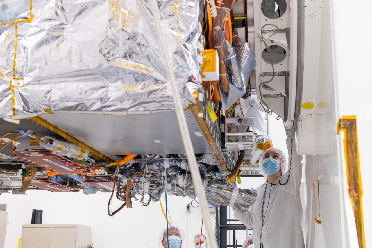
The Solar Electric Propulsion (SEP) Chassis of NASA's Psyche spacecraft is mounted onto a rotation fixture in High Bay 1 of the Spacecraft Assembly Facility at NASA's Jet Propulsion Laboratory in Southern California. This photo was taken March 28, 2021, just after the chassis — a major component of the Psyche spacecraft — was delivered to JPL by Maxar Technologies. Maxar's team in Palo Alto, California, designed and built the chassis, which includes all the primary and secondary structure and the hardware components needed for the high-power electrical system, the propulsion system, the thermal system, guidance and navigation sensors and actuators, and the high-gain antenna. The phase known as assembly test, and launch operations (ATLO) for Psyche is now underway at JPL. In this photo, ATLO Mechanical Lead Michelle Colizzi of JPL oversees the docking of the chassis to the dolly. Over the next year additional hardware will be added to the spacecraft including the command and data handling system, a power distribution assembly, the X-band telecommunications hardware suite, three science instruments (two imagers, two magnetometers, and a Gamma Ray Neutron Spectrometer), and a deep space optical communications technology demonstrator. The spacecraft will finish assembly and then undergo rigorous checkout and testing, before it's shipped to NASA's Kennedy Space Center in Cape Canaveral, Florida, for an August 2022 launch to the main asteroid belt. Psyche will arrive at the metal-rich asteroid of the same name in 2026, orbiting for 21 months to investigate its composition. Scientists think that Psyche is made up of mostly iron and nickel — similar to Earth's core. Exploring the asteroid could give valuable insight into how our own planet and others formed. https://photojournal.jpl.nasa.gov/catalog/PIA24476
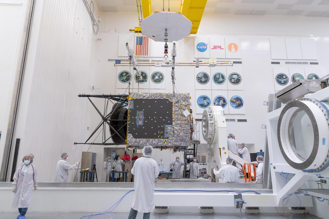
A major component of NASA's Psyche spacecraft has been delivered to the agency's Jet Propulsion Laboratory in Southern California, where the phase known as assembly, test, and launch operations (ATLO) is now underway. Taken on March 28, 2021, this photo shows the Solar Electric Propulsion (SEP) Chassis just after it was delivered to JPL by Maxar Technologies. Here, the chassis is about to be attached to the dolly in High Bay 1 of JPL's Spacecraft Assembly Facility. Maxar's team in Palo Alto, California, designed and built the SEP Chassis, which includes all the primary and secondary structure and the hardware components needed for the high-power electrical system, the propulsion system, the thermal system, guidance and navigation sensors and actuators, and the high-gain antenna. Over the next year additional hardware will be added to the spacecraft, including the command and data handling system, a power distribution assembly, the X-band telecommunications hardware suite, three science instruments (two imagers, two magnetometers, and a Gamma Ray Neutron Spectrometer), and a deep space optical communications technology demonstrator. The spacecraft will finish assembly and then undergo rigorous checkout and testing before being shipped to NASA's Kennedy Space Center in Cape Canaveral, Florida, for an August 2022 launch to the main asteroid belt. Psyche will arrive at the metal-rich asteroid of the same name in 2026, orbiting for 21 months to investigate its composition. Scientists think that Psyche is made up of mostly iron and nickel — similar to Earth's core. Exploring the asteroid could give valuable insight into how our own planet and others formed. https://photojournal.jpl.nasa.gov/catalog/PIA24474

A major component of NASA's Psyche spacecraft has been delivered to NASA's Jet Propulsion Laboratory in Southern California, where the phase known as assembly, test, and launch operations (ATLO) is now underway. This photo, shot March 28, 2021 shows engineers and technicians preparing to move the Solar Electric Propulsion (SEP) Chassis from its shipping container to a dolly in High Bay 1 of JPL's Spacecraft Assembly Facility. The photo was captured just after the chassis was delivered to JPL by Maxar Technologies. Maxar's team in Palo Alto, California, designed and built the SEP Chassis, which includes all the primary and secondary structure and the hardware components needed for the high-power electrical system, the propulsion system, the thermal system, guidance and navigation sensors and actuators, and the high-gain antenna. Over the next year, additional hardware will be added to the spacecraft including the command and data handling system, a power distribution assembly, the X-band telecommunications hardware suite, three science instruments (two imagers, two magnetometers, and a gamma ray neutron Spectrometer), and a deep space optical communications technology demonstrator. The spacecraft will finish assembly and then undergo rigorous checkout and testing before being shipped to NASA's Kennedy Space Center in Cape Canaveral, Florida, for an August 2022 launch to the main asteroid belt. Psyche will arrive at the metal-rich asteroid of the same name in 2026, orbiting for 21 months to investigate its composition. Scientists think that Psyche is made up of mostly iron and nickel — similar to Earth's core. Exploring the asteroid could give valuable insight into how our own planet and others formed. https://photojournal.jpl.nasa.gov/catalog/PIA24475
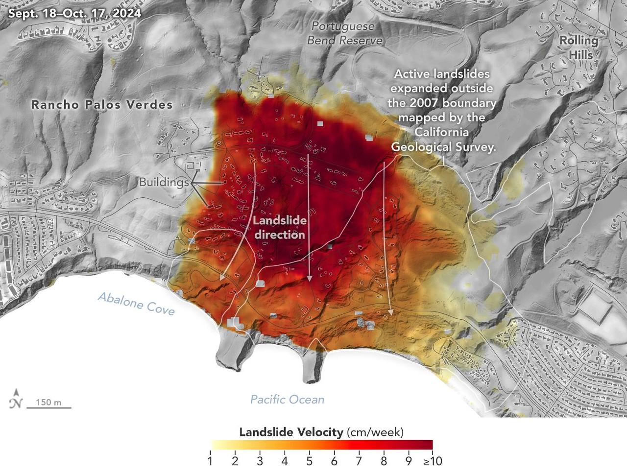
Researchers at NASA's Jet Propulsion Laboratory in Southern California used data from an airborne radar to measure the movement of the slow-moving landslides on the Palos Verdes Peninsula in Los Angeles County. The analysis determined that, during a period of four weeks in the fall of 2024, land in the residential area slid toward the ocean by as much as 4 inches (10 centimeters) per week. Portions of the peninsula, which juts into the Pacific Ocean just south of the city of Los Angeles, is part of an ancient complex of landslides and has been moving for at least the past six decades, affecting hundreds of buildings in local communities. The motion accelerated and the active area expanded following record-breaking rainfall in Southern California in 2023 and another heavy-precipitation winter in 2024. To create this visualization, the Advanced Rapid Imaging and Analysis (ARIA) team used data from four flights of NASA's Uninhabited Aerial Vehicle Synthetic Aperture Radar (UAVSAR) that took place between Sept. 18 and Oct. 17. The UAVSAR instrument was mounted to a Gulfstream III jet flown out of NASA's Armstrong Flight Research Center in Edwards, California, and the four flights were planned to estimate the speed and direction of the landslides in three dimensions. In the image, colors indicate how fast parts of the landslide complex were moving in late September and October, with the darkest reds indicating the highest speeds. The arrows represent the direction of horizontal motion. The white solid lines are the boundaries of active landslide areas as defined in 2007 by the California Geological Survey. The insights from the UAVSAR flights were part of a package of analyses by the ARIA team that also used data from ESA's (the European Space Agency's) Copernicus Sentinel-1A/B satellites. The analyses were provided to California officials to support the state's response to the landslides and made available to the public at NASA's Disaster Mapping Portal. The ARIA mission is a collaboration between JPL and Caltech, which manages JPL for NASA, to leverage radar and optical remote-sensing, GPS, and seismic observations for science as well as to aid in disaster response. The project investigates the processes and impacts of earthquakes, volcanoes, landslides, fires, subsurface fluid movement, and other natural hazards. UAVSAR has flown thousands of radar missions around the world since 2007 studying phenomena such as glaciers and ice sheets, vegetation in ecosystems, and natural hazards like earthquakes, volcanoes, and landslides. https://photojournal.jpl.nasa.gov/catalog/PIA26495
STS059-S-026 (11 April 1994) --- This is an image of Death Valley, California, centered at 36.629 degrees north latitude, 117.069 degrees west longitude. The image shows Furnace Creek alluvial fan and Furnace Creek Ranch at the far right, and the sand dunes near Stove Pipe Wells at the center. The dark fork-shaped feature between Furnace Creek fan and the dunes is a smooth flood-plain which encloses Cottonball Basin. The SIR-C/X-SAR supersite is an area of extensive field investigations and has been visited by both Space Radar Lab astronaut crews. Elevations in the Valley range from 70 meters below sea level, the lowest in the United States, to more than 3300 meters above sea level. Scientists are using SIR-C/X-SAR data from Death Valley to help answer a number of different questions about the Earth's geology. One question concerns how alluvial fans are formed and change through time under the influence of climatic changes and earthquakes. Alluvial fans are gravel deposits that wash down from the mountains over time. They are visible in the image as circular, fan-shaped bright areas extending into the darker valley floor from the mountains. Information about the alluvial fans help scientists study Earth's ancient climate. Scientists know the fans are bulit up through climatic and tectonic processes and they will use the SIR-C/X-SAR data to understand the nature and rates of weathering processes on the fans, soil formation, and the transport of sand and dust by the wind. SIR-C/X-SAR's sensitivity to centimeter-scale (or inch-scale) roughness provides detailed maps of surface texture. Such information can be used to study the occurrence and movement of dust storms and sand dunes. the goal of these studies is to gain a better understanding of the record of past climatic changes and the effects of those changes on a sensitive environment. This may lead to a better ability to predict future response of the land to different potential global cimate-change scenarios. Death Valley is also one of the primary calibration sites for SIR-C/X-SAR. The bright dots near the center of the image are corner reflectors that have been set-up to calibrate the radar as the Shuttle passes overhead. Thirty triangular-shaped reflectors (they look like aluminum pyramids) have been deployed by the calibration team from JPL over a 40 kilometer by 40 kilometer area in and around Death Valley. The calibration team will also deploy transponders (electronic reflectors) and recievers to measure the radar signals from SIR-C/X-SAR on the ground. Spaceborne Imaging Radar-C and X-Synthetic Aperture Radar (SIR-C/X-SAR) is part of NASA's Mission to Planet Earth (MTPE). The radars illuminate Earth with microwaves allowing detailed observations at any time, regardless of weather or sunlight conditions. SIR-C/X-SAR uses three microwave wavelengths: L-Band (24 cm), C-Band (6 cm), and X-Band (3 cm). The multi-frequency data will be used by the international scientific community to better understand the global environment and how it is changing. The SIR-C/X-SAR data, complemented by aircraft and ground studies, will give scientists clearer insights into those environmental changes which are caused by nature and those changes which are induced by human activity. SIR-C was develpoed by NASA's Jet Propulsion Laboratory (JPL). X-SAR was developed by the Dornire and Alenia Spazio Companies for the German Space Agency, Deutsche Agentur fuer Raumfahrtangelegenheiten (DARA), and the Italian Space Agency, Agenzia Spaziale Italiana (ASI). JPL Photo ID: P-43883

STS059-S-074 (15 April 1994) --- This color composite C-Band and L-Band image of the Kilauea volcano on the big island of Hawaii was acquired by the Spaceborne Imaging Radar-C and X-Band Synthetic Aperture Radar (SIR-C/X-SAR) flying on the Space Shuttle Endeavour. The city of Hilo can be seen at the top. The image shows the different types of lava flows around the crater Pu'u O'o. Ash deposits which erupted in 1790 from the summit of Kilauea volcano show up as dark in this image, and fine details associated with lava flows which erupted in 1919 and 1974 can be seen to the south of the summit in an area called the Ka'u Desert. In addition, the other historic lava flows created in 1881 and 1984 from Mauna Loa volcano (out of view to the left of this image) can easily be seen despite the fact that the surrounding area is covered by forest. Such information will be used to map the extent of such flows, which can pose a hazard to the subdivisions of Hilo. Highway 11 is the linear feature running from Hilo to the Kilauea volcano. The Kilauea volcano has been almost continuously active for more than the last 11 years. Field teams that were on the ground specifically to support these radar observations report that there was vigorous surface activity about 400 meters (one-quarter mile) inland from the coast. A moving lava flow about 200 meters (660 feet) in length was observed at the time of the Shuttle over flight, raising the possibility that subsequent images taken during this mission will show changes in the landscape. SIR-C/X-SAR is part of NASA's Mission to Planet Earth (MTPE). SIR-C/X-SAR radars illuminate Earth with microwaves allowing detailed observations at any time, regardless of weather or sunlight conditions. SIR-C/X-SAR uses three microwave wavelengths: L-Band (24 cm), C-Band (6 cm), and X-Band (3 cm). The multi-frequency data will be used by the international scientific community to better understand the global environment and how it is changing. The SIR-C/X-SAR data, complemented by aircraft and ground studies, will give scientists clearer insights into those environmental changes which are caused by nature and those changes which are induced by human activity. SIR-C was developed by NASA's Jet Propulsion Laboratory (JPL). X-SAR was developed by the Dornire and Alenia Spazio Companies for the German Space Agency, Deutsche Agentur fuer Raumfahrtangelegenheiten (DARA), and the Italian Space Agency, Agenzia Spaziale Italiana (ASI). JPL Photo ID: P-43918