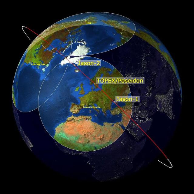
This image is a family portrait of Topex/Poseidon, Jason-1 and Ocean Surface Topography Mission/Jason-2 OSTM/Jason-2, NASA satellites that have measured global sea surface heights since 1992.
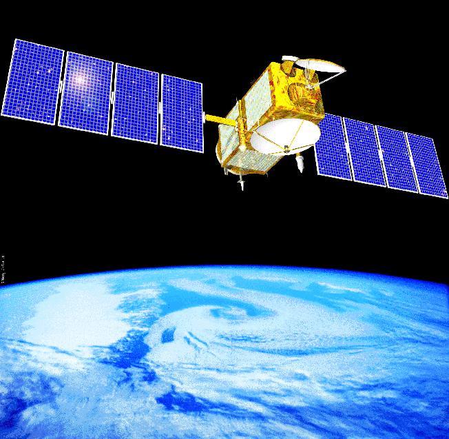
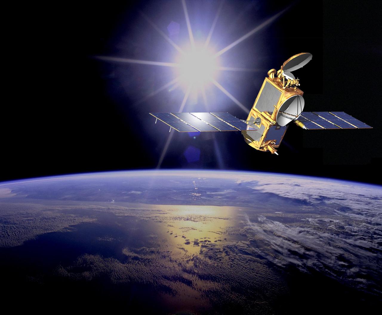
Artist concept of NASA's Jason 1 spacecraft from December, 2002. http://photojournal.jpl.nasa.gov/catalog/PIA04237
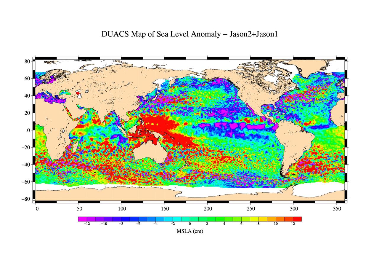
This is the first global map of ocean surface topography produced with data from the new interleaved tandem mission of NASA Jason-1 and Ocean Surface Topography Mission OSTM/Jason-2 satellites.
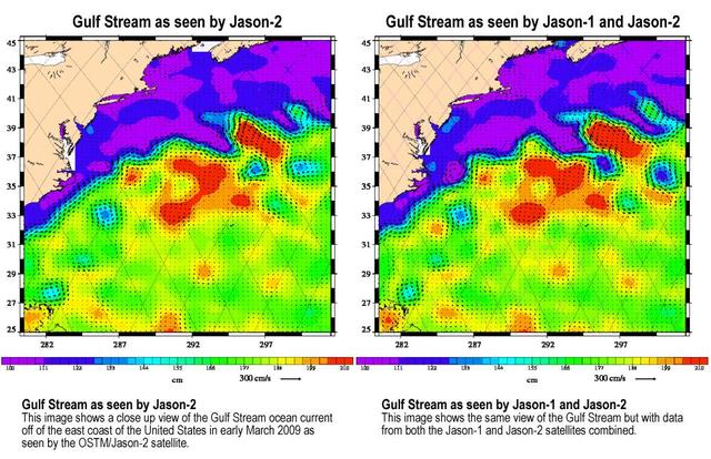
Created with altimeter data from NASA's Ocean Surface Topography Mission (OSTM)/Jason-2 satellite and the Jason-1 satellite, this image shows a portion of the Gulf Stream off the east coast of the United States. It demonstrates how much more detail is visible in the ocean surface when measured by two satellites than by one alone. The image on the left was created with data from OSTM/Jason-2. The image on the right is the same region but made with combined data from OSTM/Jason-2 and Jason-1.It shows the Gulf Stream's eddies and rings much more clearly. This image is a product of the new interleaved tandem mission of the Jason-1 and Ocean Surface Topography Mission (OSTM)/Jason-2 satellites. (The first global map from this tandem mission is available at PIA11859.) In January 2009, Jason-1 was maneuvered into orbit on the opposite side of Earth from its successor, OSTM/Jason-2 satellite. It takes 10 days for the satellites to cover the globe and return to any one place over the ocean. So, in this new tandem configuration, Jason-1 flies over the same region of the ocean that OSTM/Jason-2 flew over five days earlier. Its ground tracks fall mid-way between those of Jason-2, which are about 315 kilometers (195 miles) apart at the equator. Working together, the two spacecraft measure the surface topography of the ocean twice as often as would be possible with one satellite, and over a 10-day period, they return twice the amount of detailed measurements. Combining data from the two satellites makes it possible to map smaller, more rapidly changing features than one satellite could alone. These images show sea-level anomaly data from the first 14 days of the interleaved orbit of Jason-1 and OSTM/Jason-2, the period beginning on Feb. 20, 2009. An anomaly is a departure from a value averaged over a long period of time. Red and yellow are regions where sea levels are higher than normal. Purple and dark blue show where sea levels are lower. A higher-than-normal sea surface is usually a sign of warm waters below, while lower sea levels indicate cooler than normal temperatures. http://photojournal.jpl.nasa.gov/catalog/PIA11997
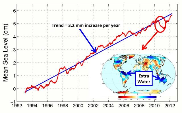
This figure shows changes in global mean sea level as measured by satellite altimetry NASA/CNES Topex/Poseidon and Jason-1; and NASA/CNES/NOAA/EUMETSAT Jason-2 between 1992 to 2012.
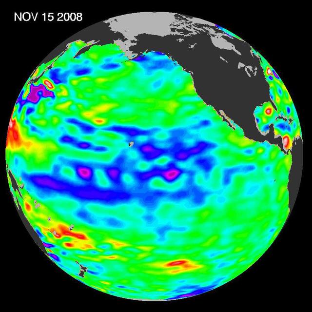
The latest image of sea-surface height measurements from NASA U.S./French Jason-1 oceanography satellite shows the Pacific Ocean remains locked in a strong, cool phase of the Pacific Decadal Oscillation.
This sea surface height map of the Gulf of Mexico and the northwestern Caribbean Sea, with the Florida peninsula on the upper right, is based on altimeter data from three satellites including NASA Jason-1.
Recent sea-level height data from NASA Jason-1 altimetric satellite show that continuing weaker-than-normal trade winds in the western and central equatorial Pacific have triggered another strong, eastward moving, warm Kelvin wave.
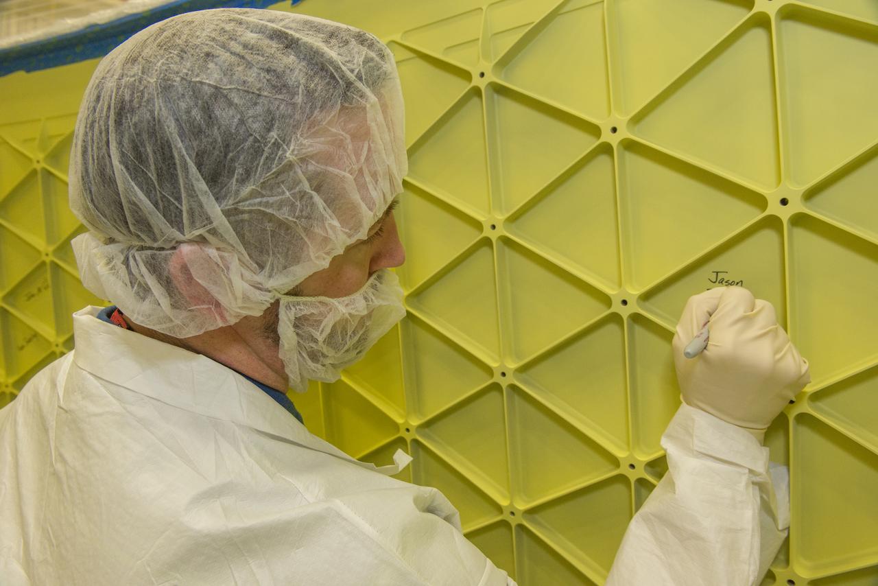
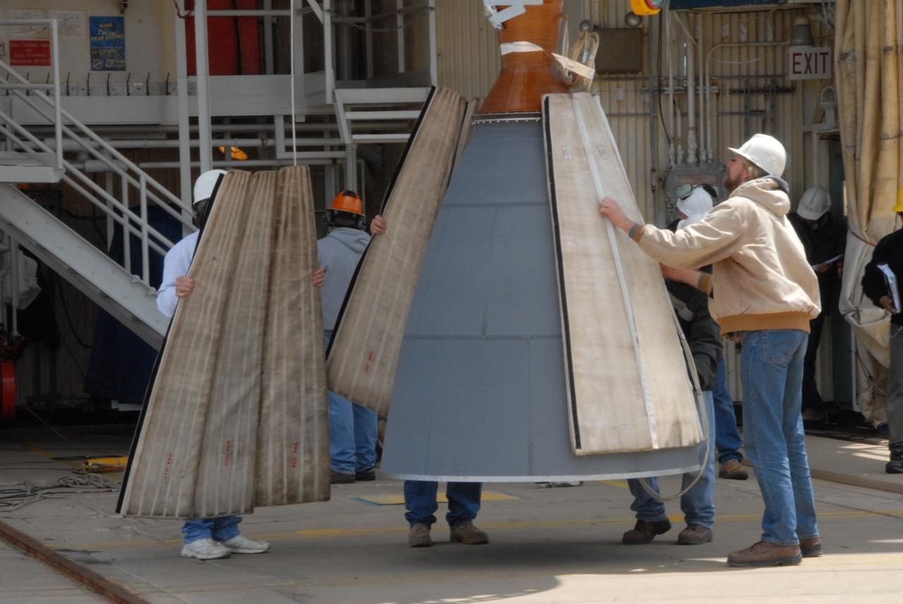
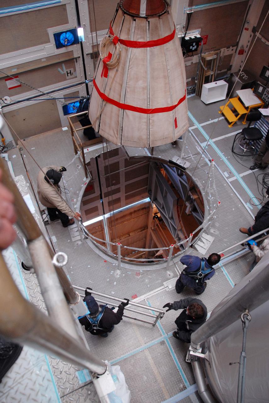
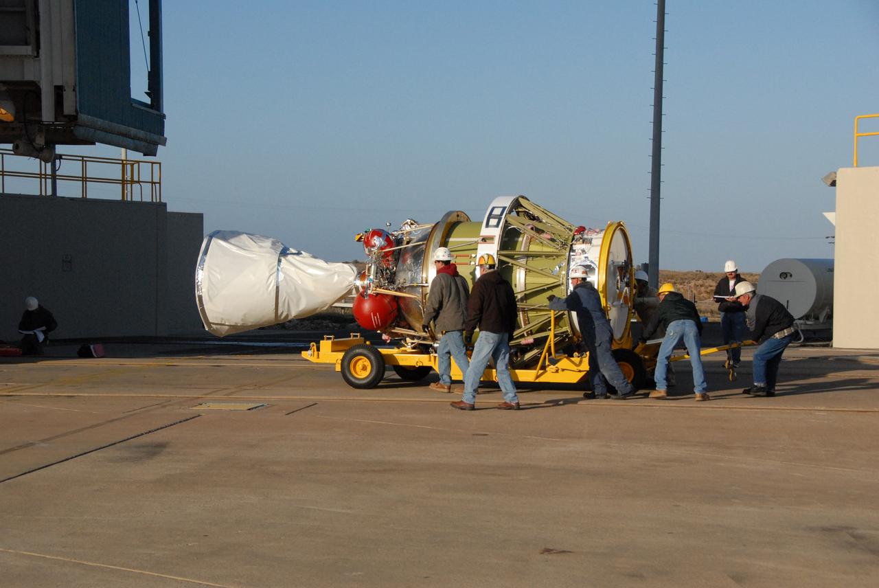
JASON ELDRIDGE, AN ERC INCORPORATED EMPLOYEE SUPPORTING THE MATERIALS & PROCESSES LABORATORY AT NASA'S MARSHALL SPACE FLIGHT CENTER, SIGNS HIS NAME ON THE INTERIOR OF THE ADAPTER THAT WILL CONNECT THE ORION SPACECRAFT TO A UNITED LAUNCH ALLIANCE DELTA IV ROCKET FOR EXPLORATION FLIGHT TEST (EFT)-1. MARSHALL CENTER TEAM MEMBERS WHO WERE INVOLVED IN THE DESIGN, CONSTRUCTION AND TESTING OF THE ADAPTER HAD THE OPPORTUNITY TO AUTOGRAPH IT BEFORE THE HARDWARE IS SHIPPED TO NASA'S KENNEDY SPACE CENTER IN FEBRUARY. ELDRIDGE WAS ON A TEAM THAT PERFORMED ULTRASONIC INSPECTIONS ON THE ADAPTER'S WELDS -- ENSURING THEY ARE STRUCTURALLY SOUND. EFT-1, SCHEDULED FOR 2014, WILL PROVIDE EARLY EXPERIENCE FOR NASA SPACE LAUNCH SYSTEM (SLS) HARDWARE AHEAD OF THE ROCKET'S FIRST FLIGHT IN 2017.
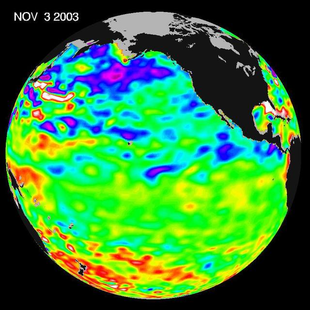
Some climate forecast models indicate there is an above average chance that there could be a weak to borderline El Niño by the end of November 2003. However, the trade winds, blowing from east to west across the equatorial Pacific Ocean, remain strong. Thus, there remains some uncertainty among climate scientists as to whether the warm temperature anomaly will form again this year. The latest remote sensing data from NASA's Jason satellite show near normal conditions across the equatorial Pacific. There are currently no visible signs in sea surface height of an impending El Niño. This equatorial quiet contrasts with the Bering Sea, Gulf of Alaska and U.S. West Coast where lower-than-normal sea surface levels and cool ocean temperatures continue (indicated by blue and purple areas). The image above is a global map of sea surface height, accurate to within 30 millimeters. The image represents data collected and composited over a 10-day period, ending on Nov. 3, 2003. The height of the water relates to the temperature of the water. As the ocean warms, its level rises; and as it cools, its level falls. Yellow and red areas indicate where the waters are relatively warmer and have expanded above sea level, green indicates near normal sea level, and blue and purple areas show where the waters are relatively colder and the surface is lower than sea level. The blue areas are between 5 and 13 centimeters (2 and 5 inches) below normal, whereas the purple areas range from 14 to 18 centimeters (6 to 7 inches) below normal. http://photojournal.jpl.nasa.gov/catalog/PIA04878

SpaceX Crew-1 NASA astronauts, from left to right, Shannon Walker, Victor Glover, Mike Hopkins, and Japan Aerospace Exploration Agency (JAXA) astronaut Soichi Noguchi, right, presents a montage from their mission to Capitol Police officer Jason Conlon at the Destination Station mobile exhibition on Capitol Hill, Wednesday, Nov. 17, 2021, in Washington. Walker, Glover, Hopkins, and Noguchi launched on the first crew rotation mission to the International Space Station for SpaceX’s Falcon 9 and Crew Dragon spacecraft as part of the agency’s Commercial Crew Program and spent 168 days in space across Expeditions 64 and 65. Photo Credit: (NASA/Aubrey Gemignani)

The tropical Pacific Ocean is beginning to exhibit the characteristics of a developing La Niña condition.
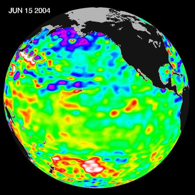
Recent sea level height data from NASA U.S./France Jason altimetric satellite during a 10-day cycle ending June 15, 2004.
Since the weak El Niño event of last winter, the equatorial Pacific has cooled and oceanographers have been on a La Niña watch. Thus far, equatorial waters have seesawed between cooling and the present slight warming.
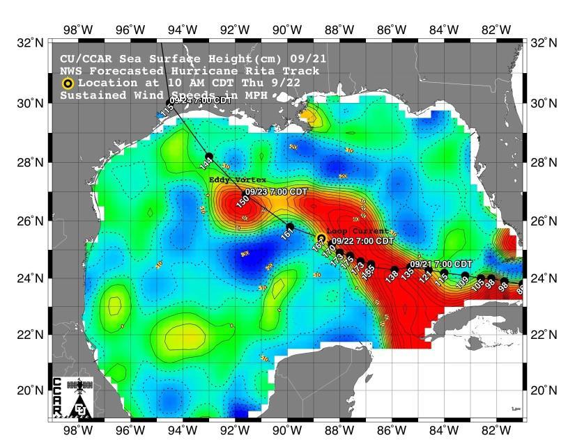
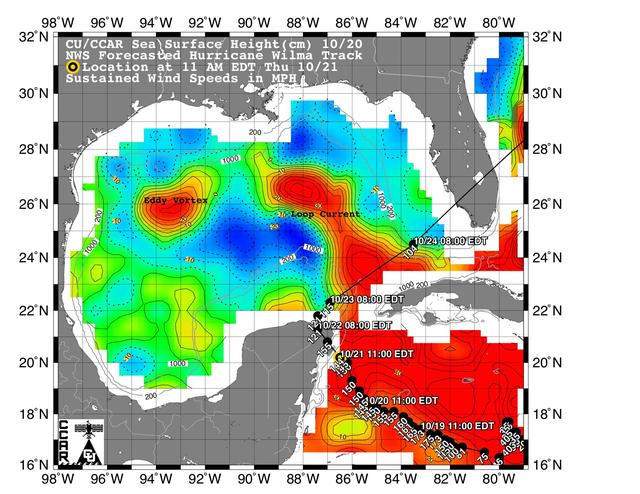
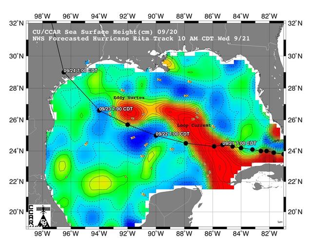
This sea surface height map of the Gulf of Mexico, with the Florida peninsula on the right and the Texas-Mexico Gulf Coast on the left, is based on altimeter data from four satellites including NASA’s Topex/Poseidon and Jason. Red indicates a strong circulation of much warmer waters, which can feed energy to a hurricane. This area stands 35 to 60 centimeters (about 13 to 23 inches) higher than the surrounding waters of the Gulf. The actual track of a hurricane is primarily dependent upon steering winds, which are forecasted through the use of atmospheric models. However, the interaction of the hurricane with the upper ocean is the primary source of energy for the storm. Hurricane intensity is therefore greatly affected by the upper ocean temperature structure and can exhibit explosive growth over warm ocean currents and eddies. Eddies are currents of water that run contrary to the direction of the main current. According to the forecasted track through the Gulf of Mexico, Hurricane Rita will continue crossing the warm waters of a Gulf of Mexico circulation feature called the Loop Current and then pass near a warm-water eddy called the Eddy Vortex, located in the north central Gulf, south of Louisiana. http://photojournal.jpl.nasa.gov/catalog/PIA06427
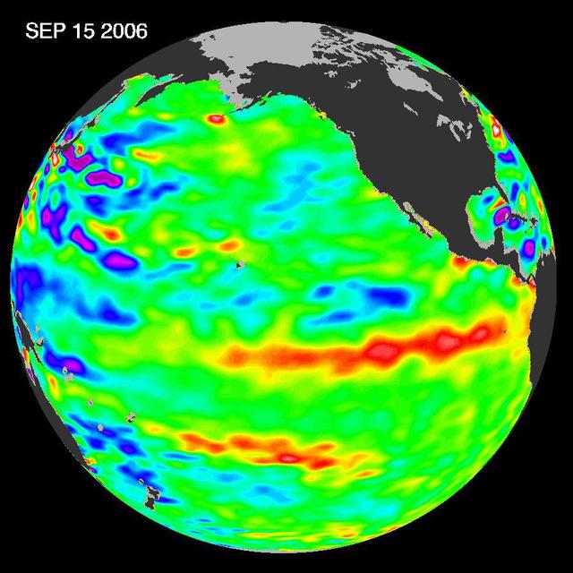
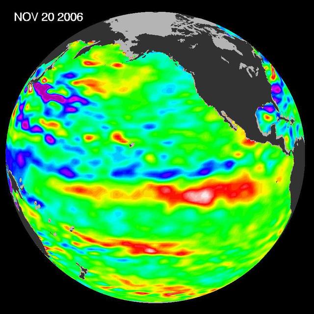
In September 2006, NASA satellite data indicated that El Niño had returned to the tropical Pacific Ocean, although it was relatively weak.
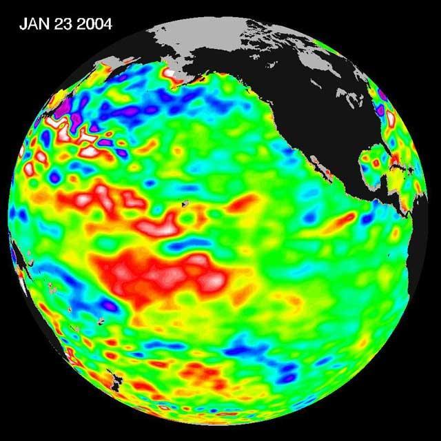
The latest remote sensing data from NASA's Jason satellite show that the equatorial Pacific sea surface levels are higher, indicating warmer sea surface temperatures in the central and west Pacific Ocean. This pattern has the appearance of La Niña rather than El Niño. This contrasts with the Bering Sea, Gulf of Alaska and U.S. West Coast where lower-than-normal sea surface levels and cool ocean temperatures continue (indicated by blue and purple areas). The image above is a global map of sea surface height, accurate to within 30 millimeters. The image represents data collected and composited over a 10-day period, ending on Jan 23, 2004. The height of the water relates to the temperature of the water. As the ocean warms, its level rises; and as it cools, its level falls. Yellow and red areas indicate where the waters are relatively warmer and have expanded above sea level, green indicates near normal sea level, and blue and purple areas show where the waters are relatively colder and the surface is lower than sea level. The blue areas are between 5 and 13 centimeters (2 and 5 inches) below normal, whereas the purple areas range from 14 to 18 centimeters (6 to 7 inches) below normal. http://photojournal.jpl.nasa.gov/catalog/PIA05071
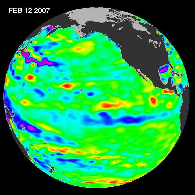
New data of sea-level heights from early February, 2007, by the Jason altimetric satellite show that the tropical Pacific Ocean has transitioned from a warm El Niño to a cool La Niña condition during the prior two months
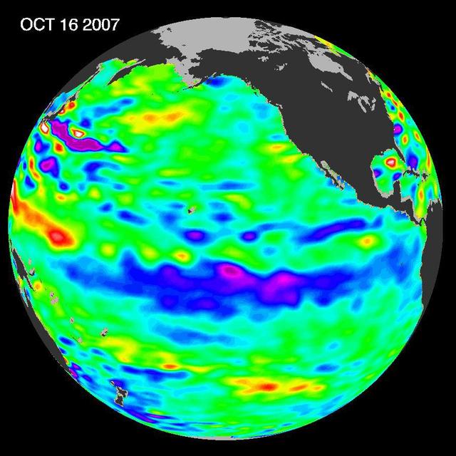
The tropical Pacific Ocean remains in the grips of a cool La Niña, as shown by new data of sea-level heights from mid-October of 2007, collected by NASA U.S-French Jason altimetric satellite.
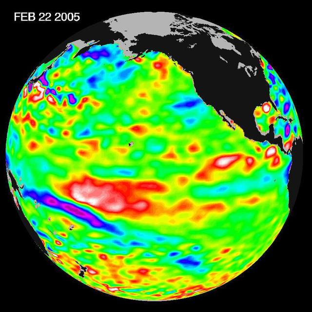
Recent sea-level height data from NASA U.S./France Jason altimetric satellite during a 10-day cycle ending February 22, 2005, show that the central equatorial Pacific continues to exhibit an area of higher-than-normal sea surface heights.
This sea surface height map of the Gulf of Mexico, with the Florida peninsula on the right and the Texas-Mexico Gulf Coast on the left, is based on altimeter data from four satellites including NASA’s Topex/Poseidon and Jason.

Tropical Cyclone Heat Potential TCHP field in the Gulf of Mexico during September 22, 2005. The path of Hurricane Rita is indicated with circles spaced every 3 hours with their size and color representing intensity see legend.
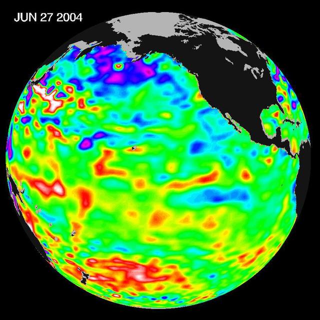
Recent sea level height data from NASA U.S./France Jason altimetric satellite during a 10-day cycle ending June 27, 2004.
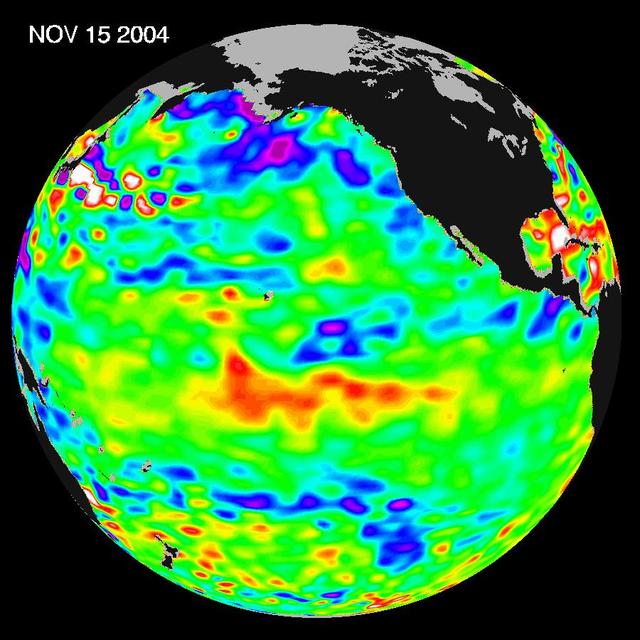
Recent sea-level height data from NASA U.S./France Jason altimetric satellite during a 10-day cycle ending November 15, 2004.
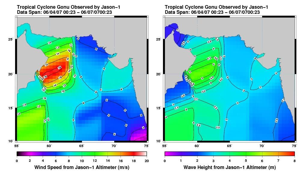
This pair of images from the radar altimeter instrument on NASA U.S./France Jason mission reveals information on wind speeds and wave heights of Tropical Cyclone Gonu, which reached Category 5 strength in the Arabian Sea prior to landfall in early June.
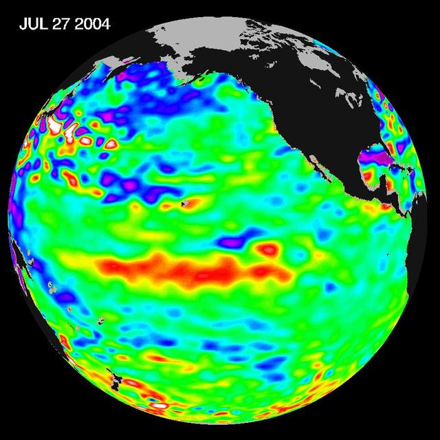
Sea-level height data from NASA U.S./France Jason altimetric satellite during a 10-day cycle ending July 27, 2004, show weaker than normal trade winds in the western and central equatorial Pacific have triggered an eastward moving, warm Kelvin wave.
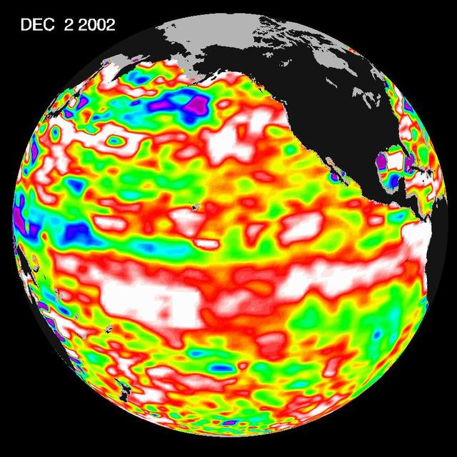
The latest image from NASA Jason oceanography satellite, taken during a 10-day collection cycle ending December 2, 2002, shows the Pacific dominated by two significant areas of higher-than-normal sealevel warmer ocean temperatures.
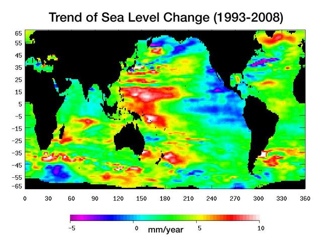
Warming water and melting land ice have raised global mean sea level 4.5 centimeters 1.7 inches from 1993 to 2008. But the rise is by no means uniform.
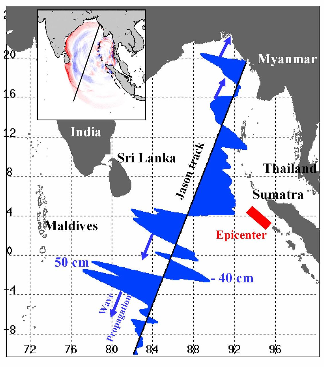
Displayed in blue color is the height of sea surface (shown in blue) measured by the Jason satellite two hours after the initial magnitude 9 earthquake hit the region (shown in red) southwest of Sumatra on December 26, 2004. The data were taken by a radar altimeter onboard the satellite along a track traversing the Indian Ocean when the tsunami waves had just filled the entire Bay of Bengal (see the model simulation inset image). The data shown are the changes of sea surface height from previous observations made along the same track 20-30 days before the earthquake, reflecting the signals of the tsunami waves. The maximum height of the leading wave crest was about 50 cm (or 1.6 ft), followed by a trough of sea surface depression of 40 cm. The directions of wave propagation along the satellite track are shown by the blue arrows. http://photojournal.jpl.nasa.gov/catalog/PIA07219
One of the strongest La Niñas in many years is slowly weakening but continues to blanket the Pacific Ocean near the equator, as shown by new sea-level height data collected by NASA U.S.-French Jason oceanographic satellite.
In early 2006, a weak La Niña event kept the temperatures in the Pacific Ocean along the equator a little cooler than normal.
The U.S./European Jason-3 satellite has produced its first map of sea surface height, which corresponds well to data from its predecessor, Jason-2. Higher-than-normal sea levels are red; lower-than-normal sea levels are blue. El Niño is visible as the red blob in the eastern equatorial Pacific. Extending the timeline of ocean surface topography measurements begun by the Topex/Poseidon and Jason 1 and 2 satellites, Jason 3 will make highly detailed measurements of sea-level on Earth to gain insight into ocean circulation and climate change. http://photojournal.jpl.nasa.gov/catalog/PIA20532
An artist concept of the Ocean Surface Topography Mission/Jason 2 Earth satellite. The Ocean Surface Topography Mission/Jason 2 is an Earth satellite designed to make observations of ocean topography for investigations into sea-level rise and the relationship between ocean circulation and climate change. The satellite also provides data on the forces behind such large-scale climate phenomena as El Niño and La Niña. The mission is a follow-on to the French-American Jason 1 mission, which began collecting data on sea-surface levels in 1992. http://photojournal.jpl.nasa.gov/catalog/PIA18158
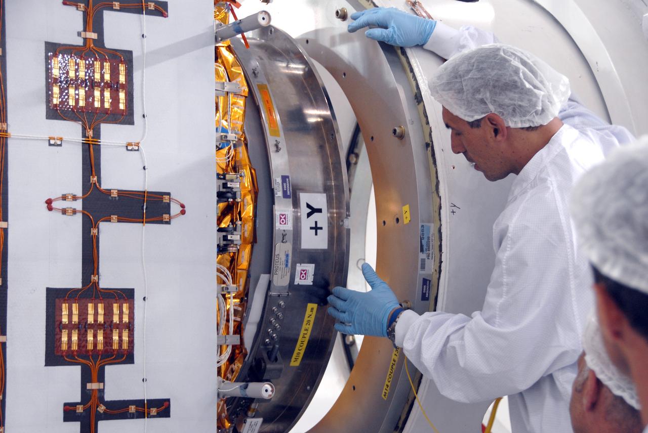
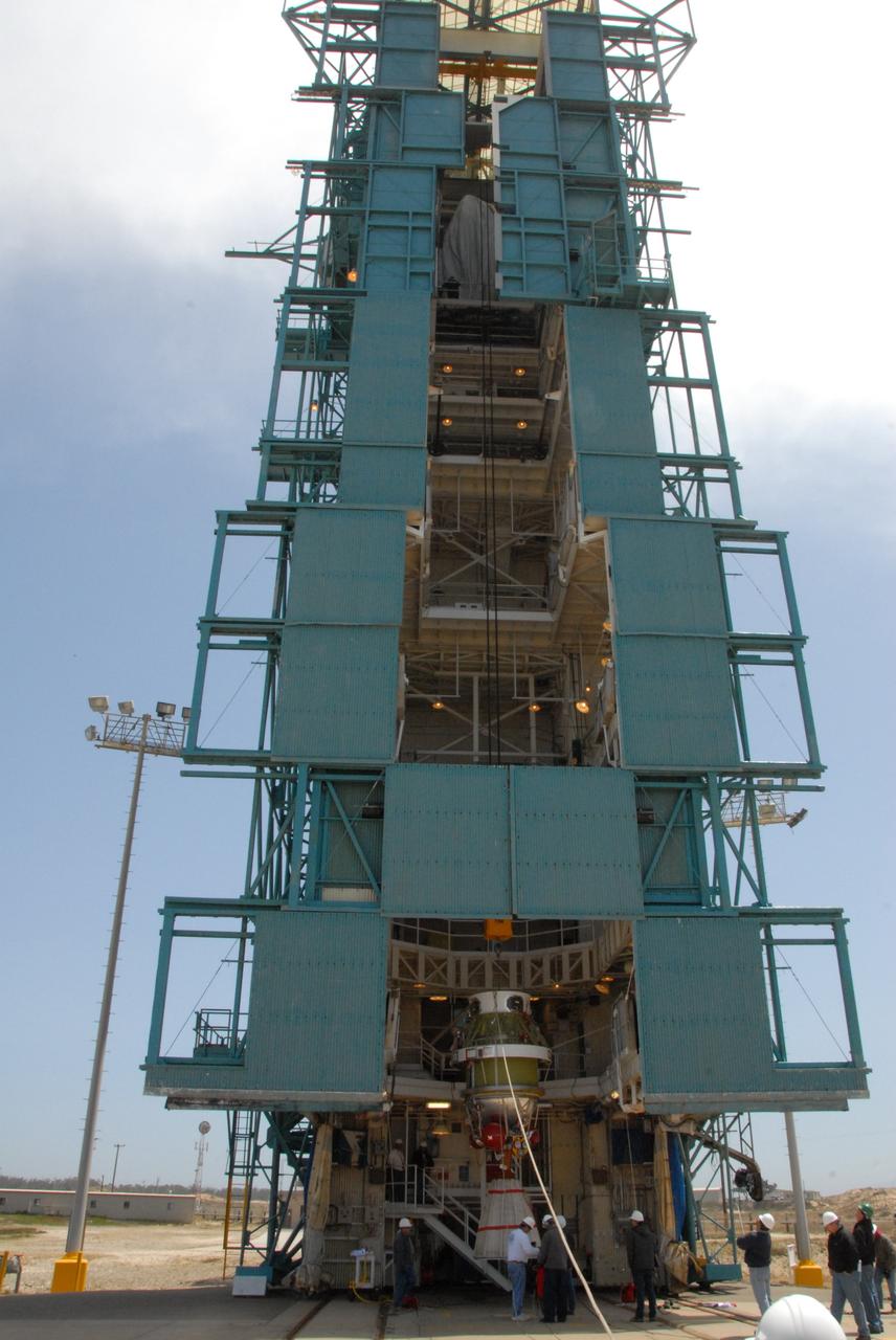
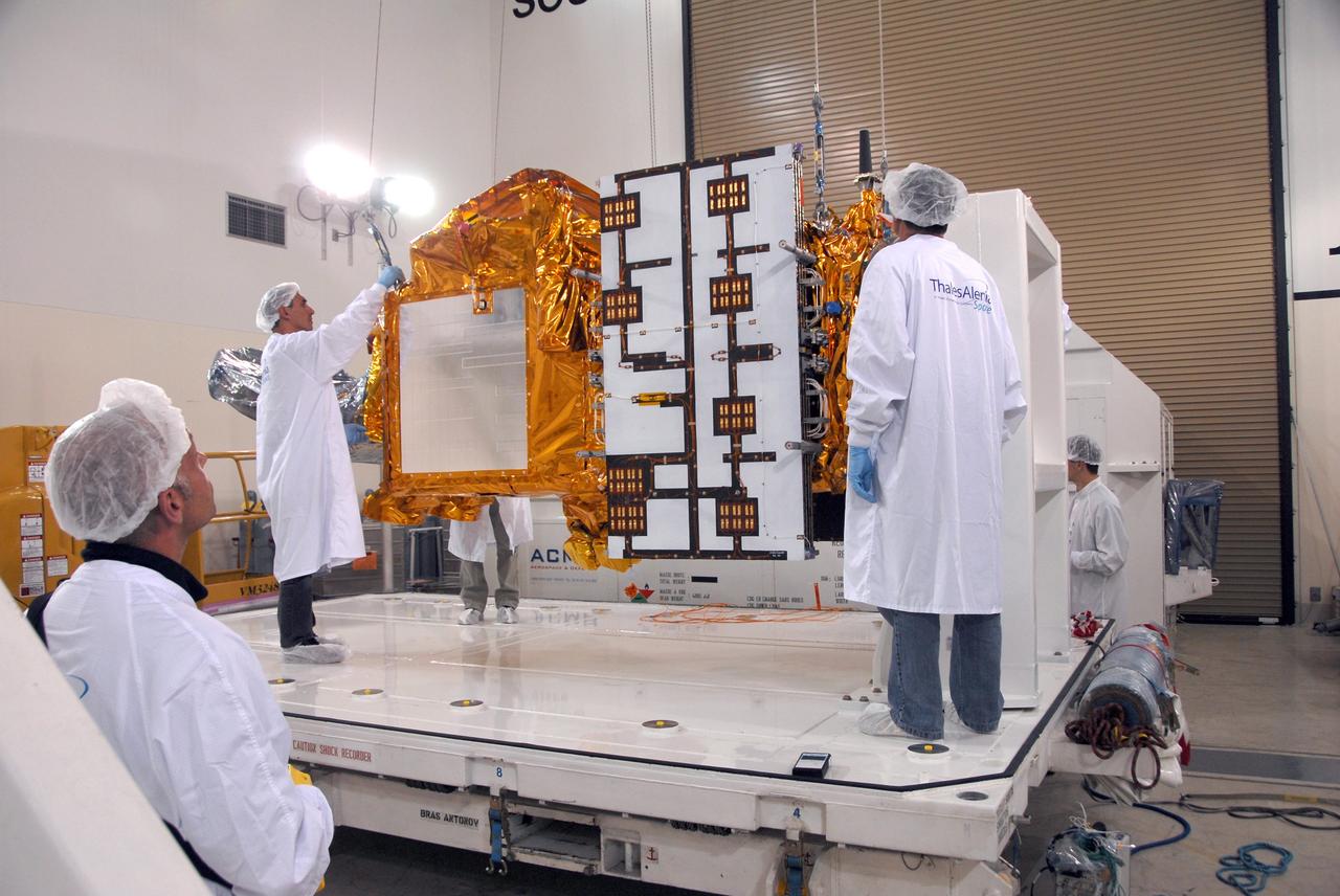
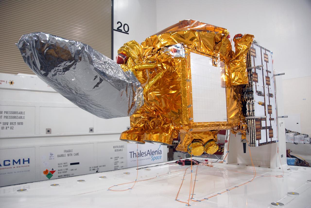
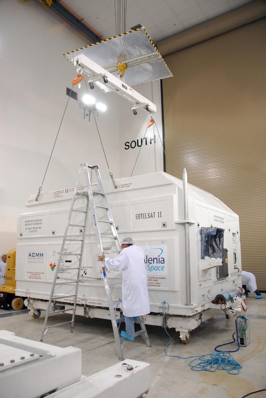
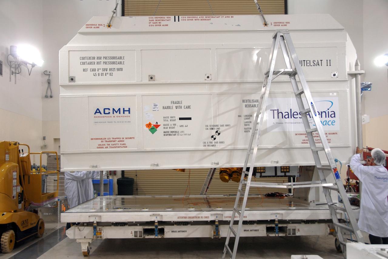
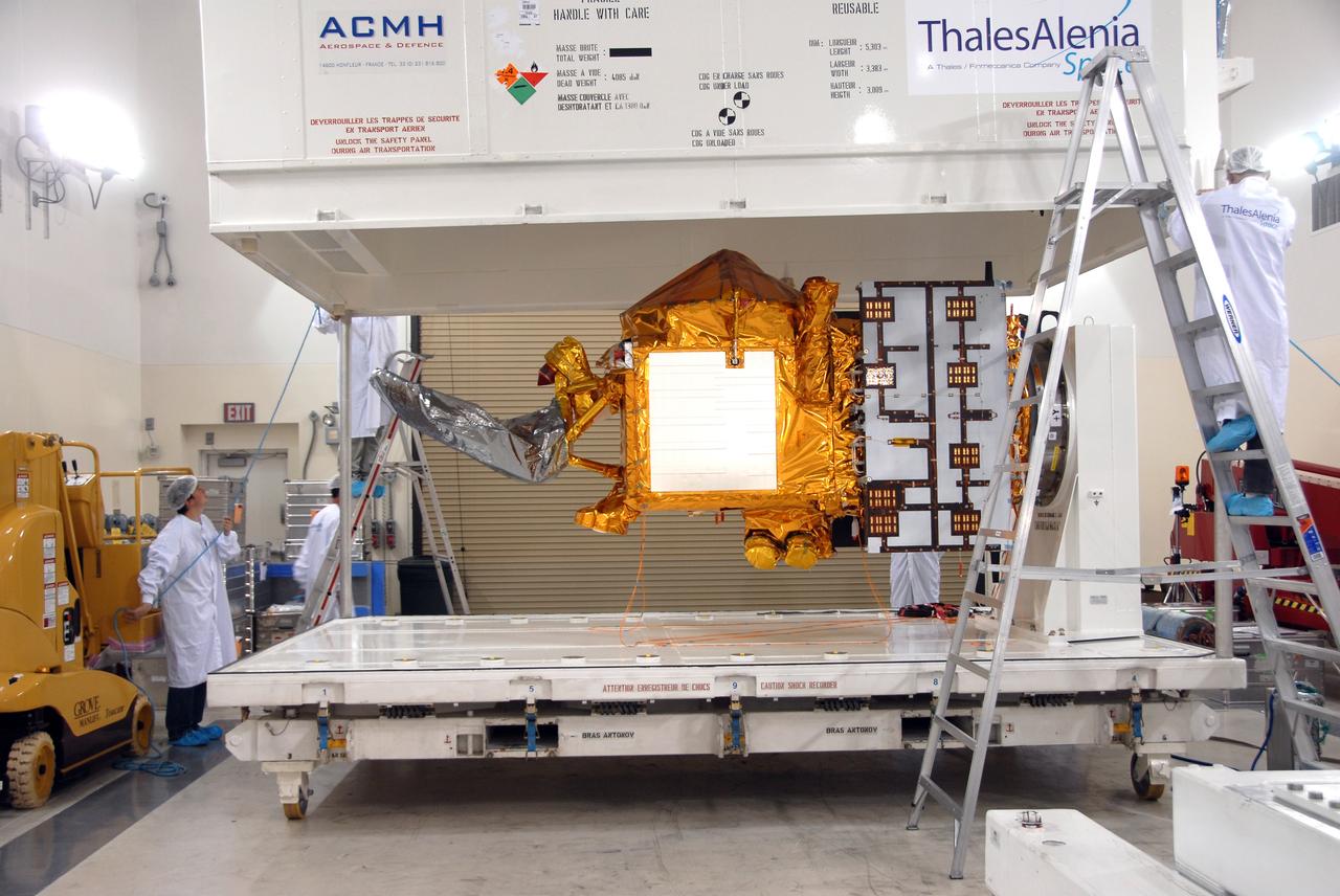
VANDENBERG AIR FORCE BASE, Calif. -- Inside the Astrotech processing facility at Vandenberg Air Force Base, the OSTM/Jason-2 spacecraft is lifted to a near-45-degree angle on the tilt dolly. The OSTM, or Ocean Topography Mission, on the Jason-2 satellite is a follow-on to Jason-1. It will take oceanographic studies of sea surface height into an operational mode for continued climate forecasting research and science and industrial applications. This satellite altimetry data will help determine ocean circulation, climate change and sea-level rise. OSTM is a joint effort by the National Oceanic and Atmospheric Administration, NASA, France’s Centre National d’Etudes Spatiales and the European Meteorological Satellite Organisation. OSTM/Jason-2 will be launched aboard a United Launch Alliance Delta II 7320 from Vandenberg on June 15. Photo credit: NASA/Mark Mackley
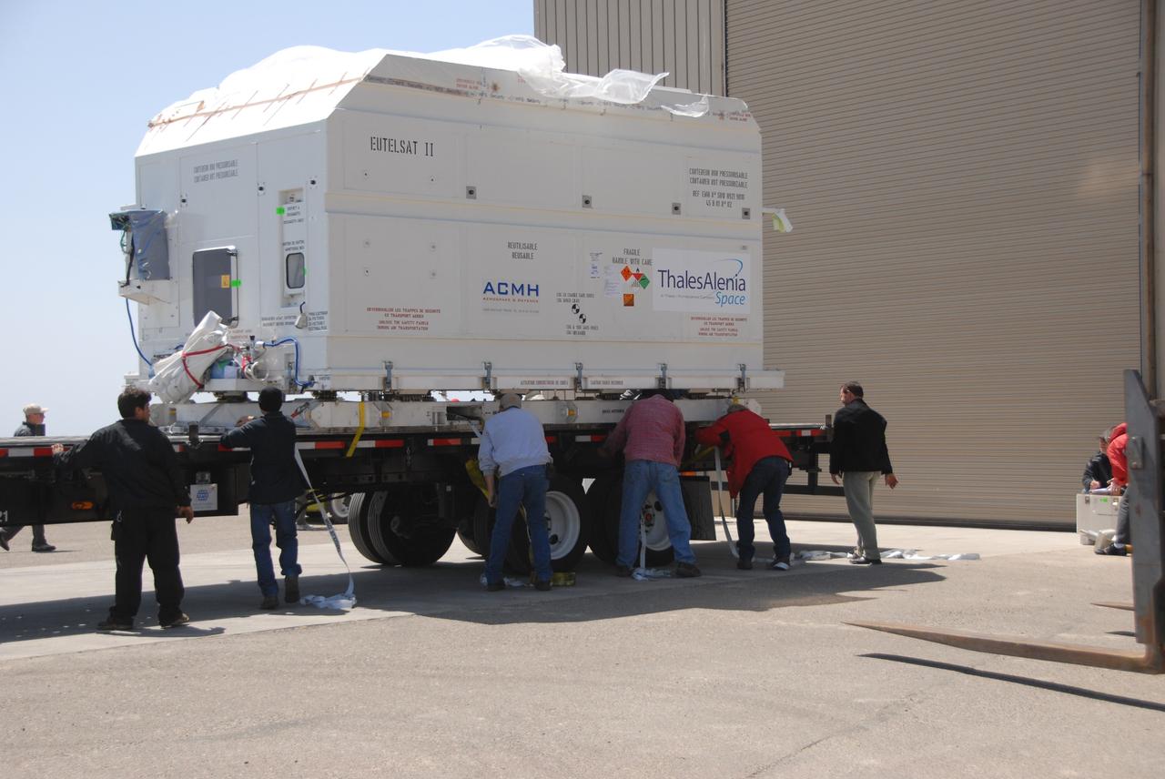
VANDENBERG AIR FORCE BASE, Calif. -- In front of the Astrotech processing facility at Vandenberg Air Force Base, a forklift begins to lift the OSTM/Jason-2 satellite shipping container off the flatbed truck. The OSTM, or Ocean Topography Mission, on the Jason-2 satellite is a follow-on to Jason-1. It will take oceanographic studies of sea surface height into an operational mode for continued climate forecasting research and science and industrial applications. This satellite altimetry data will help determine ocean circulation, climate change and sea-level rise. OSTM is a joint effort by the National Oceanic and Atmospheric Administration, NASA, France’s Centre National d’Etudes Spatiales and the European Meteorological Satellite Organisation. OSTM/Jason-2 will be launched aboard a United Launch Alliance Delta II 7320 from Vandenberg on June 15. Photo credit: NASA/Dan Liberotti
VANDENBERG AIR FORCE BASE, Calif. -- Workers on Space Launch Complex 2 at Vandenberg Air Force Base in California prepare to attach a sling crane onto the Delta II second stage. The sling will lift the second stage into the mobile service tower for installation on the first stage for launch of the OSTM/Jason-2 spacecraft. The OSTM, or Ocean Topography Mission, on the Jason-2 satellite is a follow-on to Jason-1. It will take oceanographic studies of sea surface height into an operational mode for continued climate forecasting research and science and industrial applications. This satellite altimetry data will help determine ocean circulation, climate change and sea-level rise. OSTM is a joint effort by the National Oceanic and Atmospheric Administration, NASA, France’s Centre National d’Etudes Spatiales and the European Meteorological Satellite Organisation. OSTM/Jason-2 will be launched on June 20. Photo credit: NASA
VANDENBERG AIR FORCE BASE, Calif. -- In front of the Astrotech processing facility at Vandenberg Air Force Base, the OSTM/Jason-2 satellite shipping container is on the ground, ready to be moved inside. The OSTM, or Ocean Topography Mission, on the Jason-2 satellite is a follow-on to Jason-1. It will take oceanographic studies of sea surface height into an operational mode for continued climate forecasting research and science and industrial applications. This satellite altimetry data will help determine ocean circulation, climate change and sea-level rise. OSTM is a joint effort by the National Oceanic and Atmospheric Administration, NASA, France’s Centre National d’Etudes Spatiales and the European Meteorological Satellite Organisation. OSTM/Jason-2 will be launched aboard a United Launch Alliance Delta II 7320 from Vandenberg on June 15. Photo credit: NASA/Dan Liberotti
VANDENBERG AIR FORCE BASE, Calif. -- At Vandenberg Air Force Base, the truck carrying the OSTM/Jason-2 satellite is ready to transport the cargo to the Astrotech processing facility. The OSTM, or Ocean Topography Mission, on the Jason-2 satellite is a follow-on to Jason-1. It will take oceanographic studies of sea surface height into an operational mode for continued climate forecasting research and science and industrial applications. This satellite altimetry data will help determine ocean circulation, climate change and sea-level rise. OSTM is a joint effort by the National Oceanic and Atmospheric Administration, NASA, France’s Centre National d’Etudes Spatiales and the European Meteorological Satellite Organisation. OSTM/Jason-2 will be launched aboard a United Launch Alliance Delta II 7320 from Vandenberg on June 15. Photo credit: NASA/Dan Liberotti
VANDENBERG AIR FORCE BASE, Calif. -- At Vandenberg Air Force Base, the truck carrying the OSTM/Jason-2 satellite arrives at the Astrotech processing facility. The OSTM, or Ocean Topography Mission, on the Jason-2 satellite is a follow-on to Jason-1. It will take oceanographic studies of sea surface height into an operational mode for continued climate forecasting research and science and industrial applications. This satellite altimetry data will help determine ocean circulation, climate change and sea-level rise. OSTM is a joint effort by the National Oceanic and Atmospheric Administration, NASA, France’s Centre National d’Etudes Spatiales and the European Meteorological Satellite Organisation. OSTM/Jason-2 will be launched aboard a United Launch Alliance Delta II 7320 from Vandenberg on June 15. Photo credit: NASA/Dan Liberotti
VANDENBERG AIR FORCE BASE, Calif. -- Workers on Space Launch Complex 2 at Vandenberg Air Force Base in California place protective covers over the engine of the Delta II second stage. It will be lifted into the mobile service tower for installation on the first stage for launch of the OSTM/Jason-2 spacecraft. The OSTM, or Ocean Topography Mission, on the Jason-2 satellite is a follow-on to Jason-1. It will take oceanographic studies of sea surface height into an operational mode for continued climate forecasting research and science and industrial applications. This satellite altimetry data will help determine ocean circulation, climate change and sea-level rise. OSTM is a joint effort by the National Oceanic and Atmospheric Administration, NASA, France’s Centre National d’Etudes Spatiales and the European Meteorological Satellite Organisation. OSTM/Jason-2 will be launched on June 20. Photo credit: NASA
VANDENBERG AIR FORCE BASE, Calif. -- On Space Launch Complex 2 at Vandenberg Air Force Base in California, workers attach the Delta II first stage for the OSTM/Jason-2 spacecraft to the launcher in the umbilical tower. The OSTM, or Ocean Topography Mission, on the Jason-2 satellite is a follow-on to Jason-1. It will take oceanographic studies of sea surface height into an operational mode for continued climate forecasting research and science and industrial applications. This satellite altimetry data will help determine ocean circulation, climate change and sea-level rise. OSTM is a joint effort by the National Oceanic and Atmospheric Administration, NASA, France’s Centre National d’Etudes Spatiales and the European Meteorological Satellite Organisation. OSTM/Jason-2 will be launched aboard a United Launch Alliance Delta II 7320 from Vandenberg on June 15. Photo credit: NASA/Dan Liberotti
VANDENBERG AIR FORCE BASE, Calif. -- Inside the Astrotech processing facility at Vandenberg Air Force Base, the OSTM/Jason-2 spacecraft is viewed from another angle after being lifted to a vertical position on the tilt dolly. The OSTM, or Ocean Topography Mission, on the Jason-2 satellite is a follow-on to Jason-1. It will take oceanographic studies of sea surface height into an operational mode for continued climate forecasting research and science and industrial applications. This satellite altimetry data will help determine ocean circulation, climate change and sea-level rise. OSTM is a joint effort by the National Oceanic and Atmospheric Administration, NASA, France’s Centre National d’Etudes Spatiales and the European Meteorological Satellite Organisation. OSTM/Jason-2 will be launched aboard a United Launch Alliance Delta II 7320 from Vandenberg on June 15. Photo credit: NASA/Mark Mackley
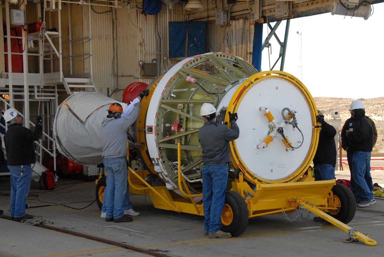
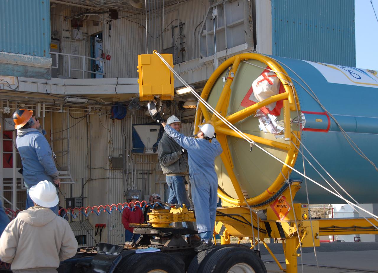
VANDENBERG AIR FORCE BASE, Calif. -- Inside the Astrotech processing facility at Vandenberg Air Force Base, a technician (right) checks the OSTM/Jason-2 spacecraft before it is moved to a tilt dolly. The OSTM, or Ocean Topography Mission, on the Jason-2 satellite is a follow-on to Jason-1. It will take oceanographic studies of sea surface height into an operational mode for continued climate forecasting research and science and industrial applications. This satellite altimetry data will help determine ocean circulation, climate change and sea-level rise. OSTM is a joint effort by the National Oceanic and Atmospheric Administration, NASA, France’s Centre National d’Etudes Spatiales and the European Meteorological Satellite Organisation. OSTM/Jason-2 will be launched aboard a United Launch Alliance Delta II 7320 from Vandenberg on June 15. Photo credit: NASA/Mark Mackley
VANDENBERG AIR FORCE BASE, Calif. -- On Space Launch Complex 2 at Vandenberg Air Force Base in California, the Delta II first stage for the OSTM/Jason-2 spacecraft is moved into place above the launcher in the umbilical tower. The OSTM, or Ocean Topography Mission, on the Jason-2 satellite is a follow-on to Jason-1. It will take oceanographic studies of sea surface height into an operational mode for continued climate forecasting research and science and industrial applications. This satellite altimetry data will help determine ocean circulation, climate change and sea-level rise. OSTM is a joint effort by the National Oceanic and Atmospheric Administration, NASA, France’s Centre National d’Etudes Spatiales and the European Meteorological Satellite Organisation. OSTM/Jason-2 will be launched aboard a United Launch Alliance Delta II 7320 from Vandenberg on June 15. Photo credit: NASA/Dan Liberotti
VANDENBERG AIR FORCE BASE, Calif. -- At Vandenberg Air Force Base, the OSTM/Jason-2 satellite shipping container has been moved inside the Astrotech processing facility. The OSTM, or Ocean Topography Mission, on the Jason-2 satellite is a follow-on to Jason-1. It will take oceanographic studies of sea surface height into an operational mode for continued climate forecasting research and science and industrial applications. This satellite altimetry data will help determine ocean circulation, climate change and sea-level rise. OSTM is a joint effort by the National Oceanic and Atmospheric Administration, NASA, France’s Centre National d’Etudes Spatiales and the European Meteorological Satellite Organisation. OSTM/Jason-2 will be launched aboard a United Launch Alliance Delta II 7320 from Vandenberg on June 15. Photo credit: NASA/Dan Liberotti
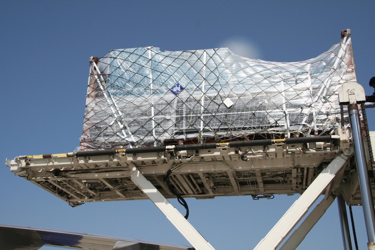
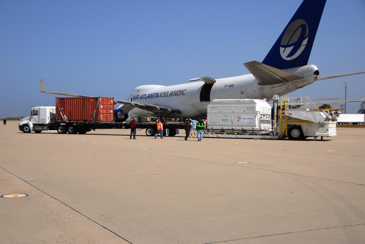
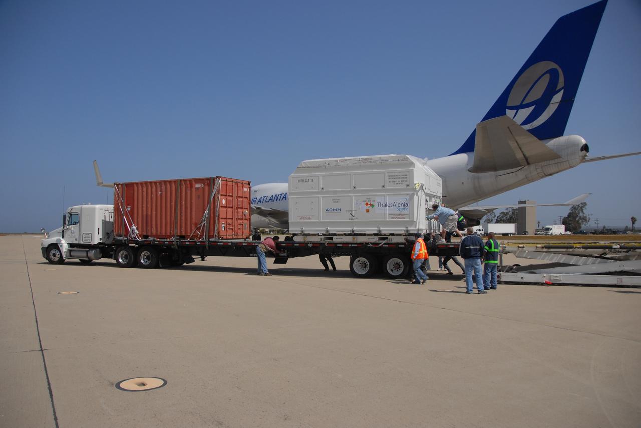
VANDENBERG AIR FORCE BASE, Calif. -- The shipping container with the OSTM/Jason-2 spacecraft inside is offloaded from the aircraft at Vandenberg Air Force Base in California. The OSTM, or Ocean Topography Mission, on the Jason-2 satellite is a follow-on to Jason-1. It will take oceanographic studies of sea surface height into an operational mode for continued climate forecasting research and science and industrial applications. This satellite altimetry data will help determine ocean circulation, climate change and sea-level rise. OSTM is a joint effort by the National Oceanic and Atmospheric Administration, NASA, France’s Centre National d’Etudes Spatiales and the European Meteorological Satellite Organisation. OSTM/Jason-2 will be launched aboard a United Launch Alliance Delta II 7320 from Vandenberg on June 15. Photo credit: NASA/Dan Liberotti
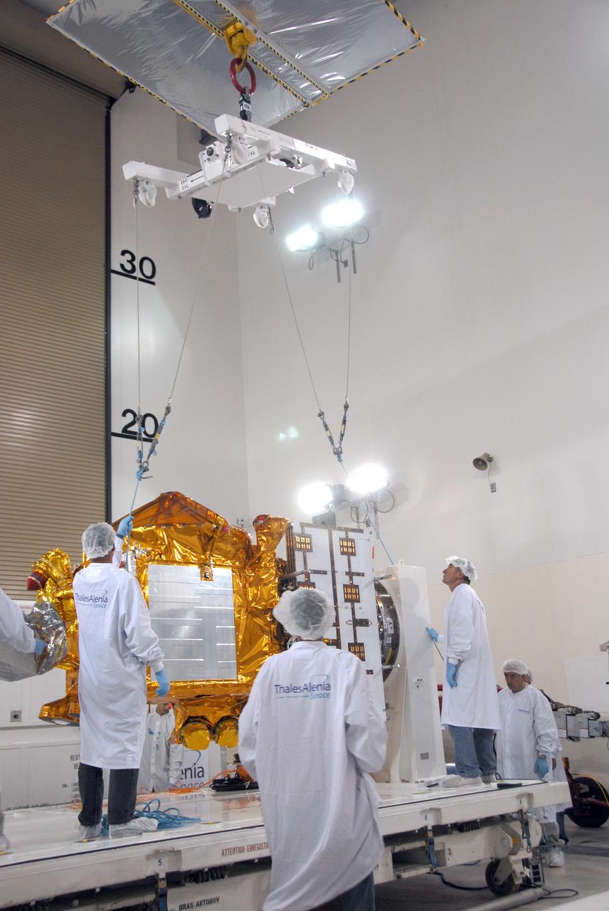
VANDENBERG AIR FORCE BASE, Calif. -- Inside the Astrotech processing facility at Vandenberg Air Force Base, workers attach an overhead crane to the OSTM/Jason-2 spacecraft. The spacecraft will be moved to a tilt dolly. The OSTM, or Ocean Topography Mission, on the Jason-2 satellite is a follow-on to Jason-1. It will take oceanographic studies of sea surface height into an operational mode for continued climate forecasting research and science and industrial applications. This satellite altimetry data will help determine ocean circulation, climate change and sea-level rise. OSTM is a joint effort by the National Oceanic and Atmospheric Administration, NASA, France’s Centre National d’Etudes Spatiales and the European Meteorological Satellite Organisation. OSTM/Jason-2 will be launched aboard a United Launch Alliance Delta II 7320 from Vandenberg on June 15. Photo credit: NASA/Mark Mackley

VANDENBERG AIR FORCE BASE, Calif. -- Inside the Astrotech processing facility at Vandenberg Air Force Base, the OSTM/Jason-2 spacecraft is moved to a tilt dolly. The OSTM, or Ocean Topography Mission, on the Jason-2 satellite is a follow-on to Jason-1. It will take oceanographic studies of sea surface height into an operational mode for continued climate forecasting research and science and industrial applications. This satellite altimetry data will help determine ocean circulation, climate change and sea-level rise. OSTM is a joint effort by the National Oceanic and Atmospheric Administration, NASA, France’s Centre National d’Etudes Spatiales and the European Meteorological Satellite Organisation. OSTM/Jason-2 will be launched aboard a United Launch Alliance Delta II 7320 from Vandenberg on June 15. Photo credit: NASA/Mark Mackley
VANDENBERG AIR FORCE BASE, Calif. -- At Vandenberg Air Force Base in California, the Delta II first stage is ready to be lifted into the mobile service tower on Space Launch Complex 2. The Delta II is the launch vehicle for the OSTM/Jason-2 spacecraft. The OSTM, or Ocean Topography Mission, on the Jason-2 satellite is a follow-on to Jason-1. It will take oceanographic studies of sea surface height into an operational mode for continued climate forecasting research and science and industrial applications. This satellite altimetry data will help determine ocean circulation, climate change and sea-level rise. OSTM is a joint effort by the National Oceanic and Atmospheric Administration, NASA, France’s Centre National d’Etudes Spatiales and the European Meteorological Satellite Organisation. OSTM/Jason-2 will be launched aboard a United Launch Alliance Delta II 7320 from Vandenberg on June 15. Photo credit: NASA/Dan Liberotti
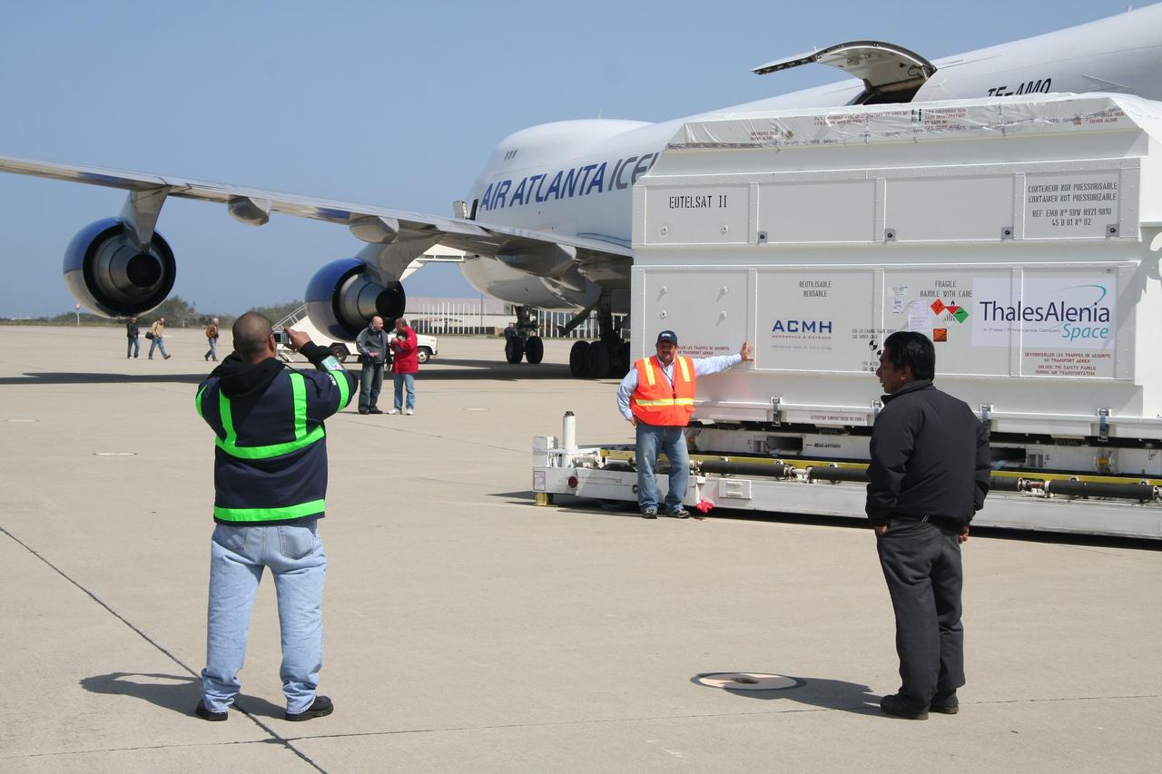
VANDENBERG AIR FORCE BASE, Calif. – A photographer (left) captures the moment after the shipping container holding the OSTM/Jason-2 satellite has been offloaded from the cargo plane at Vandenberg Air Force Base. The satellite will be taken to the Astrotech processing facility. The OSTM, or Ocean Topography Mission, on the Jason-2 satellite is a follow-on to Jason-1. It will take oceanographic studies of sea surface height into an operational mode for continued climate forecasting research and science and industrial applications. This satellite altimetry data will help determine ocean circulation, climate change and sea-level rise. OSTM is a joint effort by the National Oceanic and Atmospheric Administration, NASA, France’s Centre National d’Etudes Spatiales and the European Meteorological Satellite Organisation. OSTM/Jason-2 will be launched aboard a United Launch Alliance Delta II 7320 from Vandenberg on June 15. Photo credit: NASA/Steve Greenberg, JPL
VANDENBERG AIR FORCE BASE, Calif. -- Inside the Astrotech processing facility at Vandenberg Air Force Base, the OSTM/Jason-2 spacecraft is lifted from its stand to be moved to a tilt dolly. The OSTM, or Ocean Topography Mission, on the Jason-2 satellite is a follow-on to Jason-1. It will take oceanographic studies of sea surface height into an operational mode for continued climate forecasting research and science and industrial applications. This satellite altimetry data will help determine ocean circulation, climate change and sea-level rise. OSTM is a joint effort by the National Oceanic and Atmospheric Administration, NASA, France’s Centre National d’Etudes Spatiales and the European Meteorological Satellite Organisation. OSTM/Jason-2 will be launched aboard a United Launch Alliance Delta II 7320 from Vandenberg on June 15. Photo credit: NASA/Mark Mackley
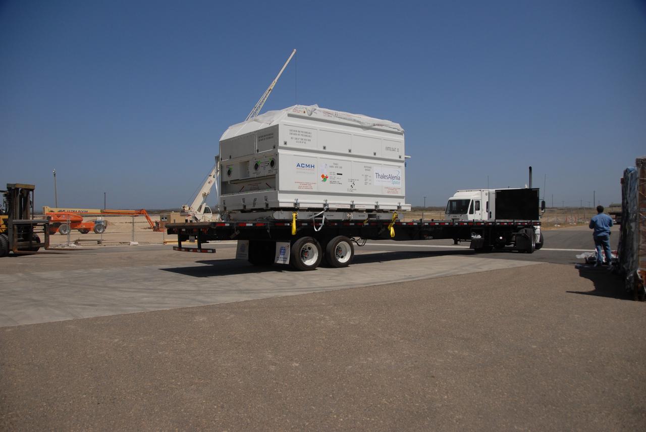
VANDENBERG AIR FORCE BASE, Calif. – Workers check the shipping container holding the OSTM/Jason-2 satellite after its placement on the flatbed truck at Vandenberg Air Force Base. The satellite will be transported to the Astrotech processing facility. The OSTM, or Ocean Topography Mission, on the Jason-2 satellite is a follow-on to Jason-1. It will take oceanographic studies of sea surface height into an operational mode for continued climate forecasting research and science and industrial applications. This satellite altimetry data will help determine ocean circulation, climate change and sea-level rise. OSTM is a joint effort by the National Oceanic and Atmospheric Administration, NASA, France’s Centre National d’Etudes Spatiales and the European Meteorological Satellite Organisation. OSTM/Jason-2 will be launched aboard a United Launch Alliance Delta II 7320 from Vandenberg on June 15. Photo credit: NASA/Steve Greenberg, JPL
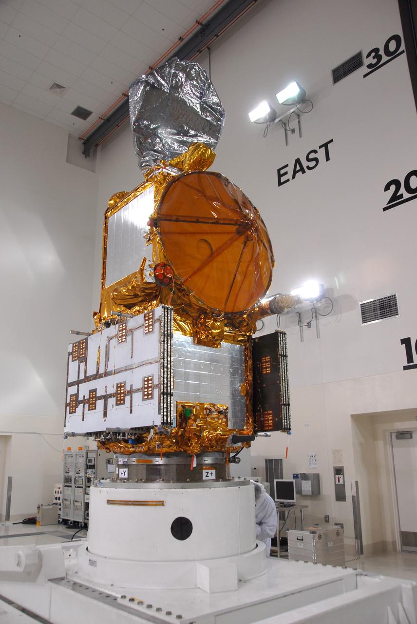
VANDENBERG AIR FORCE BASE, Calif. -- Inside the Astrotech processing facility at Vandenberg Air Force Base, the OSTM/Jason-2 spacecraft has been lifted to a vertical position on the tilt dolly. The OSTM, or Ocean Topography Mission, on the Jason-2 satellite is a follow-on to Jason-1. It will take oceanographic studies of sea surface height into an operational mode for continued climate forecasting research and science and industrial applications. This satellite altimetry data will help determine ocean circulation, climate change and sea-level rise. OSTM is a joint effort by the National Oceanic and Atmospheric Administration, NASA, France’s Centre National d’Etudes Spatiales and the European Meteorological Satellite Organisation. OSTM/Jason-2 will be launched aboard a United Launch Alliance Delta II 7320 from Vandenberg on June 15. Photo credit: NASA/Mark Mackley
VANDENBERG AIR FORCE BASE, Calif. – Ground support equipment associated with the OSTM/Jason-2 satellite is offloaded from the cargo plane at Vandenberg Air Force Base. The equipment will accompany the satellite to the Astrotech processing facility. The OSTM, or Ocean Topography Mission, on the Jason-2 satellite is a follow-on to Jason-1. It will take oceanographic studies of sea surface height into an operational mode for continued climate forecasting research and science and industrial applications. This satellite altimetry data will help determine ocean circulation, climate change and sea-level rise. OSTM is a joint effort by the National Oceanic and Atmospheric Administration, NASA, France’s Centre National d’Etudes Spatiales and the European Meteorological Satellite Organisation. OSTM/Jason-2 will be launched aboard a United Launch Alliance Delta II 7320 from Vandenberg on June 15. Photo credit: NASA/Steve Greenberg, JPL

VANDENBERG AIR FORCE BASE, Calif. -- On Space Launch Complex 2 at Vandenberg Air Force Base in California, the Delta II second stage is lowered inside the mobile service tower toward the first stage. The second stage will be mated to the first stage for launch of the OSTM/Jason-2 spacecraft. The OSTM, or Ocean Topography Mission, on the Jason-2 satellite is a follow-on to Jason-1. It will take oceanographic studies of sea surface height into an operational mode for continued climate forecasting research and science and industrial applications. This satellite altimetry data will help determine ocean circulation, climate change and sea-level rise. OSTM is a joint effort by the National Oceanic and Atmospheric Administration, NASA, France’s Centre National d’Etudes Spatiales and the European Meteorological Satellite Organisation. OSTM/Jason-2 will be launched on June 20. Photo credit: NASA
VANDENBERG AIR FORCE BASE, Calif. -- Inside the Astrotech processing facility at Vandenberg Air Force Base, a technician oversees the attaching of the OSTM/Jason-2 spacecraft to a tilt dolly. The OSTM, or Ocean Topography Mission, on the Jason-2 satellite is a follow-on to Jason-1. It will take oceanographic studies of sea surface height into an operational mode for continued climate forecasting research and science and industrial applications. This satellite altimetry data will help determine ocean circulation, climate change and sea-level rise. OSTM is a joint effort by the National Oceanic and Atmospheric Administration, NASA, France’s Centre National d’Etudes Spatiales and the European Meteorological Satellite Organisation. OSTM/Jason-2 will be launched aboard a United Launch Alliance Delta II 7320 from Vandenberg on June 15. Photo credit: NASA/Mark Mackley
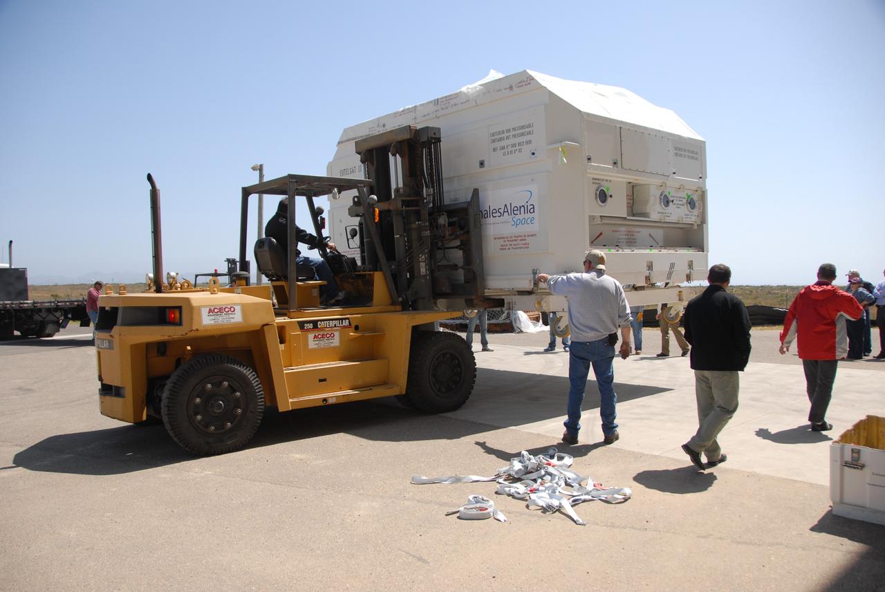
VANDENBERG AIR FORCE BASE, Calif. -- In front of the Astrotech processing facility at Vandenberg Air Force Base, a forklift has removed the OSTM/Jason-2 satellite shipping container off the flatbed truck. The OSTM, or Ocean Topography Mission, on the Jason-2 satellite is a follow-on to Jason-1. It will take oceanographic studies of sea surface height into an operational mode for continued climate forecasting research and science and industrial applications. This satellite altimetry data will help determine ocean circulation, climate change and sea-level rise. OSTM is a joint effort by the National Oceanic and Atmospheric Administration, NASA, France’s Centre National d’Etudes Spatiales and the European Meteorological Satellite Organisation. OSTM/Jason-2 will be launched aboard a United Launch Alliance Delta II 7320 from Vandenberg on June 15. Photo credit: NASA/Dan Liberotti
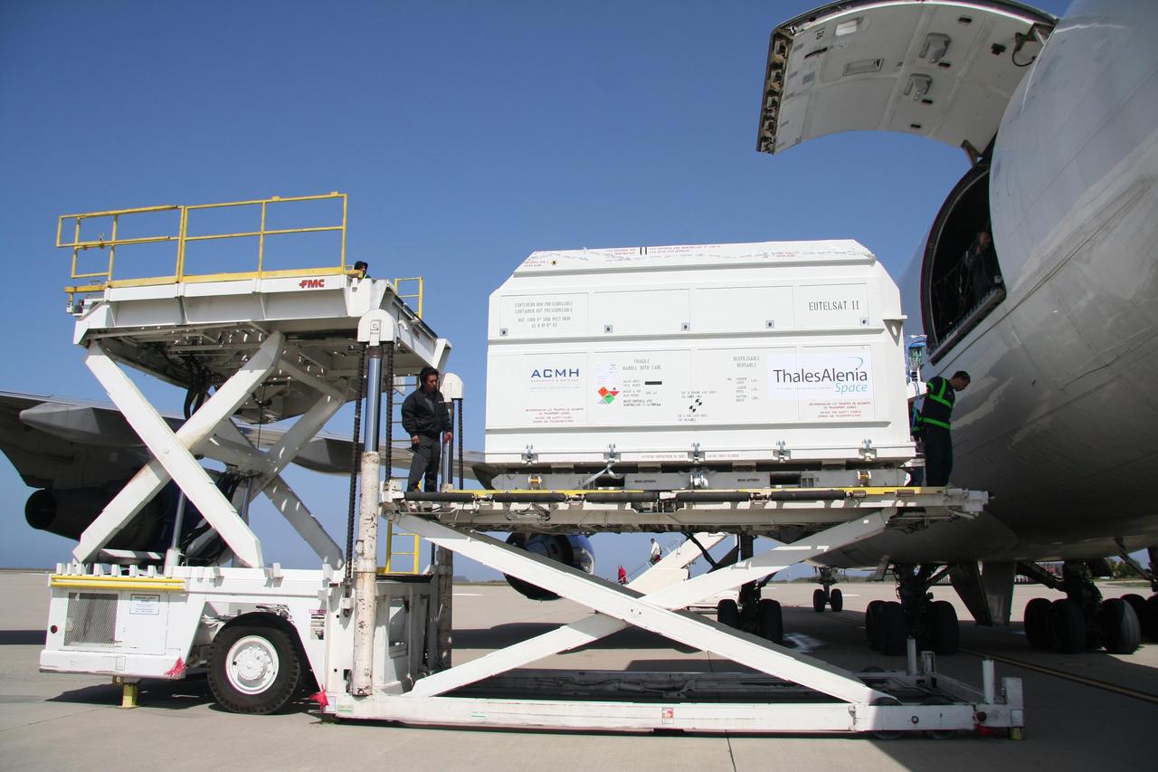
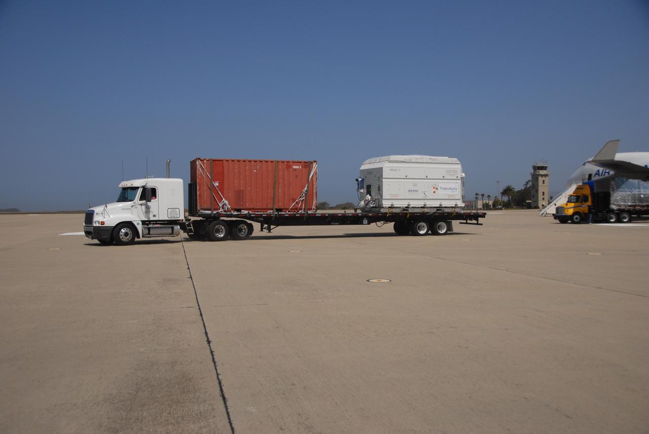
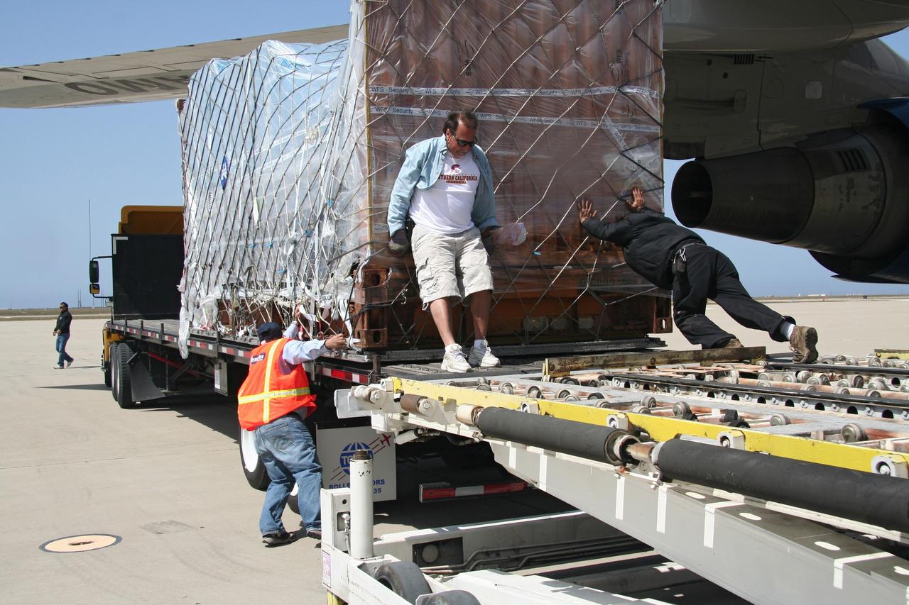
VANDENBERG AIR FORCE BASE, Calif. – After arrival of the cargo plane, the shipping container holding the OSTM/Jason-2 satellite is offloaded at Vandenberg Air Force Base. The satellite will be taken to the Astrotech processing facility. The OSTM, or Ocean Topography Mission, on the Jason-2 satellite is a follow-on to Jason-1. It will take oceanographic studies of sea surface height into an operational mode for continued climate forecasting research and science and industrial applications. This satellite altimetry data will help determine ocean circulation, climate change and sea-level rise. OSTM is a joint effort by the National Oceanic and Atmospheric Administration, NASA, France’s Centre National d’Etudes Spatiales and the European Meteorological Satellite Organisation. OSTM/Jason-2 will be launched aboard a United Launch Alliance Delta II 7320 from Vandenberg on June 15. Photo credit: NASA/Steve Greenberg, JPL
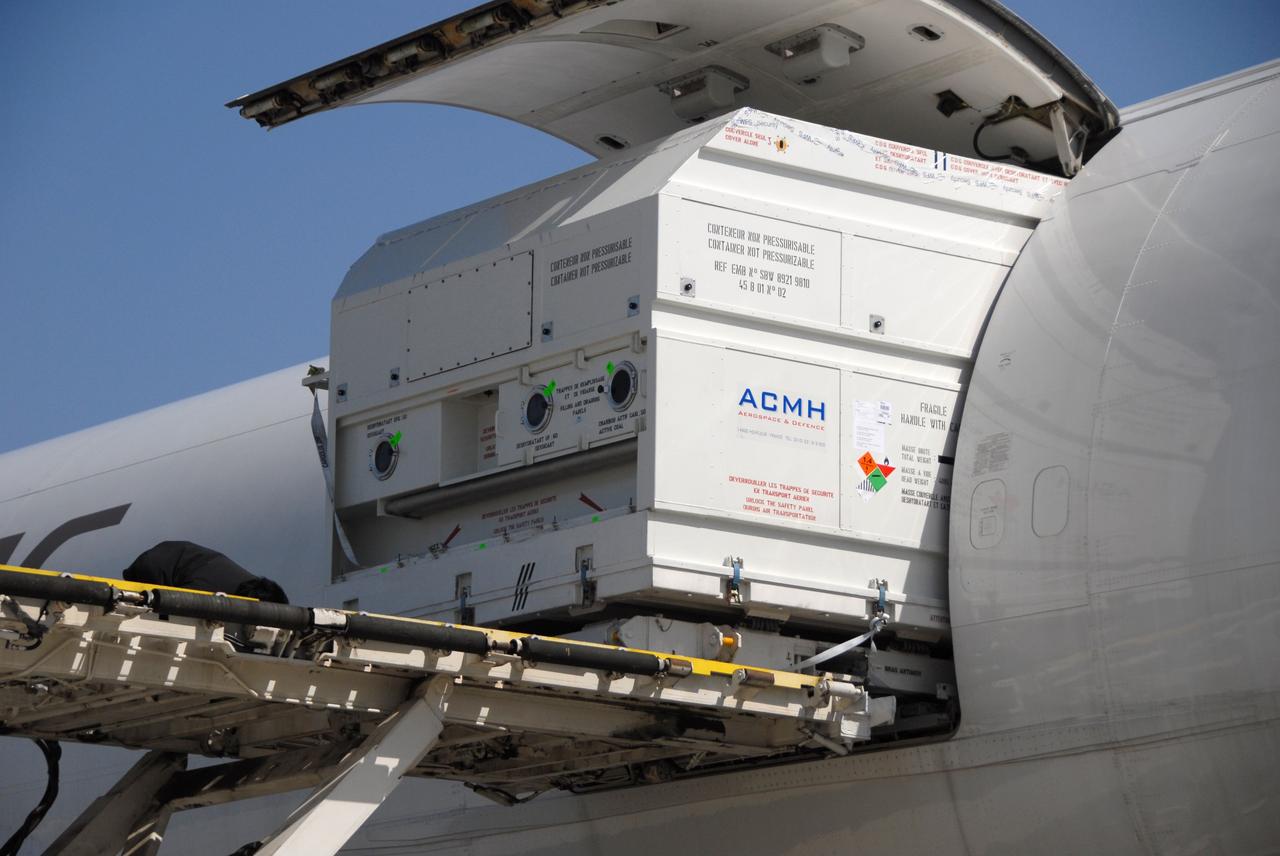
VANDENBERG AIR FORCE BASE, Calif. -- The shipping container with the OSTM/Jason-2 spacecraft inside is offloaded from the aircraft at Vandenberg Air Force Base in California. The OSTM, or Ocean Topography Mission, on the Jason-2 satellite is a follow-on to Jason-1. It will take oceanographic studies of sea surface height into an operational mode for continued climate forecasting research and science and industrial applications. This satellite altimetry data will help determine ocean circulation, climate change and sea-level rise. OSTM is a joint effort by the National Oceanic and Atmospheric Administration, NASA, France’s Centre National d’Etudes Spatiales and the European Meteorological Satellite Organisation. OSTM/Jason-2 will be launched aboard a United Launch Alliance Delta II 7320 from Vandenberg on June 15. Photo credit: NASA/Dan Liberotti
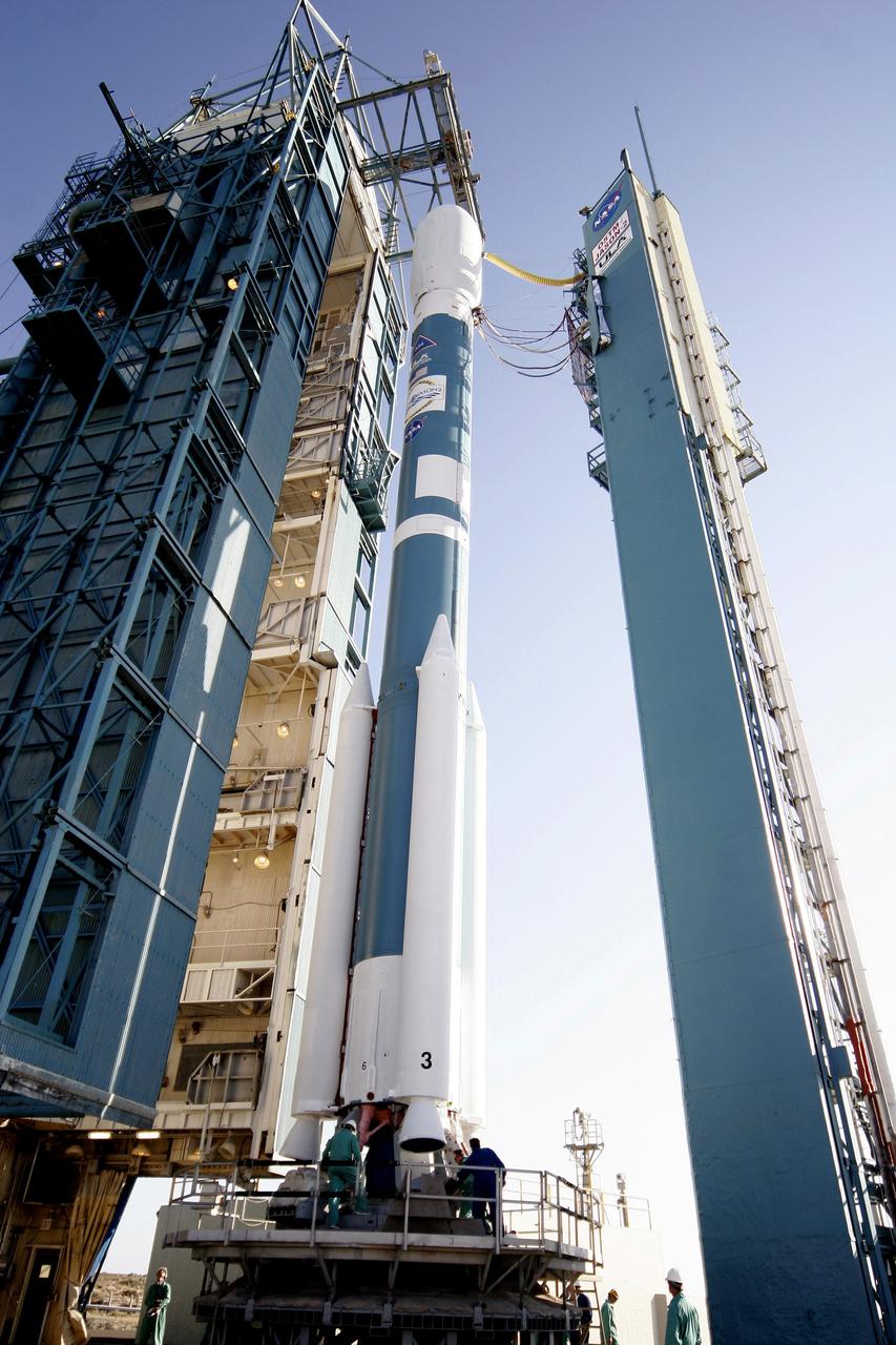
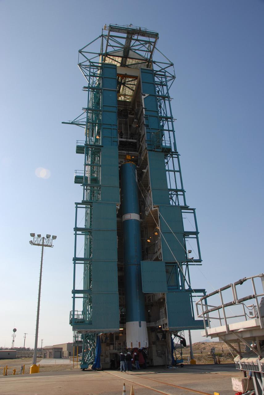
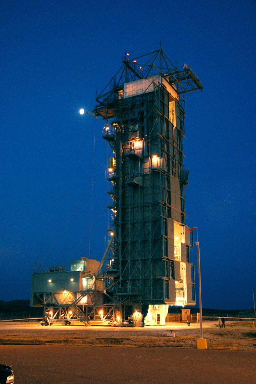
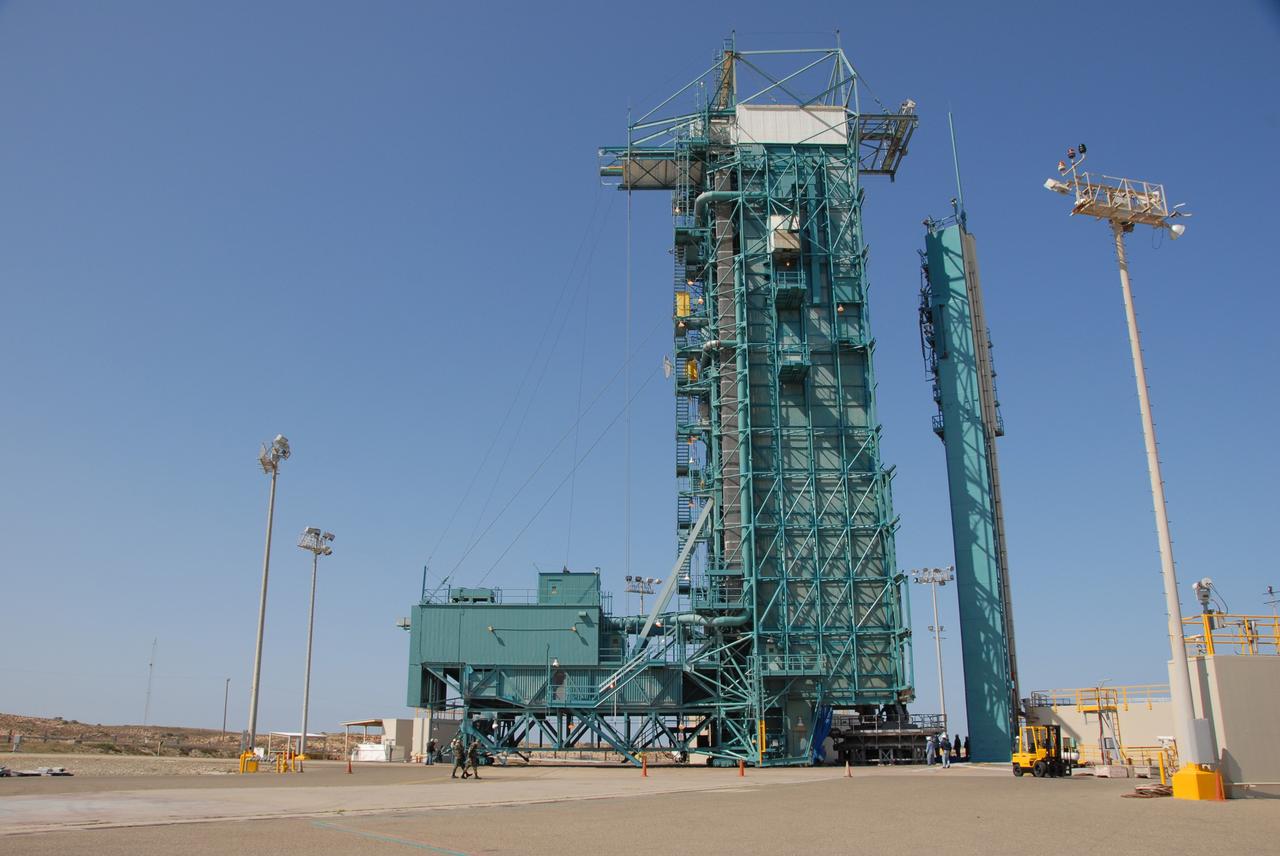
PASADENA, Calif. – A Delta II rocket carrying the Ocean Surface Topography Mission/Jason 2 satellite, is prepared for launch at Space Launch Complex 2 at Vandenberg Air Force Base, Calif. The OSTM/Jason 2 satellite will embark on a globe-circling voyage to continue charting sea level, a vital indicator of global climate change. The mission will return a vast amount of new data that will improve weather, climate and ocean forecasts. OSTM/Jason 2's expected lifetime of at least three years will extend into the next decade the continuous record of these data started in 1992 by NASA and the French space agency Centre National d'Etudes Spatiales, or CNES, with the TOPEX/Poseidon mission. The data collection was continued by the two agencies on Jason 1 in 2001. Photo credit: Carleton Bailie photograph for United Launch Alliance
VANDENBERG AIR FORCE BASE, Calif. -- On Space Launch Complex 2 at Vandenberg Air Force Base in California, the Delta II second stage is lowered inside the mobile service tower toward the first stage. The second stage will be mated to the first stage for launch of the OSTM/Jason-2 spacecraft. The OSTM, or Ocean Topography Mission, on the Jason-2 satellite is a follow-on to Jason-1. It will take oceanographic studies of sea surface height into an operational mode for continued climate forecasting research and science and industrial applications. This satellite altimetry data will help determine ocean circulation, climate change and sea-level rise. OSTM is a joint effort by the National Oceanic and Atmospheric Administration, NASA, France’s Centre National d’Etudes Spatiales and the European Meteorological Satellite Organisation. OSTM/Jason-2 will be launched on June 20. Photo credit: NASA
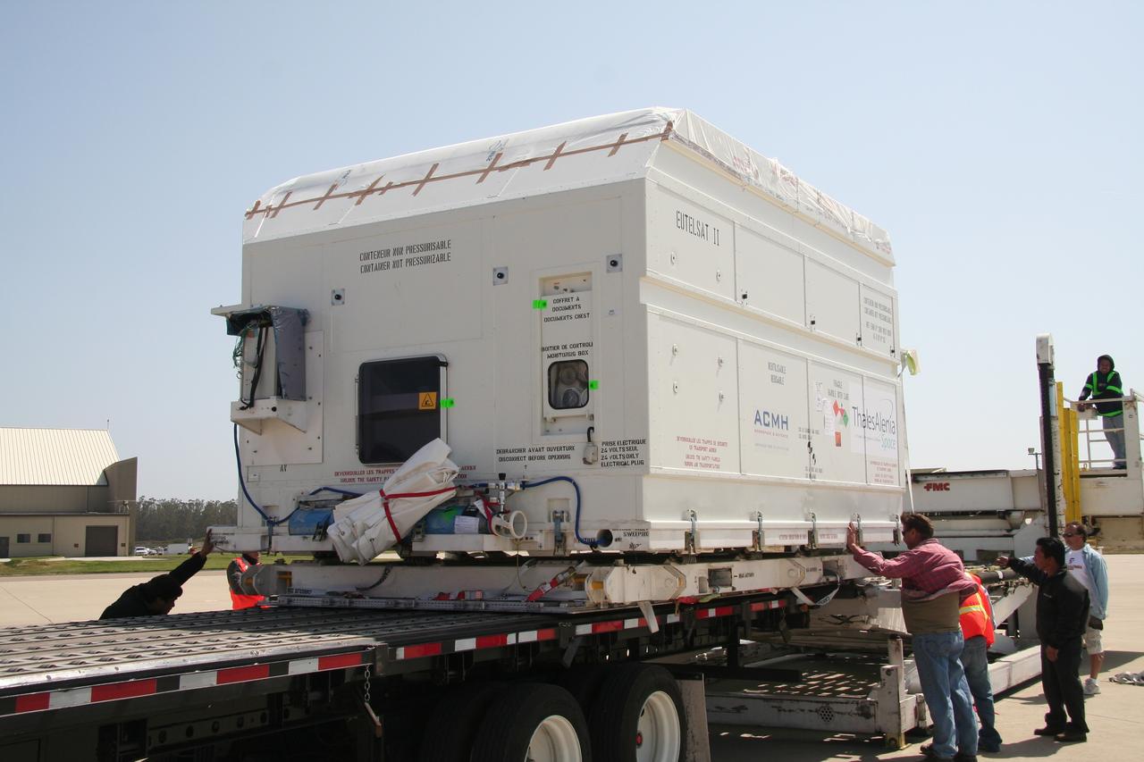
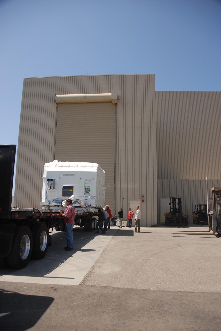
VANDENBERG AIR FORCE BASE, Calif. -- Workers prepare to move the shipping container holding the OSTM/Jason-2 satellite onto a flatbed truck at Vandenberg Air Force Base. The satellite will be transported to the Astrotech processing facility. The OSTM, or Ocean Topography Mission, on the Jason-2 satellite is a follow-on to Jason-1. It will take oceanographic studies of sea surface height into an operational mode for continued climate forecasting research and science and industrial applications. This satellite altimetry data will help determine ocean circulation, climate change and sea-level rise. OSTM is a joint effort by the National Oceanic and Atmospheric Administration, NASA, France’s Centre National d’Etudes Spatiales and the European Meteorological Satellite Organisation. OSTM/Jason-2 will be launched aboard a United Launch Alliance Delta II 7320 from Vandenberg on June 15. Photo credit: NASA/Dan Liberotti
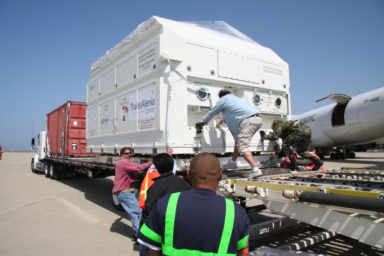
VANDENBERG AIR FORCE BASE, Calif. -- At Vandenberg Air Force Base, the truck carrying the OSTM/Jason-2 satellite arrives at the Astrotech processing facility. The OSTM, or Ocean Topography Mission, on the Jason-2 satellite is a follow-on to Jason-1. It will take oceanographic studies of sea surface height into an operational mode for continued climate forecasting research and science and industrial applications. This satellite altimetry data will help determine ocean circulation, climate change and sea-level rise. OSTM is a joint effort by the National Oceanic and Atmospheric Administration, NASA, France’s Centre National d’Etudes Spatiales and the European Meteorological Satellite Organisation. OSTM/Jason-2 will be launched aboard a United Launch Alliance Delta II 7320 from Vandenberg on June 15. Photo credit: NASA/Dan Liberotti
VANDENBERG AIR FORCE BASE, Calif. -- At Vandenberg Air Force Base, the OSTM/Jason-2 satellite shipping container is being moved inside the Astrotech processing facility. The OSTM, or Ocean Topography Mission, on the Jason-2 satellite is a follow-on to Jason-1. It will take oceanographic studies of sea surface height into an operational mode for continued climate forecasting research and science and industrial applications. This satellite altimetry data will help determine ocean circulation, climate change and sea-level rise. OSTM is a joint effort by the National Oceanic and Atmospheric Administration, NASA, France’s Centre National d’Etudes Spatiales and the European Meteorological Satellite Organisation. OSTM/Jason-2 will be launched aboard a United Launch Alliance Delta II 7320 from Vandenberg on June 15. Photo credit: NASA/Dan Liberotti
VANDENBERG AIR FORCE BASE, Calif. -- At Vandenberg Air Force Base in California, the Delta II first stage for the OSTM/Jason-2 spacecraft arrives at the base of the mobile service tower on Space Launch Complex 2. The first stage will be raised to vertical and lifted into the tower. The OSTM, or Ocean Topography Mission, on the Jason-2 satellite is a follow-on to Jason-1. It will take oceanographic studies of sea surface height into an operational mode for continued climate forecasting research and science and industrial applications. This satellite altimetry data will help determine ocean circulation, climate change and sea-level rise. OSTM is a joint effort by the National Oceanic and Atmospheric Administration, NASA, France’s Centre National d’Etudes Spatiales and the European Meteorological Satellite Organisation. OSTM/Jason-2 will be launched aboard a United Launch Alliance Delta II 7320 from Vandenberg on June 15. Photo credit: NASA/Dan Liberotti
VANDENBERG AIR FORCE BASE, Calif. -- At Vandenberg Air Force Base in California, workers prepare the equipment on Space Launch Complex 2 to raise the Delta II first stage of the OSTM/Jason-2 spacecraft. Once it is vertical, the first stage will be transferred into the mobile service tower. The OSTM, or Ocean Topography Mission, on the Jason-2 satellite is a follow-on to Jason-1. It will take oceanographic studies of sea surface height into an operational mode for continued climate forecasting research and science and industrial applications. This satellite altimetry data will help determine ocean circulation, climate change and sea-level rise. OSTM is a joint effort by the National Oceanic and Atmospheric Administration, NASA, France’s Centre National d’Etudes Spatiales and the European Meteorological Satellite Organisation. OSTM/Jason-2 will be launched aboard a United Launch Alliance Delta II 7320 from Vandenberg on June 15. Photo credit: NASA/Dan Liberotti
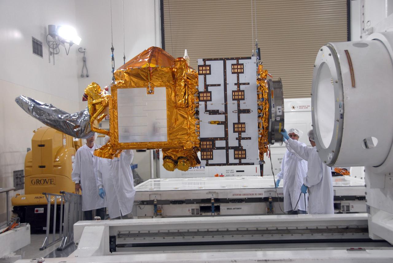
VANDENBERG AIR FORCE BASE, Calif. -- Inside the Astrotech processing facility at Vandenberg Air Force Base, the OSTM/Jason-2 spacecraft is revealed after removal of the shipping container. The OSTM, or Ocean Topography Mission, on the Jason-2 satellite is a follow-on to Jason-1. It will take oceanographic studies of sea surface height into an operational mode for continued climate forecasting research and science and industrial applications. This satellite altimetry data will help determine ocean circulation, climate change and sea-level rise. OSTM is a joint effort by the National Oceanic and Atmospheric Administration, NASA, France’s Centre National d’Etudes Spatiales and the European Meteorological Satellite Organisation. OSTM/Jason-2 will be launched aboard a United Launch Alliance Delta II 7320 from Vandenberg on June 15. Photo credit: NASA/Mark Mackley
VANDENBERG AIR FORCE BASE, Calif. – Workers adjust the shipping container holding the OSTM/Jason-2 satellite after its placement on the flatbed truck at Vandenberg Air Force Base. The satellite will be transported to the Astrotech processing facility. The OSTM, or Ocean Topography Mission, on the Jason-2 satellite is a follow-on to Jason-1. It will take oceanographic studies of sea surface height into an operational mode for continued climate forecasting research and science and industrial applications. This satellite altimetry data will help determine ocean circulation, climate change and sea-level rise. OSTM is a joint effort by the National Oceanic and Atmospheric Administration, NASA, France’s Centre National d’Etudes Spatiales and the European Meteorological Satellite Organisation. OSTM/Jason-2 will be launched aboard a United Launch Alliance Delta II 7320 from Vandenberg on June 15. Photo credit: NASA/Steve Greenberg, JPL

VANDENBERG AIR FORCE BASE, Calif. -- Inside the Astrotech processing facility at Vandenberg Air Force Base, technicians examine the attachment of the OSTM/Jason-2 spacecraft to a tilt dolly. The OSTM, or Ocean Topography Mission, on the Jason-2 satellite is a follow-on to Jason-1. It will take oceanographic studies of sea surface height into an operational mode for continued climate forecasting research and science and industrial applications. This satellite altimetry data will help determine ocean circulation, climate change and sea-level rise. OSTM is a joint effort by the National Oceanic and Atmospheric Administration, NASA, France’s Centre National d’Etudes Spatiales and the European Meteorological Satellite Organisation. OSTM/Jason-2 will be launched aboard a United Launch Alliance Delta II 7320 from Vandenberg on June 15. Photo credit: NASA/Mark Mackley
VANDENBERG AIR FORCE BASE, Calif. – Ground support equipment associated with the OSTM/Jason-2 satellite is placed on a flatbed truck at Vandenberg Air Force Base. The equipment will accompany the satellite to the Astrotech processing facility. The OSTM, or Ocean Topography Mission, on the Jason-2 satellite is a follow-on to Jason-1. It will take oceanographic studies of sea surface height into an operational mode for continued climate forecasting research and science and industrial applications. This satellite altimetry data will help determine ocean circulation, climate change and sea-level rise. OSTM is a joint effort by the National Oceanic and Atmospheric Administration, NASA, France’s Centre National d’Etudes Spatiales and the European Meteorological Satellite Organisation. OSTM/Jason-2 will be launched aboard a United Launch Alliance Delta II 7320 from Vandenberg on June 15. Photo credit: NASA/Steve Greenberg, JPL
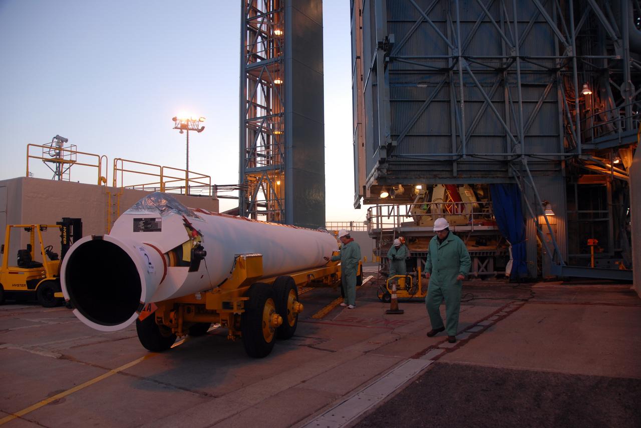
VANDENBERG AIR FORCE BASE, Calif. -- The first solid rocket motor arrives on Space Launch Complex 2 at Vandenberg Air Force Base in California. It will be attached to the Delta II first stage inside the mobile service tower. The Delta II is the launch vehicle for the OSTM/Jason-2 spacecraft. The OSTM, or Ocean Topography Mission, on the Jason-2 satellite is a follow-on to Jason-1. It will take oceanographic studies of sea surface height into an operational mode for continued climate forecasting research and science and industrial applications. This satellite altimetry data will help determine ocean circulation, climate change and sea-level rise. OSTM is a joint effort by the National Oceanic and Atmospheric Administration, NASA, France’s Centre National d’Etudes Spatiales and the European Meteorological Satellite Organisation. OSTM/Jason-2 will be launched aboard a United Launch Alliance Delta II 7320 from Vandenberg on June 15. Photo credit: NASA/Dan Liberotti
VANDENBERG AIR FORCE BASE, Calif. -- On Space Launch Complex 2 at Vandenberg Air Force Base in California, the Delta II second stage is ready to be lifted into the mobile service tower for installation on the first stage for launch of the OSTM/Jason-2 spacecraft. The OSTM, or Ocean Topography Mission, on the Jason-2 satellite is a follow-on to Jason-1. It will take oceanographic studies of sea surface height into an operational mode for continued climate forecasting research and science and industrial applications. This satellite altimetry data will help determine ocean circulation, climate change and sea-level rise. OSTM is a joint effort by the National Oceanic and Atmospheric Administration, NASA, France’s Centre National d’Etudes Spatiales and the European Meteorological Satellite Organisation. OSTM/Jason-2 will be launched on June 20. Photo credit: NASA
VANDENBERG AIR FORCE BASE, Calif. -- On Space Launch Complex 2 at Vandenberg Air Force Base in California, the Delta II second stage is lowered inside the mobile service tower toward the opening above the first stage. The second stage will be mated to the first stage for launch of the OSTM/Jason-2 spacecraft. The OSTM, or Ocean Topography Mission, on the Jason-2 satellite is a follow-on to Jason-1. It will take oceanographic studies of sea surface height into an operational mode for continued climate forecasting research and science and industrial applications. This satellite altimetry data will help determine ocean circulation, climate change and sea-level rise. OSTM is a joint effort by the National Oceanic and Atmospheric Administration, NASA, France’s Centre National d’Etudes Spatiales and the European Meteorological Satellite Organisation. OSTM/Jason-2 will be launched on June 20. Photo credit: NASA
VANDENBERG AIR FORCE BASE, Calif. -- At Vandenberg Air Force Base, the OSTM/Jason-2 satellite shipping container is being moved inside the Astrotech processing facility. The OSTM, or Ocean Topography Mission, on the Jason-2 satellite is a follow-on to Jason-1. It will take oceanographic studies of sea surface height into an operational mode for continued climate forecasting research and science and industrial applications. This satellite altimetry data will help determine ocean circulation, climate change and sea-level rise. OSTM is a joint effort by the National Oceanic and Atmospheric Administration, NASA, France’s Centre National d’Etudes Spatiales and the European Meteorological Satellite Organisation. OSTM/Jason-2 will be launched aboard a United Launch Alliance Delta II 7320 from Vandenberg on June 15. Photo credit: NASA/Dan Liberotti
VANDENBERG AIR FORCE BASE, Calif. -- At Vandenberg Air Force Base in California, workers on Space Launch Complex 2 prepare to raise the Delta II first stage of the OSTM/Jason-2 spacecraft. Once it is vertical, the first stage will be transferred into the mobile service tower. The OSTM, or Ocean Topography Mission, on the Jason-2 satellite is a follow-on to Jason-1. It will take oceanographic studies of sea surface height into an operational mode for continued climate forecasting research and science and industrial applications. This satellite altimetry data will help determine ocean circulation, climate change and sea-level rise. OSTM is a joint effort by the National Oceanic and Atmospheric Administration, NASA, France’s Centre National d’Etudes Spatiales and the European Meteorological Satellite Organisation. OSTM/Jason-2 will be launched aboard a United Launch Alliance Delta II 7320 from Vandenberg on June 15. Photo credit: NASA/Dan Liberotti
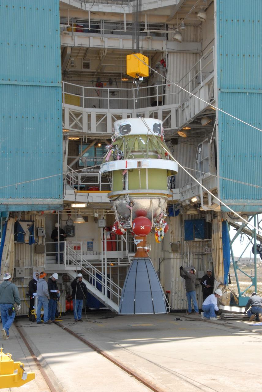
VANDENBERG AIR FORCE BASE, Calif. -- Suspended vertically, the Delta II second stage is ready to be lifted into the mobile service tower on Space Launch Complex 2 at Vandenberg Air Force Base in California. The second stage will be installed on the first stage for launch of the OSTM/Jason-2 spacecraft. The OSTM, or Ocean Topography Mission, on the Jason-2 satellite is a follow-on to Jason-1. It will take oceanographic studies of sea surface height into an operational mode for continued climate forecasting research and science and industrial applications. This satellite altimetry data will help determine ocean circulation, climate change and sea-level rise. OSTM is a joint effort by the National Oceanic and Atmospheric Administration, NASA, France’s Centre National d’Etudes Spatiales and the European Meteorological Satellite Organisation. OSTM/Jason-2 will be launched on June 20. Photo credit: NASA
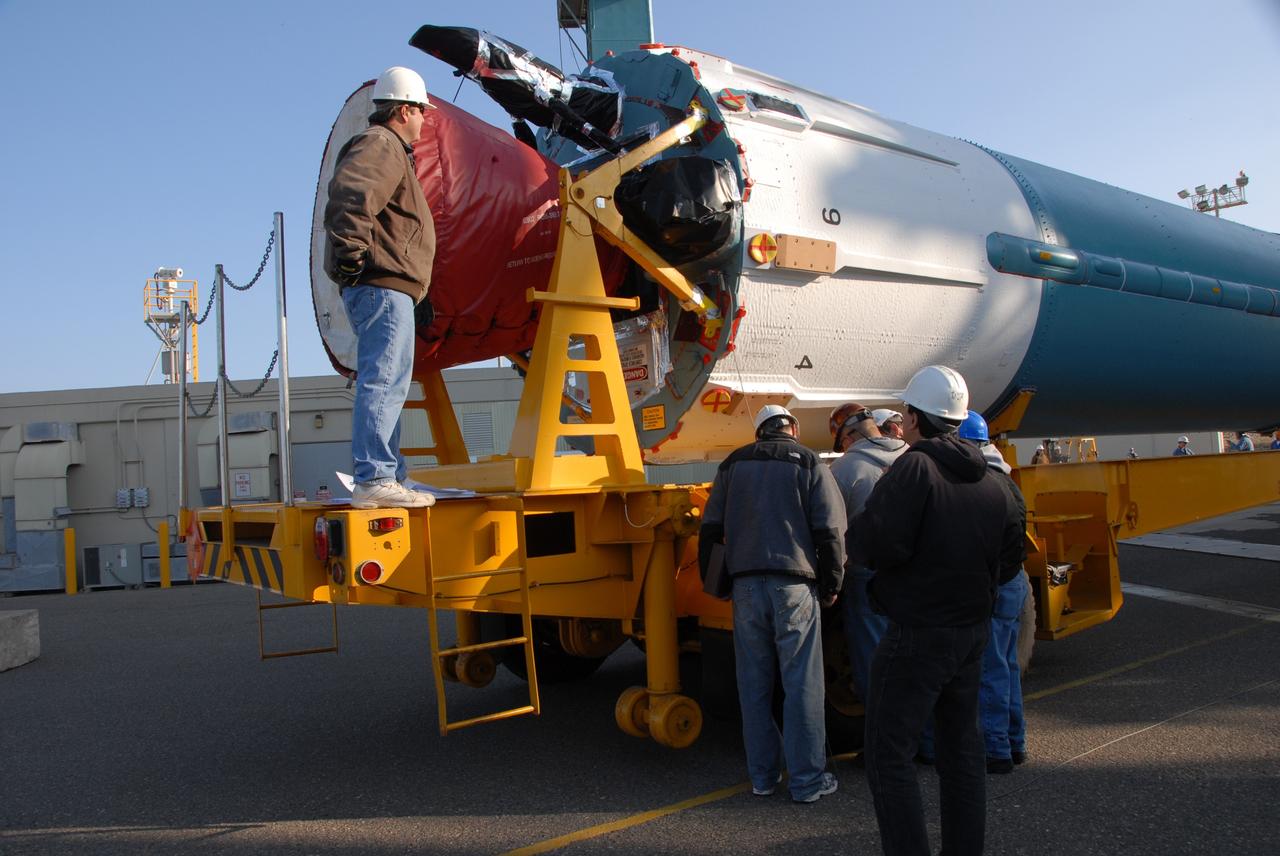
VANDENBERG AIR FORCE BASE, Calif. -- On Space Launch Complex 2 at Vandenberg Air Force Base in California, the second solid rocket motor, or SRM, is moved into place alongside the Delta II first stage. The Delta II is the launch vehicle for the OSTM/Jason-2 spacecraft. The OSTM, or Ocean Topography Mission, on the Jason-2 satellite is a follow-on to Jason-1. It will take oceanographic studies of sea surface height into an operational mode for continued climate forecasting research and science and industrial applications. This satellite altimetry data will help determine ocean circulation, climate change and sea-level rise. OSTM is a joint effort by the National Oceanic and Atmospheric Administration, NASA, France’s Centre National d’Etudes Spatiales and the European Meteorological Satellite Organisation. OSTM/Jason-2 will be launched aboard a United Launch Alliance Delta II 7320 from Vandenberg on June 15. Photo credit: NASA/Dan Liberotti
VANDENBERG AIR FORCE BASE, Calif. -- Workers on Space Launch Complex 2 at Vandenberg Air Force Base in California maneuver the transporter with the Delta II second stage into place. It will be lifted into the mobile service tower and installed on the first stage for launch of the OSTM/Jason-2 spacecraft. The OSTM, or Ocean Topography Mission, on the Jason-2 satellite is a follow-on to Jason-1. It will take oceanographic studies of sea surface height into an operational mode for continued climate forecasting research and science and industrial applications. This satellite altimetry data will help determine ocean circulation, climate change and sea-level rise. OSTM is a joint effort by the National Oceanic and Atmospheric Administration, NASA, France’s Centre National d’Etudes Spatiales and the European Meteorological Satellite Organisation. OSTM/Jason-2 will be launched on June 20. Photo credit: NASA
VANDENBERG AIR FORCE BASE, Calif. -- At Vandenberg Air Force Base, workers remove the straps holding the OSTM/Jason-2 satellite shipping container on the flatbed truck. The container will be moved inside the Astrotech processing facility at right. The OSTM, or Ocean Topography Mission, on the Jason-2 satellite is a follow-on to Jason-1. It will take oceanographic studies of sea surface height into an operational mode for continued climate forecasting research and science and industrial applications. This satellite altimetry data will help determine ocean circulation, climate change and sea-level rise. OSTM is a joint effort by the National Oceanic and Atmospheric Administration, NASA, France’s Centre National d’Etudes Spatiales and the European Meteorological Satellite Organisation. OSTM/Jason-2 will be launched aboard a United Launch Alliance Delta II 7320 from Vandenberg on June 15. Photo credit: NASA/Dan Liberotti
VANDENBERG AIR FORCE BASE, Calif. -- Workers on Space Launch Complex 2 at Vandenberg Air Force Base in California maneuver the transporter with the Delta II second stage into place. It will be lifted into the mobile service tower and installed on the first stage for launch of the OSTM/Jason-2 spacecraft. The OSTM, or Ocean Topography Mission, on the Jason-2 satellite is a follow-on to Jason-1. It will take oceanographic studies of sea surface height into an operational mode for continued climate forecasting research and science and industrial applications. This satellite altimetry data will help determine ocean circulation, climate change and sea-level rise. OSTM is a joint effort by the National Oceanic and Atmospheric Administration, NASA, France’s Centre National d’Etudes Spatiales and the European Meteorological Satellite Organisation. OSTM/Jason-2 will be launched on June 20. Photo credit: NASA

VANDENBERG AIR FORCE BASE, Calif. -- Inside the Astrotech processing facility at Vandenberg Air Force Base, technicians check the OSTM/Jason-2 spacecraft before it is moved to a tilt dolly. The OSTM, or Ocean Topography Mission, on the Jason-2 satellite is a follow-on to Jason-1. It will take oceanographic studies of sea surface height into an operational mode for continued climate forecasting research and science and industrial applications. This satellite altimetry data will help determine ocean circulation, climate change and sea-level rise. OSTM is a joint effort by the National Oceanic and Atmospheric Administration, NASA, France’s Centre National d’Etudes Spatiales and the European Meteorological Satellite Organisation. OSTM/Jason-2 will be launched aboard a United Launch Alliance Delta II 7320 from Vandenberg on June 15. Photo credit: NASA/Mark Mackley
VANDENBERG AIR FORCE BASE, Calif. – The OSTM/Jason-2 satellite is transported from the airstrip at Vandenberg Air Force Base. The satellite will be taken to the Astrotech processing facility. The OSTM, or Ocean Topography Mission, on the Jason-2 satellite is a follow-on to Jason-1. It will take oceanographic studies of sea surface height into an operational mode for continued climate forecasting research and science and industrial applications. This satellite altimetry data will help determine ocean circulation, climate change and sea-level rise. OSTM is a joint effort by the National Oceanic and Atmospheric Administration, NASA, France’s Centre National d’Etudes Spatiales and the European Meteorological Satellite Organisation. OSTM/Jason-2 will be launched aboard a United Launch Alliance Delta II 7320 from Vandenberg on June 15. Photo credit: NASA/Steve Greenberg, JPL
VANDENBERG AIR FORCE BASE, Calif. -- Inside the Astrotech processing facility at Vandenberg Air Force Base, technicians attach an overhead crane to the OSTM/Jason-2 spacecraft. The spacecraft will be moved to a tilt dolly. The OSTM, or Ocean Topography Mission, on the Jason-2 satellite is a follow-on to Jason-1. It will take oceanographic studies of sea surface height into an operational mode for continued climate forecasting research and science and industrial applications. This satellite altimetry data will help determine ocean circulation, climate change and sea-level rise. OSTM is a joint effort by the National Oceanic and Atmospheric Administration, NASA, France’s Centre National d’Etudes Spatiales and the European Meteorological Satellite Organisation. OSTM/Jason-2 will be launched aboard a United Launch Alliance Delta II 7320 from Vandenberg on June 15. Photo credit: NASA/Mark Mackley
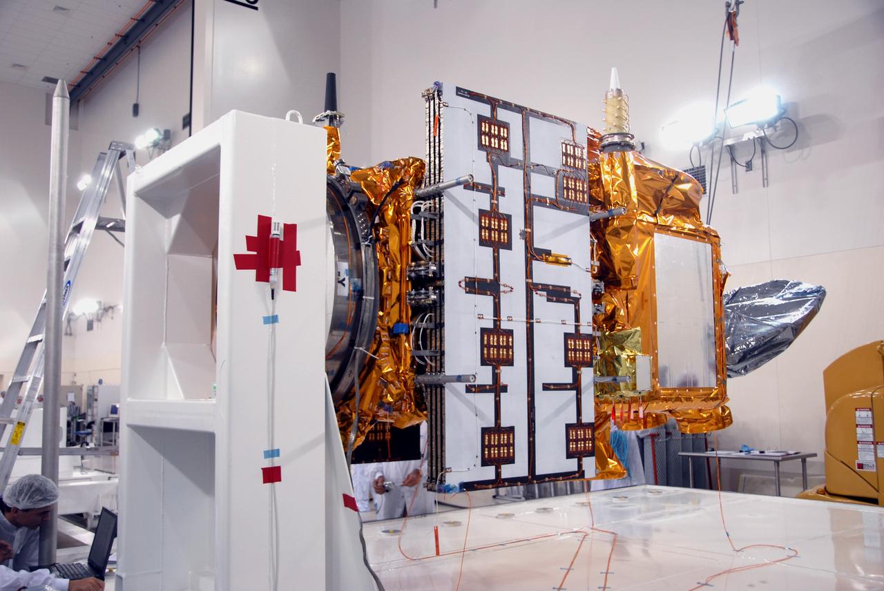
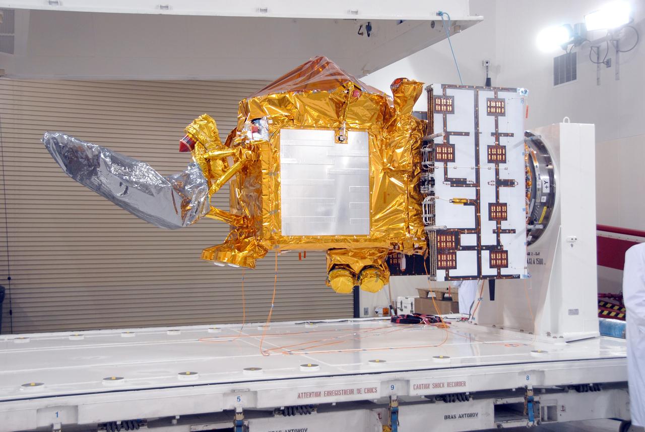
VANDENBERG AIR FORCE BASE, Calif. -- Another view of the OSTM/Jason-2 spacecraft after removal of the shipping container in the Astrotech processing facility at Vandenberg Air Force Base. The OSTM, or Ocean Topography Mission, on the Jason-2 satellite is a follow-on to Jason-1. It will take oceanographic studies of sea surface height into an operational mode for continued climate forecasting research and science and industrial applications. This satellite altimetry data will help determine ocean circulation, climate change and sea-level rise. OSTM is a joint effort by the National Oceanic and Atmospheric Administration, NASA, France’s Centre National d’Etudes Spatiales and the European Meteorological Satellite Organisation. OSTM/Jason-2 will be launched aboard a United Launch Alliance Delta II 7320 from Vandenberg on June 15. Photo credit: NASA/Mark Mackley
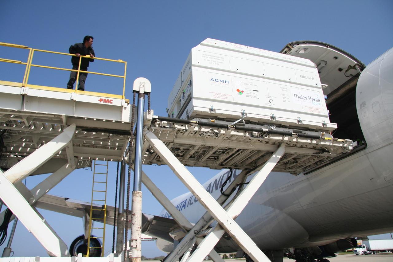
VANDENBERG AIR FORCE BASE, Calif. – The shipping container with the OSTM/Jason-2 spacecraft inside is offloaded from the aircraft at Vandenberg Air Force Base in California. The OSTM, or Ocean Topography Mission, on the Jason-2 satellite is a follow-on to Jason-1. It will take oceanographic studies of sea surface height into an operational mode for continued climate forecasting research and science and industrial applications. This satellite altimetry data will help determine ocean circulation, climate change and sea-level rise. OSTM is a joint effort by the National Oceanic and Atmospheric Administration, NASA, France’s Centre National d’Etudes Spatiales and the European Meteorological Satellite Organisation. OSTM/Jason-2 will be launched aboard a United Launch Alliance Delta II 7320 from Vandenberg on June 15. Photo credit: NASA/Steve Greenberg, JPL
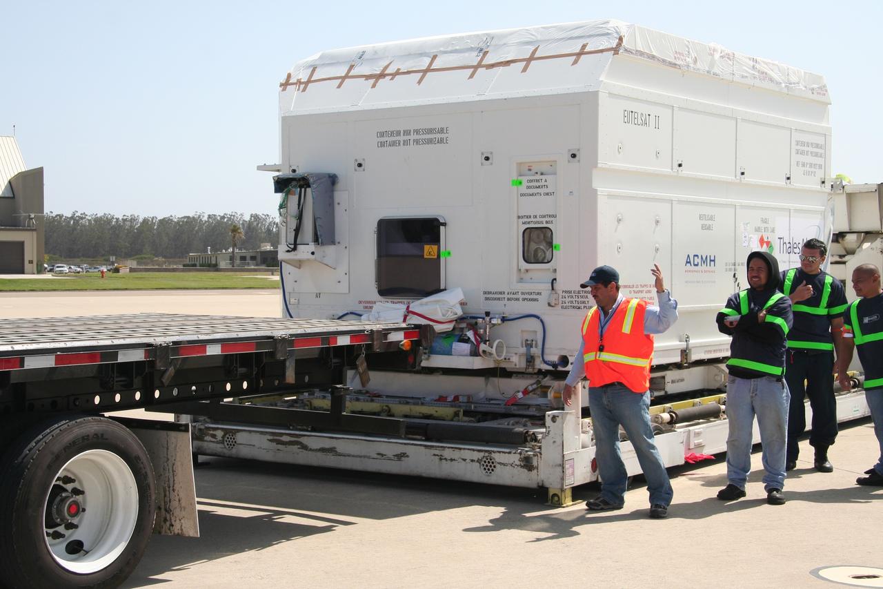
VANDENBERG AIR FORCE BASE, Calif. – Workers prepare to move the shipping container holding the OSTM/Jason-2 satellite onto a flatbed truck at Vandenberg Air Force Base. The satellite will be transported to the Astrotech processing facility. The OSTM, or Ocean Topography Mission, on the Jason-2 satellite is a follow-on to Jason-1. It will take oceanographic studies of sea surface height into an operational mode for continued climate forecasting research and science and industrial applications. This satellite altimetry data will help determine ocean circulation, climate change and sea-level rise. OSTM is a joint effort by the National Oceanic and Atmospheric Administration, NASA, France’s Centre National d’Etudes Spatiales and the European Meteorological Satellite Organisation. OSTM/Jason-2 will be launched aboard a United Launch Alliance Delta II 7320 from Vandenberg on June 15. Photo credit: NASA/Steve Greenberg, JPL
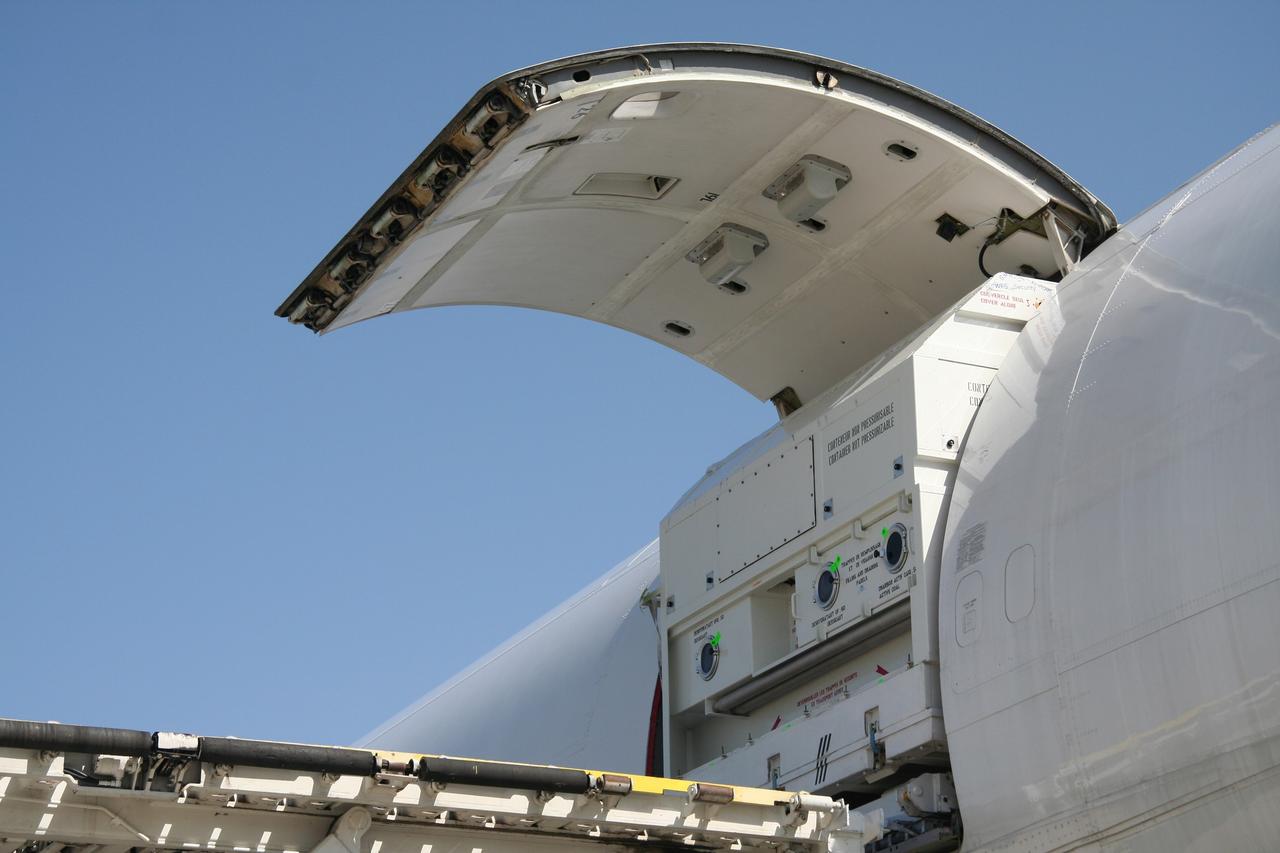
VANDENBERG AIR FORCE BASE, Calif. – The shipping container with the OSTM/Jason-2 spacecraft inside is offloaded from the aircraft at Vandenberg Air Force Base in California. The OSTM, or Ocean Topography Mission, on the Jason-2 satellite is a follow-on to Jason-1. It will take oceanographic studies of sea surface height into an operational mode for continued climate forecasting research and science and industrial applications. This satellite altimetry data will help determine ocean circulation, climate change and sea-level rise. OSTM is a joint effort by the National Oceanic and Atmospheric Administration, NASA, France’s Centre National d’Etudes Spatiales and the European Meteorological Satellite Organisation. OSTM/Jason-2 will be launched aboard a United Launch Alliance Delta II 7320 from Vandenberg on June 15. Photo credit: NASA/Steve Greenberg, JPL
VANDENBERG AIR FORCE BASE, Calif. -- In pre-dawn hours at Vandenberg Air Force Base in California, the mobile service tower/umbilical tower and launcher on Space Launch Complex 2 are being prepared for the arrival of the Delta II first stage for the OSTM/Jason-2 spacecraft. The OSTM, or Ocean Topography Mission, on the Jason-2 satellite is a follow-on to Jason-1. It will take oceanographic studies of sea surface height into an operational mode for continued climate forecasting research and science and industrial applications. This satellite altimetry data will help determine ocean circulation, climate change and sea-level rise. OSTM is a joint effort by the National Oceanic and Atmospheric Administration, NASA, France’s Centre National d’Etudes Spatiales and the European Meteorological Satellite Organisation. OSTM/Jason-2 will be launched aboard a United Launch Alliance Delta II 7320 from Vandenberg on June 15. Photo credit: NASA/Dan Liberotti
VANDENBERG AIR FORCE BASE, Calif. -- A closeup of the OSTM/Jason-2 spacecraft after removal of the shipping container in the Astrotech processing facility at Vandenberg Air Force Base. The OSTM, or Ocean Topography Mission, on the Jason-2 satellite is a follow-on to Jason-1. It will take oceanographic studies of sea surface height into an operational mode for continued climate forecasting research and science and industrial applications. This satellite altimetry data will help determine ocean circulation, climate change and sea-level rise. OSTM is a joint effort by the National Oceanic and Atmospheric Administration, NASA, France’s Centre National d’Etudes Spatiales and the European Meteorological Satellite Organisation. OSTM/Jason-2 will be launched aboard a United Launch Alliance Delta II 7320 from Vandenberg on June 15. Photo credit: NASA/Mark Mackley
VANDENBERG AIR FORCE BASE, Calif. -- At Vandenberg Air Force Base in California, the Delta II first stage for the OSTM/Jason-2 spacecraft arrives on Space Launch Complex 2. The first stage will be raised to vertical and lifted into the mobile service tower (behind it, at left). The OSTM, or Ocean Topography Mission, on the Jason-2 satellite is a follow-on to Jason-1. It will take oceanographic studies of sea surface height into an operational mode for continued climate forecasting research and science and industrial applications. This satellite altimetry data will help determine ocean circulation, climate change and sea-level rise. OSTM is a joint effort by the National Oceanic and Atmospheric Administration, NASA, France’s Centre National d’Etudes Spatiales and the European Meteorological Satellite Organisation. OSTM/Jason-2 will be launched aboard a United Launch Alliance Delta II 7320 from Vandenberg on June 15. Photo credit: NASA/Dan Liberotti
VANDENBERG AIR FORCE BASE, Calif. -- Inside the Astrotech processing facility at Vandenberg Air Force Base, an overhead crane is being attached to the OSTM/Jason-2 spacecraft. The spacecraft will be moved to a tilt dolly. The OSTM, or Ocean Topography Mission, on the Jason-2 satellite is a follow-on to Jason-1. It will take oceanographic studies of sea surface height into an operational mode for continued climate forecasting research and science and industrial applications. This satellite altimetry data will help determine ocean circulation, climate change and sea-level rise. OSTM is a joint effort by the National Oceanic and Atmospheric Administration, NASA, France’s Centre National d’Etudes Spatiales and the European Meteorological Satellite Organisation. OSTM/Jason-2 will be launched aboard a United Launch Alliance Delta II 7320 from Vandenberg on June 15. Photo credit: NASA/Mark Mackley
VANDENBERG AIR FORCE BASE, Calif. -- Inside the Astrotech processing facility at Vandenberg Air Force Base, an overhead crane is attached to the OSTM/Jason-2 spacecraft shipping container to remove it. The OSTM, or Ocean Topography Mission, on the Jason-2 satellite is a follow-on to Jason-1. It will take oceanographic studies of sea surface height into an operational mode for continued climate forecasting research and science and industrial applications. This satellite altimetry data will help determine ocean circulation, climate change and sea-level rise. OSTM is a joint effort by the National Oceanic and Atmospheric Administration, NASA, France’s Centre National d’Etudes Spatiales and the European Meteorological Satellite Organisation. OSTM/Jason-2 will be launched aboard a United Launch Alliance Delta II 7320 from Vandenberg on June 15. Photo credit: NASA/Mark Mackley
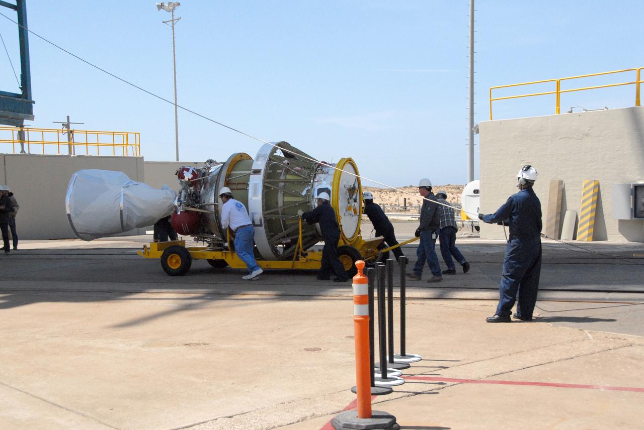
VANDENBERG AIR FORCE BASE, Calif. -- On Space Launch Complex 2 at Vandenberg Air Force Base in California, a solid rocket motor, or SRM, is lifted alongside the mobile service tower. The SRM will be moved inside the tower and attached to the Delta II first stage, which is the launch vehicle for the OSTM/Jason-2 spacecraft. The OSTM, or Ocean Topography Mission, on the Jason-2 satellite is a follow-on to Jason-1. It will take oceanographic studies of sea surface height into an operational mode for continued climate forecasting research and science and industrial applications. This satellite altimetry data will help determine ocean circulation, climate change and sea-level rise. OSTM is a joint effort by the National Oceanic and Atmospheric Administration, NASA, France’s Centre National d’Etudes Spatiales and the European Meteorological Satellite Organisation. OSTM/Jason-2 will be launched aboard a United Launch Alliance Delta II 7320 from Vandenberg on June 15. Photo credit: NASA/Dan Liberotti
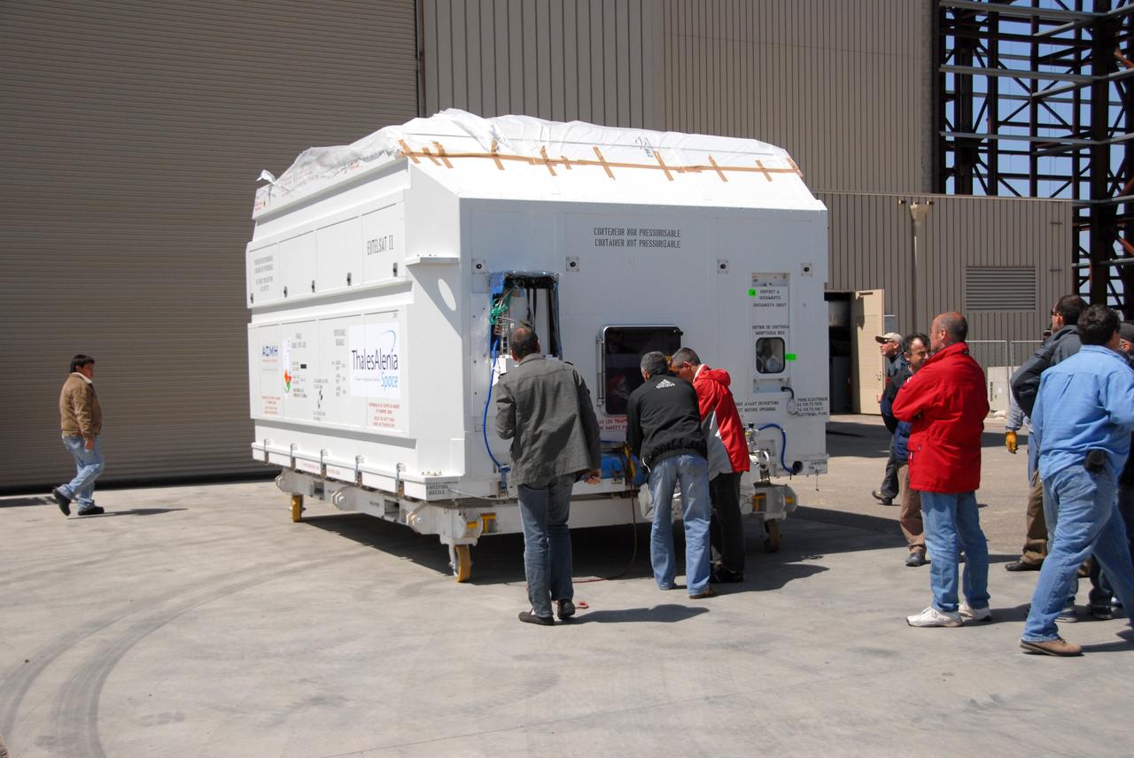
VANDENBERG AIR FORCE BASE, Calif. -- Inside the Astrotech processing facility at Vandenberg Air Force Base, the shipping container is removed from the OSTM/Jason-2 spacecraft. The OSTM, or Ocean Topography Mission, on the Jason-2 satellite is a follow-on to Jason-1. It will take oceanographic studies of sea surface height into an operational mode for continued climate forecasting research and science and industrial applications. This satellite altimetry data will help determine ocean circulation, climate change and sea-level rise. OSTM is a joint effort by the National Oceanic and Atmospheric Administration, NASA, France’s Centre National d’Etudes Spatiales and the European Meteorological Satellite Organisation. OSTM/Jason-2 will be launched aboard a United Launch Alliance Delta II 7320 from Vandenberg on June 15. Photo credit: NASA/Mark Mackley
VANDENBERG AIR FORCE BASE, Calif. -- Workers move the shipping container holding the OSTM/Jason-2 satellite on a flatbed truck at Vandenberg Air Force Base. The satellite will be transported to the Astrotech processing facility. The OSTM, or Ocean Topography Mission, on the Jason-2 satellite is a follow-on to Jason-1. It will take oceanographic studies of sea surface height into an operational mode for continued climate forecasting research and science and industrial applications. This satellite altimetry data will help determine ocean circulation, climate change and sea-level rise. OSTM is a joint effort by the National Oceanic and Atmospheric Administration, NASA, France’s Centre National d’Etudes Spatiales and the European Meteorological Satellite Organisation. OSTM/Jason-2 will be launched aboard a United Launch Alliance Delta II 7320 from Vandenberg on June 15. Photo credit: NASA/Dan Liberotti
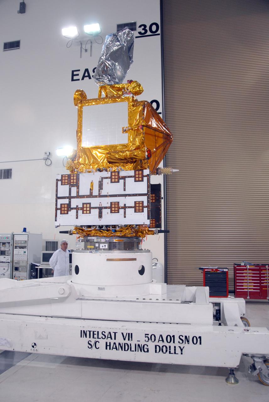
VANDENBERG AIR FORCE BASE, Calif. -- Inside the Astrotech processing facility at Vandenberg Air Force Base, the OSTM/Jason-2 spacecraft is lifted to a vertical position on the tilt dolly. The OSTM, or Ocean Topography Mission, on the Jason-2 satellite is a follow-on to Jason-1. It will take oceanographic studies of sea surface height into an operational mode for continued climate forecasting research and science and industrial applications. This satellite altimetry data will help determine ocean circulation, climate change and sea-level rise. OSTM is a joint effort by the National Oceanic and Atmospheric Administration, NASA, France’s Centre National d’Etudes Spatiales and the European Meteorological Satellite Organisation. OSTM/Jason-2 will be launched aboard a United Launch Alliance Delta II 7320 from Vandenberg on June 15. Photo credit: NASA/Mark Mackley
VANDENBERG AIR FORCE BASE, Calif. -- The Delta II second stage is transported onto Space Launch Complex 2 at Vandenberg Air Force Base in California. It will be lifted into the mobile service tower and installed on the first stage for launch of the OSTM/Jason-2 spacecraft. The OSTM, or Ocean Topography Mission, on the Jason-2 satellite is a follow-on to Jason-1. It will take oceanographic studies of sea surface height into an operational mode for continued climate forecasting research and science and industrial applications. This satellite altimetry data will help determine ocean circulation, climate change and sea-level rise. OSTM is a joint effort by the National Oceanic and Atmospheric Administration, NASA, France’s Centre National d’Etudes Spatiales and the European Meteorological Satellite Organisation. OSTM/Jason-2 will be launched on June 20. Photo credit: NASA
VANDENBERG AIR FORCE BASE, Calif. – After being offloaded from the cargo plane, the shipping container holding the OSTM/Jason-2 satellite is moved away from the plane. The satellite will be taken to the Astrotech processing facility. The OSTM, or Ocean Topography Mission, on the Jason-2 satellite is a follow-on to Jason-1. It will take oceanographic studies of sea surface height into an operational mode for continued climate forecasting research and science and industrial applications. This satellite altimetry data will help determine ocean circulation, climate change and sea-level rise. OSTM is a joint effort by the National Oceanic and Atmospheric Administration, NASA, France’s Centre National d’Etudes Spatiales and the European Meteorological Satellite Organisation. OSTM/Jason-2 will be launched aboard a United Launch Alliance Delta II 7320 from Vandenberg on June 15. Photo credit: NASA/Steve Greenberg, JPL
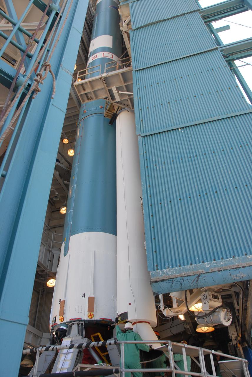
VANDENBERG AIR FORCE BASE, Calif. -- On Space Launch Complex 2 at Vandenberg Air Force Base in California, the mobile service tower with the Delta II first stage moves closer to the umbilical tower/launcher at right. The Delta II is the launch vehicle for the OSTM/Jason-2 spacecraft. The OSTM, or Ocean Topography Mission, on the Jason-2 satellite is a follow-on to Jason-1. It will take oceanographic studies of sea surface height into an operational mode for continued climate forecasting research and science and industrial applications. This satellite altimetry data will help determine ocean circulation, climate change and sea-level rise. OSTM is a joint effort by the National Oceanic and Atmospheric Administration, NASA, France’s Centre National d’Etudes Spatiales and the European Meteorological Satellite Organisation. OSTM/Jason-2 will be launched aboard a United Launch Alliance Delta II 7320 from Vandenberg on June 15. Photo credit: NASA/Dan Liberotti
VANDENBERG AIR FORCE BASE, Calif. -- Inside the Astrotech processing facility at Vandenberg Air Force Base, the shipping container is removed from the OSTM/Jason-2 spacecraft. The OSTM, or Ocean Topography Mission, on the Jason-2 satellite is a follow-on to Jason-1. It will take oceanographic studies of sea surface height into an operational mode for continued climate forecasting research and science and industrial applications. This satellite altimetry data will help determine ocean circulation, climate change and sea-level rise. OSTM is a joint effort by the National Oceanic and Atmospheric Administration, NASA, France’s Centre National d’Etudes Spatiales and the European Meteorological Satellite Organisation. OSTM/Jason-2 will be launched aboard a United Launch Alliance Delta II 7320 from Vandenberg on June 15. Photo credit: NASA/Mark Mackley